investigation and studies of the slopes along chen-yu … · investigation and studies of the...
TRANSCRIPT
Investigation and Studies of the Slopes along
Chen-Yu-Lan River Watershed after Typhoon Morakot
Sung-Chi Hsu1,*
, Ming-Hung Liu2, Ji-Yuan Lin
3, and Ming-Der Yang
4
1,2,3 Dept. of Construction Engineering, Chaoyang University of Technology (168 Jifong East Road, Wufong, Taichung
County 41349, Taiwan)
4 Dep. of Civil Engineering, National Chung-Hsing University (250, Kuo Kuang Rd., Taichung 402, Taiwan)
*Corresponding author. Email: [email protected]
Thorough in-situ investigation had been carried out at Chen-Yu-Lan River Watershed, Nantou County,
Taiwan after Typhoon Morakot in 2009. The objective of this research is to document the causes of slope
disasters in mountain areas in central Taiwan under hydrogeology and extreme weather conditions. The
failed slopes in these areas were identified, synthesized and investigated. Several road and slope failures had
occurred in high terrace deposits, classified as gravel formation GP. In-situ exploration and sampling had
been carried out in Nantou County after the typhoon to obtain the index properties of the soils. There are 39
slope related failures along Taiwan- Provincial-Highway No.21: 24 failures are originated from the upslope
of the road; and 12 failures are due to downslope failure. The major cause of downslope failure is found to be
the toe erosion of the slope by the flood during the typhoon. Numerical simulations sing SEEP/W and
SLOPE/W are performed to reveal the causes of slope failures. The factor of safety will decrease if the river
level rises under the heavy rainfall situation. Then, the toe of the slope may be exposed to erosion by the
flood. The numerical experiments show that the downslope failure is mainly initiated by the toe erosion, and
subsequent progressive failure may occur after the first slide.
Key words: extreme rainfall, investigation, slope, disaster, analysis, infiltration
1. INTRODUCTION
The moderate Typhoon Morakot attacked Taiwan
on Aug. 8th, 2009, and brought more than 2500mm
of torrential rain in central and southern Taiwan. It
was measured as 3059.5mm in Alishan rainfall
station which has been closed to the average rainfall
(3684mm) per year in Alishan. This astonishing
rainfall has exceeded the hundred year rainstorm
frequency. The infiltration of heavy rainfall made
the factor of safety of slopes to decrease and caused
landslides initiated from the upper and/or downward
slopes of a road. The landslides may then cause and
trigger mudslides or debris flow. The mud flow or
debris flow may squeeze the main river channel and
scour river banks and/or down slopes of the roads.
Thus, a lot of landslides had occurred during this
typhoon along the Taiwan-Provincial-Highway
No.21 and Chen-Yu-Lan River Watershed in central
Taiwan. The location and geology of this watershed
is shown in Fig. 1.
Slope failures due to rainfall conditions have
been studied by many researchers and the impacts of
unsaturated and saturated soil behavior on the slope
stability are also considered in many papers. The
objective of this paper is to investigate disasters that
brought by the typhoon, and try to understand the
failure processes and mechanisms of the slope
failure of high terrace deposits in Nantou County
during Typhoon Morakot.
2. STUDY AREA
Thorough in-situ investigation and documentation
had been done after the Typhoon Morakot. Most of
the occurred hazards during the typhoon in central
Taiwan is in Nantou County. Nantou County
situates at the center of Taiwan, and most of the
county is mountain areas. Thus, a lot of hazards,
including flooding, slope failures, debris flow, and
road and bridge failures have occurred in this
county, especially inside Chen-Yu-Lan River
505
Watershed, during Typhoon Morakot. There are 39
slope related failures occurred in this typhoon,
shown as the red dots in Fig. 2. Among these
failures, 24 failures are related with failure from
upslope and the others are due to the sliding from
downslope. The upslope or downslope failure is
classified based on a failure occurs above or below a
road, respectively. There are many potential debris
flow torrents inside this watershed, and they all flow
into Chen-Yu-Lan River. The extreme weather
condition induces the quick rise of river level and
may cause the flow to turn and erode banks beside
the river.
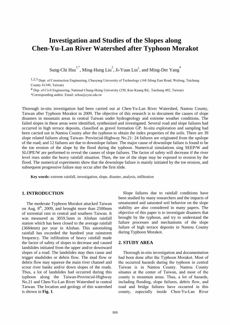
3. GEOLOGICAL CONDITIONS
Chen-Yu-Lan River is at the central Taiwan and
originates from the north peak of Yu Mountain with
an elevation of 3910 m (Fig. 1). The river length is
42.4 km with an average declination slope of 5%
and its watershed area is about 45,000 hectares.
There are three major faults, Dili, Chenyulan, and
Shanshihchia Faults across this watershed which
causes the rock formation contains many fractures
and discontinuities. The Chen-yu-lan-chi fault,
which almost parallels Chen-Yu-Lan River,
separates the Miocene sedimentary rocks of the
Western Foothills from the east side of the
Oligocene metamorphic rocks of the Shuehshan
Range. Differential uplifting along this fault has
generated great topographic relief and abundant
fractures that resulted in frequent landslides and
debris flows even prior to the Chi-Chi earthquake.
Slates and meta-sandstones are the dominant
lithologies in the metamorphic terrane. Based on the
relative amount of slate and meta-sandstone, the
metamorphic strata are divided into four formations.
In the sedimentary terrane, sandstone and shale are
the dominate rock formations.
4. STUDY METHOD
4.1 Investigation after the typhoon
Investigation had been accomplished after the
typhoon to document the location and extend of
various types of failures. Thus, researches and
analyses could be performed later on to reveal the
causes of disasters. Several major types of disasters,
i.e., landslide, debris flow, slope failure due to
scouring, have been found during the in-situ
investigation in Nantou County. Locations of the
disaster areas are positioned in Fig. 2, and photos of
several represented and serious disasters are also
placed in the figure. As shown in Fig. 2, most of the
disasters were location beside or close to the Chen-Yu-Lan River.
4.2 Index and mechanical properties In order to obtain the grain-size distribution and
related properties of the soils in Nantou County, soil
samples were obtained from the trench excavation.
The weight and volume of the soil are measured,
and sieve analyses are performed. Most of the soils
are colluvium, therefore, the biggest grain size can
be larger than 30 cm. Most of soil strata can be
classified as poorly graded gravel, GP. Modified
and standard compaction tests are made to obtain
the compaction energy similar to the in situ soil
condition. Then, large direct shear tests (25x25 cm)
are chosen to acquire the shear strength of the
colluvium under saturated and unsaturated
conditions.
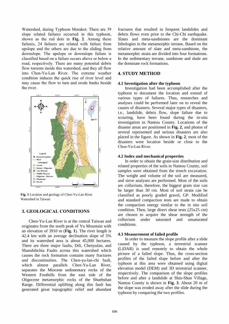
4.3 Measurement of failed profile
In order to measure the slope profile after a slide
caused by the typhoon, a terrestrial scanner
(LiDAR) is used remotely to obtain the whole
picture of a failed slope. Thus, the cross-section
profiles of the failed slope before and after the
typhoon at this area were obtained using digital
elevation model (DEM) and 3D terrestrial scanner,
respectively. The comparison of the slope profiles
before and after a landslide at Shin-Shan Village,
Nantou County is shown in Fig. 3. About 20 m of
the slope was eroded away after the slide during the
typhoon by comparing the two profiles.
Fig. 1 Location and geology of Chen-Yu-Lan River
Watershed in Taiwan
506

Fig. 2 Locations of disaster (shown as red dots) in Chen-Yu-Lan river watershed investigated after the typhoon
507
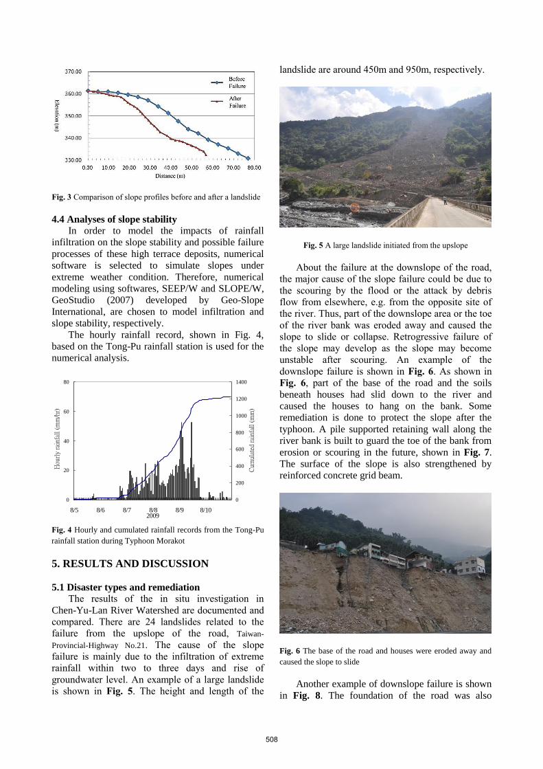
Fig. 3 Comparison of slope profiles before and after a landslide
4.4 Analyses of slope stability In order to model the impacts of rainfall
infiltration on the slope stability and possible failure
processes of these high terrace deposits, numerical
software is selected to simulate slopes under
extreme weather condition. Therefore, numerical
modeling using softwares, SEEP/W and SLOPE/W,
GeoStudio (2007) developed by Geo-Slope
International, are chosen to model infiltration and
slope stability, respectively.
The hourly rainfall record, shown in Fig. 4,
based on the Tong-Pu rainfall station is used for the
numerical analysis.
0
20
40
60
80
8/5 8/6 8/7 8/8 8/9 8/102009
0
200
400
600
800
1000
1200
1400
Cum
ulat
ed r
ainf
all
(mm
)
Hou
rly
rain
fall
(m
m/h
r)
Fig. 4 Hourly and cumulated rainfall records from the Tong-Pu
rainfall station during Typhoon Morakot
5. RESULTS AND DISCUSSION
5.1 Disaster types and remediation
The results of the in situ investigation in
Chen-Yu-Lan River Watershed are documented and
compared. There are 24 landslides related to the
failure from the upslope of the road, Taiwan-
Provincial-Highway No.21. The cause of the slope
failure is mainly due to the infiltration of extreme
rainfall within two to three days and rise of
groundwater level. An example of a large landslide
is shown in Fig. 5. The height and length of the
landslide are around 450m and 950m, respectively.
Fig. 5 A large landslide initiated from the upslope
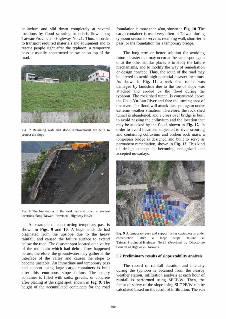
About the failure at the downslope of the road,
the major cause of the slope failure could be due to
the scouring by the flood or the attack by debris
flow from elsewhere, e.g. from the opposite site of
the river. Thus, part of the downslope area or the toe
of the river bank was eroded away and caused the
slope to slide or collapse. Retrogressive failure of
the slope may develop as the slope may become
unstable after scouring. An example of the
downslope failure is shown in Fig. 6. As shown in
Fig. 6, part of the base of the road and the soils
beneath houses had slid down to the river and
caused the houses to hang on the bank. Some
remediation is done to protect the slope after the
typhoon. A pile supported retaining wall along the
river bank is built to guard the toe of the bank from
erosion or scouring in the future, shown in Fig. 7.
The surface of the slope is also strengthened by
reinforced concrete grid beam.
Fig. 6 The base of the road and houses were eroded away and
caused the slope to slide
Another example of downslope failure is shown
in Fig. 8. The foundation of the road was also
508
colluvium and slid down completely at several
locations by flood scouring or debris flow along
Taiwan-Provincial -Highway No.21. Thus, in order
to transport required materials and equipment and to
rescue people right after the typhoon, a temporary
pass is usually constructed below or on top of the
road.
Fig. 7 Retaining wall and slope reinforcement are built to
protect the slope
Fig. 8 The foundation of the road had slid down at several
locations along Taiwan- Provincial-Highway No.21
An example of constructing temporary pass is
shown in Figs. 9 and 10. A huge landslide had
originated from the upslope due to the heavy
rainfall, and caused the failure surface to extend
below the road. The disaster spot located on a valley
of the mountain which had debris flow happened
before, therefore, the groundwater may gather at the
interface of the valley and causes the slope to
become unstable. An immediate and temporary pass
and support using large cargo containers is built
after this enormous slope failure. The empty
container is filled with soils, gravels, or concrete
after placing at the right spot, shown in Fig. 9. The
height of the accumulated containers for the road
foundation is more than 40m, shown in Fig. 10. The
cargo container is used very often in Taiwan during
typhoon season to serve as retaining wall, short-term
pass, or the foundation for a temporary bridge.
The long-term or better solution for avoiding
future disaster that may occur at the same spot again
or at the other similar places is to study the failure
mechanisms, and to modify the way of remediation
or design concept. Thus, the route of the road may
be altered to avoid high potential disaster locations.
As shown in Fig. 11, a rock shed tunnel was
damaged by landslide due to the toe of slope was
attacked and eroded by the flood during the
typhoon. The rock shed tunnel is constructed above
the Chen-Yu-Lan River and face the turning spot of
the river. The flood will attack this spot again under
extreme weather situation. Therefore, the rock shed
tunnel is abandoned, and a cross over bridge is built
to avoid passing the colluvium and the location that
may be attacked by the flood, shown in Fig. 12. In
order to avoid locations subjected to river scouring
and containing colluvium and broken rock mass, a
long-span bridge is designed and built to serve as
permanent remediation, shown in Fig. 13. This kind
of design concept is becoming recognized and
accepted nowadays.
Fig. 9 A temporary pass and support using containers is under
construction after a large slope failure at
Taiwan-Provincial-Highway No.21 (Provided by Directorate
General of Highways, Taiwan)
5.2 Preliminary results of slope stability analysis
The record of rainfall duration and intensity
during the typhoon is obtained from the nearby
weather station. Infiltration analysis at each hour of
rainfall is performed using SEEP/W. Then, the
factor of safety of the slope using SLOPE/W can be
calculated based on the result of infiltration. The van
509
Genuchten (VG) model is used for the unsaturated
material during the analyses. Analysis of the slope
shown in Fig. 6 is chosen to model. The friction
angle and cohesion of the material are selected as 46
degrees and 15 kN/m2, respectively, based on the
direct shear tests and previous studies. The slope
may remain stable under the heavy rainfall condition
if the river level is not going up. If the river level
rises as the groundwater level rises due to rainfall
infiltration, the factor of safety of the slope will
become less, i.e. 1.187, shown in Fig. 14. However,
the slope may be still stable, but the slope will
become unstable if the toe of the slope is eroded
away. If the part of the slope below the river level is
assumed to be eroded away by the flood, then the
factor of safety will be only 0.915. Thus,
retrogressive slope failure will occur subsequently.
Fig. 10 Completion of immediate and Temporary retaining wall
and road using containers (Provided by Directorate General of
Highways, Taiwan)
Fig. 11 A rock shed tunnel was damaged by landslide due to the
toe of slope was attacked and eroded by the flooding the
typhoon
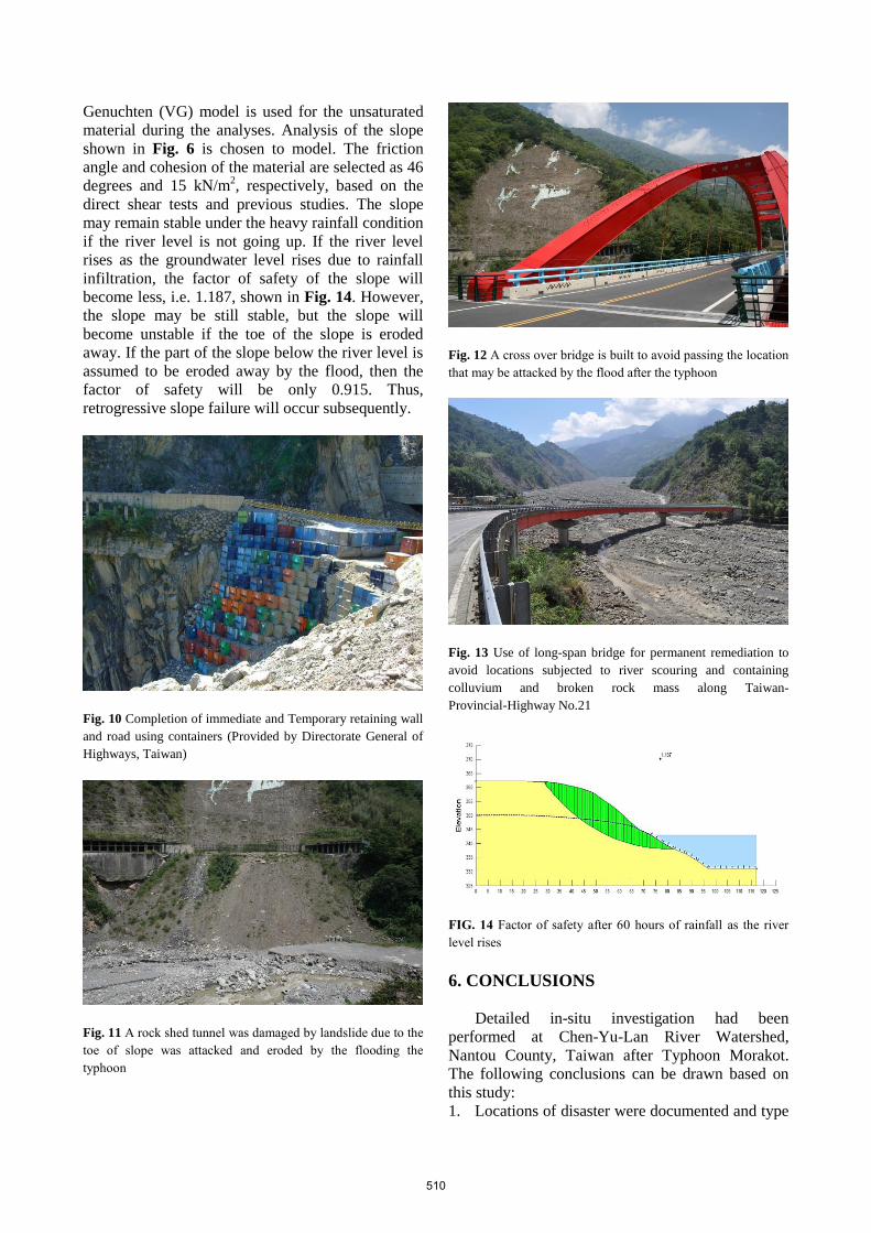
Fig. 12 A cross over bridge is built to avoid passing the location
that may be attacked by the flood after the typhoon
Fig. 13 Use of long-span bridge for permanent remediation to
avoid locations subjected to river scouring and containing
colluvium and broken rock mass along Taiwan-
Provincial-Highway No.21
FIG. 14 Factor of safety after 60 hours of rainfall as the river
level rises
6. CONCLUSIONS
Detailed in-situ investigation had been
performed at Chen-Yu-Lan River Watershed,
Nantou County, Taiwan after Typhoon Morakot.
The following conclusions can be drawn based on
this study:
1. Locations of disaster were documented and type
510

of failure was also studied.
2. There are 39 slope related failures at Taiwan-
Provincial-Highway No.21: 24 failures are
originated from the upslope of the road; and 12
failures are due to downslope failure.
3. The major cause of downslope failure is due to
the toe erosion of the slope by the flood.
4. Cargo containers are used very often to
construct a temporary pass effectively.
5. A long-span bridge is suggested and designed to
serve as permanent remediation in order to
avoid locations subjected to river scouring.
6. The factor of safety of a slope reduces as the
river level rises.
7. The factor of safety can be reduced to 0.915 if
the toe of the slope is eroded away due to the
flood.
8. Retrogressive failure will occur if the toe of the
slope is eroded away.
ACKNOWLEDGMENT: Thanks to Directorate
General of Highways, Taiwan for providing the map
and photos, and to National Science Council of
Taiwan, ROC for the support of this project.
REFERENCES
Cheng, Ya-Jen (2009): Prediction of soil-water characteristic
curve of different soils in Taiwan, Master Thesis, National
Taipei University of Technology. (in Chinese)
Chu, Bin-Lin, Hwang, C. L., Cheng, S. Y., and Pan, G. M.
(1989): Study of in situ direct shear tests in gravel formation
in Taiwan, The Third Geotechnical Conference, Taiwan. pp.
695-706. (in Chinese)
Fredlund, D. G.,Morgenstern, N. R., and Widger, R. A. (1978):
The ShearStrength of Unsaturated Soil, Canadian
Geotechnical Journal, Vol. 15, No.3, pp. 313-321.
GeoStudio (2007): Geo-Slope International.
Lee, K. T., Ho, J.-Y. (2009): Prediction of landslide occurrence
based on slope instability analysis and hydrological model
simulation, Journal of the Hydrology, 375, pp. 489-497.
Lin, Ping-Sien, Ji-Yuan Lin, Jui-Chi Hung, and Ming-Der Yang
(2002): Assessing debris-flow hazard in a watershed in
Taiwan, Engineering Geology 66, pp. 295-313.
van Genuchten, M . T. (1980): A closed-form equation for
predicting the hydraulic conductivity of unsaturated Soils,
Soil Science Society of America Journal, Vol. 44, No. 5, pp.
892-898.
Wu, Chia-Chun, Wang, Chen-Han, and Chan, Yu-Ting (2012):
Infiltration behavior of gravel-rich soil, Journal of Chinese
Soil and Water Conservation 43(1), pp. 65-74.
511