investigationoftheapplicationofaerobottechnologyatvenus · here we explore specific abilities of...
TRANSCRIPT

Acta Astronautica 56 (2005) 477–494
www.elsevier.com/locate/actaastro
Investigation of the application of aerobot technology atVenus
M.S. Gilmorea,∗, G.C. Collinsb, L.S. Crumplerc, J.A. Cuttsd, A.V. deCharone,J.W. Head, IIIf , K.T. Nockg, M. Parryh, R.A.Yingsti
aDepartment of Earth and Environmental Sciences, Wesleyan University, 265 Church St., Middletown, CT 06459, USAbAstronomy and Physics Department Wheaton College, 26 E. Main St., Norton, MA 02766, USA
cNew Mexico Museum of Natural History and Science, 1801 Mountain Road NW, Albuquerque, New Mexico 87104, USAdJet Propulsion Laboratory, California Institute of Technology, 4800 Oak Grove Drive, Pasadena, CA 91109, USA
eBigelow Laboratory for Ocean Sciences, 180 McKown Point, P.O. Box 475, West Boothbay Harbor, Maine 04575, USAfDepartment of Geological Sciences, Box 1846, Brown University, Providence, RI 02912, USAgGlobal Aerospace Corporation, 711 West Woodbury Road, Suite H, Altadena, CA 91001, USA
hAstrophysics Group, Imperial College London, Blackett Laboratory, Prince Consort Road, London, SW7 2AZ, UKiNatural and Applied Sciences, University of Wisconsin, Green Bay, Wisconsin 54311, USA.
Received 2 March 2000; received in revised form 1 June 2004; accepted 2 June 2004
Abstract
Robotic aerovehicles, or aerobots, can perform long duration detailed studies of planetary surfaces and atmospheres inthree dimensions. Here we explore specific abilities of an aerobot mission to Venus using two concept missions: the BalloonExperiment at Venus (BEV) and the Venus Flyer Robot (VFR). Oscillating between 40 and 60 km altitude, the BEV isdesigned to collect atmospheric data over a nominal lifetime of weeks as well as image the surface. The VFR, with its abilityto descend to the surface, can collect cm–m scale visible and near-infrared images of the surface, collect compositional anddynamical data of the lower atmosphere, and measure the composition of the Venus surface with a snake-mounted detector.These concept missions are used to calculate sample aerobot trajectories and descent scenarios which utilize variations inwind speed, altitude and surface slopes to maximize data collection. The trajectories are applied to two example geotraversesacross Atla Regio and Ovda Regio. Data collected at these or similar targets by an aerobot can address several unresolvedquestions about Venus such as the nature of the lower atmosphere and atmosphere-surface interactions and the presence orabsence of continental crust.© 2004 Elsevier Ltd. All rights reserved.
1. Introduction
Since 1961, over 20 missions (orbiters, landers, bal-loons, and probes) have been sent to Venus. The near
∗ Corresponding author. Tel.: +1-860-685-3129; fax: +1-860-685-3651.
E-mail address:[email protected](M.S. Gilmore).
0094-5765/$ - see front matter © 2004 Elsevier Ltd. All rights reserved.doi:10.1016/j.actaastro.2004.06.005
global mapping of the surface provided by the Mag-ellan orbiter did much to propel our understanding ofthe geologic history of the planet. However severalmajor questions about Venus remain unresolved, forexample: (1) the composition of the lower atmosphere(<20 km), (2) the nature of the superrotation of theatmosphere, (3) the nature of atmosphere-surfaceinteractions, (4) the geochemical variability and

478 M.S. Gilmore et al. / Acta Astronautica 56 (2005) 477–494
composition of the crust and (5) the nature of the venu-sian interior. Due to the importance of these questions,a mission to Venus is highly ranked in the most recentDecadal Solar System Exploration Survey[1].One method of investigating Venus is with robotic
aerovehicles, or aerobots. Aerobot technology forplanetary applications has been developed at the JetPropulsion Laboratory and utilizes a balloon filledwith a reversible fluid to control buoyancy[2]. A re-versible fluid changes phase at some temperature andpressure that causes the balloon to oscillate aroundan equilibrium altitude. Trapping the condensed fluidwill cause the balloon to remain negatively buoyantand allow excursions to a planetary surface. This tech-nology is particularly useful at Venus where the highsurface temperatures (740K) and pressures (90bars)preclude long duration surface studies. Aerobot tech-nology provides the unique opportunity of long du-ration, detailed studies of planetary atmospheres andsurfaces in three dimensions.This paper is a study of the types and scale of in-
vestigations that can be accomplished with an aerobotat Venus. To do this, we utilized technical details oftwo concept mission studies: the Balloon Experimentat Venus (BEV)[3] and Venus Flyer Robot (VFR)[4](Note: the VFR Concept mission has been since re-named Venus Geoscience Aerobot (VGA)[48]). Wefind that such missions allow acquisition of cm-meterscale images of the surface at various wavelengthsto complement the existing synthetic aperture radar(SAR) data provided by Magellan, examination of thecomposition and dynamics of the active venusian at-mosphere over space and time, and measurement ofthe chemical composition of the surface at several tar-get areas. Suchmeasurements are key to further under-standing of the workings ofVenus, and by comparison,the other terrestrial planets including our Earth. Mea-surement capabilities of these aerobot missions areplaced in context of our present knowledge of Venusand science objectives for its exploration.
2. Background, science objectives and proposedmeasurements
2.1. An aerobot mission in the Venus upperatmosphere—the balloon experiment at Venus (BEV)
The BEV aerobot is designed to oscillate at alti-tudes of∼ 40–60 km in the Venus atmosphere[3].
We assume for this study that the aerobot carries anear-infrared imager (such as the Navigation Opti-cal Sensor Experiment (NOSE) system proposed byDiCicco et al.[3]), a gas chromatograph/mass spec-trometer to measure atmospheric composition, a neph-elometer and meterological package to measure cloudproperties and dynamics, and high-resolution radio-metric tracking capabilities. The BEV system is de-signed with a mission lifetime of 1 week in the atmo-sphere. Here we discuss the Venus environment acces-sible by the aerobot and science questions that can beaddressed with this technology.
2.1.1. Venus atmosphere2.1.1.1. Composition.The enigmatic nature ofVenus is primarily a consequence of its massive,dense CO2-rich atmosphere, which obscures the sur-face from traditional methods of observation. Ques-tions regarding the Venus atmosphere and its effecton the planet may be narrowed down to three keyissues: 1. what were the circumstances surroundingVenus’ planetary and atmospheric formation; 2. whichinteractions occur between the atmosphere and thesurface and role have they played through time; and3. what processes control the differences between theatmosphere of Venus and those of the other terrestrialplanets? Examination of the composition of the at-mosphere both spatially and temporally is required toaddress these questions.The composition of Venus represents a critical data
point for models of solar nebula formation and plan-etary accretion and differentiation. The oxygen iso-topes calculated for the Earth and Mars suggest thatthese two bodies formed from separate oxygen iso-tope reservoirs[5], implying a lack of homogeneity inthe solar nebula. Estimates of the oxygen and carbonisotope ratios in the atmosphere of Venus (both calcu-lated from CO2 abundances) would provide valuableinformation about the oxygen isotopic composition ofthe Venus atmosphere and, by extrapolation, about thecomposition of the solid planet. In addition, measure-ments of inert gases (K, Ar, Xe, Ne) may suggest dif-ferences between the origin and evolution of the at-mosphere of Venus and the Earth and Mars[6,7]. Forexample, a relatively high K/Ar ratio, when comparedto the ratio of these gases for Earth and Mars, mightsuggest a younger age for the bulk of the venusian

M.S. Gilmore et al. / Acta Astronautica 56 (2005) 477–494 479
atmosphere and thus require a revision of models ofprimordial atmospheric origin.Current estimates of H2O abundance of the venu-
sian atmosphere show it to have 4–5 orders of magni-tude less volatiles than terrestrial values[8]. This re-quires that either the primordial abundance of volatileson Venus was different than Earth, which is difficultto explain within current models of solar system for-mation [9], or Venus lost its primordial water overtime. The latter explanation is supported by the D:Hof Venus, which is 100× greater than that of the Earth[8]. However, this measurement was made on a sin-gle cloud droplet that clogged the Pioneer Venus massspectrometer during descent[7]. The loss of water onVenus can be accomplished by several methods includ-ing photodisassociation, which is dependent on atmo-spheric circulation, reaction with iron in surface ma-terials, reaction with other reduced gas species, suchas CO, and recycling into the interior[10]. Accuratemeasurements of atmospheric gas species are requiredto examine these loss mechanisms. Determination ofabundances of volcanic gases such as SO2 and H2Owould also provide important limits on current modelsof resurfacing.In summary, a set of key atmospheric constituents
and physical characteristics must be quantified in athree-dimensional sense in order to further our under-standing of the origin and evolution of Venus and itsatmosphere:
1. Atmospheric abundances (vertical and latitudinal)of constituents such as SO2, CO2, CO, COS andH species (H2S, HCl).
2. H2O abundance.3. Oxygen isotope ratios(CO2).4. Atmospheric abundances of trace isotopes (K, Ar,
Ne, Kr).5. Temperature and wind speed of the atmospheric
column.
These measurements can be made by a gas chroma-tograph/mass spectrometer and temperature sensorsaboard the BEV. Wind speed can be determinedfrom precise radio tracking of the aerobot.
2.1.1.2. Circulation and dynamics.The BEV willserve as a platform from which we can study atmo-spheric circulation and dynamics at altitudes above
and below the cloud layers. A better knowledge of thecirculation of the clouds is crucial to understandingthe superrotation of the venusian atmosphere, and amajor component of atmospheric circulation is due tosolar heating and thermal tides. Thermal tides (diurnalvariations in solar heating) result in transfers of massin the Venus atmosphere, where atmospheric pressurebecomes low where the temperature is hot, and viceversa[11]. Thus the sun may impart angular momen-tum directly into the atmosphere and thus drive thewest-to-east superrotation at cloud level[12]. This hy-pothesis can be tested by pressure and temperaturemeasurements taken by an aerobot directly from the at-mosphere during the entire oscillatory phase, and alsotemperature measurements derived from a radiometer.These thermal emission readings can be compared tothose taken of the Venus night side from the Earth andPioneerVenus, whose dissimilar readings remain opento interpretation[11].Atmospheric circulation also relies on meridional
winds and eddies, about which we know little atany level in the venusian atmosphere with certainty.Present thinking is that meridional circulation is ver-tically layered with a Hadley cell near the surface,one near the cloud tops, and one in between, but thismodel has yet to be confirmed[11]. Knowledge ofthe dynamics of meridional winds and eddies is nec-essary to differentiate between competing models forthe formation and maintenance of Venus’ atmosphericsuperrotation; parameters that can be measured sim-ply with temperature, pressure, and horizontal andvertical components of wind velocity with the BEV.The BEV also provides lateral and vertical mobilityand a long lifetime (relative to probes and previousballoon missions) in the Venus clouds.An aerobot like the BEV could also have the ca-
pability of monitoring electrical discharges detectedby Pioneer Venus and Venera probes. While these dis-charges have been interpreted to be lightning, it is un-certain at which altitudes they form and the frequencyof events. There is also tantalizing evidence that elec-trical events cluster above the Beta-Atla-Themis Re-gion and thus may be associated with volcanism[13].We suggest optical and acoustic measurements of thenight side of Venus for this purpose. Sound wavesshould propagate over long distances in the venusianatmosphere and have the added potential benefit ofhigh interest to the general public.

480 M.S. Gilmore et al. / Acta Astronautica 56 (2005) 477–494
2.1.2. Proposed imaging strategyA primary goal of the further exploration of Venus
is to obtain imagery of the surface at various wave-lengths to complement the Earth-based and orbitalSAR image data sets we have presently. These imageswill serve to help determine the surface character-istics responsible for variations in backscatter seenin the radar; these variations are a function of grainsize, surface roughness, and electrical properties ofthe surface rocks. The BEV, designed to oscillate ataltitudes of∼ 40–60 km[3], provides an opportunityto perform infrared remote sensing of the surfacefrom within the atmosphere of Venus. Our prelimi-nary study of the optical properties of the venusianatmosphere poses several constraints on a balloon-mounted imager and data collection procedures for theBEV [3].The thick atmosphere of Venus presents many prob-
lems for optical remote sensing, particularly as wehave little knowledge about the optical properties ofthe lower atmosphere. Turbulence in the thick atmo-sphere may pose problems with seeing, in the astro-nomical sense, where the angular resolution of featureson the surface is blurred. The seeing from different al-titudes, in conjunction with blurring from balloon mo-tion, constrains the maximum resolution achievableby the imager. Atmospheric scattering constrains thewavelengths of light useful for studying the surfacefrom different altitudes. At higher altitudes, less of thelight coming from below is directly reflected from thesurface and more light is scattered in random direc-tions by the atmosphere, so the signal of reflected lightfrom the surface becomes lost in a fog. The magni-tude of this effect is dependent on the wavelength ofthe light. Models predict that light in the 1�m rangeis likely to be useful from 40km altitude, the bot-tom of the aerobot’s oscillation[14]. At slightly longerwavelengths, the atmosphere becomes more opaqueto solar radiation, and at shorter wavelengths, atmo-spheric scattering worsens. Emissivity at 1�m bandmay also provide information on variations of iron inthe Fe2+ state, for example the minerals olivine andpyroxene, if the temperature of the surface is well un-derstood[15].Areas of higher abundance of thesemin-erals will appear darker than areas with lower abun-dance. The abundance of these minerals is importantin understanding the variety of volcanic products onthe surface of Venus, as olivine and pyroxene become
less normative from basaltic compositions to rhyoliticcompositions.A primary feature of a 1�m imager is its ability
to detect surface temperature variations and convertthem to altitude variations that can be then comparedto the Magellan topography data in order to determineposition of an aerobot relative to the surface. How-ever, the imager will probably not detect altitude vari-ations in the daylight, because a 1% variation in sur-face reflectance in the 1�m band (easily attained byvariations in mineralogy or grain size) is four ordersof magnitude larger than the entire amount of thermalemission from the surface at this wavelength[16].During the Venus night, the thermal signal from
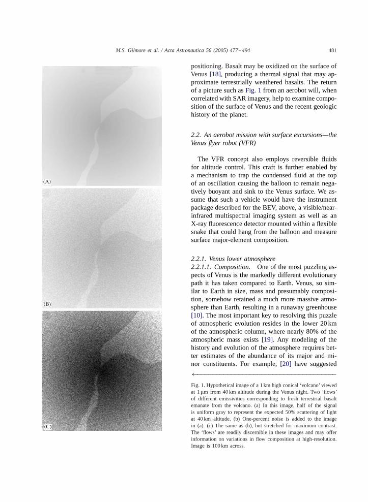
the surface will no longer contain reflected sunlightand may thus indicate surface temperature due to alti-tude or, potentially, heat flow associated with volcan-ism. However, a surface without temperature variationcould still exhibit variations in thermal emission dueto variations in grain size and mineralogy. For exam-ple, grain size is an important factor in controlling thestrength of thermal emission spectra at wavelengthsgreater than 5�m when the grain size approachesthe wavelength being observed[17], although less isknown about emissivity of minerals around the 1�mwavelength. A change in elevation on the Venus sur-face of 500m equates to a 4.5K temperature change,which produces the same variation in radiance as achange in the emissivity of the surface from 0.95 to0.82. Fig. 1 shows a hypothetical 1�m image of avenusian volcano that illustrates this variation. Thisconical volcano is 1 km high, and has two fresh lavaflows on it with a higher emissivity value (0.92) thanthe rest of the volcano (0.88). To simulate the scat-tering of 1�m light from 40km altitude, half of thesignal is uniform gray. The resulting difference in con-trast from these effects is shown inFig. 1a, where thecamera has been exposed so that the brightest pixel issaturated. InFig. 1b, noise has been added to the im-age at a 1% level, and the result is stretched for maxi-mum contrast inFig. 1c. The difference in emissivitybetween the fresh flows and the background is 0.04,the same as the difference in 1�m reflectance betweenweathered and unweathered basalt on the Earth. If theBEV/VFR relies on an autonomous navigation systemthat correlates emissivity to topography, the aerobotwill need to filter out variations in the 1�m signaldue to compositional differences to obtain accurate
M.S. Gilmore et al. / Acta Astronautica 56 (2005) 477–494 481
positioning. Basalt may be oxidized on the surface ofVenus[18], producing a thermal signal that may ap-proximate terrestrially weathered basalts. The returnof a picture such asFig. 1 from an aerobot will, whencorrelated with SAR imagery, help to examine compo-sition of the surface of Venus and the recent geologichistory of the planet.
2.2. An aerobot mission with surface excursions—theVenus flyer robot (VFR)
The VFR concept also employs reversible fluidsfor altitude control. This craft is further enabled bya mechanism to trap the condensed fluid at the topof an oscillation causing the balloon to remain nega-tively buoyant and sink to the Venus surface. We as-sume that such a vehicle would have the instrumentpackage described for the BEV, above, a visible/near-infrared multispectral imaging system as well as anX-ray fluorescence detector mounted within a flexiblesnake that could hang from the balloon and measuresurface major-element composition.
2.2.1. Venus lower atmosphere2.2.1.1. Composition.One of the most puzzling as-pects of Venus is the markedly different evolutionarypath it has taken compared to Earth. Venus, so sim-ilar to Earth in size, mass and presumably composi-tion, somehow retained a much more massive atmo-sphere than Earth, resulting in a runaway greenhouse[10]. The most important key to resolving this puzzleof atmospheric evolution resides in the lower 20 kmof the atmospheric column, where nearly 80% of theatmospheric mass exists[19]. Any modeling of thehistory and evolution of the atmosphere requires bet-ter estimates of the abundance of its major and mi-nor constituents. For example,[20] have suggested
←−−−−−−−−−−−−−−−−−−−−−−−−−−−−−−−−−−−−−Fig. 1. Hypothetical image of a 1 km high conical ‘volcano’ viewedat 1�m from 40km altitude during the Venus night. Two ‘flows’of different emissivities corresponding to fresh terrestrial basaltemanate from the volcano. (a) In this image, half of the signalis uniform gray to represent the expected 50% scattering of lightat 40 km altitude. (b) One-percent noise is added to the imagein (a). (c) The same as (b), but stretched for maximum contrast.The ‘flows’ are readily discernible in these images and may offerinformation on variations in flow composition at high-resolution.Image is 100 km across.

482 M.S. Gilmore et al. / Acta Astronautica 56 (2005) 477–494
that the atmospheric abundance of H2O near thesurface (<30 km altitude) is much less than waspreviously estimated(<45ppm). Because H2O isan important greenhouse gas, this requires the abun-dance of other greenhouse gases to be much higherthan models currently dictate to yield the temperaturegradient observed on Venus. The deciding factors re-garding the efficient retention of gases such as CO2,and the extent of the contribution of other gases suchas SO2 and H2O to the runaway greenhouse observedon Venus, can be addressed using precise estimatesof abundances of these gases throughout the atmo-sphere and as a function of altitude. Additionally, ifthe primitive gas ratios were retained, Venus may beused as an end member model for the early stages ofthe Earth’s atmosphere[10].Since the atmosphere is potentially closely coupled
with the surface, knowledge of how the various atmo-spheric species react with the surface rocks is crucial toany understanding of geologic, as well as atmospheric,formation and evolution. Constraining the current rockcycle would allow limitations to be placed on past rockcycles, which may have played an important part in re-taining the bulk of greenhouse gases. Thus, constraintof the vertical and longitudinal abundance of reactivegases such as sulfur and carbon species, and water va-por, is a key to modeling the various weathering cyclesat work on Venus. For example, it has been hypothe-sized that ancient H2O could have been permanentlytrapped in hydrous SiO2 species on the surface[21].If, however, H2O levels in the lower atmosphere arebelow the stability level for hydrated SiO2 [22], ashas been suggested in some studies (e.g.,[20]), then alarge reservoir of primordial H2O is either precludedor must have dissipated by some other mechanism. Inaddition, it has been suggested that the presence ofvolatile phases such as metal halides at high altitudemay be responsible for low altitude hazes observed byPioneer Venus[23]. Definitive answers depend uponthe abundance of very small(<2mm) particles in thelowest 6 km of the atmosphere. Essential to studies ofsurface–atmospheric interaction, then, is a clear under-standing of the compositional, thermal and dynamiccharacteristics of the lowest 20 km of the atmosphere,that portion in closest contact with the surface.
2.2.1.2. Circulation and dynamics.Atmosphericdynamics in the lower atmosphere are critical to the
understanding the large-scale circulation of the atmo-sphere. The superrotation of the venusian atmosphereis a function of the absorbed solar radiation and thetransfer of angular momentum into and within theatmosphere. Measurements by Pioneer Venus probesshow that highest density of angular momentum ofthe atmosphere lies between 10 and 40 km withinthe equatorial zone of the planet; in contrast, Earthhas ≈ 200X less excess angular momentum dis-tributed in middle and high latitude winds[11]. Thetransport of angular momentum is nominally accom-plished by eddies and circulation whose motionsand longevity are poorly understood. Additionally,as one source of excess atmospheric angular mo-mentum is interaction of the atmosphere with thevenusian surface, the atmospheric dynamics may re-flect the rotation of the solid body[11]. The angularmomentum density can be calculated from the retro-grade zonal wind velocity and atmospheric density,both of which can be measured on an aerobot suchas VFR.
2.2.2. Venus surface2.2.2.1. Composition.Earth andVenus are similar insize and bulk density, thus we expect that they may ex-hibit similar geologic processes and products. Samplesanalysed by the Venera landers demonstrated the pres-ence of basalt on the surface[24] which we can corre-spond to low-lying plains in the Magellan data (e.g.,[25]), which cover∼ 80% of the surface of Venus. Itis impossible with the present data to establish if thesesampled rock types are representative of the Venussurface as a whole or in part. The rocks sampled bythe Venera and Vega probes show a range of basalttypes[26] that may represent evolved magma compo-sitions [27]. Magellan images reveal volcanic domes[28,29] and volcanoes[30] that appear to be com-posed of viscous magmas (Section 3.2.2). Modelinghas shown that a range of magma types are possible onVenus, from high-magnesium komatiites to high-silicatonalites[31]; Venus’ atmospheric chemistry has alsoled to predictions of carbonate and sulfate magmas onVenus[32].A range of magma types may also explain some of
the structural and morphological differences betweenterrain types seen on Venus by Magellan. Approxi-mately 8% of the surface is covered by tessera terrain,

M.S. Gilmore et al. / Acta Astronautica 56 (2005) 477–494 483
which can be seen as large (1000 km across) plateausthat rise 1–4 km above mean planetary radius. Tesseraterrain is highly deformed by compressional and ex-tensional structures, resulting in a rough, and thereforebright, appearance in the radar. These plateau high-lands are very similar topographically to terrestrialplateaus such as the Tibetan and Colorado plateaus.Plateaus are high-standing either because they are ar-eas of thickened crust, they are compensated ther-mally, or they are less dense than the surroundingssuch as the terrestrial continental crust which is moreevolved (higher silica content; granitic rocks) than thebasaltic ocean basins. The tessera are the primary can-didates for evolved magmas on Venus, if this is thecase, than Venus would join Earth as the only bod-ies in the solar system known to have tertiary crust(33; see Section 3.2.2. for discussion of primary, sec-ondary and tertiary crusts). This has important impli-cations for Venus surface processes (material strengthand weathering), interior processes (mantle dynamics,distribution of heat sources within the mantle) and thegeological history of Venus, a planet whose surfacerecords only the last 500Ma.As a target for an aerobot, tessera terrain has the
advantages of standing several kilometers above meanplanetary radius (MPR), being large in areal extent(up to 1000 km), and being abundant near the equator.Tesserae also contain important volcanic features. In-tratessera plains (ITP) are abundant within the tesseraeand necessarily have erupted through the thickenedtessera crust (Fig. 2). The composition of ITP can becompared to the composition of the widespread plainsto look for evidence of any ‘crustal’ component in theITP lavas. This will test the hypothesis that tesseraeare sites of older ‘proto-continental’ crust generatedbefore the surface we see presently; there may be sev-eral eras of tessera formation preserved in the tesserae.If the roots of tesserae are becoming denser due tothe transition of basalt to eclogite, this may be man-ifested as SiO2-rich melts in the tesserae[31]. Varia-tions in different ITP of different ages as determinedby the radar data the ITP temporally may show thevertical and compositional evolution of magma sourceregion.Other sites of geochemical importance:
1. Plains-tessera boundaries. The VFR can take geo-chemical measurements of the surface across a
Fig. 2. Imaging frames sizes and positions for example aerobottrajectories—tessera terrain. (a) context image for (b) detail. Theframes (white boxes) are overlain on tessera terrain in Ovda Regio.An intratessera plain lies on the eastern edge of the area in detail.North is at the top of the image. (A) This 10× 10 km framecorresponds to an image taken at 40 km altitude with a 15◦ fieldof view (seeFig. 6). The resolution is expected to be 40m/pixel.(B) These frames correspond to an aerobot descent to the surfaceusing the wind velocity profile depicted inFig. 5. The first frame(the easternmost frame) is at 10 km altitude and has a resolution of10m/pixel. Frames are taken every 7.5min. The aerobot descendsto the west until it reaches the surface; the final frame takenbefore landing has a resolution of 1m/pixel. If the aerobot floats10m above the surface, resolutions as high as 1 cm/pixel can beattained. The aerobot drifts along the surface for approximately2 h and travels 4 km (straight line) and then ascends back to 10 kmaltitude. (C) These frames correspond to a trajectory where theaerobot descends to 2 km altitude and stabilizes there (seeFig. 8).The first frame is at 10 km altitude with a resolution of 10m/pixel.Frames are taken every 7.5min. The aerobot descends until itreaches an altitude of 2 km where the resolution is 2 km/pixel.The aerobot floats at approximately 2 km for 2 h and travels 9 kmdistance before ascending back to 10 km altitude. Magellan SARimage (portion of F-MIDR 00N104; 75m/pixel).
plains-tessera boundary to better understand thenature of this contact and obtain measurements ofplains at a relatively high altitude.

484 M.S. Gilmore et al. / Acta Astronautica 56 (2005) 477–494
Fig. 3. Imaging frames sizes and positions for example aerobottrajectories—volcanic plains. SeeFig. 2 for explanation. This areais located along the Atla geotraverse described in Section 3.2.1,Fig. 6. Portion of F-MIDR 00N189.
2. Steep sided domes. These domes range from10–100 km in diameter and have an associa-tion with both tessera and coronae[28] terrainsthought to have very different origins. Two ma-jor hypothesis have been put forth to explain theviscous magmas, evolved composition, or volatileenhancement of basalt in a reservoir[28]. Theassociation with tessera could show importanceof thickened crust and/or crustal contamination;the association with coronae could be related toabundant magma generation.
3. Coronae (Section 3.2.1). Coronae are hypothesizedto be the surface manifestations of hot spots[34].Hot spot volcanism has the potential of samplingmagmas from deep within a planet. Coronae aremost likely to record deep mantle compositions.
4. Volcanoes. See Section 3.2.1. below andFig. 3.
Fig. 4. Imaging frames sizes and positions for example aerobottrajectories—festoon flow. SeeFig. 2 for explanation. This areais located along the Ovda geotraverse described in Section 3.2.2.Portion of F-MIDR 05S098.
5. Festoon Flow. See Section 3.2.2 below andFig. 4.6. Low emissivity materials at high altitudes. See fol-
lowing section.
2.2.2.2. Electrical properties.An important ques-tion which arose out the Magellan mission was thenature and composition of the “snowline” of lowemissivity typically found on the highlands above≈ 6053 km planetary radius. It has been proposed thatthese low emissivity values may correlate to a phasechange where surface rocks chemically react with theatmosphere to produce high dielectric materials suchas pyrite (FeS2; [35–37]). The nature and abundanceof these materials is debated from a geochemicalview of stability of various species which depends onpressure, temperature, atmospheric composition andoxidation state at the surface, and also from the morebasic standpoint of the interpretation of the emissivity
M.S. Gilmore et al. / Acta Astronautica 56 (2005) 477–494 485
signal. Specifically, the emissivity signal has contri-butions from the dielectric constant of the materialand the surface roughness that need to be resolvedto test the plausibility of the existence of candidatesurface minerals[38]. As part of an attempt to answerthis question, we put forward the idea of measuringthe resistivity/conductivity of the surface of Venuswith the electromagnetic wave approach on the VFR.Such data, combined with the high-resolution im-agery obtained at the surface target will yield a muchmore complete understanding of the nature of the lowemissivity highlands.The Magellan radar system, in particular the altime-
try and radiometry components, made surface reflec-tivity measurements of Venus possible. The analysismeasured the time delay, strength and decay of the re-turning signals and was then correlated with measure-ments of the thermal emissivity of the surface. Thisthen permitted approximate values of the surface di-electric constant to be calculated. However these val-ues assumed the surface to be a poor conductor, andif the composition of the snowline is a good conduc-tor (e.g., pyrite) then it is precisely the opposite casewe would like to investigate. In fact it is the case ofa good conductor that is ideally suited for airbornemeasurement.Methods of electrical surveying are routinely used
when one is investigating shallow subsurface geologyon Earth. The most oft-used is probably the measure-ment of the resistivity to electrical current and thereare a variety of techniques to evaluate it. The approachthat interests us is the electromagnetic wave methodbecause it can be used when direct contact with thesurface is impossible, i.e. it can be an airborne mea-surement.The essential features of the electromagnetic wave
method are these: a primary electromagnetic field isproduced by a transmitter near the surface (for Earth-bound surveys, within 100–200m) which induces cur-rents in surface and subsurface conductors. These cur-rents give rise to a secondary electromagnetic field thatmust be detected by a receiver and then compared tothe primary field. The ratio of secondary to primaryfield strengths can be as little as a few parts per mil-lion. Important information is also found in the phasedifference of the two fields. Generally speaking, thetwo fields will be almost opposite in phase if the con-ductor is a good one, and close to 90◦ out of phase if
the conductivity is small. For usual airborne measure-ments the frequency of the fields is 300–3000Hz.Direct application to theVFR project is not straight-
forward however. The problematic feature is obtain-ing the secondary field from the combined primaryand secondary field that presents itself to the receiver.One approach requires the receiver and transmitter tobe fixed with respect to each other and at least 10mapart. Another relaxes the requirement that the trans-mitter and receiver be fixed, by using a primary fieldof at least two frequencies, however only phase infor-mation can be recovered and the separation distanceis usually>100m. As it stands neither method seemscompatible with the current specifications of the VFR.Other methods, such as the rotating field method (inwhich the primary field rotates) and the transient fieldmethod (in which the primary field is pulsed ratherthan continuous) also require a large separation.However there seems to be some favorable aspects
of the VFR setup. The snake attached to the VFRseems to be a natural place to house the receiver partof the system, if the snake can be made long enough.Further if, as we hope, the surface is highly conduc-tive, then we should get a large secondary signal thatwould make detection less difficult. We can also ex-pect advances in electronics to improve the signal-to-noise ratio. At this stage the dual frequency methodappears to be the most promising for the VFR.
3. Example applications of aerobot technology
3.1. Venus flyer robot trajectories and descentstrategies
3.1.1. BackgroundWhile some of the material technology needed to
send an aerobot to the Venus surface ins in devel-opment[48–50], reversible fluid balloons have beentested in the Earth’s atmosphere and have demon-strated their ability to perform oscillations about amean altitude[2]. Future developments of the systemwill allow the balloons to temporarily descend to pre-selected target sites before ascending and resumingtheir oscillatory motion.On the theoretical side, the performance model
for balloons is well established (e.g.,[46]) and hasbeen recently extended to the case of reversible fluid
486 M.S. Gilmore et al. / Acta Astronautica 56 (2005) 477–494
balloons [47]. The predictions of the model are ingood agreement with existing flight data. Besides theparticularities of the balloon such as mass, reversiblefluid being used and thermal properties of the bal-loon, one requires rather detailed knowledge of theatmosphere, winds, and heat input from the sun andfrom the ground. A number of these data could becollected during the proposed BEV mission.
3.1.2. A model for VenusTo evaluate the proposed BEV/VFR missions, we
seek to compute the trajectories of a reversible fluidballoon in the venusian atmosphere. Although theirEarth-bound counterparts are well understood; bothexperimentally and theoretically, we can at presentonly estimate a performance model for Venus. Iron-ically part of our uncertainty is because we lack thevery information the BEV/VFR missions will bringus; in particular the circulation and thermal propertiesof the atmosphere. In what follows we indicate howour performance model was calculated and what esti-mates were made.The motion of the balloon is most easily understood
when we separate it into two parts: the vertical mo-tion and the motion over the planet’s surface, whichwe will call horizontal motion. The horizontal motionis determined solely by the atmospheric winds, in factthe balloon just moves with the wind. The vertical mo-tion is subject to three forces: gravity, the buoyancy ofthe balloon, and a generalized drag force (which in-cludes any vertical component of the wind). It is thebuoyancy force which is the most problematic. Essen-tially we need to know how much of the reversiblefluid is liquid and how much is gas. This requires usknowing how much heat from the sun, the atmosphere(including clouds) and the planet’s surface is being ab-sorbed, and how much is being reflected and emittedby the balloon. A complete account requires detailedknowledge of the balloon’s materials and the balloon’senvironment at each point in time.In our model we account for the horizontal motion
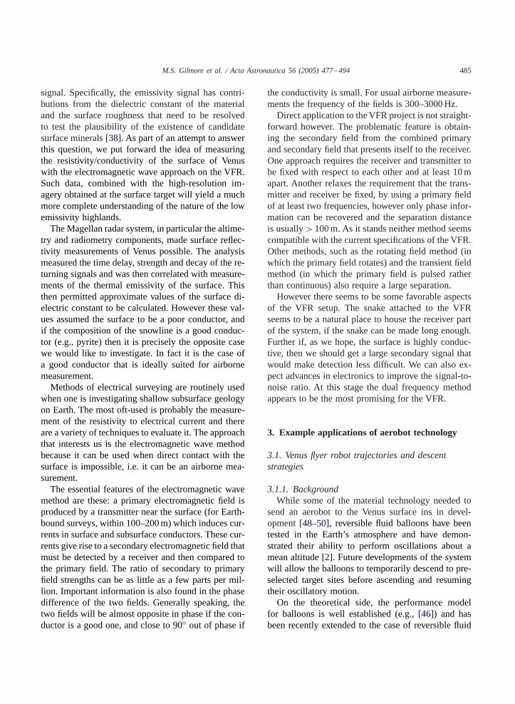
of the balloon by considering a trajectory near Venus’sequator, which fortuitously includes many surface fea-tures of great interest. Here Venera data indicate thatthe wind blows predominantly to the west with in-creasing speed as altitude increases (Fig. 5). Thus thetrajectory of the balloon will remain in the equato-
Fig. 5. Zonal (east to west) modeled wind velocity profile (dottedline) as a function of altitude. The model is fitted to the Venera 8data (averaged day/night profiles).
rial plane. For simplicity we ignore suggestions in theVenera data of violent up- and down-drafts, believingtheir effect would cancel out on the average.We are indebted to Jack Jones for his estimates
of the vertical motion of the balloon. For an ammo-nia/water reversible fluid balloon, we can expect oscil-lations between 40 and 60 km altitude. With the cur-rent specifications for the BEV mission, it is believedthe upward and downward velocities will be 1.4 and2.8m/s, respectively. For the VFR mission velocitiesof 2 and 3m/s are expected. TheVFR also as the addedability to stabilize at lower altitudes, though probablywith a slight upward velocity, estimated to be 0.1m/s.The maximum time it can spend at these lower alti-tudes is assumed to be∼ 2h. Similar to the lifetimesof the Venera Landez.
3.1.3. Trajectories and descent strategiesWe can utilize our simple model to estimate the
distances traveled and timescale of several exampleaerobot trajectories. Firstly we consider the motion ofthe aerobot in the upper atmosphere. Using the atmo-spheric constraints above, the model yields an oscil-latory stage in which the VFR/BEV travels from eastto west, completing a cycle every 5–6h (Fig. 6). Adisplacement of 1000 km in this time predicts an or-bit of the planet in around eight Earth days. A descentto the surface will take∼ 6h and allow 1h of imag-ing below 10 km altitude. In that time the VFR will

M.S. Gilmore et al. / Acta Astronautica 56 (2005) 477–494 487
Fig. 6. BEV/VFR oscillation stage. The aerobot travels from westto east, oscillating between 40 and 60 km altitude, completing acycle every 5–6h (rise time∼ 3h at 2m/s and fall time∼ 2hat 3m/s). Surface images at 1�m can be accomplished at thebottom of each oscillation which corresponds to a lateral distanceof 1000 km. The frame size of such as image can be found inFigs. 2a, 3a, 4a.
obviously move significantly to the west and so it willbe necessary for the VFR to have targeting capabil-ity if particular surface features are to be investigated.The ascent will be∼ 9h.Next we have simulated a descent to the surface,
initiated at the maximum altitude of 60 km from theeast (Fig. 7). TheVFR is carried almost 600 km lateraldistance during the descent time of roughly 6 h. A de-scent velocity of∼ 10 km/h will allow several hoursof imagery measurements to be taken below 40 km al-titude and∼ 1h of measurements below 10 km. Thiswould be a typical VFR maneuver, with the time spentat the surface clearly dependent on its ability to with-stand surface conditions; we assume a maximum of2 h for surface measurements.The ability of theVFR to stabilize at a given altitude
will enable a low-altitude pass of the surface and allowfor compositional analysis of the lower atmosphere.Such trajectories offer greater coverage than surfacedives at cooler temperatures (seeFigs. 2–4). Divesof this type will take advantage of the fact that theatmosphere becomes transparent to wavelengths lessthan 1�m below 10km. We have calculated the tra-jectories where the aerobot stabilizes at 2 km altitude(Fig. 8) and at 10 km altitude (Fig. 9). Examples offrame sizes corresponding to the 2 kmdive are found inFigs. 2c, 3c, 4c.
Fig. 7. (a) VFR surface dive. The aerobot begins its descent at60 km altitude. The VFR is carried almost 600 km lateral distanceduring a descent time of roughly 6 h. The aerobot will drift∼ 4 kmalong the surface. (b) Same trajectory as (a), but at altitudes<10 km. Approximately 5 h is available for image at wavelengthsless than 1�m. Examples of imagery frame sizes correspondingto this portion of the dive are found inFigs. 2b, 3b, 4b.
We also consider two ‘specialist’ VFR descent tra-jectories. Considerable uncertainty remains as to thevelocity of surface winds on Venus, especially whenconsidering terrains at various altitudes. If the windsare indeed near zero at the surface, lateral mobilitymay be low. One way to increase lateral coverage bythe aerobot at the surface is to utilize surface slopes, ascenario shown inFigs. 10and11. We consider sucha trajectory with the added assumption that a windblows down the highland slopes with a speed of 2m/s.This trajectory is particularly useful for surface geotra-verses that target the plains-tessera boundary along atessera highland (Section 3.2.2). Successful targetingwill require the VFR to predict its trajectory severalhundred kilometers in advance.

488 M.S. Gilmore et al. / Acta Astronautica 56 (2005) 477–494
Fig. 8. VFR stabilization at 2 km altitude. (a) This trajectoryis favorable for high-resolution imagery over longer distancesthan a surface dive utilizing both higher wind speeds and lowertemperatures. The aerobot begins its descent from the east, reachingan altitude of 2 km in∼ 6h. The aerobot stabilizes for∼ 2h,traveling a distance of 9 km, before ascending back to 60 km in∼ 8h. (b) Same trajectory as (a), but at altitudes less than 10 km.Approximately 5 h of imagery will be available at these altitudes.Examples of imagery frame sizes corresponding to this portion ofthe dive are found inFigs. 2c, 3c, 4c.
We conclude with a plot of each of these trajectoriesalong the geotraverse ofAtla Regio outlined in Section3.2.1 (Fig. 12).We have been able to estimate possible trajectories
of the VFR in the Venus atmosphere. There are a num-ber of trajectories that it will be capable of, and it isapparent that all will be of immense value from an in-vestigative point of view. The targeting capability ofthe VFR will be important and we will have to rely onthe BEV program to provide more extensive informa-tion on the Venus wind patterns.
Fig. 9. VFR stabilization at 10 km altitude. The aerobot beginsits descent in the east and reaches 10 km in∼ 5h. Two hours ofinformation can be taken as the balloon drifts∼ 7 km.
Fig. 10. Descent to the highlands from 60km altitude, where thehighland slope is facing towards the aerobot. The VFR enters fromthe east, touches down and drifts downhill for∼ 20 km along thesurface. Slope on highland is 5◦. (a) Full trajectory. (b) Trajectoryat altitudes less than 20 km.
M.S. Gilmore et al. / Acta Astronautica 56 (2005) 477–494 489
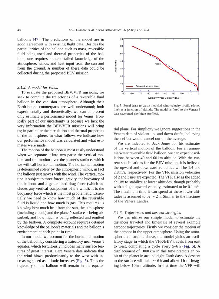
Fig. 11. Descent to highlands from 60km latitude, where thehighland slope is facing away from the aerobot. The VFR entersfrom the east, touches down and drifts along the surface downhillfor ∼ 20 km. (a) Full trajectory. (b) Trajectory at altitudes lessthan 20 km.
3.1.4. Proposed imaging systemsShort of landing on the surface, the primary tool a
balloon has for exploring the surface geology of Venusis an imaging system. An aerobot mission would givegeologists a chance to see the surface ofVenus in a fewimportant wavelengths, at a resolution from 1–100mor smaller. The 100m data would provide a cross-check for the 75m/pixel Magellan data, as well as re-gional context for “dives” to the surface. Data in the1–10m resolution range is essential for understandingthe character of the surface and interpreting the geol-ogy on an outcrop scale.The Venus atmosphere has a window of trans-
parency between 0.5 and 1.04�m [16] but the scat-tering of this light is too great to resolve surface
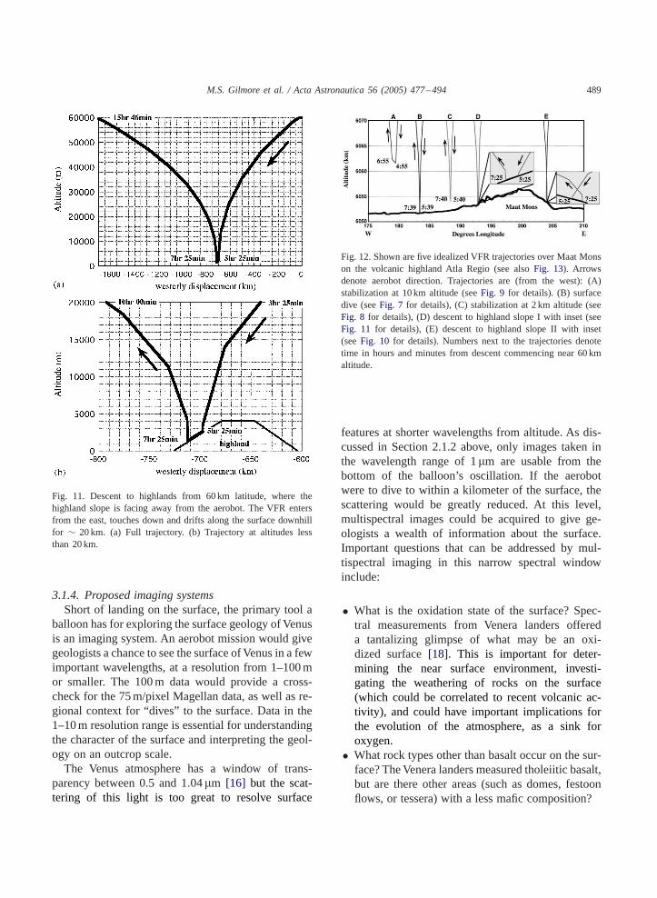
Fig. 12. Shown are five idealized VFR trajectories over Maat Monson the volcanic highland Atla Regio (see alsoFig. 13). Arrowsdenote aerobot direction. Trajectories are (from the west): (A)stabilization at 10 km altitude (seeFig. 9 for details). (B) surfacedive (seeFig. 7 for details), (C) stabilization at 2 km altitude (seeFig. 8 for details), (D) descent to highland slope I with inset (seeFig. 11 for details), (E) descent to highland slope II with inset(seeFig. 10 for details). Numbers next to the trajectories denotetime in hours and minutes from descent commencing near 60 kmaltitude.
features at shorter wavelengths from altitude. As dis-cussed in Section 2.1.2 above, only images taken inthe wavelength range of 1�m are usable from thebottom of the balloon’s oscillation. If the aerobotwere to dive to within a kilometer of the surface, thescattering would be greatly reduced. At this level,multispectral images could be acquired to give ge-ologists a wealth of information about the surface.Important questions that can be addressed by mul-tispectral imaging in this narrow spectral windowinclude:
• What is the oxidation state of the surface? Spec-tral measurements from Venera landers offereda tantalizing glimpse of what may be an oxi-dized surface[18]. This is important for deter-mining the near surface environment, investi-gating the weathering of rocks on the surface(which could be correlated to recent volcanic ac-tivity), and could have important implications forthe evolution of the atmosphere, as a sink foroxygen.• What rock types other than basalt occur on the sur-face? TheVenera landers measured tholeiitic basalt,but are there other areas (such as domes, festoonflows, or tessera) with a less mafic composition?

490 M.S. Gilmore et al. / Acta Astronautica 56 (2005) 477–494
A minimum of five filters would be needed to dothis adequately:
1.0�m pyroxene, olivine band, usable from highaltitude
0.87�m Fe2+ band (high-temperature hematite),oxidation state of the surface
0.77�m point between iron absorptions to con-strain albedo vs. absorptions
0.65�m red, Fe3+ band, oxidation state of thesurface
0.55�m green, constrain iron absorption edge
Greater spectral resolution is, of course, preferable,but it also greatly increases the amount of data thatthen must be transmitted to Earth. It would also beuseful to measure ambient light in the atmosphere onthe same imaging chip, through a mirror or other de-vice, averaging the pixels on the chip.An imager with the spectral bands above, 256×256
pixels, and a 15◦ field of view, would provide thefollowing data:
• Images at 1�m at the low points of its oscillation(40 km), would cover 10×10 km, with a resolutionof 40m, three times better than Magellan (Fig. 2a).If the balloon is moving at 50m/s at this altitude,images spaced less than 2min apart will give stereofor the overlapping halves of the frames. Stereocoverage is essential because of the lack of shadowson the surface.• When the VFR descends to 1 km altitude, it couldutilize all of its filters, covering a 260m swath,with a resolution of 1m (Fig. 2c). If wind speedat this level is∼ 1m/s, the camera would have totake pictures every 4.5min for continuous coverage,or every 2.25min for stereo coverage. At 524 kilo-bits/frame, five-color stereo coverage for 2 h (27color frames, 26 monochromatic frames), coveringan area of 0.26× 7.2 km, would generate about 84megabits of raw data.• A camera at 10m altitude would see a 2.6× 2.6marea with a resolution of 1 cm, enough to resolvelarge pebbles and outcrop details (Fig. 2b). If thewind moves the balloon at 1m/s, the camera wouldhave to take pictures every 2 s for the images toconnect, twice as often for stereo coverage. Themotion of the snake along the ground transmittingto the balloon and the motion of the balloon with
respect to the ground could seriously degrade theimages. Perhaps this type of imaging should bedone only as the balloon lands and takes off. Datacould be collected as the balloon is held at 1 kmaltitude during a descent sequence.
3.2. Example geotraverses utilizing the Venus flyerrobot
A geotraverse is a geologic mapping exercise inwhich data are collected along a narrow strip of greatlength crossing a variety of terranes and geologic units.The geotraverse approach has several advantages thatare well-adapted for the characteristics of aerobot op-eration. The chief advantage of geotraverse mappingis that it efficiently focuses attention on the longitu-dinal diversity of geologic units over a large region,but characterizes them at a uniformly larger map scalethan is otherwise generally possible in a more regionalgeologic mapping study. The results enable integra-tion of the detail local geologic processes of severallarge map scale geologic units over a broad region.When combined with more regional studies, such asthose resulting from analysis of Magellan data, the re-sults of a high-resolution geotraverse are applicableto the general interpretation of geologic units widelydistributed over the surface of Venus.
3.2.1. Atla regioA variety of geologic terranes may be sampled by
a simple east to west traverse across the Atla Regioarea. Atla Regio lies at the junction of three promi-nent rifts[39], Ganis Chasma, Parga Chasma, and DaliChasma, and is the site of the greatest concentrationof large volcanoes on Venus[40]. Much of the riftingin this area is relatively young based on cross-cuttingrelationships with impact craters. Therefore it is pos-sible that volcanism in this region may be particularlyyoung. In addition the surface directly west of AtlaRegio is an area of extensive lowland plains, RusalkaPlanitia. The great range in elevation also offers thepotential for sampling the characteristics of surfacesoccurring over a large altitude range, including areas ofanomalously low emissivity associated with the sum-mit region of Maat Mons. Together these offer the po-tential for sampling several of the significant geologicunits of Venus along a near equatorial traverse.
M.S. Gilmore et al. / Acta Astronautica 56 (2005) 477–494 491
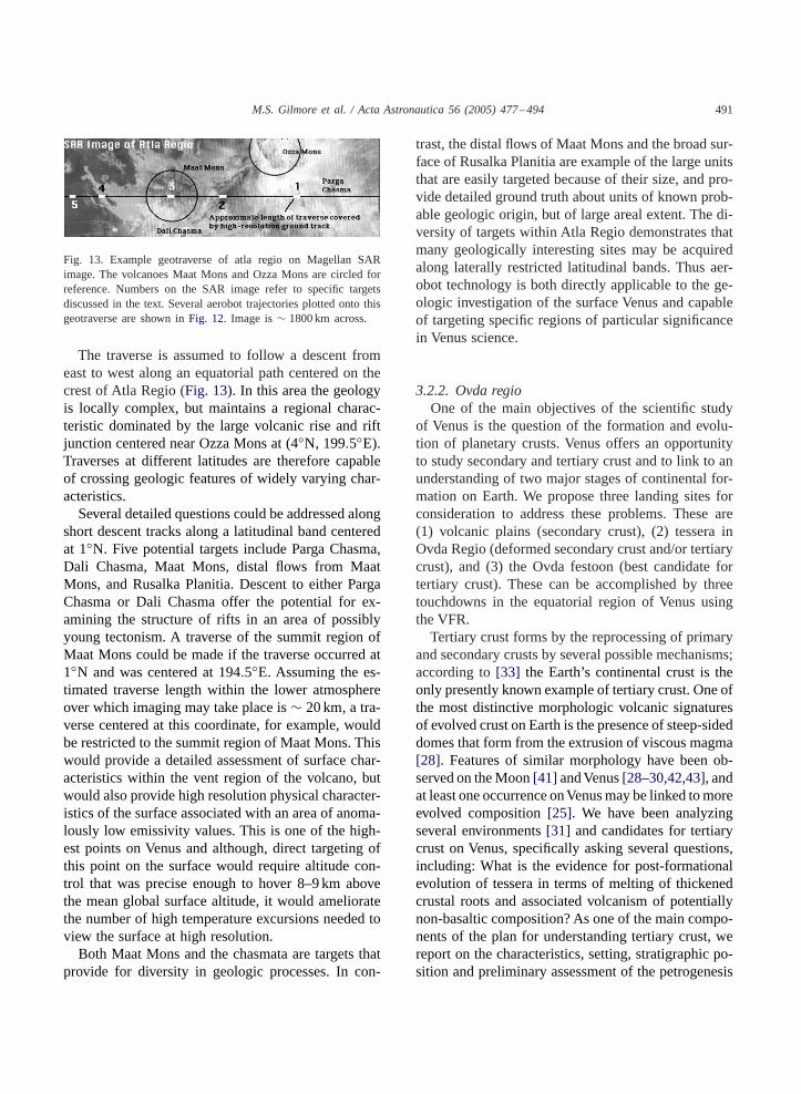
Fig. 13. Example geotraverse of atla regio on Magellan SARimage. The volcanoes Maat Mons and Ozza Mons are circled forreference. Numbers on the SAR image refer to specific targetsdiscussed in the text. Several aerobot trajectories plotted onto thisgeotraverse are shown inFig. 12. Image is∼ 1800 km across.
The traverse is assumed to follow a descent fromeast to west along an equatorial path centered on thecrest of Atla Regio (Fig. 13). In this area the geologyis locally complex, but maintains a regional charac-teristic dominated by the large volcanic rise and riftjunction centered near Ozza Mons at (4◦N, 199.5◦E).Traverses at different latitudes are therefore capableof crossing geologic features of widely varying char-acteristics.Several detailed questions could be addressed along
short descent tracks along a latitudinal band centeredat 1◦N. Five potential targets include Parga Chasma,Dali Chasma, Maat Mons, distal flows from MaatMons, and Rusalka Planitia. Descent to either PargaChasma or Dali Chasma offer the potential for ex-amining the structure of rifts in an area of possiblyyoung tectonism. A traverse of the summit region ofMaat Mons could be made if the traverse occurred at1◦N and was centered at 194.5◦E. Assuming the es-timated traverse length within the lower atmosphereover which imaging may take place is∼ 20 km, a tra-verse centered at this coordinate, for example, wouldbe restricted to the summit region of Maat Mons. Thiswould provide a detailed assessment of surface char-acteristics within the vent region of the volcano, butwould also provide high resolution physical character-istics of the surface associated with an area of anoma-lously low emissivity values. This is one of the high-est points on Venus and although, direct targeting ofthis point on the surface would require altitude con-trol that was precise enough to hover 8–9 km abovethe mean global surface altitude, it would amelioratethe number of high temperature excursions needed toview the surface at high resolution.Both Maat Mons and the chasmata are targets that
provide for diversity in geologic processes. In con-
trast, the distal flows of Maat Mons and the broad sur-face of Rusalka Planitia are example of the large unitsthat are easily targeted because of their size, and pro-vide detailed ground truth about units of known prob-able geologic origin, but of large areal extent. The di-versity of targets within Atla Regio demonstrates thatmany geologically interesting sites may be acquiredalong laterally restricted latitudinal bands. Thus aer-obot technology is both directly applicable to the ge-ologic investigation of the surface Venus and capableof targeting specific regions of particular significancein Venus science.
3.2.2. Ovda regioOne of the main objectives of the scientific study
of Venus is the question of the formation and evolu-tion of planetary crusts. Venus offers an opportunityto study secondary and tertiary crust and to link to anunderstanding of two major stages of continental for-mation on Earth. We propose three landing sites forconsideration to address these problems. These are(1) volcanic plains (secondary crust), (2) tessera inOvda Regio (deformed secondary crust and/or tertiarycrust), and (3) the Ovda festoon (best candidate fortertiary crust). These can be accomplished by threetouchdowns in the equatorial region of Venus usingthe VFR.Tertiary crust forms by the reprocessing of primary
and secondary crusts by several possible mechanisms;according to[33] the Earth’s continental crust is theonly presently known example of tertiary crust. One ofthe most distinctive morphologic volcanic signaturesof evolved crust on Earth is the presence of steep-sideddomes that form from the extrusion of viscous magma[28]. Features of similar morphology have been ob-served on theMoon[41] andVenus[28–30,42,43], andat least one occurrence onVenusmay be linked tomoreevolved composition[25]. We have been analyzingseveral environments[31] and candidates for tertiarycrust on Venus, specifically asking several questions,including: What is the evidence for post-formationalevolution of tessera in terms of melting of thickenedcrustal roots and associated volcanism of potentiallynon-basaltic composition? As one of the main compo-nents of the plan for understanding tertiary crust, wereport on the characteristics, setting, stratigraphic po-sition and preliminary assessment of the petrogenesis

492 M.S. Gilmore et al. / Acta Astronautica 56 (2005) 477–494
of the distinctive festoon deposit[44,45] lying withinsome of the highest-standing tessera in Ovda Regio.The festoon structure lies within Ovda Regio at
about (6.5◦S, 95.5◦E) and is about 250× 300 km indimension. Ovda Regio is one of the most distinctiveoccurrences of tessera on Venus and this part of Ovdais one of the highest standing on the planet; the tesseraat the edges of the festoon lie at about 6056.2 km,≈4.4km aboveMPR.Stratigraphic relationships showthat the festoon overlies the tessera terrain; the mor-phology and internal structure of the two terrains con-trast distinctly, digitate and lobate projections at thedeposit edges follow preexisting structural troughs andfractures in the tessera, and there are kipukas of tesserawithin the festoon. The deposit itself is elongated in aNE–SW direction, parallel to structural trends in ad-jacent tessera. Interpretation of the underlying tesseraas a product of downwelling and crustal thickeningprovides a basis for the assessment of petrogenesis ofthis deposit. On the basis of evidence for lava plains astessera precursor terrain and the likelihood of a basalticcrust throughout the history of Venus, one of the maincandidates for the origin of this deposit is the remeltingof a basaltic crust initially derived from melting of aperidotitic mantle. Venera lander analyses of presentlyexposed plains lead us to consider the remelting oftholeiitic basalt under anhydrous conditions; meltingof tholeiite basalt above 15–25 kb (about 53–88 km)begins at temperatures in excess of 1200◦C and in theeclogite facies (or in the garnet granulite facies, de-pending on the bulk composition). The melt that coex-ists with the eclogite assemblage (garnet and clinopy-roxene) typically is quartz-normative and stronglyenriched in SiO2. Small degrees of melting (<20%)generate trondhjemites (SiO2>65%) whereas inter-mediate degrees of melting (20–50%) yield andesitesand basaltic andesites. In contrast, the first melts ob-tained at lower pressures (10–15 kb; 35–53 km) appearto be relatively SiO2 poor. For example, the liquidsobtained by small degrees of melting at 8 kb (28 km)of high aluminobasalts are ferrobasalts containingonly 42% SiO2 and more than 20% FeO. In summary,large amounts of silicic magmas are generated at highpressures and large amounts of relatively SiO2-poor,and highly fluid, ferrobasalts are obtained under moremodest pressures. Thus, shallow crustal melting oc-curring in environments such as underthrust basalticcrust and basal melting of tessera crustal blocks less
than about 50 km thick should result in the productionof fluid ferrobasalts. Deeper crustal melting, such asthat which might be occurring at the base of zones ofvery thick tessera, should produce more viscous SiO2-rich melt products such as trondhjemites, andesites,andbasaltic andesites. The fact that the festoon de-posit occurs at the highest elevations in Ovda Regiosuggests that in terms of simple Airy isostasy this isan area of some of the thickest crust on the planet(and thus deepest melting), a conclusion consistentwith apparent depths of compensation of 70± 7 kmand Magellan gravity data. This petrogenetic modelprovides an independent estimate of crustal thickness,an estimate consistent with those from gravity data.Geochemical sampling by an aerobot mission willtest this important hypothesis for the formation oftertiary crust on a planet other than the Earth.
4. Summary—the utility of aerobots in planetaryexploration
Using the BEV and VFR concept mission studies,we have calculated some simple trajectories of an aer-obot at Venus. An aerobot like BEV or VFR can cir-cumnavigate Venus in eight Earth days, continuouslycollection compositional data between 40 and 60 kmand collecting images of the surface below the cloudsfor an hour every 5–6h. Surface dives allow longer(∼ 6h) observations below 40 km, including multi-spectral imaging below 10 km. These dives coverdistances 100 of km and allow compositional mea-surements of the lower atmosphere. Trajectories caninclude the include stabilization at low altitudes forhours of observations. Dives to the surface producemultispectral stereo imaging at up to cm-scale resolu-tion. Meter scale imaging spanning 10s of km can bedirected to boundaries between geologic units of inter-est. Technology such as an XRF instrument mountedon a snake will allow compositional measurements ofsurface materials. Surface access can be maximizedby utilizing local winds due to slope effects.The next phase of the exploration of Venus will fo-
cus on understanding several fundamental character-istics of the atmosphere that are necessary to placeVenus in context with the other terrestrial planets.These measurements include upper and lower atmo-spheric composition and atmospheric dynamics.A sin-gle aerobot mission is uniquely able to measure these
M.S. Gilmore et al. / Acta Astronautica 56 (2005) 477–494 493
critical parameters in three dimensions over the globeover time. An aerobot with decent capability also pro-vides a mechanism to collect data at the surface forbrief periods, and then return to the cooler altitudes.This type of mission has the potential to visit the sur-face at several key regions over its mission lifetime.The following briefly assesses some characteris-
tics of an aerobot type mission that enhance its “sci-ence value” with respect to other possible planetarymissions.A. New and unique resources of an aerobot:
1. Ability to explore the atmosphere in three dimen-sions over time.
2. Cheap, innovative method of surface exploration.3. Can investigate lower atmosphere characteristics.4. Applicable to several planets.
B. Major issues that could be resolved or addressedat Venus:
1. Large scale variability of surface composition onVenus.
2. Lower atmosphere chemistry and dynamics.3. The superrotation of venusian winds.4. Is Venus volcanically active?
C. Specific measurements provided by a Venusaerobot:
1. Multispectral imaging of surface in the 1–10mgap, including the relationship between large scalemorphology and small scale morphologies; lateralvariations in lithology, block sizes.
2. Multiple surface analyses over different litholo-gies and chemical compositions correlated to thoselithologies.
3. Extended traverse sampling sites enables definitionand correlation of large-scale geologic units.
4. Monitoring of compositional and physical varia-tions in atmosphere with altitude and latitude.
5. Variable resolution and high resolution imagery inregional context—essentially enables geotraverseswith ground truth.
Acknowledgements
A significant portion of this work was accom-plished at Brown University and at the Jet Propulsion
Laboratory. Comments by the editor and an anony-mous reviewer are appreciated.
References
[1] Space Studies Board, New Frontiers in the Solar System: AnIntegrated Exploration Strategy, National Academies Press,Washington DC, 2003, 232pp.
[2] K. Nock et al., Balloon Altitude Control Experiment (ALICE)Project, Proceedings of the 11th Lighter-Than-Air ConferenceAIAA-95-1632, 1995.
[3] A.G. DiCicco et al., Balloon experiment at Venus.,Proceedings of the 11th Lighter-Than-Air Conference AIAA-95-1623, 1995.
[4] J.A. Cutts et al., Planetary exploration by robotic aerovehicles,Journal of Autonomous Robots 2 (1996) 261–282.
[5] R.N. Clayton, T.K. Mayeda, Oxygen isotopes in eucrites,shergottites, nakhlites and chassignites, Earth and PlanetaryScience Letters 62 (1983) 1–6.
[6] L.M. Mukhin, The problem of rare gases in the Venusatmosphere, in: D.M. Hunten, L. Colin, T.M. Donahue, V.I.Moroz (Eds.), Venus, University of Arizona Press, Tuscon,London, 1983, pp. 1037–1042.
[7] U. von Zahn et al., Composition of the Venus atmosphere,in: D.M. Hunten, L. Colin, T.M. Donahue, V.I. Moroz (Eds.),Venus, University of Arizona Press, Tuscon, London, 1983,pp. 299–430.
[8] T.M. Donahue et al., Venus was wet: a measurement of theratio of deuterium to hydrogen, Science 216 (1982) 630–633.
[9] G.W. Wetherhill, Solar wind origin of36Ar on Venus, Icarus46 (1981) 70–80.
[10] T.M. Donahue, J.B. Pollack, Origin and evolution of theatmosphere of Venus, in: D.M. Hunten, L. Colin, T.M.Donahue, V.I. Moroz (Eds.), Venus, University of ArizonaPress, Tuscon, London, 1983, pp. 1003–1036.
[11] G. Schubert, General circulation and the dynamical stateof the Venus atmosphere, in: D.M. Hunten, L. Colin, T.M.Donahue, V.I. Moroz (Eds.), Venus, University of ArizonaPress, Tuscon, London, 1983, pp. 681–765.
[12] T. Gold, S. Soter, Atmospheric tides and the 4-day circulationon Venus, Icarus 14 (1971) 16–20.
[13] L.V. Ksanfomality et al., The electrical activity of theatmosphere of Venus, in: D.M. Hunten, L. Colin, T.M.Donahue, V.I. Moroz (Eds.), Venus, University of ArizonaPress, Tuscon, 1983, pp. 565–603.
[14] J.A. Jones, Reversible fluid balloon altitude control concepts,Proceedings of the 11th Lighter-Than-Air Conference AIAA-95-1621, 1995.
[15] G.L. Hashimoto, S. Sugita, On observing the compositionalvariability of the surface of Venus using nightside near-infrared thermal radiation, Journal of Geophysical Research108 (2003) doi:10.1029/2003/JE002082.
[16] V.I. Moroz, VA-94: Venus atmosphere model for the Venera-Discovery project, in: The Venera/Vega Projects: An AnalysisOf The Operational Experience Obtained In The Study Of

494 M.S. Gilmore et al. / Acta Astronautica 56 (2005) 477–494
The Atmopshere And Surface Of Venus, NASA/ESKOSPublication, 1994, 70pp.
[17] G.R. Hunt, R.K. Vincent, The behavior of spectral featuresin the infrared emission from particulate surfaces ofvarious grain sizes, Journal Geophysical Research 73 (1968)6039–6046.
[18] C.M. Pieters et al., The color of the surface of Venus, Science234 (1986) 1379–1383.
[19] J.B. Pollack, Atmospheres of the terrestrial planets, in: J.K.Beatty, A. Chaikin (Eds.), The New Solar System, SkyPublishing Company, Cambridge, 1990, pp. 91–106.
[20] V.S. Meadows, D. Crisp, Ground-based near-infraredobservations of the Venus nightside: the thermal structure andwater abundance near the surface, Journal of GeophysicalResearch 101 (1996) 4595–4622.
[21] J.S. Lewis, Venus: atmospheric and lithospheric composition,Earth Planetary Science Letters 10 (1970) 73–80.
[22] B. Fegley Jr., A.H. Treiman, Chemistry of atmosphere-surface interactions on Venus and Mars, in: J. Luhmann,R.O. Pepin, A.H. Treiman (Eds.), Venus and Mars:Atmospheres, Ionospheres, and Solar Wind Interaction,American Geophysical Union, Washington, DC, 1992,pp. 70–71.
[23] R.A. Brackett et al., Volatile transport on Venus andimplications for surface geochemistry and geology, Journalof Geophysical Research 100 (1995) 1553–1563.
[24] V.I. Moroz, Summary of preliminary results of the Venera13 and Venera 14 missions, in: D.M. Hunten, L. Colin, T.M.Donahue, V.I. Moroz (Eds.), Venus, University of ArizonaPress, Tuscon, London, 1983, pp. 45–68.
[25] A.T. Basilevsky et al., Geology of the Venera 8 landing siteregion from Magellan data: morphological and geochemicalconsiderations, Journal of Geophysical Research 97 (1992)16315–16336.
[26] J.S. Kargel et al., The volcanology of Venera and VEGAlanding sites and the geochemistry of Venus, Icarus 103 (1993)253–275.
[27] O.V. Nikolaeva, Geochemistry of the Venera 8 materialdemonstrates the presence of continental crust on Venus, EarthMoon and Planets 50/51 (1990) 329–341.
[28] B. Pavri et al., Steep-sided domes on Venus: characteristicsgeologic setting and eruption conditions from Magellan data,Journal of Geophysical Research 97 (1992) 13445–13478.
[29] D. McKenzie et al., Pancakelike domes on Venus, Journal ofGeophysical Research 97 (1992) 15967–15976.
[30] H.J. Moore et al., An unusual volcano on Venus, Journal ofGeophysical Research 97 (1992) 13479–13494.
[31] P.C. Hess, J.W. Head, Derivation of primary magmas andmelting of crustal materials on Venus: Some preliminarypetrogenic considerations, Earth Moon and Planets 50/51(1990) 57–80.
[32] J.S. Kargel et al., Carbonate-sulfate volcanism on Venus?,Icarus 112 (1994) 219–252.
[33] S.R. Taylor, Growth of planetary crusts, Tectonophysics 161(1989) 147–156.
[34] E.R. Stofan et al., Global distribution and characteristics ofcoronae and related features on Venus: implications for originand relation to mantle processes, Journal of GeophysicalResearch 97 (1992) 13347–13378.
[35] G.H. Pettengill et al., Venus: surface electromagneticproperties, Journal of Geophysical Research 93 (1988)14881–14892.
[36] K.B. Klose et al., Mineral equilibria and the high radarreflectivity of Venus mountaintops, Journal of GeophysicalResearch 97 (1992) 16353–16369.
[37] B. Fegley Jr., et al., Venus surface mineralogy: observationaland theoretical constraints, Proceedings of the 22nd Lunarand Planetary Science Conference, 1992, pp. 3–19.
[38] R.E. Arvidson et al., Microwave signatures and surfaceproperties of Ovda Regio and surroundings, Venus, Icarus112 (1994) 171–186.
[39] D.A. Senske et al., Regional topographic rises on Venus:geology of western Eistla Regio and comparision to BetaRegio and Atla Regio, Journal of Geophysical Research 97(1992) 13395–13420.
[40] L.S. Crumpler et al., Relation of major volcanic canterconcentration on Venus to global tectonic patterns, Science261 (1993) 591–595.
[41] J.W. Head, T. McCord, Imbrian-age highland volcanism onthe moon: the gruithuisen and mairan domes, Science 199(1978) 1433–1436.
[42] J.W. Head et al., Venus volcanism: classification of volcanicfeatures and structures, associations, and global distributionfrom Magellan data, Journal of Geophysical Research 97(1992) 13153–13198.
[43] H. Moore et al., Relief of some small landforms onVenus, Lunar and Planetary Science Conference 24 (1993)1003–1004.
[44] G. Pettengill et al., Venus surface radiothermal emission asobserved by Magellan, Journal of Geophysical Research 97(1992) 13091–13102.
[45] J. Permenter, R. Nusbaum, The thick festoon flow andadjacent dark flow, Ovda Regio, Venus, Lunar and PlanetaryScience Conference 25 (1994) 1067.
[46] L.A. Carlson, W.J. Horn, New thermal and trajectory modelfor high-altitude balloons, AIAA Journal of Aircraft 20 (1983)500–507.
[47] J.-J. Wu, J.A. Jones, Performance model for reversiblefluid balloons, Proceedings of the 11th Lighter-Than-AirConference AIAA-95-1623, 1995.
[48] A. Bachelder et al., Venus Geoscience Aerobot Study(VEGAS), Proceedings of the AIAA International BalloonTechnology Conference, AIAA-99-3856, 1999.
[49] A. Yavronian, Envelopes for Robotic Balloon Vehicles, AIAAAerospace Sciences Conference, Reno, NV, 1996.
[50] M.K. Heun, J.A. Jones, J.L. Hall, Gondola design forVenus deep-atmosphere aerobot operations, AIAA AerospaceSciences Meeting & Exhibit, 36, 1998.