iom #philippines typhoon hagupit affected population map (9 december 2014)

1
Ï ! Ï ! Ï ! Ï ! Ï ! Ï ! Ï ! Ï ! Ï ! Ï ! Ï ! Ï ! Ï ! Ï ! Surigao del Sur Tarlac Zambales Aklan Albay Antique Aurora Bataan Batangas Biliran Bohol Bulacan Camarines Norte Camarines Sur Camiguin Capiz Catanduanes Cavite Cebu Dinagat Islands Eastern Samar Guimaras Iloilo Laguna Leyte Marinduque Masbate Negros Occidental Negros Oriental Northern Samar Nueva Ecija Nueva Vizcaya Occidental Mindoro Oriental Mindoro Palawan Pampanga Pangasinan Quezon Rizal Romblon Samar Siquijor Sorsogon Southern Leyte Surigao del Norte Metro Manila 0 30 60 90 120 15 KM Ü Typhoon Hagupit: Projected Affected Areas Based on the PAGASA Forecast This map shows the actual and forecast paths of the typhoon based on PAGASA's forecast as of December 9, 2014 at 8AM. 50km (Extremely Affected), 100km (Highly Affected), and 200km (Moderately Affected) radii from the track were generated in GIS. Municipalities in Extremely and Highly Affected zones are shown. Population is based on EPRU's computed estimated 2013 population of NSO data. Legend Ï ! Actual Location Ï ! Forecast Location Actual Path Forecast Path Affected at 50km Radius Affected at 100km Radius 50km Radius 100km Radius 200km Radius EPRU-IM © Data Source: PAGASA, EPRU-IM Map Source: ESRI, EPRU-IM Date of Data Source: 12-09-2014 Date of Map: 12-09-2014 Map Code: IOMHAGUPIT0014 Map Produced By: EPRU-IM GIS Estimated Overall Affected Population Based on the 2013 Estimated Population: Estimated Extremely Affected Population: Estimated Highly Affected Population: 55,883,211 33,449,880 10,214,408 Extremely Affected Highly Affected Moderately Affected Forecast Location: 12-10-2014, 8AM Expected to Exit PAR: Wednesday evening (Source: PAGASA) Current Location: 12-09-2014, 8AM At Lubang, Occidental Mindoro Status of Hagupit: Tropical Depression (Source: PAGASA)

Upload: international-organization-for-migration-iom

Post on 06-Apr-2016

212 views

Category:

Documents


0 download

DESCRIPTION

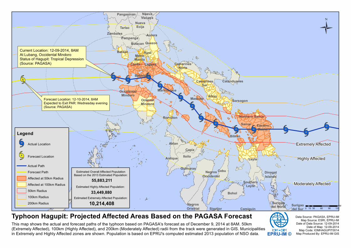
This map presents an update on the Philippines and provides details of IOM's humanitarian response in the area.

TRANSCRIPT

Ï!Ï!Ï!Ï!Ï!Ï!

Ï!Ï!

Ï!Ï!

Ï!Ï!Ï!Ï!Ï!

Surigaodel Sur

TarlacZambales

Aklan

Albay

Antique

Aurora

Bataan

Batangas

Biliran

Bohol

Bulacan

CamarinesNorte

CamarinesSur

Camiguin

Capiz

Catanduanes

Cavite

Cebu DinagatIslands

EasternSamar

Guimaras

Iloilo

Laguna

Leyte

Marinduque

Masbate

NegrosOccidental

NegrosOriental

Northern Samar

NuevaEcija

NuevaVizcaya

OccidentalMindoro

OrientalMindoro

Palawan

Pampanga

Pangasinan

Quezon

Rizal

RomblonSamar

Siquijor

Sorsogon

SouthernLeyte

Surigaodel Norte

MetroManila

0 30 60 90 12015KM

Ü

Typhoon Hagupit: Projected Affected Areas Based on the PAGASA ForecastThis map shows the actual and forecast paths of the typhoon based on PAGASA's forecast as of December 9, 2014 at 8AM. 50km(Extremely Affected), 100km (Highly Affected), and 200km (Moderately Affected) radii from the track were generated in GIS. Municipalitiesin Extremely and Highly Affected zones are shown. Population is based on EPRU's computed estimated 2013 population of NSO data.

LegendÏ! Actual Location

Ï! Forecast Location

Actual PathForecast PathAffected at 50km RadiusAffected at 100km Radius50km Radius100km Radius200km Radius

EPRU-IM ©

Data Source: PAGASA, EPRU-IMMap Source: ESRI, EPRU-IM

Date of Data Source: 12-09-2014Date of Map: 12-09-2014

Map Code: IOMHAGUPIT0014Map Produced By: EPRU-IM GIS

Estimated Overall Affected PopulationBased on the 2013 Estimated Population:

Estimated Extremely Affected Population:

Estimated Highly Affected Population:55,883,211

33,449,880

10,214,408

Extremely Affected

Highly Affected

Moderately Affected

Forecast Location: 12-10-2014, 8AMExpected to Exit PAR: Wednesday evening(Source: PAGASA)

Current Location: 12-09-2014, 8AMAt Lubang, Occidental MindoroStatus of Hagupit: Tropical Depression(Source: PAGASA)