issn 0318-2851 association of canadian map …collections.mun.ca/pdfs/acmla/acmla037.pdf · ·...
TRANSCRIPT

"'
-• ASSOCIATION OF CANADIAN MAP LIBRARIES
ASSOCIATION DES CARTOTHEQUES CANADIENNES
·--~~ .,
~
1
tt•
IWI ''I'E S n F nnt .\11 ' :\'I L \TIO :\' - - _- .. ,Lj,tJ .. ~ - -
- GOLD RE&'ION t_F'RAS·E~S RIVER __.=__
rornpll•·d rrJ_!Ill Ot 'l\,!ll! .!l \oil· .. _.., .
•t
I •
"'~"(
-~~- \· .. I
~"'· _,; •• •·t I •''.I''
NUMBER 37 I DECEMBER 1980 - NUMERO 37 I DECEMBRE 1980
ISSN 0318-2851
I , ..
/\SSUCIATI lN C'F' CANADIA!: ·~'l: LIBRI'tRIES
1-lEMBERSHIP in the Association / 'anadi'lil '~"!· i..ibrarie~ is o1en to both individual~ and ins~it•1tions havinl' fU1 interest in maps an-i the aims and cbject i ves -- f the> A!' sod at ion. Membership dues are for thf> cal<>ndar year and ar" as folloY~~
Full ( ':anadian map •'iel i) Associate (anyone irterf'St.f>dl Institutionlll
:tl" . 00 $1, .no :r, .oo
Memb"rs receive '1Uarter.y the /\(~~11 rlull.,•n, t'le ·~f'"icial Journal of the AssociatLm.
OFFT''ERS of the Asso<'iati ~n "or .-}110-!Jl '.trr:
r'res ident 1st Vice President
Past Pr<'. idcnt
Lorraine Dubre~i. Bi.ll McKinnc.n
11 homas "1 a["Y
~cGill ~n·vArsity
Prnvin,ia~ Arrhive& o" New Brunswick Tnivt=orsityor
roS...._fl~irV
Fut:ic Archives ~f -.,..iiPVifl
•1 v~r~ity cf ,.;aterln• ,H.rlPi' ~ r 1f 1:: Vt:>rslty
A·,.ociation of Canad1an Mar Librarr~ c/o National Map Colle ··ti ··n Public ArchiVPS of Canada i''' Wt>llinv+on 3tr->r•t r t taw a , r)ntario ,'ANADA K:lA "P.
Vi.e..,:_ .. ~xrrf:"S1Pd in th~ Bul ~,t~!1 are + 1lUSf' of" trv: ~.)nt-ritt..a
l.ors nnd .io r .... t necf"S sari .~.y r£=> f~.P1"t t;-_.n v P·ws n f ; t.~ J:..·.sr r d.t ion ..
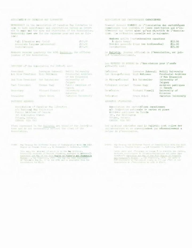
~'l\t"':B M>~r:- "'ihowinq t.hP Diff€-r~n+ RI>Utf!S of Ccnnunication with the Gold H• lil:l0:1 "'lfl F'rar,~rs R1- ver .... , by A.lexandf:"r , ... Anderson, ( 1858J o
..,t1i;J mrtr, the ori~ina.l of whi.•h is jn tht- Ma.p Division, Pr·vir1c.:.al Archives or :~ri+:sr C'1lumtia, appeared in Anderson ' ~
Hw,d-book. :md Map c·f the (",o~d Region of Fraser ' s and Thompson 1 s R: vers ... , sar~ Franci .-.c, lP.'SA rhe map has been r~produced a.;J: "''icsimi 1,. Map Nc. ,7 by ·~~~ AC~U.. A11-i is ava..lable frr:Jm the A scc-iqt en for J, ·.f .
AS":OCI ATI 1N •ES f'ARTOTHEQUES CANADIENNES
Peuvent devenir MEMBRES de ! ' Association des cartotheques canadiennes tout ir,.dividu et toute institution qui s ' interessent aux cartes ainsi qu ' aux obJectifs de ! ' Association. I a cotisation a.nnuelle est la suivant<>:
Membres actifs (cartothecaires canadiens a plein tP'llpS) ~ns .oo
~15.00 fl25 .00
Membres 'iSS :>•·iE:s ( tous les interesser>s) Institutions
Le Bulletin, jJurnal officiel de ! ' Association , est publiP trimestriPllr>ment.
Les MEMBP.ES Dl' Bl'f<E;AU de 1 ' Association pour 1 1 annee 19& -l9fll s "nt:
Fresident ler Vice-preslae~t
Lorraine Dubreuil Bill McKinnon
Bob Batchelder
!'homas Nag:r
Richard Pinnell
Grace Welch
McGill University Provincial Archives of New Brunswick University of Calgary Archives publiques du Canada University of Waterloo Carleton University
Ass >Ciatiofl dt>::. cartoth€hues canadiennes a/s Collecti~n nationale de cartes et plans Archives putl iques du Canada 39), ruE> We.l.ngton f'ttaW'a, 'nt"U'40 CM/\DA KlA N ~
Les >~ _r ions exr ~' me<>s dans le Bulletir: sont celles des C( 7.: 'l.bOrate~r~ Pt t P COrrespondent paS neCeSSairement a celles ae l'A s cat or.
'Vl'R v.ar 't\1"w 1T. •r-. .... ll't'Pr••nt fi~Jtez .J~' .:vrnmtu i 11t r. 'l,o;iP• t,)le k' d BF p;ion ):"' ra.; • r ~ River .. o, ,, 'r A l,.;..xaud,·!" c. And( rtcm , 1·2·'JA),
't•tt.e carotf_ dont .~, ' lJr.~o-... ir.al SP trouvr:- ~l a tllvi.sioi. de;i <..·artt?s, Ar.-.hivf: r v i-1le: 1~ ···,lurnbie-!:Srit1111 iq-.~e ~st [ ~u-uJ:: J~ns
AnJP.r.SrJr 1 .3 Hard-book tind Mar of t.he ('J01d RPf.l. .. m f Fra:.;er ' s at1J ThoiT"r.lcn',· f'iw~rs . . , :an 'raneiscC', Q'B. LA ('fir1.P- J:i
.-:t~ repr· ~ i+f' ""!1 ~e·--irr:.~e 1.rt.P no tt) p11.r 'AI'•" Pt ~·::;t ..
1i spc r:.._. '· 1e '~::. i-tt i .. r 'lU cc G.t. d1 .l· ~. l o

ACML Bulletin 37 i.
CONTENTS/MATIERES
BULLETIN STAFF ........................................................... ii
EDITOR'S CO~ENTS ........................................................ iii
REPORTS
Spatial Knowledge in the Future: Perspectives from the Past I Dr. Barbara B. Petchenik . . • . . . . . . . . . • . . . . . . . . . . . . . . . . . . . . . . . . . . . . . . . . . . . . . . . . . . . . . . . . 1
Exploring the Potential of Electronic Maps I Reprinted from Rand Research Review . . . . . . . . . . . . . . . . . . . . . . . . . . . . . . . . . . . . . . . . . . . . . . . . . . . . . . . . . . . . . . . . . . . 7
Report on the MARC Maps Processing Workshop Library of Congress Geography and Map Division, June 16-20, 1980 I Joan Winearls .•............ . ........ 9
A Decade of Environmental Mapping - A Cartographic Exhibit for National Cartographic Day, May 23, 1979, Arranged by the Association of Canadian Map Libraries / Janet Allin (York University Map Library), Joan Winearls and Mary Armstrong (University of Toronto Map Library) ................... 13
Report on the Western Association of Map Libraries' Fall 1980 Meeting I Frances Woodward . . . . . . . . . . . . . . . . . . . . . . . . . . . . . . . . . . . . . . . . . . . . . . . . . . . . . . . . . 20
The Map Collection at the University of Guelph, An Evaluation I Flora Francis 23
Report on PRECIS and AACR2 at the Map Division of the Provincial Archives of British Columbia I David R. Chamberlin . . . . . . . . . . . . . . . . . . . . . . . . . . . . . . . . 34
REVIEWS
Map Use: Reading, Analysis and Interpretation, reviewed by N.L. Nicholson • . . . . . . . . . . . . . . . . . . . . . . . . . . . . . . . . . . . . . . . . . . . . . . . . . . . . . . . . . . . . . . . 40 An Atlas of Fantasy, reviewed by Pat Fysh ....................... .. ..•.... 41 The Atlas of Canada and the World, Grand Atlas du Canada et du Mende, reviewed by Alun Hughes . . . . . . . . . . . . . . . . . . . . . . . . . . . . . . . . . . . . . . . . . . . . . . . . . . 42 Atlas of Winnipeg, reviewed by Robert Batchelder ................ . ........ 44
ASSOCIATION NEWS 47
REGIONAL REPORTS
Report from Alberta . . . . . . . . . . . . . . . . . . . . . . . . . . . . . . . . . . . . . . . . . . • . . . . . . . . . . . 48 Report from New Brunswick . . . . . . . . . . . . . . . . . . . . . . . . . . . . . . . . . . . . . . . . . . . . . . . . 51
NOTICES AND COMMUNICATIONS . . . . . . . . . . . . . . . . . . . . . . . . . . . . . . . . . . . . . . . . . . . . . . . 53
RECENT ACQUISITIONS . . . . . . . . . . . . . . . . . . . • . . . . . . . . . . . . . . . . . . . . . . . . . . . . . . . . . . 61
PUBLICATIONS SECTION ..................................................... 66
ARTICLES OF INTEREST ..................................................... 70
DUPLICATES . . . . . . . . . . . . . . . . . . . . . . . . . . . . . . . . . . . . . . . . . . . . . . . . . . . . . . . . . . . . . . . 7 5

ACML Bulletin 37 iii.
EDITOR'S COMMENTS
The 1980's are going to create a different set of demands upon us. In the past two decades, we have seen tremendous growth both in the facilities we toil in, and in those materials we assist others to find. The lead articles in this issue outline a bit of our future.
The computer is a very powerful machine. It is easily capable of performing over one million additions in one second. It is difficult to place numerical values such as these in human equivalents. But, besides manipulating data, the computer can easily store vast quantities of data which can be accessed by telephone lines over great distances.
A computer enthusiast could easily visualize a map library of the future consisting only of a few terminals, CRT's (i.e. television screens), and plotting tables. He may be slightly off the mark by ignoring all of the printed cartographic materials we now know, but electronic "cartographic materials" are definitely in our future, whether we are libraries or archives.
I also would like to draw member's attention to the section devoted to Association News on pages 47-48.
Notice to Contributors
Robert Batchelder Editor in Chief ACML Bulletin
Submissions which fall within the aims of the ACML are welcomed. All material submitted must be typed double-spaced and sent to the Editor in Chief. (The use of first class or registered mail is recommended.)
Aims of the ACML
The purpose of the Bulletin is to help fulfil the purposes of the ACML: 1. To promote interest in and knowledge of maps and map-related material. 2. To further the professional knowledge of its members. 3. To encourage high standards in every phase of the organization, administration and development of map libraries by: (a) providing for dicussion of mutual problems; (b) exchanging information on experiences, ideas and methods; and (c) establishing and improving standards of professional services in this field.

ii. ACML Bulletin 37
BULLETIN STAFF/COLLABORATEURS
EDITOR IN CHIEF/REDACTEUR EN CHEF
Bob Batchelder, Map & Airphoto Division, University of Calgary Library, Calgary, Alta. T2N 1N4 (403/284-5969)
CONTRIBUTING EDITORS/REDACTEURS OCCASIONNELS
Serge Sauer, Map Library, Department of Geography, University of Western Ontario, London, Ont. N6A 2H4 (519/679-3424)
Pierre Lepine, Department des cartes et plans, Collections speciales, Bibliotheque nationale du Quebec, 1700 rue St-Denis, Montreal (Que.) H2X 3K6 (514/873-4408)
REVIEW EDITOR/REDACTEUR DES COMPTES RENDUS
Joan Winearls, Map Library, John P. Robarts Research Library, 140 St. George St., Toronto, Ont. MSS lAS (416/978-3372)
REGIONAL EDITORS/REDACTEURS REGIONAUX
NEWFOUNDLAND: Margaret Chang, Provincial Archives of Newfoundland, Colonial Building, Military Road, St. John's, Nfld. AlC 2C9 (709/753-9380)
MARITIMES: Elizabeth Hamilton, Map Room, Government Publications Department, Harriet Irving Library, P.O. Box 7500, Fredericton, N.B. E3B 3HS (506/453-4752)
ONTARIO: Tara Naraynsingh, Map Section, Geological Survey of Canada Library, 601 Booth Street, Ottawa KlA OE8 (613/995-4177, 995-4151)
MANITOBA: Hugh Larimer, Map Section, Reference Department, Elizabeth Dafoe Library, University of Manitoba, Winnipeg, Man. R3T 2N2 (204/474-9844)
SASKATCHEWAN: Anwar Saddozai Qureshi, Map Library, Division of Social Science, Faculty of Arts, University of Regina, Regina, Sask. S4S OA2 (306/ 584-4401)
ALBERTA: Ron Whistance-Smith, University Map Collection, University of Alberta, Edmonton, Alta. T6G 2H4 (403/432-4760)
BRITISH COLUMBIA: Maureen Wilson, Map Division, Library, University of British Columbia, Vancouver, B.C. V6T lWS (604/228-2231)
IFLA REPORTER
Hugo Stibbe, National Map Collection, Public Archives of Canada, 395 Wellington St., Ottawa, Ont. KlA ON3 (613/992-0468)

1. ACML Bulletin 37
SPATIAL !<f'Oll..EDGE IN lHE FUTURE:
Dr. Barbara B. Petchenik Cartog~phic Services R.R. Donnelley & Sons Company 300 W. Adams Street Suite 601 Chicago, Illinois, 60606
PERSPECTIVES FROM THE PAST
Paper originally presented at Organizational Meeting Cartographic Information Society October 3, 1980 ~lwaukee, Wisconsin and print ed here with the author's permission.
The information of a new Cartographic Information Society suggests that because of major changes occurring in the cartographic world today there is a related need for change in other map-centered institutions. My remarks today are directed to establishing some bases for understanding the rapid change that is taking place in our field. In attempting to arrive at some understanding of present and future change, I will draw on our experiences with the evolution of spatial knowledge and the forms it has taken in the past.
Being here in Milwaukee, at a meeting concerned with maps and other cartographic information, evokes memories of my own past. In the fall of 1961 I became the University of Wisconsin - Milwaukee (UW-M) Geography Department's first map librarian. It really does seem only yesterday that I was pasting cardboard letters spelling out "Map Library" on the door of an essentially empty room in what is now Mitchell Hall. I had so little idea of what I was doing that I can scarcely recall what maps we had then or what I did with them. It is impressive to consider that in less that two decades UW-M has emerged as one of the premier repositories of cartographic information, in the form of the American Geographical Society Library.
Rapid and significant change characterizes the entire domain of map-making at present. A few weeks ago there appeared in The New York Times an excellent article describing the changes occurring in contemporary mapping because of the development of digital cartographyl. The headline read: "Revolution Changes the World of Maps". The word "revolution" is sometimes used rather casually by journalists, but in this i nstance it is appropriate. Not only are increasing numbers of topographic maps being digitized or converted to arrays of numbers, but through the use of computer-driven devices, all kinds of maps are being produced directl y from numerical data bases on cathode ray tubes or as CRT-generated slides or in the form of ink-on-mylar plots and even as etched plates ready for printing. More revolutionary is the notion that the map itself will become less consequential as queries about spatial information can be addressed directly to digital spatial data bases, and "answers" obtained in verbal or numerical f orm.
You have chosen a name for your new organization that reflects recognition of the fact that you will be increasingly concerned with information that does not occur in the form of printed maps and atlases. Your goals indicate a further recognition that less specialization is desirable in organizing and providing access for materials formerly considered to be in the map and geography field. Professionals with a wide variety of interests can come
c 1980 by Barbara B. Petchenik

ACML Bulletin 37
together for mutual support and assistance within the framework of this new organization for cartographic information.
But I'd like to raise a question for your consideration: have you gone far enough in a new direction? Your name utilizes the word "cartographic",
2.
which has its origins in the words for "map" and "to draw". Yet we are entering an era in which dependence on printed maps and perhaps on all forms of map images appears to be diminishing as different forms of spatial knowledge are created. Institutions and professions whose purpose has always been to deal essentially with printed maps are bound to experience dislocations as they adapt to such change. However, with the prospect of such dislocation before us, it is important not to lose sight of distinctions between what is only superficial alteration and what represents more profound change. In speaking today I want to review a few theoretical notions that may help you to make such distinctions in the field of cartographic information or, as I would prefer to say, in the domain of spatial knowledge.
Although the history of cartography is not my field of expertise, it seems to me that there have been certain trends in the development of maps and mapping that provide some insight into the current situation. The focus in what follows is not on particular map forms but on the needs that maps evolved to fill. From this perspective we can perhaps see more clearly whether the current revolution relates primarily to changes in needs or to changes in the forms of response to those needs or to both or neither.
There is, of course, no direct evidence from the remote past indicating exactly which explicit forms of knowledge first developed in response to the fundamental human need to know where, and to tell others where. Human needs for nourishment, shelter, and security have always been related to questions of "where". Superior knowledge of where things were led inevitably to greater control of food supply and/or to greater security. The power or sense of control provided by such knowledge made it essential, very early on, that "where" information be captured and recorded, for although the human memory is astonishing in its capacity, it has always needed some assistance. As scholars have shown recently, it is likely that the written language evolved from the process of recording food storage and food trade transactions, so that (among other things) there would be less need to rely on individual human memory. The physical manifestation of knowledge facilitates its transfer from one place to another, making it independent of the original knower's presence.
Information about place can be individually experienced and remembered. But for one person to share knowledge of some remote place with another, that information needs to. take on an external sensory character. It is my guess that the first "maps" were the result of gestural traces -- ephemeral lines in the sand resulting from the accidental imprint of a hand pointing and moving from here-to-there in the process of describing to someone else where food or danger lay.
The earliest maps known, on clay tablets, are not very dissimilar to appearance from reference maps today -- rivers are linear, sometimes sinuous, places where people live are points, and so on. But then this is exactly what we would expect for a system originating in gestural traces --a river's linear extent or wavy surface, mimicked by movements of the hand, an indented

3. ACML Bulletin 37
dot resulting from the physical act of pointing to "there", that place, with a fingertip.
In some respects, I suppose one can say that as long as man has existed, so long has there been spatial knowledge. But over the past several thousand years, there has been increasing articulation and externalization of such knowledge in particular aspects and forms.
In The Nature of Maps, Arthur Robinson and I identified three separate but hierarchically related levels of spatial knowledge2. At the most fundamental level, there is the experience of existence at a particular place on earth. This is the primary notion without which the other two levels, called location and structure could have no meaning. The second level, location, is only slightly more complex and simply juxtaposes one "here" with another "there", linking places in primitive topological relations. When we ask, "Where is Shorewood?", we expect an answer giving its location. We expect to hear that it is "there" (not here), relating it to places we might be likely to know: e.g., Shorewood is north of here; it's about 7 miles away; it is adjacent to Milwaukee's northern edge; it is on Lake Michigan, and so on. Prepositions in our verbal language are essentially the equivalent of the spatial knowledge called location.
Structure, the third and most complex level of spatial knowledge, has evolved rather recently in man's history. It requires powers of abstraction not achieved until relatively recently and even now, I conjecture, not achieved by most individuals in our society. A substantial inventory of place and location data must exist before structure can be inferred. Most people's spatial conceptions are extremely limited and consist of poorly related experiences of different places and the routes traversed between them within the direct sensory environment. Thus, most people's spatial conceptions embody ~n adequate notion of existence, some location and virtually no structure. Such individuals can experience rainfall occurring at a place, can imagine rain extending from there to other places, but could tell you nothing about, nor might they ever wonder about, the pattern or structure of total annual rainfall as an abstract phenomenon distributed differentially over the surface of the United States.
In a related but somewhat different analysis3 , I have more recently considered why it is that over the last century or two a distinction has arisen between two kinds of maps: reference (general or topographic) and thematic (statistical or special-purpose). This distinction is commonly made and rather casually made. When looked at closely, however, these common and casual distinctions tend to break down and are found to be superficial. This problem came to my attention at the Atlas of Early American History Project when I found that if I wanted to design a map, I had to decide whether it was essentially a reference map or essentially a thematic map, because my design plans would be different in the two situations. I found it puzzling that I could not make this basic distinction unambiguously for even one map topic.
The answer, it now seems to me, lies in looking not at the content or form of the map (as it is usually thought to), but in examining the kind of spatial knowledge one seeks to acquire from the map. Taking this point of view, it becomes obvious that any one map can be both a reference map and a thematic map, if it can be used for acquiring different kinds of knowledge. In my view

ACML Bulletin 37 4.
there are two kinds of knowledge. One, the simpler, is knowledge of place. I call it "here is ••• " knowledge. The maps we call reference maps tend to convey such information and are essentially inventories. '~ere is Milwaukee, here is a body of water called Lake Michigan, here is 27th Street," and so on. This knowledge tends to coincide with the levels of spatial articulation described earlier as existence and location.
The other kind of knowledge results from a different order of intellectual effort rather than from a direct perceptual act. It has to do with the achievement of abstract structure - that is, the construction of continuous, internally differentiated space. The nineteenth and twentieth centuries have seen the rapid development of maps to assist in the construction of such intellectual space; the present is sometimes even called "the era of thematic cartography". In thematic mapping we treat a distribution as an object (even though we have no direct perceptual acquaintance with such an object), and make that object, having spatial extent and variable magnitude, visible through the medium of the map. Thematic maps tend to be used for analytical, essentially intellectual, tasks, while reference or inventory maps fill more immediate physical/perceptual needs for getting from place to place, or predicting what will be where.
Having achieved these insights into maps, we must address a future in which it appears that printed maps, because they are only a means to an end, will be replaced to some extent by ephemeral images or by non-imaged electronic spatial data bases. The implications of this development for those of us professionally involved in the acquisition, control and access of cartographic information are not clear, especially when it appears that much of the newer information will be neither carto- nor -graphic.
Using the analysis just developed, however, we can look at the future distinguishing clearly between changes that are occurring in fundamental needs for spatial knowledge and changes that are essentially technological variations in response to those needs.
The need for "here is ... " data, or inventories of what-is-where will be met in the future to some significant extent by computer-stored spatial data bases. Users wanting such information, whether travelers requesting distances among cities or soil scientists wanting details of soil distribution for study areas will be able to get the information they seek from data bases in forms uniquely appropriate to the request or the task.
Just how institutions, like map libraries, will function in relat i on to this new direct (and often map-less) connec t ion between data and user i s not clear. It may be that instead of providing finished products as the map library has in the past, the spatial information center of the future will also provide an inventory of the raw material, data sets and computer programs, that will allow users to make their own products, whether maps or other forms.
The vast stores of existential-inventory data that are already accumulating on tapes and discs are going to create serious storage and access problems. In fact, the magnitude of this problem is discontinuous with anything previously experienced. In the past, it was always relatively costly to make maps, especially detailed inventory maps. Data-gathering was carried out by human sensors, augmented with limited tools. As a result, there

s. ACML Bulletin 37
never seemed to be a sufficient number of maps, most maps were too expensive, and they were not sufficiently complete, up-to-date, or detailed. The most urgent needs for maps were filled first, with military requirements usually getting the highest priority, and providing the basis for much other mapping.
But although it must seem to map librarians and others that there is a great deal of spatial knowledge available at present in map form, what we have by way of inventory or reference mapping now is the merest trickle compared to the impending flood of data. The production of new spatial information is no longer constrained by the limitations of the human observer, nor is it necessarily selected and shaped by explicit immediate needs. Instead, complex sensors scan the earth continuously, acquiring vast stores of digital signals that have the potential for becoming spatial information.
Because a sensor operates continuously and unselectively (once it is determined at which portions of the electromagnetic spectrum it will record signals), data virtually pour in. Anyone who has ever queried the EROS center in South Dakota about the data stored there for one point on the earth's surface and received the relevant accessing printout will know that I do not exaggerate.
Although it doesn't seem feasible to consider storing all these electronic signals forever, there do not yet seem to exist even the beginnings of an institutional apparatus for creating and implementing policy on the matter of data-discarding. Your society may well want to explore this situation further.
Again looking to the past, such curatorial problems as what cartographic information to acquire, to keep, to destroy have been limited, relatively, by the fact that a map production and publishing industry existed to link spatial data acquisition with user demand or need. Because this industry, in both the governmental and commercial sectors was highly labor intensive, it was always necessary to be selective about what spatial information would be captured and transformed into permanent form.
Now, however, as more maps are brought into being "on demand", without the constraints of the traditional publishing process, new problems in information access are likely to occur. This is evident in a letter entitled "Who Will Publish the Maps" that was published in a recent issue of Photogran:unetric Engineering and Remote Sensing4. The author of the letter notes that many complex maps now being created by high-technology firms never achieve anything but limited circulation in a report, because they were created as a technical exercise in data manipulation rather than for the purpose of circulating spatial information as broadly as feasible, given the nature of the particular map involved. Where a formal publishing industry promoted the broadest possible distribution of maps, the map librarians' job of finding maps was made much easier. What we seem to be facing now, however, is a future where untold numbers of maps will be created for special purposes and without any intention or means of distribution.
Somewhat related to this is another matter of interest and/or concern to map libraries: maps now being produced by interactive computer graphics systems are generally ephemeral in nature, consisting of a temporary image on a CRT or a plotter printout on flimsy paper. Alternatively, hard-copy output may be generated, but it is one-of-a-kind. Who will save these? Should there be any effort made to save them? Who will decide? Clearly, it is going to become increasingly difficult to identify images that qualify for long-term storage.
ACML Bulletin 37 6.
Another serious concern about the future relates to the achievement of spatial structure via maps. It seems to me that in the past when maps were consulted for "where is ••• " information, there was at least the potential for a serendipitous acquisition of information that could lead to the development of structural conceptions. In other words, if you consult a map to find out how far it is from Chicago to Des Moines, you might notice other spatial information and relationships, and eventually, after many such incidental observations, some sense of structure might evolve. Now, however, if a computer simply tells you that Chicago and Des Moines are 315 miles apart, all opportunity for incidental development of structure is lost. This may eventually result in a society with even more poorly developed conceptions of space than is true at present.
In conclusion, I have tried to show that regardless of apparent change and increasing complexity, a few basic notions about the nature of spatial knowledge can help us to distinguish between essential needs for that knowledge and changes in the forms of information that meet those needs. It is likely that traditional producers and providers of maps -- including publishers and libraries -- will instead provide raw data and the processing capability to enable users to meet old needs in new ways. A period of adjustment lies ahead, and the formation of a new professional association that is concerned with the challenges the future will bring seems an excellent beginning. My best wishes for a long and useful existence.
FOOTNOTES
1
2
3
4
Robert Reinhold, "Revolution Changes the World of Maps", The New York Times, September 23, 1980, p. C2.
Arthur H. Robinson and Barbara Bartz Petchenik, The Nature of Maps: Essays toward Understanding Maps and Mapping. Chicago: University of Chicago Press, 1976.
Barbara B. Petchenik, "From Place to Space: The Psychological Achievement of Thematic Mapping." American Cartographer, V. 6, No. 1, April 1979, pp. 5-12.
Roy A. Mead, "Who Will Publish the Maps?", Photogranunetric Engineering and Remote Sensing, V. 66, No. 9, September 1980, p. 1182.
-oOo-
7 0 ACML Bulletin 37
EXPLORII'G 1HE roTENTIAL OF ELEClRONIC MAPS
Reprinted with permission from Rand Research Review3 V. 3., No. 3., FaZZ 19?9 3 pp. 5-6.
"Displayed maps are potentially much more valuable and powerful ••• than paper maps. They can show updated and changing information .•. the results of complex computations ••. (and) the timeliness and certainty of information ..• "*
Computer mapping - the use of electronic maps to portray complex geographical relationships among massive amounts of data - has been hailed as potentially the clearest window on the world that technology has yet created. Simply put, computer maps quickly translate pages of statistics into graphic representations, allowing data that would otherwise take days or weeks to transmit to be seen and understood in a matter of minutes.
The powerful new tool is already finding uses in such diverse fields as agriculture, forestry, environmental management, city and corporate planning, law enforcement, banking, health-care planning, politics, and military command and training operations.
Now researchers at Rand are investigating a new dimension of this rapidly evolving technology. In a program of informal experimentation, scientists Robert H. Anderson and Norman Z. Shapiro have developed design guidelines for computer-based, "interactive" map display systems. These dynamic map systems, although still in the conceptual stage, represent a marked departure both from traditional paper maps and from the static displays of information that are the current medium of computer mapping. Perhaps the most unusual feature of the systems is the mode of man-machine interaction employed, in which the computer "understands" the information it is displaying and can take action based on the nature of the data.
In the one-year study, sponsored by the Advanced Research Projects Agency of the Department of Defense, the researchers identified key features of an interactive map display system (IMDS). Although emphasis was on the use of these maps in military command and control operations, the researchers foresee a widespread application to other fields as more and more computing power is incorporated into graphic display systems at reasonable cost.
DISPLAYED MAPS: WHAT ARE THEY?
The researchers defined an IMDS as a relatively self-contained unit comprising at least (1) an electronic data base, (2) a display system, such as a cathoderay tube, and associated logic, and (3) enough computational power to handle displays and take care of data-base storage, retrieval, and updating. In addition, the system would be expected to interpret information from a variety
* Design Conside~tions for Computer-Based Interactive Map Display Systems., Robert H. Anderson~ Norman Z. Shapiro~ R-2382-ARPA~ February 19?9.

ACML Bulletin 37
of user input devices, such as a keyboard, a "joystick" (modeled after an airplane flight control stick), or an electronic data tablet. Moreover, the IMDS would very likely have one or more communcation channels to external systems, either to other IMDS~ orto other information systems within a command and control network.
8.
Three representative map display systems were devised, each addressed to a different problem, and each calling for different design elements and levels of sophistication. The following is an example of how a moderately elaborate system would work.
Stored in the computer are geographic data that the user, at his discretion, may select and display on the viewing screen in various ways. At his fingertips is information - for example, on terrain, political boundaries, weather, climate, demography, flora and fauna, geology, the cultural characteristics of the inhabitants of a region, and the disposition of military forces, as well as the rates of change of all these items.
The system enables the user to obtain, usually in a few seconds, i nformation that would be infeasible, if not impossible, to get directly from a paper map. For instance, the user might ask:
Where are the bridges in sector 13 capable of supporting a 12-ton tank? At what time should the aerial refueling take place here i f our bomber squadron follows this route? Who drew in that missile site? Smith? Where did she get that information?
A cartographer could not possibly encode answers to all such questions as the first one on a paper map without the resulting clutter quickly becoming intolerable.
The second question presents a case of geographic problem-solving req~1r1ng a substantial computation. And the third reflects concern about the imprecision or staleness of information on a map.
MORE POWER THAN PAPER MAPS
Unlike a paper map, a computer-based map display can provide mil itary commanders with a continuously updated picture of a changing battlefield situation. (Today, this is most often done by clerks skilled at writing backwards on a transparent panel with a grease pencil.) The computer-driven display can also show information that varies over time, such as the evolving pattern of enemy troop deployments over the past 48 hours. And it can allow concise, accurate communication among geographically dispersed units, each with access to a display terminal. Route-of-march markings made, say, on an electronic tablet connected to one map in a network would appear simultaneously on the other maps, however widely they were dispersed.
MAN-MACHINE INTERACTION
The map system can be highly interactive, in the sense that the user can selectively display the images he wants from a potentially vast data base of
9. ACML Bulletin 37
information. He can change scale and perspective at will -e.g., zoom in to inspect a hilltop at a large map scale, or zoom out for an overview of a large coastal plain at a very small map scale. And, finally, the user can call on the system to do complex computational tasks such as solving the refueling problem previously mentioned.
The researchers stress that these systems are not simply maps but are aids to geographic planning and problem-solving in the broadest sense, and because of these fundamental differences, the design of electronic maps should not merely mimic that of paper maps.
Although the guidelines and observations that emerged from the study are preliminary, the researchers conclude:
"We have demonstrated some dramatic increases in problem-solving effectiveness using only rudimentary software systems. Further development, test, and evaluation of such systems, tailored to particular real-world problem-solving activities, seems warranted."
Joan Winearls Map Ubrary
-oOo-
REPORT ON 11-iE MARC MAPS PROCESSING WORKSHOP LIBRARY OF CONGRESS GEOGRAPHY AND MAP DIVISION
JUNE 16-20, 1980
University of Toronto Library
This workshop was a landmark event in the area of map librarianship as it was the first cataloguing workshop offered by the Library of Congress Geography and Map Division (LC G&M). It took place mainly in their splendid new quarters in the Madison Building. About sixty-five people attended the first two days which were devoted to lectures, and, about forty stayed on for the following three day practicum. The workshop was devoted to all aspects of descriptive cataloguing in AACRl, subject cataloguing, classification, tagging and handling the MARC Map format. During the practicum, participants opted either for a group including two sessions on map cataloguing with one on data preparation, or one session on map cataloguing, with one on data preparation and one on atlas cataloguing.
After an informative introduction on trends in the Division as a whole by John Walter, David Carrington, Head of Technical Services Section took over. He reported on the main operations and plans in the section. Seven to nine thousand titles per year (about eighty thousand sheets) are catalogued by the staff of twenty seven. About twenty-five hundred authorities for maps and atlases are also established annually.
There is less than 1% error in the map database and it is therefore one of the cleanest databases throughout LC. The section maintains the G schedule and the official shelf list and proposes revisions to the G schedule.

ACML Bulletin 37 10.
Carrington commented that the map section in the planned 5th edition of the G classification could be published separately, if enough interest is shown. The Data Preparation Manual is still forthcoming but the MARC map format will come out this year in a revised version but integrated with the other formats.
General Policies at LC
Diane Humes, Office of Descriptive Cataloguing Policy described the work of her section which is responsible for all descriptive cataloguing including entries, and official rule interpretations. This section is also responsible for the new Automated Names Authority File (ANAF) which is presently being prepared for on-line access. The old manual MARC authorities for personal and corporate names have been input and new names in AACR2 form are also now being input. Names used for over twenty-five entries and from three to twenty-five entries are being upgraded and will be linked from old to new forms and vice-versa. The authority file will include geographic names that will be part of corporate entries and where necessary co-ordinates will be added to identify the area. The sources information in the file is detailed and will be of great use to libraries that acquire ANAF on-line.
Mary K.D. Pietras, Chief, Subject Cataloguing Division, described the work of her section and the relationship to G & M. Her department is responsible for LC Subject Headings and the classification codes. She announced the publication of the 9th edition of subject headings and discussed a few of the changes (one unfortunate change is the removal of the detailed introduction).
The department reviews proposed new subject headings and class numbers, and gives the final approval on these. LC G&M commented at the workshop that they have great difficulty in getting subject headings appropriate for maps established and that many of the subject headings that have to be used are more theoretical than practical where maps are concerned. It is also difficult to get regional names of parts of states established (e.g. Northern California). Geographic names are generally not included in LCSH (although there are more regional names in the 9th ed.) and the authority file for the thousand's of names used in G&M for maps remains on cards in the Division.
There was also a short report by Sally McCallum from the Network Development Office on the status of MARC formats and fields in the national and international areas.
Map Cataloguing
The main discussion of this topic was presented by John Schroeder, Head, Cataloguing Unit, and Richard Fox, map cataloguer. John reported that the section has seven map and two atlas cataloguers. Maps are evenly distributed to all cataloguers and each cataloguer provides a complete record of the map. The record is then reviewed by another map cataloguer and a supervisor. The main entry is 75% by corporate body, 20% by personal name and 5% by title. Therefore the ability to use corporate main entry is vital for maps. We were reminded that the main entry does not have to be derived from the bibliographic description. At. the same time the publisher is considered to be the author only if it is known as a map publisher or is a copyright claimant.
In future, co-ordinates will be given if shown on the map. The 652 reversible

11. ACML Bulletin 37
subject headings, which provide areas as first access, are used for all sub.j ec t terms and are bracketted in tracings. These headings may be redundant when Component Word Searching is extended to maps. An on-line system is presently being developed at LC and is now being used for atlases.
The map cataloguing section expects to be involved in co-operative cataloguing in the future, particularly to assist in getting at the enormous problem of retrospective cataloguing. However Schroeder feels that they are not certain yet how to ensure the same level of standardization from all source libraries.
Atlas Cataloguing
Minnie Modelski, Head of Atlas Cataloguing, spoke on the organization of her section. G&M handles only "geographical atlases", i.e. those classified in 'G'. G&M is responsible for all cataloguing aspects: descriptive, entries (main, subject, and added), and classification. She maintains constant interaction with the main processing departments on priorities and in trying to regain atlases that have "escaped". Monographic atlases may be done first in Shared Cataloguing or Preliminary Cataloguing and passed on to G&M for subject, classing and added entry work. Atlases are handled in four different ways: as monographs, as multi-volume monographs with a closed or open date, as loose-leaf monographs with closed or open date, and as series. One of the greatest problems is with atlases defined as Serials (i.e. published more than once in 10 years) which then disappear into the serials section. With atlas cataloguing the publisher is seldom the main entry.
There are also many more atlases being given a title main entry with the increased collaborative nature of production. Almost anything may serve as a substitute title-page including an index or a shipping list. The limit of 3 subject headings is sometimes difficult for retrieval so extra unofficial subjects are often assigned. In future they expect to be able to give an alternative 'G' number on catalogue cards for those atlases in other classes. Rough guidelines for the definition of atlases have been set up and will continue to be refined.
Data Preparation
Betsy Mangan, Head Data Preparation and Files Maintenance Unit, discussed the format and coding problems. A National Record Bibliographic Level for maps is being developed as a minimum required for identification for records for NUC and exchange of records. At present to contribute to NUC, libraries must produce records based on original cataloguing, AACR2 rules, compatible headings and the same options LC is using.
The forthcoming integrated MARC format will have 6 appendices: a table of tags, keyword index, country of publication list, language codes and a history of the tags. The subscription to the format will be $30 per year and the original loose-leaf volume will be $20.
MARC map tapes were recently loaded on OCLC and RLIN. Users report a high hit rate. M. Larsgaard of the Colorado School of Mines reports a 50% hit rate for immediate checking and a 90% hit rate after a three to six month wait.

ACML Bulletin 37 12.
Several changes in the format will be made to accommodate AACR2. Tag 255 and fixed field 34 will be used for the mathematical data area. Tag 510 will become a citation field to replace the citation indicator in the fixed fields which was only used by LC for their bibliographies. Tag 501 will be used for a 'with' note. Subfields will be created in 245-300 for records being romanized. A new subfield will be added to 045 for date of situation if it is different from the date of publication.
The problem of updating the database is now being studied to see if the editing and inputting can be done on-line. At present, it is done in a batch mode which means that if a correction or change is being made, the whole field has to be re-keyed.
Mangan outlined the cutter project which is a co-operative venture to produce logical cutters for sub-areas for all U.S. states. This is a joint programme with the University of Michigan and volunteers are at present producing lists for a good number of states. Volunteers will eventually also be sought for Canada. It is hoped to publish the lists in microfiche with semi-annual updates. The main initiative for this useful listing came from LC because of the 052 code for the area part of the map classification which is searchable. The code is repeatable so that all area concepts required for a map can be coded here.
It was also announced that the OCLC map users group has become the Map On-Line Users Group with E. Mangan as President. Membership is $5 personal and $10 institutional. The group will liaise with all networks OCLC, RLIN, UTLAS that input maps or are planning to input maps into their data base (the group held a workshop in Ann Arbor in early October).
Practical Sessions
The last three days were devoted to the practicum and I signed up for a session each on Map Cataloguing, Data Preparation and Atlas Cataloguing.
The Map Cataloguing session was most valuable for the opportunity to acquire the Geography and Map cataloguing manual, to look at the LC Cataloguing decisions manual and to access the new Automated Names Authority File, the manual geographic names and the Component Word Search File. All maps, atlases and a selection of other materials in the data base had been specially loaded on the latter file for the workshop. The file proved to be very useable as its browsing capabilities allowed retrieval by parts of titles, areas, subjects, card no. etc. After a review of the processes, each participant catalogued the same maps and then the results were discussed. Unfortunately, participants were not separated into those who had catalogued maps before and those who had not. As a more experienced map cataloguer,! would have benefited from more discussion on LC cataloguing decisions, particularly in defining sets and series.
The Data Preparation section was more useful to me as it was a short course on tagging the data sheets for input. I learned a great deal about the importance of proper subfield coding and the difficulties of interpretation with complicated entries. Clearly in Canada, we will need training for tagging of maps and, particularly, for added features in the CanMarc format.

13. ACML Bulletin 37
The atlas cataloguing session provided a real insight into the complexities and difficulties of this work particularly for anyone like myself who does not catalogue atlases.
The draft definition of an atlas pays particular attention to format and even includes maps that come folded with a separate text. LC does, however, take necessary preservation steps needed with 'atlases' -unfolding, flattening, encapsulating, and filing them like maps. Unfortunately not all libraries are able to handle their atlases with this kind of freedom and common sense.
Altogether LC G&M are to be commended on a very useful workshop which it is hoped was just the first of many. The next will presumably be on map cataloguing by AACR2 rules which could be held as soon as the international interpretive manual is published. As part of an updating program on LC policies and activities, I hope they will hold these workshops at least every three years.
-oOo-
A DECADE OF ENVIRONMENTAL MAPPING - A CARTOGRAPHIC EXHIBIT FOR NATIONAL CARTOGRAPHIC DAY,~ MAY 23, 1979,~ ARRANGED BY TI-lE ASSOCIATION OF CANADIAN MAP LIBRARIES BY JANET ALLIN (YORK UNIVERSITY tvlAP LIBRARY),~ JOAN WINERALS AND tvlARY ARMSTRONG (UNIVERSITY OF TORONTO MAP LIBRARY)
UNE DECENNI E DE CARTOGRAPH IE DE L 1 ENVI RONNEMENT - UNE EXPOS 1 TI ON CARTOGRAPH I QUE
POUR LE JOUR NATIONAL DE CARTOGRAPHIE,~ 23 tvlAI 1979.~ ARRANGE PAR JANET ALLIN (YORK UNIVERSITY f'AAP LIBRARYL JOAN WINEARLS ET tvlARY ARMSTRONG (UNIVERSITY OF TORONTO f'AAP LIBRARY)
MULTI-FACETED LAND ANALYSIS ANALYSE DES TERRES PORTANT SUR PLUSIEURS ASPECTS
1. Atlantic Provinces - Les Provinces Atlantigues: Canada Land Inventory critical capability areas. - Scale 1:1,000,000. - Ottawa: Canada Land Inventory, Lands Directorate, Environment Canada, 1975.
Based on the 1:250,000 CLI series, the map identifies regions which are best suited to agriculture, forestry, recreation, wildlife or a combination of these uses. Because of their limited extent, these critical areas should be given special consideration in planning and development of the provinces.
2. Ecological "bio-physical" land classification of Labrador. - Scale 1:1,000,000. -Ottawa: Lands Directorate (Atlantic Region), Environmental Management Service, Canada Dept. of Fisheries and Environment, March 1977.
Accompanied by Ecological land classification of Labrador; a reconnaissance (85 pages) . Twenty-seven Ecological Land Regions with associated Land Districts were identified using visual interpretive information obtained from Landsat imagery.

ACML Bulletin 37 14.
3. Natural environment: development considerations: Strait of Canso natural environment inventory. - Scale 1:25,000. - Canada-Nova Scotia Strait of Canso Environment Committee, 1975.
Geology, hydrolog~ coastal geomorphology and fish and wild life habitats were used to highlight regions applicable to 4 'themes' -environmental parameters affecting construction costs; hazards; potentially useful resources and special habitats - to aid in the formulation of environmental policy decisions.
4. Mackenzie Valley and northern Yukon pipelines: regional analysis. -Scale 1:1,000,000. - Ottawa: Environmental Social Committee Northern Pipelines Task Force on Northern Oil Development, 1975-
A multipurpose map set with each factor mapped separately, on communities, terrain and aquatic sensitivity, hydrology, wildlife, non-renewable resources etc. compiled to reflect on the socio-economic and environmental implications of the proposed oil pipeline.
SPECIAL PURPOSE ANALYSIS: RECREATION ETUDES SPECIALES: RECREATION
5. Le Saguenay - touristigue & ecologigue; une invitation a la decouverte -Scale 1:250,000. - Chicoutimi: La Societe d'Expansion Economique du Saguenay Inc., 1977-78.
A pictorial presentation of communities, tourism and wildlife ecology in the Saguenay, produced to encourage tourism in the region.
6. Visual units and scenic complexes; Alaska's natural landscapes no. 3. -Scale 1:2,500,000. -Federal-State Land Use Planning Commission, 1978.
Outstanding scenic complexes and visual units (a smaller area of similar characteristics) are outlined on a shaded relief map to ident i fy regions of "primitive" land to preserve.
Land use policy designations: preliminary proposals for Niagara Escarpment: Schedule A. -Scale 1:50,000. -[Georgetown]: Niagara Escarpment Commission, 1978.
Categories of proposed land use focus especially on recreational purposes and include lakeshore, scenic drives, natural and cultural areas, hazard areas, the Bruce trail, and areas for scarp protection, as well as basic urban and agricultural land uses.
SPECIAL PURPOSE ANALYSIS: SPECIALIZED AGRICULTURE ETUDES SPECIALES: AGRICULTURE SPECIALISEE
7. Grape climatic zones in Niagara I John Wiebe; cartography by Ontario Ministry of Natural Resources, Surveys and Mapping Branch. - Scale 1:63,360, - Vineland: Ontario Ministry of Agriculture and Food, Horticultural Research Institute, 1976.
15.
8.
9.
ACML Bulletin 37
SPECIAL PURPOSE ANALYSIS: WILDLIFE ETUDES SPECIALES: FAUNE
Northern B.C. coastal wildlife resources map. - Scale ca. 1:576,576. -Smithers, Victoria: B.C. Fish and Wildlife Branch, 1977.
Point locations, and simple migratory patterns, are shown for sea lion colonies and specific types of water bird communities. Number of individuals or breeding pairs is shown in a table beside the map. Compare this to the wildlife sheets (no. 4) on the Mackenzie Valley, where regions (not point locations) of important wildlife habitats, and actual migration routes are mapped.
Environmental resources of the Toronto central waterfront. Part II study - Life Sheet I Wallace McHarg Roberts and Todd. - Scale ca. 1:19,200. - Toronto: City of Toronto Planning Board; and Central Waterfront Planning Committee, 1976.
One of five critical resource maps to help develop policy recommendations for planning in the harbourfront area, the "Life" sheet, divides the area into regions classified by type of vegetation and wildlife habitats.
ENVIRONMENTAL PROBLEMS AND MODIFICATIONS: WATER POLLUTION PROBLEMES ECOLOGIQUES: POLLUTIONS DES EAUX
10. County of Brant ground water probability: ground water guality. -Scale 1:250,000. - Toronto: Ontario Ministry of the Environment, Water Resources Branch, Map 3100, Sheet 3, 1969.
Presence or absence of sulphurous water in bedrock wells is shown for point locations. Tables of chemical analysis of water samples are also on map.
11. Acid mine drainage in the Appalachian Region - water resources of the Appalachian Region, Pennsylvania to Alabama, Sheet 9. - Scale 1:2,500,000. -Washington, D.C.: U.S. Geological Survey, 1965 (Hydrological Investigation Atlas, HA-198).
One type of pollution caused by mining is acid mine drainage in water. The sulphuric acid corrodes concrete and metal, and harms plants and fish. Red lines indicate the presence of the pollutant along rivers, as red dots did for wells on the Brant Country map (see exhibit 10) .
12. Depth to base of potable water in the Florida aquifer. - Scale ca. 1:2,000,000. -Washington, D.C.: U.S. Geological Survey; Tallahassee: Florida Dept. of Natural Resources, Bureau of Geology, 1971.
Isolines showing approximate depth to base of potable water, help planners to: 1. study areas of increasing salinity or chemical pollution, 2. assess future supplies for urban and rural areas, and 3. assess the use of the aquifer for storage of waste effluents.

ACML Bulletin 37
ENVIRONMENTAL PROBLEMS AND MODIFICATIONS: AIR AND NOISE POLLUTION PROBLEMS ECOLOGIQUES: POLLUTION DE L'AIR ET PARLE BRUIT
16.
13. Air quality assessment studies in the Sudbury area: Volume 2 -Effects of sulphur dioxide and heavy metals on vegetation and soil, 1970-1977. -Sudbury: Ontario Ministry of the Environment, Technical Support Section, Northeastern Region, 1978.
Maps from the text included, "Area over which black spotting symtom was observed on vegetation July 1975," "so2 injury to vegetation in 1976," and "Potentially injurious fumigations in 1977."
14. Air quality Dryden, annual report, 1977. - [Dryden?] - Ontario Ministry of the Environment, Technical Support Section, Northwestern Region, 1977.
2 Figure 6 showed the, "Average dustfall, 1977 (g/m /30 days), and Figure 7, "Average sulphation rates, 1977 (mg so3/100 cm2/day). These maps, produced to accompany texts, illustrate the mapping of various types of industrial pollution.
15. Air pollution and noise in the central waterfront area. - Scale not given. -Toronto: City of Toronto Planning Board, 1974.
This map is a more complex presentation of industrial pollution - both air and noise, and based on subjective and statistical data. "Spheres of influence (as judged by Ministry of the Environment Staff) delineate areas affected by private industry, and by municipal services such as the generating station or the sewage treatment plant. A series of small maps show dustfall and the sulphation rate for 1970-1972, using isolines. Bar graphs present noise levels at specific monitoring stations.
16. [Human activity and the environment- map 5.38]: noise exposure forecast for Toronto International Airport (Malton), 1974. -Ottawa: Statistics Canada, 1978.
3 classes of NEF (noise exposure forecast) are mapped, based on the noise produced by all types of aircraft at an airport, and taking into consideration the number of flights, the time of day, duration of noise, and the frequency components of the sound.
17. Impulse noise survey, Welland, July 1976.- Scale ca. 1:3,000. -[Toronto]: Ontario - Ministry of the Environment, 1976.
A noise survey based on purely subjective responses of people in the neighbourhood of 3 industries. Small black squares indicated people who volunteered a response and black circles, people whose answers were elicited, as all being disturbed by industry noise.
ENVIRONMENTAL PROBLEMS AND MODIFICATIONS: HAZARDOUS MATERIALS PROBLEMS ECOLOGIQUES: MATERIAUX DANGEREUX
18. Environmental atlas of the Greater Anchorage Area Borough, Alaska -Figure 61: Suitability of surficial deposits for waste disposal, Anchorage

17. ACML Bulletin 37
and vicinity. Alaska. - Anchorage: University of Alaska, Arctic Environment Information and Data Center, 1972.
The safe disposal of liquid waste is high priority for most local governments. Septic tanks and cesspools are the primary methods of waste disposal in the Anchorage region, and their capacity for purefying liquid waste depends upon the filtering effectiveness of surficial deposits.
19. National atlas [of the United States] - nuclear fuel materials movement by highways (BTU): 1975.- Scale 1:7,500,000.- Reston, Va., U.S.G.S., 1977.
The flow of nuclear fuel materials by highways is primarily a west to east movement to provide power for large urban agglomerations. And as a result the problem of storage of high level waste from (R) - spent fuel storage, planned reprocessing facility, and low level waste from (N) -nuclear reactor site must also be solved in these regions, if the contaminated waste is not to be transported long distances. Flow lines indicate the type and volume of material being transported.
NATURAL HAZARD MAPPING: FOREST FIRES CARTOGRAPHIE DES PHENOMENES NATURELS: FEUX DE FORETS
20. Wildland fire occurrence in Canada. -Scale ca. 1:6,336,000. -Ottawa: Environment Canada Forestry Service, 1975.
Isolines representing the number of fires I 1000 miles2 I year are enhanced by the colouring of 7 "occurrence zones". Light green is used for zones of very low occurrence, and deep reddish brown for extreme occurrence, creating a map where areas of extreme occurrences are highly visible, such as Sudbury or Halifax.
NATURAL HAZARD MAPPING: STORMS CARTOGRAPHIE DES PHENOMENES NATURELS: TEMPETES
21. U.S. tornadoes 1930-74 IT.T. Fujita and A.D. Pearson. - Scale ca. 1:10,000,000. - Chicago, Ill.: University of Chicago, 1976.
The storm paths of tornadoes cartographically resemble striation lines in mapping surficial geology. Three classes of tornados are coded by blue lines (weak), green lines (strong) and red lines (violent) showing the paths of the tornadoes, most of which are oriented on a south-west north-east axis.
NATURAL HAZARD MAPPING: EARTHQUAKES AND VOLCANOES CARTOGRAPHIE DES PHENOMENES NATURELS : TREMBLEMENTS DE TERRE ET VOLCANS
22. Potential hazards from eruptions of Mount Ranier, Washington. -Scale 1:250,000. -Washington, D.C.: U.S.G.S., 1973, (Miscellaneous geologic investigations, Map I-836).

ACML Bulletin 37 18.
Areas of low, moderate and high risk of mud flows and floods, gases and airborne rock debris are mapped using colours and symbols. Identification of "risk" areas, may lead to the prevention of development in some areas, as well as aid in the formulation of evacuation plans.
23. Geothermal energy resources of the western United States. - Scale 1:2,500,000. -Boulder, Colo.: National Geophysical and Solar- Terrestrial Data Center, Environmental Data Service, N.O.A.A.; Energy Research Development Admin., Division of Geothermal Energy, U.S.G.S., 1977.
Some regions of geothermal energy resources of the U.S. are being utilized for electric power generation, and others are being studied for their potential use. However, destructive elements, such as volcanoes and earthquakes are also associated with these resources.
NATURAL HAZARD MAPPING: EROSION AND LANDSLIDES CARTOGRAPHIE DES PHENOMENES NATURELS: GLISSEMENTS DE TERRE ET EROSION
24. Canada -Ontario Great Lakes shore damage survey coastal zone atlas -Lake Huron, sheet 2-1. -Scale 1:20,000. -[Ottawa]: Environment Canada, Inland Waters Directorate; [Toronto]: Ontario Ministry of Natural Resources, 1976.
5 maps are presented for each section of the coast showing shoreline 1) damage, 2) ownership, 3) value in dollars, 4) land use and 5) physical characteristics, to provide a basis for preliminary recommendations on more effective shoreline management.
25. River bank stability map, Mackenzie Valley - Fort Good Hope sheet / Geological Survey of Canada. - Scale 1:250,000. - Ottawa: Environmental Social Program Northern Pipelines, 1973.
Accompanies The stability of natural slopes in the MacKenzie Valley by J.A. Code. Environmental Social Program Report 73-9. The study was carried out to provide information on which to assess pipeline proposals, or future development projects. Alphabetic symbols are used to classify the composition, slope characteristics and types of erosion of the river bank.
26. Maps showing aerial slope stability in part of the northern coast ranges, California. - Denver, Colo.: U.S . Geological Survey, 1976. (Miscellaneous geologic investigation series; Map I-982).
On this sheet, 4 maps (progressively superimposed on each other) present the detailed geological structure, landslides and alluvium of the area, to attempt to correlate geological structures and potential hazards, such as loss of slope stability.
27. Computer composite map showing inferred relative stability of the land surface during earthquakes, Sugar House quadrangle, Salt Lake County, Utah.- Scale 1:24,000. -Arlington, Va.: U.S. Geological Survey, 1977 (Miscellaneous geologic investigation series; Map I-766-0).

19. ACML Bulletin 37
4 classes of stability of materials during earthquakes are mapped to show how geologic information can aid in land use planning. Most stable areas should be selected for critical emergency control services, such as police, hospitals, power lines, fire stations, etc.
NATURAL HAZARD MAPPING: FLOODS CARTOGRAPHIE DES PHENOMENES NATURELS: INONDATIONS
28. Flood risk map. Carmant Manitoba= Carte du risgue d'inondation. - Scale 1:5,000. - Ottawa: Canada Dept. of Fisheries and Environment, Inland Waters Directorate; Winnipeg: Manitoba Dept. of Mines, Resources and Environmental Management, 1976 (+text).
29. Flood risk area Boyne River, Carman, Manitoba. - Scale ca. 1:9,600. -Ottawa: Canada Dept. of Fisheries and Environment, Inland Waters Directorate; Winnipeg: Manitoba Dept. of Mines, Resources and Environmental Management, 1977.
Two cartographic presentations of flood risk along the Boyne River, Carman, Manitoba. They were both published as a pilot project on flood risk mapping by the Canadian Inland Waters Directorate and the Manitoba Dept. of Mines, Resources and Environmental Management. The goals of the project were to define areas where 1) further development should be curtailed due to flood risk and 2) where a st.rategy would be devised to help protect existing development against future floods. The first map at a larger scale, is much more detailed, showing the limits of the 1974 and 100 year innundations, individual buildings, and 5 foot contour lines. This map would be used by governments (or citizens) involved in carrying out the 2 goals mentioned above. The second map with one class of flood risk area, and many photos and accompanying text on verso, would be intended for. distribution to the general public.
-oOo-

ACML Bulletin 37
REPORT ON 'TI-iE WESTERN ASSOCIATION OF M6tP LIBRARIES' FAU.. 1980 MEETit~
Frances Woodward Special Collections Division University of British Columbia Library
The fall meeting of the Western Association of Map Libraries was held in
20.
Salt Lake City, October 9-11, 1980, with about 24 members in attendance. Although few regulars from the coastal states were there, a number of members from our eastern perimeters were at last able to attend a meeting.
The programme began with an afternoon in the Genealogical Library of the Church of Jesus Christ of the Latter Day Saints (the LDS, or Mormon Church, for short). Riley MOffat, of Brigham Young University Map Library, talked about the types of information map and geography libraries can provide for the genealogist to answer the most common questions. The most obvious source for finding place names are gazetteers and atlases, but the former do not exist for the U.S. Old directories, such as the R.L. Polk directories from the 1880s to the 1920s provided gazetteer information as well as lists of people. Many places no longer exist and old maps and atlases must be used. Facsimiles are a valuable source, as well as old editions of maps, such as old U.S.G.S. quadrangles. The old U.S. soil survey maps were mentioned in particular, and auto atlases. Two firms, E. K. Kirkham and Jackson, are reprinting maps and atlases in atlas form providing a time series in one volume for a state or county. The Library of Congress Geography and Map Divison has a revised list of facsimile maps available. Altered political jurisdictions can be a problem. Addresses were sometimes given in terms of a township which may now be used only for census purposes. Some places in the U.S. had both civil and survey townships. Useful sources mentioned were Kane's American Counties and Janet L. Harget's list of maps in the National Archives, and the Institute of Heraldry's parish maps for England and Wales.
For locations within cities E. K. Kirkham's ward atlas is valuable for the U.S., and provided addresses for records for each city. Other sources are bird's-eye views and fire insurance plans. Richard Stevenson's list of fire insurance plans in the Library of Congress should be available in February. For land ownership the old county atlases are invaluable. For more recent records the county platt books provide similar information, but are based on commercial advertisting, not pre-paid subscriptions. Some examples of platt books are those of Metsker and of Rockford (which has an index to names). Rom Grim of the National Archives is compiling an annotated bibliography of county boundary changes, covering at least 40 sources. Many county and state atlases have been reprinted, often by local history associations, and may be available from Bookmark in Knightstown, Indiana. Two other reference books mentioned are Lewis' Topographical Dictionary of England and Wales and Book of Topography. The U.S.G.S. is producing a gazetteer to names on its topographical maps with the aid of optical scanners. Research Publications has a very good but expensive set of city directories on microfilm.
The next item on the programme was an introduction to the Genealogy Library

21. ACML Bulletin 37
and a brief tour. The Library was founded in 1894 and at present covers four floors of a wing and five floors in the Church Office Tower. A new library building will soon be constructed on the west side of Temple Square. The Library is funded by donations from the Mormon Church and has 600 full time employees and several hundred volunteers, all Church members. The holdings include 160,000 bound volumes, 2000 serial subscriptions, 1.2 million rolls of catalogued microfilm, plus 6 million rolls of master copies of microfilm in the mountain vaults. The largest collections of records cover Denmark, France, Germany, Great Britain, Mexico, Sweden and the U.S. The last are being filmed in progression from east to west following the migration trails. The catalogue, which uses a modified Dewey Decimal classification, is now being computerized. Some 44,000 items were put on the computer file between March and October, with on-line authority files, place names (locality), corporate and personal names, and call number. The Library will microfilm and store in their vaults any rare material. Copies of the film are given to the holders of the original material, and there have been cases where the Library has replaced destroyed originals with a microfilm copy. The Library is involved in microfilming and oral history projects all over the world.
The WAML Business meeting was held Friday morning, with reports on MAGERT and the SLA Geography and Map Division added to the regular agenda. The Association has published seven Occasional Papers now, and a couple more are in preparation. The major item of discussion was a proposal from some midwest map librarians that WAML extend its principal region to the Mississippi River. This question will be presented to the membership in the next Information Bulletin, and brought up again at the Spring meeting which will be in the Bay area, probably in April. The Fall 1981 meeting will be in Edmonton in September. Hopefully, some ACML members will be able to attend.
The next part of the programme was a review of AACR2 by Mary Larsgaard. She referred to the Anglo-American Cataloguing Committee for Cartographic Material whose Manual (originally ACML's) is due next Spring, and the Library of Congress Cataloging Service Bulletin, Spring 1980, and pointed out various errors in AACR2 with regard to cartographic material. This was followed by an innova-tion in our programme which appears to be a very popular one, a "Sounding Board". People were asked to send in topics which they wanted to discuss and these were placed on the programme. Topics covered included: deposi-tory arrangements and what should be included; map library security; photocopiers; indexes to maps and atlases; foreign vendors; encapsulation. The discussion carried into the afternoon session and finally had to be terminated. Perhaps more time can be allotted for a future session.
The afternoon session was to be a panel discussion on "Integrating an unprocessed departmental geologic map collection," with four "experts" offering advice to Nancy Pruett of the UCLA Geology Geophysics Library. Unfortunately two of the panel were unable to attend. The general discussion made up for their absence, however, and many ideas were expressed, covering automated cataloguing, published and graphic indexes, microfilming, storage, and equipment. This session ended the formal programme.
On Thursday night everyone went for dinner to a restaurant in Trolley Square, where the old streetcar barns have been remodelled into restaurants,

ACML Bulletin 37 22.
theatres and boutiques. Some people returned Friday night to try another restaurant. Others chose to shop or visit the Genealogy Library again. On Saturday a number of WAML members joined the Great Plains - Rocky MOuntain Division of the Association of American Geographers at Snowbird Lodge. About 17 people went on a five-hour hike to the Lone Peak Wilderness Area, and the rest had a talk and tour on "The Snowbird Complex: balancing development and environment in the Wasatch National Forests", which is also the watershed for Salt Lake City. After the tour, most went on the gondola to the top of the mountain, then had lunch and shopped in the small complex at the base of the gondola, where an "Oktoberfest" was taking place.
The Canadian contingent took advantage of Thanksgiving weekend to see a little more of Salt Lake City, a very interesting area. On Sunday morning we attended the Mormon Tabernacle Choir broadcast, and toured part of the Temple Complex, saw the Beehive House (Brigham Young's home), and after lunch took a bus tour to the huge Kennecott copper mine, and to Salt Lake itself. On Monday morning we headed home with our "loot" (there are always piles of maps for redistribution at WAML meetings), wishing we could stay longer.
-oOo-

23. ACML Bulletin 37
THE fv\A.P COUECTION AT 11-iE UNIVERSilY OF GLELPH AN EV ALUATI 00
Flora Francis Ubrary University of Guelph Guelph~ Ontario
The University of Guelph has a medium sized collection housed in the Social Sciences Division of the library of some 48,000 maps. It was started in 1968 to serve a growing university community of faculty and students, now numbering 12,000. In 1972 an automated system for maps was implemented in order to make map access compatible with other library systems such as acquisitions, cataloguing, serials, documents and circulation.
In keeping with one of the goals of the library which is to provide a service that would meet the changing and increasing requirements of the academic community, and also with the collection philosophy of integration of all material regardless of format by subject, the map collection was placed in the Social Science Division rather than have it as a separate autonomous body within the library system. In addition, it was considered that this location would better enable the library to reach the primary objectives of serving undergraduates and graduates up to the master's and Ph.D. levels, of assisting graduate teaching and research, and of supporting the interests of all departments throughout the university where maps may be relevant to their detailed studies.
At first, the collection was located in an area adjacent to the Social Science reference tools, abstracts, and indexes, but, being one of the many rapidly growing map collections in Ontario mentioned by Serge Sauer in his article "University Map Collections in Ontario: New Trends and Developments, "1 it was moved to larger quarters on the same floor when the space became available in 1975, and it now occupies 3600 square feet of space on the third floor of the library.
Despite the fact that university map collections tend to be given low priority by the library administration and are often found in basements, (and should be located there as Hagen suggests in his article "Establishment of the niversity Map Library," 2) the Guelph map collection was located on the third floor in the midst of the Social Sciences so that it could respond more positively to the needs of the library users. Adherence to the library floor loading standards established in the design of the McLaughlin Library, negate the possibility of buckling floors, a phenomenon mentioned by Larsgaard in her book Map Librarianship.3
In the Social Science Division,maps are within easy reach of books, journals, reference tools, abstracts, and indexes for geography and other related social science subjects, and can be used in conjunction with studies in economics, geography, history, anthropology, sociology, and political science, all of which are housed in this division. The map collection is also only one floor away from the Science Division and is therefore accessible to library users studying in such related fields as land resource science, crop science, agrometeorology, landscape architecture, or engineering. In addition, the map

ACML Bulletin 37 24.
collection is within easy reach of the Documentation and Media Resource Centre located on the basement floor, where Canadian federal and provincial publications as well as documents from all countries in the world, the United Nations, and other international organizations are housed.
The location of the Documentation Centre on the basement floor is an asset, since this Division complements the map reference service that is offered in the Social Science Division. Maps accompanying publications,such as the Canadian Soil Survey reports,are kept with the publications in the Documentation Centre. Duplicate copies of such maps are thus provided for patron use.
MAP STORAGE AND EQUIPMENT
The Map Collection is housed in sixty wooden custom designed horizontal map cabinets. Additional facilities include seven light tables, two atlas stands, a large cork bulletin board reserved specially for the display of maps, and three sections of shelving for gazetteers, indexes, and cartobibliographical material.
Two work areas consisting of twelve large tables are interspersed with the map cabinets, and sixteen study tables and thirty two carrels adjacent to the map area provide facilities for students studying in the map area. In addition, a globe and such equipment as a rule, protractor, divider, compass, planimeter, opisometers, pantograph and magnifying glass is provided for use of the students. Two photocopy machines are located nearby.
Maps are stored horizontally in the cabinet drawers, each of which is lined with an acid free folder. These plastic coated wooden cabinets, like the rest of the library furniture, were specifically designed for the McLaughlin Library. The drawers, each of which have an inner metal frame to prevent warping, have met the fireproof criteria mentioned by Hagen4. Each cabinet is about three and a half feet high and holds twelve drawers. The height and the flat tops provide a convenient table top surface on which maps and map indexes can be consulted without discomfort to the user.
Superseded editions of National Topographic Series maps are stored elsewhere on campus. A separate general storage and a map work area for handling map acquisitions is not necessary as these needs are met in the technical service division of the library.
MAP COLLECTION - SIZE
At present there are 48,000 maps i n the collection which is growing at a rate of 2 - 4,000 per year, a pattern similar to that in other Ontario university libraries. Also, as in the other Ontario university libraries, the map collection at the University of Guelph Library is heavily oriented towards Canadian material.S This is partly due to the fact that maps are being acquired to support teaching and research in Canadian aspects of geography, agriculture, geology, urban studies and other subjects in which the university places special emphases.
The agricultural, land utilization, and land resource science emphasis is particularly obvious as two-thirds of the collection is Canadian consisting of

25. ACML Bulletin 37
the national topographical series maps, soil maps of Canada, both Canada and Ontario land inventory series, geology, military city maps, and thematic maps. The remaining one-third is comprised of world topographical series maps, world navigation and aeronautical charts, U.S. national topographical series maps for the states of California, Hawaii, Michigan, and New York, and land utilization maps, topographic and thematic maps for Great Britain, including the Ordnance Survey maps, and various maps for Europe, Asia, and the rest of the world, and illustrates no special emphases.
The map collection policy excludes rare maps, while library acquisition and processing policies exclude vertical files. Also excluded are wall maps, which are kept in the Geography and other teaching departments, and plastic relief maps. At present there are no base maps or aerial photographs but it is hoped that the Library will move in that direction once the more obvious gaps in the present collection are filled.
THE MAP COMMITTEE
During the formative years of the map collection a Map Users Committee was established with representatives from the Geography, History, Land Resource Science, and Sociology Departments, the public service librarian responsible for maps, the Division Heads from the Serials Division and the Documentation and Media Resource Centre, and the map cataloguer. The cooperation between this group of faculty and the librarians charged with the responsibility of acquiring and integrating the maps into the collection, resulted in the map collection policy now used as the basis for selecting and obtaining cartographic material and for collection development in the map area at the university.
After the initial development period, both the name and the composition of the committee was changed. Now called the Map Committee, this group consists of the map librarian; the library associate (a library employee who holds a basic university degree but does not hold a degree in library science) charged with map responsibilities; two cataloguers with special map knowledge; the Serials Division assistant responsible for map acquisition procedures; and a representative from the Documentation Centre through whom the depositories for maps are arranged.
As with other committees in the Library, the present Map Committee has developed its own aims and objectives, and meets at least once a semester to discuss problems related to the automated library systems and other problems which affect the map collection and its use.
ACQUISITION AND PROCESSING OF MAPS
The composition of this Map Committee, including staff from Serials and Processing Divisions,might seem unusual to the traditional map librarian. While the map collection reference service function is satisfied in the public areas of the library, such other important functions as acquisitions and cataloguing of maps and other cartographic material are performed in the technical services area of the library.
Initially, the acquisition procedure is a simple one. When a map is requested

ACML Bulletin 37 26.
for purchase the map librarian (who is responsible for co-ordinating all selection) fills out a map purchase request form giving full bibliographical information and forwards it to the Serials Division. The request is checked in the Bibliographic Search Section before the item is ordered from the supplier. When the map is received it is checked, in the Serials Division and forwarded to the map cataloguer for cataloguing. After this is done, the map is stamped, edged, and treated (the latter is a detection mechanism), and is then sent to the map collection where it is filed for patron use.
When an atlas is requested for purchase, the request is forwarded to the Bibliographic Search Section for checking after which it goes to the Acquisitions Section to be sent to the supplier. When the atlas is received in the library,it is catalogued and forwarded to the map collection for housing and use in the library.
The automated catalogue system enables the catalogue information for maps and atlases to be put on the library's master file. Catalogue cards are produced for atlases and are filed in the main card catalogue. No catalogue cards are produced for maps, and consequently maps do not appear in the main card catalogue. Instead, COM fiche (computer output on microform) map catalogues are produced once a semester and distributed to each public service division in the library. In addition, a paper print-out of the master shelf list file for maps is produced as a working tool for the map cataloguer.
The COM fiche map catalogue consists of: a Dictionary Area listing arranged alphabetically by geographical area; a Subject Listing arranged alphabetically by subject and subdivided by geographical area; a Classified Area Listing with all subjects under one geographical area; and a Shelf List arranged by call number order or geographical classification (see Appendix for examples).
To assist patrons in using these catalogues, there are also geographical area listings arranged both in alphabetical and classified order and a subject listing again arranged in alphabetical and classified order. The subject listing was devised from the Library of Congress List of Subject Headings, and the subject entries used in the Map Department of the American Geographical Society.6
The COM fiche map catalogues, similar to all other library catalogues, are produced to replace the book catalogues which were rapidly increasing in size. This however may be a short lived solution as the Library has recently implemented an on-line circulation and catalogue enquiry system. The benefit of this innovation to library users is that each library division has computer terminals through which the user can access the required information 1) by typing in the call number, or title, or author of an item; or, in the case of maps, the geographical area; and 2) by following a series of instructions appearing on the terminal screen to obtain the bibliographic citation for the required item as well as circulation or status information. Access to the Library file can also be had through other terminals throughout the campus.
Although the map data base has not yet been converted to the on-line system, when the conversion is completed map information will be just as readily available at the terminal as information for books and other library material is now.

27. ACML Bulletin 37
Maps are classified using the Library of Congress "G" schedule, with all its tables slightly adapted for computer use. They are catalogued using Boggs and Lewis' classification and cataloguing systems for maps and atlases as adapted by the Simon Fraser University automated system, the Simon Fraser University system being the base used by Guelph for the development of its own automated cataloguing system for maps.7
The Documentation and Media Resource Centre participates in the acquisition of maps because it is a depository for government departments at the federal, provincial, and international levels. This is true for all depository agreements except for that with the federal Department of Energy Mines and Resources which was given to the Geography Department when the University was established in 1965. Because a good rapport has been established with that department, the maps so deposited are automatically added to the library collection when they are received.
The librarians with acquisitions responsibilities in the Documentation Centre forward all information pertaining to the availability of non depository maps and atlases to the map librarian in the Social Sciences Division who selects and requests those items required for the collection. Maps received through the Documentation Centre are forwarded to the map cataloguers for cataloguing and processing before they are added to the map collection.
There is one exception which affects the decision to locate maps in the Social Sciences Division. Library policy dictates that a map accompanying a publication must remain with the publication, and, as a result, only single maps are forwarded to the map collection. Unless duplicate maps can be obtained to be placed in the map collection,these maps remain with their respective publications.
In the event that there are government publications with maps for which the location is unclear, the specific items are discussed at a Documentation Centre Committee meeting where decisions are made as to the ultimate location of such items.
In addition to the various divisions of the Library through which maps are obtained, library policy enables faculty in the various departments of the University to participate in selection. Each department of the University is allocated a certain percentage of the library acquisitions budget against which material can be requested to be placed in the Library. The benefit of this policy is the selection of maps by subject specialists. An additional benefit of the policy is that pressure on the Library's map budget is relieved, and the map librarian can use the eased funds to fill essential gaps in the collection.
STAFFING
The Social Sciences Division has a staff of seven. The Division Head, two librarians and two library associates provide reference and instructional assistance for the faculty and students, while the library assistants, with student pages, perform shelf maintenance and clerical duties. One librarian and one library associate are assigned primary responsibility for the map collection, but the other public service staff share reference responsibilities

ACML Bulletin 37 28.
for the map collection. During the academic year an undergraduate majoring in geography is hired to reshelve the maps and to assist with such routines as map edging and the daily counts for map acquisitions and map use.
SERVICE TO USERS
Mention has been already made about the COM fiche map catalogues, the primary map location device. Individual instruction in the use of the COM fiche catalogues is offered to patrons so that,if maps are needed when no staff is on duty, they can find them without difficulty.
A recent survey showed that students doing class assignments are the primary users of the map collection. This result is similar to that mentioned by Treude in her article "Location and administration of a map and atlas collection".8 The questions by users are simple and straightforward, and normally the library staff members do not have to pursue detailed reference interviews, nor do they have to show the cliente the strategy for searching out material, as Joan Winerals in her article "Reference work in a current map collection"9 suggests is necessary.
Besides individual instruction, library orientation classes arranged through the professor and the Orientation Co-ordinator are given to students at the undergraduate and graduate levels in those courses requiring the use of maps. This type of instruction generally lasts for an hour during which time a presentation using overhead transparencies is given. The map orientation program includes the use of cartographic and carte-bibliographical sources, and instruction in use of topographical and other map indexes.
The students in such classes are encouraged to ask questions about things they do not understand, and are also encouraged to seek individual assistance from the Social Sciences Division staff during the hours they are on duty. If time permits, students are given a tour of the map area.
In most cases, faculty-arranged orientation classes have a class assignment which requires the student to return to the library to use the map collection and the related cartographic material so that both the librarian and the professor can see whether the class was beneficial.
Generally, maps do not circulate. However, the flexiblity of the library system permits a patron to sign out maps on manual record forms for two to four hours, for use in seminars or in the cartographic laboratory in the Geography department.
As an extension of the map user service, the Map Librarian represents the University of Guelph Library on the Ontario Universities Library Cooperative System (OULCS) Map Project Group, attends the group meeting, and cooperates with the other map librarians and map curators in interlibrary loans and in the map exchange projects. The Librarian is also a member of the ACML (Association of Canadian Map Libraries) and through annual meetings and workshops gains knowledge to pass on to the University community.

29. ACML Bulletin 37
EVALUATION OF THE MAP COLLECTION
The map collection at the University of Guelph seems to meet all the criteria for a map library as specified by Hagen,lO Larsgaard,ll and Treude.l2 It belongs to, and is administered by a centralized library system; it provides reference service to the academic community and limited service to the general p~lk.
It is prominently located in the Social Science Division of the University library, and is within easy reach of the other Divisions of the library. It is also accessible to the various university departments on campus requiring map use. It contains maps, atlases, and other cartographic and cartobibliographic material and is close to the map selection tools.
The maps and atlases are catalogued and classified by recognised cataloguing and classification schemes which emphasize geographical area as being the most useful to map users, and the maps are made available through a quick and efficient automated catalogue (COM fiche) •
In conventional map libraries, the librarian may be involved in all phases of activity from the acquisition to the filing of maps. In the University of Guelph Library, however, the map librarian does not participate in every technical service activity from the time a map is requested until that map is filed in its appropriate drawer.
In the past this was a disadvantage as the map librarian and other members of the Social Science Division staff who provide reference service were not as familiar with the peculiarities of map cataloguing as are the map librarians who handle maps through all the processes. This group, by their involvement, are more aware of the particular maps that are best suited to a patron's specific needs. With the implementation of the COM fiche map catalogues, however, this problem has been eliminated as the catalogues provide multiple access and retrieval facilities for each map.
Another disadvantage lies in the fact that the Social Sciences Division staff members offering map reference service are not as familiar with the unconventional map acquisition and selection sources readily available to the personnel of a conventional map library, and, therefore, cannot offer the quality of referral service to unusual map sources.
One advantage of having the map collection as a reference function for maps and cartographic material in the Social Sciences Division is that it eliminates the need for duplicate office space, a work room, and general storage facilities,and the need for additional utilities such as a separate card catalogue unit, typewriter, stationary, etc., as stipulated by Larsgaard.l3 Also eliminated are all the duplicate technical services that would have to be done if the map collection was a separate autonomous map library. At Guelph,these jobs are all done by the Serials, Acquisitions, Bibliographic Search, and Cataloguing Divisions of the Librar~with the result that there is an all round savings in administrative costs for the map collection and the library.
By having the Social Science Division staff assist map users in meeting their specific needs, more people are available to provide service. Not only that, the subject expertise of the staff is another asset as patrons can be made

ACML Bulletin 37 30.
aware of other related sources in addition to maps and atlases that would be of value to them.
The map collection's location in the main library of the university is a benefit in that map material can be available whenever the library building is open, whereas, if it were in another location as a separate library, or in a university department, patron access to the maps, atlases, and other cartographic material would be limited to the specific opening hours of that institution.
The age of the map collection, the size, the selection policy, the budget, and the demands of the students and faculty have limited the types of maps that have been acquired. In these days of declining university budgets, it is conceivable that base maps, aerial photographs, city plans, plastic relief maps, and other specific types of maps could be given low acquisition priority or be excluded from the collection policy if other university libraries close by hold them and interlibrary loan borrowing can be increased. The map librarian will then be in a position to use the map budget to acquire maps for specific countries such as the Third World for which there is an increasing demand, or for subject areas that are emphasized in the university's academic programs.
Is the University of Guelph's map collection a map library? Treude states that a map library should function as a source of information represented in cartographic form. She also states that it should provide service and information to the widest audience possible. Despite the unusual acquisition and map cataloguing and processing procedures, the map collection at the University of Guelph Library is the university's and the library's main source of cartographic material and does serve the academic community and the general public. It provides a reference function for maps, atlases, and other cartographic and cartobibliographic material, and on this basis the map collection at the University of Guelph library is just as effective and efficient a map library as would be a separate map library in or out of a centralized library system.
FOOTNOTES
1 Serge Sauer, "University Map Collections in Ontario: New Trends and Developments". Special Library Association. Geography & Map Division. Bulletin, No. 90, December 1972, p. 20.
2
3
4
5
6
C. B. Hagen, "Establislnnent of a University Map Library". Western As soc ia-tion Map Libraries, Information Bulletin, No. 3, October 1971. p. 4.
Mary Larsgaard, Map Librarianship: an introduction. (Littleton, Colorado: Libraries Unlimited, Inc., 1978), p. 209.
Hagen. "Establishment of a University Map Library". p. 10.
Sauer. "University Map Collections in Ontario". p. 20.
Ralph Daehn, Bill Hansen~ and Marjon Horhota. "The Cataloguing and Classi-fication of Maps." LARC Association Computerized Cataloguing Systems Series 1, (1974), p. 80.

31.
7 Ibid . , p • 8 0 •
ACML Bulletin 37
8
9
10
11
12
13
Mai Treude, "Location and Administration of a Map and Atlas Collection." Special Library Association. Geography and Map Division. Bulletin, No. 89, September 1~72, p. 34.
Joan Winerals, "Reference work in a current map collection." ACML Proceed-ings. 8th Annual Conference. Toronto, 1974, p. 11.
Hagen. "Establishment of a University Map Library."
Larsgaard. Map Librarianship.
Treude. "Location and Administration of a Map and Atlas Collection."
Larsgaard. Map Librarianship, p. 209.
BIBLIOGRAPHY
Daehn, Ralph; Bill Hansen and Marjon Horhota, "The Cataloguing and Classification of :Maps." LARC Association Computerized Cataloguing Systems Series. (1974), pp. 79-89.
Hagen, C.B. "Establishment of a University Map Library." Western Association of Map Libraries. Information Bulletin, No. 3, October 1971, pp. 2-15.
Larsgaard, Mary, Map Librarianship. Littleton, Colorado: Libraries Unlimited, Inc., 1978.
Sauer, Serge A., "University Map Collections in Ontario: New Trends and Developments." Special Library Association. Geography and Map Division. Bulletin. No. 90, December 1972, pp. 20-24.
Treude, Mai, "Location and Administration of a Map and Atlas Collection." Special Libraries Association. Geography and Map Division. Bulletin. No. 89-, September 19-72, pp. 32-40.
Winerals, Joan, "Reference Work in a Current :Map Collection." ACML Proceedings. 8th Annual Conference. Toronto, 1974. Ottawa: ACML, 1974, pp. 11-24.
Note: This paper was originally prepared for the 1978 Summer Course Map Librarianship offered by the Faculty of Library Science, University of Toronto.
APPENDIX
Sections of the COM fiche map catalogues illustrating the entry for the map series: Soil capability for agriculture are included on the following two pages.

UNIYEHSITY OF GUELP~ ~(LAUGHLIN LIERARY
"4,.>:, >ICT llJ'IA><Y A;,, _& 1.15TIN_. PA~ 1 '0 OJ/25/77 •APs CLASSIFIED AkEA LISTING PAGE 159
CAhAOA-- !>0 ll.;,o l CANADA Sull. CU·AIULITY lu" AC,..ICUI..TU> _ !>L-<I~::.o
1 :~;o.ooo SUI'JECT CA'IA~Ao ~ ~ ~To ~r fOt ~ ST~Y ANU ~U~AL u~Y~LUP~eHTe OTTA•A• IJ~o
C l.._e atAP:,. ·~Jl':lt~t-114 U" .3114ALL':~. MULTlt-'L._ !>rt:..t..T:>e
C4'1AUA I.ANJ lNV ~ hT O~Y.
S JOIE "APS I'< 1: 12!>e00Uo
(034.)1 .J3 1 .. 74-CAM ·)A--S ·:.IL~ o
SOIL C&~A~I L ITY FUP A~I CUI.Tu~ - .
t:t.ouo.ooo s ~ T Of- 'l •:Jl.o ""'"- " ' " YA"I ~..oUS SllE So C4hAuA LANJ INVENTu~Yo
ATLANTI .:: >'I>J\II NLt S A~ C. C. u Yf.~, > \J"' I .>h~.:cTe tlkiTISit .:OLU""1A \J ,._
.!. SH::C~ T '> o lr, F .. L,.,': It AhC c '<~ISHe
H~LJI~~~ INLuH~LtTEo
G.l4-ll .JH 1._::> 1) CAhAJA--SOIL S--CL& ~ ::.l F I:ATI O ho
S•J I L R': GI ; N::> • l!lOeOOOet.OO ... AH9 t. .< T (C~..o~ ~ ~>4AL Ct...,.I:Ot :A'IA?&o D-P To •JF •41"< : ~ & .. D T: :Hhi : AL. jV~ V ~ Y.>e C. TTAWAe 19!:>tl o : Ol. • 4 7 Xo-). C. N
4TLA 5 uF : 4N& 0 Ae 133o
G J41)1 •I:. 1 '1:05 C ANA vA-- 5U~V = YINGo
t.KT c "T LF ~A""'"~ s u.cv • Ys. 1 • ~::. . 1:~0o00ue ~ OO L 4H8t ~ T ((. U NF C~~AL C.JNICt CA"AIJAo _,'J QY• . YS AN D "APDII'<G 1-'A"CHe uTT4.Ae l9!odo 4 :.:._. f N '>Mt~ T !>2 X7 ::J": ,..
ATLA.i Jl-- .,: &'lA G~' • h .:.e4e S t-t l.) e ~ L t:- G~ • ...,LJU ~ TIC. AI-4U AIR _:l~lJT ~ ...,~-o:A.D r-iJ\.. t... l)f.-V F Y S e
(0~4!)1 n lt> 1._ !:>b CANA J A--T L ~ VISI ~~.
T ~ L ~ ~ISl ~ N A~U . , Au :~ .
t:1o.o o o.->o o L4Hf'CRT c ... : ,..F ·.~ ""'- cu .. I C I C4,..A u 4o o : PTo ,JF "'"-'> M. D T--:11"ll C4L :iViiV ;; YSe uTTAWAe 1958 0
~ : n Lo (.N ~H Et T ~ 2 X70CM
ATLA ; J t- C '\~ A uP e -J le
l.i ~ 4'll ~-'7~, 1 'J 7 j
CA..,. u 4--T cLC. VI S I J•< •
: J= TtL." Yl >I U"' :Ltv ; -< 4~ E I'R f. ,'O{' H NETIII Oi< K I>~A :) t:. " CON TGIJ+<o I: 4e0!:> "> e0 4 v
:; .a ... AJ I.,_, <l-<OAO(A~T lNG :o~ Pot HGN Tht AL e l'-17 Jo 1Lu ' LIN _ 1-' .-! I NT 701( <~ ;"'
1 4. '-.t_ ~ A.,.., rl Y lJ.::...,T e qf -'4~~~y, ~lNF :> At,.IJ r<i l:.J Uk C. C. ~, CANA UAe j • • 1- "'1 . .., •• J .
G340l .JJ 1'02(:C ANACA-- ~0 IL So
SOIL SU~YEYS IN CA~ADA SERifS. CANADAo 5CIL Rf.Sf.ARC~ INSliTLTEe (ANACA CEPTo OF AGRICULTURE,
CTT AWA • 1 Y2f-CrL, VAFICUS SIZES, ~~LTIPLE SHEETSo A((.ONPANIEC EY INDEX NAPe NOST NAPS COVER INDIYICUAL
COU~TlESo ADOITIONAL COFIES WIT~ REPORTS ARE LOCATED IH THE oucu•e~TATIC~ CE~T~E FOR BoCo ALTAoo O~T.o OUtBECe ~.s,,
~.~ •• FoEolo AND THE NORTHWEST TEHRITORIESo GENERAL CALL NO, ARt: A IS CAl OA 39
~ULOihGS INCOMPLETE, VARIOUS ISSUES.
G3401 JJ t<;M:-CA"ACA--SCILS,
SCIL CAPAEILITY FOR AG~ICULTURE SE~IESo 1:2sc.ooc CANA0Ao CEPT, OF FORESTRY AND RURAL CEVf:LOPNENTe OTTAWAe 1'>66 COL. MAPS •sxt6C"' OR SMALLER, •uLTIPLE SHEETSo AI-CA SE~IfS,
C.a,._AOA LA~[ I~VENTCI'Y,
SC"'E NAPS IN l:t25e000o
G3.01 J3 1'>74-CANACA--SOILSo
SCIL CAPAEILITY FOF AGRICULTUI'Eo 1: l.occ.ccc St: l OF " CCL, SHEETS, VAifiOUS 'Srm. CANADA L&"D I"VENTCRY. ATLANTIC PROVINCES ARE COVERED ON 1 SHEET. BRITISH COLUMBIA ON
2 SHEETS. IN FRE~C~ A~t ENGLISH, HOLDINGS INCOMPLETE,
G3401 JJ4 19Se CANACA--SOIL~--CLASSIFICATIO~.
SCIL I'EGIG"S• 1:10.0CCeCCO LAMBERT (CONFORNAL CONIC) CANADA. CEPT • UF NINES AND TECHNICAL SUPVEYSo OTU,WAo 19Se, COLo 47X65CH ATLAS OF CANACAe l:f5',
G34Jl 8!: 1'>55 C4,.,ADA--SURVEYING.
E XTENT OF NAPPI"'G SURVEYS, 1955. 1: 20oCOOe CCO L AMBERT CCONF OR~AL CON I Ct CA~ADA, SURVEYS AN C ·~~. UTT'JW'A', ~.COLo QN SHEET 52X7CCM ATL AS CF CANACA e N0 o4o S~CWS LEGALe GEODETIC AND AIR
PHOTOGR A~HIC SURY£YSo

'-"'I IlEA 51 T'f C1f loUEL.PH
NAPS SHELF (l.oEOCOAAPtiiCM. AREAl LISTING
f
0/191'77
G340 I Jl I 966-CAHAOA--SO II.$ o
SOIL CAPABILITY FON AGRICULTURE SEAIESo 1!250o000
i>AioE
CNtADAo D&>To DF FORESTRY NtD AURAL DEYELOPIIIENTo llTTAUo 1966-Cill.o MAPS 45X66CM OA SMALLEAo .ULTIPl.E SlEeTS. AROA SEAIESo CNtADA UNO I NVENTOAY • SUitE MAPS IN I: 125oOOOo
G3401 .ll 1966- INDEX CANADA--INDEX NAPe
ANALYTIC- G~40& A2 16
~]
LANDS DJAECTOAATE INDEX TD SOIL CAPAIIILITY FON AGQICIA..TURE stAlES. I :Z50o000 CANADA. SI.'IYEYS AHO IIAPPINC; ~ANCHo OTTAWAo FOil DATE SEE ..VI'ESo COL. 28X59CJI !>OIL CAflllBILITY FOil AGRICULTURE SERIESo LIBRARY KEEPS MOST RECENT EDITION llNLYo
G3401 .Jl &974-CANADA--SOILS •
SOIL CAPABILITY FOH AGRICULTURE. a:a.ooo.ooo SET DF 8 COLo SHEETS. VARIOUS SIZES. CANADA LAND INVENTORY . ATLANTIC PIIDVINCES AAE COVERED ON I SHEETo ~ITISH CIJLUIIBIA ON 2
StEETSo IN FJIENCH AND ENCOLISHo HOLDI~S INaJMPLETEo
G340 I .J34 1958 CANADA--SOILS--CLASSIFICATION.
SOIL lEGIONS. I!IOoOOOoOOO LAMtiEA~ (CONFORMAL CONIC) CANADA. DEPTo OF NINES AND TECHNICAL SURVEYS, OTlA.Ao 1~58.
CIJL • 4 7 .1(65CN ATLAS OF CNtADAo IJS.
Gl401 JS 1958 CANADA--DOMESTIC AHIN~S.
FARM Ll YESTOCKo 1!20o000o000 LAN8.EJIT (CONFORMAL CONIC) CAHADAo DEPT. OF NINES AND TECHNICAL :.URV!:.YSo LTIAWAo 1958 0
6 COL. MAPS ON SHEET 52X70CN
ATLAS OF CANADAo IMo NAPS INCLUDE! COWS FOR NILK; SWito¥:; HENS AND CHICKENS; BEEF CATTLE; SHEEP AND HORSES ; THEIR DISTRI8UTION BY PROVINCE.
Colo Co2
0 II' II /79 NAPS SUBJECT LIStiNG PAGE 899
SOlLS
CAN .. DA G3401 J3 1966•
CAN .. DA-- SOU .. So SOIL CAPA~ILITY FOR AGRICULTURE SERIES, 1!250o000 CANADAo DEPT, OF FORESTRY AND RURAL DEVELOPME-NT; OT-TAWAo 1966 COL, NAPS 45X66CN ON SNALLENo MULTIPLE SHEETS• AliDA SERIES, CANADA LAND INVENTORYo SONE NAPS IN I: 125o000o
G340l J3 1974-CANADA-- SO ll . .S o
SOIL CAPABILITY FOR AGHICULTUREo l!loOOOoOOO SET OF 8 COLo SHEETS• VARIOUS SIZES, CAN.DA LAND lNVENTOHYo
----ATLANTIC PROV !NCE.> '--=-A-=R-;E----.C"'O'""'V""E"'R=-~EO ON I SHEET; ~I fl SH COLUNiii" UN 2 SHE!:TS o IN FHENCH AND ENC.LISH o
HOLDI~GS INCOMPLETE .
G340l Kl 1974-CANAOA--FORESTS AND FORESTRYo
LAND CAPA~ILITY FOR FORESTHYo l!loJlloOOO CANADAo LANDS DIRfCTO~ATE 0 OTTA•A• 1974-SET OF 8 COLo SHEETS. VARIOUS SIZES. CANADA LAND INVENTORY.
~-----------AT~A~:~~T~~cv:~c;:E~~~ ;~~E=~~L~~~ SHEETo BRITISH CCLUNBIA aN
-
-
HOLDINGS INCONPLETEo
G3431 G4 1975-CANADA• - LAN Do
CRITICAL Co\PAdiLITY AREo\S. - 1-!loJJ)~JJ) --
CAN.DAo LANDS OIRECTORATEo ENVIHONNENTAL MANA~ENENT SERWICEo OTT.IoWAo 1975.
SET OF B COLo SHEETS. CANADA LAND INVEN,TORYo
VARIOUSSIZE So ATLANTIC PROVINCES ARE COVERED ON 1
SH!:ETo dHo COLUNBIA ON 2 SHEETSo IN FHENCH AND ENGLISHo HOLDINGS INCONPLETEo
VJ N

ACML Bulletin 37
REPORT ON PRECIS AND AACR2 AT THE MAP DIVISION OF THE PROVINCIAL ARCHIVES OF BRITISH COLUMBIA
Davi4 R. Chamberlin Map Division Provincial Archives of British Columbia Victoria, B. C.
My use of AACR2 for description is probably slightly in advance of the rest
34.
of the Canadian map library community. I jumped at the opportunity of implementing it because, when I arrived in the Map Division, I took the hard decision to merge and close about six separate catalogues, none of which was "curable" without massive and immediate recataloguing. AACR2 came along just at the time I was starting a new catalogue. When I started using AACR2 for description, I decided to drop the notion of a main entry from my practice. While debates of name main entry vs. place main entry may still rage, the issue has long since been made irrelevant, mainly by the computer. Although I operate a manual catalogue, I have found it refreshing and liberating to begin the cataloguing process with the description of the document and then I later decide what appropriate author access points are required to get the catalogue user to the document description. These access points are all on an equal footing; no single one is pre-eminent.
I am still working out some of the details of the application of these rules, especially to unpublished cartographic materials and to architectural and technical drawings. In regard to the former, I have decided to incorporate additional rules to bring the description of manuscript cartographic items more in line with the description of manuscripts (chapter 4), especially in the publication, distribution, etc., area. The rules for technical drawings (chapter 8) omit any provision for scale, which I would like to see incorporated in a material specific details area (8.3), just as in cartographic materials.
In Appendixes 2 and 3 you will find some examples of AACR2 bibliographic description.
My subject catalogue uses PRECIS in a manual mode. PRECIS (Preserved Context Indexing System) is a set of rules for constructing ordered strings of indexing terms, which can be manipulated by a computer to produce index entries (subject headings). The strings consist of a number of words or terms which are preceded by letters or numerals which trigger certain types of shunting to produce the index entries. This syntactical side of PRECIS is complemented by the semantic component which expresses the relationships between terms (i.e. hierarchical, associative, etc.) which are valid regardless of the particular context the terms are used in.
A brief article such as this cannot attempt any serious exposition of PRECIS. I would, therefore, recommend that interested map librarians examine the following publications by Derek Austin:
"The Development of PRECIS, and Introduction to its Syntax" and "The Semantics of PRECIS: Vocabulary Control and the RIN System" (in International PRECIS Workshop, University of Maryland, 1976. The PRECIS Index System.

35. ACML Bulletin 37
New York: H.W. Wilson Co., 1977).
''The Development of PRECIS: a Theoretical and Technical History" (in Journal of Documentation, 30:47-102 (March 1974).
PRECIS: a Manual of Concept Analysis and Subject Indexing. London: Council of the British National Bibliography, 1974.
Since I was starting a catalogue afresh, I had the opportunity to select a subject indexing method which would, hopefully, avoid the difficulties of the former undisciplined system and would be an advance on the Library of Congress Subject Headings, which I had used in book cataloguing for over eight years. Although my knowledge of PRECIS was slight at the time, I was aware that it could generate subject headings of any degree of specificity and yet the precise terms could be drawn together by both the syntax and the semantic network. This seemed to augur well for improving both precision and recall.
While I have not conducted any tests of recall ability, the attached examples of headings should attest to the precision of entries that are possible. Make no mistake, however, PRECIS will not solve the persistent problem of what you index. I have consciously decided to take the map's subject to be what it represents itself to be (e.g. a map of Crown Lands in a particular area, the plans of a particular ship, a proposal for a road, etc.). To try to index minute features or inferred information would strain my capacity for consistency and would probably be better handled in a system of keywords and machine-based boolean searching.
In the subject catalogue, descriptive entries are filed behind guide cards which have the same PRECIS index entries typed on them. When I create a PRECIS string, I type it on a catalogue card with a unique identifying number. On the back of the same card are all of the index entries generated from the input string. The typist transfers these index entries to 8.0 x 12.5 em cards, which are filed in the subject catalogue along with any "see" and "see also" references I create. Every descriptive entry includes a Subject Indicator Number (SIN), which corresponds to the PRECIS string applicable to that entry. The typist files the required number of subject cards behind the SIN card (which also includes the input string and the index entries) until she is ready for filing. At filing time, the typist takes the SIN card, locates the index entry guide cards in the subject catalogue and files a descriptive entry behind each one. For my own purposes, I maintain a SIN file at my desk as well as a subject authority. I have been very pleased so far with the type of index entries (subject headings) I can create with PRECIS. A few examples follow in Appendix 1.
Another feature of my catalogue would probably only interest map archivists, but one aspect of it has some potential use for other map librarians. We receive map and plan archives from individuals and private and public agencies. The traditional archival finding aid, which lists items in their original or reconstructed order, is a useful tool for the researcher who is interested in examining the cartographic output or collection of a person or agency. The main difficulty with this system is the inability to have access to an individual item or a file or series in the archival group. Rule 13.6 (Multilevel description) in AACR2 gave me the hint that maybe we could have the best of both group listing and item description. While multilevel description would appear to work most economically in a computer, it can be used in a manual system. One must

ACML Bulletin 37 36.
compromise, however, and produce the finding aid type of listing in a regular page format rather than on catalogue cards. The card catalogue, entry for the entire group can be used to lead the researcher to the finding aid. In addition, if one wants to give access to individual items, they can be given full cataloguing with author and subject access and still be listed in the finding aid (in a somewhat truncated form for economy's sake). If the individual items do not warrant separate treatment, they can be listed in the finding aid, but in the rigorously standardized AACR2 format, rather than in the rather free-form type of listing usually found in finding aids. Appendix 2 contains an example of a finding aid (CM 230) with the individual items described at varying bibliographic levels. Appendix 3 is a listing in which the individual items did not merit separate treatment, but which are nevertheless described in AACR2 format (with a couple of minor changes - no general material designation and the inclusion of scale in a place not prescribed in chapter 8).
APPENDIX 1: SAMPLES OF PRECIS STRING OF ENTRIES
SIN 7
000 098 (z)(O) British Columbia (x)(l) natural resources (y)(2) management (y)(3) administrative districts (x)(3) districts (LO) (y)(3) administrative districts established
management of natural resources (sub S)(z)(q)
(z)(q) resource management regions (z)(6) maps
INDEX ENTRIES GENERATED: BRITISH COLUMBIA
for
Natural resources. Management. Administrative districts: Resource management regions - Maps
NATURAL RESOURCES. British Columbia Management. Administrative districts: Resource management regions -
Maps MANAGEMENT. Natural resources. British Columbia
Administrative districts: Resource management regions - Maps BRITISH COLUMBIA
Administrative districts established for management of na t ural resources: Resource management regions - Maps
DISTRICTS. British Columbia Administrative districts established for management of na t ural re
sources: Resource management regions - Maps ADMINISTRATIVE DISTRICTS ESTABLISHED FOR MANAGEMENT OF NATURAL RESOURCES.
British Columbia Resource management regions - Maps
RESOURCE MANAGEMENT REGIONS. British Columbia - Maps
SIN 000 100 7
(z)(O) British Columbia (x)(l) property $i real (y)(2) registration
37. ACML Bulletin 37
(y) (3} districts (x)(3) districts established for registration of
interests in real property (sub 4)(z)(q)
INDEX ENTRIES GENERATED: BRITISH COLUMBIA
(z)(q) land registration districts (z)(6) maps
Real property. Registration. Districts: Land registration districts -Maps
PROPERTY. British Columbia Real property. Registration. Districts: Land registration districts -
Maps REAL PROPERTY. British Columbia
Registration. Districts: Land registration districts - Maps REGISTRATION. Real property. British Columbia
Districts: Land registration districts - Maps BRITISH COLUMBIA
Districts established for registration of interests in real property: Land registration districts - Maps
DISTRICTS ESTABLISHED FOR REGISTRATION OF INTERESTS IN REAL PROPERTY. British Columbia
Land registration districts - Maps LAND REGISTRATION DISTRICTS. British Columbia
- Maps
SIN 000 116 4
(1) United Kingdom $h Royal Navy (p) frigates
INDEX ENTRIES GENERATED:
(q) Sutlej (1855-1869) (6) plans
UNITED KINGDOM. ROYAL NAVY Frigates: Sutlej (1855-1869) - Plans
FRIGATES. United Kingdom. Royal Navy Sutlej (1855-1869) - Plans
SUTLEJ (1855-1869). Frigates. United Kingdom. Royal Navy - Plans
PLANS United Kingdom. Royal Navy. Frigates: Sutlej (1855-1869)
APPENDIX 2: FINDING AID FOLLOWED BY INDIVIDUAL ITEMS DESCRIBED AT VARIOUS BIBLIOGRAPHIC LEVELS
CM [Vancouver Island coal mine plans I collected by William W. Johnstone]. Z30 -- Scales vary. -- 1920-1952.
The Vancouver Island coal mine plans collected by William W. Johnstone are considered a single accession (9046), although they were not all received at the same time. The first four items listed below were transferred from the Manuscript Division (Add. MSS. 780) in October 1974. The rest of the collection was apparently received at a later date, but no documentation exists for it.

CM Wl
ACML Bulletin 37 38.
[Canadian Collieries, (Dunsmuir), Limited coal mine facilities, Vancouver Island : fire insurance atlas I B.L. Johnson, Walton Co. Ltd.].-- [Vancouver, B.C. : B.L. Johnson, Walton Co., 1951-1952]. -- 1 atlas (12 fold. leaves of plates) : 11 col. plans; 30 em.
Key plan, Canadian Collieries, (Dunsmuir), Limited. -Scale [1:142 560]. 1 inch= 2-114 miles (Wl25°07'--Wl23° 35'IN49°42'--N49°00'). -- [1952?]. -- 1 map : col. ; 66 x 74 em -- Section of Vancouver Island, approximately 30 miles in length, not shown. -- Inset: Location map. Scale [1:506 880]. 1 inch = 8 miles.
Canadian Collieries, (Dunsmuir), Limited : Bright Mine, Cranberry District, Vancouver Island, B.C. --Scale [1:600]. 1 inch= 50 ft. -- 1952. -- 1 plan : col. ; 34 x 53 em.
Canadian Collieries, (Dunsmuir), Limited : No. 10 Mine plant, South Wellington, Cranberry District, Vancouver Island, B.C. --Scale [1:1200]. 1 inch= 100 feet. -- 1952. -- 1 plan : col. ; 31 x 45 em.
Canadian Collieries, (Dunsmuir), Limited : offices, washers and misc. buildings, Nanaimo, B.C. -- Scale [1:1200]. 1 inch= 100 feet. -- 1952. -- 1 plan : col. ; 31 x 42 em.
Canadian Collieries, (Dunsmuir)~ Limited : Nanaimo shops and wharves, Nanaimo, V.I., B.C. --Scale [1:1200]. 1 inch= 100 feet. -- 1952. -- 1 plan : col. ; 44 x 66 em.
Canadian Collieries, (Dunsmuir), Limited : T'Sable River Mine, Nelson District, V.I., B.C. --Scale [1:1200]. 1 inch 100 feet. -- 1952. -- 1 plan : col. ; 36 x 46 em.
Canadian Collieries, (Dunsmuir), Limited : coal washery plant, shops, wharves and townsite properties, Union Bay, V.I., B.C. --Scale [1:1200]. 1 inch= 100 feet. -- 1952. -- 1 plan col. ; 56 x 104 em.
Canadian Collieries, (Dunsmuir), Limited : Comox No. 8 Mine and Puntledge townsite, Comox District, V.I ~ B.C. -- Scale [1:1200]. 1 inch= 100 feet. -- 1952. -- 1 plan : col. ; 47 x 55 em.
Canadian Collieries, (Dunsmuir), Limited : hydro electric power house & dwellings, Comox District, V.I., B.C. --Scale [1:1200]. 1 inch= 100 feet. -- 1952. -- 1 plan: col. ; 37 x 37 em.
APPENDIX 3: FINDING AID WITH DESCRIPTION IN AACR2 FORMAT OF ITEMS NOT REQUIRING SEPARATE TREATMENT
CM B45
sh. 1
Railway equipment and buildings [technical drawing] : plans I Canadian Pacific Railway Company. -- Scales vary. -- 1907-1971.
97 technical drawings; 52 x 136 em or smaller. Blueprints, whiteprints and photostats. Donated by Patrick Hind in 1975. Dates given are of the latest revision.
A-1-37-4 C.P.R. standard double cinder pit with depressed track : detail of upper end of approach to pit I drawn by L.J.G.; checked by A.B. --Scale ca. 1:48.
1941 July 26. -- 1 technical drawing : whiteprint 47 x 61 em.

39.
sh. 2 B-1-2639
sh. 3 B-1-2639-1
sh. 4 B-7-72-1
sh. 5 B-7-72-2
sh. 6 B-8-36
ACML Bulletin 37
Canadian Pacific Railway, B.C. District, Vancouver Division, mileage 39.3, Cascade Sub., tunnel : reinforced concrete rock shed : typical details I drawn, L.B.J.; checked, A.B. Scale [1:48]. 114" = 1'-0". -- 1959 Map 29 1 technical drawing : whiteprint ; 53 x 102 em.
Canadian Pacific Railway, B.C. District, Vancouver Division, mileage 39.3, Cascade Sub., tunnel : reinforced concrete rock shed : key plan & typical details I dr., L.B.J.; ch., A.B.-- 1959 Map 29. -- 1 technical drawing : whiteprint ; 52 x 102 em.
C.P.R. approx. quantities in abutments for standard d.p.g. spans & h.d.p.g. spans : for estimating only. --Scale ca. 1:96. -- 1935 Map 20. -- 1 technical drawing : whiteprint ; 27 x 36 em. -- Elevations of abutment and graph of quantities of concrete.
C.P.R. approx. quantities in piers for standard d.p.g. spans & standard h.d.p.g. spans : for estimating purposes only. -- Scale ca. 1:96. -- 1935 May 20. -- 1 technical drawing : whiteprint ; 27 x 36 em. -- Elevations of pier and graph of quantities of concrete.
C.P.R. method for finding bills of material for standard floor of through & deck truss bridges & through plate girder bridges. -- Scales vary. --1908 Mar. 4. -- 1 technical drawing : whiteprint 23 x 30 em.
-oOo-

ACML Bulletin 37
REVIEWS
Map Use: Reading, Analysis and Interpretation I by Philip C. Muehrcke and J.O. Muehrcke. Madison, Wis. J.P. Publications, 1978. 469 p., paperback $16.25 u.s.
40.
This book, in the author's words, is "a practical treatment of map appreciation". Consequently, it is not intended as a guide to cartography (or the making of maps), but to matters more closely related to cartology. Despite this, readers of standard texts on cartography will recognise that much of the material with which they are familiar has simply been rearranged and repackaged. They should also be warned that the author adopts a very broad definition of a map as "any geographical image of the environment". Without explicitly saying so he does however confine his attention to contemporary maps. Historical maps and the fact that they have their uses are not included, despite the discussion of cognitive or mental maps. In addition the book also embraces considerations of "perspective diagrams, environmental photographs [sic] and satellite images".
In keeping with the avowed aim of map utility, the material is organised into four parts. The first three are "Map Reading", "Map Analysis", and "Map Interpretation', but these are somewhat deceptive terms to include what the author describes as "understanding the basics behind maps". The fourth section is entitled "Orientation", a somewhat curious unit as two of the items it contains - position finding and route finding - might well be expected to appear in the map reading section. That it has been accorded special status appears to be a result of the author's preoccupation with "finding one's way" to which he returns in a special six-page appendix entitled "Lost!" which includes, among other things, hints for survival in the wilderness - a topic surely at the uttermost ends of the map.
This is not the only part of the book which has a "Boy Scout air" about it. Many of the illustrations have been taken from popular sources and many points are reinforced with advertisements, cartoons (such as "Peanuts"), jokes and quotations from everyday communications. This may be because the material is designed for high school to intermediate U.S. college levels. But the attempt to mix these levels has not been altogether successful. Only sparing reference is made to the cartographical literature and the book is not written in traditional textbook style. The use of such phrases as "a lot of people have probably been turned off to maps ... " detracts from the undoubted scholarship which much of the book exhibits and which the serious illustrations clearly and succintly portray.
Despite the author's desire to "change from established procedure", he has been unable to resist including in appendices to topics such as "Remote Sensing of the Environment", "Enlarging, Reducing and Image Compositing", and "Map Projections". But he makes no real attempt to relate map projections to map uses. Other appendices which will be of particular interest to map curators and librarians are "Appendix A, Sources of ~1aps" (although it only deals with official map sources in the U.S.A.) and "Appendix E, Map Care". There is also a useful section on "Sources of Information on Public Lands in the U.S.A.", although one might not expect to find it in a chapter entitled "Land Status".

41. ACML Bulletin 37
Atlases are completely ignored (indeed the word "atlas" does not even appear in the index) but otherwise the book fulfills the jacket description that it "explores everything from road maps and hiking maps to computer and satellite maps" and like them it has its uses.
N.L. Nicholson Department of Geography University of Western Ontario London, Ontario
-oOo-
An Atlas of Fantasy I compiled by J.B. Post. New rev. ed. New York : Ballantine Books, 1979. 210 p. ISBN 0-345-27399-0, paperback : $8.95 U.S., $9.95 Can.
Inflation has not hit all the good things of life. In reviews of the first edition of the Atlas of Fantasy published in 1973, one criticism was its cost - $20.00 for hard cover and $12.00 for paperback. The new revised edition is now available in Canada in paperback format for $9.95.
With the cost of real travel becoming more expensiv~ each year, a voyage of the imaginative type is a comfortable and stimulating way to have a free trip. "Raintree County", "Hyperborea11
, and "Mouseland" can all be read about in this guide book "to the Lands-that-never-were".
The compiler, J.B. Post, is the librarian at the Map Library of the Free Library of Philadelphia, whose interests lie with "out of this world" maps. The co~entary and the maps can chart a course for reading the literature of fantasy for children and adults. Both children and adults can peruse maps of the "Secret World of Oz" and "Pooh's Turf", with pleasure, and adults can move on to a map of "The Attack of Love", with the "Map of Matrimony" in the future.
The new edition has an attractive cover showing a globe and maps, and it has a different format from th~ first edition. It is approximately the same size but with the width equal to the height of the previous edition. It contains more than 130 maps and the arrangement is more or less chronological. The new format allows the maps, which are usually slightly smaller, to be printed on one page instead of on two, thus avoiding margins which interrupted the continuity.
In the preface the compiler says that some of the less inspired maps and those of poor quality have been dropped, and the others rephotographed. This means that the maps of "Eden" and "Wild Island" are now black on white instead of the reverse.
The earliest map included is a map of Eden made by Spanish monks about 776 A.D. The l~test map, dated 1978, by Lynn K. Plagge, appears in the three volumes of "The Chronicles of Thomas Covenant the Unbeliever".
One thing that could add to the pleasure of using this atlas would be a good index to the authors and titles of the literary works included. Without an

ACML Bulletin 37
author and title index it is difficult to know if your favourite work of fantasy has been included, and it was difficult to find out what had been dropped from the first edition, and what maps had been added to the new edition.
42.
For any one who purchased the first edition the new edition would be of great interest, and because of its cheaper price it should attract new purchasers -both cartographers and friends of fantasy.
-oOo-
Pat Fysh Reference Department University of Toronto Library Toronto, Ontario
The Atlas of Canada and the World I prepared under the direction of Harold Fullard and B.M. Willett. Milwaukee : George Philip Raintree, 1979, 280 p., $39.95. ISBN 0-89810-001-1.
Grand Atlas du Canada et du Mende I prepare sous 1a direction de Harold Fullard et de B.M. Willett, avec la collaboration de Maurice Saint-Yves. Quebec : Les Editions Fran~aises, 1979, 280 p., $29.95.
As one who cut his cartographic teeth on a battered childhood copy of Philip's Modern School Atlas (Welsh Edition), I have always had a soft spot for George Philip and Sons and have long admired their workmanship. Their latest product is, as the name implies, basically a world atlas with a generous proportion of Canadian maps. Though many of the maps look familiar, being updated versions of plates used in other Philip atlases (e.g. Aldine, Library, University), a fair number are newly drawn.
The first 48 pages, an eclectic overview of astronomical, physical and human geography entitled "The Universe, Earth and Man", are completely new. Maps, cartograms, photographs, satellite pictures, tables, graphs, block diagrams and text combine with imaginative design to make this a lively, eye-catching introduction to the atlas. Though the treatment is necessarily elementary, it cannot fail to attract and stimulate the reader. This is particularly true of those pages (e.g. pp. 8 and 9, "The Atmosphere and Clouds"), where the hand of the graphic artist is apparent. Less successful, ironically, are some of the pages where maps predominate. The use of a fussy, spider's-web of a base map makes certain pages look downright messy (e.g. p. 43). Others (p. 47) are laid out in a cluttered, confusing manner or (pp. 45 and 46) suffer from perceptual overkill born of overpowering proportional symbols. Moreover, the elimination of graticules (save for the equator and tropics) hides the fact that many of the maps are drawn on the interrupted Mollweide projection and that the cartographers have defied continental drift and halved the width of the Atlantic to conserve space. Fashionable though it is to downplay the importance of projections, such covert liberties are questionable.
The atlas "proper" begins with 17 pages of general and thematic maps of the world and the oceans which display all the clarity and attractiveness one normally expects from Philip. Two criticisms are in order, however. Firstly,

43. ACML Bulletin 37
some of the thematic maps (population, climate and vegetation) duplicate others in the introductory section. In the first two cases there is perhaps no great harm done, but a comparison of the vegetation maps (pp. 5 and 25) reveals major inconsistencies. One has 11 vegetation categories, the other 12; only 6 of the class labels correspond exactly, and even when they do (e.g. Tropical Rain Forest) the mapped boundaries often do not. Later in the atlas there are vegetation maps of North America and Canada and a forest map of Canada which show different pictures again. Five versions of the natural vegetation of Canada is a bit much, even allowing for varying levels of generalization.
Secondly, it is possible to show by measurement and a consideration of the distortion characteristics of the Hammer and Mollweide projections that several maps have incorrect scales. On two maps (p. 15 in the French edition and p. 16 in the English edition), it states that the R.F. is the equatorial scale; elsewhere one has to assume that the nominal scale is given. On pages 4 and 5 however, the R.F.'s are in fact equatorial scales, while on pages 6, 7, 10 and 11 they are neither equatorial nor nominal scales. And on page 16 of the English edition what is called the equatorial scale is actually the nominal scale! The remaining R.F.'s in this section appear to be correct, but caveat emptor as they say.
Four pages on North America lead into a 45 page section of Canadian maps. These are of three types: general, land-use and thematic. The general maps are drawn on five scales- 1:17,500,000 (Canada), 1:10,000,000 (Yukon and N.W.T.), 1:7,000,000 (W. Canada; E. Canada; N. Quebec and Labrador), 1:2,500,000 (8 maps of the Canadian ecumeme) and 1:600,000 (Montreal Region; Golden Horseshoe). The maps at the two largest scales are new, and with their sans serif lettering and delicate hypsometric and hill shading are attractive indeed. My one stylistic reservation concerns the map of Southern Ontario on pages 46 and 47, where the blood-red blotches representing the major cities are decidedly obstrusive. (By the way, the contrast between the urban bustle of this map and the rustic tranquility of the older map of virtually the same area on pages 70 and 71 is illuminating).
Apart from inconsistency in depicting the Quebec/Labrador boundary (a firm provincial boundary on three maps, a pecked line on two), these maps are generally unexceptionable in terms of accuracy and content. One map however - "The Golden Horseshoe" on page 49 - shows many signs of editorial sloppiness, especially where minor settlements are concerned. In the Niagara Peninsula alone, Foothill is called Pelham, the hamlet of Fruitland is shown to be as big as Burlington, "non-places" like Homer and Montrose are included at the expense of sizeable villages like Jordan and Caistor Centre, and the name Queenston is missing in the French edition, as is the word Falls from Niagara Falls.
In addition a rather half-hearted attempt has been made to translate the map in the French edition. Thus while Mount Dennis becomes Mont Dennis, Hamilton Harbour Port de Hamilton, Puslinch Lake Lac Puslinch and St. Anns Ste. Anns, Mount Hope, Jordan Harbour, Wilcox Lake and St. Davids remain the same in both editions. Since most of the names stay resolutely English anyway, it is difficult to see the point of this. Similar inconsistencies occur on other general maps; Lake Nipissing, for instance, becomes Lac Nipissing in the French edition, but Lac St. Jean is the same in both editions.
The land-use and thematic maps are all newly drawn. The former, accompanied

ACML Bulletin 37
by ground-level photographs, are an extremely useful addition to the atlas. They cover thirteen major urban areas at a scale of 1:250,000, with Montreal and Toronto each receiving two-page spreads. For some reason the red plate of the Vancouver map in the French edition was printed after the black, with the result that many names are obscured by roads. This apart, these maps are highly legible, due in no small measure to the harmonious pastel colours used for the land-use information.
44.
The thematic maps are at various scales and cover geology, vegetation, soils, agriculture (2 maps), forestry, fisheries (3 maps), minerals, energy, industries (2 maps) and population (2 maps and various statistical diagrams). They are for the most part well-designed, though the wispiness of certain point symbols often makes them difficult to see, especially against coloured backgrounds. In addition, the Alberta portion of the energy map (p. 29) is very cluttered and the colours are sometimes hard to distinguish on the geology map (p. 23).
A somewhat surprising fact is that only half the maps reveal their data source (invariably the National Atlas of Canada) and only two give the date of the information shown. Perhaps this is deliberate, for a little detec t ive work discloses that all but one of the maps which claim the National At l as as their source are based, not on the 1974 edition, but on the 1957 edition ! The exception is the map of geology. Now it might be claimed that things like vegetation and soils change very little anyway. True enough, but our k nowledge of them does change, and there are significant differences between the maps of vegetation and soils in the two editions of the National Atlas. Worse still, the map of farm types (p. 25) turns out to be based on 1951 data.
The remainder of the atlas, a total of 70 pages, is devoted to maps of the rest of the world. Apart from three rather incongruous thematic maps (population and soils maps of the United States and a veritable dog's dinner of a vegetation map of France) all the maps are of the general variety and are drawn in the familiar Philip house style. The United States and Central and South America are accorded 24 pages, Europe 20, Asia 15, Africa 6 (only!), Australasia 4 and Antarctica 1. The atlas ends with a 91-page index and divers odds and ends.
My criticisms notwithstanding, this atlas will become a standard Canadian reference source and is sure to delight any budding cartophiles who have reached the teething stage.
-ooo-
Alun Hughes Department of Geog r aphy Brock University St. Catharines, Ontario
Atlas of Winnipeg I compiled dnd edited by Thomas R. Weir with the assistance of Ngok-Wai-Lai. Toronto : University of Toronto Press, 1978. ISBN 0-8020-5936-3. $25.00.
Many urban areas in the world have been analysed cartographically. These

45. ACML Bulletin 37
analyses have ranged from the complex Atlas of London and the London Region I Emrys Jones and D.J. Sinclair (London : Pergamon Press, 1968); A Comparative Atlas of America's Great Cities I Ronald Abler and Ki-Suk Lee (Minneapolis Association of American Geographers and the University of Minnesota Press, 1976) to the less complex Vancouver Computer Maps I Pat Johnston and Derek Hayes (Vancouver : City Planning Department [1975]) and A Socio-Economic Atlas of the City of Hamilton I Mike Penneck, Cathy Allan, Peter Steckenreiter (Hamilton :Social Planning and Research Council of Hamilton and District, 1977). The amount of information can vary from a computer manipulation of statistical data to create simple choropleth maps to a blending of many sources of information which are not easily compiled from standard statistical sources into a cartographically complex spatial image. This atlas belongs with the more complex genre.
The atlas contains 3 administrative, 4 on family structure, 14 educational status.
pages of physical maps, 4 historical, 2 on political and land use and transportation, 20 on demography, 6 on on dwellings and income, 10 on occupations, and 4 on There is a total of 151 maps with some explanatory notes.
The atlas was designed to serve a variety of users: planners, students, business interests, and the general public and to assist them all in appreciating "the spatial aspect of Winnipeg's functions, its parts, its people, and their movements." Its contents indicate the compilers' belief that "people themselves are the most important elements in any city."
Colour has not been used in either a dynamic or forceful sense. Generally, when leafing through the 67 plates of maps, the dominance of the shades of reddish brown and grey are obvious with reddish pink used in some situations to increase the range of classes depicted. There are some minor registration problems. Plate 33: "Dominance of Protestant Denominations" does not show an effective use of the colours available as the pink darkening to red is mixed with the brown ranging from lighter to darker shades. This colour mixing does not effectively depict the range of increasing dominance of the Protestant denominations. Also, only one side of each leaf is used. This space could have been easily used for explanations, or more maps.
General comments aside, how does this work represent Winnipeg? Does it adequately locate Winnipeg in its physical environment? Does it portray a city which has had a strong period of dynamic growth but which generally is not participating in the current growth of western Canada? Does it fulfill its own goals as previously set out?
The atlas does discuss fully the demographic characteristics of Winnipeg as recorded in the 1971 Census of Canada. Nearly all of the latter 54 plates are based on information from that source. There is some comparison with the previous census in 1965 but there is little indication of the dynamics of this urban area through its history. Although "anomalies" in the number of children per family are analysed in plate 35, problems or family structure are not delineated through the examination of single parent families, welfare distribution or other measures of family dysfunction whose statistics are available from other agencies.
People are an important feature of an urban area, but an urban area's dynamics are also controlled by its physical setting and the impersonal economic forces.

ACML Bulletin 37 46.
Nowhere is there an illustration of Winnipeg's lack of relief. Information is included on surficial deposits, depth to bedrock, thickness of glacial lake clay deposits, and thickness of the deposits overlying the bedrock. Why was there not included an oblique air photo, an analglyph based upon air photos or even a simple topographic map to underline the flatness which makes floods disastrous to Winnipeg? The metric system was not used in the physical section.
Included in the historical section are maps showing pre-settlement trials, early forts, and maps of Winnipeg in 1869, 1872, 1875, 1881, 1884, 1901, 1913 followed by a map depicting the growth between 1872 and 1974. The maps showing Winnipeg in the various years include the built-up area and highlight commercial and industrial use. But they do not include the railroad tracks. Winnipeg was the gateway to the prairie region which was being settled during this period. Both settlers and their supplies dramatically affected Winnipeg as they moved from Ontario to what was to become the Prairie Provinces. The location of the tracks and yards could have been included with, possibly, a table indicating the quantities of material passing through Winnipeg.
The transportation maps locate the major street commercial transportation systems. The effect of these systems are not indicated- i.e., how long does it take for the people to move through the system?
All of the above comments are not meant to dissuade anyone from purchasing this atlas. An atlas cannot include all the answers as the editor note s in his preface, and this atlas aptly shows many of the concerns highlighted by the editor in that preface. The reviewer's comments indicate those concerns which could have been included and whose inclusion would enhance the inf ormation available. This review has been primarily concerned with the quality and usefulness of the depicted information as the users are the revi ewer's primary concern.
This atlas should be in anyone's library who is concerned with ci t ies in general, and with Winnipeg in particular.
-oOo-
Reviewed by Robert Batchelder University of Calgary Libraries Calgary, Alberta, T2N 1N4

ACML Bulletin 37 48.
BULLETIN'S EDITOR-IN-CHIEF RESIGNS
Bob Batchelder has submitted his resignation from all duties connected with the Bulletin. The resignation will become effective with the publication of the March issue. If you are interested in taking up the editorial duties for the Bulletin, please contact the President, Lorraine Dubreuil.
NOMINATIONS REQUESTED FOR 1981/82 EXECUTIVE
The Nominating Committee has sent out a request for nominations for positions on the ACML Executive, deadline March 1, 1981. Please contact Chairperson Kate Donkin for further information. Her address is Map Library, BSB 137, McMaster University, Hamilton, Ontario, L8S 4Kl. Other members of the committee are Mary Armstrong (University of Toronto Library Map Library) and Olga Schlacta (Brock University, Dept. of Geography Map Library).
COMMITTEE REPORTS
Annual committee reports will not be included in the March Bulletin as in the past. The March issue has not always been available before the conference as was originally intended. They will now be included as part of the June issue. The June issue will form a conference report with committee reports and the annual membership list.
-oOo-
REGIONAL REPORTS
REPORT FROM ALBERTA
Report from the University of Calgary Library
This year has been very significant in the development of the Map and Airphoto Division at the University of Calgary Library. Two very large donations of air photos, totaling nearly 375,000 photos, were received. The original donations were larger but the duplicates have already been weeded. The library has been able to provide support for 2 more positions to assist us with the processing of this donation. When all the photos we have on hand are fully processed, we will have a collection of about 650,000 air photos. Most of the collection has come to us from local donations from the natural resource industry. As a result, our coverage is quite extensive and covers much of the prairie region, northeastern B.C., Mackenzie region, and the high arctic. This resource replaces an air photo library maintained by the National Air Photo Library in Calgary until 1970, when it was disbanded in favour of the microfilm approach.
We process the photography by grouping it according to 1:250,000 NTS reference and creating a bibliographic entry indicating the companies or governments involved, the area covered, the year and type of photography and the reference index map. We green in the flight line on the index map to show the photos held. The call number is created by a combination of the NTS area,

49. ACML Bulletin 37
scale and data. We have access through our card files by area/scale/date; area/date/scale; agency or company; type of photography; and roll numbers. If there were any demand, we could easily make this information widely available as it is all data based and manipulatable by machine.
Speaking of computer manipulative bibliographic data, much of our map cataloguing is also data based in digital format and could be made available to anyone who might wish to use it to assist in cataloguing their map collection. Should you be interested, please do not hesitate to contact me.
The ACML facsimile map no. 57 showing the township plan for the area around Calgary in 1895 has been sold out. The following is reprinted with permission from the Calgary Herald, December 12, 1980. The reaction to this column was an insatiable demand for the facsimile map and about 400 copies were sold in Calgary during the next week or so. Serge is reprinting a small quantity of unnumbered copies for those who did not receive a copy before they were sold out.
Map of Young Calgary Could be Ultimate Stocking Stuffer I by Patrick Tivy
And now, citizens, for a paltry three bucks, the ultimate stocking-stuffer.
It's a present from the past, made of a large sheet of paper (entirely suitable for framing) and covered with one of the most fascinating images ever made to show the lay of the land in our pretty little city.
It rolls up very nicely into a sort of cylinder, so all by itself it could keep a stocking standing next to the fireplace on Christmas morning.
It is, of course, a map - but not just any old map. This map is a rare reproduction of one of the very first maps of what was then the Town of Calgary.
"Plan of Township 24", says the map's title. "Range 1 West of Fifth Meridian." It was originally published in the mid-1880s by the Department of the Interior, Topographical Survey's Branch in Ottawa.
The copy used for the reprint, however, is the "sixth edition, corrected" from April 9, 1985, so it shows every improvement made to that date. It was a time when the population here was numbered in the hundreds, instead of the hundreds of thousands. The CPR had arrived, but farms and settlers were far and few between.
The map shows the names of landowners, the fences they built, even their homes. A gent named John A. Coryell, for instance, had a log cabin on his 160-acre spread northwest of the intersection of what is now 17th Ave. and Crowchild Trail S.W.
Edward Baynes had a farm where most of the downtown oil company office towers stand today, while Felix McHugh and Philip S. Van Cortlandt were tilling the fertile soil across the river in what is now Sunnyside.
Of course, since that time the city has filled in a fair bit. Many thousands of Calgarians now live along the banks of the Elbow on the former

ACML Bulletin 37
farms of Napoleon Mayett, Augustus Carney, Baptiste Anouse, and Paul Failan.
50.
But many of Calgary's major roads and freeways are shown on the map. The 1-A Highway to Banff and Richmond Road are the major "cart trails" heading west.
Macleod Trail and the Blackfoot are already etched into the prairie heading south, while the "trail to Edmonton" is the only route over the bluffs northward.
The original map is the real rarity, naturally, but even the reproduction stands a good chance of becoming a treasured collector's item. Only 500 numbered copies have been printed, and they are on sale at only three locations in Calgary - The Glenbow lobby shop, the U of C bookstore, and Carter Mapping Ltd., 510 5th St. S.W.
Ongoing Project
The reprinting of old maps, it turns out, is an ongoing project of the Association of Canadian Map Libraries. Among the many other golden oldies reprinted so far are a 1799 chart of St. John's Harbor, a map of Edmonton from 1907, and one of New France from 1703.
The Calgary map is the 57th of their series. It was chosen after one of the most active members in the association did a survey of all known copies of early Calgary maps.
That active member is Bob Batchelder, the gent in charge of the marvelous map collection at the University of Calgary.
Batchelder has more than a full plate at the U of C - the map rooms are literally overflowing with globes, hundreds of gazetteers and atlases, as well as thousands of maps and aerial photographs portraying every square centimeter of the earth. Somehow, however, Batchelder also finds time to serve as editor of the association's official publication, the Bulletin.
The map man came to the U of C in 1972. Since he took over the collection has grown five or six times, to the point where it is now in the top half-dozen in the old dominion. The maps in his care came in all shapes, sizes and varieties - he has plastic relief maps, maps to show the fur trading forts in 18th century Canada, and maps that show each house in every small town in Alberta in 1911.
The nicest thing about this incredible collection is that it is open to the public at no charge. Call 284-5969 for details.
-oOo-

51. ACML Bulletin 37
REPORT FROM NEW BRUNSWICK
A Review of the Activities of the Mineral Resources Branch of the New Brunswick Department of Natural Resources
Extracting details from government bureaucracies about their products and activities has long been a source of frustration for map curators and librarians. Happily, there is one branch in the New Brunswick government which has been notable in its attempts to make this task easier for all. The Mineral Resources Branch of the New Brunswick Department of Natural Resources has held, for the fifth consecutive year, its annual Review of Activities. This open house is designed to inform interested parties of the details of the activities of the Branch; this year, over 160 representatives attended the event, representatives from the private industrial sector; from consulting firms; from the university and research community; and even from other provincial government departments.
The organization of the Annual Review of Activities has remained basically the same over the past few years, and has proven very successful. The morning session is devoted to a review of the activities of the Branch generally, and of specific units within the Branch. As an added attraction this year, the morning's agenda included reports from major research groups which have traditionally worked with the Branch. This is especially useful, as their reports and maps are often the most elusive to find out about and to obtain. The morning session ends with lunch, supplied by the Branch. The afternoon is spent in what is known as the Poster Session. Projects in process, maps and reports completed during the year, and models of techniques used, are displayed, with project leaders on hand to explain various points and answer questions. This is the opportunity not only for the industry and research community to see the products of government expenditure and effort, but also to meet first-hand with those in the government who are responsible for policy making - such as the distribution policy for maps!
This year, reports were presented on regional activities of the Mineral Resources Branch in northern and southern New Brunswick; on processing projects; on industrial minerals and structural materials; and on energy resources activities. As well, the New Brunswick Research and Productivity Council and the Department of Geology of the University of New Brunswick presented reports of their research. It was interesting, as a member of the university community, to hear the report of the University of New Brunswick's Department of Geology. I now know why the Geology faculty has specified a need for so many geological maps for areas outside New Brunswick; their projects are not only in the Atlantic region (the Northeastern Appalachian formation) but also in the Caribbean, Wyoming, England, Sweden, and Wales.
A particularly interesting tidbit for those of us interested in the history of the producing agencies of maps was an explanation of the new organization of the Mineral Resources Branch and, even more interesting, the reasons why the changes in organization were made. The Mineral Resources Branch also noted with some sadness that the ten-year General Development Agreement with the Department of Regional Economic Expansion comes to an end this year. The question asked by all was, ·~at will happen in the year 1 A.D. - After Dree?" The funding from the Department of Regional Economic Expansion has-been a major impetus to past research and development work; how this activity will fare without DREE funding is a major source of concern.
ACML Bulletin 37 52.
The attention given to the need for public awareness by the Mineral Resources Branch is evident in its organization of the Annual Review of Activities. The Mineral Resources Branch, however, has also a very strong on-going public awareness program. The Branch has produced a film titled, "The Awakening Giant"; a slide/tape presentation on "The Mineral Industry in New Brunswick"; an eight panel display incorporating a model of a mine (complete with flashing lights to indicate the processing flow); and five hundred rock and mineral kits for general and classroom use. In 1981, the Branch will be offering, in cooperation with the University of New Brunswick Geology Department and Department of Extension Services, a prospecting course in various New Brunswick centers. In progress is a multi-coloured pamphlet entitled "New Brunswick's Mineral Heritage" which will include a generalized mineral occurence map. The Branch, in the interests of making information available in other areas of the province, has completed 80% of a microfilming project of mineral exploration assessment reports. The fiche, when complete, will be placed in various libraries around the provinces, as well as in Mineral Resources Branch regional offices; inquiries about purchasing the fiche can be directed to Carol LeBlanc at the Mineral Resources Branch. For those who require hard copy prints, the Mineral Resources Branch has purchased two microform printers, the Xerox 1824, which will produce an 18" x 24" print from the 35 mm map images, and a Xerox 740, which will produce 8-1/2" x 11" prints from the 16 mm images.
As an aid to those who were not able to attend the Annual Review of Activities, the Mineral Resources Branch has produced project resumes in Open File Report 80-5; also of interest is their Open File Report 80-4: New Brunswick's Mineral Industry. The latter publication is a 126 page document containing information on the mineral industry and on mapping activities that is otherwise not normally available. The address to write for these publications is: Mineral Resources Branch, Department of Natural Resources, P.O. Box 6000, Fredericton, New Brunswick, E3B 5Hl. Also available through this address are maps produced by the Branch, including the very popular mineral occurrence maps, NRl, NR2 and NR3.
It is commendable that the Mineral Resources Branch has seen fit to allocate funds to public relations, and has continued its Annual Review of Activities. This is a particularly useful forum, as it allows for a two-way exchange of information. For the map curator, it is especially interesting to see the spectrum of maps and reports produced; for those of us on a tight budget, seeing the maps before purchase makes collections development dec isions much, much easier!
Elizabeth Hamilton
-oOo-

53. ACML Bulletin 37
NOTICES AND COMMUNICATIONS
ACML 1981 CONFERENCE - PRELIMINARY PROGRAMME
The 1981 conference is being held in Halifax June 8 to 11. Residence accommodations will be available at Dalhousie University.
June 7:
June 8:
June 9:
Reception and Executive Meeting.
Roundtable on cartographic resources of the Maritime Provinces. Cartographic Archives: a map collecting no man's land. Orientation to map library use: a panel. Business meeting.
National bibliographies and bibliographic contributor systems for maps. Maritime Resource Management Service and the Land Registration Information System: their histories, status and future. Air photos: their storage and organization. Reports from Canada Energy, Mines and Resources; National Map Collection; and Environment Canada. Banquet.
June 10: New oceanographic atlas being produced at Dalhousie University. Alexander Murray: Saskatchewan by the sea. Architectural archives.
June 11: Tour day.
Further information can be obtained from conference organizer Garry Shutlak, Public Archives of Nova Scotia, 6016 University Avenue, Halifax, Nova Scotia, B3H 1W4, phone 902/423-9115. A more complete programme will be mailed out in the near future.
-oOo-
UNIVERSITY OF TORONTO OFFERING COURSE ON AACR2 MAP CATALOGUING
With the publication of AACR2, cartographic materials have been given standardized cataloguing rules for the first time. In addition, a manual for the interpretation of AACR2 for maps, atlases, aerial photos, etc. is being prepared by the Anglo-American Cataloguing Committee for Cartographic Materials. Both of these documents will be used in course instruction, which will emphasize descriptive cataloguing. The course will consist of lectures, as well as a hands-on practice session including work with problems specific to maps, such as: title problems, date, scale, projection, coordinates, insets, measurement, topographic series, multi-level cataloguing, etc. The plenary session will include a discussion of main entry and subject headings.
The course is designed both for those with no experience with maps and for map librarians unfamiliar with the new rules. If necessary, the practice work will be divided into two sections for beginning and advanced participants.

ACML Bulletin 37 54.
Course designation: SCS6308: AACR2 cataloguing for maps.
Instructors:
Time
Dates
Fee
Joan Winearls, Map Librarian, University of Toronto Library assisted by: Marjorie Horsley, Map Cataloguer, University of Toronto Library.
2 meetings, 7:00-9:30 pm Friday, 9:00-5:00 pm, Saturday
Friday and Saturday, April 3 and 4
$85
-oOo-
NATIONAL ARCHIVAL APPRAISAL BOARD
The National Archival Appraisal Board (N.A.A.B.) is a non-profit agency of the Canadian Historical Association offering appraisal service for historical materials donated to archival repositories in Canada.
The appraisal service is offered for a nominal fee to all public repositories which receive historical materials (manuscripts, maps, pictures, sound recordings, and related documents), for the purpose of providing the donors with credit certificates to enable them to deduct the fair market value of the donations from their taxable income.
The appraisal service is conducted by a committee of specialists of the N.A.A.B., called the Document Appraisal Committee (D.A.C.) which includes among its members historians or other specialists, archivists, librarians and professional dealers. The D.A.C. examines the donated materials (collections or individual documents) and determines their fair market value. An appropriate report is issued by the Committee which provides the basis on which the repository grants the donor a credit certificate for the value of his/her donation.
Canadian archival repositories, which include all libraries, museums and similar institutions who collect archival materials, may request this service by writing to the Regional Director of the N.A.A.B. or to the N.A.A.B. Secretariat in Ottawa. The names and addresses of Regional Directors are listed at the end of this report.
Repositories requiring appraisal service, are advised to take the following steps:
1. Obtain physical custody of the donated collection (or individual document).
2. Obtain from the donor a signed and dated statement that the ownership of the collection (or individual documents) has been transferred to the donatory repository. Note: Ownership of collections are often vested in several persons. In
such cases the record of gift should include the signatures of all the owners.

55. ACML Bulletin 37
3. Prepare a list of contents of the collection. Such a list should .be detailed enough to enable the D.A.C. to conduct efficient examination. A well-prepared list will also serve as a finding aid to the collection.
4. Contact the N.A.A.B. by writing to the Regional Director responsible for the area in which the repository is located.
5. In consultation with Regional Director, decide on the date on which the appraisal is to be conducted. The repository may wish to delay the appraisal until it has accumulated several collections which could be evaluated at the same time. Note: Appraisal should preferably be conducted in the year during which
the donation was made, but not later than the end of the fiscal year. All reports should be completed and credit certificates issued before the filing date for income tax returns for that year.
6. On the day of appraisal move the collection (or collections) to a separate room, large enough to accommodate three to five appraisers.
7. After the evaluation has been completed the repository will receive an Appraisal Report which will state the fair market value of the collection or individual document(s).
8. The repository will prepare a formal certificate stating the name of the donor, the name of the collection (or individual document(s)) and the fair market value of the donation, and will transmit it to the donor together with the Appraisal Report and other supporting documents which the N.A.A.B. will provide. If the collection was donated jointly by several persons, separate certificates should be prepared for each donor reflecting his/her share of the gift.
9. The N.A.A.B. will bill the repository for its service which normally in-eludes: -Honoraria for participating members, at $100 per diem for a full day of
appraisal, or $50 for half day's work or less. Some members do not accept honoraria.
- Travel and accommodation expenses for out-of-town members, only if their presence is required.
- Cost of meals. A small surcharge which is used for administrative purposes.
10. It should be noted that a donor has the right to reject the appraisal made by the N.A.A.B. in which case he/she should obtain the opinion of other appraisers. The donatory repository must then decide which of the reports are to be used for tax credit purposes. In either case the donation cannot be revoked.
For further information please contact your Regional Director or the N.A.A.B. Secretariat in Ottawa.
Matters relating to provisions of the Income Tax Act, as they affect donated archival materials, should be referred to Revenue Canada. Some information may be obtained from the following Interpretation Bulletins:

ACML Bulletin 37 56.
IT-78 IT-84
Capital Property Owned on December 31, 1971 - Identical Properties Capital Property Owned on December 31, 1971 - Median Rule (Tax Free Zone)
IT-107
IT-108 IT-236 IT-264 IT-288 IT-297
Costs of Disposition of Capital Property Affected by the Median Rule Costs of Disposition of Depreciable Property Reserves - Disposition of Capital Property Part Dispositions Gift of Tangible Capital Property to Charity and Others Gifts in Kind to Charity and Others.
Copies of these Bulletins are available at the Taxation offices.
It is the view of Revenue Canada that all persons who donate to an institution materials which have a market value should receive a receipt. The market value of books, stamps, etc. which have been issued in multiple form is readily determined by dealers. The market value of archival documents which are generally collections with numerous one-of-a-kind items is more difficult to gauge. There are no catalogues to turn to because the same items have never been on the market. Therefore, in the opinion of senior officers of Revenue Canada, a committee of several persons dealing at arms length with the donor and the donatory (the recipient institution) is the most desirable form of appraising archival material. The N.A.A.B. was established in 1975 in reponse to that recommendation.
During its five years of existence, Document Appraisal Committees of the N.A.A.B. have appraised collections of photographs, motion film, sound recordings, maps and architectural plans as well as the traditional archives: collections of manuscripts and records created or collected by individuals and corporate bodies. For the 1979 taxation year N.A.A.B. committees appraised collections donated to 16 institutions, which have a combined value in excess of $1,600,000. One of the 80 collections appraised was deemed to have no market value, another was appraised at more than $500,000.
Readers may be aware that gifts to an agency of the Crown may be deducted in full from the recipient's "Net Income", while gifts to most other institutions qualify as gifts to a registered charity and the deduction claimed may not exceed 20% of "Net Income". However, if the gift is determined to be Canadian Cultural Property and is donated to a qualified institution the donor may claim the full amount of the receipt and it will be exempted from capital gains tax.
For more information on the N.A.A.B. please contact this office or a regional director. These are:
British Columbia and Yukon Region
The Prairies and N,W.T. Region
Prof. Patricia E. Roy University of Victoria Victoria, B.C. V8W 2Y2
Mr. Ian E. Wilson Provincial Archivist Saskatchewan Archives Office Regina, Saskatchewan S4S OA2

57.
Ontario Region
Quebec Region
Atlantic Region
National Reg ion
ACML Bulletin 37
Prof. Elwood Jones Master, Otonakee College Trent University Peterborough, Ontario K9J 7B8
M. Fran~ois Beaudin conservateur Archives nationales du Quebec Pare des Champs de Bataille Qu~bec (Qu~bec)
GlA 1A3
Dr. Charles Armour Archivist Dalhousie University Archives Halifax, Nova Scotia B3H 4H8
Mr. R.S. Gordon Director, Manuscript Division Public Archives of Canada Ottawa, Ontario KlA ON3
Should any reader wish clarification of procedures with respect to certification as Canadian Cultural Property please write to:
Sharon Van Raalte Secretary Canadian Cultural Property Export Review Board Ottawa, Ontario KlA OMS
-oOo-
SPECIAL LIBRARIES ASSOCIATION CONFERENCE, 1981
The Special Libraries Association will be holding its 1981 conference in Atlanta City, June 14 to 18. The Geography and Map Division has chosen the theme "Beyond efficiency to effectiveness". The conference programme will emphasize how librarians can look beyond the library to the library's market -its users, their needs, and how to translate those needs into useful, pertinent services. In addition, papers on the early cartography of the South may be included. Further information can be obtained from Mai Treude, Map Librarian, Map Division, Wilson Library, University of Minnesota, Minneapolis, MN 55455.
-oOo-

ACML Rulletin 37 58.
WESTERN ASSOCIATION OF MAP LIBRARIES FALL 1981 MEETING TO BE HELD IN EDMONTON
The Western Association of Map Libraries will be holding their fall meeting in Edmonton. ACML members are welcome to attend the meeting which is being organized by Ron Whistance-Smith at the University of Alberta.
-oOo-
SIXTH ANNUAL SEMINAR OF THE NEW ZEALAND MAP KEEPER'S CIRCLE
The sixth annual seminar was recently held January 28 to 30 at Massey University, Palmerston North. The following items were selected from the programme:
"Map interpretation - settlement forms in Shropshire", B.G.R. Saunders, Dept. of Geography, Massey University.
"Maps produced by the P.N.C.C. since 1878", Ian Matheson, Records Office, Palmerston North City Corporation.
"New Zealand's first Government Survey Office (1840-1856)", Brad Patterson, Dept. of Geography, Victoria University.
"The National Map Collection", report of New Zealand Map Keeper's Circle Sub-committee.
"Union list of maps for New Zealand", report of the New Zealand Map Keeper's Circle Sub-committee.
"Early French explorers and maps of the Pacific", John Dunmore, Dept. of Modern Languages, Massey University.
"Aerial photography and map making", Hugh Van Asch, New Zealand Aerial Mapping Ltd., Hastings.
-oOo-
CANADIAN CARTOGRAPHIC ASSOCIATION 1981 MEETING
The Canadian Cartographic Association will be holding its next annual meeting in St. John's at Memorial University, August 16 to 19. The conference is being organized by Clifford Wood, and will follow the Canadian Association of Geographer's meeting scheduled for the previous week in Corner Brook. For further information, contact Clifford Wood, Dept. of Geography, Memorial University of Newfoundland, St. John's, Newfoundland, AlB 3X9.
-oOo-
CANADIAN HYDROGRAPHIC CONFERENCE FOR 1981
The twentieth annual Canadian Hydrographic Conference will be held in Burlington, Ontario, at the Holiday Inn, April 7 to 9. An invitation has been extended to those persons interested in hydrography, marine cartography, and related fields to attend the sessions which will include papers, workshops, and technical tours. The conference is sponsored by the Canadian Hydrographic Service and the Canadian Hydrographer's Association. For further information, contact the Conference Chairman, 20th Hydrographic Conference, Canadian Hydrographic Service, P.O. Box 5050, 867 Lakeshore Road, Burlington, Ontario, L7R 4A6.
-oOo-

59. ACML Bulletin 37
LANDSAT UPDATE / LANDSAT 3 DEVELOPS PROBLEM
Landsat-2
Landsat-2 is still operating almost flawlessly after its reactivation on June 6, 1980. The satellite has been providing real-time MSS data coverage for both foreign and domestic users. Very few line-start errors have been observed in Landsat-2 data.
Landsat-3
Landsat-3 real-time MSS acquisitions over the 48 states have been phased down in conjunction with the end of the crop season. Real-time MSS coverage will continue to be by approved special request only.
MSS stored data mode (tape recorder) operations continue in support of the U.S. Department of Agriculture programs.
The line-start anomaly previously noted continues to affect all Landsat-3 MSS data. The result is a permanent loss of 30 percent of data on the left side of the Landsat image.
Added note: On December 17, 1980, an anomaly occurred in the MSS data. This anomaly consisted of a breakup of the video and calibration wedge levels affecting the three least significant bits. MSS operation has been curtailed pending further investigation.
Landsat-3 RBV acquisitions continue in both stored and real time modes. The amount of data acquired has been substantial, and the rate of acqusition currently exceeds the processing commitment. Adjustments of both acquisition rate and processing commitment are under study. Present planning is to attempt real-time cloud free coverage of the U.S. at least once per season.
During October and November, Landsat-3 was in an orbit adjust phase in which the Attitude Control System was used to change the point where the orbit crosses the equator and for correction of the orbital inclination angle. Thus, drifts that occurred over the past months are now corrected and the orbit crossing locations and local times continue to be maintained within specifications.
Ground Data Processing
The Image Processing Facility (IPF) at Goddard started digital production of Landsat-3 Return Beam Vidicon (RBV) data in a test mode i n September, 1980. Actual production began on November 1, 1980. All data acquired on or after September 1, 1980 will be available from the EROS Data Center (EDC) in digital form. Several minor image anomalies do occur in the data being provided and details are available from EDC.
Production of MSS data continued at a reduced rate this past quarter due to a severe hardware problem. The preprocessor experienced several memory component board failures during the quarter. A major failure occurred on November 15 and the system was down approximately two weeks. It is expected that data availability will improve significantly in early 1981 with the introduction of several

ACML Bulletin 37 60.
new components. EDC is publishing an update to their Data User's Handbook that should clarify many questions concerning data availability and quality.
Significant improvements in processing of retrospective MSS computer compatible tapes (CCTs) in the past 6 months have reduced backlogs at Goddard. This should result in reduced turn-around times for receipt of tapes of data acquired prior to February, 1979.
Landsat-D
A new program baseline has been established for the Landsat-D program. The new baseline calls for a Landsat-D launch date in the third quarter of 1982. The Thematic Mapper will be included on Landsat-D if it is available. LandsatD launch readiness is targeted 12 to 15 months after Landsat-D's launch. Landsat-D will also include both the MSS and the TM.
The Landsat-D data processing system has been reconfigured to minimize development risks for MSS data processing. The MSS data processing system will be capable of producing 100 scenes per day in a high density tape format on the Landsat-D launch date. The system will be operational 90 days after launch and turned over to the National Oceanic and Atmospheric Administrat ion at that point.
The TM data processing system will be designed as an adaptive R&D system. Initial TM operations will be utilized to characterize the TM geometric performance (including jitter) and to develop the necessary correction algorithms to produce geometrically precise data. It is expected that 1 year after the Landsat-D launch the data processing system will have a capacity to produce 12 Thematic Mapper scenes per day; this capacity will be built up to achieve a 50 scene per day capability by January 1985. At that point, the TM system will be considered operational and turned over to NOAA.
(Reprinted from: Reflections, Vol. 3, No. 1, January 1981; published by the Eastern Regional Remote Sensing Applications Center, Goddard Space Flight Center, Greenbelt, MD).
-oOo-

61. ACML Bulletin 37
RECENT ACQUISITIONS
This list of recent acquisitions will be a regular feature of the Bulletin. Selections are made from the submissions of map libraries throughout Canada. Price and ordering information are included where available. The source of each item is identified by a letter code for the library of origin. Future contributions will be welcome. Please submit to: Tara Naraynsingh, Map Library, Geological Survey of Canada, 601 Booth St., Ottawa, Ont. KlA OE8.
Contributors: cu GSC McU UBC
Tarr, Arthur C.
Carleton University Map Library Geological Survey of Canada Map Library McGill University Map Library University of British Columbia Library - Map Division
World
World seismicity map I prepared by the United States Geological Survey from earthquake data of National Oceanic and Atmospheric Administra-
McU tion; compiled by Arthur C. Tarr. -- Scale 1:39,000,000; (E 65°--E 105° IN 84°--S 70°). --Reston, Va.: Dept. of the Interior, U.S. Geological Survey, 1974. 1 map: col. ; 79 x 116 em. Price US 1.50 Also shows bathymetry.
Udvardy, Miklos, D.F. World biogeographical provinces I by Miklos D.F. Udvardy. -- Scale 1:39,629,000; equal-area homolosene proj. (E 170°--E 180° IN 85°-s 55°). -- Sausalito, California : The CoEvolution Quarterly, 1978, cl976. 1 map: col. ; 55 x 97 em. Price US 3.50
McU Design by S. Brand and T. Oberlander; cartography by T. Oberlander and J. Odenweller. "Based on M.D.F. Udvardy: International Union for Conservation of Nature and Natural Resources, occasional paper, no. 18, 1975; prepared under contract to UNESCO's Man in the Biosphere Program, Project no. 8". Explanatory text "Biogeographical Provinces" accompanies map.
World demographic patterns, 1980. --No scale given. --Washington, D.C. Population Reference Bureau, 1980.
UBC 4 maps on 1 sheet. Contents: Fertility; Mortality; Natural increase; Contraceptive use.
World nuclear fuel cycle. -- No scale given. -- London: Nuclear Engineering International, 1979. 5 maps on 1 sheet. Sheet contains map of the world with enlargements for Western Europe, Japan, Australia, the United States and Canada.

ACML Bulletin 37 62.
Africa
Nigeria
Nigeria; pictorial map. -- 1:3,650,000. -- Edinburgh: John Bartholomew and Son, 1978.
UBC Map of the Nigerian States surrounded by pictures and text on Nigerian history, economy and ethnology ..
Asia
Israel
GSC
GSC
Hall, John K. Bathymetric chart of the Gulf of Elat I compiled by John K. Hall and Zvi Ben Avraham; prepared for the Inter-Union Commission on Geodynamics, Working Group 4: Continental and Oceanic Rifts, International Symposium on Rift Zones of the Earth, the Dead Sea Rift, Jerusalem, Sept. 10-20, 1979. -- Scale 1:250,000. -- Jerusalem, 1978.
Hall, John K. Dead Sea Geophysical Survey: bathymetric chart I compiled and drawn by John K. Hall. -- Scale 1:100,000. -- Jerusalem [1979?].
Qua tar
Quatar; the businessman's map and guide. -- Scale: various. --Manama, Bahrian: Falcon Publishing, [1979]. 3 maps on sheet printed on both sides.
UBC Contents: 1. Quatar ca. 1:400,000. 2. Environs of Doha ca. 1:50,000. 3. Doha ca. 1:7,000. Map published by Fairey Surveys Ltd., 32 p. text published by Falcon Publishing.
Thailand
Highway map of Thailand. -- 1:1,000,000. -- [Bankok] Dept. of Highways, 1978. 4 sheets
UBC Contents: North-eastern Region; Central Region; Northern Region; Southern Region. Southern Region sheet printed with same area on both sides of sheet. One side gives publishing information in English.
Europe
Baltic Sea
Jurowska, Z. Mapa osadow dennych poludniowez czesci morza Baltyckiego = Karta
GSC donnykh otlozhenii iuzhnoi chasti Baltiiskogo Moria = Map of sea floor deposits of the southern Baltic I compiled by Z. Jurowska, W. W. Kroczka. --Scale 1:500,000. --Warsaw: Instytut geologiczny, 1979.

63. ACML Bulletin 37
Germany, Federal Republic
Stadtplan Rlihrgebeit. -- Scale 1:50,000. -- 21 Auflage. --Hamburg: Falk-UBC verlag, 1980.
Accompanied by Strassenverzeichnis (87 p.) in cover with map.
Switzerland
Spicher, A. Tektonische karte der Schweiz = Carte tectonique de la Suisse I bear-
GSC beitet von A. Spicher. -- 2nd ed. -- Scale 1:500,000. --Basel : Schweizerische geologische Kommission, 1980.
Spicher, A. Geologische karte de Schweiz = Carte geologique de la Suisse I bear-
GSC beitet von A. Spicher. -- 2nd ed. -- Scale 1:50,000. --Basel, Schweizerische geologische Kommission, 1980.
North America
Canada
Canada: national parks, historic parks and sites, 1979 I produced for Parks Canada, Dept. of the Environment, by the Surveys and Mapping Branch, Dept. of Energy, Mines and Resources = Canada: pares nationaux, pares et lieux historiques nationaux, 1979 I etablie pour Pares Canada,
CU Ministere de l'Energie, des Mines et des Ressources. --Scale 1:5,000,000. -- Ottawa : Surveys and Mapping Branch, cl979. 2 maps:col. ;107 x 134 em. each. Shows also historical canals. Available free of charge from Parks Canada, Information Div., Hull, Quebec, KlA 1G2.
United States
Nuclear News. Commercial nuclear power stations in the United States: operable, under construction or ordered: August 1, 1979 I Nuclear News. -- Scale [ca.
McU 1:6,315,788]. --La Grange Park, Ill.: Nuclear News, 1979. 1 map : col. ; 55 x 85 em. Includes list of power stations, their locations, net MWC, reactor supplier, architect engineer, and commercial operation. Available free of charge from Nuclear News, 555 North Kensington Ave., La Grange Park, Ill. 60525.
Atlases
Australia
Australia. Bureau of Mineral Resources, Geology and Geophysics. GSC BMR earth science atlas of Australia I Australia Bureau of Mineral Re
sources, Geology and Geophysics. -- Canberra, 1979.
ACML Bulletin 37
Europe
Atlas prehistorique du Midi Mediterraneen. -- v. 1. --Paris Centre UBC national de la recherche scientifique, 1978.
FAMOUS, atlas photographique de la Dorsale Medico-Atlantique: rift et faille transformante par 3000 metres de fond = FAMOUS, photographic
GSC atlas of the Mid-Atlantic Ridge: rift and transform fault at 3000 meters depth I Arcyana for Jean-Louis Cheminee [et al.]. --Paris: Gauthier-Villars I C.N.E.X.O., 1978.
Great Britain
Daiches, David.
64.
UBC Literary landscapes of the British Isles: a narrative atlas. -London; New York : Paddington Press; Grosset and Dunlap [distr.], 1979.
UBC
North America
Climatic atlas of North and Central America: 1: Maps of mean temperature and precipitation. --World Meteorological Organization UNESCO, 1979.
Canada
UBC
Close-up: Canada-Quebec and Newfoundland. -- 1:3,700,000. --Washington, D.C. : National Geographic Society, 1980. On verso: southern Quebec, 1:1,550,000.
Quebec census geostatistical area map: electoral districts (1 966) ennumeration areas (1971) north of the SO'th parallel (MCR 4004).
Scale 1:2,000,000. -- Ottawa : Surveys and Mapping Branch, 1979. In English and French.
Brozowski, R.S. Environmental economic atlas of North Bay and area. -- North Bay Nipissing University College, 1978.
United States
Andriot, John L. UBC Township atlas of the United States: named townships. -- McLean,
Virginia : Andriot Associates, 1979.
New Publications
Atlas de la Guyane I Centre d'etudes de geographie tropicale et Office de la recherche scientifique et technique outre-mer. Paris : ORSTOM, 1979. ISBN 2-222-02501-X (CNRS), 2-7099-0559-0 (ORSTOM). Scales 1:1,000,000 and 1:350,000. 59 x 49 em.; 36 colour illustrations, 80 p. text, 1 detachable transparent overlay showing toponomy facilitates location of place names. Series: Atlas des departments d'outre-mer, val. IV.
Chapters on relief, geology, resources, climatology, vegetation,

65. ACML Bulletin 37
agriculture, archaeology, old maps, history, population, commerce, housing, sports and recreation, etc.
Available from: Service des Publications, ORSTOM, 70 Route d'Aulnay, 93140 BONDY, France.
Quantin, P., Archipel des Nouvelles-Hebrides: sols et quelques donnees du milieu naturel: [Atlas].-- Paris: ORSTOM. 34 x 46 em.; 7 parts ISBN 2-7099-0263-X
Information about soils of New Hebrides as well as environmental data such as rocks, landforms, physiognomy of vegetation and land use.
Available from: Service des publications, ORSTOM, 70 route d'Aulnay, 93140 BONDY, France. Price 390 F.
Smith, A.G., Hurley, A.M., Briden, J.C. Phanerozoic paleocontinental world maps. ISBN 0-521-23257-0. Cambridge University Press, 1980. 112 p., 88 maps. (Cambridge earth science series).
"Book shows the positions of the major continental areas during the past 560 million years as 4 series of computer-drawn maps. The maps have been drawn for the present day, 10 and 20 million years ago, then at 20-million-year intervals back to 240 million years, and finally at 40-million-year intervals to 560 million years ago. All the maps are based on quantitative geophysical or topographic information: paleomagnetic pole positions, ocean floor magnetic anomalies, and best fits of the continental margins." [Publisher's ad.]
Price US 20.55 Pap. ed available.
-oOo-

ACML Bulletin 37 66.
PUBLICATIONS SECTION
CANADA SURVEYS AND MAPPING BRANCH ANNUAL REPORT
The Annual Report of the Surveys and Mapping Branch for 1979 has just been published. It contains both a detailed report of the activities of the Branch during the past year and a summary of the status of various Branch projects such as topographic mapping, the production of atlas and small scale maps, the cadastral surveying of Canada Lands, and the production of technical manuals and monographs. The maps included in the appendix to this report should be of particular interest to map librarians. All except the last (a world map) show the whole of Canada in black outline with blue hydrography. The theme of each map is added to the base in black, grey and red. The following themes are covered:
Location of Primary Horizontal Control; Location of Primary Vertical Control; Location of Supplementary Control; National Topographic System 1:50,000 Coverage; Location of Authorized Map Dealers; Location of Map Depositories; Location of Authorized Aeronautical Chart Dealers; Location of Crown Canada Lands (Territorial Lands, Parks, Indian Reserves and Off-shore Areas); Location of International Boundary Commission Activities; Areas of Foreign Aid Activity
The report is bilingual, and is available free on request from the Information Officer, Surveys and Mapping Branch, 615 Booth Street, Ottawa, Ontario, KlA OE9.
-oOo-
ALA MAP & GEOGRAPHY ROUND TABLE STARTS NEWSLETTER
The American Library Association's Map and Geography Round Table has started a quarterly newsletter. It is edited by David Cobb who is assisted by Mary Larsgaard and Charles Seavey. The title of the newsletter is Base Line and it is available either upon subscription ($12 per year) or with membership in this ALA Round Table. Further information is available from the American Library Association at 50 E. Huron St., Chicago, Illinois, 60611.
-oOo-
ANOTHER ATLAS OF CANADA - FROM READER'S DIGEST
Atlas of Canada is the first complete illustrated Canadian national atlas - a brand-new, indispensable reference volume that gives you and your students a thorough understanding of our country. It combines the finest Canadian reference maps ever developed with an information-packed Canadian illustrated atlas, brimming with features never before available in a single volume!

67. ACML Bulletin 37
Every part of our country is covered in detail. You'll find a total of over 35,000 place names - from cities and villages to mountains, lakes and rivers -plus major highways, national and provincial parks, railways, airports, ferry routes, tourist and recreational information. And here, in easy-to-understand summaries, are facts and figures about our government, about every national election since 1867, about exploration and settlement •.. about industry, education, health, religion, agriculture, and every important geographical, cultural and scientific aspect of Canada!
All the maps in Atlas of Canada were provided by official Canadian Government cartographic and map-making resources.
- 220 pages (27 em x 36.5 em) - 99 pages of detailed, place-name relief maps - 54-page illustrated section of color maps, charts and photographs - 16-page quick-reference section of facts, figures, statistics - 41-page map index
Recommended retail price, $45.00. School and Library, $30.15 (i.e. direct orders from schools and libraries) (publisher's advertisement)
-oOo-
THE FLYING CAMERA IS ALSO A CALENDAR
The Flying Camera is a collection of 12 full colour aerial and satellite images - scenes of geographic, archaeologic, historic, environmental and general interest from around the world. Each photograph is documented with pertinent technical and geographical data. The images are about 49 em square and have a monthly calendar under each. Images available in the 1981 version are as follows:
- the port of Roscoff/Brittany after the Amoco Cadiz disaster Peking (Landsat)
- a radial field pattern near Beziers, France - Leningrad on the isthmus of Karelia (Landsat) - RDmerburg Frankfurt/Main - the western plains of the Po valley and Ticino (Landsat) - breeding grounds of whales in the Northwest Territories, Canada -Lake Powell and San Juan River, Colorado Plateau, U.S.A. - Qanats in Firusaband, Iran - the south and west of the Federal Republic of Germany in a Landsat
mosaic - Souf Oases, Algeria - New York (NASA U-2)
This calendar is now available from Heyden & Son Inc., 247 South 41st Street, Philadelphia, Pennsylvania, 19104, (phone 215/382-6673). $23.50.
-oOo-

ACML Bulletin 37 68.
REPORT FROM ACML CONSERVATION COMMITTEE NOW AVAILABLE
Map collections in Canada and conservation = Les collections de cartes et conservation au Canada is the title of the report recently issued by the Conservation Committee based upon the questionnaire distributed during 1976. The report is presented in both French and English and is about 113 pages in total. Besides tabulating the results, it includes useful information on repairs and conservation, education for both staff and user, methods of storage for maps, atlases, air photos, globes, relief models, microfilm, slides, and transparencies. The report begins with an informative introduction by Betty Kidd. If you are interested in receiving a copy, please contact Betty Kidd at the National Map Collection, 395 Wellington Street, Ottawa, KlA ON3.
-oOo-
MAP SOURCES DIRECTORY UPDATE AVAILABLE
Revised sections of the previously released Map Sources Directory, by Janet Allin, are now available. Sections 1, 2, 4, 5, 12 and the Index have been updated. These revised pages are designed to fit into a standard three ring binder as was the original edition. These new pages are available from Map Library, Room 115, Scott Library, York University, 4700 Keele Street, Downsview, Ontario, M3J 2R2. A cheque or money order for $3.55 ($ 3 .75 f or nonCanadian addresses) made payable to York University Libraries shoul d be included with your order. Copies of the original Directory are avail able from Carleton University Library, Assistant Librarian for Administrative Services, Ottawa, Ontario.
-ooo-
NATIONAL GEOGRAPHIC ATLAS OF THE WORLD. 5th Ed.
Prepublication announcements for a new edition of this atlas have arrived. The fourth edition is now out of print. Prepublication price is given as US $34.95. Besides including new place names, changed place names, territorial boundary changes, new features include maps of the universe, solar system, moon, the heaven's northern and southern hemispheres, and insets of world metropolitan areas. Included also will be illustrations depicting the earth's atmosphere, magnetosphere, plate tectonics, continental drift, erosive forces, and climate. Publication is expected in October of 1981 and orders can be directed to the National Geographic Society, P.O. Box 1640, Washington, D.C., 20013.
-oOo-
PALOMAR OBSERVATORY SKY SURVEY
The sixth reprinting of this major sky atlas is now being undertaken. The atlas consists of 1,872 unbound negative photographic copies on 14 x 17 inch size paper. Red and blue sensitive photographs were taken in rapid succession during the early 1950's of 936 fields with the 48 inch Schmidt telescope at
69. ACML Bulletin 37
the Palomar Observatory. The National Geographic Society assisted with the' project. Orders for this reprint were being accepted until the end of 1980 by J.W. Minges, Director of Business Services, California Institute of Technology, Pasadena, California, 91125. Anticipated cost is US $4,500.
Another project related to the Palomar Sky Survey is also being produced at the same time by the Ohio State University Radio Observatory. A set of transparent overlays has been compiled by P.C. Schmidtke, R.S. Dixon, and M.R. Gearhart. The following information is included on the overlays: equatorial and galactic coordinate grids, processional diagrams, outlines of Zwicky's clusters of galaxies, outlines of Kapteyn's selected areas (both Systematic and Special Plans), plate defects, ghost images, proper star names, and other pertinent information in the form of marginal notes. Price for the 1037 overlays is expected to be about US $700. Please contact Ohio State University Radio Observatory for further information.
-oOo-
VISUAL RESOURCES/AN INTERNATIONAL JOURNAL OF DOCUMENTATION
This journal specializes in the documentation of visual resources and contains articles and reviews on collection development, documentation of visual resources, reprographic technology, and related subjects. It is published by Iconographic Publications, P.O. Box 327, Redding Ridge, Connecticut, 06876, tri-quarterly, for US $35 for institutions.
-oOo-
Atlas of mean winter temperature departures from the long-term mean over the contiguous United States, 1895-1979. Asheville, N.C. : National Climatic Center, NOAA, EDIS, 1980.
Available from: National Climatic Center, NOAA, EDIS, Federal Building, Asheville, N.C., 28801.
-oOo-
Magnetic declination chart of Canada 1980.0. Scale 1:10,000,000. Ottawa Earth Physics Branch, Department of Energy, ~nes and Resources, 1980.
(Ordering Address: Publications, Earth Physics Branch, 1 Observatory Crescent, Ottawa, KlA OY3, $2.00)
-oOo-
Teledetection et gestion des ressources = Remote sensing and resources management. Sherbrooke: Departement de Geographie, Universite de Sherbrooke, 1980. $28.00.
(Includes papers from the 2nd symposium of the Quebec Remote Sensing Association, Sherbrooke, 1979)
-oOo-
ACML Bulletin 37
Travellers atlas of Western Australia. Perth Lands and Surveys, 1978. A $4.75.
Surveyor General, Dept. of
-oOo-
ARTICLES OF INTEREST
"Mapping of other worlds", by Joel Davis, in Star & Sky, Vol. 2, No. 10, October 1980, pp. 41-57.
70.
Outlines how images from the U.S. planetary probes are manipulated and enhanced to create maps of other planets and their satellites. It also includes information on how astronomical toponymy is arbitrated and approved by subcommittees of the International Astronomical Union.
-oOo-
CONTENTS. Cartographica. Vol. 17, No. l, Spring 1980.
A Critical Analysis of The Northpart of America, A Facsimile Atlas of Early Canadian Maps I Edward H. Dahl and Conrad E. Heidenreich. p. 1.
The Hopeless Pursuit of Purification in Cartographic Communication: A Comparison of Graphic-Arts and Perceptual Distortions of Graytone Symbols I MarkS. MOnmonier. p. 24.
Visual Comparison of Continuously Shaded Maps I Jean-Claude Muller . p. 40.
The Effects of Background on the Equal Value Gray Scale I Carleton W. Cox. p. 53.
Computer-Assisted Cartography and Rural Development: A Case Study from Kenya I D.R.F. Taylor. p. 72.
Benchmarking the Perceptual Mechanism for Map-Reading Tasks I Michael W. Dobson. p. 88.
The Pattern Recognition Problem: Man, Machine and Their Interaction I Shinyi Hsu. p. 101.
Cartographic Commentary. p. 118.
Recent Cartographic Literature I Barbara J. Gutsell. p. 127.
-oOo-
CONTENTS. The Map Collector. No. ll, June 1980.
John Ogilby's Eleventh Hours I Ralph Hyde. p. 2.

71. ACML Bulletin 37
Collecting Maps on Stamps I John Gross. p. 11.
A Minor Cartographic Mystery I David Buchanan-Dunlop. p. 16.
Philipp Cluver and the Incomparable Italia Antiqua I Stephen A. Bromberg. p. 20.
A History of the Mapping of New Zealand I P.L . Barton. p. 28.
-oOo-
CONTENTS. The Map Collector. No. 12, September 1980 .
MOses Pitt, Robert Hooke and The English Atlas I Leona Rostenberg. p. 2.
The Millard Fillmore Map Collection I Richard W. Stephenson. p. 10.
When Maps Were Cut Into Pieces I Linda Hannas. p. 18
Eighteenth Century Shore and Harbour Charts Printed in America I Peter J. Guthorn. p. 25.
Nicolas Sanson's Map of North America, 1650: An Apparently Unrecorded First State I Warren Heckrotte. p. 33.
-oOo-
CONTENTS. The Map Co 11 ector. No. 13, December 1980.
The French Mapping of North America in the Seventeenth Century I Edward H. Dahl and Conrad Heidenreich. p. 2.
When the Cycle was King of the Road I Charles Piggot. p. 14.
The Resurrection of Coronelli's Great Globes I Helen Wallis and Monique Pelletier. p. 22.
Mapping the Lizard I William Ravenhill. p. 29.
-oOo-
CONTENTS. Special Libraries. Vol. 72, No.1, January 1981.
Information Overload I Lionel VanDeerlin.
The Role of Special Libraries in the Emerging National Network I Barbara M. Robinson.
Functions of Selected Company Libraries/Information Centers I Martha J. Bailey.
Internship Programs in Special Libraries I Ron Coplen and Muriel Regan.

ACML Bulletin 37
Slide Classification and Cataloging I Catherine R. Clawson and Charles A. Rankowski.
Technology Transfer for Industry and Business through the University Library I Anthony J. Venett.
Legal Reference Work in Non-Law Libraries I Kathleen Coleman.
Marine Resources Information I Betty M. Edel and Judith B. Barnett.
Small Libraries: Keeping the Professional Position Professional I Janice Holladay.
-oOo-
CONTENTS. Special Libraries. Vol. 71, No. 12, December 1980.
Letters
The Environment for Special Libraries in the 1980s I Miriam A. Drake.
72.
Comparing the Bibliographic Utilities for Special Libraries I James K. Webster and Carolyn L. Warden.
"Now That I'm in Charge, What Do I Do?" I John Kok.
Preventative Conservation for Map Collections I Betty Kidd.
Commentary on Improving the Image of the Special Library I James H. Schwartz.
-oOo-
CONTENTS. Special Libraries Association, Geography and Map Division. Bulletin, No. 121, Spetember 1980.
Membership List. p. 2.
International Federation of Library Associations, Geography and Map Libraries Section. p. 17.
Cartographic Information Society Organizational Meeting. p. 21
Division News. p. 23.
Status of Land Use and Land Cover Mapping, U.S. Geological Survey. p. 42.
New Maps I compiled by David A. Cobb, David Lundquist and Karl Proehl. p. 43.
New Atlases I compiled by Patrick E. Dempsey. p. 47.
New Government Publications of Interest I compiled by Charles A. Seavey. p. 50.
73. ACML Bulletin 37
New Books I compiled by Susan F. Schutt, Janet G. Gee and Kathleen A. Zar. p. 53.
Book Reviews I compiled by Mary Galneder. p. 58.
Index to Early Twentieth Century City Plans Appearing in Guidebooks, reviewed by David C. McQuillan.
Maps and Their Makers; An Introduction to the History of Cartography, reviewed by Alberta Auringer Wood.
London Map-Sellers 7 1660-1720, reviewed by Alberta Auringer Wood.
Printed Maps of London 7 circa 1553-1850, reviewed by Alberta Auringer Wood.
Heritage of Canada, reviewed by Nora T. Corley.
The 1979 South American Handbook, reviewed by Joanne Hansen.
Cartographical Curiosities, reviewed by Alberta Auringer Wood.
Atlas of Ireland, reviewed by Edward P. Thatcher.
Canadian Book of the Road, reviewed by Nora T. Corley.
The Yukon-Kuskokwim Delta, reviewed by Nora T. Corley.
Geography of World Affairs, reviewed by Norman Berdichensky.
Long Distance Trails: The Appalachian Trail as a Guide to Future Research and Management Needs, reviewed by Paula M. Strain.
Map Use: Reading, Analysis and Interpretation, reviewed by Nancy Jo Pickett.
Geographical Distribution of Financial Flows to Developing Countries: Data on Disbursements, 1969 to 1975, reviewed by Bob J. Walter.
-oOo-
CONTENTS. Western Association of Map Libraries. Information Bulletin, Vol . 12, No. 1, November 1980.
Association News
Bench Marks! p. 101.
President's Page. p. 3.
WAML Attendance at Salt Lake City, Oct. 9-11, 1980. pp. 40 and SO.
WAML Election Results 1980. p. 2.

ACML Bulletin 37 74.
WAML Leadership for 198011980. p. 1.
WAML Minutes of Davis Meeting, April 24-25, 1980. p. 32.
WAML Spring 1981 Meeting Announcement, San Francisco, Mar. 26-27. p. 2.
WAML Schedule of Events, Salt Lake City Meeting. p. 39.
Feature Articles
Genealogy and Maps: Some Reference Resources I Riley Moffat. p. 21.
A Simple Numeric Filing System for 7.5- and 15-Minute Topographic Maps: The McLane System I Mary Ansari. p. 4.
Regular Features
Atlas and Book Reviews I edited by Sandra Lemprecht, Review Editor. p. 42. Atlas of California I reviewed by Rodney Steiner London Mapsellers, 1660-1720 I reviewed by R. Philip Hoehn The International Geographic Encyclopedia and Atlas I reviewed by David A. Cobb Historical Atlas of Arizona I reviewed by Rosanna Miller The Emergence of Maps in Libraries I reviewed by Stanley D. Stevens
Cataloging of Cartographic Materials I Myrna Fleming. p. 51.
Dealers' Catalogs Received. p. 75.
Duplicate Maps & Atlases Available or Wanted. p. 64.
A Geological Perspective I Nancy J. Pruett. p. 70.
Microcartography I Larry Cruse. p. 54.
New Mapping of Western North America. p. 9.
News Notes: Cartographic Information Society. p. 79. Cartographic Users Advisory Council. p. 74. Coolie Verner's Archive. p. 50. Historical Map Society of British Columbia. p. 86. Honors Award to Maud Cole. p. 87. Mineral Atlas of the Pacific Northwest. p. 88.
News Notes (in addition to above items). p. 103.
Publications of Relevance. p. 89.
Publishers' Catalogs Received. p. 61.
UCLA Atlases I David Deckelbaum. p. 80.
-oOo-

75. ACML Bulletin 37
DUPLICATES
The University of New Brunswick Map Room has a large number of National Topographic Series maps (1:50,000), various editions, all provinces, published mainly in the early 1950's. If your collection is lacking any of this vintage, or if you are interested in knowing sheet numbers, dates, and edition, please contact the address below.
We also have a large number of land inventory maps available for all provinces except New Brunswick.
Also available for exchange or gift are Ontario Department of Mines Preliminary geological map series. The following are the ones which are duplicates in our collection:
P-59 P-422 to P-472 P-60 P-474 to P-476 P-114 P-486 P-287 P-501 to P-505 P-289 P-514 to P-518 P-300 P-521 to P-525 P-356 P-527 to P-572 P-379 P-603 to P-621 P-381 P-385 P-386
If anyone has a spare copy of P-599 and P-600 of this series, we would appreciate receiving a copy.
All inquiries, requests, etc. can be addressed to:
Elizabeth Hamilton Government Documents Dept. Harriet Irving Library University of New Brunswick P.O. Box 7500 Fredericton, N.B. E3B 5H5
-oOo-

ASSOCIATION----.........
CANADIAN MAP LIBRARIES
OF I DES
CARTOTHEQUES CANADIENNES
FEDERAL, PROVINCIAL AND MUNICIPAL
MAP LIBRARIES IN CANADA
A FOLIO OF
SELECTED PLANS The 1977 Directory of Canadian Map Collections ind1cates a 15% increase , in
the last eight years, 1n the number of federal , provincial and municipal cartographic collections. This increase took place primarily in mun1cipal collect1ons . The same time penod has also shown an average growth in the size of the collections represented in the folio of between two and three fold . This aspect is reflected in the modern facilities of some cartographiC collections, the extreme overcrowding of others, and the statement by some that in the very near future they are contemplating moving to new quarters or expanding present storage facilities.
Inspection of the plans enables the user to see a number of prevailing conditions within these collections. Each scale drawing is supplemented by statistical data, general information. and a statement written to provide users with further insight into each particular facility. The statement indicates the emphasis of the collection. the types of materials collected and, in some cases, explains particular conditions relating to the plan in question.
Lorna Mcintyre, Chairman Layouts Committee, ACML
The price of the Folio is $15. It is available from: Publications Committee, ACML c/o National Map Collection Public Archives of Canada 395 Wellington Street Ottawa, Ontario KlA ON3
CARTE
DU CANADA OU DE LA
OUVELLE FRANC etdes Decouvertes quiLy ont e'te' faite
D~·l;: sur rlturL<Vo· Ob.serzNzi:Wn.r
rrnu- un"tp·a,ul nornbrr JeRe/ahoTW' U11f'rli1UL.t '"' ~
ParGudlaumc:- Del'Isle G-.:Jraphr •
de l'Academte RoLyale des Science .•
A PARIS cla..u. lAuaur.R.iu du Can.d:hJ Fro:. iJeJ S' ~ Su . ./ru:. v
av~c Pn·vJ~g.e Jr .ra M"':j ,..pour ~o - a.ru
#35. Chart of St. John's Harbour (1799). #36. A New Map of Upper and Lower
Canada (1807). #37. Stovel's Map of Alberta (1905).
a3 .
#38. Stovel's Map of Saskatchewan (1905). #39. Montreal (1859). #40. Nova Francia et Canada (1597). #41. New Map of British Columbia (1882).
Price - $2.00 each. Order from: Publications Committee (ACML) c/o National Map Collection Public Archives of Canada 395 Wellington Street Ottawa, Ontario KlA ON3
(#46. Del'Isle. 1703)
#42. Edmonton and Environs (1907). #43. Map of the Canadian Yukon (1897). #44. Topographical Plan of the City
of Toronto (1851). #45. Vancouver Harbour (1893). #46. Carte du Canada ou de la Nouvelle
France (1703).
Co~t - $2.00 par copie. Adresser vas demandes a: Comite des publications
a/s Collection nationale de cartes et plans, Archives publiques du Canada 395, rue Wellington Ottawa, Ontario KlA ON3