issn: 2354-2276 submitted: 15/01/2016 accepted:...
TRANSCRIPT
ISSN: 2354-2276
Submitted: 15/01/2016
Accepted: 21/01/2016
Published: 29/02/2016
Subject Area: Environmental Remote Sensing and GIS
DOI: http://doi.org/10.15580/GJEMPS.2016.1.011916013
Geospatial Analysis of Car Parks’ Adequacy in Obafemi Awolowo University Campus,
Ile-Ife
By
Olatunji Sharafdeen Bolaji

Greener Journal of Environmental Management and Public Safety ISSN: 2354-2276 Vol. 5 (1), pp. 013-023, February 2016.
www.gjournals.org 13
Research Article (DOI http://doi.org/10.15580/GJEMPS.2016.1.011916013)
Geospatial Analysis of Car Parks’ Adequacy in Obafemi Awolowo University Campus, Ile-Ife
Olatunji, Sharafdeen Bolaji
Cooperative Information Network, Obafemi Awolowo University, Ile-Ife, Osun State E-mail: Beejayolatunji.osb@ gmail. com
ABSTRACT Obafemi Awolowo University (OAU) is located in Ife Central, Local Government Area (LGA), Osun State, Nigeria. Car parks adequacy and their mode of utilization is a challenge to the University community, hence the use of geospatial techniques to analyse car parks adequacy in OAU campus academic areas. Google earth image covering the study area was captured, the Geographic Positioning System (GPS) points of the existing parks was taken, the capacities of the park were noted and the inflow and outflow of cars from existing car parks for a period of one Month, within the study area was also taken. The image was georeferenced, mosaicked, and after this, the following features were vectorized; roads, buildings and the car parks and this information were stored in the geodatabase. These data was now incorporated with existing literature for geospatial analysis.
Result indicates that the University has twenty nine car parks in the academic area. Almost all the car parks were over utilized while few were under-utilized. It was also noted that some areas where people parked their cars were not designated by the University authority as car parks. None of the parks has space for motorcycle, bicycle, or designated place for people with physical challenges. Larger car parks with provision for all and sundry should be put in place and underground car parks should be considered for future or ongoing structure while enforcing the university rules with respect to car parks. Keywords: Google earth image, georeferenced, mosaicked, vectorized, geodatabase, geospatial analysis. INTRODUCTION Car parking can be defined as a situation when a vehicle is temporarily/permanently put out of use and kept in a designated place without impairing the movement of other vehicles’ (Author’s definition).
Movement from one location to another is a fundamental need for human existence, since all his needs are not evenly distributed. This quest to solve geographic distance and interlink two ends has stimulated man over the years to create and develop mode and means of transportation, this includes road transportation (bicycle, tricycle, motorcycle, vehicle etc.) Air (airplane, jet etc.) Water (ship). According to Berry and Horton, (1970) transportation has been the veins and arteries of urban areas linking together social and functional zones. Over the years, road transportation and the use of cars, tricycle, bicycle, etc have become a necessity such that every individual directly/indirectly needs one. This shift has increased the number of vehicles or automobile privately and commercially owned. The consequence of this trend has led to the congestion on road and excessive use of the existing car parks. Nigeria campus communities provide examples for this study. In the campuses today, we have similar events like in the cities where there are congestions and inadequacy in the existing car parks creating traffic management challenge. The urban transportation problems today manifest in the form of poorly maintained urban road network and road complementary facilities, inefficient public transport system and poor transport planning According to Rodrigue J.P.,Comtois C. and Slack B.(2006), cities and their transport system are fully complementary. Cities are locations with a high level accumulation and concentrations of economic activities which forms complex spatial structures that are supported by transport systems. The design of University Campuses offer unique opportunities in architecture and urban planning. The freedom of thought, speech and association found on university campuses combine with the abundance of impressionable minds to provide fertile soils for sowing architectural ideas. Few people have visited the Obafemi Awolowo University, Ile–Ife campus without being impressed by its beauty and serenity. This “Most beautiful Campus in Africa” represents the Zenith of Campus planning and Architecture in Nigeria (Olaniyan 1985).
In order to provide optimal parking supply, it is the practice in conventional planning to determine how much parking to be provided at a particular site by planners based on recommended minimum parking standards published

Greener Journal of Environmental Management and Public Safety ISSN: 2354-2276 Vol. 5 (1), pp. 013-023, February 2016.
www.gjournals.org 14
by professional organizations. Litman T. (2009) and Professor Mudhuri et.cl. (2013) In the short run, different measures have been adopted such as deflations of tyre and re-allotting of existing spaces. This study will help in providing insight on the spatial distribution of car parks and baseline information for planners in managing their resources and possibly provide frame work for monitoring the inflow and outflow of cars for security purpose. However, there is need for adequate research that will provide imperial baseline information for effective management. The quest to achieve this, inform the objective of this work.
This work/research is trying to see and/or show how all the car parks in the study area is been utilized. Scholars have been done, as regards car parking e.g. how car park should be built with respect to lining of the park, measurement and numbers of exit that should be made available. Henry Clark and John Smith (1999), Adaramo A.J. et.al. (2013).
Scholars focus on discouraging people from coming to school environment with their private cars and making use of campus shuttle and the use of bicycle in order not to commit more land to parking and reduce the release of carbon dioxide into the atmosphere and put to check the numbers of accident occurring within the campus premises Parking Solution (sept.10 2013) and Parking on Campus.
Study on disable parking at the university of Leicester addressed the fact that in designing a car park, provision should be made for physically challenged people who are on wheel chair, ways and pattern of parking in an environment or in an organization discourage the habit of parking on the walk way. Yue W.L. and Young W. (1993) They further emphasize on the total adherence of the road signs and the traffic light. A study at the Department of Transportation Services: Parking Regulations, July 2015, University of Maryland. In these university, car parking is designed in a way that within the University premises both Staff, Faculties, Students, visitors and even retirees have their various parking lots and each were registered to their various parks. In the same University provision is made for Special Events parking and fines are designed to people/ cars that park in wrong parking spaces. Priyanka K., Meghna S. and Sanjay (2012). TYPES OF PARKING
1. On street parking 2. Off street parking 3. Parallel parking 4. Right angle parking 5. Multiple level car parking. (etc.)
Fig 1: On street parking. Photo source: www.engineeringcivil.com

Greener Journal of Environmental Management and Public Safety ISSN: 2354-2276 Vol. 5 (1), pp. 013-023, February 2016.
www.gjournals.org 15
Fig 2: Off street parking. Photo source: www.engineeringcivil.com
Fig 3: Parallel parking. Photo source: www.engineeringcivil.com

Greener Journal of Environmental Management and Public Safety ISSN: 2354-2276 Vol. 5 (1), pp. 013-023, February 2016.
www.gjournals.org 16
Fig. 4: Right angle parking, photo source: www.engineeringcivil.com
Fig. 5: Multiple level car park. Photo source: wwwszdaily.com
Greener Journal of Environmental Management and Public Safety ISSN: 2354-2276 Vol. 5 (1), pp. 013-023, February 2016.
www.gjournals.org 17
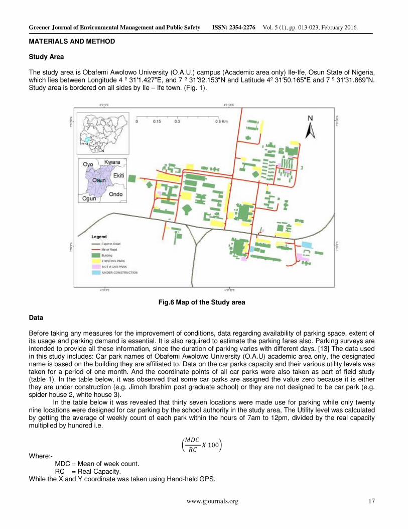
MATERIALS AND METHOD Study Area The study area is Obafemi Awolowo University (O.A.U.) campus (Academic area only) Ile-Ife, Osun State of Nigeria, which lies between Longitude 4 º 31′1.427″E, and 7 º 31′32.153″N and Latitude 4º 31′50.165″E and 7 º 31′31.869″N. Study area is bordered on all sides by Ile – Ife town. (Fig. 1).
Fig.6 Map of the Study area
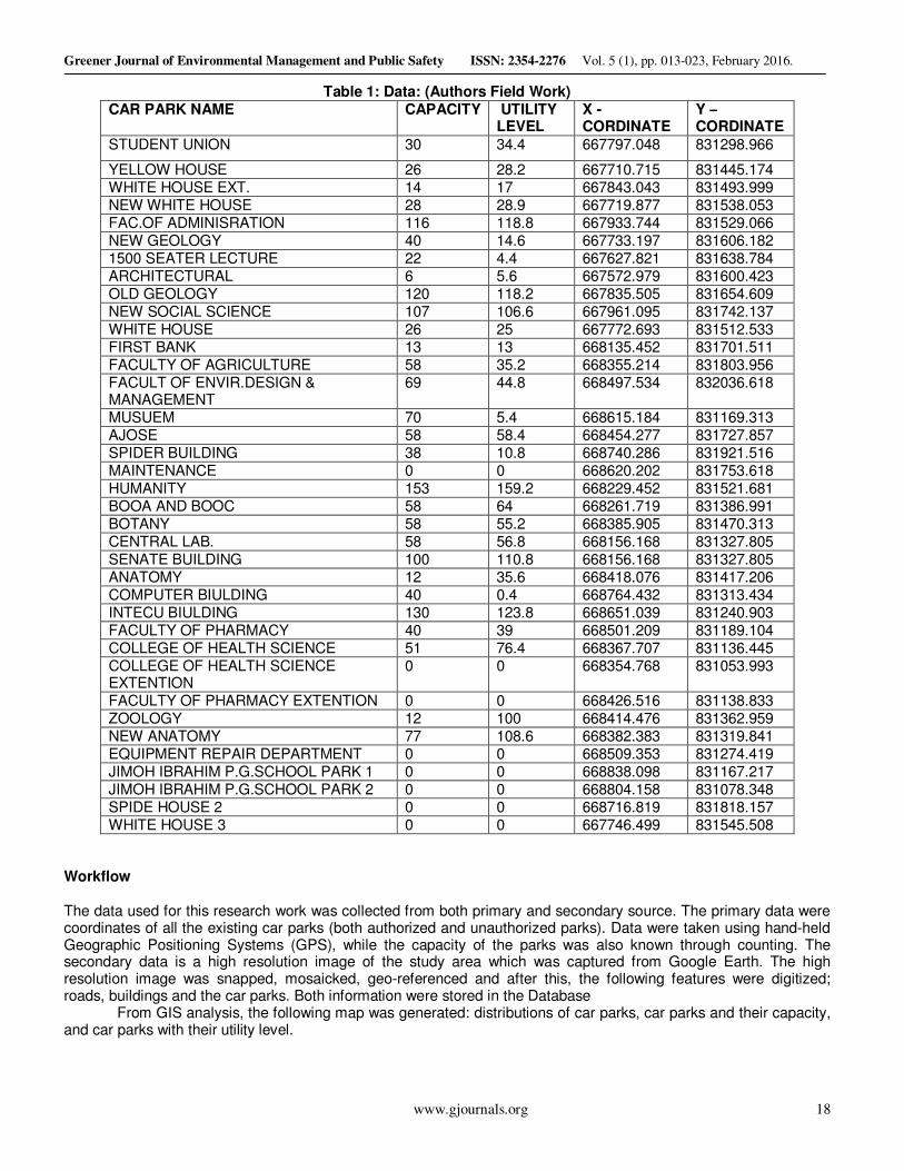
Data Before taking any measures for the improvement of conditions, data regarding availability of parking space, extent of its usage and parking demand is essential. It is also required to estimate the parking fares also. Parking surveys are intended to provide all these information, since the duration of parking varies with different days. [13] The data used in this study includes: Car park names of Obafemi Awolowo University (O.A.U) academic area only, the designated name is based on the building they are affiliated to. Data on the car parks capacity and their various utility levels was taken for a period of one month. And the coordinate points of all car parks were also taken as part of field study (table 1). In the table below, it was observed that some car parks are assigned the value zero because it is either they are under construction (e.g. Jimoh Ibrahim post graduate school) or they are not designed to be car park (e.g. spider house 2, white house 3).
In the table below it was revealed that thirty seven locations were made use for parking while only twenty nine locations were designed for car parking by the school authority in the study area, The Utility level was calculated by getting the average of weekly count of each park within the hours of 7am to 12pm, divided by the real capacity multiplied by hundred i.e.
���� �� � 100
Where:- MDC = Mean of week count. RC = Real Capacity. While the X and Y coordinate was taken using Hand-held GPS.
Greener Journal of Environmental Management and Public Safety ISSN: 2354-2276 Vol. 5 (1), pp. 013-023, February 2016.
www.gjournals.org 18
Table 1: Data: (Authors Field Work) CAR PARK NAME CAPACITY UTILITY
LEVEL X - CORDINATE
Y – CORDINATE
STUDENT UNION 30 34.4 667797.048 831298.966
YELLOW HOUSE 26 28.2 667710.715 831445.174 WHITE HOUSE EXT. 14 17 667843.043 831493.999 NEW WHITE HOUSE 28 28.9 667719.877 831538.053 FAC.OF ADMINISRATION 116 118.8 667933.744 831529.066 NEW GEOLOGY 40 14.6 667733.197 831606.182 1500 SEATER LECTURE 22 4.4 667627.821 831638.784 ARCHITECTURAL 6 5.6 667572.979 831600.423 OLD GEOLOGY 120 118.2 667835.505 831654.609 NEW SOCIAL SCIENCE 107 106.6 667961.095 831742.137 WHITE HOUSE 26 25 667772.693 831512.533 FIRST BANK 13 13 668135.452 831701.511 FACULTY OF AGRICULTURE 58 35.2 668355.214 831803.956 FACULT OF ENVIR.DESIGN & MANAGEMENT
69 44.8 668497.534 832036.618
MUSUEM 70 5.4 668615.184 831169.313 AJOSE 58 58.4 668454.277 831727.857 SPIDER BUILDING 38 10.8 668740.286 831921.516 MAINTENANCE 0 0 668620.202 831753.618 HUMANITY 153 159.2 668229.452 831521.681 BOOA AND BOOC 58 64 668261.719 831386.991 BOTANY 58 55.2 668385.905 831470.313 CENTRAL LAB. 58 56.8 668156.168 831327.805 SENATE BUILDING 100 110.8 668156.168 831327.805 ANATOMY 12 35.6 668418.076 831417.206 COMPUTER BIULDING 40 0.4 668764.432 831313.434 INTECU BIULDING 130 123.8 668651.039 831240.903 FACULTY OF PHARMACY 40 39 668501.209 831189.104 COLLEGE OF HEALTH SCIENCE 51 76.4 668367.707 831136.445 COLLEGE OF HEALTH SCIENCE EXTENTION
0 0 668354.768 831053.993
FACULTY OF PHARMACY EXTENTION 0 0 668426.516 831138.833 ZOOLOGY 12 100 668414.476 831362.959 NEW ANATOMY 77 108.6 668382.383 831319.841 EQUIPMENT REPAIR DEPARTMENT 0 0 668509.353 831274.419 JIMOH IBRAHIM P.G.SCHOOL PARK 1 0 0 668838.098 831167.217 JIMOH IBRAHIM P.G.SCHOOL PARK 2 0 0 668804.158 831078.348 SPIDE HOUSE 2 0 0 668716.819 831818.157 WHITE HOUSE 3 0 0 667746.499 831545.508
Workflow The data used for this research work was collected from both primary and secondary source. The primary data were coordinates of all the existing car parks (both authorized and unauthorized parks). Data were taken using hand-held Geographic Positioning Systems (GPS), while the capacity of the parks was also known through counting. The secondary data is a high resolution image of the study area which was captured from Google Earth. The high resolution image was snapped, mosaicked, geo-referenced and after this, the following features were digitized; roads, buildings and the car parks. Both information were stored in the Database
From GIS analysis, the following map was generated: distributions of car parks, car parks and their capacity, and car parks with their utility level.

Greener Journal of Environmental Management and Public Safety ISSN: 2354-2276 Vol. 5 (1), pp. 013-023, February 2016.
www.gjournals.org 19
Fig. 7: Flow chart of work study

Greener Journal of Environmental Management and Public Safety ISSN: 2354-2276 Vol. 5 (1), pp. 013-023, February 2016.
www.gjournals.org 20
RESULTS AND DISCUSSION
Fig. 8: Car parks and their names
In this map, all the car parks and their names were shown. It was observed that in the study area, (Academic area only) the school have twenty-nine authorized car parks; two are still under construction while six were unauthorized.
Fig. 9: Car parks and their capacity level

Greener Journal of Environmental Management and Public Safety ISSN: 2354-2276 Vol. 5 (1), pp. 013-023, February 2016.
www.gjournals.org 21
It was observed from this work that it is only one thousand five hundred and sixty-seven (1567) cars that can make use of the parks within the hours of 7:30am to 12:00 pm. It was also observed that department of Humanity car park has the largest car park capacity of one hundred and fifty-six (157) capacities while department of Architecture car park has the lowest of six capacities.
Fig. 10: Car park and their Utility level
It was observed in this study that almost 80% of all the car parks in the study area (Academic area only) were over-utilized i.e. (Administrative car park, Senate car park, Humanity car park etc.) While some were under-utilized i.e. (1500 Lecture theater car park, Spider Building car park, ICT Building car park etc. )
Fig. 11: Spatial Distribution Analysis of Car Parks
Greener Journal of Environmental Management and Public Safety ISSN: 2354-2276 Vol. 5 (1), pp. 013-023, February 2016.
www.gjournals.org 22
This analysis shows that the car parks within the study area are randomly distributed.
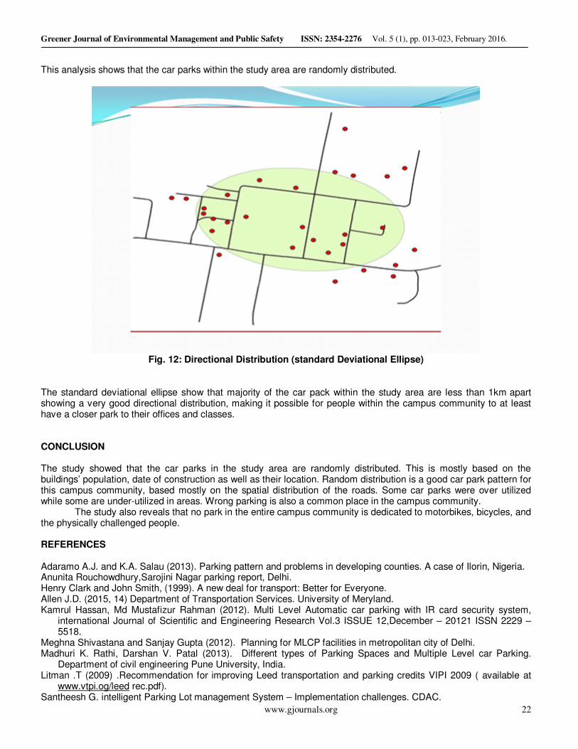
Fig. 12: Directional Distribution (standard Deviational Ellipse)
The standard deviational ellipse show that majority of the car pack within the study area are less than 1km
apart
showing a very good directional distribution, making it possible for people within the campus community to at least have a closer park to their offices and classes. CONCLUSION The study showed that the car parks in the study area are randomly distributed. This is mostly based on the buildings’ population, date of construction as well as their location. Random distribution is a good car park pattern for this campus community, based mostly on the spatial distribution of the roads. Some car parks were over utilized while some are under-utilized in areas. Wrong parking is also a common place in the campus community.
The study also reveals that no park in the entire campus community is dedicated to motorbikes, bicycles, and the physically challenged people. REFERENCES Adaramo A.J. and K.A. Salau (2013). Parking pattern and problems in developing counties. A case of Ilorin, Nigeria. Anunita Rouchowdhury,Sarojini Nagar parking report, Delhi. Henry Clark and John Smith, (1999). A new deal for transport: Better for Everyone. Allen J.D. (2015, 14) Department of Transportation Services. University of Meryland. Kamrul Hassan, Md Mustafizur Rahman (2012). Multi Level Automatic car parking with IR card security system,
international Journal of Scientific and Engineering Research Vol.3 ISSUE 12,December – 20121 ISSN 2229 – 5518.
Meghna Shivastana and Sanjay Gupta (2012). Planning for MLCP facilities in metropolitan city of Delhi. Madhuri K. Rathi, Darshan V. Patal (2013). Different types of Parking Spaces and Multiple Level car Parking.
Department of civil engineering Pune University, India. Litman .T (2009) .Recommendation for improving Leed transportation and parking credits VIPI 2009 ( available at
www.vtpi.og/leed rec.pdf). Santheesh G. intelligent Parking Lot management System – Implementation challenges. CDAC.
Greener Journal of Environmental Management and Public Safety ISSN: 2354-2276 Vol. 5 (1), pp. 013-023, February 2016.
www.gjournals.org 23
www.engineeringcivil.com 12th October 2015.
www.szdaily.com 13th October 2015.
Berry BJL, Horton F.E. (1970). Geographic Perspective on Urban system. Englewood Cliffs, NY, Prentice Hall. Rodrigue J.P. Comtois C, slack B. (2006). The Geography of transportation system. London; Rutledge. Olaniyan R.A. (1985). Ife University in colour: A Panorama of African’s most beautiful campus KNP Group Ltd, Redditch and London. Parking Solution – University of Illinois at Urbana Champaign sept.10, 2013. Yue, W.L. and Young W. (1993). “Good management minimum the conflicts in parking lots” Institute of Transportation Engineers. 63(3), 434 – 439. http://sf – streetsblog.org/2013/05/20/ advocates for the disabled say free parking for placard holders must end. Accessed August 22. 2013. Cite this Article: Olatunji, S.B. (2016). Geospatial Analysis of Car Parks’ Adequacy in Obafemi Awolowo University
Campus, Ile-Ife. Greener Journal of Environmental Management and Public Safety, 5(1):013-023, http://doi.org/10.15580/GJEMPS.2016.1.011916013.