issues paper · issues paper -shark bay terrestrial reserves & proposed terrestrial reserve...
TRANSCRIPT
Issues Paper
·shark Bay Terrestrial Reserves and Proposed Terrestrial Reserve Additions
Management Plan
October 2005
Issues Paper - Shark Bay Terrestrial Reserves & Proposed Terrestrial Reserve Additions
INTRODUCTION
The Conservation Corrimission of Western Australia (CCWA), through the agency of the Department of Conservation and Land Management (CALM) is now reviewing the management plan for the Shark Bay terrestrial reserves, as well as proposed terrestrial reserve additions identified in: • the Conservation Reserves for Western Australia Systems 9 report (EPA 197 5); • subsequent planning documents (e.g. Shark Bay Region Plan 1988, Shark Bay Regional Strategy
1997, Shark Bay Terrestrial Reserves Management Plan 2000, draft Shark Bay World Heritage Property Strategic Plan); and
• the 2015 pastoral lease exclusion for public purpose process (during this process, CALM has identified pastoral lands that would contribute towards a comprehensive, adequate and representative (CAR) reserve system' and provide for future sustainable tourism and recreation use, both terrestrial and marine.)
The Issues Paper highlights the values and m~in management issues of Shark Bay terrestrial reserves and proposed terrestrial reserve additions. These issues have been collected from meetings and workshops within CALM as well as preliminary discussions with key stakeholders. This paper has been prepared to inform and assist the public in participating in the management planning process.
Brief Overview
The Shark Bay Terrestrial Reserves Management Plan 2000-2009 was released in 2000. This Management Plan covers Francois Peron National Park, Shell Beach Conservation Park, Zuytdorp Nature Reserve, Bernier, Dorre and Koks Islands Nature Reserves, and other island nature reserves. The total area of Shark Bay's CALMmanaged terrestrial reserves is about 122 000 hectares. The parks and reserves of Shark Bay are part of CALM's. Shark Bay District. The proposed terrestrial reserve additions to be included in the new management plan include Nanga, part Murchison House, part Carrarang, part Tamala and Dirk Hartog Island pastoral leases.
Shark Bay was inscribed on the World Heritage List in December 1991 on the basis of having all four 'natural heritage' values. The four natural criteria at the time of listing were that a site contains: • outstanding examples representing the major stages of the earth's evolutionary history; or • outstanding examples representing significant ongoing geological processes, biological evolution and
. human interaction with the natural environment; or • superlative natural phenomena, formations or features (for example outstanding examples of the most
important ecosystems, areas of exceptional natural beauty or exceptional combinations of natural and cultural elements); or
• the most important and significant habitats where threatened species of animals and plants of outstanding universal value from the point of view of science and conservation still survive.
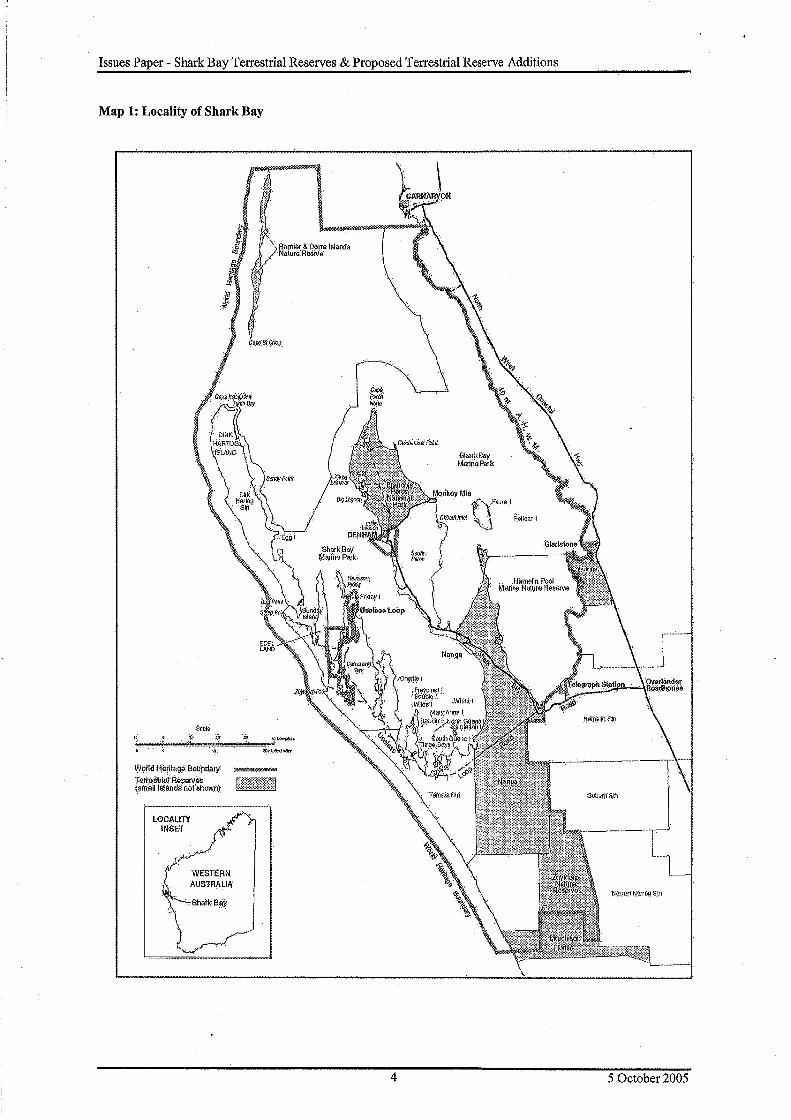
The Shark Bay World Heritage Property (SBWHP) (see Map 1) covers approximately 2.2 million hectares of land and water. The existing. terrestrial reserves covered by this management plan comprise about 5.6% of the World Heritage Property, or 19.5% of the terrestrial component.
Regional Context
Shark Bay is located on the westernmost point of Australia, about 800 km north of Perth (see Map 1). The population of the Shark Bay Shire is estimated to be 968 (source: Bureau of Statistics as at 30 June 2004) with Denham having approximately 840 and the privately operated mining town of Useless Loop having approximately 120. The regional centre of Camarvon has a population of approximately 6200. Tourist accommodation is provided at Camarvon, Denham, Monkey Mia, Nanga and Dirk Hartog Island, with camping available at Francois Peron National Park, Edel Land, Dirk Hartog Island and Tamala Station. A number of State and local Government and commercial services are provided at Denham and Camarvon. The surrounding marine and terrestrial environment of the Shark Bay area is an important recreational resource for residents of the area.
1 (see Establishment ofa Comprehensive, Adequate and Representative Terrestrial Conservation Reserve System in Western Australia on
NatureBase at http://www.naturebase.net/national parksfmanagementlindex.html).
2 5 October 2005
Issues Paper - Shark Bay Terrestrial Reserves & Proposed Terrestrial Reserve Additions
Shark Bay supports a range of industries and the region's economy is, in terms of value, largely based on fishing, tourism, salt production, shell mining, pastoral activities and aquaculture. Expansion of the salt mining operation is proposed and mineral sand mining exploration is occurring in an area adjacent to the World Heritage Property. Many of the region's existing and potential industries are dependent on maintaining the area's unique biological and geological values.
Planning Area
The planning area for the new terrestrial reserves management plan includes all existing and proposed terrestrial conservation reserves that occur within the Shark Bay World Heritage Property boundaries plus the northern part of Murchison House Station located north of the Emu proof fence (see Map 1).
·Shark Bay's existing terrestrial reserves classified as class A under the Land Administration Act 1997 comprise: • Bernier and Dorre Islands Nature Reserve (No. 24869), 9 719.8 ha, for the purpose of 'Conservation of
Flora and Fauna'; • Koks Island Nature Reserve (No. 33901), 2.6 ha, for the purpose of'Conservation of Flora and Fauna'; • Friday Island Nature Reserve (No. 33829), 0.8 ha, for the purpose of 'Conservation of Flora and Fauna'; • Charlie Island Nature Reserve (No. 33828), 0.9 ha, for the purpose of 'Conservation ofFlora and Fauna'; • Francois Peron National Park (No. 42471); 52 528.6 ha, for the purpose of 'national park'; • Shell Beach Conservation Park (No. 42443) 517.8 ha, for the purpose of 'conservation park'.
Shark Bay terrestrial reserves unclassified2 under the Land Administration Act 1997 comprise: • Zuytdorp Nature Reserve (No. 34771); 58 850 ha, for the purpose of 'Conservation of Flora and Fauna'; • Baudin, Double, Egg, Freycinet, Mary Anne, North Guano, Pelican, Salutation, South Guano, Sunday,
Three Bays, White & Wilde Islands Nature Reserve (Nb. 26004), total 205.6 ha, for the purpose of 'Conservation of Fauna and Collection of Guano'.
The proposed terrestrial reserve additions include: • former Nanga pastoral lease (176 408 ha) purchased in December 2000; • former part Murchison House pastoral lease (37 578 ha) purchased in August 2005; • former Dirk Hartog Island pastoral lease (61 438 ha) agreement to purchase in July 2005; • part Carrarang pastoral lease (18 772 ha); • part Tamala pastoral lease (56 343 ha); and • part South Peron unallocated Crown land (UCL), conservation area to be determined.
Although some of these purchases are yet to be finalised, their consideration in the management planning process will ensure an integrated and coordinated planning process. The appropriate tenure, vesting, purpose and boundary location of these proposed terrestrial reserve additions to best deliver biodiversity outcomes are issues to be addressed during the planning process. The naming of the proposed terrestrial reserve additions will also be addressed during the planning process.
Key Values
The key values associated with the Shark Bay terrestrial reserves and proposed terrestrial reserve additions include:
Nature Conservation • the most diverse and abundant examples of stromatolitic microbiolites in the world with analogous
structures the dominant benthic ecosystem on Earth for 3000 million years (a World Heritage natural value);
• a transition zone between major ecological provinces (both marine and terrestrial) and is of great scientific interest for the study of biogeography including the evolution and extinction of species, the effects of isolation, succession, diversity and other factors such as effects of steep environmental gradients (a World Heritage natural value);
• an area where the temperate climate of the southern part of Australia gives way to semi-desert climates and where a transition zone occurs between two major botanical provinces - the South West dominated by Eucalyptus species and the Eremaean dominated by Acacia species;
2 Reserves that, when created, were not classified as c.lass A under the Land Administration Act 1997
3 5 October 2005
Issues Paper - Shark Bay Terrestrial Reserves & Proposed Terrestrial Reserve Additions
Map 1: Locality of Shark Bay
Seate
li ... ii
Wor!tjJ:llirlt<tg" l'!Olind~ry: -T e.itoStri~.f Reserves (small Islands noflihoW(l)
\
--·-- - ··- ···-··-·-···-·-- ····-- .....
LOCALITY ~l ! INSET f '
!/"'7 WESTERN AUSTRALIA
.·.Sharl< Ba~
----=--J .-----1
L ...... I_ -~OIJ.l!J.i fi:!~TTOt.1.Sln
4 5 October 2005

Issues Paper - Shark Bay Terrestrial Reserves & Proposed Terrestrial Reserve Additions
• areas of exceptional coastal scenery, the largest seagrass meadow in the world, marine waters that are hypersaline with salinities almost twice that of seawater and the Wooramel Seagrass bank which is one of the few marine areas of the world dominated by carbonates (World Heritage natural values); and
• marine and terrestrial habitat for many species of plants and animals that are recorded as rare or threatened including: o on its islands, 5 of the 26 species of Australian mammals on the IUCN Red List of Threatened
Mammals (1988); o two threatened endemic land reptiles; o 35 species migratory birds that are protected by international agreements with a number of bird species
listed as threatened at the national level; o nesting populations of the green and loggerhead turtles, listed as endangered and vulnerable by IUCN; o many species of plants that are rare, threatened, little known, undescribed or endemic to the area with
25% of Shark Bay's flora at the end of its range at Shark Bay, representing 145 species of plant at their northern limit and 39 species at their southern limit.
Importantly theses habitats occur in the biogeographically significant transition zone between the southwest and arid zones (a World Heritage natural criterion).
Cultural • confinned evidence of Pleistocene occupation by Aboriginal people (18 000 to 30 000 years before present)
based on a marine economy; • over 80 known midden sites located in areas adjoining the coastline; • site of Lock Hospitals on Bernier and Dorre Islands; e presence of many registered sites protected areas under Aboriginal Heritage Act and listed on the Register
of the National Estate; • site of first European landfall in W estem Australia3 in 1616 and site of first physical evidence of European
landing in Australia; • site of studies and collections made by explorers representing some of the earliest records of Australia's
flora and fauna; • cultural heritage associated with the fishing, pastoral and mining (Guano) industries; • presence of several shipwreck sites; and • potential for some form of cooperative management between CALM and the Malgana and Nanda people,
the traditional owners for the majority of the planning area.
Recreation andTourism • terrestrial environments and proximity to marine environments that offer varied nature-based recreational
and tourism opportunities and experiences; • opportunities for viewing a diverse range of native marine and terrestrial flora and fauna; and • remote qualities of parts of the planning area.
Education and Community Involvement • opportunities for education and interpretation of World Heritage and other natural values to visitors; • opportunities for education and interpretation of cultural values, both indigenous and non-indigenous, to
visitors; • opportunities for education of visitors about the unique terrestrial and marine environments and for
community involvement with some unique wildlife; and • opportunities for visitors to interact and involvement with Malgana ·and Nanda people to gain an
understanding of indigenous culture.
Monitoring and Research • extensive research already undertaken and knowledge base of Shark Bay; and • opportunities for research and monitoring of unique natural and cultural values.
Economic • opportunities to establish and support existing tourism businesses based on the unique natural and cultural
values while avoiding harm to the environment or to local communities.
3 Willem Jansz in the Duytken landed on the western side of Cape York Peninsula in 1606.
5 5 October 2005
Issues Paper - Shark Bay Terrestrial Reserves & Proposed Terrestrial Reserve Additions
Public Participation
A Shark Bay Management Plan Advisory Committee is to be established to provide input from a cross-section of community and government organisations. Funding has been provided by CALM to undertake management planning in the area and a joint application for funding to develop a management plan for South Peron was successfully submitted to the Commonwealth government by the Department for Planning and Infrastructure (DPI), Shire of Shark Bay and CALM. Representatives from these organisations-will be involved in the planning process. In addition to conducting community workshops, community input will be further supported by regular consultation with members of the Shark Bay World Heritage Property Community Consultative and Scientific Advisory Committees as well as the Shires of Shark Bay and Carnarvon. Furthermore, there is a need to consult with the Commonwealth Government during the preparation of plans where the outcomes of the plan may affect World Heritage values, or the integrity of the World Heritage Property.
MANAGEMENT DIRECTIONS AND PURPOSE
Planning Framework
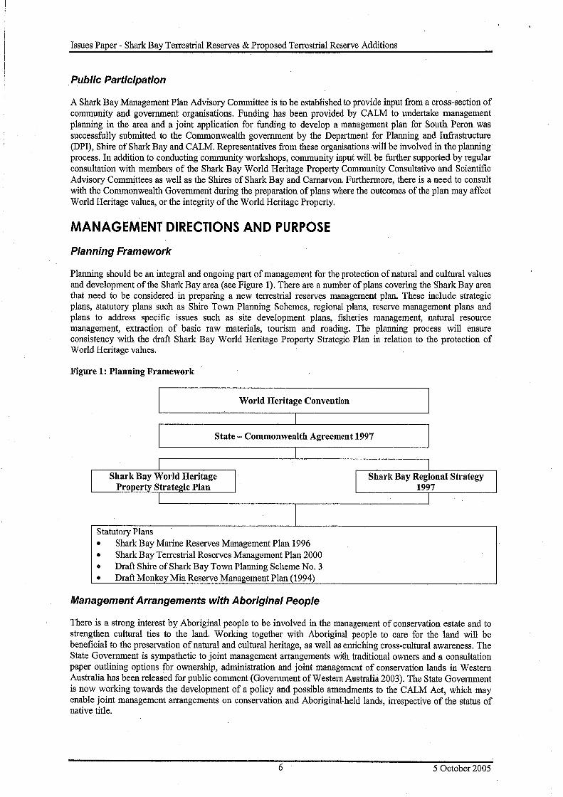
Planning should be an integral and ongoing part of management for the protection of natural and cultural values and development of the Shark Bay area (see Figure 1). There are a number of plans covering the Shark Bay area that need to be considered in preparing a new terrestrial reserves management plan. These include strategic plans, statutory plans such as Shire Town Planning Schemes, regional plans, reserve management plans and plans to address specific issues such as site development plans, fisheries management, natural resource management, extraction of basic raw materials, tourism and roading. The planning process will ensure consistency with the draft Shark Bay World Heritage Property Strategic Plan in relation to the protection of World Heritage values.
Figure 1: Planning Framework
I World Heritage Convention I
I
I State - Commonwealth Agreement 1997
I Shark Bay World Heritage
Property Strategic Plan I
Statutory Plans
I
I
• Shark Bay Marine Reserves Management Plan 1996 • Shark Bay Terrestrial Reserves Management Plan 2000 • Draft Shire ofSharkBayTownPlanning Scheme No. 3 • Draft Monkey Mia Reserve Management Plan (1994)
Management Arrangements with Aboriginal People
I
I Shark Bay Regional Strategy
1997 I
There is a strong interest by Aboriginal people to be involved in the management of conservation estate and to strengthen cultural ties to the land. Working together with Aboriginal people to care for the land will be beneficial to the preservation of natural and cultural heritage, as well as emiching cross-cultural awareness. The State Government is sympathetic to joint management arrangements with traditional owners and a consultation paper outlining options for ownership, administration and joint management of conservation lands in Western Australia has been released for public comment (Government of Western Australia 2003). The State Government is now working towards the development of a policy and possible amendments to the CALM Act, which may enable joint management arrangements on conservation and Aboriginal-held lands, irrespective of the status of native title.
6 5 October 2005
Issues Paper - Shark Bay Terrestrial Reserves & Proposed Terrestrial Reserve Additions
The common law of Australia recognises a form of native title that reflects the entitlemeQ.t of the indigenous inhabitants of Australia in accordance with their laws and customs, to their traditional lands. The rights of native title holders will depe~d on traditional laws, customs and cultural connections but may be affected by past dealings in land as well as existing tenures and uses, such as national park and marine park, private land, and pastoral use. Where relevant, the Native Title (NT) Act 199 3 will apply.
The Yamatji Marlpa Barna Baba Maaja Aboriginal Corporation is the representative Aboriginal body appointed under the Commonwealth's NT Act for the planning area. There are three active native title claims over the Shark Bay World Heritage Property: the Malgana Shark Bay People's Application (WC98/17) the Nanda People (WG6136/98) and the Gnulli (WC97/28). Two of these, Malgana and Nanda, are located within the planning area. Malgana and Nanda Native Title Working Groups have been established to deal with claims in the area but no native title determination has been made.
Proposed Tenure, Purpose, Vesting and Boundary Changes
Tenure provides the basis for management of lands and waters and Shark Bay's World Heritage values occur across several tenures. World Heritage listing does not alter tenure or take away ownership rights or control. Over much of Shark Bay, the World Heritage values can be effectively protected and managed with existing tenure and land use activities. However, changes in tenure may facilitate improved protection and management of World Heritage values in some areas. Economic and social values also need to be taken into account when tenure changes are considered.
MANAGING THE NATURAL ENVIRONMENT
· Biogeography
The planning area includes the boundary between the South-west and Eremaean Botanical Provinces, that is, the boundary between the more arid and temperate zones of Western Australia. The location of this botanical · transition zone has been the subject of considerable research and debate, and it is generally accepted that the transition zone is the boundaty between the Geraldton Sandplains and Camarvon bioregions. The Carnarvon bioregion is subdivided into the W ooramel and Cape Range subregions. Only the southern part of the W ooramel subregion occurs in the planning area. The Geraldton Sandplains is subdivided into the Edel, Geraldton Hills and Lesueur subregions. The whole of the Edel subregion and northern part of the Geraldton Hills subregion occurs in the planning area. The recommended level of reservation for each bioregion to create a CAR reserve system using nationally recognised standards is generally acknowledged as 15 % (CALM 2003).
Climate and Climate Change
Shark Bay has a semi-arid to arid climate, characterised by hot dry summers and mild winters. Average summer temperatures range from 20 to 35 degrees, and average winter temperatures range from 10 to 20 degrees. The average annual rainfall is low, ranging from 200 mm in the east to 400 mm in the west of Shark Bay. Most rain falls between May and July. The annual evaporation rate ranges from 3 000 mm in the east to 2 000 mm in the west. The Shark Bay environment is extremely saline.
Climate change presents an additional pressure for native species and ecosystems as well as exacerbating existing pressures such as habitat fragmentation/modification, competition by introduced species and altered fire regimes (IPCC 2001, cited in Western Australian Greenhouse Taskforce 2004). Whilst some species may increase in abundance or range, climate change will increase existing risks of extinction of some more vulnerable species and increase loss of biodiversity (IPCC 2001, cited in Western Australian Greenhouse Taskforce 2004). Within the Shark Bay World Heritage Property there are a number of native flora and fauna species and communities that are endemic or at or near the limits of their range and which are likely to be particularly vulnerable to climate change
Geology, Geomorphology and Soils
Geology The significance of the geology of the planning area contributed towards the nomination of Shark Bay as a World Heritage Property. The Shark Bay area is part of the Carnarvon Basin, a geological depression along the western and north-western coastline of Western Australia. It ranges in width from 50 to 300 km and is over 6000
7 5 October 2005

Issues Paper - Shark Bay Terrestrial Reserves & Proposed Terrestrial Reserve Additions
m thick and has two distinct layers: the Silurian sequence (4000 m) and the Devonian-Lower carboniferous sequence (2000 m) (Hocking et al. 1987). Within the Carnarvon Basin Shark Bay lies in the Gascoyne Subbasin, a north-south elongated, uplifted and gently west-wards tilted platfonn containing primarily Silurian and Devonian sediments with minor Carboniferous and Permian remnants (Hocking et al. 1987).
Playford (1990) described the surface geology of the Shark Bay area as being formed in the Quaternary (2 million years BP) from dunal and marine sediments and consisting of Pleistocene and Holocene limestone and sandstone. The five Pleistocene units are described as follows: • Peron Sandstone - a unit of red eolian sandstone exposed on Peron Peninsula; • Tamala Limestone - a succession of eolian limestones occurring on the Edel Land Peninsula; • Dampier Limestone - shelly limestone found on the shores of Hamelin Pool; • Depuch Formation - formed by the erosion and reworking of older Pleistocene units above and occurs as
narrow strips along the east side of Edel Land Peninsula; and • Bibra Limestone - beach-ridge deposits exposed along parts of the Shark Bay coastline (eg Hamelin Poo).
The Holocene units of sand, calcrete and beach deposits occur extensively throughout the Shark Bay area with the most interesting occurring around the shores of Hamelin Pool as stromatolites and Hamelin Coquina (Playford 1990, p. 21).
Geomorphology The unusual landforms of the reserves (and part of the World Heritage natural values) include the Zuytdorp Cliffs, Shell Beach and the birridas, lagoons and coastal cliffs of Peron Peninsula. Many of the coastal landforms are fragile and can be degraded by vehicle access, pedestrian use and grazing. Hocking et al. (1987) recognised three broad geomorphological zones in the Carnarvon Basin: coastal, transition and inland. The planning area is mostly located within the coastal zone with some parts in the inland zone. The three geomorphological regions in the planning area are: • Peron - characterised by stabilised, unconsolidated, red, quartzose sand dunes fixed by sclerophyllous scrub
and found on Peron and Nanga Peninsulas and Faure Island; • Edel - characterised by calcareous, unconsolidated dunes deposited over the Tamala Limestone and found
on Bernier, Dorre and Dirk Hartog Islands and Edel Land; and • Victoria Plateau - characterised by gently undulating sandplain with minor dunefields and found on areas
inland from the coast.
Soils Soil type will influence the amount of soil loss or movement, soil compaction, loss of vegetation, the potential intrusion of weeds and where developments may be situated. Typically, the soils of Shark Bay are sandy. There are four geomorphic districts across the planning area (Payne et al., 1987): • Carbla plateau - contains shallow, stony calcareous gradational soils, with large marine shells, Fragum
erugatum, common and occupies the thin strip of coast around Hamelin Bay; • Coastal dune - contains almost entirely uniform sandy and generally calcareous soils, and occupies the
western edge of Edel Peninsula and the islands to the north (Dirk Hartog, Dorre and Bernier); • Tamala limestone - soils range from brownish sands on undulating plains and sandplains, calcareous sands
on the coastal dunes and sandplains, shallow lithosols on low hills and stony plains, and shallow friable calcareous loams on stony plains and low rises adjacent to limestone outcrop and includes areas adjacent to the Zuytdorp cliffs and some coastal areas between Denham and Nanga station; and
• Victoria sand plain - soils include slightly coherent, earthy sands occur on the flat to undulating plains, loose siliceous or brownish sands on the broad undulating plains, calcareous sands on Peron Peninsula and are red or reddish-brown in colour, and deep, loose calcareous sands on the coastal dunes of Peron Peninsula; elliptical salt flats known as birridas form where freshwater seepage has brought dissolved gypsum to the surface and they contain saline and gypsiferous deposits of clay, silt and sand. Occupies most of the Peron Peninsula and southern inland Shark Bay area.
Hydrology and Catchment Protection
The Carnarvon Basin is generally lacking in permanent surface water due to low annual rainfall, high evaporation and permeable soil,· and, as a result, there are few surface water features in Shark Bay. There are some soaks scattered throughout the landscape and sink holes in the limestone cliffs along the coast are known to store water for short periods. Some localised freshwater springs exist on Peron Peninsula. Water from underground aquifers needs to be sustainable.
8 5 October 2005
Issues Paper - Shark Bay Terrestrial Reserves & Proposed Terrestrial Reserve Additions
The three main aquifers are the Windalia Radiolarite, the Birdrong Sandstone and the Kopke Sandstone. Wills and Dogramaci (2000) provide the following information on these three main aquifers: • Kopke Sandstone - known thickness up to 415 m and occurring at depths of between 300 to 500 m.
Salinities typically are TDS around 2000 to 3000 mg/L which is about one third of the salinity of the overlying Cretaceous aquifers;
• Windalia Radiolarite - known thickness of 15 m. The brackish water typically has a TDS of 4000 to 10 000 mg/L depending on locality; and
• Birdrong Sandstone - typically 20 to 30 m thick and intersected at depths between 200 (Hamelin Pool) and 450 m (Peron Peninsula). Salinity depends on location but varies between 3500 to 4500 mg/L TDS. Free flowing bores with flow rates of 4500 m3/day were numerous in the early stages of development but today flow rates do not exceed 1500 m3/day with the majority of pastoral bores flowing between 100-500 m3/day (DoE 2004). The estimated recharge to the aquifer is 17 x 106 m3 per year (DoE 2004) and in 2004 it was estimated that 22 x 106 m3 per year is lost from the aquifer due to uncontrolled and corroded bores coupled with inefficient bore drain systems (DoE 2004).
Native Plants and Vegetation Communities
The significance of the native flora of the planning area contributed towards the nomination of Shark Bay as a World Heritage Property. The planning area has flora of high significance, being located at the transition zone of two bota:nical provinces - the South West and Eremaean. As such many flora taxa are endemic to the area (3 7) or are located at the northern (53) or southern (13) limit of their geographical range. Vegetation on Peron Peninsula is mainly Eremaean and comprised of more arid-zone species such as desert Acacias, spinifex and samphire species. The South-West Botanical Province species are common on southern part ofNanga Station, the eastern parts of Tamala Station and Zuytdorp Nature Reserve and these areas are dominated by eucalypt, which are typical of wetter areas to the south. The transition zone is most evident on the southern parts of Nanga and Tamala Stations and on Edel Land and Dirk Hartog, Bernier and Dorre Islands (URS 2000).
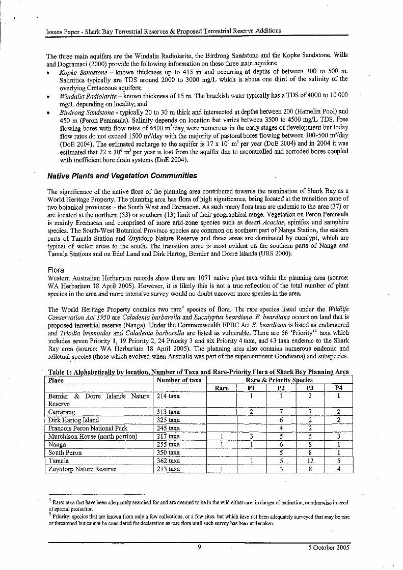
Flora Western Australian Herbarium records show there are 1071 native plant taxa within the planning area (source: WA Herbarium 18 April 2005). However, it is likely this is not a true reflection of the total number of plant species in the area and more intensive survey would no doubt uncover more species in the area.
The World Heritage Property contains two rare4 species of flora. The rare species listed under the Wildlife Conservation Act 1950 are Caladenia barbarella and Eucalyptus beardiana. E. beardiana occurs on land that is proposed terrestrial reserve (Nanga). Under the Commonwealth EPBC Act E. beardiana is listed as endangered and Triodia bromoides and Caladenia barbarella are listed as vulnerable. There are 56 'Priority' 5 taxa which includes seven Priority 1, 19 Priority 2, 24 Priority 3 and six Priority 4 taxa, and 43 taxa endemic to the Shark Bay area (source: WA Herbarium 18 April 2005). The planning area also contains numerous endemic and relictual species (those which evolved when Australia was part of the supercontinent Gondwana) and subspecies.
T bl 1 Al h b f II b I a e : IP a e 1ca IV •v ocatwn, N b fT um ero axaan dR P' · f are- nor1ty Flora o Shark Bav Planning; Area Place Number of taxa Rare & Priority Species
Rare Pl P2 P3 P4 Bernier & Dorre Islands Nature 214 taxa 1 1 2 1 Reserve Carrarang 313 taxa 2 7 7 2 Dirk Hartog Island 325 taxa 6 2 2 Francois Peron National Park 245 taxa 4 2 Murchison House (north portion) 217 taxa 1 3 5 5 3 Nanga 255 taxa 1 1 6 8 1 South Peron 350 taxa 5 8 1 Tamala 362 taxa 1 5 12 5 Zuytdorp Nature Reserve 213 taxa 1 3 8 4
4 Rare: taxa that have been adequately searched for and are deemed to be in the wild either rare, in danger of extinction, or otherwise in need of special protection 5 Priority: species that are known from only a few collections, or a few sites, but which have not been adequately surveyed that may be rare or threatened but cannot be considered for declaration as rare flora until such survey has been undertaken.
9 5 October 2005
Issues Paper - Shark Bay Terrestrial Reserves & Proposed Terrestrial Reserve Additions
Vegetation Associations Generally, two types of vegetation exist in the planning area: shrubland or grassland (steppe) or a combination of both. For the Shark Bay area, Beard (1976) determined there were five broad vegetation community types (low woodland, shrubland, steppe, succulent steppe and a mosaic unit) and seventeen vegetation associations, viz:
1. Low woodland of Eucalyptus oraria; 2. Tree heath with emergent low trees chiefly of Banksia ashbyi and Grevillea gordoniana; 3. Acacia ligulata x rostellifera thicket; 4. Acacia - Lamarchea thicket; 5. Melaleuca cardiophylla thicket; 6. Acacia ramulosa open scrub (Bowgada); 7. Scrub-heath of tall shrub layer and dense heath ground layer mainly ofMyrtaceae species; 8. Dwarf scrub of open low-shrub formation of small heath-type plants; 9. Wattle shrub of mainly Acacia ligulata x rostellifera shrubs with Triodia plurinervata dominant; 10. Wattle shrub Acacia ligulata x rostellifera with small shrubs in ground layer and Plectrachne species; 11. Dwarf-shrub ofMelaleuca cardiophylla and Thrytomene baeckiacea with spinifex grassland of Plectrachne
species; 12. Scattered shrubs of wattle and saltbush with succulent steppe (Atriplex); 13. Scattered shrubs of wattle, teatree and saltbush with succulent steppe (Atriplex); 14. Succulent steppe (Atriplex) accompanied by scattered shrubs of samphire (Arthrocneum species and
associates); 15. Heath with wattle thickets; 16. Scrub-heath with patches of Acacia-Melaleuca thickets; 17. Drift sand.
Native Animals
The significance of the native fauna of the planning area contributed towards the nomination of Shark Bay as a World Heritage Property. The planning area has a very high diversity of native fauna and is of considerable international, national and local zoological significance. Much of the fauna is also found at the end of their northern or southern ranges. The many peninsulas and islands have also protected numerous fauna species from disturbances that have occurred in other parts of the State. These areas support the only remaining populations of a number of native animals which were once widespread on mainland Australia. The planning area contains high diversities of mammals (33 species), birds (245 species) and reptiles (120 species). Amphibian diversity is low and there is only a limited understanding of the invertebrate species in Shark Bay. Dirk Hartog Island has been identified as a major ecological restoration site for native vegetation and fauna.
Reserves in the planning area also contain a number of threatened species of fauna. Seventeen species of fauna are listed as 'threatened' and three species as 'specially protected' under the Wildlife Conservation Act. Three species are listed as endangered and nine species as vulnerable under the Commonwealth EPBC Act. Finally, one species is listed internationally by the IUCN as critically endangered, three species as endangered, seven species as vulnerable and two species as near-threatened. Significant features of the native fauna include: • five of the nine mammals are listed as threatened under the Wildlife Conservation Act: boodie, banded hare
wallaby, rufous hare wallaby, western barred bandicoot and Shark Bay mouse; • sixty-seven birds are migratory and are protected under international agreements with Japan, China or under
the Bonn Convention; • under the Wildlife Conservation Act, six bird species listed as threatened (Shark Bay variegated fairy wren,
black and white fairy wren, Southern emu wren, Dirk Hartog Island rufous fieldwren and Dorre Island rufous fieldwren malleefowl), and one species as specially protected (peregrine falcon). One bird species (thick-billed grasswren) listed is listed as vulnerable under the Commonwealth EPBC Act;
• loggerhead turtle, Hawksbill turtle, the leatherback turtle, flatback turtle and the green turtle are all listed as threatened under the Wildlife Conservation Act;
• Baudin Island spiny-tailed skink, Western spiny-tailed skink and Hamelin ctenotus are listed as threatened under the Wildlife Conservation Act whilst the Ramsay's or woma python is specially protected; and
• high number and diversity of invertebrate species.
Ecological Communities
The planning area contains a range of terrestrial ecological communities which support a diverse fauna and flora. Knowledge of some ecological communities is limited although many appear fragile and sensitive to disturbance.
10 5 October 2005

Issues Paper - Shark Bay Terrestrial Reserves & Proposed Terrestrial Reserve Additions
Currently, there are no threatened ecological communities, as listed under the Commonwealth EPBC Act, in the planning area. However, a number of ecosystems have been identified as "at risk", including: reptile assemblages of islands, gulfs and peninsulas; and coastal heath communities at Steep Point (May & McKenzie 2003). The Shark Bay Regional Strategy recommends additional areas be set aside as conservation reserves to protect some of these terrestrial communities.
Some important ecological communities are not represented within the conservation reserve system. The Biodiversity of the southern Carnarvon Basin report identified several terrestrial ecological communities which should be added to the reserve system because of their high biodiversity values (McKenzie et al. 2000d): • temperate semi-arid sands containing coastal birridas immediately south of Shark Bay- from Nanga Station
to Zuytdorp Nature Reserve; • temperate arid and semi-arid sands and samphires containing coastal birridas - found on Francois Peron
National Park.and South Peron; • Edel Land dune systems containing coastal birridas - north-western Edel Land; • temperate mesic to semi-arid heaths and scrubs on sandplains - in proposed additions to Zuytdorp Nature
Reserve; and • temperate mesic specialists - in Zuytdorp Nature Reserve.
Environmental Weeds
There are 83 tax.a recorded as weeds within the planning area (source: WA Herbarium 18 April 2005). Weed numbers are low compared with other areas of Western Australia, where a total of 1032 species have been recorded and is probably because much of the original vegetation is still largely intact (Keighery et al. 2000). However, the number of weeds cited above includes only those weeds that have been collected and placed on the Herbarium database. This is unlikely to be a true reflection of the total number of weeds in each area.
The Environmental Weed Strategy for Western Australia (1999) (EWS) defines environmental weeds as plants that establish themselves in natural ecosystems and proceed to modify natural processes, usually adversely, resulting in decline of the communities they invade (CALM 1999). Environmental weeds have potential for serious impact on natural systems and nature conservation values through displacing native plants, particularly on disturbed sites, by competing with them for light, nutrients, water and space. These weeds can also have a significant adverse impact on other conservation values by altering animal habitats, harbouring pests and diseases, and increasing fire hazard.
The EWS rates environmental weeds as high, moderate, mild or low based on their potential invasiveness, distribution and environmental impacts. This rating provides the basis for identifying control priorities, with the highest rated species and species that pose a specific threat to conservation values within the World Heritage Property, being a focus for weed management. In the planning area there are 8 taxa rated as 'High' according to the EWS and 3 weeds declared under the Agricultural and Related Resources Protection Act 1976 (see Table 2).
Table 2: Declared weeds and introduced plant species rated as 'High' in EWS in the planning area
Common Name Taxa Acetosa vesicarius ruby dock Aerva javanica kapok bush Argemone ochroleuca * Mexican poppy Brassica tournefortii Mediterranean turnip Bromus diandrus greatbrome Cenchrus ciliaris buffel grass Cenchrus setigerus birdwood grass Echium plantagineum * Patersons curse Emex australis * doublegee Lupinus cosentinii sandplain lupin Lycium ferocissimum African box-thorn
'Declared species under the Agriculture and Related Resources Protection Act 1976 (as of June 2005).
11 5 October 2005
Issues Paper - Shark Bay Terrestrial Reserves & Proposed Terrestrial Reserve Additions
Introduced and other Problem Animals
Problem animals have potential for serious impact on natural systems and nature conservation values through direct effects such as predation, habitat destruction, competition for food and territory, introduction of disease, and through environmental degradation by selective grazing and accelerating erosion. Problem animals can be either native species that impact on natural and agricultural values or feral animals (introduced species that have become established as wild or naturalised populations).
The most significant introduced species in the planning area are the feral cat, fox, rabbit and goat. Significant control programs for foxes, cats, goats and rabbits are being implemented on the Peron Peninsula by the Department as part of Project Eden. On Peron Peninsula fox control with 1080 baits continues to be very successful. Since 1995 aerial baiting and ground control activities have significantly reduced the cat population but cat eradication has had limited success. Removal of cats whilst rabbits are still present has been problematic and is dependent, amongst other things, developing suitable baits that are more attractive to cats in a range of environments. Removal of stock (sheep and cattle) and feral goats from Peron Peninsula commenced in 1990. This has resulted in the removal of over 32 000 animals including the complete removal of sheep and cattle from the park and a reduction in goat numbers to very low numbers. The rabbit calicivirus was also introduced onto the Peron Peninsula in 1996 and again in 1998 but has had limited effect and although Myxomatosis was introduced in 1994 and is well established, rabbit numbers remain moderately high with regular seasonal fluctuations (CALM 2005).
A similar program to control foxes, cats and r~bbits is being implemented on Heirisson Prong by the Useless Loop Biosphere Community Group and CSIRO. Goats are both farmed and controlled on the pastoral stations in the World Heritage Property. Goats recently have been sighted on Bellefin Prong for the first time and are known to occupy land adjacent to the Zuytdorp Cliffs. Camels are possibly present in the Zuytdorp Nature Reserve and surrounding areas (CALM 2005). Dirk Hartog Island is significant for not having rabbits and foxes, although a single fox has been recorded on the Island in the past. Now that agreement to purchase Dirk Hartog Island has been reached, the removal of goats and cats from the Island is a high priority. Cats recently have been eradicated from Faure Island.
Diseases
Plant diseases No serious plant diseases are known to exist in Shark Bay. Western Australia's most damaging plant disease, Phytophthora dieback, is an introduced fungus of tropical origin with eight species or varieties but has limited distribution in the northern sandplains. Only one positive identification of Phytophthora (P. citricola) has been confirmed as far north as Kalbarri National Park with the sample taken on the southern boundary from a single plant. There is no evidence of other species being impacted by this infection and re-sampling of the site has not identified further infections. The heath vegetation of Zuytdorp Nature Reserve and neighbouring areas would be susceptible to dieback, though the risk is very low as the soils of the area are generally too dry to sustain the disease and vehicle access is limited.
Animal diseases Diseases in wildlife can be a major contributing factor to poor population health, reduced fertility and local extinctions. The discovery of symptoms of two diseases (one a type of Chlamydia and the other an unknown wart virus) (CALM 2002) in both wild and captive populations of the Western barred bandicoot has caused concern in relation to proposed translocation of this and other mammal species, and the well-being of the two surviving natural island populations of this species. Chytridiomycosis is an infectious disease affecting amphibians worldwide and caused by the amphibian chytrid fungus. This is a highly virulent fungal pathogen capable at the minimum of causing sporadic deaths in some frog populations and 100% mortality in other populations (DEH 2002). The fungus can spread in water and possibly in moist soil or on wet plants but cannot survive drying out, so probably cannot be spread in dry soil or wind dispersal (DEH 2002).
The possibility that pathogens may be transported with animals and trapping equipment or transferred direct to other species, needs to be addressed in planning captive breeding programs, fauna translocations and any future research and monitoring program.
12 5 October 2005
Issues Paper - Shark Bay Terrestrial Reserves & Proposed Terrestrial Reserve Additions
Fire
Fire naturally occurs in the semi-arid environment and has an important role in determining vegetation structure and composition. There is little known about the effect of fire on vegetation communities in the planning area. On pastoral leases vegetation structure has been modified by introducing non endemic grasses and grazing of native shrubs and this has probably altered natural fire regimes in parts of the planning area. Further knowledge on fire ecology and the requirements of native plant and animal species and communities is required.
There is only limited documentation of the fire history of the planning area. Whilst early explorers observed smoke on the mainland there is no evidence of burning on Dirk Hartog Island by Aboriginal people. Aerial photography and satellite imagery provide evidence of numerous small fires in the last 50 years around Shark Bay. in recent years many of the fires have resulted from human activities.
Biological indicators and other vital attributes of the biota (e.g. juvenile period of obligate seeders, habitat requirements of key fauna species) ·are used to help determine historic fire regimes. Fire regimes will need to be determined for the proposed terrestrial reserve additions. The development of fire management for biodiversity will be guided by key scientific principles developed by the Department and appropriate to the vegetation of the planning area.
Appropriate management of fire is essential, since some fire regimes could degrade the nature conservation values of the planning area. The Shark Bay Terrestrial Reserves Management Plan 2000-2009 (CALM 2000) addresses current fire management on some conservation reserves in the planning area. Under this plan, three burning regimes are applied to the reserves: no planned bum areas; prescribed bum buffers; and habitat management bums.
Particular communities within the planning area have special fire considerations. In spinifex-dominated communities found in South Peron, Edel Land and Dirk Hartog Island, fire management needs to be applied to maintain species diversity, but burning too frequently, or at the wrong time of year leading to large intense fires, can be detrimental to some communities. Spinifex will burn under most weather conditions but fire behaviour is particularly sensitive to wind strength and direction. In communities containing or dominated by buffel grass (South Peron and Dirk Hartog Island), regular wildfire events maintain buffel grass populations while suppressing or replacing native species. Buffel grass can bum readily, even when green (Tu 2002), and is capable of encouraging and carrying wildfires through communities that are not adapted to fire. This results in a change in the structure of the vegetation community and a reduction in species diversity (Dixon et al. 2001).
Within CALM fire management is guided by the Bush Fires Act 1954 and draft Policy 19 - Fire Management, which is currently being reviewed and was open for public comment in late 2004.
MANAGING OUR CULTURAL HERITAGE
Indigenous Heritage
The Shark Bay area was mainly associated with the Malgana and Nanda people. Tindale (1974) identifies the immediate Shark Bay area as being occupied by the Malgana people with the Nanda people occupying the land south of Preycinet Estuary to Kalbarri. ·
The primary responsibility for Aboriginal heritage management lies with the Department of Indigenous Affairs (DIA) under the Aboriginal Heritage Act 1972 in consultation with Aboriginal communities and individuals. Under the Act, it is an offence for anyone to alter in any way an Aboriginal site or object without the relevant Minister's permission. Aboriginal sites are recorded on the DIA database and protected under the Aboriginal Heritage Act with some sites listed on the Commonwealth Register of the National Estate. In the pursuit of best practice in cultural heritage management, it is important that both registers are consulted prior to undertaking any potentially damaging operations. In 1986 the area associated with the Lock Hospitals on Bernier and Dorre Islands were registered as protected areas under the Aboriginal Heritage Act and were also listed on the Register of the National Estate for their historic significance in 1987. These hospitals were established for indigenous patients suffering from venereal disease and operated from 1912 to 1917. Remnants of the hospital buildings and artefacts from this era still can be found on the islands.
13 5 October 2005
Issues Paper - Shark Bay Terrestrial Reserves & Proposed Terrestrial Reserve Additions
Aboriginal occupation across much of the WHP has been surveyed and currently there are about 130 Aboriginal heritage sites registered with the DIA (DIA 2005). Aboriginal sites including open shell middens, quarries, rock shelters, artefact shelters, burials and stone arrangements have been recorded at Shark Bay with most of these sites associated with the shoreline. As the register is not a comprehensive listing of all sites, assessments will be necessary prior to any operations where there is potential to inadvertently damage sites. Appropriate approvals under the Aboriginal Heritage Act are required to proceed with any works that may affect Indigenous heritage values.
Archaeological research has been conducted at several sites across the Shark Bay area and collections have been made from several of them including sites at Eagle Bluff, Monkey Mia and Silver Dollar (south of Denham) (Bowdler 1990a, 1990b, 1995) and a site at the Zuytdorp Cliffs near the Zuytdorp shipwreck (Morse 1988). The Silver Dollar site provides the oldest and most detailed evidence of human occupation of the region (Bowdler 1999). It was occupied for two periods, firstly between 30 000 and 18 000 years before present, and secondly between 7000 and 6000 years before present (Bowdler 1999). The rockshelter sites at Monkey Mia are dated to within the last 1000 years and the Eagle Bluff and Zuytdorp sites at 4000 to 4600 years before present (Bowdler 1999, Morse 1988).
A limited amount of information on the traditional life and customs of Aboriginal people is available from records of observations of early European navigators and settlers. Drawings made during the French scientific expeditions of 1801 depict semi-permanent Aboriginal camps on Peron Peninsula. Smoke was seen by navigators on Edel Land and the eastern shores of Shark Bay. Since the 1850s, Aboriginal people have been closely involved in the pearling, pastoral and fishing industries and by the early 1900s had integrated with the Chinese, Malay and British settlers. Aboriginal people today have a strong involvement in the fishing industry.
Non-Indigenous Heritage
The Shark Bay area has seven historic listed sites on the Australian Heritage database with five sites on the Register of the National Estate and one site listed as a nominated place on the National Heritage List. Shark Bay is of historical significance because: • it is the site of first European landfall in Western Australia and first location in Australia to contain physical
evidence of European landfall; · • it is the place where many studies and collections were made by explorers and therefore the place where
some of the earliest records of Australia's flora and fauna are represented; • it contains several shipwreck sites; and • it has non-indigenous cultural heritage associated with the fishing, pastoral and mining (guano) industries.
Shark Bay has a well documented, long history of visits by early European explorers. Dirk Hartog, aboard the Dutch trading ship the Eendracht, is the first known European to land on the West Australian coast6 and landed at Cape Inscription on Dirk Hartog Island in 1616 (Dept. of the Arts, Sports, the Environment, Tourism and Territories (DASETT) 1990), leaving behind a pewter plate, inscribed with a record of his visit, which remains the most tangible evidence of early European presence in Australia. The Cape Inscription area is a Nominated Place on the National Heritage List (DEH 2004) and remains of prime significance because it is the provenance of the oldest European monument recovered from Australian soil (Stanbury 1986). Many of Shark Bay's islands, bays and landmarks are named after these early explorers (DASETT 1990).
Dutch navigator Willem de Vlamingh visited Cape Inscription in 1697 aboard the Geelvink. Englishman William Dampier, on the HMS Roebuck, subsequently explored the area in 1699, landed at nearby Dampier's Landing and named the area "Shark's Bay" (Suba 1995). In 1772, Frenchman Louis St. Alouam landed at Cape Inscription at Turtle Bay, claiming Australia for France. Frenchmen Nicolas Baudin in the Naturaliste explored Shark Bay in 1801 and 1803. Louis De Freycinet established a camp on Peron Peninsula at Cape Lesueur in 1818 as part of a world scientific voyage in the Uranie (Suba, 1995, p4). British navigators Phillip King in the Bathurst visited the area in 1822 and George Grey in three whalers in 1839. Henry Denham in the HMS Herald made a comprehensive survey of the area in 1858.
The evidence of the survivors of a number of shipwrecks are of historic significance in the Shark Bay area including the Zuytdorp, a seventeenth century Dutch East Indiaman shipwrecked in 1712 and is located at the base of cliffs on the Edel Land Peninsula, and the whaler Perseverant, shipwrecked in 1841 near Cape Levillain
6 Willem Jansz landed on the western side of Cape York Peninsula in 1606.
14 5 October 2005
Issues Paper - Shark Bay Terrestrial Reserves & Proposed Terrestrial Reserve Additions
although the ship has yet to be located (WA Maritime Museum 2004). Numerous other shipwrecks have been recorded in the area but have yet to be located.
The commercial utilisation Shark Bay's natural resources provides a wealth of historic sites and material, much of which are yet to be accurately located and documented. Whaling occurred in Shark Bay as early as mid 19th century, (DASETT 1990 p. 94), guano was the first terrestrial industry in Shark Bay and initiated the area's colonial settlement in 1850 (Lefroy 1978), commercial pearling also developed in the 1850s (Lefroy 1978). The first pastoral leases were granted in the 1860s and sandalwood was first exported from the region in the 1890s (Edwards 1999, p. 291 and Suba 1995). Freshwater Camp, one of the few places to provide fresh water to pearlers, was declared the townsite of Denham in 1898 then officially gazetted in 1904 (Carmody 1970 p. 50-53). The fishing industry began in the early 1900s (Lefroy 1978).
MANAGING RECREATION AND TOURISM
Wilderness
The International Union for the Conservation of Nature (IUCN), now known as the World Conservation Union, defines wilderness as a: ' ... large area of unmodified or slightly modified land, and/or sea, retaining its natural character and influence, without permanent or significant habitation, which is protected and managed so as to preserve its natural condition'. The Australian Heritage Commission (now called the Australian Heritage Council) developed the National Wilderness Inventory (NWI) in 1986 following community concern over the decline in the area and quality of remote and natural land in Australia. The Commonwealth Department of the Environment and Heritage is the custodian of the NWI (now called the 'Australian Land Disturbance Database'). The NWI provides an index rating of wilderness quality from 0 to 20, with 20 being the highest quality based on the above four indicators.
The identification and management of wilderness areas is guided by CALM's Policy No. 62 - Identification and Management of Wilderness and Surrounding Areas. This policy incorporates the NWI criteria and specifies a NWI wilderness quality index of at least 12 and a minimum size of about 20 000 hectares in arid or semi-arid areas of the State. The policy does not place a limit on the number of areas or units of land that can be classified as wilderness areas across a tract of Crown land. The policy recognises that the criterion of a NWI wilderness quality index of 12 or above may be achieved over time by rehabilitation of past disturbances. The area encompassing Zuytdorp Nature Reserve and the former pastoral leases of part Murchison House, part Tamala and the southern part ofNanga are remote, with limited access and meets 'wilderness' criteria.
Landscape
Visual landscape management is important in a relatively unspoilt natural environment such as Shark Bay. One of the key World Heritage listing criteria met by Shark Bay is that it contains "exceptional natural beauty". The special landscape features can be seen at Zuytdorp cliffs, Shell Beach, Peron Peninsula and Nanga Peninsula coastlines, Big Lagoon, the birridas and seasonal wildflower displays. These landscapes are a vital component of people's enjoyment of the natural environment, with a strong influence on their sense of place and quality of life. Landscape values need to be identified, understood, assessed, mapped and the potential impacts on these values sensitively managed.
CALM has completed a landscape study of the Shark Bay WHP that identifies the aesthetic values of Shark Bay and establishes objectives and guidelines for managing these values. The study applied seven main assessment criteria: inventory, landscape character, community perception and value, significant features, community use, sensory characteristics and landscape classes. Developments across the WRP by agencies and private operators need to recognise the outstanding landscape character of the place and ensure that developments have minimal impact on the landscape character.
Visitor Opportunities
CALM's Recreation and Tourism Strategy (1996) incorporates principles for ecological sustainability, visitor safety, providing equity for use of conservation estate, providing the spectrum of visitor opportunities, enriching visitor experiences and being accountable for the services and facilities provided. The Strategy is complemented by CALM's proposed Policy No. 18 Recreation, Tourism and Visitor Services (subject to final consultation)
15 5 October 2005
Issues Paper - Shark Bay Terrestrial Reserves & Proposed Terrestrial Reserve Additions
which provides operational and administrative guidelines for the management of recreation and tourism · activities.
Shark Bay is a popular and important destination of the State for nature-based tourism, particularly wildlife viewing experiences. The SBWHP has unique universal natural values, a combination of which is rarely found elsewhere in the world. The natural attributes and unspoiled environment are the principal qualities that appeal to residents and visitors to Shark Bay. The Management Plan will provide a framework for the development of visitor facilities and interpretation. The Plan will provide for a range of recreation and tourism opportunities that
·facilitate appreciation of the natural values of the region. The planning process will consider management that maintains and enhances the characteristics of sites in a statewide context.
Visitor numbers and trends
Due to the climate, and lack of water and shade in the Shark Bay area, most visitation occurs in the cooler winter months, although increasing use is being recorded during the hotter months especially by European visitors.
Visitor statistics are collected from a number of sites across the planning area. Visitor numbers to Monkey Mia have remained static at about 100 000 per annum for several years (92 000 in 2004-05). However, the Monkey Mia Resort has plans to expand capacity of the accommodation and this could lead to an increase in visitor numbers at this site. Shell Beach had an estimated 64 000 visitors in 2004-05 and will continue to attract a large proportion of visitors because of its close proximity to the main access route into Denham. Visitor numbers in Francois Peron National Park have slowly increased as access and facilities have improved, especially at Peron Homestead (about 46 000 in 2004-05) and around Cape Peron.
Access to Edel Land and Nanga Peninsula is by 4WD but only a limited number of camping sites are available. 4WD access and limited camp sites to the northern parts ofNanga Peninsula will ensure visitor numbers remain low. About 4500 persons visit the Steep Point area per annum and many of these visitors camp for several days. A single car barge service is proviged for visitors to take their 4WD vehicles onto Dirk Hartog Island, otherwise access is by boat. Visitors to the Island stay for several days but access is available for only 9 months of the year and limited to 10 vehicles per day. ·
Visitor Access
Under section 62 of the CALM Act, lands and waters may be classified as "prohibited areas", "limited access" or any other classification to prescribe conditions of use (e.g. day or overnight use) for the protection of natural and cultural values. Several islands and parts of the planning area may warrant access restrictions to protect nature conservation values. ·
Many of the vehicle access tracks across the SBWHP have developed on an unplanned basis over many years, which has led to access that is poorly located, in poor condition, difficult to maintain, difficult to rehabilitate and unsuitable for recreation and conservation purposes. A sealed road connects Denham, Monkey Mia and Nanga to the North West Coastal Highway and there is an unsealed and formed road to Useless Loop. Most visitors to Shark Bay travel in 2WD vehicles and there is increasing demand to provide more 2WD access. However many parts of the planning area remain only accessible by 4WD vehicle including areas of the proposed terrestrial reserve additions such as Steep Point, Nanga peninsula and Dirk Hartog Island.
A range of walk trails of varying distance and duration is required to meet the needs and enhance the experience of visitors. Due to the climatic conditions of the area, lack of surface water and isolation, care will need to be taken in designing and locating walk trails.
Currently camel rides are provided from Monkey Mia but access using horses does not occur. Access to reserves using horses or camels will need to be managed in accordance with legislative and policy requirements.
Many parts of the marine area are accessible from land. Conversely many of the islands and large areas of coast are accessible by boat. Although boating generally has little impact on the physical environment, areas of land where visitors camp and launch their boats can become degraded. Additionally, boating can disturb fauna at some locations and at some times of the year such as breeding seasons and may conflict with other visitors. These issues will need to be considered when designing and locating boat access points and managing boating activities. Camarvon, Denham and Monkey Mia have fishing, charter, and recreational boating jetty facilities and a ship loading facility is located at Useless Loop.
16 5 October 2005
Issues Paper - Shark Bay Terrestrial Reserves & Proposed Terrestrial Reserve Additions
Airports exist at Denham and Camarvon with regular air services connecting Carnarvon and Denham/Monkey Mia to Perth and Geraldton. There are unsealed airstrips at Useless Loop, Nanga and on pastoral and former pastoral leases. Such airstrips will need to be adequately maintained to meet air safety standards before they can be used by park management or the public.
Visitor Activities
Some of the more active existing recreational use is adversely impacting on World Heritage values (e.g. use of the coast for remote four-wheel-driving, camping and fishing is degrading coastal landforms) and some activities require formal visitor risk management assessment (e.g. rock fishing). It is essential visitor sites and activities are designed, controlled and managed to prevent degradation of coastal features and other values of the Property.
The baseline user survey conducted in 1993 found that the most popular land-based activities for visitors were viewing the Monkey Mia dolphins (73.9%), sightseeing (62.2%), photography (57.8%), picnicking or barbecuing (49.6%), bushwalking (42%), shore-based fishing (40%), camping (40%), birdwatching (36%) and four wheel driving (36%). For residents the three most popular activities undertaken were four wheel driving (60%), picnicking or barbecuing (60%) and viewing the Monkey Mia dolphins (58%). Surveys of visitors at Monkey Mia in more recent times have not found many differences in the rating of such activities and dolphin viewing remains the most popular activity.
Visitor Accommodation - staying overnight
The Shark Bay area offers, a range of accommodation and camping opportunities including: • built accommodation in Denham, Nanga and Monkey Mia; • · caravan parks in Denham, Nanga, Monkey Mia and Hamelin Pool; • homestead accommodation at Dirk Hartog Island and Hamelin Pool; • basic camping in remote areas such as Peron Penirisula, Nanga Peninsula and Edel Land; and • potential for safari-type accommodation at various sites.
Camping Coastal camping is currently managed by CALM at various designated sites in Francois Peron National Park and at Petit Point on Nanga. National park camping facilities are unsophisticated and are being developed in accordance with the Recreation Development Plan outlined in the Shark Bay Terrestrial Reserves Management Plan (2000). National park camping sites have 4WD vehicle access, basic toilets, and gas barbecues. Camping also occurs on coastal areas of Carrarang and Tamala Stations, Dirk Hartog Island and South Peron under a variety of arrangements. The proposed Management Plan will provide development guidelines to ensure protection of nature conservation values and avoid duplication of services and facilities.
Built accommodation Built accommodation on CALM-managed lands is generally provided by way. of a concession with a private operator although there may be instances where remoteness, seasonality or other factors make it necessary for CALM to provide the built accommodation. Currently, built accommodation is provided only at Peron Homestead in Francois Peron National Park for special interest user groups. The terrestrial reserves management plan released in 2000 identified the potential for a safari camp in the park. Accommodation such as motels, hotels and caravan parks is provided in the vicinity but outside the CALM-managed lands.
Visitor Fees
Visitor fees include camping, entry fees, fees for permits or fees for services (e.g. guided tours). The Department currently applies a 'user-pays' policy through a system of commercial concessions and the collection of visitor fees. All fees collected are retained by CALM to assist in conserving and managing parks and reserves, including the improvement of visitor services and facilities and protection of nature conservation and cultural values. Within the planning area, fees are collected by CALM for camping in Francois Peron National Park, use of accommodation facilities at Peron Homestead, commercial concessions and entry to Francois Peron National Park and Monkey Mia. ·currently, the entry fee for Monkey Mia is set by and collected under a Local Government bylaw.
17 5 October 2005

Issues Paper - Shark Bay Terrestrial Reserves & Proposed Terrestrial Reserve Additions
Across the Shark Bay area, camping fees have been collected by pastoral lease holders including Dirk Hartog Island, Carrarang and Tamala as well as the Shire of Shark Bay. For many years the lessee of Carrarang station has employed a 'Ranger' to collect camping fees from visitors to help offset the costs of managing the area and visitors. The fees collected have supplemented the salary of the 'Ranger'. With Edel Land to be established as a national park, these arrangements will need to be reviewed.
Visitor safety
The Department has a moral and legal responsibility to provide for the safety of visitors on CALM-managed lands, however there is inherent risk associated with a visit to natural environments. All reasonable efforts need to be taken to minimise risk to visitors, consistent with CALM Policy No. 53 Visitor Risk Management and management practices that aim to minimise risk to visitors whilst retaining the natural attraction of recreation areas. Factois that contribute to visitor risk in Shark Bay include climate (e.g. dehydration and sun exposure), hazardous terrain (e.g. cliffs along the Zuytdorp coast and sandy soils), hazardous water (e.g. injury froth animal life) and remoteness (e.g. person lost or injured, bogged or broken down vehicle).
Commercial Operations
A commercial concession is a right granted by way of lease, licence or permit for occupation or use of part of an area of CALM-managed land for the purposes of providing appropriate facilities and services for visitors' use and enjoyment. All commercial visitor services operating on CALM-managed lands must have a licence or lease issued by CALM.
Leases are issued when the activity involves significant infrastructure and/or retailing and requires the exclusive use of the land. Currently in the planning area there are no leases issued over areas of terrestrial CALM-managed lands although there is the potential to offer leases to manage some operations.
Licences are issued to facilitate the entry and use of CALM-managed lands and waters and generally do not involve substantial structures. Licensed activities include nature-based tours (such as safari tours, adventure tours, boat tours or charters, diving charters, wildflower tours) and minor retail outlets (such as mobile kiosks). There are two types of commercial licence available. T Class licences are issued for activities where it is not necessary to restrict the number of licences whilst E Class licences are issued where it is necessary to restrict the number of licences for environmental management and/or visitor safety reasons. The period of a licence will vary according to several criteria. There are many licensed commercial tour operators that use CALM-managed lands in the Shark Bay area to conduct a variety of tours. Operators are based locally, intrastate and interstate.
Domestic Animals
Domestic animals are not permitted in national parks or conservation parks, except in specifically identified areas, where dogs are required for use by the disabled or for emergency (search and rescue) purposes. Dogs on a lead may be allowed on other categories of reserve according to a management plan for that reserve. Domestic animals are not permitted on nature reserves. Impacts from domestic animals can include interference with wildlife, fouling of visitor areas, unpredictable behaviour and the associated safety risks to visitors and environmental impacts.
Some parts of the Shark Bay area are baited to control cats and foxes. There may be dangers to pets arising from baiting operations and therefore baited areas are signed advising people of the dangers posed by the laying of baits. A local policy has been developed to encourage local people to assist in managing pet cats including sterilisation and microchip identification.
MANAGING SUSTAINABLE RESOURCE USE
Indigenous Resource Use
The hunting and gathering of food by Aboriginal people is an important part of their culture enabling them to maintain traditional Aboriginal relationships with the land and water, share knowledge and partake in traditional practices. Under section 23 of the Wildlife Conservation Act and with the prior consent of the occupier of the land (Executive Director of CALM), Aboriginal people may take flora and fauna for food from all land except a nature reserve or wildlife sanctuary. Food taken may only be sufficient for a person and family but is not to be
18 5 October 2005
Issues Paper - Shark Bay Terrestrial Reserves & Proposed Terrestrial Reserve Additions
sold. General provisions of the CALM Act and Wildlife Conservation Act apply to Aboriginal activities, for instance, firearms niay not be carried on a reserve.
Access for Commercial Fishing and Aquaculture
Commercial fishing is a major industry in Shark Bay and important· economically and socially. It was worth approximately $29M for the year 2003 and employs 1000 people in the region (Penn et al. 2005).
The Department of Fisheries is committed to having an ecologically sustainable fish industry. Likewise, commercial fishing needs to ensure that operations do not degrade World Heritage values. The Shark Bay World Heritage Property: Management Paper for Fish Resources (1996) addresses potential impacts on World Heritage values by fisheries activities and recommends appropriate strategies to maintain these values.
There is increasing interest in establishing land bases for aquaculture and using artesian w.ater for aquaculture operations. Such proposals will be assessed by applying existing assessment processes. Such operations are inappropriate on terrestrial reserves. Access through terrestrial reserves and proposed terrestrial reserve additions is important for the continued operation of commercial fishing, especially through Francois Peron National Park. In Edel Land, roads are used by commercial beach seiners whilst commercial abalone fishermen use the tracks through Tamala Station and Zuytdorp Nature Reserve to access offshore reefs.
Mineral and Petroleum Exploration and Mining
Current State Government policy allows exploration and mining in terrestrial and marine conservation areas in accordance with the Mining Act 1978, Petroleum Act 1967, Petroleum Pipelines Act 1969 and Petroleum (Submerged Lands) Act 1982. In national parks, current Government policy indicates that they are not available for new mining7 and petroleum tenements, except in the case of applications lodged before February 2001. The granting of a mining lease (or general purpose lease associated with mining operations) within a national park requires the consent of both Houses of Parliament. Where given, Parliamentary approval may involve the imposition of conditions. Conservation parks do not have the same level of security as national parks under the Mining Act. Should government policy change over the life of the plan, Departmental responses to proposed mining and petroleum developments relevant to the park will be in accordance with Conservation Commission and Government policies applicable at the time. Guidance on mineral exploration and mining on conservation . reserves is provided by the publication Guidelines for Mineral Exploration and Mining within Conservation Reserves and other Environmentally Sensitive Lands in Western Australia ( 1998).
The 1997 State-Commonwealth Agreement on Administrative Arrangements for the Shark Bay World Heritage Property provided for the continuation of existing commercial activities, including mining, as long as they complied with existing controls and was not a threat to the World Heritage values or overall integrity of the Property. On this basis, existing operations have been allowed to continue, subject to compliance with relevant conditions and ongoing monitoring. Other development proposals likely to have a significant effect on the environment of the Property are required to be assessed by the Environmental Protection Authority.
Mineral tenements (and applications for mining leases and exploration licenses) present within or adjacent to the planning area include those for gypsum, mineral sands, shell coquina and salt. Applications are currently active to evaluate mineral sands extraction in an area adjacent to the southern part of the World Heritage Property.
Shell deposits (Fragum erugatum) are extracted from a mining lease and a quarry on Reserve 41076 adjacent to Shell Beach Conservation Park and Nanga. The shell deposits are used primarily for the production of high quality extender and filler material as well as granulated shell for the poultry industry, which aids in egg production and hardening of shells. Some research on the biology of this species has been undertaken to determine the potential shell accretion rates for L'haridon Bight.
Coquinite (consolidated Fragum ·shell) is extracted from a quarry reserve near the Hamelin Pool Telegraph Station. This resource is limited, and as such, must be carefully managed. Coquinite has been traditionally used in the construction of buildings, many of which have heritage value. The Shire of Shark Bay manages this area in accordance with the Hamelin Pool Common Management Plan (2001 ).
7 As defined in the Mining Act - ie includes prospecting and exploring for minerals as well as actual mining operations.
19 5 October 2005
Issues Paper - Shark Bay Terrestrial Reserves & Proposed Terrestrial Reserve Additions
Salt production has occurred at Useless Loop and Useless Inlet since 1965. The salt operation is excluded from the World Heritage Property and is managed in accordance with the Shark Bay Solar Salt Industry Agreement Act 1983, an agreement between the State and the Shark Bay Salt joint venture,
There have not been any active petroleum tenements in the Shark Bay area for over 25 years. However, one petroleum exploration tenement currently exists in the World Heritage Property and extends from Bernier and Dorre Islands to the Carnarvon Coast. No field exploration activity has occurred within this tenement. A section 16(e) report by the Environmental Protection Authority has been completed for petroleum exploration and extraction within the World Heritage Property.
Basic Raw Materials
Access to basic raw materials (BRM) is covered under the Mining Act 1978 for activities on land and is not permitted in class 'A' reserves unless approved by both Houses of Parliament. There are several issues associated with the extraction of BRM: • extraction of BRM has the potential to impact on World Heritage and nature conservation values, especially
the visual landscape; · • a process for ensuring World Heritage and nature conservation values are not adversely impacted is
required; • BMR sites require appropriate and adequate rehabilitation; and • a strategic approach to resource availability and demand is required.
BRM within the Shark Bay area are used for construction purposes and include gravel, sand; limestone, gypsum and shell grit/coquina. Any construction or expansion projects requiring BRM will find sourcing quality BRM increasingly difficult or be required to transport material increasing distances. Within CALM-managed lands BRM is needed for road and recreation site construction and maintenance. In the planning area BRM requirements will need to be catered for and ideally sites containing suitable BRM for future construction purposes should be identified and set aside before the proposed terrestrial reserves are vested.
Access to gravel from national parks and conservation parks is only considered where: • the road or facility requiring gravel is within park boundaries or road reserves; • the road is required for the management and protection of the estate; • where pits have been kept open for this purpose; • the environmental cost to the conservation estate on balance is neutral; and • there is no acceptable alternative.
Rehabilitation
CALM Policy No. 10 Rehabilitation of Disturbed Land provides guidelines for implementing best practice rehabilitation. Several used and abandoned BRM sites have not received adequate or appropriate rehabilitation. Appropriate methods for rehabilitating used BRM pits can minimise environmental impacts and visual amenity. Uncontrolled vehicle access has created numerous tracks. Provision of services such as communication cabling and airstrips can cause visual degradation, especially in areas adjacent to main access roads. In arid environments, rehabilitation of tracks and areas containing services is difficult because of the terrain and vegetation type and takes a considerable amount of time because of slow growth rate of vegetation.
Pollution
There are no known point sources of pollution within the Shark Bay area. However, a range of potential pollution sources exist which could impact on World Heritage and nature conservation values. Although many of these will have greater impact on the marine environment, there will some associated impact on the adjacent terrestrial estate. Potential sources of pollution include: • atmospheric pollution, for example dust and fire; • marine pollution, for example, fuel and oil spills, littering (especially plastics and fishing line), bilge and
ballast discharge from ships, and sewage; • chemical, nutrient, or exotic biota pollution from existing services and industries, such as sewerage
treatment, salt mining and aquaculture, and associated shipping activities; • land pollution, for example littering, landfill sites and urban, industrial and agricultural pollution;
20 5 October 2005

Issues Paper - Shark Bay Terrestrial Reserves & Proposed Terrestrial Reserve Additions
• groundwater pollution, for example, seepage from septics, and nutrients and chemicals from agricultural activities; and
• noise pollution.
Public Utilities and Services
Services and infrastructure, such as roads, accommodation/housing, electricity, water, waste disposal, tourism developments, and communications are necessary to service the towns, pastoral stations and industries within and adjacent to the planning area. Groundwater from the Carnarvon Artesian Basin aquifer provides an important water resource for the settlements of Denham, Useless Loop, Monkey Mia and Nanga, and the pastoral leases adjacent to the planning area. Any extraction above a sustainable or rechargeable level may have an impact on this resource and the nature conservation values of the planning area.
The provision of new services and infrastructure has the potential to impact on the nature conservation and cultural values of the planning area, depending on their location and type. Such impacts may include the clearing of vegetation, introduction of weeds, visual impacts and the destruction of important habitats. To ensure that infrastructure does not cause these impacts it is important that there is a process of environmental assessment, which will require consideration in the management planning process.
INVOLVING THE COMMUNITY
Community Information, Interpretation and Education
Community education and participation in management is an important means of generating community understanding and support for the values and management of terrestrial reserves and proposed terrestrial reserve additions. Education and participation in management is not limited to the local community but also includes the national and international community that visit the Shark Bay area. The programs and activities consist of: • Information - providing basic data about the reserves, eg. access, facilities, attractions, activities,
regulations, code of care and cost; • Interpretation - explaining and enhancing appreciation of the natural and cultural features; and • Education - providing resource materials, presentations, organised field activities and other programs
designed to facilitate learning (particularly school groups and visitors with special interests).
Information, interpretation and education enable visitors (local, State, national and international) to: • plan their visit to the parks and reserves; • find their way to specific features and attractions; • understand the type of behaviour and actions that are appropriate in parks and reserves; and • learn about, appreciate and value the natural environment they are experiencing.
Currently CALM provides information on its activities and services through a variety of media: • signs, both directional and regulatory, to guide visitor movements and ensure appropriate behaviour; • printed material such as books, brochures (e.g. Francois Peron National Park) and pamphlets and including
specific information about World Heritage values (e.g WH Notes) and Project Eden information; • interpretive display material at Monkey Mia and Peron Homestead visitor centres; • information on the NatureBase webpage; • interpretation signs provided at recreation sites such as Skip Jack Point, Peron Homestead, Eagle Bluff; • daily guided activity programs at Monkey Mia and additional programs provided at Monkey Mia and Peron
Homestead during school holiday periods; and • personal contact with rangers or other staff.
The Communications Strategy (2002) aims to develop communications for the SBWHP which meet conservation and environmental objectives, as well as community aspirations (social' and economic) for the area, and which enhance visitor experience and satisfaction. The complementary Interpretation Action Plan (2003) aims to guide development of interpretation products across the SBWHP and coordinate the efforts of the various agencies and bodies who are undertaking interpretive activities in the area.
21 5 October 2005

Issues Paper - Shark Bay Terrestrial Reserves & Proposed Terrestrial Reserve Additions
Community Involvement and Volunteers
Community involvement js an integral component of CALM's operations. Effective community participation is an essential component of management, providing a forum for the community to contribute to the management of the area and be informed about values, planning and management of terrestrial reserves. The World heritage Property Community Consultative Committee and Scientific Advisory Committee are appropriate forums for providing community involvement in the management of terrestrial reserves in the planning area.
Various volunteer programs are effective means of gaining community involvement and CALM has a number of programs and activities where this can occur including the Bushranger program for school children, camp host program and input into capital works programs. CALM also has a number of activities where community members can assist including nature conservation activities (e.g. weed control, fauna monitoring) and visitor services activities (e.g. visitor surveys, maintenance of facilities). In addition, the community has opportunities to provide input into the management planning process through workshops, writing submissions on issues and commenting on draft plans.
Liaison with indigenous people, neighbours and other natural resource land managers can enhance integrated land management which is of importance when management issues go beyond the boundaries of the reserves. Such issues include fire management, weed control, feral animal control, use of basic raw materials and emergency situations. Management can be enhanced through liaison with other Government agencies, natural resource management bodies and various community individuals and organisations such as natural resource management bodies, tourist associations, historical societies, conservation organisations, chamber of commerce and recreational activity organisations.
IMPLEMENTING AND MONITORING THE PLAN
Research, Monitoring and Evaluation
Knowledge is essential for effective planning and managing the SBWHP. Whilst monitoring might be defined as an examination of performance, research is the acquisition of new knowledge. Research can be an inventory (what is there and where it is), baseline (how do the value characteristics vary naturally), process oriented (define the ecology of the value and factors that influence its health) or predictive (models that allow forecasting of what may occur). There has been an extensive amount of research conducted within the Shark Bay World Heritage Property covering a range of topics including archaeology, vegetation and fauna surveys, threatened fauna, geology, mining and petroleum exploration, European history, visitor satisfaction, recreation and tourism planning, fish resources, marine and terrestrial pest species, and others.
Further management-oriented research into environmental, economic and social issues is required, particularly on the impact of human activities and processes that threaten nature conservation values. Many of these issues are resource intensive, requiring considerable number of people and amounts of funding and time. Therefore a long-term, prioritised research program and monitoring program needs to be developed.
The impacts of threatening processes and management actions need to be regularly monitored and evaluated so that adjustments and refinements might be made. Adequate and appropriate performance indicators are required to assess the plan and measure performance over time. A systematic monitoring and evaluation program to measure the impact of human activities and each of the threatening processes is required and annually documented. ·
The term of the Management Plan is ten years from the date of gazettal, with a review after 5 years. At the end of the term of the Plan a new plan shall be produced and submitted for approval.
22 5 October 2005
Issues Paper - Shark Bay Terrestrial Reserves & Proposed Terrestrial Reserve Additions
BIBLIOGRAPHY
Beard, J.S. 1976 The Vegetation of the Shark Bay and Edel Areas, Western Australia, Vegetation Survey of Western Australia, Vegmap Publications, Perth.
Bowdler, S. 1990a The Silver Dollar site, Shark Bay: An interim report, Australian Aboriginal Studies, no. 2, pp. 60-63.
Bowdler, S. 1990b Archaeological research in the Shark Bay region, Western Australia: An introductory account, In P.F. Berry, S.D. Bradshaw & B.R. Wilson (eds) Research in Shark Bay- Report of the FranceAustrale Bicentenary Expedition Committee, pp. 1-12, Western Australian Museum, Perth.
Bowdler, S. 1995 The excavation of two small rockshelters at Monkey Mia, Shark Bay, Western Australia, Australian Archaeology, no. 40, pp. 1-13.
Bowdler, S. 1999 Research at Shark Bay, Western Australia, and the nature of coastal adaptations in Australia, In Jay Hall & Ian McNiven (eds) Australian Coastal Archaeology, pp. 79-84, ANH Publications, R.S.P.A.S., Australian National University, Canberra.
Carmody, R.W. 1970 Shark Bay-Its st01y, 1616-1969, unpbl, Thesis for Teachers' Higher School Certificate, Department of Education.
Chapman, K. 2002 Shark Bay World Heritage Area: Communication Strategy 2003-2006, Department of Conservation and Land Management, Perth.
Chapman, K. 2003 Shark Bay World Heritage Area Interpretation Action Plan 2003-2005, Depa1tment of Conservation and Land Management, Perth.
Department of Arts, Sport, the Environment, Tourism and Territories 1990 Nomination of Shark Bay, Western Australia by the Government of Australia for inclusion in the World Heritage List, Prepared by the DASETT, Canberra.
Department of Conservation and Land Management 1999 Environmental Weed Strategy for Western Australia, CALM, Perth.
Department of Conservation and Land Management 2000 Shark Bay Terrestrial Reserves Management Plan 2000-2009, Management Plan No. 45, CALM, Perth.
Department of Conservation and Land Management 2002 Workshop on disease in Western Barred Bandicoot populations, Internal report, CALM, Perth.
Department of Conservation and Land Management 2003 Establishment of a Comprehensive, Adequate and Representative Terrestrial Conservation Reserve System in Western Australia, CALM, Perth.
Department of Conservation and Land Management 2005 Shark Bay World Heritage Property Draft Strategic Plan 2005-2014, (unpbl.) CALM, Perth.
Department of the Environment and Heritage 2002 Chytridiomycosis due to the amphibian chytrid fangus -advice to the Minister for the Environment and Heritage from the Threatened Species Scientific Committee on Amendments to the List of Key Threatening Processes under the Environment Protection and Biodiversity Conservation Act 1999, DEH, Canberra.
Department of Environment and Heritage 2004 Australian Heritage Places Inventory: Cape Inscription Lightstation, Retrieved 9 June 2005 from http://www.deh.gov.au/cgi-bin/ahdb/search.pl, DEH, Canberra.
Department of Environment 2004 Carnarvon Artesian Basin Rehabilitation Project, Internal report, DoE, Perth.
Department of Fisheries 1996 Shark Bay World Heritage Property: Management Paper for Fish Resources, DoF, Perth.
23 5 October 2005
Issues Paper - Shark Bay Terrestrial Reserves & Proposed Terrestrial Reserve Additions
Department of Indigenous Affairs 2005 DIA heritage site database, Retrieved 24 May 2005 from http://wwwdia.wa.gov.au
Dixon, I.R., Dixon, K.W. & Barrett, M. 2001 Eradication ofbuffel grass (Cenchrus ciliaris) onAirlie Island, Pilbara coast, Western Australia, In C.R. Veitch & M.N. Clout (eds) Turning the tide in the eradication of invasive species, IUCN SSC Invasive Species Specialist Group, IUCN, Gland, Switzerland and Cambridge, UK, pp 92-101.
Edwards, H. 1999 Shark Bay through four centuries 1616 to 2000: A World Heritage area, Western Australia Perth.
Environmental Protection Authority 197 6 Conservation Reserves for Western Australia, Red Book: Systems 4, 8, 9, 10, 11, 12, EPA, Perth.
Government of Western Australia 2003 Indigenous ownership and joint management of conservation lands in Western Australia, Consultation paper, Government of Western Australia, Perth.
Hocking, R.M., Moors, H.T. & van der Graff, W.J.E. 1987 Geology of the Carnarvon Basin Western Australia, Geological Survey of Western Australia, Bulletin 133, State Printing Division, Perth.
Keighery, G.J., Gibson., N., Lyons, M.N. & Burbidge, A.H. 2000 Flora and vegetation of the southern Carnarvon Basin, Western Australia, In A.H. Burbidge, M.S. Harvey & N.L. McKenzie (eds) Biodiversity of the southern Carnarvon Basin, Records of the Western Australian Museum Supplement No. 61, pp. 77-154.
Lefroy, G.C. 1978 The Shark Bay Story, Vanguard Service Print, Perth.
May, J.E. and McKenzie, N.L. (eds) 2003 A Biodiversity Audit of Western Australia's Biogeographical Subregions 2002, Department of Conservation and Land Management, Perth.
McKenzie, N.L., Keighery, G.J., Gibson, N. & Rolfe, J.K. 2000d Patterns in the biodiversity of terrestrial environments in the southern Carnarvon Basin, Western Australia, In A.H. Burbidge, M.S. Harvey & N.L. McKenzie (eds) Biodiversity of the southern Carnarvon Basin, Records of the Western Australian Museum Supplement No. 61, pp. 511-546.
Morse, K. 1988a An archaeological survey of midden sites near the Zuytdorp wreck, Western Australia, Bulletin of the Australian Institute for Maritime Archaeology, vol. 12, pp. 37-40.
Payne, AL., Curry, P.J. & Spencer, G.F. 1987 An inventory and condition survey of the rangelands in the Carnarvon Basin, Western Australia, Technical Bulletin No. 73, Pastoral Lands Board, Perth.
Penn, J.W., Fletcher, W.J. & Head, F. (eds) 2005, State of the Fisheries Report 2003-04, Department of Fisheries, Perth.
Playford, P.E. 1990 Geology of the Shark Bay area, Western Australia, In P.F Berry, S.D Bradshaw & B.R Wilson (eds) Research in Shark Bay - Report of the France-Australe Bicentenary Expedition . Committee, pp. 13-31, Western Australian Museum, Perth.
Stanbury, M. 1986, Historic sites in Shark Bay, Paper presented at the Shark Bay Seminar, Kingswood College, University of Western Australia, 15 April 1986, Department of Maritime Archaeology, Western Australian Museum, Fremantle.
Suba, T. 1995 Peron Homestead and station precinct in the Francois Peron National Park, Shark Bay World Heritage Area, Department of Conservation and Land Management, Perth.
Tindale, N.B. 1974 Aboriginal Tribes of Australia: Their terrain, environmental controls, distribution, limits and proper names, Australian National University Press, Canberra.
Tu M. 2002 Element Stewardship Abstract for Cenchrus ciliaris L. The Nature Conservancy's Wildland Invasive Species Team, Department of Vegetable Crops and Weed Sciences, University of California.
24 5 October 2005
Issues Paper - Shark Bay Terrestrial Reserves & Proposed Terrestrial Reserve Additions
uRS 2000 Shark Bay World Heritage Property: Draft working paper on environmental values cultural uses and petroleum industry impacts, Prepared for the Environmental Protection Authority and Environment Australia, URS, East Perth.
Wills, R. & Dogramaci, S 2000 Carnarvon Basin, Hydrogeology and Hydrochemistry of the Confined Groundwater Systems, Western Australia, Hydrogeology Report No. 170, unpbl report, Waters & Rivers Commission, Perth.
Western Australian Maritime Museum 2004 The Western Australian Maritime Museum Online Databases, Retrieved 16 June 2004 from http://dbase.rnm.wa.gov.au/Shipwrecks/shipdetail.php?DataID=1327.
Western Australian Museum 2003 The Western Australian FaunaBase website, Retrieved 19 May 2005 from http://www.museum. wa. gov .au/faunabase/prod/index.htm .
Western Australian Greenhouse Taskforce 2004 Western Australian Greenhouse Strategy, Government of Western Australia, Perth
25 5 October 2005