italian national forest inventory: methods, state of the
TRANSCRIPT

2005 Proceedings of the Seventh Annual Forest Inventory and Analysis Symposium 55
Italian National Forest Inventory: Methods, State of the Project, and Future Developments
Giovanni Tabacchi1, Flora De Natale2, Antonio Floris3,
Caterina Gagliano4, Patrizia Gasparini5,
Gianfranco Scrinzi6, and Vittorio Tosi7
Abstract.—A primary objective of the Italian Nation-
al Forest Inventory (NFI) is to provide information
required by the Kyoto Protocol and the Ministerial
Conference on the Protection of Forests in Europe in
relation to sustainable forest management practices.
For this reason, the second Italian NFI was aimed at
providing data in a way that is consistent with the
international standards, such as the adopted defini-
tion of forest area. Particular attention was paid to the
quality of the data collected to obtain good accuracy
and high precision at the national level. This has been
achieved with a three-phase sampling for stratifica-
tion that allowed for a high sampling intensity in the
first two phases and careful control of the data inputs
with continuous feedback from the surveyors.
Introduction
The updating of information on national forest resources is
of primary importance for national forest programs and local
forest policies. National forest inventories (NFIs) based on
statistical surveys provide nations with reliable quantitative
forest information.
The first collection of data on Italian forests based on statistical
sampling was performed between 1983 and 1985 with the
first Italian NFI. The Forest and Range Management Research
Institute (ISAFA) designed the project plan and the procedures
for data collection and processing, while the field surveys
were carried out by the National Forest Service (NFS). The
results were published in 1988 (Castellani et al. 1988). On the
other hand, official statistics on Italian forests were provided
by the Italian Institute for Statistics (ISTAT) and derived from
annual questionnaires, completed by the NFS. These statistics
show few details, particularly on dendrometric and ecological
features, and the most recent available data are referred to 1999.
Between 1985 and 2003, local forest inventories at a regional or
subregional level were carried out by some administrative re-
gions of Italy. The framework derived from these projects, how-
ever, is neither complete, as the local inventories cover only half
of the Italian territory, nor homogeneous, because they differ in
their sampling schemes, survey procedures, and reference dates.
Therefore, at the end of the 1990s the information on Italian
forests appeared to be dated and lacking, especially in meeting
the information requirements of international standards. ItalyItaly
1 Project Leader, Consiglio per la Ricerca e la Sperimentazione in Agricoltura, Istituto Sperimentale per l’Assestamento Forestale e per l’Alpicoltura, ISAFA, 38050,Project Leader, Consiglio per la Ricerca e la Sperimentazione in Agricoltura, Istituto Sperimentale per l’Assestamento Forestale e per l’Alpicoltura, ISAFA, 38050, Villazzano (Trento), Italy. Phone: +39 0461 381111. Fax: +39 0461 381131. E-mail: [email protected] Researcher, Consiglio per la Ricerca e la Sperimentazione in Agricoltura, Istituto Sperimentale per l’Assestamento Forestale e per l’Alpicoltura, ISAFA, 38050, Villazzano (Trento), Italy.3 Forest Technician, Consiglio per la Ricerca e la Sperimentazione in Agricoltura, Istituto Sperimentale per l’Assestamento Forestale e per l’Alpicoltura, ISAFA, 38050, Villazzano (Trento), Italy.4 Research Assistant, Consiglio per la Ricerca e la Sperimentazione in Agricoltura, Istituto Sperimentale per l’Assestamento Forestale e per l’Alpicoltura, ISAFA, 38050, Villazzano (Trento), Italy.5 Researcher, Consiglio per la Ricerca e la Sperimentazione in Agricoltura, Istituto Sperimentale per l’Assestamento Forestale e per l’Alpicoltura, ISAFA, 38050, Villazzano (Trento), Italy.6 Research Manager, Consiglio per la Ricerca e la Sperimentazione in Agricoltura, Istituto Sperimentale per l’Assestamento Forestale e per l’Alpicoltura, ISAFA, 38050, Villazzano (Trento), Italy.7 Researcher, Consiglio per la Ricerca e la Sperimentazione in Agricoltura, Istituto Sperimentale per l’Assestamento Forestale e per l’Alpicoltura, ISAFA, 38050, Villazzano (Trento), Italy.

56 2005 Proceedings of the Seventh Annual Forest Inventory and Analysis Symposium
has ratified international conventions and agreements that
bind the country to provide information on several aspects of
national forests. Italy committed itself to use the criteria andItaly committed itself to use the criteria andto use the criteria and
indicators developed by the 2003 Ministerial Conference on2003 Ministerial Conference on
the Protection of Forests in Europe (MCPFE) in international in international
reporting on the status and conditions of Italian forests.
Furthermore, the agreement of the Kyoto Protocol has bound
the Italian government to report on greenhouse gas emissions
and, for this purpose, the assessment and monitoring of land
use, land use change, and forestry activities is required.
In 1998–99, ISAFA was asked by the Ministry of Agriculture
and Forestry to conduct a feasibility study for a new NFI
(ISAFA 1999). At the end of 2001, a Ministerial Order
instituted a permanent NFI to be carried out by the NFS with
the scientific and technical support of ISAFA. The “National
Inventory of Forests and Forest Carbon Sinks” (INFC) started
in 2002 with the design of the sampling scheme and the survey
procedures for the first phase. The inventory design of the
INFC is based on a three-phase sampling for stratification,
while the previous NFI had adopted one-phase sampling (INFC
2004b). Moreover, the two NFIs differ on the forest definition
adopted, the sampling intensity, the distribution of sampling
points, and the sources of the data and the attributes surveyed.
The old inventory was conducted on approximately 30,000
sample units distributed on a 3 by 3 km systematic grid that
were classified as forest or nonforest by field surveys combined
with information from available maps. Sample points identified
as forest were measured in the field (Castellani et al. 1988). The
INFC adopted a new sampling scheme to improve the precision
of estimates, which meant that it wasn’t possible to use the
previous NFI’s sample points.
Many aspects of the INFC project, such as the survey
procedures and the data sources, were designed to meet
the international commitments described above. The list of
attributes to be assessed was defined with particular attention to
the international standards, mainly the United Nations Food and
Agriculture Organization definition of forest and also the set
of pan-European indicators of sustainable forest management
(MCPFE 2003). Many different sources of information were
used, such as the national cover of digital orthophotos, national
and regional maps, databases and interviews, as well as field
data. Lastly, the same framework used for dendrometric
measurements is being used for collecting data on many aspects
of forest ecosystems, according to a multiresource approach.
Methods
The Sampling Design
The sampling design adopted for the INFC is a three-phase
sampling for stratification (fig. 1), in which the first two phases
are required to estimate the forest area and its classification
into forest categories, while the third is needed to collect
dendrometric data (INFC 2004b).
In the first phase, systematic unaligned sampling is used
to select sample points to be observed on orthophotos. The
first phase sample is formed by approximately 301,000
points distributed on a grid covering the whole Italian
territory (30,132,845 hectares), with one sample point
drawn randomly within each 1 by 1 km grid square. Through
photo interpretation, the sample points are classified by land
cover/land use class (fig. 2) to estimate the area of the strata
by administrative region, and to identify the sampling units
from which the subsamples of the following phases would be
selected. The strata derived from the first phase classification
are consistent with the first level of the CORINE Land Cover
System (European Commission 1993) and with the FAO-
Forest Resources Assessment (FRA) 2000 forest definition
(UN-ECE/FAO 1997), with a single class including bothUN-ECE/FAO 1997), with a single class including both), with a single class including both forest
and other wooded land (OWL) (INFC 2003a). In the second
phase, a subsample is randomly selected from the forest and
other wooded land stratum according to the proportion of
the land cover class in the 21 administrative regions of Italy.
Approximately 30,000 sample points in the second phase
were surveyed in the field to discriminate forest from OWL,
to identify different forest types, and to collect information
on other qualitative attributes of forest stands (INFC 2004a).
The assessment of the main tree species or species group
is the basic step to identify the forest type and subtype.
On the whole, 23 types and 91 subtypes have been defined
(fig. 2) (INFC 2003c). Lastly, a third phase subsample of

2005 Proceedings of the Seventh Annual Forest Inventory and Analysis Symposium 57
Figure 1.—Diagram illustrating the sampling design adopted by the second Italian National Forest Inventory.
Figure 2.—Scheme for land cover/land use and forest type classification adopted by the second Italian National Forest Inventory; for the second phase, some examples of forest types and subtypes are given.

5� 2005 Proceedings of the Seventh Annual Forest Inventory and Analysis Symposium
approximately 7,000 points is selected from the second phase
sample, then stratified by administrative region and forest
type. The third phase subsample is used for dendrometric
measurements and for the collection of quantitative data on and for the collection of quantitative data on
understory vegetation, dead wood, and other attributes.
Estimation Techniques
As already mentioned, the first two phases are aimed at
estimating the area of the inventory strata. The first phase
measures the land cover/land use classes and the second phase
measures the forest types, both divided by administrative
region. The weight of each second phase stratum is derived
from the proportion of the first phase sampling points falling in
the forest and other wooded land class in each administrative
region and the proportion of the second phase points falling in
each forest type and subtype for the same region. The area of
each forest category is then estimated by multiplying its weight
by the area of the whole country. The second phase sample is
also used to assess the distribution of the forest area according
to qualitative attributes (for example property, coniferous trees
vs. broadleaves composition, naturalness, etc). The estimators
used for area and variance estimates are reported in INFC
(2004b) and discussed in Fattorini et al. (2004).
For the volume estimation, a new set of 26 models is being
developed to predict volume and above-ground phytomass from
diameter at breast height (d.b.h.) and total tree height measured
in the third phase. In these models, the dependent variables are
stem and branch volume, stem and branch dry weight, slash
dry weight, dead portion dry weight, stump dry weight, and
total above-ground dry weight. To construct these models,
approximately 1,300 sample trees from across the country were
measured between 2002 and 2005. The models developed for
a pilot study area in the eastern Alps are reported in Fattorini
et al. (in press) and Gasparini et al. (2005).
Data Collection and Information Sources
In the first phase, the photo interpretation was carried outhe photo interpretation was carried out
by a team of 50 photo interpreters of the NFS working in
different regional offices connected to a central database that
was continuously updated with the results of the classification.
The land cover/land use classes and subclasses were observed
on black and white digital orthophotos with a nominal scale
of 1:10,000 and a reference date between 2000 and 2003.
Photo interpreters used Geographic Information System (GIS)
functions implemented within a national GIS, which is a public
service with several geographic information strata (cadastral,
digital elevation model, land use, ownership, etc.) distributed
by a Geographical Area Network or by Internet.
For the second and the third phases, more than 100 crews of
two to three people formed by NFS and local forest service
personnel were involved in the data collection. Phase two aimed
at collecting in-field qualitative information related to forest
stands and their ecological features. The field data were taken
within a circular plot of 2,000 square metres with the sampling
point at the plot center. In addition, administrative information
(e.g., ownership, protected areas, restrictions, etc.) are
collected by interviews or public database queries, while digital
orthophotos are used (on video or in print) to observe the crown
cover, the texture (horizontal spatial distribution of trees), and
forest edges. For each sample point, approximately 40 forestFor each sample point, approximately 40 forest
qualitative attributes, as well as several attributes related to
spatial positioning, were recorded (INFC 2004a). In phase
three, a number of quantitative attributes will be measured that
are related to dendrometric and silvicultural aspects, carbon
stock, biodiversity, stand health, and nonwood products. As
shown in figure 3, the measurements are taken in different sized
plots for each sampling unit. The set of attributes assessed in
the Italian NFI, listed by groups and with the indication of the
information source, is shown in table 1.
Figure 3.—Sample plot configuration adopted for the third phase of the second Italian National Forest Inventory, illustrating the different sized plots used to assess the attributes surveyed.

2005 Proceedings of the Seventh Annual Forest Inventory and Analysis Symposium 5�
Data Quality Control
During the first phase, the control of data quality was carried
out by the researchers and technicians of ISAFA, who
repeatedly checked the classification of the photo interpreters
to assure the quality of the final results. From three to eight
control samples per region, each one formed by 50 sampling
points, were used to test the accuracy of classification during
the work. At the end of the first phase, 2 percent of the
sampling points were randomly selected and independently
reclassified. To compare the classification of ISAFA’s and
NFS’s photo interpreters, quality standards were set for each
cover class depending on the importance of the class and on the
difficulty of its recognition on orthophotos (INFC 2003b).
For the second phase, control ground surveys were carried
out for each region to assure the final quality of the data.
Moreover, the data input was checked automatically by the
data storage software INFOR2 (Muscaritoli et al. 2004), while
periodic checks on the data stored in the central database
were undertaken to control the consistency of the data and the
progress of data collection. A similar procedure is planned for
quality control of third phase surveys.
Technology and Data Flow
The great amount of data collected by the INFC required a
sophisticated survey system and overall structure for both the
database and the data flow.
The following main principles guided the design:
1. Use mobile GIS techniques, with a double client/server
architecture and possibility of immediate, safe, and easy
data transfer between crew stations and the central server.
2. Ensure the integrity of data through the different phases of
the project.
3. Use user-friendly software for personnel without a high
level of specialization in computer procedures. Both
Table 1.—Set of attributes assessed in the second Italian NFI, listed by groups and with the indication of the information source.
Attribute group Source Attribute Phase
Land use, land cover Photo interpretation Broad land cover classes I
Forest classification Field survey Inventory category, forest type and subtype II
General information Field survey, interviews, local laws and regulations, GIS
Ownership, protected areas and other restrictions, forest management, regulations on recreational activities
II
Site information Field survey Aspect, slope, local land shape, logging possibilities, natural hazards II
Stand assessment Field survey Stand structure, stand development stage, main species composition, naturalness, microhabitats and artificial infrastructures
II
Road network Field survey, maps Roads, logging roads, paths, accessibility II
Canopy closure and spatial attributes
Photo interpretation Crown cover class, horizontal structure (texture), forest edges II
Dendrometric attributes
Field survey d.b.h., tree height, growing stock (trees with d.b.h. > �.5 cm), increment, stand age, fellings volume
III
Carbon stock Field survey Whole-tree above-ground phytomass, shrub, litter phytomass, organic C soil content (special survey)
III
Biodiversity Field survey Tree (and shrub) species, volume and decay rate of dead wood (trees and parts with diameter > �0 cm), saproxilic insects (special survey)
III
Silviculture Field survey Type (intensity) of management, cutting method, wood extraction method, regeneration and underbrush (species, density, damages)
III
Forest health condition
Field survey Primary damaging agent, biotic damages and disturbances assessment, defoliation class
II—III
Nonwood products Field survey Presence of special harvesting or picking practices III
Primary function Field survey, interview Primary (or multiple) function assessment III
d.b.h. = diameter at breast height; GIS = Geographic Information System; NFI = National Forest Inventory.

60 2005 Proceedings of the Seventh Annual Forest Inventory and Analysis Symposium
standard software packages (such as ArcPad and IBM
DB2) and specifically developed software applications
(such as INFOR2 mobile and desktop, and the SIM
GISWEB) were used.
4. Integrate between different information sources.
5. Enable remote monitoring of data collection, aimed at
early quality control, test, and correction.
During the ground surveys, each crew uses a handheld
computer (client) to gather data in the field and a laptop
personal computer (client/server) to check, complete, and send
the collected data to the central server. Other field instruments
used were Global Positioning System (GPS) receivers,
digital cameras, laser rangefinders, and more common forest
mensuration tools.
Figure 4 shows the dataflow during the different phases of the
INFC.
Figure 4.—Scheme illustrating the data flow of the second Italian National Forest Inventory.
ISAFASample point coordinates,
survey protocal, data correction
Phase One
Phase Two
Land cover classification quality check
Field-surveyed data
quality check
Land cover classification
results
ServerSIM
(Mountain Information
System)
Unclassified sample points download, software releases and technical documentation
download, remote support TCP/IPDatabase synchronization
(data transfer, software releases and technical
documentation download, remote support)
Photo interpreters’ remote
Surveyors’field computer
Surveyors’laptop computer
Pha
ses
Two
and
Thre
e
Pha
se O
ne
Preliminary data from previous phase
Field-surveyed data
Unclassified sample points
ISAFA = Forest and Range Management Research Institute.

2005 Proceedings of the Seventh Annual Forest Inventory and Analysis Symposium 6�
Ground Positioning Method and Technologies
Because about two-thirds of Italian territory is hilly or
mountainous, high-quality GPS receivers were used to acquire
accurate measurements under tree coverage and in areas of
high relief.
A navigation procedure was defined to avoid any subjectivity
in the choice of the field position of the sample point (BCRIC
2001). For this reason, a reference point (F) had to be chosen
at a distance of 15 to 25 m from the target sample point (C),
in a location suitable for GPS signal reception, collecting a
minimum of 180 GPS positions during a maximum time of 15
minutes. Distance and bearing from this point feature (average
coordinates) to the target sample point were calculated,
allowing for an objective field position of the sample point.
A static GPS point (with a minimum of 180 positions) was
acquired at the plot center sample point, as well. GPS points
were post processed using differential GPS.
Results
The final results of the second Italian NFI are not available
at present, as the end of the project is scheduled for 2006. At
the moment, the first phase of INFC is finished and the results
are published on the Internet (www.ifni.it). The second phase
ground survey is almost complete, while the third phase is
planned to start in spring of 2006. The final results of the NFI,
including quantitative information on the dendrometric features
of Italian forests, are expected in the first half of 2007.
Forest Area, Forest Types Area
The first results of the INFC are shown in table 2 and figure 5
and are based on the first phase data and on the provisional sec-
ond phase data. These data refer to 78 percent of the samplingpercent of the sampling of the sampling
points (23,383) that had been already surveyed at the end of
March 2005. Table 2 gives the extent of the land cover classes
forest and OWL for the whole country with their standard er-
rors. Concerning the forest area by administrative regions, a
high precision of estimates was obtained thanks to the sam-
pling design and the high number of sampling points surveyed
in the first two phases of the NFI. The standard error of esti-
mate was 1.12 percent for Toscana, one of the larger administra-percent for Toscana, one of the larger administra- for Toscana, one of the larger administra-
tive region of Italy with the largest forest area (the provisional
estimate of forest plus OWL area is 1,156,682 hectares and
the total area of the region is 2,298,448 hectares). Puglia and
Valle d’Aosta had standard error of estimates of 3.96 and 3.38,
respectively. Puglia is the region with the smallest proportion
of forest (approximately 8 percent of the regional territory) andpercent of the regional territory) and of the regional territory) and
Table 2.—Provisional estimates of forest and other wooded land area provided by the second Italian National Forest Inventory.
Land use Area (ha) Standard error (%)
Forest �,767,720 0.�3
Other wooded land �,662,0�� �.76
Figure 5.—Provisional area estimates for the 23 Italian forest types defined for the second Italian National Forest Inventory.

62 2005 Proceedings of the Seventh Annual Forest Inventory and Analysis Symposium
Valle d’Aosta is the smallest region of Italy (325,121 hectares
as provisional estimate of forest plus OWL area).
As explained in the description of the sampling design, the for-
est type was classified in the field on the basis of the prevailing
tree species or species group in the sample plot. Figure 5 gives
the provisional results on the proportion of the different types
of Italian forests. The standard error of estimates calculated
from the provisional data are quite small, ranging from 1.9 to
2.1 percent for the largest strata, the extent of which is approxi-percent for the largest strata, the extent of which is approxi- for the largest strata, the extent of which is approxi-
mately 1,000,000 hectares (Oak forests, Beech forests), to 2.6
to 2.8 percent for middle-sized strata of approximately 600,000percent for middle-sized strata of approximately 600,000 for middle-sized strata of approximately 600,000
hectares (Norway spruce stands, Olm oak forests). The standard
errors for the smallest strata are 8.8 percent forpercent for for Other conifer-
ous forests (approximately 63,000 hectares) and 8.6 percent forpercent for for
Fir forests (approximately 65,000 hectares).
Positioning Accuracy
The following positioning data are based on about 93 percent percent
of the total sample. If we exclude nonforest (6 percent) or percent) or) or
unapproachable8 (13 percent) points, as well as points with percent) points, as well as points with) points, as well as points with
technical problems on the GPS files (1.4 percent), we have percent), we have), we have
positioning data on about 80 percent of the surveyed sample. percent of the surveyed sample.of the surveyed sample.
Table 3 shows the distribution of the data according to classes
of distance between field and theoretical coordinate values
of the sample points. These distances can be considered
an accuracy index of the field positioning. Our results are
promising in that the average distance value was 2.73 m.
An earlier study carried out by the ISAFA (Scrinzi et al. 2003)
on GPS performances in INFC conditions had estimated
expected accuracies within 8 m (standard GPS mode, 90
percent probability level). According to INFC field survey probability level). According to INFC field survey
results, roughly 93 percent of the data are within the expected percent of the data are within the expected of the data are within the expected
accuracy. The upper class (> 30 m) includes very high and
improbable values, which can be thought of as outliers; for this
reason they have been excluded from the average calculation
and will need further processing.
8 Unapproachableness of a sample point could be declared, by the crew, according to the following criteria: crew safety (first priority), permission denied in private properties, and impenetrable vegetation. Most of the unapproachable points were remotely observable and therefore used for main forest type classifications.
Table 3.—Distribution of the second phase sampling points by class of distance from their nominal position.
Distance classes(m)
Frequency(number of points)
Frequency(% of points)
No data 560 2.52
≤ 2 �0,�32 �6.�5
> 2 to 5 �,��� 37.��
> 5 to � �,�75 �.�2
> � to �5 6�0 2.�7
> �5 to 30 �23 0.55
> 30 ��� 0.�7
Total 22,265 100.00
Concerning the operational performances of GPS, the system
failed to collect positions on the sample point location in
only 2.5 percent of cases. Failures were due mainly to severe
topography and high tree coverage conditions. Alternative
navigation procedures (compute-aided traverse path by means
of conventional techniques) were necessary only in 24 cases
(0.11 percent).).
Discussion
One of the main aims of the new Italian NFI is to produce
information needed for international reporting activities such
as FAO assessments, carbon sink estimates for the Kyoto
Protocol reporting, and the production of national reports on
the sustainability of forest management within the MCPFE
process. Therefore, by defining the inventory domain and
the survey procedures of INFC, particular attention was paid
to the international standards and commitments. It has been
decided to base the inventory domain on the FAO-FRA 2000
definitions and to include both forest and other wooded land
use. Moreover, besides the more traditional dendrometric
and silvicultural attributes, the data collection involves more
detailed measurements about above-ground phytomass and
ecological features to provide data on carbon sequestration and
to meet most of the commitments related to the MCPFE.
2005 Proceedings of the Seventh Annual Forest Inventory and Analysis Symposium 63
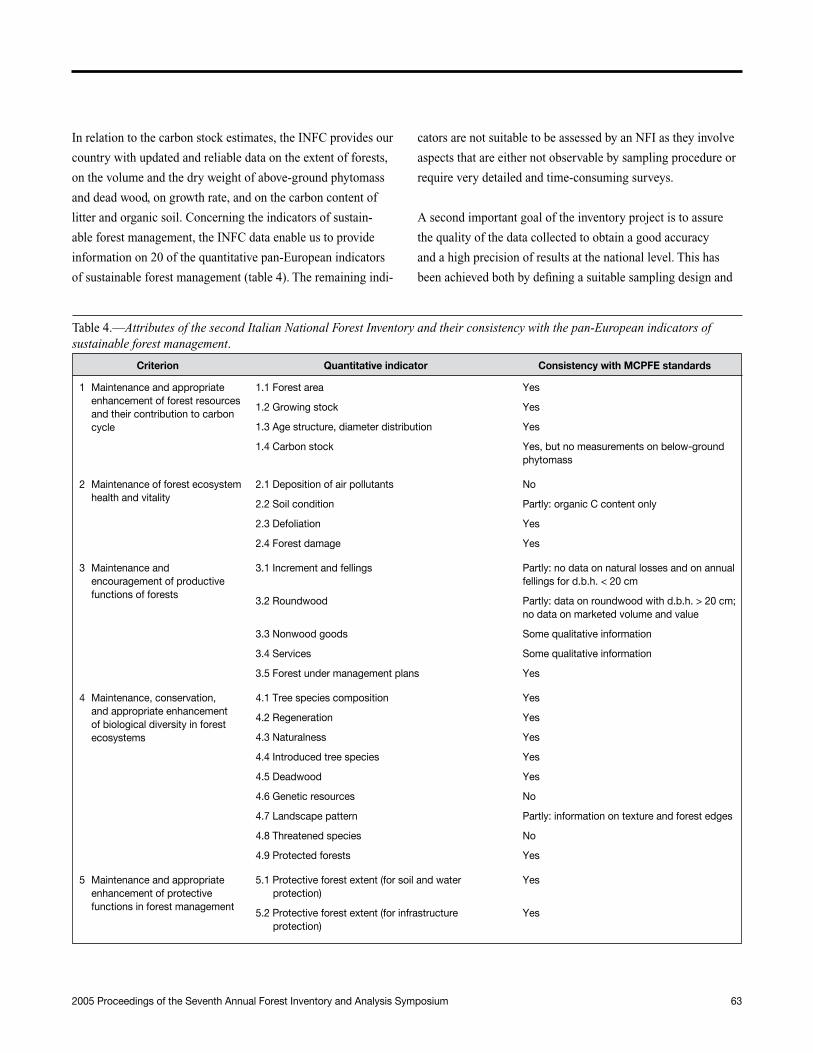
In relation to the carbon stock estimates, the INFC provides our
country with updated and reliable data on the extent of forests,
on the volume and the dry weight of above-ground phytomass
and dead wood, on growth rate, and on the carbon content of
litter and organic soil. Concerning the indicators of sustain-
able forest management, the INFC data enable us to provide
information on 20 of the quantitative pan-European indicators
of sustainable forest management (table 4). The remaining indi-
cators are not suitable to be assessed by an NFI as they involve
aspects that are either not observable by sampling procedure or
require very detailed and time-consuming surveys.
A second important goal of the inventory project is to assure
the quality of the data collected to obtain a good accuracy
and a high precision of results at the national level. This has
been achieved both by defining a suitable sampling design and
Table 4.—Attributes of the second Italian National Forest Inventory and their consistency with the pan-European indicators of sustainable forest management.
Criterion Quantitative indicator Consistency with MCPFE standards
� Maintenance and appropriate enhancement of forest resources and their contribution to carbon cycle
�.� Forest area Yes
�.2 Growing stock Yes
�.3 Age structure, diameter distribution Yes
�.� Carbon stock Yes, but no measurements on below-ground phytomass
2 Maintenance of forest ecosystem health and vitality
2.� Deposition of air pollutants No
2.2 Soil condition Partly: organic C content only
2.3 Defoliation Yes
2.� Forest damage Yes
3 Maintenance and encouragement of productive functions of forests
3.� Increment and fellings Partly: no data on natural losses and on annual fellings for d.b.h. < 20 cm
3.2 Roundwood Partly: data on roundwood with d.b.h. > 20 cm; no data on marketed volume and value
3.3 Nonwood goods Some qualitative information
3.� Services Some qualitative information
3.5 Forest under management plans Yes
� Maintenance, conservation, and appropriate enhancement of biological diversity in forest ecosystems
�.� Tree species composition Yes
�.2 Regeneration Yes
�.3 Naturalness Yes
�.� Introduced tree species Yes
�.5 Deadwood Yes
�.6 Genetic resources No
�.7 Landscape pattern Partly: information on texture and forest edges
�.� Threatened species No
�.� Protected forests Yes
5 Maintenance and appropriate enhancement of protective functions in forest management
5.� Protective forest extent (for soil and water protection)
Yes
5.2 Protective forest extent (for infrastructure protection)
Yes

6� 2005 Proceedings of the Seventh Annual Forest Inventory and Analysis Symposium
monitoring data collection and data storage. The three-phase
sampling design for stratification, with the interpretation of
orthophotos in the first phase and expeditious ground surveys
in the second phase, made it possible to use a large sample size,
which assures a high reliability of inventory results. Indeed,
the provisional estimates of forest and other wooded land
area presented in this paper are very precise, with low percent
standard errors. Forest type area estimates at national scale
follow the same trend, with percent errors of less than 3 percent percent
for most types considered. It should also be noted that our
procedures allowed for accurate spatial positioning of samples
with average distance errors of less than 2.8 m.
As a consequence of its ambitious aims, the NFI project
requires a great effort, both from an organizational and from
a technical point of view. Among the different aspects of the
inventory, the technical support together with the monitoring of
the data flow required quite a sophisticated survey system. The
management of the data flow and the database is indeed one of
the most critical issues of this project, due to the large amount
of data coming from many different parts of the country and the
large number of people involved.
Acknowledgments
The authors thank the officials and foresters of the NFS and
of the regional and provincial forest services involved in the
Italian NFI, without whose time and input this work would not
have been possible.
They are grateful to their consultants Lorenzo Fattorini
(statistics), Sandro Pignatti (botanic), and Marco Ferretti
and Alberto Cozzi (data quality) for their valuable support
throughout the project design, and to Lorenzo Cavini for his
help in finding technical solutions to topographical issues.
The authors are particularly grateful to their colleagues Marina
Berto, Giacomo Colle, Lucio Di Cosmo, David Galvagni,
Beniamino Huez, and Alessandro Paletto for their support in
many steps of this work.
They also thank RDM and DREAM for their help in training
the field crews and carrying out the control surveys, and
FINSIEL and Galileo Sistemi for the software and database
design and management.
Finally, the authors offer many thanks to Solomon Dobrowski
and Giuseppe Cappalonga for the text revision.
Table 4.—Attributes of the second Italian National Forest Inventory and their consistency with the pan-European indicators of sustainable forest management (continued).
Criterion Quantitative indicator Consistency with MCPFE standards
6 Maintenance of other socioeconomic functions and conditions
6.� Number of forest holdings No
6.2 Contribution to gross domestic product No
6.3 Net revenue of forest enterprises No
6.� Expenditures for services No
6.5 Forest sector workforce No
6.6 Occupational safety and health No
6.7 Wood consumption No
6.� Trade in wood No
6.� Energy from wood resources No
6.�0 Accessibility for recreation Yes
6.�� Cultural and spiritual values No
MCPFE = Ministerial Conference on the Protection of Forests in Europe.

2005 Proceedings of the Seventh Annual Forest Inventory and Analysis Symposium 65
Literature Cited
British Columbia Resources Inventory Committee (BCRIC).
2001. Procedures and guidelines for operational forest
resource survey and mapping using Global Positioning System
technology. British Columbia, Canada: Resources Inventory
Committee.
Castellani, C.; Scrinzi, G.F.; Tabacchi, G.; Tosi, V. 1988.
Inventario Forestale Nazionale. Sintesi metodologica e risultati.
Ministero dell’Agricoltura e delle Foreste. Trento, Italy: Istituto
Sperimentale per l’Assestamento forestale e per l’Alpicoltura.
364 p. In Italian.
European Commission. 1993. CORINE land cover guide
technique. Luxembourg: Office des Publications Officielles des
Communautés Européennes. 144 p.144 p.
Fattorini, L.; Gasparini, P.; Nocetti, M.; Tabacchi, G.; Tosi,
V. [In press]. Above-ground tree phytomass prediction andAbove-ground tree phytomass prediction and
preliminary shrub phytomass assessment in the forest stands of
Trentino. Studi Trentini de Scienze Naturali—Acta BiologicaStudi Trentini de Scienze Naturali—Acta Biologica
1: 75-121.
Fattorini, L.; Marcheselli, M.; Pisani, C. 2004. Two-phaseTwo-phase
estimation of coverages with second-phase corrections.
Environmetrics. 15: 357-368.
Gasparini, P.; Nocetti, M.; Tabacchi, G.; Tosi, V. 2005. BiomassBiomass
equations and data for forest stands and shrublands of the
Eastern Alps (Trentino, Italy). Proceedings, IUFRO conference
sustainable forestry in theory and practice: Gen. Tech. Rep.
PNW-688. Portland, OR: U.S. Department of Agriculture,
Forest Service, Pacific Northwest Research Station.
INFC. 2003a. Manuale di fotointerpretazione per la
classificazione delle unità di campionamento di prima fase.
Inventario Nazionale delle Foreste e dei Serbatoi Forestali di
Carbonio. MiPAF - Direzione Generale per le Risorse Forestali
Montane e Idriche, Corpo Forestale dello Stato, ISAFA, Trento.
82 p. http://www.isafa.it/scientifica/pubblicazioni/pu_infc/ http://www.isafa.it/scientifica/pubblicazioni/pu_infc/http://www.isafa.it/scientifica/pubblicazioni/pu_infc/
ALGT/Man_1/Man_1.pdf. (9 May 2005). In Italian.
INFC. 2003b. Procedure di controllo di qualità dei dati di
prima fase. Inventario Nazionale delle Foreste e dei Serbatoi
Forestali di Carbonio. MiPAF - Direzione Generale per le
Risorse Forestali Montane e Idriche, Corpo Forestale dello
Stato, ISAFA, Trento. 42 p. http://www.isafa.it/scientifica/42 p. http://www.isafa.it/scientifica/
pubblicazioni/pu_infc/ALGT/CTRL_1.pdf. (9 May 2005). In
Italian.
INFC. 2003c. Guida alla classificazione della vegetazione
forestale. Inventario Nazionale delle Foreste e dei Serbatoi
Forestali di Carbonio. MiPAF - Direzione Generale per le
Risorse Forestali Montane e Idriche, Corpo Forestale dello
Stato, ISAFA, Trento. 61 p. hhttp://www.isafa.it/scientifica/
pubblicazioni/pu_infc/ALGT/Cla_veg.pdf. (9 May 2005). In
Italian.
INFC. 2004a. Istruzioni per il rilievo degli attributi di seconda
fase. Inventario Nazionale delle Foreste e dei Serbatoi
Forestali di Carbonio. MiPAF - Direzione Generale per le
Risorse Forestali Montane e Idriche, Corpo Forestale dello
Stato, ISAFA, Trento. 162 p. hhttp://www.isafa.it/scientifica/
pubblicazioni/pu_infc/ALGT/Ri_Attr/RiAttrb.pdf. (9 May
2005). In Italian.
INFC. 2004b. Il disegno di campionamento. Inventario
Nazionale delle Foreste e dei Serbatoi Forestali di Carbonio.
MiPAF - Direzione Generale per le Risorse Forestali Montane
e Idriche, Corpo Forestale dello Stato, ISAFA, Trento. 36 p.
http://www.isafa.it/scientifica/pubblicazioni/pu_infc/ALGT/
Sch_Cam.pdf. (9 May 2005). In Italian.
ISAFA. 1999. 2� Inventario forestale nazionale. Studio di
fattibilità. Istituto Sperimentale per l’Assestamento Forestale e
per l’Alpicoltura, Ministero per le Politiche Agricole, Trento.Trento.
201 p. http://www.isafa.it/scientifica/pubblicazioni/pu_infc/
ALGT/Fattib.pdf. (9 May 2005). In Italian.
MCPFE Liaison Unit. 2003. Improved pan-European indicatorsImproved pan-European indicators
for sustainable forest management as adopted by the MCPFE
expert level meeting. Vienna, Austria: Ministerial Conference
on the Protection of Forests in Europe.

66 2005 Proceedings of the Seventh Annual Forest Inventory and Analysis Symposium
Muscaritoli, C.; Froncillo, F.; Piccoli, D.; Scrinzi, G.; Floris,
A.; Tartarici, G.L.; Battistini, F. 2004. L’integrazione GPS/GIS
e database sincronizzati nell’Inventario Forestale Nazionale
Italiano mediante l’applicativo INFOR2 ed i Servizi Territoriali
del Sistema Informativo della Montagna (SIM). Cartographica.
1: 13-16. In Italian.
Scrinzi, G.; Floris, A.; Galvagni, D.; Marzullo, L. 2003. Un
metodo di valutazione della precisione di ricevitori GPS, o di
metodi di posizionamento, nei rilievi forestali. Linea Ecologica.
2: 11-18. In Italian.
UN-ECE/FAO. 1997. Temperate and boreal forest resourcesTemperate and boreal forest resources
assessment 2000, terms and definitions. New York and Geneva:
United Nations. 13 p.