itasca soil and water conservation district...2014/07/02 · itasca soil and water conservation...
TRANSCRIPT
Itasca Soil and Water
Conservation District
Lake Nutrient TMDL for Jessie Lake
Prepared by:
WENCK ASSOCIATES, INC.1800 Pioneer Creek Center
P.O. Box 249Maple Plain, Minnesota 55359-0249
(763) 479-4200
October 2009
R1 July 2010R2 September 2010
R3 February 2011

Wenck Associates, Inc. Itasca SWCD 2011 Jessie Lake Nutrient TMDL
i
Table of Contents ACRONYMS ..............................................................................................................................VII
TMDL SUMMARY TABLE ................................................................................................... VIII
EXECUTIVE SUMMARY .......................................................................................................... X
1.0 INTRODUCTION ........................................................................................................... 1-1
1.1 Purpose ................................................................................................................. 1-1 1.2 Problem Identification ......................................................................................... 1-1
2.0 DETERMINATION OF ENDPOINTS ......................................................................... 2-1
2.1 Impaired Waters ................................................................................................... 2-1 2.2 Minnesota Water Quality Standards and Endpoints ............................................ 2-1
2.2.1 State of Minnesota Standards ................................................................ 2-1 2.2.2 Endpoint Used in this TMDL ................................................................ 2-2
3.0 WATERSHED AND LAKE CHARACTERIZATION ............................................... 3-1
3.1 Lake and Watershed Conditions .......................................................................... 3-1 3.2 Land Use .............................................................................................................. 3-1 3.3 Climate ................................................................................................................. 3-6 3.4 Hydrology ............................................................................................................ 3-8 3.5 Recreational Uses............................................................................................... 3-10 3.6 Fish Community................................................................................................. 3-11 3.7 Aquatic Plants .................................................................................................... 3-11 3.8 Shoreline Development and Habitat Conditions ................................................ 3-12
4.0 NUTRIENT SOURCE ASSESSMENT ....................................................................... 4-15
4.1 Introduction ........................................................................................................ 4-15 4.2 Permitted Sources .............................................................................................. 4-15 4.3 Non-Permitted Sources ...................................................................................... 4-15
4.3.1 In-Lake Nutrient Cycling in Jessie Lake ............................................. 4-15 4.3.2 Landuse Based Non-Point Sources ..................................................... 4-16 4.3.3 Atmospheric Deposition ...................................................................... 4-17 4.3.4 Ambient Groundwater Inflows ............................................................ 4-17

Table of Contents (cont.)
Wenck Associates, Inc. Itasca SWCD 2011 Jessie Lake Nutrient TMDL
ii
5.0 ASSESSMENT OF WATER QUALITY DATA .......................................................... 5-1
5.1 Monitoring Efforts ............................................................................................... 5-1 5.2 Lake Monitoring Results...................................................................................... 5-1
5.2.1 Total Phosphorus ................................................................................... 5-1 5.2.2 In-Lake Chlorophyll-a ........................................................................... 5-2 5.2.3 Secchi Depth .......................................................................................... 5-3
5.3 Stream Monitoring Results .................................................................................. 5-4
6.0 LINKING WATER QUALITY TARGET AND SOURCES ...................................... 6-1
6.1 Selection of Models and Tools ............................................................................ 6-1 6.2 Current Phosphorus Budget Components ............................................................ 6-2
6.2.1 Atmospheric Load ................................................................................. 6-3 6.2.2 Septic Systems ....................................................................................... 6-3 6.2.3 Ambient Groundwater ........................................................................... 6-4 6.2.4 Direct Watershed Runoff ....................................................................... 6-6 6.2.5 Upstream Tributaries ............................................................................. 6-6 6.2.6 Internal Phosphorus Cycling ................................................................. 6-6
6.3 Current Phosphorus Budget ............................................................................... 6-10 6.4 Water Quality Response Modeling .................................................................... 6-10 6.5 Fit of the Models ................................................................................................ 6-10 6.6 Conclusions ........................................................................................................ 6-12
7.0 TMDL ALLOCATION ................................................................................................... 7-1
7.1 Load and Wasteload Allocation ........................................................................... 7-1 7.1.1 Allocation Approach ............................................................................. 7-1 7.1.2 Critical Conditions ................................................................................. 7-1 7.1.3 Allocations ............................................................................................. 7-1
7.2 RationalE for Load and Wasteload Allocations ................................................... 7-2 7.2.1 Modeled Historic Loads ........................................................................ 7-2 7.2.2 Waste Load Allocations ........................................................................ 7-3
7.3 Seasonal and Annual Variation ............................................................................ 7-3 7.4 Margin of Safety .................................................................................................. 7-4 7.5 Reserve Capacity/ Future Growth ........................................................................ 7-5
8.0 PUBLIC PARTICIPATION ........................................................................................... 8-1
9.0 IMPLEMENTATION ..................................................................................................... 9-1

Table of Contents (cont.)
Wenck Associates, Inc. Itasca SWCD 2011 Jessie Lake Nutrient TMDL
iii
9.1 Implementation Framework ................................................................................. 9-1 9.1.1 Itasca SWCD ......................................................................................... 9-1 9.1.2 Lake Association ................................................................................... 9-1 9.1.3 BWSR .................................................................................................... 9-1
9.2 Reduction Strategies ............................................................................................ 9-2 9.2.1 Annual Load Reductions ....................................................................... 9-2 9.2.2 Internal Load Reduction Options .......................................................... 9-2
9.2.2.1 Hypolimnetic Aeration ........................................................... 9-3 9.2.2.2 Hypolimnetic Withdrawal ...................................................... 9-3 9.2.2.3 Alum Treatment ..................................................................... 9-4
9.2.3 Watershed Implementation .................................................................... 9-5 9.3 Nutrient Reduction Costs ..................................................................................... 9-6
10.0 REASONABLE ASSURANCE .................................................................................... 10-1
11.0 MONITORING .............................................................................................................. 11-1
11.1 Data Gaps ........................................................................................................... 11-1 11.2 Recommended Monitoring ................................................................................ 11-1
12.0 REFERENCES .............................................................................................................. 12-1

Table of Contents (cont.)
Wenck Associates, Inc. Itasca SWCD 2011 Jessie Lake Nutrient TMDL
iv
TABLES E.1 Morphometric Characteristics for Jessie Lake E.2 Total Phosphorus TMDL and Partitioned Loads Expressed as Annual and Daily Loads E.3 Average and Goal TP Load and Percent Load Reduction by Source (lbs/ year) 2.1 Eutrophication Standards for Lakes 3.1 Morphometric Characteristics for Jessie Lake 3.2 2007 NASS land use for the Jessie Lake sub-watersheds (acres) 3.3 Variation in Measured Annual Runoff 3.4 Average Water Balance 5.1 Range of Typical Growing Season Average Total Phosphorus and Chlorophyll-A
Concentrations and Secchi depths in Jessie Lake compared to Numeric Standard 5.2 Descriptive Statistics for Jessie Lake Tributaries 6.1 Atmospheric Deposition of Phosphorus 6.2 Groundwater Contributions to Jessie Lake (from un-gauged watersheds) 6.3 Sediment Core Sampling Results Compared to Previous Study 6.4 Current Annual Phosphorus Budget (lbs/ yr) 7.1 Total Phosphorus TMDL Allocations Expressed as Daily Loads Total Phosphorus Partitioned Load Allocation Expressed as Daily Load Total Phosphorus TMDL Allocations Expressed as Annual Loads Total Phosphorus Partitioned Load Allocation Expressed as Annual Load 9.1 Modeled Average and Goal Phosphorus Loads to Jessie Lake and Percent Reductions
Required by Source (lbs/ year) 9.2 Potential Implementation Plan and Costs FIGURES E.1 Jessie Lake Drainage Area Land Use Breakdown E.2 Jessie Lake Drainage Area and Flow Schematic 2.1 Relationship between Phosphorus, Chlorophyll-a and Secchi Depth 3.1 General location map of Jessie Lake in Itasca County, Minnesota 3.2 Jessie Lake watershed drainage area, inflows and outflows 3.3 2007 NASS land use in the sub-watersheds of Jessie Lake 3.4 Annual precipitation for the Jessie Lake Area obtained from the Minnesota Climatology
Working Group 3.5 Yearly average temperature for the Grand Rapids, MN area; obtained from the United
States Forest Service 3.6 Length of growing season in days for the Grand Rapids, MN area; obtained from the
United States Forest Service 3.7. Measured Runoff vs. Precipitation for Poole’s Creek, Spring Creek and Jessie Brook 3.8 General locations of emergent, floating leaf and submerged vegetation beds from the
1978 and 2008 Surveys

Table of Contents (cont.)
Wenck Associates, Inc. Itasca SWCD 2011 Jessie Lake Nutrient TMDL
v
4.1 Local Surficial Aquifer Elevation (in blue) (From Lindholm 1976) 5.1 Box plots of growing season average in-lake Total Phosphorus concentrations for Jessie
Lake 5.2 Box plots of annual average in-lake Chlorophyll-a concentrations for Jessie Lake 5.3 Box plots of growing season average Secchi depth readings for Jessie Lake 5.4 TP in Jessie Lake Tributaries – Semi Log Scale (All Data) 6.1 Sediment Characterization and Core Sampling Locations 6.2 Dominant Anoxic Area 6.3 Fit of the Model (Summer Average Total P) 6.4 Fit of the Model (Summer Average Chlorophyll-a)

Table of Contents (cont.)
Wenck Associates, Inc. Itasca SWCD 2011 Jessie Lake Nutrient TMDL
vi
APPENDICES A Technical Memo 1: Nutrient Load Allocation B Technical Memo 2: Load Reduction Scenarios C Internal Release Rate Field Study D Lake Model Results

Acronyms
Wenck Associates, Inc. Itasca SWCD 2011 Jessie Lake Nutrient TMDL
vii
Agency Minnesota Pollution Control Agency BWSR Minnesota Board of Water and Soil Resources Carlson TSI Carlson Trophic Status Index CFR Code of Federal Regulations cfs cubic feet per second CWA Clear Water Act CWP Clean Water Partnership DO Dissolved oxygen EPA Environmental Protection Agency Itasca SWCD Itasca Soil and Water Conservation District JLWA Jessie Lake Watershed Association LA Load Allocation (non-permitted sources) Lbs Pounds Lbs/ day pounds per day Lbs/ year pounds per year MDNR Minnesota Department of Natural Resources μg/L micrograms per liter mg/L milligrams per liter mi2 square miles MOS Margin of Safety MPCA Minnesota Pollution Control Agency MS4 Municipally Separate Storm Sewer System NASS National Agricultural Statistics Service NGVD National Geodetic Vertical Datum NLCD National Land Cover dataset NLF Northern Lakes and Forest (Ecoregion) NO2/ NO3-N Nitrate/ Nitrite- Nitrogen NPS non-point source RC Reserve Capacity SSTS subsurface sewage treatment system (formerly ISTS) STORET EPA’s “STOrage and RETrevial” System TAC Technical Advisory Committee TKN Total Kjeldahl Nitrogen TMDL Total Maximum Daily Load TN Total Nitrogen TP Total phosphorus TSS Total Suspended Solids USGS United States Geological Survey WLA Waste Load Allocation (permitted sources) WWTP Wastewater Treatment Plant

TMDL Summary Table
Wenck Associates, Inc. Itasca SWCD 2011 Jessie Lake Nutrient TMDL
viii
USDA United States Department of Agriculture USFS United States Forest Service
TMDL Summary Table EPA/MPCA
Required Elements Summary TMDL Report
Section Location Itasca County, Minnesota in the Upper Mississippi River Basin.
Section 3: Figures 3.1, 3.2 and 3.3
303(d) Listing Information
Jessie Lake 31-0786 Jessie Lake was added to the 303(d) list in 2004 due to excess nutrient concentrations impairing aquatic recreation, as set forth in Minnesota Rules 7050.0150. The TMDL for Jessie Lake was prioritized to start in 2005 and be completed by 2008.
Section 2
Applicable Water Quality Standards/ Numeric Targets
Criteria set forth in Minn. R. 7050.0150 (3) and (5). The water quality standards for the Northern Lakes and Forest ecoregion include: total phosphorus 30 µg/L; chlorophyll-a 9 µg/L; and secchi depth >2m. The numeric target for Jessie Lake discussed is a total phosphorus concentration of 29 µg/L or less.
Section 2
Loading Capacity (expressed as daily
load)
The loading capacity is the total maximum daily load for each of these conditions. The critical condition for these lakes is the summer growing season. The loading capacity is set forth in Table 7.1.
Total maximum daily total phosphorus load (lb/day) Jessie Lake 11.37 lbs/ day (4,154 lb/yr)
Section 7
Wasteload Allocation
There are no individual permitted sources in the watershed allowed to discharge to surface waters. The wasteload allocation is limited to NPDES construction allocation and is 0.04 lbs/ day.
Section 7
Load Allocation The portion of the loading capacity allocated to existing non-permitted sources.
Section 7, Table 7.1
Source Load Allocation (lb/day) Atmospheric and Groundwater 3.54
Internal Load 3.94

TMDL Summary Table
Wenck Associates, Inc. Itasca SWCD 2011 Jessie Lake Nutrient TMDL
ix
TMDL Summary Table EPA/MPCA
Required Elements Summary TMDL Report
Section Watershed Loads (including upstream lakes)
3.85
Septic Systems 0
Margin of Safety The Margin of Safety is implicit in the TMDL due to the conservative assumptions of the model and the proposed iterative nutrient reduction strategy with monitoring.
Section 7.4
Seasonal Variation Seasonal variation is accounted for by developing targets for the summer critical period where the frequency and severity of nuisance algal growth is greatest. Although the critical period is the summer, lakes are not sensitive to short-term changes but rather respond to long-term changes in annual load.
Section 7.3
Reasonable Assurance
Reasonable assurance is provided through the efforts of the Itasca SWCD. The Itasca SWCD’s mission is to provide a local organization through which landowners and operators, local units of government and state and federal agencies can cooperate to improve, develop and conserve soil, water, wildlife and recreational resources. This existing mission, jurisdiction and framework coupled with their commitment to completing a TMDL study and implementing the load reductions provides reasonable assurance that goals will be reached. Further, adaptive management methodology proposed ensures periodic evaluations and course corrections when necessary to achieve the TMDL goal.
Section 10
Monitoring The Itasca SWCD currently monitors lake and stream water quality and flow throughout Itasca County and specifically in the Jessie Lake watershed using an annual plan as funds are available. A recommended monitoring plan for adaptive management of Jessie Lake is summarized in Section 11.
Section 11,
Implementation This TMDL sets forth an implementation framework and load reduction strategies. A rudimentary implementation plan is presented herein, a final implementation plan will be prepared as part of this grant. The estimated cost of the implementation plan presented herein is approximately $1.2 million.
Section 9
Public Participation Public Comment period: Meeting location: Comments received:
Section 8

Wenck Associates, Inc. Itasca SWCD 2011 Jessie Lake Nutrient TMDL
x
Executive Summary
Section 303(d) of the Federal Clean Water Act (CWA) requires the Minnesota Pollution Control Agency (MPCA) to identify water bodies that do not meet water quality standards and to develop total maximum daily pollutant loads for those water bodies. A total maximum daily load (TMDL) is the amount of a pollutant that a water body can assimilate without exceeding the established water quality standard for that pollutant. Through a TMDL, pollutant loads are allocated to permitted and non-permitted sources within the watershed that discharge to the water body. This TMDL study prepared by Wenck Associates, Inc. (Wenck) for the Itasca Soil and Water Conservation District (Itasca SWCD), addresses the nutrient impairment in Jessie Lake (DNR# 31-0786). The goal of this TMDL is to quantify the pollutant reductions needed to meet State water quality standards for nutrients in Jessie Lake and the endpoint proposed in this TMDL. Jessie Lake is one of 950 lakes located in Itasca County. The total drainage area of the sub-watersheds draining to the Jessie Lake is approximately 29.7 square miles, excluding the lake surface which is 2.69 square miles. The morphometric characteristics of Jessie Lake are shown in Table E.1. Table E.1 Morphometric Characteristics for Jessie Lake Parameter Jessie Lake Surface Area (ac) 1,723 Average Depth (ft) 22.9 Maximum Depth (ft) 40 Volume (ac-ft) 39,535 Average Residence Time (years) 2 Littoral Area (ac) 455 Watershed- including lake surface (ac) 20,738 In 1998, a thick algae bloom and subsequent fish kill sparked stakeholder concern over declining water quality in Jessie Lake. A lake assessment conducted that same year showed markedly higher in-lake total phosphorus (TP) concentrations than those observed in 1990. Stakeholders implemented further study of Jessie Lake including a Cleanwater Partnership project in 2000 (MPCA 2002) and a diatom study (Kingston 2002). The Itasca SWCD has monitored water quality annually in Jessie Lake since 1998. Data collected from these studies showed the lake is impaired for nutrients. Average summer surface TP concentrations in Jessie Lake ranged from 19 to 48 μg/L between 1998 and 2008, with an average concentration of 35 μg/L for that 10-year period. Based on existing data, the likely background concentrations for Jessie Lake range from 25 to 30 μg/L.

Wenck Associates, Inc. Itasca SWCD 2011 Jessie Lake Nutrient TMDL
xi
The Northern Lakes and Forest Ecoregion standard is 30 μg/L. Jessie Lake lies within the Chippewa Sand Plains, a sub-region of the Northern Lakes and Forest Ecoregion. Data suggests that lakes within the Chippewa Sand Plains may have higher background TP concentrations than other lakes in the Northern Lakes and Forest Ecoregion. This is a point currently under review within the MPCA. Based on existing data, the endpoint for the Jessie Lake nutrient TMDL is 29 μg/L. The sources of nutrients to Jessie Lake include land use based watershed sources, groundwater contributions to the lake, internal cycling of phosphorus and atmospheric deposition. Current anthropogenic phosphorus sources to Jessie Lake are minimal as over 95% of the watershed is undeveloped. Figure E1 shows landuse breakdown for the watershed. The annual loads are dominated by internal cycling of TP in the lake which is driven by nutrient rich sediments, periods of summer anoxia and late summer de-stratification events. Figure E.1 Jessie Lake Drainage Area Land Use Breakdown
Internal loads are likely the result of a combination of historical anthropogenic impacts such as logging in the watershed, the naturally occurring TP concentrations in the area soils, and the lake morphometry and climate which results in late summer destratification events releasing TP into the epilimnion making it available for algal growth. Recent increases in the length of the growing season may be contributing to the internal loading. Figure E.2 shows the watershed area and lake inflows.
Deciduous Forest66.92%
Evergreen Forest10.69%
Herbaceous Wetland1.91%
Grassland0.10%
Open Water11.45%
Grass/Pasture/Non Ag3.27%
Row Crops/Wheat/ Alfalfa0.01%
Developed (Low & Medium Intensity)
0.07%
Barren/Open Space1.60%
Woody Wetlands3.71%
Shrubland0.28%

Wenck Associates, Inc. Itasca SWCD 2011 Jessie Lake Nutrient TMDL
xii
Figure E.2 Jessie Lake Drainage Area and Flow Schematic

Wenck Associates, Inc. Itasca SWCD 2011 Jessie Lake Nutrient TMDL
xiii
Nutrient loads in this TMDL are set for phosphorus, since it is typically the limiting nutrient for nuisance aquatic plants. This TMDL is written to solve the TMDL equation for a numeric target of 29 μg/L of total phosphorus, which is the target concentration for Jessie Lake. The TMDL is expressed by the following equation, and shown in Tables E2: TMDL= Σ(LA) +Σ(WLA) + MOS Table E2 Total Phosphorus TMDL and Partitioned Loads Expressed as Annual and
Daily Loads
A Margin of Safety (MOS) has been incorporated into this TMDL to account for uncertainty and to allow the project a reasonably high probability of success. MOS encompasses two primary factors: variability and uncertainty. “Variability” refers to the spatial and temporal fluctuations in measured values for a given parameter. “Uncertainty” refers to prediction error resulting from limits in the data and predictive models An implicit MOS is incorporated into this TMDL in the following ways:
1. A conservative goal, below the standard, was selected as an endpoint. The standard is 30 ug/L TP, an endpoint of 29 ug/L was selected.
Total Phosphorus TMDL (lbs/ yr)
Total Phosphorus TMDL (lbs/ day)
TMDL 4,154 11.37 Waste Load Allocation 14 0.04
Load Allocation 4,140 11.33 MOS Implicit Implicit RC See WLA See WLA
Partitioned Total Phosphorus Load Allocation (lbs/ yr)
WatershedSeptic
SystemsAtmospheric & Groundwater Internal
1,407 0 1,294 1,439
Partitioned Total Phosphorus Load Allocation (lbs/ day)
WatershedSeptic
SystemsAtmospheric & Groundwater Internal
3.85 0 3.54 3.94T:\2212-Jessie\MPCA Q data\[Copy of RAK_Q Eval_jcm_Final.xls]Table Figs
Wenck Associates, Inc. Itasca SWCD 2011 Jessie Lake Nutrient TMDL
xiv
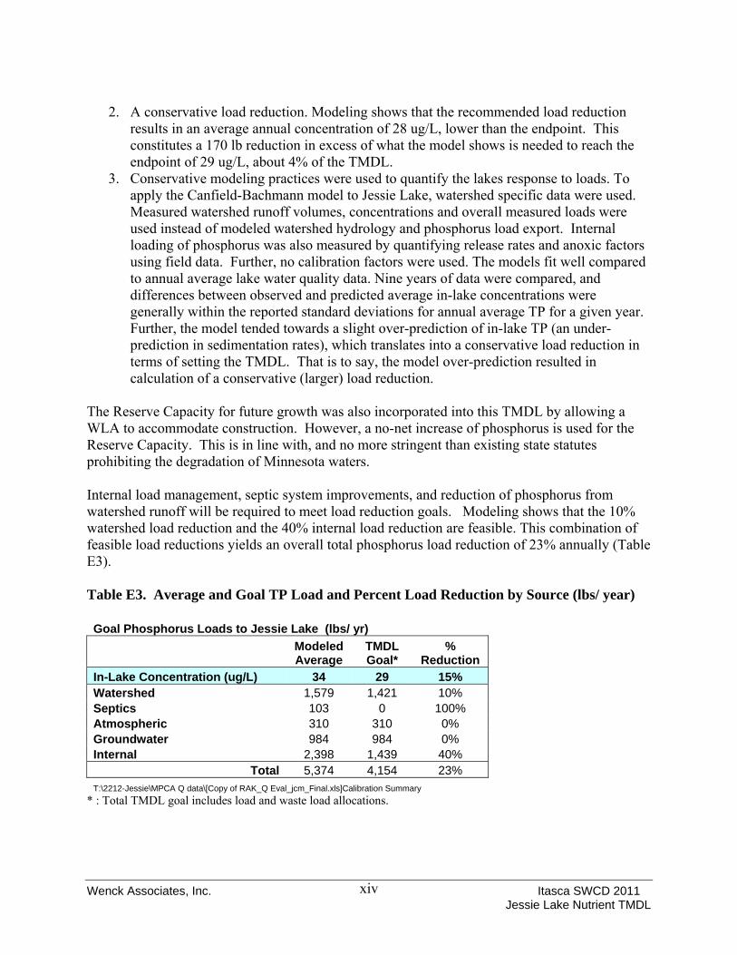
2. A conservative load reduction. Modeling shows that the recommended load reduction results in an average annual concentration of 28 ug/L, lower than the endpoint. This constitutes a 170 lb reduction in excess of what the model shows is needed to reach the endpoint of 29 ug/L, about 4% of the TMDL.
3. Conservative modeling practices were used to quantify the lakes response to loads. To apply the Canfield-Bachmann model to Jessie Lake, watershed specific data were used. Measured watershed runoff volumes, concentrations and overall measured loads were used instead of modeled watershed hydrology and phosphorus load export. Internal loading of phosphorus was also measured by quantifying release rates and anoxic factors using field data. Further, no calibration factors were used. The models fit well compared to annual average lake water quality data. Nine years of data were compared, and differences between observed and predicted average in-lake concentrations were generally within the reported standard deviations for annual average TP for a given year. Further, the model tended towards a slight over-prediction of in-lake TP (an under-prediction in sedimentation rates), which translates into a conservative load reduction in terms of setting the TMDL. That is to say, the model over-prediction resulted in calculation of a conservative (larger) load reduction.
The Reserve Capacity for future growth was also incorporated into this TMDL by allowing a WLA to accommodate construction. However, a no-net increase of phosphorus is used for the Reserve Capacity. This is in line with, and no more stringent than existing state statutes prohibiting the degradation of Minnesota waters. Internal load management, septic system improvements, and reduction of phosphorus from watershed runoff will be required to meet load reduction goals. Modeling shows that the 10% watershed load reduction and the 40% internal load reduction are feasible. This combination of feasible load reductions yields an overall total phosphorus load reduction of 23% annually (Table E3). Table E3. Average and Goal TP Load and Percent Load Reduction by Source (lbs/ year) Goal Phosphorus Loads to Jessie Lake (lbs/ yr)
Modeled Average
TMDL Goal*
% Reduction
In-Lake Concentration (ug/L) 34 29 15% Watershed 1,579 1,421 10% Septics 103 0 100% Atmospheric 310 310 0% Groundwater 984 984 0% Internal 2,398 1,439 40%
Total 5,374 4,154 23% T:\2212-Jessie\MPCA Q data\[Copy of RAK_Q Eval_jcm_Final.xls]Calibration Summary
* : Total TMDL goal includes load and waste load allocations.
Wenck Associates, Inc. Itasca SWCD 2011 Jessie Lake Nutrient TMDL
xv
The Itasca SWCD will coordinate efforts with other local stakeholders to implement the approved TMDL for Jessie Lake. Itasca SWCD is the appropriate local unit of government (LGU) to coordinate with other stakeholders to implement the TMDL given their coordination of the stakeholder process for preparing the TMDL, their jurisdiction over the entire drainage area for Jessie Lake, and their existing resources in terms of their annual monitoring program and qualified staff. The stakeholder process for the Jessie Lake TMDL was considerable. A technical advisory committee (TAC) was formed from representatives of stakeholder groups including:
• Jessie Lake Watershed Association (JLWA), • Itasca Soil and Water Conservation District (Itasca SWCD), • Minnesota Department of Natural Resources fisheries and hydrology departments (MN
DNR), • US Forest Service (USFS) and • Minnesota Pollution Control Agency (MPCA)
Results of modeling conducted to set this TMDL were presented to the TAC at three presentations and in the form of Technical Memos included here as Appendices A and B. Details of the modeling, goal selection and potential load reductions are presented in these memos. These memos were used as the foundation of this TMDL report. While potential load reductions were presented therein, the final TMDL is presented in this report.

Wenck Associates, Inc. Itasca SWCD 2011 Jessie Lake Nutrient TMDL
1-1
1.0 Introduction
1.1 PURPOSE This TMDL study addresses the nutrient impairment in Jessie Lake, located in Itasca County Minnesota. The goal of this TMDL is to quantify the pollutant reductions needed to meet State water quality standards and the appropriate endpoint for nutrients in the lake. The nutrient TMDLs for Jessie Lake is being established in accordance with section 303(d) of the Clean Water Act, because the State of Minnesota has determined waters in lake exceed the State established standards for nutrients. This TMDL provides the waste load allocation (WLA) and load allocation (LA) for Jessie Lake. Based on the current State standard for nutrients, the TMDL establishes eutrophication standard of 30 µg/L total phosphorus concentration for lakes in the Northern Lakes and Forests Ecoregion. 1.2 PROBLEM IDENTIFICATION The Jessie Lake (DNR# 31-0786) is located in Itasca County, Minnesota. Jessie Lake is within the Big Fork River watershed within the Lake of the Woods basin. The lake was placed on the 2004 State of Minnesota’s 303(d) list of impaired waters. The waters of Jessie Lake were identified for impairment of aquatic recreation (e.g., swimming). Water quality does not meet state standards for nutrient concentrations. Late season nuisance algal blooms impede recreation on the lake. Residents have voiced concern over the algal blooms and the habitat in Jessie Lake.

Wenck Associates, Inc. Itasca SWCD 2011 Jessie Lake Nutrient TMDL
2-1
2.0 Determination of Endpoints
2.1 IMPAIRED WATERS Jessie Lake was added to the 303(d) impaired water list in 2004. The lake is impaired by excess nutrient concentrations, which inhibit aquatic recreation. The TMDL project for Jessie Lake was scheduled to be completed in 2008. The TMDL study began in 2000 with a Clean Water Partnership Study of Jessie Lake which was published in 2002. 2.2 MINNESOTA WATER QUALITY STANDARDS AND ENDPOINTS 2.2.1 State of Minnesota Standards Minnesota’s standards for nutrients limit the quantity of nutrients which may enter waters. Minnesota’s standards at the time of listing (Minnesota Rules 7050.0150(3)) stated that in all Class 2 waters of the State (i.e., “…waters…which do or may support fish, other aquatic life, bathing, boating, or other recreational purposes…”) “…there shall be no material increase in undesirable slime growths or aquatic plants including algae…” In accordance with Minnesota Rules 7050.0150(5), to evaluate whether a water body is in an impaired condition the MPCA developed “numeric translators” for the narrative standard for purposes of determining which lakes should be included in the section 303(d) list as being impaired for nutrients. The numeric translators established numeric thresholds for phosphorus, chlorophyll-a, and water clarity as measured by Secchi depth. Jessie Lake is classified as a 2B water in Minnesota. Table 2.1 lists the water quality standards for Class 2B waters of the Northern Lakes and Forests Ecoregion in Minnesota. Jessie Lake fails to meet these water quality standards and as a result has been added to the 303(d) list.

Wenck Associates, Inc. Itasca SWCD 2011 Jessie Lake Nutrient TMDL
2-2
Table 2.1. Water Quality Standards for 2B Waters of the Northern Lakes and Forests Ecoregion in Minnesota Water Quality Parameter TP (µg/L) Chl-a (µg/L) Secchi
(m) Northern Lakes and Forests Ecoregion 30 9 Not less
than 2.0 (Carlson TSI) (<53) (<53) (<53) TSI= Carlson trophic state index; Chl-a= chlorophyll-a; μg/L= micrograms per liter; m=meters 2.2.2 Endpoint Used in this TMDL The endpoint for the Jessie Lake TMDL is the high end of the range of background summer surface TP conditions for Jessie Lake. Based on the analysis of available data, background conditions in Jessie Lake range from 25 to 30 μg/L. The endpoint was set at 29 μg/L. Average summer surface TP concentrations over the past 10 years have ranged between 19 and 48 μg/L, with an average concentration of 35 μg/L over that period. An endpoint of 29 μg/L represents a significant reduction in annual TP loads to the lake. In establishing the numeric eutrophication standards for lakes, shallow lakes and reservoirs, Minnesota documented the well-established link between high total phosphorus concentrations to both high chlorophyll-a concentrations and low secchi depth (MPCA 2007, SONOR Book 2). Figure 2.1, taken from the MPCA web site presents the relationship between Secchi depth, Chlorophyll-a and phosphorus for Minnesota Lakes. This relationship is widely documented by others as well (Heiskary and Walker, 1988, Heiskary and Wilson, 2005). Achieving the total phosphorus goals for Jessie Lake will result in the lake meeting the corresponding water quality standards for chlorophyll-a and secchi disk transparency within the basin. Further discussion of the endpoint is presented in Sections 3 and 4 of Technical Memo 2 (Appendix B).

Wenck Associates, Inc. Itasca SWCD 2011
Figure 2.1 Relationships between Phosphorus, Chlorophyll-a and Secchi Depth (Source: MPCA web site http://www.pca.state.mn.us/index.php/water/water-types-and-programs/surface-water/lakes/lake-water-quality/asessment-definitions-and-notes.html?menuid=&missing=0&redirect=1)
Jessie Lake Nutrient TMDL 2-3

Wenck Associates, Inc. Itasca SWCD 2011 Jessie Lake Nutrient TMDL
3-1
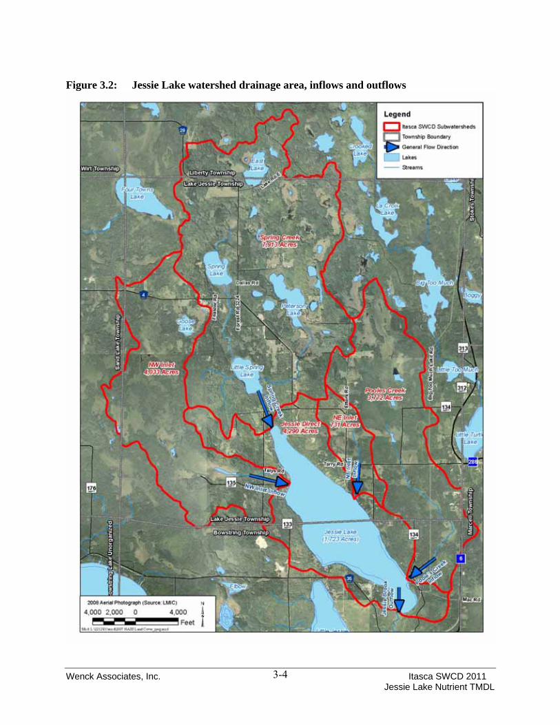
3.0 Watershed and Lake Characterization
3.1 LAKE AND WATERSHED CONDITIONS Itasca County is located in northeast Minnesota (Figure 3.1). There are 950 lakes within Itasca County, ranging in size from a few to several thousand acres. Jessie Lake is located within the central portion of Itasca County, within the townships of Jessie Lake and Bowstring. The nearest town is Big Fork, located approximately 12 miles to the northeast of the lake. The lake lies within the Big Fork River Watershed, which is part of the Rainy River Watershed. The surface area of Jessie Lake is 1,723 acres, based on the planimetered area of the MN DNR lake map, making it the 18th largest basin in Itasca County. The lake is relatively shallow for its size with an average depth of 22.9 feet and a maximum depth of 40 feet. The littoral area of Jessie Lake, which is the area of the lake that is 15 feet or less, comprises 455 acres (approximately 26% of the surface area of Jessie Lake). Jessie Lake has a fairly long fetch of over 4 miles, and lies on a northwest orientation, which is the direction of the prevailing winds. The morphometric characteristics of Jessie Lake are presented in Table 3.1. The total area of the Jessie Lake watershed (including lake surface area) is 20,738 acres or 5.1 square miles. There are five sub-watersheds within the Jessie Lake watershed, four inlet tributaries and the lake direct sub-watershed. The four inlet tributaries include the Northeast Inlet, Northwest Inlet, Spring Creek and Poole’s Creek (Figure 3.2). The outlet to Jessie Lake is Jessie Brook, which flows to the southwest before draining into Bowstring Lake. Table 3.1 Morphometric Characteristics for Jessie Lake Parameter Jessie Lake Surface Area (ac) 1,723 Average Depth (ft) 22.9 Maximum Depth (ft) 40 Volume (ac-ft) 39,535 Average Residence Time (years) 2 Littoral Area (ac) 455 Watershed- including lake surface (ac) 20,738 3.2 LAND USE Jessie Lake lies within the Northern Lakes and Forests Ecoregion. The general land use within in this ecoregion is comprised of 54 to 81 percent forest, 14 to 31 percent marsh, wetlands and open water, with developed and agricultural uses accounting for 10 percent or less of the total. Land use analysis for the Jessie Lake watershed was conducted using multiple data sets and sources. The main data set used was the 2007 National Agricultural Statistics Service (NASS)
Wenck Associates, Inc. Itasca SWCD 2011 Jessie Lake Nutrient TMDL
3-2
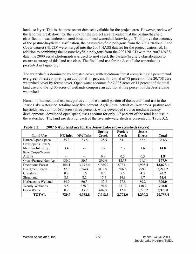
land use layer. This is the most recent data set available for the project area. However, review of the land use break down for the 2007 for the project area revealed that the pasture/hayfield classification was underestimated based on local watershed knowledge. To improve the accuracy of the pasture/hayfield classification, the pasture/hayfield polygons from the 2001 National Land Cover dataset (NLCD) were merged into the 2007 NASS dataset for the project watershed. In addition to combining the pasture/hayfield polygons from the 2001 NLCD with the 2007 NASS data, the 2000 aerial photograph was used to spot check the pasture/hayfield classification to ensure accuracy of this land use class. The final land use for the Jessie Lake watershed is presented in Figure 3.3. The watershed is dominated by forested cover, with deciduous forest comprising 67 percent and evergreen forest comprising an additional 11 percent, for a total of 78 percent of the 20,738 acre watershed cover by forest cover. Open water accounts for 2,735 acres or 11 percent of the total land use and the 1,100 acres of wetlands comprise an additional five percent of the Jessie Lake watershed. Human influenced land use categories comprise a small portion of the overall land use in the Jessie Lake watershed, totaling only five percent. Agricultural activities (row crops, pasture and hayfields) account for 680 acres (three percent), while developed (low & medium density developments, developed open space) uses account for only 1.7 percent of the total land use in the watershed. The land use data for each of the five sub-watersheds is presented in Table 3.2. Table 3.2 2007 NASS land use for the Jessie Lake sub-watersheds (acres)
Land Use NE Inlet NW Inlet Spring Creek
Poole’s Creek
Jessie Direct Total
Barren/Open Space 55.3 23.6 125.9 64.1 62.4 331.5 Developed (Low & Medium Intensity) 3.4 -- 7.2 2.3 1.6 14.6 Row Crops/Wheat/ Alfalfa -- -- 0.9 0.5 0.5 1.9 Grass/Pasture/Non Ag 130.9 30.5 299.6 125.3 91.5 677.9 Deciduous Forest 464.1 3,092.4 5,685.2 2,731.1 1,905.4 13,878.1 Evergreen Forest 37.9 554.4 817.9 506.6 299.3 2,216.2 Grassland 0.2 1.6 8.6 5.5 4.3 20.2 Shrubland 8.3 8.2 17.5 14.8 9.7 58.4 Herbaceous Wetland 24.9 60.3 152.8 77.8 80.2 396.0 Woody Wetlands 5.5 228.0 194.0 231.2 110.2 768.8 Open Water 0.2 33.9 602.9 12.8 1,725.2 2,375.0
TOTAL 730.7 4,032.8 7,912.6 3,772.0 4,290.3 20,738.4

Wenck Associates, Inc. Itasca SWCD 2011 Jessie Lake Nutrient TMDL
3-3
Figure 3.1: General location map of Jessie Lake in Itasca County, Minnesota
Wenck Associates, Inc. Itasca SWCD 2011 Jessie Lake Nutrient TMDL
3-4
Figure 3.2: Jessie Lake watershed drainage area, inflows and outflows

Wenck Associates, Inc. Itasca SWCD 2011 Jessie Lake Nutrient TMDL
3-5
Figure 3.3: 2007 NASS land use in the sub-watersheds of Jessie Lake

Wenck Associates, Inc. Itasca SWCD 2011 Jessie Lake Nutrient TMDL
3-6
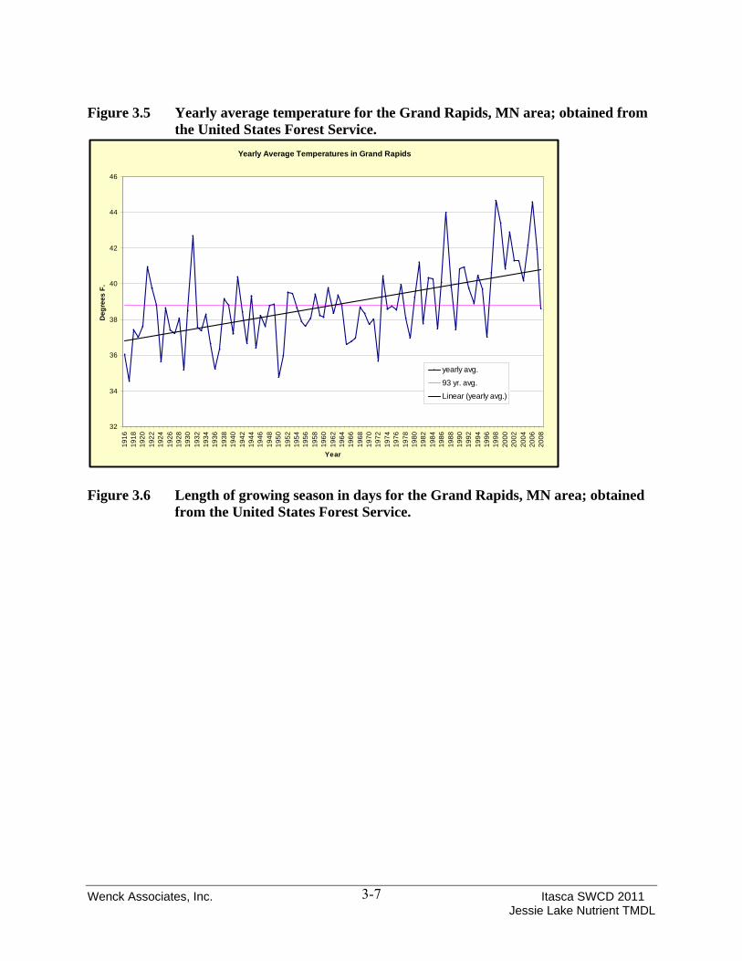
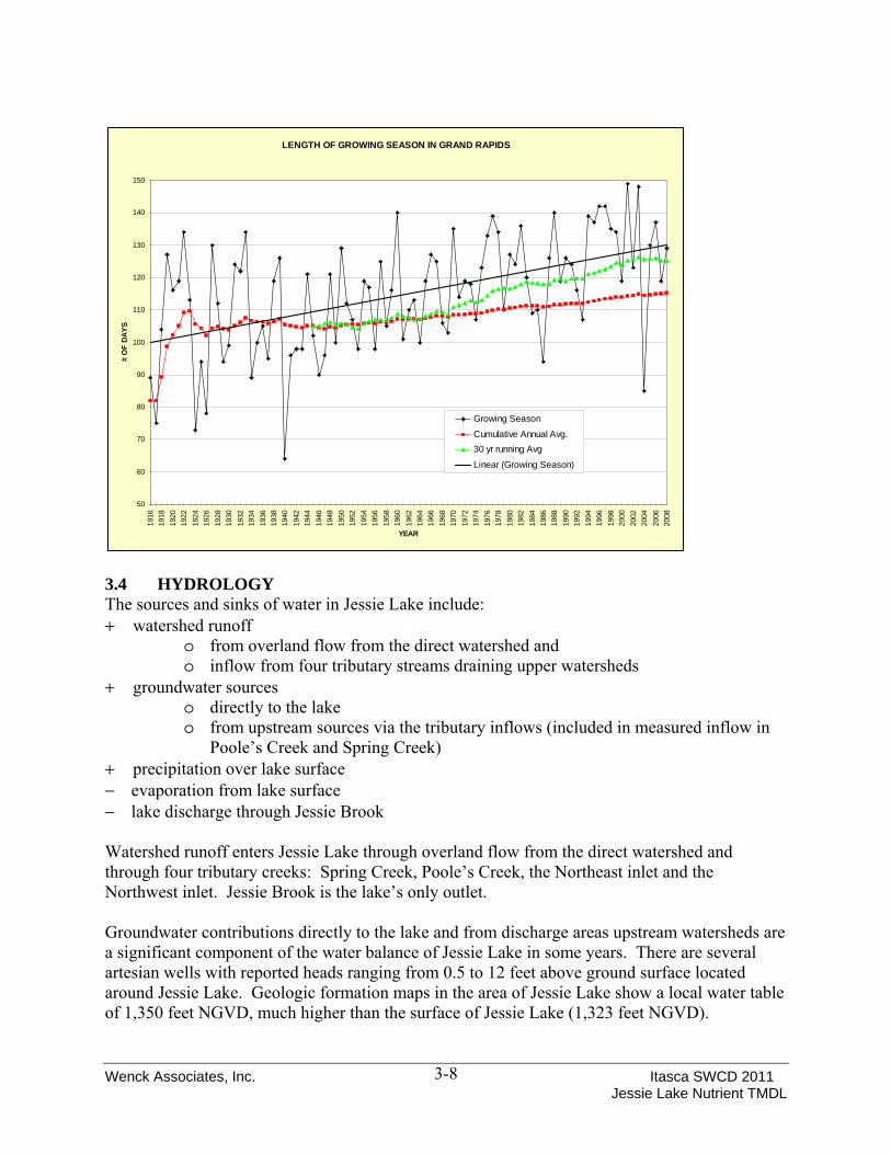
3.3 CLIMATE Precipitation data for the Jessie Lake area was obtained from the Minnesota Climatology Working Group of the Minnesota DNR. Additional climate data including, annual precipitation, average annual temperature and length of growing season was obtained for Itasca County from the United States Forest Service (USFS). The 1998 through 2008 average annual precipitation for the Jessie Lake area (Grand Rapids, MN) is 28 inches compared to the 1971 to 2000 normal reported is 28.78 inches (NCDC). Over the last 20 years, total annual precipitation has varied from a low of 21.7 inches in 2003 to a high of 34.2 inches in 2004. Average annual precipitation for the last 20 years is displayed in Figure 3.4. The USFS data of annual average temperature shows an increasing trend in the average annual temperature for the Grand Rapids area (Figure 3.5). The growing season for the Grand Rapids, MN area has ranged from 75 to 150 days over the last 90 years. The average growing season for that period is approximately 105 to 110 days. Over the last 30 years the length of the growing season has been increasing, with a recent average of approximately 120 to 125 days (Figure 3.6). Figure 3.4 Annual precipitation for the Jessie Lake Area obtained from the Minnesota
Climatology Working Group
Annual Precipitation for Jessie Lake
0.0
5.0
10.0
15.0
20.0
25.0
30.0
35.0
40.0
1989
1990
1991
1992
1993
1994
1995
1996
1997
1998
1999
2000
2001
2002
2003
2004
2005
2006
2007
2008
Tota
l Pre
cipi
tatio
n (in
)
Average Annual Precipitation
Wenck Associates, Inc. Itasca SWCD 2011 Jessie Lake Nutrient TMDL
3-7
Figure 3.5 Yearly average temperature for the Grand Rapids, MN area; obtained from the United States Forest Service.
Figure 3.6 Length of growing season in days for the Grand Rapids, MN area; obtained
from the United States Forest Service.
Yearly Average Temperatures in Grand Rapids
32
34
36
38
40
42
44
46
1916
1918
1920
1922
1924
1926
1928
1930
1932
1934
1936
1938
1940
1942
1944
1946
1948
1950
1952
1954
1956
1958
1960
1962
1964
1966
1968
1970
1972
1974
1976
1978
1980
1982
1984
1986
1988
1990
1992
1994
1996
1998
2000
2002
2004
2006
2008
Year
Deg
rees
F.
yearly avg.
93 yr. avg.
Linear (yearly avg.)
Wenck Associates, Inc. Itasca SWCD 2011 Jessie Lake Nutrient TMDL
3-8
3.4 HYDROLOGY The sources and sinks of water in Jessie Lake include: + watershed runoff
o from overland flow from the direct watershed and o inflow from four tributary streams draining upper watersheds
+ groundwater sources o directly to the lake o from upstream sources via the tributary inflows (included in measured inflow in
Poole’s Creek and Spring Creek) + precipitation over lake surface − evaporation from lake surface − lake discharge through Jessie Brook Watershed runoff enters Jessie Lake through overland flow from the direct watershed and through four tributary creeks: Spring Creek, Poole’s Creek, the Northeast inlet and the Northwest inlet. Jessie Brook is the lake’s only outlet. Groundwater contributions directly to the lake and from discharge areas upstream watersheds are a significant component of the water balance of Jessie Lake in some years. There are several artesian wells with reported heads ranging from 0.5 to 12 feet above ground surface located around Jessie Lake. Geologic formation maps in the area of Jessie Lake show a local water table of 1,350 feet NGVD, much higher than the surface of Jessie Lake (1,323 feet NGVD).
LENGTH OF GROWING SEASON IN GRAND RAPIDS
50
60
70
80
90
100
110
120
130
140
150
1916
1918
1920
1922
1924
1926
1928
1930
1932
1934
1936
1938
1940
1942
1944
1946
1948
1950
1952
1954
1956
1958
1960
1962
1964
1966
1968
1970
1972
1974
1976
1978
1980
1982
1984
1986
1988
1990
1992
1994
1996
1998
2000
2002
2004
2006
2008
YEAR
# O
F DA
YS
Growing Season
Cumulative Annual Avg.30 yr running Avg
Linear (Growing Season)

Wenck Associates, Inc. Itasca SWCD 2011 Jessie Lake Nutrient TMDL
3-9
Annual runoff measured in Spring Creek, Poole’s Creek and Jessie Brook is highly variable. The variability cannot be accounted for through precipitation or watershed storage alone as shown in Table 3.3 and Figure 3.7. Comparison of the MPCA’s discrete field flow measurements to the continuous flow record developed by the MPCA indicate that the quality of the flow data was good for both inflow and outflow records (Appendix A). Table 3.3. Variation in Measured Annual Runoff
Figure 3.7. Measured Runoff vs. Precipitation for Poole’s Creek, Spring Creek and Jessie Brook
As demonstrated by Table 3.3 and Figure 3.7 the surface water, groundwater and precipitation interactions are complex, variable and not well understood at this time. This lack of groundwater data, while not essential to development of the TMDL, has been identified as a data gap that may
Pooles Creek Runoff Spring Creek Runoff Jessie Brook RunoffMeasured Runoff (ac-ft) Watershed Area (ac): 3,772 Watershed Area (ac): 7,912 Watershed Area (ac): 19,013
Year Annual Precipitation (in) Ac-ft MeasuredInches
Measured Ac-ft MeasuredInches
Measured Ac-ft MeasuredInches
Measured2000 30.22 2,202 7.0 2,688 4.1 12,030 7.6 2001 32.55 3,728 11.9 6,420 9.7 28,428 17.9 2002 25.84 2,874 9.1 3,771 5.7 25,485 16.1 2003 24.92 530 1.7 1,550 2.4 8,181 5.2 2004 31.45 2,042 6.5 5,090 7.7 26,369 16.6 2005 31.31 2,869 9.1 2,312 3.5 26,598 16.8 2006 21.27 778 2.5 2,620 4.0 11,585 7.3 2007 32.34 479 1.5 3,651 5.5 10,331 6.5
T:\2212-Jessie\MPCA Q data\[Copy of RAK_Q Eval_jcm_Calib4.xls]Table Figs
0
2
4
6
8
10
12
14
16
18
20
20 22 24 26 28 30 32 34
Measured Precipitation (inches)
Mea
sure
d Ru
noff
(inch
es)
Poole's CreekSpring CreekJessie Brook

Wenck Associates, Inc. Itasca SWCD 2011 Jessie Lake Nutrient TMDL
3-10
constitute an obstacle to effective implementation. The implementation plan allows for more study if necessary. The Hydrology Guide for Minnesota reports average annual runoff near Jessie Lake was about 5.8 inches while average annual precipitation based on 1941 to 1970 normal was 25 inches (USDA 1975). Recent average annual precipitation based on the 1971 to 2000 normal reported for Grand Rapids is 28.78 inches (NCDC) compared with 25 inches reported historically. Given the increase in precipitation, average annual runoff has likely increased as well to about 6 inches. The Hydrology Guide for Minnesota reports average annual evaporation in the area of Jessie Lake as 24 inches per year. As evaporation is generally less than precipitation in this part of the state, and the surface area of Jessie Lake is large, the net difference between evaporation and precipitation over the lake surface can account for on average an addition of almost 5 inches over the lake surface of extra water annually. According to Assistant State Climatologist Greg Spoden, precipitation is far more variable annually than evaporation. As such, evaporation, or lack of evaporation cannot completely account for measured fluctuations of annual runoff. Storage is also an important component of the water budget for Jessie Lake as 9% of the watershed tributary to the lake is comprised of wetlands and lakes which can provide storage for watershed runoff and groundwater discharge. However, changes in surface watershed storage (i.e. lakes and wetlands) alone cannot account for the fluctuations in annual runoff. A current average year water budget is presented in Table 3.4 Table 3.4 Average Water Balance
3.5 RECREATIONAL USES Recreational uses on Jessie Lake include boating, water skiing and fishing during the open water and ice fishing seasons. The lake receives a moderate to high amount of recreational use, with the variation mainly attributed to angler usage in response to the success of walleye stocking efforts. An aerial creel survey conducted on 90 lakes in Grand Rapids fisheries management area revealed that Jessie Lake ranks as an important regional recreation resource. The lake ranked 9th out of 90 lakes surveyed for total angler hours and 13th when compared on an angler-hour per
Water BalanceCategory ac-ft/yr % of inputs Note
Water Sources 23,594
Precipitation (lake surface only) 4,125 17%Measured 28.73 inches over calibration/ validation period
Direct Watershed Runoff 1,527 6% Modeled and validatedNE Inlet 409 2% Modeled and validated
NW Inlet 2,095 9% Modeled and validatedSpring Creek 5,025 21% Measured
Poole's Creek 1,997 8% MeasuredGroundwater 8,417 36% Back calculation
Water Sinks 23,594Jessie Brook, Lake Outlet 20,148 Measured
Evaporation (lake surface only) 3,446 State Climatolgist (24 in/ yr)T:\2212-Jessie\Lake Response Model\Annual Precip\Version 6\[Average Annual LRModel 6 (Jessie).xls]Water Balance
Wenck Associates, Inc. Itasca SWCD 2011 Jessie Lake Nutrient TMDL
3-11
acre basins. There is one public boat access, owned and maintained by the DNR, on the southeast shore of the lake. There are two actively operating resorts located on Jessie Lake that contribute to the overall recreational use of the lake. The lake lies within the Chippewa National Forest and as a result hiking, camping or hunting activities take place near or along the shores of the lake. 3.6 FISH COMMUNITY The Minnesota DNR actively manages the fish community of Jessie Lake. There have been two lake surveys and eight populations assessments conducted by the DNR over the last fifty years, with the most recent assessment occurring in 2004. The DNR lake management plan lists walleye and northern pike as the primary management species and black crappie as a secondary management species. The DNR stocks walleye fry in Jessie Lake in a two-years on, two-years off program. The DNR has been studying walleye stocking success in Jessie Lake as a compared to natural walleye reproduction. Historically, walleyes collected in DNR assessments were comprised equally of stocked and naturally reproduced walleyes. However, recently stocked walleyes appear to be accounting for a larger portion of the total catch. Anglers on Jessie Lake indicate that the walleye fishing is tied to the success of stocked walleye year classes. The DNR has undertaken habitat improvement projects for walleyes, such as the creation of an artificial reef in the lake in 1980 and the creation of spawning riffles in Spring Creek in 1998 and 2003. While walleyes are the primary species sought by anglers, other species present in the Jesse Lake include northern pike, black crappie, yellow perch, bluegill, rock bass and largemouth bass. The fish community can influence the water quality of a lake. For example, rough fish such as common carp can add to nutrient loading and reduce water clarity by uprooting aquatic macrophytes during feeding and spawning that re-suspends bottom sediments and nutrients. In other instances, large populations of small panfish (bluegills, crappies or perch) can exhibit strong grazing pressure on the zooplankton community, which in turn reduces zooplankton grazing on algae, which can lead to reduced water clarity. The fish community of Jessie Lake appears to be well balanced based on the DNR survey results. Rough fish do not appear to be overly abundant in the lake and there appears to be a mechanism for top-down control of predators such as walleye and northern pike on the panfish community. Additionally, sensitive species such as tullibee are present in the system. It does not appear that the existing fish community is negatively impacting the water quality or habitat of Jessie Lake. 3.7 AQUATIC PLANTS Aquatic plants are beneficial to lake ecosystems providing spawning and cover for fish, habitat for macroinvertebrates, refuge for prey, and stabilization of sediments. However, in excess they limit recreation activities such as boating and swimming and reduce aesthetic value. Excess nutrients in lakes can lead to non-native, invasive aquatic plants taking over a lake. Some exotics can lead to special problems in lakes. For example, Eurasian watermilfoil can reduce plant biodiversity in a lake because it grows in great densities and outcompetes all the other plants. Ultimately, this can lead to a shift in the fish community because these high densities favor panfish over larger game fish. Species such as curly leaf pondweed can cause very specific problems by changing the dynamics of internal phosphorus loading. All in all, there is a delicate balance within the aquatic plant community in any lake ecosystem.

Wenck Associates, Inc. Itasca SWCD 2011 Jessie Lake Nutrient TMDL
3-12
There have been three aquatic plant surveys conducted in Jessie Lake. The first was a non quantitative survey completed in 1978 by DNR Fisheries Division in which species were identified and beds roughly delineated during their lake assessment. The second was a partial lake survey which was conducted in 2001 as part of the Minnesota County Biological Survey. The third survey was conducted during the summer of 2008 by DNR fisheries and provided the most detail through the utilization of the point intercept method.
Although the three studies cannot be directly compared, overall it appears that the aquatic vegetation community of Jessie Lake has remained stable over the last 30 years. The initial aquatic plant survey conducted by the DNR Fisheries Division noted that emergent vegetation was present around approximately 90 percent of the shoreline fringe of the basin. The greatest depth of submerged aquatic vegetation was noted as being out to a depth of 10 feet during the 1978 survey. General locations of emergent, floating leaf and submerged vegetation beds from the 1978 survey is presented in Figure 3.7. The 1978 survey identified 26 combined species of emergent, floating leaf and submerged vegetation. Hardstem bulrush and spikerush were the emergent species identified as abundant in the basin during the survey and the submerged species flatstem pondweed, water milfoil and variable pondweed identified as abundant in the basin. The 2001 Minnesota County Biological Survey for Jessie Lake did not provide locations or abundance ratings for aquatic plant species observed. However, the survey found almost the exact same total number of combined species present in the basin at 25. The 2008 aquatic plant survey identified 33 total species, more than either of the previous surveys, although several of the species were observed at only a few locations. While the final summary results of the 2008 survey are not yet available, the most commonly observed species during the survey included bulrush, chara, northern milfoil and water lily. The results of the 2008 vegetation survey are also presented in Figure 3.7. Compared to the 1978 survey, it appears that some of the submerged and emergent vegetation beds have expanded in size. Overall, it appears that the aquatic vegetation community of Jessie Lake has remained stable of the last 30 years. A similar number of species were observed across all three vegetation surveys, with many of the same species present across all surveys. Based on the survey results, there are no harmful exotic vegetation species present that could be impacting aquatic habitat or water quality. Water clarity may be limiting submerged vegetation growth to shallower areas of the basin, less than 10 feet deep. If water clarity was improved through reduced nutrient loading, this could increase the total area of vegetation growth in the basin. The increased vegetation could help to remove additional nutrients from the water column further improving water clarity and in-lake nutrient concentrations. 3.8 SHORELINE DEVELOPMENT AND HABITAT CONDITIONS The shoreline areas are defined as the areas adjacent to the lakes edge with hydrophytic vegetation and water up to 1.5 feet deep or a water table within 1.5 feet from the surface. Shoreline areas should not be confused with shoreland areas which are defined as 1,000 feet upland from the ordinary high water level (OHWL). Natural shorelines provide water quality

Wenck Associates, Inc. Itasca SWCD 2011 Jessie Lake Nutrient TMDL
3-13
treatment, wildlife habitat, and increased biodiversity of plants and aquatic organisms. Natural shoreline areas also provide aesthetic values and important habitat to fisheries including spawning areas and refugia. Vegetated shorelines provide numerous benefits to both lakeshore owners and lake users including improved water quality, increased biodiversity, important habitat for both aquatic and terrestrial animals, and stabilizing erosion resulting in reduced maintenance of the shoreline. Identifying projects where natural shoreline habitats can be restored or protected will enhance the overall lake ecosystem. The littoral zone is defined as that portion of the lake that is less than 15 feet in depth and is where the majority of the aquatic plants are found. The littoral zone of the lake also provides the essential spawning habitat for most warm water fishes (e.g. bass, walleye, and panfish). Jessie Lake has a moderate amount of shoreline development compared to length of the lake shoreline. The lake is classified as a recreational development lake by the both Itasca County and the DNR. According to the DNR lake management plan approximately 65 percent of the lake shoreline is privately owned, while the State, Itasca County, and U.S. Forest Service own the remaining 35 percent of the shoreline. There are currently 38 homes, 65 seasonal cabins and two active resorts on the lake. Developed shorelines often include the removal of native vegetation both on shore and in the lake, which can lead to increase nutrient runoff and shoreline erosion. Communications with the DNR and the Itasca SWCD indicate that shoreline erosion and degradation is a problem on certain areas of Jessie Lake. One area of concern includes large slumping banks near the Northwest Inlet tributary. These eroding banks add sediment to the lake which is likely impacting water quality and clarity as well as fish habitat in that portion of the basin. Several shoreline restoration projects have been conducted through combined efforts of the DNR, Jessie Lake Association and private land owners. The goal of the restorations was to reduce shoreline erosion, reduce nutrient runoff from adjacent properties, improve fish and wildlife habitat and improve the aesthetics of the shoreline. The DNR lake management plan identifies continued restoration of natural shorelines as an important future management strategy for Jessie Lake.

Wenck Associates, Inc. Itasca SWCD 2011 Jessie Lake Nutrient TMDL
3-14
Figure 3.8 General locations of emergent, floating leaf and submerged vegetation beds from the 1978 and 2008 Surveys

Wenck Associates, Inc. Itasca SWCD 2011 Jessie Lake Nutrient TMDL
4-15
4.0 Nutrient Source Assessment
4.1 INTRODUCTION
Understanding the sources of nutrients to a lake is a key component in developing a TMDL for lake nutrients. In this section, we provide a description of the potential sources of phosphorus to the lake. 4.2 PERMITTED SOURCES
The only permitted source of nutrients to Jessie Lake would be construction stormwater runoff from any future development conducted under an NPDES permit. This is not a current nutrient source for consideration in the current nutrient budget, but a potential future source to be considered in the TMDL allocation. There are no known wastewater treatment plant (WWTP) effluent discharges, Municipal Separate Storm Sewer Systems (MS4s), or industrial discharges located within the Jessie Lake watershed. There are no other known permitted sources within the watershed tributary to Jessie Lake. 4.3 NON-PERMITTED SOURCES
The non-permitted sources of nutrients include: • In-lake nutrient cycling, • Land-use based non-point sources from the tributary watersheds including lake-shore
residential areas and associated septic systems as well as other developed or agricultural land uses draining to Jessie Lake through the four major tributary streams or directly through overland flow
• Atmospheric loads • Ambient groundwater inflows
These sources are assessed in the sections that follow. 4.3.1 In-Lake Nutrient Cycling in Jessie Lake
In-lake nutrient cycling is an important component of the whole lake nutrient budget. Phosphorus in the lake sediments released under specific conditions is called in-lake nutrient cycling, or internal loading. Internal loading can be a result of sediment anoxia where poorly bound phosphorus is released into the water column in a form readily available for phytoplankton production.

Wenck Associates, Inc. Itasca SWCD 2011 Jessie Lake Nutrient TMDL
4-16
Internal loading can also result from sediment resuspension that may result from wind mixing, rough fish activity or prop wash from boat activity. In many eutrophic or hypoeutrophic systems, internal loading can often comprise the largest component of the overall lake nutrient budget. Past modeling of Jessie Lake indicates that the internal nutrient load may exceed 50 percent of the total nutrient load for the lake in some years. 4.3.2 Landuse Based Non-Point Sources
Tributary Inflows The total drainage area to Jessie Lake is 20,738 acres (including lake surface). Of that total, 16,400 acres or approximately 80% of the watershed drains through four main tributaries to Jessie Lake including the Northeast Inlet, Northwest Inlet, Poole’s Creek and Spring Creek. Inflow concentrations and flows were measured at each of the tributaries, as such the individual components of the tributary inflow loads were not estimated; however, the sources of nutrients that comprise these inflows are listed below. Drainage from the tributaries conveys nutrients to Jessie Lake from: • watershed runoff from land use based sources (Figure E.1, Table 3.2) including
o <5 % open space, grass land or pasture o <0.1% residential land use, mostly in lake shore areas o <0.01% agricultural land use
• highly variable groundwater discharge and associated phosphorus in groundwater discharged in the upper watershed, and carried to Jessie Lake via tributaries
• phosphorus released from upstream wetlands which comprise 9% of the total watershed area draining to Jessie Lake
• Internal loading from upstream lakes including Peterson Lake, Spring Lake and Little Spring Lake
Measurement of the tributary inflow concentrations and loads reduced the uncertainty associated with the model given that inflow concentrations from 80% of the drainage area were measured. Direct Watershed The direct watershed refers to the tributary watershed that drains to Jessie Lake primarily through overland flow. Sources of nutrients in the direct watershed area also include landuse based sources (Table 3.2). However, residential land use which comprises a small percent of the total drainage area is none the less closest to the lake and likely poses a greater impact per acre than similar land use farther away. Within areas comprised of residential landuse, sources that potentially contribute phosphorus to runoff include lawn fertilizers, detergents or roads and driveways. Though land used based sources of phosphorus are the same in both the direct watershed and the remainder of the watershed, the two are differentiated for the purpose of partitioning measured loads to the lake and unmeasured loads to the lake. Tributary loads are measured, whereas direct overland flow is difficult to measure and is therefore modeled using the rational method, measured precipitation and measured watershed concentrations from other areas of the watershed with similar landuses.

Wenck Associates, Inc. Itasca SWCD 2011 Jessie Lake Nutrient TMDL
4-17
Septic Systems There are no municipal waste water treatment systems in the vicinity of Jessie Lake. As a result all of the homes located along the lake shoreline or within the watershed are served exclusively by Subsurface sewage treatment systems (SSTS). The JLWA conducted an SSTS survey of residents in the Jessie Lake watershed in 2001. Based on the survey results, 60 to 65% of the homes in the watershed and along the lake are seasonal dwellings, with full time residents comprising the remaining 35 to 40%. The soils in the Jessie Lake watershed are sandy loams and loamy sands. High phosphorus loading from SSTS is possible in sandy soils even when systems are largely compliant. The CWP 2002 Jessie Lake Report identified that the soils in the Jessie Lake watershed have restrictions for on-site individual septic system drain fields, due to their high percolation rate and poor filtering capacity. Septic system failure rates were assumed to be 50% for TMDL modeling. This assumption of 50% failure rates is conservative in the context of the TMDL and protective of lake water quality. Minimizing the potential load reductions to be gained from SSTS maximizes the load reductions required of other areas. In any case, eliminating loads from SSTS is a necessary element of TMDL implementation, but the load allocation does not overly rely on them to meet standards. 4.3.3 Atmospheric Deposition
The atmosphere delivers phosphorus to water and land surfaces both in precipitation and in so-called “dryfall” (dust particles that are suspended by winds and later deposited). As such atmospheric inputs must be accounted for in development of a nutrient budget, though they are generally small direct inputs to the lake surface and are impossible to control. 4.3.4 Ambient Groundwater Inflows
Jessie Lake lies within the Big Fork River Watershed, which is a tributary to the Rainy River Watershed. The hydrologic atlas, “Water Resources of the Big Fork River Watershed, North-Central Minnesota” (Lindholm, et al., 1976; U.S Geological Survey HA-549), includes the Jessie Lake watershed. According to the hydrologic atlas bedrock in the Jessie Lake area is 150 to 250 feet below the land surface, with overlying glacial drift. The area immediately around Jessie Lake is generally sandy to a sand/gravel mix. The atlas indicates that most of the wells in the area around Jessie Lake are screened in the shallow surficial aquifer and range from 20 to 100 feet deep. The sand/gravel soils and the relatively shallow depth of water supply wells indicate that Jessie Lake is subject to local groundwater interactions. There are several artesian wells with heads from 0.5 to 12 feet above ground surface near Jessie Lake and the reported water levels in the area directly around Jessie Lake is a local high at 1,350 feet NGVD, much higher than the lake’s water surface at around 1,323 feet NGVD in recent years (Figure 4.1).

Wenck Associates, Inc. Itasca SWCD 2011
Figure 4.1 Local Surficial Aquifer Elevation (in blue) (From Lindholm 1976)*
Jessie Lake Nutrient TMDL 4-18
(* = Large blue dots on map represent regional groundwater divide) These evaluations show the potential for significant groundwater discharge to Jessie Lake itself and lesser but still significant groundwater contributions to streams and lakes in tributary watersheds. Hydrologic data and stream water quality data (see Section 5 of this report) collected for this study support that conclusion. The MPCA conducted a baseline water quality survey of Minnesota’s principal aquifers (MPCA, 1999). The report for northeastern Minnesota included a survey of 30 wells in Itasca County, sampling for a variety of water quality parameters including nutrients. Total phosphorus concentrations in groundwater wells in Itasca County varied from 14 to 300 ug/L. Of these 30 wells, only one was located within the Jessie Lake watershed, on the southwest edge of the basin. The measured total phosphorus concentration for this well was 43 ug/L. This concentration is within the range of in-lake total phosphorus concentrations typically observed in Jessie Lake, and greater than the State standard for the region of 30 ug/L. Due to the likely volume of groundwater contributions to Jessie Lake and the measured total phosphorus concentration in the local aquifer, in years where groundwater inflow is significant, it represents a significant, highly variable in terms of annual volume, and uncontrollable load to Jessie Lake.
Wenck Associates, Inc. Itasca SWCD 2011 Jessie Lake Nutrient TMDL
5-1
5.0 Assessment of Water Quality Data
5.1 MONITORING EFFORTS
In 1998, a severe algae bloom and subsequent fish kill coupled with the results of the 1998 water quality assessment sparked concern over declining water quality. Stakeholders secured a CWP grant in 2000 to conduct detailed in-lake water quality sampling as well as stream flow and water quality monitoring in 2000 and 2001. The final CWP report (MPCA 2002) summarizes results of the field studies and monitoring efforts conducted from 1998 through 2001. Since that time water quality data has been collected every year on Jessie Lake, through a combination of efforts from the JLWA, Itasca SWCD, MPCA and the Citizen’s Lake Monitoring program. 5.2 LAKE MONITORING RESULTS
5.2.1 Total Phosphorus
Total phosphorus concentrations were monitored in Jessie Lake in1986, 1992, and 1998 through 2007. Water quality samples were collected monthly, from May through September, for most monitoring years. However, bi-weekly samples were collected from May through September in 1986, 1999 and 2000 monitoring years. During the 2001 monitoring year, total phosphorus samples were collected weekly from May through September. The average total phosphorus concentrations for all monitoring years are displayed with the minimum, maximum and one standard deviation above and below the average (Figure 5.1). In-lake average TP concentrations have varied from a low of 19 μg/L in 2005 to a high of 48 μg/L in 1998. The average value in 2004 was 17 μg/L, however late summer samples were not represented in the 2004 average and as such it is not considered representative of annual average conditions. The annual average TP concentrations exceeded the State Standard of 30 ug/L for the Northern Lakes and Forest Ecoregion during six of the twelve monitoring years. Recent typical growing season average TP concentrations are compared with MPCA lake standards for the Northern Lakes and Forests Ecoregion in Table 5.1

Wenck Associates, Inc. Itasca SWCD 2011 Jessie Lake Nutrient TMDL
5-2
Figure 5.1: Box plots of growing season average in-lake Total Phosphorus concentrations for Jessie Lake. The range of the box represents one standard deviation above and below the annual average. The minimum and maximum observed values for each year are also displayed.
* Late summer samples were not collected in 2004 likely skewing the results for that year towards the low end of observed TP concentrations. Table 5.1 Range of Typical Growing Season Average Total Phosphorus and
Chlorophyll-a Concentrations and Secchi depths in Jessie Lake compared to Numeric Standards
Parameter Standard 1998-2007 TP (μg/L) 30 19 – 48 Chlorophyll-a (μg/L) 9 6 – 22 Secchi Depth (m) >2.0 1.83 – 4.11 5.2.2 In-Lake Chlorophyll-a
Water quality monitoring for chlorophyll-a in Jessie Lake generally coincides with monitoring efforts for total phosphorus. Chlorophyll-a concentrations were sampled at the same frequency as total phosphorus samples for all years described in Section 5.2.1 for Jessie Lake, with the exception of 2004. Average in-lake chlorophyll-a concentrations have ranged from a low of 4.7 ug/L in 1992 to a high of 22.3 ug/L in 1998. Average chlorophyll-a concentrations have exceeded the State standard of 9 ug/L for the Northern Lakes and Forest Ecoregion during eight
Jessie Lake - Average Total Phosphorus(May - September)
0.0
20.0
40.0
60.0
80.0
100.0
120.0
140.0
1986 1992 1998 1999 2000 2001 2002 2003 2004 2005 2006 2007 2008Sample Year
Tota
l Pho
spho
rus
(ug/
L)
Standard Deviation
Minimum
Mean
Maximum
Standard Deviation
State Standard: 30 ug/L

Wenck Associates, Inc. Itasca SWCD 2011 Jessie Lake Nutrient TMDL
5-3
of the twelve monitoring years. Recent typical growing season average chlorophyll-a concentrations are compared with MPCA lake standards for the Northern Lakes and Forests Ecoregion in Table 5.1 Figure 5.2: Box plots of annual average in-lake Chlorophyll-a concentrations for Jessie Lake. The range of the box represents one standard deviation above and below the annual average. The minimum and maximum observed values for each year are also displayed.
5.2.3 Secchi Depth
Secchi depth readings were initially measured on Jessie Lake in 1985, one year before additional water quality monitoring began. Secchi depth readings were taken bi-weekly during 1985 and 1986. Readings were taken only monthly in 1992, but then the frequency was increased in 1998, when weekly Secchi depth readings were recorded. Bi-weekly readings were again taken in 1999 and 2000, and then the frequency was again increased to weekly readings for the years of 2001 through 2007, for the growing season months on May through September. The average Secchi depth readings have ranged from a low of 1.83 meters in 1998 to a high of 4.15 meters in 1992. Growing season average Secchi depth readings have been greater than the State standard of greater than 2 meters for the Northern Lakes and Forest Ecoregion for all but the 1998 monitoring year.
Jessie Lake - Average Chlorophyll-a(May - September)
0.0
10.0
20.0
30.0
40.0
50.0
60.0
1986 1992 1998 1999 2000 2001 2002 2003 2005 2006 2007 2008Sample Year
Chl
orop
hyll-
a (u
g/L)
Standard Deviation
Minimum
Mean
Maximum
Standard Deviation
State Standard: 9 ug/L
T:\2212-Jessie\Lake Jessie_bkrnd inf\[Jessie_Lake_Chemistry_85-07_JCM .xls]Box P lots

Wenck Associates, Inc. Itasca SWCD 2011 Jessie Lake Nutrient TMDL
5-4
Figure 5.3: Box plots of growing season average Secchi depth readings for Jessie Lake. The range of the box represents one standard deviation above and below the annual average. The minimum and maximum observed values for each year are also displayed.
5.3 STREAM MONITORING RESULTS
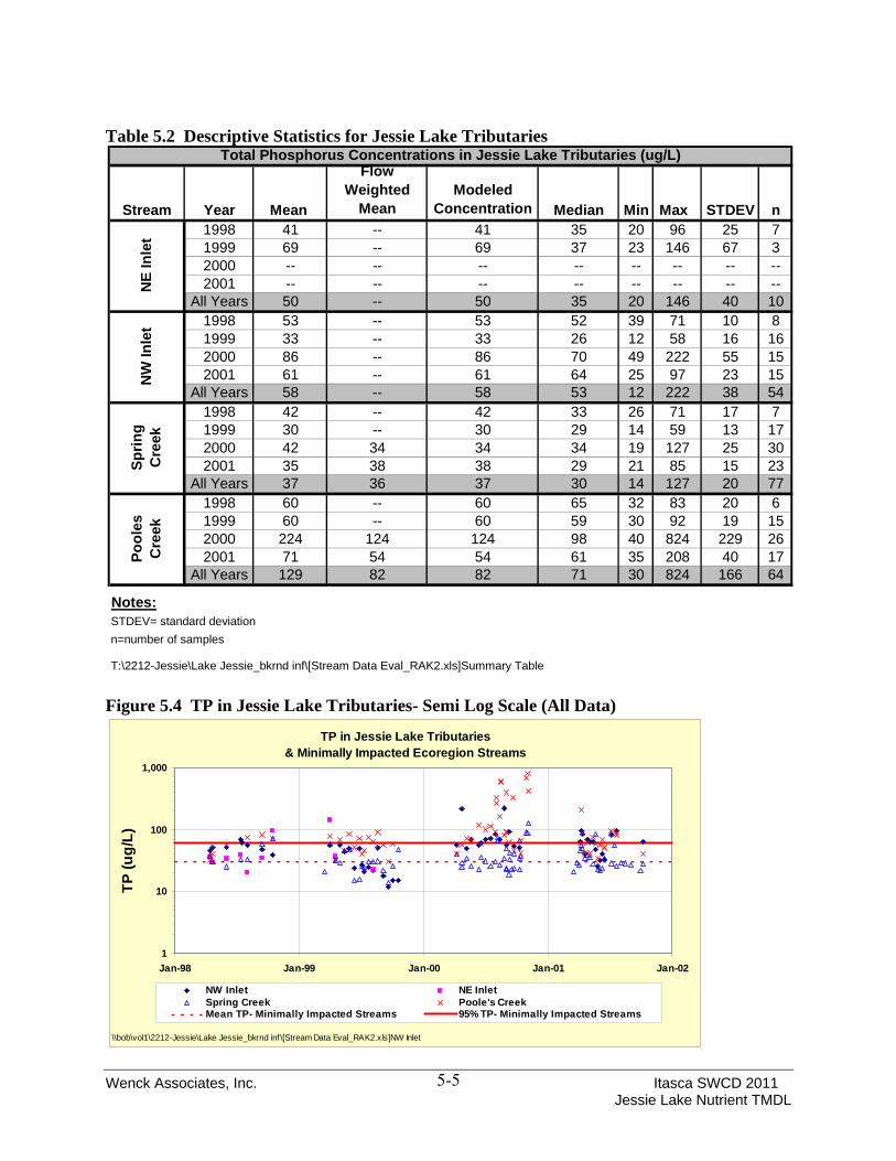
Discrete samples of stream water quality were collected in each of the main tributaries to Jessie Lake. Data is summarized in Table 5.2 (Note that the NW Inlet sampling site is located at a road crossing, which was later determined to be upstream of an area of high, sloughing banks.) Figure 5.4 compares TP in Jessie Lake tributaries to each other and to those found in minimally impacted streams in the ecoregion (McCollor & Heiskary, 1993). The figures, along with Table 5.2, show minimal variation in inter-annual TP concentrations in terms of the mean, except for 2000, which is consistently higher than the other three years for both mean and standard deviation. Coincidentally, hydrologic data show that 2000 was a year of low groundwater contributions based on the outflow at Jessie Brook. Data indicate higher groundwater contributions in 2001 (outflow in 1998 and 1999 was not measured). High contributions of low-phosphorus-content groundwater (relative to watershed runoff) can reduce stream concentrations and reduce variability in sampling results, as is seen here compared with the 2000 data.
Jessie Lake - Average Secchi DepthMay - September
0.0
1.0
2.0
3.0
4.0
5.0
6.0
7.0
8.0
1985 1986 1992 1998 1999 2000 2001 2002 2003 2004 2005 2006 2007 2008Sample Year
Secc
hi D
epth
(m)
Standard Deviation
Minimum
Mean
Maximum
Standard Deviation
State Standard: >2.0 M
Wenck Associates, Inc. Itasca SWCD 2011
Table 5.2 Descriptive Statistics for Jessie Lake Tributaries
Jessie Lake Nutrient TMDL 5-5
Total Phosphorus Concentrations in Jessie Lake Tributaries (ug/L)
Stream Year Mean
Flow Weighted
MeanModeled
Concentration Median Min Max STDEV n1998 41 -- 41 35 20 96 25 71999 69 -- 69 37 23 146 67 32000 -- -- -- -- -- -- -- --2001 -- -- -- -- -- -- -- --
All Years 50 -- 50 35 20 146 40 101998 53 -- 53 52 39 71 10 81999 33 -- 33 26 12 58 16 162000 86 -- 86 70 49 222 55 152001 61 -- 61 64 25 97 23 15
All Years 58 -- 58 53 12 222 38 541998 42 -- 42 33 26 71 17 71999 30 -- 30 29 14 59 13 172000 42 34 34 34 19 127 25 302001 35 38 38 29 21 85 15 23
All Years 37 36 37 30 14 127 20 771998 60 -- 60 65 32 83 20 61999 60 -- 60 59 30 92 19 152000 224 124 124 98 40 824 229 262001 71 54 54 61 35 208 40 17
All Years 129 82 82 71 30 824 166 64
Notes:STDEV= standard deviationn=number of samples
T:\2212-Jessie\Lake Jessie_bkrnd inf\[Stream Data Eval_RAK2.xls]Summary Table
NE
Inle
tN
W In
let
Sprin
g C
reek
Pool
es
Cre
ek
Figure 5.4 TP in Jessie Lake Tributaries- Semi Log Scale (All Data)
TP in Jessie Lake Tributaries& Minimally Impacted Ecoregion Streams
1
10
100
1,000
Jan-98 Jan-99 Jan-00 Jan-01 Jan-02
TP (u
g/L)
NW Inlet NE InletSpring Creek Poole's CreekMean TP- Minimally Impacted Streams 95% TP- Minimally Impacted Streams
\\bob\vol1\2212-Jessie\Lake Jessie_bkrnd inf\[Stream Data Eval_RAK2.xls]NW Inlet

Wenck Associates, Inc. Itasca SWCD 2011 Jessie Lake Nutrient TMDL
6-1
6.0 Linking Water Quality Target and Sources
A lake nutrient budget can be used to identify and prioritize management strategies to improve water quality. Additionally lake response models can be developed to understand how lake nutrient concentrations respond to changes in nutrient loads. Through this knowledge, managers can make decisions about how to allocate lake restoration dollars and efforts and quantify the effects of such efforts. 6.1 SELECTION OF MODELS AND TOOLS
Three models were selected to assist in setting the TMDL for Jessie Lake: • A lake response to nutrient input model (Canfield- Bachmann), • A watershed runoff model (rational method based on National Agricultural Statistics
Service (NASS) 2007 land cover and precipitation, land slope, and soil type), and • An internal load model (Nurnberg 1998)
A model of lake response to nutrient inputs was needed to quantify existing nutrient loads and required load reductions for Jessie Lake to meet state standards. The Canfield-Bachmann model was selected for this purpose because it represents an appropriate level of detail for the amount of data available. The model is robust and well understood and is accepted in Minnesota for setting TMDLs. The Canfield Bachman model was used to predict the response of the Jessie Lake described herein to phosphorus loads and load reductions. The Canfield-Bachmann model was developed using data collected from 704 natural lakes to best describe the lake phosphorus sedimentation rate which is needed to predict the relationship between in-lake phosphorus concentrations and phosphorus load inputs. The phosphorus sedimentation rate is an estimate of net phosphorus loss from the water column through sedimentation to the lake bottom. The phosphorus sedimentation rate is used by the Canfield-Bachman model in concert with lake-specific characteristics such as annual phosphorus loading, mean depth, and hydraulic flushing rate to predict in-lake concentrations of phosphorus as they relate to phosphorus loading. These model predictions are compared to measured data to evaluate how well the model describes the lake system. To apply the Canfield-Bachmann model to Jessie Lake, watershed specific data were used including. For the Jessie Lake TMDL lake response modeling, measured watershed runoff volumes, concentrations and overall loads were used instead of calculated watershed hydrology and phosphorus load export. For the Jessie Lake TMDL lake response modeling effort no calibration factors were used, with the exception of adjusting the sediment phosphorus release rates within ranges of measured values. The model fit reasonably well compared to annual average lake water quality data. Thirteen years of measured in lake water quality data were compared to modeled values. Differences between observed and model-predicted average in-

Wenck Associates, Inc. Itasca SWCD 2011 Jessie Lake Nutrient TMDL
6-2
lake concentrations were generally within the reported standard deviations for annual average TP for a given year. The model represents a reasonable fit to the available data (Appendix A). In general the lake response models for Jessie Lake typically tended towards a slight over-prediction of in-lake TP (an under-prediction in sedimentation rates), which translates into a conservative load reduction in terms of setting the TMDL. That is to say, the model over-prediction of in-lake phosphorus concentrations results in the calculation of a conservative (larger) required load reduction to reach water quality goals for Jessie Lake. The lake response model is an annual lump sum model calibrated to annual summer averages measured between 1998 and 2007. The Canfield-Bachmann model was selected to accomplish the following tasks:
• Quantify the lake’s response to annual nutrient inputs in terms of summer average TP concentration
• Validate the internal load model • Evaluate load reduction scenarios
Watershed runoff is modeled using rational method runoff coefficients based on 2007 NASS Land Cover dataset, slopes and soil types. Land use, land cover and soil type are evaluated to determine the fraction of precipitation that runs off the watershed annually; typically this is a range of potential values. These fractions are calibrated to measured runoff and applied to areas and time periods for which runoff data is not available. Measured runoff data is used where available. The internal loading model is summarized by Nurnberg (1998, 2005). It models annual phosphorus released from the sediment based on the measured release rates and the anoxic factor, which is based on measured lake temperature and DO profiles. It is an annual lump sum model and does not model episodic events such as climatic mixing. Technical Memo 1 in Appendix A presents a detailed accounting of the modeling efforts. 6.2 CURRENT PHOSPHORUS BUDGET COMPONENTS
The current phosphorus load contributions from each potential source was developed using the various models and collected data described above. The phosphorus load contributions to Jessie Lake were partitioned into six contributing components:
1. Atmospheric load, 2. Septic systems, 3. Ambient groundwater, 4. Direct watershed runoff, 5. Contributing tributaries, 6. Internal phosphorus cycling.
A description of the assessment of each partitioned source and the modeling efforts used to account for each source are provided.

Wenck Associates, Inc. Itasca SWCD 2011 Jessie Lake Nutrient TMDL
6-3
6.2.1 Atmospheric Load
The atmosphere delivers phosphorus to water and land surfaces both in precipitation and in so-called “dryfall” (dust particles that are suspended by winds and later deposited). A recent statewide study of phosphorus sources commissioned by the MPCA (Barr, 2004 updated in 2007) gives the following atmospheric load data for the Rainy River Basin (Table 6.1): Table 6.1 Atmospheric Deposition of Phosphorus Deposition Component [kg/ha/yr] [lb/ac/yr] Low-Precipitation P Deposition 0.06 0.05 Average-Precipitation P Deposition 0.07 0.07 High-Precipitation P Deposition 0.09 0.08 Dry P Deposition 0.12 0.11 Dry-Year Total P Deposition 0.18 0.16 Average-year Total P Deposition 0.19 0.18 Wet-year Total P Deposition 0.21 0.19 Deposition rates were applied to the area of the lake surface based on annual precipitation for dry (< 25 inches), average, and wet precipitation years (>38 inches). The atmospheric load typically comprises a small percentage of the total load for the lake. 6.2.2 Septic Systems
Information from the Itasca SWCD indicates there are 93 lake shore residences on Jessie Lake. The JLWA conducted an SSTS survey of residents in the Jessie Lake watershed in 2001. The survey results indicate that residents comprise both part-time (~70%) and year-round residents (~30%). The survey results also indicate that over 90 percent of the SSTS in the watershed are a combination of a septic tank/drywell with a drainfield/seepage drywell system. Holding tanks and cesspools comprise only small percentage of the total systems in the watershed. There are two active resorts along the shores of Jessie Lake that utilize SSTS with drain fields to treat waste water. The total annual septic load to Jessie Lake was calculated by multiplying the number of homes around the lake assuming four persons per home and a total phosphorus load of 4.2 pounds of phosphorus per system per year. While there are 93 lake shore residents, the majority of the residents are seasonal (part-time residents). It was assumed that a seasonal residence produces a load equivalent to one-quarter of a full time resident. To calculate the load from the two resorts on the lake, it was assumed that each of the two resorts produce double the load a full time residence produces. There are 13 rental cabins total between the two resorts, and limited camping and RV areas. These resorts are occupied seasonally at varying levels of occupancy. Assuming each resort is equivalent to two full time residences equates to 16 seasonal residences representing 13 cabins, plus the limited RV and camping sites.

Wenck Associates, Inc. Itasca SWCD 2011 Jessie Lake Nutrient TMDL
6-4
Given that the loads from the resorts may vary from year to year, it is conservative in terms of meeting in-lake goals to under predict the septic load in terms of setting the TMDL. Minnesota law requires that assigning a zero load allocation to septic systems. Under-predicting the existing septic loads means assigning more load reduction to other sources. Meanwhile, implementation plans necessarily tackle knocking down all existing load from septic systems, as none is allowable. This provides a small margin of safety for the overall TMDL (small given that septic systems are such a small fraction of the overall loads to the lake). These assumptions were then used to determine an equivalent number of full time residents on the lake for the septic load calculation. The total system equivalent on Jessie Lake was determined as follows: (65 seasonal residents x 0.25) + (28 full time residents) + (2 resorts x 2) = 48.25 systems (rounded up to 49 for modeling calculations) The total phosphorus septic load to the lake was then determined by multiplying the total septic load by an assumed failure rate of 50 percent. Based on the above assumptions the septic load to the lake would be calculated as follows: (49 system equivalents)*(4.2 lbs TP/yr per system)*(50% failure rate) = 103 lbs TP to Jessie Lake 6.2.3 Ambient Groundwater
The un-gauged groundwater contributions to Jessie Lake are comprised of not only direct contributions to the lake, but from additional groundwater contributions via the NE and NW inlets and their tributary watersheds as well as from groundwater discharge in the direct watershed which ultimately discharge to Jessie Lake. Measured inflows in Spring Creek and Poole’s Creek indicate that groundwater comprises a variable annual percentage of stream flow and likely a proportional contribution in ungauged watershed discharge and to the lake itself. These inflows were called the un-gauged groundwater contributions to Jessie Lake. Un-gauged groundwater inputs were calculated based on:
• Measured inflows at Spring Creek and Poole’s Creek, • Modeled inflows for the NE and NW inlets and the direct watershed to Jessie Lake and • The total outflow of Jessie Lake at Jessie Brook. • Measured TP concentrations in area groundwater
The un-gauged groundwater contribution to Jessie Lake in terms of water volume was calculated as the difference between the sum of measured and modeled inflows and the outflow from Jessie Lake as measured at Jessie Brook: Groundwater Contribution to Jessie Lake = ∑(Jessie Lake Outflow) - Σ(Jessie Lake Inflows) Where:
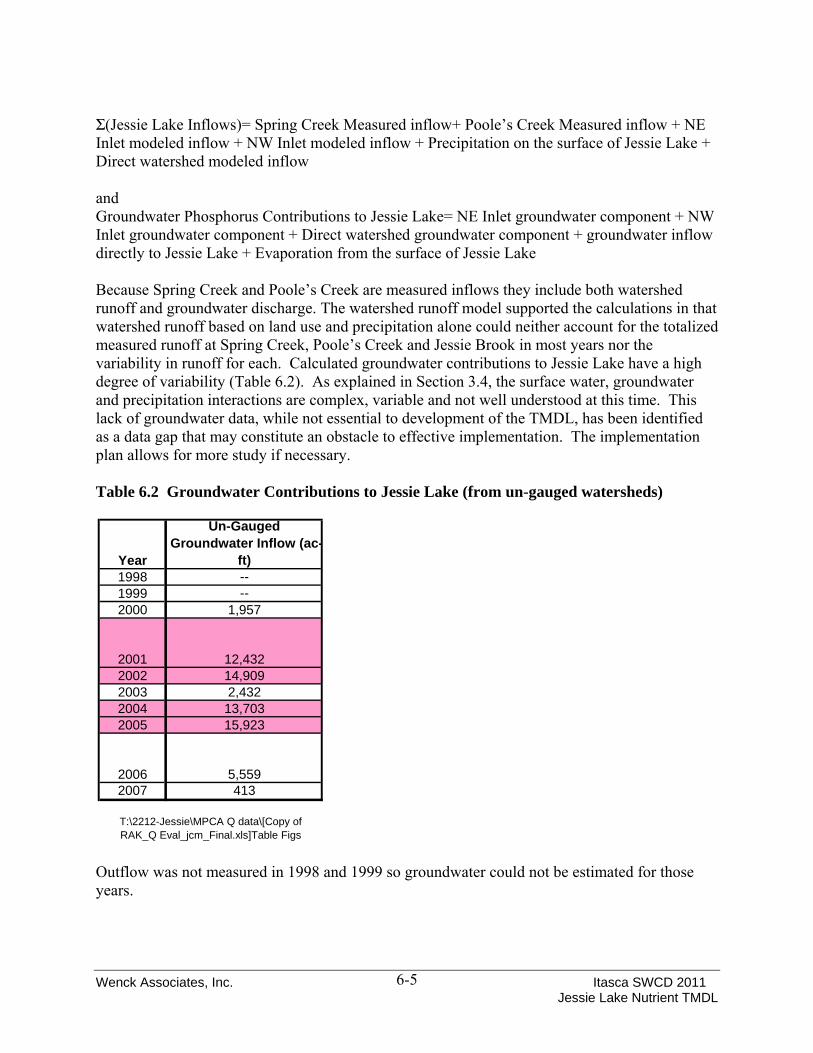
Wenck Associates, Inc. Itasca SWCD 2011 Jessie Lake Nutrient TMDL
6-5
Σ(Jessie Lake Inflows)= Spring Creek Measured inflow+ Poole’s Creek Measured inflow + NE Inlet modeled inflow + NW Inlet modeled inflow + Precipitation on the surface of Jessie Lake + Direct watershed modeled inflow and Groundwater Phosphorus Contributions to Jessie Lake= NE Inlet groundwater component + NW Inlet groundwater component + Direct watershed groundwater component + groundwater inflow directly to Jessie Lake + Evaporation from the surface of Jessie Lake Because Spring Creek and Poole’s Creek are measured inflows they include both watershed runoff and groundwater discharge. The watershed runoff model supported the calculations in that watershed runoff based on land use and precipitation alone could neither account for the totalized measured runoff at Spring Creek, Poole’s Creek and Jessie Brook in most years nor the variability in runoff for each. Calculated groundwater contributions to Jessie Lake have a high degree of variability (Table 6.2). As explained in Section 3.4, the surface water, groundwater and precipitation interactions are complex, variable and not well understood at this time. This lack of groundwater data, while not essential to development of the TMDL, has been identified as a data gap that may constitute an obstacle to effective implementation. The implementation plan allows for more study if necessary. Table 6.2 Groundwater Contributions to Jessie Lake (from un-gauged watersheds)
Outflow was not measured in 1998 and 1999 so groundwater could not be estimated for those years.
Year
Un-Gauged Groundwater Inflow (ac-
ft)1998 --1999 --2000 1,957
2001 12,4322002 14,9092003 2,4322004 13,7032005 15,923
2006 5,5592007 413
T:\2212-Jessie\MPCA Q data\[Copy of RAK_Q Eval_jcm_Final.xls]Table Figs
Wenck Associates, Inc. Itasca SWCD 2011 Jessie Lake Nutrient TMDL
6-6
Annual groundwater inflow volume was multiplied by the expected groundwater TP concentration of 43 μg/L based on an MPCA study (MPCA 1999) to obtain the loads for each year. 6.2.4 Direct Watershed Runoff
The direct sub-watershed is defined as the portion of the upstream load that is not tributary to a major inflow stream. Runoff from this watershed drains directly into Jessie Lake, typically via overland flow. Sources of phosphorus in direct watershed runoff are land use based and similar to those in gauged watersheds. Phosphorus loads from the direct sub-watershed to Jessie Lake are based on direct measurement of water quality from other sub-watersheds with similar land use and a rational method watershed runoff model based on landuse and precipitation. 6.2.5 Upstream Tributaries
The upstream tributaries include Spring Creek, Poole’s Creek, NE Inlet and NW Inlet. Water and phosphorus loads from the four upstream tributaries were calculated based on a combination of measured data and watershed model results. Discrete water quality samples were collected from each of the four tributary streams. These data, summarized in Section 5 of this report, were used in concert with measured stream flow and modeled watershed runoff to calculate TP loads to Jessie Lake. Specifically, continuous flow measurements were collected in Spring Creek and Poole’s Creek between 2000 and 2007. These direct measurements of discharge were used in concert with measured stream water quality to calculate phosphorus loads from these watersheds. Phosphorus loads from the NE and NW Inlets were calculated using measured stream water quality in conjunction with modeled watershed runoff. Watershed runoff was modeled using the rational method with measured local precipitation and land use. 6.2.6 Internal Phosphorus Cycling
Past studies indicated that both internal phosphorus cycling and groundwater contributions might be significant nutrient loads to Jessie Lake. Field studies and laboratory evaluation were performed to provide a direct measurement of internal loading as opposed to an implicit measurement given the uncertainty of groundwater contributions. Results of these studies are included as Appendix C. To determine internal load, the Itasca SWCD collected sediment core samples at two locations within Jessie Lake to measure sediment phosphorus content and phosphorus release rates. A sediment characterization survey was also conducted during 2008-2009 to characterize the sediment across the lake and provide context for the results of the two release rates measured. Figure 6.1 shows the locations of the sediment survey as well as the two sediment core samples. The deep sample was collected to characterize release rates in the anoxic zone, at the deepest part of the lake in accordance with published guidelines (Nürnburg 1995). A second sample was collected in the shallow part of the lake to characterize release rates there at the request of a

Wenck Associates, Inc. Itasca SWCD 2011 Jessie Lake Nutrient TMDL
6-7
stakeholder. The 2008-2009 sample results are compared to previously collected data for Jessie Lake in Table 6.3. In addition to the field surveys, existing dissolved oxygen (DO) and temperature profiles were evaluated to determine the anoxic area. Dissolved oxygen profiles were available for eleven years, from the 1992 and 1998 – 2007 monitoring seasons. The frequency of DO profile collection varied from monthly to weekly across the monitoring years. For all monitoring years, anoxia in the hypolimnion typically began in late June and continued through July and August. Lake turn-over leading to oxygenation of the hypolimnion occurred between late August and mid-September. The area of the lake experiencing anoxia in the hypolimnion for the summer growing season months is displayed in Figure 6.2. The anoxic factor varied from a low of 12 days during the 2007 monitoring year to a high of 60 days during the 1998 monitoring year. The average anoxic factor across all monitoring years is 39 days for Jessie Lake. Once the anoxic factor is calculated and the release rate was measured, the internal phosphorus load was quantified using the following equation (Nurnberg 1995): AF x RR x Lake Area = Internal TP load Where the AF is the anoxic factor expressed in days as described above and RR is the release rate of total phosphorus from sediments experiencing anoxia expressed in mg per m2 per day. Using a release rate of 4.0 mg per m2 per day, for anoxic factors ranging from 12 to 60 days, the calculated internal loads for Jessie Lake ranged from 740 to 3,700 pounds. For the Jessie Lake sediment core release rate experiments the measures TP release rate was 7.2 mg per m2 per day from the northern portion of the lake and 3.9 mg per m2 per day from the southern portion of the lake. The release rate used for the internal load model was 4.0 mg per m2 per day. The observed values from the Jessie Lake experiments are within the observed range of release rates from mesotrophic northern shield lakes (Nurnberg 1988; Nurnberg 1997). The internal total phosphorus load was estimated in this same manner in the lake response model for all monitoring years modeled for Jessie Lake.

Wenck Associates, Inc. Itasca SWCD 2011 Jessie Lake Nutrient TMDL
6-8
Figure 6.1 Sediment Characterization and Core Sampling Locations

Wenck Associates, Inc. Itasca SWCD 2011 Jessie Lake Nutrient TMDL
6-9
Figure 6.2 Dominant Anoxic Area
Table 6.3 Sediment Core Sampling Results Compared to Previous Study
The findings of the internal loading model are consistent with those predicted by the TMDL Study Canfield-Bachmann model and the previous Clean Water Partnership Model.
Variable Wang et al. (2002) James (2009)
Sample depth (m) 12 10.1 to 11.8
Surface moisture content (%) 94.3 92.1 to 93.5
Surface density (mg/kg) 56.7 60 to 75
Total phosphorus (mg/g) 1.746 1.369 to 1.485
Loosely-bound phosphorus (mg/g) 0.012 0.080 to 0.104
Iron-bound phosphorus (mg/g) 0.042 0.219 to 0.419
Calcium-bound phosphorus (mg/g) 0.064 0.198 to 0.202
Total iron (mg/g) 6.53 25.3 to 25.5
Total Calcium (mg/g) 16.09 16.3 to 18.8
Anoxic phosphorus release (mg m-2 d-1) 16.9 3.9 to 7.2

Wenck Associates, Inc. Itasca SWCD 2011 Jessie Lake Nutrient TMDL
6-10
6.3 CURRENT PHOSPHORUS BUDGET
A current phosphorus budget quantifying the relative contributions from each of the potential sources was developed using the models and data described above. Data from 1998 to 2007 were used to develop the phosphorus budget for the critical condition because these data represent current relevant watershed conditions that influence TP export as well as a range of wet and dry conditions and a range of groundwater inflow conditions. The phosphorus budget derived from the water quality modeling is shown in Table 6.4, the modeling summary is included as Appendix D. Table 6.4 Current Annual Phosphorus Budget (lbs/ yr) Current Phosphorus Loads to Jessie Lake (lbs/ yr) Average Min Max Watershed 1,572 969 2,046 Septics 103 103 103 Atmospheric 310 276 310 Groundwater 984 48 1,862 Internal 2,398 738 3,689 TOTAL 5,374 2,482 6,926 T:\2212-Jessie\MPCA Q data\[Copy of RAK_Q Eval_jcm_Final.xls]Calibration Summary
Table 6.4 represents the range of conditions observed. The relative contribution from sources varies annually based on several factors including precipitation, groundwater contributions, and anoxic factor. For example, in 2003, internal load was 68% of the annual P contribution to the lake but was only 35% in 2005. 6.4 WATER QUALITY RESPONSE MODELING
The Canfield-Bachman model was developed using measured runoff and modeled runoff volumes and measured water quality data. The methodology for quantifying individual P sources to the lake was described earlier in Section 6 of this report. No calibration factors were used in the modeling. 6.5 FIT OF THE MODELS
The overall lake response model fit reasonably well compared to annual average lake water quality data, differences between observed and predicted average in-lake concentrations were generally within the reported standard deviations for annual average TP for a given year (Figure 6.3). The TMDL lake response model results are included as Appendix D.
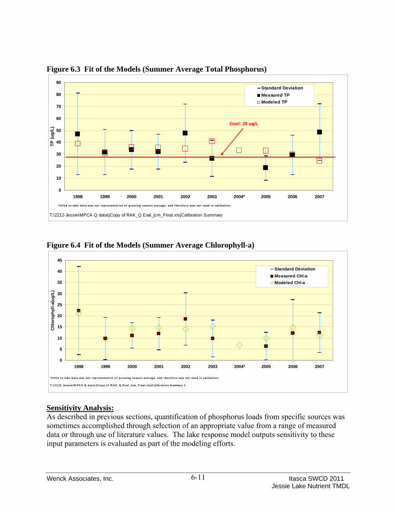
Wenck Associates, Inc. Itasca SWCD 2011 Jessie Lake Nutrient TMDL
6-11
Figure 6.3 Fit of the Models (Summer Average Total Phosphorus)
Figure 6.4 Fit of the Models (Summer Average Chlorophyll-a)
Sensitivity Analysis: As described in previous sections, quantification of phosphorus loads from specific sources was sometimes accomplished through selection of an appropriate value from a range of measured data or through use of literature values. The lake response model outputs sensitivity to these input parameters is evaluated as part of the modeling efforts.
0
10
20
30
40
50
60
70
80
90
1998 1999 2000 2001 2002 2003 2004* 2005 2006 2007
TP (u
g/L)
Standard DeviationMeasured TPModeled TP
*2 0 0 4 in- lake dat a was not rep resent at ive o f g ro wing seaso n averag e, and t heref o re was no t used in valid at io n.
T:\2212-Jessie\MPCA Q data\[Copy of RAK_Q Eval_jcm_Final.xls]Calibration Summary
Goal: 29 ug/L
0
5
10
15
20
25
30
35
40
45
1998 1999 2000 2001 2002 2003 2004* 2005 2006 2007
Chlo
roph
yll-a
(ug/
L)
Standard DeviationMeasured Chl-aModeled Chl-a
*2 0 0 4 in- lake d at a was not represent at ive o f g rowing seaso n averag e, and t heref ore was no t used in valid at io n.
T :\ 2 2 12 - Jessie\ M PC A Q d at a\ [ C o py o f R A K_ Q Eval_ jcm_ Final.xls] C alib rat ion Summary 1

Wenck Associates, Inc. Itasca SWCD 2011 Jessie Lake Nutrient TMDL
6-12
In addition to evaluating changes in lake response model predictions, the resulting load allocations and implementation recommendations were evaluated based on the range of appropriate data and literature values. Changes in inputs within the appropriate ranges do not influence the load allocation to the extent that it would change the resulting implementation recommendations discussed in Section 9 of this report. In all cases, management of both internal and watershed loads will be required to meet standards. 6.6 CONCLUSIONS
• Water quality in Jessie Lake is dominated by the internal loading component. • Groundwater inputs represent a significant, highly variable and uncontrollable input to Jessie
Lake annually. • Based on the model results, it appears that water quality goals can be met through a
combination of watershed and internal load reductions and management.

Wenck Associates, Inc. Itasca SWCD 2011 Jessie Lake Nutrient TMDL
7-1
7.0 TMDL Allocation
7.1 LOAD AND WASTELOAD ALLOCATION
Nutrient loads in this TMDL are set for phosphorus, since this is typically the limiting nutrient for nuisance aquatic plants. This TMDL is written to solve the TMDL equation for a numeric target of 29 μg/L of total phosphorus, which is the target concentration for Jessie Lake. The TMDL is expressed by the following equation: TMDL= Σ(LA) +Σ(WLA) + MOS+ RC Where LA is the Load Allocation, WLA is the Waste Load Allocation, MOS is Margin of Safety, and RC is Reserve Capacity. 7.1.1 Allocation Approach
The Allocation must be divided among existing sources, save those that are not permitted under state law. Discharge from septic systems, for example, is not allowed by law and therefore the load allocation for septic systems is zero. Relative proportions allocated to each source are based on reductions that can reasonably be achieved through Best Management Practices as discussed in the implementation section of the report. For Jessie Lake, the sources are almost exclusively non-permitted, or non-point source in nature. The only permitted source is future construction (development or redevelopment) in the watershed covered under an NPDES permit. There are no other known wasteloads in the watersheds tributary to Jessie Lake as there are no permitted WWTPs, MS4s or other industrial or municipal point discharges. 7.1.2 Critical Conditions
The critical condition for lakes is the summer growing season. Minnesota lakes typically demonstrate the impacts of excessive nutrients during the summer recreation season (June 1 to September 30) including excessive algal blooms and fish kills. Lake goals have focused on summer-mean total phosphorus, Secchi transparency and chlorophyll-A concentrations. These parameters have been linked to user perception (Heiskary and Wilson 2005). Consequently, the lake response models have focused on the summer growing season as the critical condition. 7.1.3 Allocations
The loading capacity is the total maximum daily load. The daily and annual Load and Wasteload Allocations for the average conditions are shown in Table 7.1 as well as the Load Allocations by source annually and daily. No reduction in atmospheric or groundwater loading is targeted

Wenck Associates, Inc. Itasca SWCD 2011 Jessie Lake Nutrient TMDL
7-2
because this source is impossible to control on a local basis. The remaining load reductions were applied based on our understanding of the lake, efficacy of proposed implementation strategies, as well as from the Canfield-Bachman lake model output. Daily total maximum loads are calculated from annual loads dividing by 365.25 days per year (to account for leap year). The loading capacity is based on average model inputs for the recent 10 year period which represents both wet and dry conditions. Table 7.1 Total Phosphorus TMDL and Partitioned Loads Expressed as Annual and Daily Loads
7.2 RATIONALE FOR LOAD AND WASTELOAD ALLOCATIONS
The TMDL presented here is developed to be protective of the aquatic recreation beneficial uses in lakes. 7.2.1 Modeled Historic Loads
Using the Canfield-Bachmann equation, historic loads were calculated for the 10-year period between 1998 and 2007. These calculations provide some insight into the assimilative capacity
Total Phosphorus TMDL (lbs/ yr)
Total Phosphorus TMDL (lbs/ day)
TMDL 4,154 11.37 Waste Load Allocation 14 0.04
Load Allocation 4,140 11.33 MOS Implicit Implicit RC See WLA See WLA
Partitioned Total Phosphorus Load Allocation (lbs/ yr)
WatershedSeptic
SystemsAtmospheric & Groundwater Internal
1,407 0 1,294 1,439
Partitioned Total Phosphorus Load Allocation (lbs/ day)
WatershedSeptic
SystemsAtmospheric & Groundwater Internal
3.85 0 3.54 3.94T:\2212-Jessie\MPCA Q data\[Copy of RAK_Q Eval_jcm_Final.xls]Table Figs

Wenck Associates, Inc. Itasca SWCD 2011 Jessie Lake Nutrient TMDL
7-3
of the lake under historical conditions as well as over time. Additionally, these results provide a sense for the level of effort necessary to achieve the TMDL and whether that TMDL will be protective of the water quality standard. 7.2.2 Waste Load Allocations
There are no permitted point discharges within the subwatersheds tributary to Jessie Lake within the framework of the TMDL. However, there may be land use changes occurring within the watershed, including the construction of new residential developments on land that was previously forested. Developments over one acre in size will be required to obtain an NPDES construction permit. These permits regulate erosion control and require best management practices be employed at a construction site. However, even with BMP implementation at a construction site there invariably will be some impacts in terms of phosphorus loads due to construction. To account for waste loads associated with NPDES construction permits, an allocation of one percent of the total watershed portion of the TMDL load is included. 7.3 SEASONAL AND ANNUAL VARIATION
The daily load reduction targets in this TMDL are calculated from the current phosphorus budget for Jessie Lake. The budget is an average of ten years of monitoring data collected between 1998 and 2007, and includes both wet years and dry years to account for annual variation. The watershed BMPs to address excess loads to Jessie Lake will be designed for average conditions; however, the performance will be protective of all conditions. For example, a rain garden designed for average conditions may not perform at design standards for wet years; however the assimilative capacity of the lake increases in wet years due to increased flushing. It is recommended however, that any project to address internal loading be based on a percent reduction from the maximum loading condition over the average condition. Programmatic BMP targets such as areal coverage for riparian restorations are finite and can be increased to be protective in all conditions. However, the implementation of this BMP is largely based on willing participation from land owners and will be recommended to the maximum possible extent in any case. Additionally, in dry years the watershed load will be naturally lower allowing internal loading to comprise a larger portion of the overall phosphorus budget. Consequently, averaging across several modeled years addresses annual variability in lake loading. Seasonal variation is accounted for through the use of annual loads and developing targets for the summer period where the frequency and severity of nuisance algal growth will be the greatest. Although the critical period is the summer, an infrequent short-term change in nutrient load rarely relates in a chronic worsening of nuisance algae, rather lakes respond to long-term changes such as changes in the annual load (Canfield and Bachman, 1981; Rechow and Chapra, 1983). Therefore the seasonal variation is accounted for in annual loads. Additionally by setting the TMDL to meet targets established for the most critical period (summer), the TMDL will inherently be protective of water quality during all other seasons.

Wenck Associates, Inc. Itasca SWCD 2011 Jessie Lake Nutrient TMDL
7-4
7.4 MARGIN OF SAFETY
A Margin of Safety has been incorporated into this TMDL to account for any lack of knowledge concerning the relationship between load and waste load allocations and water quality and to ultimately ensure that the nutrient reduction strategy is protective of the water quality standard. The basic purpose of the MOS component of the TMDL equation is to estimate uncertainty to allow the project a reasonably high likelihood of success (e.g. probability of success). As such, MOS encompasses two primary factors affecting these outcomes: variability and uncertainty. “Variability” refers to the fluctuations in measured values for a given parameter over a lake (spatially) as well as by time - such as within year (seasonal) and year-to-year changes (induced by climatic conditions and biological response). “Uncertainty” refers to prediction error resulting from limits in the data and predictive models The implicit MOS is incorporated into this TMDL in the following ways:
4. A conservative goal, below the standard was selected as an endpoint. The standard is 30 ug/L TP, an endpoint of 29 ug/L was selected.
5. Modeling shows that the recommended load reductions result in an average annual concentration of 28 ug/L, lower than the endpoint. This constitutes a 170 lb reduction in excess of what the model shows is needed, about 4% of the TMDL.
6. In addition to conservative selection of endpoint and load reductions, other conservative modeling approaches were also used. The Canfield Bachman model was used to predict the response of Jessie Lake to phosphorus loads and load reductions. The Canfield-Bachmann model was developed using data collected from 704 natural lakes to best describe lake phosphorus sedimentation rate which is needed to predict the relationship between phosphorus load inputs and in-lake phosphorus concentrations. The phosphorus sedimentation rate is an estimate of net phosphorus loss from the water column through sedimentation to the lake bottom. The phosphorus sedimentation rate is used in concert with lake-specific characteristics such as annual phosphorus loading, mean depth, and hydraulic flushing rate to predict in-lake concentrations of phosphorus as they relate to phosphorus loading.
To apply the Canfield-Bachmann model to Jessie Lake, watershed specific data were used: − measured watershed runoff volumes, concentrations and overall loads were used
instead of modeled watershed hydrology, and − Internal release rates and anoxic factors were measured − Phosphorus load export was measured.
Further, no calibration factors were used, only the sediment phosphorus release rates were adjusted within ranges of published values for specific lake types (i.e. eutrophic lakes, Nurnberg 2004).
The models fit reasonably well compared to annual average lake water quality data. Nine years of data were compared, and differences between observed and predicted average in-lake concentrations were generally within the reported standard deviations for annual

Wenck Associates, Inc. Itasca SWCD 2011 Jessie Lake Nutrient TMDL
7-5
average TP for a given year. The models typically tended towards a slight over-prediction of in-lake TP in 6 of 9 years (an under-prediction in sedimentation rates), which translates into a conservative load reduction in terms of setting the TMDL. That is to say, the model over-prediction resulted in calculation of a conservative (larger) load reduction. A margin of safety has been incorporated into this TMDL by using conservative modeling assumptions and conservative implementation approaches. These were used to account for an inherently imperfect understanding of the lake system and to ultimately ensure that the nutrient reduction strategy is protective of the water quality standard.
7.5 RESERVE CAPACITY/ FUTURE GROWTH
The Jessie Lake watershed is located in a rural portion of Itasca County. There are no municipalities within the watershed. Significant development is not anticipated, but many of the areas in which growth may be expected are lake shore properties which have the greatest potential to impact water quality. To protect and improve water quality within Jessie Lake, planned developments must be undertaken to avoid increasing phosphorus loads to lakes over existing conditions, and to decrease phosphorus loads where possible. The phosphorus load reductions required to meet water quality goals make stormwater BMPs and low impact development in these growth areas necessary. It will be one of the most cost effective methods to limit watershed phosphorus loads. Further, there are no planned WWTP expansions in the area at this time, and it is unlikely given current MPCA policy and citizen sentiment that any WWTP would be permitted for an expansion of that expansion meant discharges to Jessie Lake. This means that reserve capacity for growth is essentially zero with respect to phosphorus, with the exception of development covered under a NPDES permit. This does not mean no growth, it simply means growth must be accomplished without increasing phosphorus loads to impaired waters. We have the design tools to accomplish this, what is needed is the regulatory framework and intergovernmental coordination in terms of development review and design standards. Recommendations to that end are incorporated in the implementation plan. This is in line with, and no more stringent than existing state statutes prohibiting the degradation of Minnesota waters.

Wenck Associates, Inc. Itasca SWCD 2011 Jessie Lake Nutrient TMDL
8-1
8.0 Public Participation
Public participation is critical to the process of implementing the TMDL to meet water quality standards. The public participation conducted for this TMDL was an extension of work already underway by stakeholders concerned over declining water quality prior to the TMDL framework. Citizen and governmental agency concern over the stability of Jessie Lake’s highly valued waters arose in 1998 due to severe algae blooms and a dramatic decline in the lake’s aesthetic and recreational value. The Itasca Soil and Water Conservation District applied for and was awarded a Clean Water Partnership (CWP) diagnostic grant to study Jessie Lake in detail. A technical advisory committee (TAC) comprised of local, state, and federal government agencies, the watershed association, and the state university was immediately established to help guide the diagnostic study. Based on the findings of the CWP study, Jessie Lake became the first lake in the Rainy River Basin to be placed on the Environmental Protection Agency’s Clean Water Act 303(d) list of Impaired Waters for excess nutrients in 2004. In 2006, the Itasca SWCD was awarded a third party TMDL and reconvened the TAC to oversee the TMDL process. In 2008, the SWCD realized it needed additional support to complete the TMDL and revised its contract with the state in order to hire Wenck and Associates to finalize the TMDL document. Since 1998, public participation has been addressed through multiple TAC meetings, articles in semi-annual watershed association newsletters, informational pieces at annual watershed association meetings, newspaper articles, and one public meeting at the local town hall to inform citizens about impaired waters and the TMDL process. Public input has been instrumental in guiding the decision making process and has been critical to the establishment of an effective plan that will guide Jessie Lake and its future.

Wenck Associates, Inc. Itasca SWCD 2011 Jessie Lake Nutrient TMDL
9-1
9.0 Implementation
9.1 IMPLEMENTATION FRAMEWORK
Implementing the Jessie Lake TMDL will be a collaborative effort between state and local government, and individuals, with the overall effort led by the Itasca SWCD. To meet water quality standards Itasca SCWD will leverage existing regulatory framework, and relationships to generate support for TMDL implementation efforts, providing technical support, funding, coordination and facilitation when needed. Efficiency and cost savings are realized by using existing governmental programs and services for TMDL implementation to the maximum extent possible. 9.1.1 Itasca SWCD
The mission of the Itasca SWCD is to provide a local organization through which landowners and operators, local units of government and state and federal agencies can cooperate to improve, develop and conserve soil, water, wildlife and recreational resources. The SWCD will encourage adoption of proper land use practices as needed, recognizing that these measures are essential for maintenance of permanent and prosperous natural resource-based industries in Itasca County.
Because the primary goal and mission of the Itasca SWCD is in line with the goal of TMDL implementation, many of the implementation strategies are extensions of existing Itasca SWCD programs and projects and can be funded to some extent using existing Itasca SWCD budgets. However, additional funding will be necessary. The recommended implementation plan to meet lake water quality goals and associated cost is described in the following section. 9.1.2 Lake Association
Partnerships with counties and lake associations are one mechanism through which the Itasca SWCD protects and improves water quality. The Itasca SWCD will continue its strong tradition of partnering with state and local government to protect and improve water resources and to bring Jessie Lake into compliance with State standards. 9.1.3 BWSR
The Itasca SWCD recognizes that public funding to set and implement TMDLs is limited, and therefore understands that leveraging matching funds as well as using existing programs will be

Wenck Associates, Inc. Itasca SWCD 2011 Jessie Lake Nutrient TMDL
9-2
the most cost efficient and effective way to implement the Jessie Lake TMDL. The Itasca SWCD does project a potential need for about 50% cost-share support from the BWSR or other sources in the implementation phase of the TMDL process. 9.2 REDUCTION STRATEGIES
9.2.1 Annual Load Reductions
The focus in implementation will be on reduction the annual phosphorus loads to the lake through structural and non-structural Best Management Practices and projects. The TMDL established for Jessie Lake is presented in Section 7 of this report. No reductions in atmospheric or groundwater loading are targeted because these sources are not readily controllable. The remaining load reductions were applied based on our understanding of the lake and surrounding watershed, as well as output from the model. Table 9.1 shows existing and proposed P load reductions. Table 9.1 Modeled Average and Goal Phosphorus Loads to Jessie Lake and Percent
Reductions Required (lbs/ year) Goal Phosphorus Loads to Jessie Lake (lbs/ yr)
Modeled Average
TMDL Goal*
% Reduction
In-Lake Concentration (ug/L) 34 29 15% Watershed 1,579 1,421 10% Septics 103 0 100% Atmospheric 310 310 0% Groundwater 984 984 0% Internal 2,398 1,439 40%
Total 5,374 4,154 23% T:\2212-Jessie\MPCA Q data\[Copy of RAK_Q Eval_jcm_Final.xls]Calibration Summary
* : Total TMDL goal includes load and waste load allocations. About a 10% load reduction from watershed sources is likely achievable through BMPs. Septic system discharge is not permitted under state law and therefore the 100% reduction is required. This leaves a required internal load reduction of about 40%. It is important to note that under the highest internal loading conditions, the internal phosphorus load is about 3,500 lbs/ year. Conservative implementation planning would require load reduction from internal sources at 60% to reach the modeled goal in years with the highest anoxic factors. 9.2.2 Internal Load Reduction Options
Modeling efforts and nutrient load quantification conducted as part of this TMDL, as well as during past studies of Jessie Lake, indicate that internal loading generally comprises a large percentage of the Jessie Lake nutrient budget. It is believed that implementation actions focusing on internal nutrient load management and control will be required in order to achieve water quality targets and goals for Jessie Lake. A description of several internal load management options for Jessie Lake is provided.

Wenck Associates, Inc. Itasca SWCD 2011 Jessie Lake Nutrient TMDL
9-3
9.2.2.1 Hypolimnetic Aeration
Lake hypolimnetic aeration controls internal loads by aerating hypolimnetic waters (cold, dense water trapped at the bottom of a deep lake) to maintain oxic (oxygenated) conditions in the hypolimnion and sediment surface. It is the anoxic (no dissolved oxygen) condition of the hypolimnetic sediments which contribute to the internal phosphorus load. Internal load studies conducted on Jessie Lake sediments during this TMDL revealed that there was little to no phosphorus release from lake sediments under oxygenated conditions. Conversely, these same experiments revealed that phosphorus release from sediments under anoxic conditions was significant. It therefore may be possible to reduce internal phosphorus release from sediments using Hypolimnetic aeration. Hypolimnetic aeration only aerates water of the hypolimnion without causing it to mix with the epilimnion. This prevents the lake from stratifying and limits the amount of water to be aerated. An engineering design and feasibility study of Jessie Lake would be necessary to determine the specific requirements for successful hypolimnetic aeration. One of the items that would have to be determined is the number and location of the aeration units. Another item that would have to be considered is the possible need to add ferric chloride to the system. The addition of ferric chloride (an iron salt) solution may be necessary if iron becomes the limiting constituent in the deactivation of soluble phosphorus release. Therefore both aeration and ferric chloride lines could possibly be installed in the lake during the initial construction. An additional item that would have to be researched would be the possibility of year round aeration. If aeration is used through the winter, it has the disadvantage of destroying ice cover and causing open water, posing a hazard for winter lake use. Therefore, strict safety measures have to be observed during winter operation. Air-lift hypolimnetic aerators work by introducing diffused air at the bottom of the aerator in the hypolimnion, and the buoyancy of the air-water mixture lifts the water through the central pipe to the top of the aerator. The air bubbles leave the water and are vented to the water surface, while the water returns to the hypolimnion by sinking through the external tube. A hypolimnetic aeration project will likely require review and comment from several local and state agencies. Two permits are required from the Minnesota DNR for a hypolimnetic aeration project. The first is from the Division of Fisheries. The second is the General Work in Public Waters Permit due to work being conducted below the OHW elevation, such as the placement of the pipes, anchors and aeration units. The typical time frame to acquire a General Work in Public Waters permit is 60 days. However, depending on the complexity of the project and the potential for controversy with the lake shore residents and/or general public the permitting process could take considerably longer. DNR shoreline set-back requirements may apply to certain aspects of the project construction. The MPCA would also need to review the project in conjunction with the DNR permits.
9.2.2.2 Hypolimnetic Withdrawal
Hypolimnetic withdrawal is where anoxic bottom water is removed from the lake and either discharged downstream or treated and returned to the lake. Water would be pumped out of the

Wenck Associates, Inc. Itasca SWCD 2011 Jessie Lake Nutrient TMDL
9-4
hypolimnion into a pump house constructed on shore. A force main would be laid on the bottom of the lake with a screen at the intake. The intake would be placed at a depth below the normal thermal stratification depth. The actual placement of the intake would be determined during engineering design study, which would also determine the size of pump required. The engineering study would also determine the potential need for multiple intake points and/or pumps, depending on the volume of water that would need to be removed. Once water reaches the pump house, it is aerated over a cascade of concrete weirs into a basin. The water in the hypolimnion of Jessie Lake may contains hydrogen sulfide (H2S) and which could result in the aeration process releasing hydrogen sulfide gas into the air, creating a very potent “rotten egg” smell. However, due to the rural location of the lake it may be possible to construct the discharge system in an area that would not impact local lake residents or the resorts on the lake. If it is determined that residents may be impacted by the smell of the water from the system, the hydrogen sulfide gas would need to be reduced to a suitable level before leaving the pump house. To reach this level, a series of air filters will be required. Along with the air filters in the pump house building, air monitoring equipment will also be required because even at low concentrations, hydrogen sulfide is potentially dangerous to maintenance personnel working in the building. The engineering study would determine if the water pumped from the hypolimnion would be returned to Jessie Lake or discharged to a wetland, field or stream downstream of the basin. Like hypolimnetic aeration, hypolimnetic withdrawal would require a General Work in Public Waters permits. Additionally, the project most likely will require a Water Appropriations permit from the DNR. The threshold for an appropriations permit is one million gallons per year and due to the large volume of the hypolimnion of Jessie Lake, this volume would likely be exceeded. A third permit that may be required from the DNR is Partial Drawdown Waters Work permit. An analysis of the impact to the lake water levels as a result of the project will need to be conducted. The Partial Drawdown Waters Work permit is not defined by a certain minimum or maximum allowable level to fluctuate without requiring a permit. Instead the language is very general and reviewed on a case by case basis. If it is determined that a Partial Drawdown Waters Work permit is required, then all of the lake shore property owners would be required to approve the project before a permit could be issued. If multiple permits are required for the project, they could all be handled under one application to the Area Hydrologist who would circulate the application to any other parties in the DNR that may need to review or approve the application. The MPCA would need to review the project in conjunction with the DNR permit.
9.2.2.3 Alum Treatment
No formal permits are required to conduct in-lake alum treatment. However, several agencies request that they be informed of the proposed project so they can provide comment or direction. These agencies include the MPCA and the DNR. When requesting comments for the DNR, both the DNR Waters division and the Fisheries and Ecological Services division would like to provide comments.

Wenck Associates, Inc. Itasca SWCD 2011 Jessie Lake Nutrient TMDL
9-5
9.2.3 Watershed Implementation
Given the relatively limited anthropogenic impacts that linger in the watershed today, options for watershed based load reductions are limited. As such, load reduction goals were set at 10%. Some may be employed to gain small load reductions and to prevent further increase in watershed nutrient load to the lake. Within a year of the development and approval of the TMDL study, the MPCA develops a TMDL implementation plan that identifies specific options for project in the watershed that will target improvements in water quality in Jessie Lake. Potential tools that will be considered in the development of the implementation plan for Jessie Lake are listed here.
• No net P increase ordinance: Such ordinances govern redevelopment and new development in the watershed tributary to Jessie Lake. The steps entailed in administering such a program include developing rules on a county level and running the permit program. Costs include staff time to manage development applications and review and approve or deny those applications and guide developers toward no-net-increase development technology or low-impact development practices. Funding is required on an annual basis and costs are dictated by development. Additional county board time is typically required to grant formal approval.
• Lakeshore buffers: Some watershed districts have effectively offered matching grants
and technical support for homeowners to install lakeshore buffers on their property. Individual lake shore buffers typically range from $30 to $50 per foot. For a typical lakeshore property owner with 100 feet of shoreline, the cost would be approximately $3,000 to $5,000. This would include some in-kind labor from property owners but also possibly from the local SWCD or Watershed Association. For example, the SWCD has partnerships with the NRCS, which often has local or regional specialists that can provide in-kind consultations on plant selection and buffer design. Cost-sharing programs can be developed to provide approximately 25% to 75% of the total cost for the project (depending on available funding) and also the in-kind technical assistance from the SWCD or NRCS office for design and consultation.
• Septic system improvements: Calculations of potential septic loads to Jessie Lake are
conservative, based on a 50% failure rate based on the survey provided by Itasca SWCD. High groundwater table, poor soils for SSTS, and the age and type of systems provided point towards high potential failure rates. At this rate, replacing all the failing septic systems will reduce loads to Jessie Lake by about 100 lbs of the 2,400 lbs required to meet the TMDL. Land owners are required to upgrade their SSTS’s upon sale or renovation. County SWCDs can fully fund low interest loans to homeowners to replace systems through the Clean Water Revolving Funds. SSTS installation for a single-family home is $10,000 to $15,000. Low-interest loans can be as little as 1% to 3 % with a 10-year repayment period. There is generally little or no cost to the county.
• Septic BMP Education: Educational BMPs encouraging lakeshore property owners to
use low phosphorus products will help to address phosphorus discharge from septic systems of owners who aren’t required to upgrade their system or who expand their water
Wenck Associates, Inc. Itasca SWCD 2011 Jessie Lake Nutrient TMDL
9-6
use through activities that do not trigger septic upgrade requirements (an increase in family size, installation of dishwashers or washing machines). Phosphorus fact sheets can be distributed through the Jessie Lake Watershed Association and at public meetings. It should also be noted that as of July 1, 2010 stores in Minnesota are no longer allowed to sell household dishwashing detergent with a phosphorus content of more than 0.5% by weight.
• Upstream lake improvements: Nutrient load reductions to the lakes upstream of Jessie
Lake will provide a small level of nutrient load reduction due to the reduction of loading to Spring Creek. Reducing loads in upstream lakes might result in a load reduction of about 200 lbs annually. This would probably be expensive and require a combination of internal and external load reductions for the lakes upstream of Jessie Lake. Should these lakes be assessed and placed on the 303d list, the TMDL program may (partially) fund the study and implementation plans for these lakes.
• Forestry BMPs: Forestry BMPs can be implemented through the US Forest Service and
may be eligible for funding through TMDL Implementation.
• Riparian stream restorations: Riparian stream restorations can range from $50 to $200 per lineal foot. Grants are typically available for such work but often require staff time for grant preparation and sometimes matching funds. It is advisable to perform baseline evaluation and periodic monitoring to assess stream stability to prioritize areas for restoration and avoid downstream impacts. The Wisconsin Method is a basic low-cost but highly-effective method for evaluating recision rates, which can be tied into the TMDL and load reduction scenarios. Anthropogenic vs. natural stream rescission should be determined as well. Riparian stream restorations are typically tied more to turbidity TMDLs and biotic impairments. To better quantify the impact of stream bank failures and anthropogenic erosion, biologically available soil P content and rescission rates should be evaluated to quantify the actual annual load to Jessie Lake. It is also important, then, to add a parameter such as TSS and/or turbidity to the stream monitoring. A small portion of the stream load from occasional stream bank failures that occur between the monitoring station and the lake (several hundred feet) may not be represented in the overall load from these lakes. An added benefit of conducting riparian or channel restorations is the creation of additional fisheries habitat that can be utilized by fish populations from the main lake.
9.3 NUTRIENT REDUCTION COSTS
Implementation of the watershed load reductions will require staff time, likely at the SWCD level. Recommended measures such as a no-net increase phosphorus measure will likely require county staff time for permit review and administration of the program. That coupled with coordinating grants for septic upgrades, riparian restorations, and lake shore buffers as well as any major projects selected by the TAC. Table 9.2 shows the costs for a potential implementation plan. Actual costs may vary, and a more detailed and refined cost estimate will be provided in the implementation plan.

Wenck Associates, Inc. Itasca SWCD 2011
Table 9.2 Potential Implementation Plan and Costs
Source Implementation Strategy Unit Cost Qty Cost Note
Internal Alum Treatment
$240 to $700/ acre over 25 to 50% of the ~1700 acre lake, roughly $200,000 to $400,000 300,000$
This is likely the most cost effective way to control internal load.
Watershed No-Net P Increase Ordinance 85,000$
Annual cost after adoption, depends on development. County staff time is required, cost can be used to retain staff to administer this and other TMDL implementation activities.
Lakeshore Buffers $3,000 to $5,000 ea 30 120,000$
Septic Upgrade Grants$10,000 to $15,000 ea
for total replacement 40 $200,000Look to provide partial grants to piggy-back onto other programs.
Upstream Lake Improvements $50,000 to $5,000,000 -- 0
Wide array of options here- likely a small return on investment. Implement only if upper lakes are listed as impaired and require restoration.
Forestry BMPs $100 per acre 1400 140,000$
Assign a cost per acre to achieve reductions. Target reductions to that area.
Riparian Stream Restorations $200 to $500 per lineal ft 1000 350,000$
Set aside a fund for restorations as needed, or fund a study to set priorities for restoration in the watershed.
Potential Implementation Plan Cost: 1,195,000$
Jessie Lake Nutrient TMDL
9-7

Wenck Associates, Inc. Itasca SWCD 2011 Jessie Lake Nutrient TMDL
10-1
10.0 Reasonable Assurance
When establishing a TMDL, reasonable assurances must be provided by demonstrating the ability to reach and maintain water quality endpoints. Several factors control reasonable assurance, including a thorough knowledge of the ability to implement BMPs as well as the overall effectiveness of the selected BMPs. This TMDL establishes load reduction goals in Jessie Lake to reduce nutrient loads to the impaired lakes. TMDL implementation will be implemented on an iterative basis so that implementation course corrections based on annual monitoring and reevaluation can adjust the strategies to meet the standards. The Itasca County SWCD will continue to work with the Minnesota DNR, the Jessie Lake Association and land owners within the watershed identify projects within the watershed targeting improving water quality within Jessie Lake. The Itasca County SCWD would oversee the overall program including continued water quality monitoring efforts; coordination with local landowners and stakeholders and construction and monitoring of BMP’s or implementation projects.

Wenck Associates, Inc. Itasca SWCD 2011 Jessie Lake Nutrient TMDL
11-1
11.0 Monitoring
The Itasca SWCD measures lake water quality annually. This monitoring will continue, along with some recommended additions, and will be sufficient to track significant water quality trends, assess progress towards goals and make adjustments towards adaptive management. Recommended monitoring plan and adaptive management framework is listed below: 11.1 DATA GAPS
Collection of additional data will assist in targeting the TMDL implementation and tracking effectiveness. Data gaps are listed below:
1. The MPCA recommended gathering specific data on agricultural practices in the watershed. A windshield survey and communication with residents to gather information on such practices as grazing or pasturing near tributaries would assist in targeting buffer strips.
2. Lakes of the Chippewa Sand Plains may exhibit a statistically significant higher in lake TP concentration than other lakes within the Northern Hardwood Forest Ecoregion. Understanding the characteristics of minimally impacted lakes in this sub-section of the Northern Hardwood Forest Ecoregion will be helpful to determine appropriate background TP concentrations and goals for lakes within the Chippewa Sand Plains. Such an evaluation should be conducted, and the results should be considered as part of the adaptive management of Jessie Lakes, resetting endpoints and the resulting load reduction goals and implementation strategies if necessary.
3. Bracket the variability in groundwater contributions to the lake through conducting baseflow separation on a longer-term (statistically significant) continuous flow monitoring of lake inflows and outflows.
11.2 RECOMMENDED MONITORING
A perfect understanding of natural systems is impossible, as such there are always data gaps. The monitoring associated with filling data gaps towards targeting the TMDL implementation, tracking progress, or refining goals are listed here.
1. Conduct a windshield survey of watershed agricultural and forestry practices. Gather specific data on practices such as grazing livestock in riparian areas. Because the agricultural land tributary to Jessie Lake is so minimal, it is recommended to visit with each land owner to determine the appropriate BMPs for the land.
2. Continue to monitor lake water quality annually. Collect surface, thermocline and bottom samples monthly for TP, Ortho-Phosphorus (OP), Total Nitrogen (TN), Chlorophyll-a (surface only) and dissolved iron (bottom only). Collect field parameters (Secchi depth and temperature and dissolved oxygen profiles) every two weeks to characterize the depth and period of anoxia to quantify annual internal loads and bracket the variability.

Wenck Associates, Inc. Itasca SWCD 2011 Jessie Lake Nutrient TMDL
11-2
3. Assess monitoring data annually and report findings in Annual Monitoring Report. The report should list TMDL implementation activities evaluate progress towards goals and make recommendations towards course corrections in terms of monitoring and implementation annually. This is the framework for adaptive management.
4. In addition to baseline lake water quality data, add special monitoring to track progress of implementation strategies. Assess special monitoring needs annually based on implementation projects underway, report findings the Annual Monitoring Report. For example, if watershed loading is targeted, watershed loads should be measured.
5. Install a continuous pressure transducer at the Jessie Brook to measure flows and track annual runoff.
6. Monitor groundwater elevations at two locations on the east and west sides of the lake to gauge direct inflow to lake. Explore measurement of phosphorus concentrations of groundwater in area wells.
7. Field verify watershed boundaries. 8. Add discrete flow gauging and water quality sampling for the four major watershed
tributaries. Sample weekly for TP, OP, TN, TSS, and field parameters. 9. Characterize the conditions of minimally impacted lakes within the Chippewa Sand
Plains to assess the validity of the standard and endpoint.
Wenck Associates, Inc. Itasca SWCD 2011 Jessie Lake Nutrient TMDL
12-1
12.0 References
Barr Engineering Company, February 2004 (updated in 2007). Phosphorus Sources to Minnesota Watersheds. Prepared for Minnesota Pollution Control Agency.
Clean Water Partnership. 2002. Diagnostic Study – Jessie Lake CWP. MPCA Clean Water
Partnership. EPA 440/5-80-011, "Modeling Phosphorus Loading and Lake Response Under Uncertainty: A
Manual and Compilation of Export Coefficients". Gerbert, W.A, Graczyk, D.J., and Krug, W.R., 1987 “Average Annual Runoff in the United
States, 1951-1980” Edition 1.0 US Geological Survey Web Site Heiskary, S.A. and C.B. Wilson. 2005. Minnesota lake water quality assessment report:
Developing nutrient criteria. Minnesota Pollution Control Agency. St. Paul, Minnesota. Heiskary, S.A. and C.B. Wilson. 2008. Minnesota’s approach to lake nutrient criteria
development. Lake Reserv. Manage. 24:282-297. Heiskary, S.A. and W.W. Walter, Jr. 1988. Developing Phosphorus Criteria for Minnesota
Lakes. Lake and Reservoir Manage., 1988 4(1): 1-9. Helgesen, J.O., et al., 1975. Water Resources of the Mississippi and Sauk Rivers Watershed,
Central Minnesota. HA-534, U.S. Geological Survey. Hubbard, E.F., et al. 1982. “Measurement of Time of Travel and Dispersion in Streams by Dye Kingston, J.C. 2002. Completion Report for the Jessie Lake Paleolimnology Project. Natural
Resources Research Institute, University of Minnesota. Lindholm et al. 1976. “Water Resources of the Big Fork River Watershed, North-Central
Minnesota” Department of the Interior, USGS & Minnesota Department of Natural Resources Division of Waters, Soils and Minerals.
McCollor and Heiskary. 1993. “Selected Water Quality Characteristics of Minimally Impacted
Streams from Minnesota’s Seven Ecoregions.” Minnesota Pollution Control Agency Water Quality Division
Midje, H.C., et al. c. 1966. “Hydrology Guide for Minnesota”. U.S. Department of Agriculture
Soil Conservation Service.

Wenck Associates, Inc. Itasca SWCD 2011 Jessie Lake Nutrient TMDL
12-2
Minnesota DNR, Fall 2005. “Status of Wildlife Populations”
http://www.dnr.state.mn.us/publications/wildlife/populationstatus2005.html Minnesota DNR, 1996. “Minnesota Land Use and Land Cover- A 1990’s Census of the Land” Nurnberg, G. K. 2005. Quantification of Internal Phosphorus Loading in Polymictic Lakes. SIL,
Verh. Internat. Verein. Limnol. vol. 29. Nurnberg, G. K. 1995. Quantifying anoxia in lakes. Limnol. Oceanogr. vol. 40, no. 6 Nurnberg, G. K. 1988. Prediction of Phosphorus Release Rate from Total and Reductant-Soluble
Phosphorus in Anoxic Lake Sediments. Canadian Journal of Fisheries and Aquatic Sciences. vol 45.
MPCA July 2007, “SONAR, BOOK II for Numeric eutrophication standards for lakes, shallow lakes and reservoirs” http://www.pca.state.mn.us/index.php/water/water-permits-and-rules/water-rulemaking/archived-water-quality-standards-rule-revisions.html MPCA. 2002. Water Quality Reconstruction from Fossil Diatoms: Applications for Trend Assessment, Model Verification, and Development of Nutrient Criteria for Lakes in Minnesota, USA. Minnesota Pollution Control Agency, St. Paul, Minnesota. MPCA 2004 “Guidance Manual for Assessing the Quality of Minnesota Surface Waters” MPCA, May 1999. Phosphorus in Minnesota’s Ground Water. Minnesota Pollution Control
Agency information sheet. Spatial Climate Analysis Services, 2000. Oregon State University.
“http:www.ocs.orst.edu/pub/map/precipitation/Total/States/MN/ Stumm, W., and Stumm-Zollinger, E., 1972. The Role of Phosphorus in Eutrophication. Chapter
2 in Mitchell, R., ed., 1972, Water Pollution Microbiology, Wiley-Interscience, New York.
USDA, c. 1966. Hydrology Guide for Minnesota. U.S. Department of Agriculture, Soil
Conservation Service, St. Paul Vighi, M., and G. Chiaudani. 1985. A simple method to estimate lake phosphorus concentrations
resulting from natural background loadings. Water Research 19:987-991. Wang W., Hondzo, M., Stauffer, B., and Wilson, B., 2002. “Phosphorus Dynamics in Jessie
Lake: Mass Flux Across the Sediment-Water Interface”