itea3.org viewitea3.org
TRANSCRIPT
APPS - State of The Art Review Document
Document No :D2.1
Issue No :1.0
Issue Date : 20/07/2015
STATE OF THE ART REVIEW DOCUMENTD2.1
ADVANCING PLUG & PLAY SMART SURVEILLANCE (APPS) PROJECT
ITEA Contract Number13035
Due Date:Actual Submission Date: 20/07/2015Project Dates: Project Start Date : January 01, 2015
Project End Date : December 31, 2017Project Duration : 36 months
Leading Contractor Organization: ITEA2
Project funded by the ITEA2 (2015-2017)Dissemination LevelPU PublicPP Restricted to other programme participants (including the
Commission Services)RE Restricted to a group specified by the consortium
(including the Commission Services) X
CO Confidential, only for members of the consortium (including the Commission Services)
Page 1 of 62
APPS - State of The Art Review Document
Document No :D2.1
Issue No :1.0
Issue Date : 20/07/2015
Document management
Document history
Version Status Date Responsible
Reason for change
V0.1 Initiated 25/06/2015 ASELSAN Creating Document
V0.2 Updated 30/06/2015 ASELSAN Document is updated with the partners’ inputs
V1.0 Updated 14/07/2015 ASELSAN Document is updated with the partners’ inputs
Review History
Reviewed Version
Date Reviewer Name Company Current Version
0.1 29/06/2015 Rob Wijnhoven ViNotion 0.2
0.2 30/06/2015 David Mobach Thales NL 0.3
0.2 01/07/2015 Julien Vijnverberg Siqura 0.3
Page 2 of 62
APPS - State of The Art Review Document
Document No :D2.1
Issue No :1.0
Issue Date : 20/07/2015
Contents1. OVERVIEW...............................................................................................................................................7
1.1 Purpose, Scope and Objectives.........................................................................................................7
1.1.1 Purpose...................................................................................................................................71.1.2 Scope......................................................................................................................................71.1.3 Objectives...............................................................................................................................8
1.2 Project Overview..............................................................................................................................8
2. DEFINITIONS AND ABBREVIATIONS...............................................................................................9
2.1 Definitions........................................................................................................................................9
2.2 Abbreviations...................................................................................................................................9
3. Contributors.............................................................................................................................................10
4. APPS Technologies..................................................................................................................................11
4.1 Plug and Play Surveillance.............................................................................................................12
4.1.1 Introduction..........................................................................................................................124.1.2 Existing State-of-the-Art......................................................................................................124.1.3 Existing Problems and Unmet Needs...................................................................................324.1.4 APPS Innovation..................................................................................................................33
4.2 Smart Surveillance..........................................................................................................................37
4.2.1 Introduction..........................................................................................................................374.2.2 Existing State-of-the-Art......................................................................................................374.2.3 Existing Problems and Unmet Needs...................................................................................464.2.4 APPS Innovation..................................................................................................................46
4.3 IoT for Maritime Sensors...............................................................................................................47
4.3.1 Introduction..........................................................................................................................474.3.2 Existing-State-of-the-Art.....................................................................................................484.3.3 Existing Problems and Unmet Needs...................................................................................534.3.4 APPS Innovation..................................................................................................................53
5. Conclusion................................................................................................................................................55
6. References.................................................................................................................................................56
Page 3 of 62
APPS - State of The Art Review Document
Document No :D2.1
Issue No :1.0
Issue Date : 20/07/2015
Page 4 of 62
APPS - State of The Art Review Document
Document No :D2.1
Issue No :1.0
Issue Date : 20/07/2015
LIST OF FIGURES
Figure 1 A typical surveillance system stack..................................................................................................6Figure 2 Enabling plug & play and smart surveillance..............................................................................11Figure 3 Conceptual model for Processes.....................................................................................................13Figure 4 Alternative model view for physical and non-physical processes...............................................14Figure 5 Description of NIEM’s Abstraction Layers..................................................................................15Figure 6 NIEM Metadata Schema................................................................................................................16Figure 7 An Example Subset Schema Document for NIEM......................................................................17Figure 8 NIEM Wantlist Generation............................................................................................................17Figure 9 European Interoperability Reference Architecture Views..........................................................24Figure 10 ISO 7-Layer Model Maping of ISR Interfaces...........................................................................25Figure 11 Interoperability Levels..................................................................................................................32Figure 12 Profiling Approach........................................................................................................................34Figure 13 The Current Hydroflown Probe..................................................................................................47Figure 14 Acoustic Vector Sensors Installed on UAVs and User Displays...............................................48Figure 15 Contributors to Poor Water Quality...........................................................................................49
Page 5 of 62
APPS - State of The Art Review Document
Document No :D2.1
Issue No :1.0
Issue Date : 20/07/2015
LIST OF TABLES
Table 1 APPS Innovation for Plug and Play Surveillance..........................................................................34Table 2 Projects Related to APPS (Smart Surveillance).............................................................................38Table 3 Global comparison of the classes of detection methods................................................................41Table 4 State of the Art Capabilities of the Current Industrial Systems..................................................42
Page 6 of 62
APPS - State of The Art Review Document
Document No :D2.1
Issue No :1.0
Issue Date : 20/07/2015
1. OVERVIEW
This deliverable presents the technologies and concepts as a state-of-the-art works in the research and market fields related to APPS project.
1.1 Purpose, Scope and Objectives
1.1.1 Purpose
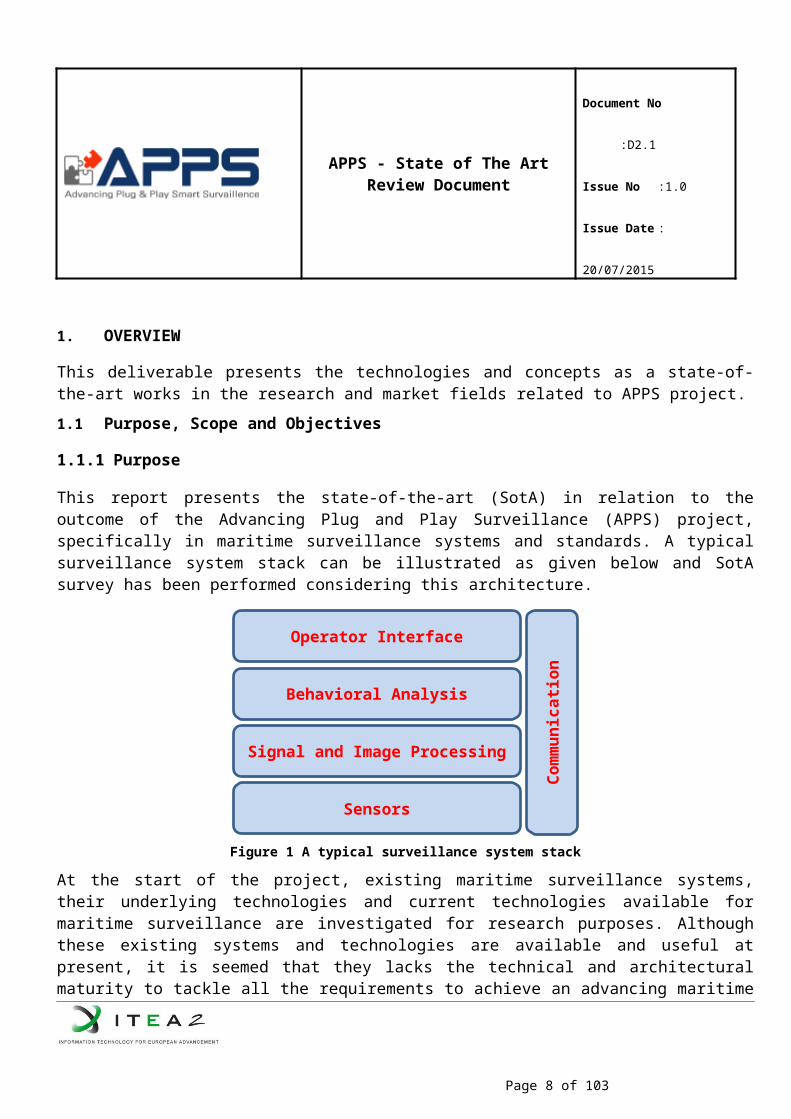
This report presents the state-of-the-art (SotA) in relation to the outcome of the Advancing Plug and Play Surveillance (APPS) project, specifically in maritime surveillance systems and standards. A typical surveillance system stack can be illustrated as given below and SotA survey has been performed considering this architecture.
Figure 1 A typical surveillance system stack
At the start of the project, existing maritime surveillance systems, their underlying technologies and current technologies available for maritime surveillance are investigated for research purposes. Although these existing systems and technologies are available and useful at present, it is seemed that they lacks the technical and architectural maturity to tackle all the requirements to achieve an advancing maritime surveillance system for future expectations and technological enhancements. Some companies have some of the APPS subsystems as individual, disparate systems; some have “unified” systems that display several data feeds all at once without the critical automated decision making and support component and yet some have an integrated system with only very limited algorithmic capabilities.
1.1.2 Scope
Deliverable 2.1 presents the current state-of-the-art in the technologies and standards in relation to the scope of APPS Project. The document presents the related concepts in the structure given below and delves into the concepts by organizing the sections as existing protocols/standards, projects, problems & unmet needs and APPS innovation:
Plug and Play Surveillance Smart Surveillance
Page 7 of 62
Sensors
Signal and Image Processing
Behavioral Analysis
Operator Interface
Com
mun
icati
on
APPS - State of The Art Review Document
Document No :D2.1
Issue No :1.0
Issue Date : 20/07/2015
Communication and Networks Visualization Frameworks Internet of Things (IoT) for Maritime Sensors
1.1.3 Objectives
1.2 Project Overview
At present, maritime surveillance systems consist of radar and visualization sensors. These sensors are not able to be used in conjunction with full capacity due to their limits such as integration, network constraints, and computational constraints etc. Besides, as these surveillance systems are being used with 24/7 and are often massive projects with big budgets, easy modifications, updates and enhancements are also severe difficulties to be managed. Besides, due to the technological improvements in sensors, needs for easy sensor management, increased interoperability of systems with others and enhanced situational awareness methodologies are increasing in surveillance system domains such as maritime surveillance.Advancing Plug and Play Surveillance (APPS) project tries to overcome these needs and difficulties by providing technical solutions derived from the state-of-the-art and by providing innovative approaches. Following a systems-of-systems paradigm, APPS will specify and implement a profiling-based architecture addressing technical, semantic and organizational levels of the interoperability stack to enable the development of plug-and-play solutions. At the device level, the sensors will integrate on plug and play basis into a surveillance system. The system will automatically detect when a new sensor is attached or an existing sensor is removed. As a result, all the layers of the system will reconfigure themselves and continue operating without interruption. To benefit from the advanced and flexible plug and play systems approach, the APPS project also aims to enable smart surveillance based on simultaneous observations of events made by multi-sensor systems (radar, visual, thermal, acoustic and physicochemical), by recognizing abnormalities and behavior in a sequence of events observed over longer time intervals. Integrating its results, APPS will demonstrate the enhanced capabilities adopted from above mentioned technologies in maritime surveillance, in particular cases based on detecting illegal activities at sea and protection of critical infrastructure at sea and in harbors. Considering the fact that APPS relies on heterogeneous technologies, it will develop robust communication layer to achieve an effective maritime surveillance system. Last but not least, to establish an enhanced situational awareness, APPS will develop and use several tools such as signal and image processing algorithms and behavioral analysis methods, for the data received from the sensors.It is obvious that future surveillance technologies will be different from the current ones as new sensor technologies and capabilities are being developed. To achieve a successful and effective maritime surveillance system, a plug-and-play approach seems useful and effective. Hence, APPS aims to achieve future technologies for maritime surveillance systems by implementing the paradigms mentioned in the document.
Page 8 of 62
APPS - State of The Art Review Document
Document No :D2.1
Issue No :1.0
Issue Date : 20/07/2015
2. DEFINITIONS AND ABBREVIATIONS
2.1 Definitions
The following definitions explain the keywords within the context of the APPS project:
Project hereafter it refers APPS.
Partner is used to refer company, research institute, university that contributes the project.
2.2 Abbreviations
AIS Automatic Identification SystemAPPS Advancing Plug & Play Smart SurveillanceBII Business Interoperability Interface
C2 Command and ControlCISE Common Information Sharing Environment for the EU Maritime
DomainCR Change RequestIHE Integrated Healthcare Enterprise
NES North European Subset
NIEM National Information Exchange Model
O&M Observation and MeasurementOGC Open Geospatial Consortium OWL Ontology Web Language
OWL-DL Ontology Web Language – Description Logics
RDF Resource Description Framework
SAS Sensor Alert Service SensorML Sensor Model LanguageSOS Sensor Observations ServiceSPS Sensor Planning ServiceSWE Sensor Web EnablementUAV Unmanned Air VehicleW3C World Wide Web Consortium
WNS Web Notification ServiceXML Extensible Markup Language
Page 9 of 62
APPS - State of The Art Review Document
Document No :D2.1
Issue No :1.0
Issue Date : 20/07/2015
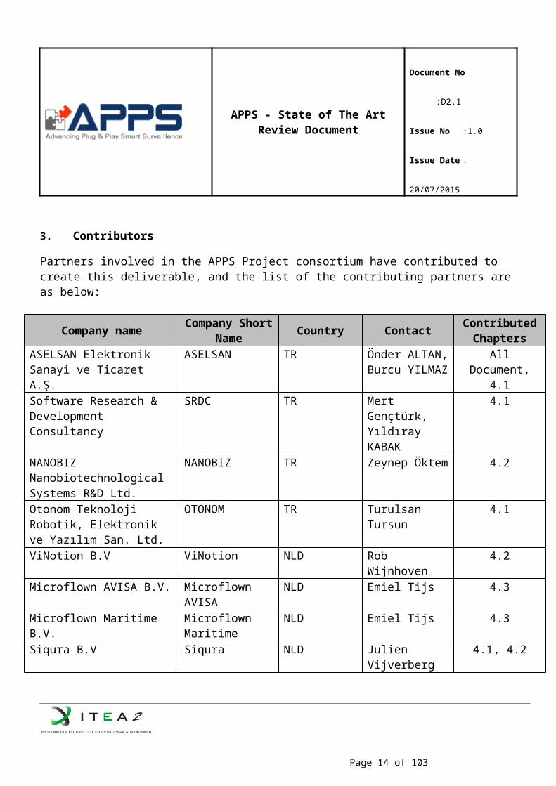
3. Contributors
Partners involved in the APPS Project consortium have contributed to create this deliverable, and the list of the contributing partners are as below:
Company name Company Short Name Country Contact Contributed
ChaptersASELSAN Elektronik Sanayi ve Ticaret A.Ş.
ASELSAN TR Önder ALTAN,Burcu YILMAZ
All Document, 4.1
Software Research & Development Consultancy
SRDC TR Mert Gençtürk,Yıldıray KABAK
4.1
NANOBIZ Nanobiotechnological Systems R&D Ltd.
NANOBIZ TR Zeynep Öktem 4.2
Otonom Teknoloji Robotik, Elektronik ve Yazılım San. Ltd.
OTONOM TR Turulsan Tursun 4.1
ViNotion B.V ViNotion NLD Rob Wijnhoven 4.2Microflown AVISA B.V. Microflown
AVISANLD Emiel Tijs 4.3
Microflown Maritime B.V. Microflown Maritime
NLD Emiel Tijs 4.3
Siqura B.V Siqura NLD Julien Vijverberg 4.1, 4.2Technische Universiteit Eindhoven
TUE NLD Egor Bondarev 4.2
Thales Nederland B.V. Thales NLD Sorin M. IACOBDavid Mobach
GMT Co., Ltd. GMT KOR Kilyong Kim 4.3Prodevelop, S.L Prodevelop ESP Cristophe Joubert 4.4NGARO Intelligent Solutions, S.L
NGARO ESP Ruth Manzanares 4.4
ITI - Instituto Tecnológico de Informática
ITI ESP 4.4
NUNSYS S.L NUNSYS ESP 4.4Tellence Technologies SRL TTS ROU Jesus Alonso 4.5
Page 10 of 62
APPS - State of The Art Review Document
Document No :D2.1
Issue No :1.0
Issue Date : 20/07/2015
4. APPS Technologies
Advancing Plug & Play Smart Surveillance (APPS) project aims to significantly improve surveillance systems in the following aspects:
The APPS architecture calls for an advanced operator interface equipped with an innovative visualization component.
Surveillance systems should not be limited anymore to static environments and scenarios, because threats and the scenarios change as soon as the environments become more protected. Furthermore, there is great benefit if two or more surveillance systems, especially if they are geographically in close proximity, can exchange information and share situational awareness. Ideally, surveillance systems in the future should operate as systems of systems consisting of existing legacy systems as well as entirely new systems. This capability should be integrated in the design of the systems in terms of flexibility, re-targeting the use of the system. This will require significant integration efforts and system re-design experiments.
APPS project also advances the state-of-the-art in surveillance systems at interoperability level to allow fluent metadata conversion and open formats for logging, alerting and smooth communication between different surveillance systems. At lower levels of granularity, at device level, the sensors will be plug and play components of a surveillance system. At higher levels of granularity, the surveillance systems will also plug and play into each other, as systems of systems. They will be able to exchange and fuse information, especially if they are in close proximity, share situational awareness and collaborate. Achieving plug and play interoperability involves not a single standard but a collection of standards addressing different layers in the interoperability stack. However, there are several alternative standards to be chosen from for each layer and some standards specify a range of standards for a layer. The APPS project will adapt a profiling approach addressing technical, semantic and organizational levels of the interoperability stack to enable the plug-and-play solutions.
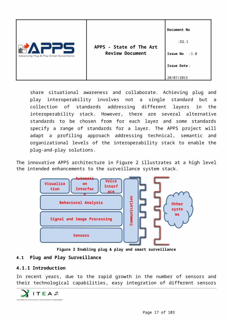
The innovative APPS architecture in Figure 2 illustrates at a high level the intended enhancements to the surveillance system stack.
Page 11 of 62
APPS - State of The Art Review Document
Document No :D2.1
Issue No :1.0
Issue Date : 20/07/2015
Figure 2 Enabling plug & play and smart surveillance
4.1 Plug and Play Surveillance
4.1.1 Introduction
In recent years, due to the rapid growth in the number of sensors and their technological capabilities, easy integration of different sensors into existing or prospective systems, or sensors’ interoperability with other technologies have become a challenging topic. The “plug-and-play” paradigm is very useful to handle this engineering problem, however for surveillance systems this capability has not been adopted yet. In order to achieve a properly operating plug-and-play surveillance system, the aspects of the paradigm should be investigated and researched from both system and sensor levels. From system level, syntactic and functional interoperability between the surveillance systems and sensors and from sensor level, standardized interfaces to access data and metadata of sensors become a base to achieve a plug-and-play surveillance system. Considering all these prerequisites, state-of–the-art in the “plug-and-play” research field can be summarized from the APPS Project’s point-of-view as bellow.
4.1.2 Existing State-of-the-Art
4.1.2.1 Protocols/Standards
OGC Sensor Web Enablement
This section describes the architecture implemented by Open Geospatial Consortium’s (OGC) Sensor Web Enablement Initiative (SWE). In much the same way that HTML and HTTP standards enabled the exchange of any type of information on the Web, the SWE initiative is focused on developing standards to enable the discovery of sensors and corresponding observations, exchange, and processing of sensor observations, as well as the tasking of sensors and sensor systems. The functionality that OGC has targeted within the Sensor Web includes:
Discovery of sensor systems, observations, and observation processes that meet our immediate needs
Determination of a sensor’s capabilities and quality of measurements
Page 12 of 62
Sensors
Signal and Image Processing
Behavioral Analysis
Visualization
Com
mun
icati
on
Other systems
Automation Interface
Voice Interface
APPS - State of The Art Review Document
Document No :D2.1
Issue No :1.0
Issue Date : 20/07/2015
Access to sensor parameters that automatically allow software to process and geo-locate observations
Retrieval of real-time or time-series observations and coverages in standard encodings Tasking of sensors to acquire observations of interest Subscription to and publishing of alerts to be issued by sensors or sensor services based
upon certain criteria
The Sensor Web represents a meta-platform that integrates arbitrary sensors and sensor networks; each maintained and operated by individual institutions, e.g. the Australian Water Resources Network, the European Environment Information and Observation Network, or the South African Earth Observation Network. This reflects the existing legal, organizational and technical situation. Sensors and sensor systems are operated by various organizations with varying access constraints, security, and data quality and performance requirements. The architectural design of the Sensor Web allows the integration of individual sensors as much as the integration of complete sensor systems without the need of fundamental changes to the legacy systems.
Within the SWE initiative, the enablement of such sensor webs is being pursued through the establishment of the following encodings for describing sensors and sensor observations,
1. Sensor Model Language (SensorML) – standard models and XML Schema for de-scribing sensors systems and processes; provides information needed for discovery of sensors, location of sensor observations, processing of low-level sensor observations, and listing properties that can be separated in the different tasks
2. Observations and Measurements Schema (O&M) – standard models and XML Schema for encoding observations and measurements from a sensor, both archived and real-time and through four standard interface definitions for Web services:
Sensor Observations Service (SOS) – standard web service interface for requesting, filtering, and retrieving observations and sensor system information
Sensor Planning Service (SPS) – standard web service interface for requesting user-driven acquisitions and observations, to (re-)calibrate a sensor or to task a sensor network
Sensor Alert Service (SAS) – standard web service interface for publishing and subscribing to alerts from sensors
Web Notification Services (WNS) – standard web service interface for asynchronous delivery of messages or alerts from any other web service.
SensorML
Providing Standard models and XML encoding by describing any processes including the processes of measurement by sensors and instructions for deriving higher-level information from observations, SensorML is good for discovery of sensors, sensor systems, processes, on-demand processing of observations, alert services, archiving of sensor parameters and plug-and-play and autonomous sensor networks.
Page 13 of 62
APPS - State of The Art Review Document
Document No :D2.1
Issue No :1.0
Issue Date : 20/07/2015
In its simplest application, SensorML can be used to provide a standard digital means of providing specification sheets for sensor components and systems. It devises a metadata that includes identifiers, classifiers, constraints (time, legal, and security), capabilities, characteristics, contacts, and references, in addition to inputs, outputs, parameters, and system location to be able to mined and used for discovery of sensor systems and observation processes. Describing in detail the process through which an observation is performed, it increases the confidence level of with regard to the observation. Discovered and distributed over the web, SensorML describes and executes Process chains for geolocation or higher-level processing of observations on-demand without a priori knowledge of the sensor or processor characteristics. SensorML defines and builds on common data definitions that are used throughout the OGC Sensor Web Enablement (SWE) framework. Due to the self-describing characteristic of SensorML-enabled sensors and processes, development of auto-configuring sensor networks, as well as the development of autonomous sensor networks in which sensors can publish alerts and tasks to which other sensors can subscribe and react is supported. SensorML enables the development of plug-n-play sensors, simulations, and processes, which can be added seamlessly to decision support systems.
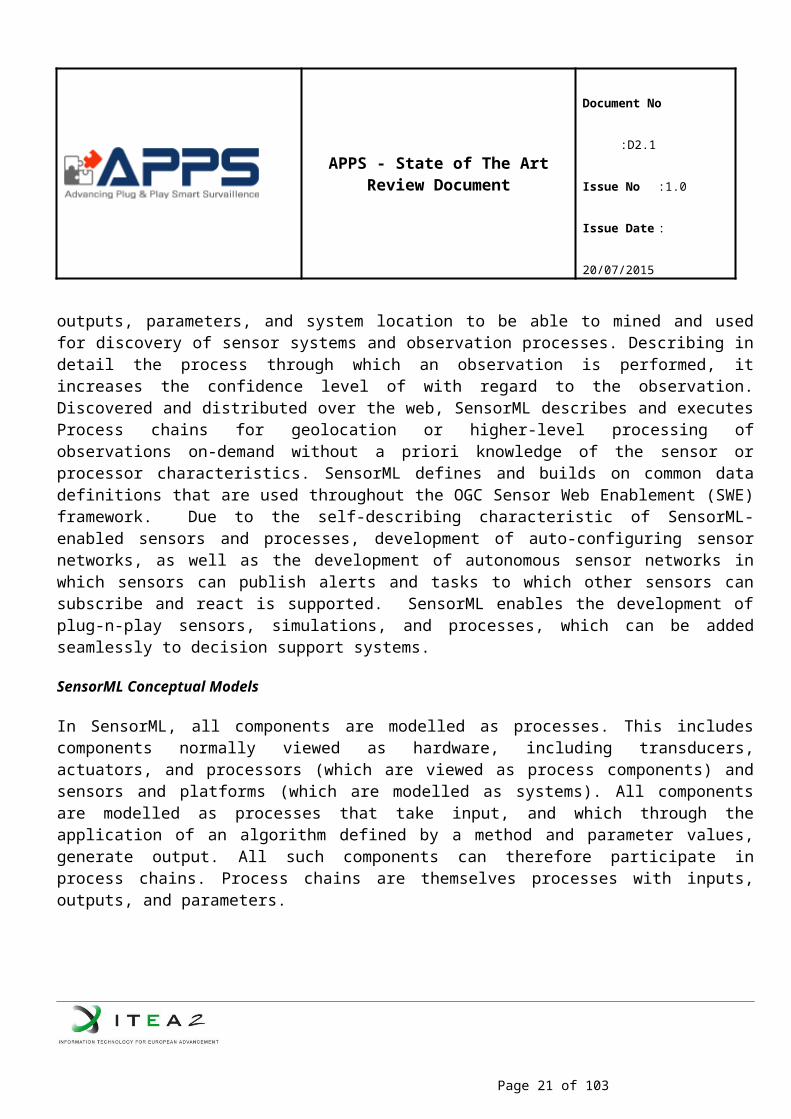
SensorML Conceptual Models
In SensorML, all components are modelled as processes. This includes components normally viewed as hardware, including transducers, actuators, and processors (which are viewed as process components) and sensors and platforms (which are modelled as systems). All components are modelled as processes that take input, and which through the application of an algorithm defined by a method and parameter values, generate output. All such components can therefore participate in process chains. Process chains are themselves processes with inputs, outputs, and parameters.
Page 14 of 62
APPS - State of The Art Review Document
Document No :D2.1
Issue No :1.0
Issue Date : 20/07/2015
Figure 3 Conceptual model for Processes
SensorML models sensor systems as a collection of physical and non-physical processes. It also supports the description of processes that have been applied to an observation (i.e. observation lineage) or can be applied on an observation (i.e. on-demand processing). In this sense, processes in SensorML are intended as serializations of executable components. An instance of a process in SensorML should describe the inputs and outputs expected, as well as the parameters and methodology required to create output values from input values.
Page 15 of 62
APPS - State of The Art Review Document
Document No :D2.1
Issue No :1.0
Issue Date : 20/07/2015
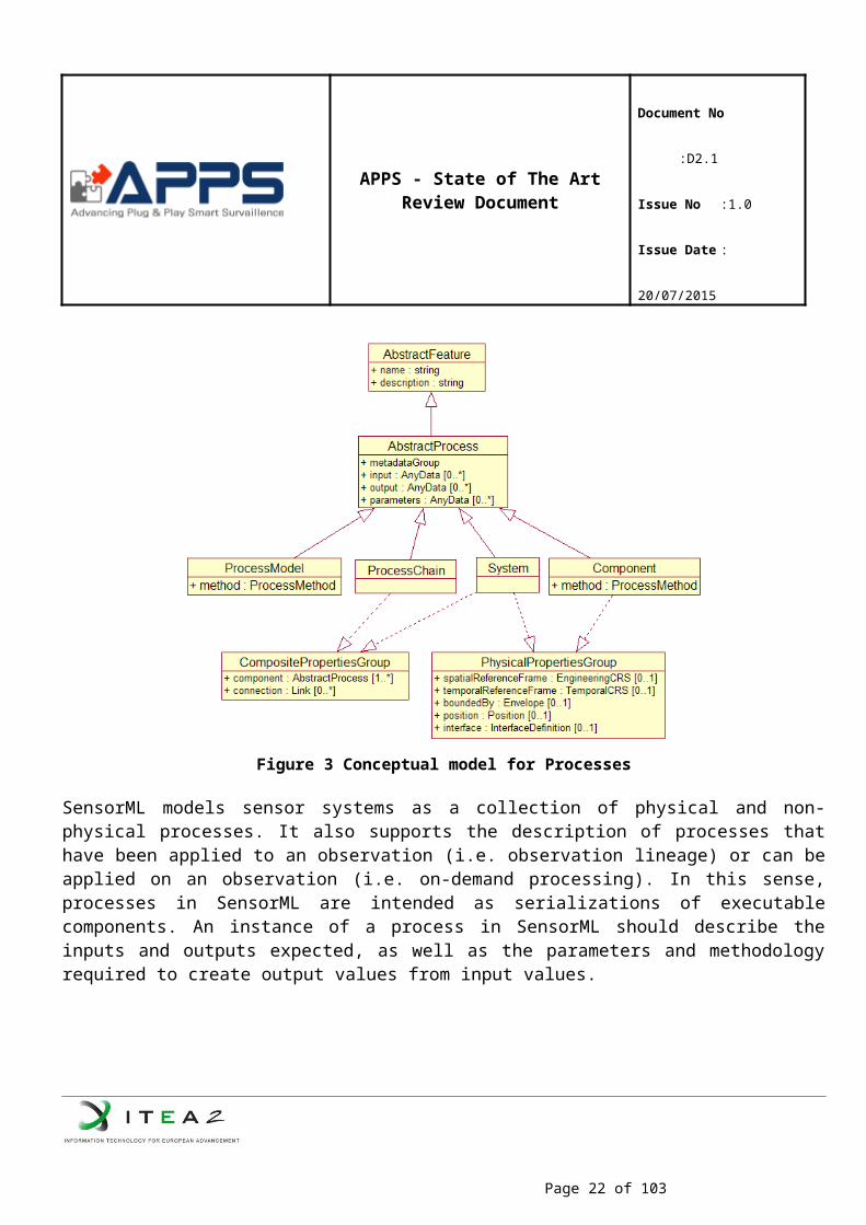
Figure 4 Alternative model view for physical and non-physical processes
National Information Exchange Model (NIEM)
NIEM is an XML-based information exchange framework designed for achieving collaborative partnership of different agencies and organizations including governmental and private sectors. Developed in U.S, it is a community-driven, standards-based approach to exchanging information and data sharing.
NIEM is not a software program, database, network, or computer system, but NIEM defines terms, definitions, and relationships for data being exchanged. In the NIEM there are two main components such: the NIEM core and NIEM domains.
In the NIEM core, there are data elements, which are commonly understood and defined across domains, such as person, activity, document, location, and item. All NIEM domains govern the NIEM core jointly.
NIEM domains contain mission-specific data components that build upon the NIEM core concepts and add additional content specific to the community supporting that mission. Representing both the governance and
Page 16 of 62
APPS - State of The Art Review Document
Document No :D2.1
Issue No :1.0
Issue Date : 20/07/2015
model content oriented around a community’s business needs, a NIEM domain manages their portion of the NIEM data model and works with other NIEM domains to collaboratively identify areas of overlapping interest. Additionally, there are future domains that are added to NIEM as necessary, based on an established business needs.
Technical Architecture of NIEM Model
Technical architecture of NIEM’s model is a set of reusable XML schema documents. Grouped into abstraction layers, these schema documents contain commonly used data components. Each abstraction layer reuses and extends data components from previous layers as illustrated in the figure below.
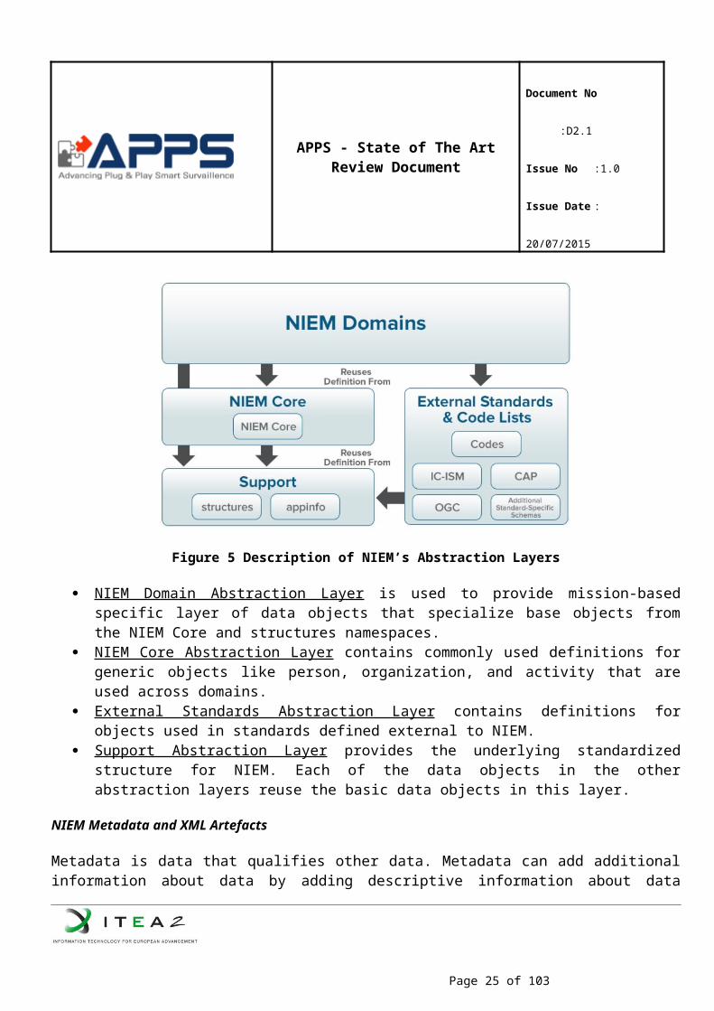
Figure 5 Description of NIEM’s Abstraction Layers
NIEM Domain Abstraction Layer is used to provide mission-based specific layer of data objects that specialize base objects from the NIEM Core and structures namespaces.
NIEM Core Abstraction Layer contains commonly used definitions for generic objects like person, organization, and activity that are used across domains.
External Standards Abstraction Layer contains definitions for objects used in standards defined external to NIEM.
Support Abstraction Layer provides the underlying standardized structure for NIEM. Each of the data objects in the other abstraction layers reuse the basic data objects in this layer.
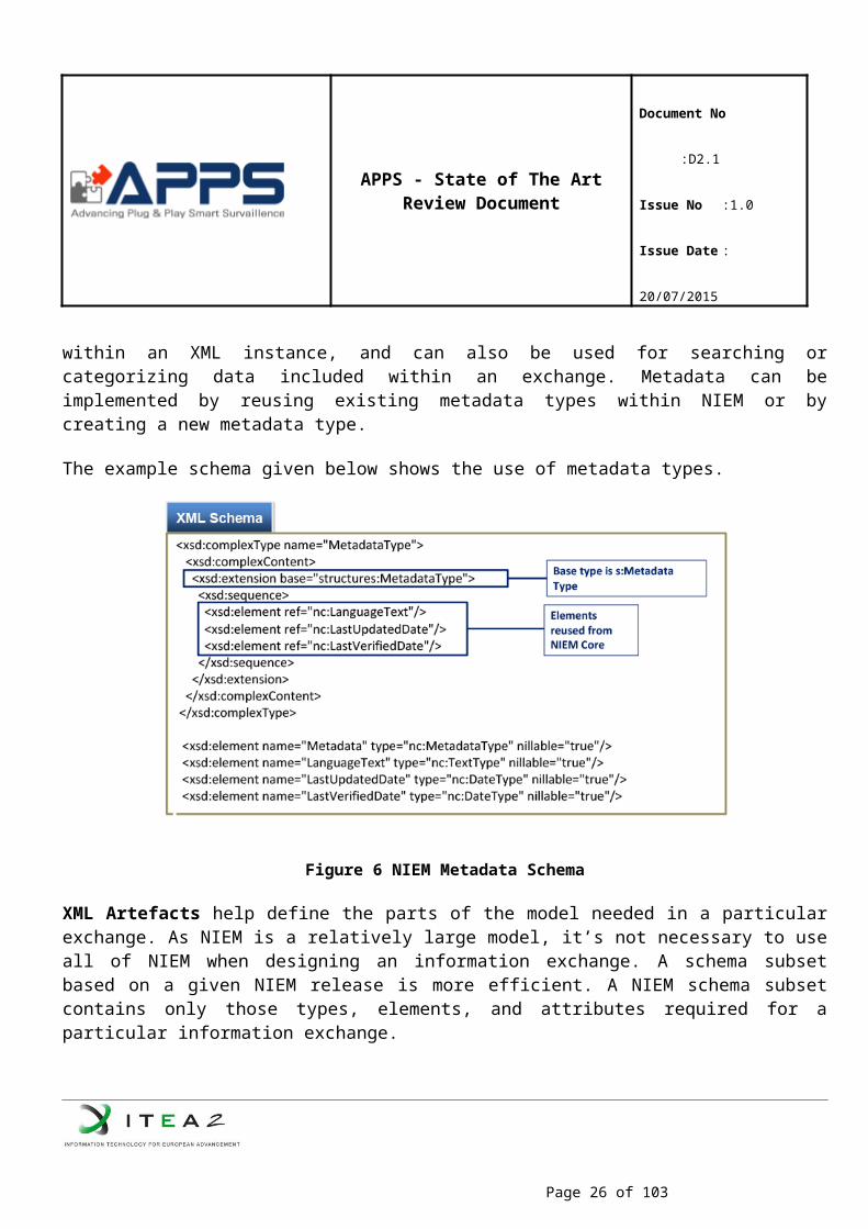
NIEM Metadata and XML Artefacts
Metadata is data that qualifies other data. Metadata can add additional information about data by adding descriptive information about data within an XML instance, and can also be used for searching or categorizing data included within an exchange. Metadata can be implemented by reusing existing metadata types within NIEM or by creating a new metadata type.
Page 17 of 62
APPS - State of The Art Review Document
Document No :D2.1
Issue No :1.0
Issue Date : 20/07/2015
The example schema given below shows the use of metadata types.
Figure 6 NIEM Metadata Schema
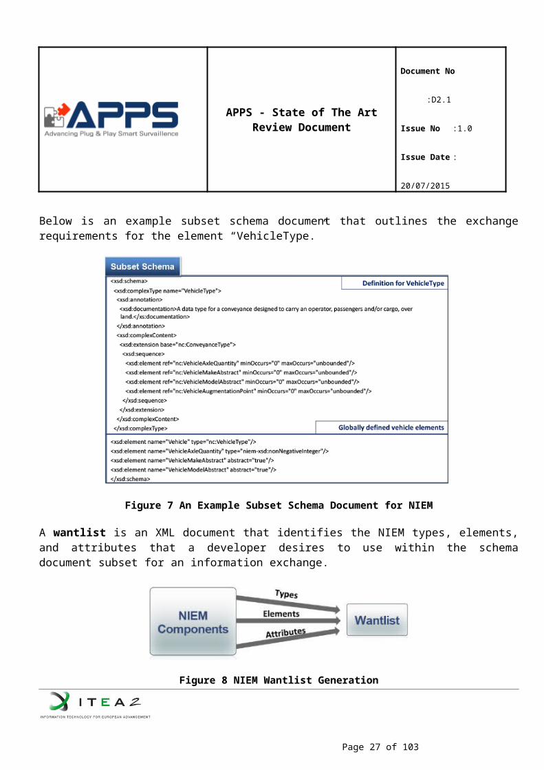
XML Artefacts help define the parts of the model needed in a particular exchange. As NIEM is a relatively large model, it’s not necessary to use all of NIEM when designing an information exchange. A schema subset based on a given NIEM release is more efficient. A NIEM schema subset contains only those types, elements, and attributes required for a particular information exchange.
Below is an example subset schema document that outlines the exchange requirements for the element “VehicleType.”
Page 18 of 62
APPS - State of The Art Review Document
Document No :D2.1
Issue No :1.0
Issue Date : 20/07/2015
Figure 7 An Example Subset Schema Document for NIEM
A wantlist is an XML document that identifies the NIEM types, elements, and attributes that a developer desires to use within the schema document subset for an information exchange.
Figure 8 NIEM Wantlist Generation
Semantic Web Technologies
Semantic Web
Nowadays, data found on the Internet lacks structure and explicit meaning, creating difficulties for information retrieval and readability by computers. Therefore, the W3C organization has decided to pursue a “Semantic Web” project-devised in 2001 and by TIm Berners-Lee at first time-, which the Internet is transformed into a machine-interpretable network. In this ‘semantic’ vision, the Internet would be extended with conceptual metadata1 that reveals the intended meaning of Web resources, making them more useful to 1 Metadata is “data about data”, meaning a set of facts about the content.
Page 19 of 62
APPS - State of The Art Review Document
Document No :D2.1
Issue No :1.0
Issue Date : 20/07/2015
machines
The Semantic Web addresses the shortcomings of the current web by offering a data centric markup language, XML, and the descriptive standards, RDF and OWL. eXtensible Markup Language (XML) provides a surface syntax for structured documents, but it does not provide sufficient data meaning for “efficient sharing of conceptualization”. In other words, it stores and displays information; however, it does not provide any description to it.
Resource Description Framework (RDF) is a basic ontology language with graphical applications that combines XML syntax and semantics to represent information about resources on the web. Resources are described in terms of properties and property values using RDF statements.
OWL (Web Ontology Language) has “more facilities, [such as additional vocabulary], for expressing meaning and semantics than XML, RDF, and RDF Schemas, and thus OWL goes beyond these languages in its ability to represent machine interpretable content on the Web”. In other words, OWL is a stronger language with greater machine interpretability and larger vocabulary than RDF.
To facilitate the exchange of data between computer applications, standard vocabularies of a domain must be established and captured in ontology. It is a knowledge representation model defined in terms of classes, properties and relationships for individuals who need to share information in a domain.
Ontology
In computer science and information science, ontology formally represents knowledge as a set of concepts within a domain, and the relationships between those concepts. It can be used to reason about the entities within that domain, and may be used to describe the domain. In theory, ontology is a "formal, explicit specification of a shared conceptualization". Ontology renders shared vocabulary and taxonomy, which models a domain — that is, the definition of objects and/or concepts, and their properties and relations.
Contemporary ontologies share many structural similarities, regardless of the language in which they are expressed. Most ontologies describe individuals (instances), classes (concepts), attributes, and relations. Ontologies are commonly encoded using ontology languages such as OWL and RDF. OWL is W3C’s latest Semantic technology that builds these ontologies to enable agents to exchange data across web applications and resources.
Resource Description Framework (RDF)
The Resource Description Framework (RDF) is a general framework for how to describe any Internet resource such as a Web site and its content. An RDF description (such descriptions are often referred to as metadata, or "data about data") can include the authors of the resource, date of creation or updating, the organization of the pages on a site (the sitemap), information that describes content in terms of audience or content rating, key words for search engine data collection, subject categories, and so forth. The Resource Description Framework will make it possible for everyone to share Web site and other descriptions more easily and for software developers to build products that can use the metadata to provide better search engines and directories, to act as intelligent agents, and to give Web users more control of what they're
Page 20 of 62
APPS - State of The Art Review Document
Document No :D2.1
Issue No :1.0
Issue Date : 20/07/2015
viewing. The RDF is an application of another technology, the Extensible Markup Language (XML), and is being developed under the auspices of the World Wide Consortium (W3C).
Web Ontology Language (OWL)
Released in February 2004 by the W3C, Web Ontology Language (OWL) is an ontology language that describes the classes, properties and relations between them that are inherent in Web documents and resources. OWL is used to describe, share and publish the set of terms that are inherent in Web documents and applications. OWL uses both Unique Resource Locators (URL)2 (e.g.: http://www.w3c.org) for naming and the description framework for the Web provided by RDF to extend the capabilities of ontologies. OWL is a vocabulary extension of RDF and RDF-S by providing an elaborated description of classes, properties, and individuals. This feature enhances the machine interpretability of Web content.
OWL has three sub languages, each with a different level of expressive description of the data:
OWL Lite: It is the simplest language for ontologies with simple class hierarchies and constraints. This subset of OWL-DL contains an easier reasoner than the other species.
OWL-DL: It corresponds to Description Logics3, meaning that it has “decidable reasoning”. Thus, it automatically computes the classification hierarchy and checks for inconsistencies. OWL-DL does not allow datatype properties to be transitive, symmetric, or have inverse properties. Therefore, relationships can only be formed between individuals or between an individual and a data value.
OWL Full: It is an extension of RDF with OWL syntax, where it allows for classes as instances. In OWL-Full, classes can be related, but this cannot be reasoned with.
OWL-DL Reasoner
One of the appealing features of OWL is its reasoning power. Reasoning capabilities, such as consistency checking and classification, are used to detect logical inconsistencies within the ontology. OWL-DL requires a reasoner to infer information that isn’t explicitly represented in ontology. The reasoner can check whether or not all of the statements and definitions in the ontology model are mutually consistent and can also recognize which concepts fit under which definitions.
There are three well-known OWL-DL reasoner tools:
Pellet Reasoner: Pellet is a complete and capable OWL-DL reasoner with acceptable to very good performance, extensive middleware, and a number of unique features. Pellet is written in Java and is open source under a very liberal license. It is the first sound and complete OWL-DL reasoner with extensive support for reasoning with individuals, user-defined data types, and debugging support for ontologies.
Apache Jena Reasoner: The Jena OWL reasoners could be described as instance-based reasoners. 2 URI is an address for a resource available in the Web .3 Description Logic focuses on descriptions to express logic (such as union, intersection and negation) of a domain. It emphasizes on the use of classification and subsumption reasoning for inference.
Page 21 of 62
APPS - State of The Art Review Document
Document No :D2.1
Issue No :1.0
Issue Date : 20/07/2015
That is, they work by using rules to propagate the if- and only-if- implications of the OWL constructs on instance data. Reasoning about classes is done indirectly - for each declared class a prototypical instance is created and elaborated.
EYE Reasoner: EYE stands for "Euler Yet another proof Engine" and it is a further development of Euler which is an inference engine supporting logic based proofs. EYE is an inference engine supporting logic based proofs. It is a backward-forward-backward chaining reasoner enhanced with Euler path detection. The backward-forward-backward chaining is realized via an underlying Prolog backward chaining, a forward meta-level reasoning and a backward proof construction. EYE is looking through N3 glasses and doing inferencing in N3Logic.
OWL Parser
An OWL-RDF parser takes an RDF/XML file and attempts to construct an OWL ontology that corresponds to the triples represented in the RDF. The OWL Semantics and Abstract Syntax (OWL S&AS) document provides a characterization of OWL ontologies in terms of an abstract syntax. This is a high level description of the way in which the characteristics of classes and properties can be defined. In addition, S&AS gives a mapping to RDF triples which explains how such an abstract description of an OWL ontology can be transformed to a collection of RDF triples (which can then be represented in a concrete fashion using, for example RDF/XML).
There are some well known owl parser tools:
Jena OWL Parser: There are many ways of writing down an ontology, and a variety of opinions as to what kinds of definition should go in one. In practice, the contents of an ontology are largely driven by the kinds of application it will be used to support. Jena do not take a particular view on the minimal or necessary components of an ontology. Rather, it tries to support a variety of common techniques. Through the Ontology API, Jena aims to provide a consistent programming interface for ontology application development, independent of ontology language used in programs.
OWL API: The OWL API is a Java API and reference implementation for creating, manipulating and serializing OWL Ontologies. The latest version of the API is focused towards OWL 2.
Ontology Editor
Some well known ontology editors are:
Protégé: Protégé’s plug-in architecture can be adapted to build both simple and complex ontology-based applications. Developers can integrate the output of Protégé with rule systems or other problem solvers to construct a wide range of intelligent systems.
OWLGrEd: OWLGrEd is easy to understand Ontology Editor and use even for "non-ontologists". It provides good visualization, creation, edition and export features. It can also interoperate with Protégé.
Vitro: Vitro is a general-purpose web-based ontology and instance editor with customizable public browsing. Vitro is a Java web application that runs in a Tomcat servlet container.
Page 22 of 62
APPS - State of The Art Review Document
Document No :D2.1
Issue No :1.0
Issue Date : 20/07/2015
Profile
Integrating the Healthcare Enterprise (IHE)
Integrating the Healthcare Enterprise (IHE) is an initiative designed to stimulate the integration of the information systems that support modern healthcare institutions. Its fundamental objective is to ensure that in the care of patients all required information for medical decisions is both correct and available to healthcare professionals. The IHE initiative is both a process and a forum for encouraging integration efforts. It defines a technical framework for the implementation of established messaging standards to achieve specific clinical goals. It includes a rigorous testing process for the implementation of this framework.
IHE IT Infrastructure Integration Profiles (see the figure below), offer a common language that healthcare professionals and vendors can use to discuss integration needs of healthcare enterprises and the integration capabilities of information systems in precise terms. Integration Profiles specify implementations of standards that are designed to meet identified clinical needs. They enable users and vendors to state which IHE capabilities they require or provide, by reference to the detailed specifications of the IHE IT Infrastructure Technical Framework. Integration profiles are defined in terms of IHE Actors and transactions. Actors are information systems or components of information systems that produce, manage, or act on information associated with clinical and operational activities in the enterprise. Transactions are interactions between actors that communicate the required information through standards-based messages. Vendor products support an Integration Profile by implementing the appropriate actor(s) and transactions. A given product may implement more than one actor and more than one integration profile.
CEN Workshop on Business Interoperability Interfaces (CEN/BII)
The BII Workshop was established in May 2007 with the objective of harmonizing electronic procurement in Europe. Today, the Workshop is in its third development phase (CEN WS/BII3) that began on March 2013 with the approval of the business plan. The BII specifications have been implemented in several institutions, including the European Commission, and government agencies in Norway, Sweden, Italy, Netherlands, Iceland, etc.
The BII initiative aims to address interoperability issues in European public procurement, by developing technical specifications to implement e-Procurement processes in a compatible manner across the EU. The mission of the CEN BII Workshop is to spread and facilitate the use of e-Procurement standards for buyers and suppliers, and especially public administrations, by:
identifying requirements (including legal requirements) regarding e-procurement standards; providing a general framework for the organizational and semantic levels of the electronic
procurement documents; supporting the implementation of commonly applied international e-procurement standards; providing organizational support to ensure the governance and maintenance for those requirements
during the lifetime of the workshop.
Page 23 of 62
APPS - State of The Art Review Document
Document No :D2.1
Issue No :1.0
Issue Date : 20/07/2015
In this regard, several profiles have been specified. A BII profile description is a technical specification describing
the scope of a business process with its goals, preconditions and the roles of participating parties, the choreography of the business process covered, i.e. a detailed description of the way the business
partners collaborate to play their respective roles and share responsibilities to achieve mutually agreed goals with the support of their respective information systems,
the electronic business transactions exchanged as part of the business process, with their information requirements, and the sequence in which these transactions are exchanged,
the business rules governing the execution of that business process, as well as any constraints on information elements used in the transaction data models.
North European Subset (NES)
NES is cooperation among a group of countries and organizations to facilitate the practical use of electronic collaboration in the procurement chain, based on available international standards. The initiative comprises representation from both government and industry. The main aim of NES is to facilitate the establishment of a common platform for e-procurement among its members, and through this to facilitate interoperability and practical use of e-procurement in both domestic and cross border trade harmonization of different types of e-procurement documents contribute to the development and use of an international standard for e-procurement. The first version of the northern European implementation of UBL 2.0, that shows how the participating countries plan to apply UBL, was made available on March 23, 2007. Following the publication of NES version 2 in 2007 a new workshop was launched by the European Committee for Standardization (CEN) under the workshop name Business Interoperability Interfaces (BII). The BII workshop adopted the NES deliverables and model architecture and further evolved it as a semantic specification of electronic message processes that is syntax neutral and can consequently be implemented by using different syntax. The scope of the project was also expanded to include pre award public procurement as well as adding new profiles various other specification to the list of deliverables.
The focus of NES is to define the specific use of UBL 2.0 electronic procurement documents domestically and between the member countries. The definition covers semantic interoperability within and between all business sectors, public and private.
Joint Consultation, Command and Control Information Exchange Data Model (JC3IEDM)
Unilateral capability is important to nations but most planning is made on the assumption of alliance and coalition operations in scenarios that are difficult to predict and which often arise at short notice. Thus the nature and composition of a force structure to meet military requirements will be specific to current operational requirement and based upon a general and flexible military capability. To achieve this, an assured capability for interoperability of information is essential. The successful execution of fast moving operations needs an accelerated decision-action cycle, increased tempo of operations, and the ability to conduct operations within combined joint formations. Commanders require timely and accurate information. Also, supporting command and control (C2) systems need to pass information within and across national and
Page 24 of 62
APPS - State of The Art Review Document
Document No :D2.1
Issue No :1.0
Issue Date : 20/07/2015
language boundaries. Moreover, tactical C2 information must be provided to the operational and strategic levels of command including other governmental departments. Additionally, forces must interact with non-governmental organizations, including international aid organizations. In this respect, the Multilateral Interoperability Programme (MIP) aims to deliver an assured capability for interoperability of information to support joint / combined operations.
The aim of the Multilateral Interoperability Programme (MIP) is to achieve international interoperability of Command and Control Information Systems (C2IS) at all levels from corps to battalion, or lowest appropriate level, in order to support multinational (including NATO), combined and joint operations and the advancement of digitization in the international arena.
Towards this aim, MIP produced the Joint C3 Information Exchange Data Model (JC3IEDM) which is a model that when physically implemented aims to enable the interoperability of systems and projects required to share Command and Control (C2) information. JC3IEDM is an evolution of the C2IEDM standard that includes joint operational concepts, just as the Land Command and Control Information Exchange Data Model (LC2IEDM) was extended to become C2IEDM.
Common Information Sharing Environment for the EU maritime domain (CISE)
The objective of CISE is to ensure that maritime surveillance information collected by one maritime authority and considered necessary for the operational activities of others can be shared and be subject to multiuse, rather than collected and produced several times, or collected and kept for a single purpose . Maritime surveillance information data includes ship positions and routing, cargo data, sensor data, charts and maps, meteo-oceanic data etc.
It is stated in that the initiatives to improve information exchange for the maritime domain have already been ongoing for some time and important steps have been taken which date back to 2002 as;
The Union maritime information and exchange system, SafeSeaNet, providing integrated maritime services inter alia for traffic monitoring (situational awareness) and to ensure the implementation of EU legislation, hosted by the European Maritime Safety Agency (EMSA) and managed by the Commission’s Directorate-General for Mobility and Transport (MOVE) together with EU/EEA Member States in the High Level Steering Group;
The Common Emergency Communication and Information System (CECIS) facilitating communication during maritime incidents and disasters managed by the Commission’s Directorate-General for Humanitarian Aid and Civil Protection (ECHO);
The Vessel Monitoring System managed by Member States, the Data Exchange Highway (DEH) and the Fisheries Language for Universal eXchange (FLUX), managed by the Commission's Directorate-General for Maritime Affairs (MARE), supporting the Common Fisheries Policy;
The Maritime Surveillance network (MARSUR) managed by the European Defence Agency (EDA) supporting the Common Foreign and Security Policy;
Page 25 of 62
APPS - State of The Art Review Document
Document No :D2.1
Issue No :1.0
Issue Date : 20/07/2015
The European Border Surveillance System (EUROSUR) improving the situational awareness and reaction capability of Member States and of the EU Border Agency (FRONTEX) at the external borders as well as the Secure Information Exchange Network Application (SIENA), the information exchange system of EUROPOL, and the Joint Research Centre's Blue Hub platform supporting EU R&D in maritime surveillance and situational awareness and experimenting with new data sources previously untapped.
The next steps for a Maritime CISE include pursuing a common data model to serve as a translation tool between maritime information systems. By end of 2017, a technical reference architecture for public services will be defined in line with the European Interoperability Reference Architecture developed by the programme on "Interoperability Solutions for European public administrations" (ISA programme).
European Interoperability Reference Architecture (EIRA)
The European Interoperability Reference Architecture (EIRA) is an application of Enterprise Architecture with a focus on interoperability in the public sector.
The Interoperability Solutions for European Public Administrations (ISA) coordination group endorsed EIRA on 12th June 2014 stating that it is mature enough to go to public consultation and to be used in pilot applications.
EIRA is a four-view reference architecture for delivering digital public services across borders and sectors and defines the required capabilities for promoting interoperability as a set of Architecture Building Blocks (ABBs). The views are Legal view, Organisational view, Semantic view, and Technical view–Application and Infrastructure
Page 26 of 62
APPS - State of The Art Review Document
Document No :D2.1
Issue No :1.0
Issue Date : 20/07/2015
Figure 9 European Interoperability Reference Architecture Views
The views include definitions of processes, groups, services, components, functions, interfaces, actors, objects, roles, representations, networks and nodes that are given in. For example the “Data Exchange Service” is defined as enabling the secure exchange of messages, records, forms and other kinds of data between different ICT systems. This definition is based on ”European Interoperability Framework (EIF) for European public services” document Error: Reference source not found.
It is stated in ISA web page Error: Reference source not found that Denmark, Estonia, The Netherlands, DG CONNECT/e-SENS and DG MARE (Directorate-General for Maritime Affaris and Fisheries) are using the solution in pilot stage in its latest version 0.8.3 beta.
NATO Intelligence, Surveillance and Reconnaissance (ISR) Interoperability Architecture (NIIA)
NIIA is a technical architecture specification that provides interoperability between NATO nations’ ISR systems. The objective is to achieve structured data exchange and some specific interfaces for “seamless sharing of data” which involves the automated sharing of data amongst systems based on a common exchange model.
Page 27 of 62
APPS - State of The Art Review Document
Document No :D2.1
Issue No :1.0
Issue Date : 20/07/2015
Figure 10 ISO 7-Layer Model Maping of ISR Interfaces
Several standardization agreement (STANAG) documents have been defined in order to provide interoperability standards for ISR systems including:
STANAG 4609, “NATO Digital Motion Imagery Standard” STANAG 4607, “NATO Ground Moving Target Indication Format (GMTIF)” STANAG 7023, “NATO Primary Imagery Format” (NPIF) STANAG 4545, “NATO Secondary Imagery Format” (NSIF) STANAG 7085, “Interoperable Data Links for Imaging Systems”
NIIA also uses commercial standards wherever applicable to encourage use of the commercial off-the-shelf hardware and software, for example TCP/IP is used in some cases where network connectivity is needed.
The “ISO 7-Layer Model Mapping of ISR Interfaces” is depicted as given in the above figure.
Joint Architecture for Unmanned Systems (JAUS)
The Joint Architecture for Unmanned Systems (JAUS) is an international standard currently being maintained by Society of Automotive Engineers (SAE) AS-4 Unmanned Systems Steering Committee since 2004.
Page 28 of 62
APPS - State of The Art Review Document
Document No :D2.1
Issue No :1.0
Issue Date : 20/07/2015
JAUS is initially started in 1995 by the Joint Project Office for Unmanned Ground Vehicles/Systems within U.S. Department of Defense to define a standard that would reduce the cost of development and increase the interoperability between two of their simultaneous, ongoing unmanned ground vehicle acquisitions. The standard was formerly known as JAUGS, Joint Architecture for Unmanned Ground Systems.
The purpose of the standard is to achieve interoperability for different products from different manufacturers used in unmanned systems. The standard has gone through several revisions. The current standard known as SAE JAUS employs a service oriented approach and defines message formats as well as standard services for various unmanned system capabilities.
JAUS is a collection of specification documents, together which define the following and more;
Transmission of JAUS messages – AS5669A JAUS Transport Specification Data structure of services, messages and protocol – AS5684 JAUS Service Interface Definition
Language (JSIDL) Low level services including discovery and transport – AS5710A JAUS Core Service Set Mobility services such as positioning and vehicle control – AS6009 JAUS Mobility Service Set Manipulation services for controlling robotic manipulators – AS6057 JAUS Manipulation Service
Set
The architecture objectives defined in are;
Support all classes of unmanned systems Rapid technology insertion Interoperable operator control unit Interchangeable/interoperable payloads Interoperable unmanned systems
UDP, TCP and serial based data transmission is specified for transmission of JAUS messages. The JSIDL is formalized as an XML Schema and specifies how messages are to be structured rather than the format of specific messages.
There exists also UGV interoperability profile (IOP) defined for unmanned ground vehicles which provides specific rules and requirements associated with the profiling of the SAE JAUS message set to achieve system level and platform level interoperability.
JAUS topology includes;
System – A collection of subsystems Subsystem – A complete platform (e.g. a vehicle/UGV) Node – Any device with a physical address Component – Software application running on a node and is composed of services
Page 29 of 62
APPS - State of The Art Review Document
Document No :D2.1
Issue No :1.0
Issue Date : 20/07/2015
OASIS Common Alerting Protocol (CAP)
The Common Alerting Protocol (CAP) is an XML-based data format for exchanging public warnings and emergencies between alerting technologies. CAP allows a warning message to be consistently disseminated simultaneously over many warning systems to many applications. CAP increases warning effectiveness and simplifies the task of activating a warning for responsible officials. CAP also facilitates the detection of emerging patterns in local warnings of various kinds. CAP also provides a template for effective warning messages based on best practiced identified in academic research and real-world experience.
CAP provides an open, non-proprietary digital message format for all types of alerts and notifications. It does not address any particular application or telecommunications method. The CAP format is compatible with emerging techniques, such as Web services, existing formats including the Specific Area Message Encoding (SAME) user for the US National Oceanic and Atmospheric Administration (NOAA) Weather Radio and the Emergency Alert System (EAS) while offering enhanced capabilities that include:
Flexible geographic targeting using latitude/longitude shapes and other geospatial representations in three dimensions;
Multilingual and multiaudience messaging; Phased and delayed effective time and expiration; Enhanced message update and cancellation features; Template support for framing complete and effective warning messages; Compatible with digital encryption and signature capability; and, Facility for digital images and audio
Key benefits of CAP include reduction of costs and operational complexity by eliminating the need for multiple custom software interfaces to the many warning sources and dissemination systems involved in all-hazard warning. The CAP message format can be converted to and from all kinds of sensor and alerting technologies.
OtherONVIF (Open Network Video Interface) and PSIA (Physical Security Interoperability Alliance) are standards for devices in CCTV networks to support interoperability between these devices. The focus of these standards is on video and audio streaming and has limited support for video analytics on single-camera streams.
4.1.2.2 Existing Projects
SALUS
Project Objectives
Scalable, Standard based Interoperability Framework for Sustainable Proactive Post Market Safety Studies (SALUS) is an R&D project co-financed by the European Commission's 7th Framework Programme (FP7), coordinated by SRDC.
Page 30 of 62
APPS - State of The Art Review Document
Document No :D2.1
Issue No :1.0
Issue Date : 20/07/2015
Pre-approval clinical trials cannot guarantee that drugs will not have serious side effects after they are marketed. Post-approval drug safety data studies aim to address this problem, however, their effectiveness is started to be discussed especially after recent examples of drug withdrawals. This is due to the fact that, current post market safety studies largely depend on the submission of spontaneous case reports where underreporting is a major problem. Effective integration and utilization of electronic health records (EHR) can help to improve post-market safety activities on a proactive basis. SALUS aims to facilitate this through providing functional interoperability profiles and supporting open source toolsets enabling EHR systems and clinical research systems to communicate and exchange EHR data; implementing semantic interoperability solutions enabling meaningful interpretation of the exchanged EHR data; implementing security and privacy mechanisms and open source toolsets ensuring that clinical information is shared in an ethical and safe way and providing a novel exploratory analysis framework for open-ended temporal pattern discovery for safety studies on top of disparate, distributed, heterogeneous EHR Systems. In short, SALUS aims to create the necessary semantic and functional interoperability infrastructure to enable secondary use of EHR data in an efficient and effective way for enabling pro-active post market safety studies. SALUS has successfully ended in April 2015.
Similarity & Relevance to APPS Objectives
SALUS aims to achieve syntactic and functional interoperability between EHR systems and clinical research systems. To achieve this, it is needed to define standardized interfaces between EHR systems and clinical research systems. To define such standardized interfaces, “profiling” approach is followed in the project in health domain. APPS project will follow similar “profiling” approach for security domain.
SALUS provides semantic interoperability framework to enable two or more computer systems to exchange information, automatically interpret the information exchanged meaningfully and accurately in order to produce useful results. In APPS, dynamic information will be mapped to each other in Semantic Interoperability Layer. Although APPS will expose the functionality of emergency applications as Web services with standard interfaces, there are overlapping standards and it is not realistic to expect all emergency responding parties to conform to the same standards. Therefore, in APPS, a semantic interoperability suite will be developed based on the know-how obtained in SALUS project.
iSURF
Project Objectives
An Interoperability Service Utility for Collaborative Supply Chain Planning across Multiple Domains Supported by RFID Devices (iSURF) is an R&D project co-financed by the European Commission's 7th Framework Programme (FP7), coordinated by Middle East Technical University (METU). SRDC participated to the project as a partner.
To be able to cope with the requirements of today’s competitive and demanding digital world of business, companies, especially SMEs, need to be more agile, and be ready to react to the changing requirements of the sector. This requires a better view and a more comprehensive analysis of the whole marketplace. Trading partners within a supply chain usually have different competencies based on their business strategies and varying sources of information. When this information is not shared, the decision making capability of
Page 31 of 62
APPS - State of The Art Review Document
Document No :D2.1
Issue No :1.0
Issue Date : 20/07/2015
companies is reduced since the impact of a decision on the supply chain as a whole cannot be assessed correctly. An environment needs to be created to facilitate the collaborative exploitation of this distributed intelligence of multiple trading partners in order to better plan and fulfil the customer demand in the supply chain. As a response to this need, iSURF project provides a knowledge-oriented inter-enterprise collaboration environment to SMEs to share information on the supply chain visibility, individual sales and order forecast of companies, current status of the products in the manufacturing and distribution process, and the exceptional events that may affect the forecasts in a secure and controlled way. iSURF project was successfully completed in July 2010. Although iSURF enables a generic collaborative environment, the outcomes were demonstrated in the textile domain through the iSURF Pilot Application by Fratelli Piacenza S.p.A. which is a manufacturer of fine cashmere fabrics and supplier to many world-leading apparel brand manufacturers, including Boss and INCO/Zegna.
Similarity & Relevance to APPS Objectives
When companies involved in more than one supply chain need to exchange their planning information across multiple domains, they face an interoperability problem. iSURF provides a Semantic Interoperability Service Utility (ISU) for achieving the semantic reconciliation of the planning and forecasting business documents exchanged between the companies according to different standards. In order to standardize the semantic specifications developed for the iSURF Interoperability Service Utility, a technical committee namely “OASIS Semantic Support for Electronic Business Document Interoperability (SET)” was initiated by the iSURF Project under OASIS umbrella. APPS will use the approach developed in the “OASIS Semantic Support for Electronic Business Document Interoperability (SET) TC ” which is to explicate the semantics of different but overlapping electronic business document standards as ontologies and then provide semantic mediation among these ontologies.
RECONSURVE
Project Objectives
A Reconfigurable Surveillance System with Communicating Smart Sensors (RECONSURVE) is an R&D project co-financed by the ITEA2 which is the EUREKA Cluster programme supporting innovative, industry-driven, pre-competitive R&D projects in the area of Software-intensive Systems & Services (SiSS). The project was coordinated by ASELSAN which is the largest electronics integrator in Turkey in terms of both revenue and employee headcount. SRDC participated into the project as a partner.
The RECONSURVE project has been motivated by and aims to address the need to control the rapidly increasing number and complexity of maritime surveillance issues such as illegal immigration especially using small vessels, interoperability between heterogeneous systems, automated cost-effective and efficient decision support. Although there are some maritime surveillance systems available, they lack the technical and architectural maturity to tackle all these requirements at once. Some companies provide some of the RECONSURVE subsystems as individual, disparate systems; some have “unified” systems that display several data feeds all at once without the critical automated decision making and support component and yet some have anintegrated system with only very limited algorithmic capabilities. A maritime surveillance system with a diverse set of smart sensors installed on various platforms forming a coherent network via interoperability interfaces would address maritime border security needs properly. The RECONSURVE
Page 32 of 62
APPS - State of The Art Review Document
Document No :D2.1
Issue No :1.0
Issue Date : 20/07/2015
project goes beyond the typical maritime surveillance system. RECONSURVE has successfully ended in December 2014.
Similarity & Relevance to APPS Objectives
A common language is needed for surveillance systems to exchange information with other national and international entities, such as fisheries control (VMS), law enforcement agencies, automatic identification system (AIS) and long range identification and tracking (LRIT). Lack of an agreed-upon common language is one of the main reasons for the fragmented state of the current status of the surveillance systems and inadequate cooperation between entities. RECONSURVE addresses this issue by developing an Interoperability Framework, where interfaces with maritime surveillance systems are defined through an ontological framework. In APPS, semantic interoperability suite will be developed based on the know-how obtained in RECONSURVE project.
PERSEUS
Project Objectives
Funded by FP7, “Protection of European Seas and Borders through the intelligent use of surveillance” (PERSEUS) is a demonstration project in the context of European surveillance of (maritime) borders – EUROSUR.
By means of two large scale demonstrations, PERSEUS has devised a maritime surveillance system to increase the effectiveness of the existing systems by creating a common maritime information sharing environment for the benefit of the network including National Coordination Centres, Frontex and the European Maritime Safety Agency (EMSA). The project has also envisaged collaboration with non European countries and international agencies such as NATO or the International Maritime Organisation (IMO), among others. Moreover, applying the system-of-systems approach, already existing information systems provided by the European and national agencies has been used to integrate existing and upcoming national maritime surveillance systems.
Results of the PERSEUS can be summarized as below but not limited with to:.
Common Information Sharing Environment through increased interoperability guidelines at data and process level, increased correlation capabilities, and automation of information exchange,
Common situational picture through higher integration of all assets at trans-national level, and continuous surveillance coverage,
Common Situational Information Picture enhanced through the surveillance mission planning module and linking to the intelligent sources
Sensors management improvements though data fusion algorithms, sensor management module, and incorporating novel sensors,
Identification and detection of suspicious vessels through issuing documented alarms on suspicious vessels, and continuous tracking and classifications,
Small vessels and low flying air-craft detection through installing and testing the several sensor systems such as radars, high resolution cameras etc.
Page 33 of 62

APPS - State of The Art Review Document
Document No :D2.1
Issue No :1.0
Issue Date : 20/07/2015
The PERSEUS continued for 4 years starting from 2011, and has successfully concluded in2014.
Similarity & Relevance to APPS Objectives
The PERSEUS is a demonstration project for new generation maritime surveillance systems, with the participation of 30 partners and using various sensors such as radars, high resolution cameras, AIS etc., and it enhanced the understanding of the difficulties in systems-of-systems concept and improved the user-driven target vision. Improving interoperability and increasing cooperation skills, PERSEUS demonstrated two main scenarios within 5 exercises successfully. Operations of various sensors to achieve a maritime surveillance with innovative approaches provided by the common information sharing, data fusion algorithms, enhanced common situational picture and effective sensor management have been illustrated. Focusing on the increased sensor management with plug-and-play architecture and improved surveillance capabilities through smart surveillance, APPS aims to devise a new generation maritime surveillance systems.
4.1.3 Existing Problems and Unmet Needs
Achieving plug-and-play solutions is a common goal in the engineering world. This goal has been pursued and achieved successfully in numerous market segments for countless product categories at different levels of granularity. Today, plug & play capabilities do not exist in the market for surveillance systems. Syntactic and functional interoperability between the surveillance systems and the sensors are the necessary condition for further enabling semantic interoperability. Syntactic and functional interoperability is required in order to define standardized interfaces. Indeed, standards are the cornerstones of the interoperability in this regard.
Providing interoperability across different organizations requires a robust yet agile information model in order to correctly select and use services and exchange information. On the other hand, having standards for both surveillance systems and sensor systems does not alone guarantee plug & play surveillance due to the fact that there are lots of standards, each having many versions and lacking common semantics. Therefore, to achieve a cutting edge plug and play maritime surveillance system, all aspects of the state-of-the-art concepts should be investigated together.
4.1.4 APPS Innovation
Achieving plug and play surveillance systems and sensors needs to cover all levels of the interoperability. The levels of interoperability can be summarized as in Error: Reference source not found. The raw information gathered via sensors at the technical layer is turned into human actions at the organizational layer as they are seamlessly communicated to the higher levels and processed: the ambiguous evolves to the decisions with the exploitation of ontologies, where ontology is a means to semantic interoperability (Machine to Machine interactions) using a formal machine language.
The Technical (Protocol and Data) interoperability layer addresses connectivity, the data formats and structures among parties. It comprises of a set of common standard interfaces that will allow data/metadata exchange and communication among disparate systems. By complying with a standard interface, each system can exchange data with all other compliant systems. The APPS Logical Data Model will be built as a core data model of standard interface and will let users to customize and extend their data models according
Page 34 of 62
APPS - State of The Art Review Document
Document No :D2.1
Issue No :1.0
Issue Date : 20/07/2015
to their specialized requirements. The APPS Logical Data Model will be a mix and match of existing models in order to let already existing applications to be easily plugged into APPS system of systems: the full set of standards to be used will be determined after the requirements analysis phase of the project. Candidates are OASIS EDXL, MIP JC3IEDM or the MIP Information Model (MIM), NIEM and OGC-SWE. In the APPS project, the functionality will be wrapped and exposed as operational web services for connectivity.
Figure 11 Interoperability Levels
The Semantic (Information and Knowledge) interoperability layer will guarantee that the information producers and consumers attach the same meaning to each data item. Although APPS will expose the functionality of surveillance applications as web services with standard interfaces, there are overlapping standards and it is not realistic to expect all relevant parties to conform to the same standard. In order to enable the collaborating systems to automatically interpret the exchanged data meaningfully and accurately for producing useful results, APPS project will define a semantic interoperability layer built upon this extensible, modular Logical Data Model. The layer will include a harmonized ontology as a linked set of Ontologies, i.e. a modular interoperability approach. The use of ontology will provide ability to information shared by systems to be understood through formally defined domain concepts. For example, the observation for a ground-moving target can be expressed as a “tank” or an “armored combat vehicle”, and both of these are OK for the operator who is looking a military weapon. But unless the term is associated with a unique code from a code system, automated processing of the exchanged term is very difficult because an application, programmed to use “tank”, would not understand that “tank” is a kind of “armored combat vehicle” and they are military weapon. The semantic mediators that run on top of this formally defined harmonized domain concepts will facilitate mapping of message payloads. Furthermore, the model can be used for controlled annotation – quality consistency of data/information, easy navigation through content and classification / query / index of sensor data/information.
Page 35 of 62
TECHNICAL
SEMANTIC
ORGANIZATIONALSituational Awareness, Actions & Decisions
Information
Unambigious Data
Ambigious Data
Human Actions
Processed Information
Raw Information
Alerts & Warnings
Triggers
Business Rules
Inferences
Fused Data & Facts
BehaviorPatterns
Processing Rules
Metadata
Data
Uncertainty Credibility
Assumptions Constraints
APPS - State of The Art Review Document
Document No :D2.1
Issue No :1.0
Issue Date : 20/07/2015
The Organizational interoperability layer deals with the execution of surveillance tasks to the satisfaction of the user of the receiving system, i.e. it addresses the seamless collaboration not only in terms of data or information exchange but also in task definitions. This is achieved with the help of process guidelines for similar work/process flows. APPS Plug & Play Surveillance profiles will be defined at this layer by specifying machine computable choreographies, business rules and constraints. In addition to seamless collaboration among systems, this will also enable systems to have the meaning of exchanged information accurately by narrowing the scope, as the system investigate the possible semantics of the information that is exchanged between those systems in light of the task to be performed.
Achieving plug and play interoperability involves not a single standard but a collection of standards addressing different layers in the interoperability stack. However, there are several alternative standards to be chosen from for each layer and some standards specify a range of standards for a layer. Profiling approach (see Figure 12) avoids this problem by fixing the combination of the standards and even further restricting them to provide interoperability via Integration Profiles, i.e. APPS Plug and Play Integration Profiles. The profile concept aims to eliminate the need for a bilateral agreement between any two information exchange partners by defining a standard set of messages/documents, choreographies, business rules and constraints. Profiling has been used successfully in the eHealth, eBusiness and eGoverment domains; these are the domains which can connect data among systems and collaborate seamlessly. To achieve plug & play surveillance, the APPS project will follow the lessons learnt from aforementioned domains and will adopt a profiling approach for both sensors and surveillance systems. The profiles will adopt open standards supporting a modular, loosely coupled and highly cohesive system structure and be disseminated to increase awareness and adoption without trying to impose a new standard. The APPS project will produce clear guidelines and recommendations for standardization – including the combined use of existing standards In addition to the conventional profiling approach, APPS will consider organizational aspects, such as policies, procedures and operations, since these are as important as technical interoperability aspects for surveillance systems and security applications.
Figure 12 Profiling Approach
Table 1 APPS Innovation for Plug and Play Surveillance
Topic SotA Innovation Quantified Objectives
Benefits Impact
Page 36 of 62
Technical Layer
Semantic Layer
Organizational Layer
Inte
rope
rabi
lity
Stac
k
Integration Profiles
(such as, IHE in eHealth,
or NES UBL in eBusiness)
Specifications with Diagrams: Sequence DiagramsChoreography/Business Process Standards: WSCDL, ebBP
Processing Rules (such as, schmatrons, SWRL)Terminologies/Coding Systems: NC3 TaxonomyOntologies
Domain Specific Standards: JC3IEDM, NFFI, C2Core, NIEM, OGC-SWE or Battle Management Language (BML)
APPS - State of The Art Review Document
Document No :D2.1
Issue No :1.0
Issue Date : 20/07/2015
Standardized Protocols and Procedures
There are no widely accepted and adopted standards for surveillance systems.
APPS will consider not only one standard but also a set of standards and will actively take part in standardization activities.
At the end of the project a standardization profile will be submitted for plug and play surveillance integration for both maritime surveillance and urban surveillance. This profile will be based on at least five most recognized standards in the domain.This will increase the participation to collaboration by partners 30%.
Legacy systems adapting an available standard can easily be connected to APPS network
Standardization activities will increase awareness of APPS innovations and adoption rate.
Number of interoperable systems connecting to APPS network will increase.
The standalone systems can interoperate and collaborate without tedious integration efforts.
Coordinated Concept of Operations
Guidelines and task lists are not machine computable.
There is inadequate procedural support for joint surveillance tasks.
Aligned Procedures and Operations will be enabled by machine computable workflow definitions, which will include steps such as informing concerned parties or retrieving an inventory of existing sensors and resources.
Joint surveillance tasks will be defined in machine computable workflow definitions. This will cover maritime surveillance missions and urban surveillance missions. The coordination among these participants will be 70% faster in terms of response time.
These workflow definitions will allow the right information to be delivered to the right place and with the minimum delay and will help to inform all who need to be involved as to the overall response effort, and illustrate what tasks are being carried out by other parties.
Manual collaboration efforts such as tracking the status of requests and entering in information will be eliminated
Faster and coordinated response will be provided and avoids gaps in response.
Inter-operability
Available efforts are not designed to cover all layers of
APPS will cover all layer of interoperability stack by achieving
Plug and play surveillance will decrease the integration time of the sensor by
This will enable plug and play surveillance and seamless collaboration
Fast adaptable and easily deployed mechanisms will be
Page 37 of 62
APPS - State of The Art Review Document
Document No :D2.1
Issue No :1.0
Issue Date : 20/07/2015
interoperability stack, addresses different levels of granularity.
syntactic and functional interoperability through profiling approach.
On top of that semantic interoperability will be provided.
more than 50% and the cost of connecting one or more sensors will nearly be the same.
among surveillance systems and sensors and between surveillance systems and sensors.
provided, (eliminating the need for integration).
Semantic Technologies
Some isolated efforts are available for having semantic web applications in surveillance systems.
Available ontologies for creating a common ground for surveillance applications will be harmonized and presented to the standardization organizations.
This will resolve the disambiguation in the exchanged data and will provide 20% more awareness to the operators due to explicit knowledge extraction during reasoning. This will allow increasing the area of surveillance or simultaneous events by 50%.
This will help to resolve the semantic misalignment due to the use of different concepts, standards and different compositional aggregations to represent the same concept differently even when APPS profiles are used.
Better decision-making will be enabled by APPS Interoperability framework as it allows data compiled by different agencies to be interpreted and correlated for the next workflow steps.
4.2 Smart Surveillance
4.2.1 Introduction
Coastal and harbour control units are accredited to detect, verify, track and navigate any vessel at the close proximity to the corresponding unit area. A port state control should identify, verify and track the vessels called into the port of the state, while a Flag State wish to track the positions and trajectories of the vessels under its flag worldwide. The common goals of these maritime control organizations are: (a) timely detection of non-cooperative or illegal vessels, (b) prevention of illegal traffic of humans and drugs, and (c) establishment of a global vessel tracking system at the European level. To reach these goals, a comprehensive surveillance system is required. Such system should be able to reliably detect, verify and track any arbitrary-size vessel at any weather/lighting conditions. Moreover, such system should provide an accurate collision-avoidance support during external vessel navigation.
4.2.2 Existing State-of-the-Art
Page 38 of 62
APPS - State of The Art Review Document
Document No :D2.1
Issue No :1.0
Issue Date : 20/07/2015
4.2.2.1 Protocols/Standards
There are not many standards for describing detections of objects in video. Therefore, during the WATERVisie project, a standard document has been created that enables the synchronization of detections throughout a larger surveillance system. This document standard considers XML documents over standard HTTP connections and is specifically targeted towards ships.
To enable a fair comparison of the detection performance of detection and tracking systems, typically public datasets are used for the evaluation. For detection of objects on water in thermal videos, only a small number of datasets is available. The “changedetection2014” dataset (Jodoin, et al., 2015) is a dataset with videos containing some challenging scenarios including visible light recordings of objects on water. The “i-LIDS new technologies” (Home Office, 2011) contains infrared sequences to detect objects approaching a bridge over water. However, the distribution of these datasets seems to have ceased. Most researchers working on ship detection and tracking operate on their own proprietary datasets.
4.2.2.2 Existing Projects
ViCoMo is an ITEA2 project focused on context modelling and multi-camera tracking for video surveillance. ViCoMo included many partners also involved in APPS. The lessons learned from ViCoMo will be re-applied to the APPS project.
At present, the coastal and harbour surveillance systems use stationary radar data and Automatic Identification System (AIS) data obtained from vessels as main sources of information for monitoring. All vessels longer than 45m of length are supposed to cooperatively report their identification, location and route data through the AIS system, while smaller fishing vessels report via Vessel Monitoring System (VMS). The AIS and radar data are fused together for more comprehensive vessel tracking, navigation and collision avoidance. An example of such an approach to vessel behaviour analysis has been developed in the Dutch project Poseidon. Anomalies are detected here based on fused information from heterogeneous sources, a model of normal behaviour distilled from large amounts of trajectory data, and an ontology of anomalous events (Simple Event Model)
Surveillance Range
The AIS transmission features a distance limitation, since its range is limited with the VHF radio band (40 nm). A similar type of limitation holds for conventional coastal radars limited by the horizon. To overcome these surveillance-range limitations a number of steps have been recently taken. First, AIS is proposed to be extended with a satellite-based communication (S-AIS) with an unlimited range. Second, a Long-Range Identification and Tracking (LRIT) system is under deployment as a supplementary source of information from large vessels. Third, Over-The-Horizon4 radars extending the range to 200km are currently deployed in a few experimental surveillance setups.
4 Very long range surveillance and early warning (OTH: Over The Horizon radar) https://www.thalesgroup.com/en/content/coast-watcher-200
Page 39 of 62
APPS - State of The Art Review Document
Document No :D2.1
Issue No :1.0
Issue Date : 20/07/2015
A different approach for increasing the surveillance range relies on the use of mobile platforms. The decreasing cost of the hardware makes this an affordable choice for civil surveillance operations, although the cost of operation remains high, as this need to be operated by specially trained personnel. Recent advances in autonomous systems and robotics have already simplified the operation of unmanned vehicles, by moving the control from piloting to navigation. Further research is required for developing support for task-oriented UAV control, and for coordinated operation of multiple UAVs.
Reliability in Vessel Detection and Verification
While the range limitation is currently becoming less severe due to the abovementioned improvements, the AIS- and LRIT-based surveillance still relies on cooperative behaviour of vessels. Especially this holds for holds for small-size vessels, since coastal or harbour radars are not able to reliably detect small vessels in heavy-traffic areas or under rainy/windy weather conditions. In case a small vessel is not reporting itself and is moving in a close proximity with a large vessel, conventional surveillance systems are not able to detect and inspect the ship. This limitation is misused for illegal trafficking of drugs, humans and weapons in small boats. Moreover, this results in sudden collisions with larger vessels in crowded harbour areas due to the absence of external guidance from the coastal state.
In order to increase reliability and accuracy in vessel detection, several research projects/units proposed to complement the AIS/LRIT and radar data with sensors data of different modalities. The WATERVisie project (NL) proposed a solution for harbour surveillance based on fusion of the AIS/radar data with a data obtained from high-resolution optical sensors. The solution substantially increased reliability in detection of small non-cooperative vessels during day-light time and under good weather conditions. However, the solution is limited since at night-time and in foggy weather conditions the optical sensors are not able to provide sufficient data for reliable detection.
The RECONSURVE project targeted fusion of the radar data with buoy-based sonar and UAV-based optical sensor data. The conducted experiments have shown promising results validating those data modalities as a viable source of information for reliable vessel detection. The APPS project is a continuation of RECONSURVE and since the key partners continue to work together within the APPS project, we plan to mature the sonar/optical/radar data fusion technologies in this successor project. Moreover, we will complement these technologies with stationary optical surveillance technologies developed in the WATERVisie project and acoustic-matrix sensors developed in the RECONSURVE-NL project.
Another interesting piece of work has been done within the AMASS project, where the comprehensiveness and reliability of small vessel detection over the coastal line was claimed to be achieved by deployment of a network of unmanned buoys with optical and acoustic sensors mounted. It is also worth to mention the SEABILLA project, where radar data where complemented with a visual data from a network of unmanned aerial vehicles.
At this moment, the usage of multi-modal sensors to achieve reliable and comprehensive maritime surveillance is highly fragmented due algorithmic (data fusion), architectural (interoperability) and institutional (multiple end-users) barriers. The APPS project aims at building up the mosaic from the
Page 40 of 62

APPS - State of The Art Review Document
Document No :D2.1
Issue No :1.0
Issue Date : 20/07/2015
individual technologies by focusing on both aspects of multi-modal sensing/fusion and plug-and-play interoperability.
Global Situational Awareness
The Coastal/Flag/Port States, border/marine control, harbour security and fishery control units, which comprise the maritime ecosystem and use current surveillance infrastructure, need Smart Surveillance solutions providing global situational awareness in an automated mode and round-the-clock. Current surveillance infrastructures are rendering a raw input data onto the security terminals with very limited interpretation of the situation. Security guards are supposed to extract, analyse and interpret the data manually which is costly and inefficient. As desired, smart surveillance technology would enable continuous and automated detection of suspicious events (entrance of non-cooperating vessel, false AIS reporting, multi-vessel manoeuvring) as well as reliable identification of potentially dangerous situations (vessel collision, improper mooring, etc.). The identified event then is classified and rendered as an early notification/ alarm of a corresponding type, thereby providing global situational awareness to the guards.
Such behaviour analysis and abnormality detection is currently investigated only at the research level, and is proposed to be solved by behavioural patterns methods. This is a high level task which requires a number of pre-processing steps (behaviour classification, pattern modelling and learning) and powerful AI algorithms to assess suspicious vessel-behaviour deviations in real-time. Due to the complexity of the methods, behavioural patterns are not yet deployed in the state-of-the-art maritime surveillance. In the APPS project, we plan to build up upon the technologies developed in the ITEA ViCoMo project, where the advanced video-interpretation algorithms were enhanced by multiple sensor systems and extended with models of the context in which such systems are used. The project enabled advanced content- and context-based analysis applications in surveillance and security.
A different approach for increasing the surveillance range relies on the use of mobile platforms. The decreasing cost of the hardware makes this an affordable choice for civil surveillance operations, although the cost of operation remains high, as these needs to be operated by specially trained personnel. Recent advances in autonomous systems and robotics have already simplified the operation of unmanned vehicles, by moving the control from piloting to navigation. Further research is required for developing support for task-oriented UAV control, and for coordinated operation of multiple UAVs.
The following table provides an overview on the projects in the domain of smart surveillance in the (near) maritime domain.
The APPS project is related to a number of European projects. The list of these projects and their relation to APPS is illustrated in the following table:
Table 2 Projects Related to APPS (Smart Surveillance)
Project Name Cooperative Programme
Time period(approx.) Technical Focus Relation to, and difference with, this
project proposal
Page 41 of 62
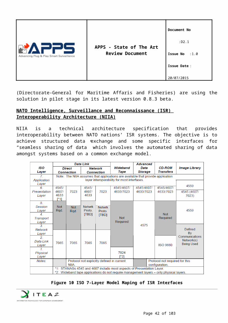
APPS - State of The Art Review Document
Document No :D2.1
Issue No :1.0
Issue Date : 20/07/2015
RECONSURVE ITEA2 2011-2014 Interoperable Maritime Surveillance Framework enhanced with situational awareness functionalities for preventing illegal immigrations, border protection and so on.
Related to semantic interoperability of surveillance applications and different in focusing on only maritime domain and addressing interoperability only at the semantic level.
SEABILLA FP7 Security Integration of legacy maritime surveillance systems and, improvement in shareable common maritime picture targeted to detect non cooperative boats and illicit activities
Related to integration of legacy maritime surveillance systems and situational awareness functionalities but different in not addressing plug & play surveillance systems for future systems and smart surveillance functionalities for different domains.
CANTATA ITEA2 2006-2009 Fully content aware systems and with understanding of the content that it is processing. It is applied for different domains (medical, surveillance, home multimedia).
CANTATA addresses video content analysis but does not consider multi sensor data for tracking, reasoning and decision-making.
ViCoMo ITEA2 2009-2012 Advanced video-interpretation algorithms to enhance images acquired with multiple camera systems and by modelling the context in which such systems are used,
Although multi-camera analysis is addressed, it does not address back-tracing of events in large (>2000) camera systems. Moreover, a standard interfacing for plug & play and dealing with legacy equipment is not covered.
FEDSS ITEA2 2013-2016 Maritime Surveillance, semantic information
FEDSS is related to data fusion from several sensors. Experience in image analysis and suspicious pattern detection could be applied to APPS.
Object Detection
The detection of vessels is a very challenging topic, because of several reasons. First, the appearance of ships varies significantly as there are many different types (e.g. cruise ships, sailing ships and small speedboats) and their viewpoint (they look completely different from the front and from the side). Second, because of the movement and reflections of the water surface, traditional background subtraction techniques result in low detection performance. Moreover, the difficulty of detection also depends on the location of the sensor. When considering the detection of vessels at sea, detection of the horizon line and localizing any object on this line results in ships. However, when considering in-harbour or close-to-coast scenarios, this assumption does not hold, complicating detection.
Background segmentation techniques are normally not suitable for detection of objects on water, since they assume a static background. However, recently a lot of work has been done to increase background segmentation performance for dynamic backgrounds. Zhang and Yao (Zhang, et al., 2008) use spatio-temporal LBP region-descriptors to model the dynamic background.. Chan and Weed (Chan & Weed, 2012)} apply the concept of dynamic textures (Doretto, et al., 2003) as background estimation technique combined with vessel detection based on sliding-window detector. The dynamic texture background estimation models the frame as a low-rank subspace via Principal Component Analysis. This requires storing 300 frames although these frames are divided in 32x32 blocks. Javed et al. (Javed, et al., 2014) extends Robust PCA for background subtraction an on-line version which performs well on the water sequences in the changedetection2014 dataset. They also provide an overview of recent on-line PCA methods. Their worst-case computation time of their method on a modern CPU is 51 milliseconds, which is approximately
Page 42 of 62
APPS - State of The Art Review Document
Document No :D2.1
Issue No :1.0
Issue Date : 20/07/2015
10 times better than the original OR-PCA. Bloisi et al. (Bloisi, et al., 2014) present the IMBS which combines many practical background segmentation tricks-of-the-trades. Saghafi et al. (Saghafi, et al., 2014) modify ViBe for ship detection: Each frame is divided into two sets of which one is more likely to belong to a ship. They claim it will be easier to distinguish between water and object when the contrast is not very high. In addition, they remove the backwash in the detection bounding box by checking the brightness distortion.
Motion segmentation uses tracked key-points or motion vectors to segment the image in several regions with consistent motion. These are well-known techniques and should be used in conjunction with other techniques as claimed by (Jing & Chaojian, 2011). Using motion segmentation, it seems difficult to distinguish between waves and ships.
With respect to sliding-window based detectors Wijnhoven and van Rens stated that the robust detection of ships, independent of their viewpoint and appearance is very difficult using shape-based techniques such as sliding-window detectors. Van den Broek et al. Propose to detect vessels using infrared cameras and background subtraction and add classification. Hua et al. propose morphological filtering and ripple detection after a background subtraction stage to increase ship segmentation and remove the effects of the water wave around ships. Makantasis, Doulamis and Doulamis using a Visual Attention Model that exploits low-level features, combined with background modeling. Bloisi et al. detect ships using Haar-wavelets, but seem to have a high false-alarm rate. Sullivan and Shah use MACH filters to detect ships, and show promising results. To perform detection independent on the background, Bao et al. propose a colour model for the integrated detection and segmentation of ships. They add motion saliency to increase detection robustness. The shape-based sliding-window detector from Wijnhoven et al. is used to localize cabins of ships to increase accuracy of detection. Loomans et al. integrated this system in an active pan-tilt-zoom (PTZ) camera control loop, where the camera automatically follows moving ships without user interaction.
Techniques using water classification classifies (groups of) pixels as water or non-water. A disadvantage of this class of methods is that unknown static structures in the field-of-view, such as land, offshore platform, will be classified as non-water and might be detected as foreground. Pires et al. (Pires, et al., 2010) and Bao et al. (Bao, et al., 2012), (Bao, et al., 2013)} use this method.
Attention-based segmentation, also known as salient region detection, is a collection of segmentation techniques which attempt to automatically segment the parts of the image/video to which human attention would been drawn (Hou, et al., 2012). Typical for salient region detection is that these techniques combine many low-level image features and are applicable to both images and videos. These low-level image features include among others various colour spaces, tracked features (video), and texture representations. Active research in the area of saliency investigates methods to automatically adjust the thresholds which decide whether a region is “of interest (Sezgin & Sankur, 2004). It is unknown whether this class of algorithms is suited to detect multiple objects and to decide whether there is no object in the scene.
Liu et al. (Liu, et al., 2014) assumes that the background corresponds to one or more peak in the histogram of the thermal intensity image. These peaks are identified with various thresholding techniques and subtraction from the image. They perform an extensive comparison with other thresholding techniques and the shown segmentation mask using the proposed thresholding method is impressive. Small objects can be
Page 43 of 62
APPS - State of The Art Review Document
Document No :D2.1
Issue No :1.0
Issue Date : 20/07/2015
identified using this method, but its applicability to large objects as expected in the harbour is questionable. The average time to process 1 frame is currently almost 1 second.
Table 3 Global comparison of the classes of detection methods
Bac
kgro
und
Segm
enta
tion
Mot
ion
Segm
enta
tion
Wat
er
Cla
ssifi
catio
n
Slid
ing-
win
dow
de
tect
ors
Att
entio
n-B
ased
Maritime background - -- + + +Initialization time - + + + +Slow objects -- -- + + ?Unknown static structures + + + 0 ?Unknown ship structure + + + - +Moving camera -- 0 + + +Small objects + 0 0 -- ?Ship-ship occlusion -- 0 -- + 0Computational 0 0 0 - -Data collection + + 0 - +
Classification
The last decade much work has been performed on object classification in the domain of computer vision. Typical proposals use a two-layered approach. First, the image is processed by an so-called Interest Point Operator (IPO) that finds image locations (also called keypoints or interest points) with high information content. Second, these image locations are compared to a visual dictionary of discriminative image patches. Each image patch is described using a descriptor algorithm that models the local image shape or color information. Constructing a suitable classification system for a specific task then comprises the selection of a suitable IPO, a suitable descriptor algorithm and the construction of a dictionary that is discriminative for the classification task at hand. Advantages of the use of these interest points is that their location w.r.t. the object they are part of is not important. As a result, the global shape of an object can vary without changing the resulting description.
Early work by Zhongliang and Wenjun (1992) use moment invariants and a nearest neighbour classifier to classify ships, which requires a pixel-true segmentation of the ship hull. Although this is available when using the segmentation algorithm from Bao et al., we expect that the performance that can be obtained is insufficient to cover a large number of vessel classes.
Lan and Wan classy using Zernike moments and focus on classification from aerial videos and only distinguish between aircraft carrier and chaser and obtain an 92% accuracy.
Van den Broek et al. propose classification of five ship classes, using a Bag-of-Word (BoW) approach, in which multiple small image patches of ships are compared to a dictionary of patches. For accurate
Page 44 of 62
APPS - State of The Art Review Document
Document No :D2.1
Issue No :1.0
Issue Date : 20/07/2015
description of these patches, they are described using SIFT features, which are proven descriptors in computer vision for recognition tasks. They obtain an accuracy of over 90%, but their datasets only contains a very small number of samples per ship class.
Morris et al. consider the classification of 9 vessel categories, recorded in a marina (water taxi, cabin cruiser, motorboat, raft, kayak, rowboat, canoe, paddleboat and sailboat). They use an Exemplary Support Vector Machine (E-SVM) learning technique and show that this is promising; however, detection results are still quite cumbersome.
Classification using Deep LearningThe number of object classes that are considered for vessel classification is in the order of 100. Recently, Deep Learning has gained popularity for large-scale classification tasks. In Deep Learning for computer vision, the deep network is typically formed by multiple filter layers. Each layer consists of a convolution, followed by a non-linear operation such as a MAX operator. In Deep Learning, the filter coefficients of each layer are learned incrementally using massive amounts of training data. Although these techniques result in very high classification performance, they require huge amounts of training data and are very computationally expensive. Therefore, they are mostly suited for very complex classification problems with thousands of object classes. For the considered case of vessel classification with around 100 object classes, Deep Learning can provide a suitable solution. However, it needs to be investigated which network architecture can be used, balancing computational requirements and classification performance..
4.2.3 Existing Problems and Unmet Needs
Summarizing, the problems in the maritime surveillance are: (1) detection and tracking of small vessels; (2) verification and classification of non-cooperative vessels; (3) full trust on AIS data provided by vessels, and (4) absence of analysis of vessels behaviour.
The table below specifies the state-of-the-art capabilities of the current industrial systems in the area of smart surveillance. The table also provides brief overview on the capabilities required to address the four above-mentioned problems.
Table 4 State of the Art Capabilities of the Current Industrial Systems
Components and Functionality
SOTA in Industrial Applications Required Capabilities
Sensors deployed Radar, optics, radio (AIS) Radar, acoustic matrices, depth-, IR-, thermal-, biochemical-, visual- sensors, radio (AIS).
Data fusion capabilities Very limited, if any Fusion of radar, visual, acoustic, etc data, thereby generation of comprehensive data for analysis and visualization.
Sensor location Stationary (shore-based) Stationary, water-based (buoys), air-born (UAVs), vessel-based
Detection/Verification Very limited, if any Detection of small/non-cooperative vessels, automated verification of vessels based on signatures.
Behaviour analysis Not present Behaviour analysis with generation of notifications and alarms on suspicious and critical events
Page 45 of 62
APPS - State of The Art Review Document
Document No :D2.1
Issue No :1.0
Issue Date : 20/07/2015
4.2.4 APPS Innovation
APPS Project plans to use one water quality and two airborne particle counter systems to plug-and-play platform and also to adapt them so that the systems work with seawater. Three different alternative designs for the water quality systems are under consideration; a system on a fixed offshore platform, fixed system on a buoy and a portable system. All these three alternatives will be analyzed, and according to their advantages/disadvantages, one of them will be selected for further use in the APPS project.
Once these capabilities are developed within the APPS Project, it will be possible for the system to be employed by coastal security institutions such as the Coast Guard as well as many other sectors including but not limited to logistics, healthcare, energy production, agriculture and environment.
The challenge faced in the APPS is to improve the surveillance capability substantially, in essence by complementing radar and AIS with both camera’s and acoustic vector sensors and applying novel local signal processing and data analysis capabilities. To achieve this, we elaborate on the work started in the ITEA RECONSURVE project previously. Besides improving the detection and tracking performance for surveillance, another technical challenge to solve is to prevent the required growth in surveillance equipment to cause information overload for coastguard, vessel traffic managers and information intelligence officers. Hence, the information should be limited by smart filtering and be more descriptive. In addition to radar detected position, speed and size of all vessels, identification, and behaviour analysis and risk assessment are required. The complementary sensor technology we intend to develop in the APPS project will also address these subjects building on the research performed in the ITEA ViCoMo project. The following paragraphs describe the proposed innovations in the smart maritime surveillance in detail.
Conceptual innovations:The APPS project brings two important conceptual innovations together in one application domain.
Multimodal sensing and fusion. Combining various sorts of sensors and exploiting their individual strengths is a new approach to enhance situational awareness under all circumstances. The fusion of sensor data streams is an important enabler for increasing robustness and reliability of small, medium and large vessel monitoring.
Automated understanding of vessels In APPS we will pursue detection, tracking and classification of vessels, including the most challenging type – small non-cooperative vessels. For this, we will fuse the data from three types of sensors: radar, acoustic and visual, combining the best of three worlds to enable the identification of small vessels, as well as the accurately tracking and classification of all vessel types. This is a huge innovation, since existing radar-based systems provide a name tag for monitoring authorities at best, while for small ships there is no tagging at all and remain undetected.
Application innovations:For enhanced close range detection, we propose a completely new application using floating buoys equipped with acoustic vector sensors both in air and underwater. In air, the noise of an engine can be detected, while underwater the noise of a propeller can be detected. The difference between the speed of sound in air and
Page 46 of 62
APPS - State of The Art Review Document
Document No :D2.1
Issue No :1.0
Issue Date : 20/07/2015
underwater provides the distance from the vessel to the sensor node. Also the vessel localization is identified by the acoustic vector sensors.As soon as such a small vessel is detected and localized acoustically, cameras either on the buoys or on coastal positions can focus and zoom-in on these vessels for identification. Rather than using a broad band video stream, a high-resolution picture can be sent with a low frame rate to a control room, reducing required bandwidth.Using acoustic sensors and EO/IR cameras to complement radar not only decreases the number of blind spots, but it allows the early detection of small vessels and their identification and classification which is not possible now with the radar/AIS systems. Moreover the data fusion enables identification of related suspicious behaviour, as well as improves tracking of such vessels near platforms. Early detection provides time to counteract possible collisions, illegal boarding and terrorists. In addition, the platforms have dangerous areas for both intruders and personnel; deploying intelligent cameras can help avoid accidents and improve safety.
4.3 IoT for Maritime Sensors
4.3.1 Introduction
Approach to IoMT (Internet of Maritime Things) or the maritime industry Internet (Maritime Industrial Internet) is taking place to utilize Internet of Things in the maritime sector which is hot issue in the recent ICT business sector. In this section,, it deals with the trend of standardization in internal communications for integrating the information gathered from the maritime sensors to build an IoT sensor platform in a ship at sea.
4.3.2 Existing-State-of-the-Art
4.3.2.1 Protocols/StandardsIEC61162-1/2 (NMEA 0183)
The most widely used standard for the interface between the maritime equipment is NMEA 0183. Of them, IEC 61162-1 is only for the standard applying for vessels, especially navigation devices. IEC 61162-2 is a standard for supporting a high-speed transmission of the IEC 61162-1, and IEC 61162-3 is standardized for NMEA 2000. Currently, those standards are widely used for leisure boats or small ships.
IEC61162-3 (NMEA 2000)
IEC 61162-3 has strengths by providing real-time ability because of using a Can bus; however, it also has limitation of 50 physical devices and there is a limit for configuring a complicated network including large vessel’s network. In addition, it has a problem with transmitting a large volume of data, such as video data, due to the limitation of the bandwidth.
IEC61162-450
61162-450 uses a UDP multicasting, and it has a very simple structure which helps whoever wants data to receive the desired data. The biggest purpose of IEC 61162-450 is to transmit NMEA 0183 or IEC 61162-1 sentences, which are widely used in vessel’s navigation devices, via Ethernet.
Page 47 of 62
APPS - State of The Art Review Document
Document No :D2.1
Issue No :1.0
Issue Date : 20/07/2015
IEC61162-460
When configuring an Ethernet-based integrated navigation system, IEC 61162-460 is a standard for a safe and stable operation.
NMEA OneNet
NMEA OneNet supports the transmission of a variety of audio and video data by utilizing the expanded bandwidth of the Ethernet. Also, in order to identify the various information for each device, the standardized information for each unit is defined to be able to access via the web page. In addition, it was defined to support the automatic plug & play of each device.
Acoustic Vector Sensors
Acoustic sensing has traditionally been based upon sound pressure transducers only. An array of microphones is used to obtain a certain degree of directionality. The spacing between the sound pressure transducers limits the frequency range; the larger the array size, the lower the frequencies of the sound source which can be localized. Hence, dedicated arrays exist for specific source types.
At any point in space, a sound field can be described completely by two dimensions: the scalar sound pressure, and the vector particle velocity. Although the history of sound pressure microphones goes back to 1876, it was not until 1994 before a convenient particle velocity sensor called the Microflown was invented.
By assembling a small sound pressure transducer and three orthogonally placed Microflown sensors in one single point, a compact (5x5x5mm) Acoustic Vector Sensor (AVS) can be produced. Directional sound measurements are a direct output of the AVS. There are no intrinsic frequency limitations as experienced with systems involving spatially distributed microphones. Depending on the scenario and configuration of the system, dedicated algorithms or additional Acoustic Vector Sensors allow distance to be determined as well.
Microflown’s sensors are already established in the automotive industry, but the novel Acoustic Vector Sensors (AVS) are now being used within the defense industry for the detection and localization of gunshots, artillery, air- and watercraft. AVS can be used to locate multiple sources simultaneously, even in complex situations and environments or on noisy platforms such as watercraft and UAVs. By its operating principle, an AVS has good signal-to-noise ratio at low frequencies which are usually of interest in the maritime domain, in detecting, for instance, the engine or the propeller of a boat.
Acoustic Vector Sensors can detect, classify, and locate all sorts of acoustic events in 3D space such as impulses like Small Arms Fire (SAF), Rockets, Artillery and Mortars (RAM), but also tonal sound sources like maritime vehicles and helicopters. AVS are compact, low weight, and low power. They can be deployed on all sorts of platforms, such as watercraft, unattended buoys and Unmanned Aerial Vehicles (UAVs).
Many applications can benefit from performance and operational advantages of Acoustic Vector Sensors based solutions over sheer pressure microphones based systems, such as:
Page 48 of 62
APPS - State of The Art Review Document
Document No :D2.1
Issue No :1.0
Issue Date : 20/07/2015
Low SWaP (Size, Weight and Power) Better angular and range accuracy and CPA (Closest Point of Approach) Broad-banded multi-treat localization capability Acoustic direction is a direct output
Within APPS, four new applications of AVS are investigated, which are described in more detail in the next sections.
AVS buoy
Buoys in the sea are frequently equipped with a variety of sensors such as transducers for measuring humidity, temperature, ambient pressure, vibrations, wave motion, etc. However, buoys are rarely equipped with microphones for measuring sound above the sea surface. The microphones that are employed are used often for research purposes, e.g. for monitoring the habitat of marine animals.
Although, separate hydrophones are placed below buoys to measure sound pressure under water, arrays of hydrophones are seldom used for passive detection because the large equipment size needed to measure low frequencies is difficult to install in practice. Active hydrophone systems, such as son buoys dropped from a ship or aircraft, do exist, but the presence of such systems is revealed whenever a ping is emitted.
Microflown Maritime is developing an acoustic vector sensor system for buoys. Several system configurations are build and software solutions for different scenarios are evaluated. A single AVS can measure the direction of arrival of sound sources. In certain cases, the range and thus location might be determined as well; e.g. when both the muzzle blast and shockwave of a supersonic gunshot are measured, or when the frequency shift of a go-fast passing by is determined (Doppler effect). In most other scenarios, multiple sensors are needed to determine location. Multiple buoys equipped with acoustic vector sensors in air might be used. Alternatively, with one AVS in air and one underwater sensor below a single buoy the difference in speed of sound between air and water might be used to estimate range.
Early investigations of AVS buoy principles where already performed in the ITEA project “Reconsurve”, which is now finished. Within APPS, this research is continued. Advanced prototype versions of two types of buoy systems will be built and tested; i.e. a sensor system mounted onto an existing buoy for permanent installation and a rapid deployable sensor buoy for several days of testing. Primarily the in air AVS capability will be developed, but also using (directional) underwater sensors will be attempted. Various field tests will be performed to demonstrate the hardware and acquire test data. Dedicated algorithms will be developed to process the acoustic signals measured.
Hydroflown
Underwater, arrays of hydrophones are usually used to obtain directional acoustic information. Low frequencies tend to carry far, but to measure them large hydrophone arrays are required. For optimal direction estimation the spacing between sound pressure elements should be in the order of a wavelength. Towed “triplet” or “quad” arrays can be several hundreds of meters long.
Page 49 of 62
APPS - State of The Art Review Document
Document No :D2.1
Issue No :1.0
Issue Date : 20/07/2015
Alternatively, accelerometers or sound pressure gradient microphones can be used to measure direction but there export control regulations and the sensitivity is limited at low frequencies.
The Microflown sensor can also be placed underwater – the so called Hydroflown. The sensor is immersed in a non-conductive fluid contained within a special sealed housing for electrical isolation from sea water. It is directive, sensitive at low frequencies, and its performance is uninfluenced by hydrostatic pressure. The small sensor size could allow installation on various platforms.
Figure 13 The Current Hydroflown Probe
The Hydroflown sensor was already investigated in other projects. In the Eurostars project “Hydroflown” the fundamentals of sensor element where examined and an early Hydroflown probe prototype was constructed. In the PF7 projects “CLAM” and “Seastar” where more advanced probe versions where built and several field tests were conducted. In APPS, Microflown Maritime will continue the research. The aim is to develop and test sensors and probes that are robust and sensitive. Several package types are considered to enable installation on e.g. a sea-bottom mounted setup and below a sensor buoy. Suitable calibration and characterization methods are investigated, and field tests in rivers and open waters will be conducted.
Active AVS sonar
Sonar is a well-known concept in underwater acoustics that is applied for various detection, navigation, and communication applications. Both passive and active sonar systems exist. For high frequency localization directional sound sources and sensors are used. Large arrays are needed to determine direction at low frequencies.
Page 50 of 62
APPS - State of The Art Review Document
Document No :D2.1
Issue No :1.0
Issue Date : 20/07/2015
Microflown acoustic vector sensors might be used to enhance direction finding capabilities at low frequencies to create smaller or easier to deploy arrays. Within APPS, Microflown AVISA explores the concept of using acoustic vector sensors for sonar. The directionality of these sensors might be used to find targets, but also to shield unwanted noise sources. The performance of active and passive AVS systems will be tested and analysed. Different scenarios are treated to determine the amount of sensors and sound sources needed, the range, the influence of background noise and reflections, and the number of targets localized. Both in-air and underwater cases will be studied.
Unmanned Aerial Vehicles (UAV)
For creating situational awareness Unmanned Aerial Vehicles are often equipped with cameras. Depending on requirements, regular visual cameras, infrared cameras, or even thermal cameras are employed. However, the view is restricted and targets are often difficult to spot.
Although microphones can detect if there is an acoustic event, multiple microphones are needed to determine the direction of arrival of the event and steer the camera towards the target. However, microphone arrays can be large and they are therefore hardly installed on UAVs.
For several years, Microflown AVISA has been working on AVS that can be installed on UAVs. Several prototype sensors have been made already. In some cases, the AVS is installed on the nose of the UAV, in other cases the sensor is placed on one of the wings, see the figure below. In APPS, the performance of the sensors will be further optimized (improving sensitivity, reducing wind noise, improving robustness, etc.). In addition, efforts will be spent on sensor integration, software improvements, and field testing.
Figure 14 Acoustic Vector Sensors Installed on UAVs and User Displays
Water Quality Sensors
Page 51 of 62
APPS - State of The Art Review Document
Document No :D2.1
Issue No :1.0
Issue Date : 20/07/2015
Water quality measurements provide an indicator of the nature and health of an ecosystem. Monitoring water quality characteristics allow scientists and managers to keep their “finger on the pulse” of the ecosystem and are determined by measuring a variety of water quality parameters.
In coastal marine systems, human activities, such as population growth and development, often have a detrimental impact on coastal water quality. Increased or changing nutrient delivery can result in algal blooms that discolour the water and decrease light penetration, in turn affecting benthic communities, including sea grasses.
One of the most significant threats to sea grasses is the reduction of light, i.e. light attenuation, by the water column and its components. Because of this, the parameters related to the amount of light penetration would likely be considered the most important to seagrass health, including nutrients, chlorophyll a, turbidity, TSS, and color of water. Temperature is also critical to seagrasses, especially eelgrass (Zostera marina), which thrives in cold water. Drastic salinity fluctuations can also cause severe distress in seagrasses as illustrated below.
Figure 15 Contributors to Poor Water Quality
Ongoing monitoring of water quality is mostly conducted by government agencies, and is often available for use in research and monitoring. For example, navigational buoys are often used by the U.S. Coast Guard, NOAA, and others as attachment sites for loggers, and this information is also available to the public. Using satellite technology, this data is acquired and made available in real time. This type of technology has enormous potential for long-term water quality and sea grass monitoring.
There are plenty of sensors available in the market, which are capable of measurement of parameters for water quality. However, there is an emerging need for a system capable of sampling data from such sensors, synchronization of the gathered data, data processing, and display of data and for early-warning.
Page 52 of 62
APPS - State of The Art Review Document
Document No :D2.1
Issue No :1.0
Issue Date : 20/07/2015
The important issue related with the common water quality sensors is their resistance to salt water, because salty water can erode electronic systems in a short time period or probes may show discoloring or degradation.
Airborne Particle Counter Systems
In the mid-1950s, military applications accelerated the development of the first particle counting instruments. These devices made it possible to monitor instantaneous particle levels and provide quick notifications when contamination levels exceeded limits. Instead of waiting days for particle analysis, which could allow thousands of defective products to pass through a process, the particle counters provided data in minutes. Airborne particle counters are commercially used to measure air contamination in HEPA-filtered clean rooms especially for disk drive assemblies, pharmaceutical manufacturers, small test benches, and rocket launch facilities.
Besides their commercial usage, air particle devices are used for research purposes for monitoring aerosol in the atmosphere as different aerosols can have major effect on global climate change. There are ongoing research activities related with counting the atmospheric aerosols and developing numerical methods for particle size distributions. Such research activities are focused on the analysis of particle formation events in specific areas. For example, in a research done along the Trans-Siberian railroad, ion and particle number concentrations and size distributions were measured with relevant information on meteorological conditions and atmospheric trace gas concentrations in Russia, in order to examine which sources and sinks affected the observed concentrations. Another study done in Estonia showed the modal structure of an atmospheric aerosol size spectrum determines to a significant extent the role of aerosol particles in the formation of weather and climate and their potential danger to living beings.
In addition to that, constant monitoring of air can give results for the presence of aerosol biohazards and identify biological agents ranging from protein toxins to whole cells and spores. The detection of atmospheric dispersion of biological agents (i.e.: toxins, viruses, bacteria and so on) is a key issue for the safety of people and security of environment. Environmental monitoring is one of the ways to improve fast detection of biological agents; for instance, particle counters with the ability of discriminating between biological and non-biological particles are used for a first warning when the amount of biological particles exceeds a particular threshold.
Due to the complexity of the molecules constituting the biological agents, equipment and methodologies for detection and identification of biological aerosols are still in the phase of development. Besides other methods, particle counters and air samplers are used for CBRN purposes. However, particle counters are not like other common testing instruments. In order to take accurate measurements, counters must be handled, installed, and operated correctly because particle counters include lasers, specialized optics, printed circuit boards (PCBs), and painstakingly-aligned sampling regions. Also they are extremely sensitive to environmental stresses like vibration, EMI (electro-magnetic interference), heat/cold extremes, and dirt.
During APPS project, two types of airborne particle counters will be developed, one will be on the sea platform, the other will be implemented to the airship. Such a setting will enable users to track the air quality and a possible airborne bio-attack at different locations simultaneously. The counters will have the ability to
Page 53 of 62
APPS - State of The Art Review Document
Document No :D2.1
Issue No :1.0
Issue Date : 20/07/2015
monitor the particle size at two different channels. Furthermore, to be implemented to a unmanned air platform the particle counter system will be miniaturized as much as possible to reduce the payload level.
Monitoring and Early Warning Systems
Significant advances have been made in recent years in technologies to monitor water quality for water protection, treatment operations, and distribution system management, in the event of accidental (or deliberate) contamination. Reports prepared through the Global Water Research Coalition (GWRC) and United States Environment Protection Agency (USEPA) agree that while many emerging technologies show promise, they are still some years from being deployed on a large scale. Further underpinning their viability is a need to interpret data in real time and implement a management strategy in response.
Monitoring of coastal and estuarine ecosystems has become increasingly important over the past decade. An ideal environmental monitoring program requires continuous, long-term measurement of a variety of physical, chemical, and biological parameters over a wide geographic area to represent the overall health of the ecosystem. Monitoring is only one part of the early warning process. This step provides the input information for the early warning process that needs to be disseminated to those whose responsibility is to respond. Monitoring systems, if associated with communication system and response plans, can then be considered early warning systems. Early warnings may be disseminated to targeted users (local early warning applications) or broadly to communities, regions or to media. The main goal of early warning systems is to take action to protect or reduce loss of life or to mitigate damage and economic loss, before the threat occurs (Draft report; United Nations Environment Programme (UNEP) Early Warning Systems: State-of-Art Analysis and Future Directions).
4.3.2.2 Existing ProjectsMONALISA
MONALISA is a Motorways of the Sea project which aims at giving a concrete contribution to the efficient, safe and environmentally friendly maritime transport. This is done through development, demonstration and dissemination of innovative e-navigational services to the shipping industry, which can lay the groundwork for a future international deployment. Quality assurance of hydrographic data for the major navigational areas in Swedish and Finnish waters in the Baltic Sea contributes to improving safety and optimization of ship routes.
RECONSURVE
RECONSURVE is a reconfigurable maritime surveillance framework with multimodal smart sensors installed on various platforms forming a coherent network via interoperability interfaces.
The RECONSURVE project has been motivated by and aims to address the need to control the rapidly increasing number and complexity of maritime surveillance issues such as illegal immigration especially using small vessels, interoperability between heterogeneous systems, automated cost-effective and efficient decision support.
Page 54 of 62
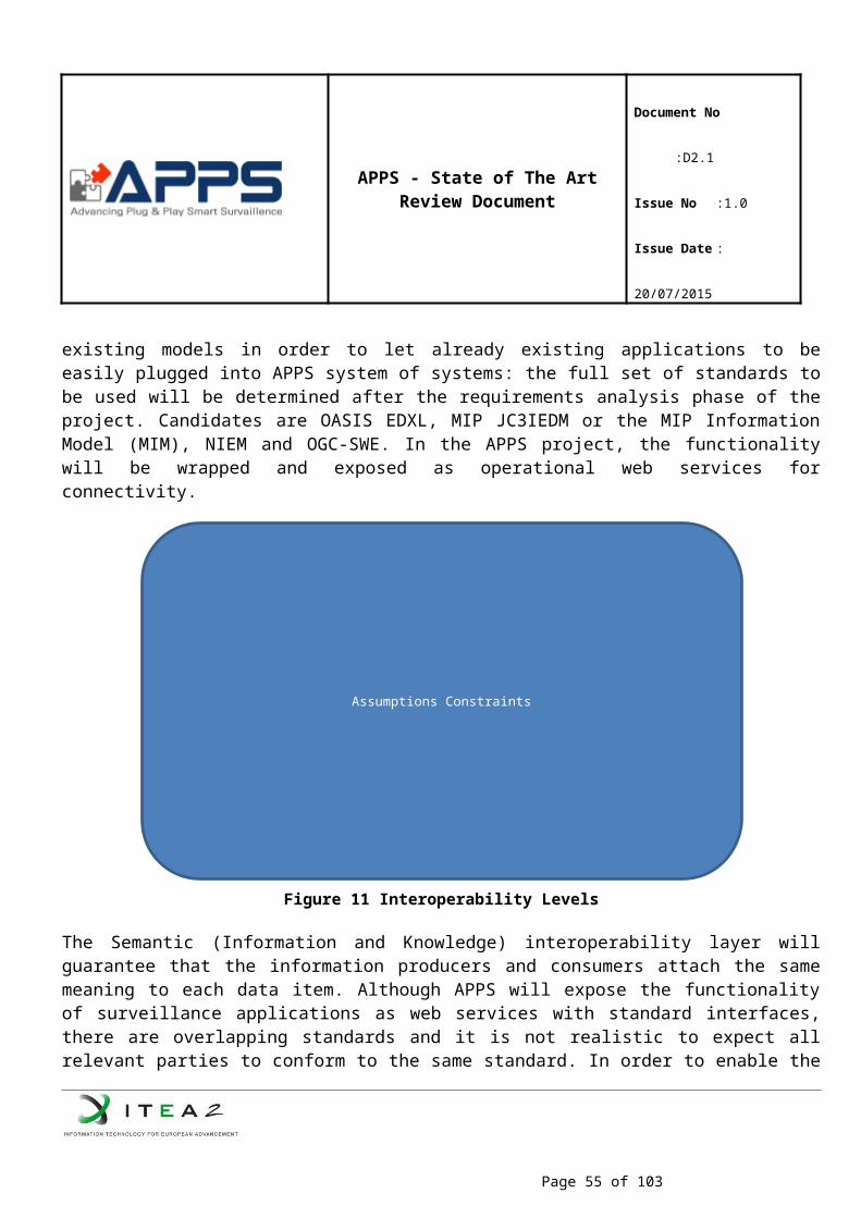
APPS - State of The Art Review Document
Document No :D2.1
Issue No :1.0
Issue Date : 20/07/2015
MARSSA
MARSSA sets out to provide a reference architecture (RA), which will serve as a base for the development of standards and, at the same time, an architecture to support the integration & interoperability of software-dependent devices and systems onboard and onshore. The RA learns from other domains such as avionics and automotive, however, it directly addresses and takes into account the specificity of the maritime domain. It provides an architectural blue print for a set of products / systems based on the pool of previously successfully implemented solutions and combined with a set of new requirements.
Maritime Cloud
The Maritime Cloud is a digital Information Technology (IT) framework consisting of standards, infrastructure and governance that facilitates secure interoperable information exchange between stakeholders in the maritime community using the principles of Service Oriented Architectures (SOA). The core of the Maritime Cloud consists of three key infrastructural components providing central framework services:
4.3.3 Existing Problems and Unmet Needs
Considering the state of the art literature mentioned above, existing problems and unmet need can be summarized as follows:
The open network of the Ethernet type are frequently exposed and affected by the traffic and behavior that occurs in the other device.
Even if a problem arises with other devices due to malware or virus, it is necessary to minimize the influence on other devices or networks.
There is a need of standards for the interface to integrated navigational system and other networks, including the connection to the external network.
Even though failures in each device or network component occur, the requirement for the plan to overcome the failures should be defined.
4.3.4 APPS Innovation
The Hydroflown, as the world’s only underwater acoustic particle velocity sensor, opens up new situational awareness prospects and potential applications never before considered as realistically achievable in such a small package configuration. Localizing surface vessels, underwater vessels and torpedoes should be possible. Submarine and unmanned underwater vehicles applications are also likely. Some other possible and interesting applications which could draw on the Hydroflown’s capabilities are: sound emission tests, underwater navigation and communications, oil explorations, border control, marine life monitoring and so on.
The IoT sensor platform transfers sensing data collected from a variety of maritime sensors to the coast station and connects to the IoT service platform to enable the vessel receive the necessary information on safety navigation in time. An IoT sensor interface device can interface with the standard sensors which use NMEA0183 or NMEA2000 as well as interface with nonstandard sensors if the sensor provides the profile
Page 55 of 62
APPS - State of The Art Review Document
Document No :D2.1
Issue No :1.0
Issue Date : 20/07/2015
according to the defined API. This device will select the best communication means depending on the situation and position of the vessel, also transfer the data to the coast station efficiently according to the priority, urgency, data size, communication cost, and so on.
Page 56 of 62
APPS - State of The Art Review Document
Document No :D2.1
Issue No :1.0
Issue Date : 20/07/2015
5. Conclusion
This report presents the current state of the art in the standards and specifications that are related to the scope of APPS Project. The standards reviewed in this document are used in the following components of the APPS project as described below:
SensorML, NIEM and JC3IEDM were used to achieve technical level plug and play sensor systems, as standards,
Web Services was used to gather information from external organizations. This information was mainly be used to execute the situational awareness rules.
OASIS CAP was used to send alarms to both C2 systems and external organizations. OGC SWE specifications were used to retrieve information from sensors in a standard way. “Behaviour analysis and abnormality detection” methodologies were researched in several ITA2
projects such as RECONSURVE, SEABILLA, CANTATA etc. to increase situational awareness. Different classification methods and algorithms were used to increase efficiency of global situational
awareness. Various sensor systems such as acoustic sensors, UAVs etc. were used to acquire data from the
environment and improve system accuracy. Different interfaces were used to achieve more effective Internet of Thing (IoT) for maritime sensors
such as IEC61162-1/2 (NMEA 0183), IEC61162-3 (NMEA 2000) etc.
Throughout this document, not only existing state of the art concepts and technologies but also needs and problems to achieve an enhanced maritime surveillance system have been reviewed. This deliverable also presents the APPS’s innovations and solutions to the existing problems and unmet needs.
Hence, all aspects of plug and play smart surveillance systems have been reviewed from APPS perspective and documented in a structured way.
Page 57 of 62
APPS - State of The Art Review Document
Document No :D2.1
Issue No :1.0
Issue Date : 20/07/2015
6. References
A. Krizhevsky, I. Sutskever and G. E. Hinton, ImageNet Classification With Deep Convolutional Neural Networks, Proc. Neural Information Processing Systems (NIPS), Lake Tahoe, NV, USA, December, 2012
B. Morris, D. W. Aha, B. Auslander and K. Gupta, Learning And Leveraging Context For Maritime Threat Analysis: Vessel Classification Using Exemplar-SVM, Naval Research Laboratory, Navy Center for Applied Research in Artificial Intelligence, 2012
CISE - Communication from the Commission to the European Parliament and the Council, http://eur-lex.europa.eu/legal-content/EN/TXT/?uri=COM:2014:0451:FIN, Last Accessed on 22/05/2015.
D. Bloisi, L. Iocchi, M. Fiorini and G. Graziano, Automatic Maritime Surveillance With Visual Target Detection, Proc. International Defense and Homeland Security Workshop (DHSS), pp 141--145, Rome, Italy, September, 2011
D.Bloisi, A.Pennisi & L.Iocchi, 2014. Background modeling in the maritime domain. Machine Vision and Applications.
de Bree, H-E. (2011) E-book, The Microflown. www.microflown.com.
de Bree, H-E. and Leussink, P. and Korthorst, T. and Jansen, H. and Lammerink, T. and Elwenspoek, M. (1996) The Microflown; a novel device measuring acoustic flows. Sensors and Actuators, 54 (1-3). pp. 552-557. ISSN 0924-4247
E.Jones & A.Botterell(Eds.).(2005).Common Alerting Protocol,v.1.1. Retrieved 27th July 2011 from http://www.oasis-open.org/committees/download.php/15135/emergency-CAPv1.1-Corrected_DOM.pdf
European Interoperability Framework (EIF) for European public services, Annex 2, 16.12.2010, ISA.
European Interoperability Reference Architecture (EIRA) - Building blocks of the EIRA, version 0.8.3 beta, 09/01/2015, European Commission - ISA Work Programme.
European Interoperability Reference Architecture (EIRA) overview, version 0.8.3 beta, 09/01/2015, ISA Interoperability Solutions for European Public Administrations.
G.Jing & S.Chaojian, 2011. Survey on methods of Moving Object Video Detection in Marine Environment. International Conference on computer science and information technology.
Glantz M.H., Usable Science: Early warning systems: Do’s and Don’ts. Report of workshop, 20-23 October, Shangai, China, 2003.
Home Office, 2011. Imagery Library for Intelligent: The i-LIDS User Guide, s.l.: s.n.
Page 58 of 62
APPS - State of The Art Review Document
Document No :D2.1
Issue No :1.0
Issue Date : 20/07/2015
Integrating the Healthcare Enterprise Profiles, http://www.ihe.net/profiles/index.cfm
ISA EIRA web page, http://ec.europa.eu/isa/ready-to-use-solutions/eira_en.htm , Last accessed on 22/05/2015.
Jaus History and Domain Model, http://standards.sae.org/air5664 UGV Interoperability Profile (IOP) – Overarching Profile JAUS Profiling Rules, Version 0, Robotic Systems, Joint Project Office (RS JPO), 2011.
J. Lan and L. Wan, Automatic Ship Target Classification Based On Aerial Images, Proc. SPIE 7156, International Conference on Optical Instruments and Technology: Optical Systems and Optoelectronic Instruments, 715612, Beijing, China , November, 2008
K. Makantasis, A. Doulamis and N. Doulamis, Vision-based Maritime Surveillance System Using Fused Visual Attention Maps And Online Adaptable Tracker, Proc. International Workshop on Image Analysis for Multimedia Interactive Services (WIAMIS), Paris, France, July, 2013
M. D. R. Sullivan and M. Shah, Visual Surveillance In Maritime Port Facilities, Proc. SPIE 6978, Visual Information Processing XVII, 697811, March, 2008
M. J. H. Loomans, R. G. J. Wijnhoven and P. H. N. d. With, Robust Automatic Ship Tracking In Harbours Using Active Cameras, Proc. IEEE International Conference on Image Processing (ICIP), pp 4117--4121, Melbourne, Australia, September, 2013
M.Chan. & C.Weed, 2012. Vessel detection in video with dynamic maritime background. Applied Imagery Pattern Recognition Workshop (AIPR), 2012 IEEE.
M.Saghafi,S. Javadein, S.Majid & H.Noorhosseini, 2014. Robust Ship Detection and Tracking Using Modified ViBe and Backwash Cancellation Algorithm}. Lecture Notes of the Institute for Computer Sciences, Social Informatics and Telecommunications Engineering, Volume 117.
M.Sezgin & B.Sankur, 2004. Survey over image thresholding techniques and quantitative performance evaluation. Journal of Electronic Imaging, 13(1).
NATO Intelligence, Surveillance and Reconnaissance (ISR) Interoperability Architecture (NIIA) Volume 1: Architecture Description, September 2005, Allied Engineering Documentation Publication, NATO Unclassified.
North European Subset of Universal Business Language, http://www.nesubl.eu/
N.Pires, J.Guinet & E.Dusch, 2010. ASV: An innovative automatic system for maritime surveillance. OCOSS 2010.
Pazienza et al., J Microb Biochem Technol 2014, 6:1 http://dx.doi.org/10.4172/1948-5948.1000120
Page 59 of 62

APPS - State of The Art Review Document
Document No :D2.1
Issue No :1.0
Issue Date : 20/07/2015
P. Sermanet, D. Eigen, X. Zhang, M. Mathieu, R. Fergus and Y. LeCun, OverFeat: Integrated Recognition, Localization And Detection Using Convolutional Networks, Proc. International Conference on Learning Representations (ICLR 2014), Banff, Canada, April, 2014
P.M.Jodoin, J.Konrad, P.Ishwar. & F.Porikli, 2015. changedetection.net. [Online] Available at: http://www.changedetection.net/
Pugatsova, A., Iher, H. & Tamm, E. 2007: Modal structure of the atmospheric aerosol particle size spectrum for nucleation burst days in Estonia. Boreal Env. Res. 12: 361–373.
Q. Zhongliang and W. Wenjun, Automatic Ship Classification By Superstructure Moment Invariants And Two-stage Classifier, Proc. Communications on the Move, ICCS/ISITA, pp 544--547, Vol. 2, Singapore, November, 1992
R. D. S. Moreira, N. F. F. Ebecken, A. S. Alves, F. Livernet and A. Campillo-Navetti, A Survey On Video Detection And Tracking Of Maritime Vessels, International Journal of Research and Reviews in Applied Sciences (IJRRAS), pp 37--50, Vol. 20, Num. 1, July, 2014
R. Wijnhoven and K. v. Rens, Towards Multi-View Ship Detection For Maritime Surveillance, Proc. International Workshop on Computer Vision Applications (CVA), pp 121--122, Eindhoven, The Netherlands, March, 2011
R. Wijnhoven, K. v. Rens, E. G. T. Jaspers and P. H. N. d. With, Online Learning For Ship Detection In Maritime Surveillance, Proc. of 31th Symposium on Information Theory in the Benelux, pp 73--80, Rotterdam, Netherlands, May, 2010
S. P. v. d. Broek, H. Bouma, M. A. Degache and G. Burghout, Discrimination Of Classes Of Ships For Aided Recognition In A Coastal Environment , Proc. of SPIE Vol. 7335, Automatic Target Recognition XIX, May, 2009
S. P. v. d. Broek, H. Bouma, R. J. d. Hollander, H. E. Veerman, K. W. Benoist and P. B. Schwering, Ship Recognition For Improved Persistent Tracking With Descriptor Localization And Compact Representations, Proc. SPIE 9249, Electro-Optical and Infrared Systems: Technology and Applications XI, 92490N, October, 2014
S.Javed. et al., 2014. OR-PCA with MRF for Robust Foreground Detection in Highly Dynamic Backgrounds. 12th Asian Conference on Computer Vision (ACCV 2014)
S.Zhang, H.Yao & S.Liu, 2008. Dynamic background modeling and subtraction using spatio-temporal local binary patterns. Image Processing, 2008. ICIP 2008. 15th IEEE International Conference on.
Vartiainen, E., Kulmala, M., Ehn, M., Hirsikko, A., Junninen, H., Petäjä, T., Sogacheva, L., Kuokka, S., Hillamo, R., Skorokhod, A., Belikov, I., Elansky, N. & Kerminen, V.-M. 2007: Ion and particle number concentrations and size distributions along the Trans-Siberian railroad. Boreal Env. Res. 12: 375–396.
Page 60 of 62
APPS - State of The Art Review Document
Document No :D2.1
Issue No :1.0
Issue Date : 20/07/2015
W. Hua, C. Yanga and D. Huang, Robust Real-time Ship Detection And Tracking For Visual Surveillance Of Cage Aquaculture, Journal of Visual Communication and Image Representation, 2011
X. Bao, S. Javanbakhti, S. Zinger, R. Wijnhoven and P. H. N. d. With, Context Modeling Combined With Motion Analysis For Moving Ship Detection In Port Surveillance, Journal of Electronic Imaging, Special Section on Video Surveillance and Transportation Imaging Applications, Vol. 22, Num. 4, 2013
X. Bao, S.Zinger. a. W. R. & de With, P. H. N., 2012. Water region detection supporting ship identification in port surveillance. Advanced Concepts for Intelligent Vision Systems
X.Bao, S. Zinger, R.Wijnhoven. & de With, P. H. N., 2013. Ship detection in port surveillance based on context and motion saliency analysis. Proc. SPIE, Volume 8663.
X.Hou, J.Harel. & C.Koch, 2012. Image signature: Highlighting sparse salient regions. Pattern Analysis and Machine Intelligence, IEEE Transactions on, 34(1), pp. 194-201.
Z.Liu. et al., 2014. Iterative infrared ship target segmentation based on multiple features. Pattern Recognition, 47(9).
http://eulersharp.sourceforge.net/
http://jena.apache.org/documentation/ontology/
http://owlapi.sourceforge.net/
http://owlgred.lumii.lv/
http://pellet.owldl.com/papers/sirin05pellet.pdf
http://protege.stanford.edu/
http://www.mip-site.org/
http://www.mip-site.org/publicsite/03-Baseline_2.0/C2IEDM-C2_Information_Exchange_Data_Model/
http://www.mip-site.org/publicsite/04-Baseline_3.0/JC3IEDM-Joint_C3_Information_Exchange_Data_Model/
http://www.opengeospatial.org/
http://www.opengeospatial.org/projects/groups/sensorweb
http://www.w3.org/TR/2003/PR-owl-semantics-20031215/
https://jena.apache.org/documentation/inference/
Page 61 of 62
APPS - State of The Art Review Document
Document No :D2.1
Issue No :1.0
Issue Date : 20/07/2015
https://www.niem.gov
Page 62 of 62