item 6(a) application number for
TRANSCRIPT
ITEM 6(a)
Application Number: 20/03293/FUL
Description: Redevelopment of the site of the Agora Centre, Wolverton and adjacent car park to provide 115 new homes (Use Class C3) and ancillary Cohousing Common House, nine ground floor commercial and community units comprising approximately 1,000 sqm (Use Classes E, F2(b) and Sui Generis); the reinstatement of Radcliffe Street between Church Street and Buckingham Street / The Square; together with associated areas of hard and soft landscaping, car and cycle parking, means of access and plant and equipment at Land At The Agora Centre, Church Street, Wolverton For: Love Wolverton Limited Statutory Target: 16.03.2021 Extension of Time: Yes – 26.08.2021 Ward: Wolverton Parish: Wolverton and Greenleys Report Author/Case Officer: Christopher Walton Principal Planning Officer [email protected] Team Manager: Chris Nash Development Management Manager [email protected] 1.0 RECOMMENDATION
1.1 Subject to the completion of a section 106 (s106) agreement/Memorandum of
Understanding (MoU) securing the obligations and terms set out in this report, permission be granted subject to the conditions set out below (as may be supplemented/modified in any accompanying written or verbal update to the Committee). The flexibility in respect of the legal mechanism arises from the possibility that ownership of the application site may transfer to the Council before any agreement is signed.
1.2 In the event that the s106 agreement/MoU is not completed within 28 days following the Committee’s resolution, the Head of Planning be delegated authority to extend the period for completion of the s106 agreement, or, in consultation with the Chair and Vice Chairs, refuse permission.
2.0 INTRODUCTION Reason for referral
2.1 The application has been referred to the Committee at the request of Wolverton and Greenleys Town Council on the grounds of various material planning considerations including parking, impact on the conservation area and the scale and massing of Block F. It
is also referred as the proposal materially conflicts with policies HN2, CT6 and CT10 of Plan:MK, in respect of affordable housing, parking and electric vehicle charging provision. The Site
2.2 The application site is an irregularly shaped parcel of land located to the south of Church Street, Wolverton, and is currently occupied by the vacant Agora Centre and its associated car park.
2.3 The Agora Centre itself occupies the western portion of the site with the car park situated to the east on a section of land which gradually tapers away to the north-east before meeting the junction between Church Street and St. George’s Way.
2.4 In addition to the car park, the north-eastern side of the site also contains small areas of soft landscaping and an abundance of trees protected by Tree Preservation Orders (TPOs). There are also two groups of London Plane trees situated near the south-east and south-west facing elevations of the Agora Centre.
2.5 The western portion of the site is effectively sandwiched between Church Street and Buckingham Street, with the latter running adjacent to its southern boundary. It is noted that the site boundary steps into the adopted highway to the north and south to include sections of road running parallel to the kerb line of Buckingham Street and Church Street.
2.6 To the west, the site is immediately adjoined by terraced, residential properties along both Church Street and Buckingham Street while to the north, on the opposite side of Church Street, the range of uses become more diverse and includes commercial units on the ground floor with residential units situated above. Similarly, to the south, beyond Buckingham Street, there lies an area between Radcliffe Street and The Square which is also characterised by ground floor commercial units and is host to the Grade II Listed War Memorial.
2.7 Immediately to the east of the Agora Centre, beyond the site boundary, is a small row of residential properties along Buckingham Street (nos. 4-22). A public footpath, Wolverton NC FP 106, runs adjacent to the eastern boundary of no.4 before transitioning into a regular footway as it meets the south-east boundary of the site and continues northwards towards Church Street.
2.8 Beyond these properties, to the east/south east of the site, lies the Grade II* Listed ‘Church of St George The Martyr’ and the Grade II Listed ‘Mortuary Chapel At St George The Martyr’. St George’s Way bounds the far east corner of the site.
2.9 The site is within the Wolverton Conservation Area, and, in addition to the abovementioned listed buildings, is also located adjacent to the Church Street Methodist Church (Grade II Listed) and the ‘Former St. George's Institute & Sunday School’ (Grade II Listed). It is noted that Agora Centre building itself has been nominated for inclusion in the New Town Heritage Register.

2.10 Plan:MK designates the site for housing. Table 18.1 of the Plan sets out that the site should deliver around 140 homes. It also identifies that the site is situated within the town centre of Wolverton, in an area demarcated for existing shopping and leisure uses. Moreover, the site is classified as being part of the primary shopping area with the northern most façades of the Agora Centre designated as being part of the primary shopping frontage and the south/south-east façades designated as being part of the secondary shopping frontage.
2.11 The Wolverton Town Centre Neighbourhood Development Plan (WNP) places the site in Character Area 1 (The Agora Centre and Church Street) and in an area defined as Wolverton Town Centre. Although not strictly designated for redevelopment in the WNP, Policy W1 sets out the criteria that must be applied to proposals concerning the redevelopment of the Agora Centre, including accordance with the Agora Development Brief SPD (adopted 2013).
2.12 Most of the site is in an Amber Risk Zone for Great Crested Newts (GCNs), save the south-western corner which is in a Green Risk Zone. The site is located in Flood Zone 1, and, in spite of being situated within the Wolverton Critical Drainage Catchment (CDC), possesses a low risk of surface water flooding as per Milton Keynes Council’s Surface Water Management Plan (SWMP) and Strategic Flood Risk Assessment (SFRA). The Proposal
2.13 The application seeks full planning permission to demolish the Agora Centre and redevelop the entire site including the car park.
2.14 The proposed development consists of 115 homes and just over 1,000 sqm (1,009 sqm) of non-residential floorspace, split between 9 separate units, designated for a mix of both commercial and community uses.
2.15 Other aspects of the proposal include hard and soft landscaping, access arrangements and car and cycle parking. In addition, the scheme would provide public open space in the form of a pocket park and ‘living streets’ informal pedestrianised areas with small areas of soft landscaping.
2.16 The scheme would also reinstate the section of Radcliffe Street which previously ran between Church Street and Buckingham Street prior to the development of the Agora Centre. In addition, the development would provide improvements to the bus stop on Church Street, a 10 x bike ‘Nextbike’ bike dock and an 8 x bike ‘Brompton’ bike hire dock.
2.17 The proposed development is divided into several irregularly shaped blocks (named ‘A’ through ‘F’). Each block is comprised of both residential and commercial uses, save Block F which is solely residential. The blocks vary in scale from 2-4 storeys and commercial uses associated with each block would be located on the ground floor.
2.18 Blocks A, B, D, E and F would contain ‘Build to Rent’ (BTR) homes. However, Block C would contain a Cohousing scheme consisting of 29 homes and a Common House associated with this scheme. Each block would have its own dedicated area for circulation space, refuse,

cycle storage and plant equipment, which would be ancillary to the associated residential use.
2.19 Below is a breakdown of the development in each block:
Block A: - 1 x 240 sqm commercial unit (Use Class E) - 1 x 95 sqm commercial unit (Use Class E) - 25 x homes (BTR) Block B: - 1 x 124 sqm commercial unit (Use Class E) - 1 x 137 sqm commercial unit (Use Class E) - 18 x homes (BTR) Block C: - 1 x 10⁵ sqm community unit (flexible use - Use Class F2[b] and E) - 29 x homes (Cohousing scheme) - 1 x 145 sqm Common House Block D: - 1 x 86 sqm commercial unit (Use Class E) - 1 x 64 sqm commercial unit (Use Class E) - 20 x homes (BTR) Block E: - 1 x 83.5 sqm commercial/sui generis unit – drinking establishment with bottling
facility (flexible use – Use Class E and Sui Generis) - 1 x 75 sqm commercial unit (Use Class E) - 12 x homes (BTR) Block F: - 11 x homes (BTR)
2.20 The homes provided would be a mix of 1, 2, 3 and 4-bedroom properties. Of the 89 BTR
properties, 27 (31%) would be designated for Discount Market Rent (DMR), while 4 (14%) of the 29 Cohousing units would be designated as social rent properties. For clarity, Cohousing schemes are usually structured – in principle and often in architecture – to encourage frequent interactions and the formation of close relationships between their members. Neighbours are encouraged to cooperate within the community and to care for their

neighbours. Cohousing developments are usually intentionally limited to around 20–40 homes and frequently feature large common areas for residents to interact in.
2.21 Below are two tables which set out the housing mix in more detail. Cohousing Scheme (Block C)
Type of house
Number of Units Number of Market Units (Market Sale)
Number of Social Rent Units
1-bed flat 8 (28%) 4 4
2-bed flat 19 (66%) 19 0
3-bed flat 2 (7%) 2 0
Total 29 dwellings 25 dwellings (86%) 4 affordable units (14%)
Remaining Housing (Blocks A, B, D, E and F)
Type of house
Number of Units Number of Market
Units (Market Rent) Number of DMR Units
1-bed flat 14 (16%) 10 4
2-bed flat 26 (30%) 21 5
3-bed flat 3 (3%) 0 3
2-bed house 9 (10%) 3 6
3-bed house 21 (24%) 14 7
4-bed house 13 (15%) 11 2
Total 86 dwellings 59 dwellings (69%) 27 affordable units (31%)
2.22 As stated above, the development is set out in a series of blocks. The blocks have, largely,
been arranged in alphabetical order from left to right with Block A situated at the western end of the site and Block F in the far north-eastern corner. The only exception to this pattern is Block E which is situated south of Block B and east of Block A.
2.23 Block A, which is the only block comprised of multiple detached buildings, would be separated from Blocks B and E by the re-instated section of Radcliffe Street. Blocks A, B, C, D and F are shown to address Church Street with their northern-most elevations while Block E and the southern section of Block A address Buckingham Street.
2.24 Vehicular access into the site would be obtained via the Church Street junction to the reinstated Radcliffe Street. This street would facilitate one-way southbound movement through the site onto Buckingham Street. A newly created access road, referred to in the supporting documentation as ‘Mews Street’, connects to Radcliffe Street and creates one-way vehicular access eastwards between Blocks B and E and south of Blocks C and D before reaching Block F and transitioning into a pedestrian/cycle route through on to St George’s Way.

2.25 Three other subsidiary streets connect to Mews Street. Two of these streets, both referred
to as ‘Little Streets’, run between blocks B and C and C and D respectively and provide cycle/pedestrian access onto Church Street. The third street, referred to as ‘The Cut’, runs between blocks D and F, and, unlike the two ‘Little Streets’, provides one-way vehicular access back on to Church Street in addition to pedestrian/cycle access.
2.26 All the blocks, apart from Block F, locate private/communal space for residents to the rear of the principal elevations. Public space would be located forward of these elevations facing on to Buckingham Street, Church Street and the other publicly accessible routes within the site. The ground floor commercial/community units within each block would be integrated into the principal elevations to address the public realm beyond.
2.27 The bike docks would be located immediately to the south of Block B while the pocket park is situated to the rear of the residential gardens associated with Block E. The two ‘Little Streets’ between blocks B and C and C and D form the ‘living streets’.
2.28 The scheme also seeks to implement a community microgrid by taking energy from on-site
renewable technologies (Photovoltaic (PV) panels) and circulating it within the development. Energy generated would be stored in batteries housed in Block A. Amendments to the application
2.29 Several amendments to the scheme have been made during the assessment process. These include: - The provision of an additional M4(3) wheelchair adaptable unit in Block C; - Removal of the bus bay, street trees, town centre parking/cycle spaces on Church Street
and withdrawal of an offer to assist in converting Church Street to a one-way system; - Relocation of 2 x Car Club spaces to The Square; - Offer to increase the provision of swift boxes; - Revision of proposed surface water discharge rate, decreased to 28 litres per second; - Revised housing accommodation schedule; - Provision of an ecological report and biodiversity impact assessment; and - Provision of a Health Impact Assessment (HIA); Scope of debate/decision
2.30 The application seeks full planning permission. Therefore, all material planning matters are to be considered.

3.0 RELEVANT POLICIES The Development Plan
3.1 Wolverton Town Centre Neighbourhood Development Plan (2015) (WNP) Policy W1 – The Agora site Policy W2 – General Town Centre Development Policy W4 – Town Centre Diversity – Ground Floor Uses Policy W6 – Supporting and promoting small, local trade Policy W7 – Shopfront Design, Advertising and Security
3.2 Plan:MK (March 2019) Policy DS1: Settlement Hierarchy Policy DS2: Housing Strategy Policy DS4: Retail and Leisure Development Strategy Policy SD1: Place Making Principles for Development Policy ER9: Character and Function of the Shopping Hierarchy Policy ER18: Non-Retail Uses on Ground Floors in Town Centres Policy HN1: Housing Mix and Density Policy HN2: Affordable Housing Policy HN4: Amenity, Accessibility and Adaptability of Homes Policy HN5: Self-Build and Custom Housebuilding Policy CT1: Sustainable Transport Network Policy CT2: Movement and Access Policy CT3: Walking and Cycling Policy CT5: Public Transport Policy CT6: Low Emission Vehicles Policy CT9: Digital Communications Policy CT10: Parking Provision Policy EH5: Health Facilities Policy EH6: Delivery of Health Facilities in New Development Policy EH7: Promoting Healthy Communities Policy INF1: Delivering Infrastructure Policy FR1: Managing Flood Risk Policy FR2: Sustainable Drainage Systems (SUDs) and Integrated Flood Risk Management Policy NE1: Protection of Sites Policy NE2: Protected Species and Priority Species and Habitats Policy NE3: Biodiversity and Geological Enhancement Policy NE4: Green Infrastructure Policy NE6: Environmental Pollution Policy HE1: Heritage and Development Policy L4: Public Open Space Provision in New Estates Policy D1: Designing a High Quality Place Policy D2: Creating a Positive Character Policy D3: Design of Buildings

Policy D5: Amenity and Street Scene Policy CC1: Public Art Policy CC2: Location of Community Facilities Policy CC4: New Community Facilities Policy SC1: Sustainable Construction Policy SC2: Community Energy Networks and Large Scale Renewable Energy Schemes
3.3 Supplementary Planning Documents/Guidance Health Impact Assessment SPD (2021) Biodiversity SPD (2021) Planning Obligations SPD (2021) Affordable Housing SPD (2020) Parking Standards SPD (2016) New Residential Development Design Guide (2012) Sustainable Construction Guide SPD (2007) Milton Keynes Drainage Strategy - Development and Flood Risk SPG (2004) Agora Development Brief SPD (adopted 2013) National Policy
3.4 National Planning Policy Framework (July 2021) (NPPF) Section 2 Achieving sustainable development Section 4 Decision-making Section 5 Delivering a sufficient supply of homes Section 6 Building a strong, competitive economy Section 7 Ensuring the vitality of town centres Section 8 Promoting healthy and safe communities Section 9 Promoting sustainable transport Section 11 Making effective use of land Section 12 Achieving well-designed places Section 14 Meeting the challenge of climate change, flooding and coastal change Section 15 Conserving and enhancing the natural environment Section 16 Conserving and enhancing the historic environment In addition, the Planning Practice Guidance (PPG) is also a material consideration.
3.5 Legislation
- the Community Infrastructure Levy (CIL) Regulations 2010 (as amended) (the ‘CIL Regulations’);
- the Town and Country Planning (Tree Preservation) (England) Regulations 2012 (the ‘Tree Regulations’).

3.6 Human Rights Act 1998 There may be implications under Article 8 and Article 1 of the First Protocol regarding the right of respect for a person's private and family life and home, and to the peaceful enjoyment of possessions. However, these potential issues are in this case amply covered by consideration of the environmental impact of the application under the policies of the development plan and other relevant policy guidance.
3.7 Equality Act 2010 Due regard, where relevant, has been had to the Milton Keynes Council's equality duty as contained within the Equality Act 2010.
4.0 RELEVANT PLANNING HISTORY
4.1 Application Site 15/00913/FUL Demolition of existing Agora building, re-instatement of Radcliffe Street, reconfiguration of existing car park (total car parking spaces 207) and construction of a new mixed-use development including 100 residential units, 8 x ground floor retail units with retail storage (GIA 3276.3sqm), associated hardstanding and landscaping work Approved – 11.03.2016 19/02989/CON Demolition of the Agora Centre, Church Street, Wolverton. Approved – 23.12.2019 21/00289/PANOTH Notification under class Q for use of car park as medical testing centre. No objections – 25.02.2021 Note: this was a notification of the intention to utilise the Agora Car Park as a COVID testing centre for a period of 6 months.
5.0 CONSULTATIONS AND REPRESENTATIONS
5.1 Wolverton and Greenleys Town Council Objection on three grounds related to parking, Block F and the conservation of the historic town. However, they are supportive of some of the elements of the scheme including reconnecting Radcliffe Street and new bus stop provision. Parking The application fails to provide the town centre and residents with sufficient parking and is far below the adopted parking standards (short by 105 spaces). It is noted that the 120 car

parking spaces in the Agora car park have been used as public spaces for a long time, not just for customers of the Agora, and therefore their loss would be significant. It is also considered that the proposal for additional town centre visitors’ parking on St George’s Way only partially addresses this issue. Block F Object to the height and mass of Block F and the fact that its location removes the possibility of space for car parking. Also note that there could be a conflict with local businesses and prospective residents due to noise. They point out that there is a discrepancy in the number of flats for Block F in the Design and Access Statement (14) and the number stated in the floor plans (11). Heritage Conservation Object to the boxy roof designs, which are deemed harmful to the Conservation Area which is noted for its historic rooftop vistas. No sign of traditional windows and doors included within the design. Street furniture does not fit in with the current adopted guidance. Other issues raised include an increase in the number of homes compared to what the applicant originally informed the Town Council of; impact on light for houses on Buckingham Street; the need to secure S106 provision for local services; car parking charges; lack of electrical vehicle infrastructure; ensuring that rents and maintenance charges are reasonable for the retail units; and that a condition should be imposed to stop these [commercial] units changing to residential dwellings via permitted development.
5.2 Cllr Pete Marland (Wolverton) No comments received.
5.3 Cllr Rob Middleton (Wolverton) No comments received.
5.4 Cllr Ansar Hussain (Cllr Norman Miles prior to May 2021) (Wolverton) No comments received. Note: Cllr Hussain was elected in May 2021, after the application was validated and publicised.
5.5 MKC Highways Initial comments Objection. The application does not provide for safe and convenient vehicle, cycle or pedestrian movement and information related to key vehicle turning movements has not

been provided. The proposed conversion of Church Street to a one-way route does not provide sufficient benefits to outweigh the disruption to local streets and journeys. Minimal bus provision and no replacement/relocation of existing bus charging plates; no mention of enhancements to real time information or other improvements to passenger facilities. Creation of private streets within the development could result in these streets being closed off in the future. Proposed new parking spaces on Buckingham Street are not acceptable. Parking provision is significantly below the Council’s required standards (139 spaces short). Disagree with the assumption in the Transport Assessment (TA) that 16-35 parking spaces may be available in streets around the development, with as many as 76 spaces available were the Council to accept 100% occupancy. It is unlikely that residents, visitors and retail customers would use those spaces. Additional parking off-site (71 spaces in St George’s Way) could mitigate the impact of the shortfall but this is outside of the scope of this application. In summary, the scheme proposes a development that is 139 parking spaces short of the Council’s standards; does not include the minimum of 1 allocated space per dwelling; does not include EV provision for each dwelling; includes unacceptable highways infrastructure proposals; would not deliver all highway alterations shown on the submitted drawings; includes private streets that do not guarantee continued, unrestricted public access and does not include sufficient information (swept path analysis, EV bays and bus charging). The scheme also includes a 15-metre loading bay which would restrict visibility for vehicles exiting the site onto Church Street. Unless the Council is able to provide significant levels of additional off-site parking and deliver highway works outside the red line, it is difficult to see how the scheme could be considered acceptable. Additional comments Objection. Whilst the applicant has removed the proposed one-way system from Church Street, in addition to the majority of the other works proposed on the south-side of the street and also on Buckingham Street and The Square, there are still outstanding issues. Firstly, several of the refuse collection points are on a private street. The Council’s collection teams do not collect from private property. The acceptability of this arrangement should be checked with the relevant team. Secondly, the application still includes a loading bay on Church Street which would likely impact on the visibility of vehicles exiting the site onto the highway. The loading bay it is not appropriate or safe to include in this location and it is recommended that revised plans are submitted to remove it. Thirdly, the scheme is 139 spaces short of the Council’s parking standards. The applicant’s information regarding parking in the local area is included in the TA and this was reviewed

in the previous highway comments. No additional information or mitigation has been provided and therefore those previous comments stand. In conclusion, the amended application proposes a development that is 139 parking spaces short of the Council’s standards, does not include the minimum of 1 allocated space for each dwelling and does not include EV provision for each dwelling. Further verbal comments Subject to the securing of the monitoring of on-street parking within the locality following the implementation of the development, and the provision of funds to install a Controlled Parking Zone, the application is acceptable in regards to car parking. The loading bay has also been removed which nullifies previous objections to its impact on highway safety and accessibility. Note: a written response is expected and will be reported via an update paper ahead of the meeting.
5.6 MKC Urban Design
No objection. The application achieves a considerable number of improvements over the existing Agora site as this development failed to respect the historic urban form and street patterns of Wolverton. Respecting Victorian context and the fine grain historic urban form does inevitably result in some compromises. However, in terms of design and layout, the Urban Design Officer fully supports the scheme. The applicant has demonstrated an understanding of Wolverton and, as a result, the application is of a high quality in terms of design and layout and the scheme should be a high quality, sustainable place to live whilst providing wider benefits to the town on the whole.
5.7 MKC Flood and Water Management (the Lead Local Flood Authority (LLFA)) Initial comments Objection. Insufficient surface water drainage strategy; inappropriate run off rates; insufficient Sustainable Urban Drainage Systems (‘SuDS’); inappropriate climate change allowances used; lack of hydraulic calculations; insufficient information regarding maintenance and management arrangements; and no sewer undertaker consent provided. Additional comments Objection. The reduction in surface water discharge rate is noted, however, additional information is required regarding hydraulic calculations and the maintenance and management arrangements for the proposed surface water drainage proposals.

Further comments The revised landscape design and planting plan is inconsistent with the latest SuDS drainage layout. It is recommended that the planning authority consult the landscaping team on these proposed changes to ensure that the effectiveness of the geo-cellular storage is not reduced or impacts on tree health, particularly in relation to Block D. In addition, SuDS planting areas have been incorrectly labelled as Public Realm Mixed Shrubs/Perennial Planting. The applicant should demonstrate that attenuation can be protected or that planting of trees close to the crates is to be restricted. Provided this remaining issue is addressed, the LLFA have no further comments and request a condition regarding the submission of a detailed surface water drainage strategy.
5.8 MKC Landscape Services (Tree Officer) Noted that the Tree Planting Plan and Landscape Plan differ as to the locations of the tree species proposed and asked for this to be amended. Regrets the loss of the car park trees but notes that they have suffered from the vagaries of car parking over the years. Considers that additional trees could be provided if some of the proposed development was removed around the existing car park. Also notes the loss of the Plane trees on Buckingham Street and on the corner of Church Street and St George’s Way given that these trees are at the margins of the site. The proposed tree provision on the streets appears sparse and it is requested that the tree planting is increased on the Radcliffe Street link, Church Street and the east west road within the development. Made a suggestion that the Hornbeam trees were replaced with another type of tree with a smaller/narrower canopy. Requested conditions regarding tree protection, provision of an arboricultural method statement; construction facilitation pruning and protection of root protection areas, if planning permission was to be granted.
5.9 MKC Landscape Architect Commented that the layout appears dominated by built form and car parking and that, from a landscape perspective, there is an opportunity to build in greenery and retain more of the existing mature trees, which with a sensitively designed approach, could contribute to a stronger character and local identity within the development. If these trees are to be lost, they should be replaced and a net gain in stock provided. The removal of the trees, particularly around the church, add to a strong landscape character and create an attractive quality to the area. The Plane trees on Buckingham Street and on the corner of Church Street and St Georges Way should be retained. If a final layout is approved, a revised arboricultural implications assessment and an arboricultural method statement should be conditioned.
The loss of existing trees on the site does not appear to have been accounted for in the biodiversity calculations. Also, noted that the drainage strategy indicates some SuDS attenuation storage tanks beneath soft landscaped areas. These should be relocated to place these below hard surfacing. Further clarity is needed on who will be responsible for the landscaped areas of the development. To assess the function and future maintenance of the proposed landscaping, a ‘conveyance style’ land management plan should be submitted which clearly shows which areas will be maintained and managed as private plot landscape, as semi-private or as public landscape managed for amenity and wildlife benefit. Public landscape shall be managed in perpetuity to ensure the public benefits (including biodiversity) are secured and cannot be removed under private ownership. Areas of landscaping, either proposed or existing which contribute to amenity infrastructure or form part of the biodiversity enhancement scheme, must not be placed in private plot ownership. The landscape plans provide sketch proposals only. Details of planting, boundary treatment and levels should be conditioned.
5.10 MKC Countryside Officer Initial comments Objection. Requested an ecological appraisal and a completed biodiversity impact assessment metric (BIAM). Additional comments Noted the submission of the ecology report and BIAM and that the development will deliver a net gain in biodiversity. Noted the impact on bats and nesting birds and raised no objection to this impact. Commented that when the application is ready to be determined, conditions should be applied regarding a landscape and ecology management plan and the implementation of the reasonable avoidance measures (RAMs) set out in the ecology report.
5.11 MKC GCN Officer No comments to make.
5.12 MKC Development Plans Initial comments No objection. The proposal relates to a site that is allocated within both Plan:MK and the Wolverton Neighbourhood Plan for redevelopment. The principle of the proposal is considered to comply with policies DS1, DS2, DS4, ER9 and CC2 of Plan:MK, and Policy W1 of the WNP.
Advised that the decision maker review the information provided with regards to the affordable housing provision within the proposed co-housing element of the scheme to ensure that this part of the proposal can be demonstrated to comply with Policy HN2. Additional comments Comments relating to Policy W6 of the WNP. It is expected, based on Policy W6, that the scheme should deliver small shop units, the number of which would be relative to the size and scale of the development. With regards the number of units to be provided, the supporting text to the policy at Paragraph 10.37 states that “to meet the requirements of Policy W6 Part A, 25% of the floorspace on schemes over 1000 square metres, subject to viability, should be small shops”. As this does not form part of the policy itself, this should be used as guidance and should form the starting point for applicants to consider in terms of provision of small shop units, as opposed to being a fixed requirement. Whereby a scheme is not proposing to deliver small retail units, as is the case here, Policy W6 outlines that the applicants will need to demonstrate that it is not viable to include these within the proposals so as to enable compliance with Policy W6. It is therefore advised that the applicants need to evidence that the delivery of small retail units would not be viable as part of this scheme.
5.13 MKC Housing Officer Initial comments Objection. Currently there is not enough clarity in the submissions to make a full assessment of the proposal. The applicant should provide detail as to location of M4 units, the increase of one to M4(3), and the requirement of either M4(3) homes at ground level in Block C or an elevator. Raised concerns that in the Cohousing Block C there is no elevator, yet the Housing Statement terms this as ‘older persons housing’ in a supportive living environment. Additional comments Note the addition of a further M4(3) adaptable unit. However, further clarification is needed as to the location of this unit. Final comments The amended accommodation schedule is acceptable. Noted that it is regrettable that the scheme is short of the policy compliant 31% for affordable housing.

5.14 MKC Archaeology No objection. The proposed development is not regarded as being of significant potential archaeological impact. As such it is unnecessary to conduct any pre-determination archaeological investigation nor do they wish to recommend any archaeological condition in respect of the site.
5.15 MKC Environmental Health Initial comments Contamination The historical records do not indicate there are any potential sources of contamination and the site investigation does not reveal any elevated levels of contamination apart from one elevated lead level, which will be underneath the building. However, the site investigation was carried out around the existing building, therefore large areas have understandably been excluded from the investigation. Because of this and the age and location of the building there are concerns about the potential contamination from made ground. The ground contamination report concludes that a discovery strategy should be employed during the development of the site and more detail is requested from the developer as to the details of this. The report also concludes that the areas of soft landscaping will need to have topsoil introduced as a growing medium, and it is asked of the developer to clarify what depth would be introduced and whether this be the same in the communal areas and private gardens. Noise No objection but would request a Construction Environment Management Plan (CEMP) including the following hours of operation for noisy works, as per adopted hours under the Control of Pollution Act 1974: 0800-1800 Mon-Fri 0800-1300 Sat No noisy works on Sundays or Bank Holidays. Air Quality Both the contaminated land ground investigation and the air quality assessment have highlighted the importance of dust control on site, which will hopefully be covered by the CEMP. This will need to closely monitored by the contractors on site due to the proximity to residential properties.
Additional comments Contamination No objection. Requested that a condition be applied regarding a discovery strategy to ensure that the examination and appropriate reporting of the areas of the site not covered in the scope of the original intrusive site investigation into potential ground contamination are addressed.
5.16 MKC Conservation Amendments requested. The design of the flat roofed buildings should be revisited in order to provide an acceptable response to the context to the Wolverton Conservation Area. Furthermore, Block F should be redesigned to provide a building which reflects the context or introduces individual architectural quality to reinforce the grouping of listed buildings adjacent. Lastly, reconsideration should be given to other elements of the scheme such as the use of timber roof shingles; beaver tail roof slates; repeated use of concrete lintels over windows and vertically divided, casement windows. At present, the scheme is deemed to cause less than substantial harm to the character and appearance of the conservation area and setting of the listed buildings. Additional comments Noted the applicant’s response to their original consultation response. Maintained the position that the heritage benefits arising from the development are not sufficient, within and of themselves, to overcome the harm the setting of the nearby listed buildings and the character and appearance of the conservation area.
5.17 MKC Cycling No comments received.
5.18 MKC Passenger Transport Initial comments Requested that monies be put towards the provision of electronic ink (E ink) displays for the bus shelter on Church Street, in addition to funds to maintain those displays and to provide annual bus passes to each household. Additional comments Following confirmation by the applicant of their intention to improve the bus stop on Church Street via an ‘in kind’ contribution, requested that a contribution be put towards MK Move Credit for each household instead.
5.19 MKC Travel Plan Coordinator Noted that a travel plan has been received as part of the application, which is acceptable. To ensure that the travel plan is delivered according to the contents, the travel plan should be secured by planning obligations, along with a contribution towards monitoring the plan.
5.20 MKC Economic Development No comments received.
5.21 MKC Strategic Transport Recommended a revised approach to the MKC Parking Standards based on evidence emerging from the review being undertaken of the Parking Standards SPD which has given an updated indication of the level of parking provision for BTR developments and what the impact of car clubs can be. Evidence emerging from the review suggests that one car club vehicle/bay can replace 6 privately owned vehicles. So, each car club vehicle/bay could replace the need for 5 other parking bays. Noted that the developer is correct in referencing Plan:MK Policy CT10, and that the development is in a location where the mitigating circumstances of good accessibility and high density justify a lower parking requirement than the standards suggest. Regarding EV Charging provision, it is stated that emerging work on revisions to the Parking Standards SPD suggests that where there are residential units with communal or unallocated parking it would be onerous to require an active EV charge point for each space. In such instances, a minimum requirement will be for every space to have passive provision for a charge point to be added in future. Section 5.5 of the developer’s TA suggests all spaces will be allocated by permit, with the 8 EV spaces unallocated. Based on this, the proposed mix of active and passive bays the proposal by the developer would seem acceptable. In terms of overall parking provision, the applicant appears to be proposing 88 parking spaces for residents, and seemingly none for the non-residential uses proposed. The calculations above, which take account of the BTR units requiring less parking provision, and making some allowance for the accessible nature of the development; would suggest 136 spaces should be provided for the residential uses, leaving a shortfall of 48 spaces. Were this shortfall to be addressed through the provision of car clubs, evidence suggests 8 bay/vehicles would be required, but this would be subject to satisfactory planning conditions/developer agreements being secured to ensure effective implementation of this.
5.22 Anglian Water No comments received.

5.23 Crime Prevention Design Advisor Does not object but made a number of suggestions regarding the scheme in relation to creating a safe and accessible environment. These suggestions related to street lighting and lighting of communal/private areas and car parking courts.
5.24 Historic England Raised concerns regarding the scheme on heritage grounds, while recognising that the development does deliver a considerable number of improvements to the conservation area such as the reintroduction of a fine-grained block layout and approximate historic roads. Also noted that the scale and form appear broadly aligned with the characteristic features of the conservation area and that the tones, colours and materials were complementary. The issues raised include the treatment of key corner buildings, detailing around windows and doors and pre-cast concrete lintels and sills. Concerns were also raised regarding Block F, which was used as an example where pre-cast concrete lintels and sills (including the arched doorways) don’t always replicate well when translated to this contemporary architectural style. No comments are made in regard to the loss of the Agora in light of the previous, approved applications seeking its demolition.
5.25 Victorian Society No objection to the principle of demolishing the Agora building and redeveloping the site but do have concerns regarding elements of the proposal. Concerns relate to the design and scale of the north corner of the building on Block A and Block F on the conservation and listed buildings.
5.26 MK Forum Support the application. Acknowledge that there are a number of controversial matters associated with the development, particularly concerning the loss of public car parking and landscaping, but feel that they are more than outweighed by the design quality of the scheme, which is a considerable improvement on the previous one and presents a contemporary interpretation of housing appropriate to an important town centre site. They feel that this is a scheme that will reflect well upon Wolverton and will substantially raise the architectural quality within the town and reflect well upon Milton Keynes as a whole. It is noted that the Agora is a critical part of the history of the town and, while pleased to see that the building’s outline is to be traced within the paving of the new scheme, the development ought to go further in providing a suitable site for at least one of the two

distinctive “Agora” signs (designed by the late Brian Jarvis of MKDC), as well as there being a full interpretive panel about the building. Two particular comments are also raised regarding the architecture: 1. The flat roofs sit a little uncomfortably within the general aesthetic of the town; and 2. It is disappointing that the scheme does not incorporate some of the stack bonded brick detailing as a ‘memory’ of the existing building.
5.27 Representations from interested parties Representations have been received from approximately 174 parties, including several organisations such as the Wolverton Arts Society, the MK Green Party and Save Wolverton’s Swifts and Martins. Of the representations received, approximately 80 object to the proposals while approximately 62 are in support. Approximately 32 representations received neither support nor object to the proposal. It should be noted that there were several representations received which, although supportive of the scheme, identified some issues and concerns. Conversely, some of the objections made regarding the proposals also noted support for some elements of the development. Interested parties raised the following issues in their representations: - Lack of parking; - Impact of lack of parking on existing services and businesses; - Loss of parking associated with the Agora; - Inaccuracies/biases/assumptions made within the transport assessment; - Impact on character of the area; - Overdevelopment; - Impact on highway safety; - Impact on ecology; - Impact on local infrastructure and services; - Loss of trees; - Impact on the conservation area; - Impact on listed buildings; - Impact on privacy; - Impact of construction of the development; - Loss of small businesses in the Agora; - Impact of Block A; - Impact of Block F – in terms of scale - Overall scale of development; - Use of flat roofs; - Lack of affordable housing; - Conflict with the WNP; - Lack of EV charging provision; - Finishes on windows and doors; - Lack of public consultation;

- Lack of outdoor space; - Offer to implement one-way system on Church Street; - Refuse collection; and - Lack of disabled car parking. The representations received in support of the application noted the following points regarding the development: - High quality design; - Provision of community use; - Reinstatement of Radcliffe Street link; - Provision of a microgrid; - General sustainability of the proposal; - Redevelopment of the area; - Economic benefits of the scheme; - Provision of Cohousing scheme; - Positive impact on character of the area; - Removal of the Agora; - Housing mix; - Positive impact on character of the area; - Benefit to small businesses through provision of commercial units; - Net gain in biodiversity; - Provision of cycle hire; and - Provision of EV charging points. In addition to the above, several non-material issues were raised regarding the development including impact on house prices within the locality and a loss of view.
6.0 MAIN ISSUES Principle of development; Highway matters and parking; Housing mix and tenure; Impact on designated/non-designated heritage assets; Design and layout; Residential amenity; Landscape; Ecology and biodiversity; Drainage and flood risk; Sustainable construction; and Infrastructure impacts and s106 matters
7.0 CONSIDERATIONS Principle of development
Redevelopment of the Agora
7.1 Policy DS1 of Plan:MK states that the majority of development will be focussed on and adjacent to the existing urban area of Milton Keynes.
7.2 Policy W1 of the WNP stipulates 20 objectives which redevelopment proposals regarding the Agora site should meet. Many of these objectives are also set out in the Agora Development Brief SPD.
7.3 The site is in the existing urban area of Milton Keynes. The proposal seeks to redevelop the
entire Agora site into a mixed-use development comprised of residential, commercial and community uses.
7.4 For these reasons it is considered that the principle of redeveloping the application site is acceptable subject to an assessment against other relevant policies within the development plan, including the criteria set out in Policy W1 of the WNP. Provision of housing
7.5 Policy DS2 of Plan:MK states that new homes within the Borough will be delivered, in part, through the completion of existing housing commitments as outlined in Appendix A of the Plan, and the delivery of sites already identified in made neighbourhood plans, both within the urban and rural areas of the Borough.
7.6 Criterion L of Policy W1 of the WNP states that applications seeking to redevelop the Agora site should include a mix of new housing which complements the existing provision and meets the particular needs of older people (extra care housing) and younger people (supported housing).
7.7 The application includes the provision of 115 new homes. The site is identified as an existing housing commitment (reference HS58) in Appendix A of Plan:MK and is allocated, in accordance with Policy DS2 of Plan:MK, for the delivery of an indicative figure of 140 homes. In addition, the provision of housing within the site is supported by the WNP.
7.8 For these reasons it is considered that the provision of housing in this location is acceptable subject to an assessment against other relevant policies within the development plan, including an evaluation of the proposed housing mix. Further, while the proposed development represents a 18% reduction in the number of houses indicated in Plan:MK, it is emphasised that this figure is indicative, and it subsequent discussion below is indicative that higher density would likely compound the effects of the development as proposed.

Provision of commercial and community uses
7.9 Policy DS4 of Plan:MK states that the Council will seek to grow and develop the Borough’s retail, leisure, entertainment and cultural offer with main town centre uses developed within town centres.
7.10 The glossary to Plan:MK defines main town centre uses as retail development (including warehouse clubs and factory outlet centres); leisure, entertainment and more intensive sport and recreation uses (including cinemas, restaurants, drive-through restaurants, bars and pubs, night-clubs, casinos, health and fitness centres, indoor bowling centres, and bingo halls); offices; and arts, culture and tourism development (including theatres, museums, galleries and concert halls, hotels and conference facilities).
7.11 Policy ER9 states that the town centre of Wolverton shall cater for the daily and weekly convenience and comparison shopping and service needs of its catchment population. The policy also states that planning permission will be granted for additional retail development within the primary shopping areas of existing ‘town centres’ as defined in national policy, and for other main town centre uses appropriate within town centres, such as leisure and entertainment, and in accordance with the Council’s defined retail hierarchy.
7.12 Part A of Policy ER18 states that planning permission for non-class A1 uses in town centres will be granted subject to an assessment against six criteria.
7.13 Policy CC2 states that non-residential community facilities within or adjacent to Central Milton Keynes, town, district and local centres will be granted planning permission.
7.14 Criterion B of Policy W1 of the WNP states that redevelopment proposals should provide an active retail frontage on the reinstated Radcliffe Street and Church Street with a mix of new ground floor units of modern standard, suitable for current retail, service and office requirements.
7.15 Criterion M of Policy W1 outlines that redevelopment proposals should include a range of small to medium sized retail (50 to 1000 square metres) and office units and workshops suitable for current town centre businesses that may require relocation and new occupiers.
7.16 Policy W4 seeks to protect, enhance and promote a diverse range of uses within the town centre through retaining A1 uses within primary and secondary frontages and preserving a certain mix of uses in specified locations.
7.17 The application includes the provision of 7 commercial units to be used for the broad purposes of Use Class E. In addition, the application also proposes a flexible Use Class E and Sui Generis unit (to be used as a drinking establishment with bottling facility) and a flexible Use Class E and F2(b) (community hall) unit. The size of the units range between 240sqm and 64sqm.
7.18 The site is located within the town centre of Wolverton and includes sections of both primary and secondary frontages. The primary frontage, as defined in Plan:MK, is formed by
the elevations of the Agora Centre which front on to Church Street. The secondary frontage is formed by the south/south-west elevations which face on to Buckingham Street. It should be noted that the WNP also includes the car park as primary frontage in addition to classifying the internal area of the Agora building as secondary frontage. However, section 38(5) of the Planning and Compulsory Purchase Act 2004 states that “if to any extent a policy contained in a development plan for an area conflicts with another policy in the development plan, the conflict must be resolved in favour of the policy which is contained in the last document to become part of the development plan”. Policy ER18 of Plan:MK would there take precedence in defining the frontages.
7.19 When assessing the proposal against the abovementioned policies, it is important to note that Use Class A1 was revoked from the Town and Country Planning (Use Classes) Order 1987 (as amended) on 1st September 2020 and was effectively replaced with subcategories (a), (b) and (c) of Use Class E which encompass: a) display or retail sale of goods (other than hot food);
b) sale of food and drink for consumption (mostly) on the premises and; c) provision of financial services, professional services (other than health or medical
services), other appropriate services in a commercial, business or service locality. 7.20 In addition to the above, Use Class E also includes 4 other subcategories of uses covering:
d) indoor sport, recreation or fitness (not involving motorised vehicles or firearms);
e) provision of medical or health services (except the use of premises attached to the
residence of the consultant or practitioner);
f) creche, day nursery or day centre (not including a residential use) and;
g) uses which can be carried out in a residential area without detriment to its amenity (offices to carry out any operational or administrative functions, research and development of products or processes and industrial processes
7.21 Most of the uses that fall under Use Class E are consistent with the main town centre uses
outlined in the glossary to Plan:MK, as is the development of a drinking establishment. As such, it is reasoned that the additional Class E floorspace delivered by the proposal would, in accordance with Policy ER9, support and enhance the functionality of Wolverton Town Centre as the source of shopping and services for its local population. Moreover, whilst it is acknowledged that community halls (Use Class F2b) are absent from this list, the support for such facilities in town centre locations is supported by Policy CC2.
7.22 Turning to Part B of Policy W1 of the WNP, the elevational drawings submitted with the application indicate that the commercial/community units located in each block would provide active frontages on to Church Street (blocks A, B, C and D), Radcliffe Street (blocks

A, B and E) and Buckingham Street (blocks A and E). Further, the scale of the proposed units accords with Part M of Policy W1 of the WNP with all 9 being between 50-1000 sqm in size.
7.23 Regarding Part A of Policy ER18 of Plan:MK, whilst it is acknowledged that Use Class A has been revoked, it is considered necessary to assess the proposed commercial/community units against the 6 criteria as set out below. The provision of these units offers the potential for occupation by an expanded range of units which were previously held under Use Class A1.
7.24 Criterion 3 of Part A specifically relates to restrictions on the location and proportion of non-retail uses on primary and secondary frontages, which is also relevant when considering Policy W4 of the WNP.
Criterion 1 – The proposed use is appropriate within a town centre setting As stated above, most of the uses contained under Use Class E accord with the main town centre uses listed in the glossary of Plan:MK, while support for community uses in town centre locations is outlined in Policy CC2 of the plan. Accordingly, it is reasoned that the proposed uses are appropriate for a town centre setting. Criterion 2 – There is not an existing over-concentration of non-class A1 uses within the town centre boundary Although there are several takeaway food businesses located within Wolverton town centre, the units within the centre are predominantly occupied by what were previously classified as A1 uses. It is not considered that there is an over-concentration of other uses within the town centre boundary – arguably de facto given they all now fall within Class E. In any case, such uses can now be altered flexibly within use class E without planning permission. Criterion 3 – The general restrictions on the location and proportion of non-retail uses set out in table 6.3 (primary and section frontages) are met Table 6.3 states that the change of use involving the loss of A1 retail will not normally be acceptable on primary frontages. Regarding secondary frontages, the table states that there are no restrictions on the proportion of units in non-retail use. Table W4.1 of the WNP sets out that the primary frontage of the Agora Centre, which includes only those units with frontages onto Church Street and the car park, should consist of a minimum of 60% A1 uses and maximum 40% non-retail uses. The same percentages of A1 and non-A1 uses are also applied to the Agora frontage facing The Square and the internal units of the Agora. The proposed development would replace the primary frontage retail units currently provided by the Agora Centre with two Use Class E units – one 240 sqm unit located on the ground floor of the north-facing elevation of Block A and a further unit on the north-western corner of Block B, fronting Church Street. In addition, the secondary frontage

currently occupied by the south-facing elevations of the Agora would be replaced with two commercial units – one on the south-east corner of Block A and another on the south-west corner of Block E. It is noted that the provision of these units opens up the possibility of non-A1 uses being introduced into the town centre which, in turn, could result in a divergence from the percentage of A1/non-A1 uses referenced in the WNP. However, it is important to consider that it does not preclude the units from being used for purposes previously held under Use Class A1. Moreover, the provision of these units should be considered in light of the justification for the amended Use Classes Order, which was primarily to enable buildings within town centres to be repurposed more readily. It is also noted that Policy W1 of the WNP explicitly expands the range of uses that can be included within redevelopment proposals involving the Agora. In light of these considerations, it is considered that the provision of units possessing a broad Class E use would be acceptable in this instance. Criterion 4 – The proposed use would enhance the vitality of the town centre by extending the range of facilities offered and/or stimulating activity outside normal shopping hours The proposed development would be replacing a currently vacant shopping premises that presently provides no services or facilities to the local population. Whilst not guaranteed, the creation of broad Use Class E units offers the potential for a wide range of businesses and services to occupy these units and strengthen the range of facilities available within Wolverton town centre. Criterion 5 - They would not have an adverse effect on any nearby residential property Given the uses contained within Use Class E, the main impact on residential amenity is likely to be noise. This is also the case for the proposed drinking establishment. However, the size of the units is likely to reduce the potential for these units to generate significant levels of noise. As is set out in more detail within the ‘Residential Amenity’ section of this report, it is not considered that the proposed development would give rise to an adverse impact on nearby residential properties, subject to the application of certain conditions. This is echoed by the Environmental Health Officer. For these reasons, it is not considered that the proposed commercial/community units would have an adverse impact on nearby residential properties. Criterion 6 - The proposed use would maintain an appropriate window display to avoid the creation of a dead frontage The elevational drawings submitted indicate that the ground floor commercial units in each block would possess large glass windows which would present active frontages onto Church Street, Buckingham Street and the newly reinstated Radcliffe Street.
For these reasons it is considered that the proposed development is, on balance, acceptable regarding the proposed provision of commercial and community uses. Therefore, it is deemed that the application would accord with Policies DS4, ER9, ER18 and CC2 of Plan:MK and Policies W1 and W4 of the WNP in this regard.
Provision of units 50sqm or smaller
7.25 Policy W6 of the WNP seeks to support and promote small, local trade through the provision of small units (which could include lockable units) of up to 50 square metres (gross). The policy states:
“For schemes involving over 1,000 square metres of development the provision of small shops will be required subject to viability, with the number of units relative to the size and scale of the development.”
7.26 The proposed development does not contain any units that are 50sqm (gross) or less in size.
However, the applicant has submitted a viability assessment which concludes that the proposed development is unviable. This assessment is discussed in more detail within the ‘Infrastructure impacts and s106 matters’ section of this report. In addition, the applicant has also provided an opinion from Punch Retail and Leisure (‘Punch’) which details what the impact of providing such units would have on the viability of the development. It is understood that Punch are working with the applicant to establish demand for the proposed commercial/community units.
7.27 The opinion details that the Agora Centre was comprised of small units that were circa 50sqm or less in size. It goes on to state that these units were far too small to satisfy end user demand and thus very difficult to let. They also note that they have received no expressions of interest from prospective tenants for units 50sqm or smaller whilst marketing the proposed development, whereas demand for units between 80 to 100sqm in size has been substantial.
7.28 Whilst it is acknowledged that smaller units would likely generate a higher rate per sqm, the provision of such units would only be beneficial for the viability of the scheme if there was sufficient demand. The Agora Centre has been disused for some time, with an apparent lack of market demand for smaller units that Policy W6 calls for. Further, the proposed development does provide several units which are only slightly larger than 50sqm.
7.29 Given that the applicant has provided evidence that the scheme is unviable in its current form, it is reasoned that the provision of units of 50sqm (gross) or less would not enhance the viability of the development. For these reasons it is considered that, subject to an evaluation of the applicant’s evidence regarding the viability of the development, the lack of provision of units of 50sqm or less is, on balance, acceptable.

Highway matters and parking
7.30 Policies CT1, CT2 and CT5 of Plan:MK seek to ensure that development proposals are sustainable in regard to their links to public transport, traffic generation and general accessibility to all users of the highway.
7.31 Policy CT3 seeks to ensure that developments are easily accessible to employment, essential services and community facilities by walking and cycling.
7.32 Policy CT10 seeks to ensure that development proposals are in accordance with the Council’s adopted car parking standards unless mitigating circumstances indicate otherwise. The policy also states that on-site parking should not be reduced below the Council’s full expectations if this would increase additional pressures in off-site parking that could not be resolved by on-street parking controls.
7.33 Part E of Policy HN1 states that where low levels of car parking are proposed, to achieve densities that help realise wider strategic objectives, they will be required to demonstrate that the site has good accessibility to frequent public transport services to public transport nodes, district/town/local centres, schools and employment areas.
7.34 Policy CT6 states that the Council will maximise the use of sustainable transport in developments and support low carbon public and personal transport. In addition, the policy states that electric vehicle parking spaces to be provided at a rate of 1 per every new dwelling.
7.35 Part J of Policy W1 of the WNP states that redevelopment proposals for the Agora site should integrate the existing Electric Bus Charging Infrastructure located in Church Street.
7.36 Policy W1 requires redevelopment proposals for the Agora site to follow the historic grid street pattern and reinstate Radcliffe Street as a direct highway link, which is pedestrian and cycle friendly, between The Square and Church Street; provide parking which is accessible to town centre users and include on-street parking; provide parking designated to each residential unit; retain existing adopted highway; improve cycling and walking links. Many of these objectives are also supported by Policies W2 and W4 of the WNP.
7.37 Paragraph 109 of the NPPF states that development should only be prevented or refused on highways grounds if there would be an unacceptable impact on highway safety, or the residual cumulative impacts on the road network would be severe. Parking
7.38 The site is located within Parking Zone 2, as per the Milton Keynes Parking Standards.
7.39 As is detailed in the tables below, the development would attract a need for 225 car parking spaces across the non-residential and residential units. Whilst the number of spaces for residential car parking can be calculated strictly in accordance with the standards, the car parking requirements for the commercial/community uses has been approximated.
7.40 The reason for this is that the current Parking Standards SPD does not take account of new
use Class E and the expanded variety of uses that can occupy units subject to this use class. As such, the car parking requirements for the commercial/community units have been based on the standards for non-food retail. It was reasoned, in consultation with the Highway Officer, that this was an acceptable approach given that applying the most severe standards (food retail) would not be appropriate as many of the proposed units are small and would be unlikely to be utilised by ‘corner shop’ style food retailers. Further, the parking requirements for other uses captured by Use Class E are broadly comparable to the requirements for non-food retail (non-food is 1:33sqm and community D/D2 is 1:30sqm/1:36sqm).
7.41 The proposed development does not provide any dedicated car parking spaces for the non-residential units. Regarding the residential units, the scheme provides a total of 15 allocated parking spaces, which would be assigned specifically to the Cohousing scheme in Block C. The applicant has explained that these spaces would be tied to the ownership of Block C and would be managed by the prospective leaseholder of the block, Still Green, or any subsequent leaseholder.
7.42 In addition, the proposal provides 71 unallocated residential spaces located along the various internal streets. 55 of the 71 unallocated spaces would be shared on a 1 for 1 basis with the residential properties within the development that are ‘2-bedroom 4 person and above’. 8 pool parking spaces would be provided for smaller units.
7.43 As is detailed in the applicant’s preliminary travel plan, the use of these spaces would be controlled via a permit system, with each ‘2 bedroom 4 person and above’ dwelling possessing 1 dedicated parking space and the 8 pool spaces being shared out on a first come first service basis. The permit system would be facilitated by the operator of the BTR units within the development. These arrangements are found to be acceptable by the Council’s Travel Plan Coordinator subject to submission and agreement to a finalised travel plan, and payment of a monitoring fee to oversee its implementation.
7.44 The remaining 8 unallocated spaces would be dedicated for EV charging and could be used without a permit. It is noted that all the spaces within the development would be installed with passive EV charging capability and could be converted to provide active charging at a later date. Passive EV charging means that the necessary underlying infrastructure (e.g. capacity in the connection to the local electricity distribution network and electricity distribution board, as well as cabling to parking spaces) is in place to ensure simple installation and activation of a charging point at a future date. The conversion of these spaces would be facilitated via the designated travel plan coordinator, as detailed in the applicant’s preliminary travel plan.
7.45 In addition to the 71 unallocated spaces, the application also proposes 2 car club spaces within the development, located on the Radcliffe Street extension, and a further 2 such spaces outside of the site on The Square. These spaces would possess EV charging capabilities. The provision of these spaces and their management would be secured via a legal agreement tied to the planning permission, with the 2 spaces in the Square secured by

virtue of obligating the applicant to apply for a Traffic Road Order (TRO) with a view to securing these spaces.
7.46 Regarding cycle parking, the proposal attracts a need for 3 powered two-wheeler (PTW) spaces and 36 bicycle spaces for the non-residential units. The applicant has provided 12 bicycle spaces around the internal streets to be used flexibly by both employees and visitors to the various non-residential units. No PTW spaces have been provided. It is appreciated that the applicant had initially sought to provide more bicycle spaces through additional provision on Church Street, however, this was subsequently omitted from the plans following highway safety concerns raised by the Highway Officer.
7.47 The required residential bicycle parking provision would be 160 spaces. The application provides 167 spaces which would be located within the shared courtyard areas of the blocks, or in the case of Block F, internally on the ground floor level.
(Non-Residential) Parking Standards
– Zone 2 (Residential Parking) Standards –
Zone 2
Required Provided Required Provided
Type On site spaces On site spaces On site spaces On site spaces
Total car parking spaces
31 0 194 86
Accessible spaces
6% of provision (6)
0 n/a n/a
Electric vehicle (EV) charging
points
1 charging points per 21-50 spaces
(1) 0
*1 per dwelling (115)
10
Site Total
31 spaces, including 6
accessible spaces and 1 EV points
0 spaces 194 spaces,
including 115 EV points
86 spaces, including 10 EV charging points
Powered two-wheeler (PTW)
2 spaces for non -residential GFA of 1000sqm or
more (2)
0 spaces
n/a
n/a
Bicycle parking - employee
1 per 200sqm (6) 12 (shared with
visitors) n/a
n/a
Bicycle parking - visitor/resident
1 per 100sqm (10)
12 (shared with employees)
160 167
Site Total 3 PTW spaces +
36 bicycle spaces 0 PTW spaces +
12 bicycle spaces 160 bicycle
spaces 167 bicycle
spaces
*In accordance with Policy CT6 of Plan:MK.
7.48 The Highway Officer initially objected to the significant shortfall in the proposed car parking
delivered by the development compared to the requirements of the parking standards. Their objection was based on the limited availability of on-street parking within the locality and the likely adverse impact that additional cars would have on the safety and accessibility of the highway.
7.49 It is noted that these concerns were also shared by several members of the public, as well as Wolverton and Greenleys Town Council, who also raised concerns regarding the loss of the Agora Centre car park and the additional impact this would have on parking availability within the locality.
7.50 Following additional consultation with the Highway Officer, the applicant has agreed to provide a sum of £50,000 towards monitoring the impact of the development on car parking within the locality. Following the completion of this monitoring, the applicant would provide further payment of £200,000 to enable the Council to implement a controlled parking zone (CPZ) in the area surrounding the development, should it be found that on-street parking has heavily increased. This payment would cover the implementation, consultation and design costs associated with the CPZ, as well as subsidising the costs of permits for residents within the locality for a period of 5 years. Residents of the proposed development would be unable to apply for a permit to park within the CPZ. These obligations would be secured via the associated legal agreement tied to the planning permission.
7.51 After the applicant’s agreement to the abovementioned contributions and obligations, the Highway Officer lifted their objection to the scheme.
Parking Standards – Zone 2
Required Proposed
Type No. of units
Allocated Unallocated
Allocated Unallocated
Visitor Tandem Visitor Tandem
1-bed flat 22 1 per unit
(22) 0.33 per unit (8)
n/a
15 total 71 total n/a
2-bed flat 45 1 per unit
(45) 0.33 per unit (15)
2-bed house 9 1 per unit
(9) 0.33 per unit (3)
3-bed house/flat 26 2 per unit
(52) 0.33 per unit (9)
4-bed house 13 2 per unit
(26) 0.33 per unit (5)
Commercial/ community uses
1009 sqm
1 per 33 sqm (31)
n/a
Totals 185
allocated 40 unallocated spaces 15
allocated 71 unallocated
Site
totals 225 total 86 total
7.52 It is acknowledged that the proposed development would significantly underdeliver against
the number of car parking spaces required by the parking standards, providing a total of 86 spaces compared to required total of 225.
7.53 However, the Strategic Transport Officer has stated that evidence, which has emerge from the review of the current parking standards, suggests the level of parking provision required for BTR properties is less than the provision required for regular private rental/owned properties. This could serve as mitigating circumstances under policy CT10 in this instance, given the location of the site. Moreover, the Strategic Transport Officer has noted that evidence suggests car club spaces can effectively replace multiple privately owned vehicles, and by extension parking bays, by a magnitude of 1:6.
7.54 86 of the residential properties provided by this development would be BTR. The application would also provide 4 car club spaces, 2 of which would be located within the development and easily accessible by residents.
7.55 The Strategic Transport Officer has calculated that, based on the evidence of car ownership in BTR developments, the total residential parking requirement for the development would be 141 spaces – over 50 spaces less than is required by the current parking standards. This figure would be reduced slightly further, taking in account the evidence that 1 car club space can remove the need for 6 regular parking bays, leaving a residual total of 129 compared to the total of 194 specified by the parking standards. Whilst it is appreciated that the evidence raised by the Strategic Transport Officer does not alleviate the requirements of the adopted parking standards, it does suggest that the application presents mitigating circumstances which lower the car parking associated with the proposed development.
7.56 In addition, it is evident that the lack of car parking proposed by the development has been driven, in part, through the need to achieve a density that enables the proposal to fulfil the allocation within the Development Plan. As has been stated in previous sections of this report, the site is allocated for the indicative delivery of 140 homes. Whilst the proposal is some 25 homes below this figure, if additional surface parking was to be provided on site, this shortfall would likely increase further, limiting the potential to properly realise the strategic allocation within the Plan. Equally, an increase in dwelling numbers, to reflect the indicative capacity in Plan:MK, could give rise to a greater disparity in parking provision.
7.57 As per Part E of Policy HN1 of Plan:MK, if developments propose low levels of parking to
achieve densities that support achievement of wider strategic objectives, there must be evidence that the application site is well served by public transport services. To this end, the applicant, via their TA, has identified that the site is in close proximity to a range of public transport services including bus stops located along Church Street, Buckingham Street and the Square and rail services at Wolverton station.
7.58 The applicant has also agreed to enhance the existing bus stop on Church Street through the installation of E ink/real time displays, the details of which would be secured by an appropriately worded condition. This would be in addition to providing a monetary contribution towards the provision of MK Move credit for each new dwelling. These

provisions would further the convenience and accessibility of the local public transport services for both existing residents within the locality and future occupiers of the development.
7.59 It is noted that the applicant’s TA has identified that 16-35 car parking spaces may be available in streets around the development, based on parking surveys undertaken at various times during the day. These spaces could be utilised by either residents/visitors or patrons of the non-residential units. The concerns raised by some members of the public regarding the accuracy of the survey data are noted. The Highway Officer considers that the prospect of nearby spaces being used is low as many are located a reasonable distance from the site. However, they did not raise concerns regarding the validity of the survey data. It is evident that the number of spare car parking spaces the TA has stated are available within the locality is insufficient to address the shortfall in on-site parking provided by the development. Further, should a CPZ be implemented, the use of these spaces would be restricted.
7.60 Regarding the loss of the Agora Centre car park, although it is noted that this is utilised for public car parking, its primary purpose was to serve the Agora and its 4,000sqm of retail floorspace. Given that the Agora Centre is being lost as a result of the development, the subsequent loss of these spaces is considered acceptable, particularly in light of the above considerations. No concerns were raised by the Highway Officer regarding the impact that the loss of these spaces would have on car parking availability for vehicles visiting the existing amenities within the locality.
7.61 Future provision of 70 additional public car parking spaces may arise at St George’s Car Park, which is a short distance from the site. Although this would contribute significantly to car parking availability in the town centre, as these spaces are yet to be provided, they are not material to the determination of this application.
7.62 Given the above, it is reasoned that, on balance, the car parking arrangements would be
acceptable. Although the quantity of car parking provision would be below the requirements of the parking standards, the site is in a highly sustainable location with strong public transport links that would be further enhanced through the abovementioned obligations and conditions. The proposal also includes measures to mitigate the impact of any additional on-street parking within the locality through the implementation of an internal permit system, which would be secured by way of a finalised travel plan. Provision would also be made within the associated legal agreement to enable the Council to implement a CPZ in the surrounding area should on-street parking levels increase following the occupation of the development.
7.63 In terms of cycle/PTW parking, it is noted that the application is broadly in accordance with parking standards minus 3 PTW spaces and 24 bicycle spaces for the non-residential units. Whilst the absence of these spaces is regrettable, is appreciated, in terms of the cycle parking, that the application also proposes 2 bike docks which could address additional demand for bicycle spaces. A condition is recommended to ensure that these docks are installed and operational prior to first occupation of the development. Further, the existing

Agora car park does not include any provision for PTW and thus the proposal would, at the very least, not result in a loss of such spaces within the locality. Access
7.64 Vehicular access into the development would be obtained via Church Street. This access would be one-way. Once within the development, vehicles could either turn left on to Mews Street or continue southbound along the reinstated Radcliffe Street and on to Buckingham Street. If cars manoeuvre along Mews Street, they would be able to egress back to Church Street via The Cut – a small road that is located between blocks D and F. Similarly, traffic along Mews Street would be one-way, eastbound from Radcliffe Street.
7.65 Pedestrian and cycle access would be unrestricted from the Buckingham Street and Church Street junctions with Radcliffe Street, with pedestrians also able to access Church Street from the ‘Little Streets’ that intersect the blocks. Pedestrian and cycle access onto St. George’s Street is available at the eastern end of Mews Street.
7.66 The Highways Officer initially objected to the access arrangements due to additional car parking and public realm improvement works that were proposed at both the Buckingham Street and Church Street junctions with Radcliffe Street. The Highway Officer also objected to the inclusion of a loading bay on Church Street as it was deemed to negatively impact the safety of the Radcliffe Street/Church Street junction. These works, including the loading bay, were subsequently removed and the Highways Officer lifted their objection to this issue. The applicant had also initially offered to facilitate the conversion of Church Street into a one-way route; however, this was also subsequently withdrawn following concerns raised by the Highways Officer.
7.67 In terms of non-car accessibility, the proposed development greatly improves upon the permeability of the site for pedestrians and cyclists through the provision of several routes through to Church Street, Buckingham Street and St George’s Way. In addition, through the restoration of the Radcliffe Street link, car movements within the locality would also be enhanced, enabling Buckingham Street to be easily accessed from Church Street. Sustainable modes of transport and access to local services
7.68 As is stated above, the proposed development is located in close proximity to several public transport services including bus stops and the rail services at Wolverton railway station. The scheme would also deliver 2 car club spaces within the site as well as a commitment to providing two further such spaces in The Square. Owing to its town centre location, the site would also be close to local amenities.
7.69 Regarding EV charging provision, it is noted that the development under-delivers on EV charging compared to the 1 for 1 standard for each new dwelling as set out in Policy CT6 of Plan:MK. There is therefore a conflict with the policy. However, it is noted that the policy also takes a broad approach to integrating low emission travel into developments. To this end, in addition to promoting walking and cycling through enhancing the permeability of the development, the scheme also provides two bike hire docks to further encourage low

carbon travel. In terms of integrating the development with the existing electric bus charging infrastructure on Church Street, the applicant has stated that they have been advised by MKC Highways and Public Transport that this infrastructure is out of date and under used and therefore it would not be appropriate to facilitate this integration. This has been confirmed, verbally, by the Public Transport Officer. Other highway related matters
7.70 It is noted that some concerns have been raised by external parties regarding the intention for the Radcliffe Street link to be unadopted. However, the Council’s Highway Officer has noted that the Council, as the Highway Authority, do not possess any powers to require landowners to offer infrastructure for adoption. The Highway Officer raised no concerns regarding the prospect of this road remaining unadopted. The developer will have to enter into a s278 agreement to secure the access from Church Street, as well as any other works on the adopted highway.
7.71 It is noted that some concerns were raised by the Highway Officer and other external parties regarding the refuse collection strategy. These concerns primarily stemmed from the location of bin storage areas in relation to the collection points on Church Street and Buckingham Street that have been identified within the application, given that refuse vehicles do not enter unadopted highway.
7.72 In response to this, the applicant has agreed to a condition requiring submission of further detail regarding how waste collections would be managed to ensure that they are adequately accessible for refuse vehicles and do not prejudice the amenity of existing or future residents.
7.73 Lastly, it is noted that the Agora Car Park is currently serving as a COVID testing centre. However, the use of the car park is due to cease in August.
7.74 For these reasons it is considered that the application is, on balance, acceptable in regard to
parking and other highway matters, subject to the abovementioned conditions and obligations. Therefore, it is considered that the application accords with Policies CT1, CT2, CT3 and CT5 of Plan:MK and Policies W2, W4 and many of the requirements of Policy W1 of the WNP, whilst material considerations are sufficient to outweigh the conflict identified with policies CT6 and CT10 of Plan:MK. Housing mix and tenure
7.75 Policy HN1 of Plan:MK states that proposals for 11 or more dwellings should provide a mix of tenure, type and size of dwelling which, amongst other criteria, reflects the Council's latest evidence of housing need and market demand. The policy also states that applications should take account of the ‘nature’ of the development proposal, for example, flats, where greater variety of house type, size or tenure may not be feasible or appropriate.
7.76 Policy HN2 states that proposals for 11 or more homes should provide 31% affordable housing. For BTR schemes specifically, the policy states that the 31% should be comprised

entirely of Discounted Market Rent (DMR), with a rental level (including service charges) at no more than 80% of market rents or Local Housing Allowance rates, whichever is lowest. However, the policy also states that the Council will have regard to the current viability of developments. Where it has been demonstrated, to the Council’s satisfaction, that the provision of affordable housing in accordance with the above levels is unviable, a flexible approach to achieving viability will be taken, including reviewing the proportion of affordable housing.
7.77 The supporting text to Policy HN2 sets out the specific requirements that a scheme must meet if it is, either in whole or in part, to be classified as BTR. These requirements relate to the length of tenancies, on-site management of the units and all units being self-contained and let separately.
7.78 Part A of Policy HN5 supports the aspirations of self-build and custom build homes and strongly supports proposals for self-build and custom housebuilding that involves the creation of low-cost and affordable housing.
7.79 Part L of Policy W1 of the WNP states that the redevelopment of the Agora site shall include a mix of new housing which complements the existing provision and meets the particular needs of older people (extra care housing) and younger people (supported housing).
7.80 As is detailed above, the housing within the development is split between 86 BTR units and 29 units within the Cohousing scheme in Block C.
7.81 In terms of housing mix, the majority of units will be split over 2, 3 and 4-bedroom units with
the lion’s share of units being 2-bedroom flats. This does not reflect the evidence of need identified within the Council’s Strategic Housing Needs Assessment (SHMA), which outlines that the greatest housing need is for 2 and 3-bedroom houses. However, the provision of flats assists in aiding the fulfilment of the allocation for an indicative 140 homes and would make efficient use of land in a very sustainable location. Were more houses to be provided, then this would likely restrict the density of the development and thus inhibit the number of residential units the site could deliver. The proposed development is already 25 homes short of this indicative figure, even though it would provide a significant number of flats. It is observed that Policy HN1 does acknowledge that housing mix will be influenced by the ‘nature of the proposal’ where ‘greater variety of house type, size or tenure may not be feasible’.
7.82 The development does deliver a varied mix of units as required by Policy W1 of the WNP. Although no extra care or supported housing is provided, the inclusion of a Cohousing scheme within Block C offers accommodation which has been tailored towards ‘second half of life’ living. As is detailed in the Planning Statement, the design of the block has been influenced by ‘Still Green’, a local co-housing group, and possesses communal gardens, walkways and a Common House.
7.83 In addition, the 29 residential units within Block C, 14% of which will be provided as social rent, can be customised by prospective occupants. As is noted in the consultation response from the Development Plans team, this element of the scheme is therefore considered to
be providing custom-built housing, of which a percentage will also be affordable, and is therefore supported by Policy HN5 of Plan:MK. If planning permission was granted, a condition would be applied to ensure that any occupants of Block C are aged 50 or above to ensure compliance with the abovementioned policies and specifically Policy W1 of the WNP.
7.84 Regarding the provision of affordable housing, the applicant has, as mentioned above, submitted a viability assessment with this application. The assessment concludes that a policy compliant scheme is unviable. A subsequent external review was undertaken to confirm this is the case.
7.85 Despite this, the application would deliver 31% of the BTR units as DMR, in accordance with Policy HN2. The relevant requirements set out in the pre-text to Policy HN2 regarding the definition of BTR housing will be secured by way of a legal agreement. However, within Block C (the Cohousing scheme) only 14% (4) of the units would be provided as affordable housing, with a specific tenure classification of ‘social rent’. This is short of the 9 units that would be required to achieve compliance with the policy.
7.86 In line with Policy HN2, the Council must have regard to the viability of developments and ”take a flexible approach to achieving viability” by reviewing the proportion of affordable housing a scheme should deliver. Accordingly, whilst the application does not deliver a sufficient supply of affordable housing within the Cohousing element of the proposal, this shortfall may be permissible if the conclusions of the applicant’s viability assessment are accepted. This is discussed in more detail within the ‘Infrastructure impacts and s106 matters’ section of this report.
7.87 The Housing Officer, whilst noting the shortfall in affordable housing and the high number of 2-bedroom flats, has stated that the proposed housing mix and tenure provided by the development is acceptable. In particular, the Housing Officer is content that the 4 affordable units within Block C are being provided as social rent – this tenure type being the most discounted from market rental levels.
7.88 For these reasons, it is considered that the proposed development would, on balance, be acceptable in regarding to housing mix and tenure subject to the conditions set out above and the signing of the associated legal agreement. The acceptability of the tenure mix is also reliant on an evaluation of the applicant’s viability assessment, set out later in this report. Therefore, the proposal is considered to accord to Policies HN1 and HN2 of Plan:MK and Part L of Policy W1 of the WNP, subject to these matters be satisfactory. Impact on designated/non-designated heritage assets
7.89 Policy HE1 of Plan:MK states that proposals will be supported where they sustain and, where possible, enhance the significance of the heritage assets recognised as being of historic, archaeological, architectural, artistic, landscape or townscape significance. These assets include conservation areas, listed buildings and non-designated heritage assets as defined in Annex 2 of the NPPF. Where appropriate, the policy dictates that development proposals must provide an impartial and objective heritage assessment where there may be an impact on heritage assets.
7.90 The policy also requires that proposals which cause less than substantial harm to a
designated heritage asset only be granted where the harm is demonstrably outweighed by public benefits delivered by the scheme. Regarding harm to non-designated heritage assets, the policy states that proposals incurring such harm will be resisted unless the need for, and benefits of the development clearly outweigh the harm, taking into account the asset's significance and importance, and only once all feasible solutions to avoid and mitigate that harm have been fully considered.
7.91 The policy notes that several considerations are to be taken into account when assessing any potential harm or enhancement to the significance of a heritage asset(s). This includes the cumulative impact of the development, respecting character and retaining architectural features and historic form of the asset(s).
7.92 Part Q of Policy W1 of the WNP states that schemes which seek to redevelop the Agora site should be of good design in keeping with the Victorian architecture of the setting which preserves and enhances the character of the Conservation Area – poor quality pastiche is not acceptable.
7.93 Paragraph 202 of the NPPF reinforces the rigours of this policy and states that, if a development proposal will lead to less than substantial harm to the significance of a designated heritage asset, consent will only be granted where the harm is demonstrably outweighed by the public benefits of the proposal including, where appropriate, securing its optimum viable use.
7.94 Paragraph 203 of the Framework specifically requires local planning authorities to take into account the significance of a non-designated heritage asset when determining planning applications, by having regard to the scale of any harm or loss and the significance of the asset.
7.95 Paragraph 199 states that when considering the impact of a proposed development on the
significance of a designated heritage asset, great weight should be given to the asset’s conservation (and the more important the asset, the greater the weight should be). This is irrespective of whether any potential harm amounts to substantial harm, total loss or less than substantial harm to its significance.
7.96 Furthermore, in accordance with Section 66 of the Planning (Listed Building and Conservation Areas) Act 1990 (the PLBCA Act), special regard must be paid to the desirability of preserving listed buildings, their setting or any features of special architectural or historic interest in which it possesses. Also, in accordance with Section 72 of the PLBCA Act, special attention must also be paid to the desirability of preserving or enhancing the character or appearance of conservation areas.
7.97 The proposed development is located within the Wolverton Conservation Area and is
situated within the setting of several listed buildings and the Wolverton War Memorial (Grade II Listed). Moreover, the Agora Centre building has been included within the New Town Heritage register and is a non-designated heritage asset.
7.98 The application has been supplemented with a heritage statement which evaluates the
significance of these heritage assets and articulates what the impact of the proposed development would be on the assets. Non-Designated Heritage Assets
7.99 Regarding the Agora Centre, the heritage statement notes that the building does hold some
significance, which can primarily be attributed to its association with the New Town programme. The proposed development would necessitate the demolition of the Agora Centre and thus a complete loss of this significance.
7.100 When considering the loss of the Agora Centre, and subsequently its significance, the heritage statement states that this is outweighed by the negative impact the building currently has on both the conservation area and surrounding listed buildings. This impact is identified as being primarily generated through both its unsympathetic design and its severing of the historic route of Radcliffe Street. The statement points to the extant permission to demolish the Agora Centre (ref: 19/02989/CON) as an indication of the acceptability of its loss.
7.101 These conclusions set out in the applicant’s heritage statement are considered reasonable. At present, the building is deemed to have a negative impact on both the conservation area and various listed buildings in the locality. It is noted that this same conclusion was reached by the Conservation Officer in consideration of the abovementioned application to demolish the building and in subsequent comments that have been received in relation to this application. Furthermore, the strategic aims of Development Plan policies point towards the demolition of the Agora Centre.
7.102 For these reasons, and in consideration of the extant permission to demolish the building, it is concluded that the loss of the Agora Centre and its associated significance would be considered acceptable by virtue of the fact that it would alleviate the harm that it currently causes to the conservation area and the setting of the nearby listed buildings. Accordingly, the heritage benefits arising from its demolition would outweigh the harm derived from both its physical loss and the loss of its significance as a non-designated heritage asset. Designated Heritage Assets
7.103 Turning to the designated heritage assets, the Wolverton Conservation Area Review (2009)
notes that the significance of the conservation area is linked to its association with the railway industry; diverse mix of late 19th century and 20th century housing; active shopping and commercial frontages; the rectangular block arrangement of its residential areas and the quality of the surviving Victorian/Edwardian domestic streets.
7.104 In assessing the impact of the scheme on the conservation area, the applicant’s heritage statement argues that the proposal would not cause harm to its significance or its character and appearance. Instead, the statement asserts that the scheme would deliver heritage benefits that contribute positively to the conservation area. This includes the reinstatement
of the Radcliffe Street link and subsequent restoration of a section of the historic road layout of the town centre, as well as mimicking of the ‘grid’ street pattern and creation of traditional, active retail frontages which resonate with those along both Church Street and The Square. In addition, the applicant has stated that the high quality, sympathetic design of the scheme, both in terms of its layout as well as its architectural detailing, benefits the character and appearance of the conservation area.
7.105 With reference to the listed buildings, the heritage statement identifies the Wolverton War Memorial (Grade II), Church of St George the Martyr (Grade II*) and its associated mortuary (Grade II), Former St. George's Institute & Sunday School (Grade II) and Church Street Methodist Church (Grade II) as being the listed buildings which the site is in the immediate setting of.
7.106 The statement refers to both the community value and architectural merits of the churches as being important to their significance, whilst the Former St George’s Institute and Sunday School is cited as being of significance by virtue of its association with Wolverton’s development as a railway town. The War Memorial is noted as being of historic interest as a display of the impact of World Wars I and II on the local community of Wolverton.
7.107 As per the assessment of the impact of the development on the conservation area, the
heritage statement concludes that the scheme would also inflict no harm to these listed buildings. The statement justifies this conclusion by referencing, amongst other factors, adjustments to the scale of buildings in key locations; a sympathetic palette of materials; high quality design and the reinstatement of the Radcliffe Street link as being important in ensuring that there would be no harm to the setting of the listed buildings or their significance.
7.108 However, despite the heritage benefits that the scheme would deliver, it is considered, contrary to the conclusions reached in the applicant’s heritage statement, that the proposed development would cause harm to the abovementioned heritage assets.
7.109 In terms of the Wolverton Conservation Area, this harm is derived from the scale of some parts of the development and certain aspects of its detailed design which, cumulatively, create a discordance with the prevailing character and appearance of the conservation area. These factors are deemed to undermine the apparent chief design objective of the scheme – to create a modern reimagining of the conservation area.
7.110 The proposed buildings would be, on average, larger than those within the immediate vicinity of the site. Whilst not necessarily harmful within and of itself, the increased scale of these buildings inevitably increases their visual impact, heightening the need for mitigation via other design choices/features to avoid creating a distraction from the traditional character and appearance of the conservation area. However, whilst some of the features of the scheme do resonate with the conservation area, including the use of a sympathetic palette of materials, a greater number serve to compound the impact of its scale and compromise the scheme’s design objectives.

7.111 One of the more significant examples of this is the use of flat roofs, which depart from the traditional pitched roofscape of the conservation area. It is appreciated that the applicant has, in certain instances (primarily on blocks A and C), attempted to mask the appearance of the flat roofs through utilising steep, front roof slopes which level off rather than forming a gable with the corresponding rear roof slope. However, as is noted by the Conservation Officer, the adoption of this design feature has the effect of creating very tall, flat dormer which gives the buildings a ‘top heavy’ appearance when compared to other buildings in the locality, as well as exacerbating their height and visual prominence.
7.112 This impact would be felt most acutely around Block A, the north-west corner of which is 4 storeys, whilst neighbouring properties on Church Street that are predominantly two storey. It is also acknowledged that the flat roofed design of Block F would substantially impact on the visual appearance of the conservation area when viewed from the junction of Church Street and St George’s Way given both its scale and prominent, ‘gateway’ location.
7.113 In addition, detailed design features, such as the repeated use of flat concrete lintels over windows and vertically divided casement windows, stand out as conflicting with the composition of the facades elsewhere in the conservation area. Whilst these details are relatively minor, their cumulative impact with the scale and more visually prominent design features counterbalance the heritage benefits outlined above.
7.114 The impact on the listed buildings is similarly affected by the abovementioned issues and namely the scale and certain design features of the proposed development. These factors challenge the prevailing, subservient traditional architecture of the conservation area which allows the individual architectural merits and historical importance of these buildings to be readily appreciated.
7.115 Particular reference is made by the Conservation Officer, and in the representations
received from the Victorian Society and Historic England, to the scale and design and Block F. Arguably situated in the most sensitive location within the site, the 4 storey block is sandwiched between the Church of St George the Martyr to the south and the Former St. George's Institute & Sunday School and Church Street Methodist Church.
7.116 It is acknowledged that attempts have been made to limit the extent to which Block F obstructs the relationship between the Church of St George the Martyr and the other heritage assets. Nevertheless, the scale and location of the building inevitably interrupts the contribution that these listed buildings make to either other’s setting whilst drawing attention away from their individual architectural merits.
7.117 The setting of the Church of St George the Martyr would also be most immediately affected by Block D, which lies in closest proximity to the Church. Whilst it is acknowledged that the rear of the northern section of the block creates a good degree of visual interest through its arrangement of fenestrations and overall design, the southern ends of both the eastern and western portions of the block, which are closer to the church, possesses visually bland, unarticulated elevations which would appear stark when viewed from within the church grounds.
Conclusion
7.118 As is stated above, it is recognised that the development delivers heritage benefits. The reinstatement of the Radcliffe Street link and the restoration of a historic section of the road layout of the town centre are significant in terms of both their contribution towards the character and appearance of the conservation area and indeed the setting of the listed buildings.
7.119 In addition, it is appreciated that there are other ways in which the scheme has sought to enhance these heritage assets, such as through the use of high-quality building design, sympathetic materials and arrangement of buildings and vehicular/pedestrian routes which results in a pattern of development which resonates with the existing street grid of the town. With respect to the requirements of Policy W2 of the WNP, it is wholly evident that the scheme does not attempt to create a pastiche of the conservation area.
7.120 Equally, it has also been identified that the scheme generates harm to these designated heritage assets. This harm is principally linked to the scale of certain elements of the proposed development, such as Block F and Block A, and some of the chosen design features, including the use of flat roofs. It should be noted that this harm could be addressed via amendments to the scheme, including reductions to the scale of the aforementioned blocks and amendments to the details on some of the facades. However, despite requesting these amendments, the applicant has not altered the scheme accordingly and instead reaffirmed their belief that the scheme does not generate harm to the designated heritage assets.
7.121 When weighed against one other, it is considered that the heritage benefits of the proposal fail to overcome the harm that it would cause to the designated heritage assets. Whilst the heritage benefits are notable, the cumulative impact of the identified design features, coupled with the significant impact of both blocks F and A, are deemed to surpass, albeit marginally, the positive contribution of these benefits on both the character and appearance of the conservation area and the setting of the listed buildings, including the Grade II* listed Church of St George the Martyr. Overall, this harm is reasoned to be less than substantial, given the strength of the heritage benefits derived from the scheme.
7.122 In accordance with Policy HE1 of Plan:MK and paragraph 196 of the NPPF, it is therefore necessary to determine whether the public benefits of the scheme are sufficient to outweigh the harm incurred to the designated heritage assets. These public benefits include the provision of housing, fulfilment of a site allocated for redevelopment in both Plan:MK and the WNP and other residual benefits. This matter will be addressed at the close of this report.
Design and layout
7.123 Policies SD1, HN1, D1, D2, D3, D5 and EH7 of Plan:MK note the need for development proposals to be of high quality, both in terms of the way in which the development is laid out and its detailed design. New residential development must also ensure that it is of a suitable density, having regard to the character of the area and the need to make an efficient
use of land, with higher density development encouraged in locations with good accessibility to facilities well served by public transport.
7.124 Policy HN4 sets out the requirements for the accessibility and adaptability of new housing. In particular, the policy requires that a certain percentage of new dwellings are wheelchair accessible and wheelchair adaptable and that all new dwellings are built to the Nationally Described Space Standard (NDSS).
7.125 The NPPF requires development proposals to reflect local design policies and government guidance on design, including guidance set out in the National Design Guide (NDG) and National Model Design Code (NMDC).
7.126 Policy W1 of the WNP sets out criteria to guide the design and layout of the redevelopment of the Agora site. This includes, but is not limited to, reinstating the Radcliffe Street link; clear distinction between public and private spaces; homes that can be adapted for home-working; homes that meet the Lifetime Homes Standard and best practice guidance in ‘Safer Places’ and ‘Secured by Design’; incorporation of public open space around the Church Street-Radcliffe Street junction; retention of views of St George’s Church from Church Street; layout of service yards; development between two-four storeys and the installation of street materials and street furniture that complies with the Public Realm Design Manual. Many of these criteria are echoed by Policy W2 of the WNP and the Agora Development Brief.
7.127 Policy W7 stipulates the requirements for shop front design and details the design criteria for security shutters on shop fronts.
7.128 Overall, the general layout and design of the development is considered acceptable and would achieve a vast majority of the policy objectives concerning both the redevelopment of the Agora site and, more generally, development within Wolverton Town Centre.
7.129 In terms of layout, the proposed development consists of a series of perimeter blocks which are dispersed throughout the site and range in scale from two to four storeys in height. The 4 storey components are primarily focused around the junctions of the Radcliffe Street link with Buckingham Street and Church Street, except for Block F which is located at the far north-east corner of the site.
7.130 The blocks are intersected by roads and footways, including between block C-D and D-F, which create lines of sight through to the Church of St George the Martyr from Church Street. These routes also facilitate pedestrian, cycle and vehicular access both around the site and beyond it into the various streets surrounding the development. The provision of these links would significantly enhance the permeability of the site whilst also restoring the historic road layout of the town centre.
7.131 Regarding the location and distribution of the various uses with the site, the non-residential, commercial/community units are located on the ground floor of the blocks to create active frontages onto the public realm and, in particular, The Square, Church Street and the reinstated Radcliffe Street link. The residential units are generally located either at ground

level in locations away from these frontages (such as along the ‘Little Streets’) or above ground level. The refuse storage and collection strategy evidences that refuse storage/servicing areas are generally located towards the rear of the blocks, or in discreet locations at the side of each block, limiting conflict with the active frontages and private amenity and parking areas for residents. For clarity, whilst it is acknowledged that highways have raised some concerns regarding the location of the refuse storage areas, which may in turn lead to minor adjustments to the location of these refuse areas, it is considered that there is scope within the scheme to maintain the discrete locations of this storage should they need to be amended.
7.132 Private amenity space is provided in the form of balconies, private gardens and roof terraces, while several of the blocks also include larger resident-shared courtyards located to the rear. These spaces would be clearly distinguished from the public realm through boundary treatments including brick walls. In some instances, it is noted that the private gardens of individual properties interact with shared courtyards in an informal fashion rather than being subdivided and enclosed. However, the semi-private, resident-shared nature of the courtyard spaces ensure a certain level of privacy in these circumstances.
7.133 It is noted that there is an absence of open space around the junction of Church Street and the Radcliffe Street link. However, Block B, which is located immediately east of the junction, is set back to create additional space for tree planting. Active frontages have also been provided in this area. Moreover, public open space has been provided as part of the development, albeit to the rear of Block E at the boundary with Buckingham Street.
7.134 Regarding density, the scheme would provide the equivalent of 100 dwellings per hectare (dph). Although higher than the density of development within the locality (approx. 78 dph), it is recognised that the site is allocated for an indicative figure of 140 homes in Plan:MK – 25 homes more than is currently proposed. Further, the site is located in a town centre that is well served by both public transport and existing services and facilities. It is in such circumstances that Policy HN1 of Plan:MK seeks to encourage higher density development. In light of this policy context, it is considered justifiable that the development possesses a higher than average density compared to the rest of the locality, both to enable it to both fulfil its contribution towards the Council’s 5 year housing land supply and to take advantage its proximity to services and transport links.
7.135 The Urban Design Officer has stated no objection to the proposal and, regarding the proposed layout specifically, has referenced the significance of reinstating the traditional, urban, fine grain layout of Wolverton and its contribution towards improving both legibility and permeability within the town. Further, the Urban Design Officer also considers that the layout is largely consistent with Policies D1 to D5 of Plan:MK, as well as the relevant provisions of the WNP.
7.136 The comments made by the Crime Prevention Design Advisor, which outline recommendations for how the scheme can further reduce the potential for criminal activity, are noted. However, it is acknowledged that most of these suggestions are relatively minor and primarily concern the provision of sufficient lighting of parking areas. The general acceptability of the development from a crime prevention perspective has not been
challenged. Indeed, the Urban Design Officer has noted that the layout maximises the surveillance of the public realm, helping to prevent crime and minimise the perception of crime.
7.137 Regarding design, in isolation from heritage considerations, the development proposes a complementary range of building sizes and forms and, where appropriate, utilises design features including materials and architectural detailing which collectively create a strong visual interest and complexity to the development. The Urban Design Officer has stated that the appearance of the buildings and the design of the public realm contributes to the enhancement and creation of a positive character. The design of the scheme is also deemed to reflect criteria set out within both the NDG and NMDC including the use of high-quality materials and through showing reverence to the urban grain of the locality.
7.138 In terms of the design of the dwellings, it is acknowledged that each unit would be built to the NDSS and that, following an amendment to the housing mix, a suitable number of wheelchair accessible and wheelchair adaptable units have been provided to enable the scheme to accord with requirements Policy HN4 of Plan:MK. The development also provides two ‘workshop’ dwellings in Block A which have designed to encourage home-working.
7.139 Details of street furniture and security shutters have not been explicitly provided within the application; however, it is reasoned that such details could be adequately addressed by way of condition. A condition could also be utilised to evidence how the scheme has sought to meet the Lifetime Homes Standard and best practice guidance in ‘Safer Places’ and ‘Secured by Design’, as this has not been evidenced within the application.
7.140 For these reasons it is considered that, subject to the abovementioned conditions, the
proposed development possesses an acceptable design and layout. Whilst there are aspects of the scheme which do not fully accord with certain objectives set out within the development plan, the application does deliver on several key design related aims associated with the regeneration of the Agora site including the reinstatement of the Radcliffe Street link and the provision of active frontages on to Church Street and Radcliffe Street. Therefore, it is considered that the proposal would, on balance, accord with Policies SD1, HN1, D1, D2, D3, D5, EH7 and HN4 of Plan:MK and Policies W2, W7 and many of the requirements of Policy W1 of the WNP, as well as the relevant provisions of the NPPF.
Residential amenity
7.141 Policy D5 of Plan:MK states that all proposals will be required to create and protect a good standard of amenity for buildings and surrounding areas whilst also ensuring that external private or shared communal garden space, in its extent and design, meets the reasonable needs of its users. The New Residential Development Design Guide SPD (NRDDG) provides guidance on matters such as rear to rear and rear to flank distances and the size requirements for private and shared amenity areas.
7.142 Policy NE6 requires developments to have an acceptable impact on future occupiers and neighbours in relation to issues including noise and environmental pollution.
7.143 The design and layout of the development is considered to both create a good standard of amenity for the proposed homes, whilst also safeguarding the amenity of the existing dwellings within the vicinity of the site.
7.144 Each new home would possess access to either a private or shared external amenity space in the form of a private balcony, private garden area, private roof terrace or shared courtyard. In some instances, such as in blocks B, C, D and E, private amenity spaces are supplemented with communal shared courtyards.
7.145 As is noted above, the semi-open way in which private ground floor gardens interact with shared courtyard areas is considered acceptable and, given the clear distinction between the courtyards and public realm through robust boundary treatments, is not felt to significantly inhibit the amenity of those private gardens – particularly in light of the fact that owners of the gardens would have access to the shared courtyard areas.
7.146 Whilst, in most instances, the private and communal external spaces accord with the standards set out in the NRDDG, it is observed that there are cases where there is a shortfall against the guidance. For example, the gardens of some of the ground floor homes in Block A measure between 4-5 metres in depth, while the NRDDG calls for gardens to be approximately 10 metres in depth.
7.147 When considering this matter, it is important to emphasise that the NRDDG is intended to act as guide for new residential developments and, primarily, references greenfield sites, where the quantity of space and absence of constraints would allow for larger garden areas, as opposed to town centre brownfield sites where space for new development is more readily restrained. In contrast, Policy D5, while informed by the NRDDG, is more flexible in its approach to the provision of private and communal amenity space and focuses instead on ensuring that such space meets the ‘reasonable needs’ of its users. This also reflects the desire to achieve higher densities in the most sustainable locations.
7.148 Within the context of the proposed development, it is appreciated that the scheme incorporates informal, albeit public, green space within the surrounding ‘living’ streets which offers additional benefits to the amenity of both residents and the locality at large. Within this context, and indeed with consideration to the general compliance of the scheme with the NRDDG in this respect, it is reasoned that arrangements for both external private and communal amenity areas would satisfactorily meet the needs of its prospective users.
7.149 Regarding sunlight and daylight, it is noted that most of the blocks (namely blocks B, C, D and E) have been arranged so as to be open on their south facing elevation, thus allowing light to filter into both internal living space, private/communal garden areas and other public open spaces within the development. In addition, many of the proposed dwellings are dual or triple aspect and have been configured to meet the design standards of the BRE’s site layout planning for daylight and sunlight. Further, the larger, 4 storey elements of the scheme have been placed in locations where they will have limited impact on existing residential properties along both Church Street and Buckingham Street, whilst also causing minimal conflict with the sunlight and daylight enjoyed by the proposed new homes. The positioning and location of these larger elements of the proposal also ensures that the

existing properties within the locality, and the new homes associated with the development, will not be subject to unacceptable visual intrusion.
7.150 In terms of privacy, the application broadly accords with the rear to rear (22 metres) distances between dwellings, as stipulated in the NRDDG. However, there are instances where there is a shortfall against this guidance. This includes the 14 metres distance between the two flats on the western side of Block A and the units on the eastern side of the block which front onto Radcliffe Street, the 16.5 metre distance between the west and east flanks of Block B and the 18 metre distance between the two units at either end of the western and eastern flanks of Block C.
7.151 In each instance various design techniques have been utilised to limit the impact on the privacy of the affected dwellings including opaque glazing, screening planters and staggering windows. Further, it is again important to acknowledge that the guidance contained within the NRDDG refers, generally, to suburban locations where strict accordance with the abovementioned requirements is more achievable.
7.152 Regarding the impact on existing dwellings within the locality it is observed that there are limited, intimate interactions within the proposed development where the privacy of the dwellings may be adversely affected. These dwellings include nos 56 and 22 Buckingham Street and 55 Church Street. In these situations, the impact on both the internal and external living space of these properties has been limited through the absence of windows and/or the implementation of obscurely glazed fenestrations with high level openings.
7.153 It should be noted that the Urban Design Officer, in consideration of the provision of sunlight, daylight and creation/protection privacy, has raised no objection to the scheme and deemed that the development was acceptable regarding both these issues.
7.154 Turning to environmental pollution, the application has been furnished with an air quality assessment; noise impact assessment; lighting assessment; ground contamination report and a document pertaining to ventilation and extraction equipment.
7.155 The submitted air quality assessment details that the development would result in a ‘slight’ increase in the annual average of nitrogen dioxide within the area and a negligible increase to inhalable, fine particulate matter. Following the completion of the dispersion modelling that was undertaken to reach these conclusions, the scheme underwent some minor amendments including the ‘pulling in’ of the corners of Block B and C from Church Street. Despite these changes, the assessment states that there would be no change to the abovementioned conclusions. Indeed, the assessment highlights that the pulling away of buildings from Church Street will reduce street ‘canyon effects’, increasing dispersion and improving air quality.
7.156 The Environmental Health Officer, having considered the content of the assessment, raises no objection to the scheme on the grounds of an adverse impact on air quality within the locality. However, the Officer states that the assessment highlighted the need to control dust on site during the construction phase, given the close proximity of the site to existing
residential properties. It is considered that this could be addressed via a condition requiring the submission of a CEMP, in the event that planning permission is granted.
7.157 The submitted noise impact assessment concludes that the noise associated with the development (including plant noise) would meet the requirements of local authority and relevant guidance and standards, subject to the implementation of certain mitigation measures. This includes the impact of noise from existing uses and activity within the locality on the proposed residential units. Recommended mitigation measures include enhanced acoustic requirements for both external wall and glazing elements of the building facades to comply with BS8233:2014 guidance for internal noise levels.
7.158 Regarding ventilation and extraction equipment details, the application details that the commercial/community units would be built with the flexibility to allow for the installation of ventilation/extract equipment in a manner that would not prejudice the amenity of residents either in terms of noise or odour. This would be achieved via the adoption of certain design criteria. In light of this, it is considered appropriate that a condition is applied to any subsequent permission requiring any ventilation or extraction equipment installed within the development to accord with the measures set out within the applicant’s submitted ventilation and extraction equipment details document.
7.159 The Environmental Health Officer has raised no objection to the scheme on noise grounds subject to the implementation of a condition requiring a CEMP. As stated above, it would be reasonable to apply a condition to address this if planning permission was granted.
7.160 In terms of lighting, the submitted lighting assessment sets out the broad approach to lighting within the site. Although most of this lighting will be at ground floor level, to assist with illuminating footways and other facilities within the site, such as the bike hire units, street lighting would also be required to adequately light the highways. To ensure that any external lighting does not impact upon the amenity of residents a condition is recommended requiring the submission of a lighting scheme.
7.161 With respect to ground contamination, it is noted that the Environmental Health Officer initially raised concerns regarding the potential contamination from ‘made ground’. The Officer noted that the ground contamination report concludes that a discovery strategy should be employed during the development of the site but requested more detail regarding this strategy, in addition to seeking clarification as to the depth at which topsoil would be introduced into communal areas and private gardens.
7.162 The applicant subsequently clarified that the topsoil would be investigated to ensure its suitability, in accordance with the relevant British Standards, while also confirming that the depth of topsoil spread would be between a minimum of 200mm for grass areas and 300mm for planting borders. Subsequent to receiving this additional information, the Environmental Health Officer raises no objection to the scheme subject to the implementation of a condition requiring the submission of a scheme to ensure the examination and appropriate reporting of the areas of the site not covered in the scope of the original intrusive site investigation.

7.163 For these reasons it is concluded that the proposed development would be acceptable, both in terms of the creation and protection of a good standard residential amenity and environmental pollution, subject to the abovementioned conditions. Therefore, it is concluded that the proposal would accord with Policies D5 and NE6 of Plan:MK in respect of these matters. Landscape
7.164 Policies D1, D2 and D5 of Plan:MK require new development to incorporate hard and soft landscaping which reflects the verdant character of Milton Keynes and contributes towards the character and appearance of the development.
7.165 Policies NE4 and L4 seek to ensure that new development contributes towards the creation of green infrastructure. In addition, proposals should provide sufficient open space.
7.166 Part N of Policy W1 of the WNP states that proposals which seek to redevelop the Agora site shall retain the existing London Plane trees and other trees where practical, replacing any trees lost as a result of the development.
7.167 Part C of Policy W2 states that development within Wolverton Town Centre shall enable the creation of new green infrastructure such as private gardens, open spaces and green roofs within the town centre, complying with Natural England’s Accessible Natural Greenspace Standard.
7.168 The NPPF requires that planning policies and decisions should ensure that new streets are tree lined, unless, in specific cases, there are clear, justifiable and compelling reasons why this would be inappropriate.
7.169 Although dominated by hard surfaces to accommodate the Agora Centre and associated car park, the site also contains numerous trees that are protected by TPOs and areas of soft landscaping and shrubbery, mainly focused in and around the car park area. Two small groups of London Plane trees, both of which are not subject to a TPO, are situated where the Agora Centre meets Buckingham Road. Several trees are also located close to the site within the grounds of the Church of St George the Martyr.
7.170 The application is accompanied by a tree survey, arboricultural implications assessment and landscape management and maintenance plan as well as a tree planting plan and details of hard and soft landscaping. It is noted that the landscaping plan was amended during the application process; however, this was to take account of issues related to highway safety rather than to address landscape specific issues.
7.171 The tree survey and arboricultural implications assessment identify a total of 55 individual trees and 3 tree groups consisting of 17 trees (one of which is situated largely beyond the western boundary of the site). The tree survey identified that of these trees 4 are category A; 32 are category B; 35 are category C and 1 is category U (category A being the highest quality of tree and U being the lowest).
7.172 In total, the scheme would necessitate the loss of 60 trees, including the majority of those around the car parking area and one group of the London Plane trees located in the south-west corner of the site. However, most of these trees are category B and C. The scheme would retain all 4 category A trees and 6 category B trees.
7.173 The proposed development would provide a total of 66 replacement trees to address the trees that would be lost. It is acknowledged that the loss of some trees, such as the group of London Plane trees, is necessary to accommodate aspects of the proposal.
7.174 Within the public realm, the application proposes to install small incidental areas of green space, as well as a limited number of street trees, to break up the large quantities of hardstanding that are required to accommodate the roads and footways.
7.175 Most of the incidental areas of green space are concentrated around the ‘Little Streets’ which intercept Blocks B-C and C-D. In addition, the scheme proposes a pocket park, located south of Block E near the retained group of London Plane trees. Initially, the applicant had also proposed to install a further 9 trees along the boundary with Church Street, but these were removed following concerns from the Highway Officer.
7.176 In response to the landscape proposals, the Landscape Officer, who did not object to the proposal, states that the development appears to be dominated by built form and car parking. The Landscape Officer also states that the number of proposed trees should be increased and that all the London Plane trees should be retained. They also request details of management and maintenance of the open space within the site, the relocation of SuDS attenuation from beneath soft landscaped areas, and that an arboricultural method statement be secured by condition. Other conditions are also requested including a finalised landscaping plan and details of finished floor levels and boundary treatments.
7.177 The Tree Officer echoes many of these points, in addition to making a comment on discrepancies on the landscaping plans and the overall availability of open space within the site. They also acknowledge that many of the trees around the car park, despite being subject to TPOs, have suffered from being located in close proximity to cars and other vehicles. A comment is also made regarding the suitability of common hornbeams between blocks B-C and C-D given the size they reach and the limited space within these locations. Conditions are requested regarding tree protection; submission of an arboricultural method statement; construction facilitation pruning and root protection.
7.178 In considering the above, it is reasoned that, on balance, the proposed landscaping is acceptable and strikes a fair balance between the provision of soft landscaping and other infrastructure and features required to support the development. Regarding the provision of street trees, it is noted that the Council’s Highway Officer recommended the removal of street trees on Church Street due to the impact it would have on highway safety.
7.179 At present, the site is occupied by trees and shrubs that, as the applicant’s tree survey and impact assessment attest, are generally of low quality. The proposal would seek to retain a good portion of the more valuable trees on site whilst also introducing a significant number of new trees to replace those that would be lost. Further, the provision of the pocket park

would improve, albeit to a limited extent, the availability of public open space within the town centre.
7.180 The loss of the group of London Plane trees is unfortunate. However, it is observed that Part N of Policy W1 of the WNP recognises that it may not be practical for all the trees to be retained. Considering the layout of the site, it is evident that the retention of these trees could prejudice the ability for the scheme to reinstate Radcliffe Street, given the proximity of the trees to its proposed route. In addition, the application includes a significant quantity of replacement tree planting, as required by Part N of the Policy.
7.181 Turning to the comments made by both the Landscape Officer and Tree Officer, it is noted that a dedicated arboricultural method statement was not submitted with the application, although a tree survey and arboricultural implications plan was. Accordingly, the applicant has agreed to a condition requiring the submission of this document so that it can be assessed by the relevant consultees.
7.182 Similarly, the applicant has agreed that the discrepancy on the landscaping plans (which was due to tree T08 on the Landscape Plan being labelled as T07 on the Tree Planting Plan) can be addressed via the submission of a finalised landscaping plan to be agreed by way of condition, as requested by the Landscape Officer. In addition, the other conditions requested by the Landscape Officer regarding details of boundary treatments and finished floor levels are also recommended to be applied, as are the various conditions requested by the Tree Officer in the interest of ensuring that both the retained trees within the site and those situated in the adjacent grounds of the Church of St George the Martyr are suitably protected.
7.183 In terms of management and maintenance of the landscaping within the site, the applicant has clarified that this will be either via a dedicated management company or a specialist management agent. Details of this arrangement will be secured via a condition requiring a landscaping management plan. Further, whilst it is noted that there may be instances where attenuation storage is located underneath soft landscaped areas, these instances are limited and are not considered to undermine the quality or acceptability of the landscaping within the site.
7.184 For these reasons it is considered that, on balance, the proposed landscaping is acceptable subject to the conditions referenced above. Therefore, it is considered that the application would accord with Policies D1, D2, D5, NE4, L4 of Plan:MK and the relevant parts of Policies W1 and W2 of the WNP in this regard. Ecology and biodiversity
7.185 Policy NE1 of Plan:MK states that development proposals which would be likely to harm the biodiversity or geological conservation value of a site of countywide or local importance will only be permitted subject to satisfying criteria associated with the need for the development and the provision of suitable compensation and mitigation.

7.186 Policy NE2 states that, where there is a reasonable likelihood of the presence of statutorily protected species or their habitats, development will not be permitted unless it has been demonstrated that the proposed development will not result in a negative impact upon those species and habitats.
7.187 Policy NE3 seeks to ensure that development delivers a net increase in biodiversity where possible. It states that proposals providing in excess of 5 dwellings will be required to submit a BIAM to demonstrate any loss or gain of biodiversity. As a last resort, any loss of biodiversity may be compensated by a contribution towards providing improvements to biodiversity elsewhere in the Borough, although the policy states that this can only occur if the loss cannot be mitigated on-site or avoided entirely.
7.188 Paragraph 175 of the NPPF states that when determining planning applications, local planning authorities should encourage opportunities to incorporate biodiversity improvements in and around developments, especially where this can secure measurable net gains for biodiversity.
7.189 Most of the site is located in an Amber Risk Zone for GCNs, save the south-western corner which is in a Green Risk Zone. Further, despite the brownfield nature of the site there are several trees and an assortment of shrubbery located, primarily, towards the eastern section of the site which may have value in terms of local ecology and biodiversity.
7.190 The application has been supplemented with an ecological appraisal and accompanying BIAMs (one using the DEFRA Metric and one using Warwickshire Metric), which were submitted for consideration during the application process.
7.191 The ecological appraisal concludes that the site is of very low ecological value. Further, it states that the proposed development would be unlikely to impact on any sites of designated biodiversity value and that any such impacts would be negligible. Regarding protected and priority species, the appraisal summarises that the impact on both bats and birds could be suitably mitigated by appropriate Reasonable Avoidance Measures (RAMs).
7.192 The BIAMs detail that, due to the limited value of the site in biodiversity terms, the proposed development would result in a net gain in biodiversity; +0.22 units under the Warwickshire Metric and +0.20 units under the DEFRA Metric. It is noted that these gains are driven primarily by high quality soft landscaping including new trees, shrubs, and perennial herbs and grasses that are either native or of recognised value to wildlife. In addition, the appraisal also sets out a commitment to provide 9 swift boxes and bee nesting bricks within the development which, although not included within the BIAM calculations, would offer some benefit to local ecology and biodiversity.
7.193 Having considered both the ecological appraisal and submitted BIAMs, the Ecology Officer raises no objection to the proposal, subject to the implementation of conditions to secure a Landscape and Ecology Management Plan (LEMP) and the adoption of the RAMs set out in the ecological appraisal. Both conditions are deemed reasonable and necessary given that they would ensure that the development both provides and appropriately manages the
landscape and ecological features necessary to achieve a net gain in biodiversity and implement suitable measures to safeguard protected species.
7.194 Regarding GCNs, the GCN Officer made no comments in relation to the potential impact of the scheme. Given that most of the site is within an existing built up area with a lack of suitable habitat for GCNs, it is reasoned that the proposal would not have an adverse impact on GCNs or their habitat.
7.195 It is acknowledged that the Landscape Officer made a comment that the loss of existing trees on the site does not appear to have been accounted for in the biodiversity calculations. In response to this, the applicant has clarified that the trees have been categorised as shrubs for the purposes of the BIAM. They confirm that this approach has been adopted based on a robust and considered review of the actual species of trees on site, their ecological value and how best to translate their value into the metric(s). It is considered that this is a reasonable approach.
7.196 Further, it is noted that, after discussions with the Save Wolverton's Swifts and Martins group, the applicant intends to provide in excess of the 9 swift boxes stated in the ecological appraisal. For the avoidance of doubt, it is considered that the provision of these boxes could be appropriately captured via the LEMP condition.
7.197 For these reasons it is considered that, subject to the conditions outlined above, the proposed development would be acceptable in regard to its impact on ecology and would deliver a measurable net gain in biodiversity. Therefore, it is considered that the proposal would accord with Policies NE1, NE2 and NE3 of Plan:MK and paragraph 175 of the NPPF. Drainage and flood risk
7.198 Policy FR1 of Plan:MK states that all new development must incorporate a surface water drainage system with acceptable flood control and demonstrate that water supply, foul sewerage and sewage treatment capacity is available, or can be made available, to serve the development. The policy also requires new development located within CDCs to evidence that there would be no increased risk of flooding within the CDC and, where possible, betterment of the drainage system would be achieved.
7.199 Policy FR2 requires new development to incorporate SuDS as a means of managing surface water drainage.
7.200 Part O of Policy W1 of the WNP states that proposals seeking to redevelop the Agora site should include introduction of water efficiency measures and new green infrastructure in the form or sustainable urban drainage systems which reduce flood risk and add ecological value and interest to the development.
7.201 The site is located within the Wolverton CDC. However, it possesses a low risk of surface water flooding according to the Council’s SWMP and SFRA.
7.202 The application is accompanied by a site-specific flood risk assessment (FRA) and drainage strategy. Certain aspects of the drainage strategy were amended during the assessment process to address the concerns of the LLFA.
7.203 The amended drainage strategy indicates that surface water would be discharged into an Anglian Water combined sewer and existing pipework at a discharge rate of 28l/s. SuDS mechanisms have also been included such as raingardens and tree pits.
7.204 Foul water would also be discharged into the existing Anglian Water sewer system. The applicant has clarified that they have received an approval in principle from Anglian Water to discharge into their sewer system.
7.205 Following the amendments to the drainage strategy and the submission of additional information, the LLFA have advised that the scheme is acceptable in regard to flood risk and surface water management subject to a condition requiring the applicant to provide a detailed surface water drainage strategy for the site. The scheme, as revised, is not deemed to increase the risk of flooding elsewhere within the CDC.
7.206 It is acknowledged that the LLFA have raised an issue regarding some discrepancies between the latest iteration of the applicant’s landscaping plan and the revised drainage plan. However, as has been mentioned above these discrepancies are relatively minor and primarily relate to slight differences in the location of attenuation tanks underneath areas of soft landscaping (particularly around Block D) and the mislabelling of certain areas of landscaping within the site. For example, some landscaped areas on the drainage plan have been labelled as ‘raingardens’ whereas on the landscaping plan they areas of generic planting. These discrepancies are not considered to undermine the acceptability of either the landscaping within the site or the proposed drainage strategy and could be adequately addressed through the abovementioned drainage and landscaping conditions to ensure that both strategies align.
7.207 For these reasons it is considered that the scheme would be acceptable in terms of flood risk, surface water management and provision of SuDS. Therefore, it is considered that the application would accord with Policies FR1 and FR2 of Plan:MK and Part O of Policy W1 of the WNP.
Sustainable construction
7.208 Policy SC1 of Plan:MK, which relates to sustainable construction, requires development proposals to demonstrate how they will implement the principles and requirements set out within the Policy. These principles and requirements refer to matters such as materials and waste, energy and climate and water. In particular, the policy requires that development proposals for 11 dwellings or more will need to submit an Energy and Climate Statement that demonstrates how the proposal will achieve certain reductions in carbon via the use of materials (19%) and the implementation of renewable energies (20%). The policy also requires that any residual carbon emissions are addressed via a contribution to the Council’s carbon offset fund.

7.209 Part A of Policy SC2 states that low carbon and renewable energy schemes will be attributed significant weight in their favour and will be supported where it can be demonstrated that there will not be any significant negative social, economic, or environmental impacts associated with them.
7.210 Part S of Policy W1 of the WNP states that, subject to viability testing, new development within the Agora site will be zero carbon, resilient to the impact of climate change and served by a district heating network where convenient connection is available.
7.211 Part O of Policy W1 states that development proposals within the Agora site should include water efficiency measures.
7.212 Part J of Policy W2 states that development proposals within Wolverton Town Centre should incorporate climate change measures.
7.213 The application has been supplemented with a sustainability statement which details the measures and features that will be incorporated into the development to address the criteria set out in Policy SC1 of Plan:MK, including the use of gravity rainwater systems and water butts to recycle water for use within garden and courtyard areas.
7.214 In addition, the sustainability statement sets out that the development could achieve a reduction of 70% (69.6%) in carbon emissions using, amongst other features, a microgrid, powered by PV panels, and the use of sustainable building methods.
7.215 The statement details that the energy generated by the microgrid would be stored in batteries housed in Block A before being distributed throughout the development. Once implemented, the microgrid also has the potential to be expanded and used by neighbouring properties. Providing that the microgrid is installed, the statement concludes that a contribution of £12,980 would be required to off-set the residual carbon emissions. The measures and features set out in the sustainability statement are considered acceptable and clearly demonstrate how the proposed development could meet the criteria set out in Policy SC1 of Plan:MK.
7.216 The scheme is not carbon neutral. However, as has been stated above the applicant has stated that the scheme is unviable. Any further decrease to carbon emissions associated with the development would likely be facilitated through additional, expensive technologies and building methods which would serve to further inhibit the scheme’s viability.
7.217 The use of a microgrid represents an opportunity to limit the carbon generated by the development whilst also creating a communal source of energy that has the potential to be expanded to meet the needs of other sites within the locality. Communal energy sources are endorsed by both Part J of Policy W2 and Part S of Policy W1 of the WNP. Moreover, it is not considered that the microgrid would, within and of itself, give rise to significant negative social, environmental or economic effects given both the un-intrusive way in which it would be incorporated into the scheme, its benefits to the wider community and the, albeit small scale, diversification of the local energy mix, which would in turn make it more robust.
7.218 It is recommended that a condition be applied which would require the submission of full
details of the proposed microgrid and a requirement that it be operational prior to occupation of the final dwelling.
7.219 For these reasons it is considered that the application would be acceptable in regard to sustainable construction and reduction in carbon emissions, subject to the abovementioned condition and further assessment of the viability of the development.
7.220 Via the proposed microgrid, the development would deliver a low carbon renewable energy scheme which, as per Policy SC2, is attributed significant weight in the favour of the development. Therefore, it is considered, on balance, that the scheme accords with Policies SC1 and SC2 of Plan:MK and Policies W1 and W2 of the WNP. s106 matters
7.221 Policy INF1 of Plan:MK seeks to ensure that the necessary on and off-site infrastructure required to support and mitigate the impact of development is either already in place, or that there is a reliable mechanism in place to ensure that it is delivered.
7.222 Policy CC1 requires that 0.5% of the gross development cost of proposals for 11 or more dwellings be allocated towards cultural wellbeing, including public art.
7.223 Policy SC1 requires that any residual carbon emissions are addressed via a contribution to the Council’s carbon offset fund.
7.224 Policy EH5 states that all new residential development proposals will only be permitted where they provide or improve essential facilities and services required to serve the scale of the development proposed. In addition, Policy EH6 requires that all Use Class C3 residential development in excess of 50 dwellings will be required to prepare a HIA to measure the wider impact on healthy living and the demands that are placed upon the capacity of health services and facilities arising from the development.
7.225 Part T of Policy W1 of the WNP states that development proposals concerning the redevelopment of the Agora site will ensure that the necessary on and off-site infrastructure are provided to support and mitigate the impact of development.
7.226 Consultation with relevant consultees has indicated that the proposed development would
result in additional demand for services and resources including, but not limited to, education, health and waste facilities, as well as attracting greater demand on neighbourhood play areas and public transport.
7.227 Through further correspondence with both consultees and the applicant, several of the contributions initially requested by the consultees were revised. In many cases, these revisions occurred as a result of consultees accounting for the specific form of the proposed development. For example, the contributions towards primary and secondary pupils were revised following recognition from the Council’s Education Department that Block C would
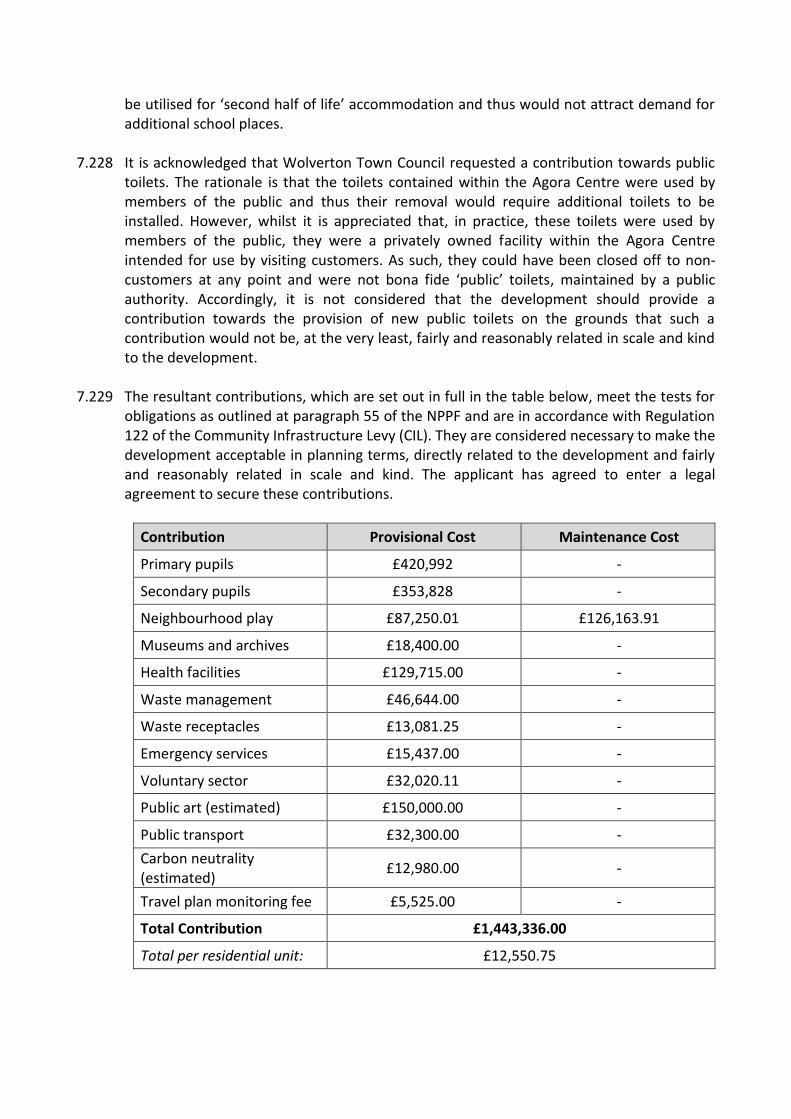
be utilised for ‘second half of life’ accommodation and thus would not attract demand for additional school places.
7.228 It is acknowledged that Wolverton Town Council requested a contribution towards public toilets. The rationale is that the toilets contained within the Agora Centre were used by members of the public and thus their removal would require additional toilets to be installed. However, whilst it is appreciated that, in practice, these toilets were used by members of the public, they were a privately owned facility within the Agora Centre intended for use by visiting customers. As such, they could have been closed off to non-customers at any point and were not bona fide ‘public’ toilets, maintained by a public authority. Accordingly, it is not considered that the development should provide a contribution towards the provision of new public toilets on the grounds that such a contribution would not be, at the very least, fairly and reasonably related in scale and kind to the development.
7.229 The resultant contributions, which are set out in full in the table below, meet the tests for obligations as outlined at paragraph 55 of the NPPF and are in accordance with Regulation 122 of the Community Infrastructure Levy (CIL). They are considered necessary to make the development acceptable in planning terms, directly related to the development and fairly and reasonably related in scale and kind. The applicant has agreed to enter a legal agreement to secure these contributions.
Contribution Provisional Cost Maintenance Cost
Primary pupils £420,992 -
Secondary pupils £353,828 -
Neighbourhood play £87,250.01 £126,163.91
Museums and archives £18,400.00 -
Health facilities £129,715.00 -
Waste management £46,644.00 -
Waste receptacles £13,081.25 -
Emergency services £15,437.00 -
Voluntary sector £32,020.11 -
Public art (estimated) £150,000.00 -
Public transport £32,300.00 -
Carbon neutrality (estimated)
£12,980.00 -
Travel plan monitoring fee £5,525.00 -
Total Contribution £1,443,336.00
Total per residential unit: £12,550.75

7.230 In addition to the above contributions, the legal agreement would also secure the provision of a finalised travel plan, arrangements for the car club spaces and a monitoring fee (£50,000) to assess the impact on on-street parking within the locality, as well as the provision of a bond to enable the Council to install a CPZ (£200,000) should on-street parking controls be required.
7.231 Regarding the impact of the proposed development on health care facilities specifically, the applicant has, in accordance with Policy EH6, provided a HIA. Following a review of the HIA by Public Health Officers, the scheme was found to be broadly acceptable, including in regard housing quality and design, social cohesion and climate change.
7.232 The review did identify that the scheme would have an impact on healthcare services and schools. However, this would be addressed through the relevant, abovementioned contributions which would be directed to Wolverton Health Centre, Wyvern Primary School and the Radcliffe School respectively.
7.233 Minor queries were raised regarding issues such as the impact of construction and crime reduction. However, as is set out in other sections of this report, the scheme has been found to be acceptable with respect to these matters subject to appropriately worded conditions. Other queries related to non-planning matters such as procurement guidance for potential occupants of the commercial units and facilitation of the supply of local food to these units.
7.234 Turning to the issue of viability, the application is supported by a viability assessment which
concludes that the scheme is unviable and, as a result, cannot deliver any s106 contributions or affordable housing provision.
7.235 The applicant’s viability assessment was reviewed by an external consultant (‘AG’) who, conversely, considered that on initial examination the scheme is viable and could deliver both a policy compliant level of affordable housing and the s106 contributions set out above. The applicant provided a rebuttal to AG’s initial findings, however despite this AG maintained their position.
7.236 Given the considerable differences between the view of the applicant and that of AG, an additional review of the viability assessment was undertaken by a second consultant (‘AY’) to both clarify the reasons for this difference of opinion and to provide an additional review of the viability of the development.
7.237 AY’s review found that the main differences were based on how the build costs for the scheme were accounted for and its gross development value (GDV). Subsequently, AY’s review concluded that the scheme is unviable and cannot deliver any s106 contributions or affordable housing provision.
7.238 Regarding build costs, AG had based their initial review on standardised estate housing. The applicant, and subsequently AY, based the build costs on the scheme as it has been presented within the application. These costs are far higher, owing in part to the chosen materials and design features.
7.239 As is recognised in AY’s review, each development should be assessed on its own merits. It therefore follows that the viability of the development should be based on how it has been presented within the application, with the build costs accounted for accordingly. A scheme with lower build costs may result in a diminished design quality which, in turn, could impact upon the acceptability of the development. As such, it is considered that taking into account the build costs of the scheme as proposed is a reasonable approach, rather than accepting lower build costs for a hypothetical development which may prove to be deficient in terms of its design or in other respects.
7.240 In terms of GDV, AG had calculated the value of the private sector housing to be far in excess of the value reached by both the applicant and AY. This is largely due to the value attributed to the non-affordable BTR element of the proposal. AG’s review broadly attributes the same value to the non-affordable BTR units as that of regular private sector housing and considers that these units will compete in the market as open market sales purchased by investors and occupiers alike. In contrast, AY’s review states that the end value generated by the rent and yield of the BTR units is lower than the end values assuming sales to owner occupiers.
7.241 Ultimately, the development is composed of a large portion of BTR housing. The BTR units would be subject to obligations secured under the legal agreement to ensure accordance with Plan:MK, insofar as meeting the Plan’s definition of BTR. Accordingly, it is deemed reasonable that the GDV associated with the BTR be accounted for in accordance with the specific type of housing on offer, rather than being compared to generic private sale/rental properties which are likely to provide a greater GDV.
7.242 For these reasons it is considered that the conclusions reached by both the applicant and AY in respect of the viability of the development are acceptable and more accurately account for the scheme as it has been proposed. The scheme is unviable and therefore cannot deliver any s106 contributions or affordable housing.
7.243 However, despite the viability of the development, the applicant has, as noted above, agreed to provide the abovementioned financial contributions to mitigate the impact of the scheme on local infrastructure. This is significant. If the scheme did not provide the contributions detailed above, the identifiable public benefits would reduce substantially. This would have implications for whether the development was considered to be acceptable, given both the less than substantial harm that would be incurred to the abovementioned designated heritage assets and indeed some of the policy requirements of the development plan that the scheme does not fully address.
7.244 In addition, the application would provide a policy compliant quantity of affordable housing across the BTR element of the proposal and 14% affordable housing within the Cohousing block (Block C). This small shortfall in affordable housing is considered acceptable in light of the viability of the development, as is the lack of provision of units of 50sqm (gross) or less and the failure of the application to achieve carbon neutrality.
7.245 In conclusion, it is considered that the proposal would be acceptable regarding its impact on infrastructure, subject to the signing of the associated legal agreement. Therefore, it is
reasoned that the development would accord with Policies INF1, SC1, CC1, EH5 and EH6 of Plan:MK and Part T of Policy W1 of the WNP.
8.0 CONCLUSIONS
8.1 On balance, the proposed development is considered to be acceptable for the many reasons outlined above. The proposed development would deliver numerous benefits including the fulfilment of a housing allocation; increased town centre accessibility for pedestrians and cyclists; provision of a community microgrid; public realm enhancements and a measurable net gain in biodiversity. In turn, it does meet several of the key requirements of Policy W1 of the WNP including the reinstatement of the Radcliffe Street link.
8.2 It is acknowledged that there are certain aspects of the Development Plan that the scheme does not wholly accord with, including some requirements of Policy W1 of the WNP. However, the development, subject to the conditions and obligations noted in this report, would deliver benefits that would outweigh the harm that this discordance would generate. It is also considered that through the use of appropriately worded conditions and obligations this harm can be minimised.
8.3 Turning to the impact on the Wolverton Conservation Area and setting of nearby listed buildings, this report has found that the scheme would result in less than substantial harm to these designated heritage assets. However, the significant, demonstratable public benefits derived from this proposal are considered to outweigh this harm. Many of these benefits, which would flow from the development, have been outlined above and provide clear and convincing justification for the less than substantial harm that the scheme would cause.
8.4 In conclusion, it is recommended that the proposed development be approved subject to the conditions outlined in full below and the signing of the associated legal agreement, the obligations of which have been expressed in the main body of this report.
9.0 CONDITIONS 1. The approved development shall be carried out in accordance with the following
drawings/details: Received 15th December 2020
EX RF DR AR 100 Existing Site and Location Plan_PL01 – Scale 1:1250 – Drawing Date: 23/10/2020 WOL_MRA_ZZ_RF_DR_AR_106_PL01 – Scale: 1:500 – Drawing Date: 23/10/2020 WOL_MRA_ZZ_00_DR_AR_100_PL01 – Scale: 1:500 – Drawing Date: 23/10/2020 WOL_MRA_ZZ_01_DR_AR_101_PL01- Scale: 1:500 – Drawing Date: 23/10/2020 WOL_MRA_ZZ_02_DR_AR_102_PL01 – Scale: 1:500 – Drawing Date: 23/10/2020 WOL_MRA_ZZ_03_DR_AR_103_PL01 – Scale: 1:500 – Drawing Date: 23/10/2020 WOL_MRA_ZZ_04_DR_AR_104_PL01 – Scale: 1:500 – Drawing Date: 23/10/2020 Block A
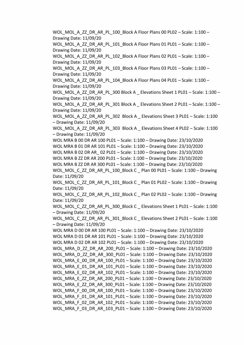
WOL_MOL_A_ZZ_DR_AR_PL_100_Block A Floor Plans 00 PL02 – Scale: 1:100 – Drawing Date: 11/09/20 WOL_MOL_A_ZZ_DR_AR_PL_101_Block A Floor Plans 01 PL01 – Scale: 1:100 – Drawing Date: 11/09/20 WOL_MOL_A_ZZ_DR_AR_PL_102_Block A Floor Plans 02 PL01 – Scale: 1:100 – Drawing Date: 11/09/20 WOL_MOL_A_ZZ_DR_AR_PL_103_Block A Floor Plans 03 PL01 – Scale: 1:100 – Drawing Date: 11/09/20 WOL_MOL_A_ZZ_DR_AR_PL_104_Block A Floor Plans 04 PL01 – Scale: 1:100 – Drawing Date: 11/09/20 WOL_MOL_A_ZZ_DR_AR_PL_300 Block A _ Elevations Sheet 1 PL01 – Scale: 1:100 – Drawing Date: 11/09/20 WOL_MOL_A_ZZ_DR_AR_PL_301 Block A _ Elevations Sheet 2 PL01 – Scale: 1:100 – Drawing Date: 11/09/20 WOL_MOL_A_ZZ_DR_AR_PL_302 Block A _ Elevations Sheet 3 PL01 – Scale: 1:100 – Drawing Date: 11/09/20 WOL_MOL_A_ZZ_DR_AR_PL_303 Block A _ Elevations Sheet 4 PL02 – Scale: 1:100 – Drawing Date: 11/09/20 WOL MRA B 00 DR AR 100 PL01 – Scale: 1:100 – Drawing Date: 23/10/2020 WOL MRA B 01 DR AR 101 PL01 – Scale: 1:100 – Drawing Date: 23/10/2020 WOL MRA B 02 DR AR_ 02 PL01 – Scale: 1:100 – Drawing Date: 23/10/2020 WOL MRA B ZZ DR AR 200 PL01 – Scale: 1:100 – Drawing Date: 23/10/2020 WOL MRA B ZZ DR AR 300 PL01 – Scale: 1:100 – Drawing Date: 23/10/2020 WOL_MOL_C_ZZ_DR_AR_PL_100_Block C _ Plan 00 PL01 – Scale: 1:100 – Drawing Date: 11/09/20 WOL_MOL_C_ZZ_DR_AR_PL_101_Block C _ Plan 01 PL02 – Scale: 1:100 – Drawing Date: 11/09/20 WOL_MOL_C_ZZ_DR_AR_PL_102_Block C _ Plan 02 PL02 – Scale: 1:100 – Drawing Date: 11/09/20 WOL_MOL_C_ZZ_DR_AR_PL_300_Block C _ Elevations Sheet 1 PL01 – Scale: 1:100 – Drawing Date: 11/09/20 WOL_MOL_C_ZZ_DR_AR_PL_301_Block C _ Elevations Sheet 2 PL01 – Scale: 1:100 – Drawing Date: 11/09/20 WOL MRA D 00 DR AR 100 PL01 – Scale: 1:100 – Drawing Date: 23/10/2020 WOL MRA D 01 DR AR 101 PL01 – Scale: 1:100 – Drawing Date: 23/10/2020 WOL MRA D 02 DR AR 102 PL01 – Scale: 1:100 – Drawing Date: 23/10/2020 WOL_MRA_D_ZZ_DR_AR_200_PL01 – Scale: 1:100 – Drawing Date: 23/10/2020 WOL_MRA_D_ZZ_DR_AR_300_PL01 – Scale: 1:100 – Drawing Date: 23/10/2020 WOL_MRA_E_00_DR_AR_100_PL01 – Scale: 1:100 – Drawing Date: 23/10/2020 WOL_MRA_E_01_DR_AR_101_PL01 – Scale: 1:100 – Drawing Date: 23/10/2020 WOL_MRA_E_02_DR_AR_102_PL01 – Scale: 1:100 – Drawing Date: 23/10/2020 WOL_MRA_E_ZZ_DR_AR_200_PL01 – Scale: 1:100 – Drawing Date: 23/10/2020 WOL_MRA_E_ZZ_DR_AR_300_PL01 – Scale: 1:100 – Drawing Date: 23/10/2020 WOL_MRA_F_00_DR_AR_100_PL01 – Scale: 1:100 – Drawing Date: 23/10/2020 WOL_MRA_F_01_DR_AR_101_PL01 – Scale: 1:100 – Drawing Date: 23/10/2020 WOL_MRA_F_02_DR_AR_102_PL01 – Scale: 1:100 – Drawing Date: 23/10/2020 WOL_MRA_F_03_DR_AR_103_PL01 – Scale: 1:100 – Drawing Date: 23/10/2020

WOL_MRA_F_ZZ_DR_AR_300_PL01 – Scale: 1:100 – Drawing Date: 23/10/2020 WOL_MRA_F_ZZ_DR_AR_301_PL01 – Scale: 1:100 – Drawing Date: 23/10/2020 1068-URBED-Z0-01-DR-L-Landscape_Plan_01 – Scale:1:500 – Drawing Date: 10/12/20 WOL_ZZ_XX_DR_AR_400 Typical Window Detail_PL01 – Drawing Date: 23/10/2020 WOL_MOL_X_ZZ_DR_AR_PL_7200_Typical window detail PL01 – Scale: 1:10 – Drawing Date: 11/09/20 WOL_MOL_X_ZZ_DR_AR_PL_7250_Typical door details PL02 – Scale: 1:10 – Drawing Date: 11/09/20 Ventilation/Extraction Equipment Details, Max Fordham December 2020 Ecological Assessment and Biodiversity Impact Assessment Metric, Hopkins Ecology December 2020
Received 16th April 2021
Drainage Maintenance and Management, dated April 2021 Wolverton Agora – Revised Surface Water Drainage Strategy, 948-01
Received 15th July 2021 Housing Accommodation Schedule Received 20th July 2021
1068-URBED-Z0-01-DR-L-Landscape_Plan_01 (Revision P5) 1068-URBED-Z0-DR-L-Hardscape_Plan (Revision P5) TR-1031, Parking Plan (Revision P05)
2. The development hereby permitted shall begin before the expiration of three years from
the date of this permission. Reason: To prevent the accumulation of planning permissions; to enable the Local Planning Authority to review the suitability of the development in the light of altered circumstances; and to comply with section 91 of the Town and Country Planning Act 1990.
3. The proposed development shall be carried out in accordance with the Reasonable Avoidance Measures (RAMs) given in section 8 of the ecological report (Hopkins Ecology, Sep 2020). Reason: To ensure that the proposed development does not have an adverse impact on protected or priority species in accordance with Policy NE2 of Plan:MK.
4. Any ventilation or extraction equipment installed within the proposed development shall accord with the specifications set out in the Ventilation/Extraction Equipment Details document by Max Fordham dated December 2020.

Reason: In the interest of safeguarding the amenity of surrounding residential properties in accordance with Policy NE6 of Plan:MK.
5. No development, including any works of demolition, shall commence until a site-wide phasing programme including the proposed sequence of providing:
(a) housing blocks, including associated parking and boundary treatments; (b) public and private highways including footways and street lighting; (c) car parking, including passive and active EV charging provision; (c) sustainable drainage systems and associated infrastructure; (d) open space and pedestrian circulation areas; and (e) any off-site works required under this permission, a planning obligation or agreement under the Highway Act 1980
has been first submitted to and approved in writing by the Local Planning Authority. The details shall be provided with reference to plan(s) and a Gantt chart and define the extent and location of individual development phases or sub-phases and any associated interim access or drainage arrangements. Where changes to the approved phasing programme are required in order to adjust the strategy for the delivery of the site as a whole, a revised phasing programme shall be submitted to and approved in writing by the Local Planning Authority. The development shall not be carried out other than in accordance with the latest approved programme. Reason: To ensure that the impacts of the development are appropriately mitigated at all stages of the construction phase, and so occupiers of the development are able to reach and access services and facilities at an appropriate time, in the interests of achieving sustainable development.
6. No development, including any works of demolition, shall take place until a Construction Environmental Management Plan (CEMP) has been submitted to and approved in writing by the Local Planning Authority. The CEMP shall include site procedures to be adopted during the course of construction including:
o routes for construction traffic o method of prevention of mud being carried onto the highway o location of site compound o methods for suppressing dust o loading and unloading of plant and materials o the erection and maintenance of security fencing/hoardings and lighting o proposed temporary traffic restrictions o parking of vehicles of site operatives and visitors
The development shall be carried out in full accordance with the approved CEMP. Reason: To ensure there are adequate mitigation measures in place, in the interests of highway and pedestrian safety and in order to protect the amenities of existing and future residents in accordance with Policies SD1, D1 and CT2 of Plan:MK (2019).
7. No development, including any works of demolition, shall take place until a Discovery Strategy has been submitted to and approved by the Local Planning Authority. The Strategy shall be employed in order to ensure the examination and appropriate reporting of the areas

of the site not covered in the scope of the original intrusive site investigation into potential ground contamination. Should any unforeseen contamination be encountered, the Local Planning Authority shall be informed immediately, whereupon any additional site investigation and remedial work that is required as a result of unforeseen contamination shall be carried out to the written satisfaction of the Local Planning Authority. Reason: To ensure that the site is fit for its proposed purposed and any potential risks to human health, property, and the natural and historical environment, are appropriately investigated and minimised in accordance with Policy NE6 of Plan:MK.
8. Prior to the construction of a building above slab level, a lighting plan shall be submitted to the Local Planning Authority. If any lighting is required within the vicinity of current or built-in bat features, it shall be low level, with baffles to direct the light away from the features, thus preventing severance of bat commuting and foraging routes. The approved scheme shall be implemented prior to the occupation of each building or dwelling. Reason: In the interest of mitigating the impact of the proposed development on bats and their habitats in accordance with Policy NE2 of Plan:MK (2019).
9. Prior to the construction of a building above slab level, a Landscape and Ecology Management Plan (LEMP), detailing the locations, specifications and ongoing management of features and habitats created to benefit biodiversity shall be submitted to and approved by the Local Planning Authority. The LEMP shall the include long term design objectives, management responsibilities and a schedule of landscape maintenance with details of the arrangements for its implementation for all landscaped open space and public amenity areas, other than privately owned domestic gardens. In addition, it shall include all features given in section 8 of the ecological report (Hopkins Ecology, Sep 2020), to enhance biodiversity value and to achieve net-gains for biodiversity. Once approved, the LEMP shall be implemented prior to the occupation of the development. Reason: To ensure that the proposed development delivers a net gain in biodiversity in accordance with Policy NE3 of Plan:MK.
10. Notwithstanding the approved drawings, prior to the construction of a building above slab level or the construction of a hard landscape area full details of both hard and soft landscape works shall be submitted to and approved in writing by the Local Planning Authority. Soft landscape works shall include planting plans at a minimum scale of 1:200 with schedules of plants noting species, supply sizes and proposed densities; and a tree planting details drawing. The planting plans shall include existing trees and/or hedgerows to be retained and/or removed accurately shown with root protection areas; existing and proposed finished levels and contours; visibility splays; proximity between street lights and tree planting; proposed and existing functional services above and below ground. All hard and soft landscape works shall be carried out in accordance with the approved details and prior to the first occupation of the building(s) or the completion of the development whichever is the sooner, or in accordance with a programme agreed in writing with the Local Planning Authority. If within a period of two years from the date of the planting of any tree or shrub,

that tree or shrub, or any tree and shrub planted in replacement for it, is removed, uprooted or destroyed, dies, becomes severely damaged or diseased, shall be replaced in the next planting season with trees and shrubs of equivalent size, species and quantity. Thereafter the hard and soft landscape works shall be maintained and retained in situ. Reason: To protect the appearance and character of the area and to minimise the effect of development on the area in accordance with Policies D1 and D2 of Plan:MK (2019).
11. Prior to the commencement of development, including site clearance, details of the proposed finished floor levels of all buildings, ground retaining measures, embankment gradients and the finished ground levels in relation to existing ground levels and root protection areas of trees and planting to be retained shall be submitted to and approved in writing by the Local Planning Authority. The development shall be carried out in accordance with the approved levels. Reason: To ensure that development proposals respond appropriately to the site and is carried out at suitable levels in accordance with Policies D1 of Plan:MK (2019).
12. Notwithstanding the approved plans, no development shall take place above slab level until details of the proposed boundary treatments have been submitted to, and approved in writing by, the Local Planning Authority. The details shall include a boundary treatment plan (at a minimum scale of 1:500) detailing the position of all proposed boundary treatment, details of hedgehog passes and including a schedule specifying the type, height, composition, elevation appearance of boundary treatment throughout the site. The development shall be carried out in accordance with the approved details prior to the occupation of each dwelling to which the boundary treatment relates and shall thereafter be retained in that form. Reason: To provide adequate privacy, to protect the external character and appearance of the area and to minimise the effect of development on the area in accordance with policy D1 of Plan:MK (2019).
13. All existing trees, woodlands and hedges to be retained are to be protected according to the provisions of BS 5837: 2012 'Trees in relation to design, demolition and construction - Recommendations' All protective measures especially the fencing and ground protection must be put in place first, prior to any other work commencing on site (this includes vegetation clearance, ground-works, vehicle movements, machinery / materials delivery etc.) and shall thereafter be maintained in place in good functional condition until the project is entirely complete and until, with the exception of soft landscaping works, all contactors, equipment and materials have left site. The fencing shall be on the RPA margin and of the same specification as that depicted in figure 2, page 20 and ground protection as specified in 6.2.3.1 - 6.2.3.5 pages 21/22 in BS 5837: 2012. Signs informing of the purpose of the fencing and warning of the penalties against destruction or damage to the trees and their root zones shall be installed at minimum intervals of 10 metres and a minimum of two signs per separate stretch of fencing.

Once erected the local authority tree officer shall be notified so the fencing can be inspected and approved. The Root Protection Area (RPA) within the protective fencing must be kept free of all construction, construction plant, machinery, personnel, digging and scraping, service runs, water-logging, changes in level, building materials and all other operations, personnel, structures, tools, storage and materials, for the duration of the construction phase. The developer shall submit details of the proposed layout and general arrangements of the site in relation to the trees to be retained. In particular, details of storage areas including what substances will stored and where, locations of car parking, welfare facilities, cement plant, fuel storage and where discharge, filling and mixing of substances will take place. The details should include site levels to enable risks posed to trees to be quantified. The RPA will be amended as the arboriculture officer feels appropriate after taking account of the details submitted. No fire shall be lit such that it is closer than 20 metres to any tree or that flames would come within 5 metres of any part of any tree. Earthworks, level changes, service runs, foundations and all other works involving excavation should not be located within the root protection areas. Reason: To ensure continuity of tree cover and to protect the appearance and character of the area and to minimise the effect of development on the area in accordance with policies D1, D2, D5 and NE5 of Plan:MK (2019).
14. Prior to the commencement of the development, an arboricultural method statement all in accordance with BS 5837:2012 should be submitted for approval it should include a scale plan accurately marking the position of all the retained trees, the extent of the root protection areas, the BS 5837: 2012 tree protection fencing along the root protection area margin, any areas to be covered in BS 5837: 2012 ground protection, construction details for the BS 5837: 2012 fencing and ground protection, no-dig construction proposals and proposals for all works within the root protection areas of retained trees including soft landscaping works. Once approved, the development shall be carried out in accordance with the method statement. Reason: To ensure continuity of tree cover and to protect the appearance and character of the area and to minimise the effect of development on the area in accordance with policies D1, D2, D5 and NE5 of Plan:MK (2019).
15. If construction-facilitation pruning of the trees is required, this should be carried out by a competent, qualified and experienced tree surgeon according to the provisions of BS 3998: 2010 and current arboriculture industry best practice. The Local Authority arboricultural officer shall be given a weeks' notice before the works are carried out so they have the opportunity to attend on site and agree the exact extent of the works with the tree surgery contractor.
Reason: To ensure continuity of tree cover and to protect the appearance and character of the area and to minimise the effect of development on the area in accordance with policies D1, D2, D5 and NE5 of Plan:MK (2019).
16. Prior to the commencement of the development, full details of the photo-voltaic powered
microgrid shall be submitted to and approved by the Local Planning Authority. Once these details are approved, the microgrid shall be installed and be operational prior to the first occupation of the final dwelling. Reason: To ensure that the proposal delivers a low carbon community energy network in accordance with Policy SC2 of Plan:MK and Part J of Policy W2 and Part S of Policy W1 of the Wolverton Town Centre Neighbourhood Development Plan.
17. Prior to the construction of a building above slab level or the construction of a hard landscape area evidence shall be submitted to and approved by the Local Planning Authority which confirms how the proposed development, as permitted, shall incorporate the Lifetime Homes Standards and best practice guidance in ‘Safer Places’ and ‘Secure by Design’. The development shall be carried out in accordance with the statement. Reason: In the interest of ensuring that the proposed development accords with Part L of Policy W1 of the Wolverton Neighbourhood Plan.
18. Prior to the installation of any security shutters on the commercial units, details of the shutters, including their colour and placement, shall be submitted to and approved by the Local Planning Authority. The shutters shall be either be link or lattice in design. The shutters shall thereafter be installed, operated and retained in accordance with the approved details. Reason: To ensure that the security shutters do not have an adverse impact on the character or appearance of the shopfronts in accordance with Policy W7 of the Wolverton Neighbourhood Plan.
19. Notwithstanding the approved drawings, prior to the commencement of works above slab level details of the street furniture and street materials shall be submitted to and approved by the Local Planning Authority. In addition, evidence shall be provided which demonstrates that these details have considered the Public Realm Design Manual published by Milton Keynes Council. The approved street furniture and street materials shall thereafter be provided in accordance with the approved phasing programme. Reason: To ensure that the proposed street furniture and materials comply with Part P of Policy W1 of the Wolverton Neighbourhood Plan.
20. Each dwelling and non-residential unit shall be furnished with a superfast broadband connection (defined as providing broadband speeds in excess of 30 megabits/second). Reason: To ensure that the development possesses sufficient digital connectivity in accordance with Policy CT9 of Plan:MK and Part L of Policy W1 of the Wolverton Neighbourhood Plan.

21. Prior to the first occupation of any part of the development hereby permitted, a Detailed
Site Waste Management Plan shall be submitted to, and approved in writing by, the Local Planning Authority. The Detailed Site Waste Management Plan shall be broadly in accordance with the Site Waste Management Plan by Civic Engineers dated December 2020 and included within Section 11 of the submitted 'Transport Assessment including Parking Assessment' and once approved all waste shall be handled as set out in the Detailed Site Waste Management Plan except as otherwise approved in writing in advance by the Local Planning Authority. Reason: In the interest of protecting the amenity of occupants of the development in accordance with Policy D5 of Plan:MK.
22. The dwellings in Block C shall only serve as the main place of residence for persons who have attained the age of 50 years and their spouse or partner including a surviving widow or widower of such persons. Reason: To ensure that the flats hereby approved are solely occupied in accordance with the proposed use for over 50 persons as detailed in the application and in accordance with Policy W1 of the WNP.
23. Prior to the commencement of the development, details of the estate roads and footways shall be submitted to and be approved in writing by the Local Planning Authority. The estate roads and footways which provide access from the existing highway shall been laid out and constructed in accordance with the approved details prior to the first occupation of a dwelling to which they serve. The estate road and footways so laid out shall be retained thereafter. Reason: To minimise danger, obstruction and inconvenience to users of the highway and of the development in accordance with Policy CT2 of Plan:MK.
24. Prior to the commencement of works, a scheme detailing the closure of all existing access points not being incorporated into the development shall be submitted to and approved by the Local Planning Authority. The access points shall be closed in accordance with the approved scheme. Reason: To limit the number of access points to the site for the safety and convenience of highway users in accordance with Policies CT1 and CT2 of Plan:MK.
25. Prior to the occupation of the convenience store in Block A, details of means of deliveries to and collections from the site, including the location of a loading bay, shall be submitted to and approved by the Local Planning Authority. Reason: To ensure appropriate servicing provision in accordance with Policy CT2 of Plan:MK.
26. Prior to the first occupation of each Block (A-F), the proposed bicycle parking for that dwelling, shown on the approved drawings, shall be provided and retained thereafter.
Reason: To ensure that adequate cycle parking facilities are provided to serve the development in accordance with Policy CT3 of Plan:MK.
27. Prior to the construction of a building above slab level or the construction of a hard landscape area, details of EV charging arrangements shall be submitted to and approved in writing by the Local Planning Authority. These details shall cover both active and passive EV charging, as well as a timetable for the provision of these arrangements (in stages if required). The EV charging arrangements shall be installed in accordance with the approved arrangements and timetable and retained thereafter. Reason: To ensure that EV Charging facilities are provided to serve the development in accordance with Policy CT6 of Plan:MK.
28. Prior to the construction of a building above slab level full details of the Brompton Bike Hire Bike Dock and Next Bike Hire Bike Dock, as well as a timetable for their provision, shall be submitted to and approved by the Local Planning Authority. The Bike Docks shall be installed in accordance with these details and approved timetable, and retained thereafter. Reason: To ensure the provision of low carbon modes of transport in accordance with Policy CT6 of Plan:MK.
29. Prior to the occupation of each respective dwelling hereby permitted, the car parking area to serve that dwelling, either solely or otherwise, as shown on the approved drawings, shall be constructed, surfaced and permanently marked out in accordance with the approved phasing programme. The car parking area so provided shall be maintained as a permanent ancillary to the respective dwelling(s) and shall be used for no other purpose thereafter. Reason: To ensure adequate parking provision at all times so that the development does not prejudice the safe free flow of traffic on the neighbouring highway in accordance with Policy CT10 of Plan:MK.
30. Prior to the commencement of works above slab level, details of the proposed improvements to the Church Street bus stop, located within the application site, shall be submitted to and approved by the Local Planning Authority. These details shall include the provision of ‘eink’/real time displays. Once approved, the improvements shall be implemented prior to the final occupation of the development. Reason: To ensure convenient access the sustainable modes of transport in accordance with Policy CT1 of Plan:MK.
31. No works to construct a building or hard surface shall commence until a surface water drainage scheme for the site, based on sustainable drainage principles, has been submitted to and approved in writing by the Local Planning Authority. The scheme shall subsequently be implemented in accordance with the approved details and the approved phasing programme. The scheme shall be based upon the principles within the agreed ‘Wolverton

Agora – Revised Surface Water Drainage Strategy’, prepared by Civic Engineers, reference 948-01-Wolverton Agora, dated 13 April 2021 and shall also include:
a) Full calculations detailing the existing surface water runoff rates for the QBAR, 3.3% Annual Exceedance Probability (AEP) (1 in 30) and 1% AEP (1 in 100) storm events; b) Full results of the proposed drainage system modelling in the above-referenced storm events (as well as 1% AEP plus climate change), inclusive of all collection, conveyance, storage, flow control and disposal elements and including an allowance for urban creep, together with an assessment of system performance; c) Detailed drawings of the entire proposed surface water drainage system, including levels, gradients, dimensions and pipe reference numbers; d) Full details of the proposed attenuation and flow control measures; e) Site investigation and test results to confirm infiltration rates; f) Temporary storage facilities if the development is to be phased; g) A timetable for implementation if the development is to be phased; h) Details of overland flood flow routes in the event of system exceedance, with demonstration that such flows can be appropriately managed on site without increasing flood risk to occupants; i) Full details of the maintenance/adoption of the surface water drainage system; and j) Measures taken to prevent pollution of the receiving groundwater and/or surface water.
The drainage scheme must adhere to the hierarchy of drainage options as outlined in the NPPF/PPG. Reason: To ensure that the proposed development can be adequately drained and to ensure that there is no increased flood risk on or off site resulting from the proposed development in accordance with Policy FR1 of Plan:MK.
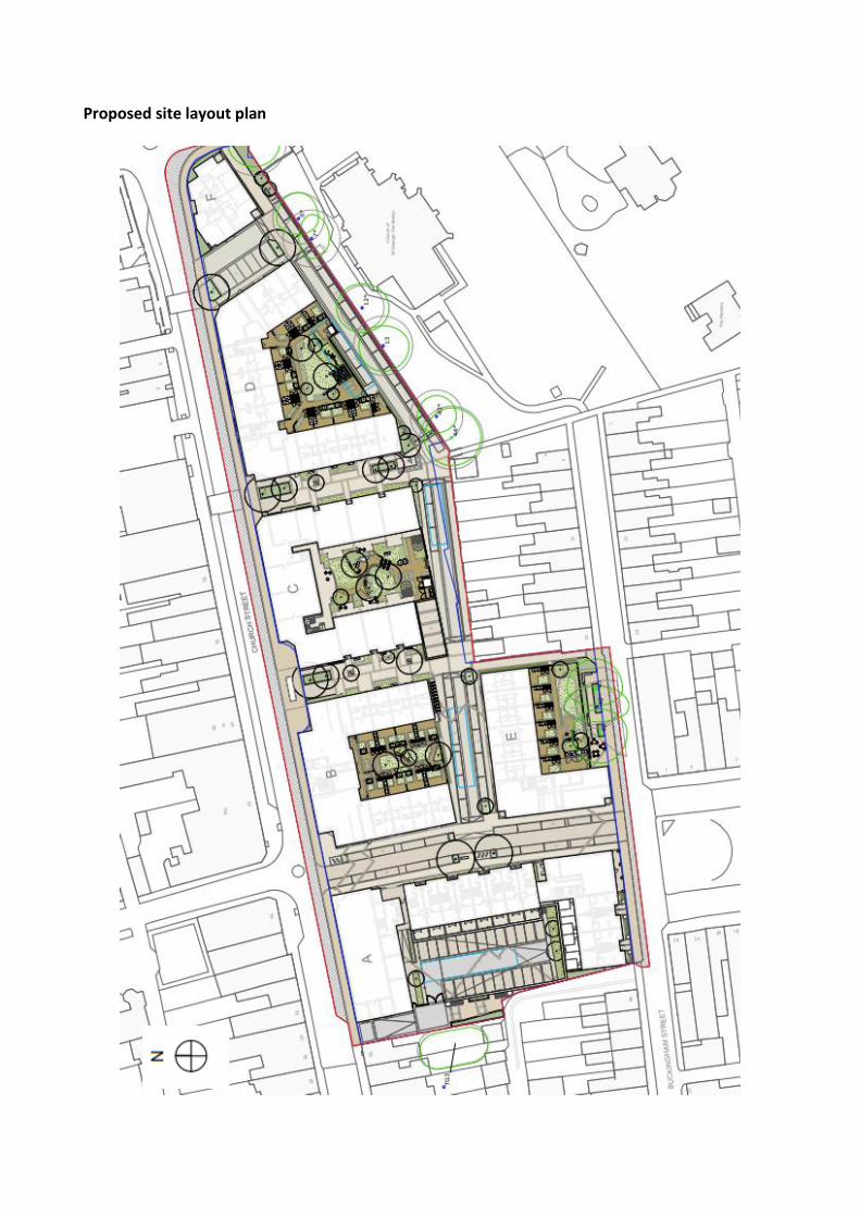
Proposed site layout plan

Axonometric drawing of the site

Proposed Church Street and Radcliffe Street (east) elevations
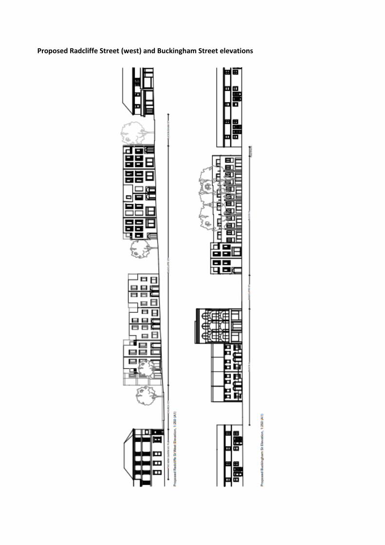
Proposed Radcliffe Street (west) and Buckingham Street elevations
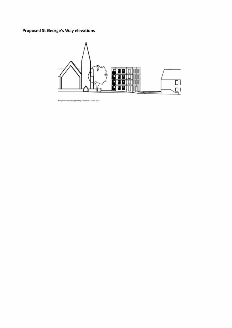
Proposed St George’s Way elevations

A1.0 FULL CONSULTATIONS AND REPRESENTATIONS
A1.1 Wolverton And Greenleys Town Council
“Wolverton and Greenleys Town Council (WGTC) welcomes the opportunity for redevelopment of the Agora site and the regeneration of the town centre by the new developer TOWN. There are some really positive moves within the plan and WGTC are pleased to note that this plan follows the vision as set out in the Wolverton Neighbourhood Plan policy W1:A (NHP 2015) to “Follow the historic grid street pattern and reinstate Radcliffe Street as a direct highway link” and to implement the much needed one-way system onto Church Street. We understand and appreciate that there has been a large amount of time and planning that has been invested in getting the application to this point, and TOWN have engaged in the past with the parish of WGTC and with the Working Group (WG). The Town Council corporate response should not be considered reflective of the views of the Councillors alone but also as a representative voice to the views of those who live and work within the parish. WGTC must convey therefore that the application is fundamentally flawed due to the following concerns it raises, as a result WGTC are minded to OBJECT to this application on the three key issues as below; 1. Parking for residents and visitors to the town centre (a partially mitigating parking proposal was received 22nd January) 2. Block F and other issues including the views of the Grade II listed church St George The Martyr being obstructed. Conservation of the historic town – The Public Realm and Wolverton Design Guide There are other concerns which WGTC would like to see addressed and discussed further in this response, to ensure a resolution will suit all where practicable. The following are seen to be the key issues for OBJECTING to this application: 1. Parking ▪ WGTC OBJECT to this proposal as it fails to provide Wolverton town centre and
residents with sufficient parking. It falls far below and fails to meet the adopted parking standards, and is therefore contrary to MK parking standards SPD 2016 and policy CT2:A(v) of the adopted local plan, Plan:MK According to the SPD Wolverton is classed within ‘zone 2’ and the parking provision for the proposed 115 residential homes breakdown should be; 1 allocated space for 1&2 bed homes plus 0.33 unallocated 2 allocated parking spaces for the 3&4bed homes plus 0.33 unallocated. The calculation is below; 11 x 4 bed x 2+0.33 = 25.63 21 x 3 bed x 2+0.33 = 48.93 54 x 2 bed x 1+0.33 = 71.82
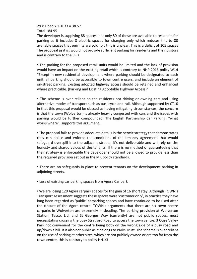
29 x 1 bed x 1+0.33 = 38.57 Total 184.95 The developer is supplying 88 spaces, but only 80 of these are available to residents for parking as it includes 8 electric spaces for charging only which reduces this to 80 available spaces that permits are sold for, this is unclear. This is a deficit of 105 spaces The proposal as it is, would not provide sufficient parking for residents and their visitors and is contrary to the SPD ▪ The parking for the proposed retail units would be limited and the lack of provision would have an impact on the existing retail which is contrary to NHP 2015 policy W1:I “Except in new residential development where parking should be designated to each unit, all parking should be accessible to town centre users, and include an element of on-street parking. Existing adopted highway access should be retained and enhanced where practicable. (Parking and Existing Adoptable Highway Access)” ▪ The scheme is over reliant on the residents not driving or owning cars and using alternative modes of transport such as bus, cycle and rail. Although supported by CT10 in that this proposal would be classed as having mitigating circumstances, the concern is that the town (Wolverton) is already heavily congested with cars and the issues with parking would be further compounded. The English Partnership Car Parking: “what works where”, supports this argument. ▪ The proposal fails to provide adequate details in the permit strategy that demonstrates they can police and enforce the conditions of the tenancy agreement that would safeguard overspill into the adjacent streets; it’s not deliverable and will rely on the honesty and shared values of the tenants. If there is no method of guaranteeing that their strategy is enforceable the developer should not be allowed to provide less than the required provision set out in the MK policy standards. ▪ There are no safeguards in place to prevent tenants on the development parking in adjoining streets. ▪ Loss of existing car parking spaces from Agora Car park ▪ We are losing 120 Agora carpark spaces for the gain of 16 short stay. Although TOWN’s Transport Assessment suggests these spaces were ‘customer only’, in practice they have long been regarded as ‘public’ carparking spaces and have continued to be used after the closure of the Agora centre. TOWN's arguments that there are six town centre carparks in Wolverton are extremely misleading. The parking provision at Wolverton Station, Tesco, Lidl and St Georges Way (currently) are not public spaces, most necessitating crossing the busy Stratford Road to access the town centre. 3 Ouse Valley Park not convenient for the centre being both on the wrong side of a busy road and up/down a hill. It is also not public as it belongs to Parks Trust. The scheme is over reliant on the use of parking at other sites, which are not publicly owned or are too far from the town centre, this is contrary to policy HN1:3

• The loss of Agora parking spaces would have a detrimental impact on the Town Centre Parking for its current users such as the mosque, St Georges Church and the King’s Community Centre (KCC). Town Centre retailers are suffering from the current pandemic and the loss of so much public parking would deal them a further blow by reducing the attractiveness of the town centre as a shopping destination. • The need for town centre visitors’ parking has only been partially addressed by the St Georges Way Parking proposal, welcome though this is.
2. Block F: Height, Mass and other issues ▪ WGTC OBJECT to this proposal due to building F’s height and mass and the issues that it causes for further demand for onsite parking. This block dominates the whole site AND the entrance to Wolverton from Creed St / McConnell Drive and is contrary to policy D3 of the local Plan and contrary to the NHP 2015 policy W1 “F. Retain views of St George’s Church, in particular the spire, through breaks in development along Church Street. (Retention of Key Views)” It could be argued that there are still some views of the building, but the proposed is completely out of context with the area and the open views that we would hope to see, particularly as the gateway to the town. ▪ There is also a difference in the number of flats in the design and access statement as 14 versus the floor plans which show 11 properties. Either figure adds to the demand for residential parking beyond the 104 homes that were in the public exhibition plans shown in 2019. ▪ Concern for local buildings/businesses such as KCC, particularly in regard to the how this would affect their music licence and the residents who move in and how it would impact them, as there could not be a legally binding agreement for new residents to accept noise intrusion.
3. Heritage Conservation– Public Realm and Wolverton Design Guide ▪ WGTC OBJECT to the proposal not following the design which is in keeping with the conservation of the Victorian town specifically in that it would be contrary to Policy W1: Q NHP 2015. Be of good design in keeping with the Victorian architecture of the setting which preserves and enhances the character of the Conservation Area. Poor quality pastiche is not acceptable. (High quality architecture). The roof designs are boxy in appearance and would be a conspicuous intrusion into the historic rooftop vistas of the Conservation Area (CA). Consequently, the character and appearance of the CA would not be preserved or enhanced, and this could further lead to more residents submitting applications to install dormers to the rear of their properties which would fit with this development, rather than the terraced roofs that are seen to be a historic feature of the town. The development should echo the Victorian feel of the town, ▪ There is no sign of traditional windows and doors included within the design - This is within the conservation area and any development by local residents would be expected to comply: window shape and size and colour should match in with designs which are
already in place; we would request sash windows with a strong horizontal division for continuity within the Conservation Area, as is required of existing properties. ▪ NHP 2015 policy W1: P. “Street materials and street furniture should comply with the Public Realm Design Manual. (Public Realm materials and street furniture)” ▪ WGTC request that the street furniture should follow the current adopted design guide – the current plans as shown do not fit with this. Other issues: 1. Increase in proposed number of homes • The original plan from TOWN encompassed around 105 homes, however, there has been an increase of properties designated for the site from 105 to 115 on this new proposal. • Plan:MK wrongly indicates 140 homes for this site - this figure has been challenged and is incorrect on Plan:MK but has never been amended to the correct figure of 104 as agreed for the former application, that was submitted by Brickhills. Plan:MK still also refers to the former application of 2015: 15/00913/FUL and cannot be considered. • This increase further compounds the issue of parking by increasing demand and reducing area available. 2. Car parking charges
▪ WGTC notes the proposals for rentals for different types of cars for residents and appreciate that electric cars are being encouraged. ▪ WGTC do not wish to see car parking fees for the town centre visitors to park. ▪ Clarification on the proposed length and hours of parking is needed. 3. Lack of Electric Vehicle infrastructure
▪ The proposal fails to provide sufficient electric parking charging points, as set out on the Milton Keynes Transport Vision and Strategy LTP3 (2011-2031) and policy CT10:ii ▪ The proposal should encourage chargers and electric cars as this is likely to be the future of travel and fits with MKC future 2050 projects and the move towards a carbon efficient society
4. Retail uses ▪ Conditions to be imposed to ensure that they remain as commercial units, Class E and cannot be used for residential use and that the developers fulfils the plan to achieve the designated retail space
▪ Rents and maintenance charges to be reasonable to encourage full usage. WGTC Proposals to make the scheme acceptable. 1. St George’s Way needs to be redefined for car parking for the Town Centre to ease the pressure and make the whole process more acceptable. This proposal recently received from MKC for St Georges Way Parking is welcomed. 2. Height scale and massing of Block F reduced or scrapped – concerns that it is overbearing and not fitting for a gateway to the town. Omitting Block F would also go some way to alleviating the parking issues by retaining two dozen existing spaces and reducing demand by reducing the number of homes. 3. Public toilets are highly desired by WGTC to make the scheme acceptable. They do not appear to be included within the plan, but these are required to make the scheme acceptable, and need to be close to the bus stop and as set out in the Agora Development Brief 4.2.46 “a desire to have public toilets included within a new development. These should be included if possible, although careful management needs to take place to ensure that they don’t undermine the quality of the town centre” As one of the busiest bus stops, the need for this facility is of great importance and should be a priority in this development. 4. Allow the creation of a pedestrian entrance to St Georges Church along the rear wall to allow easier access to the building on foot. WGTC welcomes the following:
❖ One way system on part of Church Street
❖ Reconnecting Radcliffe street
❖ New Bus Stop provision
❖ Affordable and social rented properties as well as the Community housing (Block C) for older people. Conditions and suggestions which WGTC would request as part of this application. 1. Join up the red way from McConnell Drive – this has been considered in the St
Georges way parking scheme proposal received 21st January 2021.
2. Public Toilet – Confirm if this will be part of the public hub.
3. Noted that there will be an unadopted road on Radcliffe St – This needs ongoing management by someone and there is a concern that, once development is complete, there may be issues with maintenance and responsibility.
4. Concern of loss of light for the houses on Buckingham Street
5. S106 contributions are less than previously expected. The town council recognises the concern that local people have about the pressure on local public services. We believe
that any redevelopment of the Agora site needs to deliver the section 106 contributions as well as the affordable housing required by Milton Keynes Council. See policy W1: T. of NHP 2015 “Ensure that the necessary on and off-site infrastructure, for example school places, and community facilities are provided to support and mitigate the impact of development” 5. If Block F wasn’t part of this plan, enabling another 20-22 car parking spaces, WGTC
would withdraw our main objection. Should this be application be referred to the Development Control Committee/Panel for determination a councillor from WGTC would be willing to attend.”
A1.2 Cllr Peter Marland (Wolverton)
No comments received.
A1.3 Cllr Rob Middleton (Wolverton)
No comments received.
A1.4 Cllr Norman Miles (Wolverton)
No comments received.
A1.5 MKC Highways
Initial comments “This application is for the replacement of the Agora centre with a residential and commercial development comprising 115 dwellings, 905m2 of retail space and 250m2 of community space. The proposals also include the creation of a new private street on the approximate alignment of Radcliffe street prior to the construction of the Agora. It should be noted that the applicant does not intend for this street to be a public highway; therefore, control of the new street and its use would not rest with the Council. Furthermore, it is proposed that this new private street is one-way only in the southbound direction. A key function of this street is to provide car parking for the proposed development. The application also proposes significant changes to some existing streets in the vicinity of the site: • Radcliffe Street is proposed to be one-way northbound between Church Street and Stratford Road; • Church Street is proposed to be one-way westbound between Creed Street and Radcliffe Street;
• Additional parking is proposed on Buckingham Street adjacent to The Square; • Church Street, immediately west of its junction with Radcliffe Street, will only permit vehicle movements in one direction at a time due to its limited with (although a formal one-way restriction is not proposed). It should be noted that whilst the application drawings show the full width of Church Street being affected by highway works, the applicant is not proposing to carry out all of these works, with the majority lying outside the red line site boundary. The application does not appear to provide a mechanism for the delivery of the works outside the red line. However, these works are an integral element of the scheme and the proposed development should not proceed until and unless the delivery of the works outside the red line is properly secured. The proposed changes to Church Street will reduce the existing kerbside parking capacity on the northern side of the street. Between Radcliffe Street and Creed Street (northern side) there is currently parking capacity for 22-23 cars. This will be reduced to 18 spaces as a result of the proposed works. Refuse collection points A1, A2 and B1 as shown on the application drawings, are on a private street. The Council’s collection teams do not collect from private property and refuse is normally expected to be left on the nearest part of the public highway. Two CCTV installations are affected by the proposals, one on Buckingham Street close to the new private street and one on Church Street close to the existing/proposed bus shelter. Neither of these appears on the proposed layout and it is not clear if the applicant is proposing to reinstall them. The applicant should confirm the status of the CCTV facilities including the ownership, operation and reinstatement requirements. This should form part of the application proposals. The proposals also impact on the current charging location for electric buses but the charging equipment does not appear on the drawings of the proposals. The applicant will need to relocate or replace this equipment as part of their works to Church Street. Alternatively, subject to agreement from the Council’s Passenger Transport Team, an equivalent provision to allow high-capacity bus charging should be installed. Transport Assessment (TA) The submitted TA is generally acceptable, having been modified following previous comments. The description of the site and its accessibility as well as the sections covering the proposed development and policy are acceptable. Consideration of the parking proposals is dealt with below. The lack of adequate swept path diagrams is also covered below. Scheme Layout

There are a number of issues that the proposed layout creates, many of these have been raised in earlier discussions and have not been addressed in the submitted scheme. Many of these issues relate to minimal or substandard highway provision, often as a result of trying to reduce the significant parking shortfall. The following list describes the areas that require attention: Buckingham Street • The built frontage of Block E on to Buckingham Street appears to result in a footway width of less than 2m. The existing kerbline should be retained and any building should be set back 2m from the kerbline. • Crossing to / from the pedestrian route emerging on Buckingham Street adjacent to No.22 is blocked by a proposed parking space. • The proposed parking spaces on the northern side of Buckingham Street also restrict the ability of vehicles to turn into and out of the Back Lane adjacent to No.23 Buckingham Street. • These spaces would also result in an unacceptably narrow carriageway due to the presence of existing parking spaces on the southern side of the carriageway. The loss of these existing spaces is not acceptable, particularly when they are being replaced on the northern side by alternative spaces which have safety issues. • The proposed parking space on Buckingham Street closest to the Back Lane adjacent to No.56 Buckingham Street appears to restrict movement for left turns out of the Back Lane onto Buckingham Street. Larger cars and vans may not be capable of this manoeuvre. • The junction of the new private street with Buckingham Street does not have adequate visibility due to the presence of the parking immediately to the west of the junction. Visibility splays should be clear of any obstruction. • The pedestrian route on the eastern side of the new private street does not allow safe crossing of Buckingham Street to / from the footway on the eastern side of Radcliffe street (the area on the northern side of Buckingham Street opposite the Radcliffe Street footway is again blocked by proposed parking). • These issues are no doubt why the Council placed Double Yellow Lines on Buckingham Street in this location. The proposed spaces should be removed from the scheme to ensure the safety and convenience of pedestrians, and drivers. • The new private street connecting Church Street to The Square does not provide a direct connection onto the eastern side of the square. Vehicles will need to ‘dogleg’ through the junction to continue southward. This may lead to vehicles cutting the corner at the southern end of the private street and, by being offset, does not properly reinstate the grid. Church Street • The junction of the “Block F Street” with Church Street is proposed to serve 90 dwellings. A kerbed radius should be provided (for the left turn out) and the footway on Church Street should have tactile paving to denote a road crossing. • This junction also has little or no visibility due to the proposed parking spaces immediately to the east of the junction. Whilst the application drawings show vision splays here, they are clearly blocked by this parking leading to a potentially unsafe junction for 90 dwellings. Furthermore, Church Street westbound is still a potential cycle route and therefore the visibility splays should be clear of obstructions. • For these reasons, the junction of “Block F Street” with Church Street is unacceptable. • The proposed bus laybys on Church Street are shown 2.5m wide, whereas the typical
dimension for bus laybys and bus cages is 3.0m. Typically, the buses using these stops will be around 2.5m wide (body width) plus mirrors. Buses using these laybys are therefore likely to impinge on the already limited carriageway width (4.0m). • The scheme proposes a loading bay on Church Street to the front of Block A. This loading bay restricts this section of Church Street to 4.19m wide (TA Cross Sections), which is insufficient for two-way movement, particularly immediately adjacent to a junction where eastbound vehicles may be waiting, thus preventing westbound vehicles from proceeding. • In order to achieve this loading bay, the width proposed for the opposite parking bay is only 1.91m, which would result in wider cars/vans further reducing the 4.19m available. The footway outside No.48 Church Street is also restricted to only 1.86m (between the face of a building and parked vehicles with mirrors further reducing that width). • Vehicles in this loading bay would also restrict the visibility available at the junction of the access to Block A with Church Street. The area adjacent to this access is currently covered by Double Yellow Lines, thereby providing visibility. • For these reasons, the loading bay on Church Street should be removed from the proposals. • The creation of a one-way street on Church Street will result in the loss of the ability for cyclists to travel eastbound towards the McConnell Drive Redway. This is a significant degradation in cycling provision. The applicant proposes the use of the new street running to the rear of Blocks B, C, D & F but this is a substantial diversion. It should be noted that this route would not be part of the public highway network and continued access and the quality of the route could not be guaranteed. Furthermore, no satisfactory cycle connection is shown between this street and the Church Street / Creed Street junction. Other matters which require attention: • There is an existing EV charging post and a marked-out bay on the northern side of Church Street, this is also not reflected in the proposals. • The scheme also affects two existing CCTV installations; one adjacent to the bus stop shelter on Church Street and one at the Buckingham Street / Radcliffe Street junction. Neither appears to have been incorporated into the proposals. • The refuse collection strategy includes collection points (“A1, A2 and B1”) on the new private street; however, the Council’s current collection guidelines require that waste is placed on the highway, not private areas. Swept Path Diagrams In order to ensure that all vehicles can move through the redesigned streets safely and conveniently, the swept path diagrams set out below are required. NB. This list excludes those diagrams already provided in the Transport Assessment. Bus Right turn – Creed Street into Church Street Right turn – Church Street into Radcliffe Street (the provided diagram shows the vehicle overhanging the footway which would compromise the safety of anyone using the footway at that point and is therefore not acceptable). Small Rigid / Large Car (SUV/4x4)

Left turn – Back Lane into Buckingham Street (adj 56 Buckingham Street – turn compromised by proposed parking space)*. Left turn – Back Lane into Buckingham Street (adj 23 Buckingham Street turn compromised by proposed parking space opposite)*. Right turn – Buckingham Street into Back Lane (adj 23 Buckingham Street turn compromised by proposed parking space opposite)*. FTA Rigid Right turn – Creed Street to Church Street Left turn – St Georges Way to Church Street Right turn – Church Street to Radcliffe Street Left turn – Church Street to Radcliffe Street Right turn – The Square to Buckingham Street* Right turn – Buckingham Street to Radcliffe Street* *With the removal of the proposed Buckingham Street spaces from the proposals, these diagrams are not required. It is noted that the TA includes a diagram for a bus left turn from St Georges Way into Church Street but this movement is not on any current bus route. Parking The site falls within Zone 2 for the purposes of calculating the required level of parking to meet the Council’s 2016 standards. It should be noted that the parking zones in the Council’s standards already take into account the accessibility of the area and predicted car ownership levels for Milton Keynes. Based on the Zone 2 standards, the Council’s car parking requirements for the residential element of the development are shown in the table below. Residential Car Parking Requirement
The table shows an overall requirement for 192 spaces for the residential element of the scheme, comprising 154 allocated spaces and 38 unallocated spaces. As described below, the standards for residential parking also require a minimum provision of 1 allocated space per dwelling and for that space to be EV capable.
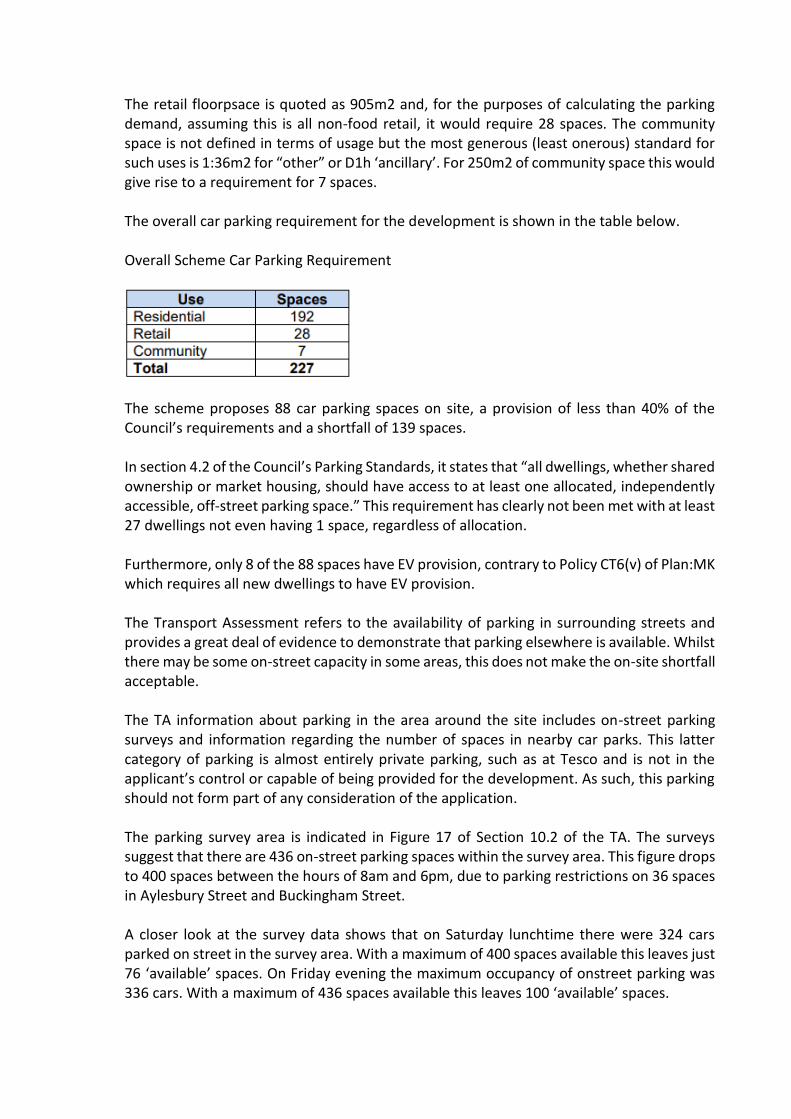
The retail floorpsace is quoted as 905m2 and, for the purposes of calculating the parking demand, assuming this is all non-food retail, it would require 28 spaces. The community space is not defined in terms of usage but the most generous (least onerous) standard for such uses is 1:36m2 for “other” or D1h ‘ancillary’. For 250m2 of community space this would give rise to a requirement for 7 spaces. The overall car parking requirement for the development is shown in the table below. Overall Scheme Car Parking Requirement
The scheme proposes 88 car parking spaces on site, a provision of less than 40% of the Council’s requirements and a shortfall of 139 spaces. In section 4.2 of the Council’s Parking Standards, it states that “all dwellings, whether shared ownership or market housing, should have access to at least one allocated, independently accessible, off-street parking space.” This requirement has clearly not been met with at least 27 dwellings not even having 1 space, regardless of allocation. Furthermore, only 8 of the 88 spaces have EV provision, contrary to Policy CT6(v) of Plan:MK which requires all new dwellings to have EV provision. The Transport Assessment refers to the availability of parking in surrounding streets and provides a great deal of evidence to demonstrate that parking elsewhere is available. Whilst there may be some on-street capacity in some areas, this does not make the on-site shortfall acceptable. The TA information about parking in the area around the site includes on-street parking surveys and information regarding the number of spaces in nearby car parks. This latter category of parking is almost entirely private parking, such as at Tesco and is not in the applicant’s control or capable of being provided for the development. As such, this parking should not form part of any consideration of the application. The parking survey area is indicated in Figure 17 of Section 10.2 of the TA. The surveys suggest that there are 436 on-street parking spaces within the survey area. This figure drops to 400 spaces between the hours of 8am and 6pm, due to parking restrictions on 36 spaces in Aylesbury Street and Buckingham Street. A closer look at the survey data shows that on Saturday lunchtime there were 324 cars parked on street in the survey area. With a maximum of 400 spaces available this leaves just 76 ‘available’ spaces. On Friday evening the maximum occupancy of onstreet parking was 336 cars. With a maximum of 436 spaces available this leaves 100 ‘available’ spaces.

However, these figures do not take into account short term fluctuations in demand, the need to avoid drivers circulating around to find a space, waiting on-street and parking in inappropriate locations for convenience. These issues lead to the use of an optimum figure for car parking capacity, which is 85% of the total capacity. At 85% occupancy the car parking should be considered ‘full’ to allow for these fluctuations in demand and for the convenience of users. Based on this, the optimum capacity of parking in the surrounding streets is 371 spaces between 6pm and 8am (85% of 436 spaces), dropping to 340 spaces between 8am and 6pm (85% of 400 spaces). The optimum capacity of 371 spaces (6pm to 8am) is only 35 spaces over the maximum observed number of cars parked (336) and the optimum capacity of 340 spaces (8am to 6pm) is only 16 spaces over the maximum observed number of cars parked (324). What this shows is that, at best, there is a ‘spare’ capacity of 76 on-street parking spaces until 100% occupancy is achieved, notwithstanding the attendant problems that this would bring. In terms of optimum capacity, there is a ‘spare’ capacity of just 16 spaces between 8am and 6pm and only 35 spaces between 6pm and 8am. Consequently, it can be seen that the availability of usable short-term and long-term (overnight) parking within the vicinity of the development (i.e. a distance away that people would be prepared to leave their vehicle and a distance they would be prepared to walk) is very limited. Even if this parking were considered to be acceptable to serve the development, it would not address the on-site shortfall of 139 spaces. With regard to the on-street parking proposals, the spaces on Buckingham Street have an unacceptable impact on the safety and convenience of pedestrians and the vehicle movements of local residents. These should be removed from the scheme. The proposed spaces on Church Street east of “Block F Street” would also compromise the safety of users of Church Street and the new development and should also be removed. This means that only 5 of the 16 “new short stay town centre parking bays” as shown on the Parking Plan would be delivered. The 2 proposed car club bays on Buckingham Street will also need to be relocated. Furthermore, the 23 “existing town centre parking bays” shown on the Parking Plan are replacing 28 current spaces – a loss of 5 spaces. Therefore, as it stands, the 5 acceptable spaces on the south side of Church Street will simply replace the 5 being lost on the north side of Church Street. The outcome of this is that the proposals have no impact on the overall number of on-street parking spaces, i.e. there is no additional on-street parking. It is understood that the Council is in the process of agreeing to provide further parking spaces off-site; it is believed that this would result in an additional 71 spaces in the car park in St Georges Way. However, those spaces do not form part of this planning application and it is unclear how the delivery of those spaces could be ensured prior to the commencement of this development.

Legally tying the delivery of those spaces to this consent is essential if they are to be considered as mitigation for the scheme. It should be noted that even then, the scheme would still be 68 spaces short (139 deficit minus 71 new spaces in St Georges Way). Summary The proposed scheme does not provide for safe and convenient vehicle, cycle or pedestrian movement in the new and existing streets. Information related to some key vehicle turning movements has not been provided. Delivery of the scheme would not provide the streetscape and transport ‘improvements’ that the applicant is describing. Pedestrian provision is not significantly improved, cycling eastbound is prejudiced and public transport provision is poor. The conversion of Church Street to a one-way street, does not deliver a significant enhancement to the transport provision in the area. Consequently, it does not appear that any minor improvements to transport justify the disruption to these local streets and journeys. Bus provision is minimal (2.5m layby rather than 3m) and the scheme does not appear to include provision for the relocation or replacement of the existing bus charging plates. No mention is made of RTPI enhancement or other improvements to passenger facilities. The creation of private streets within the development, including the street connecting Radcliffe Street to The Square, means that public access and use are not guaranteed and could potentially be reviewed, removed or restricted at any point in the future. On-street parking on church street between Radcliffe Street and Creed Street would remain at 23 spaces; 5 being lost on the northern side, replaced by 5 acceptable spaces on the southern side. The proposed new parking spaces on Buckingham Street are not acceptable. Parking provision, as proposed, is significantly below that required by the Council’s standards. The on-site provision is proposed at 88 spaces, whereas the standards would require 227 spaces. The shortfall is 139 spaces and the provision is less than 40% of the standards. Information provided in the TA shows that 16-35 parking spaces may be available in streets around the development (assuming 85% occupancy), with as many as 76 spaces available were the Council to accept 100% occupancy (which is clearly not advisable). However, the likelihood of new residents, visitors and retail customers using those spaces is low and this spare capacity would not adequately address the 139-space shortfall on site. Provision of additional parking off-site (e.g. the 71 spaces in St Georges Way) may help to mitigate the shortfall, but that is not part of this planning application. Furthermore, the

likelihood of people in the new development parking remotely in St Georges Way is also relatively low. The loss of the Agora parking as a town centre facility is difficult to assess; however, it should be borne in mind that the loss of the car park accompanies the loss of the Agora itself. It is possible that off-site parking (e.g. the 71 spaces in St Georges Way) may offset the loss of some of the Agora car park spaces but this would further limit the impact of the St Georges Way parking on the shortfall of parking within the development. The delivery of the scheme within the red line will not provide the full alterations to Church Street or any changes to Radcliffe Street between Church Street and Stratford Road. The junction of Church Street and Creed Street is also outside the red line and does not form part of the applicant’s proposed works. Unless the Council is able to provide significant levels of additional off-site parking and to deliver the highway works outside the red line, it is difficult to see how the scheme could be considered acceptable. Even then, material changes are needed to the scheme proposals to make them safe and convenient for potential users. Consequently, as submitted, this application: • Proposes a development that is 139 parking spaces short of the Council’s standards; • Does not include the minimum of 1 allocated space for each dwelling; • Does not include EV provision for each dwelling; • Includes unacceptable highway infrastructure proposals; • Would not deliver all of the highway alterations shown on the submitted drawings; • Includes private streets that do not guarantee continued, unrestricted public access; • Does not include sufficient information (e.g. Swept path diagrams, CCTV, existing EV bays, bus charging) As a result, the application, as submitted, is considered unacceptable.” Additional comments “Further to the previous highway objection and comments (see appendix to these comments) sent to the planning officer on 9th February 2021 further meetings and correspondence have taken place with the applicant. These comments relate to the additional information and plans provided by the applicant as follows: 1. Letter from TOWN dated 9 th April 2021 (registered on public access 09/04/21) 2. Landscape Plan: 1068-URBED-Z0-00-DR-L-Landscape_Plan_00 Rev P9 (registered on public access 22/04/21) On the public access system it still shows plan: 1068-URBED-Z0-00-DR-LLandscape_Plan_00 Rev P7 as being a current plan and not superseded by rev P9.

Clarity is therefore needed on which plan is being brought forward for determination. Comments based on plan 1068-URBED-Z0-00-DR-L-Landscape_Plan_00 Rev P9 As a result of discussions, the application has been amended, primarily in respect of the works to the highway. The application no longer includes works to the south side of Church Street other than minor alterations to the existing bus lay-by to provide an ‘in-line’ bus cage on the carriageway (the bus cage layout is not shown on plan 1068-URBED-Z0-00-DR-LLandscape_Plan_00 Rev P9). The one way proposal for Church Street is removed from the application. The proposed changes to parking on Buckingham Street at The Square have also been withdrawn. These changes mean that large parts of the previous highway comments no longer apply, given that changes to the infrastructure are not planned within the application itself. Changes to the infrastructure, as a separate project, may still come forward. The comments below therefore represent the outstanding issues from the original response: The application still proposes the replacement of the Agora centre with a residential and commercial development comprising 115 dwellings, 905m2 of retail space and 250m2 of community space. The proposals also include the creation of a new street on the approximate alignment of Radcliffe Street prior to the construction of the Agora. It is noted that the applicant does not intend for this street to be a public highway; therefore, control of the new street and its use would not rest with the Council. Refuse collection points A1, A2 and B1 as shown on the application drawings, are on a private street. The Council’s collection teams do not collect from private property and refuse is normally expected to be left on the nearest part of the public highway. The acceptability of the refuse collection strategy should be checked with the relevant team. The application still proposes a loading bay on Church Street to the front of Block A. This loading bay restricts the width of Church Street such that two-way movement for general traffic is not possible. This loading bay is also shown immediately adjacent to the junction of Church Street with Radcliffe Street. This would impact on the safe operation of that junction, should vehicles need to wait or stop quickly. Block A has an access with Church Street. As per the existing arrangements on street, an access is also in this location and is covered by double yellow lines which provides visibility for vehicles exiting the site. Introducing a loading bay would restrict visibility for the Block A access when a vehicle is positioned in this loading bay.

A loading bay need only be 15m in length, whereas the one shown is almost 30m. This exacerbates the issue. The proposed loading bay is in the Public Highway, whereas servicing for new developments should take place off the highway. The delivery of the loading bay is not in the gift of the applicant. The Highway Authority has separate powers to implement Traffic Regulation Orders (TROs) if it deems them appropriate. Based on the assessment of the loading bay it is not appropriate or safe to include a bay in this location and it is recommended that revised plans are submitted to remove this because we will not be taking them forward for the reasons stated. Granting planning permission showing a loading bay does not override these powers, or the consultation requirements for TROs. Mindful of this, if the applicant continues to refuse to remove the loading bay from the plans, this can be dealt with by appropriately worded Conditions and Informatives to remove the bay from the proposals should planning permission be granted. Parking The site falls within Zone 2 for the purposes of calculating the required level of parking to meet the Council’s 2016 standards. It should be noted that the parking zones in the Council’s standards already take into account the accessibility of the area and predicted car ownership levels for Milton Keynes. Based on the Zone 2 standards, the Council’s car parking requirements for the residential element of the development are shown in the table below. Residential Car Parking Requirement
The table shows an overall requirement for 192 spaces for the residential element of the scheme, comprising 154 allocated spaces and 38 unallocated spaces. The retail floorpsace is quoted as 905m2 and, for the purposes of calculating the parking demand, assuming this is all non-food retail, it would require 28 spaces (rising to 40 spaces for food retail).
The community space is not defined in terms of usage but the most generous (least onerous) standard for such uses is 1:36m2 for “other” or D1h ‘ancillary’. For 250m2 of community space this would give rise to a requirement for 7 spaces. The overall car parking requirement for the development is shown in the table below. Overall Scheme Car Parking Requirement
The scheme proposes 88 car parking spaces on site, a provision of less than 40% of the Council’s requirements and a shortfall of 139 spaces. In section 4.2 of the Council’s Parking Standards, it states that “all dwellings, whether shared ownership or market housing, should have access to at least one allocated, independently accessible, off-street parking space.” This requirement has clearly not been met with at least 27 dwellings not even having 1 space, regardless of allocation. Furthermore, the proposals include only 8 spaces with EV provision, contrary to Policy CT6(v) of Plan:MK which requires all new dwellings to have EV provision. The applicant’s information regarding parking in the local area is included in the Transport Assessment and this was reviewed in the previous highway comments. No additional information or mitigation has been provided and therefore those previous highway comments stand. The potential for provision of additional parking on nearby land remains, but its delivery is not secured and not tied to this application. The weight that should be attached to this possible parking is unclear. Summary Revised proposals have been submitted that exclude almost all of the proposed changes to the highways around the site. These changes have removed most of the highway safety and layout concerns associated with the original scheme. Some detailed issues still require further agreement, approval or resolution. The key outstanding issue is parking provision.

The detailed issues requiring agreement are: • The bus lay-by provision on Church Street; • The loading bay on Church Street; • The refuse collection strategy. The parking provision proposed is significantly below that required by the Council’s standards. The proposed on-site provision is 88 spaces, whereas the standards would require 227 spaces. The shortfall is 139 spaces and the provision is less than 40% of the standards. Information provided in the TA shows that 16-35 parking spaces may be available in streets around the development (assuming 85% occupancy), with as many as 76 spaces available were the Council to accept 100% occupancy (which is not advisable). However, the likelihood that new residents, visitors and retail customers would use those spaces is low. Furthermore, even this ‘spare capacity’ would not address the 139-space shortfall. The applicant maintains that low car ownership levels for this type of scheme, added to the site’s sustainable location, is strong mitigation against the requirements in the Parking Standards. Provision of additional parking off-site may also help to mitigate the shortfall but that parking is not part of this planning application. The revised application proposes a development that is 139 parking spaces short of the Council’s standards, does not include the minimum of 1 allocated space for each dwelling and does not include EV provision for each dwelling. The revised proposals, with the exception of parking provision and the 3 issues identified above, are broadly acceptable in terms of the layout and content of the scheme. Conclusion Based on the significant shortfall in parking there is the likelihood of capacity issues on nearby streets leading to parking in inappropriate locations to the detriment of highway safety and convenience (Policy CT10). The lack of EV charging points is contrary to policy CT10 and CT6. Based on the above the objection to the planning application is maintained.”
A1.6 MKC Urban Design “The site is located in the Wolverton Conservation area, I will therefore leave the detailed comments in terms of the design of the buildings and their appropriateness to the

surrounding context to my colleagues in Conservation. Notwithstanding this it is evident that much of this proposal is of a high standard architecturally. In terms of layout the main benefit of this proposal is that it reinstates the traditional urban fine grain layout of Wolverton. Improving both legibility and permeability within the town. The proposed development largely respects and adds to the character of Wolverton whilst also being contemporary in appearance. Whilst the proposed height in places is greater than the existing context (see Church Street) the scale and form of the new buildings is similar to the characteristics within the historic area of Wolverton. The density also reflects the existing urban area and higher density development is appropriate for a residential scheme in a town centre within close proximately to a main line railway station. In order to respect the historic Victorian layout there will need to be some flexibility in terms of some current local guidance with regards to the residential layout. Much of the Council’s current guidance with regards to residential dwellings is more applicable to new suburban developments with less constraints, often located on green field sites, not town centre developments on a brownfield sites where the existing character needs to be respected and the density should be considerably higher. The proposed layout is largely consistent with Key Design Policies D1 to D5 in Plan:MK, The approved Brief for the site and Policy W1 – The Agora Site, in The Wolverton Town Centre Neighbourhood Development Plan. It is necessary to acknowledge the importance of reinstating a fine grained perimeter block layout. Reconnecting historic streets will be a huge benefit to the town and reflects both national and local planning policies in terms of permeability, legibility and ease of movement they are positive changes that not only reflect and enhance the character of Wolverton but reinstate a pattern of streets that will foster community and hopefully be maintained whatever the fate of the buildings might be in the future. Whilst the application acknowledges that some separation distance between dwellings appear tight in relation to the guidance in the Council’s New Residential Design Guide (2012), the applicant has detailed how the proposed dwellings have been designed to provide acceptable light and privacy to residents. These mitigating factors include setting the building line back at the rear on the taller parts of buildings and including landscaping specifically to add to privacy. In terms of providing adequate daylight Blocks B, C, D and E are open on the south side, this ensures adequate light to properties. Nearly all properties are also dual or triple aspect. Given the context there is therefore acceptable privacy and daylight and the applicant is compliant with Plan:MK - Policy D5, Amenity and Street Scene. In terms of design and layout, I support the application, as there are many positive aspects in terms of design and layout of progressing this site in the manner outlined. Plan:MK - Policy SD1, PLACE-MAKING PRINCIPLES FOR DEVELOPMENT Reinstating the traditional, permeable streets network will ensure the new development will integrate with the surrounding built form to enable a high degree of connectivity helping

to promote good physical and mental health, with places and routes that are safe and perceived to be safe by creating passive surveillance and active frontages. The proposed development relates well to the surrounding area of Wolverton in terms of density, scale and materials, with positive site features, views and vistas incorporated into and used to structure the new development. The layout, form and detailed design of development adopts passive design measures to reduce energy demand for heating, lighting and cooling, create comfortable and healthy environments for people, and be responsive to predicted changes in climate. On balance the development positively adds to the appearance of Wolverton enhancing the character of the town. New social and commercial facilities and services are provided, and existing facilities improved where possible, to meet the day to day needs of new and existing residents, including, shops, and opportunities for employment. Shops, facilities and public transport stops are located in the most accessible locations, with the layout of development and network of routes designed to provide direct, safe and pleasant routes for pedestrians and cyclists. Housing is arranged according to traditional perimeter block principles so that the fronts of houses overlook streets and other public spaces, and private spaces are located securely within the block. Where the south facing elevation of the blocks are open to ensure sufficient daylight to the properties the private and shared residents gardens are securely gated behind walls and railings to ensure a clear distinction between public and private areas. Development incorporates visual cues in terms of scale and architectural detailing to aid wayfinding through the use of memorable buildings, architecture, public realm design, and views and vistas, not to mention the reintroduction of key streets. The layout and design of development enables easy, safe and pleasant access for pedestrians and cyclists. Opportunities for community cohesion have been maximised through the creation of a permeable environment that is designed in a way that will encourage people to get outdoors for recreation, social interaction, and to move around by non-vehicular means. Plan:MK - Policy D1, DESIGNING A HIGH QUALITY PLACE The development proposals as a whole respond appropriately to the site and the surrounding context of Wolverton. The proposed layout has good continuity of street frontage and locates fronts of buildings to face the street or public space.
The proposed layout has appropriate framing of space to define public and private areas. The layout maximises the surveillance of the public realm, helping to prevent crime and minimise the perception of crime. Ease of movement has been re-established within this area of Wolverton by reintroducing the fine grain urban form that was interrupted by the Agora on Radcliffe St . This results in a place that is permeable and well connected with a safe, attractive and convenient hierarchical network of routes that balances the provision for walking, cycling and public transport with that for private motor vehicles. By re-establishing the tradition street network wayfinding has been improved as the streets are more legible with new spaces and landmarks to help people to find their way around. The proposed development has a variety of layouts, street types, building sizes and forms, uses and housing tenures across the development. Policy D1 Plan:MK - Policy D2, CREATING A POSITIVE CHARACTER The scale and form of the new buildings is on the whole consistent with the characteristic features within Wolverton, albeit with slightly taller building along Church Street. .The layout, massing/scale, public realm / street design, boundary treatments are of Wolverton and the appearance of buildings exhibit a positive character and a strong sense of place that is appropriate for Wolverton. As a result the character of the development is locally inspired which is appropriate not least within a conservation area. The design allows for visual interest through the careful use of detailing, where this is appropriate. Policy D2 Plan:MK - Policy D3, DESIGN OF BUILDINGS Generally the appearance of the buildings and the design of the public realm contributes to the enhancement and creation of a positive character for this part of Wolverton. and manages to combine forward thinking and distinctive architecture whilst respecting the traditional design and form. Although reinterpreting some of the traditional Victorian architectural features has worked better in some instances than others. Where development occurs on both sides of a street, a common character in terms of building appearance is created for both sides of the street, with a careful transition between old and new areas of the town.

Whilst the scale particularly along Church Street is a little larger than the context. The buildings are of appropriate scale in relation to other buildings in the immediate vicinity in terms of their height and massing. The proposed buildings and public realm appear to be designed to a high standard and employ high quality and durable materials, and materials which reflect Wolverton. Policy D3 Plan:MK - Policy D5, AMENITY AND STREET SCENE All proposals will be required to create and protect a good standard of amenity for buildings and surrounding areas. As most blocks are open on the south side the levels of sunlight and daylight within buildings and open spaces, and gardens will be satisfactory. There is a reasonable degree of privacy to new and existing private living space and the main private garden area, with overlooking limited to an acceptable degree through tree planting and buildings being set back above the first floor. Whilst the application acknowledges that some separation distance between dwellings appear tight in relation to the guidance in the Councils New Residential Design Guide (2012), specifically on blocks A, B, and C. It should be noted that this is guidance not policy and it is primarily focussed on new suburban residential estates, largely located on green field sites. Within this context respecting the existing traditional block structure and reintroducing a fine grain of new streets outweigh concerns regarding an additional few metres between dwellings. Crucially, the applicant has detailed how the proposed dwellings have been designed to provide acceptable light and privacy to residents on Pg 40-45 of the Design and Access Statement. These mitigating factors include setting the building line back at the rear on the taller parts of buildings and including landscaping specifically to add to privacy. In terms of providing adequate daylight Blocks B, C, D and E are open on the south side, this ensures adequate light to properties. Nearly all properties are also dual or triple aspect and designed to meet BRE’s site layout planning for daylight and sunlight and consistent with The National Design Guide, creating high quality residential accommodation with good amenity. The design is therefore compliant with Plan:MK - Policy D5, Amenity and Street Scene. The design of the communal garden areas seeks to create spaces that provide opportunities for privacy or seclusion for residents as well as promoting community interaction and play. The new development on the whole is not overbearing upon existing buildings and open spaces. Policy D5 In terms of its design and layout this application achieves a considerable number of improvements over the existing Agora site as this development failed to respect the historic urban form and street patterns of Wolverton.

Respecting Victorian context and the fine grain historic urban form does inevitable result in some compromises. However, in terms of design and layout, I fully support the scheme. The applicant has demonstrated an understanding of Wolverton and as a result the application is of a high quality in terms of design and layout and the scheme should be a high quality, sustainable place to live whilst providing wider benefits to the town on the whole.”
A1.7 MKC Flood and Water Management (the Lead Local Flood Authority) Initial comments “We have reviewed the following documents: - Flood Risk Assessment & Drainage Strategy, prepared by Civic Engineers on 25 September 2020, dated December 2020. At present, we object to the grant of planning permission for the following reason: 1. Insufficient surface water strategy Paragraph 163 of the National Planning Policy Framework requires planning applications to be supported by a site-specific flood risk assessment. Such an assessment should include a surface water strategy and must demonstrate that the proposed development incorporates sustainable drainage systems (SuDS), unless there is clear evidence that this would be inappropriate. In particular, the applicant should address the following: - Inappropriate runoff rates Brownfield (previously developed land) sites must reduce the existing runoff from the site as part of the redevelopment. Where possible, in order to provide betterment, redevelopments should look to reinstate greenfield runoff rates. This is particularly important in those areas of Milton Keynes that are classified as Critical Drainage Catchments. Furthermore, the applicant wishes to discharge into a combined sewer, which can place a significant burden on the existing network. The current proposed discharge rates are unacceptable. - Insufficient SuDS Space will be specifically set aside for SuDS and used to inform the overall layout of development sites. The variety of source control techniques available means that virtually any development should be able to include a scheme based around these principles. The presence of low permeability soils, some forms of contamination and flat topography will not be accepted as reasons not to include source control. The applicant has not demonstrated that adequate source control methods will be used on site, nor have they provided evidence of why they would be inappropriate. - Proposed climate change allowances

All surface water drainage strategies are expected to incorporate the latest climate change allowances for rainfall intensity. The upper end estimate should be used for design purposes and to assess the potential flood risk implications in the design rainfall event including whether there is any increased flood risk to third parties as a result of the development. The applicant has not used the appropriate climate change allowances to inform the surface water drainage strategy. - Hydraulic calculations required Calculations to show the performance of the system for a range of summer and winter storm durations from 15 minutes up to the 10080 minute (7 day) should be undertaken. For the critical 3.3% AEP rainfall event there should be no above ground flooding. For the 1% AEP rainfall event including an allowance for climate change some short term above ground flooding may be permitted. Flood water should be managed to be safe and not enter any buildings or disrupt emergency access routes. - Maintenance and management arrangements For full applications we expect due consideration to have been given to potential organisations who may adopt/maintain the proposed surface water system and this should be outlined within the surface water drainage strategy. There should also be a management plan and maintenance schedule of work detailing the activities required. This should also consider how the system will be managed to prevent surcharging from the combined sewer. - Sewer undertaker consent required The applicant plans to discharge surface water from the site into an existing Anglian Water combined sewer network. The applicant also seeks to divert existing sewer networks. However, a in principle agreement at an agreed rate and connection location from the sewer undertaker is required to discharge into their system. No assumption should be made that a historic connection still exists and therefore the application must be assessed as if there is no existing connection. Informatives Discharge to a combined sewer Where a surface water connection to an existing combined sewer is unavoidable, it must be undertaken in such a manner and at such a location so as to facilitate future separation of the surface water from that combined system. As outlined above, correspondence with the responsible body should be submitted to demonstrate agreement in principle to the discharge and connection point. Anglian Water may require local capacity improvements for sewer connections or a new sewer may need to be requisitioned to connect to the best point on the network. These should be negotiated with the sewerage undertaker directly. Critical Drainage Catchments

Wolverton Proposals for development within Critical Drainage Catchments, as identified in the Milton Keynes Surface Water Management Plan, should investigate the potential for the scheme to reduce or mitigate existing risk in the surrounding area.” Additional comments
“We have reviewed the additional information provided: - ‘Wolverton Agora - Revised Surface Water Drainage Strategy’, prepared by Civic Engineers, reference 948-01-Wolverton Agora, dated 13 April 2021. The applicant has reduced the overall surface water discharge rate to 28 l/s. The applicant seeks to discharge to an Anglian Water combined sewer and divert existing pipework, which has been agreed in principle with the sewer undertaker. The applicant has now included permeable paving within the private street areas as well as highlighting the use of tree pits and raingardens across the site. The applicant also proposes the use of storage crates to provide attenuation for the 1% AEP event plus 40% uplift for climate change. The LLFA do not usually support the use of oversized pipes and below ground attenuation, however it is noted that the overall layout of the development site has impacted the SuDS approach onsite. At present, we require further information to remove our objection: - Hydraulic calculations Urban creep should be considered in any application to account for increases in impermeable surfaces throughout the lifetime of residential development (e.g. the addition of conservatories or building extensions). The applicant should clarify if allowances have been applied where appropriate. - Maintenance/management arrangements Plan:MK FR2 seeks that all surface water drainage proposals for new development must include full details of the means of achieving future management, maintenance and adoption of the systems, prior to approval of any planning permission, to ensure that it will function effectively over the lifespan of the development. For full applications we expect due consideration to have been given to potential organisations who may adopt/maintain the proposed surface water system, which the applicant has confirmed will be a management company for the private street areas. However, there should also be a management plan and maintenance schedule of work detailing the activities required for the entire surface water drainage network. Further guidance regarding the typical key operation and maintenance activities for each type of SuDS component are indicated in Table 32.1 of the CIRIA SuDS Manual. This plan

should also consider how the system will be managed to prevent surcharging from the combined sewer. Informatives Discharge to a combined sewer Where a surface water connection to an existing combined sewer is unavoidable, it must be undertaken in such a manner and at such a location so as to facilitate future separation of the surface water from that combined system. Anglian Water may require local capacity improvements for sewer connections or a new sewer may need to be requisitioned to connect to the best point on the network. These should be negotiated with the sewerage undertaker directly. Critical Drainage Catchments - Wolverton Proposals for development within Critical Drainage Catchments, as identified in the Milton Keynes Surface Water Management Plan, should investigate the potential for the scheme to reduce or mitigate existing risk in the surrounding area.” Further comments “We have reviewed the following information: - Drainage Maintenance & Management, prepared by Civic Engineers, dated April 2021; - Wolverton SW Network 1 with urban creep, dated 27 April 2021; - Wolverton SW Network 2 with urban creep, dated 27 April 2021; - Wolverton SW Network 3 with urban creep, dated 27 April 2021; - ‘Wolverton Agora - Revised Surface Water Drainage Strategy’, prepared by Civic Engineers, reference 948-01-Wolverton Agora, dated 13 April 2021; Alongside: - Flood Risk Assessment & Drainage Strategy, prepared by Civic Engineers on 25 September 2020, dated December 2020. The applicant proposes a surface water discharge rate of 28 l/s to an Anglian Water combined sewer and seeks to divert existing pipework, which has been agreed in principle with the sewer undertaker. The applicant has included permeable paving within the private street areas as well as the use of tree pits and raingardens across parts of the site. The applicant proposes the use of storage crates to provide sufficient attenuation for the 1% AEP event plus 40% uplift for climate change, including an allowance for urban creep. Please note, the LLFA do not support the use of oversized pipes, however the proposed layout of the development has significantly impacted the SuDS approach onsite. The revised landscape design and planting plan (9 April 2021) is inconsistent with the latest SuDS drainage layout. It is recommended that the LPA consult the landscaping team on
these proposed changes to ensure that the effectiveness of the geocellular storage is not reduced or impact on tree health, particularly in relation to Block D. In addition, SuDS planting areas have been incorrectly labelled as Public Realm Mixed Shrubs/Perennial Planting. The applicant should demonstrate that attenuation can be protected or that planting of trees close to the crates is to be restricted. Provided this remaining issue is addressed, the LLFA have no further comments and request the following condition is imposed: Condition 1 No above ground works shall commence until a surface water drainage scheme for the site, based on sustainable drainage principles, has been submitted to and approved in writing by the local planning authority. The scheme shall subsequently be implemented in full accordance with the approved details prior to occupation of the first dwelling. The scheme shall be based upon the principles within the agreed ‘Wolverton Agora - Revised Surface Water Drainage Strategy’, prepared by Civic Engineers, reference 948-01-Wolverton Agora, dated 13 April 2021 and shall also include: a) Full calculations detailing the existing surface water runoff rates for the QBAR, 3.3% Annual Exceedance Probability (AEP) (1 in 30) and 1% AEP (1 in 100) storm events; b) Full results of the proposed drainage system modelling in the above-referenced storm events (as well as 1% AEP plus climate change), inclusive of all collection, conveyance, storage, flow control and disposal elements and including an allowance for urban creep, together with an assessment of system performance; c) Detailed drawings of the entire proposed surface water drainage system, including levels, gradients, dimensions and pipe reference numbers; d) Full details of the proposed attenuation and flow control measures; e) Site investigation and test results to confirm infiltration rates; f) Temporary storage facilities if the development is to be phased; g) A timetable for implementation if the development is to be phased; h) Details of overland flood flow routes in the event of system exceedance, with demonstration that such flows can be appropriately managed on site without increasing flood risk to occupants; i) Full details of the maintenance/adoption of the surface water drainage system; j) Measures taken to prevent pollution of the receiving groundwater and/or surface water. The drainage scheme must adhere to the hierarchy of drainage options as outlined in the NPPF PPG. Reason To ensure that the proposed development can be adequately drained and to ensure that there is no increased flood risk on or off site resulting from the proposed development.

Informatives Pollution Control - Construction Environmental Management Plans (CEMP) Surface water and groundwater bodies are highly vulnerable to pollution and the impact of construction activities. It is essential that the risk of pollution (particularly during the construction phase) is considered and mitigated appropriately. A CEMP should identify how surface water run-off will be managed. In addition to run-off from exposed ground, pollutants from transport routes, washing areas and/or fuel storage areas have the potential to enter a surface water drainage system. It is essential that the risk of pollution is considered and mitigated appropriately. Appropriate interceptors should be included and not rely on retrospectives measures. Discharge to a combined sewer Where a surface water connection to an existing combined sewer is unavoidable, it must be undertaken in such a manner and at such a location so as to facilitate future separation of the surface water from that combined system. Anglian Water may require local capacity improvements for sewer connections, or a new sewer may need to be requisitioned to connect to the best point on the network. These should be negotiated with the sewerage undertaker directly. Critical Drainage Catchments – Wolverton In accordance with Plan:MK, proposals for development within Critical Drainage Catchments, as identified in the Milton Keynes Surface Water Management Plan, should investigate the potential for the scheme to reduce or mitigate existing risk in the surrounding area.”
A1.8 MKC Landscape Services (Tree Officer) “I note that the Tree Planting Plan and the Landscape Plan 00 differ as to the locations of the tree species proposed. Please can this be reconciled? The loss of the car park trees is regrettable but they have suffered from the vagaries of car parking over the years and in terms of the developable area and the mode of development proposed, the trees would pose a significant constraint to the site development. However if an area of public open space were proposed within the area of the existing the car park location as an extension of the church yard space, this could allow retention of some of the better quality trees which would be an improvement in the scheme in sustainability and arboricultural terms as the biodiversity, amenity and carbon sequestration value of new planting cannot match that of existing healthy established trees. But clearly there may be opposing factors to this such as an accepted design code or commercial viability issues, though given that quite a few of the trees are Category B does lend a bit of weight to some of the car park being converted to POS rather than buildings.
The loss of the Plane trees on Buckingham Street and on the corner of Church Street and St Georges Way is rather unfortunate, given that these trees are at the very margins of the site and therefore do not pose a great constraint to development of it. With a little leeway being granted at layout stage these trees could have been retained in return for a minor impact on the developable area. Existing trees as stated above, are much better at making positive contributions than new ones, however it appears that the we have got to the point where amendments to retain these trees could not be achieved without a significant re-design and no doubt questions about viability would be raised. The tree survey and arboricultural implications assessment should have an Arboricultural Method Statement added to it to take account of tree protection measures for retained trees including tree protection fencing, ground protection, no-dig construction proposals and proposals for works within the root protection areas of trees 6, 7, 12, 13, 43 and 44 which may require no-dig construction methods. The provision of the street trees seems a little sparse; I request that the tree planting is increased on the Radcliffe Street link, Church Street and the east-west road within the development. I appreciate that Victorian Wolverton is a terraced town with little in the way of street trees, this is no reason to stint on the provision of trees in new development, particularly given the dire situation with our climate and on-going erosion of species diversity, so where space is available new tree planting should be maximised rather than just aiming to plant a similar amount to those lost. Hornbeams although not particularly fast growing do eventually make very large trees therefore I suggest that these proposed trees are replaced with a species more appropriate to the location. I offer the following list of narrow/small canopied trees as a guide; Acer campestre ‘Elegant’ Acer campestre ‘Elsrijk’ Acer campestre ‘William Caldwell’ Betula pendula ‘Dalecarlica’ Betula pendula ‘Obelisk’ Crataegus monogyna ‘Stricta’ Ginkgo biloba ‘Mayfield’ Malus trilobata ‘Guardsman' Malus tschonoskii Prunus ‘Amanogawa’ Prunus sargentii ‘Rancho’ Sorbus thibetica ‘John Mitchell’ Calocedrus decurrens Cupressus sempervirens ‘Totem’ Picea omorika Pinus sylvestris ‘Fastigiata’ Requested conditions

1. All existing trees to be retained are to be protected according to the provisions of BS 5837: 2012 'Trees in relation to design, demolition and construction - Recommendations' All protective measures especially the fencing and ground protection must be put in place first, prior to any other work commencing on site (this includes vegetation clearance, ground-works, vehicle movements, machinery / materials delivery etc.) and shall thereafter be maintained in place in good functional condition until the project is entirely complete and until, with the exception of soft landscaping works, all contactors, equipment and materials have left site. The fencing shall be on the RPA margin and of the same specification as that depicted in figure 2, page 20 and ground protection as specified in 6.2.3.1 - 6.2.3.5 pages 21/22 in BS 5837: 2012. Signs informing of the purpose of the fencing and warning of the penalties against destruction or damage to the trees and their root zones shall be installed at minimum intervals of 10 metres and a minimum of two signs per separate stretch of fencing. Once erected the local authority tree officer shall be notified so the fencing can be inspected and approved. The Root Protection Area (RPA) within the protective fencing must be kept free of all construction, construction plant, machinery, personnel, digging and scraping, service runs, water-logging, changes in level, building materials and all other operations, personnel, structures, tools, storage and materials, for the duration of the construction phase. The developer shall submit details of the proposed layout and general arrangements of the site in relation to the trees to be retained. In particular, details of storage areas including what substances will stored and where, locations of car parking, welfare facilities, cement plant, fuel storage and where discharge, filling and mixing of substances will take place. The details should include site levels to enable risks posed to trees to be quantified. The RPA will be amended as the arboriculture officer feels appropriate after taking account of the details submitted. No fire shall be lit such that it is closer than 20 metres to any tree or that flames would come within 5 metres of any part of any tree. Earthworks, level changes, service runs, foundations and all other works involving excavation should not be located within the root protection areas. 2. Prior to commencement an arboricultural method statement all in accordance with BS 5837:2012 should be submitted for approval it should include a scale plan accurately marking the position of all the retained trees, the extent of the root protection areas, the BS 5837: 2012 tree protection fencing along the root protection area margin, any areas to be covered in BS 5837: 2012 ground protection, construction details for the BS 5837: 2012 fencing and ground protection, no-dig construction proposals and proposals for all works within the root protection areas of retained trees including soft landscaping works. 3. If construction-facilitation pruning of the trees is required, this should be carried out by a competent, qualified and experienced tree surgeon according to the provisions of BS 3998: 2010 and current arboriculture industry best practice. The Local Authority arboriculture

officer shall be given a week’s notice before the works are carried out so they have the opportunity to attend on site and agree the exact extent of the works with the tree surgery contractor. 4. Where roots are encountered outside the root protection areas excavate carefully, avoid de-barking, breaking, splitting, splintering or shattering the roots. Once uncovered the roots which will have to be removed to accommodate the construction should be cut back to a point 100mm beyond the nearest edge of the construction, they must be pruned back cleanly with sharp, clean pruning saws or bypass loppers making level, smooth right angle cuts with no ragged edges. Shuttering should be used to keep concrete pours 100mm away from the cut root ends. The void should be backfilled with an approved tree planting compost mix finished to the surface. Substances toxic to roots to be kept away from roots, i.e. tars, fuels, oils, bitumen, cement etc.”
A1.9 MKC Landscape Architect “The layout appears dominated by built form and car parking. Whilst other consultees will support this approach to reflect the heritage of Victorian Wolverton, from a Landscape perspective there is an opportunity here to build in greenery and retain more of the existing mature trees which with a sensitively designed approach could contribute to a stronger character and local identity within a quality development. Parts of this site have good quality trees (many of which have individual Tree Preservation Orders on them) which should be retained and if they are not to be retained they should be replaced to provide a considerable net gain in tree stock. The existing TPO’d trees within the Church St car park provide an attractive green and leafy amenity which due to its ‘verdant’ appearance provides some sense of setting for the Church even though it is currently just a car park. These trees add a strong landscape character and attractive quality to the area. The proposed layout could respond in a different way to make a stronger connection between the Grade 2* listed Church of St George The Martyr and Church Street. Selective removals and crown lifting of the trees could provide vistas through to the church and grounds. Instead the layout appears to further separate the connection between the street and the church and its grounds which will be placed behind new buildings. Alternatively, the crossroads of Church Street and St Georges Way could provide a new community space that links views and pedestrian connections to the church. This could allow retention of some of the better quality existing trees which make a greater contribution than new ones in various ways not least in terms of carbon sequestration - new planting cannot match that of existing healthy established trees. The Plane trees on Buckingham Street and on the corner of Church Street and St Georges Way should be retained, given that these trees are at the very margins of the site and therefore don’t pose a considerable constraint to development. We would prefer to see a revision to the layout to retain these trees.
If a final layout is approved a revised arboricultural implications assessment and an Arboricultural Method Statement should be conditioned to secure the final details of tree protection measures for retained trees including tree protection fencing, ground protection, no-dig construction proposals and proposals for works within the root protection areas of trees. The number of proposed street trees should be increased to provide a considerable net gain in tree stock over the number of trees proposed to be removed. We suggest some of these are located on the Radcliffe Street link, Church Street and the east-west road within the development. The proposed changes to the NPPF suggest a new paragraph on the importance of trees in the street scene. ‘Trees make an important contribution to the character and quality of urban environments, and can also help mitigate and adapt to climate change. Planning decisions should ensure that new streets are tree-lined, and that existing trees are retained wherever possible.’ In addition, Covid 19 lockdown has highlighted the importance of good local amenity and street trees contribute to an attractive outlook from buildings and particularly flats / apartments above ground level which have limited or no private garden space. Please note, the loss of existing trees on the site does not appear to be accounted for in the biodiversity calculations. It is regrettable that such a high density development provides so few proposed and replacement street trees for all their benefits in terms of supporting biodiversity, health, amenity / landscape value and for the contribution they makes towards combating climate change. At the very least Landscape DM suggest that as part of S106 discussions there should be an agreed sum for the replacement planting of street trees on a 2 for 1 basis planted within the local vicinity on land where they will not be removed. The drainage strategy indicates some SUDS attenuation storage tanks beneath soft landscaped areas. These should be relocated to place these below hard surfacing and limit the already limited and constrained space available for replacement tree planting. It’s not clear who will be responsible for the landscaped areas of the development. To assess the function and future maintenance of the proposed landscaping a ‘conveyance style’ land management plan should be submitted with an application which clearly shows which areas will be maintained and managed either as: private plot landscape, as semi-private or as public landscape managed for amenity and wildlife benefit. Public landscape shall be managed in perpetuity to ensure the public benefits (including biodiversity) are secure and cannot be removed under private ownership. Areas of landscaping either proposed or existing trees which contribute to amenity infrastructure or form part of the biodiversity enhancement scheme must not be placed in private plot ownership. The landscape plans provide sketch proposals only. Details of planting, boundary treatment and levels should be conditioned. Landscape DM request amendment to the layout as discussed in detailed comments above.

Following an agreed layout the remaining details should be secured by conditions. (Landscape scheme) Notwithstanding the approved drawings, no development shall take place above slab level until full details of both hard and soft landscape works have been submitted to and approved in writing by the local planning authority. Soft landscape works shall include planting plans at a minimum scale of 1:200 with schedules of plants noting species, supply sizes and proposed densities; and a tree planting details drawing. The planting plans shall include existing trees and/or hedgerows to be retained and/or removed accurately shown with root protection areas; existing and proposed finished levels and contours; visibility splays; proximity between street lights and tree planting; proposed and existing functional services above and below ground. All hard and soft landscape works shall be carried out in accordance with the approved details and prior to the first occupation of the building(s) or the completion of the development whichever is the sooner, or in accordance with a programme agreed in writing with the Local Planning Authority. If within a period of two years from the date of the planting of any tree or shrub, that tree or shrub, or any tree and shrub planted in replacement for it, is removed, uprooted or destroyed, dies, becomes severely damaged or diseased, shall be replaced in the next planting season with trees and shrubs of equivalent size, species and quantity. Thereafter the hard and soft landscape works shall be maintained and retained in situ. Reason: To protect the appearance and character of the area and to minimise the effect of development on the area in accordance with Policies D1 and D2 of Plan:MK (2019). (Levels) Prior to the commencement of development including site clearance, details of the proposed finished floor levels of all buildings, ground retaining measures, embankment gradients and the finished ground levels in relation to existing ground levels and root protection areas of trees and planting to be retained shall be submitted to and approved in writing by the Local Planning Authority. The development shall be carried out in accordance with the approved levels. Reason: To ensure that development proposals respond appropriately to the site and is carried out at suitable levels in accordance with Policies D1 of Plan:MK (2019). (Boundary Treatment) Notwithstanding the approved plans, no development shall take place above slab level until details of the proposed boundary treatments have been submitted to, and approved in writing by, the Local Planning Authority. The details shall include a boundary treatment plan (at a minimum scale of 1:500) detailing the position of all proposed boundary treatment, details of hedgehog passes and including a schedule specifying the type, height, composition, elevation appearance of boundary treatment throughout the site. The development shall be carried out in accordance with the approved details prior to the occupation of each dwelling to which the boundary treatment relates, and shall thereafter be retained in that form. Reason: To provide adequate privacy, to protect the external character and appearance of the area and to minimise the effect of development on the area in accordance with policy D1 of Plan:MK (2019).”

A1.10 MKC Countryside Officer
Initial comments “Protection of Sites 1. The development proposals are near to the following sites of designated biodiversity value; a. ‘Main Line’ Milton Keynes Wildlife Corridor (c 120m East); b. ‘Grand Union Canal’ Milton Keynes Wildlife Corridor (c. 300m East); and c. ‘Ouse Valley’ Biodiversity Opportunity Area (c. 300m East). Protected and Priority Species 2. There are records of Protected and Priority Species near to the proposed development site. Ecological Information 3. The proposals do not appear to be supported by an ecological appraisal. 4. The ecological appraisal should be carried out by a suitably qualified professional and include the following: a. A desktop study including a data search from Buckinghamshire & Milton Keynes Environmental Records Centre b. An extended Phase 1 habitat survey, carried out in accordance with the JNCC Handbook for Phase 1 Habitat Survey (2010); c. The potential for protected species to be present and the requirements for further specialist surveys; d. Identify any effects on designated sites or Habitats or Species of Principle Importance and include measures for avoidance and/or mitigation; e. Identify any invasive species; and f. Identify opportunities for biodiversity enhancements. Biodiversity Net Gain 5. Plan: MK Policy NE3c stipulates “Development proposals of 5 or more dwellings or non-residential floorspace in excess of 1,000 sq. m will be required to use the Defra metric or locally approved Biodiversity Impact Assessment Metric to demonstrate any loss or gain of biodiversity.” 6. The proposals are not supported by a BIA. A BIA is required prior to determination of the application to evidence the plans can achieve a net gain for biodiversity. The following items are required prior to determination of the application; 1. An ecological appraisal; and 2. A completed Biodiversity Impact Assessment Metric (DEFRA metric is preferred).
Please send a consultation to the ecology inbox when these items are received.” Additional comments “Protection of Sites 1. The ecological report (Hopkins Ecology, Sep 2020) satisfactorily demonstrates the proposals are unlikely to impact on any sites of designated biodiversity value, and that any such impacts would be negligible (8.2). Protected and Priority Species 2. The ecological report satisfactorily demonstrates the development site is largely unsuitable for protected/priority species (6), with the exception for residual/minor affects to: Bats 3. The report confirms the building to be demolished, and all trees to be lost have negligible potential to support roosting bats. This was supplemented by activity surveys in 2019 and 2020. Low level foraging activity was detected in the area, likely associated with the adjacent cemetery (5). 4. The report highlights that should bats be discovered unexpectedly, works must cease and advice be sought from an ecologist (8.4) and that lighting impact will be limited by appropriate design and cowls (8.5). Nesting Birds 5. Street trees and the buildings to be demolished have the potential to support nesting birds (6). 6. The report recommends works timing to avoid bird nesting season, but that a pre-work check for nesting birds be undertaken if this is not possible (8.4). Shelf Life of Validity 7. The report recommends that if development has not commenced by April 2022 that the surveys be updated to ensure they remain representative of the site. Biodiversity Enhancement & Net Gain 8. The application is supported by two completed Biodiversity Impact Assessment Metric 9. (BIAM). One is the DEFRA Metric, and the other the Warwickshire Metric.

10. Owing to the highly limited value of the site to biodiversity, the proposals result in a net gain of +0.22 units under the Warwickshire Metric, and +0.20 units under the DEFRA Metric (7, 8.6 – 8.8). 11. This is satisfactory under Plan: MK Policy NE3. 12. The report also recommends the provision of 9 Swift bricks integrated into the new units, and the provision of bee bricks within the communal gardens (8.9). 13. Given the scale of the development, there is the opportunity to utilise design features to further incorporate biodiversity value such as green/brown walls and roof space. When the application is suitably ready to be determined, I recommend the following be secured through a suitably worded condition: - A Landscape and Ecology Management Plan (LEMP), detailing the locations, specifications and ongoing management of features and habitats created to benefit biodiversity. To include all features given in section 8 of the ecological report (Hopkins Ecology, Sep 2020), to enhance biodiversity value and to achieve net-gains for biodiversity. - Implementation of the Reasonable Avoidance Measures (RAMs) given in section 8 of the ecological report (Hopkins Ecology, Sep 2020).”
A1.11 MKC GCN Officer “I have no comments to make in respect of GCN Licensing.”
A1.12 MKC Development Plans Initial comments “The proposal is for the redevelopment of the former Agora shopping Centre and Car Park, to provide 115 new homes (Use Class C3), a Cohousing Common House, 9 ground floor commercial and community units comprising approximately 1,000 sqm (Use Classes E, F2(b) and Sui Generis). The site is located within the main town centre and primary shopping area of Wolverton, which is designated as a Town Centre within the Council’s retail hierarchy outlined in Plan:MK Policy ER9. The site is however allocated for residential development in Plan:MK and is designated as such on the Plan:MK Proposals Map. The redevelopment of this site is also the principal focus of the Wolverton Neighbourhood Plan which contains a site specific policy which actively supports redevelopment proposals for the site, furthermore, the redevelopment of the site would aid in the delivery of Strategic Objective 8 of Plan:MK which seeks to support the continued regeneration of Wolverton as a town centre within the main urban area.

A detailed development brief for the site was also adopted by Milton Keynes Council in 2013 as an SPD, this sets out planning and design principles which are consistent with the neighbourhood plan policies relating to the site. The Agora Shopping Centre is now empty and a separate application for the demolition of the building was submitted (19/02989/CON) in late 2019 and permitted in December 2019. A previous planning permission was also granted for a residential-led mixed use scheme in 2016 (15/00913/FUL) for 100 residential units and over 3,000 sqm of large-floorplate retail space, however this permission was never implemented and, the current proposals are submitted by a different applicant. Principle of Development As outlined above the Wolverton Neighbourhood Plan contains a site-specific policy, Policy W1, for this site, which actively supports redevelopment proposals for the Agora site where they are consistent with a set of objectives outlined in the policy. The principle of the current proposal to redevelop the site is therefore generally in accordance with Policy W1 of the Wolverton Neighbourhood Plan, but the case officer will need to assess the proposals against each of the objectives outlined in the policy. The following deals with the principle of development in relation to each of the proposed uses in turn. Residential Uses The site is designated on the Plan:MK Policies Maps as a residential allocation with the specific site reference HS58. The site is located within the urban area of Milton Keynes and as such is in accordance with the settlement hierarchy set out in Policy DS1 which seeks to focus the majority of development in and adjacent to the existing urban area of Milton Keynes. The proposed development is also in accordance with Policy DS2 which sets out the Housing Strategy for the Borough during the Plan:MK period. Specifically, the site is referenced in Table 18.1 in Appendix A of Plan:MK as an existing Housing Commitment and, as such, the residential development of the site is in accordance with Part 3 of Policy DS2. Furthermore, the development of the site for residential purposes accords with Part 6 of Policy DS2 in that the site is identified within a made neighbourhood plan (Policy W1 of the Wolverton Neighbourhood Plan); Part 10 of Policy DS2 in providing a regeneration opportunity around the centre of Wolverton; and, Part 11 of Policy DS2 in that the proposal is for the redevelopment of a vacant, brownfield site within the Milton Keynes urban area. Furthermore, residential use is also supported by Policy W1 of the Wolverton Neighbourhood Plan which outlines under criterion L that any redevelopment proposals should include a mix of new housing. The principle of residential use on the site is therefore in accordance with the relevant policies of Plan:MK and the Wolverton Neighbourhood Plan.
Further support for the residential element of the scheme is also provided via Policy HN5 Part A, which outlines that the Council will support the aspirations of self-build and custom homes and will strongly support proposals for self-build and custom housebuilding that involve the creation of low-cost and affordable housing. The proposed development incorporates an element of custom-build housing within it via the 29 units being delivered as the Still Green Cohousing part of the scheme. Still Green, a local co-housing group, who will be the end users of these units have, as outlined in the planning statement, influenced the layout of the Block, the communal gardens, walkways, the Common House, and individual layouts of the apartments. Current group members will also be able to choose their internal fixtures and fittings for each of their respective homes. Furthermore, 14% of the co-housing units are also to be provided as social rented properties. This element of the scheme is therefore considered to be providing custom-build housing, of which a percentage will also be affordable, and is therefore supported by Policy HN5. Commercial and Community Uses Whilst the site is allocated for residential use within Plan:MK, it also sits within the Primary Shopping Area of the Town Centre of Wolverton and contains both a primary shopping frontage (the northern aspect of the Agora Centre on Church Street) and a secondary shopping frontage (southern aspect of the Agora Centre on to Market Square/Buckingham Street). Policy DS4 of Plan:MK sets out the Council’s strategy for retail and leisure over the plan period. Part A.3. of Policy DS4 outlines that over the plan period the Council will promote and support town centre development (including the night-time economy); this supports the current proposals which would help in delivering this element of Policy DS4. Furthermore, Part E of Policy DS4 outlines that, for ‘Other Town and District Centres’, of which Wolverton is one of, development will be supported in line with relevant policies in their ‘made’ neighbourhood plan. As the redevelopment of the Agora site is a key objective of the Wolverton Neighbourhood Plan and the principle of it is in accordance with the site specific Policy W1 contained within the Neighbourhood Plan, the scheme can also be deemed to comply with Part E of Policy DS4 adding further support to the current proposal. Policy ER9 of Plan:MK which sets out the character and function of the retail hierarchy outlines Wolverton as a Town Centre which will cater for the daily and weekly convenience and comparison shopping and service needs of the catchment population. Part A of Policy ER9 states that “planning permission will be granted for additional retail development within the primary shopping areas of existing ‘town centres’ as defined in national policy, and for other main town centre uses appropriate within town centres such as leisure and entertainment in accordance with the Council’s defined retail hierarchy.” The current scheme proposes to deliver 819.5sqm of commercial (Use Class E) floorspace over 4 units and a drinking establishment covering 83.5sqm (Use Class Sui Generis). The Glossary to Plan:MK outlines main town centres uses to consist of retail development; leisure; entertainment and more intensive sport and recreation uses; offices; and arts,

culture and tourism development. The majority of development that falls under the new Use Class E is consistent with the main town centre uses outlined in the Glossary to Plan:MK, as is the development of a drinking establishment. It is therefore considered that the principle of the commercial units proposed within this scheme are in accordance with Policy ER9 of Plan:MK and are appropriate for delivering the objectives of Wolverton as a Town Centre, as per Part A.2. of Policy ER9. Furthermore, the principle of provision of small scale commercial units, as proposed, is supported by Part M of Policy W1 of the Wolverton Neighbourhood Plan which expects redevelopment proposals to include a range of small to medium sized retail (50 to 1000 square metres) and office units and workshops suitable for current town centre businesses that may require relocation and new occupiers. The scheme also proposes to include one unit for non-residential community use, measuring 105sqm. As the site is located within the town centre of Wolverton, the principle of this element of the proposal is supported by Part A.1. of Policy CC2 of Plan:MK which outlines that “Planning Permission will be granted for: non-residential community facilities within, or adjacent to Central Milton Keynes, town, district and local centres”. Overall, it is considered that the principle of the commercial and community uses proposed within the scheme are in accordance with the retail and leisure development strategy for Milton Keynes as set out in Policy DS4 of Plan:MK and are in accordance with Policies ER9 and CC2 of Plan:MK and Policy W1 of the Wolverton Neighbourhood Plan. In assessing the commercial and community uses proposed in this application, consideration must also be given to Policy ER18 which seeks to protect the retailing function of the main shopping areas of the Borough and to promote town centre vitality and viability. Policy ER18 supports the development of non-class A1 (Now E(a) under new use class order) uses in town centres whereby 6 criteria can be met. It is therefore advised that the Development Management Officer considers any non-retail, commercial or community elements of the proposal against the 6 criteria outlined in Part A of Policy ER18, but does so in the context of the wider objectives of the redevelopment of the Agora site, taking into account in this assessment that the site is allocated for residential use (a non-class A1 use) in Plan:MK, has a site-specific policy within the Wolverton Neighbourhood Plan, the fact that the Agora Centre is currently entirely vacant and, the proposed scheme will be providing new town centre appropriate commercial units at ground level. Furthermore, taking into consideration the consistency of the proposal with the relevant criteria set out in Policy W1 of the Wolverton Neighbourhood Plan, specifically in this case Parts B and M. With regards Part A.3. of Policy ER18, this seeks to provide protection to primary and secondary shopping frontages within town centres, by restricting the location and proportion of non-retail uses. Specific restrictions for each town centre are outlined in Table 6.3 of Plan:MK. The proposed development site currently contains Primary and Secondary Shopping Frontages (as outlined above) which are covered within Table 6.3. Table 6.3 does not place

any restrictions on the proportion of non-retail units on the secondary frontages in Wolverton but does state that the change of use involving the loss of A1 retail will not normally be accepted on Primary frontages. These shopping frontages relate historically to the Agora Centre in relation to the retail units that were located within but are now vacant. The policy in Plan:MK (Policy ER18) which designated these frontages, was adopted prior to submission of this scheme and, as such, without an understanding of how residential-led redevelopment proposals of the Agora Centre, as supported by both Plan:MK (through the residential allocation of the site) and Policy W1 of the Wolverton Neighbourhood Plan, would impact upon these frontages. Therefore, whilst it is recognised that this proposal will result in the loss/rearrangement of primary shopping frontage outlined under Policy ER18 of Plan:MK, the development proposal will enable the creation of both new primary and secondary shopping frontages through the delivery of new units on Church Street, the reinstated Radcliffe Street and Market Square/Buckingham Street. This rearrangement of the shopping frontages is considered to be acceptable taking account of the allocation of the site for redevelopment in both Plan:MK and the Wolverton Neighbourhood Plan. The rearranged/newly created primary and secondary shopping frontages will be picked up in a review of the Local Plan Policies Maps as part of the review of Plan:MK. Other Considerations Housing Mix and Density As the proposal is for more than 11 dwellings, policy HN1 (Housing Mix and Density) of Plan:MK is relevant to this application. It is for the Development Management officer to assess the proposal for accordance with policy HN1 including the impacts of the proposed density of development and the proposed mix of properties. With regards the density of the scheme, specific consideration should be given to Part C of Policy HN1 which outlines that net densities for schemes which propose 11 or more dwellings should balance making efficient use of land with respecting the surrounding character and context, whilst also outlining that higher density development will be encouraged in locations with good accessibility to facilities, that are well served by public transport, and where it can be accommodated by existing or improved infrastructure. Given the site is situated within the town centre of Wolverton, both within the primary shopping area and in close proximity to both the main bus stops and train station, it is likely to be considered a location whereby higher density development would be considered under Part C of Policy HN1. Furthermore, Table 18.1 in Appendix A of Plan:MK outlines the site with an indicative capacity of 140 units, which is a net density of approximately 108 dwellings per hectare, which further supports the potential for higher density development in this location. The currently proposed scheme would achieve a net density of approximately 88 dwellings per hectare. With regards housing mix, Part A of Policy HN1 of Plan:MK requires proposals for 11 or more dwellings to provide a mix of tenure, type and size of dwellings which reflects the Council’s
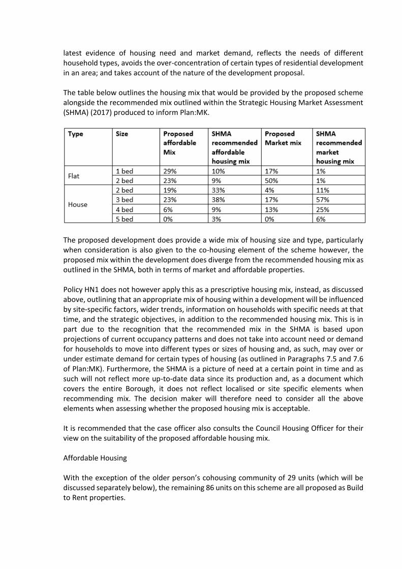
latest evidence of housing need and market demand, reflects the needs of different household types, avoids the over-concentration of certain types of residential development in an area; and takes account of the nature of the development proposal. The table below outlines the housing mix that would be provided by the proposed scheme alongside the recommended mix outlined within the Strategic Housing Market Assessment (SHMA) (2017) produced to inform Plan:MK.
The proposed development does provide a wide mix of housing size and type, particularly when consideration is also given to the co-housing element of the scheme however, the proposed mix within the development does diverge from the recommended housing mix as outlined in the SHMA, both in terms of market and affordable properties. Policy HN1 does not however apply this as a prescriptive housing mix, instead, as discussed above, outlining that an appropriate mix of housing within a development will be influenced by site-specific factors, wider trends, information on households with specific needs at that time, and the strategic objectives, in addition to the recommended housing mix. This is in part due to the recognition that the recommended mix in the SHMA is based upon projections of current occupancy patterns and does not take into account need or demand for households to move into different types or sizes of housing and, as such, may over or under estimate demand for certain types of housing (as outlined in Paragraphs 7.5 and 7.6 of Plan:MK). Furthermore, the SHMA is a picture of need at a certain point in time and as such will not reflect more up-to-date data since its production and, as a document which covers the entire Borough, it does not reflect localised or site specific elements when recommending mix. The decision maker will therefore need to consider all the above elements when assessing whether the proposed housing mix is acceptable. It is recommended that the case officer also consults the Council Housing Officer for their view on the suitability of the proposed affordable housing mix. Affordable Housing With the exception of the older person’s cohousing community of 29 units (which will be discussed separately below), the remaining 86 units on this scheme are all proposed as Build to Rent properties.
With regards Build to Rent schemes, Policy HN2 of Plan:MK does make allowance for these schemes in terms of the expected provision of affordable housing. As outlined in Parts F and G of Policy HN2, where a development complies with the Milton Keynes Council definition of Build to Rent housing, as outlined in paragraph 7.18 of the plan, the standard requirement for 31% affordable housing provision should be provided entirely as Discounted Market Rent (DMR), to be managed by the Build to Rent provider and provided at rent levels (including service charges) which are set at no more than 80% of market rents or the Local Housing Allowance rates, whichever is lowest. The applicants outline that 31% of the Build to Rent properties proposed will be provided at DMR with rent levels set at 80% of market rent. The Development Management Officer will need to be satisfied that the scheme meets the Milton Keynes definition of Build to Rent; that the proposed rental levels include service charges; and, that the proposed 80% of market rent level is lower than the Local Housing Allowance Rates. If these criteria are all met, then the Build to Rent element of the scheme can be considered to be in accordance with the relevant sections of Policy HN2. With regards the older person’s cohousing community of 29 units, the proposal provides only 14% of these units as affordable dwellings, all in the form of social rented properties; this departs from the expected 31% level required in Policy HN2. The applicants have submitted both an Affordable Housing statement and a Viability Assessment to outline why this element of the scheme cannot viably achieve the 31% affordable housing provision as required by Policy HN2 but does provide the maximum reasonable amount of affordable housing on-site. Sections of Policy HN2 (D and E) do allow for consideration of the viability of developments in relation to the provision of affordable housing and enable a flexible approach to be taken where it is demonstrated to the Council’s satisfaction, through the submission of viability evidence, which is open and transparent, that the provision of 31% affordable housing would deem the scheme unviable. It is therefore for the decision maker to consider the viability evidence submitted by the applicant and determine if the application can be considered to comply with part D of Policy HN2 and thus not provide the full 31% affordable housing provision required. The proposal involves the redevelopment of a site which is allocated within both Plan:MK and the Wolverton Neighbourhood Plan for this purpose. The principle of the proposal is considered to comply with policies DS1, DS2, DS4, ER9 and CC2 of Plan:MK, and Policy W1 of the Wolverton Neighbourhood Plan and, therefore, the Development Plans Team have no objections to raise with regards to the principle of the proposed development. It is however advised that the decision maker review the information provided with regards to the affordable housing provision within the proposed co-housing element of the scheme to ensure that this part of the proposal can be demonstrated to comply with Policy HN2.

Additional comments “The purpose of Policy W6 of the WNP is to enable the provision of small retail units (which could include lockable units) of up to 50 square metres (gross) and, of relevance to this application, the policy outlines that opportunities to provide this type of unit will be sought through planning consents or section 106 planning obligations linked to any major redevelopment. The relevant part of the policy to this proposal is Part A, which reads as follows: A. Provision through major development In the case of provision through a major development, the following requirements shall apply: • For schemes involving over 1,000 square metres of development the provision of small shops will be required subject to viability, with the number of units relative to the size and scale of the development. • Once provided in a new development, a condition (or legal agreement if appropriate) should be put in place so that planning permission would be required for any proposal to combine smaller units into larger units. As the proposed development is over 1,000 square metres we would expect it to comply with Policy W6 and to make provision of small shop units within the scheme, the number of which would be relative to the size and scale of the development. With regards the number of units to be provided, the supporting text to the policy at Paragraph 10.37 states that “to meet the requirements of Policy W6 Part A, 25% of the floorspace on schemes over 1000 square metres, subject to viability, should be small shops.”. As this does not however form part of the policy itself, this should be used as guidance and should form the starting point for applicants to consider in terms of provision of small shop units, as opposed to being a fixed requirement. Similarly, Paragraph 10.38 of the supporting text to Policy W6 also outlines that “Subject to viability, a proportion of the small shops provided through Policy W6 should have affordable rents to support start-up businesses and encourage local entrepreneurship.” Again as this is not in the Policy itself, this is not read as a strict requirement of Policy W6, but it is anticipated that applicants ‘should’ consider the potential to deliver a percentage of the smaller retail units with affordable rents where viable. Whereby a scheme is not proposing to deliver small retail units, as is the case here, Policy W6 outlines that the applicants will need to demonstrate that it is not viable to include these within the proposals so as to enable compliance with Policy W6. It is therefore advised that the applicants need to viability test this requirement and provide the case officer with evidence to demonstrate that the delivery of small retail units would not be viable as part of this scheme. It is suggested that this testing use the requirements set out in Paragraph 10.37 (as set out above) with regards the amount of floorspace to be provided, as the upper limit of floorspace requirement.”

A1.13 MKC Housing Officer Initial comments “The Council’s Plan 2016-20 approved at Council 8 June 2016 has the Key Priority: ”Growth and Affordable Housing – securing the future of Milton Keynes by continuing to support Plan:MK and supporting the aspiration that MK should grow to a population of 500,000 and beyond by 2050”. As per Policy HN2 (Affordable Housing) of Plan:MK any development that proposes for 11 or more homes should provide at least 31% affordable housing. The policy states a tenure mix of affordable housing will consist of approximately: • 20% of units under the Affordable Rent model (up to 80% of market rents) or Local Housing Allowance (whichever is lower); • 5% of units at a level broadly equivalent to Social Rent; and • 6% Shared Ownership (based on a range of 25% - 40% equity share in order to be classed as Affordable Housing). For this development the Affordable Housing we would expect to see is minimum 36 units to be compliant. We understand this site is proposed to be mainly ‘Build to Rent’ plus a 29 unit Co Housing Block (C). In this case we will deal with them as 2 entities, 86 Units in the PRS Scheme and 29 Units in the Co Housing Scheme. For PRS schemes policy requires 31% of the homes to be delivered at DMR. In this case, the Affordable Housing to be 27 units, to be compliant, and all as Discounted Market Rent (DMR). For the 29 unit Co Housing Block C we would expect to see 9 Affordable Housing units. In either scheme, any proposed Affordable Housing house size mix should be in line with current Affordable Housing need and policy; predominantly 3 bed and 2 bed, then 1 bed and 4 bed properties, as appropriate for the site and development. The 2017 SHMA indicates that only 9.8% & 8.5% respectively of the 8,200 Affordable Housing needed between 2016 and 2031 should be one-bed and two-bed flats. Instead, the need is predominantly for 3 and 2 bed houses as the table below shows:

Table 1: Expected Market Sale and Affordable Housing tenure
While Table 1 above is only reflecting the PRS Scheme the principle is still the same with the Co Housing. In reference to both the PRS Scheme and the Co Housing Block we would like to see the Affordable units dispersed throughout the site and integrated with the market housing to promote community cohesion & tenure blindness. We do not want clusters of more than 12 Affordable units. Any variance to the mix as required and detailed in the SHMA may need to be assessed through a viability assessment and against all other material planning considerations. Accessibility & Adaptability of Homes As per policy HN4 of Plan:MK, further to requirements for minimum 60% of all new dwellings to be built to Building Regulations Part M4(2) standards for accessible and adaptable dwellings, plus at least 5% to readily adaptability to M4(3), plus at least 10% of all new affordable homes must be built to Building regulations part M4(3) wheelchair accessible standard.
Thank you for overproviding on the M4(2) compliancy. Please increase the M4(3) compliancy by 1 to 9 in total. Specific Commentary to this site The reduced onsite parking will have to be a consideration by the Planner and MKCs Transport team. We appreciate the ecologically friendly approach to include the cycle parking and that the site is a community within itself and its location is central to all the amenities Wolverton has to offer. Is there visitor parking, especially for overnight visitors?

Milton Keynes Council require, for Affordable Housing provided at DMR, the rent levels (including service charges) to be set at no more than 80% of market rents or the LHA rate, whichever is the lowest. (G in Policy HN2 of Plan:MK) There was Pre preapp discussion last year where Housing Strategy presented an agreeable table for the housing mix/tenure. It appears that the table presented in the Housing Statement mirrors this sufficiently to make it acceptable. It provides for 27 Affordable Private Rented dwellings to be rented at 80% of market rent in the Discounted Market Rent Scheme and Four 1 bedroom units at Social Rent in the Co Housing Scheme. The DMR units are to be set at no more than 80% of market rents and are not required to include any Social Rent. While 31% in the Co Housing Scheme would mean 9 units we are content with the Four 1 bedroom units being they are all to be at Social Rent and are pleased and hopeful of the following from within the Housing Statement: ‘It is not expected that Social Rent tenants will pay the service charge that other dwellings will pay to maintain the co-housing common parts.’ However, we are concerned that in the Co Housing Block C there is no elevator, yet the Housing Statement terms this ‘Older persons Housing’ in a supportive living environment. An elevator would allow this accommodation to meet the residents’ needs throughout their lifetime and ensure long term residency. The proposal is for 3 levels with only stairs to access the 1st and 2nd floors. We do note and appreciate the two disabled toilet facilities with the Communal Facilities. Further, these homes would be better suited to M4(3) compliance for the same reason. We appreciate your attention to the provision of the M4(2) and M4(3) compliancy, however, more consideration is required as to location of the compliant units and the increase of 1 M4(3) as above. If M4(3) units are not provided at ground level elevators will be required. Being that the plans indicating the locations of the M4 Building standards units and the ‘Tenure mix distribution’ plans are embedded in the Housing Statement they are difficult to read and compare to other plans submitted being that it is not immediately clear what are to be flats and what are to be houses on either plan. We would, for ease and clarity, suggest the M4 classifications, house types and tenure be detailed on, possibly, the overall Site Wide Plans submitted. Attached, please find the Housing Accommodation Schedule template to be filled in and submitted in order to properly assess the locations of all the DMR and Affordable Housing. It will also aid in making clear the location of the M4 building standards. It must correlate with a detailed plan or plans (for each floor if flats on site). (possibly the Site Wide Plans?) This Accommodation Schedule and plan(s), once agreed, will form part of Clause 1 in the Decision Notice. We would like to see a table of your proposed rent levels for the DMR properties in order to be comfortable that they are based on true market rent levels and provide a starting point

for possible negotiation. Please provide evidence and justification for the proposed market rent figures and include any service charges. (These must be included in the total DMR level which should be up to 80% of market rent.) If preferable this can be conditioned in either the Decision Notice or the Section 106. We appreciate that the applicant will work with Still Green Co-housing and Milton Keynes Council to procure a suitable registered provider to acquire and let the Social Rented units, taking account of the special conditions pertaining to a co-housing community including: The need for lettings to take account of the ethos and age-restriction criteria of the development; • The importance of prospective tenants being enabled to understand the co-housing ethos, what it offers and entails and to decide if it is suitable for them; • The ideal that prospective residents are identified before completion/occupation in order to participate in community-forming activities before moving in; and • Suitable arrangements between the registered provide and Still Green Cohousing as the overarching management entity to ensure appropriate day-to-day management of the Social Rent units. We would wish this to either be presented and agreed prior to approved planning permission or conditioned in the Decision Notice or Section 106 Agreement. At this stage we object, and our response is comments and expectations only as there is not enough clarity in the submissions as indicated above to make a full assessment of the scheme; detail as to location of M4 units, the increase of 1 to M4(3), the requirement of either M4(3) homes at ground level in Block C or an elevator. The Development needs to comply with Plan:MK (2019). Strategic Housing welcome further discussions in regard to the DMR and Affordable Housing provision.” Additional comments “We are generally happy as much more clarity has been provided of which has indicated a few errors that we’d like to see corrected. Further, we need qualification of the location of the M4(3) readily adaptable. We appreciate that the numbers have been revised to be policy compliant but still need to know the location of these dwellings. The unit qualified as M4(3) compliant in Block C on the Housing Accommodation Schedule is not the same unit # as on plan ZZ_00_DR_AR_910 Accessibility distribution_PL01; on plan ZZ_00_DR_AR_910 the M4(3) compliant unit is Unit 03 whereas on the Housing Accommodation Schedule it is Unit 01. The Discount Market Rent unit number 23 on the fourth floor of Block A is said to be DMR on the Housing Accommodation Schedule but does not match plan ZZ_00_DR_AR_920 Tenure mix distribution_PL01 as it is coloured green whereas DMR is purple (12 DMR on the Housing Accommodation Schedule and 13 on plan ZZ_00_DR_AR_920 Tenure mix distribution_PL01)
In light of the need for clarification of which units are M4(3) readily adaptable I have added a column into the attached Housing Accommodation Schedule to enable the insertion of the location of the M4(3) readily adaptable dwellings.” Further comments “The information that concerns Affordable Housing is on this copy of the Housing Accommodation Schedule (location, type and M4 info) and as long as the other copy with the ‘private’ information still stands as informing us of the rents proposed, we are happy. As I said the other day, we would have liked the policy compliant 31% but are content with the 27% with the 4 being Social Rent homes.”
A1.14 MKC Archaeology “I have assessed the site against the known archaeological resource as contained in the MK Historic Environment Record (HER). In conclusion I am pleased to state that the proposed development is not regarded as being of significant potential archaeological impact. As such it is, in my view, unnecessary to conduct any pre-determination archaeological investigation nor do I wish to recommend any archaeological condition in respect of the site.”
A1.15 MKC Environmental Health
Initial comments Contamination; “I have read the report submitted in respect ground contamination (GEA, June 2019) and have the following comments to make. The historical records do not indicate there are any potential sources of contamination and the site investigation did not reveal any elevated levels of contamination apart from one elevated lead level, which will underneath building. However the site investigation was carried out around the existing building, therefore large areas have understandably been excluded from the investigation. Because of this and the age and location of the building I am still concerned about the potential contamination from made ground. The report concludes that a discovery strategy should be employed during the development of the site and I would be grateful for more detail from the developer as to the details of this, or perhaps it would be worthwhile having a condition in this regard I order to address unforeseen contamination? The report also concludes that the areas of soft landscaping will need to have topsoil introduced as a growing medium what depth would be introduced and would this be the same in the communal areas and private gardens please?”

Noise; “I've no objection to this development but would request a CEMP including the following hours of operation for noisy works, as per adopted hours under the Control of Pollution Act 1974: 0800-1800 Mon-Fri 0800-1300 Sat No noisy works on Sundays or Bank Holiday’s.” Air Quality; “I have read the Air Quality Assessment (CERC, Dec 2020), which was carried out in accordance with the IAQM, ‘Land-Use Planning & Development Control: Planning for Air Quality’ methodology. The conclusion of the report is that the change in concentration relative to the air quality standard will be slight. Therefore I have no recommendations regarding any conditions in respect of air quality. Both the contaminated land ground investigation and the air quality assessment have highlighted the importance of dust control on site, which will hopefully be covered by the CEMP. I would be grateful if you could remind the developer that this will need to closely monitored by the contractors on site due to the proximity to residential properties.” Additional comments Contamination; “Thanks for the additional information. Please can you include the following condition? A Discovery Strategy should be employed in order to ensure the examination and appropriate reporting of the areas of the site not covered in the scope of the original intrusive site investigation into potential ground contamination. Should any unforeseen contamination be encountered the Local Planning Authority shall be informed immediately. Any additional site investigation and remedial work that is required as a result of unforeseen contamination will also be carried out to the written satisfaction of the Local Planning Authority. Reason: To ensure that the site is fit for its proposed purposed and any potential risks to human health, property, and the natural and historical environment, are appropriately investigated and minimised.”

A1.16 MKC Conservation “Conservation Area The Agora building and proposal site form part of the Wolverton Conservation Area, a designated heritage asset. The Wolverton Conservation Area Review (2009) sets out in depth the significance of the conservation area, and the contribution of the Agora to it. Setting of Listed Buildings Designated heritage assets / listed buildings stand adjacent to the eastern part of the site; Church of George the Martyr and its Mortuary Chapel, The Methodist Church and The Former St. Georges Institute / Madcap building. Each of these buildings is of national architectural or historic interest, together they an important grouping within the town, making a positive contribution to the character and appearance of the conservation area. To the south, the Wolverton Memorial Cross (Wayland Tunley of MKDC) stands in The Square. The site falls within the immediate setting of these designated heritage assets / listed buildings. Whilst the site sits within the setting of the nearby listed buildings, The Agora building itself does not contribute to their setting or, in turn, their significance. The Agora has planning permission to be demolished, which received conservation support at the time, therefore a view on of its significance and demolition is not given here but is available on my response to planning application 15/00913/FUL. Development Principle The redevelopment of the Agora site and the adjacent car park is strongly supported, having the potential to deliver public benefits, including some that are heritage benefits. In particular, the overall layout proposed will reinstate the earlier grain of the town, reversing the damage done to it by The Agora redevelopment. This aspect is strongly supported. The decision to implement a modern architectural approach to the scheme is also supported, as is the applicant’s endeavour to understand those aspects that are important to character and appearance of the town, something that is clear from the supporting material submitted. Development Detail As above, those aspects that form the overall approach are supported as is the need to regenerate the site. However there a number of aspects that individually and cumulatively will cause harm to the designated heritage assets affected.

Scale / Height The scheme is typically larger than those buildings directly around it. In some cases this may be only by a single storey but can be exacerbated by larger storey heights and differing architectural forms. There are some areas where this will be felt as a subtle change in scale but others where the difference will be more of a step change, for example Block A facing over Church Street. The experience will vary upon where the viewer is, but the overall one will be that the development is identifiable from its surroundings because it is taller and more assertive. Whilst buildings taller than their context do not automatically cause harm to heritage assets, the overall scale of this development does mean that it is likely to impose itself and draw some attention away from the traditional character and appearance of the conservation area and the individual quality of the listed buildings. However, when considering this impact it will need to be judged within the context that, the development brief for the site advocates three and four storeys and a previous, approved planning permission was of similar proportions to what is now proposed. Building Design The buildings within the proposed scheme vary in their approach with, from a conservation perspective, mixed degrees of success. The smallest of the building types (two to the rear of Block A and on to the rear of Block C) successfully evoke the scale and form of the workshops often seen to the rear of Wolverton residential plots. These alongside a short run of proposed houses facing The Square are the only buildings in the development to feature genuine pitched roofs. Despite shallow slate roofs being one of the most prominent and consistent characteristics of the conservation area, the scheme consists of almost entirely flat roof blocks (as is illustrated by the axonometric visual on page 8 of the Design and Access Statement). The buildings in the scheme divide up into those that attempt to disguise the flat roof form and those that are overtly flat roof in appearance. On those buildings that attempt to disguise the flat roofs, overly steep, false pitched roofs and roof type ceramic tiles on top storey vertical surfaces are employed. On these buildings the façade carries upwards past the eaves line in various positions to form something akin to a very tall, flat, dormer window. Unfortunately this has the effect of making the buildings look top heavy when compared to the existing buildings in Wolverton . It is worth noting that this type of dormer window has been resisted on existing dwellings in Wolverton, and won at appeal, in order to preserve the linear, historic roofscapes, this therefore presents a bit of a contradiction. It is a shame the simple building forms and shapes found in the conservation area have not been utilised in greater amounts within the proposal, more sparing use of the tall dormer form might have proved more recognisable, simple, linear roofscapes (much like those in the Marmalade Lane scheme by the same developer, referenced in the Design and Access Statement, page 42, photo 2). Ultimately the design of these individual buildings is one
which contrasts basic building forms of the area, but does achieve a design which will be recognisable as a re-working of Wolverton terraced houses. Sadly, the buildings that are overtly flat roofed are conspicuous in being at odds with the overriding character and appearance of the conservation area. The impact of these blocks is most apparent along Church Street in Block A, Block C and Block F, none being instantly recognisable as belonging to Wolverton or appreciable as a reinterpretation of the Wolverton context. Whilst the flat roofed building facing south over The Square (Block A) adopts an somewhat alien approach, it does have some individual character and quality and is clearly trying to stand in its own right. The buildings above are perhaps guilty of being caught in a middle ground, neither recognisably responding to context nor adding buildings of individual quality. Block F is by someway the least successful building within the scheme. It sits directly within the grouping of listed buildings which all have individual architectural merit. This part of the site is also effectively a gateway to this part of the town, any building within it will be particularly prominent when approach from the north or east. Again, the proposed flat roofed building looks alien to Wolverton, despite oblique references, yet also fails to introduce a building that would bring individual quality to the grouping of listed buildings (in contrast to the building that occupied the site previously) and make the most of this prominent position. Then ends of Block D closest to the church provide somewhat bland, unarticulated elevations towards the listed building. Whilst the rear of Block D itself otherwise provides visual interest, these ‘ends’ are somewhat lacking and could prove to be quite dominant when viewed from the church grounds. Detail. As above, the modern re-interpretation of distinct Wolverton character and appearance is welcomed. Often in such schemes, the continuity of material types and quality can help root differing designs into an existing context. There are a number of elements however that are employed throughout the scheme in such quantity that cumulatively they undermine the quality of the built context. Briefly, these are: • The repeated use of concrete lintels over windows, with no arches present in the scheme (there are some used on doors). • Use of concrete throughout the scheme in place of natural stone. • Vertically divided, casement windows. It is noted that the architects have gone to great lengths to use vertically proportioned openings throughout the scheme which is a positive step. However, despite almost every single building in Wolverton having been constructed with sash windows divided horizontally at the mid-point, neither of these elements, separately or combined, are found in the proposed scheme. All windows are vertically divided and none appear to be sash. Other details that are alien to Wolverton: • The use of timber roof shingles – these are not found traditionally anywhere in the borough, or typical the region.
• The use of beaver tail roof slates - again these are not reflective of the overriding character of Wolverton and are normally found only on one-off buildings with a particularly decorative approach. Summary The key aspects of the scheme are strongly supported, particularly the regeneration of the area and the reinstatement of historic street layout, some public benefits will be delivered by these aspects. The applicants and architects have clearly made effort to understand the context, character and appearance of Wolverton. In some aspects of the scheme this is evident, either as a direct response or as a reinterpretation. Unfortunately some aspects of the scheme fall short of reinforcing the local distinctiveness of the area or introducing the quality of building required in this location. In addition, the blanket use of some architectural elements undermines visual interest, architectural quality and the breaking down of scale. The issues with roofscape and building forms along Church Street, particularly block F have been raised previously. The combination of these aspects cause harm to the character and appearance of the conservation area and harm to the setting of the listed buildings adjacent to the eastern portion of the site. This harm falls into the less than substantial category. The NPPF directs ‘great weight’ should be given to conservation of heritage assets irrespective of the level of harm (193). Ultimately this harm will need to be considered and weighed against the public benefits delivered by the scheme (196), however the NPPF directs LPA’s ‘to avoid or minimise any conflict between the heritage asset’s conservation and any aspect of the proposal’, to that end I recommend that amendments are sought from to address the above points, principally: • The design of the flat roofed buildings (those with continuous eaves) are revisited in order to provide an acceptable response to the context to Wolverton conservation area. • Block F is re-designed to provide a building which reflects the context or introduces individual architectural quality to reinforce the grouping of listed buildings adjacent. • The details mentioned above are reconsidered in some parts of the proposal to provide some variety and reference to local character.”
A1.17 MKC Cycling
No comments received.
A1.18 MKC Passenger Transport Initial comments “Replacement and upgrade of existing public transport infrastructure consisting of bus stop area with raised boarding kerbs, bus shelter, real time information display, passenger circulation area together with adjacent layover area(s) for terminating bus services.

Wolverton Church Street is one of the busiest stops in Milton Keynes outside of the Central area. It is served by both frequent core services together with other less frequent secondary services. Although some services operate across Wolverton, most terminate at Church St. Operating hours cover most of the day as would be expected at such a busy location. Current infrastructure consists of a picking up/setting down stop with a raised boarding area, shelter, real time information display and passenger circulation area. At other nearby locations in Church St there are marked setting down/layover areas for terminating services. To cater for at least the previous level of use and service frequency pre covid requires that similar facilities are provided. The opportunity exists to replace and upgrade the shelter with a new structure. The circulation area for waiting passengers should be maintained. There is also an opportunity to improve passenger transport information by the addition of eink displays. The installation of electronic information displays at the stop will enable the provision of high-quality bus service information including real time timetable information. Studies have shown that real-time information reduces the perceived wait time for customers building the confidence of passengers using the services and thereby encourages greater use.” Additional comments “The Agora development is 1 and 2 bed flats and they have put a lot of work in on active travel planning so our ask is likely to be challenged on those grounds. I’m happy to consider the provision of the eink/real time displays as part of the scheme to replace the Church St bus stops. Contributions can be made towards MK Move Credit for each household.”
A1.19 MKC Travel Plan Coordinator “A travel plan has been received as part of the application which is acceptable. To ensure that the travel plan is delivered according to the contents, the travel plan should be secured by S106 planning obligations. The preferred method of monitoring travel plans is through Modeshift STARS https://www.modeshiftstars.org/ and access is free. In particular for the travel plan to be effective should seek to deliver its commitments, detailed below • A designated Travel Plan Coordinator/Champion and contact details shared with • Travel surveys and consultation exercises, carried out within3 months of occupation and thereafter undertaken annually. • Delivery of measures has detailed within the travel plan, to increase active and sustainable travel to the site.
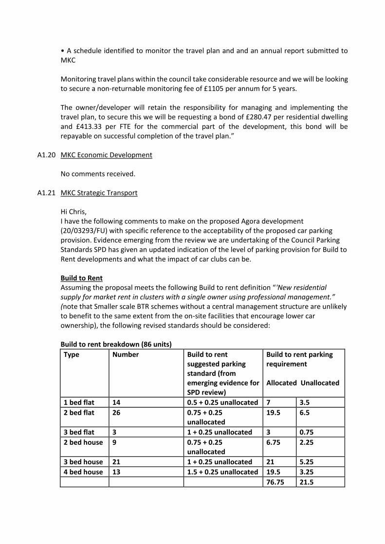
• A schedule identified to monitor the travel plan and and an annual report submitted to MKC Monitoring travel plans within the council take considerable resource and we will be looking to secure a non-returnable monitoring fee of £1105 per annum for 5 years. The owner/developer will retain the responsibility for managing and implementing the travel plan, to secure this we will be requesting a bond of £280.47 per residential dwelling and £413.33 per FTE for the commercial part of the development, this bond will be repayable on successful completion of the travel plan.”
A1.20 MKC Economic Development
No comments received.
A1.21 MKC Strategic Transport Hi Chris, I have the following comments to make on the proposed Agora development (20/03293/FU) with specific reference to the acceptability of the proposed car parking provision. Evidence emerging from the review we are undertaking of the Council Parking Standards SPD has given an updated indication of the level of parking provision for Build to Rent developments and what the impact of car clubs can be.
Build to Rent Assuming the proposal meets the following Build to rent definition “'New residential supply for market rent in clusters with a single owner using professional management.” (note that Smaller scale BTR schemes without a central management structure are unlikely to benefit to the same extent from the on-site facilities that encourage lower car ownership), the following revised standards should be considered:
Build to rent breakdown (86 units)
Type Number Build to rent suggested parking standard (from emerging evidence for SPD review)
Build to rent parking requirement Allocated Unallocated
1 bed flat 14 0.5 + 0.25 unallocated 7 3.5
2 bed flat 26 0.75 + 0.25 unallocated
19.5 6.5
3 bed flat 3 1 + 0.25 unallocated 3 0.75
2 bed house 9 0.75 + 0.25 unallocated
6.75 2.25
3 bed house 21 1 + 0.25 unallocated 21 5.25
4 bed house 13 1.5 + 0.25 unallocated 19.5 3.25
76.75 21.5
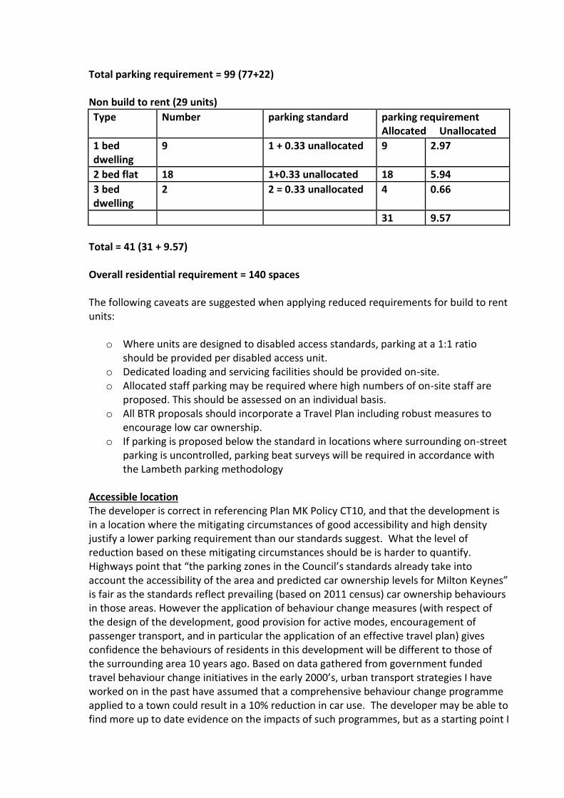
Total parking requirement = 99 (77+22)
Non build to rent (29 units)
Type Number parking standard parking requirement Allocated Unallocated
1 bed dwelling
9 1 + 0.33 unallocated 9 2.97
2 bed flat 18 1+0.33 unallocated 18 5.94
3 bed dwelling
2 2 = 0.33 unallocated 4 0.66
31 9.57
Total = 41 (31 + 9.57)
Overall residential requirement = 140 spaces
The following caveats are suggested when applying reduced requirements for build to rent units:
o Where units are designed to disabled access standards, parking at a 1:1 ratio
should be provided per disabled access unit. o Dedicated loading and servicing facilities should be provided on-site. o Allocated staff parking may be required where high numbers of on-site staff are
proposed. This should be assessed on an individual basis. o All BTR proposals should incorporate a Travel Plan including robust measures to
encourage low car ownership. o If parking is proposed below the standard in locations where surrounding on-street
parking is uncontrolled, parking beat surveys will be required in accordance with the Lambeth parking methodology
Accessible location The developer is correct in referencing Plan MK Policy CT10, and that the development is in a location where the mitigating circumstances of good accessibility and high density justify a lower parking requirement than our standards suggest. What the level of reduction based on these mitigating circumstances should be is harder to quantify. Highways point that “the parking zones in the Council’s standards already take into account the accessibility of the area and predicted car ownership levels for Milton Keynes” is fair as the standards reflect prevailing (based on 2011 census) car ownership behaviours in those areas. However the application of behaviour change measures (with respect of the design of the development, good provision for active modes, encouragement of passenger transport, and in particular the application of an effective travel plan) gives confidence the behaviours of residents in this development will be different to those of the surrounding area 10 years ago. Based on data gathered from government funded travel behaviour change initiatives in the early 2000’s, urban transport strategies I have worked on in the past have assumed that a comprehensive behaviour change programme applied to a town could result in a 10% reduction in car use. The developer may be able to find more up to date evidence on the impacts of such programmes, but as a starting point I

think where there are mitigating circumstances present (as per CT10) and the development is likely to encourage a change in behaviour through various means, a 10% reduction in parking requirement could be considered acceptable. There is a risk in double counting the benefits of an accessible location by applying a 10% discount to the parking provision required for the build to rent units as well as the other units, so it may be more prudent to apply a 4 space reduction in required provision (10% of the 41 required for the non-rentals). This discount should not be applied in combination with any allowance for the units being for a co-housing scheme, and it is noted the applicant has argued for a larger parking requirement reduction because of this.
Car Clubs Evidence emerging from the review we are undertaking of our Parking Standards SPD has given an updated indication of what the impact of car clubs can be on parking provision. The evidence suggests that one car club vehicle/bay can replace 6 privately owned vehicles. So each car club vehicle/bay could replace the need for 6 other parking bays. For this impact it is important to note among other things:
• Car clubs should be accessible not just to the development or council, but to everyone
in the local area. Ideally the car club market caters to a mix of residential and
commercial; for example, used by the Council during the week and by residents at
weekends. That way you get maximum use from the vehicles and the car club stands a
higher chance of being successful in the long run.
• The most successful clubs are clearly visible to the public. Being obvious helps with
marketing the product.
• There also needs to be consistent political support and a long-term commitment to
written planning agreements, so they are not undermined e.g.: residents moving into
car-free developments then canvassing politicians for car parking.
• Ideally developers contribute to car clubs in the longer run with an on-going subsidy,
although there are rules about how much and for how long developers contribute. The
key is to ensure developers contribute to the initial start-up costs. This requires
carefully worded planning conditions and developer agreements which meet the tests
set out in the NPPF, to ensure developments provide the facilities needed and
intended;
• Car club should be promoted to prospective occupants (off-plan), in welcome packs
and periodically post-occupation, coupled with incentives such as free membership
and drive time can help people to form new travel habits at a moment of change in
their lives.
EV Charging Policy CT6 of Plan MK states “To maximise the use of sustainable modes of transport, new residential developments will be required to provide electric charging points, at a rate of 1 charging point per dwelling at each dwelling”. Emerging work on revisions to the Parking Standards SPD suggests that where there are residential units with communal or unallocated parking it would be onerous to require an active EV charge point for each space. In such instances a minimum requirement will be for every space to have passive provision for a charge point to be added in future. Section 5.5 of the developers TA suggests all spaces will be allocated by permit, with the 8 EV spaces unallocated. Based on
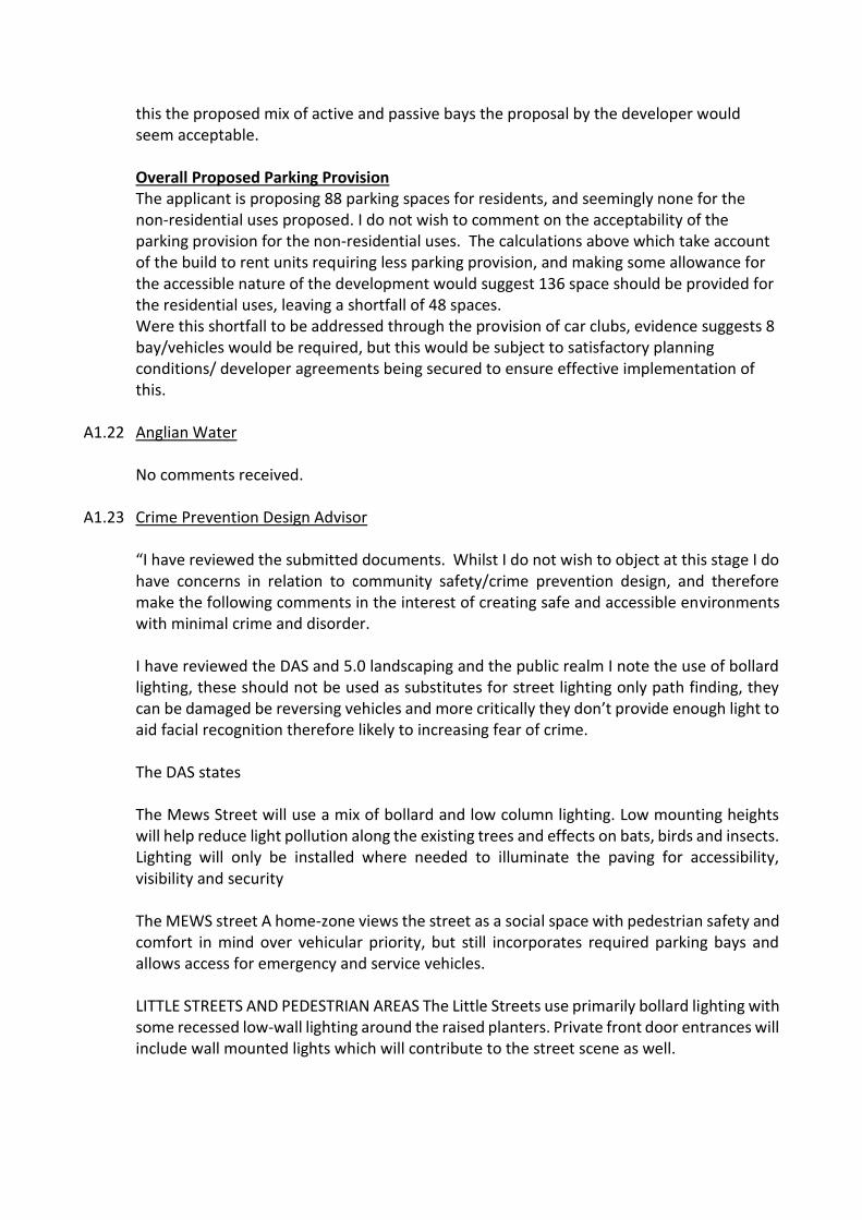
this the proposed mix of active and passive bays the proposal by the developer would seem acceptable.
Overall Proposed Parking Provision The applicant is proposing 88 parking spaces for residents, and seemingly none for the non-residential uses proposed. I do not wish to comment on the acceptability of the parking provision for the non-residential uses. The calculations above which take account of the build to rent units requiring less parking provision, and making some allowance for the accessible nature of the development would suggest 136 space should be provided for the residential uses, leaving a shortfall of 48 spaces. Were this shortfall to be addressed through the provision of car clubs, evidence suggests 8 bay/vehicles would be required, but this would be subject to satisfactory planning conditions/ developer agreements being secured to ensure effective implementation of this.
A1.22 Anglian Water No comments received.
A1.23 Crime Prevention Design Advisor
“I have reviewed the submitted documents. Whilst I do not wish to object at this stage I do have concerns in relation to community safety/crime prevention design, and therefore make the following comments in the interest of creating safe and accessible environments with minimal crime and disorder. I have reviewed the DAS and 5.0 landscaping and the public realm I note the use of bollard lighting, these should not be used as substitutes for street lighting only path finding, they can be damaged be reversing vehicles and more critically they don’t provide enough light to aid facial recognition therefore likely to increasing fear of crime. The DAS states The Mews Street will use a mix of bollard and low column lighting. Low mounting heights will help reduce light pollution along the existing trees and effects on bats, birds and insects. Lighting will only be installed where needed to illuminate the paving for accessibility, visibility and security The MEWS street A home-zone views the street as a social space with pedestrian safety and comfort in mind over vehicular priority, but still incorporates required parking bays and allows access for emergency and service vehicles. LITTLE STREETS AND PEDESTRIAN AREAS The Little Streets use primarily bollard lighting with some recessed low-wall lighting around the raised planters. Private front door entrances will include wall mounted lights which will contribute to the street scene as well.

Recommendation: I ask that THE MEWS & LITTLE STREETS AND PEDESTRIAN AREAS be lit by appropriate column lighting. Lighting levels can reduce the public’s fear of crime and reduce the opportunity for an offender to commit crime. An even spread of light avoiding shadows can play an important role in providing safety in public spaces. Lighting in the public assessable parking facilities and foot paths of this development shall comply with BS 5489-1:2003 with a min uniformity level of 0.25Uo (25%). Where CCTV is to be utilised it is recommended that a uniformity rate of at least 0.25Uo is incorporated. The DAS states COMMUNAL AND PRIVATE AREAS Low bollard lighting and recessed low wall lighting will be used along paths, communal entrances and private garden entrances only. Private back-door entrances will include wall mounted lights. Security lighting with motion sensors will be installed only where required. Recommendation: I ask that COMMUNAL AND PRIVATE AREAS be appropriately lit by column lights. Lighting levels can reduce the public’s fear of crime and reduce the opportunity for an offender to commit crime. An even spread of light avoiding shadows can play an important role in providing safety in public spaces. Bollard lighting is not appropriate for these spaces alone. Security lighting should not be on motion sensors, they should be dusk till dawn lights. All parking courts should include column lighting to the relevant standards. Adequate lighting should be installed to illuminate rear courtyard areas and any under croft areas. The lighting should comply with BS 5489:2013. The comments above are made on behalf of Thames Valley Police and relate to crime prevention design only. You may receive additional comments from TVP on other Policing issues regarding infrastructure etc. I hope that you find the above of assistance in determining the application and if you or the applicants have any queries relating to crime prevention design in the meantime, please do not hesitate to contact me.”
A1.24 Historic England “The current proposals include the demolition of the Agora Centre. Two previous applications granted planning permission for the demolition of the building (one with a replacement scheme). Whilst Historic England were not consulted on these proposals (as far as we have been able to find in our electronic records), we accept this position. We therefore offer advice on the basis of the existing consent for the building to be removed and focus our letter here on the proposed replacement development detailed in this application. Significance of the Conservation Area The Wolverton Conservation area is primarily of significance as a good example of a railway town. At its heart is the works, which was the main source of employment; to the south of
this is terraced housing, much of it built directly by the railway company. As a whole the conservation area tells the story of industrialisation in Britain very well: it demonstrates the vast scale and complexity that heavy engineering took place on during this period and the paternalistic nature of the companies involved, which not only employed but housed their workers. The residential buildings were built economically but incorporate small details and features of embellishment. Assessment of Impact As referenced above, the demolition of the Agora Centre has been established with earlier planning permissions and we do not wish to offer further comment on this. It is noted that the centre is proposed to be remembered and incorporated into the new scheme in a number of ways. Overall, the proposals provide the opportunity for a scheme that could achieve considerable enhancement to the character and appearance of the Wolverton Conservation Area. Further work is needed to ensure that the detailing on buildings, and prominent building corners, are designed so that they make a positive contribution to the conservation area and achieve innovative and high quality design aims. The proposals achieve a considerable number of improvements to the conservation are but are let down by a couple of elements that remain weak (despite design amendments as explained in the supporting statements). The corner treatment of key buildings are not always successful and this lets the scheme down, where it achieves so much in other ways. In addition, the detailing around windows and doors feel trite and lacks elegance, often feeling utilitarian. The pre-cast concrete lintels and sills (including the arched doorways) clearly reference the Victorian features so often seen around the conservation area. But they don’t always replicate well when translated to this contemporary architectural style. We recommend, in line with the requirements of paragraphs 127 and 192 of the NPPF, reviewing their use across the scheme and seeking alternative solutions where they appear awkward, for example on Block F. It is also important to encourage that the positive contemporary approach to the architecture of the proposed blocks will work best if done courageously and with innovation, which means avoiding the Victorian detailing features put forward, which confuses things architecturally, and instead proposing clear contemporary details. Colours and tones to compliment the historical character of the conservation area can still be incorporated to help provide strong visual links. The high quality treatment of doors, windows and other finer details is as important to the success of a scheme such as this, as the blocks size, position and so on. However, it is important to commend the proposed reinstatement of a fine-grained block layout and approximate historic roads which are positive changes that would reinforce the character of the conservation area. The scale and form of the new buildings appears broadly aligned with characteristic features within the conservation area, albeit with slightly taller building proposed. The general tones, colours and materials proposed for the new buildings reference those of the conservation area.

Recommendation Historic England has concerns regarding the application on heritage grounds. We consider that the issues and safeguards outlined in our advice need to be addressed in order for the application to meet the requirements of paragraphs 127 and 196 of the NPPF, to ensure that the proposals take the full opportunity available to enhance the character and appearance of the Wolverton Conservation Area. In determining this application you should bear in mind the statutory duty of section 72(1) of the Planning (Listed Buildings and Conservation Areas) Act 1990 to pay special attention to the desirability of preserving or enhancing the character or appearance of conservation areas. Your authority should take these representations into account and seek amendments, safeguards or further information as set out in our advice. If there are any material changes to the proposals, or you would like further advice, please contact us.”
A1.25 Victorian Society “I apologise for the late response to this application; we have just been alerted to this by a member of the public. Whilst the principle of demolishing the existing Agora building and redeveloping the site is acceptable, we have concerns with elements of the proposed, including the detailing and massing of corner buildings. Improving the public realm by re-establishing Radcliffe Street is positive, as is the overall approach of reinforcing the grid development characteristic of the conservation area. However, the design of the north corner building on Block A, and Block F needs to be readdressed to limit negative impact on the conservation area and listed buildings. Block F occupies one of the site’s most sensitive positions in the immediate setting of three listed buildings. St George the Martyr to the South is listed at Grade II*, whilst the Former St George’s Institute and Sunday School, and Methodist Church to the North are listed at Grade II. We understand that the site was previously occupied by the Science and Arts Institute, itself a tall building, but this should not be seen as a precedent for a modern replacement of similar height. Any development here needs to be both subservient and respond sensitively to the detailing of these heritage assets. We are not convinced that the current design achieves this and consider that this building should be reduced in scale, and greater effort made to break up the massing. We also agree with the comments made by Historic England that the detailing of the facades needs to be refined to respond more sympathetically to the existing buildings. Block A occupies a less sensitive location, but we are also unconvinced by its scale, and are concerned that the proposed would appear incongruous in comparison to existing Victorian buildings. Development on the northern side of Church Street and to the west of Block A, is typically two stories, rising to three in some cases. The proposed three stories of the majority of Block A could therefore be seen as acceptable, but the increase to four at the corner, is not. Again, we ask that this is scaled down to reduce potential harm to the
conservation area, and further improvements made to the delicacy of detailing here so that the building responds more satisfactorily to the fine urban grain of Church Street. At present, the scheme does not quite adhere to the provisions of paragraph 200 of the NPPF which states that “new development within Conservation Areas and World Heritage Sites, and within the setting of heritage assets” should “enhance or better reveal their significance”. I would be grateful if you could inform me of your decision in due course.”
A1.26 MK Forum “We support this application. We appreciate that it has a number of controversial matters attached to it, particularly concerning the loss of public car parking and landscaping, but we feel that they are more than outweighed by the design quality of the scheme, which is a considerable improvement on the previous one and presents a contemporary interpretation of housing appropriate to an important town centre site. We feel that this is a scheme that will reflect well upon Wolverton and will substantially raise the architectural quality within the town and reflect well upon Milton Keynes as a whole. The Agora was a brave scheme that deserved to succeed but unfortunately failed for a number of reasons. Nevertheless it is a critical part of the history of the town and, while we are pleased to see that the building’s outline is to be traced within the paving of the new scheme, we think that the development ought to go further than this in providing a suitable site for at least one of the two distinctive “Agora” signs (which were designed by the late Brian Jarvis of MKDC). as well as there being a full interpretive panel about the building somewhere within the scheme. We have two particular comments regarding the architecture: 1. We feel that the flat roofs sit a little uncomfortably within the general aesthetic of the town. 2. It is disappointing that the scheme does not incorporate some of the stack bonded brick detailing as a “memory” of the existing building – a point that we made many months ago during a walk around the area as part of one of the public workshops that we attended. In summary though a bravura exercise that is to be commended and deserves success.”