itsu master plan - jodc
TRANSCRIPT

IOCIINF-1124
ITSU Master Plan Second Edition
April 1999
Revised from the December 1989 Edition
The International Coordination Group for the Tsunami Warning System in the Pacific (ICGKISU), of the Intergovernmental Oceanographic Commission of UNESCO, is composed of Member States from all parts of the Pacific region, The purpose of ICG/ITSU is to provide or improve all aspects of tsunami mitigation in the Pacific including hazard assessment, warnings, preparedness, and research through a system of international cooperation and coordination of activities. This document, the second edition of the Tsunami Warning System Master Plan, gives a brief overview of tsunamis and the tsunami hazard in the Pacific. In the context of that information, it provides a description of the current status of the Tsunami Warning System in the Pacific with an identification of its limitations, and presents the views of the ICGLTSU on corresponding directions for progress.
UNESCO Intergovernmental Oceanographic Commission

IOCANF-1124 Paris, July 1999 Original: English
SC-99fWSl36

IOCIINF-1124
CONTENTS
ITSU HISTORY AND ORGANIZATIONAL STRUCTURE ............................................ 1 TSUNAMIS AND THE TSUNAMI HAZARD ................................................................. 3
Local and Regional Tsunamis ......................................................................... 3 Pacific-Wide or Distant Tsunamis ................................................................... 4 Characteristics of the Tsunami Phenomena .................................................. 5
CURRENT STATUS, LIMITATIONS, AND FUTURE DIRECTIONS ............................ 7 Hazard Assessment ......................................................................................... 7
Historical Tsunami Data .......................................................................... 7 Paleotsunami Data ................................................................................... 9 Post-Tsunami Surveys ............................................................................ 9 Numerical Modeling ................................................................................ 9
Warning ........................................................................................................... 11 Warning Systems and Centers ............................................................. 11
The Pacific Tsunami Warning Center ..... .I ..................................... 11 The West Coast/Alaska Tsunami Warning Center ....................... 12 The Japanese Tsunami Warning Centers ...................................... 13 The Russian Federation Tsunami Warning Centers ...................... 14 The Polynesian Tsunami Warning Center ...................................... 14 The National Tsunami Warning System of Chile ............................ 15 Other National Tsunami Warning Systems .................................... I5
Data ........................................................................................................ 17 Seismic Data ................................................................................. 17 Water Level Data ........................................................................... 19 Historical Tsunami and Earthquake Data ....................................... 22 Numerical Model Data ................................................................... 22 Other Data ..................................................................................... 22
Communications ................................................................................... 23 Real Time Access to Data ............................................................. 23 Dissemination of Messages ........................................................... 23
Preparedness ................................................................................................. 24 Evacuation ............................................................................................. 24
Evacuations for Local Tsunamis .................................................... 24 Evacuations for Distant Tsunamis .................................................. 25
Education .............................................................................................. 25 Public Education ............................................................................. 25 Education for Warning System Operators, Emergency Managers,
and Policy Makers ................................................................ 26 Land Use ................................................................................................ 27 Engineering ........................................................................................... 27
Research ......................................................................................................... 28 Structure ................................................................................................ 28 Areas for Research ............................................................................... 28 Recent Research Applications ............................................................. 36
CONCLUSIONS ........................................................................................................ 32 Acknowledgements .................................................................................................... 33 List of Acronyms ...................................................................................................... 34

IOC/INF-1124
Formulation of the Master Plan began in Fiji in 1982 during the Eighth Meeting of the International Coordination Group for the Tsunami Warning System in the Pacific (ICG/ITSU). At that meeting Resolution VIII.1 was passed which, among other things, requested the IOC Secretariat “to provide support to the preparation, publication, and distribution of a Master Plan”. This support was forthcoming and a document “Tsunami - Where Next?” was prepared and accepted at ITSU IX in Honolulu, Hawaii in 1984 as a document preliminary to the Master Plan. ITSU Resolution IX.1 recommended completion of the Master Plan with “a view to adopt the Master Plan at the Tenth Session”. At ITSU X held in Sidney, B.C., Canada, in 1985, the draft Master Plan was reviewed, but it was not approved in its final form until ITSU XI held in Beijing in 1987. This first edition of the Master Plan was prepared by G.C. Dohler, former Chairman of ITSU, in cooperation with the IOC Secretariat, the Director of the International Tsunami Information Center, the Chairman of ITSU, and from comments provided by the National Contacts of the ITSU Member States. The first edition, Dot. IOC / Inf- 730, was released on 23 December 1989.
At ITSU XV held in Papeete, French Polynesia, in 1995, in consideration of recent technological improvements to the system and increased scientific understanding of the tsunami’s nature, the meeting requested the Master Plan be updated and an Editorial Group was established to implement that request. A draft of the second edition was prepared for ITSU XVI held in Lima, Peru for the Member States comments and revisions. Based on their subsequent input, this second edition of the Master Plan was finalized.
The Master Plan for the Tsunami Warning System in the Pacific is designed as a long-term guide for improvement of the Tsunami Warning System based on the analysis of existing components of the system. Since 1987, technological innovations such as enhanced communication networks, improved seismic analysis techniques, and low-cost, high-power desktop computers have added greatly to the expectation that improvements recommended in the Plan can be realized for the benefit of the Member States. It is understood that technological enhancements to the Warning System, as real as the benefits can be, require financial assistance and a plan of action that can gain and maintain Member State support for successful implementation.
In addressing the current operational limitations of the present Tsunami Warning System, the Master Plan specifically recognizes a number of areas requiring improvement. By defining the basic elements of the Tsunami Warning System and the required improvements, the Plan continues as a useful, living document that can be modified and revised to capture benefits associated with technological improvements, undiscovered funding opportunities, and collaboration amongst Member States.

ITSU HISTORY AND ORGANEATIONAL STRUCRJRE
During the Third Session of the Intergovernmental Oceanographic Commission (IOC), in June of 1964, the Commission requested the Secretariat of the IOC to arrange for the convening of a meeting, preferably in Honolulu in early 1965, to discuss the international aspects of the tsunami warning system with a view towards securing the best possible international cooperation in all phases of the tsunami warning system, such as: tidal and seismic monitoring stations, internal and international communications, and the issuance and dissemination of warnings. Invitations were
extended to all IOC Member States with interests in the Pacific, with specific invitations to the United States Coast and Geodetic Survey, the Japan Meteorological Agency, the Hydrometeorological Service of the USSR, the United Nations Educational, Scientific, and Cultural Organization (UNESCO), the World Meteorological Organization (WMO), the Tsunami Committee of the International Union of Geodesy and Geophysics (IUGG), the International Telecommunications Union, and other such national or international bodies which may express interest.
Major tsunamigenic seismic zones in the Pacific region. Most tsmamis are only destructive along coasts near the generating earthquake. However, a few each century are powerjiil enough to cause destruction many thousands of kilometers away from the source.
ITSU Master Plan 1 UNESCO / IOC

A working group on the international aspects of the Tsunami Warning System in the Pacific (TWSP) met in accordance with the IOC’s request during the month of April, 1965, at Honolulu. The group discussed IOC Resolution 111.8, its implications for the benefit of the Member States, and the actions required to provide, on an international basis, timely tsunami warnings. As a result, the International Coordination Group for the Tsunami Warning System in the Pacific (ICG/ITSU, or ITSU) was formed, composed of Member States in the Pacific region. Its purpose is to recommend and coordinate programs most beneficial to countries belonging to the IOC whose coastal areas are threatened by tsunamis. To implement its objectives and ensure the success of the international tsunami warning project, the Group holds sessions about every two years at the invitation of an I’I’SU Member State and at a location within the Pacific Basin. These meetings provide an opportunity to further cooperation and coordination between the Member States, review activities of the Group since the last meeting, and set the program for the Group for the next period.
Simultaneous with the formation of ITSU, the IOC accepted the offer of the United States of America to expand its existing tsunami warning center in
Hawaii, now known as the Pacific Tsunami Warning Center (PTWC), to become the operational headquarters of the TWSP. And it accepted the offer of the other Member States to integrate their existing facilities and communications into the TWSP.
In addition, the IOC established the International Tsunami Information Center (ITIC) located in Honolulu, Hawaii and hosted by the USA, in support of ITSU and the TWSP. The mandate of ITIC, revised by ITSU in 1977, has six elements which are briefly: 1) to monitor and recommend improvements to the warning system, 2) to bring to Member and non-Member States information about activities of the warning system, ITIC, and ITSU, 3) to assist in the establishment of national tsunami warning systems in the Pacific region, 4) to gather and distribute knowledge on tsunamis and foster tsunami research and its application, 5) to help make available all records pertaining to tsunamis, and 6) to assist with and develop procedures for post-tsunami surveys.
ITSU Master Plan 2 UNESCO! IOC

TSUNAMIS AND THE TSUNAMI HAZARD
There are tens of thousands of kilometers of .coastline in the Pacific region, representing portions of at least 23 countries around the rim, and 21 island states. These areas are developing at an accelerating rate with the expansion of harbor and industrial facilities in most locations, and increasing population densities almost everywhere. This element of growth in both population and infrastructure development exposes more people
and their homes, buildings, and transportation systems to the onslaught of tsunamis. Since 1992, major local tsunamis have claimed more than 4,200 lives and caused hundreds of millions of dollars in property damage. A Pacific-wide tsunami today, similar in size to the May 1960 event generated off the coast of Chile, could easily have catastrophic consequences.
Massive destruction in the town of Aonae on Okushiri Island, Japan caused by the regional tsunami of July 12, 1993.
Local and Regional Tsunamis
Most destructive tsunami can be classified as local or regional, meaning their destructive effects are confined to coasts within a hundred km, or up to a thousand km, respectively, of the source -- usually an earthquake. It follows that the majority of tsunami related casualties and property damage also come from local tsunami. Between 1975 and 1998 there have been at least eighteen in the Pacific and its adjacent seas resulting in significant casualties and/or property damage.
For example, a regional tsunami in 1983 in the Sea of Japan or East Sea, severely damaged coastal areas of Japan, Korea, and Russia, causing more than $800 million in damage, and more than a hundred deaths. Then, after nine years without an event, eleven locally destructive tsunamis occurred in just a seven-year period from 1992 to 1998, resulting in over 4,200 deaths and hundreds of millions of dollars in property damage.
ITSU Master Plan 3 UNESCO / IOC

In most of these cases, tsunami mitigation efforts in place at the time were unable to prevent significant damage and loss of life. However, losses from future local or regional tsunamis can be reduced if a denser network of warning centers, seismic and water-level reporting stations, and better communications are established to provide a timely warning, and if better programs of tsunami preparedness and education can be put in place.
Destructive Local or Regional Tsunami Since 1975
I Estimated Date Source Location Lives Lost I
29 Nov 1975 Hawaii, USA 2 17 Aug 1976 Philippines 8,000* 19 AUE! 1977 Indonesia 189
1 18 Jul 1979 1 Indonesia
1 12 Dee 1992 1 Flores Is.. Indonesia 1 1 .OOO 1 12 Jul 1993 1 Okushiri Is.. Janan 1 230 I
3 Jun 1994 Java, Indonesia 222 4 Ott 1994 Shikotan Is., Russia 1 I 14 Nov 1994 Philippines 74
17 Feb 1996
* Figure may include earthquake casualties
Pacific-Wide or Distant Tsunamis
Far less frequent, but potentially much more estimated to be 20.4 meters (67 feet) high. The hazardous are Pacific-wide or distant tsunamis. tsunami caused 61 deaths in Hawaii, 20 in the These occur when the disturbance that generates Philippines, and 100 or more in Japan. Estimated the tsunami is sufficiently great. Usually starting damages were US$50 million in Japan, US$24 as a local tsunami that causes extensive destruction million in Hawaii and several more millions along near the source, these waves continue to travel the west coast of the United States and Canada. across the entire ocean basin with sufficient energy Distant wave heights varied from slight to cause additional casualties and destruction on oscillations in some areas to 12.2 meters (40 feet) shores more than a thousand km from the source. at Pitcaim Island; 10.7 meters (35 feet) at Hilo, In the last two hundred years, there have been at Hawaii; and 6.1 meters (20 feet) at some places in least seventeen destructive Pacific-wide tsunamis. Japan.
The most destructive Pacific-wide tsunami of recent history was generated by a massive earthquake off the coast of Chile on May 22, 1960. All Chilean coastal towns between the 36th and 44th parallels were either destroyed or heavily damaged by the action of the tsunami and the quake. The combined tsunami and earthquake toll included 2,000 killed, 3,000 injured, 2,000,OOO homeless, and $550 million damage. Off the coastal town of Corral, Chile, the waves were
No major destructive Pacific-wide tsunamis have occurred since ITSU and the TWSP were formed, and PTWC began serving as the international warning center for these types of events. But continued efforts to improve all aspects of the warning system are still needed to minimize property damage and ensure the safety of Pacific coastal residents when the next one inevitably occurs.
ITSU Master Plan 4 UNESCO / IOC
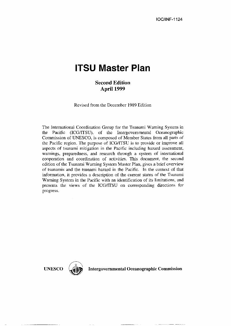
Destruction along the waterfront of Hilo, Hawaii from the Pacific-wide tsunami generated off the coast of Unimak Island, Alaska, USA on April I, 1946.
Characteristics of the Tsunami Phenomena
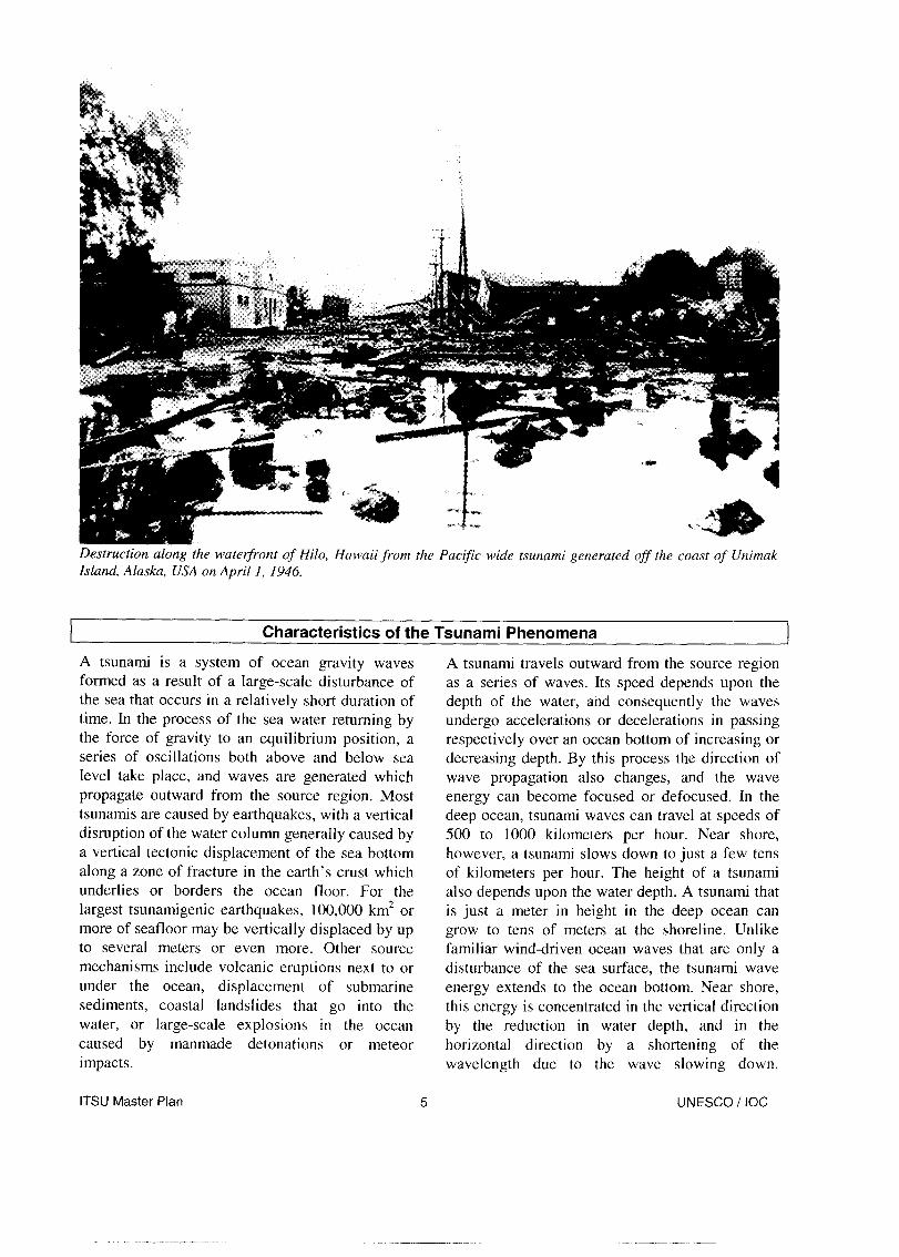
A tsunami is a system of ocean gravity waves A tsunami travels outward from the source region formed as a result of a large-scale disturbance of as a series of waves. Its speed depends upon the the sea that occurs in a relatively short duration of depth of the water, and consequently the waves time. In the process of the sea water returning by undergo accelerations or decelerations in passing the force of gravity to an equilibrium position, a respectively over an ocean bottom of increasing or series of oscillations both above and below sea decreasing depth. By this process the direction of level take place, and waves are generated which wave propagation also changes, and the wave propagate outward from the source region. Most energy can become focused or defocused. In the tsunamis are caused by earthquakes, with a vertical deep ocean, tsunami waves can travel at speeds of disruption of the water column generally caused by 500 to 1000 kilometers per hour. Near shore, a vertical tectonic displacement of the sea bottom however, a tsunami slows down to just a few tens along a zone of fracture in the earth’s crust which of kilometers per hour. The height of a tsunami underlies or borders the ocean floor. For the also depends upon the water depth. A tsunami that largest tsunamigenic earthquakes, 100,000 km* or is just a meter in height in the deep ocean can more of seafloor may be vertically displaced by up grow to tens of meters at the shoreline. Unlike to several meters or even more. Other source familiar wind-driven ocean waves that are only a mechanisms include volcanic eruptions next to or disturbance of the sea surface, the tsunami wave under the ocean, displacement of submarine energy extends to the ocean bottom. Near shore, sediments, coastal landslides that go into the this energy is concentrated in the vertical direction water, or large-scale explosions in the ocean by the reduction in water depth, and in the caused by manmade detonations or meteor horizontal direction by a shortening of the impacts. wavelength due to the wave slowing down.
ITSU Master Plan 5 UNESCO / IOC
.-_-_-_ _ _____..-

Tsunamis have periods (the time for a single wave cycle) that may range from just a few minutes to as much as an hour or even more.
At the shore, a tsunami can have a wide variety of expressions depending on the size and period of the waves, the near-shore bathymetry and shape of the coastline, the state of the tide, and other factors. In some cases a tsunami may only induce a relatively benign flooding of low-lying coastal areas, coming onshore similar to a rapidly rising tide. In other cases it can come onshore as a bore - a vertical wall of turbulent water that can be very destructive. In most cases there is also a drawdown of sea level either preceding or in between crests of the tsunami waves that results in a receding of the shoreline, sometimes by a kilometer or more. Strong and unusual ocean currents may also accompany even small tsunamis.
Destruction from tsunamis is the direct result of three factors: inundation, wave impact on structures, and erosion. Strong tsunami- induced currents have led to the erosion of
Destructive Pacific-Wide Tsunami Since 1800
4 Nov 1952 Russia 9 Mar 1957 Aleutian Is., U.S.A. 5 22 May 1960 Chile 2,000 28 Mar 1964 Alaska, U.S.A. 112 4 Feb 1965 Aleutian Is., U.S.A. - * Figure may include earthquake casualties
foundations and the collapse of bridges ana seawalls. Flotation and drag forces have moved houses and overturned railroad cars. Tsunami associated wave forces have demolished frame buildings and other structures. Considerable damage also is caused by the resultant floating
buildings, piers, and other vehicles. Ships and port facilities have been damaged by surge action caused by even weak tsunamis. Fires resulting from oil spills or combustion from damaged ships in port, or from ruptured coastal oil storage and refinery facilities, can cause damage greater than that inflicted directly by the tsunami. Other secondarv damage can result from sewage and debris, including boats and cars that become
dangerous projectiles that may crash into .
chemical pollution following the destruction. Damage of intake, discharge, and storage facilities also can present dangerous problems. Of increasing concern is the potential effect of tsunami drawdown, when receding waters uncover cooling water intakes associated with nuclear plants.
Travel-times (in hours) for the May 22, 1960 Chile tsunami crossing the Pacific basin. This tsunami was extremely destructive along the nearby coast of Chile, and the tsunami also caused significant destruction and casualties as far away as Hawaii and Japan. The awareness and concern raised by this Pact&-wide tsunami ultimately led to the formation of the TWSP and ITSU.
UNESCO / IOC

CURRENT STATUS, LIMITATIONS, AND FUTURE DIRECTIONS
The TWSP continues to expand in scope and responsibility as growth and interest within the ICG/ITSU occurs, now to include 25 Member States. With an unprecedented number of locally destructive tsunamis occurring within the last few years, there has been a heightened interest in tsunamis and the TWSP throughout the Pacific Basin and elsewhere.
The following section gives a brief description of the tsunami mitigation system in the Pacific as it currently exists, the limitations of that system, and directions and areas for work to address those limitations. The current system represents dedicated individual as well as joint efforts of the Member States of ITSU, and the efforts of ITSU as a whole. Although many shortcomings remain to be addressed, significant progress has been made to improve tsunami mitigation in the Pacific from what it was when ITSU was founded in 1965.
A document entitled “The Compilation of Data and Information for the Preparation of a Master Plan,” presented and approved at the 9th Session of ITSU in 1984, delineated five general areas for work that should be addressed by ITSU programs. Simply stated they are: (1) preparation of tsunami- related educational material; (2) collection and compilation of historical tsunami data, and development of better techniques for using historical data, seismic data, and modeling to provide warnings and predict runups; (3)
establishment of better communications channels for transmission of real time data and dissemination of warnings; (4) development of improved seismic and water level data collection and processing equipment and techniques, establishment of new data collection stations where needed, and provision of training in the installation and maintenance of equipment and stations; and (5) improvement of existing tsunami warning centers and establishment of new centers where needed along with appropriate technology transfer, training, and documentation. These areas for work remain applicable and are discussed below within the context of a conceptual model for a tsunami mitigation plan.
To mitigate the tsunami hazard, or for that matter any rapid onset natural hazard, it is critical to accurately assess the nature of the threat posed by the hazard, to design and implement a warning technique, and to prepare at-risk areas for appropriate actions to reduce the impact of the hazard. These three essential steps: 1) hazard assessment, 2) warning, and 3) preparedness, are the main elements of the mitigation model. They can be used to identify, develop, and categorize most of the activities necessary to effectively reduce the inevitable impact of tsunamis. Another key element, not directly a part of mitigation but that supports its activities, is tsunami-related research.
Hazard Assessment
The first element for effective mitigation is hazard assessment. For each coastal community, an assessment of the tsunami hazard is needed to identify populations and assets at risk, and the level of that risk. This assessment requires knowledge of probable tsunami sources, their likelihood of occurrence, and the characteristics of tsunamis from those sources at different places along the coast. For some communities, data from earlier tsunamis may help quantify these factors. For most communities, however, only very limited or no past data exist. For these coasts, numerical models of tsunami inundation can provide estimates of areas that will be flooded in the event of a local or distant tsunamigenic earthquake.
Results of the hazard assessment are also essential for motivating and designing the other two mitigation elements, warning and preparedness.
His torical Tsunami Da ta
Historical data are available in many forms and at many locations. The forms include published and manuscript catalogs of tsunami occurrences, field investigative reports, personal accounts of experiences, newspaper accounts, and film or video records. One of the larger collections of this type is maintained by the International Tsunami Information Center in Honolulu, Hawaii. Another major collection is maintained by the World Data
ITSU Master Plan 7 UNESCO / IOC
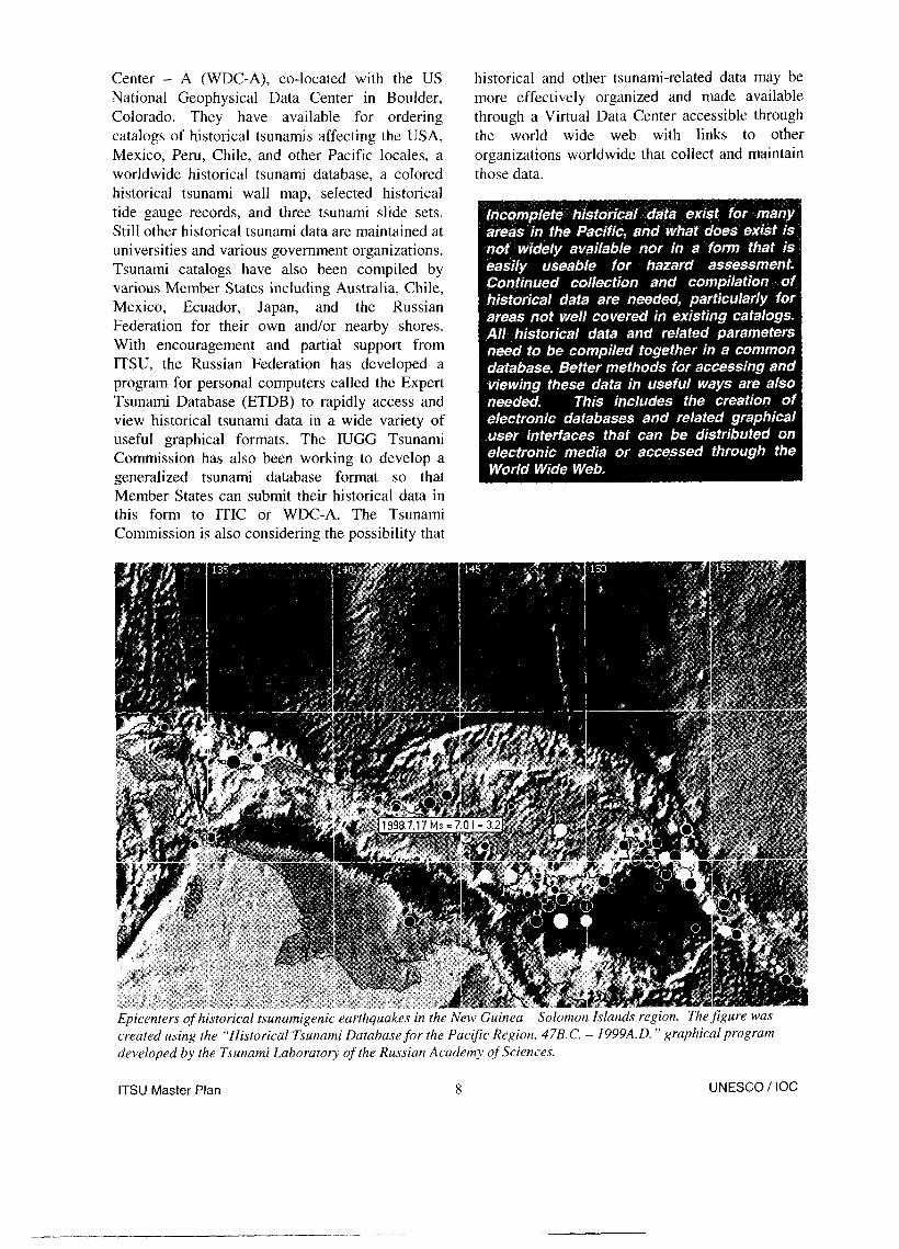
Center - A (WDC-A), co-located with the US National Geophysical Data Center in Boulder, Colorado. They have available for ordering catalogs of historical tsunamis affecting the USA, Mexico, Peru, Chile, and other Pacific locales, a worldwide historical tsunami database, a colored historical tsunami wall map, selected historical tide gauge records, and three tsunami slide sets. Still other historical tsunami data are maintained at universities and various government organizations. Tsunami catalogs have also been compiled by various Member States including Australia, Chile, Mexico, Ecuador, Japan, and the Russian Federation for their own and/or nearby shores. With encouragement and partial support from ITSU, the Russian Federation has developed a program for personal computers called the Expert Tsunami Database (ETDB) to rapidly access and view historical tsunami data in a wide variety of useful graphical formats. The IUGG Tsunami Commission has also been working to develop a generalized tsunami database format so that Member States can submit their historical data in this form to ITIC or WDC-A. The Tsunami Commission is also considering the possibility that
historical and other tsunami-related data may be more effectively organized and made available through a Virtual Data Center accessible through the world wide web with links to other organizations worldwide that collect and maintain those data.
Epicenters of historical tsunamigenic earthquakes in the New Guinea - Solomon Islands region. The figure was created using the “Historical Tsunami Database for the Pacific Region, 47B.C. - 1999A.D. ” graphical program developed by the Tsunami Laboratory of the Russian Academy of Sciences.
ITSU Master Plan 8 UNESCO / IOC
Paleo tsunami Data
Research on paleotsunamis, events occurring prior to the historical record, has recently been taking place in a few regions around the Pacific. This work is based primarily on the collection and analysis of tsunami deposits found in coastal areas, and other evidence related to the uplift or subsidence associated with nearby earthquakes. In one instance, the research has led to a new concern for the possible future occurrence of great earthquakes and tsunamis along the northwest coast of North America. In another instance, the record of tsunamis in the Kuril-Kamchatka region is being extended much further back in time. As work in this field continues it may provide a significant amount of new information about past tsunamis to aid in the assessment of the tsunami hazard.
1 Post-Tsunami Survevs
In recent years, following each major destructive tsunami, a post-tsunami reconnaissance survey has been organized to make measurements of runups and inundation limits and to collect associated data from eyewitnesses such as the number of waves, arrival time of waves, and which wave was the largest. The surveys have been organized primarily on an ad-hoc basis by academic tsunami researchers, with participants often gathered from several of the ITSU Member States. ITSU has encouraged the creation of international teams of experts from a variety of tsunami-related disciplines to carry out surveys under the auspices of the IOC, but none has yet taken place. A Post- Tsunami Survey Field Guide has been prepared by ITSU to help with preparations for surveys, to identify measurements and observations that should be taken, and to standardize data collection methods for increased consistency and accuracy.
ITSU Master Plan UNESCO / IOC
Numerical Modeling
Often the only way to determine the potential runups and inundation from a local or distant tsunami is to use numerical modeling, since data from past tsunamis is usually insufficient. Models can be initialized with potential worst case scenarios for the tsunami sources or for the waves just offshore to determine corresponding worst case scenarios for runup and inundation. Models can also be initialized with smaller sources to understand the severity of the hazard for the less extreme but more frequent events. This information is then the basis for creating tsunami evacuation maps and procedures. At present, such modeling has only been carried out for a small fraction of the coastal areas at risk. Sufficiently accurate modeling techniques have only been available in recent years, and these models require training to understand and use correctly, as well as input of detailed bathymetric and topographic data in the area being modeled.
To address this problem, ITSU has supported a program called the Tsunami Inundation Modeling Exchange (TIME) that has provided the transfer of a numerical inundation model developed by Professor Shuto of Japan to Mexico, the USA, Korea, Turkey, Canada, Mexico, Greece, Colombia, Australia, Italy, Indonesia, Ecuador,

Costa Rica, and Chile. Most importantly, the program also provides training in the use of the model. Many ITSU countries, including Chile, Mexico, France, Japan, and the United States have now established programs to systematically model the potential tsunami inundation for their coastal areas at risk.
Eureka, Califcwnia
I Tsunami Inundation I
a Liquefaction
_ Landstide
Tsunami Inundation and Liquefaction
8+ ,
9 Modified Mercafti intensity
Homes shifted from foundations, pariial cokapse of masoniary buWngs, heavy furniture and major appliances overturned.
Coastal area of Eureka, California, showing potential inundation determined from numerical modeling for a locally generated tsunami. The map also includes potential earthquake effects including liquefaction and landslides that should be considered in designing evacuation routes.
ITSU Master Plan 10 UNESCO I IOC

Warning
The second key element for effective tsunami mitigation is an appropriate warning system to alert coastal communities that danger from a tsunami is imminent. Warning systems are based on earthquake data for the rapid initial warning, and water level data for confirming and monitoring the tsunami or for canceling the warning. Warning systems also rely upon a variety of communications channels to receive seismic and water level data, and to issue messages to the appropriate authorities. Warning centers strive to be: 1) rapid -- providing warnings as soon as possible after a potential tsunami generation, 2)
hour after the occurrence of the earthquake, and is effective for communities located at least several hundred kilometers from the source region. Regional systems, such as those operated by the USA, Japan, the Russian Federation, France, and Chile, provide primarily domestic warnings within about 10-I 5 minutes of the earthquake and are effective for communities located at least a hundred kilometers from the source region. Local systems operated by Japan and Chile are capable of providing a warning in about 5 minutes or less to give some measure of protection to communities located within a hundred kilometers of the source.
Just as important as issuing warnings, are issuing rapid cancellations to warnings when no significant waves are found to exist, and informational messages for large but not potentially tsunamigenic earthquakes.
Operations area of the Pacific Tsunami Warning Center in Ewa Reach, Hawaii.
accurate -- issuing warnings for all destructive tsunamis while minimizing false warnings, and 3) reliable -- making sure they operate continuously, and that their messages are sent and received promptly and understood by the users of the system.
Centers that operate the tsunami warning systems include: the Pacific Tsunami Warning Center at Ewa Beach, Hawaii, USA; the West Coast / Alaska Tsunami Warning Center at Palmer, Alaska, USA; the Russian Federation tsunami warning centers at Petropavlovsk-Kamchatskiy, Kurilskiye, and Sakhalinsk; the Japanese tsunami warning centers at Sapporo, Sendai,
Tokyo, Osaka, Fukuoka, and Naha; the French Polynesia Tsunami Warning Center at Papeete, Tahiti, and the National Tsunami Warning System of Chile headquartered at Valparaiso.
Certain other Member States have also recently established or improved their seismic and/or water level instrumentation and analysis capabilities as the basis for national tsunami warning systems.
Warning Systems and Centers
Tsunami warning systems in the Pacific can be classified by two related factors: 1) the type of tsunami they are prepared to warn against - from local to distant, and 2) the area of responsibility (AOR) they warn for each type of tsunami - sub- national, national, regional, or international. The Pacific-wide system operated by PTWC provides an international warning about one-half to one
The Pacific Tsunami Warninq Center
In 1948, the Seismic Sea-Wave Warning System was put into operation at the Seismological Observatory in Ewa Beach near Honolulu to warn Pacific coastal communities of the USA about impending tsunamis like the one two years earlier
ITSU Master Plan 11 UNESCO / IOC

from the Aleutian Islands that struck Hawaii by surprise with disastrous results. In 1966, the Intergovernmental Oceanographic Commission approved the offer made by the USA to strengthen these facilities by establishing, on a permanent basis, the International Tsunami Information Center. Not long thereafter, the Observatory changed its name to the Pacific Tsunami Warning Center (PTWC) and became the operational center for the Tsunami Warning System in the Pacific. Its main responsibility in this regard was, and remains, to issue timely warnings (generally within about 30 minutes) for any tsunamigenic earthquake in the Pacific basin to all international participants having designated an appropriate emergency management organization to receive the message. In 1970, PTWC became the warning center for local tsunamis generated in the state of Hawaii, with the responsibility to issue warnings within 15 minutes for any Hawaii near-shore or offshore earthquakes having a magnitude of 6.8 or greater. Hawaii has a history of destructive tsunamis generated locally by earthquakes associated with its active volcanoes.
Thus, PTWC, operated by the US National Oceanic and Atmospheric Administration / National Weather Service (NOAALNWS), has three distinct responsibilities: 1) it is the international center for warning most of the Pacific about distant tsunamis; 2) it is the USA national center for warning all USA interests in the Pacific except the states of Alaska, Washington, Oregon and California about distant tsunamis; and 3) it is the Hawaii regional center for rapidly warning the state of Hawaii about local tsunamis. Appropriate communications and computer facilities, as well as a staff of geophysicists is available on a 24-hour basis to carry out these tasks. The Center utilizes its own array of telemetered seismic sensors and
water-level instrumentation located in Hawaii and elsewhere in the Pacific, as well as a variety of widely distributed seismic and water level data provided by the West Coast / Alaska Tsunami Warning Center, by other national agencies, and through the Tsunami Warning System in the Pacific.
The userYs guide for PTWC operations is the Communication Plan for the Tsunami Warning System, Tweljth Edition, published in July 1996 and updated as needed. It gives background information about tsunamis, general information about the Tsunami Warning System in the Pacific, key definitions, information about water level and seismic stations, communications requirements and communications methods applicable to each country, and message types, criteria, and formats.
The West Coast/Alaska Tsunami Warninq Center
This warning system has been operational since 1968. Formerly known as the Alaska Tsunami Warning Center, it recently changed its name to the West Coast / Alaska Tsunami Warning Center (WC/ATWC) to more accurately reflect its area of responsibility which includes the states of Washington, Oregon, and California, as well as the Pacific coast of Canada. It is also operated by NOAA/NWS of the USA. WC/ATWC provides warnings within 15 minutes of the earthquake origin time for tsunamis generated off the coast of Alaska or the west coast of North America down to the California - Mexico border. The center also warns its AOR of Pacific-wide tsunamis, in coordination with PTWC. The center utilizes its own array of telemetered seismic sensors and water-level instrumentation located in Alaska, as well as additional widely distributed seismic and water level data provided by PTWC, by other national agencies, and through the Tsunami
Warning System in the Pacific.
ITSU Master Plan UNESCO / IOC

The Japanese Tsunami Warninq Centers
The Tsunami Warning Service for Japan was established in 1952, and is operated by the Japan Meteorological Agency (JMA). There are currently six regional centers in Japan for tsunami warning services, located at Sapporo, Sendai, Tokyo, Osaka, Fukuoka, and Naha (Okinawa). These centers are responsible for issuance of tsunami warnings within each AOR.
Signals from seismic and water level stations across Japan are continuously monitored by a sophisticated automatic system called the Earthquake and Tsunami Observation System (ETOS). Soon after an earthquake is detected by ETOS, the arrival times of the P waves and their maximum amplitude are automatically measured and interactively corrected, if necessary, by an operator. From these, the earthquake’s source area and magnitude are calculated. As appropriate to the earthquake’s parameters, tsunami warnings or advisories may be issued. These messages will contain information about the level of tsunami that is expected (“tsunami attention” = minor tsunami, “tsunami expected” = up to a 2 m tsunami, and “major tsunami expected” = more than 3 m in the worst places), the areas that are expected to be affected (the Japanese coast is divided into 18 tsunami forecast regions), and estimated arrival times. Messages are disseminated to organizations for disaster reduction, the broadcast media, and others.
JMA operates about 180 seismic stations and about 80 water level stations. For tsunami monitoring, in addition to fuse type tide gauges, water level gauges with ultrasonic detectors are sited above the sea surface in harbors to monitor large tsunamis, and also above the harbor shore to monitor runup. For both pressure and ultrasonic type gauges, data transmitters are installed at higher locations to prevent them from being inundated during an event.
After the destruction caused by the 1993 Hokkaido-Nansei-Oki earthquake and tsunami, JMA reconstructed its seismic network and adopted methods to determine earthquake magnitude from the seismic P waves. This change permitted a more rapid and accurate evaluation of the earthquake parameters for the purpose of tsunami forecasting. JMA is aiming to disseminate a tsunami warning within 3 minutes after the occurrence of a tsunamigenic earthquake.
In addition, to reduce the time of transmission of tsunami warnings through the mass media to the public, JMA and the media have cooperatively developed a system to simultaneously superimpose the warning message on home television screens as soon as it is issued by JMA. To reduce their relay time, warnings are also issued to municipalities via the Satellite-based Emergency Information Multi- destination Dissemination System through the Geostationary Meteorological Satellite (GMS), and this system works as a backup to other communications systems that utilize ground links.
Operations counterfor one of six tsunami warning centers in Japan. Seismic signals are continuously monitored, and earthquakes detected and processed with an automatic Earthquake and Tsunami Observation System.
ITSU Master Plan 13 UNESCO / IOC
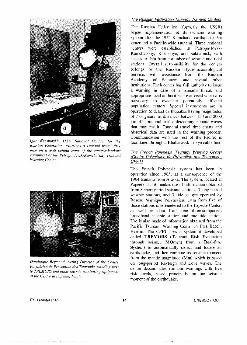
Igor Kuz’minykh, ITSU National Contact for the Russian Federation, examines a tsunami travel time map on a wall behind some of the communications equipment at the Petropavlovsk-Kamchatskiy Tsunami Warning Centec
Dominique Reymond, Acting Director of the Centre Polyne’sien de Prevention des Tsunamis, standing next to TREMORS and other seismic monitoring equipment at the Centre in Papeete, Tahiti.
The Russian Federation Tsunami Warninq Centers
The Russian Federation (formerly the USSR) began implementation of its tsunami warning system after the 1952 Kamchatka earthquake that generated a Pacific-wide tsunami. Three regional centers were established, at Petropavlovsk- Kamchatskiy, Kurilskiye, and Sakhalinsk, with access to data from a number of seismic and tidal stations. Overall responsibility for the centers belongs to the Russian Hydrometeorological Service, with assistance from the Russian Academy of Sciences and several other institutions. Each center has full authority to issue a warning in case of a tsunami threat, and appropriate local authorities are advised when it is necessary to evacuate potentially affected population centers. Special instruments are in operation to detect earthquakes having magnitudes of 7 or greater at distances between 150 and 2000 km offshore, and to also detect any tsunami waves that may result. Tsunami travel time charts and historical data are used in the warning process. Communication with the rest of the Pacific is facilitated through a Khabarovsk-Tokyo cable link.
The French Polvnesia Tsunami Warnina Center /Centre Polvnksien de Pkvention des Tsunamis - CPPTJ
The French Polynesia system has been in operation since 1965, as a consequence of the 1964 tsunami from Alaska. The system, located at Papeete, Tahiti, makes use of information obtained from 8 short-period seismic stations, 3 long-period seismic stations, and 3 tide gauges operated by Reseau Sismique Polynesien. Data from five of these stations is telemetered to the Papeete Center, as well as data from one three-component broadband seismic station and one tide station. Use is also made of information obtained from the Pacific Tsunami Warning Center in Ewa Beach, Hawaii. The CPPT uses a system it developed called TREMORS (Tsunami Risk Evaluation through seismic Moment from a Real-time System) to automatically detect and locate an earthquake, and then compute its seismic moment from the mantle magnitude (Mm) which is based on long-period Rayleigh and Love waves. The center disseminates tsunami warnings with five risk levels, based principally on the seismic moment of the earthquake.
ITSU Master Plan 14 UNESCO! IOC

The National Tsunami Warninq System of Chile [Sistema National de Alarma de Maremotos - SNAM)
The Chilean Tsunami Warning System operated by the Hydrographic and Oceanographic Service of the Chilean Navy (SHOA) has been in operation since 1964, as a consequence of the May 1960 Chilean tsunami. The system, headquartered in Valparaiso, makes use of seismic information from 31 short period seismic stations provided by the National Seismic Network run by the Department of Geophysics of the University of Chile, one TREMORS system, and 3 six-component (3 strong motion, 3 seismic) broadband stations. The system also utilizes 19 tide stations, 7 sending their data in real time by satellite to the SNAM, and the others are bubblers that send data upon request. The SNAM disseminates tsunami warnings to all coastal communities through the Navy Communications Facilities and through the National Emergency Office Radio Network.
Other National Warning Svstems
Australia. Australia is in the process of developing a tsunami warning system for its Indian Ocean coast as well as its Pacific coast. The system will be operated by the Bureau of Meteorology. Seismic data will be provided by the Australian Geological Survey Organization (AGSO) and an AGSO Tsunami Warning and Earthquake Alert System is being prototyped. The National Tidal Facility (NTF) will provide sea level response monitoring and interpretation capabilities.
Colombia. Colombia’s Observatorio Sismologico de1 Suroccidente (OSSO) is developing a warning system based on digital broadband seismometer data input to a TREMORS analysis system. Dissemination of results to appropriate organizations will be through INMARSAT. Potential runups will be determined using numerical modeling techniques acquired through the TIME program.
Nicaragua. As the base for a national tsunami warning system, Nicaragua has 20 short-period vertical seismometers with data telemetered in real time to the Instituto Nicaraguense de Estudios Territoriales (INETER). Data from a broadband seismic station at Boaco, and an array of strong- motion accelerometers may also be accessible in near real time via telephone links. A network of 7 digital mareographic stations is also being
Headquarters of the Chilean Tsunami Warning System @NAM) operated by the Hydrographic and Oceanographic Service of the Chilean Navy is located in Valparaiso.
Operations room of the National Tsunami Warning System of Chile (SNAM).
deployed on both the Pacific and Atlantic coasts and in Lake Managua, with access to the data by telephone. Communication links and procedures for tsunami warnings are being developed between INETER and Civil Defense. A siren system to alert the public is also planned.
Peru. The National System Warning System of Peru, with its center located in Callao, is operated by the Direction de Hidrografia y Navegacion de1 Peru (DHN). They administer a network of 10 mareograph stations, with data from the Callao station sent in real time to the Center. Peru has also recently acquired two TREMORS systems to strengthen its warning capabilities. Notification to Civil Defense is made by a dedicated magnetic telephone.
ITSU Master Plan 15 UNESCO / IOC

Republic of Kowa. The Korea Meteorological The plan is for a network of 31 short-period and Administration (KMA) of the Republic of Korea broadband stations with an automated analysis now utilizes a real-time network of 12 short-period system. In addition, a real-time sea level and 8 broadband seismometers, and a TREMORS, monitoring system will be installed on an island in combination with information from some of the off the eastern coast. Dissemination of warnings is other warning centers to monitor its tsunami threat. made through the public weather service system.
ITSU Master Plan 16 UNESCO / IOC
Data
Warning centers use real or near-real time seismic and water level data as well as historical tsunami and earthquake data to rapidly detect and locate potentially tsunamigenic earthquakes, to confirm that a tsunami was generated, and to estimate its potential impact to coastlines in its area of responsibility.
Seismic Data
Seismic signals, the vibrations from earthquakes that propagate rapidly through the earth, are used by warning centers to detect the occurrence of an earthquake, and then to determine its location and size. Based on this information, the likelihood that a tsunami may have been generated can be estimated quickly, and appropriate initial warnings or informational messages issued. Standard short- period (0.52 set/cycle) and long-period (18-22 set/cycle) seismometers provide data to locate and size the earthquake. Data from newer broadband (0.01-100 set/cycle) seismometers can be used for both of the above purposes and also for computing seismic moment, a better measure of size for the largest and most potentially tsunamigenic
earthquakes. Seismic data is sent to the centers in real or near real time in the form of continuous waveforms, triggered waveforms, or parametric data (for example, P wave arrival times) using a variety of short and long range communications techniques. In certain cases, seismic data is completely processed by another observatory, and only earthquake location and magnitude are sent.
To determine the location of an earthquake requires data from many seismic sensors, ideally located in a pattern that surrounds the event. For nearby earthquakes a dense array of seismic stations is often used to get a quick and accurate location. Less precise, but adequate locations may also be obtained from a single three-component seismic station if techniques of particle motion analysis are used, as they are in the TREMORS (Tsunami Risk Evaluation through seismic Moment from a Real-time System) algorithm. TREMORS also has the ability to automatically estimate seismic moment from broadband data every 50 seconds after the onset of the P wave, making it an ideal analysis tool for local, regional, and ocean-wide tsunami warning systems.
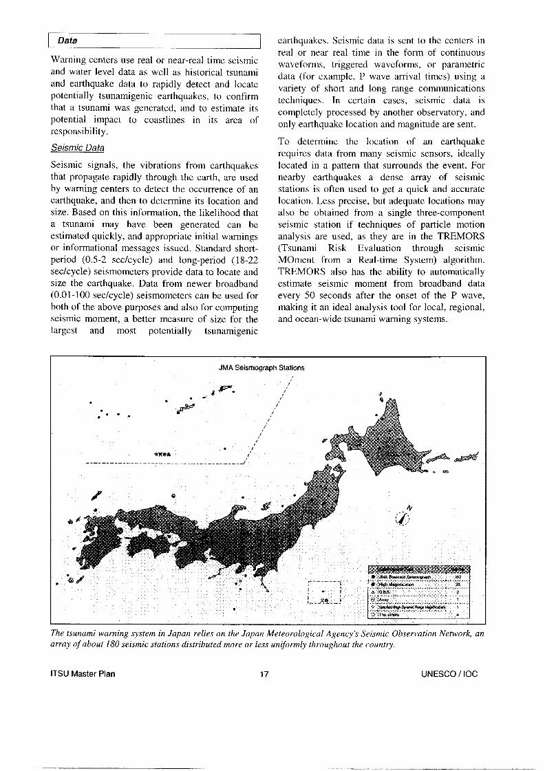
JMA Seismograph Stations
The tsunami warning system in Japan relies on the Japan Meteorological Agency’s Seismic Observation Network, an array of about 180 seismic stations distributed more or less uniformly throughout the country.
ITSU Master Plan 17 UNESCO / IOC

h
PRIMARY DATA @ SINGLE STATION REAL TIME,
CALIBRATED WAi’EFORMS
@ NAT. EARTHQUAKE INFO SYS, RAPID PARAMETRIC DATA
SUPPLEMENTARY DATA
@ SINGLE STATION PARAMETRIC DAfA
@ REGIONAL ARRAY RAPID PARAMETRIC DATA
Primary and supplementary seismic data sources that support Pacific Tsunami Warning Center operations. These data sources sometimes change, and the most current information is found in the “Communications Plan for the Tsunami Warning System” and its updates.
The globe is now populated with thousands of and the earthquake hazard. Costs associated with seismic stations, and many of the ones used by installing and maintaining these instruments often tsunami warning centers may belong to other make their multi-purpose use and support an organizations and be used primarily for other attractive strategy for all parties involved. Tsunami purposes. These include seismometers for warning centers, however, may also need their researching and/or monitoring underground own seismic sensors, to provide better coverage nuclear explosions, volcanoes, the earth’s interior, and to have more control.
ITSU Master Plan 18 UNESCO / IOC

Water level gauges used by the Pacific Tsunami Warning Center to confirm and evaluate Pacific-wide tsunamis. Gauges are owned and operated by many organizations, and their data are shared for a variety of purposes. The configuration changes from time to time, and the most current information is found in the “Communications Plan for the Tsunami Warning System” and its updates.
Water Level Data
Water-level gauges are an essential element of tsunami warning systems. When strategically located, they are used to quickly confirm the existence or non-existence of tsunami waves following an earthquake, to monitor the tsunami’s progress, to help estimate the severity of the hazard, and to provide a basis for declaring the hazard over. Water level gauges may also be the only way to detect a tsunami in cases where seismic data are, or when the tsunami is not earthquake generated.
The majority of the water level gauges used for tsunami warning purposes were designed to measure tides. Tide gauges typically use a stilling well to eliminate the higher frequency wind wave signals. A stilling well is usually a long hollow vertical cylinder, sealed at the bottom except for a small opening, and mounted on the side of a pier so it extends into the ocean. Seawater inside the cylinder rises and falls with the slowly changing tides, but the small opening at the bottom restricts the flow so that much higher frequency wind- driven waves and swell have little effect on the level. Tsunami waves have frequencies in between the two extremes and can pass inside the stilling well, but often with reduced amplitude as well as a delay. Water level measurements inside the stilling well are usually made by mechanical or acoustical techniques.
Another type of tide gauge known as a bubbler has a wider frequency response, and uses a slow but constant flow of gas that escapes out the
submerged end of a long narrow tube. As ocean levels rise and fall over the tube opening, the pressure needed to maintain that constant gas flow increases and decreases accordingly. This backpressure can be measured and converted into a water level.
ITSU Master Plan 19 UNESCO / IOC
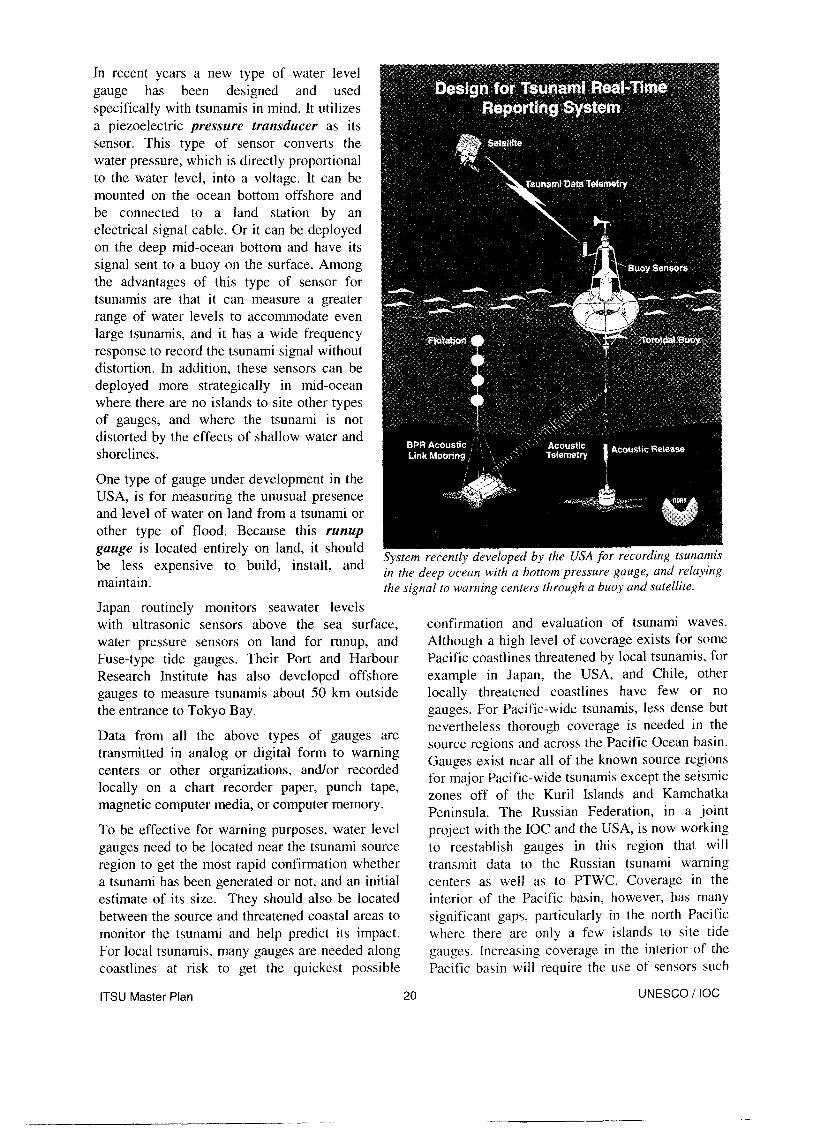
In recent years a new type of water level gauge has been designed and used specifically with tsunamis in mind. It utilizes a piezoelectric pressure transducer as its sensor. This type of sensor converts the water pressure, which is directly proportional to the water level, into a voltage. It can be mounted on the ocean bottom offshore and be connected to a land station by an electrical signal cable. Or it can be deployed on the deep mid-ocean bottom and have its signal sent to a buoy on the surface. Among the advantages of this type of sensor for tsunamis are that it can measure a greater range of water levels to accommodate even large tsunamis, and it has a wide frequency response to record the tsunami signal without distortion. In addition, these sensors can be deployed more strategically in mid-ocean where there are no islands to site other types of gauges, and where the tsunami is not distorted by the effects of shallow water and shorelines.
One type of gauge under development in the USA, is for measuring the unusual presence and level of water on land from a tsunami or other type of flood. Because this runup gauge is located entirely on land, it should be less expensive to build, install, and maintain.
System recently developed by the USA for in the deep ocean with a bottom pressure gauge, and relaying the signal to warning centers through a buoy and satellite.
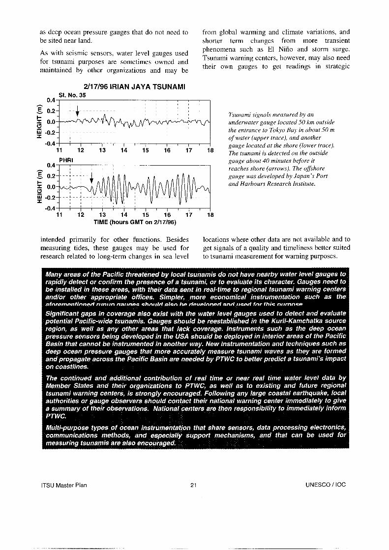
Japan routinely monitors seawater levels with ultrasonic sensors above the sea surface, water pressure sensors on land for runup, and Fuse-type tide gauges. Their Port and Harbour Research Institute has also developed offshore gauges to measure tsunamis about 50 km outside the entrance to Tokyo Bay.
Data from all the above types of gauges are transmitted in analog or digital form to warning centers or other organizations, and/or recorded locally on a chart recorder paper, punch tape, magnetic computer media, or computer memory.
To be effective for warning purposes, water level gauges need to be located near the tsunami source region to get the most rapid confirmation whether a tsunami has been generated or not, and an initial estimate of its size. They should also be located between the source and threatened coastal areas to monitor the tsunami and help predict its impact. For local tsunamis, many gauges are needed along coastlines at risk to get the quickest possible
confirmation and evaluation of tsunami waves. Although a high level of coverage exists for some Pacific coastlines threatened by local tsunamis, for example in Japan, the USA, and Chile, other locally threatened coastlines have few or no gauges. For Pacific-wide tsunamis, less dense but nevertheless thorough coverage is needed in the source regions and across the Pacific Ocean basin. Gauges exist near all of the known source regions for major Pacific-wide tsunamis except the seismic zones off of the Kuril Islands and Kamchatka Peninsula. The Russian Federation, in a joint project with the IOC and the USA, is now working to reestablish gauges in this region that will transmit data to the Russian tsunami warning centers as well as to PTWC. Coverage in the interior of the Pacific basin, however, has many significant gaps, particularly in the north Pacific where there are only a few islands to site tide gauges. Increasing coverage in the interior of the Pacific basin will require the use of sensors such
ITSU Master Plan 20 UNESCO / IOC
as deep ocean pressure gauges that do not need to from global warming and climate variations, and be sited near land. shorter term changes from more transient
As with seismic sensors, water level gauges used for tsunami purposes are sometimes owned and maintained by other organizations and may be
phenomena such as El Nifio and storm surge. Tsunami warning centers, however, may also need their own gauges to get readings in strategic
2/17/96 IRIAN JAYA TSUNAMI St. No. 35
0.4 I 1 / /
1
~~i~~~,~~ in ~- ~i~~~,~~~, ~~, i TV
/ Tsunami signals measured by an underwater gauge located 50 km outside the entrance to Tokyo Bay in about 50 m
- I -0.4 I i I i I 1 1 1 r 1 I 1 I
of water (upper trace), and another
11 12 13 14 15 16 17 18 gauge located at the shore (lower trace). The tsunami is detected on the outside
PHRI 0.4 I
11 12 13 14 15 16 17 18 TIME (hours GMT on 2/17/96)
gauge about 40 minutes before it reaches shore (arrows). The offshore gauge was developed by Japan’s Port and Harbours Research Institute.
intended primarily for other functions. Besides measuring tides, these gauges may be used for research related to long-term changes in sea level
locations where other data are not available and to get signals of a quality and timeliness better suited to tsunami measurement for warning purposes.
ITSU Master Plan UNESCO / IOC

Historical Tsunami and Earthquake Data
Warning centers need rapid access to historical tsunami and earthquake data to help in estimating whether an earthquake from a particular region may have generated a tsunami, and if that tsunami might have an impact on coastal regions within their area of responsibility. For example, it is helpful to know that a particular subduction zone has had many historical earthquakes above magnitude 8, but that none has ever generated a significant tsunami. And it is also useful to know what the historical readings were on a particular water level gauge for past destructive and non- destructive tsunamis from a certain source region. Such data, if they exist, are typically in the form of reports, catalogs, maps, and a few electronic databases, but these are formats are not optimally suited for ease and rapidity of use by warning centers. Projects such as the ITSU supported Expert Tsunami Database can help to make such data more accessible and useful to warning centers as well as scientists and emergency managers.
Numerical Model Da ta
Warning centers are beginning to use data from numerical models to provide guidance in predicting the severity of a tsunami within their AOR given the earthquake parameters and readings on water level gauges.
For example, to address their national tsunami threat, Japan is modeling runups from hypothetical earthquakes of different magnitudes and depths
ITSU Master Plan 22
located at over 1000 nearby offshore gridpoints. This will lead to a database of predicted tsunami heights along each coastal area for any local earthquake. The database will be used for warning as well as planning purposes. In case of an actual tsunami, the forecast heights and arrival times will be retrieved from the database immediately after the determination of the earthquake hypocenter and magnitude, and a tsunami warning containing those results will be disseminated. JMA is planning to begin operation of this new forecast method in the spring of 1999.
The West Coast / Alaska Tsunami Warning Center has also developed a method for predicting wave heights based on numerical modeling. It is constrained in real time by the earthquake parameters and readings from at least two water level gauges.
Other Data
Certain other types of data may be occasionally needed by tsunami warning centers, for example, as in the case of an impending volcanic eruption or landslide near a body of water. These kinds of events are usually handled on a case-by-case basis, often with the warning center working closely with another agency having more direct responsibility for the primary hazard.
UNESCO / IOC

I Communications
Tsunami warning systems have unique and extensive communications requirements. Seismic and water level signals must be sent from remote sites often without power or telephone lines, and warning messages must be transmitted quickly and reliably to subscribers having different means of access. Distances to be covered range from less than a kilometer to tens of thousands of kilometers. Meeting these needs requires a variety of communication methods.
‘1 Geostationary satellite antennas (lej2, partially hidden behind tree) and VHF radio antennas (right, at top of tower) make up part of PTWC’s many communications links.
Real Time Access to Data
Seismic and water level data used by warning centers must be reliably received in real or very near real time to be useful. Many communications techniques are used for this purpose including VHF radio, microwave, dedicated landlines, telephone dialup, continuous satellite links, scheduled satellite transmissions, and packet networks. In certain cases, more than one technique may be needed for access to a data collection site. Although a communications circuit may be commercially provided, specialized equipment is often needed to convert the data into a form transmittable on the circuit. Complicating the data communications problem is that collection sites may be located in remote places without power or access to telephone lines. Also, in the case of a local tsunami, power and telephone service may be lost due to the earthquake. For water level gauges, which have very low data rates, solar powered data collection platforms that
transmit on a regular schedule through the USA’s Geostationary Operational Environmental Satellite (GOES) or Japan’s Geostationary Meteorological Satellite (GMS) have provided a solution. Smart seismic stations that detect large earthquakes and only need to transmit a few bytes of parametric data, in contrast with standard seismic stations having a continuous data transmission requirement, are also under development.
Dissemination of Messages
Just as important as communications for real time access to data are communications methods to get a center’s warning and informational messages out quickly to its users. Short text messages may be securely transmitted to offices worldwide through dedicated circuits such as the Global Telecommunications System (GTS) or the Aeronautical Fixed Telecommunications Network (AFTN). Messages can also be transmitted worldwide through commercial circuits such as Telex. Electronic mail provides another way to quickly reach persons and offices worldwide, although this method can be less reliable because it depends on links over which centers have no control. On local or national levels, tsunami messages can also be sent over text or voice circuits designed for national defense or other emergencies. Messages can also be sent by telephone or fax, although these methods are less efficient because a connection must be established separately to each recipient.
ITSU Master Plan 23 UNESCO / IOC

1 Preparedness
Activities in this category take place in response to both the hazard assessment and warnings. The appropriate preparedness for a warning of impending danger from a tsunami requires knowledge of areas that could be flooded (tsunami inundation maps) and knowledge of the warning system to know when to evacuate and when it is safe to return. Without both pieces of information the response could be inappropriate and fail to mitigate the impact of the tsunami. A level of public awareness and understanding of tsunamis is also essential. Except in cases where there is time, resources, and procedures to carry out a mandatory forced evacuation, getting persons quickly and safely out of a potential inundation zone requires some knowledge of the hazard on their part. This is particularly true in the case of a locally generated tsunami where the only warning will be the shaking from the earthquake. Another type of preparedness is land use planning to locate essential facilities such as schools, police and fire departments, and hospitals outside of inundation zones. Engineering efforts to build tsunami- resistant structures, protect existing buildings, and create defensive tsunami barriers such as dikes or breakwaters are also a form of preparedness.
Evacuation 1
Evacuation plans and procedures are usually developed and carried out at a local level, since they require detailed knowledge of the coastal populations and facilities at risk, and the local resources that can be applied to the problem. Local tsunamis provide little or no time for a formal warning and may be accompanied by earthquake
damage, while distant tsunamis may give several hours time to get ready before the first waves arrive. For these reasons, evacuation preparations and procedures are different for the two cases.
Evacuations for Local Tsunamis
When a local tsunami is imminent, the only warning may be shaking from the earthquake, or an unusual behavior of the ocean. Persons at risk must recognize the danger signs, then move immediately and quickly inland and/or towards high ground, since destructive waves may strike within minutes or even less. Evacuees also face potential earthquake effects such as landslides and collapsed buildings and bridges that may hinder their efforts to escape. For this kind of rapid, undirected evacuation to be effective a high level of public awareness and education about the tsunami hazard is required. It also requires advance planning by public officials to map out and make known tsunami evacuation zones and safe evacuation routes. The key elements for motivating sufficient public education and the production of evacuation maps and procedures is a clear understanding of the tsunami risk and where tsunami inundation is likely to occur.
ITSU Master Plan 2 4 UNESCO / IOC
Evacuations for Distant Tsunamis
In the case of a distant tsunami, there is more time for authorities to carry out an organized evacuation. Following notification from a warning center that a tsunami has been generated, and the expected arrival time of the first wave, local emergency officials make a decision about whether an evacuation is warranted. This decision is based on knowledge from historical or model data about the threat to local coasts from the tsunami source region, and on further guidance received from the warning center about the severity of the tsunami as it moves closer. The public is informed about the impending hazard, and instructed about how, where, and when to evacuate. Designated local forces, such as the police, fire, and civil defense, help carry out the evacuation orders. Certain procedures to save property may also be carried out including moving boats and ships out to deep water and securing industrial facilities located near the water. Effective preparation is based on estimates of the potential inundation and other effects that may occur from a distant tsunami. Evacuation zones and routes to safety must be defined, and the public must be educated about the tsunami hazard and evacuation procedures so they won’t choose to remain in dangerous areas, enter them out of curiosity, or return before the threat has completely passed. Unnecessary evacuations must be minimized to retain public confidence in the system.
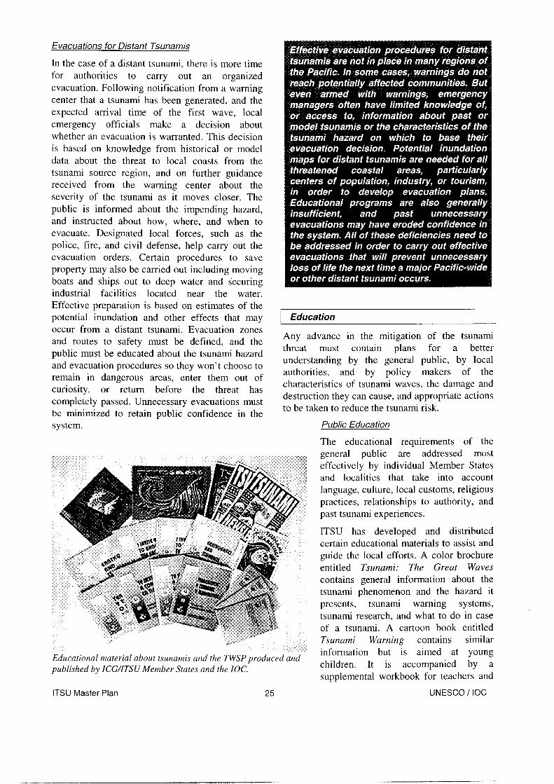
Educational material about tsunamis arid the TWSP produced and published by ICG/ITSU Member States and the IOC.
ITSU has developed and distributed certain educational materials to assist and guide the local efforts. A color brochure entitled Tsunami: The Great Waves contains general information about the tsunami phenomenon and the hazard it presents, tsunami warning systems, tsunami research, and what to do in case of a tsunami. A cartoon book entitled Tsunami Warning contains similar information but is aimed at young children. It is accompanied by a supplemental workbook for teachers and
ITSU Master Plan 25 UNESCO / IOC
Education
Any advance in the mitigation of the tsunami threat must contain plans for a better understanding by the general public, by local authorities, and by policy makers of the characteristics of tsunami waves, the damage and destruction they can cause, and appropriate actions to be taken to reduce the tsunami risk.
Public Education
The educational requirements of the general public are addressed most effectively by individual Member States and localities that take into account language, culture, local customs, religious practices, relationships to authority, and past tsunami experiences.

students that provides certain key information in more depth. Although both the brochure and the cartoon book are in English, they are now being put into a format that will facilitate easy translation and publication in other languages. Chile recently produced a set of four Spanish- language textbooks with teachers’ guides on the subject of earthquakes and tsunamis that cover grades K-12. They were subsequently translated into English by Canada. Each set has now been published and distributed with support from the IOC. In addition, ITIC is routinely involved in public education efforts such as: answering inquiries from students and concerned individuals; providing information to the news media,
PACIFIC OCEAN
--y EVtiUAriOl ROUTES L $ggj REmI@ ff)W .~.~ -i Inundation and Evacuation Map created for the coastal town of Pucusana, Peru.
producers of television and film documentaries, and book writers; giving public lectures; and assisting other organizations with programs that educate the public about tsunamis. ITIC is also developing a website that will contain a wide variety of tsunami-related information of interest to the general public as well as the tsunami mitigation community. Some Member States also carry out their own public tsunami education programs.
Education for Warninq Svstem Operators, Emerqencv Manaqers, and Policv Makers
Warning system operators, emergency managers, and policy makers also have an educational need to be met. Because tsunamis, either distant or local, occur so infrequently on any particular coast, these key
people often have little or no prior personal experience with the phenomenon on which to base their decisions concerning preparations or actions to be taken when one strikes. They may depend almost entirely upon training programs and/or convenient access to information about tsunamis in general, the particular threat to their areas of responsibility, warning systems, and mitigation measures.
ITSU has developed several programs to help meet these needs. The Visiting Experts Program conducted annually by ITIC with IOC support and assistance from PTWC and other organization% trains scientists and engineers from all over the Pacific about the tsunami threat, warning systems, and mitigation efforts. Some Member States also conduct training programs for natural hazards that include tsunamis. A Tsunami Newsletter, with information about recent tsunami events and mitigation activities is published by ITIC and distributed internationally to about a thousand persons and offices having some kind of responsibility with respect to tsunamis. ITIC also responds to frequent information requests from emergency managers and policy makers. The ITIC tsunami website will soon provide another kind of worldwide access to pertinent tsunami information. The Expert Tsunami Database is also an excellent tool that can provide quick access to historical tsunami data across the Pacific.
ITSU Master Plan 26 UNESCO / IOC

Land Use
As the global population expands, threatened coastal areas are being developed at an ever-increasing rate. While it may not be possible to prevent this development, certain communities have chosen to prohibit the construction in potential inundation zones of facilities such as such as schools and nursing homes that put especially vulnerable parts of the population at risk. Other essential facilities such as police and fire departments or hospitals have also been prohibited. In addition, tourist facilities such as beachfront hotels have been required to put in place tsunami evacuation procedures to ensure the safety of their guests.
Engineering
Certain kinds of engineering can help mitigate tsunami effects. Buildings in tsunami zones can be strengthened to withstand forces expected from the impact of waves and strong currents. Foundations can be constructed to resist erosion and undercutting from currents. In some cases the ground floor of oceanfront buildings can be made open to allow seawater to pass through. This helps reduce undercutting flow around the perimeter of the foundation. Hotel rooms can also be built only above the first floor to reduce the threat to hotel guests who may be uneducated about tsunamis.
ITSU Master Plan 27
Essential parts of a building’s infrastructure such as emergency generators, power distribution centers, and elevator motors can be located on floors unlikely to flood. Heavy objects such as fuel tanks that may float away and act like battering rams can be securely fastened to the ground. Transportation systems can be constructed or modified to facilitate rapid mass evacuation out of inundation zones. In cases where the threat is great and there are adequate resources available, certain kinds of defense works such as sea walls, sea dikes, breakwaters, and river gates can be built to repel tsunamis. Such major efforts have been carried out in Japan, particularly along the Sanriku coast. These activities are motivated in large part by knowledge of potential inundation zones, and damage from past tsunamis.
UNESCO / IOC

Research
Although not directly a part of the mitigation activities, tsunami-related research is nevertheless essential to improve mitigation. Research that yields evidence of paleotsunamis, expands a historical database, or quantifies the effects of a recent tsunami can improve the accuracy of the hazard assessment. The same is true for research that leads to improved numerical modeling of
- tsunamis. Techniques for warning systems to more rapidly and accurately assess the tsunamigenic potential of earthquakes from seismic data are developed through research. So are better water level instrumentation and techniques for forecasting the impact of tsunamis in real time. Research can also provide improved ways of designing educational campaigns to keep the public as well as emergency personnel informed about tsunamis so they carry out the proper actions when the need arises. Creating effective evacuation procedures, particularly in consideration of additional hazards that could exist if the tsunami was locally generated by a large earthquake, may require research. Research can also help guide land-use planning in potential inundation zones and can lead to more tsunami- resistant designs for structures and facilities located there.
Tsunami Society. Communications between tsunami scientists worldwide is facilitated through the Tsunami Bulletin Board, an email distribution service initially set up by the USA and now operated by ITIC for ITSU. Summary information regarding recent tsunamis, upcoming meetings, meeting reports, and recent publications are published for ITSU by ITIC with IOC support in the biannual Tsunami Newsletter. A tsunami website is also under development at ITIC that will contain information on research needs and the results of certain research projects.
Areas for Research
Structure
There is no formal research program that operates under the aegis of ITSU, nor does a formal research coordination process exist between the Member States of ITSU. Most tsunami research is carried out through research programs of the individual Member States. However, tsunami research often involves a significant amount of international collaboration and exchange of data. The most important meeting with regard to scientific research on tsunamis is the biannual Tsunami Symposium, organized by the Tsunami Commission of the International Union of Geodesy and Geophysics. Numerous other geophysical, oceanographic, and general hazard mitigation meetings also take place that include tsunamis in their programs. In addition, workshops to address specific tsunami problems or the tsunami problem in specific coastal areas are often held. Research articles are published in a wide variety of geophysical and natural hazards journals, and in the Science of Tsunami Hazards, the journal of the
Present techniques for real time tsunami prediction are still severely limited. Although the potential for a tsunami exists whenever a shallow earthquake of sufficient size and with an appropriate mechanism occurs near or under the ocean, the only way to quickly determine with certainty if an earthquake is accompanied by a tsunami is to detect the presence of the waves using a network of water level stations or to receive reliable observations by eyewitnesses. It is not yet possible to precisely determine the area1 extent, amplitude, or time history of the seafloor deformation that initiates a tsunami from seismic or water level data. Furthermore, while it is possible to predict when the initial tsunami energy will arrive at coastal locations, it is not yet possible to predict with much certainty the wave height, number of waves, duration of hazardous conditions, or forces to be expected from such waves, even with readings from water level gauges between the source and those locations.
Numerical models continue to be developed and improved to address the tsunami problem. T.raditional finite difference models are useful for modeling tsunami waves in the deep ocean, but are generally inadequate for resolving coastal geometry and bathymetry with the required precision. Finite element models, however, with their irregular triangular grids can provide the needed resolution. These types of models should be used to compute run up, inundation limits, and horizontal currents for known and hypothetical source events. The interaction of the tsunami with the tides should be considered in determining the total water level and how it varies with time during the entire duration of the tsunami. The information
ITSU Master Plan 28 UNESCO / IOC

from models regarding horizontal currents can provide input for the computation of forces on structures, as well as hazardous conditions in harbors. Techniques should also be developed to run models in real time during tsunamis to help warning centers and emergency managers predict
earthquakes”. Their rupture process may take one to several minutes in contrast to just a few seconds to several tens of seconds for an ordinary or impulse earthquake, and their depth of faulting may be very close to the seafloor. During this slow rupture it is quite possible that a larger percentage
the impact. of the seismic energy couples into the tsunami
There is a need for advance modeling of tsunami signals on key water level instruments to assist warning centers in making more rapid and accurate assessments of tsunami severity. For example, there are about twenty gauges most strategically located in the interior and along the borders of the Pacific Basin, and there are only a few major source areas for Pacific-wide events. Theoretical mareograms for appropriate combinations of sources and gauges are needed as a reference for warning centers to help in evaluating potential damaging tsunamis as they spread across the Pacific Basin.
In recent years, some unusual tsunamis (e.g. 1992 Nicaragua, 1994 Indonesia, and February 1996 Peru) have motivated a new dimension to tsunami research. The maximum amplitudes of these tsunamis are much too large relative to the sizes of the earthquake that caused them. Seismologists know that the earthquake magnitude scale based on 20-second-period surface waves saturates beyond a value of about 8 and does not accurately represent the size of the largest earthquakes. So this might account for the discrepancy. But even seismic moment, a more representative parameter for earthquake size that is based on much longer-period seismic waves that don’t saturate, cannot seem to explain why certain tsunamis have such large amplitudes. It is suggested that these earthquakes belong to special class referred to as “tsunami earthquakes” or “slow
Tsunami Forecasting
Example: 4 October 94 Kwrii Gland ‘hmami
Deep-
1 I I
6
5WN
48"N
46”N
44-N
4ZN
7 8 9 10 11 12 13 14 15 16 17 18 Hours after main shock
135”w 13ww 1ww 12o”w
Bottom pressure gauges in the deep ocean provide a more direct measurement of a tsunami than shore-based tide gauges, and these signals are more useful for predicting a tsunami’s impact at the coast. This example shows the recent Shikotan tsunami recorded in the deep ocean and near shore, and it illustrates that there can be large differences between signals of the same tsunami recorded on closely spaced shore- based gauges.
ITSU Master Plan 29 UNESCO I IOC
-.-_ ..l---_

mode, as compared to only about 10% of the seismic energy being transferred to the tsunami during a normal impulse earthquake. At present, there is no completely satisfactory explanation for the occurrence of these disproportionately large tsunamis, but it is an area that will require further research by tsunami scientists.
Another area that needs research attention is the role of resonance amplification in explaining why along the coastlines of bays and gulfs the tsunami amplitudes are so large while at other nearby locations the amplitudes are considerably smaller.
For many areas of the Pacific, the historical tsunami record is very limited or even nonexistent. Research to find and analyze evidence of paleotsunamis may help to extend the tsunami record in certain coastal regions much further back in time and lead to a better understanding of the tsunami hazard in those and nearby areas as well as perhaps the entire Pacific region.
Recent Research Applications
There are many examples in the recent past of contributions to tsunami mitigation made through research efforts. The following are just a few of them.
Hokkaido Nansei Tsunami 12 July 1993
q Tohoku I,. r-l 0 PvfFu AUJNR
Runup values for the tsunami that struck Okushiri Island, Japan, the night of July 12. 1993.
Tsunami Inundation Mapping: The technology now exists to produce inundation maps as a basis for emergency preparedness. The ITSU supported project Tsunami Inundation Modeling Exchange (TIME) has provided the transfer of a numerical inundation model developed by Professor Shuto of Japan, and training in how to use it, to many of the Member States. Scientists in the USA have enhanced the mapping technique for local events by incorporating the other earthquake effects of ground shaking, liquefaction, and landslides. These technologies offer new tools for identifying the coastal areas at risk and the level of hazard they may encounter in the event of a local or distant tsunami.
Tsunami Runup Data: The accuracy of the models mentioned above relies on observations of tsunami
to compare with numerical simulations. Since 1992, there have been 8 destructive tsunamis that have been surveyed by scientists from all over the world. Data collected by these surveys have provided a wealth of new information on the runup phase of tsunami dynamics. These data are being used to validate and improve numerical models.
Deep Ocean Tsunami Data: As tsunamis interact with coastlines and harbors, their amplitudes and periods are transformed and modified by the local bathymetry and topography. Consequently, a tsunami signal recorded within a harbor by a tide gauge yields only low quality information for predicting the tsunami impact at other locations. To provide an accurate forecast, more direct measurements of the tsunami in the open ocean are needed. A network of recently developed real time reporting deep ocean pressure gauges is now being deployed off USA coasts to provide this capability.
ITSU Master Plan 30 UNESCO / IOC
-__- -- _---

Earthquake Location and Magnitude Technology: France has developed a single station, 3- component broadband seismic system for tsunami warning purposes called TREMORS (Tsunami Risk Evaluation through seismic Moment from a Real-time System). It quickly and automatically estimates an earthquake’s location, and then computes its seismic moment, a better estimator of tsunamigenic potential. TREMORS success in Tahiti demonstrates that other countries might use this technology and these systems have recently been installed in Chile, Indonesia, Brunei, Peru, Korea, and PTWC, and also in Europe and Portugal.
ITSU Master Plan 31 UNESCO / IOC

CONCLUSIONS
Although a significant amount of progress has been made in recent years to improve the Tsunami Warning System in the Pacific, much still remains to be done to effectively mitigate the hazard posed by local and distant tsunamis in all parts of the Pacific Basin. Areas for work that are especially important for improving the TWSP and should receive the highest priority for action by ITSU in the coming years are the following:
. Runup Maps - Use numerical model and historical data to create potential runup maps as the basis for hazard assessment, for evacuation maps and plans, and to motivate other key mitigation activities on the local level including public education, land use planning, and engineering efforts.
l Historical Data - Put historical data into a common database format, and develop tools that make those data readily available to persons and offices that need them in the mitigation and research communities.
l Tsunami Education - Continue to develop educational materials and programs that will improve tsunami awareness and education among the public, warning center operators, emergency managers, and policy makers.
l Warning Centers - Establish new regional warning centers for the local tsunami threat in areas without coverage, and develop technologies and methodologies to improve the speed, accuracy, and reliability of all tsunami warning centers.
l Water Level Instrumentation - Improve the strategic coverage of water level instruments and the quality of signals they record for both warning and research purposes.
l Operational Actions - Local authorities, observatories, and warning centers need to send tsunami observations immediately to their national warning centers, and in turn those centers must send that information immediately to PTWC.
l New Tsunamis - Collect and archive all water level gauge data as well as runup and inundation measurements following each large earthquake and/or tsunami. The absence of a tsunami signal on a record is also important, and those records should be saved as well.
l Communications - Keep abreast of new communications systems that may be more effective for warning center and other purposes, and adopt them for use in the TWSP as appropriate.
l Research - Encourage and support research on tsunamis and all tsunami-related topics with the potential to improve mitigation.
The key components of the tsunami mitigation plan - hazard assessment, warning, preparedness, and research - must be highly interactive and well coordinated to be effective. ITSU, as a coordinating body of scientists, emergency managers, emergency planners, and warning center operators, with representatives from each affected nation, is well designed to successfully implement this plan.
ITSU Master Plan 32 UNESCO / IOC
ACKNOWLEDGEMENTS
Appreciation is expressed to the author, G.C. Dohler, and other contributors to the first edition of this document. The revised text for the second edition was written in parts by a variety of authors including a task team designated at ITSU-XVI made up of former ITIC Acting Director D. Sigrist and representatives from France and Mexico, and an Editorial Group designated at ITSU-XV made up of ITSU Chairman H. Gorziglia, former ITIC Director C. McCreery, Australian tsunami expert T. Murty, and IUGG Tsunami Commission representative E. Bernard. The National Contact of Japan, Y. Sawada, provided many good comments and additional information, Comments were also gratefully received from many other Member States through their National Contacts and experts, The final draft was reviewed at the January 1999 ITSU Officers Meeting by ITSU Chairman H. Gorziglia, ITSU Vice-Chairman F. Schindele, the National Contact of the Republic of Korea S. Kim, PTWC Director C. McCreery, ITIC Director M. Blackford, and the IOC Technical Secretary I. Oliounine.
ITSU Master Plan 33 UNESCO / IOC
List of Acronyms
AFTN AGSO AOR DHN ETDB ETOS GMS GOES GTS HTDB ICGLTSU
INETER IOC ITIC ITSU
IUGG JMA K-12 KMA NGDC NOAA NTF NWS osso PTWC SHOA SNAM TIME TREMORS TWSP UNESCO VHF WCIATWC WDC-A WMO
Aeronautical Fixed Telecommunications Network Australian Geological Survey Organization (Australia) Area of Responsibility Direccidn de Hidrografia y Navigacidn del Peru (Peru) Expert Tsunami Database Earthquake and Tsunami Observation System Geostationary Meteorological Satellite (Japan) Geostationary Operational Environmental Satellite (USA) Global Telecommunications System Historical Tsunami Database (or ITSU) International Coordination Group for the Tsunami Warning System in the Pacific Instituto Nicaraguense de Estudios Territoriales (Nicaragua) Intergovernmental Oceanographic Commission International Tsunami Information Center (or ICG/ITSU) International Coordination Group for the Tsunami Warning System in the Pacific International Union of Geodesy and Geophysics Japan Meteorological Agency (Japan) Kindergarten through 12” Grade Korea Meteorological Administration (Republic of Korea) National Geophysical Data Center (USA) National Oceanic and Atmospheric Administration (USA) National Tidal Facility (Australia) National Weather Service (USA) Observatorio Sismologico de1 Suroccidente (Colombia) Pacific Tsunami Warning Center Hydrographic and Oceanographic Service of the Chilean Navy (Chile) Sistema National de Alarma de Maremotos (Chile) Tsunami Inundation Modeling Exchange Tsunami Risk Evaluation through seismic Moment from a Real-time System Tsunami Warning System in the Pacific United Nations Educational, Scientific, and Cultural Organization Very High Frequency Radio West Coast / Alaska Tsunami Warning Center (USA) World Data Center - A World Meteorological Organization
ITSU Master Plan 34 UNESCO / IOC