j10017 ea final 17 may 3 - insite yancoal australia · final report j10017 ... discussed with...
TRANSCRIPT

PROPOSED MODIFICATION TO HVO SOUTH COAL PROJECT
Environmental AssessmentPrepared for Coal & Allied Operations Pty Limited |May 2010

“This page has been intentionally left blank”

Proposed Modification to HVO South Coal Project
Final Report
J10017 | Prepared for Coal & Allied
Prepared by Joanna Greenlees
Position Environmental Scientist
Signature
Date 17 May 2010
The preparation of this report has been in accordance with the brief provided by the Client and has relied upon the data
and results collected at or under the times
recommendations contained within the report are based only on the aforementioned circumstances.
Document Control
Version Date Prepared by
A 6 May 2010 JG
B 11 May 2010 JG
C 14 May 2010 BM
D 17 May 2010 BM
Environmental and Planning Consultants
T + 61 (0)2 9212 3466 | F + 61 (0)2 9
Level 4 | Suite 78 | 330 Wattle Street
emgamm.com.au
Proposed Modification to HVO South Coal Project
| Prepared for Coal & Allied Operations Pty Ltd | 17 May 2010
Approved by Brett McLennan
Environmental Scientist Position Director
Signature
Date 17 May 2010
The preparation of this report has been in accordance with the brief provided by the Client and has relied upon the data
and results collected at or under the times and conditions specified in the report. All findings, conclusions or
ined within the report are based only on the aforementioned circumstances.
Prepared by Reviewed by
BM
BM
BM PM
BM PM
Environmental and Planning Consultants
F + 61 (0)2 9212 3468
Street | Ultimo | New South Wales | 2007 | Australia
Brett McLennan
May 2010
The preparation of this report has been in accordance with the brief provided by the Client and has relied upon the data
report. All findings, conclusions or
ined within the report are based only on the aforementioned circumstances.
Australia

“This page has been left blank intentionally”

i
Table of Contents
Chapter 1 Introduction
1.1 Background 1
1.2 Approval history 1
Chapter 2 Proposed modification
2.1 HVO South ecological assessment 5
2.2 Archerfield Biodiversity Enhancement Area 6
2.3 The proposed Warkworth Extension 6
2.4 Justification 7
2.5 Goulburn River Biodiversity Area 8
2.6 Monitoring and management plans 9
Chapter 3 Conclusion
Figures
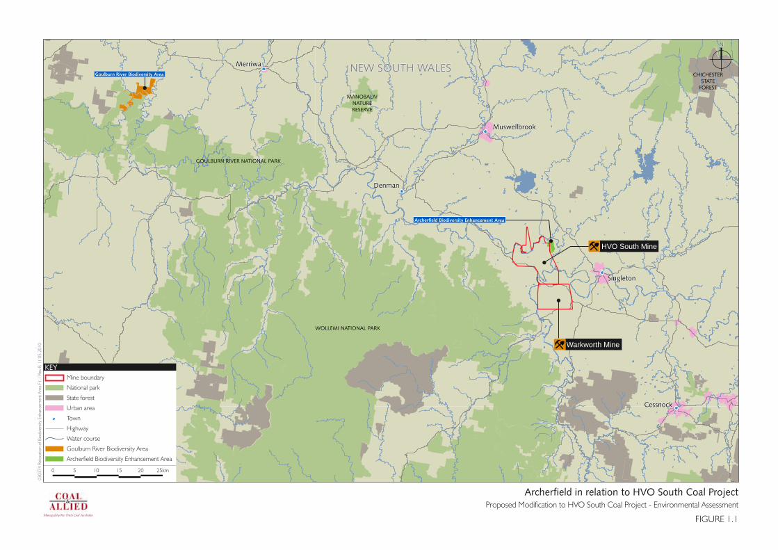
1.1 Archerfield in relation to HVO South Coal Project 3
2.1 Archerfield Biodiversity Enhancement Area 11
2.2 Vegetation Communities within Northern Biodiversity Area 13
2.3 Threatened Species within Northern Biodiversity Area 15
2.4 Vegetation Communities within Goulburn River Biodiversity Area 17
2.5 Threatened Species within Goulburn River Biodiversity Area 19
Appendix
A Current Project Approval

ii
“This page has been left blank intentionally”

1
1 Introduction
This Environmental Assessment (EA) has been prepared to support an application under Section 75W of
the Environmental Planning and Assessment Act 1979 (EP&A Act) to modify the Hunter Valley Operations
South (HVO South) Coal Project Approval 06_0261.
The modification proposed is to reallocate the Archerfield Property provided as a Biodiversity
Enhancement Area to offset impacts caused by the clearing of native remnants (48ha) and regrowth
(92ha) for the HVO South Coal Project to an alternative site within the Goulburn River Biodiversity Area
(see Figure 1.1). The Archerfield Property is herein referred to as Archerfield.
The modification proposed would allow Archerfield to be used as part of the Northern Biodiversity Offset
Area for the proposed Warkworth Extension.
Hunter Valley Operations (HVO) is an open cut coal mining complex owned by Coal & Allied Operations
Pty Limited (Coal & Allied) in the Hunter Valley, located approximately 18 kilometres (km) west of
Singleton (Figure 1.1). The HVO is split geographically by the Hunter River into HVO North and HVO
South. While HVO South and HVO North have separate project approvals, HVO is managed as an
integrated operation.
1.1 Background
The HVO South operations, which comprises the Cheshunt, Riverview and Lemington pits and the
Lemington Coal Preparation Plant (CPP), are located within the Singleton local government area. The area
surrounding the site is dominated by coal mining, industrial development and agriculture.
The movement of coal, coarse and fine reject, overburden, topsoil, operational water, equipment,
materials and personnel may occur between HVO South and HVO North.
The HVO North operations comprise the active West, Carrington and North pits and the mined out Alluvial
Lands. In addition, three coal preparation plants (CPPs) are located at HVO North; Hunter Valley CPP,
Newdell CPP and Howick CPP. There are two train load out areas; Hunter Valley Load Point and Newdell
Load Point. In addition, Ravensworth Coal Terminal is utilised.
1.2 Approval history
Coal & Allied’s HVO has expanded over time through a process of extension of existing mines and
acquisition of additional mines. As a result there were numerous historic development approvals that
applied to the operation.
In 2003, Coal & Allied obtained development consent for the continued operation and amalgamation of
all its coal mining and processing operations north of the Hunter River. This consent also amalgamated 18
differing consents and approvals with a single, unambiguous consent that sets out Coal & Allied’s
obligations, limits and controls for the HVO North operations.
In 2009, Coal & Allied obtained project approval for the continued operation and amalgamation of all coal
mining and processing operations south of the Hunter River. The project approval also amalgamated 25
separate consents and 10 associated modifications that apply to HVO South with a single project
approval. The current Project Approval 06_0261 is included in Appendix A.

2
“This page has been intentionally left blank”
SingletonSingleton
CessnockCessnock
MerriwaMerriwa
MuswellbrookMuswellbrook
DenmanDenman
Mine boundary
National park
State forest
Urban area
Town
Highway
Water course
Goulburn River Biodiversity Area
Archerfield Biodiversity Enhancement Area
KEY
0 25km5 10 15 20
03
03
74
Relo
catio
n o
f Bio
dvi
ers
ity E
nhan
cem
ent
Are
a F1
.1 R
ev
B 1
1 0
5 2
01
0
FIGURE 1.1
Archerfield in relation to HVO South Coal ProjectProposed Modification to HVO South Coal Project - Environmental Assessment
Managed by Rio Tinto Coal Australia
NN
CHICHESTERSTATE
FOREST
NEW SOUTH WALESNEW SOUTH WALES
Warkworth Mine
Archerfield Biodiversity Enhancement Area
Goulburn River Biodiversity Area
MANOBALAINATURERESERVE
GOULBURN RIVER NATIONAL PARK
WOLLEMI NATIONAL PARK
HVO South Mine

4
“This page has been intentionally left blank”

5
2 Proposed modification
The modification proposed is to reallocate remnant woodland vegetation and native enhancement areas
(140ha) in Archerfield to an alternative site within the Goulburn River Biodiversity Area (as shown in
Figure 1.1). Archerfield was provided as a “Biodiversity Enhancement Area” to offset impacts caused by
the clearing of native remnants (48ha) and regrowth (92ha) vegetation for the HVO South Coal Project.
The modification proposed would allow the Archerfield Biodiversity Enhancement Area to be used as part
of the Northern Biodiversity Offset Area for the proposed Warkworth Extension. Further details of the
proposed Warkworth Extension and the Northern Biodiversity Offset Area are provided in the Proposed
Warkworth Extension Environmental Assessment (EMGA Mitchell McLennan 2010).
2.1 HVO South ecological assessment
The ecological assessment for the HVO South Coal Project (Hunter Valley Operations South Coal Project,
ERM 2008) considered the previous assessments undertaken and the potential direct, indirect and
cumulative impacts of the existing approvals for vegetation clearance within HVO South. Any threatened
species, populations or ecological communities not previously assessed under section 5A of the EP&A Act
and Environment Protection and Biodiversity Conservation Act 1999 (EPBC Act) were identified and
discussed with respect to the potential for them to be impacted by existing approvals for vegetation
clearance within HVO South.
The ecological assessment was made on the basis that previous impact assessments have concluded that
no significant impacts to threatened species or ecological communities were expected. Much of the
habitat upon which these assessments were undertaken has since been cleared due to approved mining
operations.
The ecological assessment for the HVO South Coal Project (Hunter Valley Operations South Coal Project,
ERM 2008) found that the majority of general environments at HVO South are low in habitat complexity.
The greatest number of species recorded at HVO South were birds, with a general low diversity of ground-
dwelling and arboreal mammal species, reptiles and amphibians. This would be expected given the
isolated nature of the vegetation remnants found within HVO South, making them more suited to mobile
species such as birds and bats.
The diversity of flora species varied across the site and was greatest in areas where disturbance levels
were low or where disturbances have been removed. All areas contained exotic species, which were
generally dominant in areas of high disturbance such as roadsides and riparian zones.
Three extension areas were proposed for the HVO South Coal Project. Only one of the extension areas
had not been assessed in previous ecological impact assessments undertaken at HVO South. This area
located to the south east of the Riverview Pit, and covers some regrowth woodland, cleared and
developed land and part of the Hunter Valley Gliding Club property. The area contains previously
disturbed and cleared land with some regrowth woodland (immature trees to 8m and Diameter at Breast
Height of 10cm) and was considered to be of limited value as fauna and flora habitat. Threatened birds
such as the Grey-crowned Babbler may forage in this area but it is unlikely that any fauna species would
rely on this area for resources given its current condition, and the availability of habitat in adjacent areas.
Therefore it was considered that the removal of this small area was unlikely to impact on any threatened
species such that potential impacts would be significant.

6
The HVO South Coal Project involves increasing the area of mining and infrastructure disturbance by
250ha, which includes 48ha of remnant vegetation and 92ha of regenerated vegetation. None of these
areas to be cleared include the State listed Warkworth Sands Woodland (WSW). The assessment of
extension areas concluded that no threatened or endangered species or communities will be significantly
impacted by the proposal.
A site-specific conservation significance assessment was developed as part of the ecological assessment
to identify areas that provided the greatest biodiversity enhancement opportunities. This assessment
rated the various ecological parameters of each area to be cleared and of adjoining remnant vegetation
areas as identified by Coal & Allied.
2.2 Archerfield Biodiversity Enhancement Area
The conservation significance assessment undertaken for the HVO South Coal Project (Hunter Valley
Operations South Coal Project, ERM 2008) identified the highest rating area as Archerfield, this area is
located to the north east of the Project Application area. The 140ha area of remnant woodland
vegetation and native enhancement area was retained and managed for its potential to provide a
significant area of habitat for native flora and fauna.
The 140ha offset was proposed to provide a biodiversity enhancement area, the Archerfield Biodiversity
Enhancement Area for the life of the development (see Figure 2.1). It was determined that the area was
appropriate to provide a reasonable biodiversity offset for the loss of vegetation and habitat that would
be caused by the project.
The Archerfield Biodiversity Enhancement Area contains 123.3ha of woodland including almost 20ha of
WSW. The conservation and ongoing management of this higher value woodland and the potential for
WSW to regenerate in the area was proposed to result in the ongoing viability of a large area of flora and
fauna habitat within HVO South and the locality.
The Archerfield Biodiversity Enhancement Area also has an extensive area of the soil type and geology
required for the growth of WSW. These areas have recently been mapped as containing 195.8ha of
Warkworth Sands Derived Native Grassland. This derived grassland does not form part of the 140ha
offset for the HVO South Coal Project.
As previously discussed, the extension area assessed for the HVO South Project did not require the
clearing of WSW and offsets were not required for this community.
2.3 The proposed Warkworth Extension
Warkworth Mining Limited (WML) operates Warkworth Mine, an existing open-cut mine located
approximately 15km southwest of Singleton. Warkworth is one of several mines in the area, others being
Mount Thorley, Bulga and Wambo mines and HVO. Economic resources of coal have been identified
south and south west of the Warkworth Mine and WML is seeking a project approval under the EP&A Act
to extend mining activities into these areas, refer to Proposed Warkworth Extension Environmental
Assessment (EMGA Mitchell McLennan 2010).
Biodiversity offset areas have been proposed for the proposed Warkworth Extension. These include the
Southern, Northern and Goulburn River Biodiversity Areas. Warkworth Sands Woodland covers
approximately 202.0ha of the study area for the proposed Warkworth Extension. Of this, approximately
103.5ha of WSW is proposed to be progressively cleared consisting of high and medium quality
vegetation. This includes 35.6ha that has been previously approved for clearing before 2017, with a
further 67.9ha proposed to be progressively cleared after nominally 2017.

7
The quality of WSW varies considerably and can be considered to vary from high to low depending upon
species composition, structural formation and the level of recent disturbance. The higher quality areas
tend to occur on deep sands and have the full complement of tree and shrub species associated with this
community, while the low quality vegetation typically consists of grassland with scattered trees.
The occurrences of WSW have been assessed and mapped in an attempt to offset impacts from the
proposed clearing of 103.5ha of this community for the proposed Warkworth Extension. Accordingly,
WML propose to avoid and protect 104.9ha (19.5ha at Archerfield) as offsets for this community and
proposes to enhance and re-establish some 195.8ha (mapped as Warkworth Sands Derived Native
Grassland) of this community within a Northern Biodiversity Area at Archerfield; to establish a large, fully
functioning ecological community.
Approximately 103.8ha of the Central Hunter Grey Box- Iron Bark Woodland contained at Archerfield is
also proposed to offset clearing for the proposed Warkworth Extension.
2.4 Justification
The proposed modification to the HVO South Project Approval 06_0261 proposes that the Archerfield
Biodiversity Enhancement Area would be better utilised as an offset area for the proposed Warkworth
Extension, which is likely to have an impact on the State listed WSW, refer to Proposed Warkworth
Extension Environmental Assessment (EMGA Mitchell McLennan 2010).
Coal & Allied and WML have considered options for offsetting both the HVO South Coal Project and the
proposed Warkworth Extension using an integrated approach aimed at achieving the best conservation
outcomes for the impacts from their respective activities on Endangered Ecological Communities (EEC)
and threatened species. In order to achieve strategic conservation outcomes both mines have reassessed
their current offset strategies.
The HVO South Coal project required approximately 140ha of general woodland vegetation to be
conserved for the life of the development. This general woodland vegetation could be offset within the
Goulburn River Biodiversity Area. This area has a high biodiversity value and ability to regenerate. The
Goulburn River Biodiversity Area offers greater habitat complexity and strategic conservation outcomes
than that provided by the current offset arrangements of 140ha of general woodland for HVO South.
Further details on the Goulburn River Biodiversity Area are provided in Section 2.5.
The ability to include the Archerfield Biodiversity Enhancement Area as part of the Northern Biodiversity
Area for the proposed Warkworth Extension also has long term strategic conservation outcomes. The
proposed Northern Biodiversity Area has been developed to conserve and re-establish significant areas of
WSW whereas the offset for HVO South in this area was to conserve 140ha of general woodland. The
sands provide a higher order use for re-establishing WSW.
The desired outcome of enhancement and re-establishment of the WSW community in the biodiversity
areas is considered achievable through research undertaken by the University of New England and site
selection. The Warkworth Sands Derived Native Grassland in the Archerfield Biodiversity Enhancement
Area contains a naturally occurring intact sand profile which once supported the WSW. This sand profile
provides the foundation and hydrology suitable for the re-establishment of the woodland. The Northern
Biodiversity Area provides an increase in the area of conservation to 342ha. This area will offer long term
protection of 123.3ha of woodland (including almost 20ha of WSW to be enhanced) as well as
conservation, re-establishment and long term protection of some 195.8ha of WSW. A Biodiversity
Management Plan has been prepared for all the offsets for the proposed Warkworth Extension, including
the Goulburn River Biodiversity Area and is included in Annex E of the Proposed Warkworth Extension

8
Environmental Assessment (EMGA Mitchell McLennan 2010). The vegetation and threatened species
locations of the Northern Biodiversity Area are shown in Figure 2.2 and Figure 2.3, respectively.
2.5 Goulburn River Biodiversity Area
The Goulburn River Biodiversity Area is also proposed to form part of the offsets for the proposed
Warkworth Extension and includes 140ha for reallocating the HVO South offset.
The Goulburn River Biodiversity Area is approximately 1,562ha in size and is located approximately 100km
to the north west of HVO (see Figure 1.1). The property sits adjacent to the northern side of Goulburn
River National Park and has river frontage along the Munmurra and Goulburn rivers and includes the
junction of the two rivers. The site also sits a short distance from the Krui River, which along with the
Munmurra, has a constant flow of water fed by underground aquifers upstream. The vegetation on the
site has been generally cleared along the river flats while the vegetation of the lower foothills and upper
sandstone escarpments seems relatively undisturbed. Despite the past agricultural use of the river flat
areas weed invasion was found to be relatively low.
The vegetation on the river flats and valley floor corresponds to the State listed EEC Box Gum Grassy
Woodland and Derived Native Grasslands with canopy species, where present, including White Box,
Yellow Box and Blakely’s Red Gum. Regeneration of the canopy species is common throughout the valley
floor and it is considered that the vegetation would return to a functioning sustainable community with
the cessation of grazing. The riparian vegetation is dominated by River Oak and Roughbarked Apple while
the vegetation of the lower foothills forms four different intergrading communities with composition
depending upon slope, geology and aspect. These communities are; a shrubby version of the State listed
EEC White Box woodland; Rough-barked Apple woodland; Narrow-leaved Ironbark woodland and Slaty
Gum (Eucalyptus dawsonii) open woodland. The upper slopes and ridges typically contain two
intergrading communities dominated by Narrow-leaved Ironbark and Narrowleaved Stringybark as well as
Narrow-leaved Ironbark and Grey Gum (Eucalyptus punctata var. punctata). Other canopy species occur
within these communities depending upon location such as Black Cypress Pine (Callitris endlicheri),
Bulloak (Allocasuarina luehmannii) and Brown Bloodwood (Corymbia trachyphloia).
The site provides known habitat for the State listed endangered species Pomaderris queenslandica, five
separate epiphytic Tiger Orchids (the species forms part of an endangered population in the Hunter
Catchment), Speckled Warbler, Brown Treecreeper and Diamond Firetails. It is also considered possible
that during flowering periods that this site could provide potential breeding habitat to the Regent
Honeyeater particularly during heavy canopy tree or mistletoe flowering periods. The Goulburn River
Biodiversity Area is located approximately 100km to the north of the Capertee Valley, an area known to
be the core breeding habitat for this species. Due to the nomadic foraging habits of the Regent
Honeyeater it is not unlikely that the species would forage and/or breed on this site if suitable blossoming
is present. The vegetation and threatened species locations of the Goulburn River Biodiversity Area are
shown in Figure 2.4 and Figure 2.5, respectively.
It is proposed to allocate 140ha of the Narrow Leafed Iron Bark woodland (refer to Figure 2.4) for the HVO
South Coal Project. The offset is incorporated and integrated within the Goulburn River Biodiversity Area.
The Goulburn River Biodiversity Area offers long term protection and security of forest and woodland due
to its location immediately adjacent to the Goulburn River National Park (see Figures 2.4 and 2.5). The
implementation of the Goulburn River Biodiversity Area, an area of 1,562ha (including 140ha offset for
HVO South) when coupled with strong biodiversity management practices and long term security of the
land for conservation purposes would produce a net improvement in biodiversity outcomes.

9
2.6 Monitoring and management plans
The Goulburn River Biodiversity Area will be reserved for long term conservation and will be managed by
the proposed Warkworth Biodiversity Management Plan which has been prepared for all the offsets for
the proposed Warkworth Extension including the Goulburn River Biodiversity Area and the reallocation of
the HVO South offset. The proposed Warkworth Biodiversity Management Plan is contained in Annex E of
the Proposed Warkworth Extension Environmental Assessment (EMGA Mitchell McLennan 2010).

10
“This page has been intentionally left blank”

Warkworth Mine
Hunter Valley Operations
Wambo Mine
Archerfield Biodiversity Enhancement AreaProposed Modification to HVO South Coal Project - Environmental Assessment
FIGURE 2.1
0303
74 R
eloc
atio
n of
Bio
dvie
rsity
Enh
ance
men
t Are
a F2
.1 R
ev B
17
05 2
010
N
KEYHVO South Coal Projct boundaryArcherfield Biodiversity Enhancement Area
0 1 2 3km

12
“This page has been intentionally left blank”

Vegetation Communities within Northern Biodiversity AreaProposed Modification to HVO South Coal Project - Environmental Assessment
FIGURE 2.2
0303
74 R
eloc
atio
n of
Bio
dvie
rsity
Enh
ance
men
t Are
a F2
.2 R
ev D
17
05 2
010
N
KEYNorthern Biodiversity AreaCentral Hunter Grey Box - Ironbark GrasslandCentral Hunter Grey Box - Ironbark Woodland (RD-EEC)Warkworth Sands Derived Native GrasslandWarkworth Sands Woodland (EEC)
0 250 500 750m
Inset
Warkworth Mine
HVO South Mine

14
“This page has been intentionally left blank”

Threatened Species within Northern Biodiversity AreaProposed Modification to HVO South Coal Project - Environmental Assessment
FIGURE 2.3
0303
74 R
eloc
atio
n of
Bio
dvie
rsity
Enh
ance
men
t Are
a F2
.3 R
ev C
17
05 2
010
N
KEYNorthern Biodiversity AreaCymbidium canaliculatumGrey-crowned BabblerEastern Freetail BatEastern Bent-wing Bat
0 250 500 750m

16
“This page has been intentionally left blank”

0 0.5 1 1.5 2 km
0303
74 R
eloc
atio
n of
Bio
dvie
rsity
Enh
ance
men
t Are
a F2
.4 R
ev B
17
05 2
010
Vegetation Communities within the Goulburn River Biodiversity Area
FIGURE 2.4
Goulburn River National Park
Munmurra River
Krui River
KEY
N
National Park
Vegetation communities
Exotic Pasture
Improved Pasture
Narrow-leaved Ironbark Woodland
Regenerating Blakely'sRed Gum Shrubland
River Oak Forest
Rough-barked Apple Open Forest
Slaty Gum Open Forest
White Box Woodland (CEEC) (EPBC)
* Please note that 140ha of Narrow-leaved IronbarkWoodland will be allocated to Hunter Valley Operations
Proposed Modification to HVO South Coal Project - Environmental Assessment
Hunter Valley Operations
Inset
1
Warkworth Mine 1

18
“This page has been intentionally left blank”

Threatened Species within Goulbrun River Biodiversity AreaProposed Modification to HVO South Coal Project - Environmental Assessment
FIGURE 2.5
0303
74 R
eloc
atio
n of
Bio
dvie
rsity
Enh
ance
men
t Are
a F2
.5 R
ev A
07
05 2
010
N
KEYGoulburn River Biodiversity AreaCymbidium canaliculatumSpeckled WarblerDiamond FiretailPomaderris queenslandicaBrown Treecreeper
0 1 2km

20
“This page has been intentionally left blank”

21
3 Conclusion
The Archerfield Biodiversity Enhancement Area was provided to offset impacts for the life of the
development caused by the clearing of native remnants (48ha) and regrowth (92ha) vegetation for the
HVO South Coal Project. This proposed modification to HVO South Coal Project Approval 06_0261 is to
reallocate remnant woodland vegetation and native enhancement areas (140ha) at Archerfield to an
alternative site within the Goulburn River Biodiversity Area (see Figure 2.1). The modification proposed
would allow Archerfield to be used as part of the Northern Biodiversity Area for the proposed Warkworth
Extension.
The ability to transfer the Archerfield Biodiversity Enhancement Area as part of the Northern Biodiversity
Area for the proposed Warkworth Extension enables the use of the sands for the long term conservation
and re-establishment of the endangered WSW. The Northern Biodiversity Area has a high biodiversity
value and ability to regenerate for a net positive impact on the WSW. The Northern Biodiversity Area
provides an increase in the area of conservation from 140ha to 342ha. This area will offer long term
protection of 123.3ha of woodland (including almost 20ha of WSW to be enhanced) as well as
conservation, re-establishment and long term protection of some 195.8ha of WSW. A Biodiversity
Management Plan has been prepared for all the offsets for the proposed Warkworth Extension including
the Goulburn River Biodiversity Area.
The HVO South Coal Project required approximately 140ha of general woodland vegetation to be
conserved in the long term. Coal & Allied is proposing to utilise an area of 140ha of remnant Narrow-
leafed Ironbark woodland within the Goulburn River Biodiversity Area to reallocate this offset and to
make this area available for the proposed Warkworth Extension. The Goulburn River Biodiversity Area
offers greater habitat complexity and strategic conservation outcomes than that provided by the current
offset arrangements for HVO South.
Coal & Allied and WML have considered options for offsetting impacts for both the HVO South Coal
Project and the proposed Warkworth Extension using an integrated approach aimed at achieving the best
conservation outcomes for the impacts from their respective activities to provide a net positive impact.
Coal and Allied recognises the impacts of their operations on biodiversity and seeks to provide suitable
offsets for these impacts. The combination of the Northern Biodiversity Area increasing the conservation
of Archerfield to 342ha with the inclusion of the HVO South offset of 140ha into the Goulburn River
Biodiversity Area allows the development of both local and regional strategies to maintain and improve
the conservation management and connectivity of ecosystems and habitats.

22
“This page has been intentionally left blank”

Proposed Modifi cation to HVO South Coal Project | Environmental Assessment
Appendix ACurrent Project Approval

www.coalandallied.com.au

Project Approval Section 75J of the Environmental Planning and Assessment Act 1979 I approve the project referred to in Schedule 1, subject to the conditions in Schedules 2 to 5. These conditions are required to: • prevent, minimise, and/or offset adverse environmental impacts; • set standards and performance measures for acceptable environmental performance; • require regular monitoring and reporting; and • provide for the on-going environmental management of the project.
The Hon Kristina Keneally MP Minister for Planning
Sydney 2009
SCHEDULE 1 Project Application: 06_0261 Proponent: Coal and Allied Operations Pty Limited Approval Authority: Minister for Planning Land: See Appendix 1 Project: Hunter Valley Operations South Coal Project
Blue type represents December 2009 modification
NSW Government Department of Planning
2
TABLE OF CONTENTS DEFINITIONS 3 ADMINISTRATIVE CONDITIONS 4
Obligation to Minimise Harm to the Environment 4 Terms of Approval 4 Limits on Approval 4 Management Plans/Monitoring Programs 4 Surrender of Consents 4 Structural Adequacy 4 Demolition 5 Operation of Plant and Equipment 5 Development Contributions 5 Dispute Resolution 5
SPECIFIC ENVIRONMENTAL CONDITIONS 6
Acquisition Upon Request 6 Noise 6 Blasting and Vibration 8 Air Quality 10 Meteorological Monitoring 12 Surface and Ground Water 13 Rehabilitation and Landscape 14 Aboriginal Heritage 16 Transport and Utilities 17 Visual Amenity 18 Greenhouse and Energy Efficiency 18 Waste 19 Hazards 19
ADDITIONAL PROCEDURES 20
Notification of Landowners 20 Independent Review 20 Land Acquisition 21
ENVIRONMENTAL MANAGEMENT, MONITORING, AUDITING AND REPORTING 23
Environmental Management 23 Reporting 23 Independent Environmental Audit 24 Community Consultative Committee 24 Access to Information 24
APPENDIX 1: SCHEDULE OF LAND 25 APPENDIX 2: PROJECT LAYOUT PLANS 36 APPENDIX 3: STATEMENT OF COMMITMENTS 38 APPENDIX 4: LANDOWNER/RECEIVER LOCATION PLAN 47 APPENDIX 5: ARCHERFIELD OFFSET STRATEGY PLAN 49 APPENDIX 6: CONCEPTUAL REHABILITATION PLAN 50 APPENDIX 7: TRANSPORT OPTIONS 51 APPENDIX 8: THREATENED SPECIES AND EECs AT HVO SOUTH 52 APPENDIX 9: INDEPENDENT DISPUTE RESOLUTION PROCESS 53
NSW Government Department of Planning
3
DEFINITIONS AEMR Annual Environmental Management Report BCA Building Code of Australia CCC Community Consultative Committee CHPP Coal handling and preparation plant Council Singleton Shire Council CNA Coal and Allied Operations Pty Limited Day The period from 7am to 6pm on Monday to Saturday, and 8am to 6pm on
Sundays and Public Holidays DECCW Department of Environment, Climate Change and Water Department Department of Planning DII Department of Industry and Investment Director-General Director-General of Department of Planning, or delegate DSC Dams Safety Committee EA Environmental assessment titled Hunter Valley Operations South Coal
Project Environmental Assessment Report, Volumes 1, 2 and 3, dated January 2008, including the response to submissions
EA (Mod 1) Environmental Assessment titled Raising of Lake James Dam, dated October 2009, and the response to submissions (including its Statement of Commitments) dated November 2009
EP&A Act Environmental Planning and Assessment Act 1979 EP&A Regulation Environmental Planning and Assessment Regulation 2000 EPL Environment Protection Licence issued under the Protection of the
Environment Operations Act 1997 Evening The period from 6pm to 10pm Habitat Management Area Habitat Management Area as identified in the Warkworth coal mine
development consent (DA 300-9-2002) HVGC Hunter Valley Gliding Club Co-operative Limited HVO CNA’s mining complex known as Hunter Valley Operations HVO North CNA’s activities and facilities at its HVO mining complex located north of
the Hunter River HVO South CNA’s activities and facilities at its HVO mining complex located south of
the Hunter River Independent Dispute Resolution The independent dispute resolution process as described in Appendix 9 Process LCPP Lemington coal preparation plant LCPP ‘Short Loop’ rail line The rail loop and coal loading facilities shown in Appendix 7 Land Land means the whole of a lot, or contiguous lots owned by the same
landowner, in a current plan registered at the Land Titles Office at the date of this approval
Material harm to the environment Material harm to the environment as defined in Protection of the Environment Operations Act 1997
Mine water Water that accumulates within active mining areas, coal reject emplacement areas, tailings dams and infrastructure areas (excluding sedimentation dams)
Mining Operations The removal and emplacement of topsoil and overburden, and the extraction, processing, and transportation of coal carried out on site
Minister Minister for Planning, or delegate Night The period from 10pm to 7am on Monday to Saturday, and 10pm to 8am
on Sundays and Public Holidays NOW NSW Office of Water Offset Strategy The conservation and enhancement program described in the EA Privately-owned land Land that is not owned by a public authority, or a mining company (or its
subsidiary) Project The development described within the EA Project Area The area outlined in broken red line in Figure 2 in Appendix 2 Proponent Coal and Allied Operations Pty Limited, or its successors in title Reasonable and feasible Reasonable relates to the application of judgement in arriving at a
decision, taking into account: mitigation benefits, cost of mitigation versus benefits provided, community views and the nature and extent of potential improvements. Feasible relates to engineering considerations and what is practical to build
Response to Submissions The Proponent’s response to issues raised in submissions, dated July 2008 and 15 September 2008
ROM Run-of-Mine RTA Roads and Traffic Authority Site The land subject to this Project Approval, as listed in Appendix 1 and
shown conceptually in Figure 2 of Appendix 2 Statement of Commitments The Proponent’s commitments in Appendix 3

NSW Government Department of Planning
4
SCHEDULE 2 ADMINISTRATIVE CONDITIONS
Obligation to Minimise Harm to the Environment 1. The Proponent shall implement all reasonable and feasible measures to prevent and/or minimise any
harm to the environment that may result from the construction, operation, or rehabilitation of the project.
Terms of Approval 2. The Proponent shall carry out the project generally in accordance with the:
(a) EA; (b) statement of commitments; (c) EA (Mod1); and (d) conditions of this approval.
Notes: • The general layout of the project is shown in Appendix 2. • The statement of commitments is reproduced in Appendix 3.
3. If there is any inconsistency between the above documents, the most recent document shall prevail to
the extent of the inconsistency. However, the conditions of this approval shall prevail to the extent of any inconsistency.
4. The Proponent shall comply with any reasonable and feasible requirement/s of the Director-General
arising from the Department’s assessment of: (a) any reports, plans, programs, strategies or correspondence that are submitted in accordance
with this approval; and (b) the implementation of any actions or measures contained in these reports, plans, programs,
strategies or correspondence. Limits on Approval 5. Mining operations may take place for a period of 21 years from the date of this approval.
Note: Under this approval, the Proponent is required to rehabilitate the site and complete a Biodiversity Offset Strategy to the satisfaction of the Director-General and DII. Consequently this approval will continue to apply in all other respects other than the right to conduct mining operations until the site has been rehabilitated and the offsets provided to a satisfactory standard.
6. The Proponent shall not extract more than 16 million tonnes of ROM coal a year from the site. Management Plans/Monitoring Programs 7. With the approval of the Director-General, the Proponent may submit any management plan or
monitoring program required by this approval on a progressive basis. 8. The Proponent shall ensure that monitoring programs, management plans and the Environmental
Management Strategy, as in existence at the date of this approval in December 2008, continue to be implemented (to the satisfaction of the Director-General) until replaced by monitoring programs and management plans approved in accordance with the conditions of this approval.
Surrender of Consents 9. Within 12 months of the date of this approval, the Proponent shall surrender all existing development
consents and existing use rights associated with HVO South’s mining operations and related facilities in accordance with clause 97 of the EP&A Regulation.
9A. Within 3 months of any modification to this approval, the Proponent shall review and if necessary
revise any strategies/plans/programs required under this approval which are relevant to the modification to the satisfaction of the Director-General.
Structural Adequacy 10. The Proponent shall ensure that all new buildings and structures, and any alterations or additions to
existing buildings and structures, are constructed in accordance with the relevant requirements of the BCA.
Notes: • Under Part 4A of the EP&A Act, the Proponent is required to obtain construction and occupation certificates
for the proposed building works.
NSW Government Department of Planning
5
• Part 8 of the EP&A Regulation sets out the requirements for the certification of the project. Demolition 11. The Proponent shall ensure that all demolition work is carried out in accordance with Australian
Standard AS 2601-2001: The Demolition of Structures, or its latest version. Operation of Plant and Equipment 12. The Proponent shall ensure that all plant and equipment used on site is:
(a) maintained in a proper and efficient condition; and (b) operated in a proper and efficient manner.
Development Contributions 13. Within 12 months from the date of this approval (unless otherwise agreed by the Director-General),
the Proponent shall enter into an agreement with Singleton Council to provide development contributions to Council for the project, in accordance with Division 6 of Part 4 of the EP&A Act.
If the Proponent and Council cannot agree on the level or composition of the development contributions, then either party may refer the matter to the Director-General for resolution.
Dispute Resolution 14. In the event that the Proponent and the Council or a Government agency, other than the Department,
cannot agree on the specification or requirements of this approval, the matter shall be referred by either party to the Director-General for resolution, whose determination of the disagreement shall be final and binding on the parties.

NSW Government Department of Planning
6
SCHEDULE 3 SPECIFIC ENVIRONMENTAL CONDITIONS
ACQUISITION OF AFFECTED PROPERTIES Acquisition Upon Request 1. Upon receiving a written request for acquisition from the owner of the land listed in Table 1, the
Proponent shall acquire the land in accordance with the procedures in conditions 10-12 of schedule 4.
Table 1: Land subject to acquisition upon request
16 - Algie 38 - Henderson 32 - Algie (Curlewis) Keys (vacant land - Lot 2 DP 770905 and Lot 84 DP 753792)
Note: ‘Acquisition upon request’ for 38 – Henderson commences with the recommencement of mining operations at any South Lemington pit.
NOISE Noise Impact Assessment Criteria 2. The Proponent shall ensure that the noise generated by the project does not exceed the noise impact
assessment criteria in Table 2 at any residence on privately-owned land, or on more than 25% of any privately-owned land.
Table 2: Noise impact assessment criteria dB(A)
Land Number / Receiver Day LAeq(15 minute)
Evening LAeq(15 minute)
Night LAeq(15 minute)
Night LA1(1 minute)
Hunter Valley Gliding Club (when in use) 55 55 55
7– Stapleton (Cheshunt East) 41 41 41 45
10 – Moses (Wandewoi) 37 37 37 45
Maison Dieu residences
16 – Algie 42 42 42 45
32 – Algie (Curlewis) 5 – Bowman, 47 – Moxey, 61 – Shearer and all other land on Shearer’s Lane 41 41 41 45
34 – Ernst 40 40 40 45
50 – Nelson 24 – Clifton and Edwards and residences located within 250 metres of this residence, not otherwise listed in this table
39 39 39 45
Maison Dieu residences within 1 kilometre of Shearers Lane, not otherwise listed in this table
37 37 37 45
All other Maison Dieu residences 35 35 35 45
Jerrys Plains Road Residences
36 – Smith (ex Garland) 36 36 36 45 All Jerrys Plains Road residences other than Smith 35 35 35 45
Jerrys Plains village residences 35 35 35 45
Warkworth residences
38 - Henderson 48 48 48 45
23 – Hawkes (Springwood) 43 43 43 45 45 – Kelly and all other privately-owned land in Warkworth village 43 43 43 45
All other privately-owned land 35 35 35 45

NSW Government Department of Planning
7
However, if the Proponent has a written negotiated noise agreement with any landowner of the land listed in Table 2, and a copy of this agreement has been forwarded to the Department and DECCW, then the Proponent may exceed the noise limits in Table 2 in accordance with the negotiated noise agreement. Notes: • Noise impacts at HVCG are to be assessed in the immediate vicinity of its residential facilities and/or
clubhouse. Noise impact assessment limits are only applicable during times of use that have been notified by HVGC to the Proponent.
• The land numbers and receiver references are as described in the EA, and shown in Appendix 4. • To determine compliance with the LAeq(15 minute) noise limits, noise from the project is to be measured at the
most affected point within the residential boundary, or at the most affected point within 30 metres of a dwelling (rural situations) where the dwelling is more than 30 metres from the boundary. Where it can be demonstrated that direct measurement of noise from the project is impractical, the DECCW may accept alternative means of determining compliance (see Chapter 11 of the NSW Industrial Noise Policy). The modification factors in Section 4 of the NSW Industrial Noise Policy shall also be applied to the measured noise levels where applicable.
• To determine compliance with the LA1(1 minute) noise limits, noise from the project is to be measured at 1 metre from the dwelling façade. Where it can be demonstrated that direct measurement of noise from the project is impractical, the DECCW may accept alternative means of determining compliance (see Chapter 11 of the NSW Industrial Noise Policy).
• The noise emission limits identified in the above table apply under meteorological conditions of: � wind speeds of up to 3 m/s at 10 metres above ground level; or � temperature inversion conditions of up to 3ºC/100m, plus a 2 m/s source-to-receiver component drainage
flow wind at 10 metres above ground level for those receivers where applicable in accordance with the NSW Industrial Noise Policy.
Land Acquisition Criteria 3. If the noise generated by the project exceeds the criteria in Table 3 at any residence on privately-
owned land (not listed in Table 1 and not subject to acquisition on request by Wambo Coal Mine), or on more than 25% of any privately-owned land, the Proponent shall, upon receiving a written request for acquisition from the landowner, acquire the land in accordance with the procedures in conditions 7-9 of schedule 4.
Table 3: Land acquisition criteria dB(A)
Land Number / Receiver Day LAeq(15 minute)
Evening LAeq(15 minute)
Night LAeq(15 minute)
36 – Smith (ex Garland) 43 41 41
All Maison Dieu residences 43 41 41 All Jerrys Plains Road residences other than Smith 43 40 40
All other privately-owned land 40 40 40
Note: Noise generated by the project is to be measured in accordance with the notes presented in Table 2. Additional Noise Mitigation Measures 4. Upon receiving a written request from:
• an owner of land listed in Table 1 (unless the landowner has requested acquisition or where a negotiated noise agreement established under this approval is in place); or
• an owner of land listed in Table 4 (except where a negotiated noise agreement established under this approval is in place); or
• any residence on privately-owned land where subsequent noise monitoring show the noise generated by the project is greater than or equal to the equivalent criteria in Table 5 (except where a negotiated noise agreement established under this approval is in place)
the Proponent shall implement reasonable and feasible noise mitigation measures (such as double glazing, insulation, and/or air conditioning) at any residence on the land in consultation with the landowner.
If within 3 months of receiving this request from the landowner, the Proponent and the landowner cannot agree on the measures to be implemented, or there is a dispute about the implementation of these measures, then either party may refer the matter to the Director-General for resolution.
Within 3 months from the date of this approval, the Proponent shall notify all applicable landowners that they are entitled to receive noise mitigation measures, to the satisfaction of the Director-General.

NSW Government Department of Planning
8
Table 4: Land subject to additional noise mitigation upon request
17 – Algie 34 – Ernst 24 – Clifton and Edwards, and residences located within 250 metres of this residence
5 – Bowman, 47 – Moxey, 61 – Shearer and all other Shearers Lane residences
All privately-owned Warkworth residences 7 – Stapleton (Cheshunt East)
Table 5: Additional Noise Mitigation Criteria dB (A)
Land Number / Receiver Day LAeq(15 minute)
Evening LAeq(15 minute)
Night LAeq(15 minute)
Maison Dieu residences 39 39 39
Smith (ex Garland) 39 39 39
Jerrys Plains Road residences except Smith 38 38 38
All other privately-owned land 38 38 38
Note: Noise generated by the project is to be measured in accordance with the notes to Table 2. Continuous Improvement 5. The Proponent shall:
(a) continue to implement all reasonable and feasible best practice noise mitigation measures; (b) continue to investigate ways to reduce the noise generated by the project, including maximum
noise levels which may result in sleep disturbance; and (c) report on these investigations and the implementation and effectiveness of these measures in
the AEMR to the satisfaction of the Director-General.
Monitoring 6. The Proponent shall prepare and implement a Noise Monitoring Program for the project to the
satisfaction of the Director-General. This program must: (a) be submitted to the Director-General for approval within 6 months from the date of this
approval, or other time agreed by the Director-General; and (b) include a:
• combination of real-time and supplementary attended monitoring measures; and • noise monitoring protocol for evaluating compliance with the noise impact assessment and
land acquisition criteria in this approval. Note: The requirement for this Noise Monitoring Program may, with the Director-General’s approval, be satisfied as a component of CNA’s Hunter regional noise monitoring program. This program should take into account monitoring requirements of neighbouring mines, and where possible, be integrated with these mines’ monitoring networks.
BLASTING AND VIBRATION Airblast Overpressure Impact Assessment Criteria 7. The Proponent shall ensure that the airblast overpressure level from blasting at the project does not
exceed the criteria in Table 6 at any residence on privately-owned land. Table 6: Airblast overpressure impact assessment criteria
Airblast overpressure level (dB(Lin Peak)) Allowable exceedance
115
5% of the total number of blasts over a period of 12 months
120 0%
Ground Vibration Impact Assessment Criteria 8. The Proponent shall ensure that the ground vibration level from blasting at the project does not
exceed the criteria in Table 7, at any residence on privately-owned land.

NSW Government Department of Planning
9
Table 7: Ground vibration impact assessment criteria
Peak particle velocity (mm/s) Allowable exceedance
5 5% of the total number of blasts over a period of 12 months
10 0%
Note: Vibration shall be measured in accordance with applicable guidelines, including DECCW’s Assessing Vibration: A Technical Guideline (2006).
9. For St Philip’s Church and the outbuildings at Archerfield, the Proponent shall ensure that ground
vibration peak particle velocity generated by the project does not exceed 5 mm/s, or as otherwise approved by the Director-General.
Blasting Hours 10. The Proponent shall only carry out blasting on site between 7 am and 6 pm Monday to Saturday
inclusive. No blasting is allowed on Sundays, public holidays, or at any other time without the written approval of the DECCW.
Operating Conditions 11. During mining operations on site, the Proponent shall implement best blasting practice to:
(a) protect the safety of people, property, public infrastructure, and livestock; (b) minimise the dust and fume emissions from blasting at the project to the satisfaction of the Director-General.
12. The Proponent may carry out a maximum of:
(a) 3 blasts a day; and (b) 15 blasts a week, on the site.
13. The Proponent shall not undertake blasting within 500 metres of any privately-owned land, unless suitable arrangements have been made with the landowner and any tenants to minimise the risk of flyrock-related impact to the property to the satisfaction of the Director-General.
Road Closure 14. The Proponent shall continue to implement its existing Road Closure Management Plan for the
project to the satisfaction of RTA, Council and DII. Public Notice 15. During mining operations on site, the Proponent shall:
(a) notify the landowner/occupier of any residence within 2 kilometres of the mining area who registers an interest in being notified about the blasting schedule at the mine, or any other landowner nominated by the Director-General;
(b) operate a blasting hotline, or alternate system agreed to by the Director-General, to enable the public to get up-to-date information on the blasting schedule at the project;
(c) advertise the blasting hotline number in a local newspaper at least 4 times each year; and (d) publish an up-to-date blasting schedule on its website to the satisfaction of the Director-General.
Property Inspections 16. At least 3 months prior to blasting within 2 kilometres of any privately-owned land, or any other
landowner nominated by the Director-General, the Proponent shall advise applicable landowners that they are entitled to a structural property inspection.
If the Proponent receives a written request for a structural property inspection from the landowner, the Proponent shall within 2 months of receiving this request and prior to blasting within 2 kilometres of the property: (a) commission a suitably qualified, experienced and independent person, whose appointment
has been approved by the Director-General, to inspect the condition of any building or structure on the land, and recommend measures to mitigate any potential blasting impacts; and
(b) give the landowner a copy of the property inspection report.

NSW Government Department of Planning
10
Note: This condition does not operate so as to prevent blasting within the first 3 months of this approval as consents applying to the site contain similar provisions for the inspection or residences potentially affected by blasting operations.
Property Investigations 17. If any landowner of privately-owned land within 2 kilometres of blasting operations, or any other
landowner nominated by the Director-General, claims that buildings and/or structures on his/her land have been damaged as a result of blasting at the project, the Proponent shall within 3 months of receiving this claim: (a) commission a suitably qualified, experienced and independent person, whose appointment
has been approved by the Director-General, to investigate the claim; and (b) give the landowner a copy of the property investigation report. If this independent property investigation confirms the landowner’s claim, and both parties agree with these findings, then the Proponent shall repair the damages to the satisfaction of the Director-General.
If the Proponent or landowner disagrees with the findings of the independent property investigation, then either party may refer the matter to the Director-General for resolution.
If the matter cannot be resolved within 21 days, the Director-General shall refer the matter to an Independent Dispute Resolution Process (see Appendix 9).
Blast Monitoring Program 18. The Proponent shall prepare and implement a Blast Monitoring Program for the project to the
satisfaction of the Director-General. This program must: (a) be submitted to the Director General for approval within 6 months from the date of this
approval, or as otherwise agreed by the Director-General; and (b) include a protocol for evaluating blasting impacts on, and demonstrating compliance with, the
blasting criteria in this approval for all privately-owned residences and structures.
Note: The requirement for this Blast Monitoring Program may, with the Director-General’s approval, be satisfied as a component of CNA’s Hunter regional blast monitoring program. This program should take into account monitoring requirements of neighbouring mines, and where possible, be integrated with the mines’ monitoring networks.
AIR QUALITY Impact Assessment Criteria 19. The Proponent shall ensure that dust generated by the project does not cause additional
exceedances of the air quality impact assessment criteria listed in Tables 8, 9, and 10 at any residence on privately-owned land, the Hunter Valley Gliding Club (when in use) or on more than 25 percent of any privately-owned land. Table 8: Long term impact assessment criteria for particulate matter
Pollutant Averaging period Criterion
Total suspended particulate (TSP) matter
Annual 90 µg/m3
Particulate matter < 10 µm (PM10) Annual 30 µg/m3
Table 9: Short term impact assessment criterion for particulate matter
Pollutant Averaging period Criterion
Particulate matter < 10 µm (PM10) 24 hour 50 µg/m3

NSW Government Department of Planning
11
Table 10: Long term impact assessment criteria for deposited dust
Pollutant Averaging period
Maximum increase in deposited dust level
Maximum total deposited dust level
Deposited dust Annual 2 g/m2/month 4 g/m2/month
Notes: • Air quality impacts at HVGC are to be assessed in the immediate vicinity of its residential facilities and/or
clubhouse. Air quality limits are only applicable during times of use that have been notified by HVGC to the Proponent.
• Deposited dust is assessed as insoluble solids as defined by Standards Australia, AS/NZS 3580.10.1:2003: Methods for Sampling and Analysis of Ambient Air - Determination of Particulate Matter - Deposited Matter - Gravimetric Method, or its latest version.
However, if the Proponent has a written negotiated air quality agreement with any landowner or HVGC to exceed the air quality limits in Table 8, 9 and/or 10, and a copy of this agreement has been forwarded to the Department and DECCW, then the Proponent may exceed the air limits in Table 8, 9 and/or 10 in accordance with the negotiated air quality agreement.
Land Acquisition Criteria 20. If the dust emissions generated by the project exceed the criteria in Tables 11, 12, and 13 at any
residence on privately-owned land, or on more than 25 percent of any privately-owned land, the Proponent shall, upon receiving a written request for acquisition from the landowner, acquire the land in accordance with the procedures in conditions 7-9 of schedule 4. Table 11: Long term land acquisition criteria for particulate matter
Pollutant Averaging period Criterion
Total suspended particulate (TSP) matter Annual 90 µg/m3
Particulate matter < 10 µm (PM10) Annual 30 µg/m3
Table 12: Short term land acquisition criteria for particulate matter
Pollutant Averaging period Criterion
Percentile1 Basis
Particulate matter < 10 µm (PM10)
24 hour 150 µg/m3 992 Total3
Particulate matter < 10 µm (PM10)
24 hour 50 µg/m3 98.6 Increment4
1Based on the number of block 24 hour averages in an annual period. 2Excludes extraordinary events such as bushfires, prescribed burning, dust storms, sea fog, fire incidents, illegal activities or any other activity agreed by the Director-General in consultation with DECCW. 3Background PM10 concentrations due to all other sources plus the incremental increase in PM10 concentrations due to the mine alone. 4Incremental increase in PM10 concentrations due to the mine alone. Table 13: Long term land acquisition criteria for deposited dust
Pollutant Averaging period
Maximum increase in deposited dust level
Maximum total deposited dust level
Deposited dust Annual
2 g/m2/month
4 g/m2/month
Note: Deposited dust is assessed as insoluble solids as defined by Standards Australia, AS/NZS 3580.10.1:2003: Methods for Sampling and Analysis of Ambient Air - Determination of Particulate Matter - Deposited Matter - Gravimetric Method.

NSW Government Department of Planning
12
Additional Air Quality Impact Mitigation Measures 21. Upon receiving a written request from:
• an owner of land listed in Table 1 (unless the landowner has requested acquisition); or • an owner of land listed in Table 14 the Proponent shall implement reasonable and feasible air quality impact mitigation measures (such as air conditioning, first flush drinking water collection systems etc) at any residence on the land, in consultation with the landowner. However, if the Proponent has an air quality agreement with the owner of any land listed in Table1 or Table 14 and a copy of this agreement has been forwarded to the Department and DECCW, then the Proponent does not have to implement such measures.
If within 3 months of receiving this request from the landowner, the Proponent and the landowner cannot agree on the measures to be implemented, or there is a dispute about the implementation of these measures, then either party may refer the matter to the Director-General for resolution. Within 3 months of the date of this approval, the Proponent shall notify all applicable landowners that they are entitled to receive air quality impact mitigation measures, to the satisfaction of the director-General. Table 14: Land subject to additional air quality impact mitigation upon request
7 – Stapleton (Cheshunt East) 34 – Ernst 24 – Clifton and Edwards and residences located within 250 metres of this residence. 50 – Nelson
56 – Edwards Operating Conditions 22. The Proponent shall:
(a) ensure any visible air pollution generated by the project is assessed regularly, and that mining operations are relocated, modified, and/or stopped as required to minimise air quality impacts on privately-owned land;
(b) ensure that the real-time air quality monitoring and meteorological monitoring data is assessed regularly and, where the dust is generated by the project, that mining operations are relocated, modified and/or stopped as required to ensure compliance with the relevant air quality criteria, and in particular to mitigate dust emission impacts for Maison Dieu and Warkworth residences; and
(c) implement all practicable measures to minimise the off-site odour and fume emissions generated by any spontaneous combustion or blasting activities on site
to the satisfaction of the Director-General. Monitoring 23. The Proponent shall prepare and implement an Air Quality Monitoring Program for the project to the
satisfaction of the Director-General. This program must: (a) be submitted to the Director-General for approval within 6 months of the date of this approval,
or as otherwise agreed by the Director-General; and (b) include:
• high-volume and real-time samplers to monitor the dust emissions of the project; and • an air quality monitoring protocol for evaluating compliance with the air quality impact
assessment and land acquisition criteria in this approval.
Note: The requirement for this Air Quality Monitoring Program may, with the Director-General’s approval, be satisfied as a component of CNA’s Hunter regional air quality monitoring program. This program should take into account monitoring requirements of neighbouring mines, and where possible, be integrated with these mines’ monitoring networks.
METEOROLOGICAL MONITORING 24. During the life of the project, the Proponent shall ensure that there is a suitable meteorological station
in the vicinity of the site that complies with the requirements in the Approved Methods for Sampling of Air Pollutants in New South Wales guideline.

NSW Government Department of Planning
13
SURFACE AND GROUND WATER Discharge Limits 25. The Proponent shall only discharge mine water from the site in accordance with the provisions of an
EPL, section 120 of the Protection of the Environment Operations Act 1997 or the Protection of the Environment Operations (Hunter River Salinity Trading Scheme) Regulation 2002.
Protection of Watercourses 26. The Proponent shall:
(a) ensure mining operations do not interfere with the stability of the Hunter River, Wollombi Brook and creek lines located outside the area of mining operations; and
(b) retain a buffer zone of 150 metres, or less if agreed by the Director-General following consultation with NOW, from the edge of open cut pits and the high bank of the Hunter River and its connected alluvium, excepting the area of the site adjacent to the Hobden Gully levee.
Note: The requirement under condition 23(b) does not apply to lands, part of the site, located to the north of the Hunter River.
Water Management Plan 27. The Proponent shall prepare and implement a Water Management Plan to the satisfaction of the
Director-General. This Plan must: (a) be prepared in consultation with NOW by a suitably qualified expert whose appointment has
been approved by the Director-General; (b) be submitted to the Director-General for approval within 6 months of this approval or otherwise
agreed by the Director-General; and (c) include:
• a site water balance, which includes details of sources and security of water supply, on site water use and management and off site water transfers and investigates and describes measures to minimise water use by the project;
• an erosion and sediment control plan for surface works on the site that is consistent with the requirements of the Managing Urban Stormwater: Soils and Construction Manual (Landcom 2004, or its latest version);
• a program for review of groundwater modelling that includes assessment of the effect of short and long-term changes to groundwater quality and mobilisation of salts;
• a surface water monitoring program that includes: � detailed baseline data of surface water flows and quality in the watercourses
that could be affected by the project, including the Hunter River and Wollombi Brook;
� surface water impact assessment criteria, including trigger levels for investigating potentially adverse surface water impacts of the project; and
� a program to monitor surface water flows and quality in the watercourses that could be affected by the project;
• a groundwater monitoring program that includes: � additional baseline data of groundwater levels, yield and quality in the region,
and privately-owned groundwater bores, which could be affected by the project; � groundwater impact assessment criteria, including trigger levels for investigating
any potentially adverse groundwater impacts of the project; and � a program to monitor:
o groundwater inflows to the open cut mining operations; and o impacts of the project on the region’s aquifers, any groundwater bores,
and surrounding watercourses, and in particular, the Hunter River and Wollombi Brook and adjacent alluvium; and
• a surface and groundwater response plan which describes the measures and/or procedures that would be implemented to: � respond to any exceedances of the surface water and groundwater assessment
criteria; � offset the loss of any baseflow to watercourses caused by the project; � compensate landowners of privately-owned land whose water supply is
adversely affected by the project; and � mitigate and/or offset any adverse impacts on groundwater dependent
ecosystems or riparian vegetation, and Hunter River Red Gum populations located within and adjacent to the site.
Note: The requirements for the Surface and Ground Water Quality Monitoring Programs and Response Plan may, with the Director-General’s approval, be satisfied as a component of CNA’s Hunter regional environmental monitoring program.

NSW Government Department of Planning
14
Groundwater Impacts Report 28. The Proponent shall provide an annual report of alluvial and hard rock buffer groundwater levels. This
report shall: (a) be provided to NOW and the Department in the AEMR each year following the reporting
period; (b) include interpreted drawdown levels resulting from existing and/or ongoing mining operations
of the project; and (c) account for any drawdown loss of alluvial groundwater or river flows to the satisfaction of the Director-General.
28A. The Proponent shall design and construct Lake James (as described in the documents listed in
condition 2(c) of schedule 2) to the satisfaction of the DSC. The final dam design, as submitted to DSC, must be accompanied by a detailed assessment of the potential operational and environmental risks associated with the dam.
REHABILITATION AND LANDSCAPE Biodiversity Offset Strategy 29. The Proponent shall:
(a) implement the Archerfield Offset Strategy described in the EA and summarised in Table 15 (shown conceptually in Appendix 5);
(b) implement a trial program to enhance the two populations of Coast Banksias within the Archerfield Offset Area with the aim of restoring a functioning Warkworth Sands Woodland community;
(c) avoid impacts to Aboriginal Site 25; (d) ensure that adequate resources are dedicated towards the implementation of this offset; (e) provide appropriate long term security for this offset area; and (f) provide a timetable for the implementation of the offset strategy within 6 months from the date
of this approval, or otherwise agreed by the Director-General in consultation with DECCW and to the satisfaction of the Director-General.
Table 15: Offset Strategy
Offset Areas Minimum Size Archerfield Biodiversity Offset Area 140 hectares
River Red Gum Restoration Strategy 30. Within 12 months of the date of this approval, or otherwise agreed by the Director-General, the
Proponent shall review, revise and provide a timetable for the implementation the HVO River Red Gum Strategy for the Hunter River and Wollombi Brook river red gum populations (as shown in Appendix 8), in consultation with NOW and DECCW, and to the satisfaction of the Director-General. This strategy must be prepared by suitably qualified expert/s, and must include: (a) the conservation and restoration objectives for the river red gum populations; (b) a description of the short, medium and long term measures that would be implemented to
conserve and restore the river red gum populations (including measures to address matters which affect the long term health and sustainability of the river red gums such as surface and ground water supply, and controlling weeds, livestock and feral animals); and
(c) detailed assessment and completion criteria for the conservation and restoration of the river red gum populations.
Hunter Lowland Red Gum Forest 31. The Proponent shall protect all stands of the Hunter Lowland Red Gum Forest (also identified as
Hunter Floodplain Red Gum Woodland Complex in the EA) endangered ecological community within the site, and adjacent lands under the control of the Proponent, as shown in Appendix 8, to the satisfaction of the Director-General.
Habitat Management Areas 32. With the exception of proposed alterations to heavy equipment access routes included in the EA, and
the LCPP ‘short loop’ rail line, the Proponent shall not disturb any portion of a Habitat Management Area, without the approval of the Director-General.
Strategic Study Contribution 33. If, during the project, the Department or the DECCW commissions a strategic study into the regional
vegetation corridor stretching from the Wollemi National Park to the Barrington Tops National Park,

NSW Government Department of Planning
15
then the Proponent shall contribute a reasonable amount, up to $10,000, towards the completion of this study.
Rehabilitation 34. The Proponent shall progressively rehabilitate the site in a manner that is generally consistent with
the final landform set out in the EA (shown conceptually in Appendix 6) to the satisfaction of the DII and the Director-General.
Landscape Management Plan 35. The Proponent shall prepare and implement a detailed Landscape Management Plan for the project
to the satisfaction of the Director-General and the Director-General of DII. This plan must: (a) be prepared by suitably qualified expert/s; (b) be prepared in consultation with NOW, DII and Council where appropriate jurisdictions exist; (b) be submitted to the Director-General for approval within 12 months from the date of this
approval or as otherwise approved by the Director-General; and (c) include:
• a Rehabilitation and Offset Management Plan; • Final Voids Management Plans; and • a Mine Closure Plan.
Note: The Department accepts that the initial Landscape Management Plan may not include the detailed Final Void Management Plan and Mine Closure Plan. However, if this occurs, the Proponent will be required to seek approval from the Director-General for an alternative timetable for the completion and approval of the Final Void Management Plan and Mine Closure Plan.
Rehabilitation and Offset Management Plan 36. The Rehabilitation and Offset Management Plan must include:
(a) the objectives for rehabilitation of the site and offset area; (b) a description of how the rehabilitation of the site and implementation of the Offset Strategy
would be integrated with the rehabilitation and offset strategies of the Warkworth/Mt Thorley, Wambo, United, HVO North, Ravensworth West, Ravensworth South, Narama and Ashton mines to ensure there is a comprehensive strategic framework for the restoration and enhancement of the landscape over time;
(c) a description of the short, medium, and long term measures that would be implemented to: • rehabilitate the site; • implement the Offset Strategy; • manage the remnant vegetation and habitat on the site and in the offset areas; • maximise effective habitat linkages to surrounding vegetated lands; • conserve and reuse topsoil; • control weeds, feral pests and access; and • manage any potential conflicts between the rehabilitation works and/or biodiversity offsets
and Aboriginal cultural heritage; (d) detailed performance and completion criteria for the rehabilitation of the site and
implementation of the Offset Strategy; (e) a detailed description of how the performance of the rehabilitation of the mine and the offset
areas would be monitored over time to achieve the stated objectives; (f) a detailed description of what measures and procedures would be implemented over the next
3 years to rehabilitate the site and implement the Offset Strategy; (g) a description of the potential risks to successful rehabilitation and/or revegetation, and a
description of the contingency measures that would be implemented to mitigate these risks; and
(h) details of who (by person and/or position) is responsible for monitoring, reviewing, and implementing the plan.
Notes: Reference to “rehabilitation” in this approval includes all works associated with the rehabilitation and restoration of the site as described in the EA.
Final Voids Management 37. A Final Void Management Plan must:
(a) be prepared for each proposed final void at least 5 years prior to the completion of mining in the vicinity of the proposed void;
(b) incorporate design criteria and specifications for the final void based on verified groundwater modelling predictions and a re-assessment of post-mining groundwater equilibration;
(c) assess potential uses of the void, such as off stream water storage; (d) assess the potential interactions between the Hunter River and its connected alluvium and the
final void; and

NSW Government Department of Planning
16
(e) describe what actions and measures would be implemented to: • minimise any potential adverse impacts associated with the final void; and • manage and monitor the potential impacts of the final void.
Mine Closure Plan 38. The Mine Closure Plan must:
(a) be prepared in consultation with NOW, DII and Council; (b) define the objectives and criteria for mine closure; (c) investigate options for the future use of the site, including the final void; (d) investigate ways to minimise the adverse socio-economic effects associated with mine
closure, including reduction in local employment levels; (e) describe the measures that would be implemented to minimise or manage the ongoing
environmental effects of the project; and (f) describe how the performance of these measures would be monitored over time.
Conservation and Biodiversity Offset Implementation Bond 39. Within 3 months of the approval of the Landscape Management Plan, the Proponent shall lodge a
conservation and biodiversity implementation bond with either the DII or the Department to ensure that the Biodiversity Offset Strategy is implemented in accordance with the performance and completion criteria of the Landscape Management Plan. The sum of the bond shall be determined by: (a) calculating the full cost of implementing the Biodiversity Offset Strategy; and (b) employing a suitably qualified rehabilitation expert or quantity surveyor to verify the calculated
costs.
Notes: • If the Biodiversity Offset Strategy is completed to the satisfaction of the Director-General and DII, then the
bondholder will release the conservation bond. • If the Biodiversity Offset Strategy is not completed to the satisfaction of the Director-General and DII, all or part
of the conservation bond will be used to ensure the satisfactory completion of the relevant works. • The conservation bond may be incorporated into rehabilitation bonding arrangements under the Mining Act
1992. ABORIGINAL HERITAGE Aboriginal Heritage Management Plan 40. The Proponent shall prepare and implement an Aboriginal Heritage Management Plan for the project
to the satisfaction of the Director-General. The Plan must: (a) be prepared in consultation with DECCW and the Aboriginal community; (b) be submitted to the Director-General for approval within 12 months of this approval or as
otherwise agreed by the Director-General; and (c) include:
• measures to be taken to avoid impacts to Aboriginal cultural heritage values at all stages of the project. If impacts are unavoidable, mitigation measures are to be negotiated with the Aboriginal community;
• a program for the recording, salvage and surface collection of Aboriginal objects/sites within the site;
• a program for the conservation of the other Aboriginal objects/sites within the site, including measures to secure, analyse and record the objects/sites;
• definition of restricted access zones to protect Sites 26-44, 47-58, 84-100, 102-104 and 107-109 from disturbance;
• measures to ensure potential impacts to Sites 26-44, 47-58 and 107-109 by the proposed rail spur and loop are avoided;
• measures to provide for the controlled collection of Sites 1-24, 59-79, 80-83, 101 and 105-106, where avoidance of impacts by planned mining and infrastructure activities is not possible;
• provision for a long term ‘keeping place’ and care and control plan for any Aboriginal objects recovered from the site;
• provisions for Aboriginal cultural heritage awareness training for all HVO South employees, and as a component of mine site inductions for contractors working at HVO South;
• a description of the measures that would be implemented if any Aboriginal skeletal remains are discovered during the project;
• a protocol for the ongoing consultation and involvement of the Aboriginal community in the conservation and management of the Aboriginal heritage of the objects/sites; and
• a protocol for the regular review of the Plan’s effectiveness.
Notes:

NSW Government Department of Planning
17
• The requirements for the Aboriginal Heritage Management Plan may, with the Director-General’s approval, be satisfied as a component of CNA’s Hunter regional Aboriginal heritage management plan.
• The Aboriginal cultural heritage sites and site numbers referenced in this condition are provided in Section 12 and Annex M of the EA.
TRANSPORT AND UTILITIES Monitoring of Coal Transport 41. The Proponent shall keep records of the amount of coal transported from the site each year, and
include these records in the AEMR. Coal Haulage Limits 42. The Proponent shall not transport coal from the project by public roads, unless otherwise approved by
the Director-General. Relocation of Comleroi Road 43. The Proponent shall:
(a) prior to construction, consult with all road users and Council about the proposed road works and their timing;
(b) develop and implement procedures for road closures and diversions to be undertaken during the construction of the relocated road; and
(c) construct the relocated section of the road to the satisfaction of Council.
Jerrys Plains Road Heavy Equipment Crossing 44. Prior to the relocation of any heavy equipment, to or from the project, that would require Jerrys Plains
Road to be closed to public traffic, the Proponent shall obtain approval for each planned road closure from RTA and then undertake each transfer of equipment across Jerrys Plains Road in accordance with any approval obtained from RTA for this purpose.
Coal Conveyor to HVO North 45. The Proponent shall design and construct the conveyor to HVO North to the satisfaction of DII and
NOW. A copy of all final documentation shall be provided to the Director-General within 6 months of the completion of its construction.
LCPP ‘Short Loop’ Rail Line 46. Prior to the commencement of construction activities for the Lemington Coal Preparation Plant ‘short
loop’ rail line and coal loading facilities, the Proponent shall provide an alternative area of Habitat Management Area, to replace that disturbed by mining operations or construction of mine infrastructure, to the satisfaction of the Director-General.
Hunter Valley Gliding Club Co-operative Limited 47. While HVGC continues to use its facilities within the site, the Proponent shall maintain an agreement
with HVGC to address the potential impact of the mine on the use and operation of HVGC’s facilities, including the potential impacts to the flight paths from dragline operations. This agreement shall take into consideration the impacts of the dragline position on: • useable length of the runway; • interference with flight paths; and • guidelines of the Department of Aviation.
Note: This condition shall cease to operate if both parties agree to terminate the agreement and the need for an agreement.
48. The Proponent shall not conduct any activity associated with the project above the obstacle limitation
surface (OLS) as shown in Figure 2.3 of the HVO South Coal Project Response to Submissions Report (July 2008) unless agreed with HVGC.
49. The Proponent shall develop an Amenity Management Plan for HVGC’s facilities within the site. This
Plan shall; (a) be prepared in consultation with the Hunter Valley Gliding Club; (b) be submitted to the Director-General for approval 6 months prior to the commencement of
mining in the Riverview South East Extension Area, or otherwise agreed by the Director-General;

NSW Government Department of Planning
18
(c) include a risk assessment to identify those circumstances most likely to generate impacts from mining operations on gliding activities and use of the club’s residential facilities;
(d) include details of any proposed modifications to the HVO South mine plan to exclude land owned by the Hunter Valley Gliding Club;
(e) provide for additional air quality and noise modelling of the potential impacts of modified mining activities; and
(f) identify and implement management measures for mining activities to ensure that air quality and noise emissions meet respective impact assessment criteria, or obtain written agreement from the Hunter Valley Gliding Club to exceed these criteria
to the satisfaction of the Director-General.
If the Proponent and HVGC cannot agree on the level or composition of the Amenity Management plan, then either party may refer the matter to the Director-General for resolution.
Should the Hunter Valley Gliding Club cease to operate its facilities at the site, the Proponent’s
obligations under this condition shall cease. VISUAL AMENITY Lighting Emissions 50. The Proponent shall:
(a) ensure no external lights shine above the horizontal; (b) ensure that all external lighting associated with the project complies with Australian Standard
AS4282 (INT) 1995 – Control of Obtrusive Effects of Outdoor Lighting, or its latest version, and (c) take all practicable measures to mitigate off-site lighting impacts from the project to the satisfaction of the Director-General.
Visual Impact Mitigation 51. Within 12 months of this approval, or otherwise agreed by the Director-General, the Proponent shall
prepare a visual impact mitigation report for the project to the satisfaction of the Director-General. This report shall: (a) be prepared in consultation with Council; (b) identify the privately-owned residences and public roads that are likely to experience
significant additional visual impacts from the project during its operation; and (c) describe (in general terms) the mitigation measures that could be implemented to reduce the
visibility of the mine from these residences and roads. 52. Within 3 months of the Director-General approving this report, the Proponent shall advise all owners
of residences identified in the report that they are entitled to mitigation measures to reduce the visibility of the mine from their properties and reach agreement with Council about mitigation measures (if any) to be implemented for public roads. If the Proponent and Council cannot agree about these measures, the matter shall be referred by either party to the Director-General for resolution.
Note: The additional visual impact mitigation measures must be aimed at reducing the visibility of the mine from significantly affected residences and do not necessarily require measures to reduce visibility of the mine from other locations on the affected properties. The additional visual impact mitigation measures do not necessarily have to include measures on the affected property itself (i.e. the additional measures may consist of measures outside the affected property boundary that provide an effective reduction in visual impacts).
GREENHOUSE & ENERGY EFFICIENCY 53. The Proponent shall implement all reasonable and feasible measures to minimise greenhouse gas
emissions from the project to the satisfaction of the Director-General. 54. Within 12 months of this approval or otherwise agreed by the Director-General, the Proponent shall
prepare and implement a Greenhouse and Energy Efficiency Plan for the project. This plan must: (a) be prepared generally in accordance with the Guidelines for Energy Savings Action Plans
(DEUS 2005, or its latest version); (b) be submitted to the Director-General for approval; (c) include a program to estimate/monitor greenhouse gas emissions and energy use generated
by the project; (d) include a framework for investigating and implementing measures to reduce greenhouse gas
emissions and energy use at the project; (e) include a research program to inform the continuous improvement of the greenhouse gas
minimisation measures at the project, including a feasibility study to identify and assess potential options for the capture and reuse of coal seam methane;
(f) describe how the performance of these measures would be monitored over time; and

NSW Government Department of Planning
19
(g) report on the project’s greenhouse gas emissions and minimisation measures in the AEMR to the satisfaction of the Director-General.
WASTE
55. The Proponent shall:
(a) monitor the amount of waste generated by the project; (b) investigate ways to reuse, recycle or minimise this waste; (c) implement reasonable and feasible measures to minimise this waste; (d) ensure irrigation of treated wastewater is undertaken in accordance with DECCW’s
Environmental Guideline for the Utilisation of Treated Effluent; and (e) report on waste management and minimisation in the AEMR to the satisfaction of the Director-General.
56. Within 12 months of this approval or otherwise agreed by the Director-General, the Proponent shall
install and operate a wastewater treatment system with adequate capacity to treat wastewater loads from the Lemington workshop and facilities, to the satisfaction of DECCW.
57. Except as expressly permitted in a licence under the Protection of the Environment Operations Act
1997 or by the Protection of the Environment Operations Amendment (Scheduled Activities and Waste) Regulation 2008, waste must not be: (a) received at the project site for storage, treatment, processing or disposal; or (b) disposed of at the project site.
HAZARDS Dangerous Goods 58. The Proponent shall ensure that the storage, handling, and transport of:
(a) dangerous goods is done in accordance with the relevant Australian Standards, particularly AS1940 and AS1596, and the Dangerous Goods Code; and
(b) explosives are managed in accordance with the requirements of DII. Fire Control
59. During the project, the Proponent shall:
(a) ensure that it maintains suitable equipment to respond to any fires on site; and (b) assist the rural Fire service and emergency services as much as possible if there is a fire on
site. 60. The Proponent shall ensure that it maintains a Fire Management Plan for the site, in consultation with
Council and the Rural Fire Service.

NSW Government Department of Planning
20
SCHEDULE 4 ADDITIONAL PROCEDURES FOR AIR QUALITY AND NOISE MANAGEMENT
NOTIFICATION OF LANDOWNERS 1. Within 1 month of this approval, the Proponent shall notify the landowners of the land listed in Table 1
in writing that they have the right to require the Proponent to acquire their land at any stage of the project (subject to the note to that Table).
2. If the results of monitoring required in Schedule 3 identify that impacts generated by the project are
greater than the relevant impact assessment criteria in Schedule 3, except where this is predicted in the documents listed in condition 2 of Schedule 2 or where a negotiated agreement has been entered into in relation to that impact, then the Proponent shall, within 2 weeks of obtaining the monitoring results, notify the Director-General, the affected landowners and tenants (including tenants of mine owned properties) accordingly, and provide quarterly monitoring results to each of these parties until the results show that the project is complying with the criteria in Schedule 3.
3. If the results of monitoring required in Schedule 3 identify that impacts generated by the project are
greater than the relevant air quality impact assessment criteria in Schedule 3, then the Proponent shall send the relevant landowners and tenants (including tenants of mine owned properties) a copy of the NSW Health fact sheet entitled “Mine Dust and You” (and associated updates) in conjunction with the notification required in condition 2.
INDEPENDENT REVIEW 4. If a landowner considers the project to be exceeding the impact assessment criteria in Schedule 3,
except where this is predicted in the EA, then he/she may ask the Director-General in writing for an independent review of the impacts of the project on his/her land. If the Director-General is satisfied that an independent review is warranted, the Proponent shall within 2 months of the Director-General’s decision: (a) consult with the landowner to determine his/her concerns; (b) commission a suitably qualified, experienced and independent person, whose appointment
has been approved by the Director-General, to conduct monitoring on the land, to: • determine whether the project is complying with the relevant impact assessment criteria in
Schedule 3; and • identify the source(s) and scale of any impact on the land, and the project’s contribution to
this impact; and (c) give the Director-General and landowner a copy of the independent review.
5. If the independent review determines that the project is complying with the relevant impact
assessment criteria in Schedule 3, then the Proponent may discontinue the independent review with the approval of the Director-General.
If the independent review determines that the project is not complying with the relevant impact assessment criteria in Schedule 3, and that the project is primarily responsible for this non-compliance, then the Proponent shall: (a) implement all reasonable and feasible measures, in consultation with the landowner, to ensure
that the project complies with the relevant criteria, and conduct further monitoring to determine whether these measures ensure compliance; or
(b) secure a written agreement with the landowner to allow exceedances of the relevant impact assessment criteria,
to the satisfaction of the Director-General. However, if the further monitoring referred to under paragraph (a) above determines that the project is complying with the relevant impact assessment criteria, then the Proponent may discontinue the independent review with the approval of the Director-General.
If the independent review determines that the project is not complying with the relevant land acquisition criteria in Schedule 3, and that the project is primarily responsible for this non-compliance, then the Proponent shall offer to acquire all or part of the landowner’s land in accordance with the procedures in conditions 7-9 below, to the satisfaction of the Director-General.
6. If the independent review determines that the relevant impact assessment criteria in Schedule 3 are
being exceeded, but that more than one mine is responsible for this non-compliance, then the Proponent shall, together with the relevant mine/s: (a) implement all reasonable and feasible measures, in consultation with the landowner, to ensure
that the relevant impact assessment criteria are complied with, and conduct further monitoring to determine whether these measures ensure compliance; or

NSW Government Department of Planning
21
(b) secure a written agreement with the landowner and other relevant mines to allow exceedances of the relevant impact assessment criteria in Schedule 3,
to the satisfaction of the Director-General. If the further monitoring referred to under paragraph (a) above determines that the project is complying with the relevant impact assessment criteria in Schedule 3, then the Proponent may discontinue the independent review with the approval of the Director-General. If the independent review determines that the relevant land acquisition criteria in Schedule 3 are being exceeded, but that more than one mine is responsible for this non-compliance, then the Proponent shall acquire all or part of the landowner’s land on as equitable basis as possible with the relevant mine/s, in accordance with the procedures in conditions 7-9 below, to the satisfaction of the Director-General.
LAND ACQUISITION 7. Within 3 months of receiving a written request from a landowner with acquisition rights, the Proponent
shall make a binding written offer to the landowner based on: (a) the current market value of the landowner’s interest in the property at the date of this written
request, as if the property was unaffected by the project the subject of the project application, having regard to the: • existing and permissible use of the land, in accordance with the applicable planning
instruments at the date of the written request; and • presence of improvements on the property and/or any approved building or structure which
has been physically commenced at the date of the landowner’s written request, and is due to be completed subsequent to that date, but excluding any improvements that have resulted from the implementation of ‘additional noise mitigation measures’ in condition 4 of schedule 3, ‘additional air quality impact mitigation measures’ in condition 21 of schedule 3, or ‘additional visual impact mitigation measures’ in condition 52 of schedule 3;
(b) the reasonable costs associated with: • relocating within the Singleton or Muswellbrook local government areas, or to any other
local government area determined by the Director-General; • obtaining legal advice and expert advice for determining the acquisition price of the land,
and the terms upon which it is to be acquired; and (c) reasonable compensation for any disturbance caused by the land acquisition process.
However, if following this period, the Proponent and landowner cannot agree on the acquisition price of the land and/or the terms upon which the land is to be acquired, then either party may refer the matter to the Director-General for resolution.
Upon receiving such a request, the Director-General shall request the President of the NSW Division of the Australian Property Institute (the API) to appoint a qualified independent valuer to: (a) consider submissions from both parties; (b) determine a fair and reasonable acquisition price for the land and/or the terms upon which the
land is to be acquired, having regard to the matters referred to in paragraphs (a)-(c) above; (c) prepare a detailed report setting out the reasons for any determination; and (d) provide a copy of the report to both parties. Within 14 days of receiving the independent valuer’s report, the Proponent shall make a binding written offer to the landowner to purchase the land at a price not less than the independent valuer’s determination. However, if either party disputes the independent valuer’s determination, then within 14 days of receiving the independent valuer’s report, they may refer the matter to the Director-General for review. Any request for a review must be accompanied by a detailed report setting out the reasons why the party disputes the independent valuer’s determination. Following consultation with the independent valuer and both parties, the Director-General shall determine a fair and reasonable acquisition price for the land, having regard to the matters referred to in paragraphs (a)-(c) above and the independent valuer’s report. Within 14 days of this determination, the Proponent shall make a binding written offer to the landowner to purchase the land at a price not less than the Director-General’s determination. If the landowner refuses to accept the Proponent’s binding written offer under this condition within 6 months of the offer being made, then the Proponent's obligations to acquire the land shall cease, unless the Director-General determines otherwise.

NSW Government Department of Planning
22
8. The Proponent shall pay all reasonable costs associated with the land acquisition process described in condition 7 above.
9. If the Proponent and landowner agree that only part of the land shall be acquired, then the Proponent shall also pay all reasonable costs associated with obtaining Council approval for any plan of subdivision (where permissible), and registration of the plan at the Office of the Registrar-General.

NSW Government Department of Planning
23
SCHEDULE 5 ENVIRONMENTAL MANAGEMENT, MONITORING, AUDITING AND REPORTING
ENVIRONMENTAL MANAGEMENT 1. The Proponent shall prepare and implement an Environmental Management Strategy for the project
to the satisfaction of the Director-General. This strategy must: (a) be submitted to the Director-General for approval within 6 months of this project approval or
otherwise agreed by the Director-General; (b) provide for the strategic context for the environmental management of the project; (c) identify the statutory requirements that apply to the project; (d) describe the procedures that would be implemented to:
• keep the local community and relevant agencies informed about the operation and environmental performance of the project;
• receive, handle, respond to, and record complaints; • resolve any disputes that may arise during the course of the project; • respond to any non-compliance; • manage cumulative impacts; and • respond to emergencies;
(e) include an environmental monitoring program for the project that includes all the monitoring requirements of this approval;
(f) describe how the various incident and approval reporting requirements of the project would be integrated into a single reporting system; and
(g) describe the role, responsibility, authority and accountability of all the key personnel involved in the environmental management of the project.
Note: The requirements for the Environmental Management Strategy may, with the Director-General’s approval, be satisfied as a component of CNA’s Hunter regional environmental management strategy.
REPORTING Incident Reporting 2. Within 24 hours of detecting an exceedance of the limits/performance criteria in this approval or the
occurrence of an incident that causes (or may cause) material harm to the environment, the Applicant shall notify the Department and other relevant agencies of the exceedance/incident.
3. Within 21 days of notifying the Department and other relevant agencies of such an exceedance/incident, the Proponent shall provide the Department and these agencies with a written report that: (a) describes the date, time, and nature of the exceedance/incident; (b) identifies the cause (or likely cause) of the exceedance/incident; (c) describes what action has been taken to date; and (d) describes the proposed measures to address the exceedance/incident.
Annual Reporting 4. Within 12 months of this approval, and annually thereafter, the Proponent shall submit an AEMR to
the Director-General, CCC and all relevant agencies. This report must: (a) identify the standards and performance measures that apply to project; (b) describe the works carried out in the last 12 months; (c) describe the works planned to be carried out in the next 12 months; (d) include a summary of the complaints received during the past year, and compare this to the
complaints received in previous years; (e) include a summary of the monitoring results for the project during the past year; (f) include an analysis of these monitoring results against the relevant:
• impact assessment criteria/limits; • monitoring results from previous years; and • predictions in the EA or other documents listed in condition 2 of schedule 2;
(g) identify and discuss all exceedances of approval and licence conditions and other applicable standards and performance measures;
(h) identify any trends in the monitoring results over the life of the project; (i) identify any non-compliance during the previous year; and (j) describe what actions were, or are being, taken to ensure compliance.

NSW Government Department of Planning
24
INDEPENDENT ENVIRONMENTAL AUDIT 5. By 31 March 2010, and every 3 years thereafter, unless the Director-General directs otherwise, the
Proponent shall commission and pay the full cost of an Independent Environmental Audit of the project. This audit must: (a) be conducted by a suitably qualified, experienced, and independent team of experts whose
appointment has been endorsed by the Director-General; (b) include consultation with the relevant agencies; (c) assess the environmental performance of the project and whether it is complying with the
relevant requirements in this approval and any relevant mining lease and EPL (including any strategy, plan or program required under these approvals); and
(d) review the adequacy of strategies, plans and/or programs required under these approvals; and, if appropriate,
(e) recommend measures or actions to improve the environmental performance of the project, and/or any strategy, plan or program required under these approvals.
Note: This audit team should be led by a suitably qualified auditor, and include experts in the field of noise and air quality, surface water and groundwater and mine rehabilitation.
6. Within 6 weeks of completing this audit, or as otherwise agreed by the Director-General, the
Proponent shall submit a copy of the audit report to the Director-General with a response to any recommendations contained in the audit report.
7. Within 3 months of submitting the audit report to the Director-General, the Proponent shall review and
if necessary revise the strategies/plans/programs required under this approval, to the satisfaction of the Director-General.
COMMUNITY CONSULTATIVE COMMITTEE 8. The Proponent shall operate a Community Consultative Committee (CCC) for the project to the
satisfaction of the Director-General in general accordance with the Guideline for Establishing and Operating Community Consultative Committees for Mining Projects (Department of Planning, 2007, or its latest version).
Notes: • The CCC is an advisory committee. The Department and other relevant agencies are responsible for
ensuring that the Proponent complies with this approval. • In accordance with the Guideline, the Committee should comprise an independent chair and appropriate
representation from the Proponent, Council, recognised environmental groups and the general community in the area of the development.
• With the approval of the Director-General, this CCC may be combined with the CCC for HVO North. ACCESS TO INFORMATION 9. Within 3 months of the approval of any strategy/plan/program required under this approval (or any
subsequent revision of these strategies/plans/programs), or the completion of the audits or AEMR, required under this approval, the Proponent shall: (a) provide a copy of the relevant document/s to the relevant agencies and CCC; (b) place a copy of the document/s on its website; and (c) remove superseded copies of strategies/plans/programs from its website.
10. During the project, the Proponent shall:
(a) make a summary of monitoring results required under this approval publicly available on its website; and
(b) update these results on a regular basis (at least every 3 months).

NSW Government Department of Planning
25
APPENDIX 1 SCHEDULE OF LAND

NSW Government Department of Planning
26
LAND OWNERSHIP – HVO SOUTH PROJECT AREA
Lot Section DP Property Owner
Wholly or Partly Affected by Coal & Allied Surface Mining Lease
Wholly or Partly Affected by Coal & Allied Sub Surface Mining Lease
Location
1 48394 Coal & Allied Operations Pty Limited Y Y Warkworth North East
1 48591 Coal & Allied Operations Pty Limited Y Y
Warkworth Near Comleroi Road
1 48592 Coal & Allied Operations Pty Limited Y N
Warkworth South of Wollombi Brook
1 48646 Coal & Allied Operations Pty Limited Y Y Warkworth North East
1 90727 Coal & Allied Operations Pty Limited Y N Lemington
1 105943 Coal & Allied Operations Pty Limited Y Y
Warkworth Near Comleroi Road
1 114966 Coal & Allied Operations Pty Limited Y N Lemington
1 123374 Coal & Allied Operations Pty Limited N Y Warkworth Village
1 129808 Coal & Allied Operations Pty Limited Y Y
Warkworth South of Wollombi Brook
1 182139 Coal & Allied Operations Pty Limited Y Y
Warkworth Near Comleroi Road
1 191982 Coal & Allied Operations Pty Limited Y N Lemington
1 195523 Coal & Allied Operations Pty Limited N Y
Warkworth South of Wollombi Brook
1 249327 Coal & Allied Operations Pty Limited Y N Warkworth North East
1 251877 Coal & Allied Operations Pty Limited Y Y Warkworth North East
1 592598 Coal & Allied Operations Pty Limited Y Y
Warkworth South of Wollombi Brook
1 619309 Coal & Allied Operations Pty Limited Y Y Warkworth North East
1 633717 Coal & Allied Operations Pty Limited Y N Warkworth North West
1 657394 Coal & Allied Operations Pty Limited Y Y
Warkworth Near Comleroi Road
1 719879 Coal & Allied Operations Pty Limited Y Y Warkworth North West
1 723248 Coal & Allied Operations Pty Limited Y Y Warkworth North East
1 723249 Coal & Allied Operations Pty Limited Y Y Warkworth North East
1 729048 Coal & Allied Operations Pty Limited Y Y Lemington
1 729984 Coal & Allied Operations Pty Limited Y Y Warkworth North West
1 729985 Coal & Allied Operations Pty Limited Y N Warkworth North East
1 737796 Coal & Allied Operations Pty Limited Y Y Lemington
1 737880 Coal & Allied Operations Pty Limited N N Warkworth North West
1 741544 Coal & Allied Operations Pty Limited Y Y Warkworth North West
1 5 759053 Coal & Allied Operations Pty Limited N Y Warkworth Village
1 783484 Coal & Allied Operations Pty Limited Y Y
Warkworth Near Comleroi Road
1 797721 Coal & Allied Operations Pty Limited Y Y Warkworth North East
1 821123 Coal & Allied Operations Pty Limited Y Y Warkworth North West
1 821127 Coal & Allied Operations Pty Limited Y N Warkworth North West
1 822177 Coal & Allied Operations Pty Limited Y Y Warkworth North East

NSW Government Department of Planning
27
Lot Section DP Property Owner
Wholly or Partly Affected by Coal & Allied Surface Mining Lease
Wholly or Partly Affected by Coal & Allied Sub Surface Mining Lease
Location
1 823767 Coal & Allied Operations Pty Limited Y N Lemington
1 857021 Coal & Allied Operations Pty Limited Y Y Warkworth North West
1 876447 Coal & Allied Operations Pty Limited Y Y Warkworth North East
1 947886 Coal & Allied Operations Pty Limited N N Warkworth North West
1 963714 Coal & Allied Operations Pty Limited Y Y Warkworth North West
1 997228 Coal & Allied Operations Pty Limited Y Y
Warkworth South of Wollombi Brook
1 998117 Coal & Allied Operations Pty Limited N N Warkworth North West
1 1041635 Coal & Allied Operations Pty Limited N Y Warkworth North East
1 1103396 Coal & Allied Operations Pty Limited Y Y
Warkworth Near Comleroi Road
2 300150 Coal & Allied Operations Pty Limited N N Warkworth North West
2 306421 Coal & Allied Operations Pty Limited Y N Warkworth North West
2 48646 Coal & Allied Operations Pty Limited
Y Y Warkworth North East
2 619309 Coal & Allied Operations Pty Limited Y Y Warkworth North East
2 633717 Coal & Allied Operations Pty Limited Y N Warkworth North West
2 710088 Coal & Allied Operations Pty Limited Y Y Warkworth North East
2 719879 Coal & Allied Operations Pty Limited Y Y
Warkworth Near Comleroi Road
2 723248 Coal & Allied Operations Pty Limited Y Y Warkworth North East
2 737880 Coal & Allied Operations Pty Limited Y Y Warkworth North West
2 755267 Coal & Allied Operations Pty Limited N Y
Warkworth South of Wollombi Brook
2 783484 Coal & Allied Operations Pty Limited Y Y
Warkworth Near Comleroi Road
2 808301 Coal & Allied Operations Pty Limited Y Y Lemington
2 876447 Coal & Allied Operations Pty Limited Y Y Warkworth North East
2 998117 Coal & Allied Operations Pty Limited Y Y Warkworth North West
3 48646 Coal & Allied Operations Pty Limited N Y Warkworth North East
3 113342 Coal & Allied Operations Pty Limited N Y
Warkworth South of Wollombi Brook
3 635392 Coal & Allied Operations Pty Limited Y N Warkworth North West
3 783484 Coal & Allied Operations Pty Limited Y Y
Warkworth South of Wollombi Brook
4 113342 Coal & Allied Operations Pty Limited Y Y
Warkworth South of Wollombi Brook
4 783484 Coal & Allied Operations Pty Limited Y Y
Warkworth South of Wollombi Brook
5 720643 Coal & Allied Operations Pty Limited Y Y
Warkworth Near Comleroi Road
5 783484 Coal & Allied Operations Pty Limited Y Y
Warkworth South of Wollombi Brook
5 1085145 Coal & Allied Operations Pty Limited Y Y Warkworth North West
10 740183 Coal & Allied Operations Pty Limited Y Y Lemington
11 586639 Coal & Allied Operations Pty Limited Y Y Warkworth North East
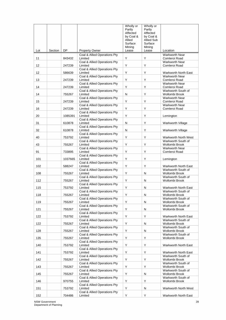
NSW Government Department of Planning
28
Lot Section DP Property Owner
Wholly or Partly Affected by Coal & Allied Surface Mining Lease
Wholly or Partly Affected by Coal & Allied Sub Surface Mining Lease
Location
11 843432 Coal & Allied Operations Pty Limited Y Y
Warkworth Near Comleroi Road
12 247239 Coal & Allied Operations Pty Limited Y Y
Warkworth Near Comleroi Road
12 586639 Coal & Allied Operations Pty Limited Y Y Warkworth North East
13 247239 Coal & Allied Operations Pty Limited Y Y
Warkworth Near Comleroi Road
14 247239 Coal & Allied Operations Pty Limited Y Y
Warkworth Near Comleroi Road
14 755267 Coal & Allied Operations Pty Limited N Y
Warkworth South of Wollombi Brook
15 247239 Coal & Allied Operations Pty Limited Y Y
Warkworth Near Comleroi Road
16 247239 Coal & Allied Operations Pty Limited Y Y
Warkworth Near Comleroi Road
20 1085391 Coal & Allied Operations Pty Limited Y Y Lemington
31 610878 Coal & Allied Operations Pty Limited N Y Warkworth Village
32 610878 Coal & Allied Operations Pty Limited N Y Warkworth Village
40 753792 Coal & Allied Operations Pty Limited Y Y Warkworth North West
43 755267 Coal & Allied Operations Pty Limited Y Y
Warkworth South of Wollombi Brook
91 733895 Coal & Allied Operations Pty Limited Y Y
Warkworth Near Comleroi Road
101 1037665 Coal & Allied Operations Pty Limited Y Y Lemington
102 588247 Coal & Allied Operations Pty Limited Y Y Warkworth North East
108 755267 Coal & Allied Operations Pty Limited Y N
Warkworth South of Wollombi Brook
112 755267 Coal & Allied Operations Pty Limited Y N
Warkworth South of Wollombi Brook
115 753792 Coal & Allied Operations Pty Limited Y N Warkworth North East
118 755267 Coal & Allied Operations Pty Limited Y N
Warkworth South of Wollombi Brook
119 755267 Coal & Allied Operations Pty Limited Y N
Warkworth South of Wollombi Brook
121 755267 Coal & Allied Operations Pty Limited Y N
Warkworth South of Wollombi Brook
122 753792 Coal & Allied Operations Pty Limited Y Y Warkworth North East
122 755267 Coal & Allied Operations Pty Limited Y N
Warkworth South of Wollombi Brook
128 755267 Coal & Allied Operations Pty Limited Y N
Warkworth South of Wollombi Brook
135 755267 Coal & Allied Operations Pty Limited Y Y
Warkworth South of Wollombi Brook
140 753792 Coal & Allied Operations Pty Limited Y Y Warkworth North East
141 753792 Coal & Allied Operations Pty Limited Y Y Warkworth North East
142 755267 Coal & Allied Operations Pty Limited Y Y
Warkworth South of Wollombi Brook
143 755267 Coal & Allied Operations Pty Limited Y Y
Warkworth South of Wollombi Brook
145 755267 Coal & Allied Operations Pty Limited Y N
Warkworth South of Wollombi Brook
146 970755 Coal & Allied Operations Pty Limited Y Y
Warkworth South of Wollombi Brook
151 753792 Coal & Allied Operations Pty Limited Y N Warkworth North West
152 704486 Coal & Allied Operations Pty Limited Y Y Warkworth North East

NSW Government Department of Planning
29
Lot Section DP Property Owner
Wholly or Partly Affected by Coal & Allied Surface Mining Lease
Wholly or Partly Affected by Coal & Allied Sub Surface Mining Lease
Location
153 704486 Coal & Allied Operations Pty Limited N Y Warkworth North East
155 705446 Coal & Allied Operations Pty Limited Y N Warkworth North East
164 729960 Coal & Allied Operations Pty Limited Y N Warkworth North West
165 729961 Coal & Allied Operations Pty Limited Y N Warkworth North West
166 729962 Coal & Allied Operations Pty Limited Y Y Warkworth North East
167 729963 Coal & Allied Operations Pty Limited Y N Warkworth North East
170 752481 Coal & Allied Operations Pty Limited Y N Lemington
179 823775 Coal & Allied Operations Pty Limited Y N Warkworth North West
182 823775 Coal & Allied Operations Pty Limited N N Warkworth North West
194 755267 Coal & Allied Operations Pty Limited Y N
Warkworth South of Wollombi Brook
195 755267 Coal & Allied Operations Pty Limited Y N
Warkworth South of Wollombi Brook
204 821040 Coal & Allied Operations Pty Limited N Y Warkworth Village
300 597726 Coal & Allied Operations Pty Limited N N Warkworth North West
745 597317 Coal & Allied Operations Pty Limited N N Warkworth North West
854 1000822 Coal & Allied Operations Pty Limited Y Y Warkworth Village
1001 785197 Coal & Allied Operations Pty Limited Y Y Warkworth North East
1002 785197 Coal & Allied Operations Pty Limited Y Y Warkworth North East
1420 586339 Coal & Allied Operations Pty Limited Y Y Warkworth North East
1421 586339 Coal & Allied Operations Pty Limited Y Y Warkworth North East
A 386100 Coal & Allied Operations Pty Limited Y Y
Warkworth Near Comleroi Road
B 386100 Coal & Allied Operations Pty Limited Y Y
Warkworth Near Comleroi Road
1 111381 J. & A. Brown and Abermain Seaham Collieries Limited Y N Warkworth North West
1 532623 J. & A. Brown and Abermain Seaham Collieries Limited Y N Warkworth North West
1 659810 J. & A. Brown and Abermain Seaham Collieries Limited Y N Lemington
1 901179 J. & A. Brown and Abermain Seaham Collieries Limited Y Y Warkworth North West
1 1102213 J. & A. Brown and Abermain Seaham Collieries Limited Y N Warkworth North West
2 111381 J. & A. Brown and Abermain Seaham Collieries Limited Y N Warkworth North West
2 114966 J. & A. Brown and Abermain Seaham Collieries Limited Y N Lemington
3 111381 J. & A. Brown and Abermain Seaham Collieries Limited Y N Warkworth North West
12 753792 J. & A. Brown and Abermain Seaham Collieries Limited Y N Warkworth North West
13 753792 J. & A. Brown and Abermain Seaham Collieries Limited Y N Warkworth North West
14 753792 J. & A. Brown and Abermain Seaham Collieries Limited Y N Warkworth North West
15 753792 J. & A. Brown and Abermain Seaham Collieries Limited Y N Warkworth North West
16 753792 J. & A. Brown and Abermain Seaham Collieries Limited Y N Warkworth North West

NSW Government Department of Planning
30
Lot Section DP Property Owner
Wholly or Partly Affected by Coal & Allied Surface Mining Lease
Wholly or Partly Affected by Coal & Allied Sub Surface Mining Lease
Location
17 752481 J. & A. Brown and Abermain Seaham Collieries Limited Y N Lemington
18 752481 J. & A. Brown and Abermain Seaham Collieries Limited Y N Lemington
19 753792 J. & A. Brown and Abermain Seaham Collieries Limited Y N Warkworth North West
20 753792 J. & A. Brown and Abermain Seaham Collieries Limited Y N Warkworth North West
21 752481 J. & A. Brown and Abermain Seaham Collieries Limited Y N Lemington
21 753792 J. & A. Brown and Abermain Seaham Collieries Limited Y N Warkworth North West
22 752481 J. & A. Brown and Abermain Seaham Collieries Limited Y N Lemington
22 753792 J. & A. Brown and Abermain Seaham Collieries Limited Y N Warkworth North West
23 753792 J. & A. Brown and Abermain Seaham Collieries Limited Y N Warkworth North West
24 753792 J. & A. Brown and Abermain Seaham Collieries Limited Y N Warkworth North West
25 753792 J. & A. Brown and Abermain Seaham Collieries Limited Y N Warkworth North West
26 753792 J. & A. Brown and Abermain Seaham Collieries Limited Y N Warkworth North West
27 753792 J. & A. Brown and Abermain Seaham Collieries Limited Y N Warkworth North West
28 753792 J. & A. Brown and Abermain Seaham Collieries Limited Y N Warkworth North West
29 753792 J. & A. Brown and Abermain Seaham Collieries Limited Y N Warkworth North West
30 753792 J. & A. Brown and Abermain Seaham Collieries Limited Y N Warkworth North West
31 753792 J. & A. Brown and Abermain Seaham Collieries Limited Y N Warkworth North West
73 753792 J. & A. Brown and Abermain Seaham Collieries Limited Y Y Warkworth North West
89 752481 J. & A. Brown and Abermain Seaham Collieries Limited Y N Lemington
98 752481 J. & A. Brown and Abermain Seaham Collieries Limited Y N Lemington
117 752481 J. & A. Brown and Abermain Seaham Collieries Limited Y N Lemington
118 752481 J. & A. Brown and Abermain Seaham Collieries Limited Y N Lemington
119 752481 J. & A. Brown and Abermain Seaham Collieries Limited Y N Lemington
120 752481 J. & A. Brown and Abermain Seaham Collieries Limited Y N Lemington
120 753792 J. & A. Brown and Abermain Seaham Collieries Limited Y Y Warkworth North West
121 752481 J. & A. Brown and Abermain Seaham Collieries Limited Y N Lemington
121 753792 J. & A. Brown and Abermain Seaham Collieries Limited Y N Warkworth North West
122 752481 J. & A. Brown and Abermain Seaham Collieries Limited Y N Lemington
123 752481 J. & A. Brown and Abermain Seaham Collieries Limited Y N Lemington
124 752481 J. & A. Brown and Abermain Seaham Collieries Limited Y N Lemington
125 752481 J. & A. Brown and Abermain Seaham Collieries Limited Y N Lemington
126 752481 J. & A. Brown and Abermain Seaham Collieries Limited Y N Lemington
127 752481 J. & A. Brown and Abermain Seaham Collieries Limited Y N Lemington
164 752481 J. & A. Brown and Abermain Seaham Collieries Limited Y N Lemington

NSW Government Department of Planning
31
Lot Section DP Property Owner
Wholly or Partly Affected by Coal & Allied Surface Mining Lease
Wholly or Partly Affected by Coal & Allied Sub Surface Mining Lease
Location
171 752481 J. & A. Brown and Abermain Seaham Collieries Limited Y Y Lemington
1 129811 Warkworth Mining Limited Y Y Warkworth South of Wollombi Brook
1 246201 Warkworth Mining Limited Y Y Warkworth Village
2 129811 Warkworth Mining Limited Y Y Warkworth South of Wollombi Brook
3 129811 Warkworth Mining Limited Y Y Warkworth South of Wollombi Brook
7001 93632 Administered by The State Land Services N Y Warkworth Village
1 90052 Commonwealth of Australia N Y Warkworth Village
1 25 759053 Crown N Y Warkworth Village
2 5 759053 Crown N Y Warkworth Village
2 25 759053 Crown N Y Warkworth Village
3 4 759053 Crown N Y Warkworth Village
3 5 759053 Crown N Y Warkworth Village
4 4 759053 Crown N Y Warkworth Village
5 4 759053 Crown N Y Warkworth Village
6 4 759053 Crown N Y Warkworth Village
130 753792 Crown Y Y Warkworth North East
175 823775 Crown N N Warkworth North West
Crown License 175936 ( Coal & Allied Operations Pty Limited ) N N Warkworth North West
Crown License 341401 (Coal & Allied Operations Pty Limited) N Y Warkworth North East
201 755267 Crown Land Y Y Warkworth South of Wollombi Brook
1 710088 The State of NSW N Y Warkworth North East
154 704486 The State of NSW N Y Warkworth North East
170 823775 The State of NSW N N Warkworth North West
172 823775 The State of NSW N N Warkworth North West
173 823775 The State of NSW N N Warkworth North West
21 1109631 Brian Kennedy & John Griffiths N Y Warkworth Village
No297 Bk 904 Ada Elizabeth Watts N Y Warkworth Village
35 755267 Cec M Hawkes Pty Ltd N Y Warkworth Village
36 755267 Cec M Hawkes Pty Ltd N Y Warkworth Village
5 247239 Construction, Forestry, Mining & Energy Union Y Y
Warkworth Near Comleroi Road
6 770904 Edward & Carol Burley N Y Warkworth Village
3 3005 Elizabeth Bowman N Y Maison Dieu
4 3005 Elizabeth Bowman N Y Maison Dieu
5 3005 Elizabeth Bowman N Y Maison Dieu
1 113343 Heather Kannar N Y Warkworth Village
1 2 759053 Heather Kannar N Y Warkworth Village
1 794506 Heather Kannar N Y Warkworth Village
2 2 759053 Heather Kannar N Y Warkworth Village

NSW Government Department of Planning
32
Lot Section DP Property Owner
Wholly or Partly Affected by Coal & Allied Surface Mining Lease
Wholly or Partly Affected by Coal & Allied Sub Surface Mining Lease
Location
2 794506 Heather Kannar N Y Warkworth Village
3 2 759053 Heather Kannar N Y Warkworth Village
3 794506 Heather Kannar N Y Warkworth Village
4 2 759053 Heather Kannar N Y Warkworth Village
4 3 759053 Heather Kannar N Y Warkworth Village
5 2 759053 Heather Kannar N Y Warkworth Village
5 3 759053 Heather Kannar N Y Warkworth Village
6 2 759053 Heather Kannar N Y Warkworth Village
6 3 759053 Heather Kannar N Y Warkworth Village
7 2 759053 Heather Kannar N Y Warkworth Village
7 3 759053 Heather Kannar N Y Warkworth Village
8 2 759053 Heather Kannar N Y Warkworth Village
8 3 759053 Heather Kannar N Y Warkworth Village
9 3 759053 Heather Kannar N Y Warkworth Village
10 3 759053 Heather Kannar N Y Warkworth Village
11 3 759053 Heather Kannar N Y Warkworth Village
12 3 759053 Heather Kannar N Y Warkworth Village
13 3 759053 Heather Kannar N Y Warkworth Village
14 3 759053 Heather Kannar N Y Warkworth Village
15 3 759053 Heather Kannar N Y Warkworth Village
16 3 759053 Heather Kannar N Y Warkworth Village
17 3 759053 Heather Kannar N Y Warkworth Village
18 3 759053 Heather Kannar N Y Warkworth Village
19 3 759053 Heather Kannar N Y Warkworth Village
20 3 759053 Heather Kannar N Y Warkworth Village
10 247239 Hunter Valley Gliding Club Cooperative Limited Y Y
Warkworth Near Comleroi Road
92 733895 Hunter Valley Gliding Club Cooperative Limited Y Y
Warkworth Near Comleroi Road
5 251617 Inchneuk Pty Ltd N Y Maison Dieu
2 617852 John Maitland, Robert Graham, George Coates N N Warkworth North West
2 835812 John Maitland, Robert Graham, George Coates Y N Warkworth North West
3 835812 John Maitland, Robert Graham, George Coates Y N Warkworth North West
4 635392 John Maitland, Robert Graham, George Coates N N
Warkworth Near Comleroi Road
4 835812 John Maitland, Robert Graham, George Coates Y N Warkworth North West
6 247239 John Maitland, Robert Graham, George Coates N N
Warkworth Near Comleroi Road
7 247239 John Maitland, Robert Graham, George Coates N N
Warkworth Near Comleroi Road
8 247239 John Maitland, Robert Graham, George Coates N N
Warkworth Near Comleroi Road
9 835812 John Maitland, Robert Graham, George Coates N N Warkworth North West
134 566275 John Maitland, Robert Graham, George Coates Y Y
Warkworth Near Comleroi Road
147 753792 Johnson Woods & Co Pty Ltd N N Warkworth Near Comleroi Road

NSW Government Department of Planning
33
Lot Section DP Property Owner
Wholly or Partly Affected by Coal & Allied Surface Mining Lease
Wholly or Partly Affected by Coal & Allied Sub Surface Mining Lease
Location
8 3005 Julie & Gregory Ernst N Y Maison Dieu
9 3005 Julie & Gregory Ernst N Y Maison Dieu
50 848334 Kenneth & Loraine Haynes N Y Warkworth Village
9 2 759053 Kenneth Russell Partridge N Y Warkworth Village
10 2 759053 Kenneth Russell Partridge N Y Warkworth Village
11 2 759053 Kenneth Russell Partridge N Y Warkworth Village
12 2 759053 Kenneth Russell Partridge N Y Warkworth Village
13 2 759053 Kenneth Russell Partridge N Y Warkworth Village
75 753792 M F Holdings Pty Ltd N N Warkworth North West
1 446656 Neville Robert Stapleton N Y Warkworth North East
1 770904 Olga Henderson N Y Warkworth Village
1 770905 Olga Henderson N Y Warkworth Village
1 1043120 Olga Henderson Y Y Warkworth Village
2 770904 Olga Henderson N Y Warkworth Village
3 770904 Olga Henderson N Y Warkworth Village
4 770904 Olga Henderson N Y Warkworth Village
5 770904 Olga Henderson N Y Warkworth Village
7 770904 Olga Henderson N Y Warkworth Village
40 755267 Olga Henderson N Y Warkworth Village
41 755267 Olga Henderson N Y Warkworth Village
186 755267 Olga Henderson N Y Warkworth Village
1 70857 Phillip & Collen Algie N Y Maison Dieu
6 3005 R & J Wenham N Y Maison Dieu
45 1015315 Redbank Project Pty Limited N Y Warkworth South of Wollombi Brook
1 66331 Robert Algie N Y Maison Dieu
7 3005 Robert Algie N Y Maison Dieu
10 3005 Robert Algie N Y Maison Dieu
2 770905 Shane & Glenn Keys Y Y Warkworth Village
84 753792 Shane & Glenn Keys Y Y Warkworth Village
1 6 759053 Singleton Council N Y Warkworth Village
2 6 759053 Singleton Council N Y Warkworth Village
3 6 759053 Singleton Council N Y Warkworth Village
2 90052 Telstra Corporation Limited N Y Warkworth Village
12 843432 Telstra Corporation Ltd N Y Warkworth Near Comleroi Road
1 738657 Wambo Coal Pty Ltd N Y Warkworth Village
1 1090601 Wambo Coal Pty Ltd N Y Warkworth Village
2 583524 Wambo Coal Pty Ltd N Y Warkworth Village
2 738657 Wambo Coal Pty Ltd N Y Warkworth Village
3 1085145 Wambo Coal Pty Ltd Y Y Warkworth North West
4 1085145 Wambo Coal Pty Ltd N N Warkworth North West
1 1088908 Wambo Coal Terminal Pty Ltd N Y Warkworth Village

NSW Government Department of Planning
34
Lot Section DP Property Owner
Wholly or Partly Affected by Coal & Allied Surface Mining Lease
Wholly or Partly Affected by Coal & Allied Sub Surface Mining Lease
Location
2 1088908 Wambo Coal Terminal Pty Ltd N Y Warkworth Village
86 755267 Wambo Coal Terminal Pty Ltd N Y Warkworth Village
88 755267 Wambo Coal Terminal Pty Ltd N Y Warkworth Village
171 755267 Wambo Coal Terminal Pty Ltd N Y Warkworth Village
174 755267 Wambo Coal Terminal Pty Ltd N Y Warkworth Village
1 17 759053 Wambo Mining Corporation Limited N Y Warkworth Village
2 113343 Wambo Mining Corporation Limited N Y Warkworth Village
2 17 759053 Wambo Mining Corporation Limited N Y Warkworth Village
3 113343 Wambo Mining Corporation Limited N Y Warkworth Village
4 113343 Wambo Mining Corporation Limited N Y Warkworth Village
5 113343 Wambo Mining Corporation Limited N Y Warkworth Village
1 4 759053 Wambo Mining Corporation Pty Limited N Y Warkworth Village
2 4 759053 Wambo Mining Corporation Pty Limited N Y Warkworth Village
7 4 759053 Wambo Mining Corporation Pty Limited N Y Warkworth Village
8 4 759053 Wambo Mining Corporation Pty Limited N Y Warkworth Village
9 4 759053 Wambo Mining Corporation Pty Limited N Y Warkworth Village
10 4 759053 Wambo Mining Corporation Pty Limited N Y Warkworth Village
11 4 759053 Wambo Mining Corporation Pty Limited N Y Warkworth Village
12 4 759053 Wambo Mining Corporation Pty Limited N Y Warkworth Village
13 4 759053 Wambo Mining Corporation Pty Limited N Y Warkworth Village
14 4 759053 Wambo Mining Corporation Pty Limited N Y Warkworth Village
15 4 759053 Wambo Mining Corporation Pty Limited N Y Warkworth Village
16 4 759053 Wambo Mining Corporation Pty Limited N Y Warkworth Village
17 4 759053 Wambo Mining Corporation Pty Limited N Y Warkworth Village
18 4 759053 Wambo Mining Corporation Pty Limited N Y Warkworth Village
19 4 759053 Wambo Mining Corporation Pty Limited N Y Warkworth Village
20 4 759053 Wambo Mining Corporation Pty Limited N Y Warkworth Village
21 4 759053 Wambo Mining Corporation Pty Limited N Y Warkworth Village
22 4 759053 Wambo Mining Corporation Pty Limited N Y Warkworth Village
23 4 759053 Wambo Mining Corporation Pty Limited N Y Warkworth Village
24 4 759053 Wambo Mining Corporation Pty Limited N Y Warkworth Village
25 4 759053 Wambo Mining Corporation Pty Limited N Y Warkworth Village
26 4 759053 Wambo Mining Corporation Pty Limited N Y Warkworth Village
199 755267 Wambo Mining Corporation Pty Limited N Y Warkworth Village
1 16 759053 Wambo Mining Corporation Pty Ltd N Y Warkworth Village
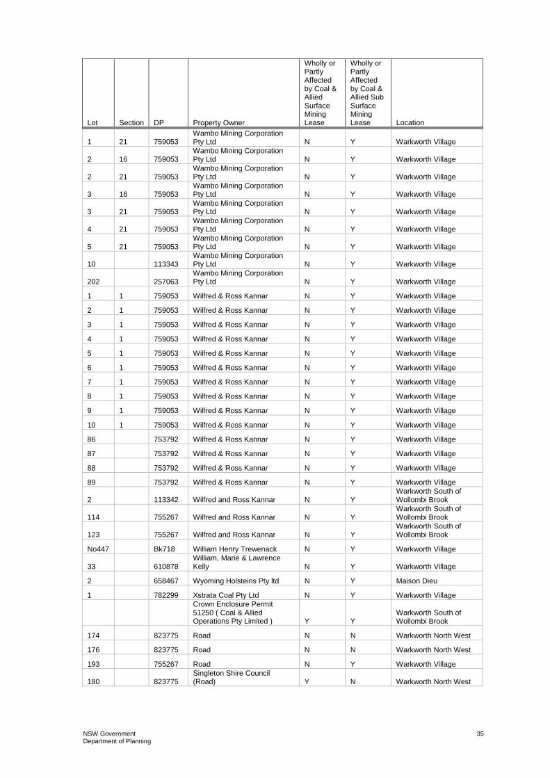
NSW Government Department of Planning
35
Lot Section DP Property Owner
Wholly or Partly Affected by Coal & Allied Surface Mining Lease
Wholly or Partly Affected by Coal & Allied Sub Surface Mining Lease
Location
1 21 759053 Wambo Mining Corporation Pty Ltd N Y Warkworth Village
2 16 759053 Wambo Mining Corporation Pty Ltd N Y Warkworth Village
2 21 759053 Wambo Mining Corporation Pty Ltd N Y Warkworth Village
3 16 759053 Wambo Mining Corporation Pty Ltd N Y Warkworth Village
3 21 759053 Wambo Mining Corporation Pty Ltd N Y Warkworth Village
4 21 759053 Wambo Mining Corporation Pty Ltd N Y Warkworth Village
5 21 759053 Wambo Mining Corporation Pty Ltd N Y Warkworth Village
10 113343 Wambo Mining Corporation Pty Ltd N Y Warkworth Village
202 257063 Wambo Mining Corporation Pty Ltd N Y Warkworth Village
1 1 759053 Wilfred & Ross Kannar N Y Warkworth Village
2 1 759053 Wilfred & Ross Kannar N Y Warkworth Village
3 1 759053 Wilfred & Ross Kannar N Y Warkworth Village
4 1 759053 Wilfred & Ross Kannar N Y Warkworth Village
5 1 759053 Wilfred & Ross Kannar N Y Warkworth Village
6 1 759053 Wilfred & Ross Kannar N Y Warkworth Village
7 1 759053 Wilfred & Ross Kannar N Y Warkworth Village
8 1 759053 Wilfred & Ross Kannar N Y Warkworth Village
9 1 759053 Wilfred & Ross Kannar N Y Warkworth Village
10 1 759053 Wilfred & Ross Kannar N Y Warkworth Village
86 753792 Wilfred & Ross Kannar N Y Warkworth Village
87 753792 Wilfred & Ross Kannar N Y Warkworth Village
88 753792 Wilfred & Ross Kannar N Y Warkworth Village
89 753792 Wilfred & Ross Kannar N Y Warkworth Village
2 113342 Wilfred and Ross Kannar N Y Warkworth South of Wollombi Brook
114 755267 Wilfred and Ross Kannar N Y Warkworth South of Wollombi Brook
123 755267 Wilfred and Ross Kannar N Y Warkworth South of Wollombi Brook
No447 Bk718 William Henry Trewenack N Y Warkworth Village
33 610878 William, Marie & Lawrence Kelly N Y Warkworth Village
2 658467 Wyoming Holsteins Pty ltd N Y Maison Dieu
1 782299 Xstrata Coal Pty Ltd N Y Warkworth Village
Crown Enclosure Permit 51250 ( Coal & Allied Operations Pty Limited ) Y Y
Warkworth South of Wollombi Brook
174 823775 Road N N Warkworth North West
176 823775 Road N N Warkworth North West
193 755267 Road N Y Warkworth Village
180 823775 Singleton Shire Council (Road) Y N Warkworth North West

NSW Government Department of Planning
36
APPENDIX 2 PROJECT LAYOUT PLANS
Figure 1: Local Setting of HVO South and North

NSW Government Department of Planning
37
Figure 2: Amended Project Application Area

NSW Government Department of Planning
38
APPENDIX 3 CNA STATEMENT OF COMMITMENTS
The following Statement of Commitments has been prepared in accordance with the DGRs and Part 3A of the EP&A Act. These commitments outline the management, mitigation and monitoring measures to be adhered to by CNA throughout the development and operation of the proposed HVO South Coal Project to manage potential environmental impacts arising from the proposal. Management of activities occurring at HVO is undertaken with reference to the corresponding management plan that details the key objectives and control measures. The management plans outline key environmental issues, performance criteria, recommended control measures, monitoring, inspection and incident management requirements, performance reporting and key related policies and procedures. The relevant EMS procedures describe the implementation of these recommended controls. Monitoring is undertaken in accordance with the approved monitoring programme to determine the effectiveness of the control measures and promotes a continuous improvement cycle. The CNA EMS will continue to be implemented across HVO and the relevant plans, procedures and monitoring programmes will be reviewed and modified to reflect the changes to HVO South resulting from the proposal. The recommended management measures from each of the technical reports include a number of control measures to minimise the potential impacts resulting from the proposal. These measures have been considered in the context of the existing HVO activities and the CNA EMS. Many of these measures are already in place as part of existing controls for the HVO South activities, and will continue to be implemented across HVO South to minimise the potential impacts resulting from the proposal. This Statement of Commitments details those controls that are considered specific to the proposal.
General
CNA will: • carry out the proposal generally in accordance with the systems, plans and
mitigation measures identified throughout this Environmental Assessment Report;
• bring any matters that arise and require further assessment by the Director General to the Director General’s attention and will comply with all requirements received; and
• obtain and maintain all permits, licences and approvals required throughout the life of the project that are not incorporated into the Part 3A Project Approval. This Statement of Commitments does not replace any obligations CNA has under these statutory requirements.
All works will be undertaken in accordance with the relevant Australian Standards where these standards do not conflict with specific legislative or safety requirements.
Standards may include but not be restricted to the latest versions of:
- AS 2601-2001: The Demolition of Structures; and
- AS1940 - The Storage and Handling of Flammable and Combustible Liquids.
Environmental Management Systems
The CNA EMS has been developed and implemented in accordance with ISO14001.

NSW Government Department of Planning
39
This EMS will continue to be applied to the activities undertaken as part of the HVO South Coal Project.
Management Measures
Community Consultation
The existing consultation programmes will continue to be undertaken to ensure any specific outcomes from the environmental assessment are included into the relevant programmes as required. The community consultation specific to the proposal will continue throughout the project, from submission through to government decision and implementation of commitments. Ongoing communication techniques utilised by CNA (Table 6.1) will be implemented as appropriate.
Noise
In addition to the mitigation measures undertaken at HVO for noise, the following controls specific to the proposal will be implemented: • equipment operation within South Lemington Pit 1 and associated truck
movements will cease during night time operations if monitoring identifies unacceptable noise impacts will result from south westerly winds (occurring at or above 2.1 m/s). At lower wind speeds, real-time noise and/or weather monitoring will be used to guide modifications to operations as required.
• noise limits that will apply to the proposal are detailed in Table 22.1.

Table 22.1 Noise Limits Applicable to Proposal, dB(A)
Day Limits Evening Limits Night Limits
No. Location
LAeq(15 min) LAeq(15 min) LAeq (15 min) L1(1 min) 3 Elisnore 38 38 38 45 4 Muller 38 38 38 45 5 Bowman 39 39 41 46 7 Stapleton1 N/A N/A N/A 45 8 Holz (Oaklands)2 N/A N/A N/A 45
10 Moses (Wandewoi)1 N/A N/A N/A 45 13 Jerrys Plains Centre 38 38 38 45 16 Algie 39 39 42 46 17 Algie 39 39 40 46 19 Birralee Feeds Pty Ltd 38 38 38 45 23 Hawkes 1 (Springwood) N/A N/A N/A 46 24 Clifton & Edwards 39 39 39 46 31 Cooper (Kilburnie) 39 39 39 49 32 Algie (Curlewis) 39 39 42 46 33 Edward & Haynes2 N/A N/A N/A 46 34 Ernst 39 39 40 46 36 Garland 38 38 38 45 38 Henderson1 N/A N/A N/A 46 43 Kannar2 N/A N/A N/A 46 45 Kelly1 N/A N/A N/A 46 47 Moxey 39 39 41 46 61 Shearer 39 39 41 46
1. These private residences are currently inside a zone of affectation. A private agreement may exist with the land holder.
2. These residences are owned by mining companies other than CNA.
General:
• Daytime (between 7am and 6pm); evening (between 6pm and 10pm); and night time (between 10pm and 7am).
• The noise emission limits above apply for winds up to 3 m/s (at a height of 10 m) and temperature gradients up to 4 degrees Celsius per 100 m.
• If there is a valid private amenity agreement with any property owners these criteria may be exceeded.
• Maison Dieu assessment locations are No’s 5, 16, 17, 24, 32, 34, 47 and 61, Warkworth Village assessment locations are No’s 23, 33, 38, 43 and 45 and Jerrys Plains assessment locations are No’s 3, 4, 13, 19, 31 and 36. Isolated assessment locations are No’s 7, 8 and 10.
• Location No. is consistent with the HVO West Pit consent (DA 450-10-2003).

NSW Government Department of Planning
41
Blast and Vibration
In addition to the mitigation measures undertaken at HVO for blast and vibration management, blasts will be designed to minimise impacts on neighbouring mine ventilation structures and minimise the potential for fracture development along pit walls to assist with pit wall stability: • blast vibration will be managed through design and modelling;
• bench heights will be managed to not significantly exceed 15 m;
• no throw blasts will take place adjacent to final walls;
• high density explosives will be toe loaded;
• blast monitoring and post blast analysis will be undertaken where required;
• presplit blasting will be implemented on final walls where this indicates improved wall conditions; and
• visual monitoring by way of regular highwall and pit inspections will be undertaken.
Air Quality
In addition to the mitigation measures undertaken at HVO for air quality management, efficient mine planning and operations will ensure: • the mine plan is regularly reviewed with a view to controlling dust emissions and keeping
emissions to the lowest levels practicable;
• exposed areas are kept to the minimum practicable; and
• haul roads are kept to the shortest routes practicable and material handling is kept to the minimum levels practicable.
Groundwater
In addition to the mitigation measures undertaken at HVO for groundwater management, the following controls specific to the proposal will be implemented: Groundwater Flow To and From Rivers: ❑ development of protocols for monitoring and reporting of NOW stream gauge results to clearly
record any reductions in flows that are attributed to mining. This will include monitoring Hunter River flows immediately up gradient and down gradient of the site. In addition, consideration will be given to tying in specific CNA water level recordings with current NOW gauging locations;
❑ monitoring of groundwater elevations within alluvium between the Hunter River and the Cheshunt Pit; and
❑ measured groundwater elevations and river flow will be assessed against predictions to determine whether application of additional management measures is required; and
❑ offset seepage to pits in accordance with regulatory requirements.
Regional Groundwater Drawdown: ❑ the HVO River Red Gum Rehabilitation and Restoration Strategy and CNA EMS procedure for
Flora and Fauna will be updated to reflect changes resulting from the proposal. This will include monitoring the health of the River Red Gums located on the Hunter River and

NSW Government Department of Planning
42
Wollombi Brook alluvium as identified in Chapter 11 (Figure 11.2). The monitoring programme will include details on frequency of monitoring, reporting and corrective actions; and
❑ up to three monitoring wells will be installed in the proximity of the cluster of registered NOW bores located to the east of the LCPP (Figure 25 Annex J). Data will be used to compare actual versus predicted impacts. Deviations away from predicted impacts will be assessed, and if predictions are exceeded, management measures will be implemented.
Alluvial Buffer Zone: ❑ a buffer zone of 100 m will be retained from the Cheshunt Pit highwall to the edge of alluvium
of the Hunter River;
❑ a buffer zone of 150 m will be retained from the South Lemington Pit 2 highwall to the edge of alluvium of the Wollombi Brook;
❑ bores will be installed to further delineate the saturated zone between the Hunter River and the Cheshunt Pit before mining commences within this area; and
❑ the groundwater component of the HVO Water Management Manual will include procedures for monitoring potential impacts, including accurately measuring seepage to pits throughout mining and assessment of proximity to alluvials as mining approaches.
Deep Cheshunt Pit Final Void: ❑ the Deep Cheshunt Pit final void will be designed to intercept leachate from overburden
emplacements and minimise discharge of saline groundwater. Deep Cheshunt Pit final void design will be reviewed at least three years prior to anticipated mine closure;
❑ the Deep Cheshunt Pit Final Void Management Plan will include future use options including investigation of feasibility to use the Deep Cheshunt Pit final void as a water storage that could be used as a buffer in times of flood flows in the Hunter River and as a supplementary water supply at times of scarce water supply. This would include additional investigations to refine predictions of final void water chemistry;
❑ a post closure monitoring programme will be developed as part of the Deep Cheshunt Pit Final Void Management Plan for water quality monitoring of the final void; and
❑ the mine plan will be further reviewed with a view to minimise the area of the Deep Cheshunt Pit final void as much as practicable.
Surface Water
In addition to the mitigation measures undertaken at HVO for surface water management, the following controls specific to the proposal will be implemented. Water Supply: ❑ modify Water Access Licences, review conditions and report on water use in the AEMR;
❑ monitor and record abstraction quantities; and
❑ increase pump capacity from Dam 20S (or alternative storage) to the LCPP and undertake minor improvements to the existing HVO South water system in conjunction with the design of the LCPP to minimise need to pump from Hunter River Water Discharge:
❑ review current discharge conditions in respect of the proposal and incorporate where applicable into the Water Management Manual.
Flood Mitigation: ❑ construct South Lemington Pit 2 Levee SLL2 as a permanent levee and ensure the outer face
of the levee will withstand 100-year ARI flood flow velocities; and

NSW Government Department of Planning
43
❑ assess Hobden Gully levee (CL1) prior to mine closure to determine if protection of the Deep Cheshunt Pit final void is required.
Erosion and Sediment Control: ❑ erosion and sediment control structures will remain in place to divert water away from the
Deep Cheshunt Pit final void unless required for use as flood flow storage.
Monitoring and Inspections: ❑ prior to LCPP and infrastructure construction works review the Surface Water Monitoring
Programme, establish additional representative monitoring sites where required and undertake monitoring; and
❑ annual monitoring of water level and water quality in the Deep Cheshunt Pit final void after mining operations have ceased as part of the post closure monitoring programme. Monitoring will continue in accordance with regulatory requirements.
Ecology
In addition to the mitigation measures undertaken at HVO for management of flora and fauna, the following controls specific to the proposal will be implemented: ❑ the River Red Gum Rehabilitation and Restoration Strategy prepared by CNA will be updated
to include the stands along the Hunter River and Wollombi Brook, will include collection and storage of seed from existing stands, and will ensure the health of these River Red Gums is periodically monitored;
❑ studies will be undertaken to investigate the preferred water source of River Red Gums and develop appropriate management measures;
❑ areas identified with sand profile will be included in the Warkworth Green Offsets research programme;
❑ the Coast Banksias will be assessed and fenced to exclude stock and provide for enhancement opportunities;
❑ rehabilitation planning will identify opportunities to create similar ecological characteristics (such as habitat types) of proposed extension areas;
❑ remnant vegetation areas not required to be disturbed by the proposal will be managed to ensure security of flora and fauna habitat in the future; and
❑ the Warkworth and Wambo Green Offset areas and the Hunter Valley Synoptic Plan will be considered with rehabilitation planning to enhance linkage where practical.
Aboriginal Heritage
In addition to the mitigation measures undertaken at HVO for management of Aboriginal heritage, the following controls specific to the proposal will be implemented as agreed with the Aboriginal Working Group. Management Measures for ACHMP HVO South Stage 1 include: ❑ all management measures will be undertaken in accordance with the Aboriginal Heritage
Assessment as outlined in the ACHMP;
❑ if at a later date it is found necessary to undertake an action that would impact sites described within the Aboriginal cultural heritage assessment, additional and specific management recommendations may be implemented in consultation with the Working Group;

NSW Government Department of Planning
44
❑ provision is to be made for the management of collected cultural heritage material;
❑ provision will be made in the ACHMP for the Working Group to undertake an independent compliance audit of the management programme on a six monthly basis. In the event that any non-compliant activities are identified at any time, an additional compliance audit may be undertaken as part of the investigation process;
❑ where any mitigation is required it will be undertaken by representatives of the Working Group and suitably qualified technical advisers;
❑ implement a management programme providing for the controlled collection of the following sites where site avoidance is not possible. Until management measures (which may involve the collection of cultural material) have been implemented, mine-related impacts to the sites will be prevented:
- Riverview South West Mining Extension Area Sites 1-24
- South Lemington Pit 1 Mining Extension Area Sites 59-79
- Proposed rail spur and loop easement Sites 80-83
- LCPP Sites 101 and 105-106
❑ the alignment of the proposed rail spur and loop have been amended to avoid impacts to Sites 26-44, 47-58 and 107-109;
❑ restricted access zones will be defined for Sites 26-44, 47-58, 84-100, 102-104 and 107-109. The boundaries (Figure 12.3) are indicative only; and
❑ land management activities on the Archerfield property will avoid any impacts to Site 25.
Management measures to be implemented in accordance with the agreed ACHMP for HVO South Stage 2.
Historic Heritage
In addition to the mitigation measures undertaken at HVO for management of historic heritage, the following action specific to the proposal will be implemented: ❑ a targeted field assessment will be undertaken by an historic heritage professional where
required to supplement existing information to report on the relative significance of the additional sites identified on CNA land including a derelict bridge structure over an unnamed ephemeral creek and the cockatoo fence and recommend additional management measures.
Visual
In addition to the mitigation measures undertaken at HVO for management of visual amenity, the following action specific to the proposal will be implemented: ❑ a review of the extension areas that adjoin Jerrys Plains Road and the proposed rail spur and
loop easement will be undertaken prior to construction of the rail spur and loop, to determine if additional screening is required.
Traffic and Transport
In addition to the mitigation measures undertaken at HVO for management of traffic and transport, the following action specific to the proposal will be implemented:

NSW Government Department of Planning
45
❑ ensure the relocation of Comleroi Road and construction of the rail loop are undertaken in accordance with the relevant regulatory requirements; and
❑ obtain the appropriate approvals, including those required for heavy equipment transfer; and
❑ ensure relevant stakeholders are consulted as required.
Waste Management
There are no suggested controls for waste management specific to the proposal. It is anticipated the mitigation measures currently implemented at HVO will be sufficient to manage the increase in waste resulting from the proposal.
Energy Management Activities
In addition to the mitigation measures currently implemented the mine plan will be regularly reviewed with a view to keeping emissions to the lowest levels practicable. Haul roads will be kept to the shortest routes practicable and material rehandling will be kept to the minimum levels practicable. Most of these measures are routinely applied as part of the efficient design of the mine.
Land Management
There are no suggested controls for land management that are specific to the proposal. The current mitigation measures implemented at HVO are anticipated to be sufficient to manage any potential impacts from the proposal on land use.
Mine Landscape Planning
In addition to the mitigation measures undertaken at HVO for management of landscape planning, the following actions specific to the proposal will be implemented: � General environmental land management practices implemented on all CNA owned land will
be applied to the Archerfield Property along with planned rehabilitation areas.
� Remnant vegetation located within the Project Application area and outside proposed disturbance areas will be protected and enhanced to improve the ecological value and biodiversity. In particular, the specific management practices will include:
- monitoring of remnant vegetation areas in accordance with existing procedures to provide evidence of success of management practices;
- undertaking bushfire management, weed and pest control in accordance with recommended practices;
- utilising local native species for seed stock where practical;
- utilising existing farm dams and retention or establishment of native vegetation around dams to provide habitat; and
- habitat creation and enhancement for common and threatened species.
� The vegetation on the Archerfield Property will require specific management practices to protect and enhance the ecological value and improve the biodiversity. In particular, the specific management practices will include:
- monitoring of remnant vegetation areas in accordance with existing procedures to provide evidence of success of management practices;
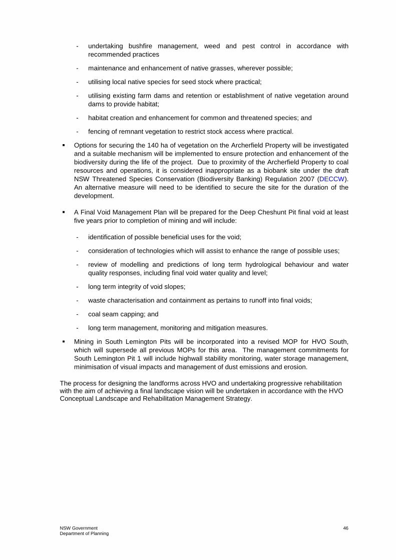
NSW Government Department of Planning
46
- undertaking bushfire management, weed and pest control in accordance with recommended practices
- maintenance and enhancement of native grasses, wherever possible;
- utilising local native species for seed stock where practical;
- utilising existing farm dams and retention or establishment of native vegetation around dams to provide habitat;
- habitat creation and enhancement for common and threatened species; and
- fencing of remnant vegetation to restrict stock access where practical.
� Options for securing the 140 ha of vegetation on the Archerfield Property will be investigated and a suitable mechanism will be implemented to ensure protection and enhancement of the biodiversity during the life of the project. Due to proximity of the Archerfield Property to coal resources and operations, it is considered inappropriate as a biobank site under the draft NSW Threatened Species Conservation (Biodiversity Banking) Regulation 2007 (DECCW). An alternative measure will need to be identified to secure the site for the duration of the development.
� A Final Void Management Plan will be prepared for the Deep Cheshunt Pit final void at least five years prior to completion of mining and will include:
- identification of possible beneficial uses for the void;
- consideration of technologies which will assist to enhance the range of possible uses;
- review of modelling and predictions of long term hydrological behaviour and water quality responses, including final void water quality and level;
- long term integrity of void slopes;
- waste characterisation and containment as pertains to runoff into final voids;
- coal seam capping; and
- long term management, monitoring and mitigation measures.
� Mining in South Lemington Pits will be incorporated into a revised MOP for HVO South, which will supersede all previous MOPs for this area. The management commitments for South Lemington Pit 1 will include highwall stability monitoring, water storage management, minimisation of visual impacts and management of dust emissions and erosion.
The process for designing the landforms across HVO and undertaking progressive rehabilitation with the aim of achieving a final landscape vision will be undertaken in accordance with the HVO Conceptual Landscape and Rehabilitation Management Strategy.

APPENDIX 4 LANDOWNER/RECEIVER LOCATION PLAN (key to landowners on following page)

Surrounding Assessment Locations used for Modelling Purposes
Location No. Location and Name MGA56 Coordinates Easting Northing
Locations at Maison Dieu (East) 5 Bowman 317887 6399172 16 Algie 318128 6397347 24 Clifton and Edwards 318660 6398580 32 Algie (Curlewis) 317982 6397802 34 Ernst 318530 3697994 47 Moxey 317979 6399821 50 Nelson 318656 6398203 56 Edwards 318607 6398553 61 Shearer 318008 6399499 Locations at Warkworth (South) 23 Hawkes (Springwood) 313989 6392994 33 Edward and Haynes 314699 6394353 38 Henderson 315584 6393898 43 Kannar 314648 6394680 45 Kelly 314149 6394563
Locations west along Jerrys Plains Road (West) 3 Elisnore 305416 6401053 4 Muller 305950 6399615 13 Jerrys Plains Centre 303535 6402851 19 Birralee Feeds Pty Ltd 305655 6400600 31 Cooper (Kilburnie) 305953 6399990 36 Garland 306139 6399895 Isolated Locations
7 Stapleton (Cheshunt) – North East
315919 6403004
8 Holz (Oaklands) – North
313711 6403979
10 Moses (Wandewoi) – North West
306970 6402069
• Location No. is consistent with the HVO West Pit consent (DA 450-10-2003). • Location No’s 33 and 43 have been purchased by Wambo Mine. • Location No. 8 has been purchased by Xstrata.

NSW Government Department of Planning
49
APPENDIX 5 ARCHERFIELD BIODIVERSITY OFFSET STRATEGY
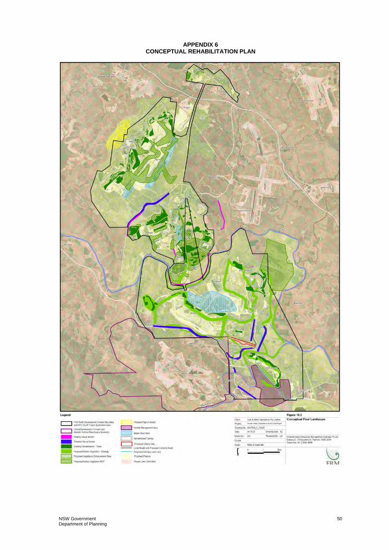
NSW Government Department of Planning
50
APPENDIX 6 CONCEPTUAL REHABILITATION PLAN

NSW Government Department of Planning
51
APPENDIX 7 TRANSPORT OPTIONS

NSW Government Department of Planning
52
APPENDIX 8 THREATENED SPECIES AND EECs AT HVO SOUTH
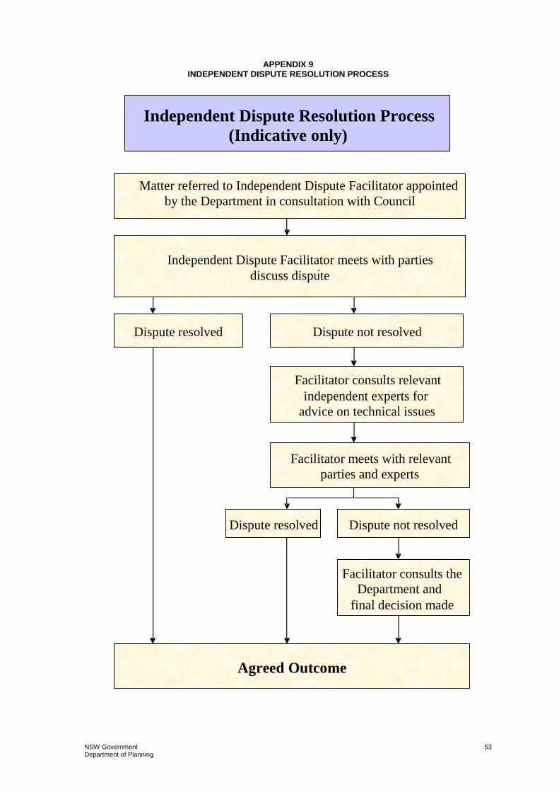
NSW Government Department of Planning
53
APPENDIX 9 INDEPENDENT DISPUTE RESOLUTION PROCESS
Independent Dispute Resolution Process
(Indicative only)
Matter referred to Independent Dispute Facilitator appointed by the Department in consultation with Council
Independent Dispute Facilitator meets with parties concerned to discuss dispute
Dispute not resolved Dispute resolved
Agreed Outcome
Facilitator consults relevant independent experts for
advice on technical issues
Facilitator meets with relevant parties and experts
Dispute resolved Dispute not resolved
Facilitator consults the Department and
final decision made

www.coalandallied.com.au