jackson county, mississippi
TRANSCRIPT
Jackson County, Mississippi
Subdivision Regulations Revised August 6, 2021

JACKSON COUNTY SUBDIVISION REGULATIONS TABLE OF CONTENTS 1
Table of Contents Description Page Preamble Intro-1 Article 1.General Provisions 1-1 100. Title 1-1 101. Policy 1-1 102. Purpose 1-1
103. Authority 1-2
104. Public Purpose 1-2 105. Jurisdiction 1-2 106. Relation to Other Laws 1-2 107. Validity and Separability 1-3 108. Saving Provision 1-3 109. Enactment 1-3 Article 2. Administration 2-1 200. Administration, Enforcement, and Interpretation 2-1 201. Reservations and Repeals 2-1 202. Amendments 2-1 203. Variances, Exceptions and Waiver of Conditions 2-1 204. Expiration and Extension 2-2 205. Voided Applications 2-2 206. Recording of Plat 2-2 207. Revision of Plat after Approval 2-2 208. Fees 2-2 209. Violations and Penalties 2-2 210. Appeal 2-3 Article 3.Subdivision Plat Determinations, Application, Procedures and
Approval Process 3-1
300. Purpose 3-1 301. General Procedure 3-1 302. Plats Exempted 3-1 303. Outline of Conditions for Minor Subdivision 3-1 304. Administrative Procedure and Approval 3-2 305. Submission Requirements 3-2 306. Combining Entire Existing Tax Parcels, Replat, Subdivision
Vacations, Plat of Streets, Common Open Spaces, and Easements for Public Utilities
3-3
307. Transfer of Property between Adjoining Owners 3-3 308. Outline of Conditions for Major Subdivisions 3-3 309. Pre-Application Conference and Sketch Plan 3-4 310. Submission Requirements 3-4 311. Preliminary Plat 3-4 312. Preliminary Plat Form 3-5 313. Preliminary Plat Content 3-5 314. Additional Information for the Preliminary Plat 3-6 315. Public Hearing 3-7 316. Filing 3-7

JACKSON COUNTY SUBDIVISION REGULATIONS TABLE OF CONTENTS 2
Description Page 317. Review and Approval of Preliminary Plats 3-7 318. Preliminary Plat Expiration 3-8 319. Preliminary Plat Recall 3-8 320. Filing Fees 3-8
321. Submission to the Jackson County Utility Authority 3-9 322. Grading of Site Prior to Final Approval 3-9 323. Model Homes 3-9 324. Final Plat Procedures 3-9 325. Final Plat Form 3-10 326. Final Plat Contents 3-10 327. Filing 3-11 328. Planning Commission Action 3-11 329. Public Improvements 3-11 330. Final Plat Expiration 3-12 331. Signing, Recordation and Transmittal of Copies of Final Plat 3-12 332. Final Plat Amendments 3-12
Article 4. Design and Construction Standards 4-1
400. General Purpose 4-1 401. Suitability of Land 4-1 402. Conformance to Applicable Rules and Regulations 4-1 403. Subdivision and Site Design 4-2 404. Monuments, Markers, and Pins 4-2 405. Blocks 4-3 406. Easements 4-4 407. Lot Improvements 4-5 408. Standards for Nonresidential Subdivisions 4-6 409. Clustering 4-6
Article 5. Street Design and Construction Standards 5-1 500. General 5-1 501. Conformity to Development Plans and Zoning 5-1 502. Official Road Design Standards 5-1 503. Street Names 5-1 504. Street and Circulation System Design 5-2 505. Street Vacation 5-2 506. Rights-of-Way 5-3 507. Special Street Types 5-3 508. Street Design Standards for all Streets Except Cul-de-Sacs and
Loop-Type Local Streets 5-4
509. Street Design Standards for Cul-de-Sac and Loop-Type Streets 5-5 510. Intersection Design Standards 5-6 511. Streets for Commercial Subdivisions 5-6 512. Streets for Industrial Subdivisions 5-6 513. Driveways 5-7 514. Acceleration, Deceleration, and Turning Lanes 5-7 515. Sidewalks and Graded Areas 5-8 516. Street and Walkway Lighting 5-9 517. Culverts and Bridges 5-9 518. Street Improvements 5-9

JACKSON COUNTY SUBDIVISION REGULATIONS TABLE OF CONTENTS 3
Description Page 519. Street Width 5-9 520. Street Subgrade 5-10 521. Street Base Course 5-10 522. Street Construction Design 5-10 523. Hot Mixed Asphalt Streets 5-10 524. Street Curbs and Gutters 5-11 525. Open Ditches and Slopes 5-11 526. Entrance Design Standards 5-11
Article 6. Utility Design and Construction Standards 6-1 600. General 6-1 601. Water Supply 6-1 602. Fire Protection 6-2 603. Sanitary Sewers 6-2 604. Design Criteria for Sanitary Sewers 6-3 605. Drainage and Storm Sewers 6-4 606. Electric, Gas, and Telephone Improvements 6-5 607. Oversize and Offsite Improvements 6-5
Article 7. Environmental and Landscaping Design and Construction Standards
7-1
700. Purpose 7-1 701. Public Sites, Open Space and Recreation 7-1 702. Flood Areas and Storm Drainage Ditches 7-2 703. Subdivision Within Flood Plain 7-2 704. Soil Erosion Requirements 7-3 705. Landscape Plan 7-4 706. Site Protection and General Planting Requirements 7-4 707. Shade Trees 7-5 708. Buffering 7-6 709. Maintenance 7-6 710. Parking Lot Landscaping 7-6 711. Paving Materials 7-7 712. Walls and Fences 7-7 713. Street Furniture 7-7
Article 8. Requirements For Construction of Improvements 8-1 800. Improvement and Cost Estimate Information 8-1 801. Performance Guarantee for Installation and Maintenance of
Improvements 8-1
802. Temporary Improvements 8-2 803. Extension of Time 8-2 804. Failure to Complete Improvements 8-2 805. Progressive Installation 8-3 806. Deferral or Waiver of Required Improvements 8-3 807. Inspection of Improvements 8-3 808. Completion of Work and Reduction of Security 8-3 809. Acceptance of Streets, Storm Drainage, Sanitary Sewer and Water
Distribution Improvements for Use and Maintenance by the Public 8-4
JACKSON COUNTY SUBDIVISION REGULATIONS TABLE OF CONTENTS 4
Description Page Article 9. Planned Unit Development
9-1
900. General Statement 9-1 901. Purpose of Planned Unit Development 9-1 902. Uses Permitted 9-1 903. General Requirements 9-1 904. Open Space 9-2 905. Management of Common Property 9-2 906. Open Space Improvement Guarantee 9-2 907. Conformity to Existing Streets and Thoroughfare Plan 9-2 908. Public Streets 9-3 909. Private Streets 9-3 910. Staging of Residential Planned Unit Development 9-3
Article 10. Required Statements and Signatures to be Affixed on the Plat 10-1 1000. Required Statements 10-1
Article 11. Definitions 11-1
Article 12. Appendices 12-1 Appendix A. Schedule of Subdivision and Parcel Transfer Fees 12-1 Appendix B. Application for Minor Subdivision Approval 12-2 Appendix C. Application for Major Subdivision Approval 12-4 Appendix D. Application for Subdivision Variance 12-6 Appendix E. Preliminary Plat Checklist 12-7 Appendix F. Final Plat Checklist 12-9 Appendix G. Subdivision Environmental Review Checklist 12-11 Appendix H. Typical Preapplication Sketch 12-12 Appendix I. Typical Preliminary Subdivision Plat 12-13 Appendix J. Typical Final Subdivision Plat 12-14
Article 13. Stormwater Runoff, Illicit Discharges, and Illegal Connections 13-1 1300. Introduction 13-1 1301. Definitions 13-2 1302. Applicability 13-5 1303. Responsibility for Administration 13-5 1304. Severability 13-5 1305. Policy 13-5 1306. Construction and/or Industrial Activity 13-6 1307. Monitoring of Discharge/Access and Inspecting Properties and
Facilities 13-9
1308. Requirement to Prevent, Control and Reduce Storm Water Pollution by the Use of Best Management Practices
13-10
1309. Watercourse or Easement Protection 13-11 1310. Notification of Spills 13-11 1311. Violations 13-11 1312. Penalties and Prosecutions 13-13 1313. Appeals 13-14 Appendix A. Notice of intent (NOI) Form 13-15 Appendix B. SWPPP Detail and Requirements 13-16

JACKSON COUNTY SUBDIVISION REGULATIONS TABLE OF CONTENTS 5

JACKSON COUNTY SUBDIVISION REGULATIONS INTRODUCTION. PREAMBLE 1
Preamble A resolution of Jackson County, Mississippi enacted in accordance with Title 17 of the General Laws of the State of Mississippi and for the purpose of protecting the public health, safety, comfort, convenience and general welfare; regulating the development of subdivided areas; promoting the proper arrangement and coordination of streets or other roads in relation to existing or planned streets or roads and to the county or regional plan; providing for the layout of lots; providing for adequate and convenient provision of open spaces, utilities, recreation, and access to service and emergency vehicles; encouraging the avoidance of future congestion of population; providing for adequate provision of water, drainage, sewer, and other sanitary facilities; providing for the administration of these Regulations and defining the powers and duties of the administrative officers; prescribing penalties for the violation of the provisions in this resolution or any amendment thereto; and for the repeal thereof.

JACKSON COUNTY SUBDIVISION REGULATIONS ARTICLE 1. GENERAL PROVISIONS 1
ARTICLE 1 GENERAL PROVISIONS STANDARDS 100. Title. These rules, regulations and standards shall be officially known as the “Official Subdivision Regulations of Jackson County, Mississippi,” and shall hereinafter be referred to as “these Regulations.” 101. Policy. a. It is declared to be the policy of Jackson County to consider the subdivision of land and
its subsequent development as subject to the control of the County, pursuant to the Comprehensive Plan.
b. Land to be subdivided shall be of such character that it can be used safely for building
purposes, and shall not be subdivided until adequate facilities and improvements such as drainage, water, sewerage, and public open space are provided, or a performance bond is filed to assure that the required improvements will be made by the subdivider.
c. The existing and proposed public improvements shall conform with and be related to the
proposals shown in the comprehensive plan, capital improvement program, and development programs of Jackson County, and it is intended that these Regulations shall supplement and facilitate the enforcement of the provisions and standards contained in building codes, housing codes, zoning regulations, the comprehensive plan, and the capital improvement program of Jackson County.
102. Purpose. These Regulations are adopted as minimum requirements for the regulation and control of land subdivision within the unincorporated area of the county. These regulations are intended: a. To guide the future growth and development of Jackson County in accordance with the
Comprehensive Plan and other approved or adopted plans and policies. b. To prevent overcrowding or over-development of land and undue congestion of
population. c. To protect the character, and promote the economic stability of all parts of the County and
to encourage the orderly and beneficial development thereof. d. To establish reasonable standards and procedures for land subdivision or re-subdivision;
to further the orderly layout and use of land; and to insure proper legal layout and use of land; and to insure proper legal descriptions and monumenting of subdivided land.

JACKSON COUNTY SUBDIVISION REGULATIONS ARTICLE 1. GENERAL PROVISIONS 2
e. To protect and conserve the value of land, the value of buildings, and improvements there upon, and to minimize conflicts among uses of land and buildings.
f. To guide public and private policy, and action to provide adequate and efficient public
facilities. g. To encourage the preservation of scenic areas and open space, and to encourage
appropriate development with regard to these natural features. h. To prevent overcrowding or over-development of land and undue congestion of
population. i. To consider the availability of public facilities and determine if there is sufficient capacity
to serve the proposed subdivision or intended land use. j. To minimize the pollution of air, water and land; to determine the adequacy of drainage
facilities; to reduce soil erosion and the threat of localized flooding; and to encourage the wise use and management of natural resources.
103. AUTHORITY. The Mississippi Code of 1972, Title 17, Chapter 1, Section 17-1-1 through 17-1-27, enables the Board of County Supervisors of Jackson County to adopt regulations governing plats and subdivisions of land within the unincorporated area of Jackson County. 104. PUBLIC PURPOSE. Regulation of the subdivision of land and the attachment of reasonable conditions to land subdivision is an exercise of public police power delegated by the state to Jackson County pursuant to Title 17 of the Mississippi Code of 1972. The developer shall be in compliance with conditions established by the Planning Commission for design, dedication, improvement, and restrictive use of the land to conform to the physical and economic development of Jackson County and the health, safety, and general welfare of the future lot owners of the subdivision and of Jackson County generally. 105. JURISDICTION. From and after the date of adoption, these regulations shall govern all subdivisions of land within the unincorporated area of Jackson County, Mississippi, provided, however, the provisions of these regulations shall not be applicable to lands containing three (3) or more acres and which are used presently or proposed for silvicultural and agricultural purposes. 106. RELATION TO OTHER LAWS. a. The provision of these Regulations shall supplement the laws of the State of Mississippi,
other resolutions adopted by the Board of Supervisors, or rules and regulations promulgated by authority of such law or resolution relating to the purpose and scope of these Regulations.

JACKSON COUNTY SUBDIVISION REGULATIONS ARTICLE 1. GENERAL PROVISIONS 3
b. No subdivision plat shall be approved for recording until the requirements of these Regulations have been met and certification thereof has been endorsed upon the plat by the appropriate reviewing authority.
c. Whenever the requirements of these Regulations are at variance with the requirements of
other lawfully adopted rules, regulations, or resolutions, the most restrictive or that imposing the highest standard shall govern. These Regulations shall be interpreted as minimum requirements.
107. VALIDITY AND SEPARABILITY. If, for any reason, any clause, provision or portion of these Regulations shall be held invalid or unconstitutional by a court of competent jurisdiction, such decision shall not affect validity or legality of these Regulations as a whole, or any part thereof, other than the part so held to be invalid. These Regulations shall not abate any legal action pending under prior subdivision regulations and shall not interfere with other applicable laws and regulations or with deed restrictions. 108. SAVING PROVISION. These Regulations shall not be construed as abating any action now pending under, or by virtue of, prior existing subdivision regulations, or as discontinuing, abating, modifying or altering any penalty accruing or about to accrue, or as affecting the liability of any person, firm, or corporation, or as waiving any right of the county under any section or provision existing at the time of adoption of these Regulations, or as vacating or annulling any rights adopted by any person, firm, or corporation by lawful action of the county except as shall be expressly provided for in these Regulations. 109. ENACTMENT. These Regulations shall become effective from and after the date of their approval, adoption, or amendment by the county and the Board of County Supervisors after public hearing and certification to the Chancery Clerk as required by Title 17 of the Mississippi Code of 1972. Henceforth, any other regulations previously adopted by Jackson County shall be deemed to be repealed. These Regulations shall in no way affect any subdivision having received preliminary plan approval prior to the effective date of these regulations or any amendment thereto, provided, however, that no changes to the preliminary plan, as approved, are introduced by the subdivider.

JACKSON COUNTY SUBDIVISION REGULATIONS ARTICLE 2. ADMINISTRATION 1
ARTICLE 2 Administration STANDARDS 200. Administration, Enforcement and Interpretation. These Regulations shall be administered by Jackson County. The Planning Commission, assisted by County staff, persons or consultants shall administer and enforce these Regulations. Discretionary, conflicting, or disputed aspects of these Regulations shall be interpreted by the Planning Director or other individual designated by the Board of Supervisors. 201. Reservations and Repeals. Upon the adoption of these Regulations, according to law, the Subdivision Regulations of Jackson County adopted on October 1, 2007, as amended, are hereby repealed, except as to those sections expressly retained in these Regulations. 202. Amendments. The Planning Commission may amend, supplement or change these Regulations in accordance with the appropriate sections of the Mississippi Code of 1972. However, the Planning Commission may only amend, supplement or change regulations, requiring the actual construction of improvements, or posting of performance guarantees, after review and adoption by the Board of Supervisors. 203. Variances, Exceptions and Waiver of Conditions. Where, due to exceptional topographic or other physical conditions, the Board of Supervisors finds that extraordinary and unnecessary hardship may result from strict application of these Regulations, or the purposes of these Regulations may be served to a greater extent by an alternative proposal, it may approve variances, exceptions, and waivers of conditions, provided that they will not be detrimental to the public health, safety, or welfare or injurious to other properties. Variances for roadway specifications and construction standards can only be made by the Board of Supervisors. Recommendations regarding variances may be provided by the Planning Commission. Such variances shall not have the effect of nullifying the intent and purpose of these Regulations, the comprehensive plan, or the zoning ordinance. In granting variances or modifications, the Board of Supervisors may require such conditions as will, in its judgment, secure substantially the objective of the standards or requirements so varied or modified. An application for relief may be denied if an owner requests it merely for his own convenience, such as when the land is not usable due to error or poor assumptions on the owner’s part, or when the only supporting evidence is that compliance would add significantly to development costs.
JACKSON COUNTY SUBDIVISION REGULATIONS ARTICLE 2. ADMINISTRATION 2
204. Expiration or Extension. Failure to comply with stated time periods of these Regulations shall result in the expiration of the application and associated Planning Commission approvals. Before expiration, the subdivider may provide a letter and extension fee stating why these time periods cannot be met and requesting their extension. The subdivider is solely responsible for knowing expiration dates and meeting or extending them in accordance with these Regulations. The Planning Commission shall have no duty, obligation or responsibility to remind or notify subdividers of approaching expiration dates. 205. Voided Applications. An application shall become void and have no rights, standing, or status under these Regulations, upon expiration, withdrawal, or disapproval. 206. Recording of Plat. No plat of any subdivision shall be recorded by the Chancery Clerk or have any validity until said plat has received a final approval in the manner prescribed in these Regulations. 207. Revision of Plat after Approval. No change, modification, or revision shall be made in any plat of a subdivision after approval has been given by the Planning Commission, and endorsed in writing on the plat, unless said plat is first resubmitted to the Planning Commission. 208. Fees. The Board of Supervisors shall establish a schedule of fees, charges, expenses, and collection procedures for administration of these Regulations. The schedule of fees shall be posted in the office of the Planning Director. Until all applicable fees, charges and expenses have been paid in full, no action shall be taken on any application or appeal. The subdivider shall be solely responsible for submittal of the plat and payment of fees to the local agency having jurisdiction regarding review and/or approval of proposed improvements, including water and sanitary sewage facilities. 209. Violations and Penalties. Whoever transfers, offers for sale, or leases any lot, parcel or tract of land from a plat of a subdivision before such plat has been recorded in the office of the Chancery Clerk or that violates these regulations shall forfeit and pay the sum of not more than one-hundred dollars ($100) for each lot, parcel, or tract of land so sold. The description of such lot, parcel, or tract by metes and bounds in the deed or transfer shall not serve to exempt the seller from the forfeiture provided in this section. No building permit shall be issued for the construction of any building or structure located on a lot or plat subdivided or sold in violation of the provisions of these Regulations, nor shall the county have any obligation to issue certificates of occupancy or to extend utility services to any parcel created in violation of these Regulations.

JACKSON COUNTY SUBDIVISION REGULATIONS ARTICLE 2. ADMINISTRATION 3
A Chancery Clerk who records a plat contrary to the provisions of these Regulations shall forfeit and pay not more than one-hundred dollars ($100) to be recovered with costs in a civil action by the prosecuting attorney in the name and for the use of the county. 210. Appeal. Any person who believes he or she has been aggrieved by these Regulations or the actions of the Planning Commission or Board of Supervisors has all the rights to appeal as set forth in the Mississippi Code of 1972 or any other applicable section.

JACKSON COUNTY SUBDIVISION REGULATIONS ARTICLE 3. SUBDIVISION PLAT PROCESSES 1
ARTICLE 3 SUBDIVISION PLAT DETERMINATIONS, APPLICATION, PROCEDURES AND APPROVAL PROCESS STANDARDS 300. Purpose. The purpose of this article is to determine when subdivision plats are required or when certain properties are exempted from the plat process. Additionally, this article’s purpose is to establish the procedure for review and approval of subdivisions, as authorized under Chapter 17 of the Mississippi Code of1972. The procedure is intended to provide orderly and expeditious processing of such applications. 301. General Procedure. Before any land is subdivided the owner of the property, or his authorized agent, shall apply for and secure approval of the proposed subdivision in accordance with the following procedures: a. Lot Split or Minor Subdivision: These shall be processed by the Planning Director and
require an accurate and clearly legible drawing of the metes and bounds survey and a deed with a legal description, and the appropriate fees (if applicable).
b. Platted Subdivision or Major Subdivision: These involve approval actions by the Planning
Commission and the Board of Supervisors. The approval process for a major development, whether a subdivision, cluster development, or planned unit development (PUD), is essentially the same, and includes three principal steps: a sketch plan, a preliminary plat, and a final plat.
302. Plats Exempted. a. Division of a tract of land proposed to continue in its present use as agricultural, farming
and growing of trees is exempted from these regulations, regardless of its location in the County.
b. Any conveyance of land between immediate family members shall be exempt from these
regulations, when dedication, vacation or reservation of any street, alley or public/private utility easement are not involved.
303. Outline of Conditions for Minor Subdivision. Approval without a plat of a minor subdivision may be granted by the Planning Director or their designee if the proposed subdivision of the parcel of land meets all of the following conditions:
JACKSON COUNTY SUBDIVISION REGULATIONS ARTICLE 3. SUBDIVISION PLAT PROCESSES 2
a. The proposed division of a parcel of land involves no more than ten (10) lots, being situated on and is along an existing public street with a total frontage of not more than eight hundred (800) feet, and intended for a use compatible with the designated use of adjacent properties shall be considered as a minor subdivision.
b. The proposed division is not contrary to applicable subdivision, zoning or other regulations
or has received any necessary variances. c. The proposed subdivision is approved by the Jackson County Utility Authority, the
Mississippi Department of Environmental Quality, local health department, the county engineer, and others as may be applicable.
304. Administrative Procedure and Approval. a. A minor subdivision or lot split application available at the County Planning Department
office shall be filed by the landowner or designated representative. A complete application shall contain a survey drawing, a deed, a legal description for each lot being created, a fee as set forth in these Regulations, and a certification of approval by the local health department, utility authority, and others as deemed applicable by the Planning Department, and endorsed in writing on the plat, unless said plat is first resubmitted to the Planning Commission.
b. After the split has been given approval by any other departments with review
responsibility, the deed, a copy of the health department and utility authority approvals and a copy of the survey drawing is then checked by the Planning Director for its conformity with these Regulations. The approved action shall be ratified by the Board of Supervisors at a scheduled meeting.
c. The deed shall then be taken to the Chancery Clerk’s office for the transfer of property
and where it will become a legal lot of record. Lot split requests expire if not recorded within (1) year of initial fee payment.
d. Incomplete or deficient proposals shall be disapproved and the subdivider notified of
issues and reasons for the disapproval. 305. Submission Requirements. The application for minor subdivision shall include the following: a. The survey shall conform to the minimum standards for boundary surveys in State of
Mississippi. b. Survey boundaries and lot lines drawn on an 11”X 17” sheet and at a scale between 1”=10,
and1”=100. All dimensions shall be shown in feet and hundredths of feet. c. Location of monuments and their descriptions. d. Location and size of all existing buildings.

JACKSON COUNTY SUBDIVISION REGULATIONS ARTICLE 3. SUBDIVISION PLAT PROCESSES 3
e. Areas within the 100 year floodplain and within floodways, as determined from flood studies or by scaling from mapping provided by the Federal Emergency Management Agency, shall be delineated.
f. Other items, or provisions deemed necessary by the Planning Director. 306. Combining Entire Existing Tax Parcels, Replat, Subdivision Vacations, Plat of
Streets, Common Open Spaces, and Easements for Public Utilities. a. Combining entire existing tax parcels can be accomplished by the County Chancery Clerk
without Planning Commission approval if the existing parcels have the same deed reference, are adjacent to each other, are not separated by a public roadway, and acreage of all parcels is combined into a single tax parcel by filling out the appropriate paperwork at the Chancery Clerk’s office listing the tax parcel numbers to be combined.
b. A subdivider proposing the re-subdivision of a plat previously recorded by the Chancery
Clerk shall follow the same procedures required for a major subdivision. c. Proposals for the platting of street openings, widenings, and extensions; platting of open
spaces for common use by owners, occupants, or leaseholders; and easements for the extension and maintenance of public sewer, storm drainage, or other public utilities shall follow the same procedures required for a major subdivision.
307. Transfer of Property between Adjoining Owners. a. Where a transfer of property between adjoining owners, which is less than five (5) acres
in size, results in a residual parcel, which is less than five (5) acres, said residual parcel shall be subject to the requirements of these Regulations; and, the transfer of property shall be approved only if the residual meets these Regulations. The grantees’ names on the deed shall match the ownership of the adjacent parcel being enlarged by the transfer. Deeds for combining acreage shall include the notation: “Not to be used as a separate building site or transferred as an independent parcel in the future without Planning Commission approval.”
b. If the transfer of property is within a recorded subdivision it shall be submitted as a major
subdivision if it involves the creation of any subdivision lot as a separate building tract. 308. Outline of Conditions for Major Subdivisions. A proposal involving any of the following shall be subject to major subdivision procedures: a. More than ten (10) lots, any one of which is less than three (3) acres, including the original
tract. b. Creation, widening or extension of a street, court or public access easement. c. Division or allocation of land as a utility or drainage easement. d. Subdividing platted land to create additional building lots in a recorded subdivision.

JACKSON COUNTY SUBDIVISION REGULATIONS ARTICLE 3. SUBDIVISION PLAT PROCESSES 4
309. Pre-Application Conference and Sketch Plat a. Prior to preparing a sketch plat, the subdivider may request an informal discussion with
the Planning Director to discuss the procedures for approval of the subdivision plat and to familiarize the developer with the comprehensive plan, thoroughfare plan, drainage and sewerage requirements, and the availability of existing utility services.
b. The application may combine a pre-application conference with the sketch plat. The
sketch plat shall include: a completed and signed application form, 4 copies of the sketch plat, and may include a fee, as set forth in the appendix.
310. Submission Requirements. Sketch plats submitted to the Planning Department, prepared in pen or pencil, shall be drawn to a convenient scale of not more than one hundred (100) feet to an inch and shall show the following information: a. Location or vicinity map. b. Ownership of property and adjacent properties. c. Existing and proposed public roads and easements. d. Existing structures. e. North arrow. f. Outline of areas to be subdivided. g. Approximation of proposed lot lines. h. Important natural features and drainage ways. i. A written statement about storm drainage, sewage disposal, water supply, and other
facilities that exist in the area and the likely impacts of the development on those systems. 311. Preliminary Plat. The developer may submit a preliminary plat for review and upon tentative approval of the submitted sketch plat prior to the formulation and submittal of detailed construction drawings. The preliminary plat is conducted for the developer’s benefit and at his discretion, its submission does not constitute a formal subdivision review pursuant to Title 17 of the Mississippi Code of 1972. With the submission of the preliminary plat, the applicant waives any rights to an approval until such time as application is made for final subdivision plat review and is submitted to the Planning Department for review and approval as detailed in these Regulations. Before any preliminary plat is approved, the Jackson County Utility Authority must be notified as required by Section 321 of these Regulations. 312. Preliminary Plat Form.
JACKSON COUNTY SUBDIVISION REGULATIONS ARTICLE 3. SUBDIVISION PLAT PROCESSES 5
The Preliminary Plat application shall contain: a. Complete application form available from the Chancery Clerk’s Office. b. Four (4) copies of the signed subdivision application form and fee set forth in the appendix
(if applicable). c. Copies of the Preliminary Plat containing all required information. d. Seven (7) sets of the conceptual subdivision plat, provided that completed design
drawings shall be required at a later time. The Preliminary Plat shall be submitted in the following form: a. Drawn at a scale of not less than 1" equals 200'. b. On one or more sheets 24”X 36” or 18”X 24” in size, clearly and legibly drawn. 313. Preliminary Plat Content. The Preliminary Plat shall contain the following information: a. Title under which proposed subdivision is to be recorded, with names and addresses of
owners, notation stating acreage, scale, north arrow, datum, bench marks, and date of survey.
b. Boundary Lines: Bearings and distances along boundary and mathematical closure on
survey. c. Name, address and telephone number of the owner, subdivider, professional surveyor
and professional engineer with appropriate numbers and seals. d. A vicinity map of a scale not less than 2000 feet to an inch. e. Name of adjacent subdivisions, owners of adjoining parcels, and location of common
boundary lines, extended to 200 feet beyond the boundary of the subdivision. f. Location, width, and names of existing streets, railroad rights-of-way, easements, parks,
buildings, corporation and township lines; wooded areas, water courses, drainage patterns, and water bodies.
g. Topographic features within and adjacent to the plat for a minimum distance of 200 feet
unless access to adjacent property has been denied the professional surveyor. h. Location of floodways, floodplains, and a good faith effort to identify other potentially
hazardous areas. i. A good faith effort to identify the location of environmentally sensitive areas. j. A good faith effort to identify the soil types, derived from the USDA Soil Survey.

JACKSON COUNTY SUBDIVISION REGULATIONS ARTICLE 3. SUBDIVISION PLAT PROCESSES 6
k. A proposed layout of the development indicating the number of lots, dimensions of each
lot, and setback lines (a note listing setback dimensions may be added in lieu of showing setback lines if the plan will be made more legible).
l. Parcels of land reserved for public use or reserved by covenant for residents of the
subdivision. m. Point of ingress/egress or driveway locations and the distance to any existing driveway(s). n. Type of water supply and wastewater disposal proposed, approximate locations and
dimensions of all proposed utilities and sewer lines, easements, drainage tiles, water mains, culverts, or other underground utilities within the tract or adjacent thereto.
o. Known cemeteries, historical or archeological sites. p. Copy of proposed covenants and restrictions, and a schedule outlining the order of
development of each section or phase of the subdivision. q. A description and/or plan of erosion and sediment control measures, which will be
employed to prevent damaging increases in erosion or in flood height velocities.
1. If the construction site is 1 to 5 acres, a Stormwater Pollution Prevention Plan must be submitted to the County.
2. If the construction site is greater than 5 acres, a Stormwater Pollution Prevention
Plan must be submitted to the County and the Mississippi Department of Environmental Quality.
3. Certification of post construction best management practice perpetual
responsibility and maintenance must be provided. r. Three (3) sets of approved construction drawings and engineering specifications as
required for grading, streets, stormwater management, waterline, sanitary sewer, and other improvements.
314. Additional Information for the Preliminary Plat. The following information does not apply to all projects, but may be requested during the review processor required during review and approval of applications. a. Statements of proposed use of lots, giving type and number of dwelling units and/or type
of business or industry. b. A drawing of all present and proposed grades and facilities for storm water drainage. c. Screening, buffering and/or noise abatement measures. d. Typical cross-sections and centerline profiles for each proposed street, and engineering
designs of any new bridges or culverts proposed in the project.

JACKSON COUNTY SUBDIVISION REGULATIONS ARTICLE 3. SUBDIVISION PLAT PROCESSES 7
e. The design for construction of improvements shall be prepared by a professional engineer licensed to practice in the State of Mississippi.
f. Soil borings of sufficient quantity along the centerline of the proposed streets shall be
provided by a licensed Geotechnical firm together with a soils report recommending the street sub-base and base material improvements. This requirement is necessary only when new street construction is proposed.
g. The Design Engineer shall provide the Planning Commission with a detailed set of
calculations used in sizing all drainage pipe, ditches and water courses in the subdivision. In the event upstream drainage passes through the subdivision, the drainage area and calculated storm runoff flows shall be included.
h. A letter from the permitting agency indicating that a driveway permit has been issued or
will be issued by the county engineer or Mississippi Department of Transportation on existing roads.
i. Other information, studies, items, or provisions deemed necessary or prudent to create
buildable sites and to promote the public health, safety, and welfare. 315. Public Hearing. The Planning Commission, prior to acting on a Preliminary Plat of a subdivision, may hold a public hearing at such time and upon such notice as the Planning Commission may designate. 316. Filing. The Preliminary Plat shall be considered officially filed after it is examined by the Planning Director and is found to be in full compliance with the formal provisions of these Regulations. The subdivider shall be notified by mail within ten (10) working days as to the date of official filing, which begins the thirty (30) day review period, and the meeting at which the plat shall be reviewed. 317. Review and Approval of Preliminary Plats. The Planning Director shall forward copies of the Preliminary Plat to such officials and agencies as may be necessary for the purpose of study and recommendation including but not limited to the County Engineer and the Road Manager, etc. After receipt of reports from such officials and agencies, the Preliminary Plat is scheduled at least fifteen (15) days in advance of the regular scheduled meeting of the Planning Commission. a. Within forty-five (45) days of submittal of the Preliminary Plat, the Planning Commission
shall act thereon and forward to the Board of Supervisors three (3) copies of the Preliminary Plat, along with a letter of approval, approval with recommendations, or disapproval. The reasons for such disapproval shall be stated in writing.
b. Within thirty (30) days of the transmittal of the Preliminary Plat to the Board of Supervisors
by the Planning Commission, the Board of Supervisors shall act thereon approving or disapproving the Preliminary Plat and shall cause to be placed upon the Plat any conditions set forth regarding approval.
JACKSON COUNTY SUBDIVISION REGULATIONS ARTICLE 3. SUBDIVISION PLAT PROCESSES 8
c. The approval of the Preliminary Plat shall be reflected in the minutes of the Board of Supervisors.
d. Approval of the Preliminary Plat shall not constitute approval of the Final Plat. Rather, it
shall be deemed an expression of approval of the layout submitted on the Preliminary Plat as a guide to the preparation of the Final Plat. Such Preliminary Plat shall not constitute an acceptance by the County of the streets dedicated in such plat, or impose any duty on the County as to maintenance thereof. No conveyances shall be made by the owner of any of the lots in such subdivision until final acceptance of such plat by the Board of Supervisors.
e. Preliminary Plats that are submitted to the Planning Commission for proposed
subdivisions of which any part thereof abuts any incorporated municipality within Jackson County shall be submitted to the Planning Commission of the municipality for its review and recommendations.
318. Preliminary Plat Expiration. The approval of the Preliminary Plat by the Board of Supervisors shall be effective for a maximum period of three (3) years from the date of its approval unless an extension of the approval has been granted in writing by the Board of Supervisors. If the final plat application is not accepted within three (3) years, the preliminary plat approval shall expire and become void. 319. Preliminary Plat Recall. The Planning Director may recall unplatted portions of the preliminary plat for consideration, and reapproval, modification, or disapproval by the Board of Supervisors. A recall may occur if: a. Incomplete, inaccurate or fraudulent information influenced approval. b. The subdivider has failed to satisfactorily pursue platting or conditions of approval. c. Previously unknown or new health, safety or environmental concerns arise. d. The subdivider shall be notified by letter no later than 30 days before the recall is
scheduled for consideration. 320. Filing Fees. In order to defray the cost of notification, field and special studies and recording, there shall be paid to the Chancery Clerk at the time of submission of the Preliminary Plat a filing fee of ten dollars ($10.00) per lot subject to a minimum fee of one hundred dollars ($100.00) made payable to Jackson County, Mississippi. Where only a portion of the approved Preliminary Plat is submitted for final approval, a final plat of the remaining area may be submitted at any time within three (3) years of the Preliminary Plat without payment of any additional filing fee by the subdivider providing the Final Plat for the additional area conforms substantially with the approved Preliminary Plat. 321. Submission to the Jackson County Utility Authority.
JACKSON COUNTY SUBDIVISION REGULATIONS ARTICLE 3. SUBDIVISION PLAT PROCESSES 9
Any plat within the jurisdictional limits of Jackson County requires the County to give notice to the Jackson County Utility Authority, as codified under the “Mississippi Gulf Coast Region Utility Act,” Senate Bill 2943, General legislation 2006 Regular Session, now codified as Mississippi Code § 49-17-70 1et.seq. 322. Grading of Site Prior to Final Approval. Subsequent to preliminary plat approval, the developer may receive approval from the Planning Department to begin earth excavation and construction to the grades and elevations required by the approved preliminary plat. The developer must install all erosion and sediment control measures in accordance with the approved and permitted storm water pollution prevention plan prior to any land clearing activities. 323. Model Homes. For the purpose of allowing the early construction of model homes in a subdivision, the Planning Director, in their sole discretion, may permit a portion of a major subdivision involving no more than (2) lots to be created in accordance with the procedures for minor subdivision, provided the portion has access from an existing city, county, or state highway, and provided no future road or other improvements are anticipated where the lots are proposed. An application for minor subdivision or lot split shall be submitted to the Planning Department simultaneously with the Preliminary Plat for the entire major subdivision. Subsequent to preliminary approval, the model homes may be constructed, subject to such additional requirements as the Planning Department may require. 324. Final Plat Procedures. Having received the approval of the Preliminary Plat, if applicable, the subdivider shall submit a Final Plat application containing all changes required by the Board of Supervisors in the Preliminary Plat. The Final Plat shall be prepared by a professional surveyor. Within five calendar days of submission, staff shall accept and schedule the plat for the next appropriate meeting of the Planning Commission. Notification shall also be given to other appropriate agencies and officials. A complete application shall contain: a. Complete and signed application form available from the Planning Department with the
fee asset forth in the appendix. b. Original plat document signed by the subdivider and lienholder with notary and seal and
the professional surveyor with seal. c. Plat, signed by applicable zoning, health, sanitary and other government authorities. d. Three (3) sets of copies of the final plat and one (1) reproducible tracing of the plat. e. Three (3) sets of “As Built” construction drawings and engineering specifications as
required for grading, streets, stormwater management, waterline, sanitary sewer, and other improvements.

JACKSON COUNTY SUBDIVISION REGULATIONS ARTICLE 3. SUBDIVISION PLAT PROCESSES 10
f. Supplementary and additional information as required by these Regulations. 325. Final Plat Form. The final plat shall be submitted in the following form: a. Drawn at a scale of one inch (1”) equals two hundred (200) feet. b. Plats shall be on one or more sheets twenty-four (24) by thirty-six (36) inches or eighteen
(18) by twenty-four (24) inches in size and shall be clearly and legibly drawn. The original shall be drawn on reproducible material capable of producing blue or black line paper prints.
c. No ditto marks shall be used on the final plat and a legend of all symbols and abbreviations
used shall be included on the plat. d. The Planning Commission may also require the final plat to be filed in a digital or computer
format. 326. Final Plat Contents. The final plat shall contain the following information: a. Primary control points or descriptions and “ties “ to such control points to which all
dimensions, angles, bearings, and similar data on the Plat shall be referred. b. Tract boundary lines, right-of-way lines of streets and easements and property lines of
residential lots and other sites. Accurate dimensions, bearings, deflection angles, and radii, arcs and central angles of all curves shall be shown for property lines, easements and street center lines.
c. Names and width of each street or other right-of-way. d. Location, dimensions, and purpose of any easements. e. Number to identify each lot or site. f. Purpose for which sites, other than residential lots, are dedicated or reserved. g. Minimum building setback line on all lots and other sites. h. Location and description of boundary monuments. i. Title, scale, north arrow, engineers seal and date. j. Names of owners of adjacent property.
1. A copy of any separate instruments Including deed restrictions or protective covenants which directly affect the land being subdivided.
k. Location of all streams, rivers, canals or lakes, and flood hazard boundaries of the area.

JACKSON COUNTY SUBDIVISION REGULATIONS ARTICLE 3. SUBDIVISION PLAT PROCESSES 11
l. Base flood elevations shall be determined by the developer’s engineer in areas where
such information has not been made available from other sources. m. A copy of any restrictive covenants, and other notes, items, restrictions, or provisions
required by these Regulations, the Planning Commission or its designated representative, or other plat signing authority.
n. A statement or table showing total acreage in the subdivision and total acreage of lots,
roads, open space, easements and other types of uses. o. A minimum of two 4” x 4”x 30” concrete survey monument with bronze discs. Monuments
shall be tied to Mississippi state plane coordinates and elevations of the appropriate vertical datum.
p. Spaces for all signatures required by Article 10. 327. Filing. The final plat shall be filed with the Planning Commission not later than three (3) years after the date of approval of the Preliminary Plat; otherwise it will be considered void unless an extension is requested by the subdivider and granted in writing by the Board of Supervisors. The final plat shall be filed at least twenty (20) days prior to the meeting at which it is to be considered. 328. Planning Commission Action. Staff shall provide a final plat report to the Planning Department. The County Board of Supervisors shall act on the final plat within thirty (30) days after filing, unless such time is extended by agreement with the subdivider, the final plat is withdrawn or a delay-of-action is requested and granted. Conditional approval of a final plat shall be limited to minor clerical and other non-substantive errors as determined by the Board of Supervisors. If disapproved, the reason shall be stated in the record of the Board of Supervisors. Failure of the Board of Supervisors to act upon the final plat within such time shall be deemed an approval of the plat. If disapproved, the subdivider shall make the necessary corrections and resubmit the final plat, within thirty (30) days, to the Board of Supervisors for its final approval. If a final plat is refused by the Board of Supervisors, the person resubmitting the plat, which the Board of Supervisors refused to approve, may file a petition within sixty (60) days after such refusal in the Circuit Court of Jackson County, Mississippi. 329. Public Improvements. Prior to the granting of approval of the final plat, the Board of Supervisors will require that all public improvements be installed prior to the signing of the final plat. If the Board of Supervisors does not require that all public improvements be installed and dedicated prior to signing of the final plat, the Board of Supervisors shall require that the applicant furnish a performance guarantee for the ultimate installation of said improvements. The requirements, approval and length of term for the performance guarantee shall be determined by the Planning Director. The developer shall provide a cost estimate for the completion of required construction items prepared by the Engineer of Record for the proposed subdivision. The developer will be required to provide a security instrument equal in monetary value to the cost estimate.

JACKSON COUNTY SUBDIVISION REGULATIONS ARTICLE 3. SUBDIVISION PLAT PROCESSES 12
330. Final Plat Expiration. The subdivider shall record the final plat within 60 days of final approval, otherwise the final plat approval shall expire and become void. 331. Signing, Recordation and Transmittal of Copies of Final Plat. When a final plat has been approved and all conditions for approval have been satisfied, the designated representative of the Board of Supervisors shall sign the certificate of approval on the original tracing and return the same to the subdivider. The subdivider shall, within 60 days, submit a copy of the approved plat for processing by the county tax assessor’s office, and filing with the Chancery Clerk. It shall be the responsibility of the subdivider to gain all necessary certifications before filing the plat with the Chancery Clerk. The subdivider shall provide the Planning Department with a paper copy of the approved plat. After the plat is recorded, the original plat or an archival quality reproducible reproduction shall be filed with the Chancery Clerk. Any office may require the submission of the final plat in digital or computer format. 332. Final Plat Amendments. Procedures and requirements for changing a Board of Supervisors approved final plat (signed, unsigned, recorded or unrecorded) shall be specified by the Board of Supervisors in keeping with the spirit, intent and purpose of these Regulations. Amendment of the preliminary plat (if one was submitted) may be required before or concurrent with amendment of the final plat. Amendment fees are set forth in the appendix.
JACKSON COUNTY SUBDIVISION REGULATIONS ARTICLE 4. DESIGN AND CONSTRUCTION STANDARDS 1
ARTICLE 4 DESIGN AND CONSTRUCTION STANDARDS STANDARDS 400. General Purpose. The purpose of good subdivision and site design is to create a functional and attractive development, minimize adverse impacts, and ensure that a project will be an asset to the county. To promote this purpose, the subdivision shall conform to this article’s standards which are designed to result in a well-planned community without adding unnecessarily to development costs. These design controls shall help insure creation of convenient and safe streets, usable lots, space for public purposes, and will minimize the undesirable features of unplanned, haphazard growth. The Planning Commission has the responsibility for reviewing the design of each subdivision early in its design development to insure that all the requirements of these Regulations are addressed. 401. Suitability of Land. If the Planning Commission finds that land proposed to be subdivided is unsuitable for subdivision development due to poor drainage, flood hazard, topography, or other reasons and other such conditions which may endanger health, life, safety, or property; and, if by any public agencies concerned it is determined that in the best interest of the public the land should not be developed for the purpose proposed, the Planning Commission shall not approve the subdivision unless adequate methods for solving the problems are advanced by the subdivider. For major subdivisions a written statement may be required by the Planning Commission describing characteristics of the development site, such assoils, topography, flood prone areas, existing vegetation, structures and road networks, visual features, and past and present use of the site. 402. Conformance to Applicable Rules and Regulations. In addition to the requirements established in these Regulations, all subdivisions shall comply with the following: a. All applicable county zoning regulations and all other applicable laws in which the
subdivision is to be located. b. The comprehensive plan, public utility plan, and capital improvement programs, including
plans for all streets, drainage systems, and parks shown on the comprehensive plan as adopted by the county.
c. The special requirements of these Regulations and any rule of the health department
and/or appropriate state agencies. d. The standards and regulations adopted by the county engineer, county road department,
and all boards, agencies and officials of the county.

JACKSON COUNTY SUBDIVISION REGULATIONS ARTICLE 4. DESIGN AND CONSTRUCTION STANDARDS 2
403. Subdivision and Site Design. Design of the subdivision shall take into consideration the existing county comprehensive plan, and shall be based on a site analysis. To the maximum extent practicable, development shall be located to preserve the natural features of the site, to avoid areas of environmental sensitivity, and to minimize negative impacts and alterations of natural features. The following specific areas shall be preserved as undeveloped open space, to the extent consistent with the reasonable utilization of land, and in accordance with the U.S. and Mississippi Constitutions and state or federal regulations: a. Unique and/or fragile areas, including wetlands, as may be defined in Section 404, Federal
Water Pollution Act, as amended; and in Mississippi Department of Environmental Quality standards.
b. Land in the floodway as identified and mapped using the Federal Emergency Management
Agency’s Flood Hazard Boundary Maps. The development shall be laid out to avoid adversely affecting groundwater and aquifer recharge; to reduce cut and fill; to avoid unnecessary impervious cover; to prevent flooding; to provide adequate access to lots and sites; and, to mitigate adverse effects of noise, odor, traffic, drainage, and utilities on neighboring properties. The placement of buildings in residential developments shall take into consideration topography, building height, orientation and drainage. 404. Monuments, Markers, and Pins. a. Monuments shall be placed at all corners or changes of alignment along the boundary of
the subdivision and at all block corners, angle points, or points of curves in street right-of-way lines. These monuments shall be an iron rod or pipe 3/4 to 1” inch diameter and at least eighteen (18) inches long, driven flush with the surface of the ground. Concrete monuments shall be placed in strategic locations as determined by the Planning Commission and these monuments shall consist of four (4) inch by four (4) inch concrete posts not less than thirty (30) inches in length reinforced with a single two (2) inch bronze disc in the center extending not less than one-fourth (1/4) inch or more than one-half (1/2) inch above the top of the concrete. At least one monument shall be referenced to a recognized section monument in the area. The Mississippi State Plane Grid Coordinates shall be referenced to the boundary survey and assigned to the concrete monuments.
b. Markers shall be placed to locate all lot corners or changes in alignment in lot boundaries
and driven flush with the surface of the ground. These markers shall consist of iron pipe not less than one-half (1/2) inch in diameter and not less than twenty-four (24) inches in length. Where utility service lines are shown to terminate near each front lot corner, these front corner markers are to be offset along the property line at least 10 feet. Such offset shall be shown on the final plat.
c. Monuments shall be set with the top thereof flush with finish grade. Where farming
operations or other land uses might destroy or disturb the monument, it shall be sunk underground and referenced to permanent landmarks.
d. Elevations (mean sea level datum) shall be established for each monument described in
Section 404.a.

JACKSON COUNTY SUBDIVISION REGULATIONS ARTICLE 4. DESIGN AND CONSTRUCTION STANDARDS 3
405. Blocks. The following regulations shall govern the design and layout of blocks: a. The arrangements of blocks shall conform to
the street design criteria set forth in these regulations.
b. Blocks shall be arranged to accommodate
lots and building sites of the size and character required by these regulations and any applicable zoning requirements, to provide for adequate community facilities, and with regard of the limitations and opportunities of topography.
c. Irregularly shaped blocks, blocks intended for
cul-de-sacs and loop streets, and blocks containing interior parks and playgrounds may be approved by the Planning Commission if properly designed and located.
d. No block shall be larger than 1,200 feet, or be
less than 400 feet, but the Planning Commission may elect to make exceptions in particular cases. Cross streets shall be provided between blocks.
e. Where blocks are more than 600 feet in
length, a walkway easement not less than 10 feet in width or near the halfway point of the block may be required between streets.
f. Blocks in the traditional gridiron pattern
should consist of two tiers of lots and an easement may be included to separate them.
g. Through lots (extending from one parallel
street to the other) shall be discouraged to avoid problems between adjoining owners, and to reduce the number of streets.
h. No building lots shall be platted in areas
known to be subject to flooding or in areas, which for other reasons, are unsuitable for such use. Areas subject to inundation shall be clearly indicated on the preliminary and final plat.
406. Easements.

JACKSON COUNTY SUBDIVISION REGULATIONS ARTICLE 4. DESIGN AND CONSTRUCTION STANDARDS 4
a. Location of utility line easements within the road right-of-way shall be located outside of
the improved portion of the roadway. Utility easements may also be located along the front of line or centered on the rear or side lot line as necessary for utility lines. Easements shall give access to every lot, park or public grounds. Such easements shall be a total of not less than twenty (20) feet wide at ground level with an additional 6 feet wide overhang on each side from 12 feet above ground and up.
b. Recommendations on the proposed layout of telephone and electric company easements
should be sought from all of the utility companies serving the area. It shall be the responsibility of the subdivider to submit copies of the preliminary plat to all appropriate public utility companies.
c. Where a subdivision is traversed by a water course, drainage way, channel or stream,
there shall be provided a storm water easement or drainage right-of-way of not less than twenty (20) feet conforming substantially with the lines of such water course or an accepted canal or drainage course plus additional width as necessary to accommodate future construction and channel maintenance as recommended by the County Engineer, Road Manager, and the Planning Commission. No fences, poles or any other obstruction will be permitted within the drainage channel. Fences and poles will be permitted along the edge of the drainage easement if such fences and poles will not obstruct the water flow. The plat shall specify the entity or person responsible for maintenance of storm water facilities.
d. Whenever practicable, the utilities shall be placed underground, according to the
standards of the appropriate utility company. e. The location of mailboxes and similar structures in the right-of-way of a public or private
street shall be constructed so as to not create a hazard to the public and shall be constructed pursuant to standards of the Mississippi Department of Transportation.
f. Easements across lots or centered on rear or side - lot lines shall be provided for utilities
or drainage where necessary and shall be at least twenty (20) feet wide at ground level with an additional 6 feet wide overhang on each side from 12 feet above ground and up. Where drainage easements are required and are to be located adjoining utility easements, the combined easement shall be thirty-five (35) feet; twenty (20) feet for utility and fifteen (15) feet for drainage. Drainage easements shall not be combined with utility easements.
g. Where easements intersect or sharp changes in alignment are necessary, corners shall
be cutoff sufficiently to permit equipment access as determined by the County Engineer, Road Manager, and Planning Commission.
h. No buildings or structures will be placed or permitted within easements. i. The county shall maintain only those improvements specifically accepted for public
maintenance. Other easements shall stipulate that contiguous owners shall be responsible for general maintenance of such easements. The governing authority and utility companies with lines in such easements shall have full right of access. No structures of any kind (including fences) shall impede access to any parts of the Utility Authority’s system including water meters, sanitary sewer connections or components thereof (including power and control panels).
JACKSON COUNTY SUBDIVISION REGULATIONS ARTICLE 4. DESIGN AND CONSTRUCTION STANDARDS 5
j. Any overhang limbs, shrubbery or vegetation of any kind may be removed from within the
limits of easements at the sole discretion of the maintenance personnel of the utilities installed or to be installed in or above the easements. Any landscaping or fencing within an easement is done at the risk of the individual property owner.
k. Easements which do not open at both ends upon a street, alley, or another easement shall
not be permitted. 407. Lot Improvements. Lot Arrangement and Dimensions a. Lot arrangement, design and dimensions shall be such that all lots will provide satisfactory
building sites. Driveway access to buildings on the lot shall be from a dedicated public street (existing or proposed or on a private street meeting public street standards). Lots shall be properly related to topography and the character of the surrounding development, and shall be incompliance with the county or township zoning resolution and health regulations for the district in which they are located and for the use for which they are intended.
b. The minimum lot size, width and frontage shall be as specified in the Zoning Ordinance.
Where soil conditions are of such a nature that proper operation of wells and septic tanks may be impaired, the Planning Commission, upon recommendation from the health department may increase the size of any or all lots in the subdivision, or upon recommendation from the Utility Authority may deny approval of the subdivision.
c. Dimensions of corner lots shall be large enough to allow the erection of buildings,
observing the minimum front-yard setback from both streets. Lot Orientation a. Residential lots shall front on a dedicated public street (existing or proposed) or on a
private street meeting public street standards. All side lot lines where practicable should be at approximate right angles to street lines or radial to curving street lines, unless a variation from these rules will give a better street or lot plan. Variations are permitted to accommodate barriers such as streams and existing utility easements. However, side lot lines shall not deflect more than (30) degrees from the perpendicular in relation to street centerlines. A side lot line shall maintain the same angle of deflection between the front lot line and the minimum building setback line as established by the Zoning Ordinance.
b. The lot line common to the street right-of-way shall be the front line. All lots shall face the
front line and a similar line across the street. Wherever feasible, lots shall be arranged so that the rear line does not abut the sideline of an adjacent lot.
Double Frontage Lots and Access to Lots a. Double frontage and reversed frontage lots shall be avoided except where essential to
provide separation of residential development from traffic arterials or to overcome specific disadvantages of topography and orientation.
JACKSON COUNTY SUBDIVISION REGULATIONS ARTICLE 4. DESIGN AND CONSTRUCTION STANDARDS 6
b. Lots may not be created by dividing land at the end of stub streets in adjacent subdivisions,
such stub streets being intended to promote continuity of street systems in adjoining subdivisions.
c. Fifty (50) feet (minimum) of additional lot depth or a buffer strip in accordance with the
landscape standards herein may be required where a residential lot in a subdivision backs up to a railroad right-of-way, a natural gas line, open drainage ditch, an arterial street or interstate highway, an industrial area or other existing land use which may have a detrimental effect on the residential use of the property, and where no local street is provided at the rear of such lot.
408. Standards for Nonresidential Subdivisions. a. In addition to the principles and standards in these Regulations, the applicant shall
demonstrate to the satisfaction of the Commission that the streets, parcels, blocks, and lot patterns proposed are specifically adapted to the uses anticipated and take into account other uses in the vicinity.
b. Proposed industrial parcels shall be suitable in area and dimension to the types of
industrial development anticipated. c. Every effort shall be made to protect adjacent residential areas from potential nuisance
from a proposed commercial or industrial subdivision, including the provision of extra depth in parcels backing up on existing or potential residential development and provisions for a permanently landscaped buffer strip when necessary.
d. Blocks intended for commercial and industrial subdivisions shall be designed specifically
for such purposes and shall include adequate provision for parking, loading and delivery services. Such blocks shall not be less than (250) feet in width and not less than (500) feet in length.
e. Lots intended for other nonresidential use shall be specifically noted and designed for
such purposes, and shall have adequate provisions for off-street parking, setbacks, and loading and unloading areas.
409. Clustering. On lots or parcels where significantly environmental resources exist, owners or developers may use or be required to use an innovative land development technique known as clustering. a. The concept of clustering involves allowing development on the most suitable parts of a
development site (also known as the developable area) while avoiding the environmentally sensitive areas of the site (which is called the preservation area). In order for clustering to be allowed, the following criteria must be met:
1. The resource or preservation area to be protected must be clearly identified. 2. In order to determine the allowable development of a site, the number of units
allowed for the entire parcel must be determined, subject to availability of supporting facilities and services such as water and sewer.

JACKSON COUNTY SUBDIVISION REGULATIONS ARTICLE 4. DESIGN AND CONSTRUCTION STANDARDS 7
3. This number of units will then be allowed on the portion of the parcel that remains
after the environmental resources are perpetually preserved.
JACKSON COUNTY SUBDIVISION REGULATIONS ARTICLE 5. STREET DESIGN AND CONSTRUCTION STANDARDS 1
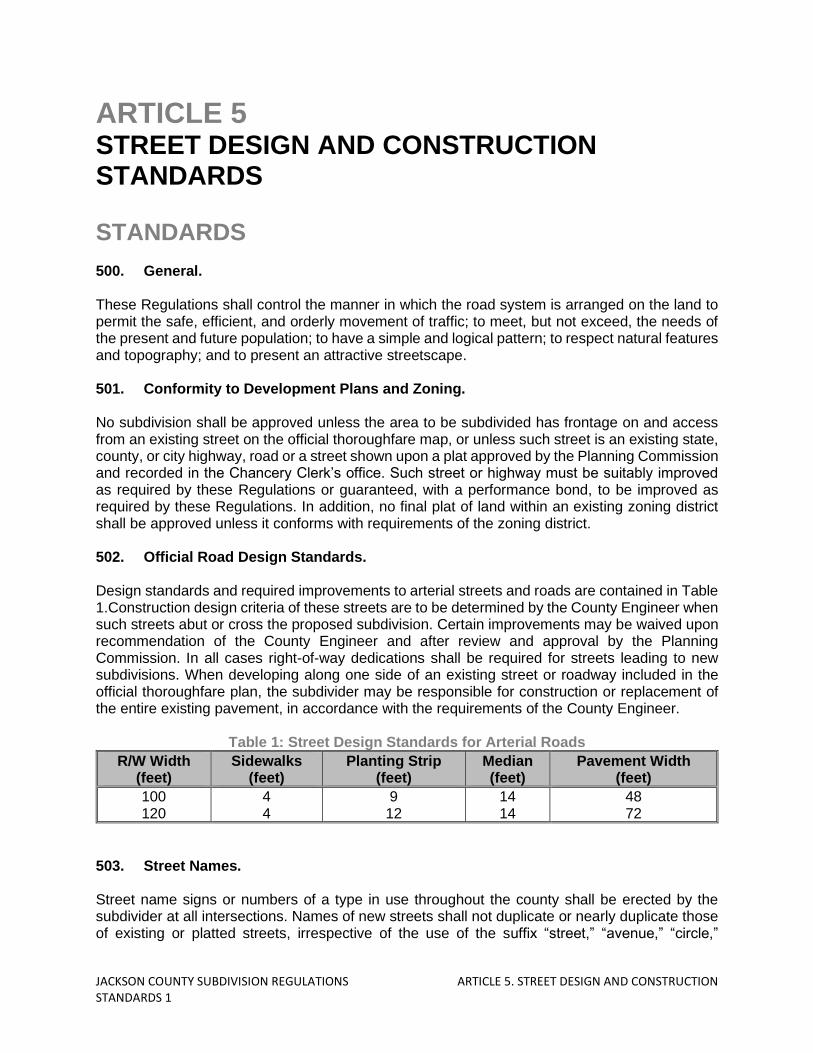
ARTICLE 5 STREET DESIGN AND CONSTRUCTION STANDARDS STANDARDS 500. General. These Regulations shall control the manner in which the road system is arranged on the land to permit the safe, efficient, and orderly movement of traffic; to meet, but not exceed, the needs of the present and future population; to have a simple and logical pattern; to respect natural features and topography; and to present an attractive streetscape. 501. Conformity to Development Plans and Zoning. No subdivision shall be approved unless the area to be subdivided has frontage on and access from an existing street on the official thoroughfare map, or unless such street is an existing state, county, or city highway, road or a street shown upon a plat approved by the Planning Commission and recorded in the Chancery Clerk’s office. Such street or highway must be suitably improved as required by these Regulations or guaranteed, with a performance bond, to be improved as required by these Regulations. In addition, no final plat of land within an existing zoning district shall be approved unless it conforms with requirements of the zoning district. 502. Official Road Design Standards. Design standards and required improvements to arterial streets and roads are contained in Table 1.Construction design criteria of these streets are to be determined by the County Engineer when such streets abut or cross the proposed subdivision. Certain improvements may be waived upon recommendation of the County Engineer and after review and approval by the Planning Commission. In all cases right-of-way dedications shall be required for streets leading to new subdivisions. When developing along one side of an existing street or roadway included in the official thoroughfare plan, the subdivider may be responsible for construction or replacement of the entire existing pavement, in accordance with the requirements of the County Engineer.
Table 1: Street Design Standards for Arterial Roads
R/W Width (feet)
Sidewalks (feet)
Planting Strip (feet)
Median (feet)
Pavement Width (feet)
100 120
4 4
9 12
14 14
48 72
503. Street Names. Street name signs or numbers of a type in use throughout the county shall be erected by the subdivider at all intersections. Names of new streets shall not duplicate or nearly duplicate those of existing or platted streets, irrespective of the use of the suffix “street,” “avenue,” “circle,”
JACKSON COUNTY SUBDIVISION REGULATIONS ARTICLE 5. STREET DESIGN AND CONSTRUCTION STANDARDS 2
“boulevard,” “drive,” etc., and shall be displayed at each street intersection with street signs of the type established by the county. When a new street is a direct extension of an existing street, the name shall remain the same. Street names shall be subject to the approval of the Planning Commission. The subdivider is responsible for the cost of purchasing and installing all signage. 504. Street and Circulation System Design. a. The arrangement, character, extent, and location of all streets shall conform to the
thoroughfare plan of the county; such streets shall be considered in their relation to existing and planned streets, topographic conditions, public convenience and safety, and in their relation to the proposed uses of land to be served by such streets. The Planning Commission reserves the right to disapprove any street plan which does not represent good design or does not insure continuity of the existing street system.
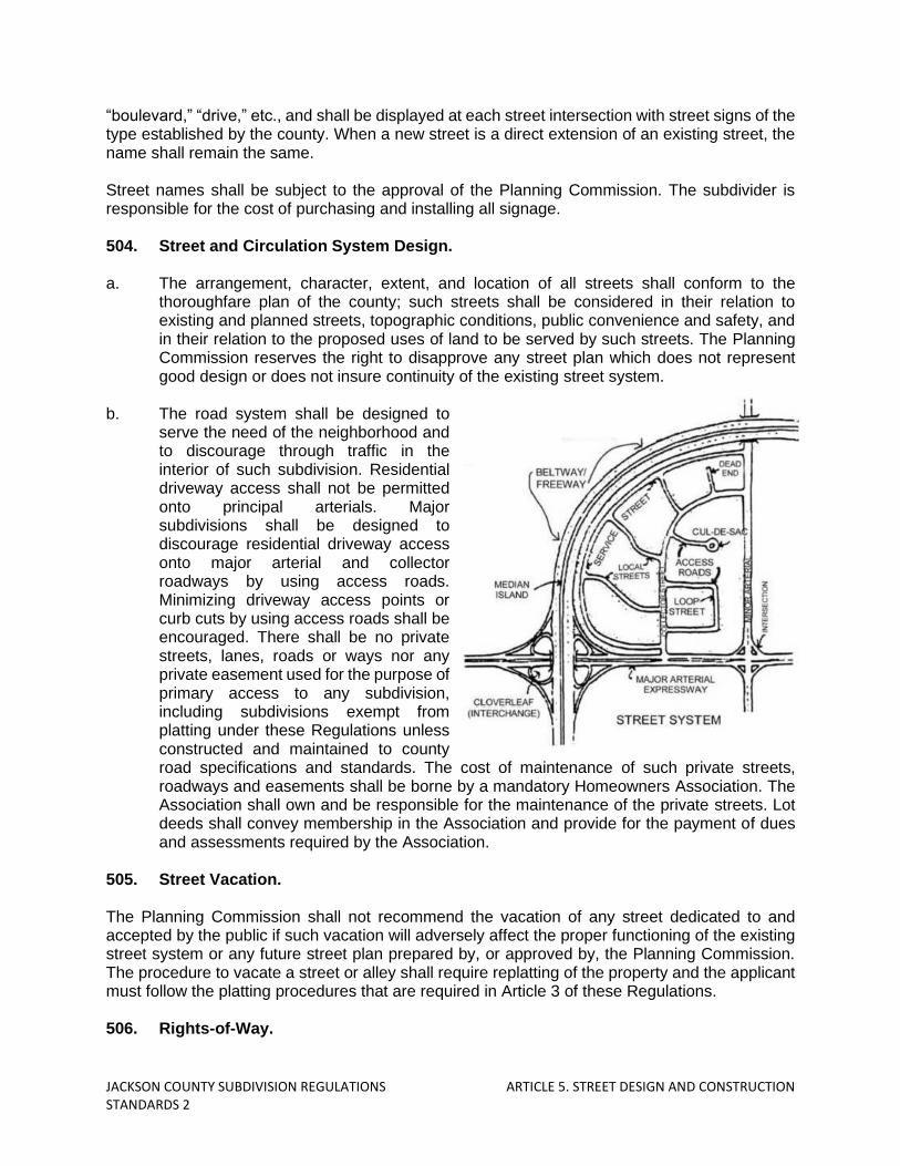
b. The road system shall be designed to
serve the need of the neighborhood and to discourage through traffic in the interior of such subdivision. Residential driveway access shall not be permitted onto principal arterials. Major subdivisions shall be designed to discourage residential driveway access onto major arterial and collector roadways by using access roads. Minimizing driveway access points or curb cuts by using access roads shall be encouraged. There shall be no private streets, lanes, roads or ways nor any private easement used for the purpose of primary access to any subdivision, including subdivisions exempt from platting under these Regulations unless constructed and maintained to county road specifications and standards. The cost of maintenance of such private streets, roadways and easements shall be borne by a mandatory Homeowners Association. The Association shall own and be responsible for the maintenance of the private streets. Lot deeds shall convey membership in the Association and provide for the payment of dues and assessments required by the Association.
505. Street Vacation. The Planning Commission shall not recommend the vacation of any street dedicated to and accepted by the public if such vacation will adversely affect the proper functioning of the existing street system or any future street plan prepared by, or approved by, the Planning Commission. The procedure to vacate a street or alley shall require replatting of the property and the applicant must follow the platting procedures that are required in Article 3 of these Regulations. 506. Rights-of-Way.

JACKSON COUNTY SUBDIVISION REGULATIONS ARTICLE 5. STREET DESIGN AND CONSTRUCTION STANDARDS 3
a. The right-of-way shall be measured from lot line to lot line and shall be sufficiently wide to contain the roadway, curbs, sidewalks, utilities, graded areas and shade trees, if required.
b. The right-of-way of a new street that is a continuation of an existing street shall in no case
be continued at a width less than that of the existing street. c. The right-of-way for roads shall be in accordance with the major thoroughfare plan, and
shall provide for future development. 507. Special Street Types. The following requirements shall apply to special street types: a. One way streets: One-way streets are permitted in new subdivisions if the Planning
Commission determines that such streets are properly integrated with the existing and proposed street system in the area.
b. Permanent dead-end streets shall not be permitted. Temporary dead-end streets shall be
permitted only as a segment of a continuing street plan subject to extension into undeveloped acreage. Temporary dead-end streets shall extend to the boundary of such undeveloped acreage and shall be provided with an interim turnaround satisfactory to the Planning Commission in design. The Planning Commission shall reserve the right to limit the length of such a dead-end street based on principles of proper planning, and the Planning Commission may require a street along the boundary between a proposed subdivision and the undeveloped acreage to provide for future development.
c. Cul-de-sac streets shall not exceed a length of seven hundred (700) feet in length for
medium to high density traffic and 1,000 feet for low density traffic. The terminus may be circular with a minimum driving surface radius of forty (40) feet measured from a point on the street centerline. Other termini types, such as “T’s” or vegetated islands, are acceptable and subject to review and approval by the County Engineer and Planning Commission. Cul-de-sacs may exceed 1,000feet with an intermediate turnaround depending upon the total number of lots served by the road.
d. The dedication of new half-streets shall not be permitted. If a parcel to be subdivided exists
adjacent to a dedicated or platted and recorded half-width street or alley, the other half-width of such street or alley falling within the proposed subdivision shall be platted, provided that in the opinion of the Planning Commission such right-of-way is necessary for the proper development of the area.
e. Where a subdivision adjoins an arterial street, a marginal access street shall be designed
to control access from lots fronting on it. Points of access to the arterial street shall be spaced at a minimum of thirteen hundred twenty (1320) feet. A planting strip having a minimum width of twenty (20) feet shall be provided between the pavement of the marginal access street. The minimum width of the marginal access right-of-way shall be fifty (50) feet. In addition, the Planning Commission may also require the provision of buffer planting strips, the platting of loop streets or cul-de-sacs connected to such parallel streets, or any combination thereof.

JACKSON COUNTY SUBDIVISION REGULATIONS ARTICLE 5. STREET DESIGN AND CONSTRUCTION STANDARDS 4
f. Easements or reserve strips controlling access to streets shall be prohibited except where deemed necessary by the Planning Commission and where their control is definitely placed with the county.
g. In subdividing land along existing streets or roads and within a proposed subdivision,
provisions for the dedication of land for one or more access streets to undeveloped land not fronting on an existing street or road shall be incorporated. Said access streets shall be spaced not less than eight hundred (800) feet, nor more than one thousand four hundred (1,400) feet apart.
h. Alleys may be approved in residential subdivisions when justified by subdivision street
design, to provide vehicular access to parking areas. Alleys may be approved in commercial and industrial subdivisions if no other provisions can be made for adequate service access. The minimum right-of-way widths for alleys shall be thirty (30) feet and they shall be dedicated to the public.
i. Alley intersections and sharp changes in alignment shall be avoided, but, where
necessary, corners shall be cut off sufficiently to permit safe vehicular movement. j. Dead-end alleys shall be avoided where possible but, if unavoidable, shall be provided
with adequate turnaround facilities at the dead-ends as determined by the Planning Commission.
Table 2: Right-of-Way Standards by Types of Road
Street Type R-O-W Width (feet)
Street Type R-O-W Width (feet)
Major Arterial Minor Arterial
Major Collector Minor Collector Local Industrial
100-300 50-100 50-70 50-60 60-80
Local Street/Road Access Street
Alley Cul-de-Sac
50-60 28-36
30 50
508. Street Design Standards for all Streets Except Cul-de-Sacs and Loop-Type Local
Streets. The design and improvement standards contained in Table 4 are minimums for all local streets and collector streets, except cul-de-sacs and loop-type streets, in residential subdivisions.
Table 3: Street Design Standards for Local and Collector Streets
Local Street Collector Street
Terrain Classification Level Rolling Level Rolling
Right-of-way (ft) 50* 50* 60 60
Pavement Width 24 24 36-40 36-40
Minimum Stopping Sight Distance (ft) 200 150 250 200
Maximum Grade 4% 8% 4% 8%
Maximum Spacing when intersected with an arterial (ft) - - 1,320 1,320
Maximum Center Line Radius of Streets with an

JACKSON COUNTY SUBDIVISION REGULATIONS ARTICLE 5. STREET DESIGN AND CONSTRUCTION STANDARDS 5
Local Street Collector Street
Terrain Classification Level Rolling Level Rolling
angle of turn of: (1) Between 80 and 100 50 50 (2) Less than 80 or more than 100 200 200
Minimum Center Line Radius 250 175 350 350 * A utility easement ten (10) feet in width may be required along each side of the street right-of-way for these streets. Note: Exceptions to the standards contained in this table are permitted under certain conditions for large lots.
Table 4: Street Design Standards for Cul-de-Sacs and Loop-Type Streets
Terrain Classification Level Rolling
Right-of-way (ft) 50*-60* 50*-60*
Pavement Width 24 24
Minimum Stopping Sight Distance (ft) 200 150
Maximum Grade 4% 8%
Maximum cul-de-sac length 1,000 (50%) 1,000 (50%)
Maximum cul-de-sac radius (row) 50 50
Maximum cul-de-sac radius (pavement) 40 40
Maximum Center Line Radius of Streets with an angle of turn of:
(1) Between 80 and 100 50 50 (2) Less than 80 or more than 100 200 200
*A utility easement ten (10) feet in width may be required along each side of the street right-of-way for these streets. *A 60’ right-of-way is required in low density developments on roadways with curbside ditches.
Table 5: Intersection Design Standards
Terrain Classification Level Rolling
Maximum Approach Speed (mph) 25 25
Clear Sight Distance (ft, length along each approach leg)
90 90
Vertical Alignment with Intersection Flat 2%
Minimum Angle of Intersection Streets 90 degrees 90 degrees
Minimum Curb Radius (ft) a. local-local 25 – all classes 25 – all classes b. local-collector 25 – all classes 25 – all classes c. collector-collector 30 – all classes 30 – all classes d. collector, marginal access-arterial 35 – all classes 35 – all classes
Minimum Centerline Offset of Adjacent Intersection (ft)
a. local-local 125 – all classes 125 – all classes b. local-collector 150 – all classes 150 – all classes c. collector-collector 200 – all classes 200 – all classes
d. collector, marginal access-arterial 1,320 – all
classes 1,320 – all
classes
509. Street Design Standards for Cul-de-Sac and Loop-Type Streets. The design and improvement standards contained herein are minimum for cul-de-sac and loop type local streets in a residential subdivision. All such streets shall be designed and constructed
JACKSON COUNTY SUBDIVISION REGULATIONS ARTICLE 5. STREET DESIGN AND CONSTRUCTION STANDARDS 6
in accordance with standards as specified in Table 4. Cul-de-sacs are required whenever a street is intended to be permanently dead-ended. 510. Intersection Design Standards. a. The design and improvement standards for intersections are suggested minimums for all
street intersections in subdivisions. All such intersections shall be designed and constructed in accordance with standards as specified in Table 5.
b. Multiple intersections involving junctions of more than two (2) streets shall not be
permitted. c. Proposed streets shall intersect one another as nearly at right angles as topography or
other limiting factors will permit. No intersection of streets on angles less than seventy-five (75) degrees shall be approved unless justified by extreme topographical conditions. In such a case, special provisions as deemed necessary by the Planning Commission shall be made.
d. Low points which would result in water ponding or poor visibility shall not be permitted. e. All Streets intersecting other streets shall either intersect directly opposite to each other,
or shall be separated by at least a one hundred-fifty (150) foot offset between centerlines, measured along the centerline of the street being intersected.
f. All Street intersections shall be located at least one hundred-fifty (150) feet from the right-
of-way of any railroad, measured from the center point of the intersection to the railroad right-of-way line nearest the intersection.
511. Streets for Commercial Subdivisions. Streets serving business developments and accessory parking areas shall be planned to connect with arterial streets so as not to generate traffic on local streets. The intersection of driveways from parking areas with arterial or collector streets shall be located so as to cause the least possible interference with traffic movement on the streets, and shall be located not less than one hundred(100) feet from the intersection of an arterial or collector street with any other street, and shall be located not less than one hundred (100) feet from the intersection of an arterial or collector street with any other street, and shall be spaced not less than two hundred (200) feet from each other. The Planning Commission may require marginal access streets to provide maximum safety and convenience. 512. Streets for Industrial Subdivisions. Collector streets for industrial subdivisions shall be planned to serve industrial areas exclusively and shall connect with arterial streets so that no industrial traffic will be directed into any residential streets. The intersections of service streets from parking areas, with arterial or collector streets shall not be less than one hundred (100) feet from the intersections of the arterial or collector street with any other street. Streets shall be planned to be extended to the boundaries of any adjoining land planned for industry, except if severe physical conditions prevent this or if the Planning Commission finds such extension is not in accord with the approved plan of the area. 513. Driveways.

JACKSON COUNTY SUBDIVISION REGULATIONS ARTICLE 5. STREET DESIGN AND CONSTRUCTION STANDARDS 7
a. A private driveway may be used to provide vehicular access to no more than four single
family detached dwelling units. The Planning Commission may require passing lanes, turnarounds, and overhead and width clearances as necessary to accommodate fire and emergency vehicles. A homeowner’s association shall be formed to provide for the long-term maintenance of any private access way. Common driveways shall have a maintenance agreement acceptable to the planning commission. Any driveway serving more than four (4) single-family dwelling units shall be considered a street and shall be designed and constructed according to these Regulations.
b. Access roads or vehicular ways within subdivisions containing single-family attached
dwelling units or multifamily dwellings shall be considered streets and designed and constructed according to these Regulations.
c. A driveway permit or letter indicating the access point as approved shall be obtained from
the office of the County Engineer, or Mississippi Department of Transportation. Proof of such permit shall be submitted with the final plat, or plat dedication shall include a statement requiring all lot owners to apply for a driveway permit prior to development.
d. When adequate frontage is available on a non-limited access highway, two driveways to
a property used for a single purpose may be permitted. e. Driveways should have a maximum grade of (15) percent. Driveways and curb cuts shall
be located not less than three (3) feet from the side lot line. Curb cuts for straight curbs and the flare for rolled curbs shall be three (3) feet wider than the driveway on each side. The subdivider or developer shall place the approved drainage structures under intersecting roads, drives, lanes or property entrances and at other locations where required. Driveways shall be designed so as to drain into the roads ditch and not into the roadway surface. Smooth transitions of driveways must be done not to impede drainage.
Table 6: Recommended Driveway Dimensions
Residential Commercial Industrial
Minimum Width 10 15 20
Maximum Width 30 40 40
Turn Radius Minimum 10 15 25
Turn Radius Maximum 25 50 50
Minimum Angle of Intersection 45 45 45 * The minimum width of commercial driveways is intended to apply to one-way operation. In high-pedestrian activity areas, such as in a business district or in the same block with an auditorium, school or library, the maximum basic width should be 30 feet. The width is intended to be measured along the right-of-way line. The maximum radius for major generator driveways should be much higher than the values shown. Minimum acute angle is measured from edge of pavement, and generally based on one-way operation. For two-way driveways, and in high pedestrian activity areas, the minimum angle should be 70 degrees.
514. Acceleration, Deceleration, and Turning Lanes. a. Deceleration or turning lanes will be required by Jackson County where the proposed
subdivision will intersect a major street or an arterial unless determined unnecessary by the County Engineer.

JACKSON COUNTY SUBDIVISION REGULATIONS ARTICLE 5. STREET DESIGN AND CONSTRUCTION STANDARDS 8
b. Deceleration lanes shall be designed to the following standards:1. The lane width shall be the same as the required width of the roadway moving lanes.2. The lane shall provide the full required land width for its full length. It shall not be tapered.3. The minimum land length shall be as follows:
Design Speed of Road Minimum Deceleration Lane Length
30 mph 165 feet 40 mph 230 feet 50 mph 310 feet
c. Acceleration lanes are only required when indicated as needed by a traffic impact study.
The design shall be as per the recommendation of the County Engineer. Where needed, a paved taper shall be provided for right hand turns.
515. Sidewalks and Graded Areas. a. Sidewalks may be required in all subdivisions. Where the average lot line frontage is 100
feet or less, sidewalks may be required on both sides of the street. Where the average lot line frontage is greater than 100 feet, sidewalks may only be required on one side of the street. Where the average lot line frontage is greater than 150 feet, sidewalks may not be required.
b. In conventional developments, sidewalks shall be placed in the right-of-way, parallel to the
street, unless an exception has been permitted to preserve topographical or natural features or to provide visual interest, or unless the applicant shows that an alternative pedestrian system provides safe and convenient circulation. In commercial and in high-density residential areas, sidewalks may abut the curb.
c. Pedestrian-way easements ten (10) feet wide may be required by the Planning
Commission through the center of blocks to provide circulation or access to schools, playgrounds, shopping or other community facilities.
d. Sidewalks shall measure four (4) feet in width; wider widths may be necessary near
pedestrian generators and employment centers. Where sidewalks abut the curb and parked cars overhang the sidewalk, widths shall be five (5) feet. The width of graded areas shall be the same as for sidewalks.
e. All sidewalks shall meet the requirement of the Americans with Disabilities Act. f. Sidewalks cross slope shall not exceed 2%, and the running slope shall not exceed 5%. g. Curb ramps shall be installed at all roadway intersections and designated pedestrian
crossings. Ramps shall be installed in accordance with the Mississippi Department of Transportation’s standard detail sheet – working number SDCCR-1, latest revision.
h. Sidewalks and ramps shall be constructed in accordance with the Federal Highway
Administration publication, “Accessible Sidewalks and Street Crossings – An Internal Guide”, FHWA-SA-03-019.

JACKSON COUNTY SUBDIVISION REGULATIONS ARTICLE 5. STREET DESIGN AND CONSTRUCTION STANDARDS 9
i. Sidewalks and graded areas shall be constructed according to the specifications set forth in these Regulations.
j. Public sidewalks may be required for industrial lots, subject to the approval of the Planning
Commission. 516. Street and Walkway Lighting. When a developer plans an expansion of a subdivision, creates a new subdivision, replats an existing subdivision, develops part or all of a previously platted and recorded subdivision, or creates a division of land as defined in Article 11, Section B of the Jackson County Subdivision Regulations, which is located in a Lighting District as created by House Bill No. 1638, 1991 Legislative Session, then the developer must install the street lights in accordance with the lighting district’s regulations. When a developer plans a new subdivision which adjoins a lighting district and the new subdivision is connected by streets where one can travel as if in one subdivision, then the developer must petition the Board of Supervisors to become part of that lighting district as created by House Bill No. 1638, 1991- Legislative Session and shall install the street lights in accordance with the lighting district’s regulations. 517. Culverts and Bridges. a. Where natural drainage channels intersect any street right-of-way, it shall be the
responsibility of the subdivider to have satisfactory bridges and/or culverts constructed. Where culverts are required, minimum requirements shall be observed as follows:
b. All culverts shall extend for an adequate distance to accommodate the required roadway
embankment slopes. The cover over the culvert and its capacity shall be determined by the developer’s professional engineer and approved by the County Engineer. The minimum diameter of the culvert pipe shall be eighteen (18) inches. Depending on the existing drainage conditions, head walls may be required. Where driveway culverts are wholly or partially in the street right-of-way, they shall have a minimum length of twenty (20) feet and minimum diameter of fifteen (15)inches. The driveway culverts shall be laid so as to maintain the flow lines of the ditch or gutter.
c. Culverts shall be designed in accordance with the Mississippi Department of
Transportation Design Manual along with HDS #5, Publication No. FHWA-NHI-01-020. 518. Street Improvements. All streets and thoroughfares shall be graded to their full width, including side slopes, and improved in conformance with the standards given or referred to in these Regulations. These standards are considered minimum and are subject to change where deemed necessary. All materials and construction procedures shall be in accordance with the MDOT Construction Manual. 519. Street Width. Minimum street pavement widths shall conform to the standards of these Regulations. Where pavement widths greater than those specified are deemed necessary by the County Engineer and approved by the Planning Commission, the subdivider shall bear the extra cost of providing the width beyond the requirements of these Regulations.

JACKSON COUNTY SUBDIVISION REGULATIONS ARTICLE 5. STREET DESIGN AND CONSTRUCTION STANDARDS 10
520. Street Subgrade. Soil borings shall be obtained by the developer from a licensed Geotechnical firm of sufficient quantity to identify the soil characteristic of the road subgrade. Soil borings will be required every 300 feet along the proposed centerline of roadway and will also be required at the center of every proposed cul-de-sac. In addition, soil borings will be taken at minimum depths of eight (8) feet below ground and will be required at the entrance of the proposed subdivision and at all low areas. A report shall be included recommending the methods to be used for the street design. 521. Street Base Course. The developer has the option of using any of the following base courses, based on recommendations of the County Engineer as to soil and traffic conditions: aggregate, bituminous aggregate, asphalt concrete, or equally suitable base course. Thickness shall be determined by the Developer’s Geotechnical Engineer and approved by the County Engineer, Road Manager, and the Planning Commission, based upon the physical properties of the base course used and the physical properties of the roadbed. 522. Street Construction Design. a. The subdivider shall construct streets including all grubbing, grading, laying of sub-base,
base, pavements, curbs and gutters, culverts, bridges, storm sewer mains, and structures in accordance with the MDOT standards. The design of the work shall be submitted to the County Engineer and the Road Manager prior to the construction of the work.
b. All pavement or surfacing designs shall be based on a twenty (20) year life and must be
approved by the Planning Commission before any construction is undertaken to insure adequate design for the existing soil conditions and proposed use to which it is to be subjected. Design calculations for the road surfacing and base shall be submitted to the County Engineer, the Road Manager, and the Planning Commission for approval.
523. Hot Mixed Asphalt Streets. a. Design thickness for combined surface and base material shall be based on the subgrade
condition, the ADT factor and the magnitude of equivalent 18,000 pounds axle load where estimated ADT of 100 vehicles per day.
b. Design guides provided by the AASHTO, National Asphalt Pavement Association and the
Asphalt Institute shall be used. c. Surface material shall be at least 3 inches in thickness. Base material may consist of soil
cement, limestone, clay gravel, crushed gravel, or hot mix asphalt base and shall extend a distance of one (1) foot beyond the curb limit. The design mix of the asphalt shall conform to local accepted material or according to Mississippi Department of Transportation specifications.
524. Street Curbs and Gutters.

JACKSON COUNTY SUBDIVISION REGULATIONS ARTICLE 5. STREET DESIGN AND CONSTRUCTION STANDARDS 11
The requirements for curbs and gutters will vary according to the character of the area and the density of development. In areas with substantial flash flooding or heavy rain runoff, curbs shall be required on all streets designed for areas where the existing or anticipated residential density of the area surrounding the proposed subdivision equals or exceeds three (3) dwelling units per net acre. In commercial developments, or where other similar intensive urban uses exist or are anticipated, curbs shall be required. Where curbs exist on abutting properties, their extension shall be required throughout the proposed subdivision. Curbs and gutters shall be constructed in conformance with the current Constructions and Material Specifications of the State of Mississippi Department of Transportation. 525. Open Ditches and Slopes. Open ditch construction for roadside drainage shall be permitted in low density areas, and constructed according to Mississippi Department of Transportation specifications. Minimum depth of ditches shall be two (2) feet below the edge of pavement, and one (1) foot minimum at top of hill and toe of bank. All ditches shall be protected against erosion. The designer shall utilize the Federal Highway Administration Hydraulic Engineering Circular No. 15 (HEC 15) to calculate and determine channel lining requirements for all proposed roadside ditches and open channels. Concrete linings will be required in areas determined by the County Engineer and the Road Manager. All open ditches will be concreted or curb and gutter with storm drain will be required. 526. Entrance Design Standards. a. Any private street with an access control gate shall have a minimum uninterrupted
pavement width of twenty-four (24) feet at the location of the access control device. All restricted access gates shall be approved by the particular Fire Department servicing the area and meet access requirements for emergency vehicles.
b. Overhead barriers shall not be allowed. c. Internal storage for three (3) vehicles shall be provided between the right-of-way line and
the point of the access control device. An additional setback between the point of the access control device and the access gate shall be required to allow a vehicle which is denied access to safely turn around and exit onto a public street.
d. On lots adjacent to access gates, screening walls may exceed thirty (30) inches in height,
up to a maximum of eight (8) feet within the front yard setback of the adjacent lot.
JACKSON COUNTY SUBDIVISION REGULATIONS ARTICLE 6. UTILITY DESIGN AND CONSTRUCTION STANDARDS 1
ARTICLE 6 UTILITY DESIGN AND CONSTRUCTION STANDARDS STANDARDS 600. General. A professional engineer, licensed in the State of Mississippi, shall design any plans for public water supply, stormwater and wastewater facilities. 601. Water Supply. a. All property used for human occupancy, employment, recreation, or other purposes, where
a potable water system is available, shall have a properly constructed service connection to each system installed and administered in accordance with the Jackson County Utility Authority Rules and Regulations. Public water distribution and public well systems shall meet the requirements of the Jackson County Utility Authority.
b. Where an approved public water main is accessible, the subdivider shall install adequate
water facilities (including fire hydrants) subject to the specifications of the governing agencies. All water main extensions shall be approved by the Jackson County Utility Authority.
c. Necessary action shall be taken by the applicant to receive development approval from
the Authority for the applicant’s utility plan, prior to construction within the Authority’s jurisdiction. The process for completing this review along with the subsequent review fees are further described in the Jackson County Utility Authority’s Rules and Procedures Manual.
d. Based on the location of the proposed development, in relation to the existing water
infrastructure and the capacity of that existing infrastructure, the Authority will determine the development’s appropriate course of action regarding the installation of waterlines. Each course of action will require the developer to include covenants which stipulate to each lot owner, the options that they are required to adhere to.
e. To facilitate the above, the location of all fire hydrants, all water supply improvements, and
the boundary lines of proposed districts, indicating all improvements proposed to be served, shall be shown on the preliminary plat, and the cost of installing same shall be included in the performance bond or cash deposit in lieu of construction to be furnished by the developer.
f. Materials shall conform to the Jackson County Utility Authority’s Standards and
Specifications Manual. g. It shall be the responsibility of the developer to coordinate approval of proposed utility
systems with the Jackson County Utility Authority. Developer shall meet the requirements
JACKSON COUNTY SUBDIVISION REGULATIONS ARTICLE 6. UTILITY DESIGN AND CONSTRUCTION STANDARDS 2
of the Utility Authority prior to beginning construction. The final approval from the Authority shall be required prior to construction and recording of a final plat with the Jackson County Chancery Clerk.
h. The Authority may require the installation of a public water supply and distribution system
or individual on-site water supply systems in a proposed development for lots or parcels that are not connected to water infrastructure owned and operated by the Authority. Consideration for such systems shall be on a case-by-case basis.
602. Fire Protection. a. Fire hydrants shall be designed and installed per requirements of the Mississippi State
Rating Bureau by the subdivider in all subdivisions with adequate public water supplies. To eliminate future street openings, all underground utilities for fire hydrants, together with the fire hydrants themselves shall be installed before any final paving of a street shown on the subdivision plat.
b. Hydrants shall be located between property lines and curbs with all outlets facing or
parallel to the street. Hydrants shall be placed at the corners of all blocks and at midblock for blocks exceeding one thousand (1,000) feet in length. Hydrants shall also be required at the entrance and end of all cul-de-sacs exceeding five hundred (500) feet in length.
c. Hydrants shall be spaced to provide necessary fire flow. In addition, hydrants shall be
spaced so that each residence shall be within 500 feet of a hydrant. d. A hydrant shall be located at all low points and at all high points with adequate means of
drainage provided. e. The type of hydrant and control valves and the location of the hydrant shall be approved
by the fire chief or person responsible for the fire protection for the district in which the plat is located.
f. The minimum size of any water line serving any hydrant shall not be less than six (6)
inches in diameter and shall be on circulating water lines. The size and location of water lines shall be approved by the County Engineer, the fire chief, or person responsible for the fire protection.
603. Sanitary Sewers. a. Where an adequate public sanitary sewer system is reasonably accessible in the
determination of the Utility Authority, public sanitary sewers shall be installed to adequately serve all lots, including lateral connections to the public system. Public sewer system extensions shall meet the requirements of the Jackson County Utility Authority’s Rules and Procedures Manual. Combinations of sanitary sewers and storm sewers shall be prohibited.
b. Where a public sanitary sewer system is not reasonably accessible, the Utility Authority
may consider alternative wastewater collection and treatment systems. Lots may be served by individual disposal systems only with approval of the Utility Authority and the Health Department. Where the installation of individual disposal systems is considered, the absorptive ability of the soil, surface drainage, ground water level and topography shall
JACKSON COUNTY SUBDIVISION REGULATIONS ARTICLE 6. UTILITY DESIGN AND CONSTRUCTION STANDARDS 3
be the criteria used for determining whether or not the installation of individual systems is permissible.
c. When individual, on-lot sewage systems are approved, each lot so served shall be of a
size and shape to accommodate the necessary length of a leach field at a safe distance from and at a lower elevation than the proposed building(s). Such lot size and shape shall conform to the requirements of the zoning district in which they are located.
d. At least one (1) percolation test shall be located in close proximity to the proposed
individual sewage disposal unit, numbered and with its location shown on the preliminary plan. All percolation tests shall be performed in accordance with the requirements of the Utility Authority and the Mississippi Department of Health.
604. Design Criteria for Sanitary Sewers. These design criteria are not intended to cover extraordinary situations. Deviations will be allowed and may be required in those instances when considered justified by the Utility Authority and its engineers. a. Design Factors: Sewer capacities shall be adequate to handle the anticipated maximum
hourly quantity of sewage and industrial waste together with an adequate allowance for infiltration and other extraneous flow.
b. Size: The diameter of sewers proposed shall not exceed the diameter of the existing or
proposed outlet, whichever is applicable, and shall be no less than eight (8) inches. c. Minimum Slope: All sewers shall be designed to give mean velocities, when flowing full,
of not less than 2.0 feet per second and not greater than 10.0 feet per second. All velocity and flow calculations shall be based on the Manning Formula using an “n” value of 0.013.
d. Alignment: All sewers shall be laid with straight alignment between manholes, unless
otherwise directed or approved by the Utility Authority engineer. e. Manholes: Manholes shall be installed at the end of each line; at all changes in grade,
size, or alignment; at all intersections; and at distances not greater than 400 feet for sewers 15 inches and smaller, and 500 feet for sewers 18 inches in diameter and larger. The difference in elevation between any incoming sewer and the manhole invert shall not exceed 12 inches except where required to match crowns. The use of drop manholes will require approval by the Utility Authority engineer.
f. Sewerage Location: Sanitary sewers shall be located within street or alley rights-of-way
unless topography dictates otherwise. When located in easements on private property there shall be access to all manholes. A manhole shall be provided at each street or alley crossing. End lines shall be extended to provide access from street or alley right-of-way when possible.
605. Drainage and Storm Sewers.

JACKSON COUNTY SUBDIVISION REGULATIONS ARTICLE 6. UTILITY DESIGN AND CONSTRUCTION STANDARDS 4
All storm drainage design shall be planned and executed so as to preserve natural topographic features and vegetative cover, to minimize change to existing topography, and to preserve natural drainage systems. a. Where an adequate public storm sewer is available at the plat boundary, the subdivider
shall construct a storm sewer system and connect with such storm sewer line. If such a storm sewer system is not accessible, natural drainage channels with easements of adequate width shall be provided as determined by the County Engineer and Road Manager and approved by the Planning Commission. Storm drainage from lots, including drain tile around basements, shall not be permitted to discharge into any sanitary sewer facility, but shall connect to an adequate drainage outlet.
b. The subdivider shall construct all necessary facilities including underground pipe, inlets,
catch basins, or open drainage ditches, as determined by the Planning Commission, to provide for the adequate disposal of subsurface and surface water and maintenance of natural drainage courses. The best available technology shall be used to minimize off-site stormwater runoff, increase onsite filtration, encourage natural filtration functions, simulate natural drainage systems, and minimize off-site discharge of pollutants to ground and surface water. Best available technology may include measures such as retention basins, recharge trenches, porous paving and piping, contour terraces, and swales.
Subdivision development shall not increase the rate of runoff and an increase in the volume of runoff shall require a reduction in the rate of runoff.
c. When necessary, outlet ditches of closed sewers of an approved type and size shall be
required as part of the construction. If same is across private property, rights-of-way or easements shall be obtained by the subdivider or developer for the construction and future maintenance. These rights-of-way or easements shall be shown on the construction plans. Whenever possible, post-development drainage patterns shall be the same as pre-development drainage patterns. The design of streets and grading shall be such that runoff from roofs, driveways and other impervious surfaces will be collected in ditches and/or gutters in short runs three hundred (300) feet to four hundred (400) feet in length. The runoff shall then be diverted from the surface, if not already underground, into storm sewers or a natural water course. Streets shall be located away from water courses unless storm sewers are to be installed. The channel downstream of the subdivision shall be improved adequately by the developer to convey the storm runoff from the subdivision and across the adjacent property owner so that damages from flooding are minimized. Additional easements for the maintenance of the downstream channel shall be obtained by the Developer.
d. The subdivider shall guard against the creation or continuation of swampy areas or
stagnant pools, unless they are a component of a designed wetlands open space. The Planning Commission may require fill, swale, and/or channel improvements in order to forestall such problems.
e. Adequate measures for the protection of open and closed drainage channels shall be
provided. Maintenance easement widths shall be determined by the County Engineer and Road Manager. The velocity flow on an open ditch shall not exceed four (4) feet per second in soil ditches or six (6) feet per second in turf gutters. Paved gutters will be required if velocities of flow are greater than those specified, or if it is otherwise likely that destructive erosion will result. Drainage ditches shall not be permitted to discharge into

JACKSON COUNTY SUBDIVISION REGULATIONS ARTICLE 6. UTILITY DESIGN AND CONSTRUCTION STANDARDS 5
any sanitary sewer facility. The design of all open ditches and channels shall be in accordance with the Federal Highway Administration Hydraulic Engineering Circular No. 15 (also referred to as HEC 15). Concrete lining will be required in areas deemed necessary by the County Engineer and Road Manager.
f. No water course shall be altered in such a way as to change the amount or direction of
flow; no fill, building or structures shall be situated in natural water courses unless provision is made for the flow of water in a manner satisfactory to the County Engineer.
g. All storm drainage design shall be completed in accordance with the requirements of the
Mississippi Department of Transportation: “Roadway Design Manual”, particularly Chapter 7.Subdivisions shall be designed for a 25-year design storm frequency. Additionally, cross drains and culverts under primary roadways for subdivisions shall be checked for function with a 50-year storm event and may require the use of the 50-year storm criteria, when warranted.
606. Electric, Gas, and Telephone Improvements. a. Electric and telephone service shall be provided within each subdivision. Gas service may
be required where reasonably accessible. Whenever such facilities are reasonably accessible and available, they may be required to be installed within the area prior to the approval of the final plat. Telephone, electric, and street lighting wires, conduits, and cables shall be constructed underground. This provision may be waived in non-urban and rural developments.
b. Overhead utility lines where permitted shall be located at the rear of all lots unless the
County Engineer, upon the recommendation of utility company, provides reasons that justify the location of easements at another location. The width of the easement per lot shall be not less than ten (10) feet and the total easement width shall be not less than twenty (20) feet.
c. Whenever a sanitary sewer line and electric and/or telephone line are each placed
underground in the same utility easement, the total easement width shall be not less than twenty (20) feet.
d. Whenever a major gas transmission line is on or adjacent to property proposed to be
subdivided, adequate measures shall be taken to insure that all buildable sites are at a minimum safe distance from the transmission line easement, as recommended by the gas transmission company and the Mississippi Public Service Commission.
607. Oversize and Offsite Improvements. The County Supervisors, with advice provided by the Planning Commission may require that pavements, and other land improvements for the proposed subdivision be designed oversized, and/or with extensions provided, to serve nearby land which is an integral part of the neighborhood service or drainage area as determined by the County Engineer. The subdivider shall be required to pay only his or her percentage cost of construction of major arterial streets as determined by the County Engineer. Where public improvements are installed which are intended to extend, expand or improve the Utility Authority’s public improvements beyond the public improvements required to service or

JACKSON COUNTY SUBDIVISION REGULATIONS ARTICLE 6. UTILITY DESIGN AND CONSTRUCTION STANDARDS 6
benefit the subdivision or development activity proposed by the developer, the Utility Authority in its discretion may enter into a written reimbursement agreement with the developer who installs the public improvement. The amount and source of the reimbursement to the developer shall be determined pursuant to the reimbursement schedule adopted by the County Utility Authority Board after receiving recommendations from its engineer. The reimbursement amount(s) for the oversized portion of the public improvements shall not exceed the actual, reasonable costs incurred in installing the oversized portion of the public improvements.
JACKSON COUNTY SUBDIVISION REGULATIONS ARTICLE 7. ENVIRONMENTAL AND LANDSCAPING 1
ARTICLE 7 ENVIRONMENTAL AND LANDSCAPING DESIGN AND CONSTRUCTION STANDARDS 700. Purpose. Landscaping shall be provided as part of the site plan and subdivision design for planned unit developments and for commercial, industrial, and medium and high density residential subdivisions. Careful thought shall be given as to how best to preserve existing plant material at the site. Landscaping may include plant materials such as trees, shrubs, ground covers, perennials, and annuals, and other materials such as rocks, water, sculpture, art, walls, fences, paving materials and street furniture. 701. Public Sites, Open Space and Recreation. a. Due consideration shall be given to the allocation of suitable areas for parks and
playgrounds to be dedicated for public use where shown on a plat such public sites and open spaces shall be constructed during the development of the subdivision and prior to Final Plat approval.
b. The Planning Commission, in conjunction with the Board of Supervisors, may require that
land area totaling three percent (3%) of the land included in the plan of the subdivision be designated for park or recreational purposes.
c. Where a large-scale subdivision or planned unit development is proposed, the Planning
Commission may request that consideration be given to sites for schools, parks, playgrounds, and other such areas for common use and that provisions be made for such acquisition by the proper local or state agency.
d. The Planning Commission may reserve the right to deny approval to a subdivision if such
subdivision disregards the preservation of natural features such as wooded areas, water courses, beaches, areas of natural or historical significance and similar irreplaceable assets which add value to residential development and the community.
e. Due regard shall be shown for all natural features such as large trees, water courses,
historic spots, and similar county assets which, if preserved, will add attractiveness and value to the property.
f. Lakes, ponds, creeks, and similar areas will be accepted for maintenance only if sufficient
land is dedicated as a public recreation area or park or if such area constitutes a necessary part of the drainage control system, such areas must be approved by the Planning Commission and accepted by the Board of Supervisors before approving the plat.
702. Flood Areas and Storm Drainage Ditches.
JACKSON COUNTY SUBDIVISION REGULATIONS ARTICLE 7. ENVIRONMENTAL AND LANDSCAPING 2
Appropriate measures shall be taken to elevate buildings to required levels. A proposed subdivision may be denied if access to the subdivision is periodically blocked by floodwaters. Flood control or storm drainage facilities shall be provided as follows: a. Access to flood control or storm drainage ditches and channels shall be provided by
easements of not less than twenty (20) feet in width, located on one side of the flood control or drainage ditch, channel or similar facilities.
b. Flood control or storm drainage easements containing underground facilities shall have a
minimum width of twenty (20) feet. c. Whenever a flood control or storm drainage ditch or channel has a depth of five (5) feet or
more, or a bank slope of two (2) feet horizontal to one (1) vertical or steeper, a five (5) foot high masonry wall or a five (5) foot high chain link fence may be required by the Planning Commission.
703. Subdivision Within Flood Plain. There shall be no platting or subdivision of land allowed by the Board within the area defined as a floodplain unless the following conditions are met: a. It is determined by the Board after receipt of additional hydrological or grade studies from
the subdivider or appropriate federal or state agencies that the lands to be developed are no longer subject to be covered by flood water of a 100-year frequency flood, or
b. The location, grade, and flood-proofing of all proposed water mains and wastewater
collectors which are to be extended into or through any portion of the flood plain to serve the proposed development shall first be approved by the Board, prior to the extensions of such utilities into the flood plain area.
c. That the development of any land located within the flood plain will be accomplished so
as to completely protect all areas of habitation and employment by raising of the ground elevation to at least one (1) foot above the 100-year frequency flood. The raising of the ground shall be accomplished in such a manner that the general flow and storage of water is not unduly restricted or limited and will not cause flood hazards to other lands and developments, either within the proposed subdivision or otherwise, and that said protection shall be accomplished without creating the need of significant public expenditures for flood control. This may require a detailed study to ensure the site raising will not cause flood hazards.
d. That any proposed use which is located within a flood plain shall not include buildings
which are inhabited and will be limited to such uses as open space, streets, and parking areas on that portion of the land within the flood plain where significant damage to life and property from flooding is more likely to occur. Any use approved to be located on land which is included within an area designated as a flood plain shall be approved only where the following factors have been considered and arrangements have been made which area satisfactory to the Board.
1. The danger to life and property by water which may be backed up or diverted by
such obstruction or land use;
JACKSON COUNTY SUBDIVISION REGULATIONS ARTICLE 7. ENVIRONMENTAL AND LANDSCAPING 3
2. The danger that the obstruction or land use will be swept downstream to the injury
of others; 3. The availability of alternate locations; 4. The construction or alteration of the obstruction in such a manner as to lessen any
danger; 5. The permanence of the obstruction or land use; 6. The anticipated development in the foreseeable future of the area in which the
proposed subdivision is to be located which may be affected by the obstruction or land use; and
7. Any additional conditions adopted by the Board to ensure proper use of the areas
within the flood plain. e. The proposed centerline grade of streets, roads, or private roadways located within the
floodplain that are necessary to serve the proposed development shall not be more than one (1) foot below the 100-year frequency flood elevation.
f. Any area within a flood plain from which fill is taken shall be hydrologically designed and
maintained to reduce the likelihood of becoming refilled by silt. The subdivider must make arrangements satisfactory to the Board binding his/her successors and assigns, to regrade or remove such silt as is necessary to return any area to its approved design after flooding has occurred. Any area from which fill is taken within a flood plain shall be at a grade that will continue to permit adequate drainage into the stream or watercourse. If a water area is to be maintained within the flood plain, consideration shall be given to the effect the water area may have upon the flooding of both the land within the flood plain and other lands outside of the flood plain.
The subdivider shall obtain the approval of the County Engineer for any modifications in the location or design of the borrow area within the flood plain.
704. Soil Erosion Requirements. a. Installation of improvements must be done in such a manner as to provide for the most
effective control of erosion and sediment. Practical combinations of the following technical principles must be used. Developers shall follow the standards and best management practices as outlined in the Planning and Design Manual for the Control of Erosion, Sediment and Stormwater (USDA-NRCS, MS Department of Environmental Quality, MS Soil and Water Conservation Commission).
1. The smallest practical area of land must be exposed at any one time during
development. 2. When land is exposed during development, the exposure is to be kept to the
shortest practical period of time.

JACKSON COUNTY SUBDIVISION REGULATIONS ARTICLE 7. ENVIRONMENTAL AND LANDSCAPING 4
3. Temporary vegetation and/or mulching must be used to protect critical area exposed during development.
4. Sediment basins (debris basins, desilting basins, or silt-traps) must be installed
and maintained to remove sediment from waters from land undergoing development.
5. Provisions must be made to effectively accommodate runoff caused by changed
soil conditions during and after development. 6. Permanent final vegetation and structures must be installed as soon as practical
in the development. 7. The development plan must be fitted to the topography and soils so as to create
the least possible erosions. 8. Wherever feasible, natural vegetation must be retained and protected.
b. Maintenance of Facilities. All improvements, including post construction best management
practices and landscaping, shall be maintained in and cannot be developed for any other use which would limit or cause to limit the use of the improvements. Responsibility and maintenance of these improvements shall follow the Ownership of the property. Each property owner shall, be liable within the contents of his deed, for the maintenance of the improvements. A special note this effect shall appear on any final plat of subdivision. When problems arise due to inadequate maintenance, the County Inspector may inspect the improvements and compel the correction of the problem by written notice. If it is impracticable for the property owner to make the correction, the property owner may contract with the County for the correction of the problem if such service is available, provided the County is adequately reimbursed.
705. Landscape Plan. A landscape plan shall be submitted with each site plan application for planned developments, commercial, industrial, and/or high density residential subdivisions, unless an exception is granted by the Planning Commission pursuant to these Regulations. The landscape plan shall identify existing and proposed trees, shrubs, and ground covers; natural features; and other landscaping elements. Where existing plants are to be retained, the applicant shall include in the plans proposed methods of protecting them during construction. 706. Site Protection and General Planting Requirements. a. Topsoil Preservation: Topsoil shall be temporarily stored and later redistributed on all
regarded surfaces so as to provide at least (4) inches of even cover to all disturbed areas of the development and shall be stabilized by seeding or planting.
b. Removal of Debris: All stumps and other tree parts, litter, brush, weeds, excess or scrap
building materials or other debris shall be removed from the site and disposed of in accordance with the law. No tree stumps, or portions of tree trunks or limbs shall be buried anywhere in the development. If trees and limbs are reduced to chips, they may be used as mulch in landscaped areas, subject to approval by the Planning Commission.
JACKSON COUNTY SUBDIVISION REGULATIONS ARTICLE 7. ENVIRONMENTAL AND LANDSCAPING 5
c. Protection of Existing Plantings: Maximum effort should be made to save fine or exceptional plant specimens. No material or temporary soil deposits shall be placed within four (4) feet of shrubs or ten (10) feet of trees designated on the landscape plan to be retained. Protective barriers or tree wells shall be installed around each plant and/or group of plants that are to remain on the site. Barriers shall not be supported by the plants they are protecting, but shall be self-supporting. They shall be a minimum of four (4) feet high and constructed of a durable material that will last until construction is completed. A silt fence is an example of an acceptable barrier.
d. Slope Plantings: Landscaping of all cuts and fills and/or terraces shall be sufficient to
prevent erosion, and all roadway slopes steeper than one (1) foot vertically to three (3) feet horizontally shall be planted with ground cover appropriate for the purpose and for soil conditions, water availability, and environment.
e. Additional Landscaping: In residential developments, besides the screening and street
trees required, additional plantings or landscaping elements may be required throughout the subdivision where necessary for climate control, privacy, or other reasons in accordance with the landscape plan approved by the Planning Commission taking cost constraints into consideration. In non-residential developments, all areas of the site not occupied by buildings and required improvements shall be landscaped by the planting of grass or other ground cover, shrubs, and trees as part of the landscape plan approved by the Planning Commission.
f. Planting Specifications: Deciduous trees shall have at least a two-inch caliper at planting.
Size of evergreens and shrubs shall be allowed to vary depending on setting and type of shrub. All trees, shrubs, and ground covers shall be planted according to accepted horticultural standards. Dead and dying plants shall be replaced by the developer during the following planting season.
g. Plant Species: The plant species selected shall be hardy for the climate and appropriate
in terms of function and size. 707. Shade Trees. Shade trees shall be installed on both sides of all streets in accordance with the approved landscape plan. When trees are planted at predetermined intervals along streets, spacing shall depend on tree size (at maturity), as shown in Table 7-1. When the spacing interval exceeds 40 feet, small ornamental trees can be placed between the larger trees. If a street canopy effect is desired, trees may be planted closer together, following the recommendations of a registered landscape architect. The planting of trees shall be coordinated with utilities, roadways, sidewalks, sight easements, or streetlights. Tree location, landscaping design, and tree spacing shall be approved by the Planning Commission as part of the landscape plan.
Table 7-1: Spacing Between Shade Trees

JACKSON COUNTY SUBDIVISION REGULATIONS ARTICLE 7. ENVIRONMENTAL AND LANDSCAPING 6
Tree Height (feet)
Planting Interval (feet)
Large Trees (40+) 50-70
Medium Trees (30-40) 40-50
Small Trees (to 30) 30-40
708. Buffering. Buffering is the provision of an area between different land uses that attempts to minimize negative environmental impacts from one to the other. Buffers shall provide a year-round visual screen in order to minimize adverse impacts. They may consist of fencing, evergreens, berms, rocks, boulders, mounds, or combinations thereof to achieve the same objectives. Every developer shall provide sufficient buffering when topographical or other barriers do not provide reasonable screening and when the Planning Commission determines that there is a need to shield (1) neighboring properties from any adverse external effects of a development; or (2) the development from negative impacts of adjacent uses such as streets or railroads. In high-density developments, when building design and siting do not provide privacy, the Planning Commission may require landscaping, fences, or walls to screen dwelling units for privacy. Buffers shall be measured from side and rear property lines, excluding driveways. Plant materials shall be sufficiently large and planted in such a fashion that a year-round screen at least eight (8) feet in height shall be produced within three (3) growing seasons. All plantings shall be installed according to accepted horticultural standards.
Table 7-2: Buffer Strip Width
Parking lots, garbage collection, utility areas, and loading and unloading areas
5 ft. width minimum
All other land uses 25 ft. width minimum
709. Maintenance. Plantings shall be watered regularly and in a manner appropriate for the specific plant species through the first growing season, and dead and dying plants shall be replaced by the applicant during the next planting season. No buildings, structures, storage of materials, or parking shall be permitted within any buffer area. Buffer areas shall be maintained and kept free of all debris, rubbish, weeds, and tall grass. 710. Parking Lot Landscaping. a. In parking lots, at least five percent (5%) of the
interior parking area shall be landscaped with plantings, and one(1) tree for each ten (10) spaces shall be installed. Parking lot street frontage screening and perimeter screening shall be a minimum of five (5) feet wide. Planting required within the parking lot is exclusive of other planting requirements, such as shade trees planted along the street.

JACKSON COUNTY SUBDIVISION REGULATIONS ARTICLE 7. ENVIRONMENTAL AND LANDSCAPING 7
b. Landscaping should be located in protected areas, such as along walkways, in center islands, at the ends of bays, or between parking stalls. All landscaping in parking areas and on the street frontage shall be placed so that it will not obstruct sight distance. Plantings in parking areas and on streets shall pay particular attention to sun position during the summer months so that maximum cooling effects can be gained from well-placed trees.
c. A mixture of hardy flowering and/or decorative evergreen and deciduous trees may be
planted. The evergreens should be used along the perimeter of the lot for screening, and the deciduous trees for shade within the lot. The area between trees shall be mulched or planted with shrubs or ground cover. Any area that will be under the overhang of vehicles shall be mulched or covered with paving material.
711. Paving Materials. Design and choice of paving materials used in pedestrian areas shall consider such factors as function, climate, characteristics of users, availability, cost, maintenance, glare, drainage, noise, appearance, and compatibility with surroundings. Acceptable materials shall include, but are not limited to, concrete, brick, cement pavers, asphalt, and stone. 712. Walls and Fences. Walls and fences shall be erected where required for privacy, screening, separation, security, erosion control, or to serve other necessary and reasonable functions. The design and materials used shall be functional and compatible with existing and proposed site architecture. No fence or wall shall be so constructed or installed as to constitute a hazard to traffic or safety. 713. Street Furniture. Street furniture such as trash receptacles, benches, and phone booths, shall be located and sized in accordance with their function. The different street furniture components shall be compatible in form, material, and finish. Design and materials shall be coordinated with existing and proposed site architecture. Selection of street furniture shall take into consideration functionality and durability.

JACKSON COUNTY SUBDIVISION REGULATIONS ARTICLE 8. CONSTRUCTION OF IMPROVEMENTS 1
ARTICLE 8 REQUIREMENTS FOR CONSTRUCTION OF IMPROVEMENTS STANDARDS 800. Improvement and Cost Estimate Information. Before the signing of the final plat, all applicants shall be required to complete, to the satisfaction of the County Engineer, the Road Manager, the County Utility Authority or other appropriate agency, all the streets, sanitary improvements, and other public improvements, including lot improvements on the individual lots, as listed on the preliminary plan and engineering plans and as construction-certified on the final plat. When required improvements are not completed, the subdivider shall insure their completion with a performance guarantee acceptable to the Planning Commission and Board of Supervisors. All required improvements shall be made by the developer, at his or her expense, and cost estimates for various materials and labor shall be provided as requested by a professional engineer licensed in the State of Mississippi. The developer shall dedicate public improvements to the County, free and clear of all liens and encumbrances on the dedicated property and public improvements. 801. Performance Guarantee for Installation and Maintenance of Improvements. To guarantee the construction and/or maintenance of required improvements prior to the approval and recording of the final plat, the subdivider shall be required to provide a performance guarantee in one or a combination of the following arrangements: a. Performance Bond, Certified Check, or Irrevocable Letter of Credit: The subdivider shall
post a bond, executed by a surety company, or a certified check or irrevocable letter of credit equal to the estimated cost plus ten (10) percent of the required improvements. The bond shall be in favor of the Board of Supervisors, and shall guarantee construction of the improvements according to the plans and specifications approved by the Planning Commission. The term of the bond shall not exceed two (2) years plus a maintenance period for a total of four (4) years. The Planning Commission may grant an extension where due cause can be shown. The bond amount can be reduced to a percentage of its original amount during the maintenance period. Under no circumstances shall the required performance bond, cash deposit or irrevocable letter of credit be tied to or be considered a portion of the developer’s financing for the development.
b. Deposit: The subdivider may make a deposit with the County, with a responsible escrow
agent, or with a trust company. The deposit shall be money or negotiable bonds in an amount equal to the estimated cost plus ten (10) percent of the required improvements. If a cash deposit is made, an agreement may be executed to provide payments to the contractor or the subdivider from the deposit as the work progresses and is approved by the responsible county officials.

JACKSON COUNTY SUBDIVISION REGULATIONS ARTICLE 8. CONSTRUCTION OF IMPROVEMENTS 2
c. Contract Documents or Escrow Agreements: Where contract documents or escrow agreements for the proposed improvements are available, copies of such contracts shall be certified to the Board of Supervisors and, when approved, will constitute sufficient guarantee for the installation of required improvements in lieu of other methods stated above.
d. Undue Hardship Waiver: Where the application of this section would impose an undue
hardship upon an owner and/or developer, the Board of Supervisors, upon the recommendation of the Planning Commission, may waive the requirements of this Section in the following instances: 1. Where the Planning Commission approves a contract executed by a solvent
contractor with the owner to complete the required streets and other improvements within a reasonable time to be specified in such contract, provided, however, that such contractor shall be under bond to the owner and the county for the faithful performance of such contract; or
2. Where the owner and/or developer shall agree in writing that the county shall have
an express lien on the property being developed for its completion, in accordance with these subdivision regulations.
802. Temporary Improvements. The applicant shall build and pay for all temporary improvements required by the Planning Commission and shall maintain those temporary improvements for the period specified by the Planning Commission. Prior to construction of any temporary facility or improvement, the developer shall file with the Planning Commission a separate performance guarantee in an amount equal to the estimated cost of the temporary facilities, which shall ensure that the temporary facilities will be properly constructed, maintained and removed. 803. Extension of Time. If the construction or installation of any improvements or facility, for which guarantee has been made by the developer in the form of a performance bond, cash deposit, or irrevocable letter of credit, is not completed within two (2) years from the date of final approval of the recorded plat, the developer may request the Board of Supervisors to grant an extension of six (6) months, provided he can show reasonable cause for inability to complete said improvements within the required two (2) years. The request shall be accompanied by revised cost estimate of construction to be completed. 804. Failure to Complete Improvements. In case the subdivider fails to complete the required public improvements work within such time period as required by the conditions or guarantees as outlined above, the Board of Supervisors may proceed to have such work completed and reimburse itself for the cost thereof by appropriating the cash deposit, certified check, surety bond, or by drawing upon the letter of credit, or shall take the necessary steps to require performance by the bonding company.
JACKSON COUNTY SUBDIVISION REGULATIONS ARTICLE 8. CONSTRUCTION OF IMPROVEMENTS 3
805. Progressive Installation. After the preliminary plan of a proposed subdivision has been approved by the Planning Commission, the subdivider may improve a part of the entire area and submit a final plat for that improved portion to the planning commission for approval. 806. Deferral or Waiver of Required Improvements. The Planning Commission may defer or waive, at the time of final plat approval and subject to appropriate conditions, the provision of any or all public improvements as, in its judgment, are not requisite in the interest of the public health, safety, or welfare, or which are inappropriate because of the inadequate or nonexistence of connecting facilities. Any determination to defer or waive the provision of certain public improvements must be expressly made on the record. Whenever it is deemed necessary by the Planning Commission to defer the construction of any improvement, the subdivider shall pay his share of the costs of the future improvements to the County prior to the signing of the final subdivision plat by the Planning Commission. The developer may provide a separate performance bond, cash deposit or irrevocable letter of credit for the completion of the deferred improvements upon demand of the County. 807. Inspection of Improvements. The Planning Commission shall coordinate with the County Engineer, the Road Manager, County Utility Authority or other appropriate agency to provide for inspection of required improvements during construction and ensure their satisfactory completion. The applicant shall pay to the Planning Commission an inspection fee, and shall notify proper administrative officials at least forty-eight (48) hours before each phase of the improvements is ready for inspection. The Planning Commission may waive the requirement for inspection fees to be paid by the developer. Work requiring periodic inspections and an inspection schedule shall be finalized by the developer and inspectors before any work begins. If, in the opinion of the inspector, installations are improper or inadequate, the inspector shall issue a stop order. The developer may appeal the inspector’s findings to the County Engineer and/or Utility Engineer within forty-eight (48) hours. Failure to comply with the inspector, county and/or utility engineer’s directive, will be deemed a violation of these Regulations subject to having the approved final plat invalidated by the Board of Supervisors. 808. Completion of Work and Reduction of Security. As required improvements are completed, the Board of Supervisors may, with concurrence of the County Engineer, the Road Manager, and Planning Commission, reduce the amount of the performance bond, cash deposit, or irrevocable letter of credit, in the following increments: 25%, 50%, and 75%.Twenty-five percent (25%) of the remaining amount of the guarantee shall be released when all construction, installation, and improvements by the subdivider’s contract have been completed and approved by the County. The subdivider shall provide the County with the developer’s warranty prior to the release of the performance bond. The remaining three percent (3%) will be held for the maintenance period. Performance bonds, cash deposit, or irrevocable letter of credit for roads, storm drainage, water and sanitary sewer improvements shall not be released independently.

JACKSON COUNTY SUBDIVISION REGULATIONS ARTICLE 8. CONSTRUCTION OF IMPROVEMENTS 4
809. Acceptance of Streets, Storm Drainage, Sanitary Sewer and Water Distribution Improvements for Use and Maintenance by the Public. The subdivider shall have properly constructed and maintained all required improvements at the time he requests their acceptance by the Board of Supervisors and/or Utility Authority Board of Directors. Upon completion of all improvements, the developer shall request that the County Engineer, Road Manager, and/or Utility Authority Engineer perform an inspection for conditional acceptance. After the inspection, the County Engineer, Road Manager and/or Utility Authority Engineer will do one of the following: a. Issue a letter to the Board of Supervisors and/or Utility Authority Board of Directors, with
a copy to the developer, recommending conditional acceptance and the amount of a maintenance bond.
b. Issue a letter to the developer, with a copy to the Board of Supervisors and/or Utility
Authority Board of Directors listing items of work necessary to accomplish satisfactory completion of the improvements.
Upon completion of the improvements and conditional acceptance by the Board of Supervisors and/or Utility Authority Board of Directors, the developer shall furnish a maintenance guarantee in the amount of $500 per lot contained within the development. The subdivider shall be responsible for routine maintenance of all improvements and shall repair all failures due to faulty construction as soon as they become apparent. Said subdivider shall also make repairs due to erosion or abuse by utility companies installing utilities and shall repair all failure, for all other reasons, during the maintenance period, which shall be the greater of two (2) years or until such time that 85 percent of the number of lots in the subdivision have received a certificate of occupancy for the dwelling units constructed therein. He shall restore the improvements at the end of the maintenance period. The improvements will be eligible for final acceptance after the maintenance period. The maintenance bond shall remain in effect until final acceptance by the Board of Supervisors and/or Utility Authority Board of Directors. Before the Board of Supervisors and/or Utility Authority Board of Directors will release the maintenance bond or maintenance fund, the developer shall submit a sworn statement that all bills and financial obligations incurred for maintenance or restoration of the subdivision improvements have been fully paid. After the maintenance period, the developer shall, after restoring all improvements to an acceptable condition, and after all monies are paid, request that the County Engineer, Road Manager, and/or Utility Authority Engineer perform an inspection for final acceptance. After the inspection, the County Engineer and/or Utility Authority Engineer will do one of the following: a. Issue a letter to the Board of Supervisors and/or Utility Authority Board of Directors, with
a copy to the developer, recommending final acceptance of the improvements and release of maintenance bond(s).
b. Issue a letter to the developer, with a copy to the Board of Supervisors and/or Utility
Authority Board of Directors, listing items of work necessary to accomplish before the recommendation for final acceptance can be made.

JACKSON COUNTY SUBDIVISION REGULATIONS ARTICLE 9. PLANNED UNIT DEVELOPMENT 1
ARTICLE 9 PLANNED UNIT DEVELOPMENT STANDARDS 900. General Statement. The Planned Unit Development is a contiguous area to be planned and developed as a single entity containing one or more structures to accommodate residential, and/or commercial uses in accordance with applicable zoning regulations. The procedure for approval of Planned Unit Developments is subject to the approval procedure specified by Article 3 of these Regulations. 901. Purpose of Planned Unit Development. Planned unit development of land may be permitted in order to provide a means for a more desirable physical development pattern than would be possible through the strict application of zoning regulations and subdivision regulations. The Planning Commission will permit certain variety and flexibility in land development to encourage the subdivider to adjust design to irregular topography, economize in the construction of utilities, and create architectural variation as well as attractive and usable buildings and building sites. 902. Uses Permitted. Compatible residential, commercial, and public and quasi-public uses may be combined, provided that the proposed location of the commercial uses will not adversely affect or disregard adjacent property, public health, safety, and the general welfare. A variety of housing and building types is encouraged by permitting a higher per acre housing density and a reduction in lot dimensions and yard and building setbacks, compared with conventional development standards. 903. General Requirements. a. The gross area of the tract to be developed under the planned unit development approach
shall comprise not less than (5) acres, unless otherwise approved by the Planning Commission.
b. The total ground area occupied by buildings and structures shall not exceed (80) percent
of the total ground area, unless previous development in the neighborhood has a greater ground coverage, in which case the plan may increase the ground coverage of buildings and structures to correspond with the average coverage in the neighborhood.
c. A minimum of (10) percent of the land developed shall be reserved for open space and
similar uses such as an internal park network, recreational facilities, and preservation of natural features.
d. The minimum lot size shall be not less than (70) percent of the lot area per family or use
which would be otherwise be required under these Regulations. Lot widths and required yards may be reduced to (80) percent of the requirements of these Regulations.
JACKSON COUNTY SUBDIVISION REGULATIONS ARTICLE 9. PLANNED UNIT DEVELOPMENT 2
e. The design of the internal circulation system shall provide convenient access to dwelling units and non-residential facilities, separation of vehicular and pedestrian traffic, shall be adequate to carry anticipated traffic, including access for emergency vehicles.
904. Open Space. The amount of open space reserved in the Planned Unit Development shall either be held in corporate ownership by the owners of the project area, for the use of those who buy property, be held by an association of property owners within the development, or be dedicated to the County and retained as open space or related uses. All land dedicated to the County shall meet the requirements of the Planning Commission. Public utility or water course easements are not acceptable for open space dedication unless such land is usable as a trail and approved by the Planning Commission. 905. Management of Common Property. A homeowner’s association, or in the case of non-residential development, an owners association, shall be established to provide for the maintenance of all facilities and/or properties held in common within Planned Unit Developments. These shall include, but not be limited to, private streets and walkways, private recreational facilities, common lots and open space areas. The developer shall submit evidence as to the financial ability of the homeowners association to maintain any property or facilities held in common ownership, including the estimated annual cost of maintaining all common properties and facilities; the estimated monthly fee which shall be assessed to each residential property; and an estimate of the value of the dwelling units which will be constructed within the planned unit development. Any homeowners association and accompanying regulations shall be reviewed and approved by the County Attorney. 906. Open Space Improvement Guarantee. At the time of the application for final plat approval, the subdivider shall provide: a. A performance guarantee in accordance with Section 801 of these Regulations, in the
amount of the estimated cost of the proposed improvements. b. A maintenance guarantee, in accordance with Section 801 of these Regulations, in such
amount as determined and approved by the Planning Commission that shall be arranged for a required maintenance period from the date of acceptance of the improvements.
907. Conformity to Existing Streets and Thoroughfare Plan. Whenever a Planned Unit Development abuts or contains an existing or proposed major thoroughfare or minor existing street, the roadway standards as contained in these Regulations shall be applicable. 908. Public Streets.
JACKSON COUNTY SUBDIVISION REGULATIONS ARTICLE 9. PLANNED UNIT DEVELOPMENT 3
The Planning Commission may require certain streets within the Planned Unit Development be public if it determines that the project density necessitates the use of public streets for adequate circulation. 909. Private Streets. a. Private streets may be permitted in Planned Unit Developments and shall meet the
construction requirements of these Regulations. Private streets shall be owned and maintained by a mandatory Homeowners Association. Lot deeds shall convey membership in the Association and provide for the payment of dues and assessments required by the Association.
b. The following notice shall appear in bold print on each deed to property in the subdivision,
on the plat of the subdivision and on each contract on the sale of land within the subdivision:
Notice: The lots within this subdivision are governed by a Homeowners Association requiring the payments of fees. Failure to pay such fees are subject to attachment of a lien on your property by the Association.
c. The Association documents shall establish a reserve fund for the maintenance of streets
and other improvements and contain provisions for reliable access to provide county services and to other utility service providers with appropriate identification. The Association may not be dissolved, and no portion of the Association documents pertaining to this section may be amended without the written consent of the County.
d. In the event the Association fails to maintain the streets in accordance with County
standards, the County may repair and maintain the streets and charge the cost to the Association. If the Association fails to pay for the maintenance cost, after notice to the property owners, the costs shall be filed as a lien on all property within the subdivision.
910. Staging of Residential Planned Unit Development. a. Each stage of a Planned Unit Development must be so designed so as to stand
independently of future related stages, in the event future stages are not constructed. The construction and provision of all the common open spaces and public and recreational facilities which are shown on the final development plan must proceed at the same rate as the construction of dwelling units.
b. If a Planned Unit Development contains non-residential uses, these uses may be
constructed first, but only if the Planning Commission approves such construction on the final development plan.

JACKSON COUNTY SUBDIVISION REGULATIONS ARTICLE 10. REQUIRED ITEMS ON THE PLAT 1
ARTICLE 10 REQUIRED STATEMENTS AND SIGNATURES TO BE AFFIXED ON THE PLAT STANDARDS 1000. Required Statements. Some or all of the following statements, or similar appropriate statements, may be required to be affixed on the subdivision plat. The Planning Commission may require modifications to the statements. All signatures, except the signatures of the Chancery Clerk, and the Planning Commission shall be obtained prior to approval of the subdivision plat by the Planning Commission. A. Deed Reference and Legal Description Situated in _________ Section, ______Township, _____ Range, Jackson County, Mississippi, containing ___ acres and being (part or) the same tract as conveyed to ________ and described in the deed recorded in Deed (Official Records) Book ___ Page ___, Jackson County, Mississippi. B. Owner’s Consent and Dedication We, the undersigned, being all the owners and lien holders of the lands herein platted, do hereby voluntarily consent to the execution of the said plat and do dedicate the streets, parks or public grounds as shown here on to the public use forever. Any “Public Utility Easements” as shown on this plat are for the placement of sidewalks and for the maintenance and repair of streets. This easement and all other easements shown on this plat, unless designated for a specific purpose, are for the construction, operation, maintenance, repair, replacement or removal of water, sewer, gas, electric, telephone, cable television, or other utility lines or services, stormwater disposal and for the express privilege of cutting, trimming or removing any and all trees or other obstructions within said easement, or immediately adjacent thereto, to the free use of said easements or adjacent streets and for providing ingress and egress to the property for said purposes and are to be maintained as such forever. No buildings or other structures may be built within said easements, nor may the easement area be physically altered so as to (1) reduce clearances or either overhead or underground facilities; (2) impair the land support of said facilities; (3) impair ability to maintain the facilities; or (4) create a hazard. The above public utility easements are for the benefit of all public utility service providers including, but not limited to: (List all applicable public utility service providers in sentence form) (Signature of owner, all lien holders and two witnesses for each signature required) C. Certificate of Notary Public

JACKSON COUNTY SUBDIVISION REGULATIONS ARTICLE 10. REQUIRED ITEMS ON THE PLAT 2
State of Mississippi, S.S. Be it remembered that on this ___ day of _____, 20___ before me the undersigned, a Notary Public in and for said State, personally came _______________ (and _______________), who acknowledged the signing and execution of the foregoing plat to be their voluntary act and deed. In testimony whereof, I have set my hand and Notary Seal on the day and date above written. (Signature) ________________________________________ (Print name here) ________________________________________ NOTARY PUBLIC State of Mississippi My commission expires ___________ D. Certificate of Surveyor I hereby certify that this map is a true and complete survey made by me (under my supervision, on date) and that all monuments and lot corner pins are (or will be) set as shown. (Signature)__________________________ (Print name and registration number here) _______________________________________________________________________ Registered Surveyor E. Planning Commission Approval This plat was approved by the ___________________________Planning Commission on this_______ day of _________, 20___. _________________________
President, Jackson County Planning Secretary, Jackson County Planning Commission Commission F. County Engineer Approval I hereby approve this plat on this ____ day of _____________, 20 ___. _________________________ County Engineer

JACKSON COUNTY SUBDIVISION REGULATIONS ARTICLE 10. REQUIRED ITEMS ON THE PLAT 3
G. County Road Manager Approval I hereby approve this plat on this ____ day of _____________, 20 ___. _________________________
Road Manager H. Board of Supervisors Approval I hereby approve this plat on this ____ day of _____________, 20 ___.
________________________________________
President, Jackson County Board of Supervisors ATTEST: ________________________________________
Chancery Clerk, Board of Supervisors I. County Utility Authority Approval I hereby approve this plat on this ____ day of _____________, 20 ___. ________________________________________
County Utility Authority - Executive Director J. Chancery Clerk’s Office File No. _______Received on this ___ day of _________, 20 ___ at _____ ____ .M. Recorded on this ___ day of _________, 20 ___ at _____ ___ .M. Recorded in plat book No. __________, Page _______. Fee ______. By ____________________________________________ K. Certificate of Ownership We, ___________ and _____________ do hereby certify that we are the owners of the property described in the above caption and that all legally due taxes have been paid, and that as such owners, we have caused the said above described property to be surveyed and subdivided as shown. _________________________________Seal _________________________________Seal Jackson County State of Mississippi L. Drainage Statement Jackson County assumes no legal obligation to maintain or repair any open drainage ditches or channels designated as “drainage easements” on this plat. The easement area of each lot and all

JACKSON COUNTY SUBDIVISION REGULATIONS ARTICLE 10. REQUIRED ITEMS ON THE PLAT 4
improvements within it shall be maintained continuously by the lot owner. Within the easements, no structure, planting, fencing, culvert, or other material shall be placed or permitted to remain which may obstruct, retard, or divert the flow through the watercourse. M. Acceptance of Dedications Be it resolved by the Board of Supervisors, that the dedications shown on this Plat are hereby approved and accepted this _______ day of ___________ 20 ______.

JACKSON COUNTY SUBDIVISION REGULATIONS ARTICLE 11. DEFINITIONS 1
ARTICLE 11 DEFINITIONS STANDARDS A. Interpretation of Terms or Words For the purpose of these Regulations, certain terms or words used herein shall be interpreted as follows: a. The word “person” includes a firm, association, organization, partnership, trust, company,
or corporation as well as an individual. b. The present tense includes the future tense, the singular number includes the plural, and
the plural number includes the singular. c. The word “shall” is a mandatory requirement, the word “may” is a permissive requirement,
and the word “should” is a preferred requirement. d. The words “used” or “occupied” include the words “intended, designed, or arranged to be
used or occupied.” e. The word “lot” includes the words “plot or parcel.” f. The word “County” where used shall mean Jackson County and its legal entities. B. Glossary Alley: See Thoroughfare. Authority: The Jackson County Utility Authority. Block: A parcel of land, intended to be used for urban purposes, which is entirely surrounded by public streets, highways, railroad rights-of-way, public walks, parks or green strips, rural and/or drainage channels or a combination thereof. Block Frontage: Property abutting on one side of a street, and lying between the two nearest intersecting or intercepting streets, or between the nearest intersecting or intercepting street and railroad right-of-way, waterway, or other definite barrier. Board: The Board of Supervisors of Jackson County, Mississippi. Building: A structure designed to be used as a place of occupancy, storage or shelter. Building Site: A parcel under separate deed or description containing less than 5 acres and having road frontage. Corner Lot: See Lot Types.
JACKSON COUNTY SUBDIVISION REGULATIONS ARTICLE 11. DEFINITIONS 2
County Engineer: An engineer employed directly by the County or hired as a consultant to act on the behalf of the County. Covenant: A written promise or pledge. Cul-de-sac: See Thoroughfare. Culvert: A transverse drain that channels under a bridge, street, or driveway. Dead-end Street: See Thoroughfare. Density: A unit of measurement; the number of dwelling units per acre of land. Department of Environmental Quality Agency: The official Mississippi State Agency whose responsibilities include environmental issues (also referred to MDEQ). Develop: To make a development; also to do any grading or filling of land, whether undeveloped or already subdivided, so as to change the drainage or the flow of water, or to do any work upon the land that is capable of serving as a subdivision or development of building sites in the future. Developer: Any individual, subdivider, firm association, syndicate, partnership, corporation, trust, or any other legal entity commencing proceedings under these regulations to effect a subdivision of land hereunder for himself or for another. Development: Any man-made change to improved or unimproved real estate, including but not limited to buildings or other structures, mining, dredging, filling, grading, paving, excavation or a drilling operation that requires the installation of a water supply or wastewater system. Such changes may be made for residential, commercial, or industrial construction. Driveway: A vehicular travel way used to provide access from a street to dwelling units or commercial or industrial activities. Driveways are designed for low travel speeds and are often used as, or are integral with, parking areas for vehicles. Dwelling Unit: Space within a building comprising living, dining, sleeping and storage rooms as well as space and equipment for cooking, bathing, and toilet facilities, all used by only one (1) family and its household employees. Easement: A grant by the property owner of the use of a strip of land by the public, a corporation, or other persons, for specified purposes. Engineer: Any person registered to practice professional engineering in the State of Mississippi (See Registered Engineer) Erosion: The wearing away of the earth’s soil surface by water, wind, gravity, or any other natural process. FEMA: The Federal Emergency Management Agency. Final Plat: A revised version of the preliminary plan showing exact locations of lot lines, rights-of-way, easements, and dedicated areas. The final plat is recorded in the office of the Chancery Clerk.

JACKSON COUNTY SUBDIVISION REGULATIONS ARTICLE 11. DEFINITIONS 3
Flood: An overflowing of water, from watercourses, onto land which is normally dry. Flood, 100-Year: The temporary inundation of normally dry land areas by a flood that is likely to occur once every 100 years (i.e., that has a one percent (1%) chance of occurring each year, although the flood may occur in any year.) Flood Plain: Any land area susceptible to be inundated by water from the base flood. The term refers to that area designated as subject to flooding from the base flood (100-year flood) on the “Flood Boundary and Floodway Map” prepared by the Federal Emergency Management Agency. Grade: The amount of rise or descent of a sloping land surface, usually measured as a percent where the numbered percent represents the amount of vertical rise or fall, in feet, for every 100 feet horizontally. For example, a one foot vertical rise over one hundred horizontal feet represents a one percent slope. Gross Acreage: The total acreage lying within the boundaries of the plat. Health Department: Jackson County Health Department. Improvements: Street pavement or resurfacing, curbs, gutters, sidewalks, water lines, sewer lines, storm drains, street lights, flood control for drainage facilities, utility lines, landscaping, and other related matters normally associated with the development of raw land into building sites. Impervious Surface: A surface which has been compacted or covered with a layer of material so that it is highly resistant to infiltration by water. The term includes most conveniently surfaced streets, roofs, sidewalks, parking lots, and similar structures. Land Contract: A legal agreement between a landowner and another person or persons interested in purchasing real property owned by the landowner, wherein the landowner agrees to receive regular payments, at specified intervals for a specified period of time, from the purchaser and at the end of the specified time period agrees to transfer ownership of the property to the purchaser. Letter of Credit: A written statement from a bank or loan company, written against the good standing of a developer, guaranteeing necessary funds, the amount to equal a professional engineer’s cost estimate for subdivision improvements, to complete such improvements should the developer fail to complete them within the time frame and conditions as specified in the subdivision approval agreements.(See also, Performance Bond or Surety Bond) Location Map: See Vicinity Map. Lot: A subdivision of a block or other parcel of land intended as a unit for the transfer of ownership or for building development or both, and which abuts on a public right-of-way. Lots mean tracts, sites or parcel. Lot Area: The area of a lot computed exclusive of any portion of the right(s) of way of any public or private street. Lot Depth: The mean horizontal distance between the front and rear lines of a lot.

JACKSON COUNTY SUBDIVISION REGULATIONS ARTICLE 11. DEFINITIONS 4
Lot Frontage: The front of a lot shall be constructed to be the portion nearest the street. For the purpose of determining yard requirements on corner lots and through lots, all sides of a lot adjacent to streets shall be considered frontage, and yards shall be provided as indicated under Yards in this section. Lot Measurements: A lot shall be measured as follows: a. Depth of a lot: The distance between the mid-points of straight lines connecting the
foremost points of the side lot lines in front and the rearmost points of the side lot lines in the rear.
b. Width of a lot: The distance between straight lines connecting front and rear lot lines at
each side of the lot, measured at the building setback line, provided, however, that the width between side lot lines at their foremost points (where they intersect with the street line) shall not be less than eighty (80) percent of the required lot width.
Lot of Record: A lot which is part of a subdivision recorded in the office of the Chancery Clerk, or a lot or parcel described by metes and bounds, the description of which has been so recorded. Lot Types: Terminology used in these regulations with reference to corner lots, interior lots and through lots is as follows: a. Corner Lot: A lot located at the intersection of two or more streets. A lot abutting on a
curved street or streets shall be considered a corner lot if straight lines drawn from the foremost points of the side lot lines to the foremost point of the lot meet at an interior angle of less than one hundred thirty-five (135) degrees.
b. Interior Lot: A lot other than a corner lot with only one frontage on a street. c. Through Lot: A lot other than a corner lot with frontage on more than one street. Through
lots abutting two streets may be referred to as double frontage lots. d. Reversed Frontage Lot: A lot on which frontage is at right angles to the general pattern
in the area. A reversed frontage lot may also be a corner lot. e. Flag Lot: A lot whose only frontage on a public street is through a narrow strip of land
which is generally wide enough to accommodate a driveway, but too narrow to accommodate any structures. The narrow strip of land is referred to as the panhandle.
Lot Width: The horizontal distance between side lot lines measured along the required building setback line. When the street line is curved, the measurement shall be made on the arc, on or parallel to the curve of the street line. Major Subdivision: A Major Subdivision of land involves more than ten (10) lots, any of which is less than three (3) acres, including the original tract, where public improvements are involved, such as the creation, widening or extension of a street, court or public access easement, division or allocation of land as a utility or drainage easement, or when subdividing platted land to create additional lots in a recorded subdivision. Minor Subdivision: A Minor Subdivision of land involves no more than ten (10) lots, being situated on and is along an existing public street with a total frontage of not more than eight
JACKSON COUNTY SUBDIVISION REGULATIONS ARTICLE 11. DEFINITIONS 5
hundred (800) feet, and intended for a use compatible with the designated use of the adjacent properties. Major Thoroughfare Plan: The Comprehensive Plan adopted by the County Board of Supervisors indicating the general location recommended for arterial, collector, and local thoroughfares within the unincorporated area of the county. Maintenance Bond: An agreement by a subdivider or developer with the county guaranteeing the maintenance of physical improvements for a period of two (2) years or until such time that 85 percent of the number of lots in the subdivision have received a certificate of occupancy for the dwelling units constructed therein from the release of the performance bond or filing of the final plat. Monuments: Concrete posts, iron bases or iron pipes which will be set at all lot or parcel corners within the subdivision. Net Density: the relationship between the number of dwelling units per acre on a site and the gross acreage. Open Space: An area open to the sky which may be on the same lot with a building. The area may include, along with the natural environmental features, swimming pools, tennis courts, and any other recreational facilities that the planning commission deems permissive. Streets, structures for habitation, and the like shall not be included. Out Lot: Property shown on a subdivision plat outside of the boundaries of the land which is to be developed and which is to be excluded from the development of the subdivision. Owner: Any individual, firm, association, syndicate, co-partnership, corporation, trust or any other legal entity having sufficient proprietary interest in the land sought to be subdivided to commence and maintain proceedings to subdivide the same under these Regulations. Pad: A building site prepared by artificial means, including, but not limited to, grading, excavation, or filling, or any combination thereof. Parcel: Any piece of land described by a current deed. Parking Space, Off-Street: For the purpose of these Regulations, an off-street parking space shall consist of an area adequate for parking an automobile with room for opening doors on both sides, together with properly related access to a public street or alley and maneuvering room, but shall be located totally outside of any street or alley right-of-way. Performance Bond or Surety Bond: An agreement by a developer with the county for the amount of the estimated construction cost (as approved by County Board of Supervisors and County Engineer)guaranteeing the completion of physical improvements according to plans and specifications within the time prescribed by the subdivider’s agreement. (See also, Letter of Credit) Performance Guarantee: Any security that may be accepted by a municipality as a guarantee that the improvements required as part of an application for development that are satisfactorily completed.

JACKSON COUNTY SUBDIVISION REGULATIONS ARTICLE 11. DEFINITIONS 6
Person: An individual, trustee, executor, other fiduciary, corporation, firm, partnership, association, organization, or other entity acting as a unit. Planned Unit Development: An area of land, in which a variety of housing types and/or related commercial facilities are accommodated in a pre-planned environment under more flexible standards, such as lot size and setbacks, than those restrictions that would normally apply under these Regulations. The procedure for approval of such development contains requirements in addition to those of the standard subdivision, such as building design principles and landscaping plans. Plat: The map, drawing, or chart on which the developer’s subdivision is presented to the Planning Commission for approval, to the county recorder (final) for recording. Preliminary Plat: The initial proposal, including both narrative and site design information, intended to provide the Planning Commission with an understanding of the manner in which the site in question is to be developed. Private street: A street primarily used for vehicular access to more than two lots owned and maintained by a private entity. Public Way: An alley, avenue, boulevard, bridge, channel, ditch, easement, expressway, freeway, highway, land, parkway, right-of-way, road, sidewalk, street, subway, tunnel, viaduct, walk, or other ways in which the general public entity have a right, or which are dedicated, whether improved or not.(See Right-of-Way) Registered Engineer: An engineer properly licensed and registered in the State of Mississippi. (See Engineer) Replat: A subdivision or plat, the site of which has heretofore been platted or subdivided with lots or parcels of land. It may include all or any part of a previous subdivision or plat. Residential Density: The relationship between the total number of dwelling units on a site and the gross acreage. Right-of-Way: A strip of land taken or dedicated for use as a public way. In addition to the roadway, it normally incorporates the curbs, lawn strips, sidewalks, lighting and drainage facilities, and may include special features (required by the topography of treatment) such as grade separation, landscaped areas, viaducts, and bridges. (See Public Way) Road Manager: A road foreman or manager employed directly by the County or hired as a consultant to act on the behalf of the County. Setback Line: A line established by the subdivision regulations generally parallel with and measured from the lot line, defining the limits of a yard in which no building or structure, other than an accessory building, may be located above ground. Sewers, Central: An approved sewage disposal system which provides a collection network and disposal system and central sewage treatment facility for a single development, community or region.
JACKSON COUNTY SUBDIVISION REGULATIONS ARTICLE 11. DEFINITIONS 7
Sewers, On-Site: A septic tank or similar installation on an individual lot which utilizes an aerobic bacteriological process, or an equally satisfactory process, for the elimination of sewage, and provides for the proper and safe disposal of the effluent, subject to the approval of health and sanitation official shaving jurisdiction. Sidewalk: The portion of a road right-of-way outside the roadway or a cross walkway, which is improved for the use of pedestrian traffic. See Walkway. Silviculture: The science, art and practice of caring for forests with respect to human objectives. Sketch Plat: An informal drawing which shows how a developer proposes to subdivide a property and which gives sufficient site information for the Planning Commission representatives to offer suggestions for site development. Stopping Sight Distance: The distance down a roadway for which a motorist is able to have unobstructed sight. Stopping sight distance is reduced by vertical and horizontal road curvature, fixed objects on the side of the road, and overhanging vegetation. Subdivider: Any individual, developer, firm, association, syndicate, partnership, corporation, trust, or any other legal entity commencing proceedings under these regulations to affect a subdivision of land hereunder for himself or for another. Subdivision: a. The division of any parcel of land shown as a unit or as contiguous units on the last
preceding tax roll, into two (2) or more parcels, sites, or lots, any one of which is less than five (5) acres, for the purpose, whether immediate or future of transfer of ownership, provided, however, that the division or partition of land into parcels of more than five (5) acres not involving any new streets or easements of access, and the sale or exchange of parcels between adjoining lot owners, where such sale or exchange of parcels between adjoining lot owners, does not create additional building sites, shall be exempted; or
b. The improvement of one or more parcels of land for residential, commercial, or industrial
structures or groups of structures involving the division or allocation of land for the opening, widening, or extension of any street or streets except private streets serving industrial structures; the division or allocation of land as open spaces for common use by owners, occupants, or lease holders, or as easements for the extension and maintenance of public sewer, water, storm drainage, or other public facilities. (See Major Subdivision)
Surveyor: Any person registered to practice surveying in the State of Mississippi. Terrain Classification: Terrain within the entire area of the preliminary plat is classified as level, or rolling for street design purposes. The classifications are as follows: a. Level: Land which has a cross slope range of four (4) percent or less; b. Rolling: Land which has a cross slope range of more than four (4) percent but not more
than eight (8) percent; Thoroughfare, Street, or Road: The full width between property lines bounding every dedicated travel way, with a part thereof to be used for vehicular traffic and designated as follows:

JACKSON COUNTY SUBDIVISION REGULATIONS ARTICLE 11. DEFINITIONS 8
a. Alley: A minor street or right-of-way used primarily for vehicular service access to the back
or side of properties abutting on another street. Design speed is 10 miles per hour. b. Arterial Street: A general term denoting a highway primarily for through traffic, carrying
heavy loads and large volume of traffic, usually on a continuous route. Design speed is generally 55miles per hour.
c. Collector Street: A thoroughfare, whether within a residential, industrial, commercial, or
other type of development, which primarily carries traffic from local streets to arterial streets, including the principal entrance and circulation routes within residential subdivisions. Design speed is generally 35 miles per hour.
d. Cul-de-Sac: A local street of relatively short length with one (1) end open to traffic and the
other end terminating in a vehicular turnaround. Design speed is generally 25 miles per hour.
e. Dead-end Street: A street temporarily having only one (1) outlet for vehicular traffic and
intended to be extended or continued in the future. f. Local Street: A street primarily for providing access to residential, commercial, or other
abutting property. Design speed is generally 25 miles per hour. g. Loop Street: A type of local street each end of which terminated at an intersection with the
same arterial or collector street, and whose principal radius points of the one hundred and eighty (180) degree system of turns are not more than three thousand (3000) feet from said arterial or collector street, nor normally more than six hundred (600) feet from each other.
h. Marginal Access Street: A local or collector street, parallel and adjacent to an arterial or
collector street, providing access to abutting properties and protection from arterial or collector streets. (Also called Frontage Street.)
Through Lot: See Lot Types. Utility: A commodity or service which is of public consequence and need, such as cable television, electricity, gas, sewer, water, or telephone service. Variance: A modification of the strict terms of the relevant regulations where such modification will not be contrary to the public interest and where owing to conditions peculiar to the property and not the result of the action of the applicant, a literal enforcement of the regulations would result in unnecessary and undue hardship. Vicinity Map: A drawing located on the plat which sets forth by dimensions or other means, the relationship of the proposed subdivision or use to other nearby developments or landmarks and community facilities and services within the county in order to better locate and orient the area in question. Walkway: A composite term for all formal surfaces supporting walking. This includes sidewalks, trails, paths, stairs, ramps, open passageways, boardwalks, and floating docks/trails.
JACKSON COUNTY SUBDIVISION REGULATIONS ARTICLE 11. DEFINITIONS 9
Watershed: The drainage basin in which the subdivision drains or that land whose drainage is affected by the subdivision. Wetland: An area of land, as defined by the federal definition at the time of preliminary plan submission, inundated by water for a portion of each year resulting in the land possessing unique soil and vegetative types. Yard: A required open space other than a court unoccupied and unobstructed by any structure from three (3) feet above the general ground level of the graded lot upward, provided, accessories, ornaments, and furniture may be permitted in any yard, subject to height limitations and requirements limiting obstructions of visibility. a. Yard, Front: A yard extending between side lot lines across the front of a lot and from the
front lot line to the front of the principal building. b. Yard, Rear: A yard extending between side lot lines across the rear of a lot and from the
rear lot line to the rear of the principal building. c. Yard, Side: A yard extending from the principal building to the side lot line on both sides
of the principal building between the lines establishing the front and rear yards.

JACKSON COUNTY SUBDIVISION REGULATIONS ARTICLE 12. APPENDICES 1
ARTICLE 12 APPENDICES
Appendix A – Schedule of Subdivision and Parcel Transfer fees LOT SPLITS Two Lots (with either 0 or more than 5 acres residue after splitting) $25.00 Lot line adjustment between parcels $25.00 SUBDIVISION PLATTING Sketch Plat/Site Review Preliminary Plat one/two family residential $10.00 per lot
(minimum $100) other subdivision types $10.00 per lot
(minimum $100) Final Plat one/two family residential $10.00 per lot
(minimum $100 if fees not paid at preliminary plat)
other subdivision types $10.00 per lot
(minimum $100 if fees not paid at preliminary plat)
Note: If sketch plat and preliminary plat phases were not performed, the fee for the final plat will include the fees that would have been charged for sketch plat and preliminary plat review
OTHER SUBDIVISION FEES Preliminary Plat Amendment $100.00 Final Plat Amendment $100.00 Subdivision Appeal or Variance $25.00 Inspection Rates per Hour Current Hourly Rate

JACKSON COUNTY SUBDIVISION REGULATIONS ARTICLE 12. APPENDICES 2
Appendix B - Application for Minor Subdivision Approval Pursuant to Mississippi Code of 1972, Title 17, Chapter 1. Five completed and executed copies of this application supplemented with applicable required information must be filed with the County Planning Department. Such applications will be assigned a file number and sent to the office of County Engineer, and Utility Authority for review and comments. A review for compliance with county zoning regulations will also be conducted by the Planning Department. Separate application shall be submitted for each lot subdivided. One copy of the application, together with the actions taken by the Planning Department will be returned to the applicant or his/her agent. NAME OF APPLICANT OR AGENT____________________________________________
ADDRESS__________________________________________________________________
CITY_______ STATE____ ZIPCODE____________ TELEPHONE___________
NAME OF GRANTOR_________________________________________________________
ADDRESS___________________________________________________________________
CITY_______ STATE____ ZIPCODE____________ TELEPHONE___________
NAME OF GRANTOR_________________________________________________________
ADDRESS___________________________________________________________________
CITY_______ STATE____ ZIPCODE____________ TELEPHONE___________
Section Size of Parcel
(For use of the County Engineer Only)
Date Received_______________________ Date Reviewed________________
County Engineer
Comments
JACKSON COUNTY SUBDIVISION REGULATIONS ARTICLE 12. APPENDICES 3
(For Utility Authority Use Only)
Date Received Date Reviewed
Action:
Authority Representative
Comments
(For use of the Planning Commission Only)
Date Received_______________________ Date Reviewed________________
Action:
Fees Due: $
Fees Paid: $
Date Paid:
Comments
Director

JACKSON COUNTY SUBDIVISION REGULATIONS ARTICLE 12. APPENDICES 4
Appendix C - Application for Major Subdivision Approval
NAME OF DEVELOPMENT
Sketch plat____________________ Preliminary plat ____________ Final plat_____________
General Information:
Owner ___________________________________________________________________
Address _________________________________________________
Phone: Home ________________ Business _________________
Applicant ___________________________________________________________________
Address _________________________________________________
Phone: Home ________________ Business _________________
Engineer or Surveyor ____________________________________________
Address _________________________________________________
Phone: Home ________________ Business _________________
Development Data:
Location ___________________________________________________________________
Existing Zoning______________________________________________
Proposed Use_____________________________________________________________
Number of Lots______________________________________________
Total Acreage________________________________________________________________
Minimum Lot Size___________________________________________
Linear Feet of New Street________________________________________________________
Water Supply:__________ Public System______________ On Lot System_________
Sewerage System:__________ Public System______________ On Lot System_______
(For Official Use Only)
Exhibits Submitted Distribution of Plat
Sketch Design Plat County Engineer
Preliminary Plat Road Manager
Final Plat Feasibility Study Utility Authority
Street Profile and Cross Sections Zoning Administrator
JACKSON COUNTY SUBDIVISION REGULATIONS ARTICLE 12. APPENDICES 5
Drainage Study MDOT
Performance Bond MDEQ
Deed Restrictions School District
Other Other
ACTION:
Sketch Plat:
Comments
Preliminary Plat:
Approved:
Rejected:
Comments
Final Plat:
Approved:
Rejected:
Comments
Plat Recorded with County:

JACKSON COUNTY SUBDIVISION REGULATIONS ARTICLE 12. APPENDICES 6
Appendix D - Application for Subdivision Variance
Date Application Prepared_________ Fee__________ Application Number ___________ A variance is a modification of the strict terms of the relevant regulations where such modifications will not be contrary to the public interest and where, owing to conditions peculiar to the property and not the results of the action of the applicant, a literal enforcement of the regulations would result in unnecessary and undue hardship.
NAME OF APPLICANT OR AGENT____________________________________________
ADDRESS__________________________________________________________________
CITY_______ STATE____ ZIPCODE____________ TELEPHONE___________
Location of property under consideration (Address and/or description):
____________________________________________________________________________
Nature of variance required: (Describe generally the nature of the variance)
____________________________________________________________________________
Justification of variance: On a separate sheet, please attach a statement explaining why the variance from requirements of the subdivision regulation is required. Include such items as: a. Exceptional topographical or other conditions peculiar to this particular parcel or land. b. Why the strict interpretation of the regulations would deprive the applicant of rights enjoyed
by other property owners. c. That the peculiar conditions do not result from previous actions of the applicant. d. That the required variance is the minimum variance that will allow a reasonable division
of the land. e. A sketch of the area showing the location and characteristics of the requested variance. I certify that all information contained in this application and its supplements is true and correct.
DATE________________________ SIGNATURE __________________________
(For Official Use Only)
Date Application Received _______________________________________
Planning Commission Action ___________ Approved ______________ Disapproved _______
Description of Action__________
Fee Received: YES_____________ AMOUNT___________ NO__________________
Comments:___________________________________________________________________

JACKSON COUNTY SUBDIVISION REGULATIONS ARTICLE 12. APPENDICES 7
Appendix E - Preliminary Plat Checklist
Subdivision Name: ________________________________________________________
Owner: _________________________________________________________________
Reviewer: ________________________________________________________________
Date: _____________________________________________________________________
The following items (do, do not) conform with the requirements of the Jackson County Subdivision Regulations. Items not conforming are explained on the reverse side of this checklist. Does Does
Not Items
1. Application form complete
2. Variance application form complete (if necessary)
3. One set of preliminary subdivision improvement plans complete
4. Sheet size and map scale
5. Proposed name (no duplication) and location
6. Name, address, and phone number of owner, subdivider, professional
engineer, and professional surveyor with appropriate numbers and seals
7. Scale of plat, north point, legend, and vicinity map of scale not less
than 1” = 2000’
8. Names of adjacent subdivisions, owners of adjoining parcels, and
locations of common boundary lines within 20 feet of the subdivision boundaries
9. Topographic contours (2 feet for <5% slopes, 5 feet for >5% slopes-
<15% slopes)
10.
Locations, widths, and names of existing streets, railroad R/W’s, easements, parks, buildings, corporation and wooded areas, water courses, drainage patterns, water bodies, and topographic features within and around the subdivision for 200 feet from its borders
11. Locations of floodways, floodplains and other potentially hazardous
areas
12. Locations of environmentally sensitive areas
13. Soil types from USDA soils map
14. Layout, numbers, dimensions of lots, and setback lines
15. Parcels reserved for public use or for use by residents of subdivision
16. Points of ingress/egress to the subdivision and locations of proposed
future access way locations for adjacent lands
17.
Type of water supply and wastewater disposal systems, locations and dimensions of proposed utilities, utility easements, sewer lines, water mains, culverts, drainage tiles, or other underground utilities within or adjacent to the tract.
18. Locations of cemeteries, historical, or archaeological sites
19. Copy of proposed covenants and restrictions and an anticipated
schedule of construction

JACKSON COUNTY SUBDIVISION REGULATIONS ARTICLE 12. APPENDICES 8
Does Does Not
Items
20. Drawing of present and proposed grades and facilities for stormwater
drainage in cases where natural drainage is altered.
21. Cross sections and centerline profiles for each proposed street and
preliminary engineering designs for any bridges or culverts proposed in the project.
22. Complete stormwater drainage study including drainage area maps,
hydraulic calculations, and hydraulic calculations for all proposed improvements.
23. Detention pond calculations - identify pre and post stormwater runoff
conditions; include stage versus storage discharge calculations and physical design for all stormwater detention facilities.
The following information does not apply to all subdivisions and may be requested during the preliminary plat phase. 24. Statements of proposed use of lots with type and number of dwelling units.
25.
Conceptual plan for commercial or industrial development showing proposed parking, loading areas, alleys, pedestrian walkways, streets, points of vehicular ingress/egress to the development, and landscape features.
26. Screening, buffering, and/or noise abatement measures.
27. All sidewalks and curb ramps meet Americans with Disabilities Act (ADA)
requirements.
28. Other information deemed necessary or prudent to create buildable sites
or to promote the public health, safety, and welfare.

JACKSON COUNTY SUBDIVISION REGULATIONS ARTICLE 12. APPENDICES 9
Appendix F - Final Plat Checklist
Subdivision Name: ________________________________________________________
Owner: _________________________________________________________________
Reviewer: ________________________________________________________________
Date: _____________________________________________________________________
The following items (do, do not) conform with the requirements of the Jackson County Subdivision Regulations. Items not conforming are explained on the reverse side of this checklist. Does Does
Not Items
1. Application form complete.
2. Variance application form complete (if necessary).
3. One original final plat/appropriate # of copies complete.
4. One original set of subdivision improvement plans and required # of
copies complete with name, address and phone number of the professional engineer with appropriate number and seal.
5. Sheet size and map scale.
6. Proposed name (no duplication) and location.
7. Name, address, and phone # of owner, subdivider, and professional
surveyor with appropriate numbers and seals.
8. Date of survey, scale of plat, north point, and acreage.
9. Plat boundaries based on a field boundary survey. All lot numbers and
lines shown with accurate dimensions in feet and hundredths.
10. Building front, rear, and side setback lines with dimensions.
11.
Outline of areas to be dedicated or reserved for public use or common use by subdivision residents and outlines of previous lots or blocks and their numbers, indicated by a contrasting line style, in the case of a replat.
12. Bearings and distances to the nearest established street lines and
accurate location and description of all monuments.
13.
Names, locations, dimensions, rights-of-way of all existing and proposed streets and railroads within and adjoining the plat. Radii, internal angles, points of curvature, tangent bearings, length of arcs, and lengths and bearing of chords of all streets.
14. Purposes, locations, and dimensions of all easements.
15. Locations of all water bodies and flood hazard boundaries.
16. Base flood elevations determined by a professional engineer when
necessary.
17.
The owners of record, acreage, deed book and page references for all abutting metes and bounds tracts and the names of all abutting subdivisions, with lot lines, lot numbers and plat book and page references.
18. A copy of any restrictive covenants, and other notes, items,
restrictions, or provisions required by the subdivision regulations or the county.

JACKSON COUNTY SUBDIVISION REGULATIONS ARTICLE 12. APPENDICES 10
Does Does Not
Items
19. A letter from the permitting agency indicating that a driveway permit has
been issued or will be issued by the office of the County Engineer, or Mississippi Department of Transportation on existing roads.
20. Final plat was submitted within 36 months of preliminary plan approval.
21. Developer’s Warranty/Maintenance Bond.

JACKSON COUNTY SUBDIVISION REGULATIONS ARTICLE 12. APPENDICES 11
Appendix G – Subdivision Environmental Review Checklist
Subdivision Name: ________________________________________________________
Owner: _________________________________________________________________
Reviewer: ________________________________________________________________
Date: _____________________________________________________________________
The following questions should be answered as part of the sketch plat and preliminary plat process. By giving serious consideration to the issues posed by the questions, environmental problems posed by subdivision creation can be minimized. Yes No
1. Does the subdivision conflict with any existing plats?
2. Does the subdivision affect the use of a recreation area, an area of important visual value, or preempt a site with potential recreation or open space value?
3. Will any unique natural or manmade features in the subdivision area be disturbed?
4. Do the engineering plans follow recommended guidelines for erosion control?
5. Do the engineering plans follow recommended guidelines for stormwater management?
6. Does the subdivision change existing topography or involve construction on any floodplain, natural drainage course, or watercourse? Are cuts and fills adequately engineered?
7. Is the subdivision one of a series of cumulative actions, which, although individually small, may as a whole have significant environmental impact?
8. Could the subdivision change existing features of any stream frontage areas?
9. Will the subdivision remove substantial amounts of vegetation, including ground cover?
10. Will the subdivision affect the hydrology of the region?
11. Will the subdivision serve to encourage development of presently undeveloped areas or intensify development of already developed areas? Have adequate measures been taken to plan for this development?
12. Is there appreciable opposition to the subdivision or is it likely to be controversial?
13. Will the subdivision create new or aggravate existing health or safety hazards?
14. Will the subdivision generate significant amounts of dust or odor?
15. What will be the effects on traffic volumes and flow in the vicinity of the subdivision?
16. Will the subdivision contribute to the loss of agricultural land?
17. Have adequate measures been taken to minimize pollution of the air, water, and soil? Measures shall consider the subdivision’s future impacts of noise pollution; light pollution; air pollution from dust; water pollution from chemical applications, soil erosion, and human effluent, and soil pollution from chemical applications and human effluent.

JACKSON COUNTY SUBDIVISION REGULATIONS ARTICLE 12. APPENDICES 12
APPENDIX H TYPICAL PREAPPLICATION SKETCH
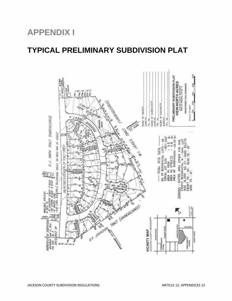
JACKSON COUNTY SUBDIVISION REGULATIONS ARTICLE 12. APPENDICES 13
APPENDIX I TYPICAL PRELIMINARY SUBDIVISION PLAT

JACKSON COUNTY SUBDIVISION REGULATIONS ARTICLE 12. APPENDICES 14
APPENDIX J TYPICAL FINAL SUBDIVISION PLAT
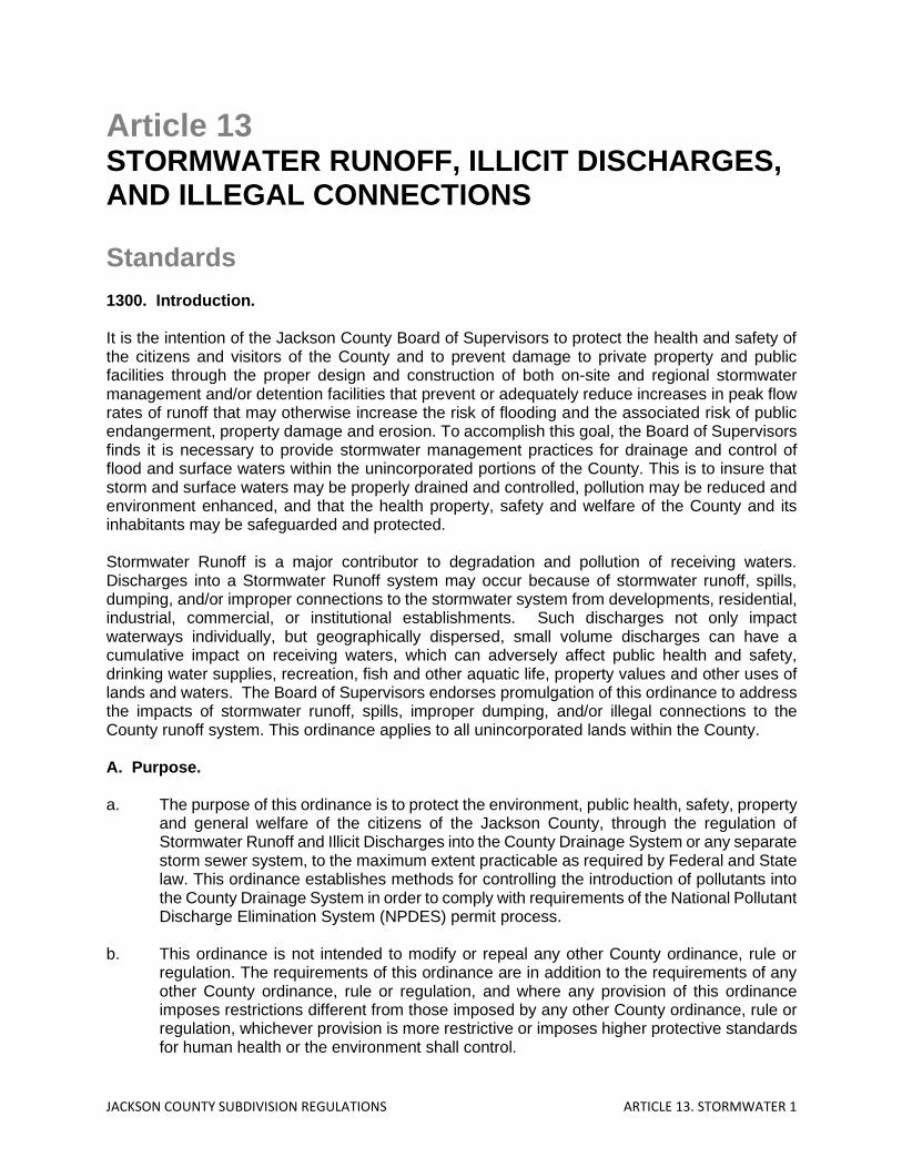
JACKSON COUNTY SUBDIVISION REGULATIONS ARTICLE 13. STORMWATER 1
Article 13 STORMWATER RUNOFF, ILLICIT DISCHARGES, AND ILLEGAL CONNECTIONS Standards 1300. Introduction. It is the intention of the Jackson County Board of Supervisors to protect the health and safety of the citizens and visitors of the County and to prevent damage to private property and public facilities through the proper design and construction of both on-site and regional stormwater management and/or detention facilities that prevent or adequately reduce increases in peak flow rates of runoff that may otherwise increase the risk of flooding and the associated risk of public endangerment, property damage and erosion. To accomplish this goal, the Board of Supervisors finds it is necessary to provide stormwater management practices for drainage and control of flood and surface waters within the unincorporated portions of the County. This is to insure that storm and surface waters may be properly drained and controlled, pollution may be reduced and environment enhanced, and that the health property, safety and welfare of the County and its inhabitants may be safeguarded and protected. Stormwater Runoff is a major contributor to degradation and pollution of receiving waters. Discharges into a Stormwater Runoff system may occur because of stormwater runoff, spills, dumping, and/or improper connections to the stormwater system from developments, residential, industrial, commercial, or institutional establishments. Such discharges not only impact waterways individually, but geographically dispersed, small volume discharges can have a cumulative impact on receiving waters, which can adversely affect public health and safety, drinking water supplies, recreation, fish and other aquatic life, property values and other uses of lands and waters. The Board of Supervisors endorses promulgation of this ordinance to address the impacts of stormwater runoff, spills, improper dumping, and/or illegal connections to the County runoff system. This ordinance applies to all unincorporated lands within the County. A. Purpose. a. The purpose of this ordinance is to protect the environment, public health, safety, property
and general welfare of the citizens of the Jackson County, through the regulation of Stormwater Runoff and Illicit Discharges into the County Drainage System or any separate storm sewer system, to the maximum extent practicable as required by Federal and State law. This ordinance establishes methods for controlling the introduction of pollutants into the County Drainage System in order to comply with requirements of the National Pollutant Discharge Elimination System (NPDES) permit process.
b. This ordinance is not intended to modify or repeal any other County ordinance, rule or
regulation. The requirements of this ordinance are in addition to the requirements of any other County ordinance, rule or regulation, and where any provision of this ordinance imposes restrictions different from those imposed by any other County ordinance, rule or regulation, whichever provision is more restrictive or imposes higher protective standards for human health or the environment shall control.

JACKSON COUNTY SUBDIVISION REGULATIONS ARTICLE 13. STORMWATER 2
B. Objectives. a. The objectives of this ordinance are:
(1) to regulate or restrict the introduction of pollutants that may potentially enter the County Drainage System;
(2) to prohibit Illegal Connections and Illicit Discharges to any separate storm sewer
system; (3) to identify, define, and regulate erosion, sediment and detention controls related
to Stormwater Runoff; (4) to prevent discharges that may occur as a result of spills, inappropriate dumping
or disposal, and/or improper connections to the County Drainage System, whether from residential, industrial, commercial or institutional establishments;
(5) to provide the County with the means to effectively manage Stormwater Runoff,
non-conformance, and Illicit Discharges, and to establish enforcement actions for those persons or entities found to be in noncompliance, or that refuse to allow access to their facilities; and
(6) to establish means to carry out all inspection, surveillance, monitoring and
enforcement procedures necessary to ensure compliance with this ordinance. C. Citation. This ordinance may be cited as the Jackson County, Mississippi Stormwater Ordinance. 1301. Definitions. Accidental Discharge: A discharge prohibited by this ordinance, which occurs by chance, and without planning or thought prior to occurrence. Authorized Enforcement Agency: Jackson County, Mississippi. Best Management Practices (BMPs): Schedules of activities, prohibitions of practices, general good housekeeping practices, pollution prevention and educational practices, maintenance procedures and other management practices designed to prevent or reduce the discharge of pollutants directly or indirectly to stormwater, receiving waters, or stormwater conveyance systems. BMPs also include treatment practices, operating procedures and practices to control site runoff, spillage or leaks, sludge or water disposal, or drainage from raw materials storage. Best Management Practices (BMPs) – Non-Structural: A policy, practice or preventative action that involves operational planning and source controls designed to provide a similar approach to stormwater management. Best Management Practices (BMPs) – Structural: A physical device designed and constructed or manufactured to trap or filter pollutants from runoff, to reduce runoff velocities, or to minimize or prevent the effects of soil erosion caused by Stormwater Runoff.
JACKSON COUNTY SUBDIVISION REGULATIONS ARTICLE 13. STORMWATER 3
Board of Supervisors: The Board of Supervisors of Jackson County, Mississippi. Clean Water Act: The Federal Water Pollution Control Act (33 U.S.C., 1251 et seq.), and any subsequent amendments thereto. Construction Activity: Activities subject to NPDES construction permits. These include construction projects resulting in land disturbances. Such activities include, but are not limited to, clearing and grubbing, grading, excavating and demolition. County Drainage System (CDS): Any County maintained or designated roadway, ditch, culvert, channel, or conduit intended to direct water flows. Facility: A structure, installation, or system that is designed to serve a particular purpose, service, or function. Hazardous Materials: Any material, including any substance, waste, or combination thereof, which because of its quantity, concentration, or physical, chemical, or infectious characteristics may cause, or significantly contribute to, a substantial present or potential hazard to human health, safety, property, or the environment when improperly treated, stored, transported, disposed of, or otherwise managed. Illegal Connections: Any pipe, open channel, drain or conveyance, whether on the surface or subsurface, which allows an illegal discharge to enter the drainage system including but not limited to any conveyances which allow any non-stormwater discharge including sewage, process wastewater, wash water, or any other such discharge, to enter the City Drainage System and any connections to the County Drainage System from any source, regardless of whether such pipe, open channel, drain, connection, or source had been previously allowed, permitted, or approved by the County. Illicit Discharge: Any direct or indirect discharge into the County Drainage System that is not composed entirely of stormwater. Industrial Activity: Activities subject to NPDES Industrial Permits as defined in 40 CFR, Section 122.26(b)(14). Larger Common Plan of Development or Sale: A contiguous area where multiple separate and distinct construction activities are occurring under one plan. The plan in a common plan of development or sale is broadly defined as any announcement or piece of documentation (including a sign, public notice or hearing, sales pitch, advertisement, drawing, permit application, zoning request, computer design, tec.) or physical demarcation (including boundary signs, lot stakes, surveyor markings, etc.),indicating that construction activities may occur on a specific plot. National Pollutant Discharge Elimination System (NPDES) Stormwater Discharge Permit: A permit issued by EPA (or by the State under authority delegated pursuant to (33 USC 1342(b)) that authorizes the discharge of Pollutants to waters of the United States, whether the permit is applicable on an individual, group, or general area-wide basis. Non-Stormwater Discharge: Any discharge to the County Drainage System that is not composed entirely of stormwater.

JACKSON COUNTY SUBDIVISION REGULATIONS ARTICLE 13. STORMWATER 4
Person: Any individual, association, organization, partnership, firm, trust, estate, commission, board, public or private institution, utility, cooperative, city, county or other political subdivision of the State, any interstate body or other legal entity, joint venture, public or private corporation, or other entity recognized by law and acting as either the owner or as the owner’s agent. Pollutant: Any substance which causes or contributes to pollution. Pollutants may include, but are not limited to paints, varnishes, solvents, petroleum hydrocarbons, automotive fluids, cooking grease, detergents (biodegradable or otherwise), degreasers, cleaning chemicals, non-hazardous liquid and solid wastes, yard wastes, refuse, rubbish, garbage, litter, discarded or abandoned objects, munitions, accumulations that may cause or contribute to pollution, any floatables, pesticides, herbicides, fertilizers, hazardous substances and wastes, sewage, fecal coliform and pathogens, dissolved and particulate metals, animal wastes, wastes and residues that result from constructing a building or structure including concrete/cement (this includes water from washing out cement trucks) and noxious or offensive matter of any kind or any other substance which has been or may be determined to be a pollutant. Pollution: The contamination or other alteration of any water’s physical, chemical or biological properties by the addition of any substance or condition including but not limited to, a change in temperature, taste, color, turbidity, or odor of such waters, or waters as will or is likely to create a nuisance or render such waters harmful, detrimental or injurious to the public health, safety, welfare, or environment, or to domestic, commercial, industrial, agricultural, recreational, or other legitimate beneficial uses, or to livestock, wild animals, birds, fish or other aquatic life. Premises: Any parcel of land whether improved or unimproved. State Waters: Any and all rivers, streams, creeks, branches, lakes, reservoirs, ponds, drainage systems, springs, wells, and other bodies of surface and subsurface water, natural or artificial, lying within or forming a part of the boundaries of the State, which are not entirely confined and retained completely upon the property of a single person. Storm Drainage System: Any one (1) or more of various devices used in the collection, treatment or disposition of storm, flood or surface drainage waters, including but not limited to any roads with drainage systems, natural and human-made or altered drainage channels, reservoirs, manmade structures and natural watercourses and/or floodplains for the conveyance of runoff, such as detention or retention areas, berms, swales, improved gutters, pumping stations, pipes, ditches, siphons, catch basins, inlets, and other equipment and appurtenances and all extensions, improvements, remodeling, additions and alterations thereof; and any and all rights or interests in such stormwater facilities. Stormwater/Stormwater Runoff: Any surface flow, runoff and/or drainage consisting entirely of water from any form of natural precipitation, which is not absorbed, transpired, evaporated or left in surface depressions, and which then flows controlled or uncontrolled into a watercourse or body of water. Stormwater Pollution Prevention Plan (SWPPP): A document which describes the Best Management Practices (BMPs) and activities to be implemented by a person or business to identify sources of pollution or contamination at a site and the actions to eliminate or reduce pollutant discharges to stormwater, stormwater conveyance systems and/or receiving waters to the maximum extent practicable.
JACKSON COUNTY SUBDIVISION REGULATIONS ARTICLE 13. STORMWATER 5
Structural Stormwater Control: A structural stormwater management facility or device that controls stormwater runoff and changes the characteristics of that runoff, including but not limited to, the quantity and quality, the period of release or the velocity of flow. Wastewater: Any water or other liquid, other than uncontaminated stormwater, discharged from a facility. Watercourse: Any stream, river, or drainage channel or drainage easement, that is located in the unincorporated portions of Jackson County. 1302. Applicability. This ordinance shall apply to any and all water entering the County Drainage System. This ordinance shall apply to any and all water entering a storm drainage generated on any developed or undeveloped lands throughout all of the unincorporated portions of the County unless explicitly exempted by the County and the provisions of the State of Mississippi’s Phase II Stormwater MS4 General Permit. The standards set forth herein and promulgated pursuant to this ordinance are minimum standards; therefore, this ordinance does not intend nor imply that compliance by any person will ensure that there will be no contamination, pollution, or unauthorized discharge of Pollutants. 1303. Responsibility for Administration. The County Administrator, or designee, shall enforce the provisions of this ordinance. 1304. Severability. The provisions of this ordinance are hereby declared to be severable. If any provision, clause, sentence, or paragraph of this ordinance, or the application thereof to any person, establishment, or circumstances, shall be held invalid, such invalidity shall not affect the other provisions or application of this ordinance. 1305. Policy. No owner of any parcel of land or property, whether with or without a structure thereupon, shall permit the erosion or escape of soil, sand, gravel, or similar material from said parcel onto any adjoining property, public street or into any drainage channel that receives Stormwater Runoff from said parcel in such quantities as to harm said adjoining property, public street, drainage channel or County Drainage System. In the development or use of any site, the owners or occupant shall not construct or conduct any activity so as to cause the discharge of Stormwater in such a manner as to cause erosion or to increase blockage of a channel or the County Drainage System. This includes both pre-construction and post-construction. A. Purpose. Stormwater permits and Stormwater Pollution Prevention Plans (SWPPP) are required as follows:
• 0-.9 Acre of land disturbed: No permit or SWPPP required unless the subject property is part of a larger common plan of development or sale.
• 1-5 Acres of land disturbed: Permit required from the County. A Notice of Intent (NOI) and SWPPP must be submitted to the County Permits Office. (See Appendix A and B for examples)
• Above 5 Acres: Permit required from MDEQ. SWPPP must also be submitted to MDEQ.
JACKSON COUNTY SUBDIVISION REGULATIONS ARTICLE 13. STORMWATER 6
• All land disturbance activities for commercial construction shall obtain a permit from Jackson County. Permit applications for commercial land disturbance activities less than five acres shall be submitted to the County complete with an NOI and SWPPP.
• For projects greater than 5 acres, the permitted entity is required to submit to the County copies of the approved MDEQ permits.
• Permitted shall provide proof of issuance of other applicable permits from the U.S. Army Corps of Engineers if waters of the United States are to be filled, rerouted, or dammed.
1306. Construction and/or Industrial Activity. Any person subject to an industrial or construction activity National Pollution Discharge Elimination System (NPDES) Stormwater Discharge Permit shall comply with all provisions of such permit. Proof of compliance with said permit may be required in a form acceptable to the County prior to the allowing of discharges to the County Drainage System. Dumping excess cement and washing out cement trucks are included in this article. All construction activities regulated through this ordinance including both residential and commercial construction shall include sediment and erosion control measures designed for a 25-year design storm frequency. Structural components (post-construction) of a storm drainage system may be designed on the basis of a lesser storm event providing the calculations demonstrate that the 25-yearevent can be accommodated through a combination of design features, such as infiltration and storage. Post-Construction storm drainage design shall be completed in accordance with the requirements of the Mississippi Department of Transportation: “Roadway Design Manual”, particularly Chapter 7. A. Standards and Requirements for Erosion/Sediment Control
(a) Prior to the final approval of the plat of any subdivision, or prior to commencement
of construction upon any lot or parcel of land for which a drainage report and construction plan for the installation of stormwater facilities has not been prepared and approved, the owner of the property being subdivided or upon which construction is being commenced shall, at such owners cost, prepare a detailed drainage report and construction plans for the installation of all Stormwater facilities required for such subdivision or lot, including any off-site facilities required to convey Stormwater to existing drains, channels, streams, detention ponds or to other points, all in conformity with the SWPPP on file.
(b) No final subdivision plat, subdivision construction plan, site plan or building permit
shall be approved by the County unless the plans for the proposed development include temporary and permanent erosion and sedimentation control measures such that siltation of downstream drainage ways are minimized.
(c) The above requirement shall be accomplished through a combination of the
following practices:
a. installation of structural BMPs before and during construction in order to reduce on-site soil erosion and provide temporary capture of sediment;
b. temporary and/or permanent revegetation of bare ground in order to stabilize disturbed soil at the earliest practicable date;

JACKSON COUNTY SUBDIVISION REGULATIONS ARTICLE 13. STORMWATER 7
c. construction of on-site Stormwater detention facilities by the landowner or developer in a manner such that detention ponds function as temporary sedimentation basins until permanent revegetation of the subject tract is accomplished;
d. Control of construction debris, litter and sanitary wastes through
appropriate and acceptable means; and e. Other measures which may be necessary to control erosion and
sedimentation on a site-by-site basis.
B. Standards and Requirements for Stormwater Detention. (a) It is prohibited to place fill material or construct impervious cover or construct or
place any other structure on a person’s property or perform any excavation or grading in a manner that alters the flow of surface water across said property in a manner that damages any adjacent property.
1. No final subdivision plat, subdivision construction plan, site plan or building
permit shall be approved by the County unless it can be demonstrated by the owner or developer of such property that the proposed development will not result in damage to any adjacent or downstream property. This will be certified by a professional engineer’s submittal of sufficient data and calculations.
(b) The above requirement shall be accomplished through one of the following means:
1. Design and construction of an on-site Stormwater detention facility, or
facilities, by the owner or developer that limits the peak stormwater runoff from the proposed development to the existing peak stormwater runoff from the subject tract.
2. Construction of, or participation in the construction of, off-site drainage
improvements, such as storm inlets, storm sewers, culverts, channel modifications, land filling, and/or other drainage facilities such that the peak stormwater runoff for fully-developed watershed conditions from the watershed area in which the proposed development is located will be sufficiently and safely passed without flooding of adjacent and downstream property and roadways.
3. Design and construction of the development utilizing engineering data and
calculations using limited impervious cover, infiltration of runoff from impervious cover via flow through pervious areas, and/or grass-lined swales or channels such that these measures result in a minimal increase in peak stormwater runoff from the development. A thorough review of the downstream drainage facilities shall be performed to verify that any increase in the peak stormwater runoff does not adversely affect existing structures or properties.
4. All on-site Stormwater detention facilities shall be designed to adequately
and safely pass all stormwater inflow, including on-site runoff and runoff
JACKSON COUNTY SUBDIVISION REGULATIONS ARTICLE 13. STORMWATER 8
from upstream and adjacent properties that have natural and/or existing overland flow toward and onto the subject tract. The on-site Stormwater detention facilities should not impound Stormwater onto or cause backwater to inundate any upstream or adjacent properties in excess of existing conditions.
C. Illicit Discharges
(a) It shall be unlawful for any person to allow discharges to the County Drainage System that are not composed entirely of Stormwater Runoff, or to contribute to increased nonpoint source pollution and degradation of receiving waters.
(b) It shall be unlawful for any person to throw, deposit, empty, drain, discharge, or to
permit to be thrown, deposited, emptied, drained or discharged into any creek, or upon its margins, slopes, banks, or stormwater drainage system within the County any garbage, rubbish, refuse, hair, ashes, cinders, fruit, vegetables, paper, rags, any animal carcass or waste, sewerage, excrement, urine, liquid, or semi-liquid waste from any industry, or any noxious substance or liquid.
(c) No Person shall, or allow others under its control to, throw, drain, or otherwise
discharge or cause to be discharged into the County Drainage System or watercourses any Pollutants or waters containing any Pollutants that cause or contribute to a violation of applicable water quality standards, other than Stormwater. The commencement, conduct or continuance of any Illicit Discharge to the County Drainage System is prohibited except as follows:
1. discharges specified in writing by the County as being necessary to protect
public health and safety; 2. water line flushing performed by the County or the regional utility authority; 3. landscape irrigation or lawn watering, diverted stream flows, rising ground
water, groundwater infiltration to storm drains, uncontaminated pumped ground water, foundation or footing drains (not including active groundwater dewatering systems), crawl space pumps, air conditioning condensation, springs, non-commercial washing of vehicles, natural riparian habitat or wet-land flows, swimming pools (less than one PPM chlorine),firefighting activities, and any other water source not containing Pollutants; and
4. dye testing is an allowable discharge, but requires a verbal notification to
the County prior to the time of the test.
This prohibition shall not apply to any non-stormwater discharge permitted under an NPDES permit, waiver, or waste discharge order issued to the discharger and administered under the authority of the Federal Environmental Protection Agency, provided that the discharger is in full compliance with all requirements of the permit, waiver, or order and other applicable laws and regulations, and provided that written approval has been granted for any discharge to the County Drainage System.

JACKSON COUNTY SUBDIVISION REGULATIONS ARTICLE 13. STORMWATER 9
D. Illegal Connections The construction, connection, use, maintenance or continued existence of any illegal connection to the County Drainage System is prohibited. This prohibition expressly includes, without limitation, illicit connections made in the past, regardless of whether the connection was permissible under law or practices applicable or prevailing at the time of connection. The construction, use, maintenance or continued existence of illicit connections to the storm drainage system is prohibited.
(a) A person is considered to be in violation of this ordinance if the person connects a line
conveying sewage to the County Drainage System, or allows such a connection to continue.
(b) Improper connections in violation of this ordinance must be disconnected and redirected,
if necessary, to an approved onsite wastewater management system or the sanitary sewer system upon approval of the County.
(c) Any drain or conveyance that has not been documented in plans, maps or equivalent, and
which may be connected to the County Drainage System, shall be located by the owner or occupant of that property upon receipt of written notice of violation from the County requiring that such locating be completed. Such notice will specify a reasonable time period within which the location of the drain or conveyance is to be completed, that the drain or conveyance be identified as storm sewer, sanitary sewer or other, and that the outfall location or point of connection to County Drainage System, sanitary sewer system or other discharge point is identified. Results of these investigations are to be documented and provided to the County.
1307. Monitoring of Discharges/Access and Inspecting Properties and Facilities A. Applicability This section applies to all properties that create stormwater discharges associated with the use of the property.
1. Access to Properties and Facilities
(a) The County Administrator or designee shall be permitted to enter and inspect
properties and facilities subject to regulation under this ordinance at reasonable times and as often as may be necessary to determine compliance with this ordinance. If a discharger has security measures in force, which require proper identification and clearance before entry into its premises, the discharger shall make the necessary arrangements to allow access to representatives of the County.
(b) Property owners and facility operators shall allow the County Administrator or
designee access to all parts of the premises for the purposes of inspection, sampling, photographing, videotaping, examination and copying of records that must be kept under the conditions of an NPDES permit to discharge stormwater, and the performance of any additional duties as defined by State and Federal law.

JACKSON COUNTY SUBDIVISION REGULATIONS ARTICLE 13. STORMWATER 10
(c) The County Administrator or designee shall have the right to set up on any permitted property such devices as are necessary in the opinion of the County Administrator or designee to conduct monitoring and/or sampling of the facility’s Stormwater discharge.
(d) The County Administrator or designee has the right to require a discharger to install
monitoring equipment as necessary, and perform monitoring and make the monitoring data available to the County Administrator or designee. The sampling and monitoring equipment shall be maintained at all times in a safe and proper operating condition by the discharger at its own expense. All devices used to measure Stormwater flow and quality shall be calibrated to ensure their accuracy.
(e) Any temporary or permanent obstruction that does not allow safe and easy access
to the property to be inspected and/or sampled shall be promptly removed by the owner at the written or oral request of the County Administrator or designee and shall not be replaced. The costs of clearing such access shall be borne by the owner.
(f) Unreasonable delays in allowing the County Administrator or designee access to
a permitted property is a violation of a Stormwater discharge permit and of this ordinance. A person who is the owner of property with a NPDES permit to discharge Stormwater associated with industrial activity commits an offense if the person denies the County Administrator or designee reasonable access to the permitted property for the purpose of conducting any activity authorized or required by this ordinance.
2. If the County Administrator or designee has been refused access to any part of the
premises from which Stormwater is discharged, and is able to demonstrate probable cause to believe that there may be a violation of this ordinance, or that there is a need to inspect and/or sample as part of a routine inspection and sampling program designed to verify compliance with this ordinance or any order issued hereunder, or to protect the overall public health, safety, environment, and welfare of the community, then the County Administrator may seek issuance of an administrative warrant from the County Court.
1308. Requirement to Prevent, Control, and Reduce Storm Water Pollution by the Use of
Best Management Practices (BMPs). The Board of Supervisors will adopt requirements identifying Best Management Practices for any activity, operation, or facility which may cause or contribute to pollution or contamination of Stormwater, the County Drainage System, or waters of the U.S. The owners or operators of commercial or industrial establishments shall provide, at their own expense, reasonable protection from accidental discharge of prohibited materials or other wastes into the County Drainage System through the use of these structural and non-structural BMPs. Further, any person responsible for a parcel, which is, or may be, the source of an Illicit Discharge, may be required to implement, at said person’s expense, additional structural and non-structural BMP’s to prevent the further discharge of Pollutants to the County Drainage System. Compliance with all terms and conditions of a valid NPDES permit authorizing the discharge of Stormwater associated with industrial activity, to the extent practicable, shall be deemed compliance with the provisions of this section. These BMP’s shall be part of a Stormwater Pollution Prevention Plan (SWPPP) as necessary for compliance with requirements of the NPDES permit.

JACKSON COUNTY SUBDIVISION REGULATIONS ARTICLE 13. STORMWATER 11
1309. Watercourse or Easement Protection Any person owning property through which a Watercourse passes, or such person’s lessee, shall keep and maintain that part of the Watercourse within the property free of trash, debris, excessive vegetation, and other obstacles that would pollute, contaminate, or significantly retard the flow of water through the Watercourse. In addition, the owner or lessee shall maintain existing privately owned structures within or adjacent to a Watercourse, so that such structures will not become a hazard to the use, function, or physical integrity of the Watercourse. 1310. Notification of Spills. In the event of a release of Hazardous Materials, emergency response agencies and/or other appropriate agencies shall be immediately notified. Notwithstanding other requirements of law, as soon as any person responsible for a facility, activity, or operation, or responsible for emergency response for a facility, activity, or operation has information of any known or suspected release of Pollutants or non-Stormwater materials from that facility or operations which are resulting or may result in Illicit Discharges or Pollutants discharging into Stormwater, the County Drainage System, State waters, or waters of the U.S., said person shall take all necessary steps to ensure the discovery, containment, and cleanup of such release so as to minimize the effects of a discharge. In the event of recognition of such a release of Hazardous Materials said person shall immediately notify the County Administrator or designee and emergency response agencies of the occurrence, either in person, by phone, or facsimile no later than 24 hours after discovery of the occurrence. In the event of a release of non-hazardous materials, said person shall notify the County Administrator or designee in person or by phone or facsimile no later than 5:00 P.M. the next business day. Notifications in person or by phone shall be confirmed by written notice addressed and mailed to the County Administrator or designee within three business days of the telephonic notice. If the discharge of prohibited materials emanates from a commercial or industrial establishment, the owner or operator of such establishment shall also retain an on-site written record of the discharge and the actions taken to prevent its recurrence. Such records shall be retained for at least three years. Said person shall also take immediate steps to ensure no recurrence of the discharge or spill. Failure to provide notification of a release as provided above is a violation of this ordinance. 1311. Violations.
1. General A. The notice shall contain: (1) the name and address of the alleged violator;
(2) the address when available or a description of the building, structure or land upon which the violation is occurring, or has occurred;
(3) a statement specifying the nature of the violation;

JACKSON COUNTY SUBDIVISION REGULATIONS ARTICLE 13. STORMWATER 12
(4) a description of the remedial measures necessary to restore compliance with this ordinance and time schedule for the completion of such remedial action;
(5) a statement of the penalty or penalties that shall or may be assessed
against the person to whom the notice of violation is directed; and (6) a statement that the determination of violation may be appealed to the
Board of Supervisors by filing a written notice of appeal with the County Administrator, within fifteen (15) days of service of notice of violation.
B. Such notice may require:
(1) the performance of monitoring, analyses, and reporting; (2) the elimination of illicit connections or discharges; (3) that violating discharges, practices, or operations shall cease and desist.
Depending on severity of the violations, offending person(s) may be given as little as 24 hours to clean up sediments, pollutants, etc., and an additional 24 hours to put stormwater controls in place, otherwise, a stop-work order may be issued;
(4) the abatement or remediation of Stormwater pollution or contamination
hazards and the restoration of any affected property; (5) payment of a fine and any costs to cover administrative, remediation,
and/or abatement expenses; and (6) the implementation of source control, pollution prevention practices, or
treatment BMPs.
If abatement of a violation and/or restoration of affected property is required, the notice shall set forth a deadline within which such remediation or restoration must be completed. Said notice shall further advise that, should the violator fail to remediate or restore within the established deadline, the work will be done by the County or a contractor and the expense thereof shall be charged to the violator.
2. Violations Enforcement.
In the event a violation constitutes an immediate danger to public health or public safety, the County Administrator or designee is authorized to enter upon the subject private property, without giving prior notice, to take any and all measures necessary to abate the violation and/or restore the property. After abatement of the violation, the owner of the property shall be notified of the cost of abatement, including administrative costs. The property owner may file an appeal within 15 days of the receipt of such notice. If the amount due is not paid within a timely manner as determined by the decision of the appropriate authority or by the expiration of the time in which to file an appeal, the charges shall become a special assessment against the property and shall constitute a lien on the property for the amount of the assessment.
JACKSON COUNTY SUBDIVISION REGULATIONS ARTICLE 13. STORMWATER 13
1312. Penalties and Prosecutions. 1. General A. Civil
In the event the alleged violator fails to take the remedial measures set forth in the notice of violation or otherwise fails to cure the violations described therein within ten days, or such greater period as the County Administrator shall deem appropriate, after the County has taken one or more of the actions described above, the County may seek any legal or equitable remedy available under the law. The County may recover all attorneys’ fees, court costs, and other expenses associated with enforcement of this ordinance, including sampling and monitoring expenses.
B. Criminal
Violations of this ordinance shall be deemed a misdemeanor. The County may issue a citation to the alleged violator requiring such person to appear before the County Court to answer charges for such violation. Upon conviction, such person shall be punished by a fine not to exceed $1,000.00 or imprisonment in the County jail for 90 days, or both.
C. Injunction
If a person has violated or continues to violate the provisions of this ordinance, the County may petition for an injunction restraining the person from activities which would create further violations or compelling the person to perform abatement or remediation of the violation.
D. Alternative Action
In addition to any other remedy, the County may impose upon a violator alternative compensatory action, such as storm drain stenciling, attendance at compliance workshops, creek cleanup, or similar action.
2. Remedies Not Exclusive
The remedies listed in this ordinance are not exclusive of any other remedies available under any applicable federal, state or local law and it is within the discretion of the County to seek cumulative remedies.
3. Violations Deemed a Public Nuisance
In addition to the enforcement processes and penalties provided herein, any condition caused or permitted to exist in violation of any of the provisions of this ordinance is a threat to public health, safety, and welfare, and environment, is declared and deemed a nuisance, and may be abated by injunctive or other equitable relief provided by law.
4. Suspension of Access to Storm Drainage System(s)
JACKSON COUNTY SUBDIVISION REGULATIONS ARTICLE 13. STORMWATER 14
A. Suspension Due to Illicit Discharges in Emergency Situations
The County may, without prior notice, suspend discharge access to a person when such suspension is necessary to stop an actual or threatened discharge, which presents or may present imminent and substantial danger to the environment, or to the health or welfare of persons, or waters of the United States. If the violator fails to comply with a suspension order issued in an emergency, the County may take such steps as deemed necessary to prevent or minimize damage to the County Drainage System or waters of the United States, or to minimize danger to persons.
B. Suspension Due to Detection of Illicit Discharge
1. A person discharging to the County Drainage System in violation of this
ordinance may have access thereto terminated if such termination would abate or reduce an Illicit Discharge. The County Administrator will notify a violator of the proposed termination of its County Drainage System access. The violator may petition the County Administrator for are consideration and hearing.
2. A person commits an offense if the person reinstates access to premises
terminated pursuant to this Section, without the prior approval of the County.
1313. Appeals. Any person receiving a notice of violation may appeal the determination within 15 days of issuance of notice to the County Administrator. The notice of appeal must be filed with the County Administrator. A hearing on the appeal shall be set by the Board of Supervisors with at least ten (10) days’ notice to the violator. If the violation has not been corrected pursuant to the requirements set forth in the notice of violation, or, in the event of an unsuccessful appeal, then representatives of the County may enter upon the subject private property and are authorized to take any and all measures necessary to abate the violation and/or restore the property. If entry refused the County Administrator may need administrative warrant in County Court authorizing such access.
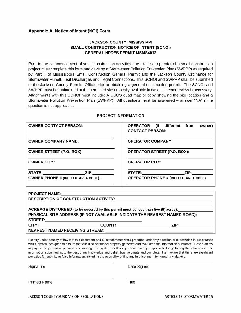
JACKSON COUNTY SUBDIVISION REGULATIONS ARTICLE 13. STORMWATER 15
Appendix A. Notice of Intent (NOI) Form
JACKSON COUNTY, MISSISSIPPI
SMALL CONSTRUCTION NOTICE OF INTENT (SCNOI)
GENERAL NPDES PERMIT MSMS4012
Prior to the commencement of small construction activities, the owner or operator of a small construction
project must complete this form and develop a Stormwater Pollution Prevention Plan (SWPPP) as required
by Part II of Mississippi’s Small Construction General Permit and the Jackson County Ordinance for
Stormwater Runoff, Illicit Discharges and Illegal Connections. This SCNOI and SWPPP shall be submitted
to the Jackson County Permits Office prior to obtaining a general construction permit. The SCNOI and
SWPPP must be maintained at the permitted site or locally available in case inspector review is necessary.
Attachments with this SCNOI must include: A USGS quad map or copy showing the site location and a
Stormwater Pollution Prevention Plan (SWPPP). All questions must be answered – answer “NA” if the
question is not applicable.
PROJECT INFORMATION
OWNER CONTACT PERSON: OPERATOR (if different from owner)
CONTACT PERSON:
OWNER COMPANY NAME: OPERATOR COMPANY:
OWNER STREET (P.O. BOX): OPERATOR STREET (P.O. BOX):
OWNER CITY: OPERATOR CITY:
STATE: ZIP: STATE: ZIP:
OWNER PHONE # (INCLUDE AREA CODE): OPERATOR PHONE # (INCLUDE AREA CODE)
PROJECT NAME:
DESCRIPTION OF CONSTRUCTION ACTIVITY:
ACREAGE DISTURBED (to be covered by this permit must be less than five (5) acres):
PHYSICAL SITE ADDRESS (IF NOT AVAILABLE INDICATE THE NEAREST NAMED ROAD):
STREET:
CITY: COUNTY ZIP:
NEAREST NAMED RECEIVING STREAM:
I certify under penalty of law that this document and all attachments were prepared under my direction or supervision in accordance
with a system designed to assure that qualified personnel properly gathered and evaluated the information submitted. Based on my
inquiry of the person or persons who manage the system, or those persons directly responsible for gathering the information, the
information submitted is, to the best of my knowledge and belief, true, accurate and complete. I am aware that there are significant
penalties for submitting false information, including the possibility of fine and imprisonment for knowing violations.
Signature Date Signed
Printed Name Title

JACKSON COUNTY SUBDIVISION REGULATIONS ARTICLE 13. STORMWATER 16
Appendix B. SWPP Detail and Requirements A. SWPPP Development. A SWPPP shall be developed and implemented by the owner or
operator of a small construction project. The SWPPP must include a description of appropriate control measures (i.e., BMPs) that will be implemented as part of the construction activity to control pollutants in storm water discharges.
1. The SWPPP shall be retained at the permitted site or locally available. A copy of
the SWPPP must be made available to the MDEQ inspectors for review at the time of an on-site inspection.
2. BMPs shall be in place upon commencement of construction. 3. The Executive Director of MDEQ may notify the owner or operator at any time that
the SWPPP does not meet the minimum requirements of this permit. After notification, the owner or operator shall amend the SWPPP, implement the changes and certify in writing to the Executive Director that the requested changes have been made. Unless otherwise provided by the Executive Director, the requested changes shall be made within 15 days.
4. The owner or operator shall amend the SWPPP and implement the changes before
there is a change in construction, operation, or maintenance, which may potentially effect the discharge of pollutants to State waters.
5. The owner or operator shall amend the SWPPP and implement the changes if the
SWPPP proves to be ineffective in controlling storm water pollutants including, but not limited to, significant sediment leaving the site and non-functioning BMPs.
B. Compliance with Local Storm Water Ordinances.
1. In addition to the requirements of this permit, the SWPPP shall be in compliance with all local storm water ordinances and shall provide a brief description of applicable local erosion and sediment controls and post-construction BMPs.
2. When storm water discharges into a municipal storm sewer system, the owner or
operator must make the SWPPP available to the municipal authority upon request. C. SWPPP Details.
1. Owner or Operator. The SWPPP shall identify the “owner or operator” as defined in Part VII. of this permit. The operator’s name, complete mailing address and telephone number(s) shall be identified on the plan.
2. Erosion and Sediment Controls. The owner or operator shall list and describe
controls appropriate for the construction activities and the procedures for implementing such controls. Controls shall be designed to retain sediment onsite and should:
• Divert upslope water around disturbed areas
• Limit exposure of disturbed areas to the shortest time possible
• Disturb the smallest area possible

JACKSON COUNTY SUBDIVISION REGULATIONS ARTICLE 13. STORMWATER 17
• Preserve existing vegetation where possible, especially trees
• Preserve vegetated buffer zones around any creek, drain, lake, pond or wetland
• Slow rainfall runoff velocities to prevent erosive flows
• Avoid disturbing sensitive areas such as: - Steep and/or unstable slopes - Land upslope of surface waters - Areas with erodible soils - Existing drainage channels
• Transport runoff down steep slopes through lined channels or piping
• Minimize the amount of cut and fill
• Re-vegetate disturbed areas as soon as possible
• Implement best management practices to mitigate adverse impacts from storm water runoff; and
• Remove sediment from storm water before it leaves the site by allowing runoff to pond in controlled areas to drop out sediment
• Filter runoff by using natural vegetation, brush barriers, silt fences, hay bales, etc.
At a minimum, the controls must be in accordance with the standards set forth in “Planning and Design Manual for the Control of Erosion, Sediment and Stormwater,” or other recognized Manual of design as appropriate for Mississippi. The planning and design manual can be obtained by calling 601/961-5171 or may be found electronically at Mississippi State’s educational web site athttp://abe.msstate.edu/csd/p-dm/. In addition, Mississippi’s “Storm Water Pollution Prevention Plan (SWPPP) Guidance Manual for Construction Activities” is available by calling 601/961-5171 or on the MDEQ website at www.deq.state.ms.us. The erosion and sediment controls shall address the following minimum components.
A. Vegetative practices shall be designed to preserve existing vegetation
where possible and revegetate disturbed areas as soon as practicable after grading or construction. Such practices may include surface roughening, temporary seeding, permanent seeding, mulching, sod stabilization, vegetative buffer strips, and protection of trees.
B. Structural practices shall divert flows from exposed soils, store flows or
otherwise limit runoff from exposed areas. Such practices may include construction entrance/exit, straw bale dikes, silt fences, earth dikes, brush barriers, drainage swales, check dams, subsurface drains, pipe slope drains, level spreaders, drain inlet protection, outlet protection, detention/retention basins, sediment traps, temporary sediment basins or equivalent sediment controls.
C. Post construction control measures shall be installed to control pollutants
in stormwater after construction is complete. These controls include, but are not limited to on-site infiltration of runoff, flow attenuation using open vegetated swales, exfiltration trenches and natural depressions, constructed wetlands and retention/detention structures. Where needed,

JACKSON COUNTY SUBDIVISION REGULATIONS ARTICLE 13. STORMWATER 18
velocity dissipation devices shall be placed at detention or retention pond outfalls and along the outfall channel to provide a non-erosive flow.
3. Non-Storm Water Discharges. Except for flows from firefighting activities, sources
of non-storm water listed in Part I. E. of this permit that are combined with storm water discharges associated with construction activity must be identified in the SWPPP. The SWPPP must identify and ensure the implementation of appropriate pollution prevention measures for the non-storm water component(s) of the discharge.
4. Housekeeping Practices. The owner or operator shall describe and list practices
appropriate to prevent pollutants from entering storm water from construction sites due to poor housekeeping. The owner or operator shall:
• designate areas for equipment maintenance and repair and concrete chute wash off;
• provide waste receptacles at convenient locations;
• provide regular collection of waste;
• provide protected storage areas for chemicals, paints, solvents, fertilizers, and other potentially toxic materials;
• provide adequately maintained sanitary facilities; and
• provide secondary containment around on-site fuel tanks.
Releases into the environment of hazardous substances, oil, and pollutants or contaminants, which pose a threat to applicable water quality standards or causes a film, sheen or discoloration of State waters, shall be reported to the:
• Mississippi Emergency Management Agency (601) 352-9100
• National Response Center 1-800-424-8802
5. Prepare Scaled Site Map. The owner or operator shall prepare a scaled site map showing total area of the site, original and proposed contours (if practicable), direction of flow of stormwater runoff, adjacent receiving water bodies, north arrow, all erosion and sediment controls(vegetative and structural), post construction control measures as described in Part III. C. 2. Of this permit, and an estimate of the pre and post construction runoff coefficients of the site (see runoff coefficients in Part VII.) and the increase in impervious area.
6. Implementation Sequence. The owner or operator shall prepare an orderly listing
which coordinates the timing of all major land-disturbing activities together with the necessary erosion and sedimentation control measures planned for the project.