jammu & kashmir - archaeological survey of india
TRANSCRIPT


1
Director GeneralArchaeological Survey of India
New Delhi2019
Jammu & KashmirM on uments and S i tes

©
Archaeological Survey of India
Government of India
2019
Printed By
M/s Dream Real Pvt. Ltd
Unit #1, RNYC Tower, 1st floor,
Adjacent to Unitech Signature Tower,
South City, Phase I,Gurugram, Haryana - 122001

3
Preface
It is a matter of immense pleasure to bring forth a monograph on the monuments and sites of Jammu and Kashmir. This small endeavour is intended to introduce the readers to the rich and varied cultural heritage of the Indian state of Jammu and Kashmir.
The state has long been considered the pinnacle of pristine scenic beauty, to the extent that often its scenic magnificence overshadows its cultural legacy. This state is home to many wonderful monuments and archaeological sites reflecting its rich and varied history in nature, purpose and religious affiliations. The archaeological evidence from various excavations and explorations in the state has indicated a continued human presence, from the paleolithic to the medieval periods.
The Archaeological Survey of India administers monuments and sites of diverse religious affiliations across various periods of time, such as the Martand Temple in district Anantnag, to the monasteries of Lamayuru and Alchi in district Leh and the mosques, gardens, arcades and sarais of districts Srinagar and Baramulla. These monuments also stand testimony to the secular unity of the state in safeguarding these treasures of the past, across the centuries.
This monograph is the first of a new series of publications initiated by the Archaeological Survey of India. All circles and mini circles of ASI will soon bring forth a volume on the protected monuments and archaeological sites falling under their jurisdiction.
Usha Sharma Director General

4

5
Contents
Introduction
Physical Features of Jammu & Kashmir
Historical Background of the Region
Archaeological Monuments and Sites
4.1 Jammu Region
4.2 Srinagar Region
4.3 Ladakh Region
1.
2.
3.
4
06
08
12
16
19
35
95

6
1. Introduction
The state of Jammu and Kashmir in India, covers an area of 222,801 sq. Km. It includes the regions of Jammu, Kashmir, Ladakh, Gilgit, Baltistan and Hunza. The region of Kashmir with its several mountainous passes and routes served as an important trade route facilitating the movement of caravans connecting the Indian mainland with Afghanistan and Central Asia. The important rivers of this state are Indus, Chenab, Jhelum, Tawi, Zanskar and several other tributaries of River Indus.
Distinct geographical location and physiological features of the region, has given rise to several unique aspects in the form of art, culture, architecture, traditions and customs. Within the geographical region as a whole, several regional variations in the traditions and customs can also be noticed.
The Jammu region houses a mixture of people from the Hindu and Muslim communities. The commonly spoken languages in this region are Dogri, a derivative of Sanskrit, besides Punjabi and Persian languages. Among the communities represented in this region, the prominent ones are the Dogras, Brahmins, Gujjars, Paharis, Khatris, and Mahajans. The region is known for early historical sites like Akhnur, Ambaran besides Manda, a Harappan site located on the right bank of Chenab.
The Kashmir valley has been a blending point of different cultures, including the Greeks, Romans, Kushanas and Persians, ascertained by the archaeological discoveries. The earliest evidence of such a cultural interaction can be traced back to the Neolithic times of Kashmir valley. The excavation at Kanishpur (ancient Kanishkapura) suggests the beginning of Neolithic age in the middle of the fourth millennium BCE. The Neolithic site of Burzahom in the valley, with the presence of artefacts of Harappan origin, indicates the cultural contacts with the Harappan civilization during third millennium BCE. Likewise the site of Panderthan located 5 km south-east of Srinagar has been identified as Puranadhisthana, the ancient capital of Kashmir. Various religious faiths thrived in the valley during different time periods. The different communities present in the valley are Kashmiri Pandits, Muslims, Sikhs, and other groups like dooms, galawans, bombas, khakhas,

7
chaupans. The boatmen of Kashmir are known as hanjis. The language spoken in the Kashmir valley is Kashmiri, consisting of rich proverbs, sayings and folklore.
The Baltistan region is located to the northeast of the Kashmir valley and located between Ladakh and Gilgit regions. A mixture of Baltis and Ladakhis is seen here. This region is known as Tsera (apricot) Bhautan by the Kashmiris, due to the vast cultivation of apricot. To the west of Baltistan is the Gilgit region, wherein an oasis is located. Some Buddhist establishments were earlier identified in this region.
Ladakh is the land of ancient Bhauttas and Ladakhis consists of four prominent groups of people over a period of time, viz., Gyalpo or Raja, Jirak or officials, Mungrik or cultivators and Ringan or menials. Buddhism has been the living religion and each village has a prominent gonpa or monastery, which serves as the religious and cultural institution. These monastic complexes are well known for their unique architecture, paintings and iconography.
The picturesque valley of Jammu and Kashmir moulded the lives of various communities due to ongoing dynamic cultural process involving commerce, trade, tourism and agriculture.

8
2. Physical Features of Jammu and Kashmir
The geology of the Jammu and Kashmir is part of the Himalayan formations, broadly similar to the areas to its west and east. Broadly based on physiographical features, as per Wadia, the state may be divided into various sub-regions like the; (i) Outer Ranges or the Sub-Himalaya or Siwalik Ranges, (ii) The Middle Ranges or Lesser or Middle Himalayas – Panjal and Dhauladhar Ranges, (iii) Inner Himalayas, (iv) Valleys, (v) Lakes and (vi) Glaciers. Among them, the Vale of Kashmir presents a unique geological feature.
2.1 Outer Ranges of the Sub-Himalaya or Siwalik Ranges
The outer ranges of the Sub-Himalaya or Siwalik ranges starts from the plain areas from the border of Punjab, and around the Jammu region the ranges gain a gentle slope up to around 620 m, and afterwards with sudden escarpments, the slope is almost perpendicular. These form the Siwalik Ranges, which also extend eastwards and are found in Himachal Pradesh and Uttarakhand states. ‘Dun’ is the name of geological formations, which are wide longitudinal and strike valleys within the hills, examples of which are Dehra Dun, Kothri Dun and Patli Dun. In the Jammu region, the duns of Udhampur and Kotli may be cited as examples. The Rivers Ravi on the east and Jhelum on the west incise these formations and forms the present boundary of Jammu hills.
2.2 The Middle Ranges or Lesser or Middle Himalayas – Panjal and Dhauladhar Ranges
The Middle Ranges are distinct from the Outer Ranges as they reach 3650 – 4580 m in altitude, deeply scarred by ravines and precipitous defiles, and often form ridges in irregular directions, which emanate in multitudes in different directions.
2.2.1 The Pir Panjal Range
The Pir Panjal Range is a good example of Middle Himalayas, which extend from Kaghan Valley to a little beyond River Ravi. The characteristic feature of this range is the nature of a steep escarpment towards Jammu region and a gentle slope towards Kashmir valley. The northern and north eastern slopes of Pir Panjal Range support a good soil cover, hence lush and green vegetation is found here, capped by snow during winter months. The southern and south western slopes towards Jammu region are devoid of this feature due to a steep profile to support a soil cover.

9
2.2.2 The Dhauladhar Range
Towards east of Pir Panjal Range, the continuing similar features are known as Dhauladhar Range, found in Himachal Pradesh, the prominent locations on them being Dalhousie, Dharamshala and Shimla.
2.3 Inner Himalayas
The lofty and higher peaks of the Inner Himalayas Range located to the north of Kashmir Valley rise above the snow line. The Inner Himalayas located in the northern part of Jammu and Kashmir, to the west of Zanskar ranges, vary between 4580 and 6100 m. There is no vegetation beyond this altitude and there are elevated peaks and high mountain ranges. Large and wide depressions separate these mountain ranges. The lofty peaks found in this region are K2 (8615 m) and Nanga Parbat (8114 m). The Karakoram ranges marks the northernmost boundary of the state.
The north and north eastern parts of Kashmir are also characterised by extensive wide, flat and depressed plains, examples of which are Deosai, Lingzhi Tang and Dipsang. These desolate and high altitude regions of Jammu and Kashmir are extremely cold, frost bitten and windswept, receive very less rainfall when compared to the region around the Vale of Kashmir. The prominent habitations in these localities are in the Gilgit and Ladakh regions. Baltistan, which is located in between Gilgit and Ladakh, presents a weather condition intermediate of these regions.
2.4 Valleys
The valleys of the Jammu and Kashmir state are basically the creation of the major rivers like the Sutlej, Indus, Ravi, Chenab, Jhelum and key tributaries of the Indus like Zanskar and Gilgit. The tributaries of Jhelum are Kishanganga and Kunhar, while those of Chenab are Wardwan and Ans. It has been estimated that the transverse river valleys are relatively older than the rise of Himalayas itself. A few of the valleys are very deep in character due to the incessant erosion through the ages. In the River Indus, the deepest gorge is 5182 m in the Gilgit region.
2.5 Lakes
The Vale of Kashmir is also identified as an extensive lake in antiquity and the legends attribute a name known as Satisar. The tradition also attributes its draining to the ascetic Kashyapa and the name Kashmir a derivative of Kashyap-pur (the land reclaimed by Kashyapa) or Kashyap-mar. Evidences of salt lakes in Ladakh region indicate desiccation, for example, Lake Tsomoriri in Rupshu (24.1 km long and 3.22 to 8.1 km width), Pangkong in Ladakh (64.4 km long and 3.22 to 6.44 km width).

10
The lakes like Ghangchenmo, Dipsang and Lingzi Thang found at an elevation of 4876 – 5182 m are indicative of lacustrine origin, due to desiccation and silting of saline lake basins without any outlet.
2.6 Glaciers
While no glaciers are present in the middle and outer ranges, the region around Zanskar presents numerous ones albeit of smaller size. The region around Nanga Parbat presents numerous glaciers with larger dimensions, example being Dayamir.

11
The Hunza valley located to the south of Karakoram also has large glaciers like Biafo, Baltoro, Siachen, Remo and Braldu. Evidences of glaciers descending to lower latitudes are found up to a height of 1220 m at places in the Jhelum valley between Uri and Baramulla. The fine buff coloured sands and laminated clays, found between stratified deposits of Karewa deposits in the Kashmir are also attributed to be of glacial origin.

12
3. Historical Background of the Region
The sources to understand the history of Jammu and Kashmir are numerous ranging from traditions to archaeology to historical literature and foreign accounts. Traditions attribute how the ascetic Kashyapa inhabited the Kashmir valley after draining the vast lake, which approximates the entire area of Vale of Kashmir at present. The traditions attribute a vast lake known as Satisar Lake, supported by the evidence of lacustrine (lake originated) deposits found in the Kashmir valley and substantiated by the geologists. Etymologically, the name of Kashmir means “land desiccated from water”; the Sanskrit roots being ka for water and shimira meaning ‘to desiccate’. The Nilmatpurana of the sixth to seventh century CE also records the legends associated with the origin of Kashmir. It narrates that the Kashmiri King, Nila prescribed certain rituals and observances to counter the evil forces of Pishachas.
3.1 Historical literature
The reference of Kashmir is found in the Puranic literature, in particular, Avanadikosha, which mentions in Chapter VIII the meaning of Kashmir as “land, ruling in which is difficult”. The most elaborate historical account of Kashmir is that of Kalhana’s Rajatarangini datable to circa 12thc. CE. In his account, he refers to several contemporary historical literatures, which are now incidentally lost but for the Nilmatpurana, the works of Nrapavali of Kshemendra, chronicles of Padmamihira and Chavillakran. These chronicles are the records of the kings ruling over Kashmir. The Nilamatpurana records a number of sacred places located in the valley, which incidentally have helped in the physical reconstruction of sacrosanct locations of this region.
The mention of Kashmir is found in Ashtadhyayi of Panini, Brihatsamhita of Varahamihira, and the latter mentioning Kashmir as a northern division of India.
The other historical literature for understanding the history and geography are Mahatmyas numbering to around fifty, Haracaritacintamani of Jayadratha (12th
c. CE), Kuttanimata Kavya of a court poet of Jayapida (8th c. CE), Desopadesa, Narmamala, and Samayamatrika of Kshemendra (11th c. CE), Vikramankadevacarita of Bilhana of the time of King Kalasha (CE 1063-89), who later became the court poet of Tribhuvanamalla Parmadi of Kalyani Chalukyas, Srikanthacarita of Mankha (CE 1128-44), the contemporary of Kalhana. Later, a chronicler named as Jonaraja (15th c. CE) gives a vivid account and descriptions from the Srikanthacarita.

13
The historical literature helps in understanding the local geography and important sacred places associated with pilgrimage. Further literature like Desopadesa presents a vivid account of the different professions and occupations of the inhabitants in the valley like students, Siva gurus, and even misers, cheats, bawds and prostitutes. The Srikanthacarita gives description of Kashmir and Pravarapura (modern Kashmir).
Among all the historical literature, Kalhana’s Rajatarangini hovers high due to the historical narrative it presents, drawing inputs from contemporary and earlier works. Among the eight books, tarangas, or waves of Sanskrit composition consisting of 7826 verses, the first three are legendary in nature, referring to the early rules, and tracing the earliest ruler to be contemporary with Yuddhishtara of the Mahabharata. The text mentions the first ruler as Gonanda after whom a local dynasty known as Gonandiya is mentioned in third canto. It has been generally estimated that the historical narrative of Rajatarangini is reliable from seventh c. CE onwards. The other subsequent dynasties mentioned are Karkota (up to 9th c. CE), First Lohara (10th – 11th c. CE) and second Lohara (12th c. CE). Apart from the commentary of succession of rulers, the literature is an admirable source for the appraisal of contemporary socio-cultural political and economic life styles, etc.
Rajatarangini was translated into Persian by Zain-ul-Abidin in 15th c. CE, while it is also mentioned in the Ain-i-Akbari of Abul Fazl. The Ain-i-Akbari and Akbar Nama provide details on the geography, history, administration, agriculture, arts, socio-economic conditions and literature of the contemporary Kashmir. Later, it was translated into French by M. Toyer, and also into an elaborate translation in two volumes by Aurel Stein in 1900 and subsequently an English translation was brought out by R.S. Pandit in 1935.
Subsequent to Rajatarangini, the other historical literature of importance is Srikanthacarita which gives a description of rulers up to the reign of Sultan Zain-ul-Abidin (1420-70 CE). The writing of chronicles continued in the form of Rajavalipataka by Prajyabhatta (up to 1513-14 CE), which was continued by Suka after the period of Akbar’s conquest of Kashmir. During the period of Jahangir, Malik Haider Chaudura wrote the history from the earliest to his period in Persian in 1617 CE. Tawarikh-i-Kashmir of Narayan Kaul Ajiz is a good source of history of Kashmir written in 1710 CE. The other works are Waquat-i-Kashmir (1735 CE) by Muhammad Azam Kaul, Gauhar-i-Alam by Khwaja Muhammad Aslam, Twarikh-i-Kashmir by Moulvi Ghulam Hasan, Mulla Ahmad’s translation of Ratnakar Purana (which is now lost).

14
3.2 Archaeological sources
The antiquity of Kashmir region dates back to the prehistoric times, which was brought to light by a series of discoveries made by De Terra and Patterson under the Yale-Cambridge expedition in 1935. Later, the discovery of prehistoric tools from Lidder Valley by H.D. Sankalia strengthened the presence of humans during prehistoric times. The recent investigations in the Ladakh and Zanzkar valleys by the Archaeological Survey of India have brought to light the temporary human habitations starting as early as 9th millennium BCE. The excavations at Sasoma near Saser La also indicated the semi-permanent nature of human habitations in this area. The Neolithic settlements of Kanishpur (1998-99), Burzahom (1960-71) and Gufkral (1980-82) have revealed habitations of regular nature. The excavations at Burzahom in 1960s clearly demonstrated the transformation of human cultures from the Neolithic settlements (from subterranean pit dwellings to dwellings of mud walls above the ground) to the Iron Age settlements. The Neolithic period of Burzahom also clearly demonstrates the links with the contemporary Harappan settlements in the form of ceramics, elaborate carnelian jewellery. The region was under the rule of Mauryan and Kushana dynasties during the period from third century BCE to second century CE. Asoka is credited with the introduction of Buddhism in Kashmir, wherein Majjantika was sent on a mission of spreading Buddhism. The Indo-Greek rulers also held sway over this region before the Kushanas gained control. The Kushana occupation is attested by the occurrences of their coins and inscriptions. The settlements of Kanishkapura (modern Kanispore), Hushkapur (modern Ushkur) and Jushkapur (modern Zukur) testify the influence of the Kushanas. It is also attributed that Kanishka conducted the Buddhist council at Kundalvan monastery in Kashmir. Xuanchang, the Chinese traveller also mentions the settlement of monks in Kashmir.
The Kashmir region passed on to several dynasties like the Karkotas (seventh to ninth century CE) Utpala and Lohara, until the establishment of Muslim rule in 14th c. CE and later the Mughals annexed the territory under Akbar. The Afghan control of the region, which had started around mid 18th c. CE, continued until 1819 CE. It was followed by the rule of the Sikhs and Dogra, until India’s independence. The Ladakh region was patronised by a number of Buddhist monastic establishments located in the upper Indus region. The excavations at Harwan and Ambaran have unearthed evidence of Buddhist establishments of the early centuries of the Common Era. The excavation at Harwan in 1925 brought to light an extensive courtyard with terracotta tiles decorated with figures. The discovery of sculptures from Ushkur excavations indicated the strong influence of the Gandharan School of art. Similarly, excavation at sites like Avantipura and Martand also brought to light specimens of architecture, a mixture of Gandhara and Gupta, as seen at Avantipura and Verinag. At Tappar, near Pattan, remains of a temple with fragments
15
of inscriptions datable to 12th c. CE were unearthed. The architectural significance of Jammu and Kashmir may be witnessed in several examples of temples from Kiramchi, Naranag, Avantipura, Manwal, Billawar, Bandi, Pattan, to name a few.
3.3 Foreign Accounts
One of the earliest accounts on Kashmir is by Ptolemy, who refers the region as Kaspeiria. The boundaries are mentioned as ‘below the sources of the Bidaspes (Vitasta or Jhelum), and of the Sandabal (Chandrabhaga) and of the Adris (Iravati)’. A passage from the lost poem of Dionysios from Samos mentions Kaspeiroi as a tribe with fast feet. Kashmir is mentioned as Kaspapyros, a city of Gandharians by Hekataois (549-486 BCE). Herodotus mentions Kaspatyros, which may correspond to Kashmir.
Later, the Chinese travellers and pilgrims have left vivid account of this region. It was mentioned as Ki-pin, a general terminology used for Upper Kabul Valley, which also included the northern regions of India. The first account of Kashmir may be traced back to 541 CE, which describes it as ‘enveloped on all sides like a precious jewel by the snowy mountains, with a valley in the south, which leads up to it and serves as the gate of the kingdom’. Xuanchang visited Kashmir in 631 CE and stayed for two years to learn Sanskrit and Buddhism, during which he mentions the route he traversed and also gave a vivid account of the viharas and stupas present there. Xuanchang also mentions the lake Mo-ho-to-mo-loung or Mahapadma (modern Wular lake) and the capital city Po-lo-ou-lo-po-lo (Pravarapura, near modern Srinagar).
The annals of the T’ang dynasty of China mentions two emissaries sent by the kings of Kashmir in eighth century CE. Alberuni in his book Kitab fi tahqiq-i-mali’l-Hind mentions about Kashmir in Chapter XVIII, wherein the routes, mountains, rivers, lakes and the fortresses are mentioned. The first European account is by Father Gerome Xavier who visited the court of Akbar and accompanied him to Kashmir. A French physician, Francis Bernier, accompanied Aurangazeb to Kashmir in 1665 CE and gave a detailed account. Desideri, a Jesuit priest from Italy visited Kashmir in 1714 CE and was awestruck with the beautiful landscape. He also left a good account of Ladakh, which he visited in 1715 CE. George Foster, of the Bengal Army visited in 1783 CE and his accounts are considered as one of the best in the light of the Afghan rule in the valley and its chaotic nature. The other accounts that are worth mentioning are of Vigne (1835 CE), surveys done by Drew, Lawrence and Cunningham. The work of Fredric Drew entitled (1875 CE) ‘The Jammoo and Kashmir Territories’ serves as a good source of geography and physiographical features.

16
4. Archaeological Monuments and Sites
4.1 Introduction
The archaeological pursuits in the state of Jammu and Kashmir started in 1904 with the formulation of Department of Archaeology under Maharaja Pratap Singh, who re-designated the Ranbir Institute of Ancient Studies and Research, founded in 1870 by Maharaja Ranbir Singh. The State Department of Archaeology undertook conservation and preservation of monuments of Jammu and Kashmir. The Government of India during the year 1958 sanctioned the de facto transfer of ancient monuments and archaeological sites and remains of the state, which were considered to be of national importance from the state of Jammu and Kashmir to the Union of India (Archaeological Survey of India) for their better maintenance and upkeep. This was done in response to the resolution passed by the Constituent Assembly of the State.
In the year 1959-60, the monuments and sites of the State Department of Archaeology was taken over by the Archaeological Survey of India with the headquarters at Srinagar for a newly created circle designated as Frontier Circle. In the year 1976, the monuments and sites of Punjab, Haryana and Himachal Pradesh, which were previously under the jurisdiction of North Western Circle, Dehradun were attached to the Frontier Circle and renamed as North Western Circle with headquarters at Srinagar. Thus, the jurisdiction of the circle became wide and thereby responsibilities for conservation, preservation and maintenance also increased many fold.
During the year 1973, a full fledged Ladakh Project was created along with adequate staff for conservation and preservation of monuments of Ladakh region under the control of a Deputy Superintending Archaeologist. Later, this project was merged with the Srinagar Circle in 1985. During the same year, a new circle with headquarters at Chandigarh was created to look after the monuments and sites of Punjab, Haryana and Himachal Pradesh, thus considerably reducing the responsibilities of Srinagar Circle. This step was also taken as per the recommendations of the Mirdha Committee, which recommended creation of circles with headquarters, preferably with the name of the city in which it is located in the capital of the concerned state. Thus, the jurisdiction of the Srinagar Circle was then confined only to the state of Jammu and Kashmir.

17
In the year 2010, a mini circle was created with Leh as headquarters under the jurisdiction of Deputy Superintending Archaeologist.
4.2 Profile of Srinagar Circle
At present, there are 56 monuments and sites under the jurisdiction of Srinagar Circle and a further 14 under Leh Mini Circle. They range in age from the neolithic to the late medieval period. The site of Burzahom is the earliest, known for its pit dwellings and Neolithic habitation. The ancient sites located at Semthan and Pandrethan in Kashmir valley and Ambaran and Babour in Jammu region belong to the early historic period. Pandrethan (ancient Puranadhishthana) is identified with the ancient city of Srinagar. A large number of Saivite and Vaishnavite temples were constructed in Kashmir valley, the remains of which dates back to sixth to seventh century CE to 13th century CE. These were constructed during the rule of Karkota, Utpala and Lohara dynasties. The important ones among them are Shankaracharya, Martand, Loduv, Bandi, Buniyar, Fatehgarh, Tappar, Pattan, Avantipura, Kakpora, Khrew, Payar and Naranag. The Sun Temple at Martand is one of the largest temples and represents the typical Kashmir style of architecture depicted on its façade and peristyle enclosure. The temples located at Kiramchi, Manwal, Billawar and Basholi of Jammu region are worth mentioning.
The prominent Buddhist sites are Harwan (ancient Shadarhadvana), Ushkura (ancient Huvishkapura), Parihaspora, Malangpora and Pandrethan. The excavations carried out at Ushkura and Harwan brought to light the remains datable to the Kushana period. The excavations at Ambaran during 1999-2001 brought to light the Buddhist establishment in the Jammu region.
The Buddhist monasteries (gonpa) of Ladakh were established in the 10th – 11th c. CE by Rinchen -Zangpo. The constructional activities continued later also and a few of the monasteries and stupas (Chorten) were constructed during 14th – 15th c. CE. The living and vibrant monasteries at Alchi, Lamayuru, Phyang, Hemis and Thiksey provide a glimpse of ancient murals, thanka paintings, metal sculptures and other works of monastic art and rituals. The Tisseru Stupa near Leh is one of the largest and belongs to 15th c. CE. These edifices are of paramount importance to the profile of Ladakh.
Some of the finest edifices of Kashmir Sultanate and Mughal period are also under the protection of Archaeological Survey of India. Examples are Tomb of Zainul-al-abidin’s mother and Khanqah of Shah Mosque. The Mughal rulers Jahangir and Shah Jahan spent much of the summer months in the Kashmir valley, which

18
also corresponds to creation of several architectural marvels. The Arcade of Spring at Verinag, the source of Vitasta (Jhelum), mosque of Akhun Mulla Shah, Pathar Masjid and terraced structural complex known as Pari Mahal are some of the best tourist attractions. The Mughal rulers also constructed caravan sarai on the ancient trade routes for the benefits of the merchants. A few protected ones are at Khanpur, Aliabad and Hirpur.
The Dogra rulers of Jammu also built a number of forts and palaces in Jammu region, the prominent among them being the Akhnoor and Ramnagar forts. The mural paintings in Sheesh Mahal, Ramnagar represents the exemplary Dogra style of the 19th c. CE.

19
4.3 Monuments and Sites of Jammu Region
Jammu is the winter capital of the state of Jammu and Kashmir. It is located on the slopes of the Siwalik ranges on the right banks of River Tawi, at an altitude of 305 MSL. The River Tawi originates in the Kaplas mountains above Chenani and joins River Chenab nearly 16 km west of Jammu.
There are fifteen protected monuments and sites in the Jammu region ranging from early historic to late medieval. A brief account of each is given In the following pages.
20
Remains of Ancient Site Ambaran, (Pambaran), tehsil Akhnoor, district Jammu
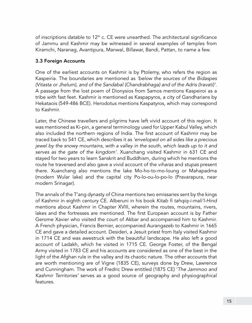
This historic site at Ambaran near Akhnoor in Jammu district is located on the right bank of River Chenab (Chandrabhaga). The ASI conducted excavations here in 1973-74 and later for four field seasons between 1999 and 2010, which brought to light the remains of a Buddhist stupa and vihara. Four periods of occupation were identified here, viz., (i) period of grey ware (second - first century BCE), (ii) Kushana period (first - third century CE), (iii) Gupta period (forth - sixth century CE) and post-Gupta period (sixth - seventh century CE). The excavation carried out during 2008-10 has brought to light Buddhist monastic remains including a stupa having spoked wheel (dharamchakra) on plan. Similar spoked wheel on plan type of stupas were reported earlier at sites like Vaishali (Bihar) and Sanghol (Punjab).
Buddhist monastic remains at Ambaran, district Jammu

21
Akhnoor Fort, district Jammu
Ancient Fort, Akhnoor, tehsil Akhnoor, district Jammu
The 19th c. Akhnoor fort of Raja Alam Singh is located on the right bank of the Chenab in the foothills of the Pir Panjal. Apart from a two-storied palace, the fort has high fortification walls with bastions at regular intervals and is crowned by battlements.
It is located on the ancient settlement known as Manda representing the northernmost limit of the Harappan Civilization (c. 2600-1900 BCE). The excavation has revealed a fourfold sequence in a deposit of 9.2 m, viz., Harappans, late Harappan and Painted Grey Ware and Kushana periods.

22
Harihara Temple, Billawar, district Kathua
Ancient Temple (Harihara), Billawar, tehsil Billawar, district Kathua
The temple has a square sanctum with a pillared mandapa in front. It is crowned by a sikhara. The shrine may be dated to circa tenth century CE.

23
Trilochan Nath Temple, Basholi, tehsil Basholi, district Kathua
The temple dedicated to Siva has multiple offsets on each side with a sikhara surmounted by kalasa. On plan, the temple consists of a garbhagriha and antarala.
Trilochan Nath Temple, Basholi, district Kathua

24
Ancient Site, Babour, Thalora, tehsil Majalta, district Udhampur
The ancient site of Babour is located at a distance of 65 km north on the Jammu – Srinagar highway. The excavations brought to light the remains of Kushana and medieval periods.
Excavations at Babour, district Udhampur

25
Temple of Devi Bhagawati together with adjacent land, Thalora, tehsil Majalta, district Udhampur
On stylistic consideration, this temple is assignable to circa tenth century CE. It consists of a garbhagriha and antarala with a square mandapa. The walls of the mandapa have eight niches; its roof has fallen. The jambs are profusely carved with images. Externally also the temple is well decorated.
Kala Dera Temple I, Thalora, district Udhampur
Ancient Temple (Kala Dera I and II) together with adjacent land, Thalora, tehsil Majalta, district Udhampur
Assignable to tenth – eleventh century CE Kala Dera I temple is built on a high basement and is preceded by mandapa. The doorjambs of the sanctum are decorated with sculptured reliefs. Among the fragments lying in the mandapa are two representations of Nataraja. Kala Dera II: assignable to tenth - eleventh century CE and consists of a garbhagriha, antarala and a mandapa. The mandapa has three entrances. Its northern wall bears a defaced inscription in the Sharada script.

26
Kala Dera Temple II, Thalora, district Udhampur

27
Ancient Temple Nand Babour together with adjacent land, Thalora, tehsil Majalta, district Udhampur
Assignable to tenth - eleventh century CE, the temple stands on a rectangular base. It consists of three garbhagrihas each proceeded by an antarala attached to a common mandapa. The ceiling of the mandapa rested on fluted columns decorated with pot and foliage motifs.
Nand Babour Temple, Thalora, district Udhampur

28
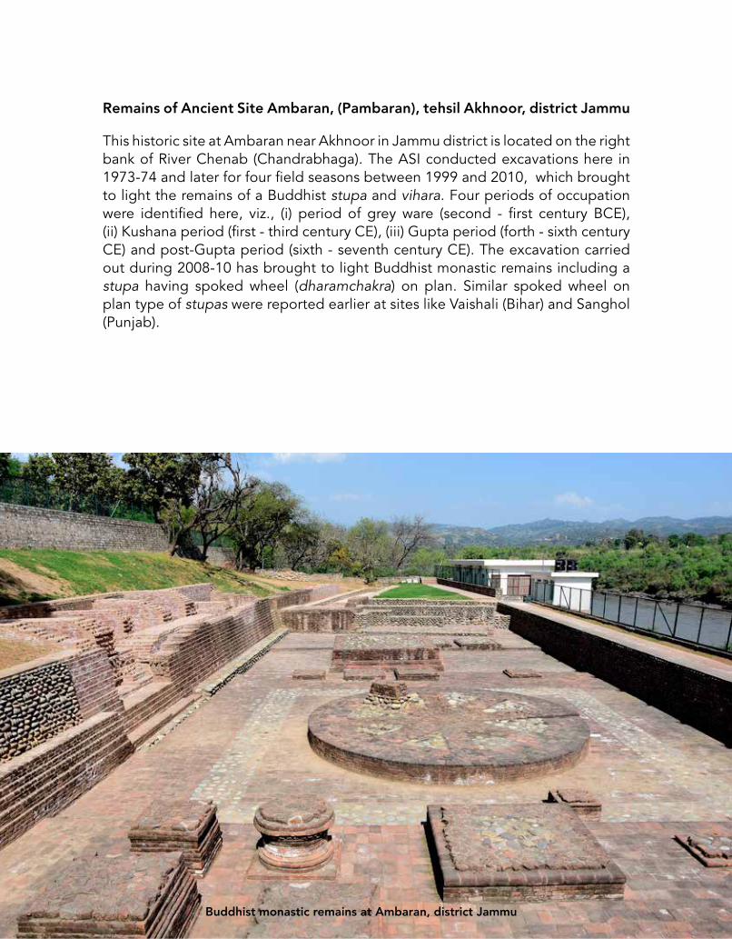
Group of Temples, Kiramchi, tehsil Udhampur, district Udhampur
Assignable to eighth - ninth century CE, this group consists of five temples. Three have been constructed on a common platform and the remaining two on a separate platform. Four temples face east and the smaller temple faces west. The four temples comprise of garbhagriha with curvilinear sikhara and an antarala with sukanasika.

29
30
Group of Temples, Kiramchi, district Udhampur

31

32
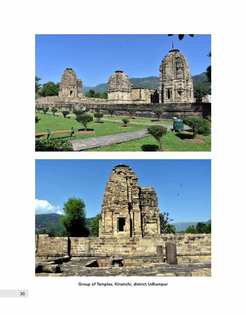
Ancient Fort attributed to Raja Suchet Singh and Samadhi of Queen of Raja Suchet Singh, Ramnagar, tehsil Ramnagar, district Udhampur
Ancient Fort attributed to Raja Suchet Singh: This fort, square on plan, was built by Raja Suchet Singh (1801-1844 CE) with polygonal bastions to support its four corners.
Samadhi of Rani of Raja Suchet Singh: This Samadhi was built by Raja Ranbir Singh, a nephew of Raja Suchet Singh, at the spot where the Rani performed sati after the death of her husband Raja Suchet Singh in 1844 CE. The complex consists of a main shrine with painted walls.
Ramnagar Fort, district Udhampur
33
Mausoleum outside the Ramnagar Fort, district Udhampur

34
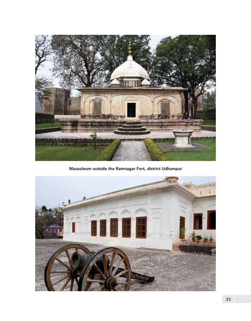
Ancient Palaces attributed to Raja Suchet Singh, Ramnagar, tehsil Ramnagar, district Udhampur
Old Palace (Purana Mahal): Purana Mahal was built by Raja Suchet Singh (1801-1844 CE). The palace is a big complex of rooms rising to three storeys having high walls and watch towers at regular intervals. The walls of the rooms are decorated with stucco work and painted with floral designs. The wooden ceilings are also decorated.
Nawa Mahal complex: Nawa Mahal complex was built by Raja Ram Singh, son of Raja Ranbir Singh. It comprises an inner courtyard surrounded by rooms with two entrances facing each other.
Sheesh Mahal complex: The Sheesh Mahal complex was built by Raja Ram Singh (1801-1844 CE). It comprises of two forecourts having burjs at corners. Behind these are halls and rooms flanked on either side of the central passage. To the left of the entrance are Darbar Hall, Sheesh Mahal and Rang Mahal. To the right is an arcaded verandah with rooms in the rear. The Darbar hall has scenes of mural paintings depicting themes from the Ramayana, Bhagawata and other Puranas, besides battle scenes connected with Raja Suchet Singh. Adjoining the Darbar Hall is Sheesh Mahal with its walls decorated with fine glass work arranged in various designs and later lithographs. The walls of Rang Mahal adjoining Sheesh Mahal are decorated with mirrors and mural paintings arranged in panels depicting scenes of Nayikas, Raginis and Krishna-lila, besides hunting and court scenes.
Raja Suchet Singh’s Palace, Ramnagar, district Udhampur
35
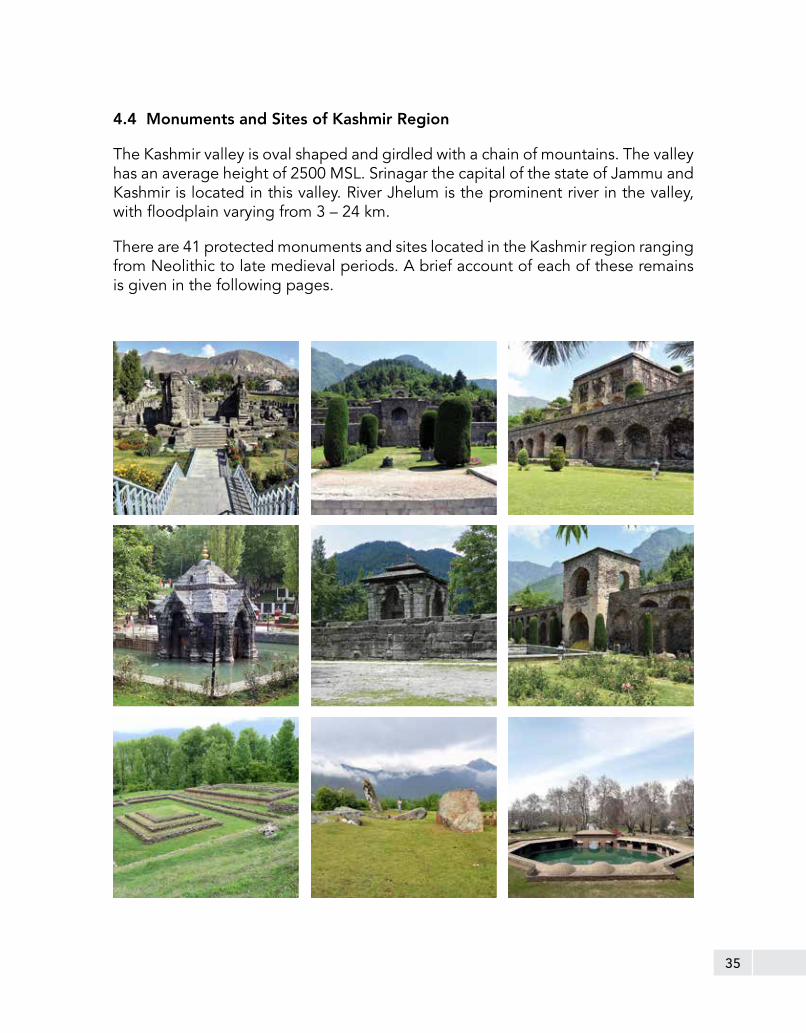
4.4 Monuments and Sites of Kashmir Region
The Kashmir valley is oval shaped and girdled with a chain of mountains. The valley has an average height of 2500 MSL. Srinagar the capital of the state of Jammu and Kashmir is located in this valley. River Jhelum is the prominent river in the valley, with floodplain varying from 3 – 24 km.
There are 41 protected monuments and sites located in the Kashmir region ranging from Neolithic to late medieval periods. A brief account of each of these remains is given in the following pages.

36
Ancient Site of Chakradhar or Semthan, tehsil Anantnag, district Anantnag
The ancient site of Semthan is located in the Anantnag district, 44 km from Srinagar on the Jammu-Srinagar highway. The site is situated atop a high plateau. The site consists of six small and high contiguous mounds with the highest elevation of about 18 m. The local names of the mounds are Tshradakuta, Kuta, Rajama Teng, Chakradhara, Guda and Sonakutta. A limited excavation at Semthan was conducted in 1977 followed by a systematic work during three field seasons from 1981 to 1983 under the direction of R.S. Bisht. It was a step towards reducing the cultural gap between the Neolithic and the Kushana period occupation in Kashmir valley.
The excavation at Semthan gave evidence of a continuous occupation, dating from the Neolithic period onwards. The excavation at Semthan also provided important evidence on two previously unknown cultures in the Kashmir valley, i.e. pre-Northern Black Polished Ware (NBPW) and NBPW culture. Regarding the other cultures, namely the Indo-Greek, the Kushana and the Hunas, the site revealed further information. The habitational remains, thus unearthed at Semthan belong to a range from the Neolithic times to 500 CE.
Site of Chakradhar or Semthan, district Anantnag

37
The Pre-NBPW deposit is the earliest and is characterized by successive floor levels with post-holes, which put the antiquity of this site to the Neolithic period. The ceramic industry of this level is represented with diagnostic types of earthen ware pre-dominantly wheel-made, with different types of bowl, jar, lid, vase, cooking vessel, etc. Their subsistence was not only based on the hunting but on cereals such as rice, wheat, barley, moong, lentil, etc, supported by their recovery from the level. All these features of Neolithic culture at Semthan, demonstrate that the people here were economically developed and living an agro-pastoral lifestyle.
The studies at the site revealed the fact that the Indo-Greek rule in Kashmir in general and Semthan in particular had an important role in that period. The Indo-Greek coins and Kushana art objects confirms their extension of influence in the valley, in addition to the region of Indo-Gangetic plain. The staple diet during this era was wheat and rice. The pottery industry was prominently present throughout this period. The copper coins were in circulation while iron tools were in vogue.
Site of Chakradhar or Semthan, district Anantnag

38
Mughal Arcade including spring together with adjacent land, Verinag, tehsil Anantnag, district Anantnag
Verinag is located at a distance of 26 km from Anantnag. A spring of the same name is also the major source of the Jhelum river. There is an octagonal stone basin at Verinag Spring and an arcade surrounding it, which was built by Mughal emperor Jahangir in 1620 CE. Subsequently, Shah Jahan laid out a beautiful garden next to this spring. The construction of the octagonal basin and the arcade, which now surrounds it, was originally commenced by Jahangir and was completed in the time of Shah Jahan. It is an octagonal reservoir about 6 x 6 m. The range of twenty-four arches round the spring remains partially intact. The arches were originally built of stone, the walls being surmounted by a row of beautifully carved brackets, which supported the eaves. On two sides of the octagon are larger chambers, each containing a staircase leading to the upper storey. The brick facing of the majority of the arches, as well as ruins of the walls of the second storey over the entrance chamber, belong to the repairs done by Wazir Punnu during the reign of the late Maharaja Ranbir Singh in 19th c. CE. There are two inscribed stone tablets, one belonging to the time of Jahangir and the other to that of Shah Jahan built into the wall of the arcade.
Mughal Arcade, Verinag, district Anantnag

39
There is a provision for discharge of the surplus water of the spring by an underground conduit, the mouth of which is visible from above. Passing under the buildings, the conduit crossed the garden and carried the water to the royal bathrooms, the ruins of which and of other buildings are still to be seen outside the rubble wall on the east side. The stream, which flows from the spring, is about 3.6 m in width and runs throughout the length of the garden. It is spanned in the middle and at the northern end by two modern barahdaris. Only the upper terrace is enclosed, though the presence of the ruined water chute, over which the stream rushed down, before leaving the garden, suggests the existence of a lower terrace.
Mughal Arcade, Verinag, district Anantnag

40

41

42
Ancient Temple, Martand, Ranbirpora, tehsil Anantnag, district Anantnag
The temple at Martand is dedicated to Sun god. It is situated in the Anantnag district at a distance of 35 km from Srinagar. It was built by the Karkota King Lalitaditya Muktapida around eight century CE. The king named the temple Martand as a tribute to the fishermen as fishing and trading were the prominent professions during his reign.
The Martand temple follows the typical architectural features of Kashmir temples. It consists of a courtyard with the principal shrine in the middle and a colonnaded peristyle. The latter is 67 m long and 43 m broad and contains eighty-four fluted columns facing the courtyard. The peristyle is externally plain, except on the west side, which originally had a row of columns. The gateway stands in the middle of the western side of the quadrangle and is of the same width as the temple itself. On the exterior, the Martand gateway resembles the temple itself with regard to parts and in the decoration of its pediments and pilasters. It was open to west and east, and was divided into distinct portions forming an inner and outer portico, by a cross wall with a doorway in the centre, which originally had a wooden door as protective measure.
On each side of the gateway, massive fluted pillars supported the pediment, 5.3 m in height, or 2.4 m higher than those in the quadrangle. The pillars are connected through the architrave and entablature. The front and back pediments of the gateway were supported on large pillars. The roof was pyramidal; for a portion of the sloping mouldings of its pediment was still to be seen on one side. The walls of the gateway are profusely decorated internally and externally, the chief motif of decoration being rows of double pedimented niches altering with rectangular panels. Most of the pedimented niches contained single standing figures of gods.

43
Martand Temple, Ranbirpora, district Anantnag
The rectangular panels contained sitting groups, floral scrolls, pairs of geese, etc. The main shrine is about 19 m in length by 11 m in width at the eastern end and only 8 m in width at the western end. It contains three distinct chambers, ardhamandapa is square in plan with measurement 5.51 m; the antarala is about 5.48 m x 1.37 m; and the garbhagriha is about 5.63 m x 4 m. The first is open and highly decorated. The middle chamber is decorated in the same style; but the inner chamber is plain and is closed on three sides. The walls of the temple itself are 2.7 m thick and of its entrance chamber only 1.37 m thick, being respectively one half and one fourth of the interior width of the building.

44
Bamzuva Cave and Temple, Bumzuva, tehsil Anantnag, district Anantnag
The little village of Bamzuva or Bhumju or Bumzu or Bhaumajo is located nearly 1.5 km to the north of the sacred springs of Bavan (Matan), which lies at the mouth of the Lidder valley in Anantnag district. The caves are situated on the left bank of the river Lidder nearly 1.5 km north of the village of Bawan. The largest one is dedicated to Kaladeva.
It is carved out of a large mass of limestone cliffs overlooking the lower section of the Lidder valley. The excavations were carried out in the weak stone formations and hence the façade of the gateway has, therefore, been built of stone masonry in lime. It consists of a single trefoil-arched doorway, surmounted by a pediment, and sidewalls.
On the left-side of the wall, is a small rectangular niche measuring 67 cm x 33 cm. Its pilasters are carved with floral scrolls of extraordinary delicacy. The lintel is ornamented with a row of rosettes and the cornice with a row of slightly projecting dentils, whose intervening spaces appear to have been filled with figures of dancing ganas, all of which are now defaced. In its interior is a small temple, which is similar in style to other temples of Kashmir. It is square in plan externally with arm measuring about 3 m and stands on a base 1.4 m in height. A remarkable feature is the very slight projection of the porch. The corner pilasters have two rectangular niches. On stylistic consideration a date assignable to it, is 12th c. CE.
At the foot of the cave in the village, there are two temples, which have been converted into Muslim ziarats. The larger temple now goes by the name of the Ziarat of Baba Bamdin Sahib. The pyramidal roof is buried under a mound of earth, which surmounts the modern square double wooden roof. The interior is square on plan with sides measuring 2.5 m. The ceiling consists of overlapping stones. The uppermost stone is carved with a full-blown lotus. The entrance is in the north wall.
To the west of this temple are the ruins of a smaller temple. The exterior of the roof is destroyed, but the ceiling inside is intact and is similar to the ceiling of the larger temple. Its porches are exact replicas of those of the cave temple, a fact which leads to the surmise that all three were built at about the same time.
The larger temple has been identified with the Bhimakesava shrine built by Bhima Shahi of Gandhara, the maternal grandfather of Queen Didda, who ruled Kashmir as the wife of Kshemagupta from 950-958 CE, and remained as sole sovereign from 980-1003 CE.

45
Bumzuva Cave and Temple, district Anantnag

46
Entrance to Bumzuva Cave and Temple, district Anantnag
Inside the Bumzuva Cave, district Anantnag

47
Detha Mandir, Bandi, tehsil Uri, district Baramulla
The very word dethamandir or dathamandir literally means “ruined temple”. It is also known as Bandi Mandir. It is located nearly 21 km from the Baramulla district headquarters on Uri-Rampur road. The remains of main shrine are situated at the centre of a courtyard having cells all around on a plinth of limestone platform. The doorjambs of these cells are beautiful with half-engaged columns. The architectural plan of this temple is typical of the Kashmir type. But earlier it was supposed to be devoid of any peristyle colonnade. The excavation here brought to light the flagstone flooring, which signifies that the current cells were made over an old peristyle plinth. The archetypal entrance of about 7 m in breadth is divided into two parts, each measuring about 5 m in width and 1.76 m in height. The sidewalls of both the portions are adorned with clover headed niches. The jambs are ornamented with depiction of the river goddesses Ganga and Yamuna.
Detha Temple at Bandi, district Baramulla

48Detha Temple at Bandi, district Baramulla
The main shrine having domical ceiling, is built of green limestone. Both the mandapa and sanctum of the main shrine is as usual square on plan; their arms respectively measure about 7 m and 3.65 m. The sanctum preserves the evidence of a pedestal of the idol. The entrance of temple too is square with plain straight moulding and surmounted by pediments containing trefoil decorations. It is supposed to be a temple dedicated to lord Vishnu as manifested by a column placed exactly opposite the main shrine probably for the garudastambha or garudadhwaja. Two replicas of the main shrine but of later date and smaller in size exist in the northwest corner of the complex. It is datable to tenth century CE.
49
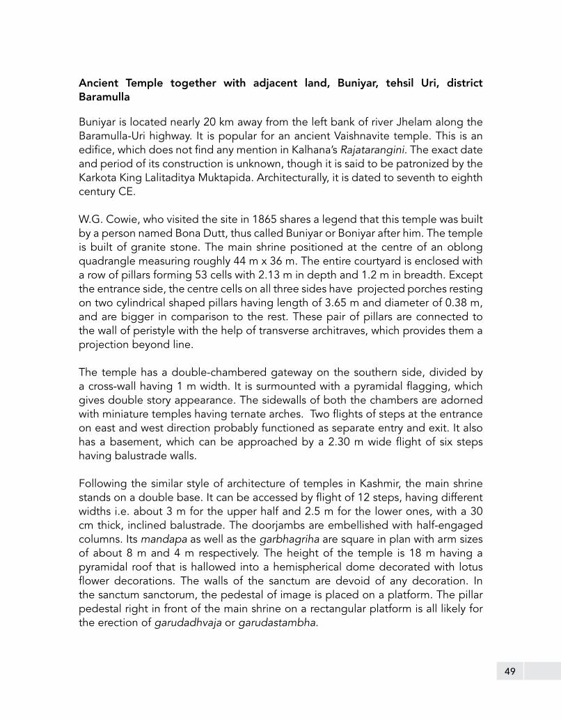
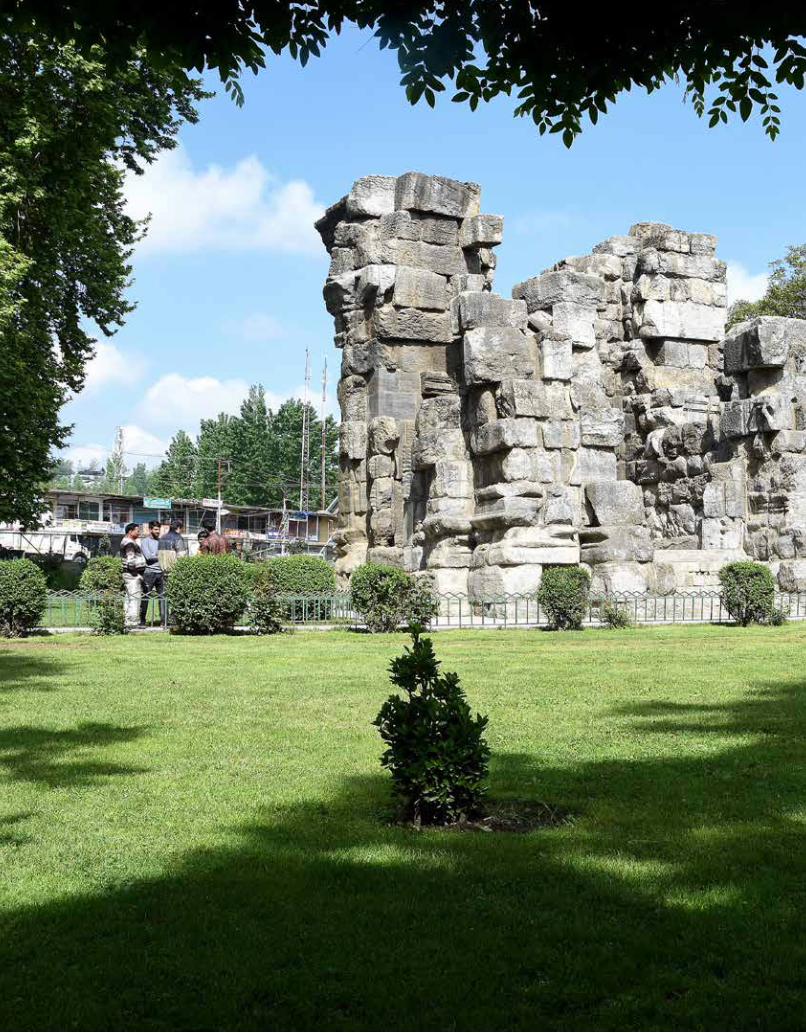
Ancient Temple together with adjacent land, Buniyar, tehsil Uri, district Baramulla
Buniyar is located nearly 20 km away from the left bank of river Jhelam along the Baramulla-Uri highway. It is popular for an ancient Vaishnavite temple. This is an edifice, which does not find any mention in Kalhana’s Rajatarangini. The exact date and period of its construction is unknown, though it is said to be patronized by the Karkota King Lalitaditya Muktapida. Architecturally, it is dated to seventh to eighth century CE.
W.G. Cowie, who visited the site in 1865 shares a legend that this temple was built by a person named Bona Dutt, thus called Buniyar or Boniyar after him. The temple is built of granite stone. The main shrine positioned at the centre of an oblong quadrangle measuring roughly 44 m x 36 m. The entire courtyard is enclosed with a row of pillars forming 53 cells with 2.13 m in depth and 1.2 m in breadth. Except the entrance side, the centre cells on all three sides have projected porches resting on two cylindrical shaped pillars having length of 3.65 m and diameter of 0.38 m, and are bigger in comparison to the rest. These pair of pillars are connected to the wall of peristyle with the help of transverse architraves, which provides them a projection beyond line.
The temple has a double-chambered gateway on the southern side, divided by a cross-wall having 1 m width. It is surmounted with a pyramidal flagging, which gives double story appearance. The sidewalls of both the chambers are adorned with miniature temples having ternate arches. Two flights of steps at the entrance on east and west direction probably functioned as separate entry and exit. It also has a basement, which can be approached by a 2.30 m wide flight of six steps having balustrade walls.
Following the similar style of architecture of temples in Kashmir, the main shrine stands on a double base. It can be accessed by flight of 12 steps, having different widths i.e. about 3 m for the upper half and 2.5 m for the lower ones, with a 30 cm thick, inclined balustrade. The doorjambs are embellished with half-engaged columns. Its mandapa as well as the garbhagriha are square in plan with arm sizes of about 8 m and 4 m respectively. The height of the temple is 18 m having a pyramidal roof that is hallowed into a hemispherical dome decorated with lotus flower decorations. The walls of the sanctum are devoid of any decoration. In the sanctum sanctorum, the pedestal of image is placed on a platform. The pillar pedestal right in front of the main shrine on a rectangular platform is all likely for the erection of garudadhvaja or garudastambha.

50
Ancient Temple, Fatehgarh, tehsil Baramulla, district Baramulla
The village of Fatehgarh is located at the mouth of Narvav valley nearly 6 km away from its district headquarters at Baramulla. It is constructed on a platform. The sanctum sanctorum is a massive platform, which once had a colossal Sivalinga, as indicated by the fragments found in the precinct. The platform is decorated with torus moulding and the space around it was used as pradakshinapatha. The front of the platform is adorned with two rows of trefoil niches probably used for placing the worship lamps. The ceiling was constructed using corbelling pattern. It is datable to the ninth century CE.
Temple at Fatehgarh, district Baramulla

51
Ancient Stupa (excavated remains) together with adjacent land, Ushkura, tehsil Baramulla, district Baramulla
The village of Ushkar or Wushkur is situated in Baramulla district. The name is a corruption of the word Huvishkapura, which is the name of a city, founded by Kushana King Huvishka in second century CE. It was a flourishing town during medieval times and the Karkota King Lalitaditya built here a shrine of Vishnu named Muktasvamin and a large vihara with a stupa in the eighth century CE. It is said that the Chinese pilgrim Xuanchang who visited Kashmir in 631 CE, entered the valley by the Baramulla pass, and spent his first night at one of the monasteries. A number of fragmentary parts of sculptures found form this site display the influence of the Gandhara school of the third and fourth century CE.
Excavated Remains of Stupa at Ushkura, district Baramulla

52
Pratapaswamin Temple with four subsidiary shrines together with adjacent land, Tappar-Waripora, tehsil Baramulla, district Baramulla
The temple is in the middle of a courtyard enclosed by a peristyle. It is assignable to the eighth century CE, and consists of a garbhagriha and a mandapa. It has a subsidiary shrines in the courtyard. Only the plinth is preserved, rest of the superstructure has fallen.
Pratapaswamin Temple, Tappar - Waripora, district Baramulla

53
Shankargaurisvara Temple and excavated structures together with adjacent land, Pattan, tehsil Baramulla, district Baramulla
The temple is dedicated to Siva and is situated in Pattan of Baramulla district, 27 km from Srinagar. It was built by King Shankaravarman of Utpala dynasty in his capital city, then known as Shankarapattan in ninth century CE and named after the king himself.
The entrance porch of the temple, which faces east, exhibits intricately sculpted carvings both on its exterior and interior surfaces. The pediments are stacked symmetrically one above the other. The columns at the entrance are also elaborately sculpted in an architectural style typical of the Kashmir region. The plinth of the temple, and of the shrine next to it, is built in a peristyle, an open colonnade pattern, within a walled enclosure. The sanctum sanctorum is square on plan and measures 5.15 m. The walls are plain and adorned with niches.
54

55

56
Sugandesha Temple, Pattan, tehsil Baramulla, district Baramulla
The temple is attributed to Sugandha, queen of Sankaravarman and was built in the ninth century CE. The temple is adjacent to another temple called Gaurishvara, located in the southern direction. It is built on a double plinth that is approached by a flight of steps and the main entrance faces east. The garbhagriha is square on plan measuring 4.25 m on each side. There are niches in the other three walls of the sanctum, which measures 1.80 m x 1.25 m internally, and have trefoil entrances surmounted with pediments. The gateway is peristyle as usual and divided into two chambers measuring 5.15 m x 2.30 m internally. The cells are of 1.20 m x 0.83 m in dimensions with sixteen sided pillars to support the portico.
Sugandesa Temple, Pattan, district Baramulla
57
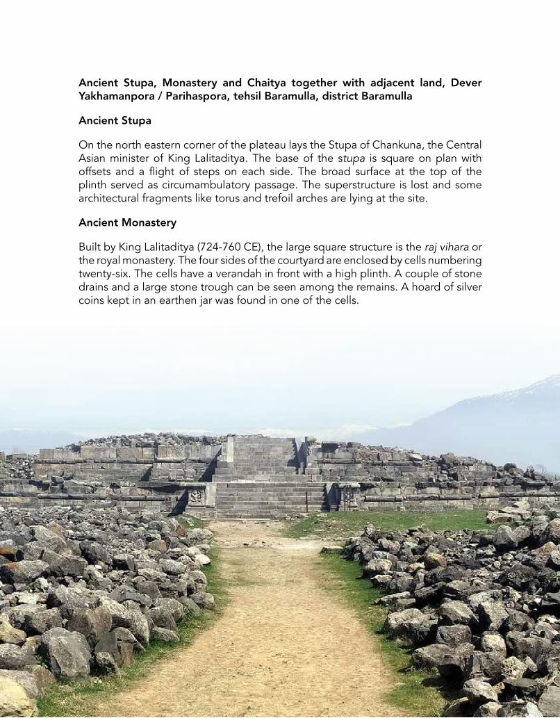
Ancient Stupa, Monastery and Chaitya together with adjacent land, Dever Yakhamanpora / Parihaspora, tehsil Baramulla, district Baramulla
Ancient Stupa
On the north eastern corner of the plateau lays the Stupa of Chankuna, the Central Asian minister of King Lalitaditya. The base of the stupa is square on plan with offsets and a flight of steps on each side. The broad surface at the top of the plinth served as circumambulatory passage. The superstructure is lost and some architectural fragments like torus and trefoil arches are lying at the site.
Ancient Monastery
Built by King Lalitaditya (724-760 CE), the large square structure is the raj vihara or the royal monastery. The four sides of the courtyard are enclosed by cells numbering twenty-six. The cells have a verandah in front with a high plinth. A couple of stone drains and a large stone trough can be seen among the remains. A hoard of silver coins kept in an earthen jar was found in one of the cells.
58
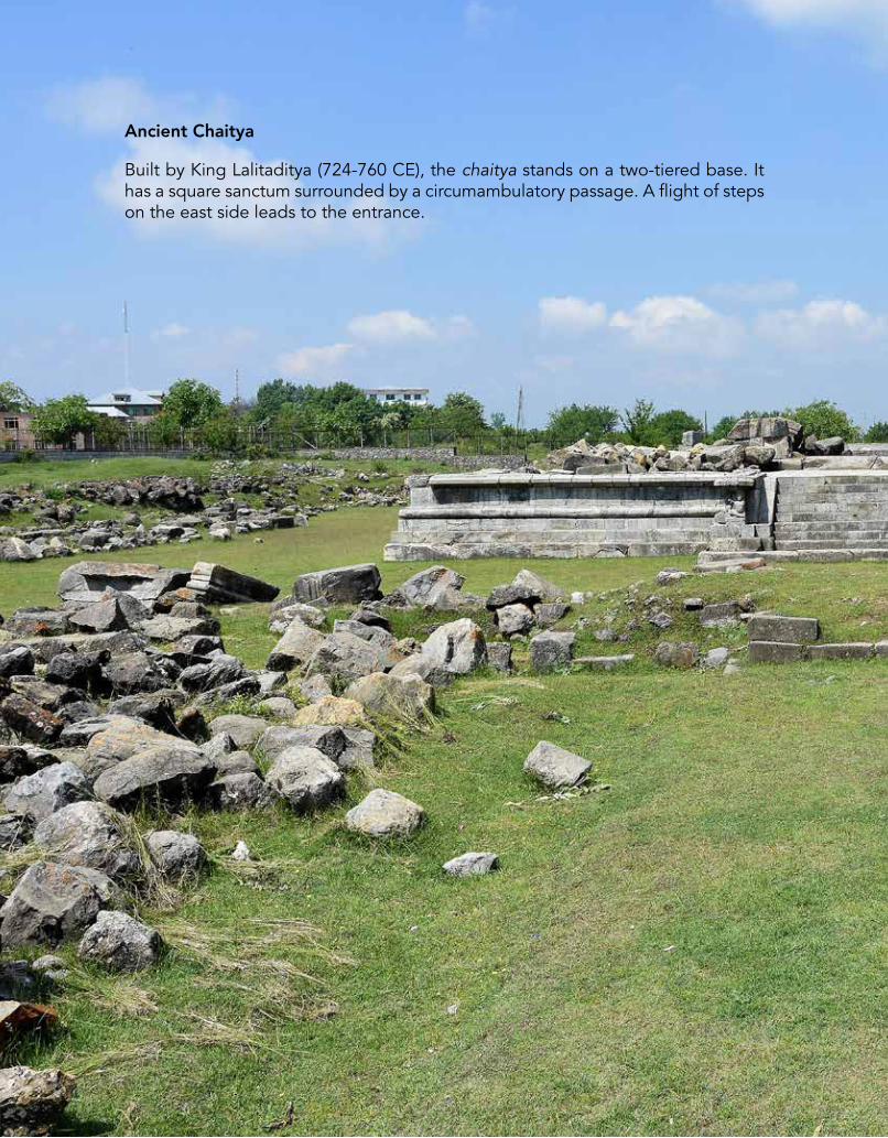
Ancient Chaitya
Built by King Lalitaditya (724-760 CE), the chaitya stands on a two-tiered base. It has a square sanctum surrounded by a circumambulatory passage. A flight of steps on the east side leads to the entrance.

59

60
Ancient Site, Sumbal, tehsil Sonawari, district Baramulla
The ancient site lies near the bank of river Jhelum and located 20 km from Kashmir. Built by King Jayapida towards the eighth century CE, the city was known as Jayapura. All structures are damaged except some sculptures.
Tomb and Mosque at Wular Lake, district Baramulla
Mosque and other ancient remains on the island, Wular Lake, tehsil Bandipora, district Baramulla
Mosque
The Wular Lake in ancient times known as the Mahapadma- sara, the abode of great snake deity (Mahapadma) King Zain-ul-Abdin built a small mosque here.
Ancient remains of Tomb
The tomb was built in the 15th c. CE by King Zain-ul-Abidin over a common plinth in an island of the lake, where existed the residue of a temple. Among the architectural features are trefoil niches, fluted columns and ribbed capitals. The structure has a small domed chamber of brick and stone masonry, which is square internally. The inner walls of the chamber are coated with painted plaster.

61
Remains of Sarai at Khanpur, district Budgam
Khanpur Sarai, Khanpur, tehsil Chadura, district Budgam
Located at Khanpur on the ancient Mughal route, it served as a sarai in the Mughal period. The sarai mostly in the ruins has the arched cells built of lakhauri bricks. The area has been fenced for development of garden.

62
Aliabad Sarai, Aliabad, tehsil Shopian, district Shopian
A ruined sarai probably built during the reign of Akbar (1556-1605 CE).
Remains of Sarai at Aliabad, district Shopian

63
Avantiswamin Temple together with adjacent land, Avantipur, tehsil Pulwama, district Pulwama
Avantipur is situated about 28 km from Srinagar in Pulwama district. King Avantivarman of Utpala dynasty first founded the city in ninth century CE on the banks of river Jhelum. Although, Avantivarman was a devotee of lord Vishnu yet he ordered to construct two splendid temples named Avantiswamin and Avantisvara dedicated to the lord Vishnu and lord Siva respectively. The latter one bigger than the former was erected to fulfill the need of his loyal and prudent minister Sura who was an ardent devotee of lord Siva and helped him in consolidating the empire.
The story of unearthing these two temples begun in 1783 when George Forster visited the site first in a line of scholars thereafter; William Moorcroft (1823), B.C. Hugel (1835), Alexander Cunningham, W.G. Cowie (1865), H.H. Cole (1868), J.P. Vogel (1903). J.H. Marshall, then Director General, Archaeological Survey of India in 1907 when he visited Kashmir, recommended an excavation here at the site in collaboration with State Department of Archaeology & Research. The excavation started in 1910 under the direction of J.C. Chatterji of J&K State department.
Avantisvami Temple at Avantipur, district Pulwama

64
Further on a bigger level the said work was taken up by D.R. Sahni of ASI who exposed the hidden antiquity of the one-time full blown temples of Avantipur.
Avantiswami Temple
The Avantisvami temple is located adjacent to the Avantisvara temple. The temple compound has a panchayatana type of layout consisting main shrine at the centre and four smaller but symmetric shrines at the four corners. They are dedicated to Sankarshana, Vasudeva, Pradyumana and Aniruddha. The main shrine is dedicated to Vishnu. The whole structural complex is enclosed within a colonnade wherein the main temple is situated in a rectangular courtyard roughly measuring 53 m x 45 m. Barring the west side, which has the entrance, the entire row of columns is very lightly adorned. The sanctum is approached by stairs having a plain railing and a sidewall on either of its sides through an opening exactly at the centre of western wall, which is divided by a cross-wall into two chambers.

65
The pilasters of sidewalls are embellished with beautifully sculpted relief images of lord Vishnu and other associated deities of his pantheon. The entrance from both the sides is copiously adorned with sculptures. Out of which the location of sculptures of makaravahini (Ganga) and kachchhpavahini (Yamuna) on the either side of the entrance to temple, function as source of purification for devotees entering the sanctum.. Besides, a panel supposed to depict the king and his two queens are praiseworthy. In addition to these there are other remarkable reliefs of. Vishnu with his two consorts Lakshmi and Bhumi, Krishna, Brahma, Kamadeva with his two consorts Rati and Priti, carved panels of fight between Garuda and Nagas, elephants, flying Vidyadhara, Kirtimukhas, Chauri-bearers, etc. A pillared hall with all sides open is located opposite the steps of the central shrine for Garuda-dhvaja, which is an indispensable adjunct of every temple, dedicated to the lord Vishnu. During subsequent period of occupation, several additional structures were added to this complex, out of which two shrines at rear of central shrine between south east and north west corners are noteworthy.

66
Avantisvara Temple, Avantipura, teshsil Pulwama, district Pulwama
The village of Avantipur, situated at a distance of 28 km from Srinagar is identified with the town of Avantipura, founded by Avantivarman, who reigned from 855 to 883 CE. There are two magnificent temples, the first and larger is the temple of Siva, known as Avantisvara and the second, temple of Vishnu known as Avatisvamin. The Avantisvara temple is with massive walls near the village of Jaubror, a km from Avantipur. It is situated in a courtyard enclosed by a massive stonewall, the western face of which is adorned externally with a row of fluted columns without any recesses behind. The gateway is in the middle of this wall, and is divided into two chambers by a cross plain wall.
The base on which the shrine in the centre of the courtyard stand is 17.5 m square and 3 m high. To each of its corners was attached a platform about 4.8 m square, which must originally have supported a small subsidiary shrine. It has a stair on each of its four sides like the temple of Pandrethan. The stairs have a width of 2.69 m, and are supported on either side by flank walls 5.33 m in length. The platform seem to have been originally attached to the plinth of the temple at one point stage, but afterwards they were completely joined with it by means of a connecting wall built of architectural fragments that had fallen from the temple. The sole exterior is a series of projecting facets, the larger of which were originally surmounted by plain rectangular capitals. In the two rear corners of the courtyard there are two subsidiary shrines.

67
There is a large assortment of architectural fragments strewn about in the courtyard, the most interesting of which are (1) the spandrel of an arch in front of the southern stair, (2) the flower-and-vase capital of a dodecagonal pilaster, (3) the spandrel of another arch by its side, and (4) the base of a pilaster decorated with two seated rams and a dancing girl who plays upon a damaru (kettle drum) standing on a throne ornamented with two lions at the sides and an elephant, facing in the middle.
Avantisvara Temple, Avantipura, district Pulwama

68
Ancient Temple, Kakpora, tehsil Pulwama, district Pulwama
Kakpora is located in Pulwama district on the banks of river Romshi about 20 km south of the capital city Srinagar. It was founded during the time of Utpala King Avantivarman. It is famous for its ruined temple of 11th c. CE out of which only the base of the sanctum and a few cells of the peristyle are preserved. It is built in the centre of an oblong courtyard. The main shrine consists of a pancharatha sanctum and portico on plan above the common jagati and preserves only its basal mouldings. A flight of steps on the east provides an access to the temple. A peristyle, the upper platform of which is also damaged, encloses the courtyard of the temple. It has a double-chambered gateway in the middle of eastern side, the roof of which is now missing.
Temple at Kakpora, district Pulwama

69
Monolithic Shrine, Khrew, tehsil Pulwama, district Pulwama
This small monolithic shrine is assignable to tenth to eleventh century CE.
Monolithic Shrine at Khrew, district Pulwama
70
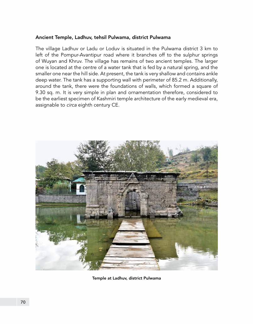
Ancient Temple, Ladhuv, tehsil Pulwama, district Pulwama
The village Ladhuv or Ladu or Loduv is situated in the Pulwama district 3 km to left of the Pompur-Avantipur road where it branches off to the sulphur springs of Wuyan and Khruv. The village has remains of two ancient temples. The larger one is located at the centre of a water tank that is fed by a natural spring, and the smaller one near the hill side. At present, the tank is very shallow and contains ankle deep water. The tank has a supporting wall with perimeter of 85.2 m. Additionally, around the tank, there were the foundations of walls, which formed a square of 9.30 sq. m. It is very simple in plan and ornamentation therefore, considered to be the earliest specimen of Kashmiri temple architecture of the early medieval era, assignable to circa eighth century CE.
Temple at Ladhuv, district Pulwama

71
Ancient Stupa Remains along with adjacent area, Malangpora, tehsil Pulwama, district Pulwama
This ruined stupa assignable to seventh to eighth century CE rises from a square base with re-entrant angles. The stupa has been exposed during the scientific clearance works in the year 2008 and conserved.
Remains of Ancient Stupa, Malangpora, district Pulwama

72
Ancient Siva Temple, Payar, tehsil Pulwama, district Pulwama
The village of Payar is located at the foot of the karewa in Pulwama district. This temple is well preserved and a good example of a medieval Kashmiri shrine. It is square on plan measuring 2.5 m on each side and 6.4 m in height including the base. The chief mouldings of which are a plain torus in the middle and a filleted torus on the top. The sanctum is open on all sides, but is reached only by a single flight of steps on the east side. The doorways are rectangular, and are surmounted by a trefoil arch, which in turn is enclosed by a pediment.
The pilasters on which the pediments rest are surmounted by capitals bearing pairs of geese with long foliate tails, and the pilasters from which the trefoil arch springs are crowned by recumbent bull capitals. The bulls have scarves tied to their humps. The eastern trefoil itself encloses a relief, in which Siva is seen seated cross-legged on a throne under the canopy of an overhanging tree, surmounted by votaries, two of whom are seated, with legs hanging down.
Ancient Siva Temple at Payar, district Pulwama

73
On the north side, the relief represents Bhairava, the manifestation of Siva, pursuing a human being, who turns towards him in an attitude of supplication. Behind the Bhairava is an elephant’s long trunk. On the west side is the very animated figure of six-armed dancing Siva. The upper two arms are raised aloft, holding the two ends of a scarf. The middle two hands are gesticulating, the lowest left hand holds a flower and the right the trident, the special emblem of Siva. In the left lower corner of the group is a musician playing on a vina; on the right is another beating a drum in accompaniment. The roof is pyramidal, and is divided into two sections by an ornamental band, consisting of square spaces alternately projecting and receding.
Ancient Temple, Bohri Kadal, tehsil Srinagar, district Srinagar
This ruined temple has an octagonal plan with longer arms alternating with shorter ones at the cardinals. It may be ascribed to early medieval period.
Ancient Temple at Bohri Kadal, district Srinagar

74
Pathar Masjid, Zaina Kadal, tehsil Srinagar, district Srinagar
Pathar Masjid, locally known as Naev Masheed is a Mughal period mosque, is located on the left bank of the river Jhelum in old Srinagar, built by Nur Jahan in 1623 CE. The mosque has some distinct features that separate it from the rest of the mosques in the valley. Unlike other mosques, it does not have the traditional pyramidal roof. It is rectangular on plan and measures 65.60 m (N-S) and 23.40 m (E-W). Furthermore, the mosque has nine mihrab, with the central one being larger than the others. Its façade consists of nine cusped arches including an arched portion in the centre. Its roof consists of twenty-seven domes, which are partly ribbed and partly vaulted. The prayer hall has eighteen massive square columns. The front of the mosque and southern walls has been provided with small widows perhaps for admitting the natural light. Internally, the roof is made of sixteen massive columns having projections on the east and west sides. The lower portion of the arched pillars is made of stone and the upper in bricks, covered by a thick coat of lime plaster. A flight of steps in each jamb of the main entrance provides an access to the roof, which is as usual made of inclined nature.
Pathar Masjid at Zaina Kadal, district Srinagar

75
Tomb of Zain-ul-Abidin’s mother, together with adjacent land, Zaina Kadal, tehsil Srinagar, district Srinagar
The tomb for the mother of Zain-ul-Abidin was built in 15th c. CE by Zain-ul-Abidin or Ghiyas-ud-Din Zain-ul-Abidin, who ruled Kashmir for more than fifty years from 1418 to 1470 CE. He was known for his liberal religious policy, promoted learning, interests in art, architecture, promotion Sanskrit, Persian and Arabic languages, appointing Hindus to high posts, abolition of Jizya, forbidding cow slaughter in Kashmir, etc. He, therefore, got an epithet ‘Akbar of Kashmir’. He constructed this tomb in memory of his mother.
On plan, the tomb is square, with angles cut off and replaced by rectangular projections. The super structure follows the same plan, and consists of a single chamber in the middle with projections recessed internally at the angles, roofed over by five domes, the largest being in the centre and four smaller domes in the corners. Its principal features are the glazed and moulded blue bricks, which are studded at intervals in the exterior walls, the semi-circular brick projections, on the drum of the main dome, and the moulded string courses and sunk panels on the drums of the cupolas. The wooden lintels of the ventilation apertures are remarkably well preserved.
A small graveyard, containing royal graves, including the graves of Sultan himself and his wives and children adjoins it. The whole group is enclosed in a massive stone wall with a ridged coping having two entrances, one on the riverside and the other on the road. It is a typical feature of temple architecture in Kashmir, as reflected in its early history.
Tomb of Zain-ul-Abidin’s mother at Zaina Kadal, district Srinagar

76
Khanqah of Shah Hamdan, Shah Hamdan, tehsil Srinagar, district Srinagar
The mosque of Shah Hamdan is located on the right bank of river Jhelum in Srinagar. It is the mosque named after Mir Sayyid Ali Hamdani, known as Shah Hamdan who was born in Hamdan in Iran in 1314 CE. His contribution to Kashmir is in the spread of Islam by preaching and persuasion during his three visits to the valley.

77
This mosque also known as Khanqah-i-Moualla, is built by his son Mir Mohammed and now known as the shrine of Shah Hamdan. The mosque is dated to 15th c. CE, is square on plan and consists of two storeys, basically built over ancient remains. it is embellished with wooden mouldings and beautiful carvings over doors and windows. A steep sided pinnacle crowns the roof. It bears no decoration and plain from in and outside. The ceiling of the main hall rests on four wooden pillars and surmounted by a typical Kashmiri dome conceived on the pattern of panelled umbrella. It was destroyed in fire in 1479 CE and 1731 CE and on both the occasions it was repaired elaborately, therefore at present the original mosque conceived by Hamdan does not exist except for the reconstructed form of the Mughal period.
Khanqah of Shah Hamdan, district Srinagar

78
Mosque of Akhun Mulla Shah together with adjacent area, Kathi Darwaza, tehsil Srinagar, district Srinagar
Dara Shikoh built the Akhun Mulla Shah mosque in 1649 CE in the memory of his teacher Akhun Mulla. It is a mosque with madrasa on the slopes of Hari Parbat a hill overlooking the Srinagar city. Akhun Mulla was a renowned saint of Qadri order. For the religious merit of his murids, he desired to build a mosque with dual. The mosque proper was built on a terrace raised by subterranean vaulted cells. On the north of the mosque, a series of arched cells were built for the students and the main entrance to the mosque was laid far away below the terrace.
Mosque of Akhun Mulla Shah, Hari Parbat, district Srinagar

79
The proper mosque is double storied and built on a raised plinth. The core of the building is built in brick and the exterior and interior are embellished with grey polished stones. Its external decorations are cusped arches enclosed in rectangular panels. The rear side and external faces of the mosque are also embellished with recessed arches. The central courtyard is open to sky. The water pond meant for ablution is built on the terrace away from the mosque. The special prayer chamber is one of the highlights of this mosque and its lotus finial over the pulpit is the only example of its kind surviving in Kashmir.

80
Gates in the fortification of the fort (a) Kathi Darwaza, (b) Sangeen Darwaza, tehsil Srinagar, district Srinagar
Both the gates were part of a fort at Hari Parbat constructed by the Mughal emperor Akbar to provide employment to the people and overcome the situation of drought occurring during his time. At present, nothing of his period survives except these two gateways known as Kathi Darwaza and Sangeen Darwaza. The present remnants of the fort and fortification belong to Afghan and Dogra rulers.
Kathi Darawaza
The Kathi Darwaza was built in the fortification to serve as the principal entrance to the fort. It has an arched gateway with raised platform meant for the guards. On either side of the gate are large bastions strengthening the fortification. The façade is decorated with arched panels and two lotus medallions in the high relief on the spandrels of the arch. At the centre of the gate above the arched opening, an inscription dated 1597 CE is fixed describing the foundation of the city of Akbar and its cost and other details. The inner ceiling of the gateway is vaulted. The bastions were decorated with fine chiselled stone work and core was of rubble stones. On plan, the bastion appears a half octagon. The lower part of these bastions had projections and the top, perhaps, surmounted by open canopies.
Kathi Darwaza, fort at Hari Parbat, district Srinagar

81
Sangeen Darawaza, fort at Hari Parbat, district Srinagar
Sangeen Darawaza
Sangeen Darwaza, like the Kathi Darwaza is also built in the fortification wall on the western side of the Hari Parbat fort.
It is relatively more decorated than the Kathi Darwaza; therefore it could have been intended for the private entry. Inside the gateway, there are two chambers for the guards.
82
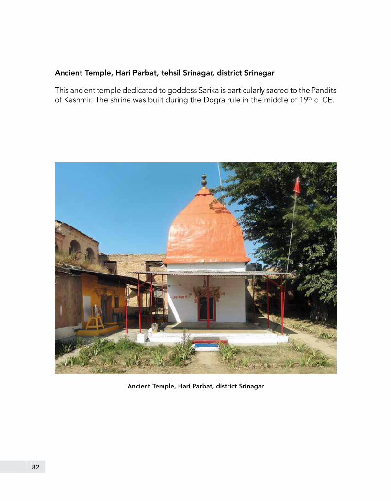
Ancient Temple, Hari Parbat, tehsil Srinagar, district Srinagar
This ancient temple dedicated to goddess Sarika is particularly sacred to the Pandits of Kashmir. The shrine was built during the Dogra rule in the middle of 19th c. CE.
Ancient Temple, Hari Parbat, district Srinagar

83
Group of Ancient temples, Naranag, tehsil Srinagar, district Ganderbal
Naranag is a village situated 6 km upstream from river Sindh, a tributary of Jhelum in the Ganderbal district. It is known for its cluster of temples dedicated to lord Siva. The Karkota King Lalitaditya Muktapida built them in the eighth century CE. They are divided into two groups, namely upper and lower or eastern and western. The main shrine in upper group and lower group are Jyeshtheswar and Bhuteshwar respectively. Apart from these two principal temples, there are many smaller temples, which existed originally. The original planning and orientation of the temple complex indicates that except Temple 3, the remaining structures belong to post- Lalitaditya period.
The main temple in the upper group is built on a flat terrace on a raised square plinth measuring 10.50 m. A flight of steps leads to the platform. The garbhagriha is square on plan, which measures 4.5 m on each side that has an access through a 1.5 m wide entrance. The interior is simple, walls devoid of any decorations; the ceiling is domical made of kanjur stones, which give it a pyramidal look from the exterior. It is adorned with trefoil niches on three sides externally. The eight subsidiary shrines built exactly on the same plan to the northern side of the main temple have no set direction. All the temples are surrounded by an enclosure wall

84
measuring 41 m x 45 m. A common gateway for this huge complex is located in the northern wall with pediments resting on independents columns on the front and back.
The lower group too surrounded by a massive wall measuring 42 m x 50 m having a two chambered gateway on the south western side. The main shrine faces south east and is built on a 1 m high platform to the north of complex. It is square on plan and measures 12 m from outside. The main entrance is on the eastern direction, which measures 5 m x 5 m. The architectural features of the main temple and subsidiary shrines are similar to the upper group.
Group of Ancient Temples, Naranag, district Ganderbal

85
Ancient Site and Remains, Burzahom, tehsil Hazratbal, district Srinagar
The ancient site of Burzahom is situated 16 km northeast of the capital city Srinagar on Naseem-Shalimar road on a high terrace, which is part of the floodplain of the Jhelum river and has karewa formation. It is a prehistoric settlement and regarded as the northernmost excavated Neolithic site in the country. In the local language, the word ‘Burzahom’ literally means ‘birch’ a tree species generally grow in the Himalayas.
It is an interesting fact-cum-discovery that the remains of birch tree wood was found in the excavations from the settlement area in the form of roofing material, which confirms its use during Neolithic times. The site was excavated and researched upon for ten years in 1960s by T.N. Khazanchi of ASI that brought to light many features like Neolithic and Megalithic phase of human occupation along with their food habits, economy, disposal of dead, inter-civilizational connection, etc.
The excavation at Burzahom brought to light four periods of continuous occupation, viz., Period I – Pre Pottery Neolithic (devoid of any pottery) and
Ancient Site of Burzahom, district Srinagar

86 Petroglyph depicting a hunting scene, Burzahom, district Srinagar
Period II is Pottery Neolithic, particularly characterized by dwelling pits, the largest measuring 2.74 m at the top to 4.75 m at the base at a depth of 3.95 m. The stone and bone tools and other implements from both the occupational levels of the Neolithic periods have revealed certain common types; in stone are axe, chisel, adze, hoe, point, wedge, celt, mace head, knife, pestle, quern, harvester, etc.; in bone are needle, harpoon, point, arrow, spear, etc. The presence of bone harpoons clearly indicate the exploitation of fish from the lakes located nearby.
Burzahom is also known for the evidence of disposal of dead in the form of burying the dead in the pits dug into the house floor. The pits of varying diameters ranging from 1 m to 2 m are generally narrower towards the top and plastered with chunam on the inner side. The bodies were buried with pots, tools and other objects of day-to-day life, indicating the belief in life after death. The ochre on the bones is a special feature here in human burials. At times animal were buried with the dead as pets, perhaps as part of ritual. The Palaeo-botanical remains indicate that wheat, barley and lentil were among the staple food along with meat and fish.
Period III belongs to Megalithic age as noted by the free standing large Menhirs stones. Period IV is attributed to the early Modern Period.

87
Ancient Monastery and Stupa together with adjacent land, Harwan, tehsil Srinagar, district Srinagar
Harwan identified with Shadarhadvana is said to be the centre of the fourth Buddhist Council held during the reign of Kanishka. Among the remains are three – Tiered base of a stupa, A set of rooms in diaper pebble style of masonry. The area around the stupa is paved with decorated tiles. The antiquities found include terracotta figures, and fragments of Buddha image and a few clay tablets bearing miniature stupas in relief.
Remains of Stupa at Harwan, district Srinagar
Ancient Monastery at Harwan, district Srinagar
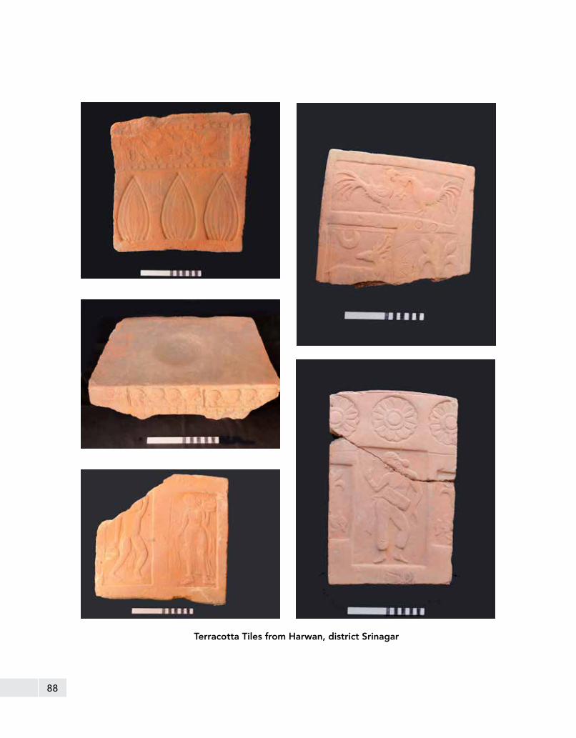
88
Terracotta Tiles from Harwan, district Srinagar

89
Group of arched terraces / structural complex, Pari Mahal, tehsil Srinagar, district Srinagar
Pari Mahal , which literally means Abode of Angel, is a six terraced garden with a total length of about 12 m and varying width from 55 m to 62 m. It is located in the south west of Dal lake at the top of Zabarwan mountain overlooking the Srinagar city. Dara Shikoh built it in 1645 CE during the reign of the Shah Jahan. It served as a library as well as an abode for him where he lived in the years 1640,1645 and 1654 CE.
In the uppermost terrace are the ruins of two structures, a barahdari facing the lake, and a water reservoir built against the mountainside. The reservoir was fed from above by a spring, which has since gone dry, and of which the only extant remains are the fragmentary stone conduit and the retaining wall against the hill-side. It is a simple chamber, built of rubble stones in lime with a façade of two small arches. Internally it measures 3.44 m x 1.53 m, and has a recess in each of its walls. Water flowed through an arched drain pierced in the front wall, which is now partially blocked up. At each corner of the terrace wall is a flight of steps leading to the lower terrace, measuring 7 m x 1.31 m.
Structural Complex at Pari Mahal, district Srinagar

90
In the middle of the second terrace and exactly in front of the barahdari is a large tank with brick sides measuring 12 m x 8 m. The façade of the retaining wall is ornamented with a series of twenty-one arches, including two of the side-stairs. The arches are built in descending order of height from the centre. Each of them is surmounted with a niche, the height of which increases in proportion to decrease in the height of the arch.
The third terrace is, architecturally, the most interesting portion of the garden. The entrance, which is of the usual Mughal type, arched in front and behind with a central domed chamber, is in the middle of the east wall, and is covered with a coat of fine painted plaster. On either side of it are a series of spacious cells: the one to its north seems to have functioned as a hamaam.
Fragments of the water pipes are still seen projecting from a corner of its domed ceiling. Its interior is relatively more decorated then the other chambers in the Pari Mahal. On the south side of the entrance are two chambers, but its function remains to be ascertained. Both of these chambers have pipes inserted into their ceilings, the one nearest the gateway has one pipe while the next one possesses two which was possibly used as a kitchen. The western half of the retaining wall has recently fallen; which also contained chambers similar to those on the other side. In the central recess of the arcade is visible the originally hidden earthen pipe which
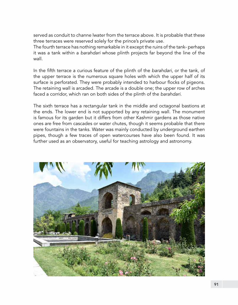
91
served as conduit to channe lwater from the terrace above. It is probable that these three terraces were reserved solely for the prince’s private use.The fourth terrace has nothing remarkable in it except the ruins of the tank- perhaps it was a tank within a barahdari whose plinth projects far beyond the line of the wall.
In the fifth terrace a curious feature of the plinth of the barahdari, or the tank, of the upper terrace is the numerous square holes with which the upper half of its surface is perforated. They were probably intended to harbour flocks of pigeons. The retaining wall is arcaded. The arcade is a double one; the upper row of arches faced a corridor, which ran on both sides of the plinth of the barahdari.
The sixth terrace has a rectangular tank in the middle and octagonal bastions at the ends. The lower end is not supported by any retaining wall. The monument is famous for its garden but it differs from other Kashmir gardens as those native ones are free from cascades or water chutes, though it seems probable that there were fountains in the tanks. Water was mainly conducted by underground earthen pipes, though a few traces of open watercourses have also been found. It was further used as an observatory, useful for teaching astrology and astronomy.

92
Shankaracharya Temple together with adjacent land, Kothi Bagh, Durganag, tehsil Srinagar, district Srinagar
The temple is located to the southeast of capital city Srinagar on Takht-i-Silaiman hill. The ancient name of the hill and temple respectively were Gopadri and Jyeshtheshvara., The Rajatarangini states that “King Gopaditya built a shrine of Jyeshthesvara on the Gopadri.” It is built on an octagonal platform with a parapet wall measuring about 7 m on all sides. It can be approached by flights of steps. The balustrades enclosed with two sidewalls bear a couple of same number of inscriptions in Persian dated to 1659 CE but are effaced hence not readable now.
The main shrine is square externally but circular from inside having diameter of about 4 m. A modern ceiling composed of flat stone slabs and wooden boards with the help of two lintels, which is supported on four columns, covers the interior of sanctum. Out of them, the one on southwest corner has two Persian inscriptions, which gives a date of 1644 CE. However, it is originally datable to seventh century CE. In later phase, the Mughal rulers especially Shah Jahan beautified the area around the temple by developing a garden with variety of tulips.
Shankaracharya Temple, district Srinagar

93

94
Ancient Site, Pandrethan, tehsil Srinagar, district Srinagar
The word ‘Pandrethan’ is derived from ‘Puranadhishthana’ meaning the old capital that is believed to have been founded by Mauryan emperor Ashoka in third century BCE and became an erstwhile capital when the capital shifted at the site of present Srinagar. His son named Jalauka is credited with the initiative of worship of Siva in the capital town, which was further developed by Huna King Mihirakula in sixth century CE with construction of a sanctuary called Mihireshvara devoted to the lord Shiva. The present village of Pandrethan is situated roughly 6 km from Srinagar on the Srinagar-Anantnag road and is known for its Siva Temple.
Excavated Remains, Pandrethan, tehsil Srinagar, district Srinagar
The ASI excavated the ancient site of Pandrethan in 1931. The excavation yielded besides several Buddhist sculptures, the remains of two dilapidated stone stupas and the quadrangular rubble-built enclosure possibly of a monastery, all assignable to the eighth century CE. Both the stupas were enclosed by compounded walls. No structural remains exist now. At present this area is under the occupation of the Indian army.
Pandrethan Temple together with adjacent land, Pandrethan, tehsil Srinagar, district Srinagar
It is one of the best-preserved temples of Siva of the sarvatobhadra type, located in the middle of a tank. It is relieved by figure sculptures, which are particularly remarkable on the ceiling. It has a two- tiered pyramidal roof while its four entrances show the usual type of pediment trefoil design. The edifice does not appear to be later than circa tenth century CE.

95
4.5 Monuments and Sites of Ladakh Region
Ladakh, literally ‘The Land of Passes’ is geographically the northern most part of India. It is a vast area of high altitude area bounded by Karakoram ranges in the north, Tibet on the east, Himachal Pradesh on the south and Baltistan on the west. The city of Leh is the capital of this region, which historically served as an important trading centre, connecting the plains of India on the south and regions of Yarkand, Khotan and Tibet on the north and east. Ladakh region has vast high altitude deserts such as Lingzi Thang (4880 m) and Kiunlun (5185 m). The region hardly receives any rainfall. The summer months have warm days and pleasant nights, while during winter it is exceedingly cold. At present, there are 14 Centrally Protected Monuments in the Ladakh region under the jurisdiction of Archaeological Survey of India, which are mostly living Buddhist monasteries and shrines, besides palaces, castles and rock cut sculptures and a stupa. The monasteries in general date back to 10th -11th c. CE to 16th 17th c. CE. The castle and stupa were built around 15th c. CE, while the rock cut sculptures dates back to Eighth-Ninth century CE. A brief account of each of them is given below.

96

97
Buddhist Monastery, Lamayuru, district Leh
The Buddhist monastery of Lamayuru is located in Lamayouru or Lamayuru on the Srinagar-Leh highway at a distance of 126 km from Leh. Originally, the monastery consisted of five independent buildings, and was the largest and oldest monastery in Ladakh region. In the 11th c. CE, Mahassidha Naropa came to this place and meditated in the cave which is still to be seen. When the great translator Rinchen Zangpo arrived there the teaching of kadampa sect flourished until the rule of King Jamyang Namgyal, 1580-1590 CE.

98
Buddhist Monasteries, Alchi, district Leh
Alchi is located at a distance of 65 km west of Leh and approachable from the Leh- Srinagar Highway. Popularly known as Alchi Choskor (Monastic Complex). It was established during the time of the great translator Rinchen Zangpo (958- 1055 CE). The Buddhist monastic complex of Alchi has three important components, viz., Dukhang (Assembly Hall), the Sumtsek (Three tiered temple) and the Temple of Manjusri. The other important temples are Lotsava Lakhang (Translator’s temple) and a modern temple namely Lakhang Soma.The monastery is well-known for its wall paintings depicting various mandalas and deities which are apparently executed with influence from Indian artistic tradition.

99
Monastery at Alchi, district Leh Painting of Tara at Buddhist Monastery, Alchi, district Leh

100
Buddhist Gonpa, Phyang, district Leh
The monastery is located at a distance of 17 kms from Leh city on Srinagar-Leh National Highway. It was built in the 16th c. CE during the time of king Tashi Namgyal. This is the first monastery of Drigungpa sect in Ladakh. It has one of the finest collections of thangkas and various wall paintings dating from 16th c. CE.
Ancient Palace, Leh, district Leh
The Leh Palace is a former royal palace located on the Tsemo hill in the town of Leh. King Tsewang Namgyal, the founder of Namgyal dynasty of Ladakh initiated its construction in 1553 CE. However, it was his nephew Sengge Namgyal, who completed it. The palace consists of nine storeys; the royal family used the upper floors for residential purpose, the lower ones had storerooms and stables. The royal family had to desert the palace and shift to Stok Palace in the mid 19th c. CE due to the invasion of Dogra forces. This dun-coloured palace is a dominant structure in Leh and provides a panoramic view of Leh and the surrounding areas.

101
The palace is built of stones, wood, mud and sand. The walls of the palace being constructed with wood and mud help keep the scorching heat away, thus creating a soothing and pleasant temperature inside. The entrance of the palace is decorated with wood carved figurines. Although the palace is in ruins, some small compartments, few spacious rooms and corridors still exist. Some murals that managed to remain visible in the dilapidated walls of the palace depict the majestic grandeur of the past. The famous Victory Tower constructed to commemorate the brave fight put up by the Ladakhi soldiers against the invading Balti Kashmiri soldiers in the 16th c. CE, lies above the palace.

102
Old Castle (Tsemo Hill), Leh, district Leh
The fort was built during the reign of King Tashi Namgyal around 16th c. CE. It is a four storied high building made of sun dried mud bricks and rammed earth walls. It enshrines a gonpa named Gon-Khang.
Old Castle (Tsemo Hill), Leh, district Leh

103
Remains of Stupa at Tisseru, district Leh
Stupa Tisseru, district Leh
The construction of this Stupa is attributed to King Gragspa Bumlde (1410-1440 CE). According to popular tradition, it was built to counter the evil effects of a spirit that dwell at the site inflicting harm to inhabitants of the region. It is the largest Stupa in the Ladakh region. Built of rubble stone and sun-dried brick masonry, it comprises lower and upper terraces and four walls built in ascending order, provided with three ambulatory passages. There is a circular drum with a partly preserved vaulted roof on its periphery, buttressed with radiating walls.

104
Ancient Palace, Shey, district Leh
The royal palace and shrine of Shey is located 16 kms to the east of Leh on Manali-Leh highway. It was built by the king Deldan Namgyal in the beginning of 17th century CE. Shey is also known as the ancient capital of Ladakh. A shrine inside the Palace complex enshrines a copper gilt statue of Buddha Sakyamuni rising to a height of three storeys, made by king Deldan Namgyal in memory of his father the great king Sengge Namgyal. This statue is the only one of its kind in the entire region. The Palace remained a royal residence of the Namgyal dynasty until the Dogra invasion in 1830’s.

105
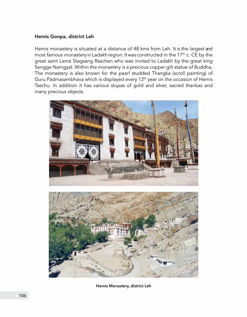
106
Hemis Gonpa, district Leh
Hemis monastery is situated at a distance of 48 kms from Leh. It is the largest and most famous monastery in Ladakh region. It was constructed in the 17th c. CE by the great saint Lama Stagsang Raschen who was invited to Ladakh by the great king Sengge Namgyal. Within the monastery is a precious copper gilt statue of Buddha, The monastery is also known for the pearl studded Thangka (scroll painting) of Guru Padmasambhava which is displayed every 12th year on the occasion of Hemis Tsechu. In addition it has various stupas of gold and silver, sacred thankas and many precious objects.
Hemis Monastery, district Leh

107
Ancient Gonpa, Thiksey, district Leh
Thiksey monastery is situated 19 kms from Leh on the top of a hill. It is a wonderful architectural complex resembling the great Potala Palace of Lhasa in Tibet. The Chamba Lhakhang at the monastery enshrines a 15 m tall beautiful statue of Buddha Maitreya. The monastery was founded by Paldan Sherab in the beginning of 15th c. CE.
Ancient Gonpa, Thiksey, district Leh

108
Shrine of Four Lords Gon-Khang (Tsemo Hill), Leh, district Leh
The shrine was built by King Tashi Namgyal who ruled from about 1500 to 1532 CE. During this period, the Mongol (Hor) soilders attacked Ladakh, however, the invaders were defeated in the battle and their dead bodies were buried beneath the foot of the statue of Jigched Gonbo, (Mahakala), the main protector deity, in order to repulse further attack from the borders. The walls of this shrine have a mural of a royal scene believed to be depicting the portrait of king Tashi Namgyal dressed in foreign attire.
109
Sculptures at Drass
Drass is located at a distance of 140 km from Srinagar at an altitude of 3300 m in the Kargil district, approached after crossing the Zoji La Pass,hence often called “the Gateway of Ladakh”. It was a flourishing town of Buddhist culture in historical period, remnants of which are still present here in the form of antiquarian remains. The four stone sculptures represent Maitreya, Avalokitshvara, a horse rider and a lotus flower and are assignable to circa eight century CE.
Sculptures at Drass, district Kargil

110
Buddhist Monastery, Likir
Buddhist Monastery, Likir
Likir is located at a distance of 52 km west of Leh, and the monastery here belongs to the Gelugpa sect of Buddhism. The monastery was founded during the reign of Lhachen Gyalpo, the fifth king of Ladakh by Lama Duwang Chosje around 1065 CE, who introduced Kadampa sect there. In 15th c. CE Lhawang Lodos came from central Tibet and introduced Gelugspa sect into the monastery. The monastery has two important assembly halls, known as Dukhangs.

111
Rock Cut Sculpture of Bodhisattva Maitreya, Mulbeg, district Kargil
Rock-cut sculpture, Mulbeg
A colossal rock-cut sculpture of standing image of Bodhisattva Maitreya is assignable stylistically to circa Eighth to Ninth century CE and is located in the village Mulbeg on the right side of Srinagar-Leh national highway. It combines Shaivite symbolism with early Buddhist art and is one of the largest rock carved sculpture in/of the Ladakh region.

112
Ancient Gonpa Complex Wanla, district Leh
The Ancient Gonpa Complex Wanla is about 122 Kms to the West of Leh and is constructed on the top of the hill overlooking the Wanla village. From architectural point of view the Sumstek or Chug-shig-zhal shrine (three tier gonpa) is similar to the Sumstek shrine of Alchi monastery assigned to 11th-12th c. CE. The Chug-shig-zhal shrine has three large niches with standing stucco images of Avalokiteshvara, Shakyamuni Buddha and Kaserpani Avalokiteshvara respectively. The walls are adorned with mural depicting Lord Buddha, Bodhisattvas, Mandalas, Wheel of Life and paintings of royal scenes. One of the interesting murals at upper level of the shrine is a portrait of Rinchen Zangpo (Ratna Baitra), the famous translator, philosopher known in the region. The earliest structures in the monastery complex are the dilapidated watch towers on the west side of the three tiered shrine (Chug-shig-zhal).

113

114

115

116
References
1. Agrawal, R.C. 1998. Kashmir & its Monumental Glory. Aryan Books International. New Delhi
2. Bamzai, P.N.K. 1994. Cultural and Political History of Kashmir: Ancient Kashmir (Vol.I). M.D. Publication. New Delhi
3. Joshi, J.P, Krishna Deva (Eds.). 1998 Inventory of Monuments and Sites of National Importance: Srinagar Circle (Vol I, Part 1). Archaeological Survey of India
4. Kak, R.C. 1933. Ancient Monuments of Kashmir. The Indian Society. London
5. Wadia, D.N. 1919. Geology of India. Macmillan & Co. Limited. London