january 22, 2021 by email officers christian klein, chair
TRANSCRIPT

January 22, 2021 BY EMAIL Christian Klein, Chair Zoning Board of Appeals Town of Arlington Arlington, MA 02476 re: Climate Resiliency Review, Mugar Lands Dear Christian: Attached for the Board’s consideration is a review of climate resiliency issues with respect to the proposed development of the Mugar site. State policy encourages, and common sense demands, that the reality of climate change be taken into account in evaluating any proposed development in this area that already experiences regular and severe flooding. A short-sighted view of the potential adverse consequences of development in the floodplain would carry increased risks to public health and safety beyond the site itself to the surrounding East Arlington neighborhoods. The Town of Arlington through its special permit process has demonstrated a commitment to requiring that any major development with significant environmental impacts must consider the effects of climate change. Such would be the case for any development proposed on this, the most environmentally sensitive land in the Town. That this project is being conducted under Chapter 40B cannot be an excuse to hold it to a lower standard. Thank you for your consideration. Very truly yours, Arlington Land Trust, Inc. by: Christopher Leich, President attachment: Weston & Sampson report ecc: Arlington Conservation Commission c/o Emily Sullivan Arlington Select Board c/o Lauren Costa
Officers
President Christopher Leich
Vice President Clarissa Rowe
Secretary Ann LeRoyer
Treasurer John F. Page
Directors Nellie Aikenhead
Peter Belknap
Carol Kowalski
Bancroft Poor
Brian Rehrig
Ted Siegan
Advisory Board Nora Frank
Cindy Friedman
Sean Garballey
Cathy Garnett
Jay Kaufman
Kevin Knobloch
Anne Paulsen
Dave Rogers

westonandsampson.com
55 Walkers Brook Drive, Suite 100, Reading, MA 01867
Tel: 978.532.1900
M E M O R A N D U M
TO: Arlington Land Trust
FROM: Indrani Ghosh, Resiliency Technical Leader, Weston & Sampson
DATE: January 20, 2021
SUBJECT: Resiliency review consultation services related to the East Arlington Mugar site
Weston & Sampson Engineers, Inc. (Weston & Sampson) is pleased to present this memorandum to
the Arlington Land Trust to summarize climate resiliency considerations of the Thorndike Place proposed
design at the East Arlington Mugar site (the “Site”) being developed by OakTree Development and
designed by BSC Group.
Executive Summary
The Arlington Land Trust (ALT) engaged Weston & Sampson to evaluate the climate resiliency of the
Thorndike Place design at the East Arlington Mugar site. This was presented through production of
talking points for the Zoning Board of Appeals (ZBA) meeting on December 22, 2020 and this
memorandum summarizing the review comments. The key considerations described in this
memorandum include the following:
1. Use of FEMA Data Compared to Neighboring Communities Standards
a. Current design relies solely on regulatory FEMA base flood elevation (Zone AE, 100-yr
floodplain, 6.8 ft NAVD88 elevation) and does not consider that the site is also located
in the FEMA 500-yr floodplain, nor does it consider the effects of sea level rise and
storm surge due to climate change.
b. The Amelia Earhart Dam actively affects flood elevations around the site. As reported in
the City of Cambridge’s Climate Change Vulnerability Assessment (CCVA), the Boston
Harbor Flood Risk Model (BH-FM) shows that the dam will likely be flanked in 2045 and
overtopped by 2055. This overtopping or circumventing could cause the flow of water to
be reversed, increasing the flood vulnerability of upstream communities.
c. Regional coordination is a crucial component of climate resiliency, and neighboring
communities of Cambridge and Boston have already considered future flooding for
resilient design.
2. Design Storm Depths

Page 2
Offices in: MA, CT, NH, VT, NY, NJ, PA, SC & FL westonandsampson.com
a. The stormwater management system presented by the BSC Group meets current rainfall
conditions, but it does not consider the increased magnitude of storm events in the
future, such as the climate change projections for the 2070s planning horizon.
b. Future MassDEP wetlands regulations will likely incorporate the NOAA Plus Method for
design storm depth, increasing the stormwater basin design size for most locations.
c. Future Climate Resilience Design Standards, as developed by the Resilient
Massachusetts Action Team (RMAT), include design standards for future extreme
precipitation. As demonstrated further in this memorandum, these percent increases in
precipitation exceed the design storm depths considered in the proposed design of the
Site.
3. Additional Resilient Design Issues:
a. Deployable flood barriers are not recommended for precipitation flooding due to time
needed for deployment and cost of retrofitting.
b. Buildings proposed to be in any flood hazard area must be designed in Base Flood
Elevation + 1 ft of freeboard, or the Design Flood Elevation, whichever is higher
according the Massachusetts State Building Code.
c. Provision of a compensatory flood storage ratio of 2 to 1 will minimize the area of
Bordering Land Subject to Flooding and regrade a portion of the Site, impacting flood
recovery.
d. Site design does not consider or propose methods to mitigate and protect against future
projections for extreme heat.
Background
History
The Site is located within a protected wetland in both a FEMA established 100-year floodplain and 500-
year floodplain. OakTree Development is utilizing the Chapter 40B statute to seek to bypass the
protected wetlands zoning regulations by providing a certain percentage of affordable housing in the
Thorndike Place development. These wetlands serve as flood storage, and there is concern that
developing on the wetlands will exacerbate an area that has already experienced extreme flooding
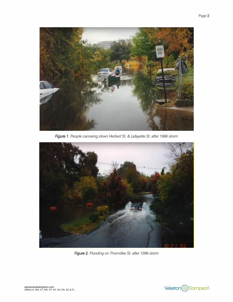
events in recent decades. Figures 1 through 7 depict scenes after some of these previous extreme storm
events. More images and videos of flooding events near the Mugar wetlands can be found at the
following link: https://www.youtube.com/watch?v=1QyLmZv1hAs
Page 3
Offices in: MA, CT, NH, VT, NY, NJ, PA, SC & FL westonandsampson.com
Figure 1. People canoeing down Herbert St. & Lafayette St. after 1996 storm
Figure 2. Flooding on Thorndike St. after 1996 storm

Page 4
Offices in: MA, CT, NH, VT, NY, NJ, PA, SC & FL westonandsampson.com
Figure 3. Flooding on Alewife Brook Parkway after 1996 storm
Figure 4. Car submerged on Herbert St. and Lafayette St. after 2001 storm

Page 5
Offices in: MA, CT, NH, VT, NY, NJ, PA, SC & FL westonandsampson.com
Figure 5. DPW pumping from Route 2 to into Mugar site wetlands during 2001 storm
Figure 6. Flooding seen on Fairmont St. after 2010 storm

Page 6
Offices in: MA, CT, NH, VT, NY, NJ, PA, SC & FL westonandsampson.com
Figure 7. People canoeing at Magnolia Playground after 2010 storm.
Current Design
The planned project will include a 176-unit multi-family housing complex, a percentage of which will be
designated as affordable housing. There will be 239 parking spaces, with 204 of these spaces located
below ground. The current design of the Thorndike Place development meets regulatory requirements,
with a 2 to 1 compensatory flood storage ratio, as well as a design flood elevation (DFE) in accordance
with FEMA’s 100-year base flood elevation (BFE). The first floor of livable units has a DFE of 13 feet
NAVD88, while the DFE of the underground parking garage is unknown. Various stormwater
management systems are included in the current design such as a rooftop detention system, a trench
drain, a deep sump catch basin, porous asphalt, and deployable flood barriers. A HydroCAD model
was used to model the watershed, comparing both pre-development and post-development conditions
of the Site. However, the proposed design does not consider sea level rise (SLR), storm surge (SS), and
precipitation effects that are very likely to occur during the useful life of the proposed development due
to climate change. With the current design of the proposed development, it is likely that the residents
who will be inhabiting the planned affordable housing units as well as neighboring Arlington residences
may be subject to significant flooding effects when an extreme storm hits.

Page 7
Offices in: MA, CT, NH, VT, NY, NJ, PA, SC & FL westonandsampson.com
Figure 8. BSC Group's conceptual site plan, as of September 2020
FEMA Regulations vs. Neighboring Communities
Portions of the Site lie in both the 100-year floodplain and the 500-year floodplain, as established by the
Federal Emergency Management Agency (FEMA). Current Massachusetts legislature requires that
buildings be designed to the 100-year BFE, which is the elevation that Thorndike Place design relies on
at 6.8 feet NAVD88. Although this is the regulatory DFE for Massachusetts developments, FEMA
published that, “BFEs reflect estimates of flood risk, but there are many unknown factors that can cause
flood heights to rise above the BFE, such as wave action, bridge and culvert openings being blocked
by debris, and development in the floodplain. It is important to remember that floods more severe than
the 1- percent-annual-chance event can and do occur.”1
This indicates that designing to the 100-year
base flood elevation area may not be enough to prevent flood damage, especially in areas that are
prone to flooding. Since the Site is additionally located within the 500-year floodplain, there are further
concerns about the current design of the Thorndike Place development. According to flood profiles of
1 FEMA , Building Higher in Flood Zones: Freeboard – Reduce Your Risk, Reduce Your Premium
https://www.fema.gov/media-library-data/1438356606317-
d1d037d75640588f45e2168eb9a190ce/FPM_1-pager_Freeboard_Final_06-19-14.pdf

Page 8
Offices in: MA, CT, NH, VT, NY, NJ, PA, SC & FL westonandsampson.com
Alewife Brook (Little River)2
created by FEMA, the 500-year elevation for the Site is 10.75 feet NAVD88.
Furthermore, all of FEMA’s elevations for the Site are based on data collected up to June 4, 2010, and
do not consider SLR or SS effects due to climate change. The first floor living space for the Thorndike
Place development is designed at an elevation of approximately 13 feet-NAVD88, making it suitable for
projected SLR and SS effects, but the underground parking area is at a severe risk of flooding.
Figure 9. FEMA FIRMette for Site
One factor that FEMA’s 100-year BFE does not consider is the effect that SLR and SS are predicted to
have on nearby infrastructure such as the Amelia Earhart Dam (AED) in Somerville. This dam affects
flood elevations along the Mystic River, Lower Mystic Lake, and Alewife Brook (Little River). According
to the Cambridge Climate Change Vulnerability Assessment, which utilizes the Boston Harbor Flood
Risk Model (BH-FRM), the AED is likely to be flanked by 2045 and overtopped by 2055. If the AED is
flanked and overtopped, it implies that the coastal flooding from the Boston Harbor will affect the
2 FEMA, Flood Profiles, Alewife Brook (Little River), p. 11P – 13P.
https://map1.msc.fema.gov/data/25/S/PDF/25017CV003C.pdf?LOC=78020f32f89217822e61ed46a9aab90e

Page 9
Offices in: MA, CT, NH, VT, NY, NJ, PA, SC & FL westonandsampson.com
proposed development site, and the site is likely to experience a greater than 20% annual probability of
flooding by 2070.3
The Department of Conservation and Recreation (DCR) is actively undertaking a
Feasibility Analysis on raising and extending the AED and pursuing this effort in coordination with
regional resiliency efforts. The timeline for these improvements is uncertain, which is why the Thorndike
Place Development should consider these future flooding impacts. Figure 10 shows a map of the 1%
annual chance flood depth projected throughout Arlington for 2070 by the BH-FRM, which was the
model used in the Cambridge Climate Change Vulnerability Assessment. This map indicates a
projected flood depth of at least 10 feet throughout the Mugar site.
Figure 10. Map from the BH-FRM showing the 2070 1% Annual Chance Flood
Regional coordination is a crucial component of climate resiliency. Coordination and collaboration
across communities, State Agencies, and jurisdictions can help strengthen resilient designs and
implementation. Similar to Cambridge conducting a Climate Change Vulnerability Assessment, other
neighboring communities have taken advantage of updated climate change data in designing new
developments. Boston has included coastal flood resilient design that accounts for SLR and SS
projections from the BH-FRM developed by the Woods Hole Group for MassDOT. These projections
3 “Climate Change Vulnerability Assessment. Part 2.” February 2017. https://www.cambridgema.gov/-
/media/Files/CDD/Climate/vulnerabilityassessment/finalreport_ccvapart2_mar2017_final2_web.pdf

Page 10
Offices in: MA, CT, NH, VT, NY, NJ, PA, SC & FL westonandsampson.com
are currently being updated as part of the Massachusetts Coastal Flood Risk Model (MC-FRM), which
will serve as new design standards for buildings and infrastructure projects across the Commonwealth
and will be recommended that cities and towns adopt. Prior to the MC-FRM flood elevations being
available, the BH-FRM elevations can serve as a minimal estimate of future projections at the proposed
site, as the MC-FRM has consistently projected higher elevations for adjacent areas. Additionally, the
City of Cambridge is recommending that all new developments build to the higher of the precipitation
or SLR/SS 2070 10-year flood elevation, as well as having the ability to recover from the higher of the
precipitation or SLR/SS 2070 100-year flood elevation.
Design Storm Depths
In the November 2020 Stormwater Report, prepared by the BSC Group, design of the stormwater
management system was stated to exceed the provisions of the Department of Environmental Protection
(DEP) Stormwater Management Standards. HydroCAD Stormwater Modeling Software was used to
model the watershed, comparing both pre-development and post-development conditions of the Site.
The HydroCAD model analyzed the following recurrence intervals and inches of precipitation over 24
hours, shown in Table 1, below. The design storm depth values that were used for the HydroCAD
analysis may meet the rainfall conditions outlined by the current regulatory DEP standards, but they do
not accurately consider the increased magnitude of storm events predicted out to the 2070s planning
horizon. For example, research on what climate change projections neighboring communities of
Cambridge and Boston are using demonstrates that the present-day 100-yr storm event is comparable
to the 25-yr storm in 2070.
As discussed in the MassDEP Stormwater Advisory Committee Meeting on September 22, 2020,
MassDEP is currently evaluating updating the wetlands regulations to “incorporate the risk observed in
the current data to reflect the range of larger observed storms and provide greater resiliency for
infrastructure than National Oceanic Atmospheric Administration (NOAA) Atlas 14 design values.”4
These updated statewide stormwater standards would include the NOAA Atlas 14 Plus Method for
determining design standards for precipitation. The NOAA Atlas 14 Plus Method uses 0.9 times the
upper confidence interval of the NOAA Atlas 14 estimate of the 24-hour rainfall depth as a standard for
resilient design. MassDEP states that these larger stormwater controls will be better able to
accommodate runoff from larger storms and therefore will likely increase the stormwater basin size at
most locations.5
Expected in early 2021 is the release of the Climate Resilience Design Standards and Guidelines on
ResilientMA.org developed by the Resilient MA Action Team (RMAT). Led by the Executive Office of
Energy and Environmental Affairs (EEA) and the Massachusetts Emergency Management Agency
(MEMA), the RMAT is an interagency steering committee responsible for implementation, monitoring,
4 MassDEP Stormwater Advisory Committee Meeting 3. September 22, 2020.
https://www.mass.gov/doc/stormwater-advisory-committee-meeting-3-presentation/download
5 MassDEP Meeting Summary. September 22, 2020. https://www.mass.gov/doc/stormwater-advisory-committee-
meeting-3-summary/download

Page 11
Offices in: MA, CT, NH, VT, NY, NJ, PA, SC & FL westonandsampson.com
and maintenance of the State Hazard Mitigation and Climate Adaptation Plan (SHMCAP)6
. These design
standards and guidance are for State projects and expected as a resource for MVP projects and other
grants. While not regulatory for this project, these standards will be implemented statewide and provide
recommendations for design for extreme precipitation.
Climate resilient design for the average level of effort (“Tier 2”), as proposed by the RMAT Standards,
include percent increases for NOAA Atlas 14 estimates. These percent increases for the mid-century
(2030/2050) and late-century (2070/2090) show greater design storm depths than used for the proposed
project. A comparative representation of the precipitation depths discussed in this memorandum is
shown in Figure 11, with the corresponding values indicated in Table 1, below. It is recommended that
these updated precipitation depths be evaluated within the HydroCAD model to appropriately design a
stormwater management system at the Site that will be effective in the 2070s planning horizon.
Figure 11. Comparison of Total Storm Depths
6 Resilient Massachusetts Action Team (RMAT), 2020. https://www.mass.gov/info-details/resilient-ma-action-
team-rmat

Page 12
Offices in: MA, CT, NH, VT, NY, NJ, PA, SC & FL westonandsampson.com
Table 1. Total Storm Depth (inches/24-hours) comparison across sources and standards.
Recurrence
Interval NOAA Atlas 14
(in/24-hr)7
Values used in
the HydroCAD
Model (in/24-hr)
NOAA Plus
(in/24-hr)
RMAT Tier 2
Mid-Century
(in/24-hr)
RMAT Tier 2
Late-Century
(in/24-hr)
2-yr 3.27 3.23 3.62 3.53 3.92
10-yr 5.16 4.90 5.76 5.57 6.19
25-yr 6.34 6.20 7.47 6.85 7.61
50-yr 7.21 7.23 8.70 7.79 8.65
100-yr 8.16 8.89 10.35 9.06 10.36
200-yr 9.35 NA 11.88 10.75 12.72
500-yr 11.2 NA 14.76 12.88 15.23
Additional Resilient Design Issues
Deployable Flood Barriers
The BSC Group stated in the December 8, 2020 ZBA Meeting that they had considered projections for
extreme precipitation and consequent flooding in 2070 and proposed the use of deployable flood
barriers to protect the Site against flood waters. Deployable flood barriers, however, are not
recommended for precipitation flooding due to installation time in preparation of the storm event and
preliminary cost of retrofitting. There are pre-installation site modifications required for use of these
barriers with structural considerations that have not yet been acknowledged or specified by the BSC
Group.
Operational capacity is essential for the effectiveness of deployable flood barriers. Example operational
considerations include installation needs (time range for deployment, manpower, installation cost, etc.),
repair during storm event, retraction needs, storage, and re-use of the products. Furthermore, the use
of deployable flood barriers does not consider how barrier protection will impact adjacent properties
and affect the stormwater management system design. Please refer to the Boston Public Works
Department Climate Resilient Design Standards and Guidelines for Protection of Public Rights-of-Way
for further considerations8
.
7 NOAA Atlas 14 Point Precipitation Frequency Estimates.
https://hdsc.nws.noaa.gov/hdsc/pfds/pfds_map_cont.html
8 Climate Resilient Design Standards & Guidelines for Protection of Public Rights-of-Way
https://www.boston.gov/sites/default/files/embed/file/2018-
10/climate_resilient_design_standards_and_guidelines_for_protection_of_public_rights-of-
way_no_appendices.pdf

Page 13
Offices in: MA, CT, NH, VT, NY, NJ, PA, SC & FL westonandsampson.com
Base Flood Elevation
Buildings proposed to be located in any flood hazard area must be designed in accordance with ASCE
24 guidelines9
. ASCE 24 requires a minimum elevation of the lowest floor as the BFE + 1 foot of
freeboard, or the DFE, whichever is higher.
Compensatory Flood Storage Ratio
Provision of a compensatory flood storage ratio of 2 to 1 in southeast quadrant of the Site will minimize
the area of Bordering Land Subject to Flooding and regrade a portion of the Site, impacting flood
recovery. More detail into how the 2:1 compensatory storage ratio was achieved should be provided.
Urban Heat Island Effect
Review of available design documents for the Site does not indicate how development will change land
surface temperatures or mitigate the already increasing urban heat island effect. Furthermore, the
current Site design does not consider or propose methods to mitigate and protect against future
projections for extreme heat.
Taken from the Town of Arlington Community Resilience Building 2018 Report, Figure 12 depicts the
current heat island analysis for the Arlington area based on land surface temperature10
. This figure
demonstrates that the Site is one of limited areas within the Town that has lower land surface
temperatures. The Cambridge CCVA further shows that ambient air temperatures are projected to
increase through 2070, becoming dangerous to human health, worsening the situation for already
vulnerable populations expected to be living on the Site11
.
With changes in land cover and removal of existing vegetated species, it is essential to evaluate how
extreme heat could be exacerbated or mitigated at the Site. The proposed building footprint is
approximately 1.2 acres, not including the paved parking area with 35 parking spots located adjacent
to the building.
9 https://ascelibrary.org/doi/book/10.1061/9780784413791 10
Town of Arlington Community Resilience Building Workshop Summary of Findings & Recommendations. May
2018. https://www.mass.gov/doc/2017-2018-mvp-planning-grant-report-arlington/download
11 “Climate Change Vulnerability Assessment. Part 1.” November 2015. https://www.cambridgema.gov/-
/media/Files/CDD/Climate/vulnerabilityassessment/ccvareportpart1/cambridge_november2015_finalweb.pdf

Page 14
Offices in: MA, CT, NH, VT, NY, NJ, PA, SC & FL westonandsampson.com
Figure 12. Arlington Land Surface Temperature Map, 2018

Page 15
Offices in: MA, CT, NH, VT, NY, NJ, PA, SC & FL westonandsampson.com
Summary of Recommendations
The Town of Arlington has historically experienced extreme flood events and therefore, the design of
future developments within the Town should consider increased sea level rise, storm surge, and
precipitation projections due to climate change. The Mugar site has previously been used as an area
for flood storage, and as such should use extreme caution in development planning. The current design
of the Thorndike Place Development does not utilize the best available climate data for this location, and
therefore the impacts of the proposed development under future climate scenarios should be assessed.
Weston & Sampson Engineers, Inc. provides the following recommendations regarding the design of
the Thorndike Place Development:
1. Coordinate to discuss flood elevation findings from Climate Change Vulnerability Assessments
conducted by surrounding municipalities and utilize the findings to come up with a DFE that
would provide flood protection for the 2070s planning horizon.
2. Utilize updated 24-hr design storm depths in the HydroCAD model to appropriately design a
stormwater management system that will be effective in the 2070s planning horizon. The RMAT
Tier 2 Methodology provides percent increases to the NOAA Atlas 14 design depths used in the
current design of the Thorndike development. The efficacy of the proposed stormwater
management at the Site should be assessed using the recommended RMAT Tier 2 Late Century
percent increases.
3. Consider alternative means of flood protection since relying on deployable flood barriers are not
recommended for precipitation flooding due to installation time in preparation of the storm event
and preliminary cost of retrofitting.
4. Consider how provision of a compensatory flood storage ratio of 2 to 1 in the southeast quadrant
of the Site will minimize the area of Bordering Land Subject to Flooding and regrade a portion of
the Site, impacting flood recovery.
5. Provide information on how development of the Site will change land surface temperatures to
prevent exacerbating the already increasing urban heat island effect.
Limitations
Weston & Sampson has completed this memorandum for the Arlington Land Trust based on the level
of information provided about the project to this date. The opinions presented within the memorandum
are not intended for final opinions for construction and will continue to be vetted with future design
changes. Within the limitations of scope, schedule, and budget, our services have been executed in
accordance with the generally accepted practices in this area at the time this memorandum was
prepared. No warranty, expressed or implied, is given.

Page 16
Offices in: MA, CT, NH, VT, NY, NJ, PA, SC & FL westonandsampson.com
List of Acronyms
AED – Amelia Earhart Dam
ALT – Arlington Land Trust
BFE – Base Flood Elevation
BH-FRM – Boston Harbor Flood Risk Model
CCVA – Climate Change Vulnerability Assessment
DCR – Department of Conservation and Recreation
DEP – Department of Environmental Protection
DFE – Design Flood Elevation
EOEEA – Executive Office of Energy and Environmental Affairs
FEMA – Federal Emergency Management Agency
MC-FRM – Massachusetts Coastal Flood Risk Model
MEMA – Massachusetts Emergency Management Agency
NOAA – National Oceanic Atmospheric Administration
RMAT – Resilient Massachusetts Action Team
SHMCAP – State Hazard Mitigation and Climate Adaptation Plan
SLR – Sea Level Rise
SS – Storm Surge
ZBA – Zoning Board of Appeals

Page 17
Offices in: MA, CT, NH, VT, NY, NJ, PA, SC & FL westonandsampson.com
Glossary
Terms Description
100-year floodplain
Area with a 1% annual chance of flooding (or 1 in 100 chance)1
. Also known as a
1% Annual Exceedance Probability (AEP) flood event (see definition for Annual
Exceedance Probability below).
500-year floodplain
Area with a 0.2% annual chance of flooding (or 1 in 500 chance).1
Also known as
a 0.2% Annual Exceedance Probability (AEP) flood event (see definition for
Annual Exceedance Probability below).
Accommodate Adaptation strategy that mitigates the potential impact of a hazard by making
space for, or buffering, the associated climate condition.
Adaptation An action that seeks to reduce vulnerability and risk to an anticipated climate
impact. For the Tool, this term is focused on the design of physical assets only.
Annual Exceedance Probability (AEP)
Probability of a flood event being equaled or exceeded in a given year.
Base Flood Elevation (BFE)
The elevation of surface water resulting from a flood that has a 1% chance of
equaling or exceeding that level in any given year.
Best Practices Successful activities exemplified in case studies. Available to provide examples
for how the Guidelines are best applicable to a project.
Boston Harbor Flood Risk Model (BH-FRM)
A hydrodynamic model created in 2015 to identify projected flood risk and depth
from coastal storms and sea level rise.
Climate Change
According to SHMCAP, climate change refers to “a change in the state of the
climate that can be identified by statistical changes of its properties that persist
for an extended period, whether due to natural variability or as a result of human
activity.”
Design Flood Elevation (DFE)
The anticipated flood elevation to which an asset should be designed, to protect
the asset.
Design Storm
The magnitude and temporal distribution of precipitation from a storm event
defined by probability of occurrence (e.g., five-year storm) and duration (e.g., 24
hours), used in the design and evaluation of stormwater management systems.
Flood Insurance Rate Map (FIRM)
Official map of a community on which FEMA has delineated the Special Flood
Hazard Areas (SFHAs), the Base Flood Elevations (BFEs), and the risk premium
zones applicable to the community, based on historic information.
Freeboard Freeboard is a factor of safety usually expressed in feet above a flood level for
purposes of floodplain management.
Risk
According to SHMCAP, risk is defined as “the potential for an unwanted
outcome resulting from a hazard event, as determined by its likelihood and
associated consequences; and expressed, when possible, in dollar losses. Risk
represents potential future losses, based on assessments of probability,
severity, and vulnerability.”
Sea level rise (SLR)
The worldwide average rise in mean sea level, which may be due to a number
of different causes, such as the thermal expansion of sea water and the addition
of water to the oceans from the melting of glaciers, ice caps, and
ice sheets; contrast with relative sea-level rise.

Page 18
Offices in: MA, CT, NH, VT, NY, NJ, PA, SC & FL westonandsampson.com
Storm Surge (SS)
An abnormal rise in sea level accompanying a hurricane or other intense storm,
whose height is the difference between the observed level of the sea surface
and the level that would have occurred in the absence of the cyclone.
Tidal Benchmarks
Tidal datums are standard elevations defined by a certain phase of the tide and
are used as reference to measure local water levels. Such datums are
referenced to known fixed points called tidal benchmarks.

Page 19
Offices in: MA, CT, NH, VT, NY, NJ, PA, SC & FL westonandsampson.com
References
“Alewife Area Floods Near Mugar Wetlands”. May 13, 2015. https://www.youtube.com/watch?v=
1QyLmZv1hAs
“Climate Change Vulnerability Assessment. Part 1.” November 2015. https://www.cambridgema.gov/-
/media/Files/CDD/Climate/vulnerabilityassessment/ccvareportpart1/cambridge_november2015
_finalweb.pdf
“Climate Change Vulnerability Assessment. Part 2.” February 2017. https://www.cambridgema.gov/-
/media/Files/CDD/Climate/vulnerabilityassessment/finalreport_ccvapart2_mar2017_final2_web.
Climate Resilient Design Standards & Guidelines for Protection of Public Rights-of-Way
https://www.boston.gov/sites/default/files/embed/file/2018-
10/climate_resilient_design_standards_and_guidelines_for_protection_of_public_rights-of-
way_no_appendices.pdf
FEMA , Building Higher in Flood Zones: Freeboard – Reduce Your Risk, Reduce Your Premium
https://www.fema.gov/media-library-data/1438356606317-
d1d037d75640588f45e2168eb9a190ce/FPM_1-pager_Freeboard_Final_06-19-14.pdf
FEMA, Flood Profiles, Alewife Brook (Little River), p. 11P – 13P.
https://map1.msc.fema.gov/data/25/S/PDF/25017CV003C.pdf?LOC=78020f32f89217822e61e
d46a9aab90e
NOAA Atlas 14 Point Precipitation Frequency Estimates.
https://hdsc.nws.noaa.gov/hdsc/pfds/pfds_map_cont.html
MassDEP Stormwater Advisory Committee Meeting 3. September 22, 2020.
https://www.mass.gov/doc/stormwater-advisory-committee-meeting-3-presentation/download
MassDEP Meeting Summary. September 22, 2020. https://www.mass.gov/doc/stormwater-advisory-
committee-meeting-3-summary/download
Resilient Massachusetts Action Team (RMAT), 2020. https://www.mass.gov/info-details/resilient-ma-
action-team-rmat

Page 20
Offices in: MA, CT, NH, VT, NY, NJ, PA, SC & FL westonandsampson.com
Town of Arlington Community Resilience Building Workshop Summary of Findings &
Recommendations. May 2018. https://www.mass.gov/doc/2017-2018-mvp-planning-grant-
report-arlington/download