january 6-8 2017 cold snap - · pdf filejanuary 6-8 2017 cold snap arctic ‘norther...
TRANSCRIPT

January 6-8 2017 Cold Snap
Arctic ‘Norther Brings Dangerous Cold to RGV

Valley-Wide Freeze on January 7th
is First in Nearly Six Years
_____________________________________
Hard, Dry Freezes Cover Part of Valley and All of Ranches; Grasses Cured
Overview This time, it came without the ice. It had been nearly six years, but on January 7, 2017, the entire Valley and Deep South Texas ranchlands fell to at least 32°F – for the first time since February 5, 2011, the day after the famous ice storm of February 3 and 4, 2011. This time, the front initially followed the script of the “sharp change” “Gray” ‘norther; for the second time in a little more than two weeks, afternoon-to-afternoon temperature differences between balmy January 5 and brisk January 6 fell more than 40 degrees in most locations. Biting north winds made it feel much colder; at 2 PM on the 6th, wind chill readings ranged through the upper 20s across the Lower and Mid Valley, an apparent temperature plunge of more than 50°F. Each crash was virtually identical to the plunge between December 17 and 18, 2016 – only with starting points on the 5th about 10 degrees lower. That alone would be a story itself – the last time there were two such crashes in a single season was during the winter of 2013/14 (December-February) when there were two cases (three if including the biggest slam of them all, March 2-3, 2014). But the story continued through the weekend of January 7 and 8. A deeper surge of arctic air, higher up in the atmosphere than the typical “gray ‘norther” of the Valley, allowed clearing skies and even colder air to invade all of Deep South Texas after midnight, bottoming out just after sunrise on the 7th. Despite sunny skies for all but the Lower Valley, afternoon temperatures struggled through the 40s as stiff north winds continued. Lighter winds and remaining dry air under clear skies Saturday night into early Sunday (January 8) allowed radiation to do its thing and cool the surface even lower by sunrise on the 8th for all but the Lower and Mid Valley (where a band of clouds slid west from the arctic air moving over the still warm Gulf and held temperatures up long enough to preclude a second freeze). Rapidly moderating air returned by the afternoon of the 8th, with 60°F temperatures ending the chill.

January 7: Coldest “Feeling” Day Since February 3, 2011 Through the evening of the 6th, temperatures which had crashed into the mid to upper 30s actually rose toward 40 as the cloud bases rose above what had been a close to the surface freezing level (just 750 feet above the ground) and into the teeth of an atmospheric inversion, where temperatures were in the 40s and even the lower 50s. Just before midnight, the anticipated surge of drier air raced into the Upper Valley, and by 2 to 3 AM was off the coast and well south into Mexico south of the Rio Grande. With the inversion broken, the cold air dam “broke” and temperatures began falling at 1 to 2°F per hour. By 8 AM CST, all areas had fallen to or below 32°F, and many locations nestled in the upper 20s before sunshine eased readings above freezing by 10 AM in most areas. Locations mainly in the livestock/ranch region north of the populated Rio Grande Valley, recorded a hard freeze (temperatures ≤27°F for 2 or more hours) for the first time in large coverage since February 5, 2011. Hard freeze duration generally ranged from 2 to 4 hours, mainly across the northern ranchlands from north of Zapata through Sarita and Armstrong. Continued brisk north winds at 15 to 25 mph near the coast and 10 to 20 mph inland pushed wind chills, or “feels like” temperatures, into the bitter (by Valley standards ) teens to lower 20s. As mentioned in the Overview, full sunshine helped push temperatures into the 45 to 50°F range across the Mid and Upper Valley, as well as the ranchlands. Closer to the coast, that sunshine was short lived as northeast flow in the few thousand feet above the surface pushed the mass of clouds that had formed when the cold air surged over initially warm (67 to 73°F) Gulf waters onshore by late morning (below). For Port Isabel to South Padre, air temperatures held in the upper 30s and “feels like” temperatures locked down in the 20s, right through the afternoon before a slow rise into the lower 40s as the low clouds temporarily insulated the surface.
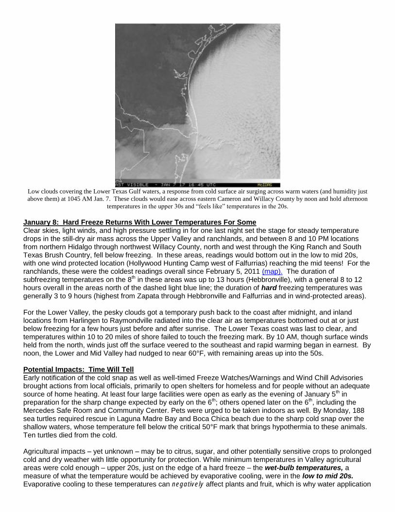
Low clouds covering the Lower Texas Gulf waters, a response from cold surface air surging across warm waters (and humidity just
above them) at 1045 AM Jan. 7. These clouds would ease across eastern Cameron and Willacy County by noon and hold afternoon
temperatures in the upper 30s and “feels like” temperatures in the 20s. January 8: Hard Freeze Returns With Lower Temperatures For Some Clear skies, light winds, and high pressure settling in for one last night set the stage for steady temperature drops in the still-dry air mass across the Upper Valley and ranchlands, and between 8 and 10 PM locations from northern Hidalgo through northwest Willacy County, north and west through the King Ranch and South Texas Brush Country, fell below freezing. In these areas, readings would bottom out in the low to mid 20s, with one wind protected location (Hollywood Hunting Camp west of Falfurrias) reaching the mid teens! For the ranchlands, these were the coldest readings overall since February 5, 2011 (map). The duration of subfreezing temperatures on the 8th in these areas was up to 13 hours (Hebbronville), with a general 8 to 12 hours overall in the areas north of the dashed light blue line; the duration of hard freezing temperatures was generally 3 to 9 hours (highest from Zapata through Hebbronville and Falfurrias and in wind-protected areas). For the Lower Valley, the pesky clouds got a temporary push back to the coast after midnight, and inland locations from Harlingen to Raymondville radiated into the clear air as temperatures bottomed out at or just below freezing for a few hours just before and after sunrise. The Lower Texas coast was last to clear, and temperatures within 10 to 20 miles of shore failed to touch the freezing mark. By 10 AM, though surface winds held from the north, winds just off the surface veered to the southeast and rapid warming began in earnest. By noon, the Lower and Mid Valley had nudged to near 60°F, with remaining areas up into the 50s. Potential Impacts: Time Will Tell Early notification of the cold snap as well as well-timed Freeze Watches/Warnings and Wind Chill Advisories brought actions from local officials, primarily to open shelters for homeless and for people without an adequate source of home heating. At least four large facilities were open as early as the evening of January 5th in preparation for the sharp change expected by early on the 6th; others opened later on the 6th, including the Mercedes Safe Room and Community Center. Pets were urged to be taken indoors as well. By Monday, 188 sea turtles required rescue in Laguna Madre Bay and Boca Chica beach due to the sharp cold snap over the shallow waters, whose temperature fell below the critical 50°F mark that brings hypothermia to these animals. Ten turtles died from the cold. Agricultural impacts – yet unknown – may be to citrus, sugar, and other potentially sensitive crops to prolonged cold and dry weather with little opportunity for protection. While minimum temperatures in Valley agricultural areas were cold enough – upper 20s, just on the edge of a hard freeze – the wet-bulb temperatures, a measure of what the temperature would be achieved by evaporative cooling, were in the low to mid 20s. Evaporative cooling to these temperatures can negatively affect plants and fruit, which is why water application

is highly discouraged on dry and windy nights. More information on the degree of crop damage should be available by late winter 2017.
Reasons for the Cold Snap Unlike most “Gray ‘northers” that affect the Rio Grande Valley, the January 6-8 event began gray but turned blue – as in blue (clear) sky – which made all the difference in bringing the brunt of the modified arctic air mass deep into the subtropics. At the surface, the core of the high pressure was among the strongest in recent years (1041+ mb) and reached all the way across the Rio Grande (first graphic, below). The strong surface high was aided by what is known as “cross-polar” atmospheric flow (second graphic) where steering originates in the arctic and “dives” southward across western Canada before curving east toward the Great Plains, Mississippi Valley, and sometimes becoming a broad “bowl” to cover the entire eastern U.S. The reduction of clouds, though only briefly near the coast, was partly the result of no subtropical jet (southwesterly flow that originates in the eastern tropical or subtropical Pacific and “overruns” the cold dome near the surface). Without the overrunning surface – which brings prolonged drizzle and temperatures that typically settle above freezing but move little day or night – skies were able to clear and the very cold air was allowed to drain all the way to the coast by the morning of the 7th. The strong surface high was able to settle across the Mid and Upper Valley for about 36 hours, allowing two consecutive nights with a widespread freeze (second night covered nearly 90% of the region). The multi-night, widespread freeze – like the overall event itself – was the first for Deep South Texas since February 3-5, 2011.

500 mb (~18.000 feet) steering pattern across the U.S. and southern Canada. The flow from the northwest (lines are “pointed” in the
direction of the wind) at this level, extending all the way to the surface from late on January 6th
through early on January 8th
, cleared
out skies and maximized the ability for temperatures to fall below freezing.