jerusalem model at the holyland hotel - josh & sally vis · jerusalem model at the holyland...
TRANSCRIPT

1
JerusalemModel at the
Holyland HotelThe photographs of the model at the Holyland Hotel were taken with the permission and courtesy of the hotel.

2
Map of Jerusalem in 1st century A.D.
Map1. This map provides a bird’s-eye view of Jerusalem in the Second Temple period.2. The map gives the primary features of the model, including the three walls, the
Temple and Temple Mount, the Antonia Fortress, the Pools of Bethesda, thehippodrome, the City of David, the theater, Herod’s palace, and the tower ofPsephinus.
3. It also includes an inner wall (along the east side of the Western Hill) that hassince been removed from the model.

3
Model from west panorama
Introduction1. The model represents the city in 66 A.D., prior to its destruction. This was in
essence, “Jerusalem at its peak”, before the Jewish Revolt began.2. The model is the largest of its kind. Work on it began in the early 1960s, and it
was used as a means of study when there was no access to the Old City ofJerusalem, which was controlled by Jordan until 1967. Mr. Hans Kroch boughtthis entire hill where his son was killed, and built the hotel and model here.
3. Michael Avi-Yonah, a leading expert of Second Temple period Jerusalem, designedthe general plan. His wife, an artist, supplied the details.
4. The model is built exactly to scale, and has the same drainage problems as the cityof Jerusalem.
5. The primary sources for the model are the writings of Josephus and archaeologicalexcavations. Other sources include the Talmud and the New Testament.
6. The scale of the model is 1:50. A human would be represented about 1 2/5 incheshigh.

4
Model from north panorama
The Third Wall1. The Third Wall was built by Agrippa I in 41-44 A.D. According to Josephus it
was not completed for one of three reasons:a. Agrippa died.b. The emperor ordered that the building be stopped.c. Agrippa was afraid that the emperor would order construction be stopped,
so he ceased work.2. The Third Wall was not completed until the First Revolt, when the rebels rebuilt
it.3. For more than a hundred years, scholars have debated the location of the “Third
Wall.” The “minimalist” position, held by Vincent and Kenyon (among others),places the line of the Third Wall along the line of the northern wall of the Old Citytoday. The “maximalist” position, held by the majority of scholars today, placesthe Third Wall along the “horizon line,” about 500 meters (1,600 ft.) north of theOld City. The model places the Third Wall according to the “maximalist” position.

5
Northern suburbs from west
None of these buildings have been found archaeologically, but it is reasonable toassume that there were houses between the Second and Third Walls. The design ofthe houses is based on houses known from this period in Jerusalem and around theRoman world.

6
Psephinus tower and city from northwest
The Tower of PsephinusThe Tower of Psephinus was located at the northwestern corner of the Third Wall ofthe city. According to Josephus, this tower was 8-sided and 70 cubits (over 100 ft.)tall. Nothing of this tower has been found archaeologically; its design is based on anancient tower in Athens that still exists today. Josephus said that from the top ofthis tower it was possible to see the Arabian mountains and the Mediterranean Sea.

7
Temple Mount from west panorama
The Western Wall of the Temple Mount1. The Western Wall of the Temple Mount is 488 meters (1,560 ft.) long.2. It is one of the retaining walls of the temple complex built by Herod the Great
beginning in 20 B.C.3. Pilasters (engaged columns) decorated the top portion of the retaining walls.
Most of this was destroyed in the Roman conquest in 70 A.D. There are twoplaces along the Temple Mount, not accessible to tourists today, where pilastershave been preserved. The Machpelah in Hebron was likely built by Herod and itpreserves pilasters to their full height.

8
First and Second Walls from west

9
The Second Wall
The Second Wall1. The Second Wall had only 14 towers according to Josephus. This indicates that it
was a short wall.2. Josephus described this wall very briefly: “The Second Wall started at the
Gennath, a gate in the first wall. It enclosed the northern quarter only and wentup as far as Antonia.”
3. The Second Wall was located somewhere inside the densely populated Old Citytoday, and archaeologists have not found evidence of its location.
4. Every scholar has a different suggestion for the location of the Second Wall.5. The wall was likely constructed by Herod the Great.

10
Temple Mount from west
The red arrow and smooth stones show the Western Wall prayer area of today.

11
Herod's towers from above
Defensive Towers of Herod’s Palace1. The Western Hill in the Second Temple Period was the location of Herod’s palace
and of the houses of the wealthy. This area was known as the Upper City.2. Herod built three large defensive towers at the northern end of this palace.3. The towers were named after important people in Herod’s life: Hippicus (a
friend), Phasael (his brother), and Miriamne (his wife).4. According to Josephus (War 7:1-2), the Roman general Titus destroyed the entire
city but decided to save Herod’s three towers and a section of the western citywall because:
a. He wanted to show Jerusalem’s former strength.b. He had soldiers stationed there using it as living quarters.
5. After destroying Jerusalem, the Tenth Roman Legion was stationed here for 200years.
6. The three towers appear in the Medeba Map (6th century) and in Crusadermaterials (12th century), so two of the towers were apparently destroyed in theMameluk period.
7. One of Herod’s towers remains standing today. It has a solid base; the top partwas re-built by Mameluks in the 15th century. It is sometimes called the “Towerof David,” but it was built by Herod and is unrelated to David. Scholars disagreeover the identification of this tower; some believe that it was the Phasael towerand others believe it is the Hippicus tower.

12
Garden Tomb area
This is the rocky escarpment today identified as the “Hill of the Skull” by the GardenTomb Association. According to this theory, Jesus was crucified on the hill, visibleto many passers-by on the main road. The Garden Tomb, believed by many to be thetomb of Joseph of Arimathea where Jesus was laid, is around the corner to the west.

13
Crucifixion area of Holy Sepulcher with Antonia Fortress
The traditional area of Jesus’ crucifixion and burial is the Church of the HolySepulcher. Excavations have determined that this was an area of quarrying in the 1stcentury A.D. Areas of quarrying were often used for tombs after the quarrying wascompleted.

14
Crucifixion area of Holy Sepulchre with city gate
Some have identified the nearby gate as the “Gennath (Garden) Gate.”

15
Upper City from west
The Upper City1. The Upper City was the location of a wealthy residential quarter in the 1st
century A.D. It was located on the summit of the Western Hill.2. When first constructed, Avi-Yonah was criticized for making the houses too large
and luxurious. Since that time, excavations in the Jewish Quarter of the Old Cityhave revealed that the model is too modest.
3. Many priests likely lived in the Upper City.

16
Herod's Palace from above
Herod’s Palace1. Excavations beneath the Citadel today have found remains of Herod’s platform
which supported the palace.2. This palace is reconstructed on the basis of limited finds in Jerusalem and
according to the excavations of Herod’s palace at Jericho.3. The dimensions of the palace were from the area of today’s Jaffa gate to the
southwest corner of the present-day, Old City walls. The size is estimated to be1,050 x 415 feet (330 x 130 m).
4. The palace was built on an elevated platform, archaeological evidence of which hasbeen found. The platform was made of a series of retaining walls 13-16 feet (4-5m) above ground level. Amiran-Eitan’s excavations revealed some parts of thesuperstructure which included sections of painted plaster. The construction ofthe podium covered over some remains of Hasmonean buildings. A.D.Tushingham suggested that the podium collapsed after Herod’s reign and wasrepaired by Agrippa I (Geva et al. 1993: 736).

17
Herod's Palace from southwest
Herod’s Palace1. The palace had two main wings, each with its own banquet halls, baths, and
accommodations for hundreds of guests. It was surrounded by groves of trees,canals, and ponds, and studded with bronze fountains. The two wings were namedafter Agrippa and Caesar.
2. In the middle of the palace were gardens with porticoes. There is debate aboutwhether there were pools and statues in the garden.

18
Herod's Palace and agora
Though not known archaeologically, the model designers constructed an agora (forum)next to the palace. It is likely that such a commercial plaza existed. Locating itadjacent to Herod’s palace accounts for how a large crowd could have gathered next toHerod’s palace without entering it (and thus, being defiled before the Passover).

19
Theater

20
Hasmonean Palace from west with Western Wall
Hasmonean PalaceJosephus mentions a Hasmonean palace in the city. This was located in the UpperCity opposite the Temple Mount. Attempts to locate the Hasmonean palacearchaeologically have not been successful. Some try to identify some of N. Avigad’sexcavations in the Jewish Quarter with this palace, but few agree with thisidentification.

21
Typical house in Upper City

22
David's Tomb from northwest
King David’s Tomb1. David was buried in Jerusalem according to 1 Kings 2:10.2. His tomb still existed in the city in the 1st century A.D., as noted in Acts 2:26,
Josephus, Diocassius, and the Talmud.3. The original location of the tomb is not known today. Late tradition places it on
the summit of the Western Hill (modern Mt. Zion), but this is not the “City ofDavid” and thus it is an inaccurate tradition. The model designers placed the tombhere for lack of a better alternative.

23
David's Tomb

24
Central Valley from south
The Central Valley is also known as the Tyropoean Valley (its Greek name), or as ithas been inaccurately translated, the Cheesemaker’s Valley. Today the Arabs call itsimply el-Wad, the valley.

25
City of David from south
The City of David1. No significant remains have been found from the time of Herod in the City of
David (southern half of the Eastern Hill). This is largely because EmperorHadrian had the city wiped clean of any traces of the Jews following the SecondJewish Revolt (135 A.D.).
2. The Pool of Siloam is located on the western side of the City of David in theCentral (Tyropoean) Valley. Jesus sent a blind man here to be healed (John 9).

26
City of David
The City of David1. Josephus speaks of large palace structures on the Eastern Hill built by Queen
Helene of Adiabene. These complexes are built in a foreign style (Parthian); theyare meant to represent brick buildings. The people of Mesopotamia built brickhouses/palaces which were completely different from all other buildings.
2. The southernmost building is the synagogue of the Freedman. This building hasnot been found, but Raymond Weill found an inscription referring to a synagoguebuilt by “Theodotos, son of Vetenos.”

27
Siloam Pool

28
Hippodrome from south
The Hippodrome1. Josephus wrote that Jerusalem had a hippodrome. Hippodromes were built for
public horse races.2. Avi-Yonah had originally built the hippodrome larger on the model, to fit the
required length of hippodromes. Later on he felt that it was too large and reducedits size.
3. Excavations of this area of Jerusalem indicate that the hippodrome was certainlynot located at this place. Some doubt whether a hippodrome existed in Jerusalem.

29
Temple Mount from southwest

30
Temple Mount western wall from south
Robinson’s Arch1. The staircase over Robinson’s Arch provided direct entrance to the Royal Stoa.2. “Robinson’s Arch” was named after the American explorer, Edward Robinson,
who discovered it in 1838.3. Originally this arch was believed by scholars to be the first in a series of arches
that formed a bridge that spanned the Central Valley and crossed to the UpperCity (Western Hill). Today scholars are agreed that there was only a single archand it supported a staircase leading down into the valley.

31
Temple Mount southern entrances
The Southern Side of the Temple Mount1. The primary entrances to Herod’s Temple Mount were on the southern side.2. Two staircases leading to the Temple Mount have been found, with corresponding
gates.3. The Talmud records stories of sages stopping here on the staircases and teaching.
It is possible that Jesus taught his disciples on these steps.4. Archaeologists found a large concentration of Jewish ritual baths (mikvot) in this
area. Because it was required that a person be ritually pure before entering theTemple Mount, these baths were built in close proximity to the entrances for theconvenience of the worshippers.

32
Temple Mount southern wall
The Hulda Gates1. The southern gates of the Temple Mount are known as the Hulda Gates for one of
two reasons:a. The prophetess Hulda (2 Kings 22) had a monument here.b. The word “Hulda” means “mole” and this characterized these underground
passageways to the Temple Mount.2. Today the western gate is preserved as a “Double Gate” and the eastern one is
preserved as a “Triple Gate.” Some scholars believe that both were originallydouble gates (as is depicted on the model).
3. For traffic control, entrance to the Temple Mount was by the eastern gate and exitwas by the western gate. The exception to this rule was those who were inmourning over the passing of an immediate family member. They would go theopposite direction, thus to be comforted by those who knew them.

33
Temple Mount Royal Stoa from northeast
The Royal S toa1. The Temple Mount plaza was surrounded by covered colonnades on all sides.
The largest one was on the south side and was known as the “Royal Stoa.”2. This area was used for monetary transactions and judicial activity.3. The Royal Stoa was built with four rows of monolithic columns crowned by
Corinthian capitals. The columns were 27 feet high and 4.6 feet in diameter.“Several column and capital fragments have been found, along with pieces ofupper sections of decoration, some painted gold” (McRay 1991: 110).
4. “The Sanhedrin may have moved to the Royal Porch about the time of the deathof Christ; according to the Babylonian Talmud it was ‘forty years before thedestruction of the Temple’ that the Sanhedrin moved from its former meetingplace at the Chamber of Hewn Stone, which the Mishnah states was ‘in theTemple Court’” (M cRay 1991: 110).
5. The model of the Royal Stoa is based upon the Stoa of Attalos in Athens, whichwas recently reconstructed.

34
The Royal Stoa
Josephus’ Description of the Royal Stoa“ But the fourth front of the temple, which was southward, had indeed itself gates in its middle, as alsoit had the royal cloisters, with three walks, which reached in length from the east valley unto that onthe west, for it was impossible it should reach any farther: and this cloister deserves to be mentionedbetter than any other under the sun; for while the valley was very deep, and its bottom could not beseen, if you looked from above into the depth, this further vastly high elevation of the cloister stoodupon that height, insomuch that if any one looked down from the top of the battlements, or down boththose altitudes, he would be giddy, while his sight could not reach to such an immense depth. Thiscloister had pillars that stood in four rows one over against the other all along, for the fourth row wasinterwoven into the wall, which [also was built of stone]; and the thickness of each pillar was such,that three men might, with their arms extended, fathom it round, and join their hands again, while itslength was twenty-seven feet, with a double spiral at its basis; and the number of all the pillars [in thatcourt] was a hundred and sixty-two. Their chapiters were made with sculptures after the Corinthianorder, and caused an amazement [to the spectators], by reason of the grandeur of the whole. These fourrows of pillars included three intervals for walking in the middle of this cloister; two of which walkswere made parallel to each other, and were contrived after the same manner; the breadth of each of themwas thirty feet, the length was a furlong, and the height fifty feet; but the breadth of the middle part ofthe cloister was one and a half of the other, and the height was double, for it was much higher thanthose on each side; but the roofs were adorned with deep sculptures in wood, representing many sortsof figures. The middle was much higher than the rest, and the wall of the front was adorned withbeams, resting upon pillars, that were interwoven into it, and that front was all of polished stone,insomuch that its fineness, to such as had not seen it, was incredible, and to such as had seen it, wasgreatly amazing. Thus was the first enclosure” (Ant. XV.xi.5).

35
Temple with Court of Women from east
The Courts of the Temple1. The Court of the Gentiles was separated from the Court of the Women by a
balustrade 3 cubits (4.6 ft.; 1.4 m) high known as the “Soreg.” Warnings toGentiles against entry lined the outside of this fence. One complete inscriptionand another partial one have been found. The complete inscription is in theIstanbul Museum; the fragmentary one is in the Israel Museum.
2. One of most elaborate gates leading from the outer court to the inner court ofTemple is Nicanor’s Gate. Some believe that Nicanor’s Gate is the same as the“Beautiful Gate” mentioned in Acts 3:2.

36
Temple with eastern gates

37
Herod's Temple from northeast

38
Temple Gate of Nicanor
39
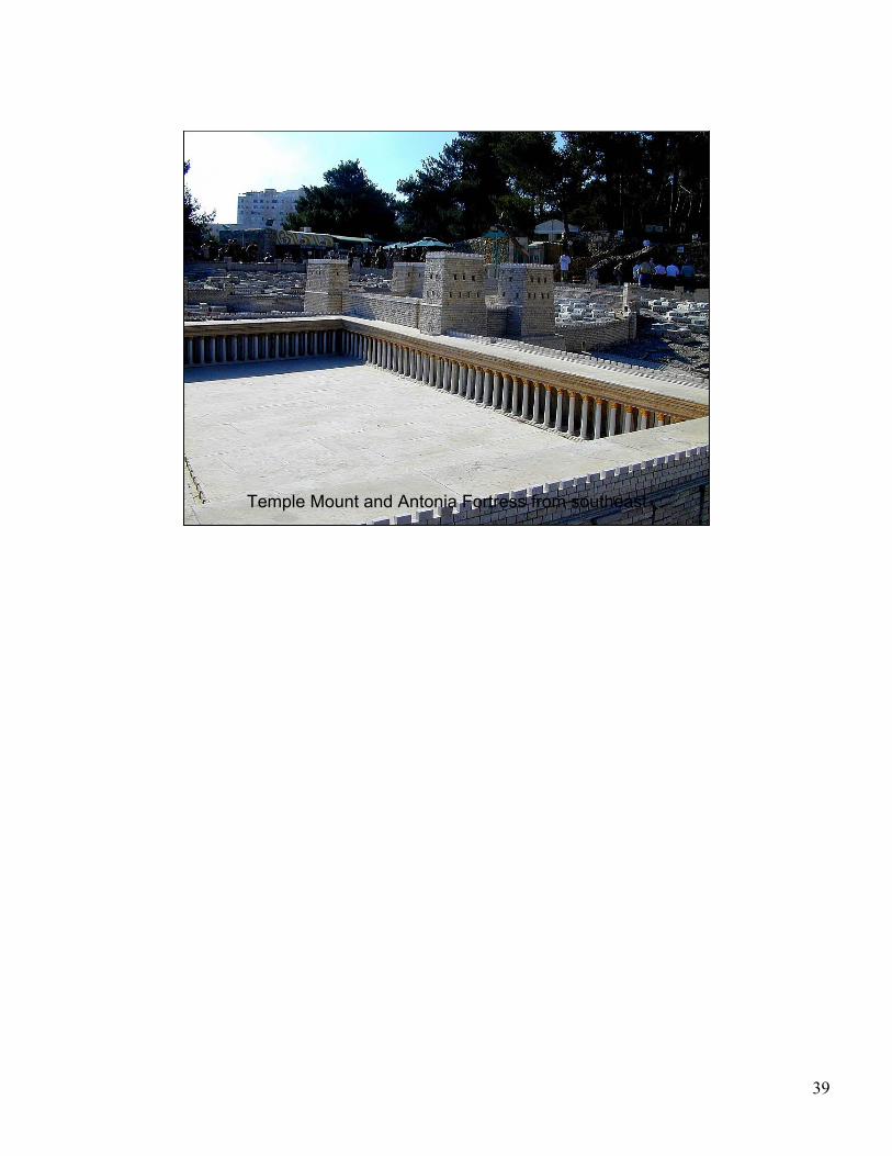
Temple Mount and Antonia Fortress from southeast

40
Antonia Fortress from northeast
The Antonia Fortress1. The Antonia Fortress was built by Herod and named in honor of Mark Anthony.2. The purpose of this fortress was to protect the Temple Mount and to watch over
the activities on the Temple Mount. The Temple was a center of nationalisticfeelings and many incidents occurred here. For this reason, many soldiers werestationed right next to the Temple.
3. The Antonia Fortress was huge; Josephus calls it a virtual town within itself.4. Tradition locates Pilate’s residence at the Antonia Fortress, but today most
scholars believe that he stayed at Herod’s Palace.5. After Herod’s rule, there was direct Roman rule over Judea. Rome was always
careful to keep additional soldiers here during the feasts.6. In Acts 21-22, Paul was taken to the Antonia at the Passover feast.7. The Apostle Paul was accused of taking Gentiles beyond the Court of the
Gentiles. He was attacked on the Temple Mount but spared serious harm whenRoman soldiers arrested him. The “barracks” where Paul was likely brought wereprobably in the Antonia Fortress.

41
Antonia Fortress from west

42
Temple Mount from north

43
Pools of Bethesda
Jesus healed the lame man at the five-porched Pools of Bethesda (John 5).
Helpful SourcesGeva, H. et al.
1993 Jerusalem. The New Encyclopedia of Archeological Excavations in theHoly Land, vol. 2, ed. E. Stern. New York: Simon and Schuster.
McRay, John.1991 Archaeology and the New Testament. Grand Rapids: Baker.