jessica kilfoil. projecting the map collection : academic
TRANSCRIPT
Jessica Kilfoil. Projecting the Map Collection : Academic Map Libraries and Communicating the Value of Services on the World Wide Web. A Master's paper for the M.S. in L.S. degree. November, 2002. 55 pages. Advisor: David W. Carr. Map librarians face communication challenges in promoting their collections to an academic
community. The interdisciplinary nature of map collections, combined with the lack of
experience many patrons have with spatial data, make it difficult for map collections to claim
a well-defined user group. Map librarians must communicate to a broad group in order to
alleviate patrons’ intimidation and to encourage exploration of map collections. The World
Wide Web is a communication medium that is effective for reaching a wide audience.
This paper analyzes the contents twenty-six academic map collection websites. Special
attention is devoted to accessibility, elementary and advanced description of spatial data
tools and resources, the provision of online map resources, and the presence of instructional
documents and services.
Headings:
Library websites.
Map Collections—Public relations.
Academic libraries—Public relations.
Libraries—Special collections—Maps.
PROJECTING THE MAP COLLECTION : ACADEMIC MAP LIBRARIES AND COMMUNICATING THE VALUE OF SERVICES
ON THE WORLD WIDE WEB.
by
Jessica Kilfoil
A Master's paper submitted to the faculty of the School of Information and Library Science of the University of North Carolina at Chapel Hill
in partial fulfillment of the requirements for the degree of Master of Science in
Library Science.
Chapel Hill, North Carolina
November, 2002
Approved by:
___________________________
Advisor
2
Table of Contents
Introduction ……………………………………………………………………………….3
Literature Review……………………………………………..……………………………7
Methodology……………………………………………………………………………...25
Results………………………………………………………………………………….…29
Discussion……………………………………………………………………………..….30
Conclusion………………………………………………………………………………..46
Appendix A…………………………………………………………………………….…49
Appendix B……………………………………………………………………………….50
Works Cited……………………………………………………………………………....51
3
Introduction
In an ideal library, perhaps, maps would be classified with complementary books in
the each section of the library, where patrons could pull them easily from the shelves during
the course of their research or browsing in subject areas. Historical maps would accompany
related books; weather and ecological maps would be shelved in the science library; religious,
sociological, census, decorative, and other maps would find their place in the library stacks.
Unfortunately, due to the peculiarities of format, these maps are typically separated from
their linear counterparts in a library.
There are many reasons for this separation. Unique preservation needs of
cartographic materials necessitate flat storage. A logical, geographically-based classification
schedule ensures that maps inhabit spaces in a library that are closer to other maps and
geographic references than to any related subject of an individual map. Specialized technical
knowledge is required of the map librarians who manage map resources. According to Mary
Larsgaard in the third edition of Map Librarianship: an Introduction, map librarians must be
proficient with “spatial data (history, how to interpret them, how they are made, and how to
care for and provide service for them), selection, acquisition, classification, cataloging,
storage, reference, marketing, preservation, management, and cartobibliography” (301). Not
every librarian is familiar enough with the format or reference sources to provide assistance,
even if they specialize in history, meteorology, ecology, or other map themes.
For these reasons, spatial data are cloistered in map collections, spaces created and
staffed for the storage, preservation, and reference services that they entail. Map collection will
4
be the term used herein to describe the department or branch within an academic library that
houses paper and digital spatial data, including: atlases, map reference tools such as
gazetteers and place-name thesauri, geographic information systems (GIS) and their data
sets, and related serials. In many instances in this paper, the term maps will be used
interchangeably with the term spatial data. Both terms signify information that is based on
geographic systems. In the case of maps, the data are expressed pictorially or symbolically on
sheets or in digital format, usually through cartographic processes. Maps include charts,
diagrams, grids, and other pictorial representations of data based on geographical
components. The term spatial data includes maps, but also includes atlases, dictionaries,
serials, gazetteers, indexes, and other tools associated with the study of maps. Map collections
contain maps and spatial data.
The outsider status of map collections, which prompted William L. Hall’s frequently
quoted suggestion that “Maps are often the stepchildren of libraries,” has nothing to do with
the information value of spatial data. Most university and college libraries contain a spatial
data collection. Spatial data continue to be active parts of academic collection development
because of they are valuable to many types of patrons. Spatial data, in all formats, convey
worlds—literally—of information. Academic libraries collect and manage graphic and
cartographic resources because this format expresses data efficiently.
We have all heard the platitude, “A picture is worth a thousand words,” yet few of us
would consider looking at a picture to be the equivalent of hours of poring over textual
sources. Spatially referenced data illustrates information in much the same way that a picture
does. Rather than providing a textual explanation of an occurrence or trend, spatial data
illustrate the pattern in which occurrences and trends appear in space and time. Academic
5
disciplines—such as geography, geology, and city planning—have traditionally been
connected with spatial data in research and data collection. Many other disciplines—
including life and social sciences—may also benefit from spatial data. Many patrons lack
experience in spatial data use. Two problems stem from unfamiliarity with spatial data:
inexperienced patrons may not recognize the value of spatial data resources in their subject
discipline, and they may not recognize the value of spatial data for creating patterns and
illustrating ideas. The exclusion of spatial data collections from many patrons’ research
plans puts map librarians and curators at a disadvantage. In addition to managing their
collections, they must put effort into promoting the value of their collections to potential
patrons; once patrons enter, map librarians often act as instructors in the most basic skills
needed to locate, interpret, and cite spatial data materials.
Promotional communication is not often discussed in the context of academic
librarianship. But in academic map collections, promotional communications were in the
forefront of discussion between the early decades of map collections in libraries and the
1970s. Numerous articles appeared in map library publications providing tips for luring
patrons into map collections. In “A Case Study In Promotion and Use of the Map
Collection: Travel Literature,” Olsgaard and Van Balen describe an “unspoken assumption
that the nature of a map collection dictates poor patron response” (105). Unlike most
academic branch libraries—which might cater to artists, law students, medical researchers,
and other clearly defined populations—map collections manage materials suitable for a range
of disciplines and users. The marginalization of spatial materials from the collections that
cater to artists, law students, medical researchers, and other populations may affect patrons’
utilization of spatial data.
6
Because the potential clientele for a map collection is unclear, map librarians must
widely communicate the value of their collection. Recommendations for promotion include
all varieties of written and verbal outreach, aimed at academic and public communities.
Now, thirty years later, there is less discussion of luring patrons in. Through the 1980’s and
1990’s, major changes took place in the tools that librarians used to organize collections and
inform patrons and potential patrons of their collections.
The purpose of this paper is to discuss the methods the modern map librarian uses
to communicate the value and organization of the spatial data collection to specific and
potential patrons. To inform this discussion I undertook an analysis of the online resources
for twenty-six major map collections. For each site, I observed contents related to access,
specific materials, subject-related collections, and pedagogical advice. Overall, this paper is
concerned with the questions: Do map libraries promote their holdings and services through
use of a homepage and website? Do they effectively communicate the value of varied
holdings and services? Is assistance provided to give patrons or potential patrons a starting
point for searching spatial data? Are collections adequately explained, with help pages and
links?
7
Literature Review
Map collections provide valuable spatial resources for many academic disciplines; the
contents and services must be communicated to the community of users. To answer the
question, “What is a collection,” Hur-Li Lee provides the following description:
Collections facilitate information seeking. An immediate collection provides the first level of access where users of the community may retrieve needed quality information readily and conveniently. This collection may not exist in isolation, and its users should have flexibility and support to reach beyond this level of access when they need to do so (1111).
The value of spatial data is offset by the lack of familiarity most patrons have with the use
and retrieval of such resources.
The value of spatial data
Most library materials convey information textually or verbally. Spatial data materials, having
few words, convey information graphically. In his essay “Visualization in Historical
Context,” Michael Wood compares imagery and graphics of maps to “written language and
mathematical symbolism” as expressions of thinking (14). Complicated ideas based on
spatial and temporal ideas—such as a biblical atlas depicting political and cultural variations
over generations, or a map of camping areas in national parks of North Carolina—are more
easily communicated and interpreted graphically than verbally. Symbols, colors, textures,
and patterns combine with the spatial projection and a key to depict some pattern to the
user. “Many topics, geographical and other,” states Mark Monmonier, “are clearer in
graphic terms than in verbal terms” (4 1988).
8
Describing the importance of spatial data as cognitive and communication tools,
W.G.V. Balchin stresses the necessity of “the communication of spatial information that
cannot be conveyed adequately by verbal or numerical means” (Balchin 216). That which in
text is convoluted with prepositions and adjectives—like a simple geographic description of
Georgia, which is north of Florida, east of Alabama, bordering South Carolina to the north
and northeast, and bordering North Carolina a little on its northwest tip, to say nothing of
major cities, vegetation, ports, or transportation—may be simply conveyed in a map. In his
essay “Visualization in Historical Context,” Michael Wood states, “When something is
visualized, the viewer is brought closer to understanding it” (14).
To contrast this visual communication of spatial relationships with a textual
communication, a 1993 study of spatial language by Landau and Jackendoff showed that
“language used to describe the location of an object or place usually relies on a limited
number of prepositions (only 80-100 spatial locatives are used in the English language) that
are open to interpretation unless qualified with precise numerical information (Kitchin and
Blades 78-79). To contrast the graphic communication of spatial data with physical
existence in a place, R. Lloyd [cited by Michael Woods] demonstrated that “for distance and
directional information […] 10 minutes of map study was more effective than 10 years of
living in an environment” (Woods 15).
W.G.V. Balchin states, “The well-educated person will be articulate, literate,
numerate, and graphicate” (217). While the first three of his four requirements are quite
common, the last is not something that is often discussed in education. In Map
Appreciation, Monmonier defines map literacy, or graphicacy, as “fluency with graphs, maps,
diagrams, and photographs” (9). Higher education, in both technological and liberal arts
9
institutions, works towards creating learners and thinkers. Schools of higher education strive
to ensure that students are educated and competent in a variety of life skills. A related topic,
creativity, seems at times to lack credibility in the halls of higher education. Yet imagery and
creativity are related. In his essay, “Cognitive Issues in Cartographic Visualization,” Michael
Peterson summarizes research by R. Finke, showing “how images can stimulate the
discovery of unexpected patterns, new inventions, and creative concepts” (36). Edward
Tufte also assigns higher-order thinking to imagery and visualization: “We envision
information in order to reason about, communicate, document, and preserve that
knowledge” (33).
Numerous geographers write about the research and cognitive values of spatial data
in learning and creating knowledge. Two of Mark Monmonier’s books on the subject of
map use in research and learning, one a general and the other a Humanities and Social
Sciences, are cited in this paper. Other geographer-educators whose work is useful are Paul
A. Longley, who writes about the multidisciplinary potential for GIS, and Alan M.
MacEachren, whose focus is on the communication value of maps. Both are notable
authors in the field of teaching and learning with spatial data.
Contemporary and historical maps are, in the simplest terms, pictures of the world.
They capture a specific idea—with numerous opportunities for complexity—in space and
time.
Map collections in the library
Within an academic library, departmental and subject collections are a part of a larger
system of collection development, organizational culture, information focus, and
management. Subject collections are “part of the culture of their parent organization,
10
thinking and doing things the way the organization thinks and does things” (Powers 478).
The Association of College and Research Libraries (ACRL) defines such component
collections as ‘branch’ libraries; they may also be called ‘departmental’ (if they originated in
response to the need of one academic discipline, such as geology) or ‘special collection’
libraries.
In the 1990 guidelines the ACRL developed for branch libraries, the description
states, “the primary mission of the branch library is to provide information and access to
information to meet the instructional and research needs of its user group […] as well as the
cross-disciplinary needs of others in the academic community” (171). Each branch library
must provide certain resources, including “competent staff […] staff is a primary link
between the communities needs and the library’s services and collections” (172). Whether
students and patrons know of the availability and uses of spatial data is up to instructors and
librarians.
The smaller scope of these collections, according to Patricia Suozzi and Sandra
Kerbel in “The Organizational Misfits,” allows them to provide “specialized and tailored
services, intensive knowledge of clients, and document delivery” (513). Conversely, the
same article states several sections later, “a large amount of writing has been done on
whether departmental libraries should even exist” (515). Departmental and branch libraries
are evaluated constantly by their institutions (Suozzi and Kerbel 520; ACRL 174). Yet if
map collections held no value, current or historic, academic libraries might hesitate to make
“large investments of time and money in the creation of the collection and in the space and
labor needed to maintain them” (Womble 414).
11
Since before Robert S. Taylor wrote his 1968 article “Question-Negotiation and
Information Seeking in Libraries,” librarians have struggled with the problem of how the
user, in a self-help environment like a library collection, “depends on his own knowledge,
frequently incomplete, of the system” (Taylor 179). In collections of spatial data, incomplete
knowledge may be magnified. Barbara Tiberio, a map librarian at the State University of
New York in Bingamton, claims “the lack of the most elementary cartographic skills [among
users] will probably surprise the map librarian” (51). Larsgaard states, “Americans in
general are less map-conscious than are Europeans, perhaps due to the low status of
geography in education at all levels” (275). Describing the spectrum of patrons, Larsgaard
states “One category, for example, is made up of those who do not know how to read a map
but who are interested in using spatial data” (274). The potential map collection visitor may
not know that he or she could use spatial data resources at all, or how widely spatial data can
be applied.
Robert S. Taylor uses a coincidentally apt metaphor to describe a major problem for
map librarians when he describes the anomalous states of knowledge that surround a library
visitor, who might have “a certain incompleteness in his picture of the world—an
inadequacy in what we might call his ‘state of readiness’ to interact purposefully with the
world around him,’ in terms of a particular area of interest” (Taylor 180-181). Taylor’s
model goes on to describe the importance of the reference librarian in creating new
boundaries in the patron’s ‘picture of the world.’
Spatial data reference, which must translate literal world pictures to patrons, requires
different skills from many other types of reference. In “Reference Service for Maps,” Elka
Tenner and Katherine Weimer state, “unlike standard reference, which relies primarily on
12
the knowledge of the types of sources, much of map reference requires a knowledge of
maps” (181). An unusually formatted collection, maps may not fit precisely into a system
created for textual information in book form (Weimer 386; Rockwell 40).
In the information age, profligate information necessitates open lines of
communication between librarians and patrons. Patrons of academic libraries—students,
faculty, staff, researchers, and often the public—are presumed to know the services and
tools that will best provide them with the information they need. Yet in the large academic
library, information in all formats is relegated to many areas and collections. Patrons may
have to explore multiple library departments and collections in order to meet information
needs. Because search tools depend upon collections, cataloging, format, and location of
materials, patrons may have difficulty navigating library resources. Effective information
retrieval is affected by patrons’ familiarity with the organization and availability of
information within a library system.
Promotion of specific collections within a library system cannot begin effectively
until it is decided “what you are offering and to whom” (Coote 23). For map collection
staff, what is being offered is relatively stable, with the newest change being GIS technology.
To promote services to a general audience ‘audience’ requires organization and planning.
Map collection staff must look at the information and pedagogical needs of the academic
community and decide from that point how to present their collections.
Promotion and Communication
Any of the terms used to denote promotional activities—public relations, marketing,
promotion, advertising, etc.—may be described with numerous synonyms that conflict and
confuse. In this paper, however, the idea of “promotional communication” will be used to
13
describe activities and relationships that a librarian adopts in order to communicate the value
of his or her collection and services to the public, including those that are defined in the
literature as public relations, marketing, advertising, and other similar phrases.
Helen Coote, the author of How to Market your Library Service Effectively, uses the
Chartered Institute of Marketing’s definition to define marketing as: “the management
process responsible for identifying, anticipating, and satisfying customer requirements” (6).
It is important that the librarian proactively communicates the library’s missions, goals and
services. This helps to clarify the role of the librarian in the mind of patrons and potential
patrons, the public, and the institution in which one is a part. Richard L. Daft describes
promotional activity as a “major strategy for handling environmental uncertainty” (84). In a
library, uncertainty may arise from unclear expectations of patrons, from internal changes in
services and staffing, or from a variety of decisions and imperatives that ones institution
enacts. Student patrons are usually working to deadlines and often wish to expend the least
amount of effort to accomplish a task.
A wordy definition of public relations, created by Rex Harlow from numerous other
definitions, describes the many facets of promotional activities:
Public relations is the distinctive management function which helps establish and maintain mutual lines of communication, acceptance, and cooperation
between an organization and its publics; […] helps management keep abreast of and effectively utilize change, serving as an early warning system to help anticipate trends; and uses research and sound and ethical communication techniques as its principal tools. (Steinmacher 12)
The reiteration of communication in the selected definitions is the common factor
among the many terms used to describe the process of librarians reaching out to promote
their collections to a community of patrons or potential patrons. “Cooperation between an
organization and its publics” is another significant phrase. It describes the need for mutual
14
assessment of resources and needs. Finally, to “effectively utilize change” parallels Daft’s
earlier definition of promotion; to use change is to decrease uncertainty in the face of it.
Coote, with her stress on marketing strategies, is one of the few who states that
promotional activities are important for all libraries, “public, academic, or special” (3).
Public relations, marketing, and promotion are words not often associated with the job
responsibilities of academic librarians. A common assumption in the field is that a
collection—by virtue of the library’s considerate selection and careful augmentation,
maintenance, and organization—should naturally attract and satisfy patrons.
Cosette Kies, a proponent of library promotion and a prolific author on the subject,
states that number of academic libraries do not have written public relations goals and
objectives in their mission statements (90). Why should they? The library presumably
acquires those materials necessary for the research needs of the academic community.
Selections are traditionally based on institutional strengths, faculty and student research
interests, and historical strengths, limited by budget. Even if the librarians do not know
every patron, they may assess the users’ needs through communication with the faculty, staff,
and academic administration. The community of users in an academic setting depends on
the library to meet information needs, which in this setting often revolve around curriculum
needs. Academic libraries are considered “the first and basic requirement of the institution”
(Harrison 11). Patrons “will be different for different libraries, depending upon each
institution’s purpose and potential audience” (Larsgaard 274).
In Practical Strategies for the Modern Academic Library, Mike Heery and Steve
Morgan tacitly address “academic integration,” or fostering relationships with members of
academic departments through communication with faculty and students. Rather than
15
simply assisting with retrieval of necessary information, librarians will understand the
pedagogical incentive of assignments. Hope, Kajiwara and Liu explore the challenge faced
in the modern academic library as the support of information literacy, which must build
upon a foundation of core-curriculum research skills (30).
Important changes in the library, academic, and Web environments have led
librarians to describe their “increasing roles as teachers, in formal instruction classes, from
the reference desk, and as partners in developing information literacy programs to meet new
university curricular requirements” (Hope, Kajiwara and Liu 15). Branch libraries are at an
advantage in this requirement, with the responsibility to “serve as an effective liaison
between the faculty, staff, students, and administration of the schools or departments
served” (ACRL 173).
The primary problem with this plan to increase the teaching responsibilities is that
instructors often “have not thought about the library” in the stages of curriculum
development (Hope, Kajiwara and Liu 30). Participation in “course planning and curriculum
development, provision of subject based guides and bulletins” and other academic interests
assists librarians bringing about student’s achievement of “departmental or institutional
goals” as well as their own goals in fostering information literacy (19).
According to Heery and Morgan, the main focus of the academic librarians should
be “service-orientation,” which is similar to the general definitions of promotional
communication discussed in the previous section. Their “service orientation” engages an
academic librarian into mutual communication with patrons, both on a one-on-one basis and
through long-distance methods, including the World Wide Web (12). This also
16
complements the earlier definitions of Harlow and Daft, by “utilize change … to help
anticipate trends” (Steinmacher 12).
Before seeking information, however, a patron must make the decision based on an
information-need to seek answers in a library. In academic institutions, the library is a
natural choice. As Robert S. Taylor describes, the patron must make a decision to choose
the library; factors in this decision include familiarity with the library environment, and ease
of access (181). If the patron has little or no experience with the library, the information-
need may be prolonged or unmet. Larsgaard makes an important statement while discussing
public relations and marketing in Map Librarianship, that “Reaching out to the casual user or
the nonuser is a difficult procedure” (288). As will be discussed later, the Internet acts as a
potential communication medium that ‘reaches out’ to the distant user or non-user.
Carlos Hagen states, “In a large university, the map library serves the needs of the
entire campus community” (47). In this circumstance, the target audience must begin with
those closest to the service, the faculty and students. In his article on course-related library
Web pages, Patrick Ragains argues, “In middle- to large-sized universities, students often
have limited exposure to library instruction” (86).
Representing the importance of communication in the map collection, the Special
Libraries Association Geography and Maps Division Standards for University Map
Collections discusses librarians’ responsibility for promotion of the collection and services.
The first standard for university map collection services states, “Information services in the
map collection shall include reference service, bibliographic instruction, and promotional
activity” (1). Both reference service and bibliographic instruction may be considered
17
common practice; their inclusion is not unusual in the standard. Promotion is more
surprising. In promotional services, the “Commentary on Standard A.1” explicates:
Promotion of the map collection shall be through publications, presentations, and exhibits. While reference and instructional services facilitate structured contacts between librarians and users, promotional activities educate and inform individuals who may not be aware of the availability and value of
cartographic materials […] (2).
This standard raises the responsibility of the academic map collection from the role of
acquirer and manager to educator and informer. These roles are seemingly considered separate
from the reference and instructional roles that map librarians must fill. The Web is
becoming a powerful tool for all these responsibilities; a growing number of libraries “have
developed or are developing instructional websites” with the goal of empowering students in
the information-seeking environment (Hope, Kajiwara and Liu 26).
Reference, instruction, and promotional communication may easily coexist on the
World Wide Web. Rather than reaching out to “individuals,” as the standards recommend,
the collection website provides the potential for communication with hundreds of patrons
simultaneously; reference, instruction, and promotional communication. In “Bibliographic
Instruction on the Internet,” Gillian Allen states that choosing instruction topics, the
intended audience, and active methods for tutorials should be a highly self-evaluative
procedure (147-148).
Libraries have moved rapidly from paper to electronic catalogs over the past twenty
years, a process that improves access from remote locations around the clock. Map
collections, though there is increased talk of retrospective conversion and cataloging, lag far
behind monographs and serial collections in cataloging rates (Cobb 50; Womble 414). Many
academic libraries “only have single digit percentages of maps actually cataloged” according
18
to David Cobb (50). If larger percentages are cataloged, it is often through an internal
system and is “not represented in the library’s online catalogs” (50). Retrospective
conversion is causing a move towards online cataloging, but spatial data remain inaccessible
from remote locations for as long as the conversions take (Andrew 406).
Cataloging is not often considered a promotional activity in library culture; yet the
difference between cataloging in a small card catalog locked in the basement map collection
and the presence of the same catalog information in an online public access catalog (OPAC)
could mean an increase of patronage. In an article for the “Maps and Related Cartographic
Materials” issue of Cataloging and Classification Quarterly, Kathryn Womble states,
“Mainstreaming maps by cataloging them in a centralized online catalog along with books,
journals and other library materials will provide the avenue of access that the users of these
materials deserve” (414).
Map collection communication
The two dominant approaches to writing about library promotion seem to be the
theoretical exposition and the handbook. The first approach, described above, speaks of the
library taboo on promotional activity but works through the costs and benefits rationally.
The promotional literature that specifically describes map collections is pragmatic, based on
the theoretical value of such communications and activities. For map collection libraries and
curators, promotional literature mainly takes the form of the handbook: lists of suggested
steps to take towards practical promotional expenditures of time and energy.
Librarians may perform some simple and natural activities to successfully
communicate the value of his or her collection and services to the patron and learner. In an
article on academic map collection promotions in 1977, Barbara Tiberio proposes the
19
creation of information sheets listing such items as “location, hours, categories of materials
housed, major holdings […] and the compilation of bibliographies of interest to broad cross
sections of potential patrons” (50). Olsgaard and Van Balen describe a successful
cartobibliographic promotion with the University of South Dakota in Vermillion map
collection; their method depended on “four mechanisms to promote the map/travel
collection: handouts, newspaper articles, general campus mailings for new map and
document acquisitions, and displays” (108). Essentially, the public relations activity on
which the article focused was based on a selected audience—college students who might
have time and resources to plan vacations and travel—and created lists of spatial data
resources that might help the audience plan adventures.
Those articles that listed specific methods that communicate the existence and
strength of the collection have numerous commonalities. The most popular of the
guidebook recommendations, synthesized, include:
• Exhibits highlighting a thematic or attractive collection of the map collection’s materials.
The creation of exhibits highlights a certain collection or feature of the map collection.
Because imagery dominates in many spatial data formats, maps and atlases may be selected
for visual or emotional impact. An exhibit theme may be chosen to highlight a collection
strength, to pique the interest of a wide variety of patrons, or to celebrate a local event.
(Tiberio 44; Larsgaard 290; Olsgaard and Van Balen 108; Harrison 97; Barrow and Hudson
27).
• Creating cartobibliographies—compiled on-site or acquired from another source—that highlight a
particular type of publication, a map-maker, or a theme.

20
Many agencies that are linked closely with the creation and use of spatial data—like the
USGS, the Census Bureau, the Sanford Insurance Company, and National Geographic—
publish cartobibliographies. If a collection has significant holdings published by an
agency—as a government repository might—a cartobibliography is a good investment. Such
a list helps researchers see the scope of publications. Authored cartobibliographies, those
that are compiled by a researcher based on a theme or subject, might also be useful to
researchers who wish to consult maps for a specific research endeavor, like a Civil War
project or a local history. The last type of cartobibliography, which takes more time and
effort, is that produced by a librarian describing his or her collection’s specific holding.
(Larsgaard 288; Olsgaard and Van Balen 109; Barrow and Hudson 27; Harrison 35; Tiberio
51)
• Research guides for a specific topic or class, perhaps naming a variety of sources, from cartobibliographies to
gazetteers and pertinent publishers.
Guides assist patrons in finding related sources, regardless of format. A research guide for
an ecology class, for example, might list the primary index for the topic, agencies that
produce ecology maps (with contact information), specific general map titles, and any
materials on CD-ROM, online, or in other collections that could prove rich for researchers.
This complies with Cosette Kies recommendation for a practical way to get started with a
promotional endeavor, “the identification of target audiences […] and the promotion of
specifics to particular groups” (45). One conversation with one professor could potentially
bring him and fifty of his students into the collection. (Larsgaard 288; Tiberio 50).
Of the articles published specifically on the promotion of map collections, the
majority was published before 1980. Later articles of promotional hints and anecdotes vary
21
in one major way—use of the World Wide Web as a tool to communicate map collection
holdings and services to a broad range of patrons and potential patrons. One additional
recommendation, only found in more recent publications, suggests:
• Maintaining an informative website that lists hours and some service highlights. Larsgaard describes potential Web usage for several sections of the public relations chapter.
Barrow and Hudson, in addition to recommending online exhibits and bibliographies,
suggest “post campus/community map meetings on Maps-l, campus homepage, electronic
bulletin boards, the local ‘free-net’” (27). (Barrow and Hudson 29; Larsgaard 287).
Homepages and the library collection
In “A Primer on Developing and Using Course-related Library Web Pages,” Patrick
Ragains discusses subject-related websites, stating he “has found this type of Web page to be
a well-accepted access tool and an effective supplement to the one shot [bibliographic
instruction] session but not as a replacement for group instruction” (89).
According to Kristen Garlock and Sherry Piontek in Designing Web Interfaces to
Library Services and Resources, website design should be influenced by four primary factors:
• Statement of the problem
• Target audience
• Information organization
• User interface (4).
The “problem” is the information that the creator hopes to communicate to visitors of the
site. Important information includes hours, services, organization, materials, and other
descriptive functions of the collection. The target audience includes library patrons and
visitors; in the case of academic collection websites, this particularly involves students and
22
faculty. Information organization and user interface should mainly make the site navigable.
Web interfaces to academic sources should be “as intuitive as possible” and should exist
mainly to organize information so users may effectively use the information provided (Hope,
Kajiwara and Liu 32).
Ragains recommends library subject pages have definite contents, including:
• “Links to points on the library website, including the library home page, the online
catalog, a page of reference information …
• A subject-related list of proprietary online indexes and databases.
• Recommended subject-related websites that are freely available. These sites include, but
are not limited to, subject gateways, scholarly associations, government organizations, and
interest groups” (86).
A site with multiple levels of information should provide “a few simple, categorical
selections and then branch into specifics” (Hope, Kajiwara and Liu 6). Problems may arise
in the “information organization” stage of website design. Hur-Li Lee describes:
Collections of information resources should be developed with a policy that provides all necessary parameters for the collections, including a definition of the user community, collection scope, format, and depth. Collections have interrelationships with each other and some collections are subsets of others (1111).
A library website probably has numerous categorical choices that branch into widely
different services and materials. According to Lee, the community of patrons should be
considered in the phrasing and description of categories at all levels. Naming links with
jargon or vague terms (such as “OPAC” or “resources” or “databases”) is acceptable,
assuming that everyone knows what these terms mean (Klein 37). For online map
collections, there the additional problem of spatial data jargon must be considered as well.
23
As a fundamental necessity in the academic environment, librarians are facing the
problem of changing patron culture. Hope, Kajiwara, and Liu state that busy students
increasingly value “convenience over quality” (18). Lee states, “Research indicates that users
tend to base decisions in information seeking on their own benefit, cost, and/or effort
(1110). When a perfunctory search of the online catalog returns an adequate number of
sources (some with the added convenience of being ephemeral digital documents), students
may not seek further. Web presence is therefore vital to the average library collection. All
available digital resources should be used and linked online. Additionally, materials that are
impractical in an online environment should be described and promoted so patrons may
realize the value of resources that are stored in paper or non-networked formats.
The digitization of library materials is perhaps the ideal for access and preservation
for any library collection. The Library of Congress is hoping to mount more than 60,000
map and cartographic images for the National Digital Library project (Fitzpatrick 62). The
Online David Rumsey Collection, a digital map collection of approximately 7200 items, had
more than 100,000 visitors during its first six months of existence; the average visitor
explored the site for twenty minutes (Rumsey 97-98). For preservation, accessibility and
reaching out to atypical patrons, digital pictures are advantageous. Digitization of images
simplifies browsing, increases public accessibility and search flexibility (Arms 381).
Yet digitization of maps presents some hurdles to the average library collection. The
digital environment obfuscates physical features such as size, resolution and clarity, (Arms
389). Because of their size, maps must often be scanned in sections, then pasted together.
This requires more staff hours and heroic attention to detail, considering “the fine detail of
maps, contour lines and text are sometimes as small as 1mm, meaning little contrast between
24
the print and the background” (Corsmeier 14). The process of digitization requires space,
hardware, software, and large amounts of money. A plan must be created in order to select
and prioritize materials that warrant digitization (Fitzpatrick 66). Corsmeier would say size is
detrimental to the effort; additionally, copyright law and the need to provide spatial metadata
and cataloging deter collections from digitization pursuits (Corsmeier 19; Arms 383; Rumsey
103).
Notably, all the authors mentioned in the two preceding paragraphs are a part of
cartographic or image digitization projects. Despite seeing the negative side of the process,
they are mainly proponents of digital map projects, when it comes to accessibility. For those
collections that do not digitize maps, providing online access to digital collections follows
what Suzanne S. Bell calls “the librarian’s ethos: to try to make users aware of as many
resources as possible” (181). Linking to online collections maintained by others may be an
increasingly popular procedure.
25
Methodology
The purpose of this study is to find a pattern in the information provided on the
websites of large academic map collections. A collection-specific website allows the
academic map collection to communicate the unique holdings it offers to the library
community. Web pages inform patrons and potential patrons of the organization, research
services, tools, and major types of materials offered in the collection. Additionally, map
librarians may take the opportunity to answer common questions, to address information
needs, and to act as a starting point for information-seekers unfamiliar with spatial data
resources. To find a pattern in map collection web pages, I plan to closely study the
organization of twenty-six academic map collection websites.
Selection
The initial list of potential participants was compiled from the World Directory of
Map Collections and the ALA Guide to U.S. Map Resources. The first directory was
compiled via a voluntary questionnaire, and is not comprehensive. The ALA guide—
compiled with the aggressive assistance of map librarians in numerous regions—may be
considered comprehensive. Charles A. Seavey’s “Ranking and Evaluating the ARL Map
Collections” supplemented the map collection data.
The final list of twenty-six subjects was chosen with the following criteria: the
collection is part of an academic library system, the collection has a website, and the
collection contained at least 195,000 maps and aerial photographs in 1991, when the ALA
published its guide. The first criterion, the collection in an academic library, ensures that the
26
collection management is subject to relative stability in institutional policy and procedures,
funding, objectives, user patterns and needs. The second criterion, a collection home page
on the World Wide Web, was really the most important. Maintenance of a home page
proved to be a standard practice. Only one of the collections from the initial search was
excluded because it failed to meet this requirement. In one other case, the online expression
of the map collection existed only as part of a ‘digital library’ site. After much deliberation, I
discarded the data.
The final requirement, that the collection exceed a minimum size, was necessary to
narrow the potential subject group. The original criterion was for 210,000 maps or more; I
lowered it in order to increase the test group size. This increased the test group size too
much, however it widened the regional scope of the test group greatly. When I had to limit,
despite size qualifications, I chose a collection in a state unrepresented in the test group over
a collection whose state of origin was already represented. A survey group containing all
map collections that meet the criteria was not deemed necessary.
The final list of twenty-six URL’s appears in Appendix A.
Research
All map collections chosen for examination in the survey are also represented by
home pages on the World Wide Web. Home pages were compiled using the World
Directory of Map Collections. When an address failed, I entered the complete name of the
institution and the word “library” into a Google search <www.google.com.> and navigated
to the map collection from the library homepage.
My content analysis of websites was based on public relations recommendations for
map collections from the literature of map promotion. I created a checklist of common
27
recommendations for library websites in order to analyze each site (Appendix B). The
checklist was divided into two sections. The first asked three introductory questions about
the collections’ hours, number of staff, and presence of links to staff. The introductory
questions could be answered from anywhere on the collection or the main library website
(particularly important in the case of listing hours and staff).
A checklist of ten items follows these introductory questions. Analyses for the
checklist were based on the collection’s homepage and the next three levels [no more than
four links, or clicks, into the pages]. In order to reduce variables and subjectivity, these
questions were phrased to warrant a yes or no response. Answers indicated the presence or
absence of information about services, collections, organization, instruction, and other
important promotional communications that may be prominently placed in the first levels of
the websites. In several cases, I noted how many of the twenty-six collection websites
displayed a certain category of information on the home page. The data gathered solely
from homepages is marked as such.
Several of the questions stem from common promotional recommendations,
synthesized from Larsgaard; Barrow and Hudson; and Tiberio. These questions indicate the
presence or absence of information about exhibits, new acquisitions, collection guides and
descriptions, cartobibliography, and thematic lists of materials (based on a class, special
interest, or organizational strength). Remaining questions include some pedagogical and
Web instruction/Web content themes, as recommended by Ragains; Hope; Garlock and
Piontek; and Klein. These include the availability of bibliographic instruction, presence of
online search tools, instructions for digital materials, and links to subject-related websites.
Additionally, due to the literature on the state of map cataloging in the OPAC, one question

28
asks for the presence of a statement informing patrons how to search for materials (Cobb;
Tenner and Weimer; Womble). Whether the maps are online or in a card catalog, the
presence of such a statement warrants a positive [yes] answer.
29
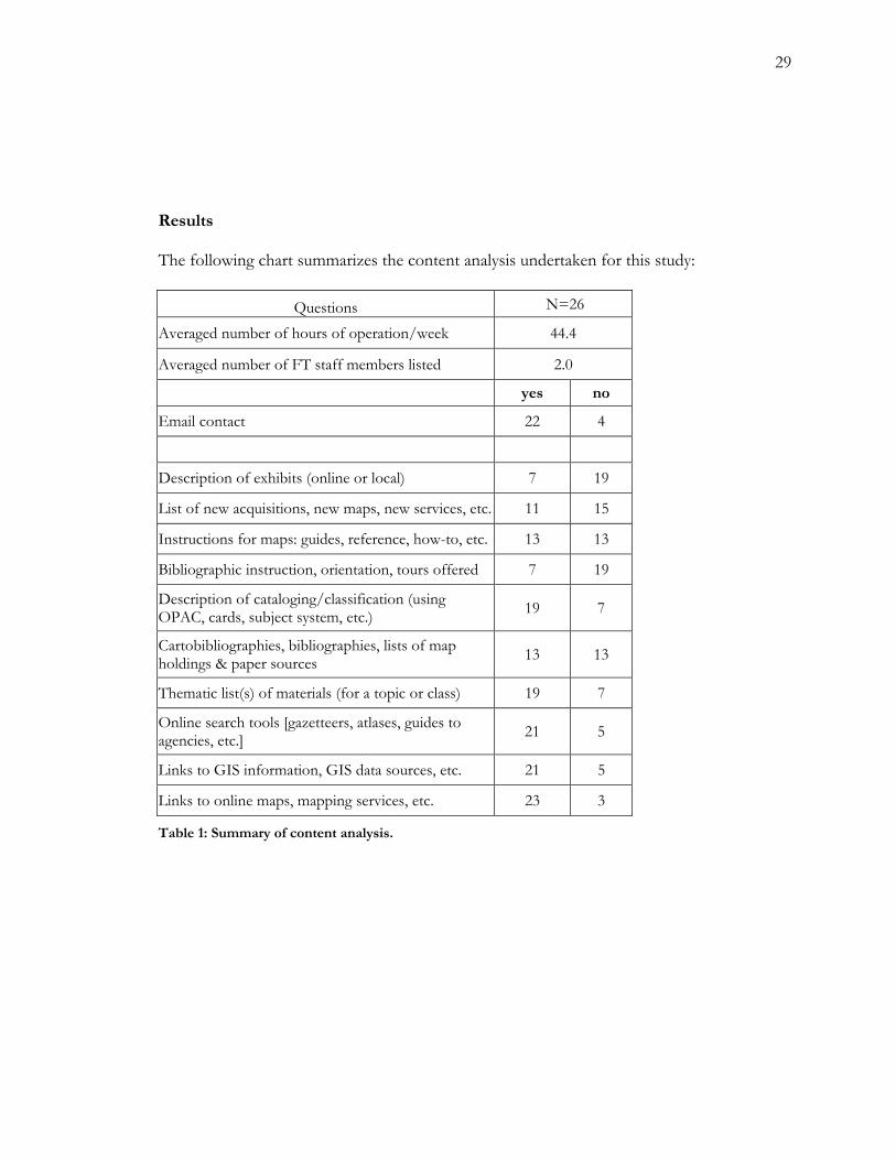
Results
The following chart summarizes the content analysis undertaken for this study:
Questions N=26
Averaged number of hours of operation/week 44.4
Averaged number of FT staff members listed 2.0
yes no
Email contact 22 4
Description of exhibits (online or local) 7 19
List of new acquisitions, new maps, new services, etc. 11 15
Instructions for maps: guides, reference, how-to, etc. 13 13
Bibliographic instruction, orientation, tours offered 7 19
Description of cataloging/classification (using OPAC, cards, subject system, etc.) 19 7
Cartobibliographies, bibliographies, lists of map holdings & paper sources 13 13
Thematic list(s) of materials (for a topic or class) 19 7
Online search tools [gazetteers, atlases, guides to agencies, etc.] 21 5
Links to GIS information, GIS data sources, etc. 21 5
Links to online maps, mapping services, etc. 23 3
Table 1: Summary of content analysis.
30
Discussion
My areas of inquiry into each map collection may be divided into general categories
of communication. The first category involves access—when the library is open, what types
of materials are available in the physical collection and online, and who may use the materials
and services. The second category, reference sources, includes descriptions and links to
reference tools that may help a patron find information. Tools include online maps and data
sources, cartobibliographies and bibliographies of materials by type or subject, dictionaries,
journals, and indexes. The online catalog is a tool, as is a list of topographic maps. The
third category involves those services the map collection staff may put online in order to
teach users the basic skills for spatial data use. These may range from “how-to” descriptions
of searching the catalog, to offering bibliographic instruction or orientation sessions. The
fourth category, general interest, includes other information that may attract patrons to the
website or the map collection. Examples of general interest areas include local maps, current
events maps, new acquisitions and services, and links to related websites.
Access
Information related to access is the basic level of description that a map collection
may communicate through its website. Access information is collection-specific and largely
descriptive of the holdings and policies of the collection. This category of information
anticipates the basic questions patrons may have about the collection: who provides spatial
data and assistance, what materials and services are offered, when the library is open, and
31
where it is located. Providing this information online is important due to the frequency of
such questions and the consistent nature of Web-based communication. Internet access to
the collection is available twenty-four hours a day, seven days a week.
In my analysis, the average map collection has 2.0 full-time staff members. Several
list their student assistants on the website; others do not. Student assistants were not
included in this count. Several sites fail to list staff at all. If the existence of staff could not
be located through the institution’s main library pages, the collections were listed as having
no staff, which brought the staff averages down. The staff for five collections failed to
appear, even after searching library online directories. Yet several of the “ghost” libraries
included a generic email address for patron contact within their website, which still makes
them an approachable entity to inquiring patrons. Altogether, four collections failed to
provide an email contact; two of those also failed to list staff.
Listing hours is another basic element of a library website posting. The average map
collection in this study is open 44.4 hours each week, which essentially excludes evening and
weekend hours from the schedule. This trend reduces “after hours” availability of staff for
non-traditional or working students, making the Web presence of the collection more
important for researchers who may have limited time during business hours, Monday
through Friday. Each collection listed its hours within its Web pages or easily available
through the institution’s library website.
Web pages may communicate the library’s policy on access to materials. Twenty-five
homepages in the survey present a description or a link that describes “Collection
Information,” “About the Collection,” or some variation on this theme. Even those sites
[there were three] that provided only one page of information, with fewer than three links,
32
provided a brief history and description of the collection. The links provided a description
of the collection size, formats of holdings, and often a history and an acquisition policy.
Such descriptions prepare a patron for the major types of spatial data sources that the
collection maintains. Additionally, the organization of materials—into categories of
reference, circulating, and non-circulating, or supervised use—helps patrons prepare for a
trip to the collection.
GIS are growing in popularity in schools across the country; many map libraries now
manage the hardware, software, and data the systems require. Seventeen of the twenty-six
surveyed collection home pages included a link to information about the institution’s GIS
services, to GIS data, or to a FAQ page for GIS resources. Several of the seventeen map
collections offering GIS information links are not responsible for GIS services, yet include a
link to the responsible library or academic department.
Earlier, it was discussed that a small percentage of map collections have the entirety
of their holdings represented in an OPAC. Of the twenty-six surveyed map collections,
nineteen explained the searchability of their spatial data in the OPAC or an alternate paper
or electronic catalog. Many described partial online cataloging; several, in recognition of the
partial representation of materials in the OPAC, required website visitors to physically visit
the collection to search through card catalogs or databases. Quoting the University of
Chicago site, “Most of the Map Collection's sheet maps are still uncataloged. The best way
to find out what the Collection holds is to visit, write, call, or e-mail.” Similarly, the
Harvard site states, “Users are encouraged to visit the Map Collection as only a small
percentage of our materials are currently available via HOLLIS [the OPAC].”
33
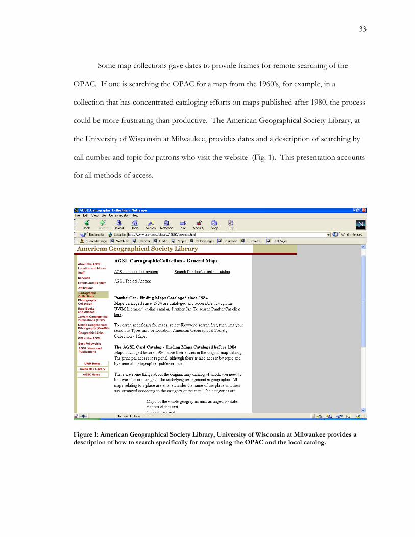
Some map collections gave dates to provide frames for remote searching of the
OPAC. If one is searching the OPAC for a map from the 1960’s, for example, in a
collection that has concentrated cataloging efforts on maps published after 1980, the process
could be more frustrating than productive. The American Geographical Society Library, at
the University of Wisconsin at Milwaukee, provides dates and a description of searching by
call number and topic for patrons who visit the website (Fig. 1). This presentation accounts
for all methods of access.
Figure 1: American Geographical Society Library, University of Wisconsin at Milwaukee provides a description of how to search specifically for maps using the OPAC and the local catalog.
34
Sources and tools
All map library websites describe their reference collections in some manner.
Important reference sources must be described on a map site because their use might not be
part of the common knowledge base of patrons. Sources such as gazetteers, index maps,
thematic atlases, map sets that cover common themes and areas, and place-name thesauri
might warrant added description within the map collections’ Web pages. Communication
about reference sources is provided at the discretion of map collection staff.
Providing online tools—for both reference inquiries and mapping—allows remote
searchers to explore information independently before making a trip into the collection.
Twenty-one of the twenty-six collection websites provided links to at least one online search
tool. Search tools include gazetteers, dictionaries, interactive map indexes, links to mapping
agencies and their resources, and other spatial data tools. The online reference tool is one of
the most common categories of information found across the twenty-six websites surveyed.
Nineteen of the collections included the link from their home page, which seems to imply
that the information that may easily be supplied online—place-name tools, mapping services,
and map images—effectively fulfill many users’ needs in digital format.
Links to online resources are an effective way to increase the amount and
accessibility of information offered by a collection. While it is expensive to put maps online,
it is relatively easy to create links to services that have already done so. Government
agencies, commercial sources, private collectors, and other libraries, museums, and non-
government institutions may maintain online maps. Interactive maps are a flexible tool for
general reference but are costly to develop. Many sites link to government and academic
websites that provide digitized maps. Twenty-three of the twenty-six collection websites
35
included links to online mapping services and online maps. Online mapping services
provide interactive digital maps for public use via the World Wide Web. Such services are
numerous; most are free. Establishing a link to such free services provides a venue for
patrons who may be looking for directions, images, or ideas of spatial relationships.
Online map collections are usually created from the process of scanning and
cataloging paper maps; recent government maps are created and available in digital form
They may be browsed in ways analogous to paper collections. Often the classification
method is based on regions, themes, dates, or publishers—or some combination of these.
Providing a link to such collections enriches ones own collection by as many materials as are
included.
The Perry Castañeda Library Map Collection, of the University of Texas at Austin,
has a notable collection of digitized maps offered through its website. A statement in the
website’s FAQ section states, “Only a small part of our printed map collection has been
scanned and made available on the Web. Currently this amounts to about 5,000 map
images.” A collection of five thousand maps is insignificant when compared to the size of
many paper map collections. The map collection puts more of an emphasis on the 5,000
online maps than on the 245,000 paper maps it also contains. Yet the online maps act as an
index and search tool for visiting patrons. Seemingly, an online collection is something map
librarians believe their customers are interested in—nineteen of the twenty-five remaining
collections include a link to the Perry Castañeda Library Map Collection website .
Several of the map collections surveyed were dominated by online map resources,
including the University of California at Los Angeles’ map collection website, which is the
“Maps & GIS” section of the “Reference Collection Online.” If one really searches around
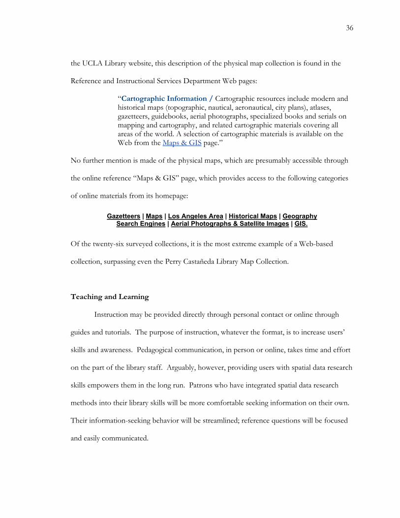
36
the UCLA Library website, this description of the physical map collection is found in the
Reference and Instructional Services Department Web pages:
“Cartographic Information / Cartographic resources include modern and historical maps (topographic, nautical, aeronautical, city plans), atlases, gazetteers, guidebooks, aerial photographs, specialized books and serials on mapping and cartography, and related cartographic materials covering all areas of the world. A selection of cartographic materials is available on the Web from the Maps & GIS page.” No further mention is made of the physical maps, which are presumably accessible through
the online reference “Maps & GIS” page, which provides access to the following categories
of online materials from its homepage:
Gazetteers | Maps | Los Angeles Area | Historical Maps | Geography Search Engines | Aerial Photographs & Satellite Images | GIS.
Of the twenty-six surveyed collections, it is the most extreme example of a Web-based
collection, surpassing even the Perry Castañeda Library Map Collection.
Teaching and Learning
Instruction may be provided directly through personal contact or online through
guides and tutorials. The purpose of instruction, whatever the format, is to increase users’
skills and awareness. Pedagogical communication, in person or online, takes time and effort
on the part of the library staff. Arguably, however, providing users with spatial data research
skills empowers them in the long run. Patrons who have integrated spatial data research
methods into their library skills will be more comfortable seeking information on their own.
Their information-seeking behavior will be streamlined; reference questions will be focused
and easily communicated.
37
Bibliographic instruction—in the form of classes, orientations, or guided tours—
provide an opportunity for the map collection staff to familiarize a group of potential
patrons with the collection. Group explorations save the time needed to perform
orientations to each patron individually. Seven of the twenty-six map collections list the
potential for bibliographic instruction in their Web pages. One of the most prominent,
Cornell University includes a “Reference and Instruction” link on its home page; this brings
visitors to two options: learning more about library workshops, and an “Email: ask us your
question” link. Commonly, the sites requested appointments to be scheduled before the
class session.
Another type of bibliographic instruction is the guide. Thirteen of the twenty-six
websites included a guide of “how-to” instructions for at least one paper collection or form
of spatial data in the collection. These varied immensely. Some collections included basic
instruction on topics like map reading and map citation. Many broke down holdings by
format—into atlases, serials and serial indexes, USGS and government maps, and other
categories that may require some explanation to the unfamiliar user.
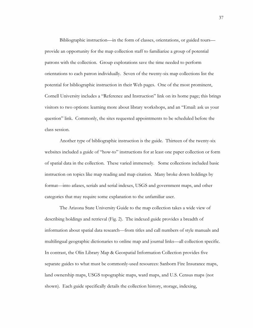
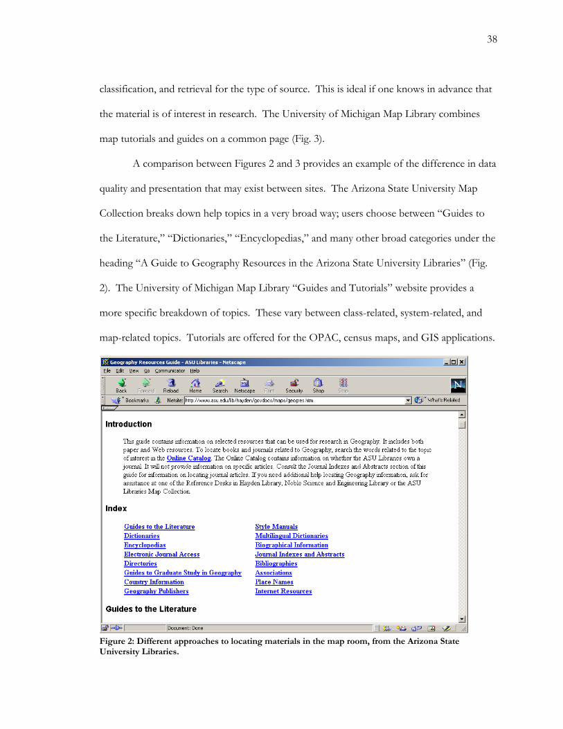
The Arizona State University Guide to the map collection takes a wide view of
describing holdings and retrieval (Fig. 2). The indexed guide provides a breadth of
information about spatial data research—from titles and call numbers of style manuals and
multilingual geographic dictionaries to online map and journal links—all collection specific.
In contrast, the Olin Library Map & Geospatial Information Collection provides five
separate guides to what must be commonly-used resources: Sanborn Fire Insurance maps,
land ownership maps, USGS topographic maps, ward maps, and U.S. Census maps (not
shown). Each guide specifically details the collection history, storage, indexing,
38
classification, and retrieval for the type of source. This is ideal if one knows in advance that
the material is of interest in research. The University of Michigan Map Library combines
map tutorials and guides on a common page (Fig. 3).
A comparison between Figures 2 and 3 provides an example of the difference in data
quality and presentation that may exist between sites. The Arizona State University Map
Collection breaks down help topics in a very broad way; users choose between “Guides to
the Literature,” “Dictionaries,” “Encyclopedias,” and many other broad categories under the
heading “A Guide to Geography Resources in the Arizona State University Libraries” (Fig.
2). The University of Michigan Map Library “Guides and Tutorials” website provides a
more specific breakdown of topics. These vary between class-related, system-related, and
map-related topics. Tutorials are offered for the OPAC, census maps, and GIS applications.
Figure 2: Different approaches to locating materials in the map room, from the Arizona State University Libraries.

39
Figure 3: The Map Library, University of Michigan, provides a variety of tutorials and collection guides relating to using specific and general materials based on publisher, theme, and format.
Figure 4: Cartographic Information Service, University of Washington, provides a tutorial for locating topographic maps in the OPAC. This page provides links to an index map and series coverage.
40
Nine map collections provided a tutorial for the location of cartographic and
geographic materials through an OPAC, map index, paper catalog, classification system, or
some combination of these retrieval tools. Each collection used a unique method to explain
and display their tutorial. Many paste OPAC screen images for search steps, like the
Cartographic Information Services from the University of Washington (Fig. 4). Series and
title searches for one series of USGS maps are a very narrow scope for a tutorial. As
discussed by Tenner and Weimer, in “Reference Service for Maps: Access and the Catalog
Record,” title searching is difficult for maps. This tutorial deals mainly with the steps to
performing a title search on USGS topographic maps from Washington State; seven specific
sections and five screen pastes are devoted to the tutorial. It is a very complicated tutorial.
Presumably, topographic maps are a popular resource at the University of Washington. The
most common topics among map collection tutorials include: descriptive search methods,
using classification systems, and GIS.
The guides mentioned above are collection-specific, as opposed to general guides
provided by outside organizations in support of a service or product. A common example
occurs in GIS tutorials. In addition to offering a schedule of local GIS instruction
opportunities, several sites sponsor links to software-based tutorials in support of their
collection’s GIS software. Because of the complexity and lack of standardization in GIS
applications, software providers offer self-paced tutorials and instructions in order to assist
users.
Another form of the general guide appears in websites offering tutorials and
instructions for the navigation and use of online spatial data. Examples of online guides
include those published in sites maintained by cartographic agencies of the U.S.
41
government—like the USGS and the Census Bureau—which describe the publication, use,
and availability of their spatial data. Another example, which falls into the commercial and
governmental realm, may be found in geospatial data clearinghouses of GIS data sets. The
websites of Clearinghouses usually provide instruction for the downloading of data and the
migration of data for various software packages. In these examples, map librarians do not
need to create such tutorials and guides locally because issuing agencies provide general
information about the creation, use, and retrieval of spatial data. If patrons are directed
towards these guides, less time is dedicated to collection-specific information for general
resource information.
An additional activity that is related to learning is the communication between map
librarian and academic instructor. The only obvious website manifestation of such a
communication is a guide or site created specifically for an academic class—often in the
form of a reserve list, a guide, or a thematic grouping of maps with a course name in the
title. Nine of the twenty-six websites contained one or more demonstrations of instructor-
library collaboration.
General interest
The website communications that fall under the category of ‘general interest’ provide
attractive, compelling information to patrons. This group of communications is relatively
subjective; that which is of general interest to some may not interest others at all. However,
some common themes of general interest across the twenty-six websites analyzed include:
current events and news maps, local maps, historical collections, and subject-based
collections. The common factor in general interest communications is the isolation of
42
certain materials from the collection based on a characteristic or idea. This activity may
seem redundant, as all materials presumably are searchable to those who are truly interested
in finding them. Yet general interest links call patrons’ attention to subjects, themes, and
materials that may enrich their research experience.
Eleven of the twenty-six surveyed collections include a page devoted to new
acquisitions, new services, or new maps. Several of the collections list new maps and atlases
related to Afghanistan and the Middle East, regions of current interest. Other new materials
list focus on new GIS data sets, calling attention to GIS program growth. Both examples of
new materials communicate active collection development procedures to patrons. Such
inclusions fulfill a dual purpose: communicating an active acquisition process to patrons, and
ensuring active website editing.
Fifteen of the twenty-six collections include a link from their home page to data on
the subject of local (state or urban area) spatial data. Local atlases, GIS information, digital
maps, digitized historical maps, and cartographies are included in these sources. Such a
focus ensures that patrons from the academic community have a spatial resource for the area
and community of which they are a part. Patrons and affiliates of the institution who are
doing primary research close to home would find this an invaluable resource. Additionally,
students, faculty and patrons may find such resources helpful for planning trips, exploring
the region, and enriching their associations to the community.
Exhibits sponsored by the map collection or another organization may be linked to a
Web page. This was a common recommendation within the map-promotion literature.
Maps are visually stimulating; many are artistic and reflect historical, political, and artistic
developments. Of the twenty-six websites surveyed, seven included a description of or link
43
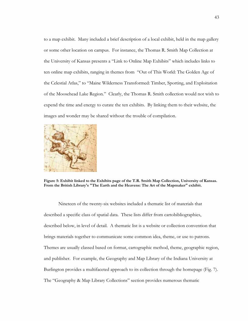
to a map exhibit. Many included a brief description of a local exhibit, held in the map gallery
or some other location on campus. For instance, the Thomas R. Smith Map Collection at
the University of Kansas presents a “Link to Online Map Exhibits” which includes links to
ten online map exhibits, ranging in themes from “Out of This World: The Golden Age of
the Celestial Atlas,” to “Maine Wilderness Transformed: Timber, Sporting, and Exploitation
of the Moosehead Lake Region.” Clearly, the Thomas R. Smith collection would not wish to
expend the time and energy to curate the ten exhibits. By linking them to their website, the
images and wonder may be shared without the trouble of compilation.
Figure 5: Exhibit linked to the Exhibits page of the T.R. Smith Map Collection, University of Kansas. From the British Library's "The Earth and the Heavens: The Art of the Mapmaker" exhibit.
Nineteen of the twenty-six websites included a thematic list of materials that
described a specific class of spatial data. These lists differ from cartobibliographies,
described below, in level of detail. A thematic list is a website or collection convention that
brings materials together to communicate some common idea, theme, or use to patrons.
Themes are usually classed based on format, cartographic method, theme, geographic region,
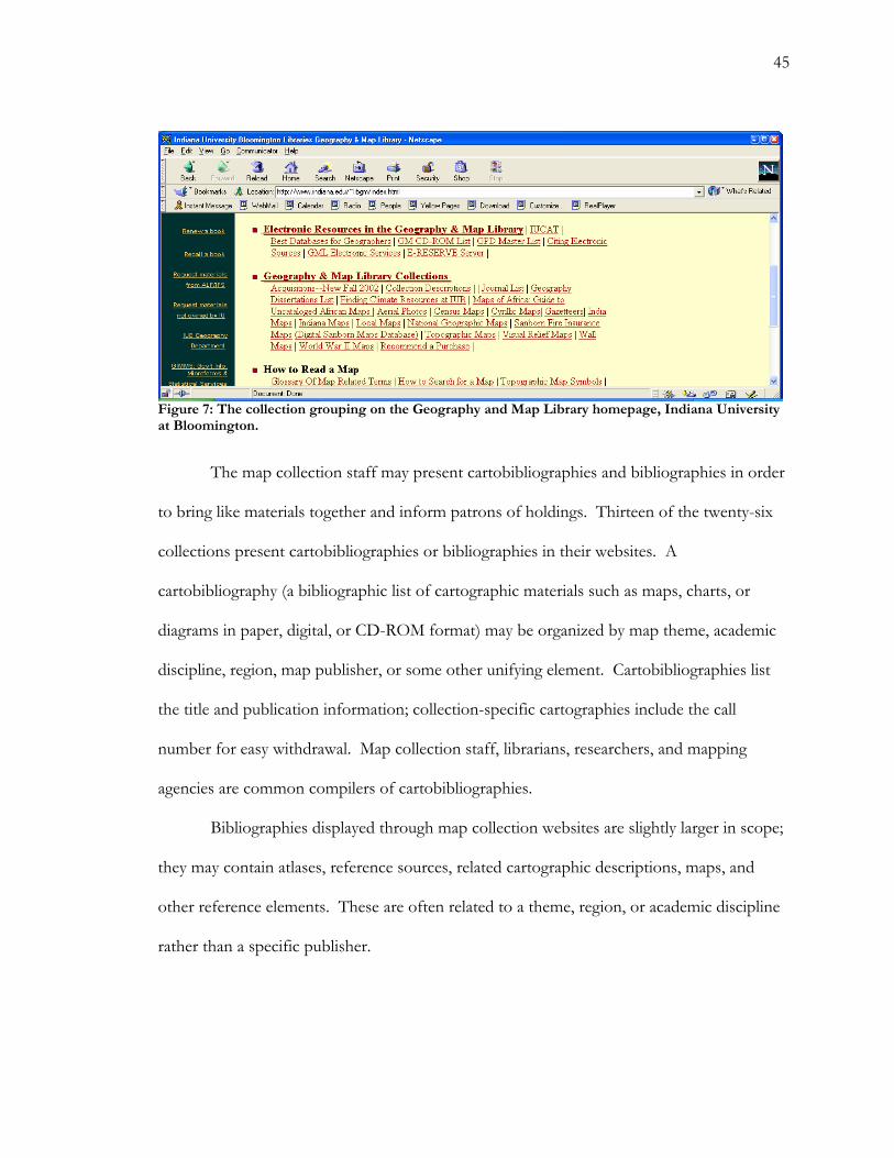
and publisher. For example, the Geography and Map Library of the Indiana University at
Burlington provides a multifaceted approach to its collection through the homepage (Fig. 7).
The “Geography & Map Library Collections” section provides numerous thematic
44
approaches to the spatial data resources. Patrons may choose between well-defined
collections like “census maps,” “topographic maps,” “National Geographic maps,” and
“World War II maps.” These classes are interspersed with finding aids and non-map
resources. The resulting collection description is cross-referenced, a multifaceted approach
to the collection.
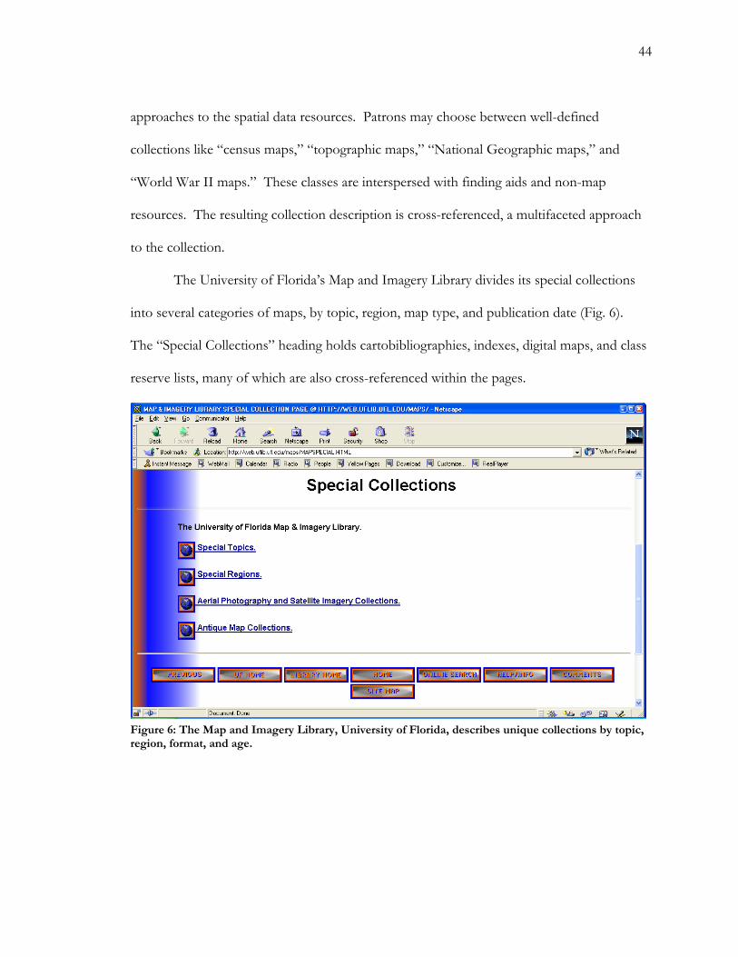
The University of Florida’s Map and Imagery Library divides its special collections
into several categories of maps, by topic, region, map type, and publication date (Fig. 6).
The “Special Collections” heading holds cartobibliographies, indexes, digital maps, and class
reserve lists, many of which are also cross-referenced within the pages.
Figure 6: The Map and Imagery Library, University of Florida, describes unique collections by topic, region, format, and age.
45
Figure 7: The collection grouping on the Geography and Map Library homepage, Indiana University at Bloomington.
The map collection staff may present cartobibliographies and bibliographies in order
to bring like materials together and inform patrons of holdings. Thirteen of the twenty-six
collections present cartobibliographies or bibliographies in their websites. A
cartobibliography (a bibliographic list of cartographic materials such as maps, charts, or
diagrams in paper, digital, or CD-ROM format) may be organized by map theme, academic
discipline, region, map publisher, or some other unifying element. Cartobibliographies list
the title and publication information; collection-specific cartographies include the call
number for easy withdrawal. Map collection staff, librarians, researchers, and mapping
agencies are common compilers of cartobibliographies.
Bibliographies displayed through map collection websites are slightly larger in scope;
they may contain atlases, reference sources, related cartographic descriptions, maps, and
other reference elements. These are often related to a theme, region, or academic discipline
rather than a specific publisher.
46
Conclusion
The twenty-six map collection websites that I analyzed varied greatly in structure and
in content. One contributing factor to wide variation could be the lack of updated map
collection standards. No standards have been created since 1987, when the Special Libraries
Association stated, “Information services in the map collection shall include reference
service, bibliographic instruction, and promotional activity.” In the past fifteen years, the
continuous growth of Web-based communication has provided a medium for the
informative and educational devices found in this survey. Reference service, bibliographic
instruction, and promotional activity have changed dramatically as a result of the World
Wide Web.
The average map collection website in this survey includes the following
information:
• A description of the collection, including hours of operation, major types of spatial data
sources, and a brief description of the OPAC or local cataloging system.
• An email contact to staff.
• Instructions for map collection use. There are many forms of instruction, including
orientations, tutorials, descriptive guides printed online, and FAQ sheets. The subject
matter varies greatly, as well.
• Cartobibliographies and thematic lists of maps and collection holdings. These common
lists bring various sources together based on a common coverage area, theme, publisher,
47
•
•
•
•
or some other feature. They are a useful starting point in collection exploration; they
often focus on a collection’s strengths.
• Links to online search tools, online maps, and GIS resources.
All twenty-six collections, it is significant to note, embraced the World Wide Web as
a medium for communication, to varying degrees of effectiveness. The best sites, after close
study, would contain all of those categories of information described in the above list.
Additionally, they would provide:
More extensive descriptions of the collection, to include: each material type and useful
resources specific to the format, including digital and online information sources. Since I
only checked for the presence or absence of information, sites supplemented by this
criterion would not be distinguishable from other sites using my research criteria; but one of
the most common sources of confusion on the sites stemmed from a lack of descriptive text.
A site composed of two-hundred hyperlinks to additional information is useless if a patron
does not know which link to choose. Categories of information that are logical to a map
librarian (“Topos,” “TIGER files,” “The Perry Castañeda Library,” and “Sanborn maps,”
for example, with no further description) will probably not be helpful to a student.
The name and telephone number of a member of the reference staff, thus reducing
anonymity of contact.
Acquisition policy for materials, explaining what collections are most important in the
library mission.
Increased cross-references between material types. In map cataloging, classification and
subject heading systems work together to create subject and area access to a material. The
library website should mimic this convention, adding more details about format and use. If
48
this practice were adopted, a patron looking in a local paper collection might learn that the
library also holds CD-ROMs of similar data, which might better suit needs. Online retailers
do this; it is one of the valuable capabilities of computer technology. Patrons, particularly
those unfamiliar with spatial data and the map collection.
The most prominent problem among map collection websites is the technical—
geographic, cartographic, and governmental—jargon. These fields are peppered with rather
esoteric knowledge, language, and understanding of concepts and organization. As has been
discussed throughout this paper, communication is the key to teaching and guiding
unfamiliar patrons through spatial data resources. The librarian should act as a translator,
instructor, and friendly information source to patrons who find themselves in the strange
world of map collections.
For further research, it would be interesting to post a survey in the map collection
homepage to ask patrons what they wish to see on the map collection website. It would also
be interesting to analyze a site for the number and length of “hits”—is it possible that online
resources and collections decrease user rates within the physical collection? (Can a website
be too effective?) Finally, it would be interesting to ask map collection Web page designers
what their major goals were, and how they evaluate their sites.
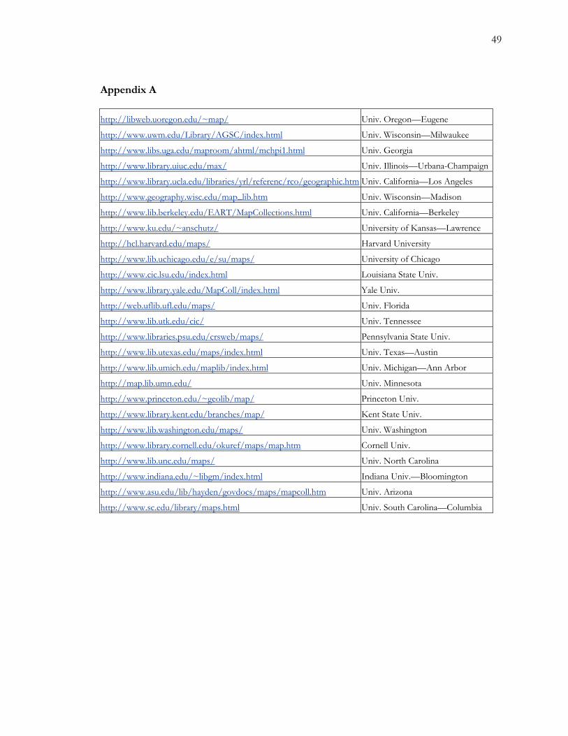
49
Appendix A
http://libweb.uoregon.edu/~map/ Univ. Oregon—Eugene
http://www.uwm.edu/Library/AGSC/index.html Univ. Wisconsin—Milwaukee
http://www.libs.uga.edu/maproom/ahtml/mchpi1.html Univ. Georgia
http://www.library.uiuc.edu/max/ Univ. Illinois—Urbana-Champaign
http://www.library.ucla.edu/libraries/yrl/referenc/rco/geographic.htm Univ. California—Los Angeles
http://www.geography.wisc.edu/map_lib.htm Univ. Wisconsin—Madison
http://www.lib.berkeley.edu/EART/MapCollections.html Univ. California—Berkeley
http://www.ku.edu/~anschutz/ University of Kansas—Lawrence
http://hcl.harvard.edu/maps/ Harvard University
http://www.lib.uchicago.edu/e/su/maps/ University of Chicago
http://www.cic.lsu.edu/index.html Louisiana State Univ.
http://www.library.yale.edu/MapColl/index.html Yale Univ.
http://web.uflib.ufl.edu/maps/ Univ. Florida
http://www.lib.utk.edu/cic/ Univ. Tennessee
http://www.libraries.psu.edu/crsweb/maps/ Pennsylvania State Univ.
http://www.lib.utexas.edu/maps/index.html Univ. Texas—Austin
http://www.lib.umich.edu/maplib/index.html Univ. Michigan—Ann Arbor
http://map.lib.umn.edu/ Univ. Minnesota
http://www.princeton.edu/~geolib/map/ Princeton Univ.
http://www.library.kent.edu/branches/map/ Kent State Univ.
http://www.lib.washington.edu/maps/ Univ. Washington
http://www.library.cornell.edu/okuref/maps/map.htm Cornell Univ.
http://www.lib.unc.edu/maps/ Univ. North Carolina
http://www.indiana.edu/~libgm/index.html Indiana Univ.—Bloomington
http://www.asu.edu/lib/hayden/govdocs/maps/mapcoll.htm Univ. Arizona
http://www.sc.edu/library/maps.html Univ. South Carolina—Columbia
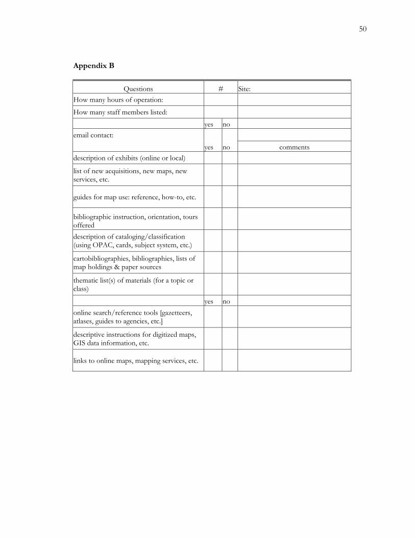
50
Appendix B
Questions # Site: How many hours of operation: How many staff members listed: yes no email contact: yes no comments description of exhibits (online or local) list of new acquisitions, new maps, new services, etc.
guides for map use: reference, how-to, etc.
bibliographic instruction, orientation, tours offered description of cataloging/classification (using OPAC, cards, subject system, etc.) cartobibliographies, bibliographies, lists of map holdings & paper sources thematic list(s) of materials (for a topic or class) yes no online search/reference tools [gazetteers, atlases, guides to agencies, etc.] descriptive instructions for digitized maps, GIS data information, etc.
links to online maps, mapping services, etc.
51
Works Cited
Allen, Gillian. “Bibliographic Instruction on the Internet.” The Role and Impact of the Internet on Library and Information Services. Lewis-Guodo Liu, ed. Westport, Conn. : Greenwood Press, ©2001.
Andrew, Paige G. “A Survey Technique for Map Collection Retrospective Conversion Projects.” Cataloging and Classification Quarterly. New York : Haworth Press. Vol. 27, no. 3/4 (1999). P. 405-428.
Arms, Carolina R. “Getting the Picture: Observations from the Library of Congress on
Providing Online Access to Pictorial Images.” Library Trends. Urbana, Ill. : University of Illinois Library School. Vol. 48, no. 2 (Fall 1999). P.379-409.
Association of College and Research Libraries. “ACRL guidelines for branch libraries in
colleges and universities.” College & Research Library News. Chicago : Association of College and Research Libraries. Vol. 52, no. 3 (Mar. 1991) P. 171-174. Balchin, W.G.V. Concern for Geography: A selection of the work of Professor W.G.V.
Balchin. Swansea, U.K. : Dept. of Geography, University College of Swansea, 1981.
Barrow, Bill, and Alice Hudson. “Promoting the Map Library to Your Boss and to the Public: How Local Map Societies, Library Friends Groups and Geographic Alliances Further the Work of Map Libraries.” Bulletin (Special Libraries Association. Geography and Map Division). New York : Special Libraries
Association.. No. 182 (Spring 1996) p. 26—29. Bell, Suzanne S. “Integrating Access to Formal and Informal Collections: What is Important
and What Succeeds.” Journal of Academic Librarianship. Ann Arbor, Mich. : Mountainside Publishing. Vol. 21 (May 1995). P. 181-186.
Cobb, David. Limits to Access: You Can Look, but Don’t Touch.” INSPEL. Berlin :
Universitätsbibliothek der Technischen Universität Berlin. Vol. 36, no. 1 (2002). P. 49-52.
Coote, Helen. How to Market Your Library Service : and enjoy it in the process!. London :
Aslib, The Association for Information Management, 1994. Corsmeier, Thomas. “The Microreproduction and Digitization of Maps: A Comparative
Analysis.” Information Bulletin. Sacramento, Calif. : Western Association of Map Librarians. Vol. 30, no. 1 (Nov. 1998). P. 10-34.
52
Daft, Richard L. Management. 5th ed. Fort Worth : Dryden Press, ©2000.
Fitzpatrick, Gary. “Digital Developments in the Geography and Map Division, Library of Congress.” Information Bulletin. Sacramento, Calif. : Western Association of Map Librarians. Vol. 29, no. 2 (Mar. 1998). P. 61-66.
Garlock, Kristen L. and Sherry Piontek. Designing Web Interfaces to Library Services and
Resources. Chicago : American Library Association, 1999. Hagen, Carlos B. A survey of the usage of a large map library. Bulletin (Special
Libraries Association. Geography and Map Division). New York : Special Libraries Association. No. 87 (March 1972) p. 46-47.
Harrison, K.C. Public Relations for Librarians. 2nd rev. ed. Aldershot, England : Gower
Publishing Company Ltd., c1982. Heery, Mike, and Steve Morgan. Practical Strategies for the Modern Academic Library.
London : Aslib, The Association for Information Management, 1996.
Hope, Charity B., Sandra Kajiwara, and Mengxiong Liu. “The Impact of the Internet: Increasing the Reference Librarian’s Role as Teacher.” Evolution in Reference and Information Services : the Impact of the Internet. Edited by Di Su. New York : Haworth Press, 2001. P. 13-36.
Kies, Cosette. Marketing and Public Relations for Libraries. Metuchen, N.J. : The
Scarecrow Press, 1987. Kitchin, Rob, and Mark Blades. The Cognition of Geographic Space. New York : I.B.
Tauris, 2002. Klein, Leo. “The Web is Not Your Library.” Library Journal. New York : Bowker. Vol.
126, no. 1 (Winter 2001) p. 36-38. Larsgaard, Mary Lynette. Map Librarianship: an Introduction. 3rd ed. Englewood, Colo. : Libraries Unlimited, 1998. Lee, Hur-Li. “What is a Collection?” Journal of the American Society for Information
Science. New York, N.Y. : The Society. Vol. 51, no. 12 (Oct. 2000). P. 1106-1113. MacEachren, Alan M. How Maps Work : Representation, Visualization, and Design. New
York : Guilford Press, ©1995. Monmonier, Mark S. and George A. Schnell. Map Appreciation. Englewood Cliffs, N.J. :
Prentice-Hall, ©1988.
53
---. Mapping It Out : Expository Cartography for the Humanities and Social Sciences.
Chicago : University of Chicago Press, 1993. Olsgaard, John N. and John Van Balen. “A Case Study In Promotion and Use of the
Map Collection: Travel Literature.” Information Bulletin. Sacramento, Calif. : Western Association of Map Libraries. Vol. 9, no. 2 (March 1978) p. 105—[111].
Peterson, Michael P. “Cognitive Issues in Cartographic Visualization.” Visualization in
Modern Cartography. Eds. Alan M. MacEachren and D.R. Fraser Taylor. Tarrytown, N.Y. : Elsevier Science, ©1994. P. 27-43.
Powers, Janet E. “Marketing in the Special Library Environment.” Library Trends. Urbana, Ill. : University of Illinois Library School. Vol. 43, no. 3 (Winter 1995). P. 478-493.
Ragains, Patrick. “A primer on developing and using course-related library Web pages.”
Research Strategies. Ann Arbor, MI : Mountainside Publishing. Vol. 18 (2001). P. 85-93.
Rockwell, Ken. “Problem Areas in the Descriptive Cataloging of Sheet Maps.” Cataloging
and Classification Quarterly. New York : Haworth Press. Vol. 27, no. 3/4 (1999). P. 39-63. Rumsey, David, Phil Hoehn and Julie Sweetkind. “The Rumsey Collection Goes Online.”
Information Bulletin. Sacramento, Calif. : Western Association of Map Librarians. Vol. 32, no. 2 (Mar. 2001). P. 97-105).
Special Libraries Association. Geography and Map Division. Committee on Standards.
Standards for University Map Collections. Washington : Special Libraries Association, Geography and Map Division, 1987.
Steinmacher, Michael. “Underlying Principles of Library Public Relations.” Kentucky
Libraries. Paducah, Ky. : Kentucky Library Association. Vol. 64, no. 1 (Winter 2000). P. 12-15.
Suozzi, P.A. and S.S. Kerbel. “The Organizational Misfits.” College and Research Libraries.
Chicago : American Library Association. Vol. 53, no. 6 (Nov. 1992). P. 513-522. Taylor, Robert S. “Question-Negotiation and Information Seeking in Libraries.” College
and Research Libraries. Chicago : American Library Association. Vol. 29, no. 3 (May 1968) p. 178-194.
Tenner, Elka and Katherine H. Weimer. “Reference Service for Maps: Access and the
Catalog Record.” Reference & User Services Quarterly. Chicago : American Library Association. Vol. 38, no. 2 (1998). P. 181-186.
54
Tiberio, Barbara. “Publicizing the Map Collection in the Academic Library: A Facet
of Aggressive Reference Service.” Bulletin (Special Libraries Association. Geography and Map Division). New York : Special Libraries Association. No. 107. (March 1977) p. 49—53.
Tufte, Edward R. Envisioning Information. Cheshire, Conn. : Graphics Press, ©1990. Weimer, Katherine H. “Subject Analysis for Cartographic Materials.” Cataloging
and Classification Quarterly. New York : Haworth Press. Vol. 27, no. 3/4 (1999). P. 385-404.
Womble, Kathryn. “Retrospective Conversion and Cataloging of a Major Academic
Map Collection: The University of Washington Story.” Cataloging and Classification Quarterly. New York : Haworth Press. Vol. 27, no. 3/4 (1999).
Wood, Michael. “Visualization in Historical Context.” Visualization in Modern
Cartography. Eds. Alan M. MacEachren and D.R. Fraser Taylor. Tarrytown, N.Y. : Elsevier Science, ©1994. P. 13-26.