jncc/cefas partnership report...
TRANSCRIPT
JNCC/Cefas Partnership Report Series
Report No. 18
CEND23/16X Cruise Report: Monitoring Survey of Pisces Reef Complex cSAC/SCI
Jenkins, C. & Nelson, M.
June 2017
© JNCC, Cefas 2017
ISSN 2051-6711

CEND23/16X Cruise Report: Monitoring Survey of Pisces Reef Complex cSAC/SCI
Jenkins, C. & Nelson, M.
June 2017
© JNCC, Cefas, 2017
ISSN 2051-6711
For further information please contact: Joint Nature Conservation Committee Monkstone House City Road Peterborough PE1 1JY www.jncc.defra.gov.uk
This report should be cited as: Jenkins, C. & Nelson, M. 2017. CEND23/16X Cruise Report: Monitoring survey of Pisces Reef Complex cSAC/SCI. JNCC/Cefas Partnership Report Series No. 18. JNCC, Peterborough.
This report is compliant with the JNCC Evidence Quality Assurance Policy http://jncc.Defra.gov.uk/default.aspx?page=6675. This report was reviewed by Cefas and JNCC, with comments and input from an external contractor who was employed by JNCC for the purposes of this project.
Summary This report summarises the methods and data acquired during a survey of the Pisces Reef Complex candidate Special Area of Conservation (cSAC) and Site of Community Importance (SCI). The monitoring survey of the Pisces Reef Complex was carried out from 30th October – 4th November 2016, as part of a cruise that also visited Utopia Marine Conservation Zone (MCZ) on behalf of Natural England. There were two key aims of the survey:
1. Acquire sentinel monitoring data to support the ongoing monitoring time-series for the Pisces Reef Complex.
2. Provide evidence on the structure, function and condition of the Annex I Reefs (both rocky and stony) against which the direction of change can be inferred over time.
A variety of data types were collected during the six-day survey including multibeam echosounder bathymetry and backscatter, chirper sub-bottom profiles, high resolution video and stills, and water samples to calibrate the camera frame mounted CTD. Weather conditions were very good throughout the survey period with only minor data artefacts occurring in the sub-bottom data. Video transect locations were selected on vessel using multibeam echosounder and sub-bottom profiler data to target both areas of potentially exposed rocky reef and wider muddy habitat. 391km of multibeam and chirper data were acquired across the three Pisces Reef areas along with 63 video transects and 11 water samples. Due to the good weather, all of the survey objectives were completed with the vessel able to remain on site and work continuously, with no need to make use of the weather contingency sites.

Contents
1 Background and introduction ..................................................................................... 1
1.1 Survey project team ................................................................................................ 1
1.2 Site description – Pisces Reef Complex cSAC/SCI ................................................. 1
2 Aims and objectives .................................................................................................... 4
2.1 Aim ......................................................................................................................... 4
2.2 Objectives and priorities .......................................................................................... 4
2.3 Acoustic data collection .......................................................................................... 6
2.3.1 Multibeam echosounder (MBES) ..................................................................... 6
2.3.2 Chirper acquisition and mitigation .................................................................... 6
2.3.3 Acoustic data formats ...................................................................................... 6
2.4 Groundtruthing stations ........................................................................................... 7
2.4.1 Visual groundtruthing ....................................................................................... 7
2.4.2 ESM2 logger .................................................................................................... 9
2.4.3 Water sampling from Niskin sample bottle ..................................................... 10
2.4.4 Groundtruth data formats ............................................................................... 10
2.5 Positioning ............................................................................................................ 11
3 Cruise narrative .......................................................................................................... 12
4 Results ........................................................................................................................ 14
4.1 Acoustic line summaries ....................................................................................... 14
4.1.1 Bathymetry and backscatter ........................................................................... 14
4.1.2 Sub-bottom profiler (chirper) .......................................................................... 16
4.2 Drop frame camera transect summaries ............................................................... 17
4.3 ESM2 logger ......................................................................................................... 17
4.4 Marine mammal observations ............................................................................... 18
5 Quality control (QC) ................................................................................................... 19
5.1 Bathymetry and backscatter .................................................................................. 19
5.2 Sub-bottom profiling .............................................................................................. 19
5.3 Seabed imagery .................................................................................................... 19
5.4 ESM2 logger ......................................................................................................... 19
6 Human activity ........................................................................................................... 20
7 H&S events ................................................................................................................. 21
8 References ................................................................................................................. 22
Appendix 1. Vessel and equipment used ........................................................................ 23
RV Cefas Endeavour ....................................................................................................... 23
STR SeaSpyder “Telemetry” drop camera system........................................................... 25
Positioning software-Tower ............................................................................................. 25
Niskin water bottle ........................................................................................................... 25

CEND23/16X Cruise Report: Monitoring survey of Pisces Reef cSAC/SCI
Multibeam echosounder (bathymetry and backscatter) .................................................... 25
Sub-bottom profiler (chirper) ............................................................................................ 25
Appendix 2. Equipment calibration .................................................................................. 26
GPS positions and corrections. ....................................................................................... 26
Calibration patch test report, Kongsberg EM2040 multibeam. ......................................... 26
Appendix 3. Offsets........................................................................................................... 27
Stern gantry ..................................................................................................................... 27
Side gantry ...................................................................................................................... 27
HiPAP.............................................................................................................................. 28
Appendix 4. Summary of survey operation time ............................................................. 29
Appendix 5. Copy of daily progress reports ................................................................... 30
Appendix 6. Survey metadata .......................................................................................... 31
Appendix 7. Habitat types................................................................................................. 46
Appendix 8. Marine mammal observations report .......................................................... 59

CEND23/16X Cruise Report: Monitoring survey of Pisces Reef cSAC/SCI
1
1 Background and introduction
1.1 Survey project team The monitoring survey at Pisces Reef Complex candidate Special Area of Conservation (cSAC) and Site of Community Importance (SCI) was carried out from 30th October– 4th November 2016, aboard the RV Cefas Endeavour. The survey team for the duration of the fieldwork included Cefas marine scientists, three marine scientists from the Joint Nature Conservation Committee (JNCC), two geophysicists, two hydrographers and a Passive Acoustic Monitoring (PAM) operator. Cross-shifts Chris Jenkins (Cefas Scientist in Charge) Claire Mason (Cefas Data Manager) Daylight hours James Albrecht (JNCC Marine Mammal Observer (MMO)) Night hours Gareth Duguid (Gardline MMO and PAM operative) Day Shift Daniel Wood (Cefas Shift Lead) Marc Whybrow (Cefas Marine Instrumentation Team Technician) Anna Downie (Cefas GIS & survey planning) Nicholas Darley (Electronic Geophysical Services (EGS) Hydrographer) Thomas Smethurst (EGS Geophysicist) Night Shift Paul McIlwaine (Cefas Shift Lead) Louise Brown (Cefas GIS) Paul Nelson (Cefas Chemist) Mike Nelson (JNCC Survey Lead) Nikki Taylor (JNCC Survey Scientist) Liam Flynn (EGS Hydrographer) Rory Anderson (EGS Geophysicist)
1.2 Site description – Pisces Reef Complex cSAC/SCI
The Pisces Reef Complex cSAC/SCI is located in the western Irish Sea, in the north-west mud basin. It is approximately midway between the Isle of Man and the coast of Northern Ireland. The area consists of an extensive mud plain through which three areas of Annex I bedrock and boulder-dominated stony reef protrude. The average seabed depth within the site boundary is approximately 100m with a maximum of 150m and a minimum of 70m at the peaks of the rocky reef outcrops. The deepest depths are within the scour pits which encircle the outcropping rocky reefs.
The three extruding reefs are composed of tertiary igneous rock and boulders, with the reef tops composed of silty bedrock, with a patchy veneer of muddy sediment due to sediment deposition from a localised scouring process. The reefs support a diverse animal community, including hydroids (e.g. Diphasia nugra), a range of sponges, including the cup sponge Axinella infundibuliformi, echinoderms, for example the cushion star Porania pulvillus and various crustaceans, for example the edible crab Cancer pagurus and squat lobster Munida

CEND23/16X Cruise Report: Monitoring survey of Pisces Reef cSAC/SCI
2
rugosa. Additionally, the reef may provide shelter for juvenile fish, including blue whiting, bib, red gurnard and wrasse. In particular, the mosaic of bedrock and stony reef provide a myriad of ledges and habitat niches. Of note is the occurrence of the Diphasia alata hydroid community which is not currently included within the Marine Habitat Classification for Britain and Ireland, and is considered rare. The difference in species composition and abundance between the reefs and the surrounding mud plain highlights the importance of the reefs in providing a refuge for numerous species. The site boundary for the Pisces Reef Complex cSAC/SCI has been defined using JNCC’s marine SAC boundary definition guidelines. The boundary is made up of three separate polygons enclosing the minimum area necessary to ensure protection of the Annex I habitats (Figure 1). It does not include the areas of muddy sediment that lie between the reefs, however, the boundaries do encompass a number areas of burrowed mud between the exposed bedrock / boulders. The bedrock reef features were derived by collating survey data from various detailed acoustic and biological surveys. The areas of bedrock and stony reef that met the definition of Annex I Reef were delineated based on the interpretation of acoustic data, which showed a clear distinction between the hard and soft substrates. Seabed modelling using the Benthic Terrain Modeller (NOAA) was also carried out for all three areas. It should be noted that the data used for this analysis may have limitations in differentiating between exposed rock and rock with a shallow mud veneer. As any bottom trawling that occurs in the area may pose a threat to the reef, the site boundary includes a margin to allow for mobile gear on the seabed being some distance from the location of a vessel at the sea surface. This 400m buffer has been applied individually to each of the reef features of the site. Further detail can be found in the Pisces Reef Complex cSAC/SCI Conservation Objectives and Advice on Operations document (JNCC 2012b).
Figure 1. Original habitat map for Pisces Reef Complex cSAC/SCI (JNCC 2012a).

CEND23/16X Cruise Report: Monitoring survey of Pisces Reef cSAC/SCI
3
Several previous surveys have collected data from the area1, and existing video tow positions are presented in Figure 2. A more recent habitat map was created in 2015 using opportunistic data collected from Pisces Reef Complex cSAC/SCI on a survey to Slieve na Griddle MCZ (Figure 2). This map does not, however, cover all three areas of Pisces Reef Complex cSAC/SCI (Barrio Froján 2015).
Figure 2. Existing video tow stations and habitat map covering Pisces Reef Complex cSAC/SCI created as part of the recent Slieve na Griddle MCZ verification surveys.
1 JNCC Pisces Reef Complex cSAC/SCI Site Information Centre
CEND23/16X Cruise Report: Monitoring survey of Pisces Reef cSAC/SCI
4
2 Aims and objectives
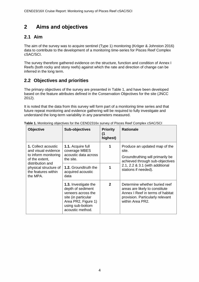
2.1 Aim The aim of the survey was to acquire sentinel (Type 1) monitoring (Kröger & Johnston 2016) data to contribute to the development of a monitoring time-series for Pisces Reef Complex cSAC/SCI. The survey therefore gathered evidence on the structure, function and condition of Annex I Reefs (both rocky and stony reefs) against which the rate and direction of change can be inferred in the long term.
2.2 Objectives and priorities The primary objectives of the survey are presented in Table 1, and have been developed based on the feature attributes defined in the Conservation Objectives for the site (JNCC 2012). It is noted that the data from this survey will form part of a monitoring time series and that future repeat monitoring and evidence gathering will be required to fully investigate and understand the long-term variability in any parameters measured. Table 1. Monitoring objectives for the CEND2316x survey of Pisces Reef Complex cSAC/SCI
Objective Sub-objectives Priority (1 highest)
Rationale
1. Collect acoustic and visual evidence to inform monitoring of the extent, distribution and physical structure of the features within the MPA.
1.1. Acquire full coverage MBES acoustic data across the site.
1 Produce an updated map of the site.
Groundtruthing will primarily be achieved through sub-objectives 2.1, 2.2 & 3.1 (with additional stations if needed).
1.2. Groundtruth the acquired acoustic data
1
1.3. Investigate the depth of sediment veneers across the site (in particular Area PR2, Figure 1) using sub-bottom acoustic method.
2 Determine whether buried reef areas are likely to constitute Annex I Reef in terms of habitat provision. Particularly relevant within Area PR2.

CEND23/16X Cruise Report: Monitoring survey of Pisces Reef cSAC/SCI
5
2. Collect acoustic and visual evidence to inform monitoring of the diversity and structure of biological communities, and typical species within the site.
2.1. Acquire quantitative photographic data on epifaunal communities across the reef features, stratifying effort by a) Areas PR2, PR1 & PR3, b) exposed rock & sediment veneer.
1 Supply data for Annex I Reef monitoring time-series, and characterise the different communities associated with rock and sediment veneers.
Collect data to allow future identification of any differences in habitat condition between areas where buffered (PR1 & PR3) and non-buffered (PR2) fisheries management measures have been applied.
2.2. Acquire qualitative photographic data on epifaunal communities across wider areas of sediment within the site boundary, including scour hollows.
3 Provide comparison to sediment veneer communities.
3. Acquire visual and environmental data to improve understanding of environmental conditions and sediment dynamics within the site.
3.1. Revisit camera transects surveyed in 2004 (SEA6), 2005 (AFBI/MESH), CEND1911 & CEND1414 to collect video/stills data.
2 Qualitative comparison to previously acquired photographic data, to investigate whether rock has been exposed/buried, and whether there is any evidence for mobility of sediment veneers.
3.2. Acquire environmental data (conductivity, turbidity, temperature, salinity, chlorophyll) at camera stations.
1 Temperature, conductivity (salinity), pressure (depth), fluorescence (chlorophyll), light transmission (suspended load), dissolved oxygen will be collected for use in the evaluation of proposed supporting indicators for the determination of shallow sublittoral rock habitat status and to identify environmental variables that may be influential in any patterns observed in the epibenthic assemblages.
Objective 1.3 concerns the investigation of the depth of sediment veneers across the site. Existing data have shown areas of the Annex I Reef as being covered in a veneer of mud (JNCC 2012a). Determining whether buried reef areas are likely to constitute Annex I Reef in terms of habitat provision would provide vital contextual information for the site.

CEND23/16X Cruise Report: Monitoring survey of Pisces Reef cSAC/SCI
6
2.3 Acoustic data collection The survey was undertaken aboard the RV Cefas Endeavour. Details of the vessel and the equipment used are provided in Appendix 1; details of equipment calibration are presented in Appendix 2. The planned survey operations and the equipment operation protocols are described below. The following acoustic systems2 were planned for use:
• Multibeam echosounder (MBES) run at 200kHz and 400kHz
• Chirper run at 11.2kHz. The MBES and chirper system were monitored continuously throughout the survey operations. Acoustic and sub bottom lines were planned for areas PR1, PR2 and PR3. In all three areas MBES was collected for 100% coverage in both frequencies (200 and 400kHz), with each frequency being acquired perpendicular to the other. The chirper system was run simultaneous to the MBES and was acquired at a line spacing between 125-150m, dictated by the spacing required to acquire 20-30% overlap of the MBES swathe.
2.3.1 Multibeam echosounder (MBES) MBES data (bathymetry and backscatter) were acquired continuously throughout survey operations to provide information about seabed depth, type and distinguish between hard and softer substrates.
2.3.2 Chirper acquisition and mitigation The chirper system was operated by two technicians to allow 24hr operations and interpretation. JNCC guidelines for seismic surveys were used during the survey with respect to the sub-bottom profiler3; these require that deployments of the sub-bottom system are ‘logged’ in a noise register. Pre-shoot watches of 30 minutes were undertaken, by a trained Marine Mammal Observer, in daylight hours, and a Passive Acoustic Monitoring operator during night hours prior to the system being activated. A ‘soft-start’ of the chirper was initiated 20 minutes prior to the line, where the frequency of the source was incrementally increased over this period up to full power. Where marine mammals were detected within 500m of the vessel, during the 30 minute observation period, survey operations were delayed for 20 minutes from the time when the mammals left the 500m mitigation zone. Where line turns were known to be less than 40 minutes the source power was reduced to 10% of full power, but was kept firing throughout the turn (JNCC 2010).
2.3.3 Acoustic data formats The formats in which the acoustic data were stored are shown in Table 2. Table 2. Acoustic data formats
Kit Data format(s)
Multibeam .all .gsf .xyz .sd .wcd .TIF
2 Details of the acoustic systems are presented in Appendix 1. 3 http://jncc.defra.gov.uk/pdf/JNCC_Guidelines_Seismic%20Guidelines_Aug%202010.pdf

CEND23/16X Cruise Report: Monitoring survey of Pisces Reef cSAC/SCI
7
.tid
Chirper .segy .jpg summary images .sd
2.4 Groundtruthing stations
2.4.1 Visual groundtruthing Placement of video tows followed the same protocol at all three Pisces Reef sites (PR1, PR2 and PR3; Figure 1). Processed MBES bathymetry, 200kHz (all sites) and 400kHz (PR1 and PR3) backscatter and sub-bottom profiler data were combined to construct a full coverage GIS layer of most likely surface substrate. Bathymetry and backscatter were gridded to 1m and 30cm, respectively. The class of the upper identified horizon (mud, reworked sediment (sediments laid down and then eroded again before being redeposited) or rock) and the thickness of the mud layer, were exported at 60-70cm intervals along the sub-bottom profiler track and imported into ArcGIS v10.1 as a point feature. Several topographic derivatives, including slope, bathymetric rugosity and bathymetric position index (BPI) were calculated from the bathymetry. Values of the raster layers were extracted at the point locations of the sub-bottom profiler track. A subset of 3000 values (1000 observations of each bottom class) was used to train two separate Conditional Inference Tree (CI) models, one on the bathymetry and derivative and the other on the backscatter. The splits identified by the models were used to reclassify the backscatter layer into soft and hard substrate. The layers of slope, bathymetry and a broad-scale BPI were used to further try to separate rock from the reworked sediments. Concave surfaces that were likely to accumulate sediment locally were identified using a fine scale BPI and reclassified as mud. Figure 4 illustrates the data used to identify potential rock and the different strata used to plan towed lines.

CEND23/16X Cruise Report: Monitoring survey of Pisces Reef cSAC/SCI
8
Figure 3. Illustration of acoustic data and different strata used in planning line placement at PR1.
A mixture of 200m and 100m lines were placed across and within strata of depth, slope and potential bottom type. The 200m lines were exploratory, aimed towards identifying the range of conditions covered by habitats, in order to improve accuracy for mapping the rock habitat. The 100m lines were placed within strata to provide descriptive data for characterisation of the habitat. Some camera tows, at PR2, were planned to be coincident with several locations previously investigated during the CEND1414 survey. Figure 4 presents the spatial distribution of video tows across Pisces Reef areas PR1, PR2 and PR3.

CEND23/16X Cruise Report: Monitoring survey of Pisces Reef cSAC/SCI
9
Figure 4. Planned Video tows at Pisces Reef Complex cSAC/SCI overlaid on predictive strata
Visual groundtruthing was carried out using a drop frame equipped with laser scale, digital stills and HD video camera. The number of planned tows per Pisces Reef area are presented in Table 3. Tows were conducted at a speed of 0.3kts using the vessel’s dynamic positioning capability. Video footage with overlay of ship’s position were recorded during the tow, once the drop frame has reached the seabed. Still images were taken at 60 second intervals from a dedicated stills camera, together with opportunistic stills that would assist in completing the survey objectives. The drop frame was deployed from the side gantry and the Tower logging system was set up to record USBL position at five second intervals. Table 3. Number of planned drop frame transects per Pisces Reef area.
Location
Number of stations
PR1 21
PR2 25
PR3 17
2.4.2 ESM2 logger
An ESM2 logger was mounted to the camera drop frame for continuous data acquisition during camera tows. The logger is a CTD system capable of measuring;
• Temperature • Conductivity (salinity) • Pressure (depth) • Fluorescence (chlorophyll) • Light transmission (suspended load)
CEND23/16X Cruise Report: Monitoring survey of Pisces Reef cSAC/SCI
10
2.4.3 Water sampling from Niskin sample bottle Sea water samples were collected using a 10L Niskin sample bottle to validate data collected by the ESM2 logger. Each Niskin was subsampled by syphoning off water using a silicon rubber tubbing for dissolved oxygen, salinity, chlorophyll, and suspended load. All samples were collected in four replicates. All samples collected will be analysed after the survey back at the Lowestoft Cefas laboratory with the exception of the dissolved oxygen. Dissolved oxygen analysis was performed within 24hrs of collection as the sample can degrade over a 1 to 4-week period depending on storage method. Dissolved oxygen samples were collected first directly from the Niskin bottle and as soon as possible after collection as the water will rapidly equilibrate with the atmosphere once on deck. Water is carefully decanted into glass bottles of known volume to prevent bubble formation and the dissolved oxygen fixed by the addition of a known volume of manganous sulphate. A known volume of alkaline iodide is then added to convert the fixed oxygen into iodine. The iodine concentration is then measured by titrating against sodium thiosulphate. The dissolved oxygen concentration is directly proportional to the titration of thiosulphate and iodine (Winkler 1988). Salinity samples were collected by syphoning off water into rinsed clean glass salinity bottles. The lip and opening of the bottle were wiped clean to prevent salt formation and potential loss of determinant. An insert is placed in the neck of the bottle to prevent evaporation and the bottle is then capped. Chlorophyll samples were collected by syphoning off water into a high density polypropylene sample bottle and 250ml of sample is then filtered through a glass fibre filter. The filters are then folded in half and wrapped in foil and stored at -80oC. Suspended load samples were collected by syphoning off water into high density polypropylene sample bottles and 750ml of water was then filtered through pre-weighed polycarbonate filters.
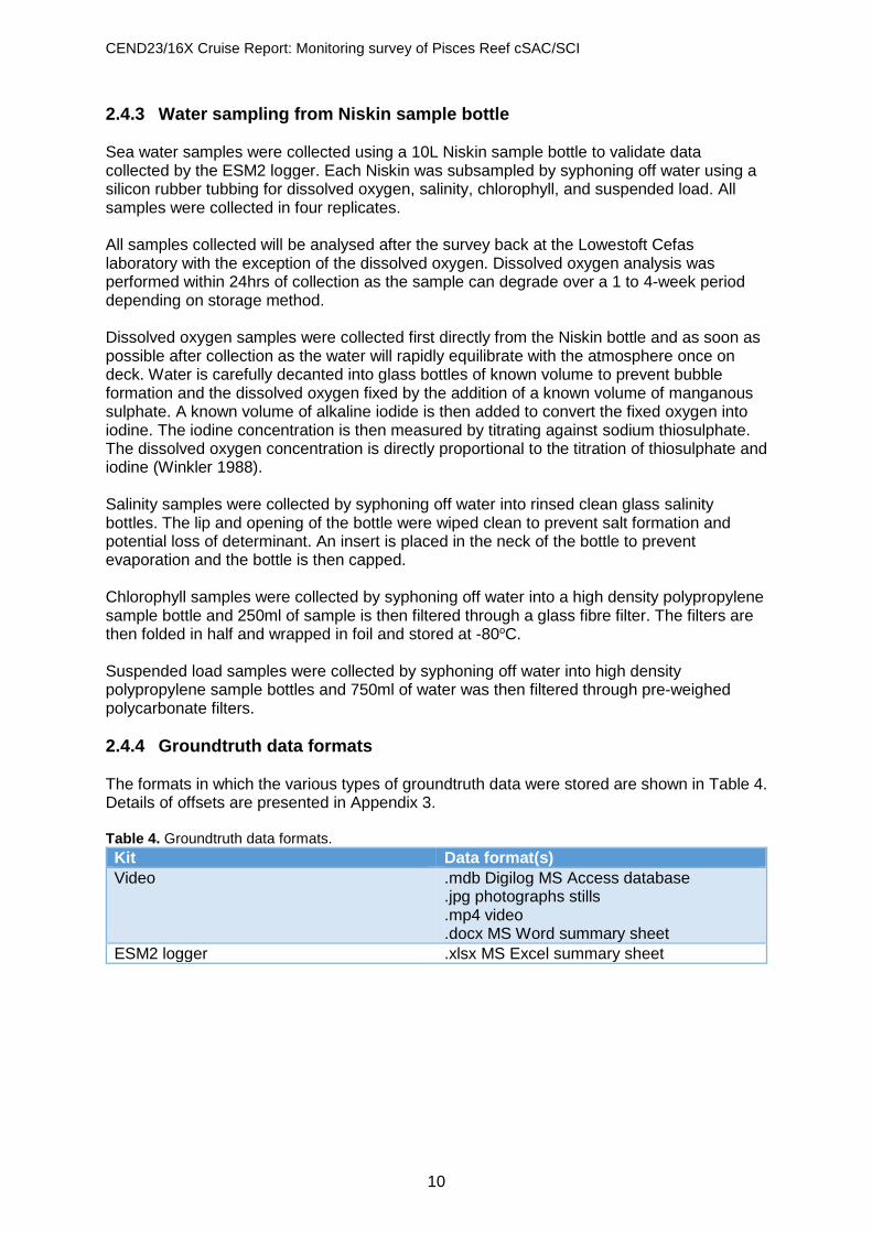
2.4.4 Groundtruth data formats The formats in which the various types of groundtruth data were stored are shown in Table 4. Details of offsets are presented in Appendix 3. Table 4. Groundtruth data formats.
Kit Data format(s)
Video .mdb Digilog MS Access database .jpg photographs stills .mp4 video .docx MS Word summary sheet
ESM2 logger .xlsx MS Excel summary sheet

CEND23/16X Cruise Report: Monitoring survey of Pisces Reef cSAC/SCI
11
2.5 Positioning GPS fixes were recorded using the Tower Navigation system on RV Cefas Endeavour. This records the positional coordinates of the gantry from which the sampling equipment is being deployed, automatically compensating for the offset between these gantries and the GPS antenna, as well as the corrected position provided by the HiPAP beacon, if used; details of offsets are presented in Appendix 3. Positional fixes were made for the camera tows at five second intervals during the transect. This allowed accurate positional fixing of each still image to be applied retrospectively by time matching the still image to the nearest positional fix. The drop camera was always deployed from the side gantry of the vessel, so the fixes record the position of the side gantry. Improved accuracy of the positions assigned to the video footage and still images taken with the drop camera was achieved through use of the positional data generated using the HiPAP system. Still images were time matched against fix records taken every five seconds using the HiPAP. Fix positions for the HIPAP were quality assured using GIS visualisation and removing erroneous fix positions. The information on water depth and ‘cable out’ were routinely recorded in the field metadata. Course over Ground for each tow was estimated from the uncorrected fix positions for the still images plotted in ArcGIS.
CEND23/16X Cruise Report: Monitoring survey of Pisces Reef cSAC/SCI
12
3 Cruise narrative Survey equipment was mobilised to RV Cefas Endeavour on the 28th October in Liverpool, with Cefas, JNCC scientists, EGS processors and the Gardline PAM operator joining the vessel the next day, 29th October. The hired sub-bottom profile (SBP) chirper system was mounted on a frame and positioned within the moon tube on the starboard deck side for easy deployment and stability. The vessel sailed for site on the 29th October at 23:35 and commenced operations at 09:30 on the 30th October. The hull mounted MBES was calibrated over a known wreck during the transit to site in preparation for survey operations. The chirp system was simultaneously tested and the positioning assessed in comparison with the calibrated MBES bathymetry. The remote data collection of MBES and SBP had been prioritised and were deployed to commence operations upon arrival at site at 18:00 on the 30th November 2016. Weather conditions were good throughout the survey period and operations were not impacted by prevailing site conditions. After acoustic calibrations were completed over the wreck, the vessel transited to the northern most area of the Pisces Reef Complex cSAC/SCI (PR1). This entailed single pass operations for MBES and SBP, to gather 100% coverage across the area for bathymetry and backscatter. Line spacings were selected to ensure 20-30% beam overlap at the outer edges of the MBES swathe. This ensured that SBP data was collected roughly at a line spacing of 125-150m. Prior planning discussions had considered whether different frequencies of the EM2040 MBES would result in different penetrations of the seabed. Differences in sediment penetration between the two frequencies has the potential to influence future mapped products looking at determining rocky habitat extent. Data was, therefore, collected at 200kHz in an east to west orientation and at 400kHz in a north to south orientation for comparison purposes. All lines, at all three of the sites, were completed over the survey period. Marine mammal observations were undertaken prior to any chirper operations according to JNCC marine mammal guidance for offshore surveys (JNCC 2010). These watches were carried out by trained marine mammal observers for at least 30 minutes, prior to the chirper being turned on. Where marine mammals were observed within 500 metres of the vessel during the 30-minute pre-shoot window, chirper operations were delayed until 20 minutes after the mammals had left the 500m mitigation area. Additional to the pre-shoot watch, visual or PAM, a 20-minute soft start was begun prior to commencement of operations. This soft start was achieved by incrementally increasing the power of the chirper system from its lowest setting up to operational power over the 20-minute time window. Video and stills were collected across the three Pisces Reef areas (PR1-3) to gather evidence on the extent and condition of exposed rocky areas identified from the MBES and SBPs. As part of the wider environmental evidence gathering across the site the camera frame had been equipped with sensors capable of measuring temperature, depth, fluorescence and light transmissivity. This required water samples be taken at various points across the site to ensure data from the camera mounted sensor be calibrated to measured values. Four water samples were taken 2m from the seabed at two of the reef areas, PR1 and PR2, whilst three were taken at PR3 and all were processed by the on-board chemist. Camera tows were planned at lengths of either 120m or 250m dependent on their location within strata. Where strata where identified from depth, backscatter and slope thresholds. Sixty-three camera stations were planned and completed over the survey period. The vessel was able to work continuously at the Pisces Reef Complex cSAC/SCI site with no need to make use of the weather contingency sites, with all the tasks identified in the survey plan completed.

CEND23/16X Cruise Report: Monitoring survey of Pisces Reef cSAC/SCI
13
Survey operations were concluded on the 4th November at 15:00 and the RV Cefas Endeavour continued for the Natural England-led Utopia MCZ site survey. Survey operations at the Utopia MCZ site commenced on the 6th November. A summary of survey operation time is presented in Appendix 4 and Appendix 5 contains copies of Daily Progress Reports.

CEND23/16X Cruise Report: Monitoring survey of Pisces Reef cSAC/SCI
14
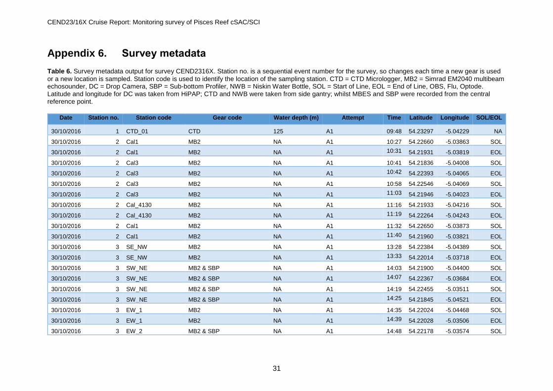
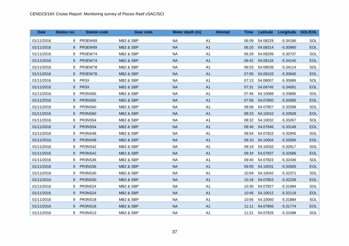
4 Results A full record of all the survey line and sample metadata is provided in Appendix 6.
4.1 Acoustic line summaries A total of 391km of MBES were collected across the three Pisces Reef areas. This allowed 100% coverage of the three sites PR1-3 at both 200kHz and 400kHz for bathymetry and backscatter (Figure 5, Figure 6 and Figure 7). SBP data was acquired simultaneously at a line spacing of 125-150m and accounted for 391km of acquired data (Figure 8). Figure 9 is a representation of the data acquired from the system and illustrates how the mud veneer and rocky habitat were differentiated.
4.1.1 Bathymetry and backscatter
Figure 5. Initial combined bathymetric data for 200 and 400kHz for all three of the Pisces Reef Complex cSAC/SCI areas.

CEND23/16X Cruise Report: Monitoring survey of Pisces Reef cSAC/SCI
15
Figure 6. Initial backscatter data collected at 200kHz for all three of the Pisces Reef Complex cSAC/SCI areas.
Figure 7. Initial backscatter data collected at 400kHz for all three of the Pisces Reef Complex cSAC/SCI areas.

CEND23/16X Cruise Report: Monitoring survey of Pisces Reef cSAC/SCI
16
4.1.2 Sub-bottom profiler (chirper)
Figure 8. Acquired chirper lines at all three of the Pisces Reef Complex cSAC/SCI areas.
Figure 9. Example of acquired chirper data with demonstration of analysis differentiating mud and rock layers. Depth below surface shown in red and in metres.

CEND23/16X Cruise Report: Monitoring survey of Pisces Reef cSAC/SCI
17
4.2 Drop frame camera transect summaries Drop frame camera transects were successfully recorded at 63 stations across the three Pisces Reef areas (Figure 10). On one occasion, at PR2_007, a camera tow was abandoned due to the presence of a school of fish obscuring the view and disturbing the soft sediments below. This tow was later revisited and successfully completed. Several habitats were identified from the video in real time. These varied from coarse, mud or mixed sediments through to low energy rock. Representative images of the various habitat types are presented in Appendix 7.
Figure 10. Completed video tows at the three Pisces Reef areas (PR1-3), showing tows where hard substrate was present and those where no hard substrate was seen.
4.3 ESM2 logger Data was successfully collected by the ESM2 logger at all camera stations. Data analysis, calibration and interpretation will be carried out later. Figure 11 shows the sampling locations for Niskin water sampling.

CEND23/16X Cruise Report: Monitoring survey of Pisces Reef cSAC/SCI
18
Figure 11. Locations of Niskin bottle water samples collected at the three Pisces Reef Complex cSAC/SCI areas.
4.4 Marine mammal observations Three trained members of the survey team (undertook marine mammal observations and passive acoustic monitoring, following JNCC guidance (JNCC 2010), prior to commencement of chirper firing. A broadband (10Hz to 180kHz) passive acoustic monitoring system (PAM) was used over four days, night hours only, of the Pisces Reef Complex cSAC/SCI habitat identification survey to mitigate the effects of the use of the chirper sub-bottom profiling system. The PAM system was towed 75m behind the vessel from the stern gantry for all pre-shoot watches prior to the initiation of the soft start of the Chirp system, to check if any cetaceans were within a 500m mitigation zone. Two soft starts were delayed due to the presence of dolphins, even though the animals were subsequently judged to be outside the mitigation zone, the PAM operator took a precautionary approach as distance and bearing information to the dolphins was not calculable. When the PAM operator was satisfied that the animals were outside the mitigation zone, an ‘all clear’ for soft start operations was given. The PAM system was used for a total of 24 hours and 32 minutes of operations of the four days of acoustic survey on the Pisces Reef Complex cSAC/SCI. The Marine mammal observations report can be found in Appendix 9.

CEND23/16X Cruise Report: Monitoring survey of Pisces Reef cSAC/SCI
19
5 Quality control (QC)
5.1 Bathymetry and backscatter For the MBES, a patch test and calibration were carried out during the transit to the survey site. For details of the calibration see Appendix 1. Following the calibration, all offsets were applied to the data and the resulting data showed all data from the different lines to be perfectly aligned. Further checks were undertaken during the remainder of the survey where perpendicular survey lines were situated over seabed features. Good alignment was observed in all cases.
5.2 Sub-bottom profiling The chirper was most affected by the speed over ground and metocean conditions. The outputs from the chirper were monitored as soon as it started firing before the start of each line. Vessel speed was adjusted to ensure high quality output; this was typically at 4-5kts.
5.3 Seabed imagery Camera stills were examined after each tow. Occasionally photographs were blurry. This was typically because either the drop frame moved when the photograph was taken, or the concentration of suspended matter in the water column was too high. Video files were viewed directly after each tow to confirm video data were recorded.
5.4 ESM2 logger To validate the data derived from the CTD sensor, water samples were collected by Niskin bottle and are to be analysed post-survey, with the exception of dissolved oxygen.

CEND23/16X Cruise Report: Monitoring survey of Pisces Reef cSAC/SCI
20
6 Human activity Multibeam echo-sounder data did not identify areas of human activity.

CEND23/16X Cruise Report: Monitoring survey of Pisces Reef cSAC/SCI
21
7 H&S events A safety induction to the vessel for scientific staff was carried out at 19:00 on 29th October 2016. A toolbox talk was held at 08:00 followed by a muster station drill at 08:30. During the drill all staff were familiarised with lifeboat deployment and relevant safety equipment. On the morning of the 2nd October a near-miss relating to equipment was reported to the vessels Master and Scientist in Charge (SiC). This was investigated on board and appropriate action was taken to avoid a repeat incident. No personnel were injured and no kit was damaged as a result of this near miss. Cefas, JNCC and P&O continued to pass details through the appropriate H&S system onshore.

CEND23/16X Cruise Report: Monitoring survey of Pisces Reef cSAC/SCI
22
8 References Barrio Froján, C., Brown, L. & Downie, A. (2015) Slieve na Griddle rMCZ Post-survey Site Report. Defra report. JNCC. (2010). JNCC guidelines for minimising the risk of injury and disturbance to marine mammals from seismic surveys. http://jncc.defra.gov.uk/marine/seismic_survey JNCC. (2012a) Pisces Reef Complex SAC Selection Assessment: Version 7.0 JNCC. (2012b) Pisces Reef Complex Draft Conservation Objectives and Advice on Operations 3.0 (http://jncc.defra.gov.uk/PDF/PiscesReef_ConservationObjectives_AdviceOperations_V3.0.pdf) [Accessed 07/12/2016] Kröger, K. & Johnston, C. (2016) The UK marine biodiversity monitoring strategy v4.1 (http://jncc.defra.gov.uk/pdf/Marine_Monitoring_Strategy_ver.4.1.pdf) [Accessed 07/12/2016] Winkler, L.W. (1888). Die Bestimmung des in Wasser gelösten Sauerstoffen. Berichte der Deutschen Chemischen Gesellschaft, 21: 2843–2855.

CEND23/16X Cruise Report: Monitoring survey of Pisces Reef cSAC/SCI
23
Appendix 1. Vessel and equipment used
RV Cefas Endeavour
Port of registry Lowestoft
Length OA 73.00 m (excluding stern roller)
Length extreme 73.916 m
Breadth (MLD) 15.80 m
Depth (MLD) 8.20 m
Design draft 5.00 m
Deep draught 5.50 m
LBP 66.50 m
Gross tonnage 2983 tonnes
Net register tonnage 894 tonnes
Net lightship 2436 tonnes
Deadweight @ 5.00 m 784 tonnes
Deadweight @ 5.50 m 1244 tonnes
Displacement @ 5.00 m 3210 tonnes
Displacement @ 5.50 m 3680 tonnes
Builder Ferguson Shipbuilders Limited, Port Glasgow
Commissioned 2003
Communications In port BT Tel. Cellphone Voice/Fax/Data Radio TELEX Inmarsat C Fleet 77 (Inmarsat F) and VSAT (eutelsat) internet access
Endurance 42 days
Complement En suite accommodation for 16 crew and 19 scientists with dedicated hospital facility
Propulsion System AC/DC Diesel Electric 3 x diesel electric AC generators, individually raft mounted 2x tandem electric DC motors Single screw
Power generation 3240 Kw
Power propulsion 2230 Kw
Thrusters Bow thruster (flush mounted azimuthing) Stern thruster (tunnel)
Trial speed 14.4 knots
Bollard pull 29 tonnes
Call sign VQHF3
Official number 906938
MMSI 235005270
Lloyds/IMO number 9251107

CEND23/16X Cruise Report: Monitoring survey of Pisces Reef cSAC/SCI
24
Side Gantry 7.5 tonne articulated side A-frame
Stern Gantry 25 tonne stern A-frame
Winches 3x cranes 35 tM, heave compensated 2x trawl winches 2x drum winches, (1 double) Double barrel survey winch with motion compensation and slip rings Double barrel survey winch with slip rings Double barrel towing winch with slip rings Side-scan sonar winch with slip rings 3x Gilson winches (one fitted to stern A-frame)
Transducers/Sea tube Drop keel to deploy transducers outside the hull boundary layer in addition to hull mounted transducers 1.2 m diameter sea tube/moon-pool
Acoustic equipment Kongsberg Simrad: HiPAP 500 positioning sonar EK60, 38/120 kHz scientific sounder EA 600, 50/200 kHz scientific sounder Scanmar net mensuration system SH80 high frequency omni-directional sonar EM3002 swathe bathymetry sounder Hull mounted Scanmar fishing computer transducers
Boats 2x 8 m rigid work and rescue boats with suite of navigational equipment deployed on heave-compensated davits
Laboratories 8 networked laboratories designed for optimum flexibility of purpose 4 serviced deck locations for containerised laboratories
Special features Dynamic positioning system Intering anti-roll system Local Area Network with scientific data management system Ship-wide general information system CCTV
Class LRS 100A1+LMC UMS SCM CCS ICC IP ES(2) DP(CM) ICE class 2

CEND23/16X Cruise Report: Monitoring survey of Pisces Reef cSAC/SCI
25
STR SeaSpyder “Telemetry” drop camera system Telemetry operation over coaxial cable 18 mega pixels underwater digital stills camera High power camera flash 20W high intensity LED lights x 4 Dual scaling Subsea lasers x 4 (spaced at 17cm) 250kHz precision altimeter Combined compass & depth STR in-house software
Positioning software-Tower Vessel offsets are defined from the pitch roll centre of the vessel – the Common Reference Point (CRP) used by the Tower CEMAP software to calculate offsets.
Niskin water bottle A 10 litre Niskin water bottle was used to collect the water samples. Water was collected for the purposes of calibrating the ESM2 logger and was processed as described previously.
Multibeam echosounder (bathymetry and backscatter) A Simrad EM2040 operated at 300kHz was used.
Hardware On-line Remarks
Kongsberg EM2040 Head serial 220
Seapath 330 plus MRU-5 Serial MRU-5 2043 Serial Seapath S/N10580
C-Nav 3050 GPS C-NAVC2 (GPS + GLONASS)
Thales 3011 GPS Fugro Seastar differential corrections
MAHRS Gyro SN 040644
SAIV SD204 CTD casts SN 718
Reson SVP24 Mounted on blade next to sonar heads
Druck PTX 1830 Vessel draft sensor
Software (including version) Remarks
Kongsberg SIS V4.1.3 -
Caris HIPS V7.1 SP2 Hotfix 1-5 -
IVS3D Fledermaus GT v7.3.2a -
Sub-bottom profiler (chirper) An EdgeTech 2000 FS Combined Sidescan and Sub-Bottom System (100/400kHz or 300/600kHz SSS and DW-216: 2-16kHz SBP) was hired from STR. This system was stripped down from its original mounting and reconfigured onto a new mounting bracket for deployment through the RV Cefas Endeavour moon tube. The sidescan transducer were removed from the system as they were not required for the objectives of this survey. This allowed the chirper system to be deployed and recovery very easily and run at survey speeds between 4 and 5kts. This system has an internal receiver and does not require a towed hydrophone. The received signal is processed and stored in industry-standard (SEGY) format. Screen shots (in JPEG format) can be provided for real-time interpretation. Operating parameters used during this cruise were:
Source frequency: 11.2kHz Shot interval: 250 milliseconds (~0.5 metres) Survey speed: 4-5 knots

CEND23/16X Cruise Report: Monitoring survey of Pisces Reef cSAC/SCI
26
Appendix 2. Equipment calibration
GPS positions and corrections GPS fixes were recorded using the Tower Navigation system on RV Cefas Endeavour. This records the latitude/longitude position of the side gantry from which the sampling equipment was deployed, automatically compensating for the offset between these gantries and the GPS antenna. Fixes for grab samples were taken at the instant the grab contacted the seabed. The mini-Hamon grab and drop camera systems were always deployed from the side gantry and appended with a beacon for HiPAP. This data is data is checked post deployment for inconsistencies. Where large errors are recorded the ships side gantry position is used preferentially, though an offset of up to 10m can be observed in strong tides. The side gantry position was used for recording day grab positions. In the case of the drop camera, this could be accounted for by comparing the logged position of the side gantry steer point with position calculated by the ships High Precision Acoustic Positioning (HiPAP) system. Where large differences were observed between the position logged using the side gantry steer point and the HiPAP position, the HiPAP position was considered to be most accurate. GPS positional fixes were taken, for both the side gantry steer point and the position derived from HiPAP, continuously at five second intervals throughout the tow. This allowed the position of the camera system above the seabed to be cross referenced with the time at which the still image was captured to accurately determine the position of each still image acquired during the drop camera transect.
Calibration patch test report, Kongsberg EM2040 multibeam A patch test took place on the afternoon of Saturday 30th October 2016 west of the Isle of Man, during transit from Liverpool to the main survey site. A charted wreck close to the planned transit plan was chosen. The blade was deployed to 3.2m. Three parallel lines were surveyed at constant speed, in each direction. This provided sufficient data to calibrate pitch, roll and yaw offsets. Lines were not run for latency as 1PPS (Pulse Per Second) is being used. On completion of data collection, all survey data were loaded in Caris HIPS. The Caris HIPS calibration tool was used to determine offsets and were applied to in the Caris vessel configuration file (Endeavour_EM2040.hvf). The following correction factors were obtained from the patch test: Pitch correction: -1.0 degrees Roll Correction: +0.10 degrees Yaw: -3.7 degrees Following the calibration, all offsets were applied to the data and the resulting data showed all data from the different lines to be perfectly aligned. Further checks were undertaken during the remainder of the survey where perpendicular survey lines were situated over seabed features. Good alignment was observed in all cases.

CEND23/16X Cruise Report: Monitoring survey of Pisces Reef cSAC/SCI
27
Appendix 3. Offsets The following vessel offsets were used to calculate the true positions of equipment deployed from the RV Cefas Endeavour.
Stern gantry
Side gantry

CEND23/16X Cruise Report: Monitoring survey of Pisces Reef cSAC/SCI
28
HiPAP

CEND23/16X Cruise Report: Monitoring survey of Pisces Reef cSAC/SCI
29
Appendix 4. Summary of survey operation time Table 5. Breakdown of survey operations.
Action Total Remark
Multibeam echosounder EM2040 391 kilometres (Combination of 200kHz and 400kHz)
Chirper 391 kilometres
Video tows 65 tows
Water sample (Niskin bottle & data logger)
11 water samples taken 2m from seabed
Figure 12. Summary of operations.
Offshore Cal5%
Transit20% Survey
37%
Sampling35%
Equipment Down 2%
Other1%
Offshore Cal Transit Survey Sampling Equipment Down Other

CEND23/16X Cruise Report: Monitoring survey of Pisces Reef cSAC/SCI
30
Appendix 5. Copy of daily progress reports The full Daily Log Status Report is provided as a supplemental download.
CEND23/16X Cruise Report: Monitoring survey of Pisces Reef cSAC/SCI
31
Appendix 6. Survey metadata Table 6. Survey metadata output for survey CEND2316X. Station no. is a sequential event number for the survey, so changes each time a new gear is used or a new location is sampled. Station code is used to identify the location of the sampling station. CTD = CTD Micrologger, MB2 = Simrad EM2040 multibeam echosounder, DC = Drop Camera, SBP = Sub-bottom Profiler, NWB = Niskin Water Bottle, SOL = Start of Line, EOL = End of Line, OBS, Flu, Optode. Latitude and longitude for DC was taken from HiPAP; CTD and NWB were taken from side gantry; whilst MBES and SBP were recorded from the central reference point.
Date Station no. Station code Gear code Water depth (m) Attempt Time Latitude Longitude SOL/EOL
30/10/2016 1 CTD_01 CTD 125 A1 09:48 54.23297 -5.04229 NA
30/10/2016 2 Cal1 MB2 NA A1 10:27 54.22660 -5.03863 SOL
30/10/2016 2 Cal1 MB2 NA A1 10:31 54.21931 -5.03819 EOL
30/10/2016 2 Cal3 MB2 NA A1 10:41 54.21836 -5.04008 SOL
30/10/2016 2 Cal3 MB2 NA A1 10:42 54.22393 -5.04065 EOL
30/10/2016 2 Cal3 MB2 NA A1 10:58 54.22546 -5.04069 SOL
30/10/2016 2 Cal3 MB2 NA A1 11:03 54.21946 -5.04023 EOL
30/10/2016 2 Cal_4130 MB2 NA A1 11:16 54.21933 -5.04216 SOL
30/10/2016 2 Cal_4130 MB2 NA A1 11:19 54.22264 -5.04243 EOL
30/10/2016 2 Cal1 MB2 NA A1 11:32 54.22650 -5.03873 SOL
30/10/2016 2 Cal1 MB2 NA A1 11:40 54.21960 -5.03821 EOL
30/10/2016 3 SE_NW MB2 NA A1 13:28 54.22384 -5.04389 SOL
30/10/2016 3 SE_NW MB2 NA A1 13:33 54.22014 -5.03718 EOL
30/10/2016 3 SW_NE MB2 & SBP NA A1 14:03 54.21900 -5.04400 SOL
30/10/2016 3 SW_NE MB2 & SBP NA A1 14:07 54.22367 -5.03684 EOL
30/10/2016 3 SW_NE MB2 & SBP NA A1 14:19 54.22455 -5.03511 SOL
30/10/2016 3 SW_NE MB2 & SBP NA A1 14:25 54.21845 -5.04521 EOL
30/10/2016 3 EW_1 MB2 NA A1 14:35 54.22024 -5.04468 SOL
30/10/2016 3 EW_1 MB2 NA A1 14:39 54.22028 -5.03506 EOL
30/10/2016 3 EW_2 MB2 & SBP NA A1 14:48 54.22178 -5.03574 SOL

CEND23/16X Cruise Report: Monitoring survey of Pisces Reef cSAC/SCI
32
Date Station no. Station code Gear code Water depth (m) Attempt Time Latitude Longitude SOL/EOL
30/10/2016 3 EW_2 MB2 & SBP NA A1 14:52 54.22148 -5.04434 EOL
30/10/2016 3 EW_2 MB2 & SBP NA A1 15:07 54.22171 -5.04564 SOL
30/10/2016 3 EW_2 MB2 & SBP NA A1 15:11 54.22169 -5.03581 EOL
30/10/2016 3 SE_NW MB2 & SBP NA A1 15:23 54.22009 -5.03755 SOL
30/10/2016 3 SE_NW MB2 & SBP NA A1 15:30 54.22398 -5.04422 EOL
30/10/2016 3 NS_2 MB2 & SBP NA A1 15:41 54.22480 -5.03996 SOL
30/10/2016 3 NS_2 MB2 & SBP NA A1 15:45 54.22037 -5.03994 EOL
30/10/2016 3 NS_2 MB2 & SBP NA A1 15:58 54.21955 -5.03986 SOL
30/10/2016 3 NS_2 MB2 & SBP NA A1 16:02 54.22426 -5.04007 EOL
30/10/2016 3 EW_3 MB2 NA A1 16:19 54.22228 -5.04554 SOL
30/10/2016 3 EW_3 MB2 NA A1 16:23 54.22261 -5.03748 EOL
30/10/2016 3 EW_3 MB2 NA A1 16:35 54.22253 -5.03606 SOL
30/10/2016 3 EW_3 MB2 NA A1 16:39 54.22241 -5.04510 EOL
30/10/2016 3 Cal_4130 MB2 NA A1 16:54 54.22383 -5.04135 SOL
30/10/2016 3 Cal_4130 MB2 NA A1 16:57 54.21956 -5.04131 EOL
30/10/2016 4 CTD_02 CTD 119 A1 17:52 54.18644 -5.13848 NA
30/10/2016 5 PR1EW30 MB2 & SBP NA A1 19:42 54.18693 -5.18669 SOL
30/10/2016 5 PR1EW30 MB2 & SBP NA A1 19:58 54.18767 -5.14403 EOL
30/10/2016 5 PR1EW36 MB2 & SBP NA A1 20:08 54.18627 -5.14989 SOL
30/10/2016 5 PR1EW36 MB2 & SBP NA A1 20:26 54.18551 -5.19146 EOL
30/10/2016 5 PR1EW42 MB2 & SBP NA A1 20:37 54.18417 -5.18790 SOL
30/10/2016 5 PR1EW42 MB2 & SBP NA A1 20:53 54.18496 -5.14386 EOL
30/10/2016 5 PR1EW48 MB2 & SBP NA A1 21:04 54.18367 -5.14357 SOL
30/10/2016 5 PR1EW48 MB2 & SBP NA A1 21:21 54.18274 -5.18753 EOL
30/10/2016 5 PR1EW54 MB2 & SBP NA A1 21:32 54.18153 -5.18785 SOL
30/10/2016 5 PR1EW54 MB2 & SBP NA A1 21:52 54.18223 -5.14374 EOL
30/10/2016 5 PR1EW60 MB2 & SBP NA A1 22:07 54.18096 -5.14334 SOL

CEND23/16X Cruise Report: Monitoring survey of Pisces Reef cSAC/SCI
33
Date Station no. Station code Gear code Water depth (m) Attempt Time Latitude Longitude SOL/EOL
30/10/2016 5 PR1EW60 MB2 & SBP NA A1 22:30 54.18014 -5.18763 EOL
30/10/2016 5 PR1EW66 MB2 & SBP NA A1 23:06 54.17957 -5.14357 EOL
30/10/2016 5 PR1EW72 MB2 & SBP NA A1 23:19 54.17826 -5.14280 SOL
30/10/2016 5 PR1EW72 MB2 & SBP NA A1 23:41 54.17745 -5.18741 EOL
30/10/2016 5 PR1EW66 MB2 & SBP NA A1 23:44 54.17881 -5.18760 SOL
31/10/2016 5 PR1EW24 MB2 & SBP NA A1 00:01 54.18822 -5.18788 SOL
31/10/2016 5 PR1EW24 MB2 & SBP NA A1 00:22 54.18903 -5.14494 EOL
31/10/2016 5 PR1EW18 MB2 & SBP NA A1 00:33 54.19032 -5.14478 SOL
31/10/2016 5 PR1EW18 MB2 & SBP NA A1 00:54 54.18959 -5.18740 EOL
31/10/2016 5 PR1EW12 MB2 & SBP NA A1 01:04 54.19099 -5.18749 SOL
31/10/2016 5 PR1EW12 MB2 & SBP NA A1 01:23 54.19174 -5.14476 EOL
31/10/2016 5 PR1EW06 MB2 & SBP NA A1 01:34 54.19307 -5.14479 SOL
31/10/2016 5 PR1EW06 MB2 & SBP NA A1 01:53 54.19229 -5.18741 EOL
31/10/2016 5 PR1NS68 MB2 & SBP NA A1 02:35 54.19593 -5.17834 SOL
31/10/2016 5 PR1NS68 MB2 & SBP NA A1 02:53 54.17467 -5.17718 EOL
31/10/2016 5 PR1NS64 MB2 & SBP NA A1 03:03 54.17472 -5.17577 SOL
31/10/2016 5 PR1NS64 MB2 & SBP NA A1 03:20 54.19577 -5.17670 EOL
31/10/2016 5 PR1NS59 MB2 & SBP NA A1 03:31 54.19629 -5.17491 SOL
31/10/2016 5 PR1NS59 MB2 & SBP NA A1 03:49 54.17476 -5.17370 EOL
31/10/2016 5 PR1NS54 MB2 & SBP NA A1 04:01 54.17469 -5.17192 SOL
31/10/2016 5 PR1NS54 MB2 & SBP NA A1 04:18 54.19624 -5.17296 EOL
31/10/2016 5 PR1NS49 MB2 & SBP NA A1 04:28 54.19607 -5.17106 SOL
31/10/2016 5 PR1NS49 MB2 & SBP NA A1 04:44 54.17475 -5.16981 EOL
31/10/2016 5 PR1NS44 MB2 & SBP NA A1 04:55 54.17456 -5.16806 SOL
31/10/2016 5 PR1NS44 MB2 & SBP NA A1 05:11 54.19577 -5.16903 EOL
31/10/2016 5 PR1NS39 MB2 & SBP NA A1 05:21 54.19595 -5.16723 SOL
31/10/2016 5 PR1NS39 MB2 & SBP NA A1 05:37 54.17477 -5.16606 EOL

CEND23/16X Cruise Report: Monitoring survey of Pisces Reef cSAC/SCI
34
Date Station no. Station code Gear code Water depth (m) Attempt Time Latitude Longitude SOL/EOL
31/10/2016 5 PR1NS34 MB2 & SBP NA A1 05:49 54.17454 -5.16414 SOL
31/10/2016 5 PR1NS34 MB2 & SBP NA A1 06:06 54.19591 -5.16526 EOL
31/10/2016 5 PR1NS29 MB2 & SBP NA A1 06:15 54.19599 -5.16350 SOL
31/10/2016 5 PR1NS29 MB2 & SBP NA A1 06:28 54.17471 -5.16223 EOL
31/10/2016 5 PR1NS24 MB2 & SBP NA A1 06:38 54.17457 -5.16038 SOL
31/10/2016 5 PR1NS24 MB2 & SBP NA A1 06:52 54.19576 -5.16146 EOL
31/10/2016 5 PR1NS19 MB2 & SBP NA A1 07:01 54.19593 -5.15955 SOL
31/10/2016 5 PR1NS19 MB2 & SBP NA A1 07:13 54.17470 -5.15843 EOL
31/10/2016 5 PR1NS14 MB2 & SBP NA A1 07:22 54.17460 -5.15652 SOL
31/10/2016 5 PR1NS14 MB2 & SBP NA A1 07:37 54.19590 -5.15767 EOL
31/10/2016 5 PR1NS9 MB2 & SBP NA A1 07:44 54.19590 -5.15562 SOL
31/10/2016 5 PR1NS9 MB2 & SBP NA A1 07:57 54.17480 -5.15470 EOL
31/10/2016 5 PR1X MB2 & SBP NA A1 08:04 54.17576 -5.15144 SOL
31/10/2016 5 PR1X MB2 & SBP NA A1 08:22 54.19370 -5.17984 EOL
31/10/2016 5 PR1X MB2 & SBP NA A1 08:31 54.19455 -5.18106 SOL
31/10/2016 5 PR1X MB2 & SBP NA A1 08:48 54.17636 -5.15159 EOL
31/10/2016 6 PR2EW8 MB2 & SBP NA A1 09:29 54.16407 -5.21986 SOL
31/10/2016 6 PR2EW8 MB2 & SBP NA A1 10:02 54.16998 -5.28968 EOL
31/10/2016 6 PR2EW13 MB2 & SBP NA A1 10:17 54.16892 -5.29092 SOL
31/10/2016 6 PR2EW13 MB2 & SBP NA A1 10:52 54.16304 -5.22076 EOL
31/10/2016 6 PR2EW18 MB2 & SBP NA A1 11:07 54.16190 -5.22082 SOL
31/10/2016 6 PR2EW18 MB2 & SBP NA A1 11:39 54.16763 -5.28974 EOL
31/10/2016 6 PR2EW23 MB2 & SBP NA A1 11:54 54.16659 -5.29030 SOL
31/10/2016 6 PR2EW23 MB2 & SBP NA A1 12:28 54.16074 -5.22081 EOL
31/10/2016 6 PR2EW28 MB2 & SBP NA A1 12:38 54.15956 -5.22093 SOL
31/10/2016 6 PR2EW28 MB2 & SBP NA A1 13:10 54.16501 -5.29694 EOL
31/10/2016 6 PR2EW33 MB2 & SBP NA A1 13:22 54.16439 -5.29036 SOL

CEND23/16X Cruise Report: Monitoring survey of Pisces Reef cSAC/SCI
35
Date Station no. Station code Gear code Water depth (m) Attempt Time Latitude Longitude SOL/EOL
31/10/2016 6 PR2EW33 MB2 & SBP NA A1 13:56 54.15845 -5.22096 EOL
31/10/2016 6 PR2EW38 MB2 & SBP NA A1 14:06 54.15719 -5.22119 SOL
31/10/2016 6 PR2EW38 MB2 & SBP NA A1 14:39 54.16319 -5.29048 EOL
31/10/2016 6 PR2EW43 MB2 & SBP NA A1 14:49 54.16207 -5.29057 SOL
31/10/2016 6 PR2EW43 MB2 & SBP NA A1 15:23 54.15631 -5.22127 EOL
31/10/2016 6 PR2EW48 MB2 & SBP NA A1 15:33 54.15516 -5.22118 SOL
31/10/2016 6 PR2EW48 MB2 & SBP NA A1 16:04 54.16092 -5.29030 EOL
31/10/2016 6 PR2EW53 MB2 & SBP NA A1 16:18 54.15987 -5.29116 SOL
31/10/2016 6 PR2EW53 MB2 & SBP NA A1 16:49 54.15390 -5.29010 EOL
31/10/2016 6 PR2EW58 MB2 & SBP NA A1 16:59 54.15274 -5.22144 SOL
31/10/2016 6 PR2EW58 MB2 & SBP NA A1 17:30 54.15862 -5.29020 EOL
31/10/2016 6 PR2EW63 MB2 & SBP NA A1 17:43 54.15735 -5.28948 SOL
31/10/2016 6 PR2EW63 MB2 & SBP NA A1 18:13 54.15182 -5.22123 EOL
31/10/2016 7 CTD_03 CTD 124 A1 18:29 54.15799 -5.23158 NA
31/10/2016 8 PR2EW68 MB2 & SBP NA A1 20:08 54.15260 -5.24499 SOL
31/10/2016 8 PR2EW68 MB2 & SBP NA A1 20:27 54.15640 -5.29047 EOL
31/10/2016 8 PR2X MB2 & SBP NA A1 20:39 54.15686 -5.29208 SOL
31/10/2016 8 PR2X MB2 & SBP NA A1 21:08 54.16420 -5.21861 EOL
31/10/2016 8 PR2NS125 MB2 & SBP NA A1 21:28 54.16904 -5.23446 SOL
31/10/2016 8 PR2NS125 MB2 & SBP NA A1 21:42 54.15008 -5.23901 EOL
31/10/2016 8 PR2NS100 MB2 & SBP NA A1 21:59 54.15246 -5.24808 SOL
31/10/2016 8 PR2NS100 MB2 & SBP NA A1 22:15 54.16969 -5.24390 EOL
31/10/2016 8 PR2NS75 MB2 & SBP NA A1 22:28 54.17055 -5.25318 SOL
31/10/2016 8 PR2NS75 MB2 & SBP NA A1 22:42 54.15138 -5.25794 EOL
31/10/2016 8 PR2NS50 MB2 & SBP NA A1 22:57 54.15191 -5.26756 SOL
31/10/2016 8 PR2NS50 MB2 & SBP NA A1 23:18 54.17115 -5.26289 EOL
31/10/2016 8 PR2NS25 MB2 & SBP NA A1 23:33 54.17148 -5.27234 SOL

CEND23/16X Cruise Report: Monitoring survey of Pisces Reef cSAC/SCI
36
Date Station no. Station code Gear code Water depth (m) Attempt Time Latitude Longitude SOL/EOL
31/10/2016 8 PR2NS25 MB2 & SBP NA A1 23:46 54.15234 -5.27716 EOL
01/11/2016 9 PR3EW4 MB2 & SBP NA A1 00:58 54.09759 -5.31645 SOL
01/11/2016 9 PR3EW4 MB2 & SBP NA A1 01:09 54.09714 -5.34113 EOL
01/11/2016 9 PR3EW9 MB2 & SBP NA A1 01:21 54.09589 -5.34146 SOL
01/11/2016 9 PR3EW9 MB2 & SBP NA A1 01:34 54.09659 -5.30846 EOL
01/11/2016 9 PR3EW14 MB2 & SBP NA A1 01:45 54.09535 -5.30871 SOL
01/11/2016 9 PR3EW14 MB2 & SBP NA A1 01:58 54.09482 -5.34129 EOL
01/11/2016 9 PR3EW19 MB2 & SBP NA A1 02:11 54.09382 -5.34181 SOL
01/11/2016 9 PR3EW19 MB2 & SBP NA A1 02:25 54.09427 -5.30839 EOL
01/11/2016 9 PR3EW24 MB2 & SBP NA A1 02:35 54.09304 -5.30889 SOL
01/11/2016 9 PR3EW24 MB2 & SBP NA A1 02:48 54.09257 -5.34140 EOL
01/11/2016 9 PR3EW29 MB2 & SBP NA A1 02:59 54.09152 -5.34158 SOL
01/11/2016 9 PR3EW29 MB2 & SBP NA A1 03:12 54.09212 -5.30862 EOL
01/11/2016 9 PR3EW34 MB2 & SBP NA A1 03:21 54.09095 -5.30844 SOL
01/11/2016 9 PR3EW34 MB2 & SBP NA A1 03:34 54.09031 -5.34126 EOL
01/11/2016 9 PR3EW39 MB2 & SBP NA A1 03:45 54.08921 -5.34154 SOL
01/11/2016 9 PR3EW39 MB2 & SBP NA A1 03:59 54.08979 -5.30922 EOL
01/11/2016 9 PR3EW44 MB2 & SBP NA A1 04:07 54.08876 -5.30769 SOL
01/11/2016 9 PR3EW44 MB2 & SBP NA A1 04:21 54.08813 -5.34033 EOL
01/11/2016 9 PR3EW49 MB2 & SBP NA A1 04:32 54.08693 -5.34272 SOL
01/11/2016 9 PR3EW49 MB2 & SBP NA A1 04:46 54.08762 -5.30789 EOL
01/11/2016 9 PR3EW54 MB2 & SBP NA A1 04:55 54.08650 -5.30788 SOL
01/11/2016 9 PR3EW54 MB2 & SBP NA A1 05:09 54.08586 -5.34080 EOL
01/11/2016 9 PR3EW59 MB2 & SBP NA A1 05:19 54.08470 -5.34195 SOL
01/11/2016 9 PR3EW59 MB2 & SBP NA A1 05:33 54.08531 -5.30863 EOL
01/11/2016 9 PR3EW64 MB2 & SBP NA A1 05:43 54.08424 -5.30754 SOL
01/11/2016 9 PR3EW64 MB2 & SBP NA A1 05:57 54.08360 -5.34084 EOL
CEND23/16X Cruise Report: Monitoring survey of Pisces Reef cSAC/SCI
37
Date Station no. Station code Gear code Water depth (m) Attempt Time Latitude Longitude SOL/EOL
01/11/2016 9 PR3EW69 MB2 & SBP NA A1 06:09 54.08229 -5.34186 SOL
01/11/2016 9 PR3EW69 MB2 & SBP NA A1 06:20 54.08314 -5.30890 EOL
01/11/2016 9 PR3EW74 MB2 & SBP NA A1 06:29 54.08209 -5.30737 SOL
01/11/2016 9 PR3EW74 MB2 & SBP NA A1 06:42 54.08134 -5.34140 EOL
01/11/2016 9 PR3EW78 MB2 & SBP NA A1 06:53 54.08039 -5.34114 SOL
01/11/2016 9 PR3EW78 MB2 & SBP NA A1 07:05 54.08103 -5.30845 EOL
01/11/2016 9 PR3X MB2 & SBP NA A1 07:13 54.08007 -5.30686 SOL
01/11/2016 9 PR3X MB2 & SBP NA A1 07:31 54.09745 -5.34091 EOL
01/11/2016 9 PR3NS65 MB2 & SBP NA A1 07:45 54.10089 -5.33685 SOL
01/11/2016 9 PR3NS65 MB2 & SBP NA A1 07:58 54.07850 -5.33585 EOL
01/11/2016 9 PR3NS60 MB2 & SBP NA A1 08:06 54.07807 -5.33398 SOL
01/11/2016 9 PR3NS60 MB2 & SBP NA A1 08:23 54.10010 -5.33508 EOL
01/11/2016 9 PR3NS54 MB2 & SBP NA A1 08:32 54.10032 -5.33267 SOL
01/11/2016 9 PR3NS54 MB2 & SBP NA A1 08:46 54.07846 -5.33149 EOL
01/11/2016 9 PR3NS48 MB2 & SBP NA A1 08:54 54.07822 -5.32945 SOL
01/11/2016 9 PR3NS48 MB2 & SBP NA A1 09:10 54.10004 -5.33056 EOL
01/11/2016 9 PR3NS42 MB2 & SBP NA A1 09:19 54.10032 -5.32817 SOL
01/11/2016 9 PR3NS42 MB2 & SBP NA A1 09:34 54.07837 -5.32689 EOL
01/11/2016 9 PR3NS36 MB2 & SBP NA A1 09:40 54.07823 -5.32436 SOL
01/11/2016 9 PR3NS36 MB2 & SBP NA A1 09:55 54.10031 -5.32605 EOL
01/11/2016 9 PR3NS30 MB2 & SBP NA A1 10:04 54.10042 -5.32371 SOL
01/11/2016 9 PR3NS30 MB2 & SBP NA A1 10:18 54.07853 -5.32236 EOL
01/11/2016 9 PR3NS24 MB2 & SBP NA A1 10:30 54.07827 -5.31984 SOL
01/11/2016 9 PR3NS24 MB2 & SBP NA A1 10:46 54.10012 -5.32116 EOL
01/11/2016 9 PR3NS18 MB2 & SBP NA A1 10:56 54.10050 -5.31884 SOL
01/11/2016 9 PR3NS18 MB2 & SBP NA A1 11:11 54.07856 -5.31774 EOL
01/11/2016 9 PR3NS13 MB2 & SBP NA A1 11:21 54.07826 -5.31588 SOL

CEND23/16X Cruise Report: Monitoring survey of Pisces Reef cSAC/SCI
38
Date Station no. Station code Gear code Water depth (m) Attempt Time Latitude Longitude SOL/EOL
01/11/2016 9 PR3NS13 MB2 & SBP NA A1 11:37 54.10019 -5.31709 EOL
01/11/2016 9 PR3NS7 MB2 & SBP NA A1 11:48 54.10046 -5.31501 SOL
01/11/2016 9 PR3NS7 MB2 & SBP NA A1 12:03 54.07829 -5.31359 EOL
01/11/2016 9 PR3NS3 MB2 & SBP NA A1 12:11 54.07853 -5.31202 SOL
01/11/2016 9 PR3NS3 MB2 & SBP NA A1 12:11 54.10037 -5.31328 EOL
01/11/2016 9 PR3XNESW MB2 & SBP NA A1 12:42 54.10170 -5.31096 SOL
01/11/2016 9 PR3XNESW MB2 & SBP NA A1 13:03 54.07790 -5.33887 EOL
01/11/2016 10 TRANPR3PR2 MB2 & SBP NA A1 13:11 54.07649 -5.34275 SOL
01/11/2016 10 TRANPR3PR2 MB2 & SBP NA A1 14:45 54.16824 -5.23736 EOL
01/11/2016 10 PR2NS140 MB2 & SBP NA A1 15:07 54.16860 -5.22868 SOL
01/11/2016 10 PR2NS140 MB2 & SBP NA A1 15:20 54.14965 -5.23327 EOL
01/11/2016 10 PR2NS135 MB2 & SBP NA A1 15:28 54.14962 -5.23534 SOL
01/11/2016 10 PR2NS135 MB2 & SBP NA A1 15:42 54.16885 -5.23051 EOL
01/11/2016 10 PR2NS130 MB2 & SBP NA A1 15:51 54.16892 -5.23247 SOL
01/11/2016 10 PR2NS130 MB2 & SBP NA A1 16:05 54.14960 -5.23722 EOL
01/11/2016 10 PR2NS120 MB2 & SBP NA A1 16:13 54.15026 -5.24078 SOL
01/11/2016 10 PR2NS120 MB2 & SBP NA A1 16:27 54.16937 -5.23619 EOL
01/11/2016 10 PR2NS115 MB2 & SBP NA A1 16:36 54.16932 -5.23814 SOL
01/11/2016 10 PR2NS115 MB2 & SBP NA A1 16:49 54.15046 -5.24273 EOL
01/11/2016 11 PR2NS110 MB2 & SBP NA A1 16:59 54.15066 -5.24463 SOL
01/11/2016 11 PR2NS110 MB2 & SBP NA A1 17:13 54.16963 -5.24007 EOL
01/11/2016 12 TRANPR2PR1 MB2 & SBP NA A1 17:21 54.17360 -5.22299 SOL
01/11/2016 12 TRANPR2PR1 MB2 & SBP NA A1 17:50 54.18802 -5.16150 EOL
01/11/2016 13 PR1_004 DC & CTD, OBS, Flu, Optode 114 A1 18:52 54.18793 -5.16165 SOL
01/11/2016 13 PR1_004 DC & CTD, OBS, Flu, Optode 124 A1 19:17 54.19000 -5.16116 EOL
01/11/2016 14 PR1_010 DC & CTD, OBS, Flu, Optode 124 A1 19:44 54.18874 -5.16550 SOL
01/11/2016 14 PR1_010 DC & CTD, OBS, Flu, Optode 133 A1 20:10 54.18927 -5.16903 EOL

CEND23/16X Cruise Report: Monitoring survey of Pisces Reef cSAC/SCI
39
Date Station no. Station code Gear code Water depth (m) Attempt Time Latitude Longitude SOL/EOL
01/11/2016 15 PR1_013 DC & CTD, OBS, Flu, Optode 118 A1 20:34 54.18797 -5.16904 SOL
01/11/2016 15 PR1_013 DC & CTD, OBS, Flu, Optode 124 A1 21:00 54.18698 -5.17234 EOL
01/11/2016 16 PR1_012 DC & CTD, OBS, Flu, Optode 140 A1 21:17 54.18782 -5.17355 SOL
01/11/2016 16 PR1_012 DC & CTD, OBS, Flu, Optode 144 A1 21:43 54.18575 -5.17476 EOL
01/11/2016 17 PR1_005 DC & CTD, OBS, Flu, Optode 133 A1 22:18 54.18610 -5.17877 SOL
01/11/2016 17 PR1_005 DC & CTD, OBS, Flu, Optode 134 A1 22:31 54.18711 -5.17894 EOL
01/11/2016 18 PR1_006 DC & CTD, OBS, Flu, Optode 139 A1 22:54 54.18814 -5.17848 SOL
01/11/2016 18 PR1_006 DC & CTD, OBS, Flu, Optode 140 A1 23:05 54.18907 -5.17797 EOL
01/11/2016 19 PR1_002 DC & CTD, OBS, Flu, Optode 108 A1 23:34 54.18502 -5.17084 SOL
01/11/2016 19 PR1_002 DC & CTD, OBS, Flu, Optode 133 A1 23:59 54.18344 -5.17319 EOL
02/11/2016 20 PR1_007 DC & CTD, OBS, Flu, Optode 114 A1 00:26 54.18520 -5.17154 SOL
02/11/2016 20 PR1_007 DC & CTD, OBS, Flu, Optode 102 A1 00:55 54.18395 -5.16807 EOL
02/11/2016 21 PR1_007 NWB 100 A1 01:17 54.18390 -5.16806 NA
02/11/2016 22 PR1_001 DC & CTD, OBS, Flu, Optode 88 A1 01:49 54.18493 -5.16819 SOL
02/11/2016 22 PR1_001 DC & CTD, OBS, Flu, Optode 123 A1 02:17 54.18293 -5.17019 EOL
02/11/2016 23 PR1_011 NWB 91 A1 02:47 54.18556 -5.16983 NA
02/11/2016 24 PR1_011 DC & CTD, OBS, Flu, Optode 91 A1 03:19 54.18557 -5.16984 SOL
02/11/2016 24 PR1_011 DC & CTD, OBS, Flu, Optode 81 A1 03:48 54.18469 -5.16622 EOL
02/11/2016 25 PR1_003 DC & CTD, OBS, Flu, Optode 89 A1 04:42 54.18570 -5.16852 SOL
02/11/2016 25 PR1_003 DC & CTD, OBS, Flu, Optode 112 A1 05:08 54.18772 -5.16721 EOL
02/11/2016 26 PR1_009 NWB 95 A1 05:32 54.18534 -5.16511 NA
02/11/2016 27 PR1_009 DC & CTD, OBS, Flu, Optode 95 A1 06:01 54.18539 -5.16503 SOL
02/11/2016 27 PR1_009 DC & CTD, OBS, Flu, Optode 114 A1 06:29 54.18553 -5.16108 EOL
02/11/2016 28 PR1_008 NWB 108 A1 06:44 54.18265 -5.16223 NA
02/11/2016 29 PR1_008 DC & CTD, OBS, Flu, Optode 108 A1 07:07 54.18268 -5.16227 SOL
02/11/2016 29 PR1_008 DC & CTD, OBS, Flu, Optode 108 A1 07:18 54.18310 -5.16358 EOL
02/11/2016 30 PR2_008 NWB 65 A1 08:13 54.15941 -5.23770 NA

CEND23/16X Cruise Report: Monitoring survey of Pisces Reef cSAC/SCI
40
Date Station no. Station code Gear code Water depth (m) Attempt Time Latitude Longitude SOL/EOL
02/11/2016 31 PR2_008 DC & CTD, OBS, Flu, Optode 66 A1 08:37 54.15941 -5.23770 SOL
02/11/2016 31 PR2_008 DC & CTD, OBS, Flu, Optode 68 A1 08:59 54.15975 -5.24079 EOL
02/11/2016 32 PR2_005 NWB 67 A1 09:16 54.15966 -5.24234 NA
02/11/2016 32 PR2_005 NWB 67 A2 09:22 54.15966 -5.24232 NA
02/11/2016 32 PR2_005 NWB 67 A3 09:39 54.15964 -5.24239 NA
02/11/2016 33 PR2_005 DC & CTD, OBS, Flu, Optode 68 A1 09:52 54.15962 -5.24245 SOL
02/11/2016 33 PR2_005 DC & CTD, OBS, Flu, Optode 98 A1 10:12 54.15915 -5.24524 EOL
02/11/2016 34 PR2_006 DC & CTD, OBS, Flu, Optode 99 A1 10:42 54.16197 -5.24041 SOL
02/11/2016 34 PR2_006 DC & CTD, OBS, Flu, Optode 96 A1 11:03 54.16119 -5.23769 EOL
02/11/2016 35 PR2_004 DC & CTD, OBS, Flu, Optode 78 A1 11:28 54.16035 -5.23888 SOL
02/11/2016 35 PR2_004 DC & CTD, OBS, Flu, Optode 108 A1 11:48 54.16095 -5.23616 EOL
02/11/2016 36 PR2_009 DC & CTD, OBS, Flu, Optode 75 A1 12:15 54.15962 -5.23715 SOL
02/11/2016 36 PR2_009 DC & CTD, OBS, Flu, Optode 118 A1 12:37 54.16068 -5.23462 EOL
02/11/2016 37 PR2_001 DC & CTD, OBS, Flu, Optode 70 A1 13:02 54.15935 -5.23856 SOL
02/11/2016 37 PR2_001 DC & CTD, OBS, Flu, Optode 107 A1 13:23 54.15775 -5.23717 EOL
02/11/2016 38 PR2_007 DC & CTD, OBS, Flu, Optode 81 A1 13:49 54.15859 -5.23977 SOL
02/11/2016 38 PR2_007 DC & CTD, OBS, Flu, Optode 83 A1 14:09 54.15852 -5.24267 EOL
02/11/2016 39 PR2_010 DC & CTD, OBS, Flu, Optode 67 A1 14:34 54.16020 -5.24004 SOL
02/11/2016 39 PR2_010 DC & CTD, OBS, Flu, Optode 71 A1 14:56 54.16037 -5.24311 EOL
02/11/2016 40 PR2_003 DC & CTD, OBS, Flu, Optode 73 A1 15:13 54.16052 -5.24266 SOL
02/11/2016 40 PR2_003 DC & CTD, OBS, Flu, Optode 96 A1 15:34 54.16213 -5.24375 EOL
02/11/2016 41 PR2_002 DC & CTD, OBS, Flu, Optode 74 A1 16:02 54.16000 -5.24694 SOL
02/11/2016 41 PR2_002 DC & CTD, OBS, Flu, Optode 97 A1 16:25 54.15818 -5.24775 EOL
02/11/2016 42 PR2_012 DC & CTD, OBS, Flu, Optode 78 A1 17:37 54.16151 -5.24694 SOL
02/11/2016 42 PR2_012 DC & CTD, OBS, Flu, Optode 79 A1 17:58 54.16187 -5.24983 EOL
02/11/2016 43 PR2_011 DC & CTD, OBS, Flu, Optode 78 A1 18:16 54.16155 -5.25111 SOL
02/11/2016 43 PR2_011 DC & CTD, OBS, Flu, Optode 80 A1 18:38 54.15973 -5.25103 EOL

CEND23/16X Cruise Report: Monitoring survey of Pisces Reef cSAC/SCI
41
Date Station no. Station code Gear code Water depth (m) Attempt Time Latitude Longitude SOL/EOL
02/11/2016 44 PR2_013 DC & CTD, OBS, Flu, Optode 87 A1 19:17 54.16010 -5.25281 SOL
02/11/2016 44 PR2_013 DC & CTD, OBS, Flu, Optode 88 A1 19:36 54.15963 -5.25019 EOL
02/11/2016 45 PR2_015 DC & CTD, OBS, Flu, Optode 82 A1 19:59 54.16073 -5.25597 SOL
02/11/2016 45 PR2_015 DC & CTD, OBS, Flu, Optode 94 A1 20:22 54.15912 -5.25752 EOL
02/11/2016 46 PR2_016 DC & CTD, OBS, Flu, Optode 86 A1 20:42 54.16220 -5.25852 SOL
02/11/2016 46 PR2_016 DC & CTD, OBS, Flu, Optode 84 A1 21:05 54.16072 -5.25626 EOL
02/11/2016 47 PR2_014 DC & CTD, OBS, Flu, Optode 87 A1 21:28 54.16252 -5.25353 SOL
02/11/2016 47 PR2_014 DC & CTD, OBS, Flu, Optode 89 A1 21:49 54.16153 -5.25592 EOL
02/11/2016 48 PR2_018 DC & CTD, OBS, Flu, Optode 88 A1 22:08 54.16009 -5.26124 SOL
02/11/2016 48 PR2_018 DC & CTD, OBS, Flu, Optode 89 A1 22:19 54.15940 -5.26197 EOL
02/11/2016 49 PR2_017 DC & CTD, OBS, Flu, Optode 85 A1 22:34 54.16067 -5.26304 SOL
02/11/2016 49 PR2_017 DC & CTD, OBS, Flu, Optode 89 A1 22:56 54.16072 -5.26602 EOL
02/11/2016 50 PR2_020 DC & CTD, OBS, Flu, Optode 87 A1 23:16 54.16072 -5.26602 SOL
02/11/2016 50 PR2_020 DC & CTD, OBS, Flu, Optode 85 A1 23:27 54.16066 -5.27175 EOL
02/11/2016 51 PR2_021 DC & CTD, OBS, Flu, Optode 86 A1 23:42 54.15985 -5.27162 SOL
02/11/2016 51 PR2_021 DC & CTD, OBS, Flu, Optode 88 A1 23:52 54.15911 -5.27237 EOL
03/11/2016 52 PR2_019 NWB 80 A1 00:13 54.16105 -5.27275 NA
03/11/2016 53 PR2_019 DC & CTD, OBS, Flu, Optode 80 A1 00:28 54.16106 -5.27282 SOL
03/11/2016 53 PR2_019 DC & CTD, OBS, Flu, Optode 87 A1 00:50 54.16155 -5.27577 EOL
03/11/2016 54 PR2_007 NWB 83 A1 01:31 54.15856 -5.24265 NA
03/11/2016 55 PR2_007 DC & CTD, OBS, Flu, Optode 84 A1 01:45 54.15856 -5.24257 SOL
03/11/2016 55 PR2_007 DC & CTD, OBS, Flu, Optode 81 A1 02:07 54.15860 -5.23947 EOL
03/11/2016 56 PR3_012 NWB 88 A1 03:11 54.08996 -5.32419 NA
03/11/2016 57 PR3_012 DC & CTD, OBS, Flu, Optode 88 A1 03:26 54.08992 -5.32409 SOL
03/11/2016 57 PR3_012 DC & CTD, OBS, Flu, Optode 90 A1 03:46 54.08839 -5.32262 EOL
03/11/2016 58 PR3_002 NWB 85 A1 04:30 54.08687 -5.32516 NA
03/11/2016 58 PR3_002 NWB 85 A2 04:37 54.08688 -5.32516 NA

CEND23/16X Cruise Report: Monitoring survey of Pisces Reef cSAC/SCI
42
Date Station no. Station code Gear code Water depth (m) Attempt Time Latitude Longitude SOL/EOL
03/11/2016 58 PR3_002 NWB 85 A3 04:44 54.08694 -5.32464 NA
03/11/2016 59 PR3_002 DC & CTD, OBS, Flu, Optode 84 A1 05:03 54.08685 -5.32509 SOL
03/11/2016 59 PR3_002 DC & CTD, OBS, Flu, Optode 93 A1 05:24 54.08595 -5.32251 EOL
03/11/2016 60 PR3_015 NWB 93 A1 05:40 54.08716 -5.31992 NA
03/11/2016 61 PR3_015 DC & CTD, OBS, Flu, Optode 93 A1 06:01 54.08699 -5.32018 SOL
03/11/2016 61 PR3_015 DC & CTD, OBS, Flu, Optode 102 A1 06:22 54.08543 -5.32158 EOL
03/11/2016 62 PR3_011 DC & CTD, OBS, Flu, Optode 109 A1 06:36 54.08486 -5.32034 SOL
03/11/2016 62 PR3_011 DC & CTD, OBS, Flu, Optode 105 A1 06:58 54.08586 -5.31773 EOL
03/11/2016 63 PR3_001 DC & CTD, OBS, Flu, Optode 102 A1 07:11 54.08574 -5.31911 SOL
03/11/2016 63 PR3_001 DC & CTD, OBS, Flu, Optode 116 A1 07:21 54.08504 -5.31820 EOL
03/11/2016 64 PR3_008 DC & CTD, OBS, Flu, Optode 97 A1 08:12 54.08776 -5.31919 SOL
03/11/2016 64 PR3_008 DC & CTD, OBS, Flu, Optode 91 A1 08:32 54.08858 -5.32174 EOL
03/11/2016 65 PR3_007 DC & CTD, OBS, Flu, Optode 97 A1 08:50 54.08914 -5.32010 SOL
03/11/2016 65 PR3_007 DC & CTD, OBS, Flu, Optode 106 A1 09:00 54.08993 -5.31958 EOL
03/11/2016 66 PR3_016 DC & CTD, OBS, Flu, Optode 93 A1 09:20 54.08955 -5.32121 SOL
03/11/2016 66 PR3_016 DC & CTD, OBS, Flu, Optode 92 A1 09:40 54.09075 -5.32336 EOL
03/11/2016 67 PR3_004 DC & CTD, OBS, Flu, Optode 90 A1 09:58 54.09098 -5.32478 SOL
03/11/2016 67 PR3_004 DC & CTD, OBS, Flu, Optode 104 A1 10:08 54.09188 -5.32469 EOL
03/11/2016 68 PR3_005 DC & CTD, OBS, Flu, Optode 93 A1 10:32 54.09053 -5.32563 SOL
03/11/2016 68 PR3_005 DC & CTD, OBS, Flu, Optode 94 A1 10:52 54.09018 -5.32272 EOL
03/11/2016 69 PR3_010 DC & CTD, OBS, Flu, Optode 103 A1 11:16 54.08543 -5.32326 SOL
03/11/2016 69 PR3_010 DC & CTD, OBS, Flu, Optode 99 A1 11:36 54.08550 -5.32625 EOL
03/11/2016 70 PR3_006 DC & CTD, OBS, Flu, Optode 101 A1 11:55 54.08617 -5.32754 SOL
03/11/2016 70 PR3_006 DC & CTD, OBS, Flu, Optode 90 A1 12:07 54.08691 -5.32672 EOL
03/11/2016 71 PR3_014 DC & CTD, OBS, Flu, Optode 92 A1 12:28 54.08611 -5.32587 SOL
03/11/2016 71 PR3_014 DC & CTD, OBS, Flu, Optode 90 A1 12:50 54.08745 -5.32388 EOL
03/11/2016 72 PR3_009 DC & CTD, OBS, Flu, Optode 93 A1 13:09 54.08774 -5.32697 SOL

CEND23/16X Cruise Report: Monitoring survey of Pisces Reef cSAC/SCI
43
Date Station no. Station code Gear code Water depth (m) Attempt Time Latitude Longitude SOL/EOL
03/11/2016 72 PR3_009 DC & CTD, OBS, Flu, Optode 88 A1 13:31 54.08931 -5.32548 EOL
03/11/2016 73 PR3_003 DC & CTD, OBS, Flu, Optode 91 A1 13:54 54.08949 -5.32681 SOL
03/11/2016 73 PR3_003 DC & CTD, OBS, Flu, Optode 91 A1 14:15 54.08857 -5.32428 EOL
03/11/2016 74 PR3_013 DC & CTD, OBS, Flu, Optode 92 A1 14:38 54.08989 -5.32688 SOL
03/11/2016 74 PR3_013 DC & CTD, OBS, Flu, Optode 96 A1 14:59 54.08838 -5.32817 EOL
03/11/2016 75 PR3_017 DC & CTD, OBS, Flu, Optode 100 A1 15:22 54.09130 -5.32755 SOL
03/11/2016 75 PR3_017 DC & CTD, OBS, Flu, Optode 113 A1 15:43 54.09304 -5.32781 EOL
03/11/2016 76 PR1_019 DC & CTD, OBS, Flu, Optode 100 A1 17:39 54.18569 -5.17110 SOL
03/11/2016 76 PR1_019 DC & CTD, OBS, Flu, Optode 111 A1 17:49 54.18635 -5.17200 EOL
03/11/2016 77 PR1_020 DC & CTD, OBS, Flu, Optode 96 A1 18:08 54.18532 -5.17040 SOL
03/11/2016 77 PR1_020 DC & CTD, OBS, Flu, Optode 91 A1 18:20 54.18616 -5.16969 EOL
03/11/2016 78 PR1_018 DC & CTD, OBS, Flu, Optode 88 A1 18:34 54.18573 -5.16985 SOL
03/11/2016 78 PR1_018 DC & CTD, OBS, Flu, Optode 101 A1 18:46 54.18633 -5.17108 EOL
03/11/2016 79 PR1_016 DC & CTD, OBS, Flu, Optode 91 A1 19:09 54.18489 -5.16907 SOL
03/11/2016 79 PR1_016 DC & CTD, OBS, Flu, Optode 93 A1 19:19 54.18540 -5.17026 EOL
03/11/2016 80 PR1_015 DC & CTD, OBS, Flu, Optode 84 A1 19:36 54.18504 -5.16748 SOL
03/11/2016 80 PR1_015 DC & CTD, OBS, Flu, Optode 99 A1 19:47 54.18422 -5.16831 EOL
03/11/2016 81 PR1_021 DC & CTD, OBS, Flu, Optode 83 A1 20:00 54.18492 -5.16683 SOL
03/11/2016 81 PR1_021 DC & CTD, OBS, Flu, Optode 96 A1 20:11 54.18400 -5.16694 EOL
03/11/2016 82 PR1_014 DC & CTD, OBS, Flu, Optode 82 A1 20:28 54.18482 -5.16640 SOL
03/11/2016 82 PR1_014 DC & CTD, OBS, Flu, Optode 92 A1 20:39 54.18441 -5.16499 EOL
03/11/2016 83 PR1_017 DC & CTD, OBS, Flu, Optode 88 A1 20:54 54.18555 -5.16699 SOL
03/11/2016 83 PR1_017 DC & CTD, OBS, Flu, Optode 88 A1 21:09 54.18486 -5.16528 EOL
03/11/2016 84 PR2_023 DC & CTD, OBS, Flu, Optode 95 A1 22:05 54.16038 -5.27707 SOL
03/11/2016 84 PR2_023 DC & CTD, OBS, Flu, Optode 91 A1 22:50 54.16006 -5.27065 EOL
03/11/2016 85 PR2_022 DC & CTD, OBS, Flu, Optode 90 A1 23:16 54.16039 -5.26760 SOL
03/11/2016 85 PR2_022 DC & CTD, OBS, Flu, Optode 88 A1 23:25 54.16108 -5.26689 EOL

CEND23/16X Cruise Report: Monitoring survey of Pisces Reef cSAC/SCI
44
Date Station no. Station code Gear code Water depth (m) Attempt Time Latitude Longitude SOL/EOL
03/11/2016 86 PR2_024 DC & CTD, OBS, Flu, Optode 90 A1 23:49 54.16248 -5.25892 SOL
04/11/2016 86 PR2_024 DC & CTD, OBS, Flu, Optode 100 A1 00:28 54.15991 -5.25502 EOL
04/11/2016 87 PR2_025 DC & CTD, OBS, Flu, Optode 97 A1 00:49 54.15917 -5.25312 SOL
04/11/2016 87 PR2_025 DC & CTD, OBS, Flu, Optode 83 A1 01:32 54.16154 -5.24844 EOL
04/11/2016 88 CTD_04 CTD 98 A1 01:59 54.15616 -5.24746 NA
04/11/2016 88 CTD_04 CTD 98 A2 02:32 54.14680 -5.24314 NA
04/11/2016 89 PR2NS105 MB2 & SBP NA A1 04:09 54.16990 -5.24153 SOL
04/11/2016 89 PR2NS105 MB2 & SBP NA A1 04:25 54.15066 -5.24663 EOL
04/11/2016 89 PR2NS95 MB2 & SBP NA A1 04:34 54.15073 -5.25055 SOL
04/11/2016 89 PR2NS95 MB2 & SBP NA A1 04:49 54.16971 -5.24570 EOL
04/11/2016 89 PR2NS90 MB2 & SBP NA A1 04:59 54.16990 -5.24768 SOL
04/11/2016 89 PR2NS90 MB2 & SBP NA A1 05:13 54.15098 -5.25234 EOL
04/11/2016 89 PR2NS85 MB2 & SBP NA A1 05:23 54.15108 -5.25426 SOL
04/11/2016 89 PR2NS85 MB2 & SBP NA A1 05:38 54.16993 -5.24958 EOL
04/11/2016 89 PR2NS80 MB2 & SBP NA A1 05:47 54.17015 -5.25157 SOL
04/11/2016 89 PR2NS80 MB2 & SBP NA A1 06:01 54.15122 -5.25631 EOL
04/11/2016 89 PR2NS60 MB2 & SBP NA A1 06:57 54.15157 -5.26379 SOL
04/11/2016 89 PR2NS60 MB2 & SBP NA A1 07:12 54.17049 -5.25912 EOL
04/11/2016 89 PR2NS55 MB2 & SBP NA A1 07:20 54.17062 -5.26084 SOL
04/11/2016 89 PR2NS55 MB2 & SBP NA A1 07:34 54.15046 -5.26604 EOL
04/11/2016 89 PR2NS45 MB2 & SBP NA A1 07:41 54.15194 -5.26969 SOL
04/11/2016 89 PR2NS45 MB2 & SBP NA A1 07:57 54.17082 -5.26483 EOL
04/11/2016 89 PR2NS40 MB2 & SBP NA A1 08:05 54.17100 -5.26630 SOL
04/11/2016 89 PR2NS40 MB2 & SBP NA A1 08:19 54.15210 -5.27131 EOL
04/11/2016 89 PR2NS35 MB2 & SBP NA A1 08:28 54.15213 -5.27330 SOL
04/11/2016 89 PR2NS35 MB2 & SBP NA A1 08:44 54.17112 -5.26866 EOL
04/11/2016 89 PR2NS30 MB2 & SBP NA A1 08:52 54.17139 -5.26992 SOL

CEND23/16X Cruise Report: Monitoring survey of Pisces Reef cSAC/SCI
45
Date Station no. Station code Gear code Water depth (m) Attempt Time Latitude Longitude SOL/EOL
04/11/2016 89 PR2NS30 MB2 & SBP NA A1 09:05 54.15238 -5.27530 EOL
04/11/2016 89 PR2NS20 MB2 & SBP NA A1 09:16 54.15247 -5.27917 SOL
04/11/2016 89 PR2NS20 MB2 & SBP NA A1 09:31 54.17137 -5.27441 EOL
04/11/2016 89 PR2NS15 MB2 & SBP NA A1 09:40 54.17157 -5.27570 SOL
04/11/2016 89 PR2NS15 MB2 & SBP NA A1 09:53 54.15263 -5.28079 EOL
04/11/2016 89 PR2NS10 MB2 & SBP NA A1 10:02 54.15273 -5.28301 SOL
04/11/2016 89 PR2NS10 MB2 & SBP NA A1 10:16 54.17167 -5.27816 EOL
04/11/2016 89 PR2Xa MB2 & SBP NA A1 10:28 54.17010 -5.28093 SOL
04/11/2016 89 PR2Xa MB2 & SBP NA A1 10:51 54.15165 -5.22854 EOL
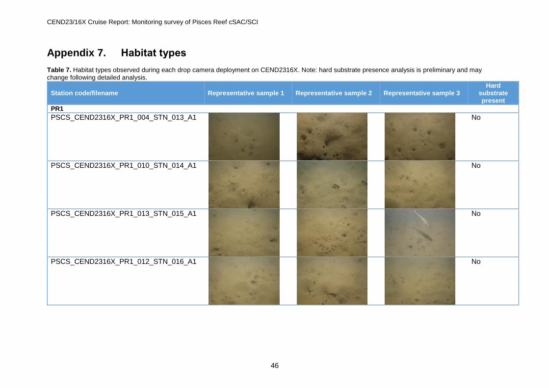
CEND23/16X Cruise Report: Monitoring survey of Pisces Reef cSAC/SCI
46
Appendix 7. Habitat types Table 7. Habitat types observed during each drop camera deployment on CEND2316X. Note: hard substrate presence analysis is preliminary and may change following detailed analysis.
Station code/filename Representative sample 1 Representative sample 2 Representative sample 3 Hard
substrate present
PR1
PSCS_CEND2316X_PR1_004_STN_013_A1
No
PSCS_CEND2316X_PR1_010_STN_014_A1
No
PSCS_CEND2316X_PR1_013_STN_015_A1
No
PSCS_CEND2316X_PR1_012_STN_016_A1
No
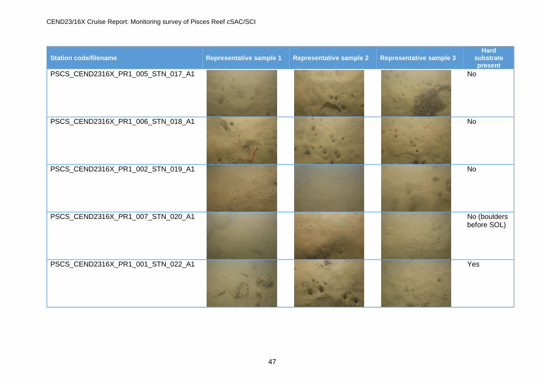
CEND23/16X Cruise Report: Monitoring survey of Pisces Reef cSAC/SCI
47
Station code/filename Representative sample 1 Representative sample 2 Representative sample 3 Hard
substrate present
PSCS_CEND2316X_PR1_005_STN_017_A1
No
PSCS_CEND2316X_PR1_006_STN_018_A1
No
PSCS_CEND2316X_PR1_002_STN_019_A1
No
PSCS_CEND2316X_PR1_007_STN_020_A1
No (boulders before SOL)
PSCS_CEND2316X_PR1_001_STN_022_A1
Yes

CEND23/16X Cruise Report: Monitoring survey of Pisces Reef cSAC/SCI
48
Station code/filename Representative sample 1 Representative sample 2 Representative sample 3 Hard
substrate present
PSCS_CEND2316X_PR1_011_STN_024_A1
Yes
PSCS_CEND2316X_PR1_003_STN_025_A1
No
PSCS_CEND2316X_PR1_009_STN_027_A1
Yes
PSCS_CEND2316X_PR1_008_STN_029_A1
No
PSCS_CEND2316X_PR1_019_STN_076_A1
Yes
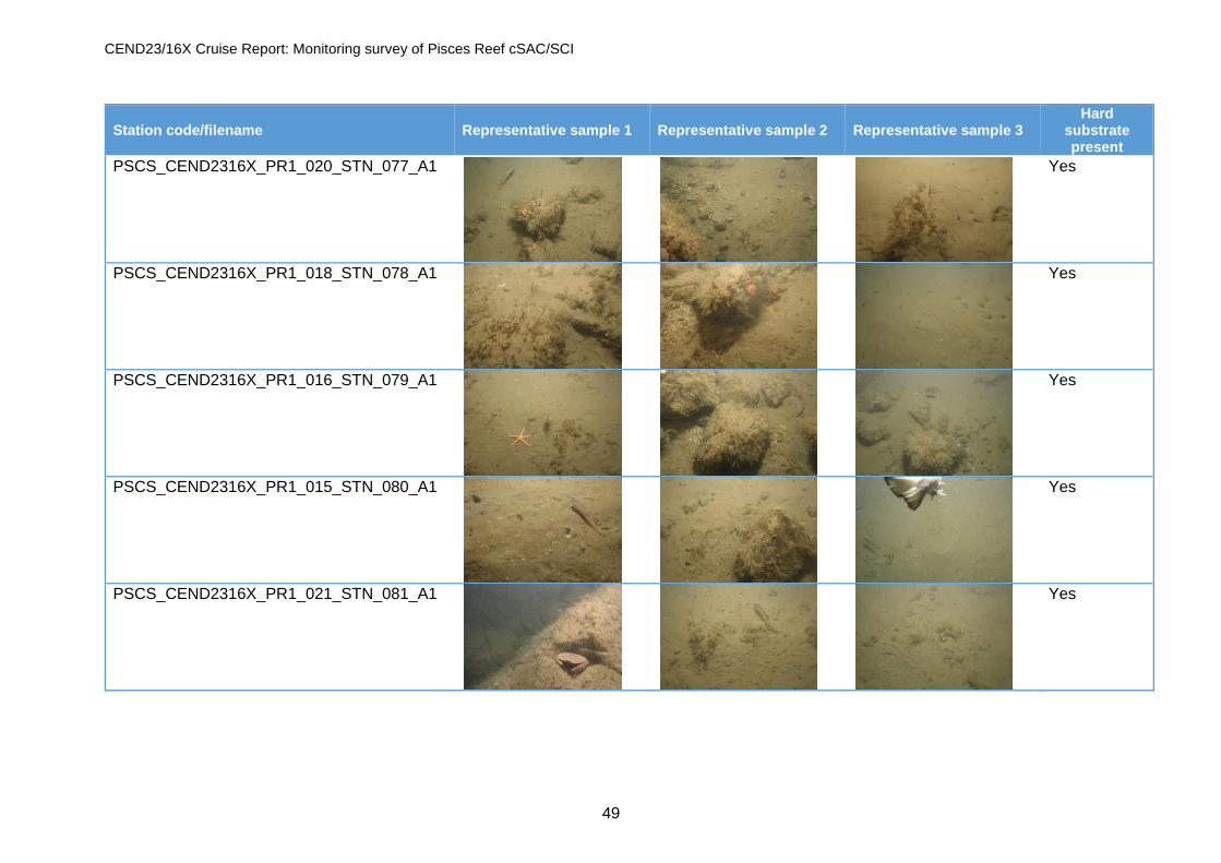
CEND23/16X Cruise Report: Monitoring survey of Pisces Reef cSAC/SCI
49
Station code/filename Representative sample 1 Representative sample 2 Representative sample 3 Hard
substrate present
PSCS_CEND2316X_PR1_020_STN_077_A1
Yes
PSCS_CEND2316X_PR1_018_STN_078_A1
Yes
PSCS_CEND2316X_PR1_016_STN_079_A1
Yes
PSCS_CEND2316X_PR1_015_STN_080_A1
Yes
PSCS_CEND2316X_PR1_021_STN_081_A1
Yes

CEND23/16X Cruise Report: Monitoring survey of Pisces Reef cSAC/SCI
50
Station code/filename Representative sample 1 Representative sample 2 Representative sample 3 Hard
substrate present
PSCS_CEND2316X_PR1_014_STN_082_A1
Yes
PSCS_CEND2316X_PR1_017_STN_083_A1
Yes
PR2
PSCS_CEND2316X_PR2_008_STN_031_A1
Yes
PSCS_CEND2316X_PR2_005_STN_033_A1
Yes
PSCS_CEND2316X_PR2_006_STN_034_A1
Yes

CEND23/16X Cruise Report: Monitoring survey of Pisces Reef cSAC/SCI
51
Station code/filename Representative sample 1 Representative sample 2 Representative sample 3 Hard
substrate present
PSCS_CEND2316X_PR2_004_STN_035_A1
Yes
PSCS_CEND2316X_PR2_009_STN_036_A1
No
PSCS_CEND2316X_PR2_001_STN_037_A1
No
PSCS_CEND2316X_PR2_007_STN_038_A1
No
PSCS_CEND2316X_PR2_010_STN_039_A1
No

CEND23/16X Cruise Report: Monitoring survey of Pisces Reef cSAC/SCI
52
Station code/filename Representative sample 1 Representative sample 2 Representative sample 3 Hard
substrate present
PSCS_CEND2316X_PR2_003_STN_040_A1
No
PSCS_CEND2316X_PR2_002_STN_041_A1
No
PSCS_CEND2316X_PR2_012_STN_042_A1
No
PSCS_CEND2316X_PR2_011_STN_043_A1
No
PSCS_CEND2316X_PR2_013_STN_044_A1
No

CEND23/16X Cruise Report: Monitoring survey of Pisces Reef cSAC/SCI
53
Station code/filename Representative sample 1 Representative sample 2 Representative sample 3 Hard
substrate present
PSCS_CEND2316X_PR2_015_STN_045_A1
No
PSCS_CEND2316X_PR2_016_STN_046_A1
No
PSCS_CEND2316X_PR2_014_STN_047_A1
No
PSCS_CEND2316X_PR2_018_STN_048_A1
No
PSCS_CEND2316X_PR2_017_STN_049_A1
No

CEND23/16X Cruise Report: Monitoring survey of Pisces Reef cSAC/SCI
54
Station code/filename Representative sample 1 Representative sample 2 Representative sample 3 Hard
substrate present
PSCS_CEND2316X_PR2_020_STN_050_A1
No
PSCS_CEND2316X_PR2_021_STN_051_A1
No
PSCS_CEND2316X_PR2_019_STN_053_A1
Yes
PSCS_CEND2316X_PR2_007_STN_055_A1
Yes
PSCS_CEND2316X_PR2_023_STN_084_A1
Yes
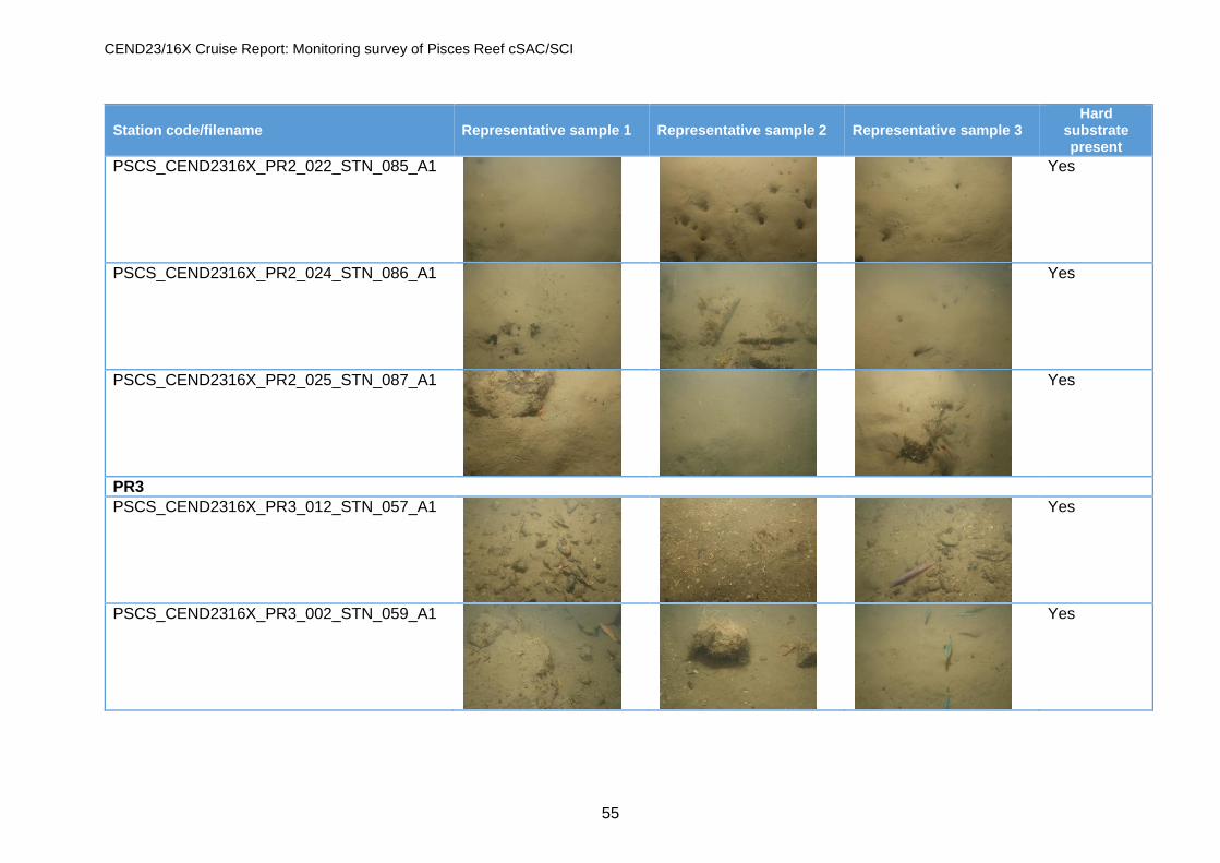
CEND23/16X Cruise Report: Monitoring survey of Pisces Reef cSAC/SCI
55
Station code/filename Representative sample 1 Representative sample 2 Representative sample 3 Hard
substrate present
PSCS_CEND2316X_PR2_022_STN_085_A1
Yes
PSCS_CEND2316X_PR2_024_STN_086_A1
Yes
PSCS_CEND2316X_PR2_025_STN_087_A1
Yes
PR3
PSCS_CEND2316X_PR3_012_STN_057_A1
Yes
PSCS_CEND2316X_PR3_002_STN_059_A1
Yes

CEND23/16X Cruise Report: Monitoring survey of Pisces Reef cSAC/SCI
56
Station code/filename Representative sample 1 Representative sample 2 Representative sample 3 Hard
substrate present
PSCS_CEND2316X_PR3_015_STN_061_A1
Yes
PSCS_CEND2316X_PR3_011_STN_062_A1
Yes
PSCS_CEND2316X_PR3_001_STN_063_A1
Yes
PSCS_CEND2316X_PR3_008_STN_064_A1
Yes
PSCS_CEND2316X_PR3_007_STN_065_A1
Yes

CEND23/16X Cruise Report: Monitoring survey of Pisces Reef cSAC/SCI
57
Station code/filename Representative sample 1 Representative sample 2 Representative sample 3 Hard
substrate present
PSCS_CEND2316X_PR3_016_STN_066_A1
Yes
PSCS_CEND2316X_PR3_004_STN_067_A1
Yes
PSCS_CEND2316X_PR3_005_STN_068_A1
Yes
PSCS_CEND2316X_PR3_010_STN_069_A1
Yes
PSCS_CEND2316X_PR3_006_STN_070_A1
Yes

CEND23/16X Cruise Report: Monitoring survey of Pisces Reef cSAC/SCI
58
Station code/filename Representative sample 1 Representative sample 2 Representative sample 3 Hard
substrate present
PSCS_CEND2316X_PR3_014_STN_071_A1
Yes
PSCS_CEND2316X_PR3_009_STN_072_A1
Yes
PSCS_CEND2316X_PR3_003_STN_073_A1
Yes
PSCS_CEND2316X_PR3_013_STN_074_A1
Yes
PSCS_CEND2316X_PR3_017_STN_075_A1
Yes

CEND23/16X Cruise Report: Monitoring survey of Pisces Reef cSAC/SCI
59
Appendix 8. Marine mammal observations report The full Marine Mammal Observation and Passive Acoustic Monitoring Report is provided as a supplemental download. Gardline: Survey Report for Centre for Environment, Fisheries and Aquaculture Science Project: CEND23/16X Pisces Reef Complex cSAC/SCI Monitoring Survey Description: Marine Mammal Observation and Passive Acoustic Monitoring Report Survey Dates: 29-October-2016 to 09-November-2016 Project Number: 10897 Report Status: Final

JNCC/Cefas Partnership Report Series. CEND23/16X Cruise Report: Monitoring Survey of Pisces Reef Complex cSAC/SCI, No. 18. Jenkins, C. & Nelson, M. June 2017. ISSN 2051-6711