jobs - bureau of labor statistics · pdf fileoccupational outlook quarterly • spring 2005...
TRANSCRIPT
Occupational Outlook Quarterly • Spring 2005
2
Geography
jobs

3
Spring 2005 • Occupational Outlook Quarterly
3
by Olivia Crosby
A wildfire rages in a California forest. In a faraway con-ference room, a group of mapmakers and geographers meet.
Everyone is on high alert. Each of them knows that when firefighters arrive at the blaze, the first thing they will need is a map. Some workers arrange for planes to locate and photograph the flames from overhead. Others analyze these photographs and combine them with exist-ing information about land features, climate, roads, hous-ing and business locations, and cell phone towers. With these data, they create up-to-the-minute maps.
At the same time, workers meet with city planners, of-ficials, and major businesses to explain the progress of the fire and its effects. The location of the wildfire is not entirely surprising: months earlier, map-makers gave satellite measurements to resource managers so that they could identify vegetation at risk for combustion.
Geography

Occupational Outlook Quarterly • Spring 2005
4
When people think of geography, they don’t of-ten think of crisis management. But the study of location is applied to all sorts of issues that
affect people and the environment.Geography involves more than memorizing States
and capitals. It’s a unique way of looking at the world and solving problems. And for some people, it provides a way to earn a living.
People working in jobs related to geography study how the elements of a place relate to each other. Not all of these workers respond to crises, such as wildfires. They might, for example, create topographical maps of a flood zone to show where people or animals live or how the coastline has changed over time. Other workers might analyze how a proposed road would affect the people, businesses, and natural features around it.
“Understanding geography can help governments and businesses make better decisions,” says Michael Phoenix, a geographer for a mapping software company in Red-lands, California. “People who can think spatially—think about where things are in relation to other things—are in great demand.”
The number of workers with the title of “geographer” or “mapmaker” is small; there are fewer than 11,000 mapmakers and geographers in the United States, ac-cording to the U.S. Bureau of Labor Statistics (BLS). But technology is creating new career opportunities related to geography. Read on to learn more about them.
What is a “geography job”?A geography job is any work that focuses on location. For many people, the jobs that first come to mind are those related to making maps. But many other kinds of work are linked to place. Jobs range from planning the loca-tions of schools and businesses to analyzing the political stability of a region.
Workers in geography jobs do not necessarily need a college degree in geography. In some of these jobs, in fact, workers need a degree in another subject. And some geography jobs have no degree requirement at all. Even if it is not required, however, some training in geography—whether in the form of a geography degree, a certificate, or individual courses—is an advantage in all of the careers profiled here.
The ability to work with data is becoming increasing-
ly important in geography, due, in large part, to techno-logical advances. For example, much of our information about where things are located comes from satellites that continuously beam coordinates to global positioning devices on Earth. In the last decade, the Federal Govern-ment has launched several new global positioning satel-lites. These, together with some commercial satellites, greatly increase the accuracy and amount of geographic data available. At the same time, new Geographic Infor-mation System (GIS) software can process those data with greater speed and flexibility.
This technology creates new career possibilities for people who understand geography and who can process and use geographic information.
Jobs in data gathering, GIS, and urban planning
A few geography jobs are based almost entirely on the study of location. Remote sensing specialists, photogram-metrists, and surveyors gather data about where things are on Earth. GIS analysts review these data and sometimes use them to make maps. And planners help to determine where buildings and roads should be located.
Remote sensing specialists and photogrammetristsMany maps rely on photographs or other data taken from airplanes, jets, and satellites. Remote sensing specialists oversee the collection of this information and interpret satellite images. Photogrammetrists interpret the more detailed data from jets and planes.
When a government, business, or other client needs a map, remote sensing specialists analyze the type of infor-mation that the map should include and then decide what type of sensors to use to get that information. The amount of detail required determines what equipment is needed, such as the size of the camera and the type of plane that will carry it.
In addition to seeing how things look, remote sensing specialists might need to measure temperature, moisture in the air, and other phenomena. For example, Steve Raber, a remote sensing specialist and program manager at the National Oceanic and Atmospheric Administration Coastal Services Center in Charleston, South Carolina, uses sensors to measure chlorophyll and, thus, helps to
Olivia Crosby is the managing editor of the OOQ, (202) 691-5716.
5
Spring 2005 • Occupational Outlook Quarterly
5
determine the abundance of plant life.When data come from satellites, remote sensing
specialists run the information through a series of com-puter programs to create images and maps. The special-ists might use different colors to show where interesting features are, such as different types of forests and crops. Jim Vogelmann, a remote sensing specialist at the U.S. Geological Survey’s National Center for Earth Resource Observations and Science in Sioux Falls, South Dakota, studies the different wavelengths of light shown in satel-lite images and uses that information to assess the condi-tion of forests. “With satellites, you see large chunks of land at once,” he says. “We can create land-cover maps that show thousands of square miles. We provide a broad overview of the Earth’s landscapes.”
When data come from aerial photographs or other sensors closer to Earth, photogrammetrists interpret the data to decide what they show. The first step in analyzing a photograph is to orient it to the ground. “Essentially, we are taking the photograph and, from it, creating a topographic map,” says Van Corey, a cartographic ana-lyst at an international mapping company in Frederick, Maryland. The exact location of the sensing equipment is recorded every time a photograph is taken. In this way, specialists and photogrammetrists can compare the photographs to the hills and valleys where the pho-tographs were taken and determine the elevation of the objects in the photographs.
Computers usually do most of these calculations. But photogrammetrists choose which formulas and tools to use, and they also need to recognize when the software makes a mistake.
After a photograph is oriented to the ground, the next step is to identify the objects in it. Photogrammetrists, such as Bryan Blackburn, who works a few steps from Corey’s office in Frederick, study aerial photographs at large computer monitors. Like many photogrammetrists, Blackburn wears large, clear goggles designed to let him see photographs in three dimensions. With a bird’s-eye view, he locates trees, buildings, hills, and other objects.
Photogrammetrists accomplish this 3-D trick by over-lapping two photographs of the same piece of land, each taken from a different angle. Using computer software, photogrammetrists overlap the two photographs to create a stereoscopic effect. “It’s similar to what your two eyes do when they work together to see in 3-D,” says Black-burn.
As they look at the screen, photogrammetrists trace outlines of the items in the photograph onto a correspond-ing diagram using a computer mouse. They might trace a length of road and the location of a house,
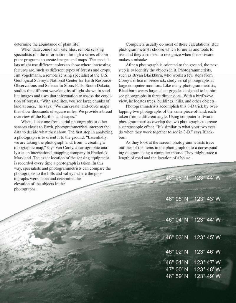
46° 59’ N 123° 49’ W
46° 04’ N 123° 44’ W
46° 03’ N 123° 45’ W
46° 02’ N 123° 46’ W
46° 01’ N 123° 47’ W47° 00’ N 123° 48’ W
46° 05’ N 123° 43’ W
46° 06’ N 123° 44’ W

Occupational Outlook Quarterly • Spring 2005
6
for example, using lines and symbols to show what each object is. The fuzzy outline of the road becomes a clear black line on the map. The house is marked with a partic-ular red shape. Someone reading the diagram will be able to identify these objects and to know their actual size.
Deciphering an image is not always easy. “The toughest part is figuring out what’s there,” says Black-burn. He studies shadows to determine the shape of things, and he analyzes the size of objects. Height helps him to distinguish between houses and highrises.
Interpreting photographs and sensor data also re-quires coping with uncertainty. Many images are par-tially blocked by trees or other obstacles, so the ground is obscured. And the detail of some images is limited by the type of camera lens or sensor used. Using probability and statistics, remote sensing specialists and photogram-metrists fill these holes. They make inferences based on what is likely to be there and then calculate how certain they are about various parts of the photograph and result-ing map.
Employment and earnings. BLS does not collect data on remote sensing specialists. It does gather infor-
mation on photogrammetrists, but it groups them with cartographers, who develop and draw maps.
According to BLS, there were 9,870 cartographers and photogrammetrists in May 2004. They had median annual earnings of $46,080, meaning that half of these workers earned more than that amount and half earned less. The highest earning 10 percent made more than $74,440; the lowest earning 10 percent made less than $28,210. Most worked for architectural and engineering services companies, governments, and consulting firms.
Education and training. Remote sensing specialists and photogrammetrists often have a bachelor’s or higher degree in geography or a related subject, such as survey-ing or civil engineering. Classes in statistics, geometry, and matrix algebra also are useful. “This occupation takes a lot of math,” says Clifford Mugnier, a photogramme-trist and professor at Louisiana State University. “If you don’t understand the calculations, you’ll never be able to understand the results the computer gives you. And you’ll never know if the numbers are wrong.”
Many remote sensing specialists have degrees in the natural sciences, including forestry, biology, and geology.
Photo courtesy of EarthData.
Geographers use computers to process data and create maps.
7
Spring 2005 • Occupational Outlook Quarterly
7
They often take courses in remote sensing or mapping while earning these degrees.
Not everyone working in this field has a bachelor’s degree, however. People who have an associate degree or a certificate in remote sensing or photogrammetry usually begin as assistants and gain additional skills on the job. Taking high school or college-level classes in mapping, drafting, and science can also lead to assistant jobs. Some employers hire entry-level workers who do not have col-lege training but do have an aptitude for math and visualizing in three dimensions.
Formal education notwithstanding, learn-ing to interpret aerial and satellite photographs takes time. Rob Murphy, a photogrammetrist for a small mapping company in Phoenix, Arizona, usually hires photogrammetrists who have geography backgrounds because they have an understanding of maps. But, he says, they learn the technical specifics on the job.
The American Society for Photogrammetry and Remote Sensing offers certification to re-mote sensing scientists and photogrammetrists and to remote sensing and photogrammetry technologists. Certification requires passing the society’s written examination and having training and experience.
Surveyors and surveying techniciansSurveyors also map and measure the Earth. But unlike the satellite photographs used by remote sens-ing experts, the surveyors’ data come from the ground.
Surveyors measure the land directly, often to de-termine the legal boundaries of a property. They also measure the incline of the ground so that building sites can be made level and so that construction projects can be properly designed. Some surveyors measure the depth of rivers, lakes, and harbors to establish shipping routes and to find out how far boats can go inland without going aground.
Although surveyors do their measuring outside, they usually start a project in records offices and libraries, researching previous measurements of the land. They look up old deeds, survey reports, blueprints, and other documents for clues about legal boundaries and the loca-tions of foundations and other hidden construction. “It’s detective work,” says Curt Sumner, a licensed surveyor in Maryland and Virginia and executive director for the
American Congress on Surveying and Mapping. “You search for any information you can find and then see if the past measurements match what is really there now, on the land.”
Surveyors look for previously placed groundmarkers or for physical boundaries, such as streams, that older documents describe. If the measurements do not match, surveyors figure out why. They compare different docu-ments, and they analyze the place itself. Perhaps a stream
eroded its bank, for example, or a brush fire consumed a tree that had been used as a landmark. Surveyors decide proper boundaries based on the best evidence.
Deciding what type of measurements to take can be another mystery. Like any good detectives, surveyors zero in on relevant facts. “You need to know where to look and what to measure,” says Sumner. Before a building can be constructed, for example, surveyors might need to find all of the parts of the sewage system on that site. They study the plans for the system, measure the depth of manholes, and look at ridges and indents in the landscape to find the system’s exact location.
Surveyors choose among many types of measuring equipment, including lasers and 3-D laser scanners, steel tapes, and theodolites, which measure angles.
Taking measurements is much easier and more pre-cise now than it was in the past. Now, surveyors use glob-al positioning equipment to take many measurements. In
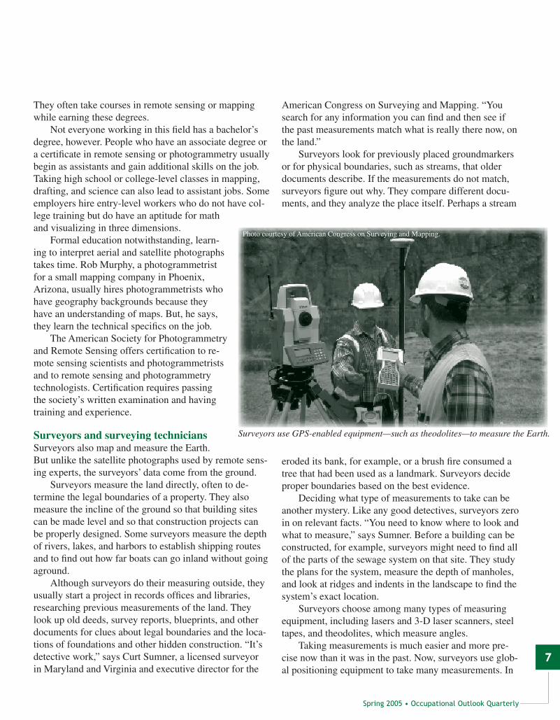
Surveyors use GPS-enabled equipment—such as theodolites—to measure the Earth.
Photo courtesy of American Congress on Surveying and Mapping.

Occupational Outlook Quarterly • Spring 2005
8
global positioning, a group of satellites broadcast location information to receivers on the ground. Based on that information, the equipment pinpoints the location of the place being measured.
Even though the equipment does this automatically, surveyors need to monitor the process. “It’s important to
know whether a measurement makes sense,” says Sum-ner. “You have to have the general shape of the boundary in your mind. If you don’t know what it should look like, you might get it wrong.”
Often, surveyors supervise a team of survey techni-cians rather than take measurements themselves. Entry-
Phot
o co
urte
sy o
f E
arth
Dat
a.
Photogrammetrists often use light tables to study aerial photographs.
9
Spring 2005 • Occupational Outlook Quarterly
9
level technicians might begin by placing markers on the land or by entering measurements into a laptop computer. Later, technicians learn to operate equipment indepen-dently. Eventually, they help to decide where and how to measure. Under general guidance from the surveyor, lead technicians supervise teams of technicians.
Surveyors and technicians communicate with cli-ents and their neighbors to explain their measurements. Because surveyors sometimes measure disputed borders, they may face irate neighbors as they mark a property’s borders. Communication skills are an asset for such situations. “Some people know the technical part,” says Sumner, “and underestimate the rest.” Those who have both technique and tact are at an advantage.
At the end of a project, surveyors write a report that includes maps. Occasionally, they also keep a diary de-scribing their methods. Survey technicians often help sur-veyors write reports. But it is the surveyor who certifies the final report and is legally responsible for its accuracy.
Employment and earnings. According to BLS, about 52,680 surveyors were employed in May 2004. They had median annual earnings of $42,980, with the high-est earning 10 percent making more than $71,640 and the lowest earning 10 percent making less than $24,640. Most surveyors worked for architectural and engineer-ing services companies, governments, or construction companies.
BLS counts surveying technicians and mapping technicians as a group. In May 2004, these workers held about 60,530 jobs and had median annual earnings of $30,380. The highest earning 10 percent made more than $51,070, and the lowest earning 10 percent made less than $19,140.
Education and training. Surveyors are re-sponsible for certifying legal boundaries and for ensuring that the land is properly marked for construction projects. Because of these responsi-bilities, all 50 States and the District of Colum-bia require surveyors to be licensed. Surveyors must pass two written exams administered by the National Council of Examiners for En-gineering and Surveying. Many States also require formal education, related experi-ence, and a passing score on a State-administered exam.
Surveyors in an increasing number of States need a bachelor’s degree in
surveying or in a closely related discipline, such as civil engineering or forestry, that includes surveying course-work. Other surveyors earn an associate degree in sur-veying or a related field, and some qualify with a com-bination of experience and vocational courses. About 20 schools offer a bachelor’s degree in surveying.
Surveying technicians might enter the occupation after high school. But to become a supervisor, many need to complete additional training, such as an associ-ate degree or an apprenticeship. Technicians often need to know how to do trigonometry, geometry, drafting, and technical drawing.
The National Society of Professional Surveyors of-fers four levels of voluntary certification for surveying technicians. Each level requires passing an exam and hav-ing progressively complex work experience.
GIS analystsGIS analysts turn geographic data into maps and deci-sion-making tools. They create large databases of geographic information and use them to solve problems.
Occupational Outlook Quarterly • Spring 2005
10
Consider an appliance company that needs to find the most efficient way to schedule service calls. It turns to GIS analysts for help. The analysts start with a computer-ized street map and add information about traffic patterns, the locations of customers, and the age of their appli-ances. With these data, analysts are able to make software to identify the best routes, which could save the company millions of dollars.
GIS analysts are divided into three major types: Those who focus on making maps, those who combine mapmaking with other types of analysis, and those who develop GIS software.
Mapmaking analysts start a project by choosing a base map that shows land features and boundaries. Base maps come from recent satellite and aerial photographs, from existing maps, and from other records, such as property tax reports. GIS analysts query a database of geographic information and download the map they want. Sometimes, GIS analysts or their assistants go outdoors to gather data about where things are, using a laptop com-puter and Global Positioning System (GPS) device.
Once they have a base map, analysts add layers of data to it. A layer might show where subway stations are, for example. On top of that, analysts might add a layer showing the location of major highways.
GIS analysts export data layers from the database and make sure that the scale and positioning of the data are accurate. Because all two-dimensional maps are differ-ent from the reality of a three-dimensional world, GIS analysts also need to make sure that the inaccuracies of a map will not affect its usefulness.
How the map will be used is another consideration. “Knowing who the user will be is very important,” says Leslie Jacobs, a GIS specialist in Washington, D.C. “I always ask, ‘Who will see this map? What will they use it for? What are you trying to explain?’ Knowing that helps me decide what kind of data to use, what should go on top of what, and what should be easy to see.”
Colors and symbols need to make sense, too, espe-cially if the map will be available to the public. Parks are usually green, for example, and water is blue. “Maps are tricky things,” says Jacobs, “and if you aren’t careful, they can be misinterpreted.”
For some maps, such as those used in textbooks and marketing pieces, artistry is paramount. To make these maps, GIS analysts work with graphic artists or use their own artistic skills. They might use design software or
scan paper-drawn maps into the computer. Because of their focus on the look of maps, GIS analysts who do this work often have the more traditional title “cartographer.” Some employers call all GIS analysts cartographers.
GIS analysts in “combination jobs” blend map-ping ability with some other skill. Many use geographic data to solve a particular type of problem. For example, some GIS analysts also work as market research ana-lysts, studying the locations of potential customers; other analysts are environmental scientists who track ecological conditions, such as the density of forests. GIS analysts who have dual roles like these concentrate more on the analysis of the data than on the maps themselves.
Other GIS workers train people to use GIS software. As GIS applications move to other disciplines, such as farming or ecology, GIS experts are needed to train people to use these applications in specific ways. (For more information about how farmers use geographic data, see “Farming in the 21st century: A modern business in a modern world” elsewhere in this issue of the Quarterly.)
GIS developers focus on creating GIS software and managing GIS databases. These workers have many job titles, including GIS developer, programmer, or analyst. Computer science is the most important part of their work, but understanding mapmaking and geography helps developers know how the software should work and how it will be used.
Employment and earnings. BLS classifies GIS ana-lysts into a few different occupations. GIS analysts who focus on mapmaking are counted as cartographers. As stated previously, there were about 9,870 cartographers and photogrammetrists in May 2004. As a group, these workers had median annual earnings of $46,080.
GIS analysts who concentrate on solving problems with geography are classified as geographers. According to BLS, there were about 750 geographers in May 2004; they had median annual earnings of $58,970. The highest earning 10 percent made more than $86,270, and the low-est earning 10 percent made less than $35,410.
GIS analysts or developers who create new software or design databases are classified as computer applica-tions software engineers or database administrators. In May 2004, there were 425,890 computer applications software engineers, with median annual earnings of $74,980. The highest earning 10 percent made more than $113,830. The lowest earning 10 percent made less than $46,520.

11
Spring 2005 • Occupational Outlook Quarterly
11
There were about 96,960 database administrators in May 2004. The highest earning 10 percent made more than $97,450. The lowest earning 10 percent made less than $33,380.
Analysts who combine GIS work with other occupa-tions are counted as part of those occupations.
Education and training. GIS analysts who focus on mapmaking often have a bachelor’s or graduate degree in geography. They gain experience in the most common types of mapping software through class projects and internships. Other common degree subjects are urban
planning, resource management, environmental science, and forestry—each of which usually includes coursework in GIS and geometry. Computer science classes also are particularly useful for GIS analysts, especially for those who need to modify GIS software to fit their specific needs. Art classes also are valuable, both for helping ana-lysts make better-looking maps and for honing visualiza-tion skills.
Some GIS analysts earn an associate degree or cer-tificate in GIS. These credentials qualify them for some entry-level and assistant jobs and show that they have
the technical skills needed to do the GIS tasks that are common in other occupations, such as market-ing or environmental science.
The American Society for Photogrammetry and Remote Sensing offers certifications of GIS Mapping Scientist or GIS Mapping Technician to people who pass an exam and who have a combination of GIS experience and education. The GIS Certification Institute also offers certification to people who have a qualifying combination of education, experience, and profes-sional accomplishments.
Training for GIS developers is somewhat different. Because they program software and create databases, developers often have a degree in computer science. But apart from this training, under-standing how to think spatially and visualize in three dimensions prepares GIS developers to create mapping software. In fact, some developers start with geography training. “Not every computer geek is in the computer science depart-ment,” says Michael Phoneix, a geographer and GIS recruiter in Redlands, California. “GIS is a good way to combine interests.”
Photo courtesy of EarthD
ata.
GIS analysts confer with their clients to determine what kind of map is needed.

Occupational Outlook Quarterly • Spring 2005
12
Urban and regional planningThe placement of your local school, library, and shopping mall—and the roads that connect them—is no accident. Nearly every local government employs urban, regional, and neighborhood planners to determine the placement of public buildings and roads and to help to decide which types of private construction will be allowed and where.
Some urban and regional planners create compre-hensive, long-term plans that show how the layout of the entire city or region might change over time. They look for trends in population and economic development to understand what issues the area will face in the future. For example, are more people moving into the area? If so, new housing might be needed. And if that’s true, what areas should be zoned for new housing construction?
Planners write reports showing alternatives for cop-ing with issues like these. They also report on how pro-posed construction projects will affect growth, economic development, traffic, and the environment.
Urban and regional planners usually work on projects that are 10, 15, or even 20 years into the future, so devel-oping projections about future population and economic
conditions is a large part of their work. “Planning and forecasting go hand in hand,” says Sharlene Reed, an ur-ban and transportation planner for the District of Colum-bia. “You look for trends that show how many people are moving into the area, how many people commute to the cities, and which businesses are hoping to locate there.”
Some planners, like Reed, concentrate on transpor-tation issues, working to eliminate traffic jams and air pollution. They use algorithms to calculate traffic volume. Planners estimate the number of trips a commuter will take, for example, after moving to a different neighbor-hood. They might also get data by going to an intersec-tion and counting cars, or, more often, by asking techni-cians to do this after showing them how.
Planning gets more personal at the neighborhood level. Neighborhood planners, also called community planners or community developers, concentrate on main-taining or developing a small part of a city or region.
Planners think about how location will affect people’s lives. “Plans should make life better for people,” says Melissa Bird, a neighborhood planner for the District of Columbia. “It makes sense to put the library close to the
Phot
o by
Deb
orah
L. C
rain
/cou
rtes
y of
Offi
ce o
f Pl
anni
ng, G
over
nmen
t of
the
Dis
tric
t of
Col
umbi
a.
Planners consider how the design of a city affects communities over time.

13
Spring 2005 • Occupational Outlook Quarterly
13
school, close to social services and healthcare, and close to public transportation.”
Planner George Gilliam of Cleveland, Ohio, cites business location as another factor that affects quality of life. “You can revitalize an area by concentrating stores in one place,” he says, “so that people can get shoes repaired while waiting for a prescription to be filled.”
Planners also try to solve problems in the community. Sue Schwartz, for example, president of the National Planning Association and chief of neighborhood plan-ning for Greensboro, North Carolina, uses planning to make neighborhoods safer and more prosperous. She and her staff analyze geographic data to find the causes of neighborhood troubles. They identify areas of high crime, the location of rental properties versus owned properties, and business locations. They overlay this information with maps showing income statistics, the age of city sew-ers, and many other data to set priorities for funding and revitalization.
Geographic data give planners a feel for how a neigh-borhood works. The placement of sidewalks, for example, helps to determine if children walk to school. Similarly, if a major road cuts a neighborhood in half, the two sides might offer very different living conditions. Or if build-ings are rundown, new businesses may not be attracted to the site.
Information about a neighborhood doesn’t always exist in a database. “You can’t do this job sitting behind a desk,” says Schwartz. Planners go out to see conditions firsthand. They take detailed notes that are later entered into maps.
Planners also meet with community groups to deter-mine which areas need the most attention. “At the start of any project, we set up lots of neighborhood meetings to hear everyone’s concerns and establish priorities,” says Mary Beth Kerns, another Greensboro planner. “You try to balance the needs and opinions of competing groups.” Planners also explain development projects to commu-nities, showing them maps and drawings. “We create change in the city,” says Kerns.
Employment and earnings. Urban and regional plan-ners held 31,140 jobs in May 2004, according to BLS. At the median, they earned $53,450, with the highest earning 10 percent making more than $82,610 and the lowest earning 10 percent making less than $33,840. Most plan-ners work for local governments; many others work for architectural firms.
Education and training. The best way to train for a career in urban or regional planning is to get a bachelor’s or higher degree in that subject. Many local governments prefer to hire planners who have a graduate degree. About 80 colleges and universities have programs accredited by the Planning Accreditation Board that lead to a bachelor’s or higher degree in planning.
A degree in geography is an alternative to a degree in planning; what matters is understanding the link between people and places, a focus that the two disciplines share. “Employers are looking to hire people with that skill set, and geographers have those skills,” says Schwartz, who studied applied geography and took additional courses in urban planning.
Whatever their college major, prospective planners benefit from courses in GIS and from internships with local government planning departments.
The American Institute of Certified Planners, part of the American Planning Association, grants certification to workers who pass an exam and who have a combination of education and experience in planning.
Other careers in geographyThe careers described in the previous section are a few of the possibilities available for geographically minded people. Geographic information is important in a variety of other career fields, including business, earth science, and the social sciences.
BusinessMany businesses are eager to put newly available geo-graphic information to use. Geography figures prominent-ly when deciding where to build stores, developing real estate, and helping tourists choose where to travel.
Location analysis. When chain stores expand into a new area, they want the full power of geographic infor-mation to help them decide where to locate. Location analysts work for consulting firms and large corporations to choose placement for retail stores and other commer-cial developments. Analysts gather data about population and income patterns, housing and business sites, roads and traffic patterns, natural features and environments, real estate prices, and myriad other factors. They use this information to develop a database and program GIS soft-ware. Their goal is to find a place that attracts customers.
Location analysts create maps to show the pros and cons of various sites. They review the data and make

Occupational Outlook Quarterly • Spring 2005
14
recommendations about where to build a new store or housing development.
Many location analysts study geography with a concentration in economic geography and GIS. Business, marketing, economics, and statistics classes are also help-ful.
Real estate development. Some workers’ tasks go beyond the scope of location analysts’ to include choos-ing and buying land for development or investment. Real estate developers might combine skill in location analysis with expertise in finance, accounting, and real estate. They focus on property values, getting the best price, and making sure that money is available to buy the property. Later, they might oversee construction, renovations, or property management.
Real estate developers often have a master’s degree in business administration or another advanced degree in a related subject, such as real estate or finance. Coursework in geography, however, also is useful for developers, helping them to conduct or oversee GIS mapping and lo-cation analysis. GIS and geography skills also are useful in other real estate occupations, such as commercial and
residential real estate agent and real estate appraiser.Tourism. Tourism is another area of business that re-
quires an understanding of geography. Travel agents need to understand places, including both cultural and natural features, to know what attracts visitors and to help people plan trips. It is especially important for agents who plan international travel to understand social geography, which involves the cultural, economic, and political conditions of the places to which people travel.
In addition to working as travel agents, some geogra-phy-minded workers create adventure-travel businesses or work for tourism boards to attract visitors to a com-munity.
The most common training for travel agents is a high school diploma or vocational classes at a community col-lege. But a bachelor’s or higher degree in tourism, busi-ness, or geography is becoming more common for jobs that include marketing, the planning of complex trips, or management responsibilities. Geography classes can be good early training for executives in the travel industry before they pursue a master’s degree in business.
Earth scientists and geographers monitor the size and health of streams.
15
Spring 2005 • Occupational Outlook Quarterly
15
Earth science geographyPhysical geography—the study of land features, climate, and other natural characteristics and their locations—re-lates closely to earth science and several earth science careers, including forestry and conservation science, geomorphology, and climatology.
Forestry and conservation science. Foresters manage land for timber companies or governments. These work-ers inventory the number and types of trees, decide where to put roads so that trees can be transported, and monitor and limit the impact of deforestation on the environment.
Conservation scientists work with farmers, ranchers, and foresters to protect rangelands and to preserve the quality of water and soil. In addition to consulting with people who use the land, conservation scientists might monitor the health of streams and other natural resources by tracking animal populations and measuring pollution levels.
Foresters and conservation scientists need training in the natural sciences, including botany and environmental science. Foresters also need training in the economics of forestry. But understanding mapmaking, GIS applica-tions, and the relationship between people and the envi-ronment—all of which are the purview of geography—is also important.
Geomorphology. Another career field that meshes earth science with the study of location is geomorphol-ogy, the analysis of how the shape of the Earth changes. Geomorphologists might study how the course of a stream changes after a flood, for example, and whether and how the stream should be rerouted. They investigate the causes and effects of such change. Based on these analyses, they make recommendations about construction projects and reclamation efforts.
Geomorphology is a specialty of geography, and most geomorphologists have advanced degrees in their specialty.
Climatology. Climatologists study how climate changes and what factors affect it. Unlike meteorologists, who make short-term predictions of the weather, clima-tologists focus on the long term. They study how the ele-ments of a place, such as its plant life, land features, and human activity, both affect and are affected by climate. For example, Mark D. Schwartz, a climatologist and pro-fessor of geography at the University of Wisconsin-Mil-waukee, studies how the lower atmosphere interacts with plants, and vice versa, at the onset of spring. By studying
such relationships, climatologists can help other scientists and policymakers understand global warming and other environmental issues.
People preparing for a career in climatology and other specialties within physical geography take courses in the natural and the physical sciences. Schwartz ex-plains that both geographers and natural scientists need technical, scientific knowledge, but geographers combine that scientific knowledge with an understanding of other subjects, such as culture and economics. “Climatologists and other geographers don’t always do as much of the basic science. They take an interdisciplinary approach to understanding how we interact with the planet,” he says. “Studying all the elements of a place—including both hu-man activity and the natural environment—will help us to solve many of the issues we face on the planet.”
Social science geographySocial science geographers use geography to study social issues. Most social science geographers work for the Federal Government. At the U.S. Department of State, for example, social science geographers apply geography to the study of foreign policy. They might study the migra-tion of refugees, the spread of terrorism networks, or other issues that cross national boundaries.
Often, their work involves creating or studying maps, but it also extends to other kinds of analysis. Geographer Bill Wood, the State Department’s deputy assistant secre-tary for intelligence and research, says issues of foreign policy are affected by the location of natural resources, populations, ethnic migrations, and centers of economic growth or stagnation. Geographers understand how all of these issues interact within a region. And they can ana-lyze how and why a county or region is changing.
Geographers, including those at the State Depart-ment, often write reports about current issues. They conduct spatial analyses and make maps, but they also study reports written by analysts in other disciplines, such as economics or political science. And they study primary sources, such as images and newspapers from the area in question.
Geography professors also research geographic is-sues as part of their work. Some university and college instructors consult for governments and nonprofit organi-zations.
Even though they are not called geographers, many social scientists use geography in their work. “Look

Occupational Outlook Quarterly • Spring 2005
16
beyond job title,” says Diane Castiglione, director of recruitment at the State Department. “In nearly every analyst position we have, understanding geography—how the aspects of a place and its natural resources affect land use, boundaries, and political stability—is an asset.”
Locating career informationThere are many sources of information about geography careers. One source is the Occupational Outlook Hand-book. The Handbook describes hundreds of occupations, including several related to geography. Geography-related occupations and occupational groups, most of which are described in this article, include environmental scientists and geoscientists; geographers; market and survey researchers; surveyors, cartographers, photogram-metrists, and survey technicians; travel agents; and urban and regional planners.
For each occupation, the Handbook discusses job duties, working conditions, earnings, education and train-ing, and current and projected employment. The Hand-book is available in many libraries and career centers and online at www.bls.gov/oco.
Several associations also provide career information to people who like learning about places and thinking about location. The following associations offer career brochures, interviews with current workers, sample job descriptions, or information about training and certifica-tion. Most of these associations offer all of these.
American Congress on Surveying and Mapping, The National Society of Professional Surveyors, and The Cartography and Geographic Information Society 6 Montgomery Village Ave., Suite 403Gaithersburg, MD 20879(240) 632-9716www.acsm.net
American Planning Association122 S. Michigan Ave., Suite 1600Chicago, IL 60603(312) 431-9100www.planning.org

17
Spring 2005 • Occupational Outlook Quarterly
17
American Society for Photogrammetry and Remote Sensing5410 Grosvenor Ln., Suite 210Bethesda, MD 20814-2160(301) 493-0290www.asprs.org
Association of American Geographers1710 16th St. NW.Washington, DC 20009-3198(202) 234-1450www.aag.org
Geospatial Information and Technology Association14456 East Evans Ave.Aurora, CO 80014(303) 337-0513www.gita.org
GIS Certification Institute1460 Renaissance Dr., Suite 305Park Ridge, IL 60068(847) 824-7768www.gisci.org
National Council of Examiners for Engineering and SurveyingP.O. Box 1686 Clemson, SC 29633-1686 (800) 250-3196www.ncees.org
Urban and Regional Information Systems Association1460 Renaissance Dr., Suite 305Park Ridge, IL 60068(847)824-6300www.urisa.org
The U.S. Department of Labor’s Employment and Training Administration also offers information and a brochure about careers in geospatial technology. The brochure describes several occupations along with their education and training options. The information is avail-able online at www.careervoyages.gov or by calling the toll-free career help hotline: 1 (877) US2-JOBS (872-5627).