joe nunan the evidence for early new english settlements in mogeely and blackrock … ·...
TRANSCRIPT
1
Joe Nunan
The Evidence for Early New English Settlements in Mogeely and Blackrock
5.0 Introduction
The present chapter examines the house forms and types built by the New English
settlers in the Mogeely area for the sixteenth century and at Carrigeen. The settlement
of Carrigeen was situated northwest of Mogeely hamlet, on the northern bank of the
river Bride. A second area of archaeological excavation undertaken by Dr. Colin
Breen at Blackrock, overlooking Bantry bay in west Cork will then be examined.
Blackrock was a New English settlement site. A map of the settlement dating to the
early decades of the seventeenth century was use by Breen to locate the best possible
excavation area. During the course of their excavations house sites and defensive
palisades were identified in-situ. In the current chapter emphasis and analysis shall
focus upon the defensive elements of the site. Finally, a brief account of some
economic activity associated with the settlement shall be mentioned. Ultimately,
Blackrock, like Mogeely, failed as viable long term settlement.
5.1 House types and settler activity: Mogeely estate map c.1598
5.1.1 Mogeely
Whilst the aims of Eric Klingelhofer’s excavations at Mogeely, Curryglass, and
Carrigeen (Klingelhofer 2000; 2010) were to uncover evidence of Raleigh’s
plantation settlements in Munster along with evidence of Elizabethan occupation
within the Mogeely area Klingelhofer also identified features that could be associated
with the structures listed on the 1598 map. Klingelhofer was of the opinion that the
structure he excavated at Mogeely could be directly linked to one of the timber-
framed houses depicted on the Estate map (Klingelhofer 2000 in excavation, 110;
2010, 24). This house site overlay the upper part of a medieval ditch, upon which was
placed a spread of hard gravelly clay creating a foundation platform. Unfortunately,
the foundation walls of this structure were robbed out, bar the remains of white lime
mortar lumps left behind (Klingelhofer 2010, 24). According to Klingelhofer a
seventy centimetre wide mortar-filled foundation trench would have supported a
single-storey structure of timber-framing. Alternatively, the same type of foundations
could have supported a cob-built single storey structure (Figure 5.8). These excavated

2
remains were the only tangible evidence of house walls. There were small amount of
mortar debris within another excavation trench which revealed the edges of a possible
south-facing foundation wall. These foundations were irregular and absent but
Klingelhofer propose with some confidence that the structure measured 10.6m x 6.6m
internally, and 12m x 8m externally (Klingelhofer online at archaeology.ie).
The measurements were later amended to 11.6m by 7.3m internally upon further
examination of the archaeological record in the post-excavation phase (Klingelhofer,
2010, 24). Klingelhofer (2001, 2010) suggested the building was probably laid out on
an English house measurement of 10.7m by 6.7m internally (Klingelhofer, 1999b,
110). Other features that Klingelhofer suggested were on this site, using the pictorial
evidence from the Mogeely map, but which were not found, included the foundations
for a central chimney. While ploughing may be responsible for their destruction, their
absence could also be explained by the fact that these may have been located outside
the excavated area. Nonetheless much of this disappearance could have occurred in
the early period of the 1598 war when the rebels who were active around Mogeely:
‘burnt two fair barns…..and kept it so straitly besieged four months or more, that none
without danger could stir out of the gates for water or any other thing; after which
time they approached the walls with an engine and ladders, thinking to have made
breach, sealed, and entered with 600 men, under the leading of Redmond and William
Burke, who undertook the winning of the castle for 600l. and the spoil thereof, which
was promised them. They were repulsed with the loss of their engine, ladders, and
some of their best men’ (SP 63/205 f.355).
The scale and orientation of the excavated feature matched the house on the Mogeely
map. Unfortunately, Klingelhofer’s excavations at Curryglass revealed no evidence
for a seventeenth-century settlement or structures; there were no features that were
identifiably associated with the plantation house plots as depicted on the Mogeely
estate map. However, tentative activity on this site, during the plantation, was denoted
by the presence of course-gritted, green-glazed earthenware dated to the fifteenth,
sixteenth and seventeenth centuries (Klingelhofer 2000, 157). However, from
pedestrian survey (chapter four) this area may have well been associated with the
Raleigh or Boyle iron or glass works.

3
5.1.2 Carrigeen
Klingelhofer found evidence for two features at Carrigeen, during his excavation
despite, as he noted, that the site had been heavily ploughed over. Nonetheless,
patterns of stone scatter indicated the position of the two possible platforms. Upon
excavation they presented evidence of cobbled surfaces and some of that cobbling
extended out into a possible yard and path area. The platforms were situated 8m apart,
and the smaller of the platforms (Structure 1) was identified by the remains of slight
traces of clay residue on the subsoil surface once the topsoil had been removed.
Klingelhofer interpreted this clay trace as evidence of a stone-packed clay wall
structure (Figure 5.2). The dimensions of this structure were estimated as 8m by 10m
in the preliminary archaeology report (Klingelhofer online at archaeology.ie).
The interior of this structure, according to Klingelhofer (2010, 25), measured 5m by
10m and appeared to have been a two-bay structure with a central entrance facing the
1598 roadway. Klingelhofer believes that the right-angled corners of this feature
(Structure 1) hint at an English construction, as opposed to rounded-angles, which he
believes as being associated with Irish (Gaelic and Old English) construction. No
A view of an excavated house foundation beam slot
Figure 5.1 Wallingford, Oxfordshire excavations 2008: The Kinecroft
(Trench 3). Beam slot from a 12th to 13th century structure. Universities of
Leicester, Exeter and Oxford.

4
hearth or evidence of occupation was found in the vicinity that related to this feature
(ibid., 163-165). Nevertheless, excavation on this feature offered two unmistakable
distinguishable orientations, suggesting the existence of an earlier feature on the site
of (Structure 1), the latest of which was parallel to, and probably contemporary with,
the larger structure (Klingelhofer 2010, 25). While an earlier phase of activity at this
location he believes may have been associated with occupation activity by the local
Gaelic Irish or Old English.
The second feature (Structure 2) excavated at Carrigeen which Klingelhofer (2000)
identified, was a three-bay structure whose interior measurements were
approximately 6.5m by 15m and was rectangular in shape. The rectilinear shape of the
feature suggested an ‘English style construction’ (ibid., 2010, 25). He suggested that
the building consisted of a timber framed structure using such evidence as the
excavated beam slots. The external measurement of the structure was 8m by 16m
(Breen 2007a, 107) this which would have provided the structure with a substantial
supporting foundation of approximately 1.5m. The interior of the structure produced
some evidence of a hearth. However, Breen believes that the excavations undertaken
by Klingelhofer represented an important contribution to the archaeological record, as
evidence of a number of building styles being present, reflecting English architectural
styles and also the adaptation and combination of both English and Irish building
traditions (Breen 2007a, 108). These uncovered house forms and the settlement
morphology would suggest that these were the dwellings of New English settlers.
5.1.3 Warren
It is possible that the feature identified as Structure 1 was associated with activity in
the area identified as the Warren on the Mogeely Estate map as it was located in an
ideal area on the north of the Bride which slopes down towards the river and is
composed of soft soils, which are favorable for burrowing. Nevertheless, if it were
such a site, in order to prevent the rabbits escaping the warrens a surrounding moat or
ditch filled with water may have been needed and the location of the Bride to the
south of this site would have kept the rabbits north of the river. A palisade, worm
fence or fastness may have been provided (or not) to exclude natural predators from
the woods to the north.

5
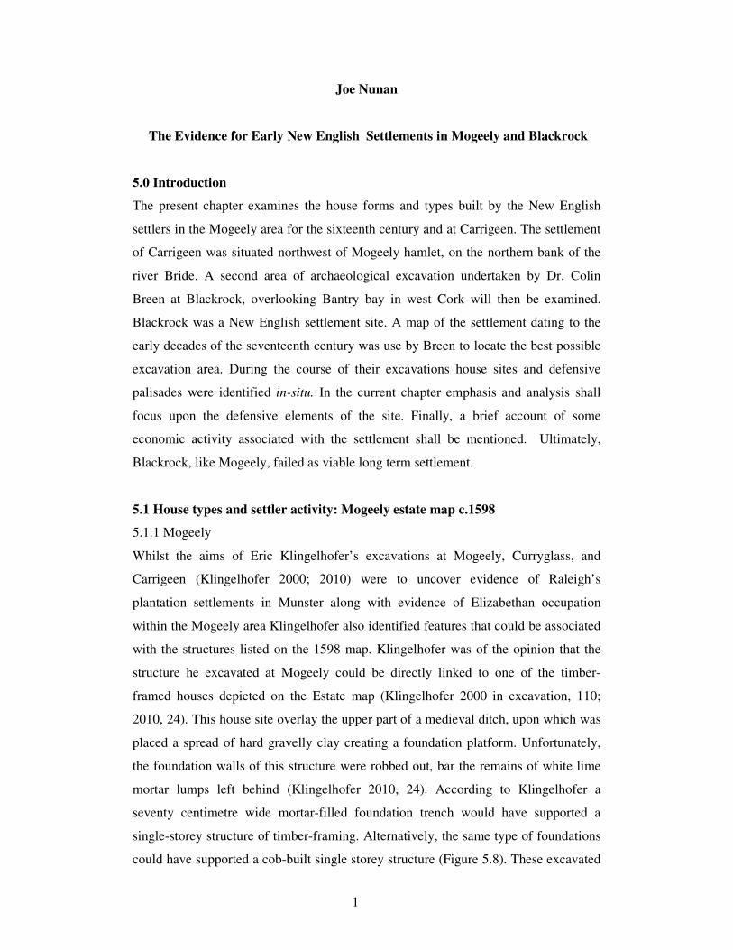
5.1.4 Pillow mound
The most characteristic structure of a warren was the pillow mound (Figure 5.2; 5.3).
These were pillow-like or oblong forms with flat tops, which were sometimes
arranged into more extensive interconnected rows and were usually provided with
pre-built, stone-lined tunnels. The preferred orientation was on a gentle slope, with
the arms of the mound extending downhill, as this facilitated drainage. These mounds
were common in Britain through out the medieval and early post-medieval period and
many are clearly marked on English OS maps. A pillow mound could measure from
nine to two hundred metres long. According to English Heritage there are at least
eight pillow mounds at Whiddon Deer Park, Devon which date from the medieval to
post medieval periods (Figure 5.2). They survive on the landscape as, either
rectangular or circular mounds, together with their associated drainage ditches. Their
length varies from 6.7m to 14m and their height can be between 0.7m and 0.9m. Up
to the present day there were some seventeen rabbit warrens found on Dartmoor in
Devon (Linehan 1966, 139). Walter Raleigh, the patent holder of Mogeely and the
surrounding lands, grew up in a farmhouse in the village of East Budleigh in Devon,
and the construction and used of such features may have been familiar to some of the
New English who settled the Bride River Valley.
6
Similar warrens and mounds may have been constructed within the Carrigeen
landscape
Figure 5.2 Top: Whiddon Park pillow mounds, Devon; Middle: Klingelhofel’s excavation at
Carrigeen, County Cork; Bottom: Carrigeen & Mogeely.

7
Similar warrens and mounds may have been constructed within the Carrigeen
landscape
Figure 5.3 The stone remains of a pillow mound in Wales adapted from google maps.

8
5.2 The Blackrock settlement
Research excavations were carried out by Colin Breen in the summer of 2001 at the
Blackrock site (in excavations 2003, 31). The plantation town was abandoned
sometime towards the middle of the seventeenth century, and the existing evidence
suggested that no further settlement took place at the location (ibid., 31). This made
the site as important as Mogeely, given its intact nature and the prospective for the
recovery of stratified cultural remains. This site was supported by all of the available
cartographic and archaeological evidence and Breen, like Klinglehofer at Mogeely,
used an early post-medieval cartographic source identified by Donovan and Edwards
(1997, 272). The map CCDD(2) housed at the East Yorkshire County Achives and
Records Services identified the location of the Blackrock New English settlement site,
in the grounds of the demesne of Bantry House (Breen, 2005, 163).
This was an important statement as he used this cartographic source along with
archaeological survey to locate the settlement. Blackrock had connections with the
seignory of Kinalmeaky while many merchants and traders from Bandon-Bridge
conducted business at Blackrock. William Hull, who was based at Leacom, had
economic interests at Blackrock and Ballygobben (Appleby 1992, 307). Hull, who
had a lease on the town of Crookhaven by 1616 (Breen 2007a, 120), also had many
land leases around the Bandon-Bridge area (MS 6139).
5.2.1 Cartographic evidence
Breen used an early seventeenth-century cartographic source to identify evidence for
the location of the early New English settlement at Bantry Bay. This enabled him to
identify the Franciscan Abbey, the settlements of Blackrock and Ballygobben. When
describing the settlement of Blackrock Breen stated a large central building is shown
as a two story structure with a centrally placed spire and cross and It is tempting to
interpret this as a church however he believed It may instead represent a
administrative building (Breen 2005, 165).
The abbey of Bantry was depicted in three different forms, on three different maps
spanning the period 1550 to 1620 (Figure 5.4). On the map CCDD(2) this ‘central
place’ Breen (ibid.,) refers to was portrayed in the same pictorial form as Bantry
abbey was in the MPF/1/94 map from many decades earlier. However, they were not

9
one and the same as the Abbey in CCDD(2) was no longer represented as a religious
house. Blackrock was a New English settlement the old abbey was, now redundant
and a new service house was possibly built for the Blackrock community and
congregation. If so, it could have had a dual function a place of religious worship and
a custom house during the lifetime of the settlement.
5.2.2 Excavation at Blackrock
Breen’s excavation at Blackrock was on the western margin of the seventeenth
century settlement site when an area measuring 10m by 12m was opened in the north-
east corner of the west side of Bantry House. Blackrock was built upon an earlier
Gaelic settlement (Figure 5.4; Breen 2005, 2007a; b; c), as was Mogeely. Magnetic
survey undertaken by Breen in 2001 located two house sites and a number of
boundary features. Upon excavation a broad range of archaeological deposits were
identified, including a mid-seventeenth-century house represented by the survival of
its western gable foundations, which in turn overlay a more substantial and better-
built rectangular structure, interpreted as a timber-built English administrative
building (Breen 2005, 2007a; in Excavations 2003).
However, in 2007 Breen believed that the excavations undertaken by him at
Blackrock in 2001 had uncovered extensive remains associated with the
Roger/Beacon 1588/1590 plantation scheme. This was a large linear settlement was
established along the waters edge and that it was initially enclosed by a large palisade.
The presence of a palisade was in his view, reflective of the campaign of resistance
mounted by some branches of the Gaelic septs in the region and it was also in his
view indicative of the underlying philosophy of the early planters (Breen 2007b, 179-
180). It would not appear unlikely then that a palisade was erected on Beacon’s lands
at Blackrock (ibid., 180).

10
Figure 5.4 Top: Left to right - CCDD(2); Taylor & Skinner: Blackrock & Bantry; MPF/1/308;
MPF/1/94. Bottom CCDD(2) & MPF/1/94.

11
5.2.3 Palisades
According to Breen a palisade trench dug late in the sixteenth or early seventeenth
century, to provide a bulwark around the early plantation settlement, pre-dated the
timber-built rectangular structure. Sixteenth-century cultivation ridges were
uncovered which cut the foundations of an earlier Gaelic domestic structure. The New
English settlers moved in and took over this location and one of their first acts was the
erection of a palisade around the site. This palisade was removed or destroyed early in
the seventeenth century and its trenches were backfilled all of this occurred in a single
instance (2005, 167-170; 2007, 121; see above 2004). Breen (2005; 2007a) speculates
that the removal of the palisade reflected a renewed sense of security by the New
English in this part of West Cork, the material culture and historic evidence suggests
this happened within the first two decades of the seventeenth century. The erection of
palisades was a common feature by English settlers both in Ireland and North
America. In the early part of the seventeenth century, in Virginia, palisades and slot
fences were constructed as settlers move into new region that offer both economics
and social advancement; hand–in-glove with new settlement establishment came the
risk of hostility from regional and external elements.
Many of the new settlers in Virginia were veterans of the Irish and mainland
European military campaigns, where palisades and pickets were used. Some of this
military knowledge was drawn upon when building settlement in hostile areas or
when it was necessary to protect the new settler’s economic interests. In Virginia,
over half of the old planters who died in 1609 in Jamestown included ex-soldier from
Elizabeth’s Irish wars (Horning 2007, 53). Knowledge of establishing defended
encampments and the effectiveness of basic palisading and slot fencing to protect a
community from hostile elements was known among these old planters. These
palisades were constructed primarily for the purpose of community and economic
self-preservation when settlers were operating or establishing in semi-hostile environs.
Archaeologists of the Chesapeake (the term Chesapeake references all that geographic
area adjacent to the Chesapeake Bay and including portions of Maryland and
Delaware as well as Virginia.) have evaluated two types of palisade defences
associated with late sixteenth and early seventeenth century settlers. According to
Luke Pecoraro (2006) these were either formal or private defences.
12
In Virginia archaeological evidence for formal fortifications came predominantly
from James Fort at Jamestown, while evidence for private works has been uncovered
at Martin’s Hundred, Flowerdew Hundred, Jordan’s Journey, Nansemond and the
Clifts Plantation (Kelso, Williams, Luccketti, and Straube 1999, 21–33; Pecoraro
2006, 88-89; Horning 2007, 53-54). In the early 1620s Virginia William and Thomas
Newce built a brick-lined well and guest-houses to receive new settlers into the region,
not only were they building settlement infrastructure but they also erected palisades to
protect the settlers and their land (McCartney 2007, 519–520; Pecoraro 2006, 91).
This was the same William Newce who was instrumental in establishing the
settlement of Bandon-Bridge and Newcestown, in the seignory of Kinalmeaky,
Munster. Along with establishing those two nucleated settlements he was leasing out
much land to new settlers who set up farmsteads through out the seignory. He resided
for a time at the fort in Coolfadda and had a residence to the west of the fort, both,
were situated on the north side of the Bandon River within the settlement of Bandon-
Bridge.
At Nansemond Fort, a site occupied by British settlers in Chesapeake, Virginia, from
c.1635–1680, the archaeological evidence suggested that within the first two years of
settlement a basic palisade was erected. A defensive palisade line approximately
44.8m long with two openings for gates ran between two structures. These structures
acted in a similar manner to the corner tower of a bawn wall or the bastion or demi-
bastions on a fortified structure. This construction was Phase 1A, c. 1635–1637 of
settlement on this site and according to Luke Pecoraro (2006, 61) this palisade may be
understood in two ways: as a defensive element, or an attempt to organise the
settlement’s social space into agricultural and domestic areas. Since there was no
equivalent palisade to the south of the site, the individuals who built the palisade may
have completed an enclosure of the three buildings on site (Figure 5.8) using a wattle,
timber or worm fence. This initial palisade was a temporary measure and a more
substantial one was constructed sometime between c.1636–1646 (Phase 1B).
5.2.4 The slot fence
In an effort to organise agricultural and domestic space on settlement sites in Virginia
slot fences were erected on many of the new settlers sites. An excavation at Port Anne
Virginia: ‘Site CL7’, an early seventeenth-century settler site identified this type of
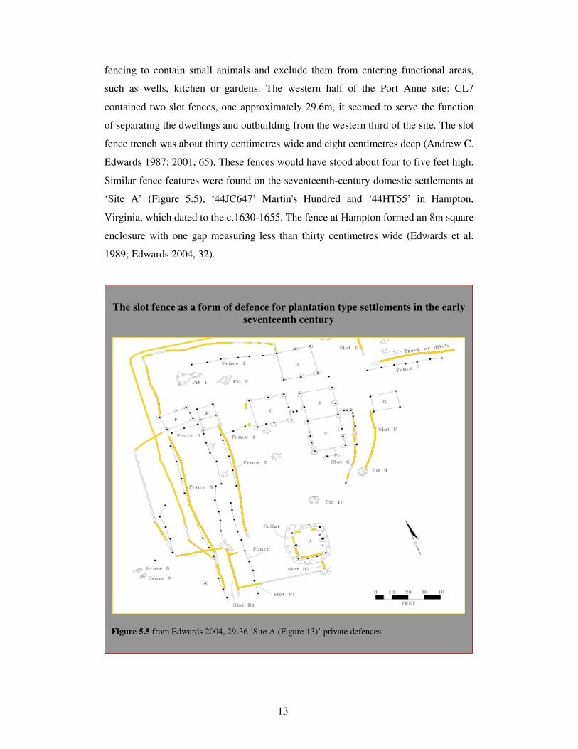
13
fencing to contain small animals and exclude them from entering functional areas,
such as wells, kitchen or gardens. The western half of the Port Anne site: CL7
contained two slot fences, one approximately 29.6m, it seemed to serve the function
of separating the dwellings and outbuilding from the western third of the site. The slot
fence trench was about thirty centimetres wide and eight centimetres deep (Andrew C.
Edwards 1987; 2001, 65). These fences would have stood about four to five feet high.
Similar fence features were found on the seventeenth-century domestic settlements at
‘Site A’ (Figure 5.5), ‘44JC647’ Martin's Hundred and ‘44HT55’ in Hampton,
Virginia, which dated to the c.1630-1655. The fence at Hampton formed an 8m square
enclosure with one gap measuring less than thirty centimetres wide (Edwards et al.
1989; Edwards 2004, 32).
The slot fence as a form of defence for plantation type settlements in the early
seventeenth century
Figure 5.5 from Edwards 2004, 29-36 ‘Site A (Figure 13)’ private defences

14
Similar fences were found by Robert Keeler at an early seventeenth-century house
site in St. John’s near St. Mary’s City, Maryland Keeler (1978) maintained that these
types of fences were attributed to poor or early planter, while post and rail fences
suggested longevity or wealth. Some fence construction used whole saplings rather
than split timbers, much like a palisade (Edwards 2004, 32-36).
At Nansemond Fort, during the later part of the 1630s, the defensive palisade was
dismantled to make way for a more substantial fieldwork to enclose the entire
settlement (Figure 5.9). However, this was a period of increased sporadic conflict
with the Nansemond people’s in the region, resulting in a two-year war that began in
1644 (Pecoraro 2006). The new enclosure c.1636–1646 (Phase 1B) was trapezoidal in
shape with two rounded bastions, at opposing corners, made of split logs. This type of
configuration was similar to some Irish bawn walls and to palisading and
fortifications used during the Nine Year’s War, as depicted in the plot of a combined
Irish and English military encampment on the Lifford c.1600 (Figure 5.7), and also to
the z-shaped Scottish tower houses (Jope 1954) and fortified house of Ballyannan,
east Cork (Figure 5.9). Yet, it was also reflective of English military forts used during
the English Civil war of the 1640s (Figure 5.6).
English civil war fortifications and defences
Figure 5.6 Plan of civil war fort at Penrose from W Cox’s (1801) Historical Tour through
Monmouthshire (Brown university Library) & Harrison (2004, 9) English Civil War Archaeology.
Formal defences
15
An examination of structures of similar form and function within county Cork, dating
to the first half of the seventeenth century, revealed part of what was, a trapezoidal
bawn at the fortified complex of Dromaneen (Nunan 2005 & 2006; Jones 1907),
whose rounded demi-bastion survives, it was incorporated mid way into its eastern
wall, which facilitated enfilading fire and compensated for musket inaccuracy and
distance. The equivalent at Nansemond was a sixty one centimetre right-angle jog in
the palisade line 42m from the northeast bastion and on the south wall 34m from the
southwest bastion (Luccketti 2007, 25; Pecoraro 2006, 67).
At Ballyannan, in east Cork, the remains of a z-shaped fortified house survives whose
shape resembles that of the two rounded bastion enclosure at Nansemond. However,
the bawn at Nansemond unlike that at Dromaneen was not a stone and mortar 3m
height construct; it was built of split timber placed in a thirty centimetre wide by sixty
centimetre deep slot trench. It stood upright, forming a wall that closely resembled a
breastwork or slot fence just tall enough to allow one to look over (Kelso, Williams,
Luccketti and Straube 1999, 29; Luccketti 2007, 25; Pecoraro 2006, 62).
It appears from Breen’s excavations and the British and Irish State Papers relating to
the Nine Year’s War, in Munster (the defence of Mogeely) that the palisades, slot-
fences and timber bawn like structures (in plan) used to protect and defend British
Virginia settlement sites were also used and employed on New English sites in county
Cork up to the closing decades of the sixteenth century. Another New English site in
county Cork where possible palisades, timber and slot-fences similar to those found
on excavations in the Chesapeake may have been constructed was at the East India
Company site at Downdaniel (chapter eight).
The fortifications at Mogeely in the 1598 campaign included the castles bawn wall
and timber defence works. These defences were such that
The White Knight and Piers Lacy, perceiving the fortification of Moghelly
to be such that they thought it impossible to take it by force, concluded that
the only way was to have Pyne's life; which presently after they put in
practice by hiring two to kill him….The White Knight, since he took
protection, caused one Thomas Spanyagh (an old soldier lately come to

16
Tyrone out of Spain, and sent by Tyrone to him) to view Moghelly. This he
did secretly, and said it was impossible to take it, except with ordnance or by
famine (SP 63/205 f.355: Sept 1599).
Similarities in timber defences to those built in Virginia may have been erected at
Mogeely c.1599 ‘in regard of the buildings and intrenchings lately made and the fact
that ‘cows, to the number of above 1,500, under the walls of Moghelly, where they
were in safety, and kept from him. When Tyrone came into Barry's country, to spoil
the same, there were above 2,000 cows of the Lord Barry's followers saved at
Moghelly from the rebel forces’ (SP 63/205 f.355). This would indicate that ditching
and palisades may have been erected as ‘Moghelly might have been taken with the
rest at the first, but that now it was not be dealt with, for it had been so provided and
fortified by Pyne, that they would of necessity be forced to quit Drumfinny woods and
the Blackwater, for Moghelly would be a scourge to them all’ (SP 63/205 f.355).
The many excavations undertaken in Virginia, that have identified private and formal
English/British settlement division of space and defence through the settler’s use of
palisades, slot-fences and timber bawns were important because similar features were
also used on the New English Munster settlement of Blackrock, especially in the early
years of plantation. Irish defence and settlement influences were acknowledged when
archaeologists examined early English settlement in North America. Alternatively,
when examining English settlement in Munster during the plantation period the
archaeology undertaken in Virginia and along the eastern coast of North America on
British settlement from the first half of the seventeenth century are an important
element that has to be incorporated into any Munster study. These excavations inform
the archaeologist how the early New English may have established settlement and
used space within an early plantation Munster context. Audrey Horning (2007, 53)
and Noël Hume (1988, 236) make the connection with plantation Ireland and the
similarities found in plantation settlement resulting from the manipulation of the
physical landscape. New settlers initially relied on and resided in or near places that
were defensible sanctuaries. However, over time it was their settlement rather than
their sanctuaries that would come to define them.
17
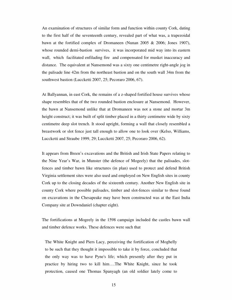
The military defences and camp on the Lifford had similarities in form with
the East India Company Industrial complex and defences on the Bandon
Figure 5.7 Above a plan of Lifford (SP 63/207/6). Below Downdaniel, West Cork – Carnsew &
East India Company site. (Formal defences).

18
Private defence at Moss-grove Kinalmeaky, Co. Cork & Nansemond Fort
Plan of Moss-grove fortified house bawn wall c.1630s. Graphic by Joe Nunan (2005)
Plan of the Nansemond Fort, Phase 1A, c.1635–1637. Graphic by to Luke Pecoraro (2006, 56)
Figure 5.8 (private defences)

19
Private defences in Virginia and Kinalmeaky
Plan of the Nansemond Fort, Phase 1B, c.1636–1646. Graphic by to Luke Pecoraro (2006, 63)
Plan of Ballyannan fortified house c. mid-seventeenth century. Graphic by Joe Nunan (2005) Figure 5.9 (private defences)

20
Charles Hodges who has investigated what he termed ‘private’ English Virginia
fortifications (Hodges 2003, 31) suggested that attention also be given to Dutch,
French, and Spanish defences. The English were just as familiar with those defences
as they were with Irish ones. This earlier notion of private and formal defence
dividing land for the dual purpose of farming and security broadens one’s perspective
when examining private fortifications. however, the realities of implementing small
scale settlement combined with commercial activity within new and at times
unfamiliar regions, with limited resources were complex and as Horning (2007)
observed that while fortified elements may be the most substantial symbol of English
and British settlement in Ireland and North America the most essential component of
colonial policy were the nucleated settlements. These acted as cultural and
administrative point of reference (Horning 2007, 53).
5.2.5 House types: Blackrock
When the palisade at Blackrock was taken down its trench was filled in and a house
was built in the area that overlaid the backfilled palisade trench. During excavation it
became clear that this was a rectangular structure with a stone foundation at its
western gable. It had an external measurement of approximately 5m by 4m and its
foundation platform comprised mostly of three sandstone slabs averaging just less
than 1m by 0.33m. The southern end of the foundation consisted of a raised area of
smaller blocks and filling stones and the western face of this feature was packed with
a line of cobble-like stone. The house foundation was compacted into the natural sub-
soil and it did not appear that bonding was used in the construction process. The
opposing gable consisted of a rectangular trench measuring just less than 5m in length
and under 1m in depth. Stone lined post holes were uncovered at either end of the
trench. Both averaged around 0.16m wide by 0.2m deep. According to Breen, the side
walls must have been of timber-framed construction supported on sill beams. Support
for this interpretation came from the large quantity of iron nails that were discovered
within the house site stratigraphy (Breen 2007a, 122; 2005, 169). Of course, box-
frame construction was common in both England and North American through out the
early post-medieval period (Newman 2001, Deetz and Deetz 1998, Breen 2007a, 122;
2005, 168).

21
There is evidence at Blackrock of a fusion of both timber-frame and earth-fast
construction. The earth-fast nature of the eastern gable according to Breen (2007a,
122) may have been to anchor and secure the house to give it added stability. This
house had glass windows as fragments of seventeenth-century green and white
window glass were identified on site. This glass may have been similar to glass
produced close to Mogeely at the end of the sixteenth century and beginning of the
next (chapter four). It appeared the door to the structure faced towards the bay. The
structure was roofed with local slate that was shaped in a rounded single form
measuring 0.25m by 0.13m with perforated nail holes; the quantity of slate within the
surviving deposit suggested the structure was pulled down in a single event or
dumped and left on site (Breen 2005, 169-170; 2007a, 122-123).
According to Horning (2007, 58), all colonial settlement attempted to regulate
building in one form or another, where for example thatch was banned in Cork after a
fire in 1622 (Horning 2007, 58). Slate roofs were preferred over thatch by the new
settle elite and many of the New English, such as Boyle, specified slate roofing over
thatch. At the end of the first decade of the seventeenth century the Carnews of
Bokelly were sending Irish house slate back to England for use on roof construction
(SP 46/72). Along with slate, Irish plantation leases specified new settler houses be
constructed after the English manner; which was a brick or stone chimney (Horning
2007, 58). The leases that Newce made with undertenants in Kinalmeaky gave
specific instructions to build dwelling house with chimney after the English fashion
(MS 6139).
The earth-fast component of Breen’s Blackrock structure was interesting as houses
using earth-fast posts in their construction may have been more widespread amongst
the Gaelic as was obvious from the excavations at Movanagher (Horning 2001, 391;
O’Conor 2002, 197, 198; Breen 2007a, 122). However many of the buildings
constructed in Virginia during the first half of the seventeenth century were of the
earthfast form (Figure 5.5; 5.8 & 5.9). This type of construction was carried out in a
number of different ways. Small posts were position into the ground at regular
spacing and the structure built on top or/and postholes were dug where needed. The
upright timbers were inserted into them and packed with soil, stones and other debris
to stabilize them. Sections of these buildings may have been prefabricated around

22
long timber shafts (Breen 2007a, 122; 2005, 168). These timber panels were placed
into position attached and linked together, forming a sheltered structure (Carson, et.al.
1981, Edwards 1987, 13).
5.2.6 Trade
Breen suggested the excavated structure at Blackrock was the residence of a trader or
merchant and manifests cartographically as one of the houses on either side of the
central building/custom house depicted on the CCDD(2) map of Bantry Bay. The
numerous finds included clay pipes, English pottery and wine bottle fragments
together with German and Italian wares. However, as mentioned in chapter two pirate
activity was taking place on a vast scale along the southwest coast of the county, an
area that extended from Baltimore to Blackrock/Ballygubben. Thus, along with the
pilchard fisheries came the pirates, the officials and the East India men. The pirates
Baughe, Hughes, and Stevenson visited the settlements of Blackrock, Ballygubben,
Leamcon and so-forth in the second decade of the seventeenth century, trading pepper,
sugar, spices, wines, and silks among other things. When Stevenson came out of
Mamora in North Africa around Christmas 1612 he arrived at Whiddy in the ship the
Thomas, according to a deposition taken of Baptist Ingle (Hingley), of King’s Lynn,
Norkfolk, and while at Whiddy he (Baptist) ‘often went ashore to make merry with a
young woman that lay at Ballygubbin’ (Appleby 1992, 130).
These pirates captured many ships and brought them into the New English coastal
settlements scattered along the south west coast of county Cork (Ibid., 1992, 125-130).
The residents of Ballygubben, Blackrock and Bandon-Bridge were conducting
business with traders, smugglers and pirates. This would explain the high status of
some of Blackrock’s buildings and also may suggest reasons other than rebellion why
a structure, such as that excavated by Breen, may have been taken down in a single
event or why palisade may have been erected or taken down in the same manner (see
Appleby 1992, 295, 297, 305).
23
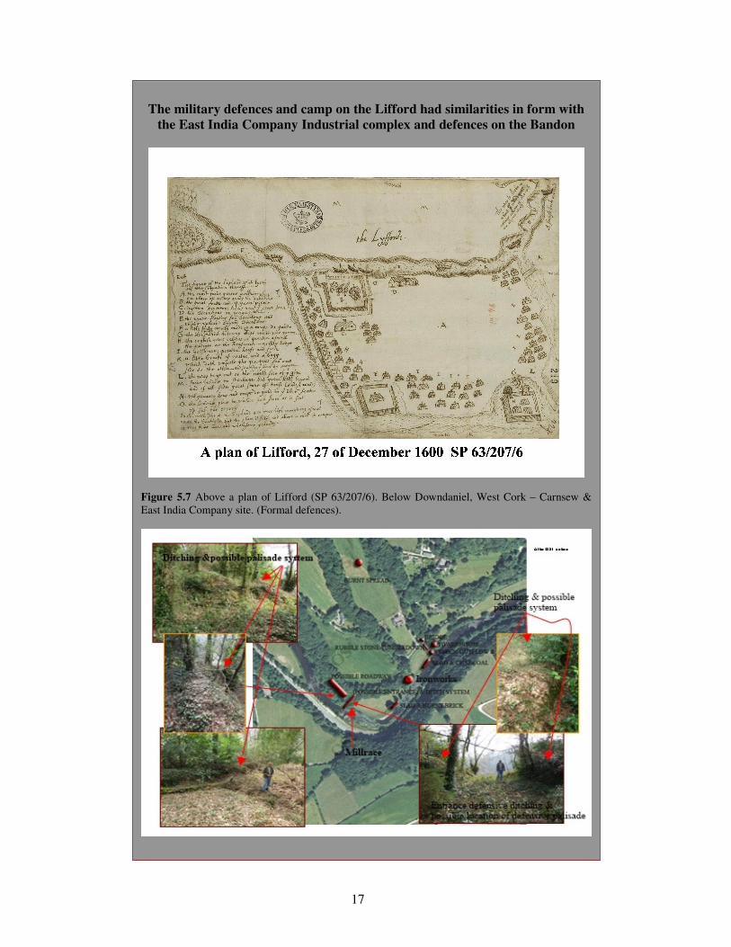
Habitation Types uncovered from excavations at Mogeely, Carrigeen and
Blackrock counnty Cork
Figure 5.10 Examples of hybride and English habitation constructs
24
A deposition taken from Edward Davenant of the island of Whiddy, county Cork
(Bantry Bay), merchant, on the first of October 1614 for the high court of the
admiralty detailed the perils of dealing/crossing the Dutch at Crookhaven.
And this deponent saw 17 of the dead corpses lying on shore, and believes
that the Hollanders then murdered above 30 persons.
When this deponent went aboard Lambert’s ship to expostulate with him,
Lambert told him that one of his buoy ropes had been cut during the night,
and that if he had any more cut he would burn the whole town. Whereto this
deponent answered that he thought it impossible for any to come out in the
night, as the storm was so extreme. And he added that Lambert should be
better advised because it was treason to burn a house in this kingdom. But
Lambert replied that he would do it, and had this deponent tell the townsmen
so. This deponent forthwith went to the town which divers of them were
affrighted and presently left the town (ibid., 286-287).
On the 28th
of June 1625, a certain Humphrey Cole, in a statement to the commission
from the High Court of the Admiralty stated he saw two chests of sugar landed at
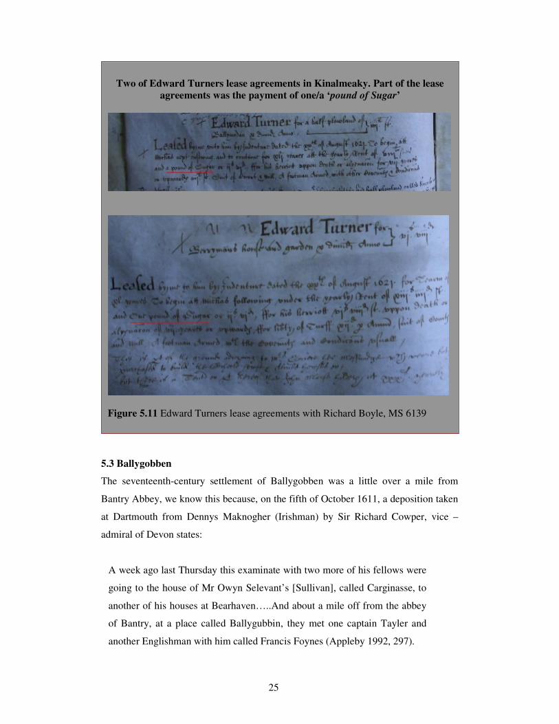
Blackrock Bantry and put into ’Mr Seker’s cellar, for the use of Edward Turner of the
Bridge’ (Appleby 1992, 305).
Murtough Kennedy stated Turner received sugar in return for cloth and other goods
and Edward Scrace stated Turner had eight chests of sugar (ibid., 306; 307). This was
the same Edward Turner who had taken a number of leases at the Bridge (Bandon-
Bridge) in 1621, two of his leases included the proviso: a payment of one pound of
sugar (Figure 5.11). Trade between Bandon-Bridge and Bantry (Blackrock and
Ballygobben) had a regional and international dimension to it, and in the case of some
individuals dictated local rent agreements.
25
5.3 Ballygobben
The seventeenth-century settlement of Ballygobben was a little over a mile from
Bantry Abbey, we know this because, on the fifth of October 1611, a deposition taken
at Dartmouth from Dennys Maknogher (Irishman) by Sir Richard Cowper, vice –
admiral of Devon states:
A week ago last Thursday this examinate with two more of his fellows were
going to the house of Mr Owyn Selevant’s [Sullivan], called Carginasse, to
another of his houses at Bearhaven…..And about a mile off from the abbey
of Bantry, at a place called Ballygubbin, they met one captain Tayler and
another Englishman with him called Francis Foynes (Appleby 1992, 297).
Two of Edward Turners lease agreements in Kinalmeaky. Part of the lease
agreements was the payment of one/a ‘pound of Sugar’
Figure 5.11 Edward Turners lease agreements with Richard Boyle, MS 6139
26
The present site of the Abbey* is approximately one mile from Bantry town. The
current inlet at Bantry was far more expansive in the late sixteenth and early
seventeenth centuries. Analysis of sixteenth-, seventeenth- and eighteenth-century
cartographic material (Figure 5.4), along with the early and late editions of the OS
maps identify reclamation in this part of Bantry. Present-day Bantry, fronting the
market place and the town square was the site of Ballygobben. Archaeological
monitoring in the town square by Breen identified the area as being devoid of material
culture (Breen 2005). No archaeological excavations have taken place in Bantry town
up to 2009, and as a result little evidence of the seventeenth-century settlement of
Ballygobben has come to light. However, as mentioned above the seventeenth-century
community was illustrated as a nucleated settlement consisting of thirty or more
upstanding structures (DDCC(2)). Both Blackrock and Ballygobbin appear on the
early cartographic source as coastal linear settlements. According to Breen,
Ballygobben looked less prosperous from its sketch on the seventeenth century map
and was referred to as a ‘fisher town’ in the early sources (ibid., 165). This may have
been so, but, it was the case that much trading and nefarious activity was being
conducted at Whiddy, Ballygobben and Blackrock in the first few decades of the
seventeenth century.
Chapter summary
The excavations undertaken by Eric Klingelhofer at Mogeely and Carrigeen represent
an important contribution to the archaeological record of New English settlement in
Munster. The archaeology produced evidence of a variety of habitation types built by
the new settlers. The habitation types signify different English architectural styles and
hint at a merging of English and Gaelic vernacular house types. It was possible the
settlement activity at Carrigeen was associated with the named field system the
warren, depicted on the 1598 Mogeely estate map. This area identified on the 1598
map combined with a pedestrian survey suggests the landscape north of the Bride
River was an ideal location for rabbit warren type activity. Trade, commerce and
industry were vital components of New English nucleated settlement. However, many
settlements were established around industry, trade and resources that were finite; as a
result many of these settlements did not last beyond a single human lifespan unless
another means of supporting the population was introduced. During their brief

27
existence they were vibrant and active settlements consisting of communities and
individuals who more mobile and less rooted to place.
Excavations carried out by Colin Breen at the deserted New English Settlement of
Blackrock, identified the late sixteenth-early-seventeenth-century settlement site.
Breen’s excavations uncovered English house types along with a defensive feature in
the form of a palisade. He believed the palisade was erected during the first phase of
New English settlement at Blackrock. Such defensive features were reflective of the
localised campaigns of resistance mounted against the new settlers. The erection of a
palisade was also indicative of the underlying philosophy of the early planters to
defend their interests and protect their settlements. There have only been a few
excavations at known deserted or abandoned New English settlement sites in Munster.
Thus they require wider contextualisation in the light of the evidence from English-
Virginia settlements. An examination of the excavation results from a select few of
Virginia’s early settlements can help archaeologists identify features that may be
present on New English Munster sites.
William Newce established settlements within Kinalmeaky, county Cork and Virginia.
Being a military man, he may have used defensive features in Munster similar to
those erected in Virginia. The East India Company established settlement within
Kinalmeaky seignory at the end of the first decade of the seventeenth century. They
erected earthen ditches close to the castle site of Downdaniel to protect their settler
and their economic interests; these ditches may have incorporated palisades and slot
fencing. The use of the palisade in early Virginia have part of their origin in the bawn
wall type construction found around the Irish tower and fortified house and in the
timber palisades and defences used in sixteenth century Irish warfare. The bawn wall
was an efficient and effective deterrent against any would be attacker or raider
whether it was constructed of stone or timber. The effectiveness and protection
afforded to the new settler by the existence of a bawn like structure was recognised by
the English both in Munster and Virginia when establishing settlement within a
potentially hostile environments.

28
-------------------------------------------------------------------------------------------------------
* In 2006 an archaeological and metal detection assessment was undertaken as a
result of the construction of a slipway at Abbey Point, and the laying of a pipeline for
Bantry sewerage scheme works at a location known as ‘the Narrows’. The potential
Bantry abbey site (CO118–029 and CO118–030(01)) is located in the vicinity of
Abbey Point and the ‘the Narrows’. No archaeological structures or materials were
encountered (Bennett 2009, 63).