john wilson attended john graybeal’s sensor interoperability workshop in portland maine, as a...
TRANSCRIPT

John Wilson attended John Graybeal’s Sensor Interoperability Workshop in Portland Maine, as a representative of IGWADTS and NASA Dryden.
John Wilson is an engineer at Creare Inc., a small R&D firm located in Hanover, NH. At Creare, John has been involved in a range of software and hardware development projects, including graphical user interfaces, control code, and device driver software in Java, C++, MATLAB, assembler, and CLIPS. He is Project Engineer on several DoD/NASA projects which utilize Creare’s Ring Buffered Network Bus technology to advance the integration and interoperability of diverse systems. The RBNB-based Intelligent Network Data Server (INDS) system used at NASA Dryden has recently supported several NASA/NOAA suborbital airborne science activities.

Copyright © 2006Creare IncorporatedAn unpublished work. All rights reserved.
MTG-06-10-2344 / 6106 2
TRIP REPORTTRIP REPORTMarine Metadata Interoperability Project:Marine Metadata Interoperability Project:
Sensor Metadata Interoperability WorkshopSensor Metadata Interoperability Workshop
October 19October 19––20, 200620, 2006Portland, MEPortland, ME
John P. WilsonJohn P. WilsonCreare Inc.Creare Inc.

Copyright © 2006Creare IncorporatedAn unpublished work. All rights reserved.
MTG-06-10-2344 / 6106 3
Contents
1. Workshop takeaways
2. MMI Workshop overview
3. Uses of metadata
4. Metadata standards
5. OGC SWE
6. Ocean observing systems
7. Workshop conclusion, “next steps”

Copyright © 2006Creare IncorporatedAn unpublished work. All rights reserved.
MTG-06-10-2344 / 6106 4
Workshop Takeaways
• Develop metadata as early on as possible
• Finalize our REVEAL/UDP schema
• Develop an IWGADTS schema?
• For cross-domain interoperability, consider using SensorML or TML– Challenge: how would each apply to the
REVEAL-to-INDS interface?
• Investigate OGC SWE– Wrap RBNB as an SOS or SAS service?

Copyright © 2006Creare IncorporatedAn unpublished work. All rights reserved.
MTG-06-10-2344 / 6106 5
Sensor Metadata Interoperability Workshop
• Goals– To educate participants on the use of metadata standards in the context of ocean observing
systems. Result: Accomplished!– Can a consensus be reached on what standard to use? Result: An increased awareness of
the unique roles of the standards.
• Hosted by the Marine Metadata Interoperability Project– “To promote collaborative research in the marine science domain, by simplifying the
incredibly complex world of metadata into specific, straightforward guidance.”
• Workshop Web site:<http://marinemetadata.org/examples/mmihostedwork/ontologieswork/mmiworkshop06>
• The conference host, and MMI PI, is John Graybeal (Software Engineer at the Monterey Bay Aquarium Research Institute, MBARI) <[email protected]>
• 52 workshop participants, multi-national (Australia, Canada, Europe, U.S.)• Workshop tracks
– Track 1: Teams assigned a standard; they come up with an instance for a particular instrument (i.e., CTD (Conductivity, Temperature, Depth) instrument).
– Track 2: Exposure/introduction to standards (primarily SensorML and TML), XML and XSLT.

Copyright © 2006Creare IncorporatedAn unpublished work. All rights reserved.
MTG-06-10-2344 / 6106 6
Uses of Metadata
1. Intelligent data exchange
2. Processing (for example, RBNB’s XMLDemux uses the REVEAL metadata)
3. System Management (access, schedule, control, tasking)
4. Data discovery
5. Logistics (access to maintenance, calibration, and other sensor historical information)
Copyright © 2006Creare IncorporatedAn unpublished work. All rights reserved.
MTG-06-10-2344 / 6106 7
Uses of Metadata, Simplified
• “Content descriptive”– Standards: DIF, ISO 19115, FGDC
– Primarily used for discovery/searching, for example:• Does the desired data exist?• If data exists, metadata can instruct where to get it (Web link or
who to contact).
• “Processable”– Standards: SensorML, TransducerML.
– Specifies information closer to the sensor: calibration, processing steps.

Copyright © 2006Creare IncorporatedAn unpublished work. All rights reserved.
MTG-06-10-2344 / 6106 8
Metadata Standards
1. ISO 19115 plus the Marine Community Profile
2. FGDC CSDGM plus the Remote Sensing Extension
3. DIF plus AD-I
4. SensorML
5. TransducerML
Copyright © 2006Creare IncorporatedAn unpublished work. All rights reserved.
MTG-06-10-2344 / 6106 9
ISO 19115 Plus theMarine Community Profile
• Describes geographic information and services.• From MMI Web site: “It provides information about the
identification, the extent, the quality, the spatial and temporal schema, spatial reference, and distribution of digital geographic data.”
• Primarily a “content descriptive” standard.• Has the benefit of being an international standard.• Implementation schema: ISO 19139.• Can be extended by embedding an instance of or reference
to another metadata object (i.e.,SensorML).

Copyright © 2006Creare IncorporatedAn unpublished work. All rights reserved.
MTG-06-10-2344 / 6106 10
FGDC CSDGM Plus the Remote Sensing Extension
• FGDC CSDGM: Federal Geographic Data Committee Content Standard for Digital Geospatial Metadata.
• From MMI Web site: “Purpose of the standard: define the information required by a prospective user to determine the availability of a set of geospatial data, the fitness the set of geospatial data for an intended use, the means of accessing the set of geospatial data, and to enable successful transfer.”
• Primarily a “content descriptive” standard.• As a federal standard, adherence is required by federal agencies
and funded programs.• Will be compliant with ISO 19115.• Remote Sensing Extension adds elements which describe the
sensor and processing.

Copyright © 2006Creare IncorporatedAn unpublished work. All rights reserved.
MTG-06-10-2344 / 6106 11
DIF Plus AD-I
• DIF plus AD-I: Directory Interchange Format plus the Ancillary Description of Instruments.
• Primarily a “content descriptive” standard; used to describe a directory of data sets.
• Used by NASA’s Global Change Master Directory (GCMD), an earth science data repository and dictionary.
– <http://gcmd.nasa.gov/>
• Fields are compatible with FGDC.– Melanie Meaux (GCMD) has developed XSLT stylesheet for the
interchange of FGDC and DIF.

Copyright © 2006Creare IncorporatedAn unpublished work. All rights reserved.
MTG-06-10-2344 / 6106 12
SensorML: Sensor Model Language
• Presentation by Alex Robin– Graduate Research Assistant in Aerospace Engineering under Dr. Michael E. Botts
(SensorML Principal Research Scientist)– Earth System Science Laboratory at University of Alabama at Huntsville– <[email protected]>
• <http://vast.uah.edu/SensorML>• Includes support to describe:
– sensor/sensor system– processing “chain”: inputs/outputs/connections– keywords for sensor discovery– history of system changes (i.e., calibrations)
• Both “content descriptive” and “processable”• SensorML is an OGC standard• Current work with NASA
– Use OGC Sensor Web Enablement technology to investigate data distribution– Developed Java/Eclipse tool to create SensorML instances

Copyright © 2006Creare IncorporatedAn unpublished work. All rights reserved.
MTG-06-10-2344 / 6106 13
TML: Transducer Markup Language
• Presentation by Steve Havens, Argon ST (the developers of TML standard)• <http://www.transducerml.org>• A data-centric, “processable” standard―very close to the sensor
– Doesn’t include search keywords, contact info, historical data, etc– Doesn’t deal with system-of-systems or data products (that is, any client-side
visualization or other application)
• Two parts– Static system descriptor: tells the receiver how to interpret the data– Dynamic data stream, including time tag and system descriptor ID tag
• Can be used to describe any sensor―“sensor agnostic”• Can be used in any domain (NASA, FBI, etc.) ―“domain agnostic”―helps
facilitate data sharing between domains• Developed to help the military perform battlefield data fusion• IWG or REVEAL UDP formats could use TML?• TML is an OGC standard

Copyright © 2006Creare IncorporatedAn unpublished work. All rights reserved.
MTG-06-10-2344 / 6106 14
OGC SWE
• Open Geospatial Consortium, Inc– <http://www.opengeospatial.org>– International industry consortium, 334 members– Develops standards (called “OpenGIS” specifications)
to support sharing of spatial information– Goal is to “geo-enable” the Web
• Sensor Web Enablement Working Group– <http://www.opengeospatial.org/projects/groups/sensorweb>– Develops “interoperability interfaces and metadata
encodings that enable real time integration of heterogeneous sensor webs into the information infrastructure”

Copyright © 2006Creare IncorporatedAn unpublished work. All rights reserved.
MTG-06-10-2344 / 6106 15
SWE Standards Include:
• Metadata standards– Sensor Model Language (SensorML)– Transducer Model Language (TransducerML or TML)– Base standard: OGC Geography Markup Language (GML)
• Sensor Observations Service (SOS): Web service interface for requesting data from a data repository.
– Wrap RBNB as SOS service for data sink request?
• Sensor Alert Service (SAS): Web service interface for subscribing to streaming data or alerts.
– Wrap RBNB as SAS service for data sink streaming?
• 52North has produced an open source Java SWE implementation <http://52north.org>

Copyright © 2006Creare IncorporatedAn unpublished work. All rights reserved.
MTG-06-10-2344 / 6106 16
Ocean Observing Systems
1. IOOS
2. ORION
3. OOSTethys
4. SSDS
5. NEPTUNE
Copyright © 2006Creare IncorporatedAn unpublished work. All rights reserved.
MTG-06-10-2344 / 6106 17
IOOS
• Integrated Ocean Observing System• U.S. contribution to the Global Ocean Observing System
and the Global Earth Observation System of Systems• http://www.ocean.us• Anne Ball <[email protected]>
– Heads the Data Management and Communications Subsystem (DMAC) Metadata Experts Team
– Provides recommendations on what metadata standards IOOS should use to assist delivering data to users
– Has produced a “Mega-Metadata Matrix”: Excel spreadsheet which compares 14 standards and 850 metadata fields

Copyright © 2006Creare IncorporatedAn unpublished work. All rights reserved.
MTG-06-10-2344 / 6106 18
ORION
• Ocean Research Interactive Observatory Network • <http://www.orionprogram.org>• NSF’s Ocean Sciences Division has developed the Ocean Observatories Initiative
(OOI), which is an integral part of ORION.• Similar to LEAD and NEON• Goal: “Provide the U.S. ocean sciences research community with access to the
basic infrastructure required to make sustained, long-term and adaptive measurements in the oceans.”
– Investigate phenomenon which fluctuate over long periods of time (decades or longer) or are episodic (i.e., underwater volcanic eruptions).
– Enable users to interact with sensors to adjust measurements.
• OOI-enabled observatories to be networked and become an “integral part” of IOOS• Cyberinfrastructure (CI) component provides the common infrastructure to connect
and coordinate the observatories– MMI ORION presentation by Alan Chave, Senior Scientist at Woods Hole Oceanographic
Institution, is on the CI team.– Based on DoDAF (DoD Architectural Framework)– Addresses “observatory resource management, mission command and control, data
management and distribution and the meaningful collaboration across a wide range of disciplines.”

Copyright © 2006Creare IncorporatedAn unpublished work. All rights reserved.
MTG-06-10-2344 / 6106 19
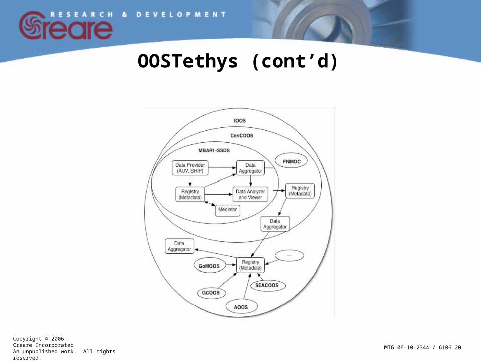
OOSTethys
• <http://www.oostethys.org>• Collaboration between two ocean observing “system of
systems” initiatives– Marine Metadata Interoperability (MMI) demonstration
<www.marinemetadata.org>: NSF and NOAA funded; focus on the exchange of marine data using ontologies based on the Web Ontology Language (OWL)
– OpenIOOS interoperability test bed <www.openioos.org>: ONR and NOAA funded; focused on developing OGC Web-based systems
– The combined interoperability system is called Tethys
• Tethys Framework uses the Russian Matryoshka as a metaphor
Copyright © 2006Creare IncorporatedAn unpublished work. All rights reserved.
MTG-06-10-2344 / 6106 20
OOSTethys (cont’d)

Copyright © 2006Creare IncorporatedAn unpublished work. All rights reserved.
MTG-06-10-2344 / 6106 21
SSDS
• Shore Side Data System• <http://www.mbari.org/ssds>• Developed by MBARI (Monterey Bay Aquarium Research Institute)
– John Graybeal (MMI Principal Investigator) is on the MBARI Software and Data Systems team and oversees SSDS development
• SSDS is a data management system with “source” and “sink” capability
– J2EE-based– Heavy use of metadata
Example: Each instrument has its own Programmable Underwater Connector with Knowledge (PUCK) containing metadata for the instrument
– Open source (in SourceForge soon)– “Wet side”: where instrument is deployed; “Shore side”: data is
collected and accessed by clients• Lessons learned
– Get the metadata up front before the instrument is deployed– Maintain the association between the data and metadata
Copyright © 2006Creare IncorporatedAn unpublished work. All rights reserved.
MTG-06-10-2344 / 6106 22
NEPTUNE
• North-East Pacific Time-Series Undersea Networked Experiments • <http://www.neptunecanada.ca>• Planned to be the largest cable-linked seafloor observatory• Begin operation in 2007; two test networks deployed in 2007–2008
– VENUS (Victoria Experimental Network Under the Sea) project off the southern British Columbia coast <http://www.venus.uvic.ca>
– MARS (Monterey Accelerated Research System) project off Monterey, California <http://www.mbari.org/mars>
• Benoit Pirenne (NEPTUNE/VENUS) presented their metadata “topology”– Motivation: Twenty years from now, be able to query for instrument data and metadata– “Topology” is the metadata document which describes each instrument’s historical record
When was the sensor deployed Historical record of calibrations and maintenance When was it taken out of the water
– Topology hierarchy Region Location Sites Platform Instrument Sensor
– There are many Sensors on an Instrument; many Instruments on a Platform, etc.
Copyright © 2006Creare IncorporatedAn unpublished work. All rights reserved.
MTG-06-10-2344 / 6106 23
Workshop Close, “Next Steps”
• Web form/GUI tools for creating XML instances which adhere to a standard schema (SensorML, TML, etc.) are needed
• The definition of common controlled vocabularies is needed; MMI VINE (Vocabulary Integration Environment) is a step in this direction
• Beginner’s resources are needed– Documentation, tutorials– E-mail/phone “helpdesk” to ask experts
• Need a better understanding of the differences between SensorML and TML• Different standards play different roles (“content descriptive” vs. “processable”)
– “Content descriptive” standards (i.e., ISO 19115) could include links to or embed instances of a “processable” objects (i.e., SensorML)
– The Workshop ISO Track 1 team used this technique in the XML instance they created