joint gfoi / gofc-gold / conabio / silvacarbon r&d expert and capacity ... · bosque muy seco...
TRANSCRIPT

Joint GFOI / GOFC-GOLD / CONABIO / SilvaCarbon R&D Expert and Capacity Building workshop on:
Regional solutions to forest type stratification and characterising the forest state for national forest
monitoring and carbon emissions reporting (REDD+ MRV and LULUCF)
Forest stratification for Carbon Monitoring in Colombia Gustavo Galindo
[email protected] [email protected]
Ideam CONABIO, Mexico City
June 7-10, 2016

Imagen cortesía Iniciativa GFOI

Activity Data - Natural Forests
-Deforestation rates
Carbon
Accounting - Carbon
Stocks - GHG
Early Warning System
Identificación áreas críticas
2014

The division of forest into distinct homogeneous groups (STRATA) with respect to CARBON.
1. Increases precision of Forest Emission Estimates

Emisiones de CO2
¿What do we do? Estimate the net CO2 deforestation emissions in Colombia
National Forest and Carbon Monitoring System-SMBYC
¿Where do Activity Data Come From?
Tier 2
Tier 1 Non forests land Covers
Forest types ¿What Emission
Factor de we use?
Static
Dynamic
Emision Estimation
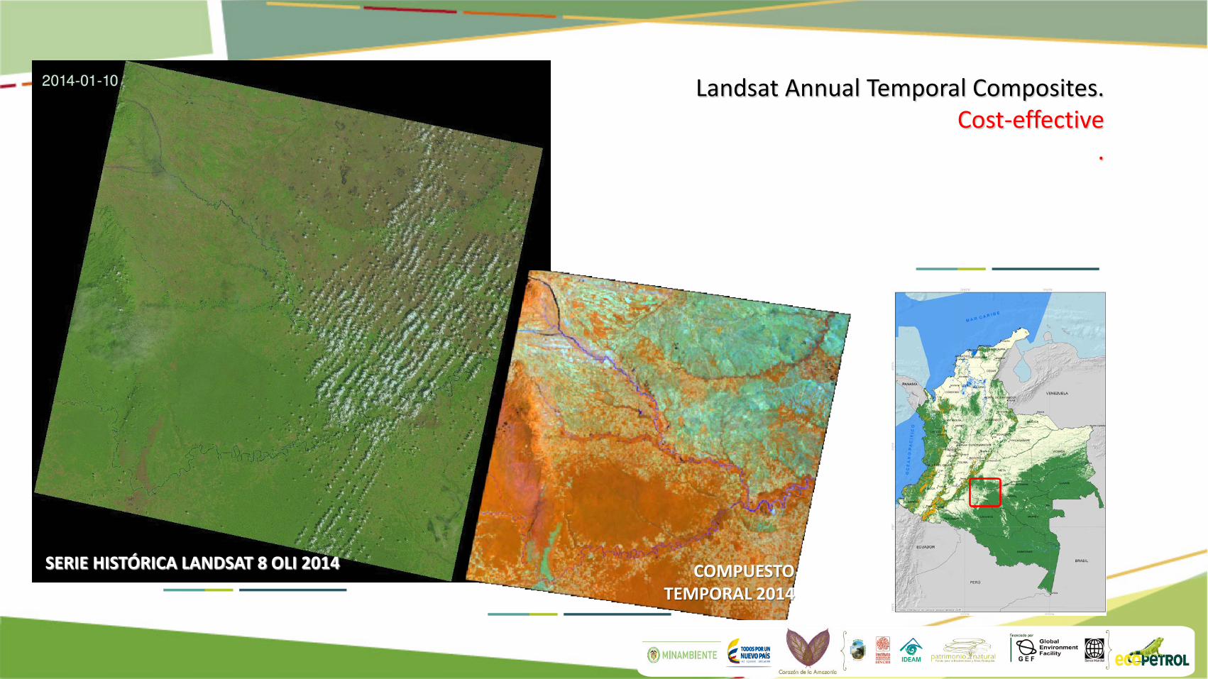
Landsat Annual Temporal Composites. Cost-effective
.
SERIE HISTÓRICA LANDSAT 8 OLI 2014 COMPUESTO TEMPORAL 2014

Imagen cortesía Iniciativa GFOI COMPUESTO TEMPORAL 2013 COMPUESTO TEMPORAL 2014 COMPONENTES PRINCIPALES MULTITEMPORALES DETECCIÓN DE CAMBIOS DEFORESTACIÓN (PÉRDIDA DE BOSQUE, INDICADO EN COLOR ROJO).


Estimation Carbon Stocks of Natural Forests for Colombia
Land Cover
Arbustales Áreas agrícolas heterogéneas Bosques naturales Bosques plantados Cultivos anuales o transitorios
Cultivos semipermanentes y permanentes
Herbáceas y arbustivas costeras Herbazales Pastos Vegetación secundaria
Forest types strata based in Holdridge life zones
Bosque muy seco tropical (bms-T)
Bosque seco tropical (bs-T)
Bosque húmedo tropical (bh-T)
Bosque muy húmedo tropical (bmh-T)
Bosque pluvial tropical (bp-T)
Bosque seco premontano (bs-PM)
Bosque húmedo premontano (bh-PM)
Bosque muy húmedo premontano (bmh-PM)
Bosque pluvial premontano (bp-PM)
Bosque seco montano bajo (bs-MB)
Bosque húmedo montano bajo (bh-MB)
Bosque muy húmedo montano bajo (bmh-MB)
Bosque pluvial montano bajo (bp-MB)
Bosque húmedo montano (bh-M)
Bosque muy húmedo montano (bmh-M)
Bosque pluvial montano (bp-M)
Land Cover Leyend(Corine Land cover)

Estimation Method
1. Stratification: Based in biophysical information that helps explain the variation of carbon distribution in Natural forests
• Holdridge (1967)
• Variables: Temperature, Precipitation.
• Source Climatological data Ideam 1970-2010
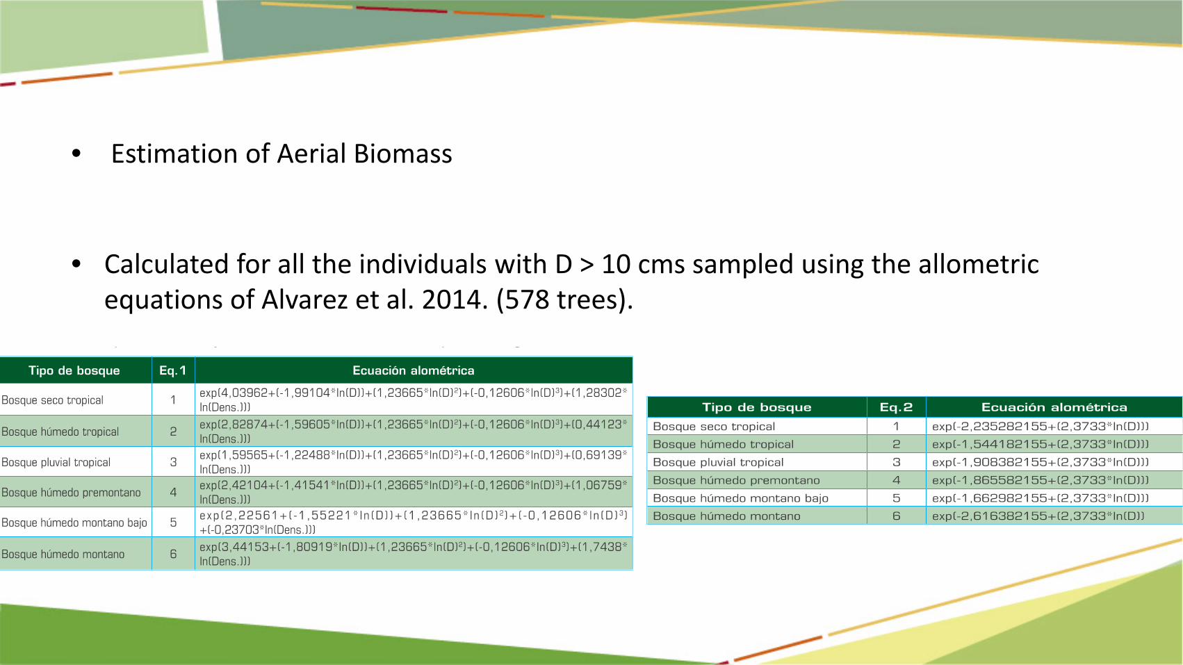
• Estimation of Aerial Biomass
• Calculated for all the individuals with D > 10 cms sampled using the allometric
equations of Alvarez et al. 2014. (578 trees).

Total Biomass for each plot, scaled to ton/ha Estimate the AB for each type of forest using the weighted average of the biomass estimates with the different plot sizes.
Fuente: Yepes et al. 2011

• Estimated for each of the 16 types of forests • Total Aboveground Biomass:14.289.723.630 t (7,23
PgC). • Uncertainty 14,6% • Biomass fluctuates in the types of forests from:
96,20 to 295,1 t ha-1. • National Average 243,8 t ha-1, (121,9 t C ha-1).
National Estimations DE BIOMASA/CARBONO
This is only for Natural Forests

14/06/2016 01:49:35 p.m. 14
Clase Mapa cobertura 1 Mapa cobertura 2
1 Bosque estable 1 Bosque 1 Bosque
2 Deforestación 1 Bosque 2 No Bosque
3 Sin Información 1 Bosque 3 Sin Información
4 Regeneración 2 No Bosque 1 Bosque
5 No Bosque estable 2 No Bosque 2 No Bosque
6 Sin Información 2 No Bosque 3 Sin Información
7 Sin Información 3 Sin Información 1 Bosque
8 Sin Información 3 Sin Información 2 No Bosque
9 Sin Información 3 Sin Información 3 Sin Información
Fecha 1 Fecha 2
Falsa Deforestación
Aparecen identificadas como bosque zonas que son No Bosque
ó Aparecen identificadas como No bosque zonas que son bosques
Falsa Regeneración
Aparecen identificadas como No bosque zonas que son bosque
ó Aparecen identificadas como bosque zonas que son No Bosque
Generation of Change Maps
15
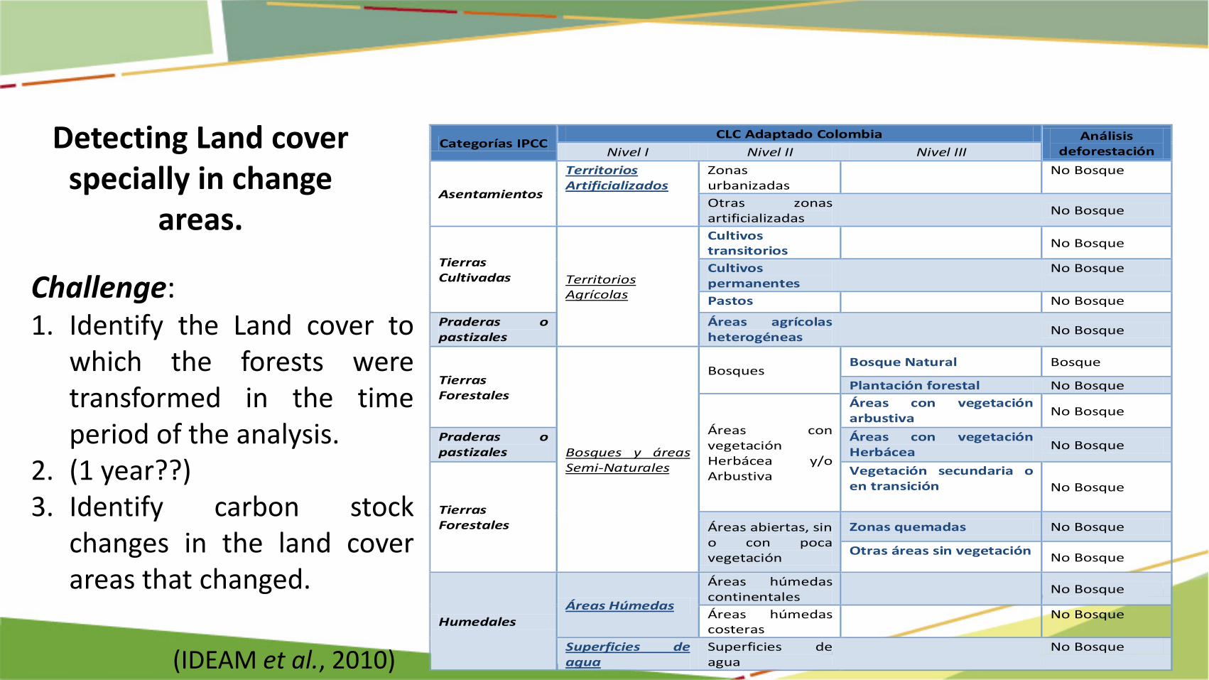
Detecting Land cover specially in change
areas.
Categorías IPCC CLC Adaptado Colombia Análisis
deforestación Nivel I Nivel II Nivel III
Asentamientos
Territorios Artificializados
Zonas urbanizadas
No Bosque
Otras zonas artificializadas
No Bosque
Tierras Cultivadas Territorios
Agrícolas
Cultivos transitorios
No Bosque
Cultivos permanentes
No Bosque
Pastos No Bosque
Praderas o pastizales
Áreas agrícolas heterogéneas
No Bosque
Tierras Forestales
Bosques y áreas Semi-Naturales
Bosques Bosque Natural Bosque
Plantación forestal No Bosque
Áreas con vegetación Herbácea y/o Arbustiva
Áreas con vegetación arbustiva No Bosque
Praderas o pastizales
Áreas con vegetación Herbácea No Bosque
Tierras Forestales
Vegetación secundaria o en transición No Bosque
Áreas abiertas, sin o con poca vegetación
Zonas quemadas No Bosque
Otras áreas sin vegetación No Bosque
Humedales Áreas Húmedas
Áreas húmedas continentales
No Bosque
Áreas húmedas costeras
No Bosque
Superficies de agua
Superficies de agua
No Bosque
Challenge: 1. Identify the Land cover to
which the forests were transformed in the time period of the analysis.
2. (1 year??) 3. Identify carbon stock
changes in the land cover areas that changed.
(IDEAM et al., 2010)
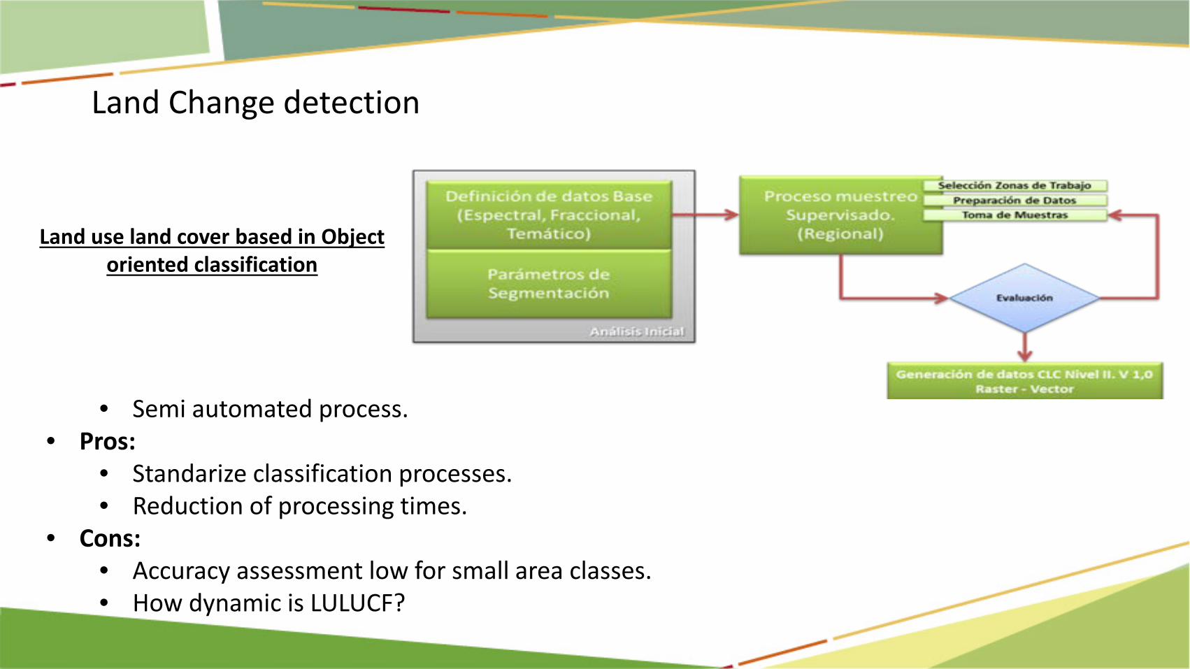
Land use land cover based in Object oriented classification
• Semi automated process. • Pros:
• Standarize classification processes. • Reduction of processing times.
• Cons: • Accuracy assessment low for small area classes. • How dynamic is LULUCF?
Land Change detection 2010-2012


2. Monitor Changes or where possible changes are going to happen.
19
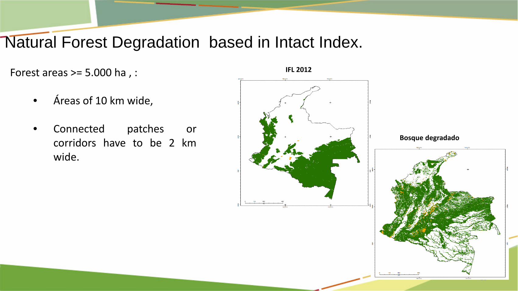
Natural Forest Degradation based in Intact Index.
Forest areas >= 5.000 ha , :
• Áreas of 10 km wide, • Connected patches or
corridors have to be 2 km wide.
IFL 2012
Bosque degradado

20
Biomasa Aérea en bosques intactos y degradados
AVANCES EN LA PROPUESTA PARA EL MONITOREO DE LA DEGRADACIÓN EN BOSQUES NATURALES
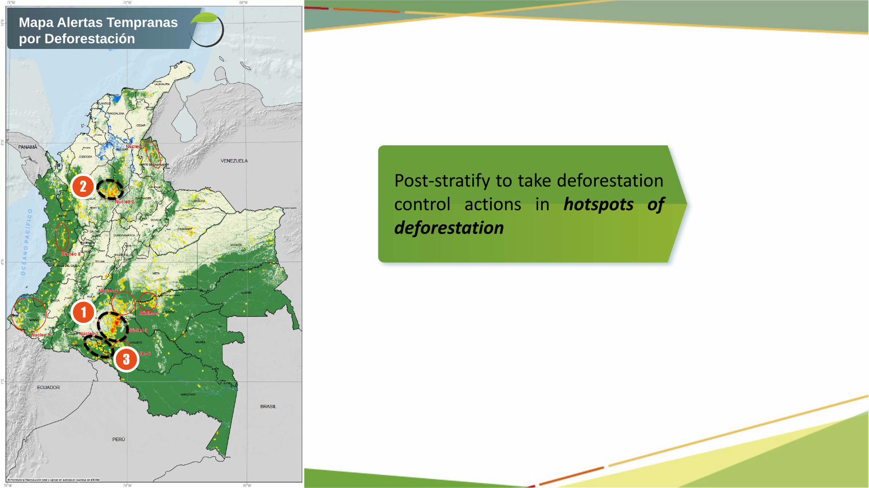
Mapa Alertas Tempranas por Deforestación
Post-stratify to take deforestation control actions in hotspots of deforestation

Núcleo 5: Norte occidente de Guaviare. (Marginal de la Selva).
Deforestation Hotspot “la Macarena”
Cortesía: FCDS/US-DOI, 2015
Cortesía: FCDS/US-DOI, 2015
Cortesía: FCDS/US-DOI, 2015
Cortesía: FCDS/US-DOI, 2015
Cortesía: FCDS/US-DOI, 2015

3. Reducing Sampling Effort while maintaining Accuracy and Precision of carrbon estimates

stratify for Accuracy Assessment


Accuracy Assesment using deforestation risk strata

Colombia´s Natural regions