joint multi-agency/scottish and southern energy ... · scoping report february 2009 joint multi...
TRANSCRIPT
SCOPING REPORT
February 2009
JOINT MULTI
AGENCY/SCOTTISH
AND SOUTHERN
ENERGY
HYDROMORPHOLOGY
RESEARCH
PARTNERSHIP
Draft Report

Joint multi Agency/Scottish and Southern Energy Hydromorphology Research Partnership – Scoping Report
Scottish and Southern Energy, SEPA and The Macaulay Institute 2
ACKNOWLEDGEMENTS
The Research Partnership would like to acknowledge and thanks all those outside of the partnership that participated with the consultation element of this report including:
• Scottish Water
• The Scottish and Northern Irish Forum For Environmental Research (SNIFFER)
• Rivers and Fisheries Trusts of Scotland (RAFTS)
• Tay District Salmon Fisheries Board
• Conon District Salmon Fisheries Board
• Ness District Salmon Fisheries Board
• Spey District Salmon Fisheries Board

Scottish and Southern Energy, SEPA and The Macaulay Institute i
CONTENTS 1. INTRODUCTION............................................................................................... 1
1.1 Background to WFD and hydro power ......................................................2 1.2 Objectives of the report ..............................................................................3
2. BACKGROUND TO PATRNERSHIP PROJECT ............................................ 4 2.1 Introduction ................................................................................................4 2.2 Partnership project objectives ....................................................................4 2.3 Project management..................................................................................4 2.4 Current Project partners.............................................................................5 2.5 Project Methods.........................................................................................5 2.6 Outputs ......................................................................................................5 2.7 Resources..................................................................................................5
3. SITE INFORMATION........................................................................................ 7 3.1 Overview....................................................................................................7 3.2 River Garry ................................................................................................7 3.3 River Shin ................................................................................................ 14 3.4 River Orrin ............................................................................................... 17 3.5 River Tarff ................................................................................................ 21 3.6 River Glascarnoch ................................................................................... 25 3.7 River Cuiach ............................................................................................ 27 3.8 Summary ................................................................................................. 28
4. GAPS ANALYSIS........................................................................................... 31
5. WAY FORWARD ............................................................................................ 33
6. REFERENCES................................................................................................ 34
Appendices Appendix A List of those Consulted Appendix B Detail of Data Availability
Appendix B1 River Garry Appendix B2 River Shin Appendix B3 River Orrin Appendix B4 River Tarff Appendix B5 River Glascarnoch Appendix B6 River Cuaich

Scottish and Southern Energy, SEPA and The Macaulay Institute ii
TABLES Table 3.1 Summary of Initial site details and issues ................................................. 7 Table 3.2Summary of survey data available for the River Garry (see Appendix
B1 for further details)......................................................................................... 9 Table 3.3 Summary of published reports and scientific papers relating to the
River Garry...................................................................................................... 11 Table 3.4 Summary of data available for the River Shinn (see Appendix B2 for
further details) ................................................................................................. 15 Table 3.5 Summary of published reports and scientific papers relating to the
River Shin ....................................................................................................... 15 Table 3.6 Summary of data available for the River Orrin (see Appendix B3 for
further details) ................................................................................................. 18 Table 3.7 Summary of published reports and scientific papers relating to the
River Oriin ....................................................................................................... 19 Table 3.8 Summary of data available for the River Tarff (see Appendix B4 for
further details) ................................................................................................. 22 Table 3.9 Summary of published reports and scientific papers relating to the
River Tarff ....................................................................................................... 23 Table 3.10 Summary of data available for the River Glascarnoch (see Appendix
B5 for further details)....................................................................................... 26 Table 3.11 Summary of published reports and scientific papers relating to the
River Glascarnoch........................................................................................... 27 Table 3.12 Summary of data available for the River Cuiach (see Appendix B6
for further details) ............................................................................................ 28 Table 3.13 Summary of published reports and scientific papers relating to the
River Cuiach.................................................................................................... 29 Table 4.1Overview of available data identifying gaps ............................................. 32
FIGURES ALL FIGURES ARE DRAFT
Figure 3.1 River Garry.............................................................................................. 8 Figure 3.2 Summary of geographic distribution of data available for the River
Garry DRAFT .................................................................................................. 11 Figure 3.5 River Shin.............................................................................................. 14 Figure 3.6 River Orrin ............................................................................................. 17 Figure 3.7 Summary of geographic distribution of data available for the River
Orrin ................................................................................................................ 18 Figure 3.8 River Tarff ............................................................................................. 21 Figure 3.9 Summary of geographic distribution of data available for the River
Tarff................................................................................................................. 23 Figure 3.10 River Glascarnoch ............................................................................... 25 Figure 3.11 Summary of geographic distribution of data available for the River
Glascarnoch.................................................................................................... 27 Figure 3.12 River Cuiach........................................................................................ 28
Comment: Aware that numbering has gone awry

Scottish and Southern Energy, SEPA and The Macaulay Institute 1
1. INTRODUCTION
In order to meet the requirements of the Water Framework Directive(WFD) a number of actions have/will be specified in each round of the River Basin Management Planning (RBMP) process to mitigate the impact of hydroelectric installations, in order for water bodies designated as heavily modified to meet good ecological potential. It is widely recognized that current understanding of the links between hydrology, morphology and ecology are not sufficiently well understood and that a long term research programme is needed to improve the underlying science.
The Scottish Environment Protection Agency (SEPA), Scottish and Southern Energy (SSE), the Macaulay Institute (MLURI), Scottish Natural Heritage (SNH) and the Fisheries Research Services have therefore joined together to support and contribute to a collaborative research scoping programme to establish what environmental and ecological data have been collected to date at a number of priority sites and what needs to be done to ensure a wider partnership of research providers can supply information on the impacts of changes in management. Further details on the intentions of this partnership are provided in Chapter 2.
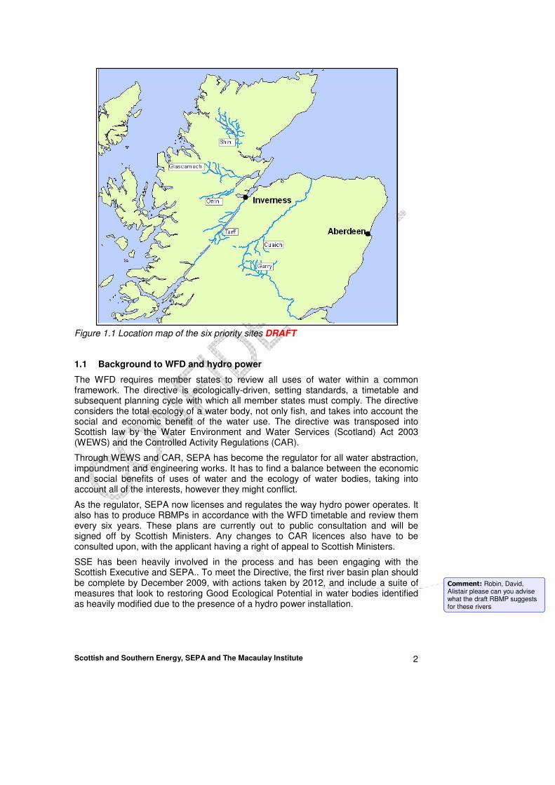
This report summarises the initial phase of this scoping programme identifying and summarising the information available for the following priority sites (see Figure 1.1 for location):
• River Garry
• River Shin
• River Orrin
• River Tarff
• River Glascarnoch
• River Cuaich
The report includes an initial view of the way forward to establish adequate baseline data at each site, which will be discussed and reviewed at a subsequent expert workshop. This will be particularly important in order to provide direction on the effectiveness of measures proposed in the first and subsequent rounds of the river basin planning process.
This list of potential sites to be considered as part is not closed and there is potential for further relevant additional sites to identified for inclusion within the collaborative research programme, if deemed appropriate by the project steering group.
Scottish and Southern Energy, SEPA and The Macaulay Institute 2
Figure 1.1 Location map of the six priority sites DRAFT
1.1 Background to WFD and hydro power
The WFD requires member states to review all uses of water within a common framework. The directive is ecologically-driven, setting standards, a timetable and subsequent planning cycle with which all member states must comply. The directive considers the total ecology of a water body, not only fish, and takes into account the social and economic benefit of the water use. The directive was transposed into Scottish law by the Water Environment and Water Services (Scotland) Act 2003 (WEWS) and the Controlled Activity Regulations (CAR).
Through WEWS and CAR, SEPA has become the regulator for all water abstraction, impoundment and engineering works. It has to find a balance between the economic and social benefits of uses of water and the ecology of water bodies, taking into account all of the interests, however they might conflict.
As the regulator, SEPA now licenses and regulates the way hydro power operates. It also has to produce RBMPs in accordance with the WFD timetable and review them every six years. These plans are currently out to public consultation and will be signed off by Scottish Ministers. Any changes to CAR licences also have to be consulted upon, with the applicant having a right of appeal to Scottish Ministers.
SSE has been heavily involved in the process and has been engaging with the Scottish Executive and SEPA.. To meet the Directive, the first river basin plan should be complete by December 2009, with actions taken by 2012, and include a suite of measures that look to restoring Good Ecological Potential in water bodies identified as heavily modified due to the presence of a hydro power installation.
Comment: Robin, David, Alistair please can you advise what the draft RBMP suggests for these rivers

Scottish and Southern Energy, SEPA and The Macaulay Institute 3
1.2 Objectives of the report
Through consultation with Board Members and individuals identified by the board (for a list of individuals and organisations contacted see annex1) this report intends to identify and summarise details on the following;
• Work completed at the sites identified
• Work currently being undertaken at the sites identified
• Future work proposed at the sites.
• Data gaps and how these can be filled within the programme
• Overview project plan/way forward

Scottish and Southern Energy, SEPA and The Macaulay Institute 4
2. BACKGROUND TO PARTNERSHIP PROJECT
2.1 Introduction
The hydroelectric energy providers are being regulated under the new WFD regimes with regulatory standards and mitigation measures based to a large degree on expert opinion. The links between the hydromorphological impacts and the ecology of the rivers have not been well demonstrated in a robust scientific manner. This project will deliver an authoritative examination of the links, based on sound experimental design and scientific methodology.
SSE have proposed a research partnership involving SSE, SNH, Freshwater Fisheries Lab, SEPA and MLURI. A project group has met on a number of occasions to formulate proposals. Other project partners (e.g. fisheries trusts, university academic researchers, and Scottish Water) may be invited to join as appropriate.
This work will form part of a larger suite of research projects investigating the links between hydromorphological impacts and ecology.
Whilst early delivery of outputs would clearly be desirable, it is recognised that this project would need to run for a number of years, with phased deliverables.
2.2 Partnership project objectives
• To develop where appropriate ecological sampling methods and data analysis techniques for assessing the ecological effects of hydromorphological pressures.
• To assess ecological benefits of remediation measures applied to hydro-electric rivers.
• To provide outputs appropriate for the development of validated best management practice guidelines for hydroelectric and other managed rivers.
The project will not act as a forum for determining or influencing regulatory decisions made between SEPA and SSE for the first river basin plan. The initial aims of the project will be to assemble baseline data sets and establish a programme of work which will enable assessment of the effects of the mitigation measures agreed between SEPA and SSE.
The programme is looking to produce a database, tools and possibly models on how to achieve an improvement in ecology (including fish, macrophytes and invertebrates) through changed management operations at a number of selected SSE installations. The work will help develop empirical knowledge to provide input to the second round of River Basin Plans. To facilitate this, a prime objective is to obtain sufficient baseline information on flows, ecology, sediment and hydromorphology and to then carry this monitoring on after the implementation of the measures within the first river basin management plan or agreed changes at other sites.
2.3 Project management
The project will be steered by a steering group of nominated representatives of contributing organisations (contributing either financially or in kind). Representatives of other organisations may be invited to join the steering group by consensus of the steering group.
The project steering group will seek to employ a part time or full time project

Scottish and Southern Energy, SEPA and The Macaulay Institute 5
coordinator.
2.4 Current Project partners
Current project partners include:
• Scottish and Southern Energy (SSE)
• Scottish Environment Protection Agency (SEPA)
• Macaulay Land Use Research Institute (MLURI)
• Scottish Natural Heritage (SNH)
• Fisheries Research Services
2.5 Project Methods
A key element to this project, which presents an almost unique opportunity, is that SSE are proposing to implement mitigation measures on a range of rivers in such a way that they can form the basis of manipulation experiments which will demonstrate the efficacy (or otherwise) of the perceived optimal mitigation measures.
The degree of manipulation, however, will be constrained by the regulatory framework and the agreed mitigation measures implemented as part of the first river basin plan or at other sites where changes can be agreed.
Therefore, at this stage, six rivers have been proposed as study sites:- River Garry, River Shin, River Orrin, River Tarff, Glascarnoch River, River Cuaich. The tributaries of these rivers will also be considered as appropriate. Chapter 3 of this report contains details of the proposed study sites.
These rivers have been identified as representative of a range of issues, such as extreme abstraction (Garry), gravel compaction (Shin) and gravel starvation (Orrin). The River Tarff as part of the new Glen Doe scheme offers the chance to conduct an extensive pre-impact study.
The proposal is that partner organisations will deliver substantial parts of the project work through work in kind. The first priority will be to ensure that adequate baseline data (particularly biological and hydromorphological parameters) is compiled, based on a rigorous scientific methodology.
Manipulation of the flow regimes and sediment management regimes of these rivers will then take place and the results monitored.
Prior to this a review of existing data will also take place. It is hoped that appropriate biological sampling strategies will be identified as part of the broader suite of hydromorphological projects being proposed through the UKTAG task teams, but, depending on timescales, this project may also have to consider in detail these sampling techniques.
2.6 Outputs
Together with a detailed technical report and scientific papers, it is envisaged at this stage that the project will seek to make its findings relevant to managed rivers in general and not just the particular study group. Thus, it would produce guidance for best practice which would influence regulatory decisions concerning abstracted rivers. This would include flow management practices and sediment management practices.
2.7 Resources
A key resource need identified by the project team is for a full time project lead over a

Scottish and Southern Energy, SEPA and The Macaulay Institute 6
number of years. The proposal is for a full time (or part time) post based at MLURI for 5 years. Therefore, the project team is seeking funding from partner organisations.
The role of the project coordinator is given in annex 1.
2.7.1 SEPA input
At the moment it is envisaged that it is likely that there will be a requirement for 20 -30 days direct project input per annum from a senior scientist in the Ecology Advisory Unit. Other SEPA work in kind (in addition to what SEPA would be doing anyway) is estimated as 0.5 to 1.0 FTE per annum.
SEPA will input £10K per annum for 3 years initially to fund the research coordinator
2.7.2 SSE Input
SSE have secured funds over the next few years (£50k/year) which will enable them to fund the research coordinator at the same level as other project partners’ contributions and will permit them to procure data collection and research work in support of the project. For example, to date this has included extensive aerial survey work of rivers in the proposed survey programme and site / ground based sediment surveys.
2.7.3 MLURI input
MLURI will provide in kind contribution of Simon Langan’s time to sit on the Project Board and research time of the wider catchment management group at the Macaulay Institute. Research will include Simon Langan’s time and the numerous other members of staff in the Institute including Hamish Moir (geomorphologist), Benoit Demars and possibly Sue Cooksley (aquatic ecologists) and use of the Institute field work resources and analytical facilities.
MLURI have also offered in-kind support for the proposed Research Co-ordinator’s post by providing a base location and general facilities and management.
2.7.4 FRS Input
?
2.7.5 SNH Input
?

Scottish and Southern Energy, SEPA and The Macaulay Institute 7
3. SITE INFORMATION
3.1 Overview
The following sections provide background to the priority sites identified and the relevant current and planned data available. As mentioned in chapter 1, there is potential for further relevant sites to be identified for inclusion within the collaborative research programme, if deemed appropriate by the project steering group. Table 3.1 provides an initial summary of the priority sites details and issues.
Table 3.1 Summary of Initial site details and issues
River Garry
River Shin River Orrin River Tarff
River Glascarnoch
River Cuaich
Operational start date
1930 extended in
1950’s 1960
Not yet operational
Operational notes
Frequent spill events
Restore flows by 2012
Releases high summer and low in winter
Occasional high volume spill events
None at present
Infrequent large spill events
Restore flows by 2012
Frequent high volume spill events
Restore flows by 2012
Primary Issue
Downstream sediment deficit
Gravel compaction
Sediment (gravel) deficit
none Sediment deficit Sediment deficit
Secondary Issue
Inverted
seasonal flow pattern
none
Aim of research
Identify sediment
management requirements to augment benefits of
restoring flow
Identify flow and sediment management requirements to improve quality of gravel
spawning areas
Identify sediment
management requirements to improve habitat and potentially
to enable natural
spawning
To identify a baseline
situation so that any future
changes can be
identified.
Identify sediment management requirements to augment benefits of restoring flow
Identify sediment
management requirements to augment benefits of
restoring flow
3.2 River Garry
3.2.1 Background
The River Garry is situated in the northern area of the River Tay catchment (Figure 1.1). The River Garry was first harnessed for hydro power in the 1930s, when Garry Dam was built at the outflow from Loch Garry, as part of the original Grampian Electricity, Rannoch and Tummel scheme. There was no compensation water required to be released from the Garry Dam - although a 1922 Act of Parliament did specify compensation flows elsewhere in the system.
In the 1950s, the North of Scotland Hydro Electricity Board extended the original scheme under Constructional Scheme 2 of the Hydro Electric Development Act. The River Garry was again utilised, with water being diverted from both the main river, a few miles below the dam, and from several of its tributaries. This water is diverted to Loch Errochty via a large tunnel, where it then passes through Errochty, Clunie and Pitlochry Power Stations. The natural flow would only pass through Pitlochry Power Station. This part of the scheme was subject to a public inquiry and, again, no
Comment: Alistair/ David are these correct- I did my best! Simon

Scottish and Southern Energy, SEPA and The Macaulay Institute 8
provision for compensation water was made.
This means that the water in Loch Garry is now used to generate electricity in no fewer than five power stations as it passes down the valley until it ends up in the River Tummel below Pitlochry.
Other than at times of overspill, immediately downstream of the weir the Garry runs dry, with flows restored gradually downstream of the weir as unregulated tributaries join the river. SSE plan to restore flow by 2012 as part of the first RBMP. Through careful reallocation of water that has historically been released from other sites within the Tummel scheme, the River Garry can be re-watered without affecting the overall output of renewable electricity. As part of this project, the River Cuaich and the Allt Sluie which flow into the upper Spey will also be restored.
Sediments trapped behind the intake have been removed over several decades and have either been stored on the river bank or been used for road and cycle path construction.
There are some steep, gorge-like sections below the intake and there are frequent, high volume spill events. This means that much of the finer sediment is likely to have washed out and it is very likely that many sections will have a significant sediment deficit.
Figure 3.1 River Garry
3.2.2 Aim
Identify sediment management requirements to augment benefits of restoring flow.

Scottish and Southern Energy, SEPA and The Macaulay Institute 9
3.2.3 Overview of available data
Table 3.2 provides an overview of the data sets identified through the consultation of the various stakeholders. Further details on each dataset are available within Appendix B1.
Table 3.2Summary of survey data available for the River Garry (see Appendix B1 for further details)
General
Activity
Specific
Activity Location Freq,
Start
date
Finish
date
Garry Chemistry Numerous chemicals
River Garry U/S River Errochty No localities: 1 NGR:NN8082365393
monthly? unknown On-going
Garry Chemistry Numerous chemicals
River Garry at Footbridge Blair Atholl No localities: 1 NGR:NN8713464944
monthly? unknown On-going
Garry chemistry Numerous chemicals
River Garry at Bridge of Garry No localities: 1 NGR:NN9141861200
monthly? unknown On-going
Errochty Water
chemistry Numerous chemicals
Errochty W. at Kindrochet No localities: 1 NGR:NN8037865097
monthly? unknown On-going
River Tilt chemistry Numerous chemicals
River Tilt at Bridge of Tilt No localities: 1 NGR:NN8755965560
monthly? 1997 On-going
Allt Dubhaig
Ecology Invertebrates Allt Dubhaig u/s ponded/marsh area No localities: 1 NGR:NN6322675098
annually summer 2008
On-going
Allt Dubhaig
Ecology Macrophytes Allt Dubhaig u/s ponded/marsh area No localities: 1 NGR:NN6322675098
three yearly
summer 2008
On-going
Garry Ecology Invertebrates Dalnaspidal d/s offtake structure No localities: 1 NGR:NN6557572368
one off summer 2008
End 2008
Garry Ecology Macrophytes Dalnaspidal d/s offtake structure No localities: 1 NGR:NN6557572368
one off summer 2008
End 2008
Garry Ecology Invertebrates Garry u/s offtake No localities: 1
annually summer 2008
On-going
Garry Ecology Macrophytes Garry u/s offtake No localities: 1
three yearly
summer 2008
On-going
Garry Ecology Invertebrates d/s main offtake, u/s Edendon water No localities: 1
annually summer 2008
On-going
Garry Ecology Macrophytes d/s main offtake, u/s Edendon water No localities: 1
three yearly
summer 2008
On-going
Garry Ecology Invertebrates Dalnamein gauging station No localities: 1
one off 2001 2001
Garry Ecology Invertebrates Garry @sheepwash d/s Dalnacardoch No localities: 1
annually summer 2008
On-going
Garry Ecology Macrophytes Garry @sheepwash d/s Dalnacardoch No localities: 1
three yearly
summer 2008
On-going
Garry Ecology Macrophytes Garry d/s Clunes Lodge u/s confl Allt a Chrombaidh
three yearly
summer 2008
On-going
Garry Ecology Invertebrates River Garry U/S River Errochty No localities: 1
spring & autumn
circa 1995
On-going
Comment: Philippa please can you do a global replace in Tables of chemicals replaced by the word determinands

Scottish and Southern Energy, SEPA and The Macaulay Institute 10
General Activity
Specific Activity
Location Freq, Start date
Finish date
Garry Ecology Invertebrates River Garry U/S Blair Atholl STW No localities: 1
Once/twice a year
circa 1995
circa 2005
Garry Ecology Invertebrates River Garry at Strathgarry No localities: 1
Once/twice a year
circa 1995
circa 2005
Garry Ecology Invertebrates River Garry at Killiecrankie Bridge No localities: 1
Spring & autumn
circa 2000
On-going
Garry Ecology Invertebrates River Garry at Bridge of Garry No localities: 1
Once/twice a year
circa 2000
Errochty Water
Ecology Invertebrates Errochty W. at Kindrochet No localities: 1
spring and autumn
circa 1990
On-going
Edendon Water
Ecology Invertebrates Edendon Water at Edendon Bridge No localities: 1
spring and autumn
2000 On-going
Allt Anndeir
Ecology Invertebrates Allt Anndeir at Dalnamein No localities: 1
one off 2001 2001
Allt a Chrombaidh
Ecology Invertebrates Allt a Chrombaidh No localities: 1
spring and autumn
2003 2003
Bruar Water
Ecology Invertebrates Bruar W. at Br. on old A9 No localities: 1
one off 2003 2003
Allt Bhric Ecology Invertebrates Allt Bhric @ Balnansteuartach No localities: 1
one off 2003 2003
Banvie Burn
Ecology Invertebrates Banvie Burn at Blair Atholl No localities: 1
one off 2003 2003
River Tilt Ecology Invertebrates River Tilt at Bridge of Tilt No localities: 1
spring & autumn
2000 On-going
River Tilt Ecology Invertebrates River Tilt near Alltandu u/s Marble Lodge No localities: 1
annually summer 2008
On-going
River Tilt Ecology Macrophytes River Tilt near Alltandu u/s Marble Lodge No localities: 1
three yearly
summer 2008
On-going
Fender Burn
Ecology Invertebrates Fender Burn at Fender Bridge No localities: 1
spring and autumn
2003 2003
Allt Mhairc
Ecology Invertebrates Allt Mhairc U/S Conf with River Tilt No localities: 1
spring and autumn
2001 2005
Allt Girnaig
Ecology Invertebrates Allt Girnaig at Killiecrankie No localities: 1
spring and autumn
2000 2003
Garry Ecology Catchment Vegetation Survey
Drumochter Hills One-off 1986 1986
Garry Ecology Electrofishing Ad hoc (03, 08 either 06/07)
Garry Hydrology Flow gauging River Garry flow gauging station @ Dalnamein
continuous
Garry Hydrology Flow gauging River Garry flow gauging station @ Killiecrankie
continuous
unknown On-going
River Tilt Hydrology Flow gauging River Tilt flow gauging station @ Marble Lodge
continuous
unknown On-going
Garry morphology sediment Garry u/s offtake annually summer 2008
On-going

Scottish and Southern Energy, SEPA and The Macaulay Institute 11
General Activity
Specific Activity
Location Freq, Start date
Finish date
Garry morphology sediment Garry @sheepwash d/s Dalnacardoch annually summer 2008
On-going
Figure 3.7 provides an indication of the spatial distribution of the data detailed in Table 3.4 above, where geographic references were provided. Figure 3.4 below is a copy of a map provided by SNH showing the coverage of the vegetation survey they have.
N.B. Figure only includes data from table 3.1 where geographic locations are available. Potential to produce reference system (e.g. a,b,c) to label points in figure and hence link to table 3.1)
Figure 3.2 Summary of geographic distribution of data available for the River Garry DRAFT
Table 3.3 provides an overview of the published reports and scientific literature of relevance to the research programme referring to the River Garry.
Table 3.3 Summary of published reports and scientific papers relating to the River Garry
NOT YET COMPLETED

Scottish and Southern Energy, SEPA and The Macaulay Institute 12
Figure 3.3a Copy of PDF map of vegetation survey supplied by SNH – River Garry NVC01

Scottish and Southern Energy, SEPA and The Macaulay Institute 13
Figure 3.4b Copy of PDF map of vegetation survey supplied by SNH – River Garry NVC02
Scottish and Southern Energy, SEPA and The Macaulay Institute 14
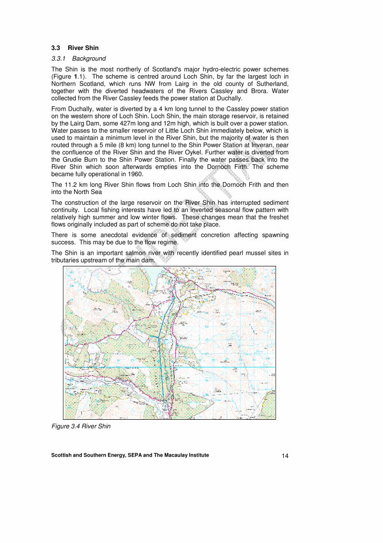
3.3 River Shin
3.3.1 Background
The Shin is the most northerly of Scotland's major hydro-electric power schemes (Figure 1.1). The scheme is centred around Loch Shin, by far the largest loch in Northern Scotland, which runs NW from Lairg in the old county of Sutherland, together with the diverted headwaters of the Rivers Cassley and Brora. Water collected from the River Cassley feeds the power station at Duchally.
From Duchally, water is diverted by a 4 km long tunnel to the Cassley power station on the western shore of Loch Shin. Loch Shin, the main storage reservoir, is retained by the Lairg Dam, some 427m long and 12m high, which is built over a power station. Water passes to the smaller reservoir of Little Loch Shin immediately below, which is used to maintain a minimum level in the River Shin, but the majority of water is then routed through a 5 mile (8 km) long tunnel to the Shin Power Station at Inveran, near the confluence of the River Shin and the River Oykel. Further water is diverted from the Grudie Burn to the Shin Power Station. Finally the water passes back into the River Shin which soon afterwards empties into the Dornoch Firth. The scheme became fully operational in 1960.
The 11.2 km long River Shin flows from Loch Shin into the Dornoch Frith and then into the North Sea
The construction of the large reservoir on the River Shin has interrupted sediment continuity. Local fishing interests have led to an inverted seasonal flow pattern with relatively high summer and low winter flows. These changes mean that the freshet flows originally included as part of scheme do not take place.
There is some anecdotal evidence of sediment concretion affecting spawning success. This may be due to the flow regime.
The Shin is an important salmon river with recently identified pearl mussel sites in tributaries upstream of the main dam.
Figure 3.4 River Shin

Scottish and Southern Energy, SEPA and The Macaulay Institute 15
3.3.2 Aim
Identify flow and sediment management requirements to improve the quality of gravel spawning areas.
3.3.3 Overview of available data
Table 3.4 provides an overview of the data sets identified through the consultation of the various stakeholders. Further details on each dataset are available within Appendix B2.
Table 3.4 Summary of data available for the River Shinn (see Appendix B2 for further details)
General Activity
Specific Activity Location Freq,
Start date
Finish date
Shin Ecology Invertebrates Shin at Inveran No localities: 1 NGR: NH5740297403
spring and autumn each year
1997 On-going
Shin Ecology Vegetation survey
Stathanloin (SW Loch Shin) One-off
Shin Ecology Invertebrates Shin at Inveran No localities: 1 NGR: NH5740297403
spring and autumn each year
1997 On-going
Shin Chemistry Numerous chemicals
Shin at Inveran No localities: 1 NGR: NH5740297403
monthly 1983 On-going
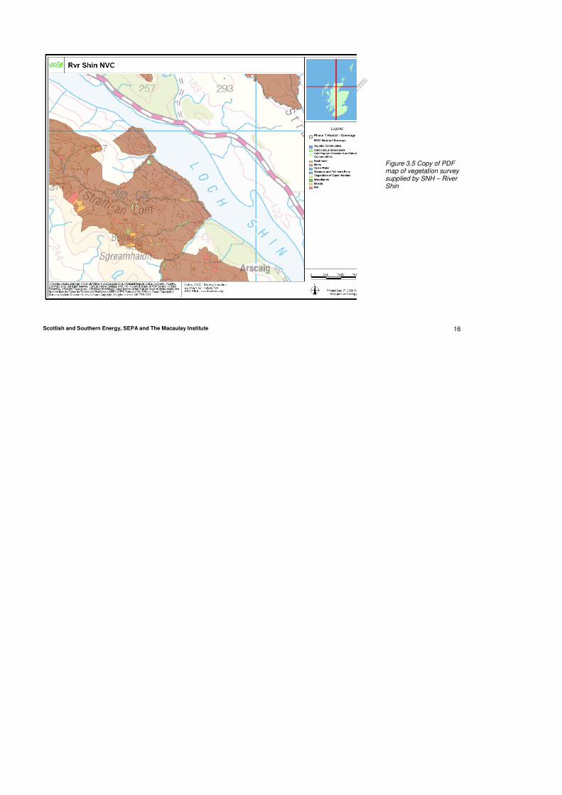
The invertebrate and chemistry data collected by SEPA is collected at the lower end of the River Shin, close to where it joins the Dornoch Firth. Figure 3.5 provides a copy of the map provided by SNH showing the coverage of available vegetation survey.
Table 3.5 provides an overview of the published reports and scientific literature of relevance to the research programme referring to the River Shin.
Table 3.5 Summary of published reports and scientific papers relating to the River Shin
NOT YET COMPLETED
Comment: Re-order rows to keep ecology together
Scottish and Southern Energy, SEPA and The Macaulay Institute 16
Figure 3.5 Copy of PDF map of vegetation survey supplied by SNH – River Shin

Scottish and Southern Energy, SEPA and The Macaulay Institute 17
3.4 River Orrin
3.4.1 Background
The construction of a large reservoir on the River Orrin has interrupted sediment continuity.
There is a variable compensation flow released from the dam, designed to improve conditions for Atlantic salmon at certain times of the year. The river downstream has some steep gorge-like sections and there are occasional high volume spill events. This means that much of the finer sediment is likely to have washed out and it is very likely that many sections will have a significant sediment deficit.
Salmon are stocked into the river due to low spawning success and this is thought to be due to lack of suitable gravel beds in the upper part of the catchment.
Figure 3.6 River Orrin
3.4.2 Aim
Identify sediment management requirements to improve habitat and potentially to enable natural spawning.
3.4.3 Overview of available data
Table 3.6 provides an overview of the data sets identified through the consultation of the various stakeholders. Further details on each dataset are available within Appendix B3.

Scottish and Southern Energy, SEPA and The Macaulay Institute 18
Table 3.6 Summary of data available for the River Orrin (see Appendix B3 for further details)
General Activity
Specific Activity Location Freq, Start date
Finish date
Orrin Ecology Invertebrates River Orrin Fairburn No localities:1 NGR: NH4541352457
2002 2002
Orrin Ecology Invertebrates R orrin u/s Orrin hatchery No localities: NGR: NH5032253030
2001 2005
Orrin Ecology Invertebrates R orrin d/s Orrin hatchery No localities: 1 NGR: NH5051753286
1997 2005
Orrin Ecology Vegetation Survey Conon Islands One off
Orrin Ecology Habitat Survey - mid summer low flow including wetted perimeter, proportion substrate, flow types etc
Every 250m One off 1995 1995
Orrin Ecology Electrofishing annually 1996 on-going
Orrin Ecology Smolt survey Upper and lower Orrin One off 2006 2007
Orrin Chemistry Numerous Chemicals River orrin at Urray. No localities: 1 NGR: NH5051753286
monthly? 1983 2006
Orrin Chemistry Numerous Chemicals R orrin d/s Orrin hatchery 1997 2005
Figure 3.7 provides an indication of the spatial distribution of the data detailed in Table 3.5 above, where geographic references were provided. Figure 3.8 provides a copy of the map provided by SNH showing the coverage of available vegetation survey.
N.B. Figure only includes data from table 3.1 where geographic locations are available. Potential to produce reference system (e.g. a,b,c) to label points in figure and hence link to data table)
Figure 3.7 Summary of geographic distribution of data available for the River Orrin

Scottish and Southern Energy, SEPA and The Macaulay Institute 19
Table 3.7 provides an overview of the published reports and scientific literature of relevance to the research programme referring to the River Orrin.
Table 3.7 Summary of published reports and scientific papers relating to the River Oriin
NOT YET COMPLETED

Scottish and Southern Energy, SEPA and The Macaulay Institute 20
Figure 3.8 Copy of PDF map of vegetation survey supplied by SNH – River Orrin

Scottish and Southern Energy, SEPA and The Macaulay Institute 21
3.5 River Tarff
3.5.1 Background
The River Tarff is currently a natural river but a large new hydro-power scheme is being constructed upstream at Glendoe.
The majority of the river length is very steep but salmon spawn in the lower reaches near the outflow into Loch Ness. The reservoir will have a Q90 compensation flow and approx. 60% of the catchment will not be affected and so the flow regime should retain a large degree of natural variability.
Figure 3.9 River Tarff
3.5.2 Aim
To identify a proper baseline situation so that any future changes can be identified.
3.5.3 Overview of available data
Table 3.8 provides an overview of the data sets identified through the consultation of the various stakeholders. Further details on each dataset are available within Appendix B4

Scottish and Southern Energy, SEPA and The Macaulay Institute 22
Table 3.8 Summary of data available for the River Tarff (see Appendix B4 for further details)
General Activity Specific Activity Location Freq,
Start date
Finish date
River Tarff
Chemistry Numerous Chemicals River Tarff No localities: 1 NGR: NH3831609076
monthly? 1987 On-going
River Tarff
Ecology Invertebrates River Tarff Abbey No localities: 1 NGR: NH3795508808
spring & autumn
2002 On-going
Allt Doe
Ecology Invertebrates Allt Doe Glendoebeg No localities: 1 NGR: NH4088108731
spring & autumn
2003 2003
River Tarff
Ecology Macrophytes River Tarff Abbey No localities: 1 NGR: NH3795508808
one off 2007 2007
River Tarff
Ecology Macrophytes River Tarff @ Culachy House No localities: 1 NGR: NH3786606556
one off 2007 2007
River Tarff
Ecology Macrophytes River Tarff U/S Black Burn Conf No localities: 1 NGR: NH3893903598
one off 2007 2007
River Tarff
Ecology Macrophytes River Tarff @ Coille Dhubh No localities: 1 NGR: NH4012001594
one off 2007 2007
River Tarff
Ecology Vegetation Survey Glen Tarff one off
River Tarff
Ecology Electrofishing adhoc (93,02,04,05,07,08)
On-going
River Tarff
Ecology Habitat Survey one off
River Tarff
Ecology Timed fishing one off 2006 2006
River Tarff
morphology Geomorphic assessment 2 locations.In lower section where Salmon are known to spawn
one-off 2008
Figure 3.9 provides an indication of the spatial distribution of the data detailed in Table 3.8 above, where geographic references were provided. Figure 3.10 provides a copy of the map provided by SNH showing the coverage of available vegetation survey

Scottish and Southern Energy, SEPA and The Macaulay Institute 23
N.B. Figure only includes data from table 3.1 where geographic locations are available. Potential to produce reference system (e.g. a,b,c) to label points in figure and hence link to data table)
Figure 3.10 Summary of geographic distribution of data available for the River Tarff
Table 3.9 provides an overview of the published reports and scientific literature of relevance to the research programme referring to the River Tarff.
Table 3.9 Summary of published reports and scientific papers relating to the River Tarff
NOT YET COMPLETED
.

Scottish and Southern Energy, SEPA and The Macaulay Institute 24
Figure 3.11 Copy of PDF map of vegetation survey supplied by SNH – River Tarff

Scottish and Southern Energy, SEPA and The Macaulay Institute 25
3.6 River Glascarnoch
3.6.1 Background
This is currently a dewatered river but SSE plan to restore flow by 2012 as part of the first River Basin Management Plan.
The construction of large reservoir has interrupted sediment continuity. The reservoir is very large relative to the catchment area and spill events are infrequent but are of very high volume.
The river downstream has some gorge-like bedrock sections and some sections may have been blasted.
This means that much of the finer sediment is likely to have washed out and it is very likely that many sections will have a significant sediment deficit.
Figure 3.12 River Glascarnoch
3.6.2 Aim
Identify sediment management requirements to augment benefits of restoring flow.
3.6.3 Overview of available data
Table 3.10 provides an overview of the data set identified through the consultation of the various stakeholders. Further details on each dataset are available within Appendix B4

Scottish and Southern Energy, SEPA and The Macaulay Institute 26
Table 3.10 Summary of data available for the River Glascarnoch (see Appendix B5 for further details)
General Activity
Specific Activity Location Freq,
Start date
Finish date
Blackwater Ecology Invertebrates River Blackwater Lubfearn No localities: 1 NGR: NH3907069604
spring & autumn
2004 2004
Allt Coir a Chundrain
Ecology Invertebrates Allt Coir a Chundrain Inchbae Lodge No localities: 1 NGR: NH3986069547
spring & autumn
2004 2004
Blackwater Ecology Invertebrates River Black Water Strathgarve No localities: 1 NGR: NH3978561325
spring & autumn
2001 2005
Abhainn an Torrain Duibh
Ecology Invertebrates Abhainn an Torrain Duibh A835 No localities: 1 NGR: NH2769174191
spring & autumn
2004 2004
Glascarnoch Ecology Invertebrates Glascarnoch River, Approx.2.6 km D/S Of dam, Garve No localities: 1 NGR: NH3681170480
spring & autumn
2007 2008
Glascarnoch Ecology Invertebrates Glascarnoch River @ Aultguish Inn, Garve No localities: 1 NGR: NH3520670522
spring & autumn
2007 2008
Glascarnoch Ecology Macrophytes Glascarnoch River @ Aultguish Inn, Garve No localities: 1 NGR: NH3520670523
one-off, summer
2008 2008
Glascarnoch Ecology Macrophytes
Glascarnoch River, Approx.2.6 km D/S Of dam, Garve No localities: 1 NGR: NH3681170480
one-off, summer
2008 2008
Glascarnoch Ecology Macrophytes Glascarnoch River 1.8 KM D/S of dam No localities: 1 NH3629970311
one-off, summer
2008 2008
Glascarnoch Ecology Habitat Survey
Every 250m one-off, summer
2005 2005
Glascarnoch Ecology Electrofishing annually 2005 on-going
Glascarnoch morphology Geomorphic assessment
3 locations. 1st – immediately D/S dam 2nd – gorge D/S dam 3rd – 200m D/S confluence with Abhainnstrath a Bathaich
one-off 2008
Figure 3.11 provides an indication of the spatial distribution of the data detailed in Table 3.10 above, where geographic references were provided.

Scottish and Southern Energy, SEPA and The Macaulay Institute 27
N.B. Figure only includes data from table 3.11 where geographic locations are available. Potential to produce reference system (e.g. a,b,c) to label points in figure and hence link to data table)
Figure 3.13 Summary of geographic distribution of data available for the River Glascarnoch
Table 3.11 provides an overview of the published reports and scientific literature of relevance to the research programme referring to the River Glascarnoch.
Table 3.11 Summary of published reports and scientific papers relating to the River Glascarnoch
NOT YET COMPLETED
3.7 River Cuiach
3.7.1 Background
This is currently a dewatered river but SSE plan to restore flow by 2012 as part of the first River Basin Management Plan.
The construction of the reservoir has interrupted sediment continuity and sediment is also removed from three intakes downstream and from the fish heck just upstream of the confluence with the River Truim.
The catchment geology produces a large amount of sediment and significant volumes have been removed and stored on the river bank or used by the local estate to construct tracks.
The reservoir is fairly small and so spill events are fairly frequent and will be of high volume.

Scottish and Southern Energy, SEPA and The Macaulay Institute 28
This means that much of the finer sediment is likely to have washed out and it is very likely that many sections will have a significant sediment deficit.
Figure 3.14 River Cuiach
3.7.2 Aim
Identify sediment management requirements to augment benefits of restoring flow.
3.7.3 Overview of available data
Table 3.12 provides an overview of the data set identified through the consultation of the various stakeholders. Further details on each dataset are available within Appendix B4
Table 3.12 Summary of data available for the River Cuiach (see Appendix B6 for further details)
General Activity
Specific Activity Location Freq, Start date
Finish date
River Cuaich Ecology Vegetation survey Drumochter Hills
One-off 1986 1986
River Trommie & Truim Ecology Electrofishing annually 1990 ongoing
River Trommie & Truim Ecology Redd count data One-off mid 90s
mid 90s
River Trommie Ecology Habitat Survey One-off 2000 2000
Comment: Philippa do tables include ecology work planned by SEPA- I don’t think they do can you add it identifying it as planned

Scottish and Southern Energy, SEPA and The Macaulay Institute 29
Figure 3.13 provides a copy of the map provided by SNH showing the coverage of available vegetation survey
Table 3.13 provides an overview of the published reports and scientific literature of relevance to the research programme referring to the River Cuiach.
Table 3.13 Summary of published reports and scientific papers relating to the River Cuiach
NOT YET COMPLETED
3.8 New future work identified
Table 3.14 summarises the work identified as being planned to be undertaken within the catchments of interest outside of the continued monitoring of those data sets identified as on-going in previous sub-sections.
The scope of work intended to be undertaken by SEPA as part of the collaborative research programme is only an initial estimate of the amount of sampling SEPA are anticipating to be able to undertake to support the project in 2009. They will be flexible according to the needs of the project. The reference “PS” has been added to Table 4.1 where it is considered this work will aid to fill identified gaps.
Table 3.14 Initial estimates of additional work to be undertaken in the catchments of interest
Ecology River/Catchment
M.invertebrates Macrophytes Fish
Morphology
Funder/party undertaking
work
River Garry and tributaries
12 sites (2 x Surber, 10 x
MTL) 3 sites 5 sites 10sites
SEPA 2009
River Shin and Cassley
4 sites ( 2 x Surber, 2 x MTL)
6 sites 2 sites SEPA 2009
River Orrin 4 sites
(2 x Surber, 2 x MTL)
3 sites 2 sites SEPA 2009
River Tarff 2 sites
(1x Surber, 1 x MTL) 3 sites 1 site
SEPA 2009
Glascarnoch River/ River Vaich
6 sites (2 x Surber, 4 x
MTL) 6 sites 4 sites
SEPA 2009
River Cuaich 2 sites
(1 x Surber, 1 x MTL)
3 sites 1 site 1 site SEPA 2009
Total 30 sites 24 sites 6
sites 20sites
Notes:- Invertebrates to be done 1 x per annum – August/Early September. Macrophytes to be done in usual summer sampling period. Morphology – determinations left flexible –need to consult further with hydromorphs – estimate 1 days per site (0.5 days per site x 2 people).

Scottish and Southern Energy, SEPA and The Macaulay Institute 30
Figure 3.15 Copy of PDF map of vegetation survey supplied by SNH – River Cuaich

Scottish and Southern Energy, SEPA and The Macaulay Institute 31
4. DATA GAPS ANALYSIS
4.1 Data gaps
Table 4.1 below summaries the gap analysis of data identified as being available for each priority site discussed in section 3 above. The aim of this section is to provide a discussion as a) to ensure that we have captured all of the available data and b) a basis for possible prioritisation of sites both within the report and consideration of a wider set of sites.
The main observations form this table include: TO BE CONFIRMED
• As far as it has been possible to ascertain flow data is only available for the River Garry-
• No chemistry data is available for the River Glascarnoch or River Cuiach
• Only data relating to fish are available for the River Cuiach
• A number of the ecology data sets for the River Tarff are limited this is because a large proportion of the data available is from one-off surveys carried out in 2007.
• The morphology data is limited temporally as the majority of information originated from a study completed in 2008.
• The work initially programmed by SEPA should target a number of current gaps apart from flow and chemistry data.
It should also be noted that temperature data was only identified for the River Garry.
4.2 Main findings/ suggestions
Based on the data collated to inform the gap analysis we would suggest that the River Garry and River Orrin stand out as the two priority rivers with the most well defined baseline.
For the other sites to provide the basis for generating an evidence base that a change in management operations there will need to be a more wide ranging set of data than currently seem to be available. In the absence of this data it will be difficult to isolate any changes in ecology and morphology that are attributable to changes in management operation versus natural variation.
We suggest that within each of the sites it would also be highly beneficial to either have a control or analogue site which is monitored to ensure changes observed are as a result of the modifications upstream rather than associated with other changes such as climate. It will be necessary to visit each location prior to providing a final decision of the suitability of each of the potential analogue site identified.
The authors are aware of 2 other sites which we may want to consider as including within the programme:
• River Moriston
• River Kerry.

Scottish and Southern Energy, SEPA and The Macaulay Institute 32
Table 4.1 Overview of available data identifying gaps
Data Available Ecology
Flow Chemistry M. Invertebrates. Macrophytes Fish
MorphologySite
Temp. Spatial Temp. Spatial Temp. Spatial Temp. Spatial Temp. Spatial Temp.
River Garry PS PS 2008
only - PS
River Shin PS ? ? PS at two sites
River Orrin 2008
only - PS
River Tarff 2008
only - PS
River Glascarnoch
2008
only - PS
River Cuiach
PS PS 2008 only
Data significantly limited
Data limited
Sufficient data available
PS Additional work planned in the future by SEPA as part of the collaborative research programme (see Table 3.14) in areas identified as significantly limited.

Scottish and Southern Energy, SEPA and The Macaulay Institute 33
5. WAY FORWARD
TO BE DISCUSSED AT MEETING
The information identified in this report will be taken forward by the Steering Group in two ways:
• Discussion of the recommended sites to identify the experiments required to be undertaken and the appropriate data sets which need collecting and analysing.
• Stakeholder workshop to obtain additional input to the findings of this report and the above discussion.
The outcomes of these two activities will be subsequently documented within future versions of this document.
NB ADDITIONAL WORK NOT YET UNDERTAKEN TO IDENTIFY RELEVANT REPORTS AND PUBLICATIONS - MLURI HAPPY TO DO THIS IF SEPA AND SSE PROVIDE REFERENCE FOR THOSE THEY ARE AWARE OF

Scottish and Southern Energy, SEPA and The Macaulay Institute 34
6. REFERENCES

Scottish and Southern Energy, SEPA and The Macaulay Institute 35
Appendix A List of Parties Consulted
Contacted Organisation Response obtained
Simon Langan Macaulay Institute b�
Alastair Stephen/David Crookall Scottish and Southern Energy b�
Robin Guthrie Scottish Environment Protection Agency b�
Iain Malcolm Fisheries Research Services b�
Angus Tree Scottish Natural Heritage b�
Colin McLeod Scottish Natural Heritage b�
Callum Sinclair Rivers and Fisheries Trusts of Scotland b�
Robert Stewart Scottish Water b�
Amanda Hutchinson Scottish Water b�
Kirsty Irving Scottish and Northern Irish Forum for Environmental Research (SNIFFER)
b�
Chris Gibbins Aberdeen University X
David Summers Tay District Salmon Fisheries Board b�
Iain McMyn Kyle & Sutherland District Salmon Fisheries Board
X
Simon McKelvey Conon District Salmon Fisheries Board b�
Keith Williams Ness District Salmon Fisheries Board b�
Bob Laughton Spey District Salmon Fisheries Board b�

Scottish and Southern Energy, SEPA and The Macaulay Institute 36
Appendix B Detail of Data Availability
Appendix B1 River Garry
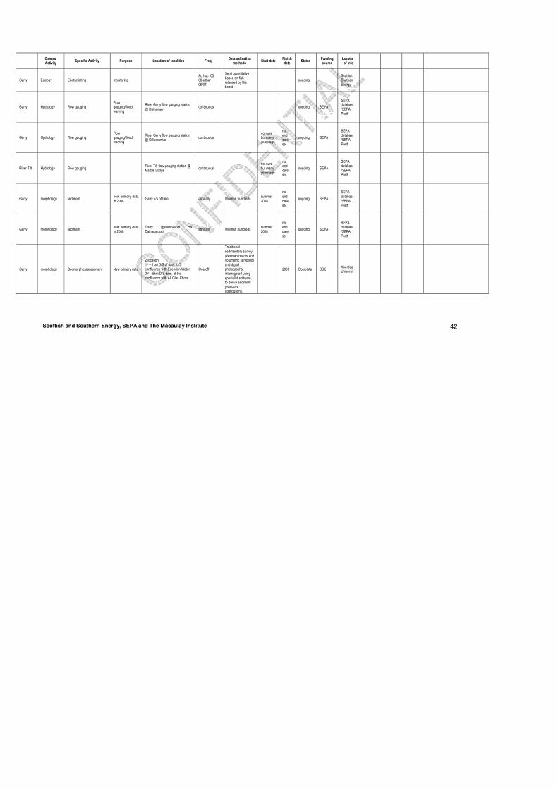
General Activity
Specific Activity Purpose Location of localities Freq, Data collection
methods Start date
Finish date
Status Funding source
Location of Info
Garry Chemistry
Alk as CaCO3 (mg/L), Ammonia as N (mg/L), BOD (ATU) (mg/L), Chloride (mg/L), ElecCond-20 (µS/cm),Nitrate as N (mg/L), Nitrite as N (mg/L),NonionNH3 (mg/L), O2 - DO (mg/L),O2 -%sat (%), SampleTemp (°C), SuspSolids (mg/L),TON as N (mg/L),o-Phos as P (mg/L), pH (pH units)
chemistry classification data
River Garry U/S River Errochty No localities: 1 SEPA location code:16975 NGR:NN8082365393
monthly? not sure but many years ago
no end date set
ongoing SEPA
SEPA databases/ SEPA Perth
Garry Chemistry
Alk as CaCO3 (mg/L), Ammonia as N (mg/L), BOD (ATU) (mg/L), Chloride (mg/L), ElecCond-20 (µS/cm),Nitrate as N (mg/L), Nitrite as N (mg/L),NonionNH3 (mg/L), O2 - DO (mg/L),O2 -%sat (%), SampleTemp (°C), SuspSolids (mg/L),TON as N (mg/L),o-Phos as P (mg/L), pH (pH units)
Chemistry classification data
River Garry at Footbridge Blair Atholl No localities: 1 SEPA location code:8729 NGR:NN8713464944
monthly? not sure but many years ago
no end date set
ongoing SEPA
SEPA databases/ SEPA Perth
Garry chemistry
Alk as CaCO3 (mg/L), Ammonia as N (mg/L), BOD (ATU) (mg/L), Chloride (mg/L), ElecCond-20 (µS/cm),Nitrate as N (mg/L), Nitrite as N (mg/L),NonionNH3 (mg/L), O2 - DO (mg/L),O2 -%sat (%), SampleTemp (°C), SuspSolids (mg/L),TON as N (mg/L),o-Phos as P (mg/L), pH (pH units)
Chemistry classification data
River Garry at Bridge of Garry No localities: 1 SEPA location code:8734 NGR:NN9141861200
monthly? not sure but many years ago
no end date set
ongoing SEPA
SEPA databases/ SEPA Perth
River Garry
Chemistry pH, Alk, Cond, Nutrients, major cations and anions, Si, DOC
Understanding environmental controls on fish productivity and performance
River Garry, near Blair Atholl No localities: 3
Monthly Dip samples. Details of analysis available if required
April 07 Oct, 07
Complete Scottish Gov.
FRS

Scottish and Southern Energy, SEPA and The Macaulay Institute 37
General Activity
Specific Activity Purpose Location of localities Freq, Data collection
methods Start date
Finish date
Status Funding source
Location of Info
Errochty Water
chemistry
Alk as CaCO3 (mg/L), Ammonia as N (mg/L), BOD (ATU) (mg/L), Chloride (mg/L), ElecCond-20 (µS/cm),Nitrate as N (mg/L), Nitrite as N (mg/L),NonionNH3 (mg/L), O2 - DO (mg/L),O2 -%sat (%), SampleTemp (°C), SuspSolids (mg/L),TON as N (mg/L),o-Phos as P (mg/L), pH (pH units)
Chemistry classification data
Errochty W. at Kindrochet No localities: 1 SEPA location code:8743 NGR:NN8037865097
monthly? not sure but many years ago
no end date set
ongoing SEPA
SEPA databases/ SEPA Perth
River Tilt chemistry
Alk as CaCO3 (mg/L), Ammonia as N (mg/L), BOD (ATU) (mg/L), Chloride (mg/L), ElecCond-20 (µS/cm),Nitrate as N (mg/L), Nitrite as N (mg/L),NonionNH3 (mg/L), O2 - DO (mg/L),O2 -%sat (%), SampleTemp (°C), SuspSolids (mg/L),TON as N (mg/L),o-Phos as P (mg/L), pH (pH units)
Chemistry classification data
River Tilt at Bridge of Tilt No localities: 1 SEPA location code:8737 NGR:NN8755965560
monthly? 1997
no end date set
ongoing SEPA
SEPA databases/ SEPA Perth
River Garry
Chemistry Temperature
Understanding environmental controls on fish productivity and performance
River Garry, near Blair Atholl No localities: 3
15mins Gemini dataloggers April 07 Oct, 07
Complete Scottish Gov.
FRS
Allt Dubhaig
Ecology Invertebrates new primary data in 2008
Allt Dubhaig u/s ponded/marsh area No localities: 1 SEPA location code:11739 NGR:NN6322675098
annually
mixed taxon (species) level for invertebrates - all three minute kick
summer 2008
no end date set
ongoing SEPA
SEPA databases/ SEPA Perth
Allt Dubhaig
Ecology Macrophytes new primary data in 2008
Allt Dubhaig u/s ponded/marsh area No localities: 1 SEPA location code:11739 NGR:NN6322675098
three yearly macrophytes by LEAFPACS methodology
summer 2008
no end date set
ongoing SEPA
SEPA databases/ SEPA Perth
Garry Ecology Invertebrates
One off historic survey 2001 plus new primary data in 2008
Dalnaspidal d/s offtake structure No localities: 1 SEPA location code:364872 NGR:NN6557572368
one off
mixed taxon (species) level for invertebrates - all three minute kick
summer 2008
End 2008
complete SEPA
SEPA databases/ SEPA Perth

Scottish and Southern Energy, SEPA and The Macaulay Institute 38
General Activity
Specific Activity Purpose Location of localities Freq, Data collection
methods Start date
Finish date
Status Funding source
Location of Info
Garry Ecology Macrophytes new primary data in 2008
Dalnaspidal d/s offtake structure No localities: 1 SEPA location code:364872 NGR:NN6557572368
one off macrophytes by LEAFPACS methodology
summer 2008
End 2008
complete SEPA
SEPA databases/ SEPA Perth
Garry Ecology Invertebrates new primary data in 2008
Garry u/s offtake No localities: 1 SEPA location code:372726 NGR:NN6977771408
annually
mixed taxon (species) level for invertebrates - all three minute kick
summer 2008
no end date set
ongoing SEPA
SEPA databases/ SEPA Perth
Garry Ecology Macrophytes new primary data in 2008
Garry u/s offtake No localities: 1 SEPA location code:372726 NGR:NN6977771408
three yearly macrophytes by LEAFPACS methodology
summer 2008
no end date set
ongoing SEPA
SEPA databases/ SEPA Perth
Garry Ecology Invertebrates
One off historic survey 2001 plus new primary data in 2008
d/s main offtake, u/s Edendon water No localities: 1 SEPA location code:327702 NGR:NN71537058
annually
mixed taxon (species) level for invertebrates - all three minute kick
summer 2008
no end date set
ongoing SEPA
SEPA databases/ SEPAPerth
Garry Ecology Macrophytes new primary data in 2008
d/s main offtake, u/s Edendon water No localities: 1 SEPA location code:327702 NGR:NN71537058
three yearly macrophytes by LEAFPACS methodology
summer 2008
no end date set
ongoing SEPA
SEPA databases/ SEPA Perth
Garry Ecology Invertebrates One off historic survey 2001
Dalnamein gauging station No localities: 1 SEPA location code:14960 NGR:NN7469269406
one off
mixed taxon (species) level for invertebrates - all three minute kick
2001 2001 complete SEPA
SEPA databases/ SEPA Perth
Garry Ecology Invertebrates new primary data in 2008
Garry @sheepwash d/s Dalnacardoch No localities: 1 SEPA location code:364870 NGR:NN7279170003
annually
mixed taxon (species) level for invertebrates - all three minute kick; also invertebrates by Surber sampling;
summer 2008
no end date set
ongoing SEPA
SEPA databases/ SEPA Perth
Garry Ecology Macrophytes new primary data in 2008
Garry @sheepwash d/s Dalnacardoch No localities: 1 SEPA location code:364870 NGR:NN7279170003
three yearly macrophytes by LEAFPACS methodology
summer 2008
no end date set
ongoing SEPA
SEPA databases/ SEPA Perth

Scottish and Southern Energy, SEPA and The Macaulay Institute 39
General Activity
Specific Activity Purpose Location of localities Freq, Data collection
methods Start date
Finish date
Status Funding source
Location of Info
Garry Ecology Macrophytes new primary data in 2008
Garry d/s Clunes Lodge u/s confl Allt a Chrombaidh No localities: 1 SEPA location code:364871 NGR:NN7852566739
three yearly Macrophytes by LEAFPACS methodology
summer 2008
no end date set
ongoing SEPA
SEPA databases /SEPA Perth
Garry Ecology Invertebrates Biology classification data
River Garry U/S River Errochty No localities: 1 SEPA location code:16975 NGR:NN8082365393
spring and autumn each year
Mix of mixed taxon (species) level and family level data for invertebrates - all three minute kick
circa 1995
no end date set
ongoing SEPA
SEPA databases/ SEPA Perth
Garry Ecology Invertebrates Biology classification data
River Garry U/S Blair Atholl STW No localities: 1 SEPA location code:8730 NGR: NN8799164511
once or twice a year
Mix of mixed taxon (species) level and family level data for invertebrates - all three minute kick
circa 1995 circa 2005
complete SEPA
SEPA databases/ SEPA Perth
Garry Ecology Invertebrates Biology classification data
River Garry at Strathgarry No localities: 1 SEPA location code:10487 NGR: NN8924264057
once or twice a year
All family level invertebrates I think
circa 1995 circa 2005
complete SEPA
SEPA databases/ SEPA Perth
Garry Ecology Invertebrates Biology classification data
River Garry at Killiecrankie Bridge No localities: 1 SEPA location code:11110 NGR: NN9107562786
spring and autumn each year
All mixed taxon (species) level data for invertebrates I think- all three minute kick
circa 2000
no end date set
ongoing SEPA
SEPA databases/ SEPA Perth
Garry Ecology Invertebrates Biology classification data
River Garry at Bridge of Garry No localities: 1 SEPA location code:8734 NGR: NN9141861200
once or twice a year
All family level invertebrates I think - three minute kick
circa 2000
complete SEPA
SEPA databases/ SEPA Perth
Errochty Water
Ecology Invertebrates Biology classification data
Errochty W. at Kindrochet No localities: 1 SEPA location code:8743 NGR: NN8037865097
spring and autumn each year
Mix of mixed taxon (species) level and family level data for invertebrates - all three minute kick
circa 1990
no end date set
ongoing SEPA
SEPA databases/ SEPA Perth

Scottish and Southern Energy, SEPA and The Macaulay Institute 40
General Activity
Specific Activity Purpose Location of localities Freq, Data collection
methods Start date
Finish date
Status Funding source
Location of Info
Edendon Water
Ecology Invertebrates Biology classification data
Edendon Water at Edendon Bridge No localities: 1 SEPA location code:11740 NGR: NN7163970578
spring and autumn
Mix of mixed taxon (species) level and family level data for invertebrates - all three minute kick
2000
no end date set
ongoing SEPA
SEPA databases/ SEPA Perth
Allt Anndeir
Ecology Invertebrates Biology classification data
Allt Anndeir at Dalnamein No localities: 1 SEPA location code:11741 NGR: NN7545669748
one off
Mix of mixed taxon (species) level and family level data for invertebrates - all three minute kick
2001 2001 complete SEPA
SEPA databases/ SEPA Perth
Allt a Chrombaidh
Ecology Invertebrates Biology classification data
Allt a Chrombaidh No localities: 1 SEPA location code:17113 NGR: NN7893166611
spring and autumn
? 2003 2003 complete SEPA
SEPA databases/ SEPA Perth
Bruar Water
Ecology Invertebrates Biology classification data
Bruar W. at Br. on old A9 No localities: 1 SEPA location code:8740 NGR: NN8240665919
one off All family level invertebrates I think - three minute kick
2003 2003 complete SEPA
SEPA databases/ SEPA Perth
Allt Bhric Ecology Invertebrates Biology classification data
Allt Bhric @ Balnansteuartach No localities: 1 SEPA location code:17112 NGR: NN8430065145
one off All family level invertebrates I think - three minute kick
2003 2003 complete SEPA
SEPA databases /SEPA Perth
Banvie Burn
Ecology Invertebrates Biology classification data
Banvie Burn at Blair Atholl No localities: 1 SEPA location code:11743 NGR: NN8678665481
one off All family level invertebrates I think - three minute kick
2003 2003 complete SEPA
SEPA databases/ SEPA Perth
River Tilt Ecology Invertebrates Biology classification data
River Tilt at Bridge of Tilt No localities: 1 SEPA location code:8737 NGR: NN8755965560
spring and autumn each year
All family level invertebrates I think - three minute kick
2000
no end date set
ongoing SEPA
SEPA databases /SEPA Perth

Scottish and Southern Energy, SEPA and The Macaulay Institute 41
General Activity
Specific Activity Purpose Location of localities Freq, Data collection
methods Start date
Finish date
Status Funding source
Location of Info
River Tilt Ecology Invertebrates new primary data in 2008
River Tilt near Alltandu u/s Marble Lodge No localities: 1 SEPA location code:372706 NGR: NN9124272157
annually
mixed taxon (species) level for invertebrates - all three minute kick; also invertebrates by Surber sampling;
summer 2008
no end date set
complete SEPA
SEPA databases/ SEPA Perth
River Tilt Ecology Macrophytes new primary data in 2008
River Tilt near Alltandu u/s Marble Lodge No localities: 1 SEPA location code:372706 NGR: NN9124272157
three yearly macrophytes by LEAFPACS methodology
summer 2008
no end date set
complete SEPA
SEPA databases/ SEPA Perth
Fender Burn
Ecology Invertebrates Biology classification data
Fender Burn at Fender Bridge No localities: 1 SEPA location code:14470 NGR: NN8821066782
spring and autumn for 1 year
All family level invertebrates I think - three minute kick
2003 2003 complete SEPA
SEPA databases /SEPA Perth
Allt Mhairc Ecology Invertebrates Biology classification data
Allt Mhairc U/S Conf with River Tilt No localities: 1 SEPA location code:11742 NGR: NN8889571195
spring and autumn
All family level invertebrates I think - three minute kick
2001 2005 complete SEPA
SEPA databases/ SEPA Perth
Allt Girnaig
Ecology Invertebrates Biology classification data
Allt Girnaig at Killiecrankie No localities: 1 SEPA location code:11744 NGR: NN9112062832
spring and autumn
All family level invertebrates I think - three minute kick
2000 2003 complete SEPA
SEPA databases/ SEPA Perth
Garry Ecology Catchment Vegetation Survey
Drumochter Hills One-off UVS survey 1986 1986 Complete SNH geo.View
River Garry
Ecology Fish
Understanding environmental controls on fish productivity and performance. Understanding importance of wide rivers fo fish.
River Garry, near Blair Atholl No localities: 3
Variable Mark recapture April 07 Oct, 07
Complete Scottish Gov.
FRS
Scottish and Southern Energy, SEPA and The Macaulay Institute 42
General Activity
Specific Activity Purpose Location of localities Freq, Data collection
methods Start date
Finish date
Status Funding source
Location of Info
Garry Ecology Electrofishing monitoring Ad hoc (03, 08 either 06/07)
Semi quantitative based on fish released by the board
ongoing Scottish & Southern Energy
Garry Hydrology Flow gauging Flow gauging/flood warning
River Garry flow gauging station @ Dalnamein
continuous ongoing SEPA
SEPA databases/SEPA Perth
Garry Hydrology Flow gauging Flow gauging/flood warning
River Garry flow gauging station @ Killiecrankie
continuous not sure but many years ago
no end date set
ongoing SEPA
SEPA databases/SEPA Perth
River Tilt Hydrology Flow gauging River Tilt flow gauging station @ Marble Lodge
continuous not sure but many years ago
no end date set
ongoing SEPA
SEPA databases/SEPA Perth
Garry morphology sediment new primary data in 2008
Garry u/s offtake annually Wolman hundreds summer 2008
no end date set
ongoing SEPA
SEPA databases/SEPA Perth
Garry morphology sediment new primary data in 2008
Garry @sheepwash d/s Dalnacardoch
annually Wolman hundreds summer 2008
no end date set
ongoing SEPA
SEPA databases/SEPA Perth
Garry morphology Geomorphic assessment New primary data
2 location. 1st – 1km D/S of dam, U/S confluence with Edendon Water 2nd – 5km D/S dam, at the confluence with Alt Glas Chore
One-off
Traditional sedimentary survey (Wolman counts and volumetric sampling) and digital photographs, interrogated using specialist software, to derive sediment grain-size distributions.
2008 Complete SSE Aberdeen University

Scottish and Southern Energy, SEPA and The Macaulay Institute 43
Appendix B2 River Shin
General Activity Specific Activity Purpose
Location of localities
Freq, .
Data collection methods
Start date
Finish date Status
Funding source
Shin Ecology Invertebrates biology class.
Shin at Inveran No localities: 1 SEPA location code: 206732 NGR: NH5740297403
spring and autumn each year
mixed taxon (species) level for invertebrates - all three minute kick
1997
no end date set
ongoing
Shin Chemistry
124TCB (ng/L) ,135TCB (ng/L) ,ACNE (ng/L) ,ACNLE (ng/L) ,a-Endosulfn (ng/L) ,Aesthetics Class ,a-HCH (ng/L) ,a-HCH (None) ,Al (µg/L) ,Al < 0.45µm (µg/L) ,Aldrin (ng/L) ,Aldrin (None) ,Alk as CaCO3 (mg/L) ,Ammonia as N (mg/L) ,Anthracene (ng/L) ,As (µg/L) ,Atrazine (ng/L) ,Atrazine (None) ,Azinphos-e (ng/L) ,Azinphos-Me (ng/L) ,B (µg/L) ,Ba (µg/L) ,BAA (ng/L) ,BAP (ng/L) ,BBFLU (ng/L) ,BBPHTH (ng/L) ,b-Endosulfn (ng/L) ,BGHIP (ng/L) ,b-HCH (ng/L) ,BKF (ng/L) ,BOD (ATU) (mg/L) ,Ca (mg/L) ,CCl4 (None) ,Cd (µg/L) ,Chlfenvinph (ng/L) ,Chloride (mg/L) ,Chrysene (ng/L) ,CO2 (mg/L) ,COD (mg/L) ,Colour (Hazen) ,Cr (µg/L) ,Cu (µg/L) ,Cu < 0.45µm (µg/L) ,DDD - pp (ng/L) ,DDE - op (ng/L) ,DDE - pp (ng/L) ,DDT - pp (ng/L) ,DDT - pp (None) ,Diazinon (ng/L) ,Diben-anth (ng/L) ,Dichlorvos (ng/L) ,Dieldrin (ng/L) ,Dieldrin (None) ,DiethHexPhthal (ng/L) ,Dimethoate (ng/L) ,DOC<0.45µm (mg/L), DOPHTH (ng/L), ElecCond-20 (µS/cm), ElecCond-25 (µS/cm),Endosulftot (ng/L), Endrin (ng/L), Endrin (None), Fe (mg/L), Fenitroth'n (ng/L), Fenthion (ng/L), Fluoranthene (ng/L) ,Fluorene (ng/L) ,g-HCH (ng/L) ,g-HCH (None) ,Hardness (mg/L) ,HCB (ng/L) ,HCB (None) ,HCBD (ng/L) ,HCBD (None) ,Hg (µg/L) ,Indenopyrene (ng/L) ,Isodrin (ng/L) ,Isodrin (None) ,K (mg/L) ,Malathion (ng/L) ,Mevinphos (ng/L) ,Mg (mg/L) ,Mn (mg/L) ,M-Parathion (ng/L) ,Na (mg/L) ,Naphthalene (ng/L) ,Ni (µg/L) ,Nitrate as N (mg/L) ,Nitrite as N (mg/L) ,N-Kjeldahl (mg/L) ,NonionNH3 (mg/L) ,O2 - DO (mg/L) ,O2 -%sat (%) ,o-Phos as P (mg/L) ,P < 0.45µm (µg/L) ,Parathion (ng/L) ,Pb (µg/L) ,PCB 28 (ng/L) ,PCB 28 (None) ,PCP (ng/L) ,PCP (None) ,pH (pH units) ,Phenanthrene (ng/L) ,Propetamph (ng/L) ,Pyrene (ng/L) ,SampleTemp (°C) ,Se (µg/L) ,Silicate as SiO2 (mg/L) ,Simazine (ng/L) ,Simazine (None) ,StreamWLevD (None) ,Sulphate as SO4 (mg/L) ,SuspSolids (mg/L) ,TCB Tot (ng/L) ,TDS105 (mg/L) ,TN (mg/L) ,TOC (mg/L) ,TON as N (mg/L) ,Tot P as P (mg/L) ,Total DDT (ng/L) ,Triazophos (ng/L) ,Trifluralin (ng/L) ,Turbidity (FTU) ,V (µg/L) ,VisibleOilD (None) ,Zn (µg/L) ,
Chemistry class. data
Shin at Inveran No localities: 1 SEPA location code: 202898 NGR: NH5740297403
monthly 1983
no end date set
ongoing
Shin Ecology Vegetation survey Stathanloin (SW Loch Shin)
One-off NVC survey Complete
Shin Ecology Invertebrates biology class.
Shin at Inveran No localities: 1 SEPA location code: 206732 NGR: NH5740297403
spring and autumn each year
mixed taxon (species) level for invertebrates - all three minute kick
1997
no end date set
ongoing

Scottish and Southern Energy, SEPA and The Macaulay Institute 44
Appendix B3 River Orrin
General Activity
Specific Activity Purpose Location of localities Freq,
. Data collection
methods Start date
Finish date
Status Funding source
Orrin Ecology Invertebrates Biology classification data
River Orrin Fairburn No localities: 1 SEPA location code: 207305 NGR: NH4541352457
All family level invertebrates I think
2002 2002 complete
Orrin Ecology Invertebrates Biology classification data
R orrin u/s Orrin hatchery No localities: 1 SEPA location code: 2073566 NGR: NH5032253030
All family level invertebrates I think
2001 2005 complete
Orrin Chemistry
Alk as CaCO3 (mg/L), Ammonia as N (mg/L), BOD (ATU) (mg/L), Chloride (mg/L), ElecCond-20 (µS/cm),Nitrate as N (mg/L), Nitrite as N (mg/L),NonionNH3 (mg/L), O2 - DO (mg/L),O2 -%sat (%), SampleTemp (°C), SuspSolids (mg/L),TON as N (mg/L),o-Phos as P (mg/L), pH (pH units)
Chemistry classification data
River orrin at Urray. No localities: 1 SEPA location code: 204051 NGR: NH5051753286
monthly? 1983 2006 complete
Orrin Ecology Invertebrates Biology classification data
R orrin d/s Orrin hatchery No localities: 1 SEPA location code: 206723 NGR: NH5051753286
All family level invertebrates I think
1997 2005 complete
Orrin Ecology
Alk as CaCO3 (mg/L), Ammonia as N (mg/L), BOD (ATU) (mg/L), Chloride (mg/L), ElecCond-20 (µS/cm),Nitrate as N (mg/L), Nitrite as N (mg/L),NonionNH3 (mg/L), O2 - DO (mg/L),O2 -%sat (%), SampleTemp (°C), SuspSolids (mg/L),TON as N (mg/L),o-Phos as P (mg/L), pH (pH units)
Biology classification data
R orrin d/s Orrin hatchery 1997 2005 complete
Orrin Ecology Vegetation Survey Primary data Conon Islands One off NVC Survey complete
Orrin Ecology Habitat Survey - mid summer low flow including wetted parimeter, propotion substrate, flow types etc
Primary data Every 250m One off Standard habitst survey method
1995 1995 complete
Orrin Ecology Electrofishing Monitoring annually 1996 on-going On-going
Orrin Ecology Smolt survey Upper and lower Orrin One off 2006 2007 complete
Orrin morphology Geomorphic assessment New primary data
3 location. 1st - 1.5km D/S at 1st tributary entering to the north 2nd – Immediately D/S of Alt Goibhre confluence 3rd - At confluence with Conon
One-off
Traditional sedimentary survey (Wolman counts and volumetric sampling) and digital photographs, interrogated using specialist software, to derive sediment grain-size distributions.
2008 Complete SSE
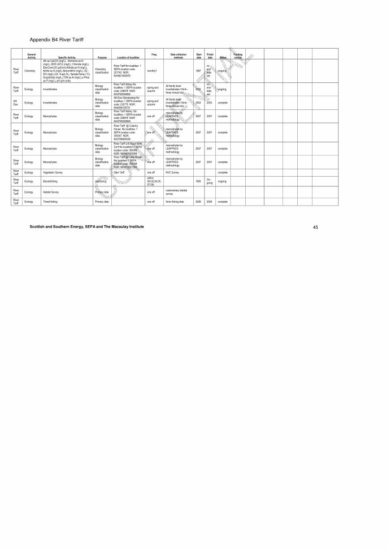
Scottish and Southern Energy, SEPA and The Macaulay Institute 45
Appendix B4 River Tariff
General Activity Specific Activity Purpose Location of localities
Freq, .
Data collection methods
Start date
Finish date Status
Funding source
River Tarff
Chemistry
Alk as CaCO3 (mg/L), Ammonia as N (mg/L), BOD (ATU) (mg/L), Chloride (mg/L), ElecCond-20 (µS/cm),Nitrate as N (mg/L), Nitrite as N (mg/L),NonionNH3 (mg/L), O2 - DO (mg/L),O2 -%sat (%), SampleTemp (°C), SuspSolids (mg/L),TON as N (mg/L),o-Phos as P (mg/L), pH (pH units)
Chemistry classification
River Tarff No localities: 1 SEPA location code: 201742 NGR: NH3831609076
monthly? 1987
no end date set
ongoing
River Tarff
Ecology Invertebrates Biology classification data
River Tarff Abbey No localities: 1 SEPA location code: 206876 NGR: NH3795508808
spring and autumn
All family level invertebrates I think - three minute kick
2002
no end date set
ongoing
Allt Doe
Ecology Invertebrates Biology classification data
Allt Doe Glendoebeg No localities: 1 SEPA location code: 232775 NGR: NH4088108731
spring and autumn
All family level invertebrates I think - three minute kick
2003 2003 complete
River Tarff
Ecology Macrophytes Biology classification data
River Tarff Abbey No localities: 1 SEPA location code: 206876 NGR: NH3795508808
one off macrophytes by LEAFPACS methodology
2007 2007 complete
River Tarff
Ecology Macrophytes Biology classification data
River Tarff @ Culachy House No localities: 1 SEPA location code: 350347 NGR: NH3786606556
one off macrophytes by LEAFPACS methodology
2007 2007 complete
River Tarff
Ecology Macrophytes Biology classification data
River Tarff U/S Black Burn Conf No localities: 1 SEPA location code: 350345 NGR: NH3893903598
one off macrophytes by LEAFPACS methodology
2007 2007 complete
River Tarff
Ecology Macrophytes Biology classification data
River Tarff @ Coille Dhubh No localities: 1 SEPA location code: 350348 NGR: NH4012001594
one off macrophytes by LEAFPACS methodology
2007 2007 complete
River Tarff
Ecology Vegetation Survey Glen Tarff one off NVC Survey complete
River Tarff
Ecology Electrofishing monitoring adhoc (93,02,04,05,07,08)
1993 On-going
ongoing
River Tarff
Ecology Habitat Survey Primary data one off rudementary habitat survey
River Tarff
Ecology Timed fishing Primary data one off 5min fishing data 2006 2006 complete

Scottish and Southern Energy, SEPA and The Macaulay Institute 46
General Activity Specific Activity Purpose Location of localities
Freq, .
Data collection methods
Start date
Finish date Status
Funding source
River Tarff
morphology Geomorphic assessment New primary data
2 location. In lower section where Salmon are known to spawn
One-off
Traditional sedimentary survey (Wolman counts and volumetric sampling) and digital photographs, interrogated using specialist software, to derive sediment grain-size distributions.
2008 Complete SSE
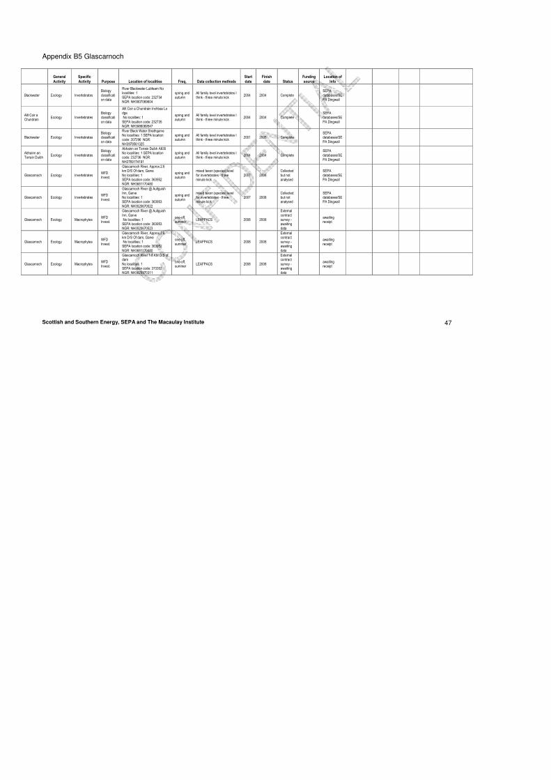
Scottish and Southern Energy, SEPA and The Macaulay Institute 47
Appendix B5 Glascarnoch
General Activity
Specific Activity Purpose Location of localities Freq, Data collection methods
Start date
Finish date Status
Funding source
Location of Info
Blackwater Ecology Invertebrates Biology classification data
River Blackwater Lubfearn No localities: 1 SEPA location code: 232734 NGR: NH3907069604
spring and autumn
All family level invertebrates I think - three minute kick
2004 2004 Complete SEPA databases/SEPA Dingwall
Robin Guthrie
Allt Coir a Chundrain
Ecology Invertebrates Biology classification data
Allt Coir a Chundrain Inchbae Lodge No localities: 1 SEPA location code: 232735 NGR: NH3986069547
spring and autumn
All family level invertebrates I think - three minute kick
2004 2004 Complete SEPA databases/SEPA Dingwall
Robin Guthrie
Blackwater Ecology Invertebrates Biology classification data
River Black Water Strathgarve No localities: 1 SEPA location code: 207296 NGR: NH3978561325
spring and autumn
All family level invertebrates I think - three minute kick
2001 2005 Complete SEPA databases/SEPA Dingwall
Robin Guthrie
Abhainn an Torrain Duibh
Ecology Invertebrates Biology classification data
Abhainn an Torrain Duibh A835 No localities: 1 SEPA location code: 232736 NGR: NH2769174191
spring and autumn
All family level invertebrates I think - three minute kick
2004 2004 Complete SEPA databases/SEPA Dingwall
Robin Guthrie
Glascarnoch Ecology Invertebrates WFD Invest.
Glascarnoch River, Approx.2.6 km D/S Of dam, Garve No localities: 1 SEPA location code: 363952 NGR: NH3681170480
spring and autumn
mixed taxon (species) level for invertebrates - three minute kick
2007 2008 Collected but not analysed
SEPA databases/SEPA Dingwall
Glascarnoch Ecology Invertebrates WFD Invest.
Glascarnoch River @ Aultguish Inn, Garve No localities: 1 SEPA location code: 363953 NGR: NH3520670522
spring and autumn
mixed taxon (species) level for invertebrates - three minute kick
2007 2008 Collected but not analysed
SEPA databases/SEPA Dingwall
Glascarnoch Ecology Macrophytes WFD Invest.
Glascarnoch River @ Aultguish Inn, Garve No localities: 1 SEPA location code: 363953 NGR: NH3520670523
one-off, summer
LEAFPACS 2008 2008
External contract survey - awaiting data
awaiting receipt
Glascarnoch Ecology Macrophytes WFD Invest.
Glascarnoch River, Approx.2.6 km D/S Of dam, Garve No localities: 1 SEPA location code: 363952 NGR: NH3681170480
one-off, summer
LEAFPACS 2008 2008
External contract survey - awaiting data
awaiting receipt
Glascarnoch Ecology Macrophytes WFD Invest.
Glascarnoch River 1.8 KM D/S of dam No localities: 1 SEPA location code: 373352 NGR: NH3629970311
one-off, summer
LEAFPACS 2008 2008
External contract survey - awaiting data
awaiting receipt

Scottish and Southern Energy, SEPA and The Macaulay Institute 48
General Activity
Specific Activity Purpose Location of localities Freq, Data collection methods
Start date
Finish date Status
Funding source
Location of Info
Glascarnoch Ecology Habitat Survey
Primary data
Every 250m one-off, summer
Standard habitat survey method - mid summer low flow including wetted perimeter, proportion substrate, flow types etc
2005 2005 complete RAFTS Callum Sinclaire
Glascarnoch Ecology Electrofishing Monitoring annually 2005 on-going On-going RAFTS Callum Sinclaire
Glascarnoch morphology Geomorphic assessment
New primary data
3 locations. 1st – immediately D/S dam 2nd – gorge D/S dam 3rd – 200m D/S confluence with Abhainnstrath a Bathaich
One-off
Traditional sedimentary survey (Wolman counts and volumetric sampling) and digital photographs, interrogated using specialist software, to derive sediment grain-size distributions.
2008 Complete SSE Aberdeen University
Chris Gibbins

Scottish and Southern Energy, SEPA and The Macaulay Institute 49
Appendix B6– River Cuaich
General Activity
Specific Activity Purpose Location of localities Freq,
. Data collection
methods Start date
Finish date
Status Funding source
Location of Info
River Cuaich
Ecology Vegetation survey Drumochter Hills One-off UVS Survey 1986 1986 Complete SNH geo.View
River Trommie & Truim
Ecology Electrofishing monitoring annually 1990 ongoing
ongoing SSE Spey DSFB
River Trommie & Truim
Ecology Redd count data primary data One-off mid 90s mid 90s
Complete SSE Spey DSFB
River Trommie
Ecology Habitat Survey primary data One-off Habitat Survey 2000 2000 Complete SSE Spey DSFB
River Cuaich
morphology Geomorphic assessment New primary data
2 location. 1st – 0.5km D/D weir at Loch cuaich 2nd – 0.5km D/S Dam
One-off
Traditional sedimentary survey (Wolman counts and volumetric sampling) and digital photographs, interrogated using specialist software, to derive sediment grain-size distributions.
2008 Complete SSE Aberdeen University