journal of environmental hydrology · journal of environmental hydrology ... shemang (1990),...
TRANSCRIPT

JOURNAL OFENVIRONMENTAL HYDROLOGY
The Electronic Journal of the International Association for Environmental HydrologyOn the World Wide Web at http://www.hydroweb.com
VOLUME 20 2012
Journal of Environmental Hydrology Volume 20 Paper 11 August 20121
The dependence on boreholes and hand-dug wells for water is increasing rapidly in Zaria,Nigeria, because of the inability of Water Works Department in the area to meet the waterconsumption requirement of the people. Almost all the boreholes and wells in the area fail toyield during dry seasons due to drastic reduction in groundwater table. This results in acutewater shortage in the area. Virtually all the boreholes are located outside of valleys. Electricalresistivity tomography was conducted in the vicinity of two valleys in the area to delineate theirunderlying aquifer zones. The data were collected along five profiles laid perpendicular to thevalleys’ strike. The data were tomographically inverted. Interpreted results show that theresistivity ranges of the bedrocks on either side of each of the valleys differ significantly whichsuggests sharp differences in the properties of the bedrocks on either side of the valleys. Itsuggests contacts of different rock blocks at the valleys’ floors. The results also suggest thatthe basement on either side of each of the valleys slopes towards the valleys’ floors. Thebasement underlying the valleys’ floors is characterized by fault zones between the differentrock blocks that are identified on the tomograms as low resistivity zones flanked by highresistivity zones. The resistivity ranges within the fault zones suggest that they are aquifers. Theresults generally suggest that the valleys in the Zaria area most likely have tectonic origins withfault zone aquifers. The study infers that aquifers which underlie the valley floors are mostlikely recharged during all seasons compared to those outside the valleys.
DELINEATION OF ALL-SEASON-RECHARGEDGROUNDWATER RESERVOIR FROM TWO VALLEYS,
ZARIA, NIGERIA
1Department of Physics, Federal College of Education, Zaria, Nigeria2School of Science Technology, CHELTECH, Zaria, Nigeria3Department of Physics, Ahmadu Bello University, Zaria, Nigeria
Stephen O. Ibe1
Gabriel N. Egwuonwu2
Isaac B. Osazuwa3

Journal of Environmental Hydrology Volume 20 Paper 11 August 20122
Groundwater Reservoir Delineation, Zaria, Nigeria Ibe, Egwuonwu, and Osazuwa
INTRODUCTIONThe Zaria area, north western Nigeria, in recent years has witnessed high population growth.
Based on the population census of the Federal Republic of Nigeria, the population of ZariaMetropolitan Area, comprising Sabon Gari, Zaria and Giwa Local Government Areas, has grownfrom about 679,446 in 1991 to 981,496 in 2006 (Federal Republic of Nigeria, 2007). This highpopulation growth is owing to the establishment of many tertiary institutions and researchinstitutes in the area by Nigerian Government. Zaria is an important centre of education andresearch, with Ahmadu Bello University and affiliated institutions such as the Institute forAgricultural Research, National Animal Production Research Institute, Federal College ofEducation and National Research Institute for Chemical Technology located in it. It is also the siteof the Nigerian Civil Aviation Training Centre and Nuhu Bamali Polytechnics. Therefore, peoplefrom all parts of Nigeria and some foreigners converge to study or work in these institutions. Thehigh population density in the area has resulted to high infrastructural demand. One of theinfrastructures in high demand in the area is water. In the urban and semi urban cities in the areathe tertiary institutions and research institutes are in high demand for water for their dailyactivities. In the rural places in the area, farmers are in high demand for water for their livestockand irrigation farming. According to Baba (2007) and Ahmadu Bello University, Zaria (2008) theunit water demand of the people of Zaria Metropolitan Area is 0.1 m3/d.
In Zaria Area, piped water was the major source of water followed by boreholes and hand-dugwells. The source of the piped water is Zaria Dam which was inaugurated in 1975. The dampresently has capacity of supplying 16000 m3 of water per day. This does not meet the daily waterdemand of the residents of Zaria Area. Also, inadequate electric power supply to water treatmentplant of Zaria Water Board makes it impossible for the plant to operate at it maximum capacity.These and other similar factors most likely are responsible for the acute water scarcity experiencedin Zaria Area in recent years. In order to ameliorate this condition, residents of the area massivelyembark on drilling boreholes and sinking hand-dug wells.
Generally water table is shallow in the area. Garba and Schoeneich (2003) observed fromrepeated water level measurements from twelve hand-dug wells in the area that the depth to watertable ranges between 1.0 m and 8.7 m below ground level in wet season and between 5.0 m and 13.7m below ground level in dry season. Most of the boreholes and hand-dug wells in the area fail duringdry seasons and this could be owing to drastic reduction in groundwater table and this results toacute water shortage in the area. A number of measures have been adopted or suggested toameliorate the acute water shortage in the area. For example, Ahmadu Bello University (ABU),Zaria, which is the biggest institution in the area, recently constituted a committee on Protectionof the Kubanni Dam Drainage Basin whose responsibility was to carry out measurement of theremaining storage in Kubanni impounding reservoir and to make proposal for upgrading theenvironment in Kubanni Drainage Basin. However, the result expected from the ABU’s measurewill only be beneficial to ABU community and not to entire Zaria Area.
Some hydrogeologists in Zaria had suggested that the high rate of drying up of wells in ZariaArea is caused by technical faults and inadequate skills of drillers. Adequate measures have beentaken to guide against these factors most recently. In spite of the measures taken, the wells are stillnot yielding during the peak of dry seasons. There is a factor which has received little or noemphasis and consideration in guiding against very poor wells’ yield during the peak of dryseasons. Before 1970, geologist in Zaria area had observed that outside the vicinity of valleys,wells are dug to the water table which falls progressively throughout the dry season; the amountof fall depending on the location. Wright and McCurry (1970) observed that since the removal of

Journal of Environmental Hydrology Volume 20 Paper 11 August 20123
Groundwater Reservoir Delineation, Zaria, Nigeria Ibe, Egwuonwu, and Osazuwa
water from the wells is principally for domestic uses and probably of negligible overall importance,the fall is mainly due to surface percolation of water through to the larger river valleys. Wright andMcCurry (1970), Garba and Schoeneich (2003) and Ahmadu Bello University, Zaria (2008) hadall observed that wells sited closer to valleys in Zaria area are of higher yield than those sited awayfrom the valleys. However, this conclusion was based only on mere inspection and measurementsof depth to water table made on hand-dug wells. There is need to carry out geophysical studies inthe vicinity of valleys to confirm the conclusion made in the foregoing. Also, the ground waterpotentials in Zaria area had been mapped by some researchers using geophysical methods. Theresearches include those of Olowu (1967), Messrs Preussag Ltd (1981 – 1982), Adanu (1987),Shemang (1990), Olatinwo (1994) and Hydro-Skill and Engineering Services, Kaduna (2005).Most of the boreholes and hand-dug wells sited at the places these researchers had delineated asaquifers failed to yield at the peak of dry seasons. It was generally observed that none of theseresearches was conducted in the immediate vicinity of valleys. This present study was conductedin the immediate vicinity of valleys with the aim of delineating aquiferous zones which most likelyyield in all seasons in Zaria area.
THE STUDY AREA
Zaria area is bounded approximately by longitudes 7o 12’ to 7o 47’ E and latitudes 11o 03’ to 11o
11’ N. It is located on a plateau at a height of about 670 m above sea level and more than 640 kmaway from the sea (Hore, 1970). The area is located within the sparsely populated Guinea Savannah.It has a typical savannah climate of distinct wet and dry seasons, with a moderate rainfall of about1047 mm/a (Garba and Schoeneich, 2003). The rainy season usually starts in May and ends inOctober and the dry season lasts from late October to April.
This study involved geophysical measurement in the vicinity of two valleys in Kubanni Basin(Figure 1), Zaria, Nigeria. The Kubanni Basin is characterized by high concentration of valleynetworks. Most of the valleys in the basin are dry. Others are seasonal except the Kubanni Riveritself. Almost all the tertiary institutions in Zaria area are located in the Kubanni Basin. Thesettlement within the basin has the highest population in Zaria area with over 300,000 people livingthere (Federal Republic of Nigeria, 2007).
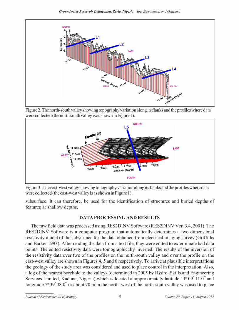
One of the valleys (Figure 2), referred to as north–south (N-S) valley in this study, is about 2.30km long and has an average width of about 15.00 m. It has approximately a north-south strike withits southern end approximately perpendicular to a long east-west valley through which KubanniRiver flows. The portion of the valley studied lies between latitudes 11o 08’ 30.0’’ N and 11o 09’
09.8’’ N and between longitudes 7o 39’ 41.9’’ E and 7o 39’ 42.6’’ E.
The second valley (Figure 3), referred to as east–west (E-W) valley in this study, is a tributaryor branch of the north - south Valley. It is about 230.00 m long and has an average width of about15.00 m. It has approximately a west-east strike. Its eastern end has confluence with the north-south valley almost perpendicularly at about 500.00 m from the northern end of the north-southvalley. The valley lies between latitudes 11o 08’ 52.9’’ N and 11o 08’ 53.9’’ N and between longitudes7o 39’ 28.6’’ E and 7o 39’ 36.4’’ E.
GEOLOGY AND HYDROGEOLOGY OF ZARIA AREAThe area belongs to the Precambrian basement complex of northern Nigeria. It is composed of
three rock types which include gneiss, porphyritic granite and medium grained granite. Theporphyritic granite and medium grained granite were intruded into the gneiss during the Pan

Journal of Environmental Hydrology Volume 20 Paper 11 August 20124
Groundwater Reservoir Delineation, Zaria, Nigeria Ibe, Egwuonwu, and Osazuwa
African (McCurry, 1973; Garba and Schoeneich, 2003). The greater part of the area is covered withthick regolith mainly derived from in-situ weathering of the basement rocks.
According to Garba and Schoeneich (2003) and Ahmadu Bello University, Zaria (2008), thereare two types of aquifers in the area: (a) the regolith (soft overburden) aquifer and (b) the fracturedbedrock aquifer. The regolith aquifer is the main aquifer and the only available source of water tothe majority of the population via hand-dug wells. This type of aquifer varies in thickness from 0m (on outcropping solid rocks) to a maximum of 50 m (Adanu, 1987) depending on the localgeology, topography and the climate of the area (McCurry, 1973).
METHOD OF STUDY AND DATA COLLECTION
Four profiles (L1, L2, L3, and L4) perpendicular to the strike of the north-south valley (Figure2) and almost equally distributed along its length were established for the study. Similarly, oneprofile (L5) perpendicular to the strike of the east-west valley (Figure 3) and located almost midway of its length was established.
An ABEM Multichannel Terrameter, model SAS4000 (ABEM Instrument AB, Terrameter SAS4000 / SAS 1000, 1999) aided with an Electrode Selector, model ES464 (ABEM Instrument AB,Lund Imaging System, 1999) was used for the data collection along the profiles. The length of eachprofile is 200 m and the centre of each spread is located at the floor of each of the valleys. Theelectrodes were placed in a straight line at 5 m interval along each profile. In this study, WEN32SXprotocol file (Continuous Vertical Electrical Sound with two cables) was used for data collection.The Continuous Vertical Electrical Sounding (CVES) is a 2D resistivity prospecting method whichyields information about both the lateral and vertical resistivity distribution of the earth’s
Figure 1. Location of the north-south (N-S) and east -west (E-W) valleys on the map of Kubanni Basin,Zaria, Nigeria (adopted from Geology Department, Ahmadu Bello University, Zaria).
Journal of Environmental Hydrology Volume 20 Paper 11 August 20125
Groundwater Reservoir Delineation, Zaria, Nigeria Ibe, Egwuonwu, and Osazuwa
subsurface. It can therefore, be used for the identification of structures and buried depths offeatures at shallow depths.
DATA PROCESSING AND RESULTS
The raw field data was processed using RES2DINV Software (RES2DINV Ver. 3.4, 2001). TheRES2DINV Software is a computer program that automatically determines a two dimensionalresistivity model of the subsurface for the data obtained from electrical imaging survey (Griffithsand Barker 1993). After reading the data from a text file, they were edited to exterminate bad datapoints. The edited resistivity data were tomographically inverted. The results of the inversion ofthe resistivity data over two of the profiles on the north-south valley and over the profile on theeast-west valley are shown in Figures 4, 5 and 6 respectively. To arrive at plausible interpretationsthe geology of the study area was considered and used to place control in the interpretation. Also,a log of the nearest borehole to the valleys (determined in 2005 by Hydro–Skills and EngineeringServices Limited, Kaduna, Nigeria) which is located at approximately latitude 11o 09’ 11.0’’ andlongitude 7o 39’ 48.0’’ or about 70 m in the north–west of the north-south valley was used to place
Figure 2. The north-south valley showing topography variation along its flanks and the profiles where datawere collected (the north south valley is as shown in Figure 1).
Figure 3. The east-west valley showing topography variation along its flanks and the profiles where datawere collected (the east-west valley is as shown in Figure 1).

Journal of Environmental Hydrology Volume 20 Paper 11 August 20126
Groundwater Reservoir Delineation, Zaria, Nigeria Ibe, Egwuonwu, and Osazuwa
additional control on the interpretations. The log of the borehole is placed by the side of eachpseudosection (Figure 4-6).
The results show the presence of low resistivity zone at the centre of each of the spreads,corresponding with the floor of each of the valleys and which extends beyond 40 m depth. The lowresistivity zone is flanked by high resistivity zones on both sides. However, the average resistivityrange of about 6007–20000 Ωm of the high resistivity zone on the eastern side of the north-southvalley is significantly higher than the average resistivity range of about 1250–3750 Ωm of the highresistivity zone on the western side of the north-south valley. Similarly, the average resistivityrange of about 3920–5150 Ωm of the high resistivity zone on the northern flank of the east- westvalley is significantly higher than the average resistivity range of about 1400–3920 Ωm of the highresistivity zone on the southern flank of it. The results also suggest that the basement on either sideof each of the valleys slopes towards the valleys’ floors.
DISCUSSIONThe results of the tomographic inversion of the resistivity data over the study area have
suggested that the minimum depth to the basement in the area is about 5 m while the maximum depthis over 40 m. These results agree well with the results of previous works in the Zaria area. Forexample, Olantinwo (1994) deduced that the depth to the basement in the Zaria area ranges fromabout 1 m to 65 m and according Shemang et al. (1992), the depth to the basement in the area variesfrom 3-44 m. The maximum basement depths are seen on the pseudosections to occur at the floorsof the valleys.
The resistivity tomography inversions have shown on all the profiles that there are zones of lowresistivity flanked by high resistivity structures. These low resistivity zones correspond with thefloors of the valleys and these are flanked by high resistivity basement structures in the subsurfaceof the valleys’ walls. The presence in the basement of low resistivity zones flanked by highresistivity zones on the tomograms suggests the presence of fault zones in the basement orientedmainly in the direction parallel to the axes of the valleys.
The results of the tomographic inversion of the resistivity data suggest that the resistivities orproperties of the basement rocks on either side of the valleys differ significantly. This furthersuggests that the bedrocks underlying the valleys are characterized by rocks of different lithologyseparated by elongated rock contacts. The areas of contact most likely constituted weak zones thatfacilitated the inferred fault zones. These faults facilitated the grabenation of the rock block in-between them which resulted to the formation of the valleys. Hence, the valleys in the areagenerally are most likely fault controlled. This further suggests that the valleys in the Zaria areaare of geotectonic origin. The fault zones constitute aquifers with average resistivity range of about8-155 Ωm and since the wells in Zaria area are phreatic in character especially in the recharge areas(Garba and Schoeneich, 2003) the recharging of the fault zones is most likely facilitated by thebasements which slope into the faults. The results have shown that the thickness of the inferredfault zone aquifers exceed 40 m and this in general is much greater than the thicknesses of theaquifers in areas of higher elevations in Zaria area which have been delineated by other researchers(Robinson, 1985, Adanu, 1987, Shemang 1990, Olatinwo 1994 and Garba and Schoeneich, 2003).
The N-S and E-W trends of the faults delineated in this work agree well with the general trendsof the faults in Zaria area, suggested by Oluyide and Udoh (1989) in their work on fracture systemsin Nigeria. Early workers in the Kubanni valley have inferred the presence of deep, well developedfaults and fractures in the area. Between 1981 and 1982, Messrs Preussag Ltd carried out aresistivity survey in Jamaa Kubanni village with the aim of siting a borehole in the village. They

Journal of Environmental Hydrology Volume 20 Paper 11 August 20127
Groundwater Reservoir Delineation, Zaria, Nigeria Ibe, Egwuonwu, and Osazuwa
Figure 6. Geologic interpretation of geoelectric section for profile L5.
Figure 4. Geologic interpretation of geoelectric section for profile L1.
Figure 5. Geologic interpretation of geoelectric section for profile L4.

Journal of Environmental Hydrology Volume 20 Paper 11 August 20128
Groundwater Reservoir Delineation, Zaria, Nigeria Ibe, Egwuonwu, and Osazuwa
inferred from the results of their resistivity data the presence of faults within the bedrock whichhave caused the downthrow of certain portion of the bedrock, especially, in the south-east part ofthe area.
This study has delineated the elongated contacts of rocks of different lithology underlying thefloors of the valleys in Zaria area. Similar contacts of rocks of different lithology have beenreported in Zaria area by earlier researchers (McCurry, 1970, Webb, 1972 and Shemang, 1990).While McCurry, (1970) suggested that the contacts are gradational, Shemang, (1990) suggestedthat the contacts are sharp and not gradational.
CONCLUSIONThis study has delineated the potentials of the bedrocks underlying the floors of the valleys in
Zaria area, Nigeria, in solving the perennial water shortage in the area. The bedrocks underlying thefloors of the valleys in Zaria area have the following characteristics:
(a) the bedrocks are made up of rocks of different lithology, separated by elongatedrock contact and fault zones.
(b) the inferred fault zones constitute aquifers with average resistivity range ofabout 8–155 Ωm.
The aquifers have the potentials of yielding in all seasons in Zaria than those aquifers locatedon higher elevation because of the following characteristics:
(i). the thicknesses of the aquifers underlying the valleys’ floors are much greater than thethicknesses of the aquifers underlying the areas of higher elevations in Zaria area which have beendelineated by other researchers.
(ii) the recharging of the fault zones underlying the floors of the valleys is most likelyfacilitated by the basements which slope into the fault zones.
These characteristics favour continuous yielding of aquifers. The problem of acute waterscarcity in Zaria area, resulting from wrong siting of wells and boreholes may likely be solved whenthe wells and boreholes are sited at areas of low elevation such as valleys’ floors. The aquifers inthese areas have the potential of yielding in all seasons.
ACKNOWLEDGMENTThe authors immensely appreciate the support of the International Program for Physical
Sciences (IPPS) Uppsala Sweden, in Nigeria, for providing the field equipment and grants used forthis study. Secondly the authors appreciate the geoscientists who reviewed the manuscript of thisarticle namely Professor Krzysztof Schoeneich: Professor of Hydrogeology, Department ofGeology, Ahmadu Bello University Zaria, Nigeria and Dr. Kola M. Lawal, Applied Geophysicist,Advance Geophysical Laboratories, Physics Department, Ahmadu Bello University, Zaria, Nigeria.
REFERENCES
ABEM Instrument AB, Lund Imaging System. 1999. ABEM Lund Imaging System Reference Manual. BrommaSweden.
ABEM Instrument AB, Terrameter SAS 4000 / SAS 1000. 1999. ABEM Terrameter SAS 4000 / SAS 1000Reference Manual. Bromma Sweden.
Adanu, E.A. 1987. Some Hydrogeophysical Characteristics of the Shallow Basement Aquifer in the Zaria –Kaduna Area of Nigeria. In: Matheis and Schandelmeier (Eds.) Current Research in African Earth Sciences.

Journal of Environmental Hydrology Volume 20 Paper 11 August 20129
Groundwater Reservoir Delineation, Zaria, Nigeria Ibe, Egwuonwu, and Osazuwa
Balkema, Rotterdam. pp. 451–454.Ahmadu Bello University, Zaria. 2008. ABU Committee on Protection of Kubanni Dam Drainage Basin. Unpub.
Report on Results of Measurement of the Remaining Storage in Kubanni Impounding Reservoir and Proposalfor Upgrading the Environment in Kubanni drainage Basin.
Baba, A. 2007. Surface and Groundwater Availability in ABU Main Campus, Samaru, Zaria. Unpublished M.Sc.Thesis. Geology Dept., Ahmadu Bello University, Zaria.
Federal Republic of Nigeria. 2007. Official Gazette, No. 24, Vol. 94.Garba, M.L., and K. Schoeneich. 2003. A Preliminary Report on the Hydrogeology of Kubanni Dam. The
Nigerian Journal of Scientific Research. Vol. 4(1), pp.75–80.Griffiths, D.H., and R.D. Barker. 1993. 2-D Resistivity Imaging and Modelling in Areas of Complex Geology.
Journal of Applied Geophysics, 29, pp. 211–226.Hore, P.N. 1970. Weather and Climate in Zaria and Its Region.In: Zaria and Its Region. Occasional Paper No. 4. Department of Geography, ABU, Zaria. pp. 41–54.
Hydro-Skill and Engineering Services, Kaduna. 2005. Files on Borehole Records in ABU, Zaria, Nigeria. EstateDepartment, ABU, Zaria.
McCurry, P. 1970. The Geology of Degree Sheet 21 (Zaria). Unpublished M.Sc. Thesis. Geology Dept., AhmaduBello University, Zaria.
McCurry, P. 1973. Geology of Degree Sheet 102SW. In: Zaria and its region. Occassional Paper No. 4.Department of Geography, ABU, Zaria. pp. 5–11.
Messrs Preussag Ltd. 1981–1982. Files on Borehole Records. Kaduna State Water Board, Kaduna, Nigeria.Olatinwo, M.O. 1994. Geoelectrical Investigation in the Northern Part of Kaduna State, Nigeria. Unpublished
Ph.D Thesis. Physics Dept., Ahmadu Bello University, Zaria.Olowu, J. 1967. Preliminary Investigation of the Groundwater Conditions in Zaria, Sheet 102SW. G.S.N. Report
No. 1462.Oluyide, P.O., and A.N. Udoh. 1989. Preliminary Comments on the fracture systems of Nigeria, In: Ajakaiye,
D.E., S.B. Ojo., M.A. Daniyan, and A.O. Abatan, (Eds.) Proceedings of the National Seminar on Earthquakesin Nigeria, National Technical Committee on Earthquakes Phenomena. pp. 97-109.
RES2DINV Ver. 3.4. 2001. Geoelectrical Imaging 2-D and 3D GEOTOMO SOFTWARE. www.geoelectrical.com.Robinson, O.O. 1985. Hydrogeology of Jama’a Kubanni area (Zaria sheet 102 SW). Unpub B.Sc. project,
Department of Geology, Ahmadu Bello University, Zaria.Shemang, E.M. 1990. Electrical Depth Sounding at Selected Well Sites within the Kubanni River Basin, Zaria.
Unpublished M.Sc. Thesis, Physics Dept., ABU, Zaria.Shemang, E.M., C.O. Ajayi, and I.B. Osazuwa. 1992. The Basement Rocks and Tectonism in the Kubanni River
Basin, Zaria Nigeria: Deductions from D.C. Resistivity Data. Journal of Mining and Geology, Vol. 28(1), pp.119–124.
Webb, P.K. 1972. Recent Research on the Geology between Zaria and Kaduna. Savannah 2, pp. 241.Wright. J.B., and P. McCurry. 1970. Geology of Zaria and its Region (sheet 102 SW). In: Mortimore, M.J. (Ed.).
Zaria and its Region. Occasional paper No. 4 Published by Department of Geology, Ahmadu Bello University.Zaria. pp. 5-12.
ADDRESS FOR CORRESPONDENCEGabriel N. EgwuonwuSchool of Science TechnologyCHELTECHZaria, Nigeria
Email: [email protected]