(june to september) r . r i d u s i n planned cities on...
TRANSCRIPT

20°N
40°N
80°E
100°
E
B a y o fB e n g a l
A r a b i a nS e a
Godavari River
Krishna River
Indus R iv
er
Brahmaputra R. Ganges River
DECCANPLATEAU
INDO-GANGETIC PLAIN
T H A RD E S E R T
HINDU KUSH
KARAKORAM MTS.
HI M
AL A Y A S
WE
STE
RN
GH
AT
S
G
HATS
BOLANPASS
KHYBERPASS
EA
STE
RN
I N D I A
Harappa
Mohenjo-Daro
Kalibangan
Dry monsoon winds(October to May)Wet monsoon winds(June to September)Indus Valley civilization
0
0
200 Miles
400 Kilometers
Ancient India, 2500–1500 B.C.
TAKING NOTES
MAIN IDEA WHY IT MATTERS NOW TERMS & NAMES
Planned Cities on the Indus• subcontinent• monsoon
• Harappan civilization
INTERACTION WITH ENVIRONMENT The first Indian civilization built well-planned cities on the banks of the Indus River.
The culture of India today has its roots in the civilization of the early Indus cities.
SETTING THE STAGE The great civilizations of Mesopotamia and Egypt rose and fell. They left behind much physical evidence about their ways of life. This is the case in what today is the area known as Pakistan and part of India where another civilization arose about 2500 B.C. However, historians know less about its origins and the reasons for its eventual decline than they do about the origins and decline of Mesopotamia and Egypt, because the language of the culture has not been translated.
The Geography of the Indian SubcontinentGeographers often refer to the landmass that includes India, Pakistan, and Bangladesh as the Indian subcontinent. A wall of the highest mountains in the world—the Hindu Kush, Karakorum, and Himalayan ranges—separates this region from the rest of the Asian continent.
Rivers, Mountains, and Plains The world’s tallest mountains to the north and a large desert to the east helped protect the Indus Valley from invasion. The moun-tains guard an enormous flat and fertile plain formed by two rivers—the Indus and the Ganges (GAN•jeez). Each river is an important link from the interior of the subcontinent to the sea. The Indus River flows southwest from the Himalayas to the Arabian Sea. Much of the lower Indus Valley is occupied by the Thar Desert. Farming is possible only in the areas directly watered by the Indus. The Ganges drops down from the Himalayas and flows eastward across northern India. It joins the Brahmaputra River as it flows to the Bay of Bengal.
The Indus and Ganges and the lands they water make up a large area that stretches 1,700 miles across northern India and is called the Indo-Gangetic Plain. Like the Tigris, the Euphrates, and the Nile, these rivers carry not only water for irrigation, but also silt, which produces rich land for agriculture.
Below the Indo-Gangetic Plain, the southern part of the subcontinent is a pen-insula that thrusts south into the Indian Ocean. The center of the peninsula is a high plateau cut by twisting rivers. This region is called the Deccan (DEK•uhn) Plateau. The plateau is framed by low mountain ranges called the Eastern and Western Ghats. These mountains keep moist air from reaching the plateau, mak-ing it a dry region. A narrow border of lush, tropical land lies along the coasts of southern India.
Use the graphic organizer online to take notes on Indus Valley civilizations.
3
44 Chapter 2
9-12_SNLAESE491127_010203.indd 44 6/2/10 10:23:52 AM

20°N
40°N
80°E
100°
E
B a y o fB e n g a l
A r a b i a nS e a
Godavari River
Krishna River
Indus R iv
er
Brahmaputra R. Ganges River
DECCANPLATEAU
INDO-GANGETIC PLAIN
T H A RD E S E R T
HINDU KUSH
KARAKORAM MTS.
HI M
AL A Y A S
WE
STE
RN
GH
AT
S
G
HATS
BOLANPASS
KHYBERPASS
EA
STE
RN
I N D I A
Harappa
Mohenjo-Daro
Kalibangan
Dry monsoon winds(October to May)Wet monsoon winds(June to September)Indus Valley civilization
0
0
200 Miles
400 Kilometers
Ancient India, 2500–1500 B.C.Monsoon Winter
Monsoon Summer
GEOGRAPHY SKILLBUILDER: Interpreting Maps 1. Human-Environment Interaction What landforms presented natural barriers around the
Indus Valley?2. Movement Why do the winter monsoon winds carry so little moisture?
Monsoons Seasonal winds called monsoons dominate India’s climate. From October to February, winter monsoons from the northeast blow dry air westward across the country. Then, from the middle of June through October, the winds shift. These monsoons blow eastward from the southwest, carrying moisture from the ocean in great rain clouds. The powerful storms bring so much moisture that flood-ing often happens. When the summer monsoons fail to develop, drought often causes crop disasters.
Environmental Challenges The civilization that emerged along the Indus River faced many of the same challenges as the ancient Mesopotamian and Egyptian civilizations.
•Yearlyfloodsspreaddepositsofrichsoiloverawidearea.However,thefloods along the Indus were unpredictable.
•Theriverssometimeschangedcourse.•Thecycleofwetanddryseasonsbroughtbythemonsoonwindswas
unpredictable. If there was too little rain, plants withered in the fields and people went hungry. If there was too much rain, floods swept away whole villages.
Identifying Problems
What environmental challenge did the farmers of the Indus Valley face that the Sumer ians and Egyptians did not?
Early River Valley Civilizations 45
9-12_SNLAESE491127_010203.indd 45 6/30/10 11:35:32 AM

Plumbing Facts
• The ancient Romans also built sophisticated plumbing and sewage systems. Aqueducts supplied Roman cities with water.
• In the 17th century, engineers installed a series of water wheels to pump water for the fountains of Versailles, the palace of French king Louis XIV. The water was pumped from a river three miles away. This was the largest water-supply system powered by machine rather than gravity.
• The flush toilet was patented in 1775 by Alexander Cumming, a British mathematician and watchmaker.
▼ A map of the citadel portion of Mohenjo-Daro shows an organized pattern of buildings and streets.
Civilization Emerges on the IndusHistorians know less about the civilization in the Indus Valley than about those to the west. They have not yet deciphered the Indus system of writing. Evidence comes largely from archaeological digs, although many sites remain unexplored, and floods probably washed away others long ago. At its height, however, the civ ilization of the Indus Valley influenced an area much larger than did either Mesopotamia or Egypt.
Earliest Arrivals No one is sure how human settlement began in the Indian subcontinent. Perhaps people who arrived by sea from Africa settled the south. Northern migrants may have made their way through the Khyber Pass in the Hindu Kush mountains. Archaeolo gists have found evidence in the highlands of agriculture and domesticated sheep and goats dating to about 7000 b.c. By about 3200 b.c., people were farming in villages along the Indus River.
Planned Cities Around 2500 b.c., while Egyptians were building pyramids, people in the Indus Valley were laying the bricks for India’s first cities. They built strong levees, or earthen walls, to keep water out of their cities. When these were not enough, they constructed humanmade islands to raise the cities above possi ble floodwaters. Archaeologists have found the ruins of more than 100 settlements along the Indus and its tributaries mostly in modernday Pakistan. The largest cities were Kaliban gan, MohenjoDaro, and Harappa. Indus Valley civilization is sometimes called Harap pan civilization, because of the many archaeological discoveries made at that site.
One of the most remarkable achievements of the Indus Valley people was their sophisticated city planning. The cities of the early Mesopotamians were a jumble
of buildings connected by a maze of winding streets. In contrast, the people of the Indus laid out their cities on a precise grid system. Cities featured a fortified area called a citadel, which contained the major buildings of the city. Buildings were constructed of ovenbaked bricks cut in standard sizes, unlike the simpler, irregular, sundried mud bricks of the Mesopotamians.
Early engineers also created sophisticated plumbing and sewage systems. These systems could rival any urban drain age systems built before the 19th century. The uniformity in the cities’ planning and construction suggests that the Indus peoples had dev el oped a strong central government.
Harappan Planning Harappa itself is a good example of this city planning. The city was partially built on mudbrick wall about three and a half miles long surrounded it. Inside was a citadel, which provided protection for the royal family and also served as a temple.
The streets in its grid system were as wide as 30 feet. Walls divided residential districts from each other. Houses varied in size. Some may have been three stories high. Narrow lanes separated rows of houses, which were laid out in block units. Houses featured bathrooms where wastewater flowed out to the street and then to sewage pits outside the city walls.
46 Chapter 2
9-12_SNLAESE491127_010203.indd 46 5/29/10 5:01:05 PM

Plumbing Facts
• The ancient Romans also built sophisticated plumbing and sewage systems. Aqueducts supplied Roman cities with water.
• In the 17th century, engineers installed a series of water wheels to pump water for the fountains of Versailles, the palace of French king Louis XIV. The water was pumped from a river three miles away. This was the largest water-supply system powered by machine rather than gravity.
• The flush toilet was patented in 1775 by Alexander Cumming, a British mathematician and watchmaker.
RESEARCH WEB LINKS Go online for more on water and waste management.
Plumbing in Mohenjo-DaroFrom the time people began living in cities, they have faced the problem of plumbing: how to obtain clean water and remove human wastes? In most ancient cities, people retrieved water from a river or a central well. They dumped wastes into open drainage ditches or carted them out of town. Only the rich had separate bathrooms in their homes. By contrast, the Indus peoples built extensive and modern-looking plumbing systems. In Mohenjo-Daro, almost every house had a private bathroom and toilet. No other civilization achieved this level of convenience until the 19th and 20th centuries. The toilets were neatly built of brick with a wooden seat. Pipes connected to each house carried wastewater into an underground sewer system.
1
2
3
4
5
6
7
8
9
Wastes drained through clay pipes into brick sewers running below the streets. These sewers had manholes, through which sanitation workers could inspect the drains and clean out the muck.
1. Making Inferences What does the attention the Indus people gave to the plumbing and sewer systems suggest about their culture?
See Skillbuilder Handbook, Page R10.
2. Comparing and Contrasting Find out how water is supplied and wastewater disposed of in your home or community. How does the system in your home or community compare with what was used in Mohenjo-Daro?
1
2
3
4
5
6
7
8
9
In their private baths, people took showers by pouring pitchers of water over their head.
47
9-12_SNLAESE491127_010203.indd 47 6/14/10 6:45:18 PM
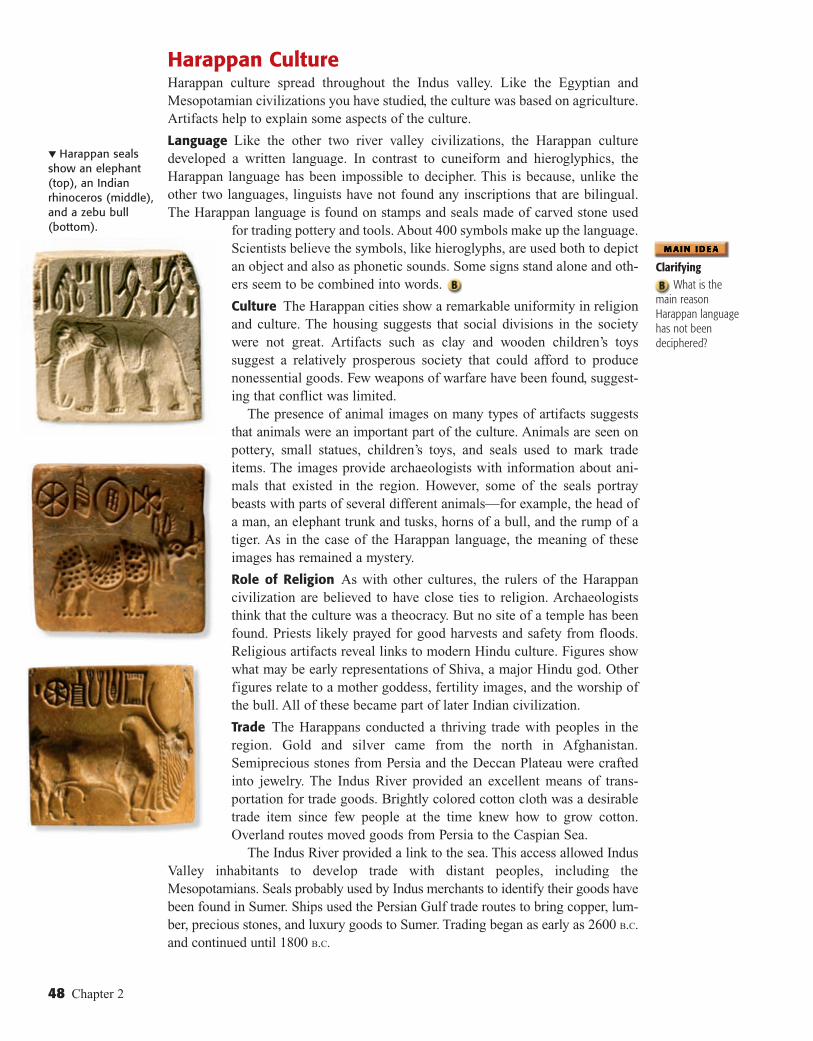
▼ Harappan seals show an elephant (top), an Indian rhinoceros (middle), and a zebu bull (bottom).
Harappan CultureHarappan culture spread throughout the Indus valley. Like the Egyptian and Mesopotamian civilizations you have studied, the culture was based on agriculture. Artifacts help to explain some aspects of the culture.
Language Like the other two river valley civilizations, the Harappan culture developed a written language. In contrast to cuneiform and hieroglyphics, the Harappan language has been impossible to decipher. This is because, unlike the other two languages, linguists have not found any inscriptions that are bilingual. The Harappan language is found on stamps and seals made of carved stone used
for trading pottery and tools. About 400 symbols make up the language. Scientists believe the symbols, like hieroglyphs, are used both to depict an object and also as phonetic sounds. Some signs stand alone and others seem to be combined into words.
Culture The Harappan cities show a remarkable uniformity in religion and culture. The housing suggests that social divisions in the society were not great. Artifacts such as clay and wooden children’s toys suggest a relatively prosperous society that could afford to produce nonessential goods. Few weapons of warfare have been found, suggesting that conflict was limited.
The presence of animal images on many types of artifacts suggests that animals were an important part of the culture. Animals are seen on pottery, small statues, children’s toys, and seals used to mark trade items. The images provide archaeologists with information about animals that existed in the region. However, some of the seals portray beasts with parts of several different animals—for example, the head of a man, an elephant trunk and tusks, horns of a bull, and the rump of a tiger. As in the case of the Harappan language, the meaning of these images has remained a mystery.
Role of Religion As with other cultures, the rulers of the Harappan civilization are believed to have close ties to religion. Archaeologists think that the culture was a theocracy. But no site of a temple has been found. Priests likely prayed for good harvests and safety from floods. Religious artifacts reveal links to modern Hindu culture. Figures show what may be early representations of Shiva, a major Hindu god. Other figures relate to a mother goddess, fertility images, and the worship of the bull. All of these became part of later Indian civilization.
Trade The Harappans conducted a thriving trade with peoples in the region. Gold and silver came from the north in Afghanistan. Semiprecious stones from Persia and the Deccan Plateau were crafted into jewelry. The Indus River provided an excellent means of transportation for trade goods. Brightly colored cotton cloth was a desirable trade item since few people at the time knew how to grow cotton. Overland routes moved goods from Persia to the Caspian Sea.
The Indus River provided a link to the sea. This access allowed Indus Valley inhabitants to develop trade with distant peoples, including the Mesopotamians. Seals probably used by Indus merchants to identify their goods have been found in Sumer. Ships used the Persian Gulf trade routes to bring copper, lumber, precious stones, and luxury goods to Sumer. Trading began as early as 2600 b.c. and continued until 1800 b.c.
Clarifying
What is the main reason Harappan language has not been deciphered?
48 Chapter 2
9-12_SNLAESE491127_010203.indd 48 6/26/10 3:05:14 PM

Indus Valley
Cities
Language
Trade
fact
fact
fact
▲ The bearded figure above might be a Harappan god or perhaps a priest king.
Analyzing Causes
What factors may have con-tributed to the decline of the Indus Valley civilization?
CRITICAL THINKING & WRITING6. DRAWING CONCLUSIONS What evidence suggests Indus
Valley cities were run by a strong central government?
7. SYNTHESIZING What skills would the construction of planned cities require? Explain.
8. MAKING INFERENCES How were the people of the Indus Valley connected to Mesopotamia?
9. WRITING ACTIVITY INTERACTION WITH ENVIRONMENT Write a comparison of how Sumerians, Egyptians, and the people of the Harappan civilization made use of their environment. Then identify which group you think made better use of what they had.
• subcontinent • monsoon • Harappan civilization
Vocabularytectonic plates: moving pieces of the earth’s crust
INTERNET KEYWORDHarappan seals
USING YOUR NOTES2. What is one conclusion you
can draw about the Indus Valley civilization?
MAIN IDEAS3. What problems can monsoons
cause?
4. How were the planned cities of the Indus Valley different from other early cities?
5. What reasons are suggested for the disappearance of the Indus Valley civilization?
Indus Valley Culture EndsAround 1750 B.C., the quality of building in the Indus Valley cities declined. Gradu ally, thegreat cities fell into decay. The fate of the cities remained a mystery until the 1970s. Then, satellite images of the subcontinent of India revealed evidence of shifts in tectonic plates. The plate movement probably caused earth-quakes and floods and altered the course of the Indus River.
Some cities along the rivers apparently suf-fered through these disasters and survived. Others were destroyed. The shifts may have caused another river, the Sarswati, to dry up. Trade on this river became impossible, and cities began to die. Harappan agriculture, too, would have been influenced by these events. It is likely that these environmental changes pre-vented production of large quantities of food. Furthermore, Harappan agriculture may have suffered as a result of soil that was exhausted by overuse. This too, may have forced people to leave the cities in order to survive.
Other factors had an impact on the Indus subcontinent. As Chapter 3 explains, the Aryans, a nomadic people from north of the Hindu Kush mountains, swept into the Indus Valley around 1500 B.C. Indian civilization would grow again under the influence of these nomads. At this same time, farther to the east, another civiliza-tion was arising. It was isolated from outside influences, as you will learn in Section 4.
TERMS & NAMES 1. For each term or name, write a sentence explaining its significance.
MULTIMEDIA ACTIVITY CREATING A SKETCH
Use the Internet to research Harappan seals. Make some sketches of what you see. Then create a sketch of a seal that might have been found in a ruin in an Indus Valley civilization.
SECTION ASSESSMENT3
Early River Valley Civilizations 49
9-12_SNLAESE491127_010203.indd 49 6/26/10 3:06:46 PM

TAKING NOTES
20°N
140°E
The Huang He, or Yellow River, is named for the color of its silt. This silt nurtured early development of Chinese civilization and is still a vital resource today.
Yellow silt gives the Huang He a distinctive color.
40°N
100°E
120°E80°E
YellowSea
P A C I F I CO C E A N
Huang He
(Yellow)
Xi Jiang
Ganges River
Indus
Rive
r
(Yangtze River)
Chang Jiang
G O B I D E S E R T
H
I MA
L A Y A S
Q I N L I N G
PLATEAU OFTIBET
NO
RT
H C
HIN
A PLAIN
T A K L I M A K A N
D E S E R TLuoyang
Anyang
Panlongcheng
Hao Yangzhou
Zhengzhou
I N D I A
C H I N A
Extent of Shang Dynasty(Approximate)
Extent of Zhou Dynasty(Approximate)
Border of modern China
0
0
500 Miles
1,000 Kilometers
Ancient China, 2000–200 B.C.
POWER AND AUTHORITY The early rulers introduced ideas about government and society that shaped Chinese civilization.
The culture that took root during ancient times still affects Chinese ways of life today.
SETTING THE STAGE The walls of China’s first cities were built 4,000 years ago. This was at least 1,000 years after the walls of Ur, the great pyramids of Egypt, and the planned cities of the Indus Valley were built. Unlike the other three river valley civilizations, the civilization that began along one of China’s river systems continues to thrive today.
The Geography of ChinaNatural barriers somewhat isolated ancient China from all other civilizations. To China’s east lay the Yellow Sea, the East China Sea, and the Pacific Ocean. Mountain ranges and deserts dominate about two-thirds of China’s landmass. In west China lay the Taklimakan (TAH•kluh•muh•KAHN) Desert and the icy 15,000-foot Plateau of Tibet. To the southwest are the Himalayas. And to the north are the desolate Gobi Desert and the Mongolian Plateau.
River Systems Two major river systems flow from the mountainous west to the Pacific Ocean. The Huang He (hwahng HUH), also known as the Yellow River, is found in the north. In central China, the Chang Jiang (chang jyhang), also called Yangtze (yang•SEE), flows east to the Yellow Sea. The Huang He, whose name means “yellow river,” deposits huge amounts of yellowish silt when it overflows its banks. This silt is actually fertile soil called loess (LOH•uhs), which is blown by the winds from deserts to the west and north.
Environmental Challenges Like the other ancient civilizations in this chapter, China’s first civilization developed in a river valley. China, too, faced the dangers of floods—but its geographic isolation posed its own challenges.
• The Huang He’s floods could be disastrous. Sometimes floods devoured whole villages, earning the river the nickname “China’s Sorrow.”
• Because of China’s relative geographic isolation, early settlers had to supply their own goods rather than trading with outside peoples.
• China’s natural boundaries did not completely protect these settlers from outsiders. Invasions from the west and north occurred again and again in Chinese history.
China’s Heartland Only about 10 percent of China’s land is suitable for farm-ing. Much of the land lies within the small plain between the Huang He and the
• loess• oracle bone• Mandate of
Heaven
River Dynasties in China
• dynasticcycle
• feudalism
MAIN IDEA WHY IT MATTERS NOW TERMS & NAMES
4
Use the graphic organizer online to take notes on major events in early Chinese dynasties.
50 Chapter 2
9-12_SNLAESE491127_010204.indd 50 6/2/10 10:54:40 AM

20°N
140°E
The Huang He, or Yellow River, is named for the color of its silt. This silt nurtured early development of Chinese civilization and is still a vital resource today.
Yellow silt gives the Huang He a distinctive color.
40°N
100°E
120°E80°E
YellowSea
P A C I F I CO C E A N
Huang He
(Yellow)
Xi Jiang
Ganges River
Indus
Rive
r
(Yangtze River)
Chang Jiang
G O B I D E S E R T
H
I MA
L A Y A S
Q I N L I N G
PLATEAU OFTIBET
NO
RT
H C
HIN
A PLAIN
T A K L I M A K A N
D E S E R TLuoyang
Anyang
Panlongcheng
Hao Yangzhou
Zhengzhou
I N D I A
C H I N A
Extent of Shang Dynasty(Approximate)
Extent of Zhou Dynasty(Approximate)
Border of modern China
0
0
500 Miles
1,000 Kilometers
Ancient China, 2000–200 B.C.
GEOGRAPHY SKILLBUILDER: Interpreting Maps 1. Location Describe the location of the Huang He and Chang Jiang in terms of where they
begin and end.2. Region What area did the Shang and Zhou dynasties control?
Chang Jiang in eastern China. This plain, known as the North China Plain, is China’s heartland. Throughout China’s long history, its political boundaries have expanded and contracted depending on the strength or weakness of its ruling fam-ilies. Yet the heartland of China remained the center of its civilization.
Civilization Emerges in Shang TimesFossil remains show that ancestors of modern humans lived in southwest China about 1.7 million years ago. In northern China near Beijing, a Homo erectus skele-ton was found. Known as Peking man, his remains show that people settled the river valley as much as 500,000 years ago.
The First Dynasties Even before the Sumerians settled in southern Mesopotamia, early Chinese cultures were building farming settlements along the Huang He. Around 2000 B.C., some of these settlements grew into China’s first cities. According to legend, the first Chinese dynasty, the Xia (shyah) Dynasty, emerged about this time. Its leader was an engineer and mathematician named Yu. His flood-control and irrigation projects helped tame the Huang He and its tributaries so that settlements could grow. The legend of Yu reflects the level of technology of a soci-ety making the transition to civilization.
About the time the civilizations of Mesopotamia, Egypt, and the Indus Valley fell to outside invaders, a people called the Shang rose to power in northern China.
VIDEOOmens in Ancient China
Early River Valley Civilizations 51
9-12_SNLAESE491127_010204.indd 51 6/14/10 10:02:45 PM
Vocabularytribute: payment made to keep peace
The Shang Dynasty lasted from around 1700 B.C. to 1027 B.C. It was the first family of Chinese rulers to leave written records. The Shang kings built elaborate palaces and tombs that have been uncovered by archaeologists.The artifacts reveal much about Shang society.
Early Cities Among the oldest and most important Shang cities was Anyang (ahn•YAHNG), one of the capitals of the Shang Dynasty. Unlike the cities of the Indus Valley or Fertile Crescent, Anyang was built mainly of wood. The city stood in a forest clearing. The higher classes lived in timber-framed houses with walls of clay and straw. These houses lay inside the city walls. The peasants and crafts-people lived in huts outside the city.
The Shang surrounded their cities with massive earthen walls for protection. The archaeological remains of one city include a wall of packed earth 118 feet wide at its base that encircled an area of 1.2 square miles. It likely took 10,000 men more than 12 years to build such a structure. Like the pyramids of Egypt or the cities of the Indus Valley, these walls demonstrate the Shang rulers’ ability to raise and con-trol large forces of workers.
Shang peoples needed walled cities because they were constantly waging war. The chariot, one of the major tools of war, was probably first introduced by contact with cul-tures from western Asia. Professional warriors underwent lengthy training to learn the techniques of driving and shooting from horse-drawn chariots.
The Development of Chinese CultureIn the Chinese view, people who lived outside of Chinese civilization were barbar-ians. Because the Chinese saw their country as the center of the civilized world, their own name for China was the Middle Kingdom.
The culture that grew up in China had strong unifying bonds. From earliest times, the group seems to have been more important than the individual. A person’s chief loyalty throughout life was to the family. Beyond this, people owed obedience and respect to the ruler of the Middle Kingdom, just as they did to the elders in their family.
Family The family was central to Chinese society. The most important virtue was respect for one’s parents. The elder men in the family controlled the family’sproperty and made important decisions. Women, on the other hand, were treated asinferiors. They were expected to obey their fathers, their husbands, and later, their own sons. When a girl was between 13 and 16 years old, her marriage was arranged, and she moved into the house of her husband. Only by bearing sons for her husband’s family could she hope to improve her status.
Social Classes Shang society was sharply divided between nobles and peasants. A ruling class of warrior-nobles headed by a king governed the Shang. These noble families owned the land. They governed the scattered villages within the Shang lands and sent tribute to the Shang ruler in exchange for local control.
Religious Beliefs In China, the family was closely linked to religion. The Chinese believed that the spirits of family ancestors had the power to bring good fortune
Comparing
What did Shang cities have in com-mon with those of Sumer?
Lady Hao’s TombLady Hao was a wife of king Wu Ding, a Shang ruler, during the 1200s b.c. Her relatively small grave contained some 460 bronze artifacts, 750 jade objects, and more than 6,880 cowry shells. Also found in the tomb beside Lady Hao’s coffin were the remains of 16 people and 6 dogs. Writings found in other places reveal a remarkable figure in Lady Hao. On behalf of her husband, she led more than one military cam paign, once with a force of 13,000 troops. She also took charge of rituals dedicated to the spirits of Shang ancestors, a duty reserved for the most distinguished members of the royal family.
INTERNET ACTIVITY Go online to create a multimedia presentation about Lady Hao's tomb and its contents.
52 Chapter 2
9-12_SNLAESE491127_010204.indd 52 7/30/10 12:40:18 PM

Chinese Writing
The earliest writing systems in the world—including Chinese, Sumerian, and Egyptian—developed from pictographs, or simplified drawings of objects. The writing system used in China today is directly related
to the pictographic writing found on Shang oracle bones. As you can see in the chart below, the ancient pictographs can still be recognized in many modern Chinese characters.
ox goat, sheep tree moon earth water field heaven to pray
Ancientsymbol
Moderncharacter
Recognizing Effects
How did writing help unite China?
or disaster to living members of the family. The Chinese did not regard these spirits as mighty gods. Rather, the spirits were more like troublesome or helpful neighbors who demanded attention and respect. Every family paid respect to the father’s ancestors and made sacrifices in their honor.
Through the spirits of the ancestors, the Shang consulted the gods. The Shang worshiped a supreme god, Shang Di, as well as many lesser gods. Shang kings consulted the gods through the use of oracle bones, animal bones and tortoise shells on which priests had scratched questions for the gods. After inscribing a question on the bone, a priest applied a hot poker to it, which caused it to crack. The priests then interpreted the cracks to see how the gods had answered.
Development of Writing In the Chinese method of writing, each character generally stands for one syllable or unit of language. Recall that many of the Egyptian hiero-glyphs stood for sounds in the spoken language. In contrast, there were practically no links between China’s spoken lan-guage and its written language. One could read Chinese with-out being able to speak a word of it. (This seems less strange when you think of our own number system. Both a French person and an American can understand the written equation 2 + 2 = 4. But an American may not understand the spoken statement “Deux et deux font quatre.”)
The Chinese system of writing had one major advantage. People in all parts of China could learn the same system of writing, even if their spoken languages were very different. Thus, the Chinese written language helped unify a large and diverse land, and made control much easier.
The disadvantage of the Chinese system was the enormous number of written characters to be memorized—a different one for each unit of language. A person needed to know over 1,500 characters to be barely literate. To be a true scholar, one needed to know at least 10,000 characters. For centuries, this severely limited the number of literate, educated Chinese. As a general rule, a nobleperson’s children learned to write, but peasant children did not.
▲ The earliest evidence of Chinese writing is seen on oracle bones like this one found in the city of Anyang.
Early River Valley Civilizations 53
9-12_SNLAESE491127_010204.indd 53 6/26/10 3:13:21 PM

Strong dynasty establishes peace and prosperity; it is considered to have Mandate of Heaven.
In time, dynasty declines and becomes corrupt; taxes are raised; power grows weaker.
Disasters such as floods, famines, peasant revolts, and invasions occur.
Old dynasty is seen as having lost Mandate of Heaven; rebellion is justified.
Dynasty is overthrown through rebellion and bloodshed; new dynasty emerges.
New dynasty gains power, restores peace and order, and claims to have Mandate of Heaven.
Dynastic Cycle in China
Synthesizing
According to Chinese beliefs, what role did the Mandate of Heaven play in the dynastic cycle?
Vocabularymandate: a com-mand or instruction from a higher authority
Zhou and the Dynastic CycleAround 1027 b.c., a people called the Zhou (joh) overthrew the Shang and established their own dynasty. The Zhou had adopted much of the Shang culture. Therefore, the change in dynasty did not bring sweeping cultural change. Nevertheless, Zhou rule brought new ideas to Chinese civilization.
Mandate of Heaven To justify their conquest, the Zhou leaders declared that the final Shang king had been such a poor ruler that the gods had taken away the Shang’s rule and given it to the Zhou. This justification developed over time into a broader view that royal authority came from heaven. A just ruler had divine approval, known as the Mandate of Heaven. A wicked or foolish king could lose the Mandate of Heaven and so lose the right to rule. The Duke of Shao, an aide of the Zhou leader who conquered the Shang, described the mandate:
P r i M a r y S o u r C e Heaven, unpitying, has sent down ruin on Yin [another name for Shang]. Yin has lost the Mandate, and we Zhou have received it. I dare not say that our fortune would continue to prosper, even though I believe that heaven favors those who are sincere in their intentions. I dare not say, either that it would end in certain disaster. . . .
The Mandate of Heaven is not easy to gain. It will be lost when men fail to live up to the reverent and illustrious virtues of their forefathers.
Duke of SHao, quoted in The Chinese Heritage
The Mandate of Heaven became central to the Chinese view of government. Floods, riots, and other calamities might be signs that the ancestral spirits were displeased with a king’s rule. In that case, the Mandate of Heaven might pass to another noble family. This was the Chinese explanation for rebellion, civil war, and the rise of a new dynasty. Historians describe the pattern of rise, decline, and replacement of dynasties as the dynastic cycle, shown above.
Control Through feudalism The Zhou Dynasty controlled lands that stretched far beyond the Huang He in the north to the Chang Jiang in the south. To govern this vast area, it gave control over different regions to members of the royal family and other trusted nobles. This established a system called feudalism. Feudalism is a political system in which nobles, or lords, are granted the use of lands that legally belong to the king. In return, the nobles owe loyalty and military service to the king and protection to the people who live on their estates. Similar systems would arise centuries later in both Japan and Europe.
At first, the local lords lived in small walled towns and had to submit to the superior strength and control of the Zhou rulers. Gradually, however, the lords grew stronger as the towns grew into cities and expanded into the surrounding territory.
54 Chapter 2
9-12_SNLAESE491127_010204.indd 54 6/26/10 3:15:27 PM

event 1
event 2
event 3>
▲ These Chinese coins are made of bronze. Their shape resembles a digging tool such as a hoe or spade.
CRITICAL THINKING & WRITING6. RECOGNIZING EFFECTS In your judgment, what are the
benefits and drawbacks of the belief that the group was more important than the individual?
7. COMPARING How did the social classes in Shang society differ from those in Egyptian society?
8. ANALYZING MOTIVES Do you think that the Zhou Dynasty’s downfall resulted from its method of control? Why or why not?
9. WRITING ACTIVITY POWER AND AUTHORITY Study the dynastic cycle. Then write a letter to the editor suggesting that the current ruler should be replaced.
USING YOUR NOTES2. Which event do you think was
a turning point in Chinese history?
MAIN IDEAS3. Between which two rivers is
the heartland of China found?
4. What family obligations did a Chinese person have?
5. How is the dynastic cycle connected to the Mandate of Heaven?
TERMS & NAMES 1. For each term or name, write a sentence explaining its significance.
Peoples who had been hostile toward the lords gradually accepted their rule and adopted Zhou ways. As a result, the local lords became less dependent on the king. More and more, they fought among themselves and with neighboring peoples for wealth and territory.
Improvements in Technology and Trade The Zhou Dynasty pro-duced many innovations.
• Roads and canals were built to stimulate trade and agriculture.• Coined money was introduced, which further improved trade. • Blast furnaces that produced cast iron were developed. Zhou cast iron production would not be matched in Europe until
the Middle Ages. The Zhou used iron to create weapons, especially dagger-axes and swords. They also used it for common agricultural tools such as sickles, knives, and spades. Iron tools made farm work easier and more productive. The ability to grow more food helped Zhou farmers support thriving cities.
A Period of Warring States The Zhou ruled from around 1027 to 256 B.C. The Zhou empire was generally peaceful and stable. Gradually, however, Zhou rule weakened. In 771 B.C., nomads from the north and west sacked the Zhou capital and murdered the Zhou monarch. A few members of the royal family escaped and set up a new capital at Luoyang.
However, the Zhou kings at Luoyang were almost powerless, and they could not control the noble families. The lords sought every opportunity to pick fights with neighboring lords. As their power grew, these warlords claimed to be kings in their own territory. As a result, the later years of the Zhou are often called “the time of the warring states.”
Amidst the bloodshed, traditional values collapsed. The very heart of Chinese civilization—love of order, harmony, and respect for authority—had been replaced with chaos, arrogance, and defiance. As you will learn in Chapter 4, the dynastic cycle was about to bring a new start to Chinese civilization.
CREATING A POSTER
Research the Three Gorges Dam Project in China. The project will place dams on the Chang Jiang. Create a poster showing the locations of the dams, some statistics about them, and an explanation of the project’s purpose.
CONNECT TO TODAY
• loess • oracle bone • Mandate of Heaven • dynastic cycle • feudalism
SECTION ASSESSMENT4
Early River Valley Civilizations 55
9-12_SNLAESE491127_010204.indd 55 5/29/10 5:24:35 PM

45º
Early River Valley Civilizations
• Tigris and Euphrates flooding unpredictable
• No natural barriers
• Limited natural resources
• Nile flooding predictable
• Natural barriers: deserts
• Nile an easy transportation link
• Indus flooding unpredictable
• Natural barriers: mountains, deserts
• Monsoon winds
• Huang He flooding unpredictable
• Natural barriers: mountains, deserts
• Geographically isolated
• Independent city-states governed by monarchs
• City-states united into first empires
• Pharaohs rule kingdom as gods
• Pharaohs built pyramids
• Strong centralized government
• Planned cities
• Community and family important
• Sharp social divisions
• Mandate of Heaven
• Cuneiform
• Irrigation
• Bronze
• Wheel, sail, plow
• Hieroglyphics
• Pyramids
• Mathematics, geometry
• Medicine
• Writing (not yet deciphered)
• Cities built on precise grid
• Plumbing and sewage systems
• Writing
• Silk
• Coined money
• Cast iron
Sumer
Environment
Power and Authority
Science and Technology
Egypt Indus Valley China
Sumer Egypt
China
Similar-ities
River Dynasties in China Section 4 (pages 50–55)
16. What was the great advantage of the Chinese written language?
17. Explain the dynastic cycle in China.
CRITICAL THINKING1. USING YOUR NOTES
Create a Venn diagram to indicate differences and similarities in religious beliefs among these ancient civilizations.
2. HYPOTHESIZING POWER AND AUTHORITY Think about a massive public project that might be done today, such as building a large dam. In terms of government power and authority, how would this be similar to the building of the pyramids? How would it be different?
3. DRAWING CONCLUSIONS SCIENCE AND TECHNOLOGY Why was it necessary to develop writing before civilization could advance?
4. MAKING INFERENCESWhat reasons might be suggested for the location of civilizations along river valleys?
5. COMPARINGHow was a theocracy different from a government run by warrior-kings?
Chapter 2 Assessment
TERMS & NAMESBriefly explain the importance of each of the following to early river valley civilizations from 3500–450 b.c.
1. Fertile Crescent 5. pharaoh
2. city-state 6. hieroglyphics
3. polytheism 7. Harappan civilization
4. empire 8. Mandate of Heaven
MAIN IDEASCity-States in Mesopotamia Section 1 (pages 29–34)
9. What is the Fertile Crescent and why is it called that?
10. Name three disadvantages of Sumer’s natural environment.
11. What circumstances led to the beginning of organized government?
Pyramids on the Nile Section 2 (pages 35–43)
12. Why did the Egyptians build pyramids?
13. Herodotus remarked that Egypt was the “gift of the Nile.” What did he mean by this?
Planned Cities on the Indus Section 3 (pages 44–49)
14. What does the uniformity of Indus Valley cities tell us about their government?
15. What evidence exists to show that Indus Valley civilizations traded with Sumer?
56 Chapter 2
9-12_SNLAESE491127_0102CA.indd 56 5/29/10 5:43:14 PM

Arab ianSea
Mediterranean Sea
Black Sea
Red Sea
Caspian SeaBay o fBenga l
Sou thChina
Sea
Indu
s R.
Tigris R.
Nile R.
Chang Jiang
Euphrates R.
Huang He
MemphisUr
Mohenjo-Daro
AnyangHIM
ALAYAS
40°N
120°E
80°E
40°E
Tropic of Cancer
0
0
1,000 Miles
2,000 Kilometers
Tropical-wetTropical-drySemidesertDesertMediterraneanHumid subtropicalContinentalSubarcticMountain
45º
Early River Valley Civilizations
• Tigris and Euphrates flooding unpredictable
• No natural barriers
• Limited natural resources
• Nile flooding predictable
• Natural barriers: deserts
• Nile an easy transportation link
• Indus flooding unpredictable
• Natural barriers: mountains, deserts
• Monsoon winds
• Huang He flooding unpredictable
• Natural barriers: mountains, deserts
• Geographically isolated
• Independent city-states governed by monarchs
• City-states united into first empires
• Pharaohs rule kingdom as gods
• Pharaohs built pyramids
• Strong centralized government
• Planned cities
• Community and family important
• Sharp social divisions
• Mandate of Heaven
• Cuneiform
• Irrigation
• Bronze
• Wheel, sail, plow
• Hieroglyphics
• Pyramids
• Mathematics, geometry
• Medicine
• Writing (not yet deciphered)
• Cities built on precise grid
• Plumbing and sewage systems
• Writing
• Silk
• Coined money
• Cast iron
Sumer
Environment
Power and Authority
Science and Technology
Egypt Indus Valley China
Arab ianSea
Mediterranean Sea
Black Sea
Red Sea
Caspian Sea
Bay o fBenga l
Sou thChina
Sea
Indu
s R.
Tigris R.
Nile R.
Chang Jiang
Euphrates R.
Huang He
MemphisUr
Mohenjo-Daro
AnyangHIM
ALAYAS
40°N
120°E
80°E
40°E
Tropic of Cancer
0
0
1,000 Miles
2,000 Kilometers
Tropical-wetTropical-drySemidesertDesertMediterraneanHumid subtropicalContinentalSubarcticMountain
Use the quotation and your knowledge of world history to answer questions 1 and 2.
The Lord of Fishes, He Who Makes the marsh birds to Go Upstream. There are no birds which come down because of the hot winds. He who makes barley and brings emmer [a kind of wheat] into being, that he may make the temples festive. If he is sluggish, then nostrils are stopped up, and everybody is poor. If there be thus a cutting down in the food offerings of the gods, then a million men perish among mortals, covetousness is practiced, the entire land is in a fury, and great and small are on the execution-block. . . . When he rises, then the land is in jubilation, then every belly is in joy, every backbone takes on laughter, and every tooth is exposed.
“Hymn to the Nile,” from Ancient Near Eastern Texts
1. What natural phenomenon does the Lord of the Fishes represent?
A. volcanic action
B. monsoons
C. the annual flooding of the Nile
D. a major fish kill
2. Why are the people happy when the Lord of the Fishes comes to them?
A. The wars they fight will be over.
B. They will have food to eat.
C. Corruption will stop.
D. There will be a new pharaoh.
Use the map and your knowledge of world history to answer question 3.
3. How is the location of Anyang different from the other cities shown?
A. It is located in the Western Hemisphere.
B. It is not located in a river valley.
C. Its climate is tropical.
D. Its climate is not dry.
World Climate Regions
For additional test practice, go online for:
• Diagnostic tests
• Strategies
• Tutorials
MULTIMEDIA ACTIVITY
Creating a Multimedia PresentationUsing the Internet, the library, or government resources, research the street structure of Washington, D.C., Boston, or the structure of your hometown streets. Identify their similarities and differences. Then research/work with a team to present your findings in a multimedia presentation.
• Which cities have a grid system? Which do not?
• What evidence is there of planning in the cities?
• What are the obvious similarities and differences of the twolocations?
On page 28, you looked at the justice of Hammurabi’s Code. Now that you have read about the development of four civilizations, think about how laws differ from place to place. How have they developed and changed over time? What similarities do you see between Hammurabi’s Code and the laws you live under today? How are they different? Discuss your opinions with a small group.
STANDARDS-BASED ASSESSMENT
INTERACTION WITH ENVIRONMENT Write four poems, one for each civilization in the chapter. Include some reference to how each civilization interacted with the environment. Consider the following:
• the effect of the environment on life in the area
• responses to the environment by the people
FOCUS ON WRITING
Early River Valley Civilizations 57
9-12_SNLAESE491127_0102CA.indd 57 7/29/10 11:53:59 PM