juniper dunes access road wa franklin 2013(1 ... · es-3 the alternatives analyzed in this...
TRANSCRIPT

U.S. Department of Transportation Federal Highway Administration Western Federal Lands Highway Division Vancouver, Washington
Juniper Dunes Access Road WA Franklin 2013(1) Environmental Assessment And Section 4(f) Evaluation
FINAL EA
April 2015

(This page intentionally left blank.)


(This page intentionally left blank.)

ES-1
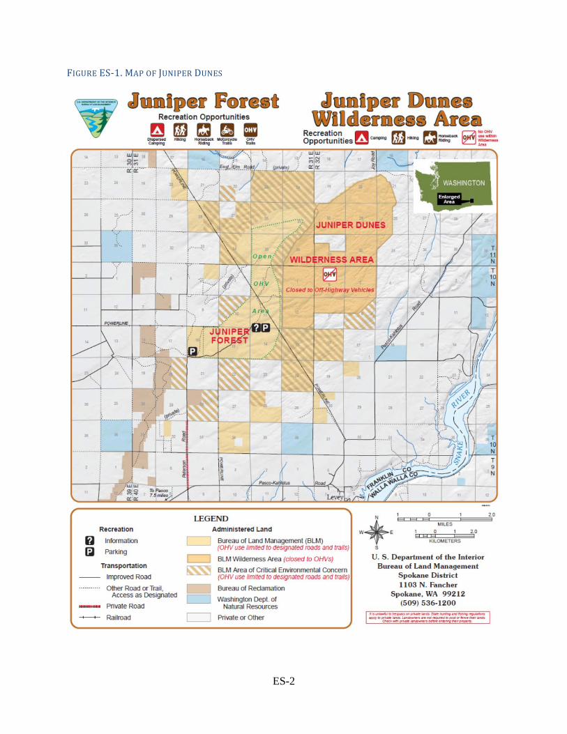
Executive Summary The Western Federal Lands Highway Division (WFLHD) of the Federal Highway Administration (FHWA), in partnership with the Bureau of Land Management (BLM) and Franklin County (collectively referred to as “Project Partners”), is planning to construct a public access road to the Juniper Dunes Wilderness and off-highway vehicle areas (Juniper Dunes). Juniper Dunes is located approximately 10 miles northeast of Pasco, Washington, in Franklin County. Juniper Dunes is used primarily for off-highway vehicles (OHVs), but is also used for picnicking and camping, and some hiking, horseback riding, and hunting. Currently, the 19,600 acres of publically-owned land in Juniper Dunes is accessed by Peterson Road, which intersects with Pasco-Kahlotus Road. Portions of Peterson Road are private, with no access easement. A map of the Juniper Dunes area is provided in Figure ES-1. Juniper Dunes consists of three adjoining areas comprising a total of approximately 19,600 acres. Each area has different use regulations:
Juniper Dunes Wilderness - The 7,100-acre wilderness area, designated in 1984, is fenced. Motorized and mechanized use (including bicycles and game carts) is strictly prohibited within the wilderness area.
OHV "Open" Area - A 3,920-acre OHV area is designated as "Open" to OHV use. Cross-country travel is permissible throughout the "Open" area.
ACEC - Lastly, within the 8,620-acre Area of Critical Environmental Concern (ACEC), currently motorized travel is limited to existing routes – to protect natural resources no off-route travel is allowed.
The purpose of this project is to provide a legal public access road to the Juniper Dunes Wilderness Area and adjacent OHV open area, starting at a public road and ending at a staging area in the Juniper Dunes OHV open area. The needs associated with this project are:
Users currently access Juniper Dunes area by a private road that does not have an access easement.
The owners of the road have closed Peterson Road in the past, cutting off access to the public.
Peterson Road is not constructed or maintained by the County, so it does not meet County standards for safety and maintenance.
There has been damage to private property along Peterson Road from users of the road. The most accessible parking area for the OHV area is outside of the OHV area and is
near to private property. The poor road conditions make it difficult for law enforcement and emergency medical
services to access the area.
ES-2
FIGUREES‐1.MAPOFJUNIPERDUNES

ES-3
The alternatives analyzed in this Environmental Assessment (EA) are (see map of the alternatives in Figure 1-1):
No Build Alternative: this alternative would not build a new road to Juniper Dunes. Alternative 1A: an alignment starting at the intersection of Peterson Road and Pasco-
Kahlotus Road and ending at the designated endpoint in the OHV area. It travels north for approximately 4.2 miles and approximately east-north-east for 1 mile.
Alternative 1B: an alignment starting at the intersection of Peterson Road and Pasco-Kahlotus Road and ending at the designated endpoint in the OHV area. It travels north for approximately 3.2 miles, east for approximately 1 mile, and north for approximately 1.2 miles.
Alternative 1C: an alignment starting at the intersection of Peterson Road and Pasco-Kahlotus Road and ending at the designated endpoint in the OHV area. It travels north for approximately 2.5 miles, then roughly follows an existing OHV pathway east-north-east for approximately 1 mile, then north for approximately 1.7 miles.
Alternative 2: an alignment along the section line (property line) one mile to the east of Peterson Road. The alignment would travel north from Pasco-Kahlotus Road approximately 4.2 miles, arriving at the same endpoint in the OHV area.
This EA analyzes the environmental impacts from the alternatives, as summarized in Table ES-1 below. Some impacts can be reduced by mitigation measures. TABLEES‐1.SUMMARYOFIMPACTSBYALTERNATIVEFORTHEPROPOSEDJUNIPERDUNESACCESSROADPROJECT
Environmental Discipline
No Build Alternative 1A
Alternative 1B
Alternative 1C
Alternative 2
Transportation, Circulation
No legal access.
No county maintenance.
Legal access. Road maintained by County. Some users may still use existing parking area outside of OHV area.
Legal access. Road maintained by County.
Legal access. Road maintained by County. Conflict between vehicles and OHVs in Smith Canyon.
Legal access. Road maintained by County. Some users may still use Peterson Road.
Land Use No impact. Low change in land use.
Low change in land use. Access to “landlocked” parcels.
Low change in land use. Access to “landlocked” parcels.
Low change in land use. Access to “landlocked” parcels.
Property Acquisitions (acres)
No impact. Private: 24.41Fed.: 27.0 Total: 51.41
Private: 28.22Fed.: 19.80 Total: 48.02
Private: 24.60 Fed.: 22.48 Total: 47.08
Private: 29.12Fed.: 11.64 Total: 40.76
Water Resources
No impact. Slight increase in
Slight increase in
Slight increase in stormwater
Slight increase in

ES-4
stormwater runoff.
stormwater runoff.
runoff. stormwater runoff.
Wetlands No impact. No impact. No impact. No impact. No impact.
Floodplains No impact. No impact. No impact. No impact. No impact.
Fish, Wildlife and Vegetation
No impact. 18.3 ac habitat impact. Potential impact to special status (non-ESA) species.
26.2 ac habitat impact. Potential impact to special status (non-ESA) species.
27.9 ac habitat impact. Potential impact to special status (non-ESA) species.
36.6 ac habitat impact. Potential impact to special status (non-ESA) species.
Cultural and Historical Resources
No impact. Low risk of cultural resource impacts.*
Low risk of cultural resource impacts.*
1 cultural resource impact.*
No cultural resource impacts.**
Recreation No legal public access.
Legal access. Improved access to recreation.
Legal access. Improved access to recreation.
Legal access. Improved access to recreation. Impact to Smith Canyon OHV use.
Legal access. Improved access to recreation.
Soils and Geology
No impact. Minimal impact.
Minimal impact.
Minimal impact.
Minimal impact.
Noise No impact. Minimal long-term impact. Construction noise.
Minimal long-term impact. Construction noise.
Minimal long-term impact. Construction noise.
Minimal long-term impact. Construction noise.
Visual Quality No impact. Low impact. Low impact. Low impact.
Some impact to Smith Canyon.
Low/mid level impact.
Hazardous Materials
No Impact. Potential for hazardous materials spills during construction.
Potential for hazardous materials spills during construction.
Potential for hazardous materials spills during construction.
Potential for hazardous materials spills during construction.
Air Quality No impact. Temporary increase in dust and exhaust during
Temporary increase in dust and exhaust during
Temporary increase in dust and exhaust during
Temporary increase in dust and exhaust during

ES-5
construction construction construction construction
Prime Farmland No impact. Low impact. NRCS impact rating = 119
Low impact. NRCS impact rating = 121
Low impact. NRCS impact rating = 117
Low impact. NRCS impact rating = 114
Utilities No impact. Minimal impacts.
Minimal impacts.
Minimal impacts.
Relocation of power poles and minimal impacts.
Socioeconomics No impact. Access to “landlocked” parcels. Temporary economic benefit due to construction.
Access to “landlocked” parcels. Temporary economic benefit due to construction.
Access to “landlocked” parcels. Temporary economic benefit due to construction.
Access to “landlocked” parcels. Temporary economic benefit due to construction.
Environmental Justice
No impact. No impact. No impact. No impact. No impact.
*Based on background research **Based on field survey

ES-6
(This page intentionally left blank.)
TableofContents1 INTRODUCTION ................................................................................................................. 1
1.1 Background ...................................................................................................................... 1
1.2. NEPA compliance ............................................................................................................ 1
1.3 Scope and Nature of the Proposed Project ....................................................................... 4
1.4 Public, Agency and Tribal Involvement in the Scoping Process ..................................... 4
1.5 Jurisdiction ....................................................................................................................... 7
1.6 Funding ............................................................................................................................ 7
2 PURPOSE AND NEED FOR PROJECT ........................................................................... 8
3 ALTERNATIVES CONSIDERED ..................................................................................... 9
3.1 No Build Alternative ........................................................................................................ 9
3.2 Alternative 1A .................................................................................................................. 9
3.3 Alternative 1B .................................................................................................................. 9
3.4 Alternative 1C ................................................................................................................ 10
3.5 Alternative 2................................................................................................................... 10
3.6 Features Common to all Build Alternatives ................................................................... 10
3.7 How the Build Alternatives Satisfy the Purpose and Need ........................................... 10
3.8 Alternatives Considered but Dismissed ......................................................................... 11
4 AFFECTED ENVIRONMENT AND ENVIRONMENTAL CONSEQUENCES ........ 13
4.1 Transportation and Circulation ...................................................................................... 14
4.1.1 Affected Environment .............................................................................................. 14
4.1.2 Direct Impacts .......................................................................................................... 18
4.1.3 Temporary Impacts .................................................................................................. 19
4.2 Land Use ........................................................................................................................ 19
4.2.1 Affected Environment .............................................................................................. 19
4.2.2 Direct Impacts .......................................................................................................... 23
4.2.3 Indirect Impacts ....................................................................................................... 23
4.2.4 Cumulative Impacts ................................................................................................. 23
4.3 Property Acquisitions..................................................................................................... 24
4.3.1 Affected Environment .............................................................................................. 24
4.3.2 Direct Impacts .......................................................................................................... 26
4.3.3 Temporary Impacts .................................................................................................. 29

4.3.4 Mitigation or Compensation .................................................................................... 29
4.4 Water Resources ............................................................................................................ 30
4.4.1 Affected Environment .............................................................................................. 30
4.4.2 Direct Impacts .......................................................................................................... 30
4.4.3 Indirect Impacts ....................................................................................................... 31
4.5 Wetlands ........................................................................................................................ 31
4.5.1 Affected Environment .............................................................................................. 31
4.5.2 Direct Impacts .......................................................................................................... 31
4.6 Floodplains ..................................................................................................................... 31
4.6.1 Affected Environment .............................................................................................. 31
4.6.2 Direct Impacts .......................................................................................................... 31
4.7 Fish, Wildlife and Vegetation ........................................................................................ 32
4.7.1 Affected Environment .............................................................................................. 32
4.7.2 Direct Impacts .......................................................................................................... 40
4.7.3 Indirect Impacts ....................................................................................................... 44
4.7.4 Cumulative Impacts ................................................................................................. 45
4.7.5 Mitigation ................................................................................................................. 45
4.8 Cultural and Historical Resources ................................................................................. 46
4.8.1 Affected Environment .............................................................................................. 49
4.8.2 Direct Impacts .......................................................................................................... 51
4.9 Recreation ...................................................................................................................... 52
4.9.1 Affected Environment .............................................................................................. 52
4.9.2 Direct Impacts .......................................................................................................... 53
4.9.3 Indirect Impacts ....................................................................................................... 54
4.10 Soils and Geology .......................................................................................................... 54
4.10.1 Affected Environment .............................................................................................. 54
4.10.2 Direct Impacts .......................................................................................................... 55
4.10.3 Temporary Impacts .................................................................................................. 55
4.10.4 Mitigation ................................................................................................................. 55
4.11 Noise .............................................................................................................................. 55
4.11.1 Affected Environment .............................................................................................. 55
4.11.2 Direct Impacts .......................................................................................................... 56
4.11.3 Temporary Impacts .................................................................................................. 56
4.11.4 Mitigation ................................................................................................................. 56

4.12 Visual Quality ................................................................................................................ 57
4.12.1 Affected Environment .............................................................................................. 57
4.12.2 Direct Impacts .......................................................................................................... 57
4.12.3 Cumulative Impacts ................................................................................................. 58
4.13 Hazardous Material ........................................................................................................ 58
4.13.1 Affected Environment .............................................................................................. 58
4.13.2 Direct Impacts .......................................................................................................... 59
4.13.3 Temporary Impacts .................................................................................................. 59
4.13.4 Mitigation ................................................................................................................. 59
4.14 Air Quality ..................................................................................................................... 59
4.14.1 Affected Environment .............................................................................................. 59
4.14.2 Direct Impacts .......................................................................................................... 60
4.14.3 Temporary Impacts .................................................................................................. 60
4.14.4 Mitigation ................................................................................................................. 60
4.15 Prime, Unique, Statewide and Locally Important Farmlands ........................................ 60
4.15.1 Affected Environment .............................................................................................. 61
4.15.2 Direct Impacts .......................................................................................................... 61
4.15.3 Cumulative Impacts ................................................................................................. 62
4.16 Utilities ........................................................................................................................... 63
4.16.1 Affected Environment ............................................................................................. 63
4.16.2 Direct Impacts .......................................................................................................... 63
4.16.3 Temporary Impacts .................................................................................................. 63
4.16.4 Mitigation ................................................................................................................. 63
4.17 Socioeconomics ............................................................................................................. 63
4.17.1 Affected Environment .............................................................................................. 63
4.17.2 Direct Impacts .......................................................................................................... 63
4.17.3 Temporary Impacts .................................................................................................. 64
4.18 Environmental Justice .................................................................................................... 64
4.19 Construction Staging Areas ........................................................................................... 64
5 SECTION 4(F) EVALUATION ........................................................................................... 66
Park, Recreation or Refuge 4(f) resources ............................................................................ 66
Juniper Dunes OHV Area De Minimis Impact Determination ............................................. 67
Juniper Dunes ACEC De Minimis Impact Determination .................................................... 68
6 IRREVERSIBLE OR IRRETRIEVABLE COMMITMENT OF RESOURCES ................ 70

7 SUMMARY OF MITIGATION MEASURES .................................................................... 71
8 PERMITS AND APPROVALS ............................................................................................ 74
9 COORDINATION AND CONSULTATION ...................................................................... 75
9.1 Agency Coordination ..................................................................................................... 75
9.2 Tribal Coordination ........................................................................................................ 75
9.3 Public Involvement ........................................................................................................ 75
9.4 List of Preparers ............................................................................................................. 75
10 REFERENCES ..................................................................................................................... 76
APPENDIX A - FHWA Coordination
APPENDIX B - Range of Alternatives Memo
APPENDIX C - Wetland Determination Memo
APPENDIX D - Biological Resources Report
APPENDIX E - Prime and Unique Farmlands Form
APPENDIX F - Section 4(f) de minimis Concurrence from BLM

List of Abbreviations
AASHTO – American Association of State Highway and Transportation Officials ACEC – Area of Critical Environmental Concern AADT – Annual Average Daily Traffic APE – Area of Potential Effect BMP – Best Management Practices BLM – Bureau of Land Management CBP– Columbia Basin Project EA – Environmental Assessment EPA – U.S. Environmental Protection Agency ESA – Endangered Species Act EWU– Eastern Washington University’s Archaeological and Historical Services FHWA – Federal Highway Administration FLAP – Federal Land Access Program FR – Federal Register GPS – Global Positioning System LWCFA – Land and Water Conservation Fund Act MBTA– Migratory Bird Act MP – Mile Post MPH – Miles Per Hour NEPA – National Environmental Policy Act NRCS – Natural Resources Conservation Service NRHP – National Register of Historic Places OHV – Off Highway Vehicle ROW – Right of Way SADT– Seasonal Average Daily Traffic SEPA – State Environmental Policy Act SHPO – State Historic Preservation Officer SOC – Species of Concern SUP – Special Use Permit TMDL – Total Maximum Daily Load TRAC – Trade, Recreation, Agricultural, and Convention Center UNIFORM ACT – Uniform Relocation Assistance and Real Property Acquisition Policies Act of
1970 (as amended) USACE – United States Army Corps of Engineers USDOT – U.S. Department of Transportation USFS – U.S. Forest Service USFWS – U.S. Fish and Wildlife Service WSDOT – Washington State Department of Transportation WDFW – Washington Department of Fish and Wildlife WFLHD – Western Federal Lands Highway Division

(This page intentionally left blank.)

1
1 INTRODUCTION
1.1 Background The Western Federal Lands Division of the Federal Highway Administration, in partnership with the Bureau of Land Management and Franklin County (collectively referred to as “Project Partners”), is planning to construct a public access road to the Juniper Dunes Wilderness and off-highway vehicle areas (Juniper Dunes). Juniper Dunes is located approximately 10 miles northeast of Pasco, Washington in Franklin County. Juniper Dunes is used primarily for off-highway vehicles (OHVs), but is also used for picnicking and camping, and some hiking, horseback riding, and hunting. Currently, the 19,600 acres of publically-owned land in Juniper Dunes is accessed by Peterson Road, which intersects with Pasco-Kahlotus Road. Portions of Peterson Road are private with no access easement. A map of the Juniper Dunes area is provided in Figure ES-1. The public and private lands in the Juniper Dunes area have been used since the 1960s for various recreational uses. The area also includes a distinct ecosystem of juniper forest as well as some of the largest sand dunes in the state of Washington. In 1971, BLM started acquiring land in the area for the purpose of protecting the ecosystem and providing public recreation opportunities. In 1984, the Washington State Wilderness Act designated approximately 7,100 acres as the Juniper Dunes Wilderness. The BLM adopted a Juniper Dunes Wilderness Management Plan in 1986 and in the Plan recognized that Juniper Dunes does not have legal public access. BLM and Franklin County have been working since that time to provide legal public access to Juniper Dunes (Juniper Dunes Wilderness Management Plan 1986). Juniper Dunes consists of three adjoining areas comprising a total of approximately 19,600 acres. Each area has different use regulations:
Juniper Dunes Wilderness - The 7,100-acre wilderness area, designated in 1984, is fenced. Motorized and mechanized use (including bicycles and game carts) is strictly prohibited within the wilderness area.
OHV "Open" Area - A 3,920-acre OHV area is designated as "Open" to OHV use. Cross-country travel is permissible throughout the "Open" area.
ACEC - Lastly, within the 8,620-acre Area of Critical Environmental Concern (ACEC), currently motorized travel is limited to existing routes – to protect natural resources no off-route travel is allowed
1.2. NEPA compliance This Environmental Assessment (EA) was prepared by the FHWA as the federal lead for National Environmental Policy Act (NEPA) compliance. The EA describes the reasonable range of alternatives and the process the Project Partners used to determine these alternatives. It also analyzes the impacts of these alternatives in the context of the existing environmental conditions and proposes mitigation measures to reduce or eliminate impacts.

2
Multiple alternatives are being analyzed in this EA for access to Juniper Dunes. All build alternatives intersect with Pasco-Kahlotus Road at the current intersection with Peterson Road (Mile Post (MP) 5.95), or along the section line (property line) one mile east of Peterson Road (MP 6.95). All build alternatives end at a designated endpoint located in Juniper Dunes OHV area approximately 4.2 miles north of Pasco-Kahlotus Road along the section line one mile east (See Figure 1-1).

3
FIGURE1‐1.JUNIPERDUNESALTERNATIVES

4
This EA is organized into the following sections: Summary - condenses the key information in the document. Introduction - describes the background of Juniper Dunes and purpose of the
document. Project Purpose and Need - describes the reason for the project and the conditions
requiring relief Alternatives Considered - describes the reasonable range of alternatives analyzed in
this document, as well as the alternatives considered but dismissed, and the process that Project Partners used to determine these alternatives.
Affected Environment and Environmental Consequences - describes the existing conditions and the project impacts.
Section 4(f) Evaluation - describes impacts to certain historic or recreational resources to satisfy the Section 4(f) of the Department of Transportation Act.
Irreversible or Irretrievable Commitment of Resources - describes any resources that once used, cannot be reversed.
Summary of Mitigation Measures - lists all the mitigation measures proposed in this EA.
Permits and Approvals - lists anticipated permits and approvals that the Project Partners must obtain.
Coordination and Consultation - includes the preparers of this document and summarizes the public and agency consultation.
References and Appendices.
1.3 Scope and Nature of the Proposed Project The proposed project would include constructing a new access road from Pasco-Kahlotus Road to a designated endpoint in Juniper Dunes. The length will vary depending on alternative. It would have two 12-foot travel lanes with 2-foot shoulders (28 feet wide total). The first mile would be asphalt over rock base and the remainder would be treated with chip seal (an application of a protective wearing surface to the road). The proposed project will also include signing and fencing as necessary.
1.4 Public, Agency and Tribal Involvement in the Scoping Process An integral part of the environmental review process is to engage the public. The goal of the public involvement process is to develop public awareness and understanding of the project, gain public input from potentially affected interests, and then appropriately consider public issues and concerns in the project development process. In early 2014, Franklin County and FHWA considered many alternatives to access Juniper Dunes. An initial review of alternatives was performed by Franklin County, which took into consideration cost of construction, environmental and property impacts, and whether the alternatives met the purpose and need. BLM and FHWA commented and contributed on the initial list of alternatives prior to the development of the reasonable range of alternatives.

5
Through this process, Project Partners narrowed down a list of possible routes to present in the scoping process. The routes, referred to as Alternative 1A, 1B, 1C, and 2 are described in the Alternatives Considered section. On June 20, 2014, FHWA mailed letters to the following tribes requesting government-to-government consultation:
Confederated Tribes of the Umatilla Indian Reservation (Umatilla Tribe) Confederated Tribes of the Colville Reservation (Colville Tribe) Confederated Tribes and Bands of the Yakama Nation (Yakama Nation)
The Colville Tribe responded on July 9, 2014, with comments on how to define the Area of Potential Effects (APE). The Umatilla Tribe and Yakama Nation did not reply. On November 13, 2014, FHWA mailed a letter to the Washington State Historic Preservation Office/Washington Department of Archaeology and Historic Preservation (SHPO) to initiate Section 106 consultation by describing how the FHWA defined the APE and requesting concurrence with a No Historic Properties Affected Section 106 of the National Historic Preservation Act (Section 106) effect recommendation. Similar letters were sent to the tribes on November 14, 2014 that also included a notification request if the tribes believed properties eligible for the National Register of Historic Places (NRHP) that are of cultural or religious significance to the tribes might be impacted by the proposed project. On December 9, 2014, FHWA received a response letter from the Colville Tribe with concerns about the cultural resources report, but also concurring with the No Historic Properties Affected recommendation. On December 11, 2014, FHWA received a response letter from the SHPO concurring with FHWA’s No Historic Properties Affected recommendation. On December 18, 2014, the FHWA emailed the Umatilla Tribe and Yakama Nation asking if they had any concerns with the project. On December 19, 2014 the Umatilla Tribe replied in an email that they defer to the other interested tribes regarding this project. On January 8, 2015, the Yakama Nation replied in an email stating that the Yakama Nation has no comments regarding the project and does not request that further consultation be conducted. Copies of the SHPO consultation and a detailed summary and copies of the tribal consultation letters can be found in Appendix A. On July 31, 2014, Project Partners held a public open house at the Trade, Recreation, Agricultural, and Convention Center (TRAC center) in Pasco, Washington. The TRAC center is located about 14 miles from the beginning of the project, and is a convenient public meeting place near the project. Pasco, along with Richland and Kennewick, make up the “Tri-Cities,” a metropolitan area with a population of over 250,000 people, according to the 2010 Census. A large majority of users of Juniper Dunes come from the Tri-Cities area. Project Partners advertised the public open house by distributing information through various means:
Direct mailing. Project Partners assembled a mailing list of property owners and residents within 2.5 miles of the project, public agencies with potential interest in the project, and Juniper Dunes user groups for whom Franklin County had contact information.

6
Public notices in the local Mid-Columbia section of the Tri-City Herald, the main newspaper for the Tri-Cities. The notices ran on Sunday, July 27, and Wednesday, July 30, 2014.
The FHWA and Franklin County websites. The TRAC center website and reader board. The reader board is outside the TRAC
center and is visible from Interstate 182, as well as local roads. Fliers to businesses that cater to OHV users in the area. Franklin County contacted
businesses that cater to OHV users and sent fliers for them to post advertising the meeting.
Project Partners organized the meeting as an open house format with a slideshow presentation. The open house ran from 6-8pm, with a presentation at 6:15pm. Franklin County gave a PowerPoint presentation which lasted about 30 minutes, and opened the floor up for questions and comments afterward. The presentation, which was developed by Project Partners, described the Juniper Dunes Area and its history, including the history of access to the Juniper Dunes Wilderness and OHV areas. It described the purpose and scope of the Juniper Dunes Access project and presented potential routes. It gave an overview of the project timeline and the current stage of the project. A copy of the presentation and informational handout are included in the Range of Alternatives Memo in Appendix B. Attendees had many questions and comments. Project Partners encouraged all attendees to fill out a comment card so they would have written records of comments. They also told attendees that all sections of the comment card are optional. A total of 38 comment cards were received during the meeting. As of the date of publication of this EA, an additional three comments were received after the meeting. A summary of general comment/question themes includes:
Support or opposition to the project or one or more of the proposed routes. Concern that the project would increase impacts to surrounding land. Comment on the timing and schedule of the project and/or access to Juniper Dunes. Suggestions for improvements to the Juniper Dunes Wilderness and OHV areas
outside of the scope of this project or other comments outside of the scope of this project.
Comments and information about Smith Canyon (an area of BLM-managed land outside of the Juniper Dunes Wilderness and OHV areas, that is adjacent to all alternatives).
Project Partners received four comment cards that suggested alternate routes not presented at the public meeting: a route entirely using BLM land, a route from Elm Road to the north of Juniper Dunes, a route from the east off Pasco-Kahlotus Road, and a suggestion to extend the road further than the designated endpoint. All of these suggested routes have been considered but dismissed from further consideration as described in the Alternatives Considered but Dismissed section of this EA. The concerns most frequently voiced in the comments received by FHWA are outlined in Table 1-1, and FHWA’s efforts to address these concerns can be found in the sections of this

7
Environmental Assessment, as listed in the table. See the Range of Alternatives Memo in Appendix B for all comments received. TABLE1‐1.MOSTFREQUENTPUBLICCOMMENTS
Comment Section(s) in EA where comment is addressed
Concern about acquisition of and impacts to private property
4.3
Suggest alternate routes or preference of an alternative
3
Suggest maintaining or expanding areas for OHV use
4.9
Suggest increasing amenities at Juniper Dunes 4.9
Concern about access issues (controlling access to Juniper Dunes depending on alternative, controlling or allowing access to private lands in the project area)
4.1
With input from tribes, the public, and interested agencies during the public scoping process, Project Partners determined the reasonable range of alternatives to be evaluated in this EA, as described in Section 3 Alternatives Considered (For more information, see the map in Figure 1-1 and the Range of Alternatives Memo in Appendix B). These build alternatives (Alternatives 1A, 1B, 1C, and 2), together with the no-build alternative, make up the reasonable range of alternatives analyzed in this EA.
1.5 Jurisdiction Currently, users access the Juniper Dunes Wilderness and OHV areas by a private road (Peterson Road), portions of which do not have an access easement. Peterson Road is owned by the adjacent landowners. Neither Franklin County nor BLM maintain Peterson Road.
1.6 Funding Funding for the project would come from the Federal Lands Access Program (FLAP) and a BLM grant. FLAP funds require a local match of 13.5%, which will be provided by Franklin County. If the build alternative is selected, the project is estimated to cost between $1,800,000 and $2,250,000 including planning, design, and construction. BLM is currently planning on providing $716,500, with FLAP funds and Franklin County’s match providing the balance. Construction of this project is anticipated to begin in 2016 and be completed in 2017.

8
2 PURPOSEANDNEEDFORPROJECTPurpose: Provide a legal public access road to the Juniper Dunes Wilderness Area and adjacent off-highway vehicle (OHV) open area, starting at a public road and ending at a staging area in the Juniper Dunes OHV open area. Needs:
Users currently access the Wilderness and OHV area by a private road (Peterson Road) that does not have an access easement.
The owners of the road have closed Peterson Road in the past, cutting off access to the Wilderness and OHV areas to the public.
Peterson Road is not constructed or maintained by the County, so it does not meet County standards for safety and maintenance, and has the following deficiencies:
o Intersection with Pasco-Kahlotus Road (major rural collector) is at an acute angle which can cause an increase in crash frequency.
o Inadequate safety clear zone on the roadway, which can cause an increase in property damage and injury accidents.
o Substandard roadway drainage, which causes poor surface conditions. o Poor road surface conditions, such as washboards and potholes, which can cause
an increased crash frequency and increase in vehicle damage. o Inadequate and inconsistent width, which can cause passing conflicts and
increased crash frequency. There has been damage to private property along Peterson Road from users of the road. The most accessible parking area for the OHV area is outside of the OHV area and is
near to private property. The location of the parking area outside of the OHV area leads to use of OHV in unauthorized areas. The proximity of the parking area to private land has caused impacts to private property.
The poor road conditions make it difficult for law enforcement and emergency medical services to access the area.
In addition to the purpose and needs described above, the Bureau of Land Management (BLM) has their own need with respect to the use of BLM managed lands by Franklin County. Bureau of Land Management Purpose and Need BLM Purpose: To provide public access to meet the recreational demands in the Juniper Dunes Wilderness and OHV area. BLM Need: The BLM’s need for the proposed action is to respond to a right-of-way application submitted by Franklin County under the authority of the Federal Land Policy and Management Act. The BLM is required to consider the application under the directions of the 1987 Spokane Resource Management Plan's, which allows actions that would acquire public access rights to the Juniper Forest Management Area. Franklin County is applying to construct, operate, and maintain a county road to the Juniper Dunes recreation area over lands administered by the BLM’s Border Field Office of the Spokane District.

9
3 ALTERNATIVESCONSIDERED
This section describes the No Build Alternative and the build alternatives, as described below: No Build Alternative: this alternative would not build a new road to Juniper Dunes. Alternative 1A: an alignment starting at the intersection of Peterson Road and Pasco-
Kahlotus Road and ending at the designated endpoint in the OHV area. It travels north for approximately 4.2 miles and approximately east-north-east for 1 mile.
Alternative 1B: an alignment starting at the intersection of Peterson Road and Pasco-Kahlotus Road and ending at the designated endpoint in the OHV area. It travels north for approximately 3 miles, east for approximately 1 mile, and north for approximately 1.2 miles.
Alternative 1C: an alignment starting at the intersection of Peterson Road and Pasco-Kahlotus Road and ending at the designated endpoint in the OHV area. It travels north for approximately 2.5 miles, then roughly follows an existing OHV pathway east-north-east for approximately 1 mile, then north for approximately 1.7 miles.
Alternative 2: an alignment along the section line (property line) one mile to the east of Peterson Road. The alignment would travel north from Pasco-Kahlotus Road approximately 4.2 miles, arriving at the same endpoint in the OHV area.
3.1 No Build Alternative Under the No Build Alternative, no improvements would be made to Peterson Road, nor would a new road be built to access Juniper Dunes. Franklin County would continue to not maintain Peterson Road. There would be no future work to Peterson Road by Franklin County, unless the status of its ownership changed. The No Build Alternative would not address the purpose and need of the project, because it would not create a legal public access road to Juniper Dunes. All of the issues from the purpose and need would likely continue to be unresolved, unless private parties improve the road or the status of ownership changes.
3.2 Alternative 1A Alternative 1A would build a road from the intersection of Peterson Road and Pasco-Kahlotus Road to the designated project endpoint in the OHV area. This alternative is the same as the existing route. It would travel north for about 4.2 miles, then travel east for about 1 mile on an existing alignment of an OHV path. It would be about 5.2 miles long.
3.3 Alternative 1B Alternative 1B would build a road from the intersection of Peterson Road and Pasco-Kahlotus Road to the designated project endpoint in the OHV area. This alternative would travel north for approximately 3.2 miles, then travel east along the north side of the Smith Canyon section for about 1 mile, then travel north for about 1.2 miles along the section line one mile east of Peterson Road. It would be about 5.4 miles long.

10
3.4 Alternative 1C Alternative 1C would build a road from the intersection of Peterson Road and Pasco-Kahlotus Road to the designated project endpoint in the OHV area. This alternative would travel north for approximately 2.5 miles, then travel for about 1 mile through Smith Canyon, along an alignment where the existing OHV path is, then travel north for about 1.7 miles along the section line one mile east of Peterson Road. It would be about 5.2 miles long.
3.5 Alternative 2 Alternative 2 would create a new road from Pasco-Kahlotus Road to the designated endpoint in the OHV area. It would start at Pasco-Kahlotus Road about 1 mile east of the intersection with Peterson Road. It would travel generally north 4.2 miles to the endpoint. This is the only alternative that would not have any ±90 degree turns. Signage would be provided at the intersection of Peterson Road and Pasco-Kahlotus Road that would indicate that there is no Juniper Dunes access and would direct users one mile east to the proposed road. It would be about 4.2 miles long.
3.6 Features Common to all Build Alternatives All alternatives access a designated endpoint in the OHV area (see Figure 1-1). Project Partners chose the designated endpoint to locate it in the OHV area and away from private property in order to reduce the likelihood of impacts to private property from users of Juniper Dunes. The endpoint is also located directly to the north of the starting point of Alternative 2. The endpoint is at the intersection of existing OHV routes and there is a flat, open area that would allow space for a parking area to be added in the future by BLM, if necessary. All alternatives would have two 12-foot travel lanes with 2-foot shoulders (28 feet wide total). The first mile would be asphalt over rock base and the remainder chip seal. The proposed project would also include signing and fencing as necessary. All alternatives would build fencing along the ROW to reduce the incidence of Juniper Dunes users trespassing on private property, and Project Partners would coordinate with property owners on fence locations to continue to allow landowners access to their property.
3.7 How the Build Alternatives Satisfy the Purpose and Need The build alternatives would address all needs of the Purpose and Need, as described below (needs from the Purpose and Need section are in italics, and a description of how the alternatives meet the needs are in regular text):
Users currently access the Wilderness and OHV areas by a private road (Peterson Road) that does not have an access easement. For the build alternatives, Franklin County would acquire property to own the right of way (ROW), or would obtain an easement.
The owners of the road have closed Peterson Road in the past, cutting off access to the Wilderness and OHV area to the public. For the build alternatives, Franklin County would acquire property to own the ROW, or would obtain an easement, ensuring continuous public access to Juniper Dunes.
Peterson Road is not constructed or maintained by the County, so it does not meet County standards for safety and maintenance. Any build alternative would be a

11
public road, and therefore would be designed and built to County standards and would be maintained by the County.
There has been damage to private property along Peterson Road from users of the road. All build alternatives would include fences where appropriate on the boundary of the ROW, so as to reduce potential damage to private property.
The most accessible parking area for the OHV area is outside of the OHV area and is near to private property. The location of the parking area outside of the OHV area leads to use of OHV in unauthorized areas. The proximity of the parking area to private land has caused impacts to private property. The endpoint of the build alternatives is located in the OHV area, over 0.2 miles from private property.
The poor road conditions make it difficult for law enforcement and emergency medical services to access the area. Any build alternative would be a public road and would be built and maintained to County standards, therefore improving the road for access by law enforcement and emergency medical services.
3.8 Alternatives Considered but Dismissed FHWA considered a multitude of alternatives to address the purpose and need of the project. If an alternative did not meet the purpose and need, it was not advanced for further study. Additionally, some alternatives may have met the purpose and need, but were not feasible due to cost, difficulty to construct, or environmental or property impacts, and were not advanced for further study. Theoretically, there is a very large number of starting points and ending points that could meet the purpose and need of this project. However, any potential route on private property that is not located on a section line would have considerably greater impacts to farming operations (irrigation circles) than a route that roughly follows section lines. Therefore, FHWA dismissed any route on private property that does not follow section lines. The following routes were considered for the project but were dismissed for the reasons described in the Range of Alternatives Memo (see Appendix B for a copy of the memo). Routes were analyzed based on cost of construction, utility of being constructed, and impacts to the affected lands.
1. Other options off of Peterson Road. There are two other options off of Peterson Road that travel along section lines: a. A route that travels north on Peterson Road approximately 1 mile from Pasco-
Kahlotus Road, then east for 1 mile, then north for approximately 3.2 miles. b. A route that travels north on Peterson Road approximately 2 miles from Pasco-
Kahlotus Road, then east for 1 mile, then north for approximately 2.2 miles. 2. Kruse Road Extension. The Kruse Road Extension would access Juniper Dunes
from the west. Kruse Road connects to Frontier Road, which connects to both Phend Road and Crestloch Road to intersect with SR-395.
3. Access from East Foster Wells Road. East Foster Wells Road would access Juniper Dunes from the southwest. East Foster Wells Road intersects with SR-395.
4. East Elm Road Extension. The East Elm Road Extension would access Juniper Dunes from the north. The existing East Elm Road is a private road that intersects with SR-395.

12
5. Murphy Road Extension. The Murphy Road Extension would access Juniper Dunes from the east. The Murphy Road extension would connect to Pasco-Kahlotus Road.
6. Joy Road. Joy Road would access Juniper Dunes from the North. Joy Road connects to Blackman Ridge Road, which connects to other roads to access SR-395 and Pasco-Kahlotus Road.
7. Falls Road. Falls Road would access Juniper Dunes from the west. Falls Road connects to Vineyard Drive which intersects with SR-395.
8. Routes entirely on BLM or public land. There are no possible routes from a public road to Juniper Dunes that are entirely on BLM land. A route entirely on public land, from Foster Wells Road to Juniper Dunes is possible, but it travels mainly on USBR land.
9. Route two miles east of Peterson Road. A route two miles east of Peterson Road would access Juniper Dunes from Pasco-Kahlotus Road to the south.
10. Other locations off of Pasco-Kahlotus Road. Numerous other locations off of Pasco-Kahlotus Road could access Juniper Dunes.
11. Different endpoints. All other endpoints other than the designated endpoint of the build alternatives.
13
4 AFFECTEDENVIRONMENTANDENVIRONMENTALCONSEQUENCES For the purpose of this EA, the project area is the extent where the project would have direct impacts. It is defined as a buffer 3,200 feet from the limits of construction, based on the distance that construction noise would travel over land. It is assumed that noise is the direct impact that extends the farthest from the actual location of the project. The distance of 3,200 feet was calculated based on guidance from the FHWA Noise Barrier Design Handbook and Washington State Department of Transportation (WSDOT) biological assessment manual. For more information on the calculation, see Section 4.12 Noise. Indirect impacts are analyzed in this EA, even if they occur outside of the project area. This EA analyzes project impacts in the environmental resources (e.g. transportation, land use, wildlife and vegetation) that the project has potential to impact. This section is divided into subsections for the separate resources, and for each resource the following categories are described:
Affected Environment Direct Impacts Indirect Impacts (as necessary) Cumulative Impacts (as necessary) Temporary Impacts (as necessary) Mitigation (as necessary)
Affected Environment The affected environment is the existing conditions relevant to the specific environmental discipline. The affected environment section discusses, commensurate with the likelihood and extent of the potential impacts, the existing social, economic, and environmental settings surrounding the project. It also identifies environmentally sensitive features in the project corridor. Each environmental resource subsection describes the affected environment related to that specific resource.
Direct Impacts Direct impacts are those long-term effects caused directly by construction or operation of the proposed action. They include potential impacts using the immediate project footprint, as well in adjacent areas that may experience increased noise or pollution during construction.
Indirect Impacts Indirect effects occur separated from the proposed project by time or distance. In general, the project could generate long term changes to either human activity levels or land use in the action area because it is increasing roadway capacity and providing improved access to previously less accessible areas.

14
Cumulative Impacts Cumulative impacts are those effects of past, current, or future public or private activities that are reasonably certain to occur within project area, combined with the effects of the proposed action. According to the Franklin County Public Works Department (Rasmussen, pers. Comm., 2014), one other County project would occur in the vicinity, a road project improving Pasco-Kahlotus Road from the intersection with Peterson Road to three miles to the east. The project would occur within the next two years and would consist of three feet of additional shoulder width, re-surfacing, and safety improvements, including raising the roadway to improve sight line distance at the proposed intersection of Pasco-Kahlotus Road with Alternative 2.
Temporary Impacts Temporary impacts are direct impacts caused by the project that are not permanent. For this project, most temporary impacts will be due to construction, which will be for a finite period of time, likely less than a year.
Mitigation The CEQ regulations define mitigation as:
Avoiding the impact altogether by not taking a certain action or parts of an action. Minimizing impacts by limiting the degree or magnitude of the action and its
implementation. Rectifying the impact by repairing, rehabilitating, or restoring the affected environment. Reducing or eliminating the impact over time by preservation and maintenance
operations during the life of the action. Compensating for the impact by replacing or providing substitute resources or
environments. Mitigation measures for this project have been proposed to mitigate for impacts to the extent possible and are described in further detail below and summarized in Section 7.
4.1 Transportation and Circulation
4.1.1 Affected Environment The project area is generally located between Pasco-Kahlotus Road on the south and Juniper Dunes on the north. Peterson Road intersects with Pasco-Kahlotus Road at MP 5.95 and travels generally north 4.2 miles to the parking area and current entrance to Juniper Dunes. It should be noted that within this 4.2 mile length of road it meanders over property lines and portions of the road are private and portions are on public land. Also, since Peterson Road is private, there is no exact definition of where it ends and part of the 4.2 mile length of road may be unnamed. For the purpose of this EA, the entire 4.2 mile length of road from Pasco-Kahlotus Road to where it enters Juniper Dunes will be referred to as “Peterson Road.” One mile east of Peterson Road is where Alternative 2 is proposed, and it currently has dirt roads and paths along the section line.

15
Existing Road Conditions and Deficiencies Peterson Road is currently a two-lane aggregate-surfaced road with a traveled way width varying from 18 feet to 24 feet. It is not managed or maintained by Franklin County or BLM. Peterson Road has a gravel surface with substandard roadway drainage along its entire length. Safety hazards that result include potholes and wash-boarding. The uneven road surface compromises a driver’s ability to maintain vehicle control, contributing to unsafe conditions. The intersection with Pasco-Kahlotus Road is at a skewed angle which can cause an increase in crash frequency. Roadways that intersect at skewed angles may experience problems with turning traffic staying in their lane and drivers may have difficulty with line of sight at acute-angle approaches. Peterson Road has an inadequate safety clear zone, which is defined as an unobstructed, relatively flat area beyond the edge of the traveled way that allows a driver to stop safely or regain control of a vehicle that leaves the traveled way. The road also has inadequate and inconsistent width, which can cause passing conflicts and increased crash frequency. Signage along the roadway is minimal and is not maintained by the county. There are two parking areas in or near the project area, both on public land, one at the north end of Peterson Road, and the other in the OHV area about a mile northeast of the proposed project endpoint. The parking areas are essentially undeveloped open areas where users park and there are no facilities other than signage and an informational kiosk (for location of the parking areas, see Figure ES-1). The portions of the routes that are not on Peterson Road vary in level of development from undeveloped (along the east-west alignment of Alternative 1B and the southern end of Alternative 2), to a sand/dirt road in the northern end of Alternative 2.
Road Uses Juniper Dunes is used primarily for OHVs, but is also used for picnicking and camping, and some hiking, horseback riding, and hunting. Juniper Dunes users access the 19,600 acres of publically-owned land via the privately-owned Peterson Road. Peterson Road also accesses approximately 40-50 residences located off connecting private streets (Haugen Road) to the west of Peterson Road, and to agricultural operations adjacent to and near the road. Recreational, commercial, and residential use occurs year-round along this road. School buses and ambulances travel on Peterson Road to access the residences off of Haugen Road. Ambulances generally do not travel into Juniper Dunes, so emergency medical services are provided by helicopter. Peterson Road runs adjacent to an area known as Smith Canyon (for location of Smith Canyon, see Figure 1-1). It is a section of land that is owned by BLM and U.S. Bureau of Reclamation and used by OHVs. Users access the area from Peterson Road, or from a trail approximately one mile east of Peterson Road that runs north-south from the main OHV area. Traveling approximately east-west through Smith Canyon is a dirt road used primarily by OHV users to cross the canyon; this road is where Alternative 1C is proposed.
16
At the north end of Peterson Road, there is a dirt parking area on BLM land. It is located outside of the designated Open OHV area and is near private property. At this parking area, Peterson Road connects to the OHV path system, and users can travel on the dirt paths into the OHV area and eventually to the Wilderness Area. The Wilderness Area is closed to OHVs and is fenced. Along the north-south section line one mile east of Peterson Road (where Alternative 2 is proposed) is a dirt road on a combination of private and public property. Landowners use it to access their agricultural fields. In the northern portion, some OHV users traverse between Smith Canyon and the main Juniper Dunes OHV area on this dirt road. As one travels south from Smith Canyon, the road becomes narrower, until it is just a two-track dirt path used for farm access. At the southern end of proposed Alternative 2 (near the intersection with Pasco-Kahlotus Road), the dirt path is entirely on private property).
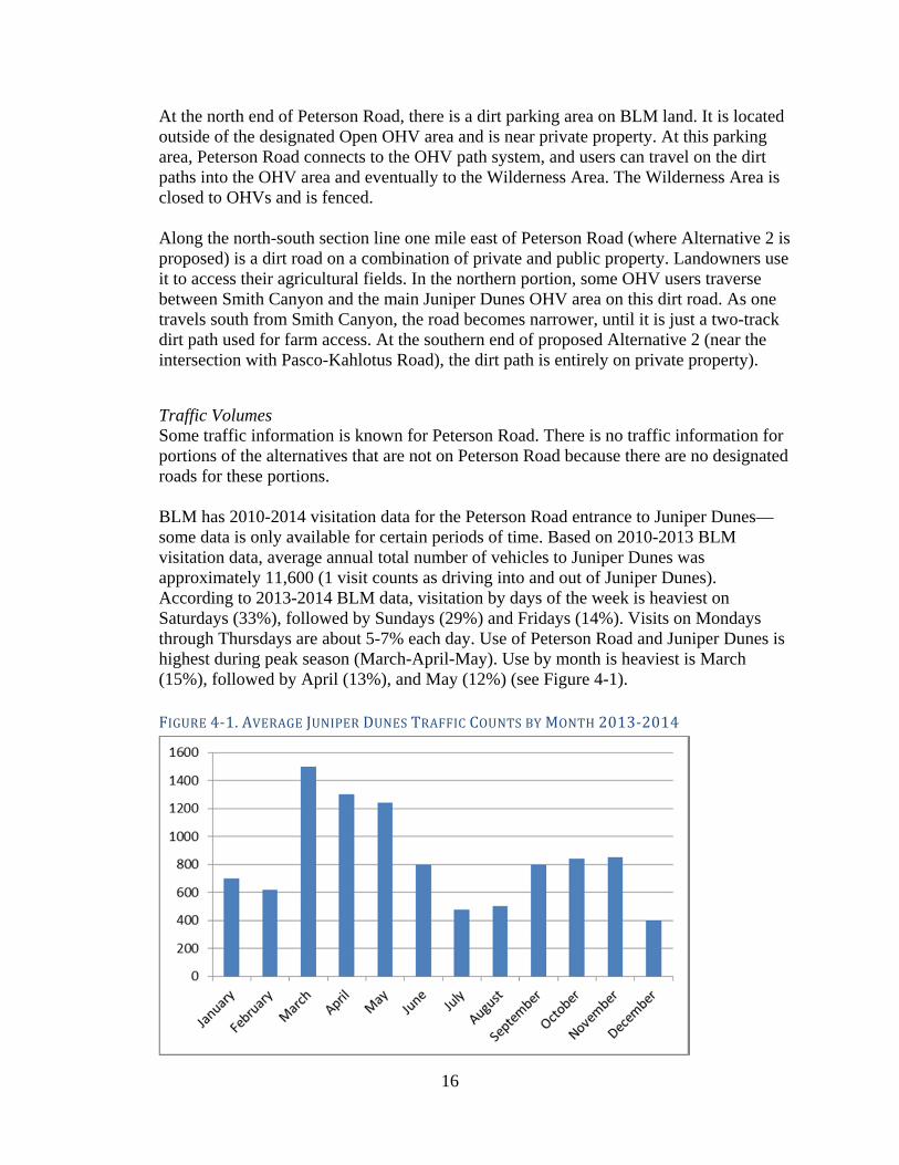
Traffic Volumes Some traffic information is known for Peterson Road. There is no traffic information for portions of the alternatives that are not on Peterson Road because there are no designated roads for these portions. BLM has 2010-2014 visitation data for the Peterson Road entrance to Juniper Dunes—some data is only available for certain periods of time. Based on 2010-2013 BLM visitation data, average annual total number of vehicles to Juniper Dunes was approximately 11,600 (1 visit counts as driving into and out of Juniper Dunes). According to 2013-2014 BLM data, visitation by days of the week is heaviest on Saturdays (33%), followed by Sundays (29%) and Fridays (14%). Visits on Mondays through Thursdays are about 5-7% each day. Use of Peterson Road and Juniper Dunes is highest during peak season (March-April-May). Use by month is heaviest is March (15%), followed by April (13%), and May (12%) (see Figure 4-1). FIGURE4‐1.AVERAGEJUNIPERDUNESTRAFFICCOUNTSBYMONTH2013‐2014

17
As one travels north on Peterson Road from Pasco-Kahlotus Road, traffic decreases. There are residences off of Haugen Road, which intersects with Peterson Road about 1.2 miles north of Pasco-Kahlotus Road. There is higher use for the section of Peterson Road between Pasco-Kahlotus Road and Haugen Road than for the section north of Haugen Road. Between Haugen Road and Juniper Dunes, most of the users are accessing Juniper Dunes, with some users accessing the agricultural land adjacent to Peterson Road. Franklin County has traffic data for Peterson Road near the intersection with Pasco-Kahlotus Road. They took traffic counts on Peterson Road near the intersection with Pasco-Kahlotus Road for two consecutive weekends (Friday/Saturday/Sunday) in June 2014. Peak season data was not available. As mentioned above, BLM has traffic data for Peterson Road at the entrance to Juniper Dunes. Traffic counts were compared equally for the two sections of Peterson Road.1 Based on the Franklin County data, the average daily traffic count for Peterson Road on a June Saturday (averaging June 7 and June 14, 2014) near the intersection with Pasco-Kahlotus is 415 vehicles. Based on the BLM data, the average daily traffic count for Peterson Road at the entrance of Juniper Dunes on a June Saturday is about 143.2 Design of new roads or improvements to existing roads should not be based on current traffic volumes alone, but should also consider future traffic volumes expected to occur over the design life of the road. Future traffic volumes for this project were estimated by applying an annual growth factor to the current traffic volume, while incorporating the expected increase of use because this project will provide legal public access. The Annual Average Daily Traffic (AADT) is the average number of vehicles that travel the route each day over the course of a year. Traffic is counted traveling in both directions. Seasonal Average Daily Traffic (SADT) is the average number of vehicles each day during the peak season. According to Franklin County’s application for FLAP funding, the design AADT (20-year projection) for the Juniper Dunes access road is 105, with a design SADT (20-year projection) of 243. The AADT and SADT are for the section of the road north of Haugen Road, and for the proposed new road (Alternative 2). Crash History Peterson Road is a private road, so crash history is not maintained or publically available. Crash data provided by Franklin County for Pasco-Kahlotus Road shows 5 crashes since 1992 at the intersection with Peterson Road, 3 property damage and 2 personal injury. Data also shows an additional 4 crashes on Pasco-Kahlotus Road within a ¼ mile of the intersection since 2001, 3 property damage and 1 personal injury. Signage There is currently no signage on Peterson Road at the intersection of Pasco-Kahlotus Road regarding access to Juniper Dunes, or whether the road is private or public.
1 BLM visitation data is reported differently than average daily traffic counts. For visitation data, if one vehicle drives into and out of Juniper Dunes, it counts as 1, whereas for average daily traffic counts if a vehicle travels northbound on Peterson Road, then southbound on Peterson Road, it counts as 2. To compare equally, the BLM visitation data was multiplied by 2. 2 According to BLM 2013-2014 data, usage in June is 8% of annual.

18
4.1.2 Direct Impacts No Build Alternative. The No Build Alternative would not provide legal public access to Juniper Dunes. If there is an ownership change of Peterson Road without this project, it could result in the establishment of legal public access, but no plans for such a transition are currently under consideration by BLM or Franklin County. Users of Juniper Dunes would likely still continue to use Peterson Road to access Juniper Dunes, unless the landowners close off the Peterson Road access. The residents living off of Peterson Road would still use it to access their properties. The purpose and needs of the project would not be met. Alternatives 1A, 1B, and 1C. Alternatives 1A, 1B, and 1C would provide legal public access to Juniper Dunes. Traffic is expected to increase, based on annual growth, and also due to the removal of questions over the legality of using Peterson Road to access Juniper Dunes. Road conditions would likely improve due to Franklin County assuming control of Peterson Road and maintaining it to county standards. Peterson Road would continue to be used by people accessing the residences, farms, and other uses off of Peterson Road and the users of Juniper Dunes. Because of the higher use of approximately the first mile of Peterson Road it is to be constructed to a low-volume standard per FHWA standards. The road beyond the first mile is planned to be designed to the FHWA very low-volume road standard. Alternatives 1A, 1B, and 1C would have more traffic than Alternative 2 due to the existing residences off of Peterson Road. Due to funding constraints, the first mile of the road will be paved and the remainder will be gravel with chip seal.
With Alternative 1A, it is likely that some users would continue to use the westernmost parking area at the end of Peterson Road because this alternative would still pass by it. Alternative 1C has the highest likelihood of conflicts between OHVs and other vehicles, since it would pass through Smith Canyon, an area currently used for OHVs. Alternative 2. Alternative 2 would provide legal public access to Juniper Dunes. Overall, traffic to Juniper Dunes is expected to increase, based on annual growth, but also due to the removal of questions over the legality of access to Juniper Dunes. Traffic on Peterson Road is expected to decrease, because the majority of users of Juniper Dunes would use Alternative 2 to access Juniper Dunes. This alternative would have a better (perpendicular) intersection with Pasco-Kahlotus Road and provide the most direct access to the project endpoint in the OHV Area. Due to funding constraints, the first mile of the road will be paved and the remainder will be gravel with chip seal. Signage would be placed at the intersection of Pasco-Kahlotus Road and Peterson Road stating that it provides no Juniper Dunes access and directing users to the proposed route. Despite the signs, some users of Juniper Dunes might still use Peterson Road to access Juniper Dunes unless property owners block off access. Over time, it is likely that most Juniper Dunes users would travel on the proposed Alternative 2 rather than Peterson

19
Road, because it will be the officially designated route and the first mile will be paved. This alternative will mostly separate users of Juniper Dunes from people accessing the residences, farms, and other uses off of Peterson Road.
4.1.3 Temporary Impacts Alternatives 1A, 1B, and 1C. During construction, there will be construction delays that will temporarily affect access along Peterson Road and Pasco-Kahlotus Road. Construction delays will be minimized to the extent possible. Alternative 2. During construction, there will be construction delays that will temporarily affect Pasco-Kahlotus Road. Construction delays will be minimized to the extent possible.
4.2 Land Use
4.2.1 Affected Environment The land use in the project area is mainly agricultural and public use, with some residential, and there is a small commercial area at the intersection of Peterson Road and Pasco-Kahlotus Road. The Zoning Map in Figure 4-2 below shows zoning in the project area. The majority of zoning is agriculture, with some residential and commercial areas. Below are Franklin County’s definitions for the purposes of the zones: Zone RR-5, Rural Residential-5:
A. The rural residential 5 zone is applicable in those outlying rural areas where considerable commitment to rural residential development has been established through previous subdivision and/or segregations and development patterns which have caused the area to be irrevocably lost to large-scale commercial farming. In these areas, the rural residential 5 zone is intended to:
1. Contain low-density development within those outlying areas already substantially committed to this use;
2. Provide areas for a continued mixture of low-density residential development and hobby farming activities.
B. The rural residential 5 zone is characterized by a mixture of land uses encompassing small-scale commercial agriculture, part-time hobby farms, and scattered low-density commuter-residential development. Development in this zone should be primarily self-supporting and of a low density so as to not cause pollution problems which would force extensions of public water and sewer facilities.
Zone C-2, Rural Service Commercial Zone: The rural service commercial zone, C-2, provides for the location of small retail and retail-wholesale businesses and commercial services in rural areas for the convenience of county residents. The uses are intended to fit into farm and rural patterns of development without creating land use or traffic conflicts. This zoning classification is limited to those areas designated in the comprehensive plan as rural activity center, rural settlement, or agricultural service center.

20
Zone AP-20, Agricultural Production-20:
A. The agricultural production 20 zone is designed to maintain the agricultural economy of the county by reserving the farmlands that are used for farming and that are suited to such use. The county comprehensive plan designates the county's agricultural lands. A majority of land in this zoning district has access to irrigation water or is surrounded by lands with access to irrigation water.
B. Residential subdivisions are not compatible with the intent of the agricultural production 20 zone. Short plats may be permitted for farm labor housing or where the landowner wishes to sell the farm and keep the house or in cases where deemed appropriate by the board of county commissioners.
Zone AP-40, Agricultural Production-40: A. The agricultural production 40 zone is designed to maintain the agricultural
economy of the county by reserving the farmlands that are used for farming and that are suited to such use. The county comprehensive plan designates the county's agricultural lands. A majority of land in this zoning district lacks access to irrigation water and emphasizes the county's rangeland and/or dry land farming practices.
B. Residential subdivisions are not compatible with the intent of the agricultural production 40 zone. Short plats may be permitted for farm labor housing or where the landowner wishes to sell the farm and keep the house or in cases where deemed appropriate by the board of county commissioners.

21
FIGURE4‐2.ZONINGINTHEPROJECTAREA
SOURCE:FRANKLINCOUNTY
Figure ES-1 shows public and private ownership and the use designations of BLM administered land. BLM has three designations for land they manage in the Juniper Dunes area:
BLM Wilderness Area. This land is closed to OHV use. BLM Area of Critical Environmental Concern. OHV use is limited to designated
roads and trails. General BLM land. OHV use is limited to designated roads and trails, and within the
general BLM land, there is the Open OHV Area, where OHV use is allowed.

22
Figure 4-3 is the Franklin County Comprehensive Land Use Plan map in the project area, which shows the long-range plans for the project area. The intersection of Peterson Road and Pasco-Kahlotus Road is shown as an Agricultural Service Center. The residences off of Haugen Road and south of Pasco-Kahlotus Road are shown as Rural Remote. All other lands in the project area are shown as agricultural. FIGURE4‐3.FRANKLINCOUNTYCOMPREHENSIVELANDUSEPLAN

23
4.2.2 Direct Impacts Because the project would be used specifically to access the Juniper Dunes area for recreation and it does not provide access to other new areas (other than as described in Indirect Impacts below), it would not directly affect land use in the project area, other than the land in the proposed ROW directly converted to transportation use.
4.2.3 Indirect Impacts Alternatives 1B, 1C and 2 could provide road access to “landlocked” parcels that currently do not have public access, thus allowing for residential or agricultural development of the parcels. This development would be limited by the existing zoning and the fact that many parcels in the area are owned by BLM.
4.2.4 Cumulative Impacts Past actions that had the most measurable effects on land use in the area included the introduction of irrigation and the designation of Juniper Dunes as a federal recreation and wilderness area. These actions changed land use from mainly undeveloped shrub-steppe habitat to irrigated farmland, residential, and recreational uses. Present and reasonably foreseeable future actions are minimal in the area, with the road project improving Pasco-Kahlotus Road from the intersection with Peterson Road to three miles to the east being the only planned future action. No Build. Combined with the past, present, and reasonably foreseeable future actions, the No Build Alternative would result in no change in the land use trend near the project area. Therefore, the incremental impacts from the No Build Alternative when added to other past, present, and reasonably foreseeable future actions would not result in substantial cumulative adverse or beneficial effects to land use. Build Alternatives. Combined with the past, present, and reasonably foreseeable future actions, Alternatives 1B, 1C, and 2 could result in a slightly higher potential for changes to the rate of land use in and near the project area than the No Build Alternative because they would provide access to some previously “landlocked” parcels, which could lead to residential or agricultural. Alternative 1A would not affect the rate of land use. Therefore, the incremental impacts from the build alternatives when added to other past, present, and reasonably foreseeable future actions, would not result in substantial cumulative adverse effects to land use.

24
4.3 Property Acquisitions This section describes expected property acquisitions (the amount of new land the project would require for ROW). Any of the build alternatives would require acquiring private property to convert to ROW owned and maintained by Franklin County. All property acquisitions would comply with the Uniform Relocation Assistance and Real Property Acquisition Policies Act of 1970 (as amended) (Uniform Act). Fair market compensation will be provided for all property acquisitions. Franklin County will be responsible for conducting property acquisitions.
4.3.1 Affected Environment Land ownership in the project area is a combination of private and publicly-owned lands (see Figure 4-4); federally-owned land is shown in pink and privately-owned land is shown in blue. The area that would be directly converted to ROW by any of the alternatives includes Peterson Road, agricultural, residential, and vacant private land, and public land. There is a private 30- to 36-inch irrigation pipe located under Peterson Road in the project area. It was built prior to 1975 and it runs for at least 1 mile north from the intersection with Pasco-Kahlotus Road. It is used to irrigate some of the agricultural fields adjacent to Peterson Road. There are numerous center-pivot irrigation spans in the project area.

25
FIGURE4‐4.PUBLICANDPRIVATEOWNERSHIPINTHEPROJECTAREA
SOURCE: FRANKLIN COUNTY PUBLIC WORKS

26
There are a number of public funding mechanisms that can provide funding for property for public use. Some of these funds have requirements that the property is not converted from recreation use (anti-conversion requirements). Section 6(f) of the Land and Water Conservation Fund Act (LWCFA) concerns transportation projects that propose impacts to, or conversion of, outdoor recreation property that was acquired or developed with LWCFA funds. FHWA contacted the Washington State Recreation and Conservation Office (RCO), which administers Section 6(f) grants, and the National Park Service (NPS), and determined that there are no Section 6(f) properties, or properties with other anti-conversion requirements, impacted by the project (see Appendix A for documentation from RCO and NPS).
4.3.2 Direct Impacts No Build Alternative. The No Build Alternative would not acquire any private property or convert any BLM property to transportation. Peterson Road would continue to be owned by the underlying landowners. Build Alternatives. All build alternatives would require the acquisition of private property to convert to ROW. This project would have no residential or commercial displacements. All build alternatives would impact irrigation circles to varying degrees. Since all routes run on section lines in locations where they are adjacent to private property, impacts to irrigation circles would be on the perimeter of the circles, but would still decrease the amount of farmable land, unless mitigated. Table 4-1 shows the total acreage of permanent acquisitions or easements required by each alternative. Table 4-2 identifies the properties by parcel number that would be impacted by the project. It shows a property address if there is one, initial acreage of the property, ownership, land use, amount of estimated property (ROW) needed (acquisition or easement), the estimated remaining acreage of the parcel, and the percent of the parcel that would be needed for ROW. Figure 4-5 shows the parcel numbers of the properties for reference to Table 4-2. The build alternatives would also require easements for Franklin County to use federal property for transportation use and to operate and maintain the road and ROW within the easements. The total acreage of easements on federal land is included in the totals below. TABLE4‐1.TOTALESTIMATEDPROPERTYACQUISITIONSBYALTERNATIVE Total ROW
Required (est. acres)
Easements on Federal Land (est. acres)
Acquisition of Private Land (est. acres)
Alternative 1A 51.41 27.00 24.41 Alternative 1B 48.02 19.80 28.22 Alternative 1C 47.08 22.48 24.60 Alternative 2 40.76 11.64 29.12

27
TABLE4‐2.PROPERTYACQUISITIONSBYPARCEL
Parcel No. Address Ownership Land Use Initial Property Acreage Estimated ROW Required Estimated Remaining Acreage Percentage ROW
110-570-017 1670 Peterson Road Private Farm 480.00 2.64 477.36 0.55%110-560-494 1381 Peterson Road Private Residential 6.00 0.28 5.72 4.67%110-560-485 N/A Private Farm 308.33 5.52 302.81 1.79%110-530-015 N/A Private Farm 500.00 5.32 494.68 1.06%110-520-017 N/A Federal ACEC 640.00 4.53 635.47 0.71%110-450-012 N/A Private Farm 640.00 0.86 639.14 0.13%110-440-014 N/A Federal ACEC 640.00 10.45 629.55 1.63%110-400-012 N/A Federal Open/OHV 640.00 12.02 627.98 1.88%110-090-063 N/A Private Farm 198.75 0.41 198.34 0.21%110-080-083 N/A Private Farm 79.92 0.39 79.53 0.49%110-050-016 N/A Private Farm 692.60 5.10 687.50 0.74%110-040-063 170 Peterson Road Private Farm 671.44 3.89 667.55 0.58%
Total 51.41
Parcel No. Address Ownership Land Use Initial Property Acreage Estimated ROW Required Estimated Remaining Acreage Percentage ROW
110-080-083 N/A Private Farm 79.92 0.39 79.53 0.49%110-040-063 170 Peterson Road Private Farm 671.44 3.89 667.55 0.58%110-050-016 N/A Private Farm 692.60 5.10 687.50 0.74%110-560-485 N/A Private Farm 308.33 5.52 302.81 1.79%110-560-494 1381 Peterson Road Private Residential 6.00 0.28 5.72 4.67%110-530-015 N/A Private Farm 500.00 5.32 494.68 1.06%110-570-017 1670 Peterson Road Private Farm 480.00 2.64 477.36 0.55%110-520-017 N/A Federal ACEC 640.00 13.01 626.99 2.03%110-510-019 N/A Private Vacant 320.00 0.23 319.77 0.07%110-460-010 N/A Federal ACEC 640.00 4.85 635.15 0.76%110-450-012 N/A Private Farm 640.00 4.85 635.15 0.76%110-400-012 N/A Federal Open/OHV 640.00 0.97 639.03 0.15%110-390-015 N/A Federal Open/OHV 640.00 0.97 639.03 0.15%
Total 48.02
Parcel No. Address Ownership Land Use Initial Property Acreage Estimated ROW Required Estimated Remaining Acreage Percentage ROW
110-080-083 N/A Private Farm 79.92 0.39 79.53 0.49%110-040-063 170 Peterson Road Private Farm 671.44 3.89 667.55 0.58%110-050-016 N/A Private Farm 692.60 5.10 687.50 0.74%110-560-485 N/A Private Farm 308.33 5.52 302.81 1.79%110-560-494 1381 Peterson Road Private Residential 6.00 0.28 5.72 4.67%110-570-017 1670 Peterson Road Private Farm 480.00 2.64 477.36 0.55%110-520-017 N/A Federal ACEC 640.00 15.69 624.31 2.45%110-510-019 N/A Private Vacant 320.00 1.93 318.07 0.60%110-460-010 N/A Federal ACEC 640.00 4.85 635.15 0.76%110-450-012 N/A Private Farm 640.00 4.85 635.15 0.76%110-400-012 N/A Federal Open/OHV 640.00 0.97 639.03 0.15%110-390-015 N/A Federal Open/OHV 640.00 0.97 639.03 0.15%
Total 47.08
Parcel No. Address Ownership Land Use Initial Property Acreage Estimated ROW Required Estimated Remaining Acreage Percentage ROW
110-040-063 170 Peterson Road Private Farm 79.92 4.85 75.07 6.07%110-030-010 N/A Private Farm 656.28 4.85 651.43 0.74%110-570-026 N/A Private Farm 160.00 2.43 157.57 1.52%110-570-017 1670 Peterson Road Private Farm 480.00 2.43 477.57 0.51%110-580-015 N/A Private Vacant 600.00 4.85 595.15 0.81%110-520-017 N/A Federal ACEC 640.00 4.85 635.15 0.76%110-510-028 N/A Private Vacant 320.00 2.43 317.57 0.76%110-510-019 N/A Private Vacant 320.00 2.43 317.57 0.76%110-450-012 N/A Private Farm 640.00 4.85 635.15 0.76%110-460-010 N/A Federal ACEC 640.00 4.85 635.15 0.76%110-400-012 N/A Federal Open/OHV 640.00 0.97 639.03 0.15%110-390-015 N/A Federal Open/OHV 640.00 0.97 639.03 0.15%
Total 40.76
Alternative 1A
Estimated Right-of-way Acquisition/Easement Requirements for Alternatives
Alternative 1B
Alternative 1C
Alternative 2

28
FIGURE4‐5.PROJECTAREAPARCELS

29
Alternative 1A would require 27.00 acres of easements on federal property and would impact 24.41 acres of private land. Of the private land, none of the parcels are vacant. Alternative 1B would require 19.80 acres of easements on federal property and would impact 28.22 acres of private land. Of the private land, 0.23 acres of the impact would be on vacant land. Alternative 1C would require 22.48 acres of easements on federal property and would impact 24.60 acres of private land. Of the private land, 1.93 acres of the impact would be on vacant land. Alternative 2 would require 11.64 acres of easements on federal property and would impact 29.12 acres of private land. Of the private land, 9.71 acres of the impact would be on vacant land. Alternatives 1A, 1B, and 1C would be built over or near the irrigation pipe that is buried near Peterson Road. Due to its age and location underground near where the road would be built, it is likely that construction would damage the pipe. If the pipe is in conflict with the ROW of the alternative, it would likely have to be moved to a different location. A preliminary cost of replacing or moving the pipe is estimated at about $210 per linear foot. Replacing or moving a ½ mile of pipe is estimated to cost over $500,000. Replacing or moving 1 mile of pipe is estimated to cost over $1 million.
4.3.3 Temporary Impacts Construction easements may be required for the temporary staging of materials and equipment during construction. Property used would be returned to the property owner after construction or when it is no longer needed. Temporary impacts to irrigation equipment could occur.
4.3.4 Mitigation or Compensation
Long-term Where property acquisition is unavoidable, the project would provide just compensation, per the Uniform Act. Franklin County is responsible for property acquisitions, and they will follow all requirements of the Uniform Act. Project partners will attempt to minimize impacts to private property to the greatest extent practicable. As project design progresses, design refinements may allow for portions of the road alignment to shift onto public property to minimize impacts to private property. If a property acquisition impacts the perimeter of an irrigation circle, a possible mitigation measure is to retrofit the irrigation sprinkler span with a “hinge.” The hinge allows the outer segments of the span to pivot at the hinge location and follow the new property line, without reducing the radius of the span in the area of the field that is not impacted by ROW (see Figure 4-6).

30
FIGURE4‐6.IRRIGATIONCOVERAGEWITHANDWITHOUTHINGE
Temporary
Compensation for construction easements could include payment to property owners in exchange for the use of their property during construction. Temporary impacts to property, due to temporary construction uses, would be compensated according to fair-market or contributory value.
4.4 Water Resources
4.4.1 Affected Environment The area is arid with no surface water or evidence of water based erosion/scouring present. Soils types range from sandy loams to loamy sands, with some small pockets of pure sand. An inventory of the project area was conducted David Evans and Associates in July 2014. The project study area was defined as a 200-foot corridor (100 feet to each side) along proposed project road alternative centerlines. No potential waterway features were observed during the field reconnaissance.
4.4.2 Direct Impacts Since there are no streams in the project area, none of the project alternatives will have impacts on streams. Paving the first mile of any of the build alternatives would increase the amount of impervious surface that is currently in the project corridor by approximately 3.15 acres. Paving would lead to increased stormwater runoff. During periods without rainfall, pollutants from vehicles collect on paved road surfaces.

31
Examples of pollutants from vehicles include nitrogen from particles of exhaust settling on the road surface and trace heavy metals such as cadmium, copper, lead, nickel, and chromium. Stormwater will run off the paved area of the road and infiltrate into the ground adjacent to the road. Because the area receives less than 10 inches of rain per year, and the type of soil has a relatively high rate of infiltration, there would be minimal impacts from the added impervious surface.
4.4.3 Indirect Impacts Increased usage of any of the build alternatives would increase pollutants from vehicles. However, the 20- year ADT and SADT projection is still very low and will produce minimal pollutants.
4.5 Wetlands
4.5.1 Affected Environment A wetland inventory of the project area was conducted David Evans and Associates in July 2014. The project study area was defined as a 200-foot corridor (100 feet to each side) along proposed project road alternative centerlines. Reference materials were reviewed prior to the field investigation to provide information regarding the possible presence of wetlands, water features, hydric soils, wetland hydrology, and site topography. Review of existing map data revealed no mapped drainages, wetlands, or hydric soils within the project study area. Similarly, no potential wetland or waterway features were observed during the field reconnaissance. Field sampled soils were consistent with soil survey mapping in that they ranged from deep sandy loam to loamy sand, which results in very well drained soils unlikely to result in the formation of hydric soils, especially given the arid nature of the area. The study area consists entirely of upland plant communities. No potential hydrophytic plant communities (i.e., wetland plant communities) were observed and therefore formal wetland delineation sampling plots were not conducted. For more information, please see Appendix C, 2014 Juniper Dunes Wetlands Determination Memo.
4.5.2 Direct Impacts Since there are no wetlands in the project area, none of the project alternatives will have impacts on wetlands.
4.6 Floodplains
4.6.1 Affected Environment None of the project area falls within a FEMA-regulated 100-year flood plain.
4.6.2 Direct Impacts Since there are no floodplains in the project area, none of the project alternatives will have impacts on floodplains.

32
4.7 Fish, Wildlife and Vegetation A variety of wildlife and plant species occur in the project area. These species can be divided into major categories and are discussed below as federal species, special status wildlife species, birds of conservation concern, and special status plant species. No fish occur within the project area. Because project-related impacts are similar across species, cumulative analysis is discussed for all wildlife and vegetation resources in Section 4.7.4.
4.7.1 Affected Environment
4.7.1.1 Vegetation The project is located in the shrub-steppe lands of the interior Columbia Basin, an essentially treeless biome that covers much of the interior west between British Columbia and Mexico (Daubenmire, 1970). Elevations within the study area range from approximately 650 to 750 feet in elevation. Much of the study area is occupied by highly degraded habitats, including developed areas, agriculture areas, and ruderal areas that appear to have been cultivated at one time, and now are dominated by non-native species. The project area includes the following habitat types: Developed, Agricultural, Steppe, Shrub-Steppe, and Upland Trees.
Developed areas include roads and residences. Agricultural areas include primarily center pivot agriculture (farmland where
irrigation equipment rotates around a centrally-located pivot) planted with wheat, corn, or potatoes.
Outside of agricultural areas, native herbaceous cover consists primarily of needle and thread (Hesperostipa comata), with less cover by bluebunch wheatgrass (Pseudoroegneria spicata), Idaho fescue (Festuca idahoensis), and Sandberg’s bluegrass (Poa secunda).
Steppe habitat is dominated by the native and non-native species herbaceous shown in Table 4-3, and was very weedy in places.
Shrub-steppe habitat includes the herbaceous species found in steppe habitat, but with a shrub layer of at least 10% cover. In the study area, this habitat type is dominated primarily by big sagebrush (Artemisia tridentata) and cheatgrass.
Upland trees (other than those present adjacent to residences) were small and very limited in distribution.
TABLE4‐3:PLANTSPECIESWITHINTHESTUDYAREA
Native Shrubs Abundance
Big Sagebrush Artemisia tridentata Dominant
Gray Rabbitbrush Ericameria nauseosa Common
Antelope Bitterbrush Purshia tridentata Common
Native Grasses and Herbs Abundance
Needle and Thread Hesperostipa comata Dominant
Common Yarrow Achillea millefolium Abundant

33
Yellow Bee Plant Cleome lutea Abundant
Indian Ricegrass Achnatherum hymenoides Common
Indian-Wheat Plantago patagonica Common
Bluebunch Wheatgrass Pseudoroegneria spicata Uncommon
Bristly Fiddleneck Amsinckia tessellata Uncommon
Non-native and Invasive Species Abundance
Cheatgrass Bromus tectorum Dominant
Russian Thistle Salsola kali Dominant
Prickly Lettuce Lactuca serriola Dominant
Jim Hill Mustard Sisymbrium altissimum Dominant
Wheat Triticum sp. Dominant
Yellow Salsify Tragopogon dubius Common
Redstem Stork's Bill Erodium cicutarium Common
Rush Skeletonweed Lygodesmia juncea Uncommon
Field Bindweed Convulvus artensis Uncommon
Scotch Thistle Onopordum acanthium Uncommon
Canada Thistle Cirsium arvense Uncommon
Russian Knapweed Centaurea repens Uncommon
Excluding agricultural and developed areas, Alternative 1A, 1B, and 1C habitat was dominated primarily by cheatgrass and big sagebrush, as well as some cover by antelope bitterbrush and gray rabbitbrush. The only areas dominated by native species (greater than 50% native species) occurred within on the southernmost 3 miles of the Alternative 2 alignment (generally found east of the property boundary). In these areas, needle and thread was dominant in large patches, with or without cover by big sagebrush.
4.7.1.2 General Field Observations A wide variety of raptors, migratory birds, and reptiles utilize the study area for forage and cover, and numerous ground-dwelling species would be expected to occur, although the time was not taken to identify burrows. In general, burrows of any size appeared to be somewhat uncommon within the study area, perhaps due to the sandy nature of the soil. This could potentially limit the presence of ground-dwelling species and their associates. Since trees were very limited within the study area, tree-nesting species were also limited. A few trees (less than 25) do occur, and they contained a few nests, including Swainson’s hawk, Bullock’s oriole, and raven. No aquatic resources or surface water connections to aquatic resources were found within the vicinity of the project area, therefore no aquatic species occur in the project. Table 4-4 shows wildlife species, or sign of the species, that were observed in the project area.

34
TABLE4‐4.WILDLIFESPECIES(ORSIGN)OBSERVEDDURINGSITERECONNAISSANCECONDUCTEDINJULY2014
American badger (burrow) (Taxidea taxus) Horned lark (Eremophila alpestris)
American crow (Corvus brachyrhynchos) House finch (Carpodacus mexicanus)
American kestrel (Falco sparverius) Mule deer (Odocoileus hemionus)
American robin (Turdus migratorius) Northern harrier (Circus cyaneus)
Bank swallow (burrow) (Riparia riparia) Red-tailed hawk (Buteo jamaicensis)
Brewer’s blackbird (Euphagus cyanocephalus) Ring-necked pheasant (Phasianus colchicus)
Brown-headed cowbird (Molothrus ater) Song sparrow (Melospiza melodia)
Bullock’s oriole (nest adj.) (Icterus bullockii) Swainson’s hawk (nest) (Buteo swainsoni)
Common raven (Corvus corax) Turkey vulture(Cathartes aura)
Coyote (tracks) Canis latrans) Violet-green swallow (Tachycineta thalassina)
European starling (Sturnus vulgaris) Western kingbird (Tyrannus verticalis)
Grasshopper sparrow (Ammodramus savannarum)
Western meadowlark (Sturnella neglecta)
4.7.1.3 Wildlife and Plants-Federal Species Federally listed threatened and endangered species are those plant and animal species formally listed by the USFWS under authority of the ESA. No critical habitat has been identified within the study area. Table 4-5 displays those endangered, threatened, proposed, and candidate species with the potential to occur in or near the study area that are listed as occurring in Franklin County, Washington (USFWS 2014). TABLE4‐5:FEDERALTHREATENED,ENDANGERED,PROPOSED,ANDCANDIDATESPECIESWITHTHEPOTENTIALTOOCCURINORNEARTHESTUDYAREACommon Name
Scientific Name
USFWS Status
Habitat Requirements *
Potential Occurrence in the Study Area?
Pygmy rabbit
Brachylagus idahoensis
Endangered Dense stands of big sagebrush growing in deep loose soils.
None. Outside the current range of the species. No further assessment.
Washington ground squirrel
Urocitellus washingtoni
Candidate
Shrub-steppe habitat. Most abundant in areas of high grass cover, on deep soils with low clay content and high silt content.
Unlikely. Randomized surveys in the area in 2013 found none.
* Source of Habitat Requirements : Natureserve 2014

35
Federal Threatened, Endangered, or Proposed Species No federally-listed threatened, endangered, or proposed species are likely to occur in the study area. Federal Candidate Species WashingtongroundsquirrelAccording to BLM (Jason Lowe, pers. Comm., 2014), one old record of the species exists near the wilderness boundary northeast of the study area (date unknown). The project area lies outside the current range of the species (WDFW 2012), The species was not found during randomized surveys conducted in the area by BLM in 2013 (Lowe, pers. Comm., 2014). DEA biologists have conducted extensive field surveys in shrub-steppe habitat, including surveys for Washington ground squirrel based on presence of scat, and no such sign was found within the study area during the site reconnaissance. The species is not likely present in the project area. Federal Species of Concern The USFWS maintains a list of Federal Species of Concern. USFWS species of concern do not warrant the same level of protection as threatened or endangered species. Table 4-6 displays the federal Species of Concern (SOC) with the potential to occur in or near the study area that are listed as occurring in Franklin County, Washington (USFWS 2014). TABLE4‐6:FEDERALSPECIESOFCONCERNWITHTHEPOTENTIALTOOCCURINORNEARSTUDYAREACommon Name
Scientific Name
USFWS Status
Habitat Requirements*
Potential Occurrence in the Study Area?
Burrowing owl Athene cunicularia
SOC
Open grasslands typified by short vegetation and presence of fresh small mammal burrows.
May occur, although few small mammal burrows seen during site visits.
Ferruginous hawk
Buteo regalis SOC Shrub-steppe with trees for nesting
Seven records within two miles of the study area, but no current nesting known within 1.5 miles of the study area.
Bald eagle Haliaeetus leucocephalus SOC
Mature forest/snags within 1 mile of large bodies of water
Known to winter along Columbia River. May fly over, but no nesting or foraging present.
Loggerhead shrike
Lanius ludovicianus
SOC Lowland communities of sagebrush shrub-steppe.
Likely to occur, but no records.
Long-eared myotis
Myotis evotis SOC Mostly forested areas, especially those with broken rock outcrops.
None. No forested areas near study area. No further assessment.
Northern sagebrush lizard
Sceloporus graciosus
SOC Shrub-steppe habitats with open ground areas
Known to occur within the study area.
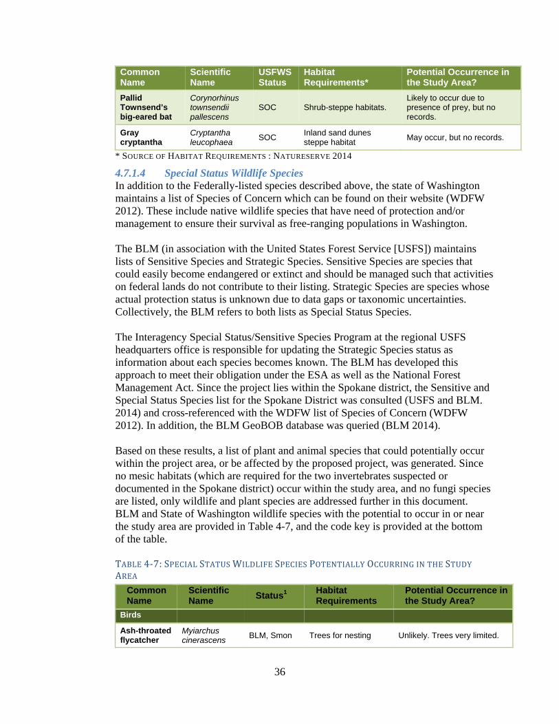
36
Common Name
Scientific Name
USFWS Status
Habitat Requirements*
Potential Occurrence in the Study Area?
Pallid Townsend’s big-eared bat
Corynorhinus townsendii pallescens
SOC Shrub-steppe habitats. Likely to occur due to presence of prey, but no records.
Gray cryptantha
Cryptantha leucophaea
SOC Inland sand dunes steppe habitat
May occur, but no records.
* SOURCE OF HABITAT REQUIREMENTS : NATURESERVE 2014
4.7.1.4 Special Status Wildlife Species In addition to the Federally-listed species described above, the state of Washington maintains a list of Species of Concern which can be found on their website (WDFW 2012). These include native wildlife species that have need of protection and/or management to ensure their survival as free-ranging populations in Washington. The BLM (in association with the United States Forest Service [USFS]) maintains lists of Sensitive Species and Strategic Species. Sensitive Species are species that could easily become endangered or extinct and should be managed such that activities on federal lands do not contribute to their listing. Strategic Species are species whose actual protection status is unknown due to data gaps or taxonomic uncertainties. Collectively, the BLM refers to both lists as Special Status Species. The Interagency Special Status/Sensitive Species Program at the regional USFS headquarters office is responsible for updating the Strategic Species status as information about each species becomes known. The BLM has developed this approach to meet their obligation under the ESA as well as the National Forest Management Act. Since the project lies within the Spokane district, the Sensitive and Special Status Species list for the Spokane District was consulted (USFS and BLM. 2014) and cross-referenced with the WDFW list of Species of Concern (WDFW 2012). In addition, the BLM GeoBOB database was queried (BLM 2014). Based on these results, a list of plant and animal species that could potentially occur within the project area, or be affected by the proposed project, was generated. Since no mesic habitats (which are required for the two invertebrates suspected or documented in the Spokane district) occur within the study area, and no fungi species are listed, only wildlife and plant species are addressed further in this document. BLM and State of Washington wildlife species with the potential to occur in or near the study area are provided in Table 4-7, and the code key is provided at the bottom of the table. TABLE4‐7:SPECIALSTATUSWILDLIFESPECIESPOTENTIALLYOCCURRINGINTHESTUDYAREA
Common Name
Scientific Name
Status1 Habitat Requirements
Potential Occurrence in the Study Area?
Birds
Ash-throated flycatcher
Myiarchus cinerascens
BLM, Smon Trees for nesting Unlikely. Trees very limited.

37
Common Name
Scientific Name
Status1 Habitat Requirements
Potential Occurrence in the Study Area?
Bald eagle Haliaeetus leucocephalus
BLM, SS, Fco
Mature forest/snags within 1 mile of large bodies of water
May fly over, but no nesting or foraging present.
Bobolink Dolichonyx oryzivorus
BLM, Smon Grasslands None. Habitat not present.
Burrowing owl
Athene cunicularia
BLM, Fco,Scan
Closely associated with burrows in grasslands, deserts and scrublands
Likely. Known to breed locally
Ferruginous hawk
Buteo regalis BLM, Fco, ST Shrub-steppe with trees for nesting
Likely. Known to breed near the study area
Golden eagle Aquila chrysaetos
Scan Forages in many habitat types; needs cliffs for nesting
Unlikely. Rare visitor to study area
Grasshopper sparrow
Ammodramus savannarum
Smon Closely associated with grasslands, fields and pastures
Detected along Alternative 2.
Gray flycatcher
Empidonax wrightii
BLM, Smon Shrub-steppe Not known to occur, but may be present.
Loggerhead shrike
Lanius ludovicianus
Fco, Scan
Closely associated with juniper woodlands and shrub-steppe
Likely to occur, but not known.
Long-billed curlew
Numenius americanus
BLM, Smon
Closely associated with grasslands and shrub-steppe where adjacent to wetland areas or irrigated fields
Likely. Known to breed near the study area.
Merlin Falco columbarius
Scan
Forages widely in open habitats; nests in westside and eastside forests
Unlikely. Rare migrant.
Peregrine falcon
Falco peregrinus
Fco, SS
Cliff nester; forages near large concentrations of prey birds
Unlikely. Rare visitor to study area
Prairie falcon
Falco mexicanus
Smon
Closely associated with grasslands and shrub-steppe; needs cliffs and rock outcrops for nesting
Unlikely. Rare visitor to study area
Sage sparrow
Amphispiza belli
Scan Shrub-steppe obligate
Unlikely. Rare migrant
Sage thrasher
Oreoscoptes montanus
Scan Shrub-steppe obligate
Unlikely. Rare summer visitor
Swainson's hawk
Buteo swainsoni
Smon
Grasslands, shrub-steppe, and juniper woodlands; nests in shrubs and trees.
Known to breed in study area

38
Common Name
Scientific Name
Status1 Habitat Requirements
Potential Occurrence in the Study Area?
Mammals
Black-tailed jackrabbit
Lepus californicus
BLM, Scan
Closely associated with shrub-steppe and desert scrublands
Known to occur to the NE, and may occur in study area
Fringed myotis
Myotis thysanodes
Fco, Smon
Requires caves, mines or rock crevices for roosting; forages over open water and fields
Not documented, but may occur
Long-eared myotis
Myotis evotis Fco, Smon
Uses caves, mines, hollow trees, loose bark or rock crevices for roosting
Not documented, but may occur
Long-legged myotis
Myotis volans Fco, Smon
Uses caves or mines as hibernacula; uses hollow trees, loose bark or rock crevices for roosting.
Not documented, but may occur
Northern grasshopper mouse
Onychomys leucogaster
Smon Closely associated with shrub-steppe
Known to occur to the NE, and may occur in study area
Ord's kangaroo rat
Dipodomys ordii
Smon Closely associated with shrub-steppe
Known to occur to the NE, and may occur in study area
Pallid bat Antrozous pallidus
Smon
Requires rock cliffs, caves or mines for breeding; closely associated with open water and wetlands for foraging
Not documented, but may occur
Small-footed myotis
Myotis ciliolabrum
Fco, Smon
Requires cliffs, rimrock boulders or talus for breeding; closely associated with wetlands, open water and grasslands for foraging
Not documented, but may occur
Washington ground squirrel
Spermophilus washingtoni
BLM, Fcan, Scan
Shrub-steppe obligate
Not documented, but may occur
Western pipistrelle
Pipistrellus hesperus
Smon
Requires cliffs, rimrock boulders or talus for breeding; closely associated with wetlands, open water and grasslands for foraging
Unlikely due to lack of habitat
White-tailed jackrabbit
Lepus townsendii
BLM, Scan
Closely associated with native shrub-steppe and grasslands
Not documented, but may occur

39
Common Name
Scientific Name
Status1 Habitat Requirements
Potential Occurrence in the Study Area?
Herpetiles
Night snake Hypsiglena torquata
Smon
Found under rocks and other objects in shrub-steppe and dry forests
Not documented, but may occur
Pacific gopher snake
Pituophis catenifer catenifer
Smon Wide range of habitats, including shrub-steppe
Likely. Documented nearby.
Racer Coluber constrictor
Smon
Found under rocks and other objects in shrub-steppe and dry forests
Likely. Documented nearby.
1 Status codes:
Fcan = Federal Candidate; Fco = Federal Species of Concern; SC = State Species of Concern; Scan = State Candidate; SE = State Endangered; Smon = State Monitor; SS = State Sensitive; ST = State Threatened; BLM= BLM Sensitive or Strategic
Birds of Conservation Concern All birds found on the most current USFWS list of Birds of Conservation Concern Great Basin Region have already been covered under the previous sections. They include ferruginous hawk, long-billed curlew, and loggerhead shrike. Although not listed by an agency, bank swallow nests were found in a cut bank near the center of Alternative 1, and swallows were seen using the nests during the site visits. These species would be protected by the Migratory Bird Treaty Act, and road widening associated with Alternatives 1A, 1B, and 1C would impact these nests.
4.7.1.5 Special Status Plant Species Of the BLM and Washington state special status plant species known to occur on the Spokane district, only gray cryptantha, which was discussed under listed species, was determined to be likely to be present within the study area (Frymire, pers. Comm., 2014). Based on habitat needs, five other plant species could potentially occur within the project area, and are discussed in Table .
TABLE4‐8:SPECIALSTATUSPLANTSPECIESPOTENTIALLYOCCURRINGINTHESTUDYAREA
Common Name
Scientific Name
Status1 Habitat Requirements
Potential Occurrence in the Study Area?
Great Basin gilia
Aliciella leptomeria
SS Open semiarid habitats with gravelly or sandy soils
Not detected, but may be present.
Snake River cryptantha
Cryptantha spiculifera
BLM, SS Dry, open areas in stable soils in steppe habitat
Not detected, but may be present.
Desert dodder
Cuscuta denticulata
SS Parasitic on sagebrush
Unlikely, but could be present in sagebrush habitats.

40
Dwarf evening-primrose
Eremothera pygmaea
BLM, SS Sagebrush shrub-steppe, on unstable soils
Unlikely since unstable soils are limited, but could be present.
Piper's daisy Erigeron piperianus
BLM, SS
Commonly found in virgin stands of big sagebrush/bluebunch wheatgrass
Unlikely since no such habitat is present, but could be present in sagebrush habitats.
1Status codes:
SS = State Sensitive; BLM=Sensitive or Strategic
4.7.2 Direct Impacts No Build Alternative With the No Build Alternative, there would be no change in the effects to vegetation and wildlife. There would be no direct loss of habitat, and the incidences of vehicle-wildlife collisions would continue at or near the existing frequency. Build Alternatives Direct effects to habitat and impacts to wildlife are discussed by species in the following sections. Direct effects are those effects caused directly by construction or operation of the proposed action. They include potential impacts to species using the immediate project footprint, as well as species using adjacent areas that may experience increased noise or pollution during construction. Unless described otherwise, direct impacts from all build alternatives will be similar.
4.7.2.1 Vegetation Based on Franklin County design, the preliminary typical section includes the following measurements (and impact assumptions):
Two 11-foot lanes with 2-foot shoulders (total of 26 feet) Two 4:1 slopes from road edge (total of 8 feet) One 2:1 ditch profile (total of 4 feet)
Therefore, total permanent impact would be 38 feet, plus 6 feet of temporary impact on either side for a total of 50 feet of impact, on average. The 12 feet of temporary impact would be re-seeded with native vegetation. For the alignment outside Peterson Road, which includes portions of Alternative 1A, 1B, and 1C, as well as all of Alternative 2, terrain is more varied (it has generally not been previously graded) and project design has not yet reached the point where cut and fill quantities can be calculated. Therefore it is assumed that cut and fill impacts would be greater outside of the Peterson Road prism. A conservative estimate of an average of at least 15 additional feet of temporary impact on either side of centerline in areas outside of the Peterson Road prism, for a total impact of 80 feet, on average (compared to 50 feet within the Peterson Road prism). A summary of impacts to steppe and shrub-steppe habitat (permanent and temporary impacts combined) is provided in Table 4-9. Impacts to agricultural and developed

41
habitats are not included, which explains the lower acreage of impact for Alternative 1A because it extends the greatest distance along Peterson Road. However, it should be noted that Alternative 1A passes by the active Swainson’s hawk nest discussed previously. Alternative 2 would have the greatest impacts to vegetation habitat, including the greatest impacts to habitat with a higher percent of native species, followed by Alternative 1C, 1B, and 1A. However, since the Juniper Dunes area is over 19,600 acres, with 15,720 acres of habitat protected with limited or no OHV use, impacts to habitat from the build alternatives would be minimal (less than 1/4th of 1% of protected acreage). TABLE4‐9:HABITATIMPACTSSUMMARYBYCATEGORYFORSTEPPEANDSHRUB‐STEPPEHABITATS(AC.)
Alignment Habitat with
approx. 70% native
species
Habitat with
approx. 50% native species
Habitat with
<1% native species
Total
Alternative 1A -- -- 18.3 18.3
Alternative 1B 2.3 1.9 11.6 26.2
Alternative 1C 5.0 1.9 8.4 27.9
Alternative 2 17.4 5.0 14.2 36.6
Areas disturbed by road construction can provide an opportunity for increased density of existing native populations, as well as the expansion of invasive plants and noxious weeds into previously non-infested areas. The proposed ROW also becomes a potential corridor for the introduction, establishment and expansion of new noxious weeds and invasive plants to the area. Herbicide application implemented with the design features would cause the mortality of noxious weeds and invasive plants and promote establishment of seed mixture.
4.7.2.2 Wildlife and Plants-Federal Species This section provides a preliminary determination of effect and recommended conservation measures for federally sensitive species that may be impacted by the project.
Federal Threatened, Endangered, or Proposed Species As discussed previously, no federally-listed threatened, endangered, or proposed species are likely to occur in or near the study area. Since no unique habitats or federally-listed species are known to occur, vegetation removal for the project would not result in destruction of unique habitats or in habitat loss for federally threatened or endangered species.
Federal Candidate Species Although it is not known to occur within the vicinity, the project may reduce habitat available for one candidate species, the Washington ground squirrel.

42
WashingtongroundsquirrelThe probability of occurrence for Washington ground squirrel in the study area is low since it lies on the edge of the species predicted range, WDFW surveys for the squirrels nearby were negative, and no sightings of the species by BLM biologists doing various other springtime surveys have been made (Lowe, pers. Comm., 2014). No conservation measures are recommended.
Federal Species of Concern The project may reduce habitat available for several federal species of concern that include or may include the study area and vicinity in their territories. The species discussed below may be displaced by noise and visual disturbances caused by construction, but are expected to move to adjacent suitable habitat. Overall, potential for project related injury, mortality, and habitat loss to these species is not expected to lead to future listing under the ESA. Variations in impacts by alignment (shown in Table 4-9), would result in greater disturbance for certain alignments, which would result in greater impacts to potential habitat, but would not be expected to increase the overall disturbance to federally listed species, unless they were found to occur within the study area or vicinity. For birds, FHWA will clear vegetation outside of the Migratory Bird Act (MBTA) nesting season or perform surveys in advance of construction to ensure that nesting birds are not present. If necessary, FHWA will coordinate with Animal and Plant Health Inspection Service for nest relocation.
BurrowingowlThe probability of occurrence is moderate since they are known to occur a few miles away, although only sandy soil types are mapped within the study area, which according to Larson et. al (2004) could decrease probability of occurrence. If individuals were present within or adjacent to the study area, construction could result in mortality or loss of fitness. However, since the project would observe the MBTA and vegetation would be cleared outside the MBTA nesting season potential for project related injury, mortality, and habitat loss to these species is low.
FerruginoushawkThe probability of occurrence for ferruginous hawks in the study area is currently relatively low due to presence of other raptor species, but the species is known to use the study area and vicinity. This species does not appear to be currently using the study area for nesting. Surveys to determine presence or absence have been conducted by BLM each year since 2008, and the nearest occupied nest is 1.7 miles to the east. While a historic nest tree is present within 1/8 of a mile of Alternative 2, it has not been occupied recently. Increased public access from the project could further decrease the likelihood of use by the species by making conditions more favorable to less-sensitive raptors. Since the probability of the species occurring in the project area is low, the potential for project related injury, mortality, and habitat loss to these species is low.

43
LoggerheadshrikeThe probability of occurrence is moderate since they are known to occur a few miles away. If the species is present, construction could result in loss of fitness for species present adjacent to the study area. However, since the project would observe the MBTA and vegetation would be cleared outside the MBTA nesting season, direct mortality would be unlikely.
PallidTownsend’sbig‐earedbatIf the species is present, construction could result in loss of fitness for species present adjacent to the study area. Mortality would be unlikely since the species would be expected to move to adjacent suitable habitat. No conservation measures are recommended.
NorthernSagebrushlizardConstruction could result in mortality or loss of fitness for species present or adjacent to the study area. Mortality would be somewhat unlikely since the species would be expected to move to adjacent suitable habitat. No conservation measures are recommended.
GraycryptanthaNo impact based on lack of sand dune habitat within the study area.
4.7.2.3 Special Status Wildlife Species Vegetation present in the project area makes up a very small portion of the potential habitat adjacent to the construction site. Birds, including those in Table 4-6 and Table 4-7 with the potential to occur, may be displaced from the project area by noise and visual disturbances caused by construction, but are expected to move to adjacent suitable habitat, and return to the project area after construction is completed. Similar to the effects discussion for listed species, potential for project related injury, mortality, and habitat loss to Special Status species is not expected to lead to future listing of these species under the ESA. Species with special considerations are discussed below.
Long-billed curlew The probability of occurrence is relatively high given documented presence near the study area, but if construction is timed to avoid the nesting season for the species, impacts can likely be avoided and no long-term direct effects are anticipated.
Swainson’s Hawk Although the species can adapt to some degree to cultivation and other forms of human disturbance, road construction within sight of an active nest would likely cause disturbance.
4.7.2.4 Mammals Special status mammals, including those in Table 4-6 and Table 4-7 with the potential to occur, may use the project area as dispersal and feeding habitat. Bats and jackrabbits are primarily active at night and are unlikely to be disturbed by daytime

44
construction unless they are roosting or denning nearby. Habitat in the project site is not essential or unique habitat for bats or jackrabbits and they would be expected to move to adjacent suitable habitat and would likely return to the project area after construction is completed.; therefore the project impacts are not likely to lead to future listing of these species under the ESA, and no further conservation measures are recommended.
4.7.2.5 Herpetiles Vegetation present in the project area is not essential or unique for herpetiles, and impacts from this project are not expected to lead to the future listing under the ESA. No direct effects are anticipated.
4.7.2.6 Birds of Conservation Concern Impacts to Birds of Conservation Concern are all listed under previous sections.
4.7.2.7 Special Status Plant Species Based on preliminary design and impact assumptions described previously, the project could directly affect a maximum of 36.6 acres of undeveloped vegetation (Alternative 2). While no special status plants species were detected during the field survey, undetected plant individuals could still occur in the project area. Alternative 2 would likely result in mortality to the prickly pear cactus populations found in the area, however they are not currently listed by BLM. The loss of individual plants may affect the local population of that particular species, but is not expected to affect a large percent of that species in the area, and overall the project is not expected to result in the listing of any special status plant species under the ESA.
4.7.3 Indirect Impacts Indirect impacts could include effects on future food resources and foraging areas, or long-term changes in increased human disturbance or changes to associated land use. In general, the project could generate long term changes to either human activity levels or land use in the action area because it is increasing roadway capacity and providing improved access to previously less accessible areas.
Indirect effects from increased traffic as a result of the project may slightly increase the number of collisions with wildlife, but would not be expected to create a barrier to wildlife movement because “at low traffic intensity (<2,500) the small proportion of fauna casualties and animals repelled causes limited impact on the proportion of animals successfully crossing a road barrier” (Forman et al. 2003). The increased ADT and SADT estimated would still remain below volumes that would be likely to make the new roadway impermeable to passage by any listed species addressed in this document. However, locating the road within currently un-roaded habitat (Alternative 2) would increase indirect impacts to wildlife through increased fragmentation, which favors generalist species such as ravens and coyotes that prey on and compete with special status wildlife.

45
4.7.4 Cumulative Impacts The road project improving Pasco-Kahlotus Road would contribute to cumulative impacts to habitat in the area, but the existing Pasco-Kahlotus Road runs through almost entirely agricultural habitat (center pivot), roadside vegetation is almost entirely weedy, and traffic levels quite high. Therefore, it is believed that wildlife use within the habitat to be impacted is currently very low and therefore cumulative impacts would be minimal.
4.7.5 Mitigation Vegetation Conservation Measures: During and immediately following construction, noxious weeds and invasive plant species would be controlled with a combination of approved methods; including the use of chemical (herbicides), mechanical (mowing, hand-cutting and pulling) and biological (insects, fire and herbivory) methods, including:
All equipment working in project area would be free of weed seed. Precautions would be taken to prevent the introduction and spread of weeds
caused by moving weed-infested sand, gravel, borrow, and fill material. All herbicide applications will follow manufacturer herbicide label instructions,
specifications, and precautions; all federal, state and local laws, rules and regulations; and BLM policy. In instances where herbicide labels, federal, or state stipulations overlap, the more restrictive criteria will apply.
Applications will be made by a certified applicator consistent with the manufacturer’s label and BLM Pesticide Use Proposal.
Chemical applications will not be made if average wind speeds exceed 8 mph. Herbicides would be used during periods of low human use, where feasible. Notify and or coordinate vegetation management activities with land owners
within or adjacent to the ROW proposed for treatment. Herbicide treatment would be implemented in accordance with the vegetation
treatment using BLM’s 2007 herbicides Programmatic Environmental Impact Statement (BLM 2007), and any subsequent updates, revisions, or replacements. The following herbicides are suggested for the noxious weeds and invasive plants common to the proposed sites, but are not exclusive:
Herbicides Maximum Rate
Picloram 1.0 # a.i./acre
2,4-D Amine 1.9 # a.i./acre
Chlorsulfuron 0.141 # a.i./acre
Revegetation with a BLM-approved native seed mixture will be planted in areas disturbed by construction activities. Seeding will be completed at the appropriate time of year as advised by qualified personnel. The individual species and application rates have been selected to promote optimum seed germination and plant growth. Changes and/or adjustments to the seed mix and/or application rate may need to be made based on local conditions. The BLM-approved seed mix is described in the 2014 Juniper Dunes Biological Resources Report (see Appendix D).

46
Ongoing mitigation would not be provided by this project.
Burrowing Owl Conservation Measures: Vegetation clearing would occur outside the burrowing owl nesting season (approximately March through September), or surveys will be conducted immediately prior to construction to ensure that nesting birds are not present. If these measures cause disruptions to the construction schedule, more specific avoidance measures will be developed in coordination with BLM and WDFW.
Ferruginous Hawk Conservation Measures: If active nests are found in the vicinity, the following WDFW guidelines should be followed: According to Larson et. al (2004), human access and ground-based activities should be avoided within a distance of 820 feet of nests during the hawks' most sensitive period (March 1 to May 31). Prolonged activities should be avoided, and noisy, prolonged activities should not occur within 0.6 miles of nests during the breeding season (March 1 to August 15). Construction or other developments near occupied nests should be delayed until after the young have dispersed, which generally occurs about a month after fledging.
If these guidelines cause disruptions to the construction schedule, more specific avoidance measures will be developed in coordination with BLM and WDFW. Such measures could include hazing during nest building to preclude use of the nearby historic nest tree, shortening the breeding season restriction to June 30 if appropriate, monitoring to see if the hawks are affected by construction noise, muffling construction equipment, or other measures deemed appropriate.
In addition, WDFW suggested minimizing human access directly to the nest area 1.7 miles east of Alternative 2 to reduce the opportunity for OHVs or hikers to disturb the historic nest in that location. A two-track road connects directly to the study area (Watson, pers. Comm., 2014), and should be fenced, gated, or otherwise excluded from access from the new roadway.
Loggerhead Shrike, Long-billed Curlew, Swainson’s Hawk Conservation Measures: Vegetation clearing would occur outside the migratory bird nesting season (approximately May 15 to July 15), or surveys will be conducted immediately prior to construction to ensure that nesting birds are not present.
4.8 Cultural and Historical Resources For the purpose of complying with Section 106 the Project Partners define the APE as encompassing an area that is 150 feet on either side of the four proposed alignment alternatives (Alternatives 1A, 1B, 1C and 2). In 2014, at the request of the FHWA, Eastern Washington University’s Archaeological and Historical Services (EWU) conducted the following tasks: (1) cultural resources background research for the APE including a SHPO file search; (2) a cultural resources field survey within the entire Alternative 2 portion of the APE and portions of Alternative 1B and Alternative 1C that overlap Alternative 2; and, (3) preparation of a professional report of findings and recommendations.

47
Following guidance from the Council on Environmental Quality and Advisory Council on Historic Preservation, the FHWA did not identify and evaluate historic properties in the APE for all NEPA alternatives. Only Alternative 2 was entirely surveyed for cultural resources. Once an alternative is selected and project designs are advanced, FHWA will ensure that the alternative is fully surveyed for cultural resources, and will complete the 106 process prior to issuing the FONSI. There is a low risk that an alternative other than Alternative 2 would result in an adverse effect considering the low archaeological site probability for the area cited in the cultural resources management literature, the other alternatives utilize existing roads, and the other alternatives have been partially surveyed previously. Alternative 2 is on a completely new alignment, so the Project Partners believed it was important to entirely survey Alternative 2. See Figure 4-7 for a map showing what previous cultural resources surveys have been conducted within the alternatives.

48
FIGURE4‐7.PREVIOUSCULTURALRESOURCESURVEYS
49
On June 20, 2014, FHWA mailed letters to the following tribes requesting government-to-government consultation:
Umatilla Tribe Colville Tribe Yakama Nation
On July 9, 2014, the Colville Tribe responded in a letter with comments on how to define the APE. On November 13, 2014, FHWA mailed a letter to the SHPO to initiate Section 106 consultation by describing how the FHWA defined the APE and requesting concurrence with a No Historic Properties Affected Section 106 effect recommendation. Similar letters were sent to the tribes on November 14, 2014 that also included a notification request if the tribes believed properties eligible for the NRHP that are of cultural or religious significance to the tribes might be impacted by the proposed project. On December 9, 2014, FHWA received a response letter from the Colville Tribe with concerns about the cultural resources report, but also concurring with the No Historic Properties Affected recommendation. On December 11, 2014, FHWA received a response letter from the SHPO concurring with FHWA’s No Historic Properties Affected recommendation. On December 18, 2014, the FHWA emailed the Umatilla Tribe and Yakama Nation asking if they had any concerns with the project. On December 19, 2014 the Umatilla Tribe replied in an email that they defer to the other interested tribes regarding this project. On January 8, 2015, the Yakama Nation replied in an email stating that the Yakama Nation has no comments regarding the project and does not request that any further consultation be conducted. Copies of the SHPO consultation and a detailed summary and copies of the tribal consultation letters can be found in Appendix A.
4.8.1 Affected Environment Ethnographic information indicates that present-day southern Franklin County is traditionally associated with the Walula and Wauyukma (together Walla Walla), and Palouse tribal groups and the Yakama ceded area. These peoples spoke dialects of the Sahaptin language family (Ray 1936:107, 119; Schuster 1998:327; Sprague 1998:352). Due to their geographic proximity, they likely shared resources with the Yakama, Wanapum, and Umatilla. Like other Columbia Plateau Native American groups, the Walula, Wauyukma, Palouse, and Yakama practiced a seasonal round of resource procurement. They traveled to various places at particular times of the year to obtain the food and resource commodities available in that location. Fish was a staple, caught both for immediate consumption and dried for storage and later use. Roots, such as biscuitroot and bitterroot, and berries were gathered where available. Hunting for game and birds was another activity. Following the adoption of the horse, probably in the mid-1700s, some Columbia Plateau people journeyed to the Great Plains to hunt buffalo. Tribal groups often spent a significant amount of time in obtaining, maintaining, and protecting their horses (Teit 1928:112-120). Walula, Wauyukma, Palouse, and Yakama people are enrolled in and represented by the Confederated Tribes of the Umatilla Indian Reservation, Confederated Tribes of the Colville Indian Reservation, regional reservations and Confederated Tribes and Bands of the Yakama Nation all of which have interests in the project APE.

50
Euro-American settlement of the Columbia Basin region began with the arrival of British-Canadian and American fur traders. They established transportation routes along the Columbia River. The traders also traveled overland routes across the Big Bend country, seeking to avoid upstream passage of the Columbia River. Plying the rivers and trails, “brigades” of boats and columns of men transported goods between a string of posts, ultimately to be delivered to Fort Colvile for distribution further east. Following the fur traders were Christian missionaries, miners and, once the United States acquired possession of the area, homesteaders. The influx of white arrivals led to conflict with the various Columbia Plateau Native American groups. Resistance was met with military force and many native inhabitants were removed to reservations, leaving most of the desirable land in the hands of the newcomers (Bruce et al. 2001:7.1-7.2). When the project APE vicinity was first surveyed by the General Land Office (GLO) in 1879, the area was entirely undeveloped, with no roads, trails, agricultural fields, or buildings visible on the plat map (GLO 1879a). The surveyor’s notes concerning landscape were uniform, consisting of variations of the same: “Surface generally even, covered with a scattering of sage brush and bunch grass, soil 3rd rate, sandy, good grazing” (GLO 1879b). Bunch grass was the only resource of any perceived value. An early primary factor in the modern development of the Columbia Plateau region was the construction of the Great Northern Railroad through the area, during the 1890s, and the subsequent building of other rail lines connecting the stockmen and farmers of the region to far-flung markets. Farming dry land wheat became an important agricultural activity, but farming in the region remained a risky venture, with success always subject to the vagaries of climate of an arid environment. After World War I, wheat prices dropped and rainfall became even scarcer. Hundreds of farms failed and were abandoned (Axton 1998). Only with the success of the Columbia Basin Project (CBP) was prosperity returned to the region. For detailed information regarding the CBP refer to Emerson (1998). Records on file at the SHPO do not indicate any traditional cultural properties have been reported, at this time, within or near the project APE. However, Native Americans are known to have gathered plant resources, as well as fished and hunted, in the general vicinity. The Colville Tribe, Umatilla Tribe, and Yakama Nation have not notified FHWA that properties of religious or cultural significance are present within the alternatives APE (see consultation summary in Appendix A). Site 45FR552, the only documented resource within one mile of the APE (Perry 2002, 2009), is within the Alternative 1C portion of the APE. Site 45FR522 consists of a disturbed historic trash scatter and several concentrations of small, rounded cobbles of unknown origin. According to the Washington Information System for Architectural and Archaeological Records Data at the SHPO, the site is listed as potentially eligible for the NRHP although the site has not been formally evaluated by the SHPO. Five cultural resources identification surveys have been completed within one mile of the proposed project APE (see Figure 4-7). As noted above, site 45FR522 is the only

51
documented resource resulting from these surveys. Perry (2007) surveyed several fence alignments including the fence line between sections 20 and 21 T10N, R31E, the eastern terminus of which is in the Alternative 1A and Alternative 1B portions of the APE and between sections 16 and 21 T10N, R31E, the northern terminus of which is in the Alternative 1A portion of the APE. Perry (2009) surveyed two proposed toilet locations including one in section 28 T10N, R31E, resulting in relocation of site 45FR522 within the Alternative 1C portion of the APE. Schlegel (2010) reports negative survey results for the south ½ section 26, T10N, R31E one mile east of the project APE. Similarly, Schlegel (2011) reports negative survey results for section 22, T10N, R31E, including a linear mile of the proposed project APE between sections 21 and 22 T10N, R31E within the Alternative 1B, Alternative 1C and Alternative 2 portions of the APE. Cowan (2013) reports survey of that section of the Pasco-Kahlotus Road at the south Alternative 2 portion of the APE terminus and again no resources were identified. Emerson and Gough (2014) from EWU report negative results from their cultural resources survey within the entire Alternative 2 portion of the APE and portions of the Alternative 1B and Alternative 1C portions of the APE. Combined previous surveys of land joining and near the project APE resulted in the documentation of a single cultural resource, historic site 45FR522. These results are indicative of the predictably low intensity of prehistoric and historic activity in a relatively low biological productivity landscape without surface water or significant plant, animal, or lithic resources attractive to prehistoric or historic people that were not available elsewhere in greater abundance. As a result, prehistoric use of the project area was unlikely to produce an archaeological record. Ground surface exposure throughout the APE was excellent providing full cultural resources discovery opportunity. Therefore, no site discovery subsurface probes were excavated. While human burials may be present in much of the eastern Washington landscape, including sand dunes far from known population or resource centers, the potential for human burials in the project APE is perceived to be very low. There are no known records of human remains in or near the project APE.
4.8.2 Direct Impacts No Build Alternative. The No Build Alternative would have no change over present conditions and would have no impacts to historic or archaeological resources. Build Alternatives. Alternative 1C would likely impact one previously recorded cultural resource, site 45FR552. According to the Washington Information System for Architectural and Archaeological Records Data at the SHPO, the site is listed as potentially eligible for the NRHP although the site has not been formally evaluated by the SHPO. If Alternative 1C is the selected alignment, FHWA will need to evaluate whether the site is NRHP-eligible and, if NRHP-eligible, assess whether impacts are adverse and resolve the adverse effects through a memorandum of agreement with the SHPO.

52
No previously recorded cultural resources will be affected by any of the other build alternatives. No other cultural resources were identified during EWU’s 2014 survey within the entire Alternative 2 portion of the APE. Alternative 1A, 1B, and 1C have not been completely surveyed for cultural resources and if any of these alternatives are selected, a cultural resources survey would be necessary in these unsurveyed areas. As described in the Affected Environment section, in general, the APE possesses low potential for prehistoric and historic activity as the APE is in a relatively low biological productivity landscape without surface water or significant plant, animal, or lithic resources attractive to prehistoric or historic people that were not available elsewhere in greater abundance.
4.9 Recreation
4.9.1 Affected Environment Juniper Dunes is approximately 19,600 acres of publically-owned land. It contains some of Washington State’s largest sand dunes (up to 130 feet high) and the largest remaining natural groves of western juniper. As mentioned in the project description, Juniper Dunes consists of three adjoining areas: Juniper Dunes Wilderness, the OHV open area, and the ACEC. Currently, most users access Juniper Dunes via Peterson Road, portions of which do not have a legal access easement. Juniper Dunes is used primarily for OHVs, but is also used for picnicking and camping, and some hiking, horseback riding, and hunting. Most use is within the OHV area is by 4-wheel drive high-clearance vehicles, all-terrain vehicles, or motorcycles. Portions of the ACEC are used for OHVs, especially Smith Canyon, which is south of the OHV open area. BLM provided visitor data for fiscal year (October 1 to September 30) 2010-2013. Average annual visitors to Juniper Dunes during those years were 28,985.3 Average total number of visitor days was about 39,200 (e.g. 2 visitors staying for 3 days equals 6 visitor days.) Most users transport their OHVs to the OHV open area via another vehicle, park at one of the designated parking locations and use their OHVs to ride in the open area. Vehicles transporting OHVs include cars, cars with trailers, trucks, trucks with trailers or campers, and RVs. Some users drive their OHVs to and from the site as well as using them onsite. Road access in Juniper Dunes past where Peterson Road ends is typically difficult due to loose sand road conditions and large dips in the OHV roads. Vehicle travel past this point normally requires a high clearance 4-wheel-drive vehicle. Users of the OHV area can get stuck, even in 4-wheel-drive vehicles. The Wilderness Area is closed to all wheeled or
3 Annual visitors is calculated by BLM by multiplying vehicle counts (approximately 11,600/year) by 2.5 visitors per vehicle.

53
motorized vehicles and is fenced and gated for the portion that abuts the OHV area. It is typically used for horseback-riding, hiking and primitive camping. The Smith Canyon area is designated as ACEC by the BLM, and therefore allows "Limited" OHV use. Under the "Limited" designation, travel is limited to designated or existing routes - no off-route travel is allowed. A number of comments from the public meeting stated that Smith Canyon is used by families and younger or less experienced riders. Also, there is a dirt road between the east side of Smith Canyon and the Open OHV area that people use to travel between the two areas (along the proposed route of Alternative 2). There are currently two information kiosks and three parking areas at Juniper Dunes, including at Smith Canyon, at the junction of Peterson Road and Juniper Road, and the upper staging area on Juniper Road which is in loose sand, but no toilets, trash cans, water sources, campsites or other facilities.
4.9.2 Direct Impacts No Build Alternative. The No Build Alternative would not change or otherwise affect recreation opportunities in the project area in the near future. Users would need to continue to use Peterson Road, portions of which do not have a legal public access easement. The private landowners that own Peterson Road could block public access to Juniper Dunes. Build Alternatives. Generally, the build alternatives would improve recreational access because they would provide a legal public access to Juniper Dunes. Alternative 1A is the same as how most users access Juniper Dunes currently. Alternative 1C bisects Smith Canyon and would likely impact its use as an OHV area. The proposed ROW travels approximately east-west through the bottom of the canyon. A road through the canyon would need to be fenced in order to keep OHV users from crossing the road while riding and to minimize potential OHV and road vehicle conflicts. Fencing the road would limit the ability for OHV users to ride in Smith Canyon because many ride down one side of the canyon and up the other side, crossing the proposed ROW. If this alternative is chosen, it would reduce OHV use of Smith Canyon. Alternatives 1B, 1C, and 2 would build a road on the last mile between the northeast corner of Smith Canyon and the OHV open area, which some users currently use to travel between the two areas on OHVs. A fenced road would limit users’ ability to travel off-road between the two areas. Design considerations could be made to allow for an OHV pathway adjacent to the road if BLM wants to continue to allow travel between the two areas. An OHV pathway is not included in the current project design; if Project Partners include a pathway after the publication of this EA, any impacts will need to be analyzed in a NEPA re-evaluation or similar document.

54
The western parking area is outside of the OHV Open Area and is near to private land. Use of OHV at and around this parking area sometimes causes damage to private property. After completion of the project, BLM would discourage the use of this parking area. Alternative 1A would continue to pass near the parking area, increasing the likelihood of its continued use, while the other build alternatives would route users of the road away from the parking area, therefore reducing its likelihood of use.
4.9.3 Indirect Impacts All build alternatives are expected to increase use of Juniper Dunes, because the project would improve road conditions and create a legal public access. As stated in the direct effects, Alternative 1C would likely reduce OHV use of Smith Canyon. If Alternative 1C is chosen, it may cause BLM to consider prohibiting OHV use in Smith Canyon, thus reducing the OHV use even further. All build alternatives would create a legal public access, which BLM has stated is a necessary precursor to additional investment in facilities at Juniper Dunes (e.g. toilets, trash cans, additional OHV staging areas).
4.10 Soils and Geology
4.10.1 Affected Environment The project area lies within the Columbia Basin physiographic province. In Eastern Washington, this large province is underlain by the Columbia River Basalt Group, a landform created by massive Miocene epoch lava flows. A series of cataclysmic Pleistocene floods triggered by collapsing ice dams holding back vast glacial lakes occurred until about 13,000 years ago, scouring the landscape, exposing and cutting the basalt bedrock and creating the Channeled Scablands (Franklin and Dyrness 1988:29-31). These glacial outburst floodwaters created a variety of erosional and depositional landforms. Flood sediments range from gravel to clay size deposited in fluvial and lacustrine environments. Subsequently, the region’s prevailing southwest winds created large sand dune fields, like the one where the project is located, as well as loess deposits. Project area surface geology is mapped as either active or stabilized sand dune (Washington Department of Natural Resources 2014). These linear dunes’ long axes are oriented parallel to the prevailing southwest winds. Project area soils are mapped as a complex mosaic of 12 soil series ranging from very fine to loamy sands and sandy loam formed in eolian and lacustrine or loess parent materials on level ground to steep slopes (EWU Soil Survey Staff 2014). According to the Franklin County Hazard Mitigation Plan (Franklin County 2011), the project area has the following geological characteristics:
National Earthquake Hazards Reduction Program Soil Type: stiff soils Liquefaction susceptibility: low Not in a landslide hazard area Not in a severe water erosion hazard area 0.1% annual chance of 1 cm or more of tephra (volcanic ash/rock) fallout

55
4.10.2 Direct Impacts No Build Alternative. Because the No Build Alternative would not expose new soils or rock cuts, it would not result in new impacts to the soils and geology of the area. Build Alternatives. The project will be designed to reduce cut-slopes and meet all design standards to minimize impacts to soils and geology. Overall, the build alternatives would have only minor and localized impacts to the soils and geology of the area.
4.10.3 Temporary Impacts Exposed cut-slopes would be subject to erosion over the short term until vegetation is reestablished. Cut-slopes would be designed and constructed in accordance with standard geotechnical slope design procedures. In cut-slope areas, the objective would be to maximize re-vegetation of the cut-slopes by using various methods such as staked wattle rolls, scattering wood debris, mulching, seeding, fertilizing, conserving topsoil, and planting native shrub species where appropriate and feasible. Native species would improve the rate of re-vegetation over the long term, as they are more adapted to the growing characteristics of the area. With BMPs in place, short-term erosion at the construction site would be minimized.
4.10.4 Mitigation The following mitigation measures are proposed to reduce the levels of impact to soils and geologic resources from the build alternatives:
Cut-slopes would be designed to take advantage of the characteristics of the natural rock and soil material as it is encountered.
Cut-slopes in soil or granular materials would be designed as flat as practicable to minimize ravel, surface erosion, and slope instability and to promote revegetation while maintaining an acceptable level of slope stability.
Topsoil would be conserved and stockpiled for later use to enhance revegetation success.
Locally native plants would be used to improve the revegetation rate. Where appropriate, weed-free straw wattles would be staked at appropriate
spacing. Appropriate sediment and erosion control BMPs would be put into place before
construction begins and would be maintained in working order throughout the construction period and until vegetation is established.
4.11 Noise
4.11.1 Affected Environment Noise has not been identified as a major concern in the project area. With relatively low traffic volumes on Peterson Road, traffic noise has not been substantial. The project area is defined as a buffer 3,200 feet from the limits of construction, based on the distance that construction noise would travel over land. The distance of 3,200 feet was calculated

56
based on guidance from the FHWA Noise Barrier Design Handbook and WSDOT biological assessment manual. Construction equipment will create noise levels of up to 90 dBA. Based on existing traffic and agricultural uses, background noise is approximately 50dBA measured 50 feet from the source. The action area exhibits “soft site” conditions (lightly vegetated terrain and unpacked earth with varying topography). Construction noise and traffic noise levels will be equivalent at approximately 3,200 feet from the project footprint, which is the extent of the area directly impacted by noise. There are some hills and valleys which may alter the area directly impacted by noise, but generally it is equal to the 3,200 foot buffer.
4.11.2 Direct Impacts No Build Alternative. Traffic would be expected to slowly increase over time with the No Build Alternative. However, since traffic volumes are expected to remain relatively low, the no build alternative is not expected to result in considerable long-term increases in noise.
Build Alternatives. Traffic would be expected to increase over time more than with the No Build Alternative. However, even with an increase in traffic, traffic volumes are expected to remain relatively low (20-year projected SADT is 243 vehicles per day), none of the alternatives are expected to result in considerable long-term increases in noise.
4.11.3 Temporary Impacts A temporary increase in noise levels in the vicinity of the project would occur due to construction activities associated with all build alternatives. Because construction methods would be similar, all build alternatives would have a similar increase in noise levels during construction. To minimize the temporarily higher noise levels, all equipment would be required to comply with FHWA’s standard noise mitigation measures. With this, no substantial noise problems are expected to occur during construction activities.
4.11.4 Mitigation The following mitigation measures would be implemented to reduce the levels of impacts from noise generation from construction of any of the build alternatives:
All equipment would have sound control devices no less effective than those provided on the original equipment. All equipment would have muffled exhaust.
All equipment would comply with pertinent noise standards of the EPA. No construction would be performed within 100 feet of any occupied residence on
Sundays, legal holidays, or between the hours of 10:00 p.m. and 6:00 a.m. on other days.
Should a specific noise impact complaint occur during construction, one or more of the following measures may be required: o Shutting off idling equipment when possible. o Rescheduling construction operations to avoid periods of noise annoyance
identified in complaint.
57
o Notifying nearby residents when extremely noisy work would be occurring. o Installing temporary or portable acoustic barriers around stationary
construction noise sources, if possible.
4.12 Visual Quality
4.12.1 Affected Environment The project area is a combination of agricultural lands, rural development, and natural shrub-steppe habitat varying from mostly natural to highly degraded. There are some OHV trails in the project area. There are no officially designated scenic areas or attributes in the project area.
4.12.2 Direct Impacts No Build Alternative. The visual elements of the project area would remain the same as existing conditions with the No Build Alternative. Alternative 1A. This alternative would impacts the visual qualities of the area very little. Peterson Road would look very similar to how it does now. Paving the first mile of Peterson Road off of Pasco-Kahlotus road would make very little change to the visual aspects of the road. Improving the first mile of road in Juniper Dunes would make the area appear slightly more developed but would not alter the feel of the open area as a whole. Alternative 1B. For the portions that this alternative shares with the other alternatives, it would have the same impacts. The mile-long east-west portion of this alternative (on the north side of Smith Canyon) would change the area from an agricultural and natural area to one that has a gravel road where there was not one before. However, it would not affect the visual qualities of Smith Canyon as a whole, since it would not traverse through the canyon. Alternative 1C. For the portions that this alternative shares with the other alternatives, it would have the same impacts. While overall visual impacts would still be minimal, this alternative would change the feel and visual quality of Smith Canyon by putting a road and fencing through the bottom of the canyon. Alternative 2. This alternative would have the most visual impact of any of the build alternatives, because it would add a road with cuts and fills in an area where there is no road, thus changing how the area directly around the limits of construction is viewed. Impacts would not extend far past where the road is built. Impacts from any of the build alternatives would still be minor due to the fact that the project would solely be adding a road with minor cuts and fills in an area that is mainly agricultural and is not designated as scenic.

58
4.12.3 Cumulative Impacts The other action in the project area for analysis for cumulative impacts to visual quality is the road project improving the intersection of Pasco-Kahlotus Road and Peterson Road. This action is not expected to substantially alter the overall feeling of the project area either separately or cumulatively. Incremental impacts to visual quality from any of the build alternatives, when added to other past, present, and reasonably foreseeable future actions, would result in minor or non-substantial cumulative impacts to visual resources.
4.13 Hazardous Material
4.13.1 Affected Environment The project area includes vacant parcels and properties developed for agriculture and residences, including center-pivot irrigation and Peterson Road. For the hazardous materials analysis, this EA only considered land within the limits of project construction, because this project will not disturb land outside of the construction limits. There may be underground storage tanks in the area that are unknown at this time used for farming operations or for other reasons. A number of hazardous materials database searches were done to determine if there are any issues within the project construction limits:
According to the EPA Superfund Site Information, there are no Superfund sites in
the project area. http://cumulis.epa.gov/supercpad/cursites/srchrslt.cfm?Start=26&sortby=cnty
A search of the Toxic Cleanup Program website found that there are no known hazardous materials sites within the project construction limits, but there were two nearby on Pasco-Kahlotus Road (see Figure 4-6) http://www.wsdot.wa.gov/Environment/HazMat/Investigations.htm
Additionally, the Franklin County solid waste director is unaware of any hazardous materials issues in the project area (personal conversation, Grant DeJongh 2014).

59
FIGURE4‐6.MAPOFHAZARDOUSMATERIALSSITESNEARTHEPROJECTAREA.
SOURCE: WSDOT TOXIC CLEANUP PROGRAM WEBSITE
4.13.2 Direct Impacts Since there are no hazardous materials sites within project construction limits, the project will have no impact on hazardous materials.
4.13.3 Temporary Impacts During construction of the proposed project, there would be a potential for hazardous material spills to occur.
4.13.4 Mitigation Prior to construction, a Hazardous Material Spill Plan would be developed. In the event of a hazardous material spill, the responses detailed in the spill plan would be implemented.
4.14 Air Quality
4.14.1 Affected Environment The federal government has established National Ambient Air Quality Standards to protect the public from air pollution. Designated “attainment” areas are areas that have not violated these air quality standards. Geographic areas where concentrations of a pollutant exceed the ambient air quality standards are classified as “non-attainment”

60
areas. Areas previously designated as non-attainment that are now in compliance with air quality standards are classified as “maintenance” areas. The project corridor is situated within an EPA air quality “attainment” area for all regulated pollutants.
4.14.2 Direct Impacts No Build Alternative. The No Build Alternative would not affect the air quality in the area. Build Alternative. Providing a paved surface for the first mile of any of the build alternatives would eliminate dust production along that segment. No long-term or regional adverse impacts to air quality would be anticipated from any of the build alternatives. The amount of expected growth in vehicle traffic from this project is so small, it would not have measurable impacts on air quality, nor would it be expected to cause the area to be designated a non-attainment area.
4.14.3 Temporary Impacts Construction work is expected to cause temporary increases in dust and exhaust, with the potential to cause a temporary minor impact to air quality.
4.14.4 Mitigation Dust control and exhaust control measures would be implemented during construction to reduce the level of short-term impacts to air quality from the proposed project.
4.15 Prime, Unique, Statewide and Locally Important Farmlands Prime and unique farmlands are protected under the Farmland Protection Policy Act. Prime, unique, statewide and locally important farmlands are defined by the National Soil Survey Handbook as follows:
Prime farmland is land that has the best combination of physical and chemical characteristics for producing food, feed, forage, fiber, and oilseed crops and that is available for these uses. In general, prime farmland has an adequate and dependable water supply from precipitation or irrigation, a favorable temperature and growing season, an acceptable level of acidity or alkalinity, an acceptable content of salt or sodium, and few or no rocks. Its soils are permeable to water and air. Prime farmland is not excessively eroded or saturated with water for long periods of time, and it either does not flood frequently during the growing season or is protected from flooding.
Unique farmland is land other than prime farmland that is used for the production of specific high-value food and fiber crops. It has the special combination of soil quality, location, growing season, and moisture supply needed to economically produce sustained high-quality and/or high yields of a specific crop when treated and managed according to acceptable farming methods (USDA, NRCS title 430-VI).

61
Additional farmland of statewide importance. This is land, in addition to prime and unique farmlands, that is of statewide importance for the production of food, feed, fiber, forage, and oil seed crops. Criteria for defining and delineating this land are to be determined by the appropriate State agency or agencies. Generally, additional farmlands of statewide importance include those that are nearly prime farmland and that economically produce high yields of crops when treated and managed according to acceptable farming methods. Some may produce as high a yield as prime farmlands if conditions are favorable. In some States, additional farmlands of statewide importance may include tracts of land that have been designated for agriculture by State law.
Additional farmland of local importance. In some local areas there is concern for certain additional farmlands for the production of food, feed, fiber, forage, and oilseed crops, even though these lands are not identified as having national or statewide importance. Where appropriate, these lands are to be identified by the local agency or agencies concerned. In places, additional farmlands of local importance may include tracts of land that have been designated for agriculture by local ordinance.
4.15.1 Affected Environment The Natural Resources Conservation Service (NRCS) of the US Department of Agriculture designates prime and unique farmlands and has determined that some prime, unique, statewide and/or locally important farmlands exist in the project area. The farmlands in the proposed ROW are deemed prime, unique, statewide and/or locally important because they are irrigated and the soils have high productivity value. Although some farmlands have been deemed prime, unique, statewide and/or locally important, between 60-80 percent of the farmland in Franklin County have the same or higher relative value than the land within the proposed project ROW.
4.15.2 Direct Impacts The area of impact is defined as the proposed ROW for each of the alternatives, because that is the area that would be converted from farmland to transportation use. No Build Alternative. The No Build Alternative would not affect prime, unique, statewide and/or locally important farmlands in the area. Build Alternatives. The amount of farmland that each alternative would convert varies, and the relative value of farmland that each alternative would convert varies. In order to place a relative impact of each alternative on prime, unique, statewide and/or locally important farmlands, FHWA and NRCS completed a Farmland Conversion Impact Rating form that weighs each of the alternatives and their impact on farmlands (see the form in Appendix E). The calculations were based on initial conservative assumptions of the amount of farmland to be converted and ROW to be acquired. All alternatives would convert some prime, unique, statewide and/or locally important farmlands to ROW. Relative impacts of the alternatives are shown in Table 4-10 below.

62
TABLE4‐10.PROJECTIMPACTSTOPRIME,UNIQUE,STATEWIDEAND/ORLOCALLYIMPORTANTFARMLANDS
Alternative Proposed ROW (acres)
Prime and Unique Farmland in Proposed ROW (acres)
Statewide and Locally Important Farmland in ROW (acres)
Approx. % of Proposed ROW that is currently farmed
NRCS Impact Rating (on scale of 260)
1A 37.8 5.2 17.3 50 119 1B 37.8 11.8 24.6 40 121 1C 37.8 9.7 18.7 30 117 2 30.5 5.4 23.3 20 114
All build alternatives would have impacts on prime, unique, statewide and/or locally farmlands. The NRCS Impact Rating places a numeric value (on a scale of 0 to 260) on the extent of impact of each alternative. The higher the NRCS Impact Rating, the higher the quality of the farmland that will be converted and the higher the impact of the alternative on farmland. Relatively, Alternative 1B would have the greatest impact, followed by 1A, 1C, and 2, respectively. However, the difference in impacts of the alternatives are minor because the amount of farmland that will be converted by any of the alternatives is less than 0.001% of all farmland in Franklin County, therefore the project will have a minor impact on prime, unique, statewide and/or locally important farmlands.
4.15.3 Cumulative Impacts It is possible that the cumulative impact of all farmland in Franklin County being converted by all types of projects (private development, public, etc.) in the long-term could cause an impact to prime, unique, statewide and/or locally important farmlands, especially if there are large future projects that convert large portions of farmland. Census data shows that Franklin County population increased from 23,342 in 1960 to an estimated 86,638 in 2013. The USDA National Agricultural Statistics Service does a Census of Agriculture every five years. Data show that land in farms in Franklin County was 590,027 acres in 1959 and 625,047 acres in 2012. Farm acreage has ranged between about 563,000 and 670,000 acres between 1959 and 2012, but there is not an overall trend of increase or decrease in farm acreage despite the increase in population. Total land area in Franklin County is 794,989 acres. This project, combined with all other development of farmland, would not contribute to a significant cumulative impact to prime, unique, statewide and/or locally important farmlands because of the following reasons: there is vacant land that could replace farmland being converted and become important farmland with the introduction of irrigation; and there are not enough projects in Franklin County converting large amounts of farmland in the reasonably foreseeable future; and despite the population growth in Franklin County over the last five decades there is not a trend of reduction in farmland.

63
4.16 Utilities
4.16.1 Affected Environment There are power lines at the intersection of proposed Alternative 2 and Pasco-Kahlotus Road. The power lines run north-south for the full length of Alternative 2. There is an existing gas main crossing near the north end of Alternative 2. An underground telephone line runs along the north side of Pasco-Kahlotus Road. Although not a public utility, a private irrigation pipe runs for at least 1 mile under Peterson Road north from the intersection of Pasco-Kahlotus Road.
4.16.2 Direct Impacts No Build Alternative. The No Build Alternative would not impact utilities. Build Alternatives. Alternative 2 would require the relocation of up to two power poles and a riser for the underground telephone lines near the intersection of Pasco-Kahlotus Road. The relocation work would be performed by the utility owner. Alternatives 1A, 1B, and 1C would not have impacts at the intersection with Peterson Road. Alternatives 1B, 1C, and 2 would run north-south near the power lines for varying distances and the power lines may need to be relocated. Relocation of the gas main is not expected, but some reinforcement work on the main may be necessary. Coordination with the utility owners will occur as project design advances.
4.16.3 Temporary Impacts During construction, temporary outages of the affected utilities could occur.
4.16.4 Mitigation During construction, Project Partners would work closely with the utility owners to minimize service outages and to provide advance notice of outages to affected parties.
4.17 Socioeconomics
4.17.1 Affected Environment There are approximately 40-50 residences off Haugen Road, which intersects with Peterson Road and is in or near the project area. There are also residences and agricultural operations that are accessed by Peterson Road. Active agricultural operations are interspersed throughout the project area.
4.17.2 Direct Impacts No Build Alternative. The No Build Alternative would have no effect to socioeconomics in the project corridor. Build Alternatives. Because the project would be used specifically to access the Juniper Dunes area for recreation, it would not affect the trends in population location, distribution, and density in the project area. Impacts to existing housing are expected to be low because Alternative 1A would be built on practically the same alignment as

64
Peterson Road, and there are no existing houses on the portions of the other alternatives outside of Peterson Road. Alternative 1B, 1C and 2 could provide road access to “landlocked” parcels that currently do not have public access, thus allowing for residential or agricultural development of the parcels. Some new ROW property would need to be acquired. Some of the land that would be acquired for ROW is publicly owned, and some of it is privately owned. Landowners would be compensated fairly for any loss of property under the Uniform Relocation Assistance and Real Property Acquisition Policies Act of 1970, as amended. Overall, the proposed project is not expected to substantially affect the socioeconomics of the region or the project area.
4.17.3 Temporary Impacts The construction project would provide a short-term increase in construction-related employment opportunities. Businesses nearby may also experience some increase in sales due to the influx of construction workers during the construction period. Construction may temporarily impact access to and from the agricultural operations, but these impacts will be minimal, and detour routes or local access through the construction zone will be provided.
4.18 Environmental Justice On February 11, 1994, President Clinton issued the Executive Order on Federal Actions to Address Environmental Justice in Minority Populations and Low-Income Populations (Executive Order 12898). In accordance with this order, the build alternatives have been reviewed to determine if they would result in, “…disproportionately high and adverse human health and environmental effects on minorities and low-income populations.” No residents or businesses would need to be displaced or relocated as a result of the project. Also, the short-term, construction related impacts and long-term impacts and benefits would affect project users on an equal basis. Opportunities for employment during project construction and the long-term road safety improvements would extend to minorities and people with low incomes in nearby communities and thus could benefit these groups. In conclusion, the build alternatives would not result in, “… disproportionately high and adverse… effects on minorities and low-income populations.”
4.19 Construction Staging Areas Construction of any of the build alternatives would require space in which to stage construction equipment, necessary fill and surfacing material, and a suitable site to dispose of excess waste soil excavated during construction. At this time, there are no government-proposed staging sites, material waste sites, or material source sites. There may be some construction activities that would take place outside the construction limits that would require ground disturbance, occupation, clearing, or could result in some environmental impacts. Such activities could include material extraction, soil waste disposal, water retrieval, staging, etc. These activities would take place at either commercial or non-commercial sources. Commercial sources are established, have provided material to public

65
and private entities on a regular basis over the last 2 years, have appropriate state and local permits, and do not require expansion outside their currently established and permitted area. Non-commercial sources would include all other sources, including established quarries and disposal locations previously used for similar activities. Should a non-commercial source be used, use of the area: (a) would not affect properties on or eligible for listing to the National Register of Historic Places (NRHP); (b) would have no more than a may affect, not likely to adversely affect level of impact to species or habitat listed as threatened or endangered under the Endangered Species Act (ESA); and (c) would not encroach into waters of the U.S. or wetlands protected under Executive Order 11990.

66
5 SECTION4(F)EVALUATION The U.S. Department of Transportation (USDOT) Act of 1966 includes a special provision, Section 4(f), which stipulates that the FHWA and other USDOT agencies may not grant approval for a project if it uses land that is a publicly-owned park, recreation area, wildlife and waterfowl refuge, or any significant historic site unless: 1) there is no prudent and feasible alternative to the use of such land, and 2) any such program or project includes all possible planning to minimize harm to these resources. Section 4(f) is codified under Title 49 United States Code (U.S.C.) Section 303 (Section 4(f) of the USDOT Act of 1966). In 2005, the Safe, Accountable, Flexible, and Efficient Transportation Equity Act: A Legacy for Users (SAFETEA-LU) made the first substantive revision to Section 4(f) since 1966. SAFETEA-LU amended existing Section 4(f) legislation to simplify the processing and approval of projects that have only de minimis impacts on properties protected by Section 4(f). If the project is determined to have a de minimis impact on a property, an analysis of avoidance alternatives is not required, and the Section 4(f) evaluation process is considered complete. There are two 4(f) properties in the project area:
1. The Juniper Dunes OHV Area. It is considered a 4(f) property because it is a recreation area.
2. The Juniper Dunes ACEC. It is considered a 4(f) property because it is similar to a wildlife refuge.
Each of these properties qualifies as a 4(f) resource for different reasons. Historic Site 45FR522 is not a 4(f) resource, as described below. Section 4(f) properties include land of an historic site that is listed on or eligible for listing on the NRHP. However, there is an exception to the requirement for Section 4(f) approval regarding archaeological sites that are on or eligible for the NRHP when FHWA concludes (in consultation with the SHPO and without SHPO objection) that the archaeological resource is important chiefly because of what can be learned by data recovery and has minimal value for preservation in place. Site 45FR522 has not been evaluated for NRHP eligibility, but if determined eligible for the NRHP, especially under criterion D, would not be considered a Section 4(f) property as an archaeological site because FHWA, in consultation with the SHPO, would conclude that the site is important chiefly because of what can be learned by data recovery and has minimal value for preservation in place.
Park, Recreation or Refuge 4(f) resources In order to qualify as a park, recreation area or refuge 4(f) resource the property must meet all of the following criteria:
It must be publicly owned; It must be open to the public (except in certain cases for refuges); Its major purpose must be for park, recreation, or refuge activities; and It must be significant as a park, recreation area, or refuge.

67
The Juniper Dunes OHV area qualifies as a recreation area because it meets all of the above criteria. The Juniper Dunes ACEC qualifies as a refuge because it meets all of the above criteria. Even though the ACEC is not designated as a refuge it is considered a wildlife management area, because it exists specifically for the protection and sanctuary of wildlife (specifically, the ferruginous and Swainson’s hawks). A project’s impact to a Section 4(f) resource is considered de minimis to a park, recreation area, or wildlife and waterfowl refuge if:
The transportation use of the Section 4(f) resource, together with any impact avoidance, minimization, and mitigation or enhancement measures incorporated into the project, does not adversely affect the activities, features, and attributes that qualify the resource for protection under Section 4(f).
The official(s) with jurisdiction over the property are informed of FHWA’s intent to make the de minimis impact finding based on their written concurrence that the project would not adversely affect the activities, features, and attributes that qualify the resource for protection under Section 4(f).
The public has been afforded an opportunity to review and comment on the effects of the project on the protected activities, features, and attributes of the Section 4(f) resource.
Juniper Dunes OHV Area De Minimis Impact Determination All build alternatives would convert varying amounts of the Juniper Dunes OHV Area from recreation to transportation, as shown in Table 5-1 below. Alternative 1A would use approximately 4.36 acres of recreation land by converting it to ROW. Alternative 1A is on BLM property from the location where the route turns east at the end of Peterson Road to the project end point. The western half of the section is not designated as OHV area so OHV use is limited to designated roads and trails. The existing road is a designated OHV road, so it is considered a recreational area. The existing road is entirely within the proposed ROW, so for approximately 2,640 linear feet, Alternative 1A would convert the 12-foot wide recreation area (existing road) to transportation use. The eastern half of the section is designated as OHV open area, so the entire ROW would be considered recreation area. For 2,640 linear feet on the eastern half of the section, Alternative 1A would convert the 60-foot ROW to transportation use. Alternative 1B, 1C, and 2 would use approximately 1.45 acres of recreation land by converting it to ROW. The last 0.2 miles of Alternatives 1B, 1C, and 2, traverses the OHV open area and would convert the entire 60-foot ROW to transportation use.

68
TABLE5‐1.OHVAREAACRESOF4(F)USE
Alternative Acres Converted (approximate)
1A 4.36
1B 1.45
1C 1.45
2 1.45
The alternative with the greatest impact, Alternative 1A, would convert approximately 4.36 acres from recreation to transportation use. The Juniper Dunes OHV Area is 3,920 acres. The OHV Area qualifies as a 4(f) resource because it is a recreation site. The conversion of 4.36 acres would be just over 1/10th of 1 percent of the entire recreation area. Since the proposed transportation use is such a small percentage of the overall area, and the project is being built specifically for the purpose of accessing Juniper Dunes and would benefit recreation in the OHV area, it “does not adversely affect the activities, features, and attributes that qualify the resource for protection under Section 4(f).” BLM has been informed of FHWA’s intention to make a de minimis impact determination and has concurred in writing (see Appendix F). The public will be given the chance to comment on the de minimis determination during the public comment period of this document. A public meeting will be held during that public comment period and FHWA will explain their intention to make a de minimis determination during that public meeting. Because it meets all of the criteria for a de minimis impact, the impacts from the any of the build alternatives on the Juniper Dunes OHV Area are deemed to be de minimis.
Juniper Dunes ACEC De Minimis Impact Determination All build alternatives would convert varying amounts of the Juniper Dunes ACEC from wildlife management area to transportation, as shown in Table 5-2 below. TABLE5‐2.ACECACRESOF4(F)USE
Alternative ACEC Converted in Acres (approximate)
1A 5.45
1B 7.27
1C 14.12
2 7.27
The alternative with the greatest impact, Alternative 1C, would convert approximately 14.12 acres from wildlife management area to transportation use. The Juniper Dunes ACEC is 8,620 acres. The ACEC qualifies as a 4(f) resource because it is a wildlife management area. The

69
conversion of 14.12 acres would be just under 1/6th of 1 percent of the entire wildlife management area. Alternative 1C has a portion that traverses through Smith Canyon, which is designated as ACEC, however, there is extensive OHV use in the canyon, so the quality of the habitat is degraded. The ACEC areas other than in Smith Canyon are all at the border of the ACEC, most near agricultural operations or Peterson Road, and therefore are not prime habitat. Since the proposed transportation use is such a small percentage of the overall area and it does not convert prime habitat, it “does not adversely affect the activities, features, and attributes that qualify the resource for protection under Section 4(f).” BLM has been informed of FHWA’s intention to make a de minimis impact determination and has concurred in writing (see Appendix F). The public will be given the chance to comment on the de minimis determination during the public comment period of this document. A public meeting will be held during that public comment period and FHWA will explain their intention to make a de minimis determination during that public meeting. Because it meets all of the criteria for a de minimis impact, the impacts from the any of the build alternatives on the Juniper Dunes ACEC are deemed to be de minimis.

70
6 IRREVERSIBLEORIRRETRIEVABLECOMMITMENTOFRESOURCES Irreversible commitments are those that cannot be regained, such as the extinction of a species, the expenditure of federal funds, or the removal and use of fossil fuels. Irretrievable commitments are those that are lost for a period of time, such as the loss of production, harvest, or use of renewable resources. Fossil fuels, labor, and construction materials such as aggregate would be irreversibly expended by construction of the proposed project. Labor and fossil fuels would be consumed during operation of construction equipment for grading, material movement, and construction activities. In addition, labor and natural resources would be used in the fabrication and preparation of construction materials. Construction would also require an expenditure of federal funds that could not be used for any other projects.

71
7 SUMMARYOFMITIGATIONMEASURES The following table summarizes the mitigation measures that would be implemented with the construction of the build alternatives. Many of the mitigation measures are duplicative and apply to more than one resource. TABLE7‐1. SUMMARYOFMITIGATIONMEASURES
Resource Mitigation Measures Property Acquisitions Just compensation, per the Uniform Act.
If a property acquisition impacts the perimeter of an irrigation circle, a possible mitigation measure is to retrofit the irrigation sprinkler span with a “hinge.”
Compensation for construction easements could include payment to property owners in exchange for the use of their property during construction. Temporary impacts to property, due to temporary construction uses, would be compensated according to fair-market or contributory value.

72
Fish, Wildlife and Vegetation
Revegetation with a BLM-approved native seed mixture. All mulch and straw bales would be certified weed free. All equipment working in project area would be free of weed seed.
Precautions would be taken to prevent the introduction and spread of weeds caused by moving weed-infested sand, gravel, borrow, and fill material.
All herbicide applications will follow manufacturer herbicide label instructions, specifications, and precautions; all federal, state and local laws, rules and regulations; and BLM policy. In instances where herbicide labels, federal, or state stipulations overlap, the more restrictive criteria will apply.
Applications will be made by a certified applicator consistent with the manufacturer’s label and BLM Pesticide Use Proposal.
Chemical applications will not be made if average wind speeds exceed 8 mph.
Herbicides would be used during periods of low human use, where feasible.
Notify and or coordinate vegetation management activities with land owners within or adjacent to the ROW proposed for treatment.
Herbicide treatment would be implemented in accordance with the vegetation treatment using BLM’s 2007 herbicides Programmatic Environmental Impact Statement (BLM 2007), and any subsequent updates, revisions, or replacements. The following herbicides are suggested for the noxious weeds and invasive plants common to the proposed sites, but are not exclusive:
Herbicides Maximum Rate Picloram 1.0 # a.i./acre 2,4-D Amine 1.9 # a.i./acre Chlorsulfuron 0.141 # a.i./acre
Vegetation clearing outside of burrowing owl nesting season (approximately
March through September), or surveys will be conducted immediately prior to construction to ensure that nesting birds are not present.
If active ferruginous hawk nests are found: o Human access and ground-based activities should be avoided within a
distance of 820 feet of nests during the hawks' most sensitive period (March 1 to May 31).
o Prolonged activities should be avoided, and noisy, prolonged activities should not occur, within 0.6 miles of nests during the breeding season (March 1 to August 15).
o Construction or other developments near occupied nests should be delayed until after the young have dispersed, which generally occurs about a month after fledging.
Vegetation clearing would occur outside the migratory bird nesting season (approximately May 15 to July 15), or surveys will be conducted immediately prior to construction to ensure that nesting birds are not present.
Note: If these guidelines cause disruptions to the construction schedule, more specific avoidance measures will be developed in coordination with BLM and WDFW.

73
Soils and Geology Cut-slopes would be designed to take advantage of the characteristics of the natural rock and soil material as it is encountered.
Cut-slopes in soil or granular materials would be designed as flat as practicable to minimize ravel, surface erosion, and slope instability and to promote revegetation while maintaining an acceptable level of slope stability.
Topsoil would be conserved and stockpiled for later use to enhance revegetation success.
Locally native plants would be used to improve the revegetation rate. Where appropriate, straw wattles would be staked at appropriate
spacing. Appropriate sediment and erosion control BMPs would be put into place
before construction begins and would be maintained in working order throughout the construction period and until vegetation is established.
Noise All equipment would have sound control devices no less effective than those provided on the original equipment. All equipment would have muffled exhaust.
All equipment would comply with pertinent noise standards of the EPA. No construction would be performed within 100 feet of any occupied residence
on Sundays, legal holidays, or between the hours of 10:00 pm and 6:00 am on other days.
Should a specific noise impact complaint occur during construction, one or more of the following measures may be required: o Shutting off idling equipment when possible o Rescheduling construction operations to avoid periods of noise annoyance
identified in complaint o Notifying nearby residents when extremely noisy work would be occurring o Installing temporary or portable acoustic barriers around stationary
construction noise sources, if possible.
Hazardous Materials Prior to construction, a Hazardous Material Spill Plan would be developed. In the event of a hazardous material spill, the responses detailed in the spill plan would be implemented.
Air Quality Dust control measures (e.g. water application) would be implemented during construction.
Utilities Project Partners would work closely with the utility owners to minimize service outages and to provide advance notice of outages to affected parties.

74
8 PERMITSANDAPPROVALS
Required permits and approvals would be obtained prior to construction. The following permits and approvals are expected to be required for implementation of any of the build alternatives:
NEPA approval. SEPA approval. National Historic Preservation Act and Section 106 approval. Application for Transportation Facilities on Federal Lands (BLM). Uniform Relocation Assistance and Real Property Acquisitions Policies Act. Franklin County Permits.

75
9 COORDINATIONANDCONSULTATION
9.1 Agency Coordination BLM and Franklin County are Cooperating and Participating Agencies on this project. BLM accepted a role as a federal Cooperating Agency by letter on September 9, 2014. Franklin County accepted a role as a non-federal Cooperating Agency on July 23, 2014 (See Appendix A). Cooperating/Participating Agencies provide meaningful and early input on project decision points and review and comment on pre-draft and pre-final environmental documents. FHWA has also coordinated with agencies that may have an interest in the project, including U.S Bureau of Reclamation, SHPO, USFWS, and WDFW.
9.2 Tribal Coordination As described in this EA document, FHWA is coordinating with the Confederated Tribes of the Colville Reservation (Colville Tribe), the Confederated Tribes of the Umatilla Indian Reservation (Umatilla Tribe), the Confederated Tribes and Bands of the Yakama Nation (Yakama Nation). FHWA sent letters to these tribes in June 2014 requesting government-to-government consultation. FHWA also sent letters to these tribes in November 2014, to initiate Section 106 consultation and request notification if the tribes believed properties of religious or cultural significance that are listed on or eligible for the NRHP are within the APE.
9.3 Public Involvement As described in this EA and in the Juniper Dunes Access Road Reasonable Range of Alternatives Memo (Appendix B), Project Partners involved the public during project planning and gave them opportunities to comment. Project Partners held a public meeting in July 2014 attended by 80-100 people and received over 40 comments. This EA will be distributed for public comment after its publication, and another public meeting will be held during that comment period.
9.4 List of Preparers This EA was prepared by Federal Highway Administration, Western Federal Lands Highway Division, with assistance from BLM and Franklin County.
Seth English-Young, FHWA Environmental Specialist, lead author and manager of environmental compliance activities
Michael Schurke, FHWA Archaeologist/Environmental Specialist, archaeological technical assistance
Grant DeJongh, Franklin County Associate Engineer, engineering technical assistance Craig Erdman, Franklin County Engineering Technician, engineering technical
assistance Technical reports were prepared by:
David Evans and Associates – Biological Resource Report and Wetlands Determination Memo
Archaeological and Historical Services, Eastern Washington University – Cultural Resources Survey

76
10 REFERENCESAxton, Susan. 1998. Stockraising. Homesteading, Farming, and Natural Resources. In A
Cultural resources Overview of the United States Bureau of Reclamation’s Scattered Tracts/Potholes Study Area, Adams, Franklin, Grant, and Walla Walla Counties, Washington, edited by Barbara J. Gundy, pp. 77-100. Eastern Washington University Reports in Archaeology and History 100-105. Archaeological and Historical Services, Cheney.
BLM. 2007. Herbicides Programmatic Environmental Impact Statement. http://www.blm.gov/wo/st/en/prog/more/veg_eis.html. Accessed December 22, 2014.
Bruce, Robin, Jeff Creighton, Stephen Emerson, Vera Morgan. 2001. A Cultural Resources Overview for the Priest Rapids Hydroelectric Generation Project (FERC Project No. 2114), Grant, Chelan, Douglas, Kittitas and Yakima Counties, Washington. Prepared for Public Utility District No. 2 of Grant County, Ephrata.
Cowan, Jason. 2013. Cultural Resources Assessment for the Pasco-Kahlotus Road Reconstruction and Overlay Phase II Project, Franklin County, WA. Technical Memo #13050-2. Cultural Resources Consultants, Inc.
Daubenmire, Rexford. 1970. Steppe Vegetation of Washington. Wash. Agr. Expt. Sta. Tech. Bull. 62, Washington State University, Pullman, WA. 131 p.
Emerson, Stephen. 1998. Columbia Basin Project. In A Cultural Resources Overview of the United States Bureau of Reclamation’s Scattered Tracts/Potholes Study Area, Adams, Franklin, Grant, and Walla Walla Counties, Washington, edited by Barbara J. Gundy, pp. 135-150. Eastern Washington University Reports in Archaeology and History 100-105. Archaeological and Historical Services, Cheney.
Federal Highway Administration. Noise Barrier Design Handbook. 2011. http://www.fhwa.dot.gov/environment/noise/noise_barriers/design_construction/design/, accessed January 7, 2015.
Franklin, Jerry F., and C.T. Dyrness. 1988. Natural Vegetation of Oregon and Washington. Oregon State University Press, Corvallis.
Franklin County Emergency Management. 2011. Franklin County Hazard Mitigation Plan. http://www.franklinem.org/pdf/2011-fchmp.pdf, accessed November 30, 2014.
General Land Office (GLO). 1879a. Cadastral Survey Plat, T10N, R31E. On file, Bureau of Land Management, Spokane District Office, Spokane.
General Land Office (GLO). 1879b. Surveyor Notes, T10N, R31E. On file, Bureau of Land Management, Spokane District Office, Spokane.
Larsen, E., J. M. Azerrad, N. Nordstrom, editors. 2004. Management recommendations for Washington’s priority species, Volume IV: Birds. Washington Department of Fish and Wildlife, Olympia, Washington, USA.
Natureserve. 2014. NatureServe Explorer: An online encyclopedia of life. Version 7.0. NatureServe, Arlington, VA. U.S.A. Available on-line: www.explorer.natureserve.org.
Perry, Madilane
2002. State of Washington Archaeological Site Inventory Form—45FR522. On file, Department of Archaeology and Historic Preservation, Olympia.

77
2007. A Cultural Resources Survey on Bureau of Land Management Lands in the Juniper Dunes Off Road Vehicle Fence and Signage Project Area, Franklin County, Washington. Survey Report #130070381. Bureau of Land Management, Spokane.
2009. A Cultural Resources Survey on Bureau of Land Management Lands in the Juniper Dunes Toilet Installation Project Area, Franklin County, Washington. Survey Report #130090111. Bureau of Land Management, Spokane.
Ray, Verne. 1936. Native Villages and Groupings of the Columbia Basin. Pacific Northwest Quarterly 27(2):99-152.
Schlegel, Trinity 2010. Class III Cultural Resources Inventory of Selected Tracts of BLM Public Lands for
Grazing Lease Inventories in Chelan, Douglas, Franklin, Grant, Kittitas, Lincoln, Okanogan and Yakima Counties on Lands Administered by the Spokane District Office, Spokane County, Washington. BLM Report Number 130090171, NW Project 1458.010. North Wind, Inc., Idaho Falls.
2011. A Class III Cultural Resources Inventory of Selected Tracts of BLM Public Lands for Grazing Lease Inventories in Benton and Franklin Counties, Washington. BLM Report Number 130100271, NW Project 1458.013. North Wind, Inc., Idaho Falls.
Teit, James A. 1928. The Middle Columbia Salish, edited by Franz Boas. University of Washington Publications in Anthropology 2(4):83-128. University of Washington Press, Seattle.
U.S. Fish and Wildlife Service (USFWS) 2013. Federally Listed Species for Franklin County, Washington, as prepared by the USFWS (Revised September 3, 2013). Available on-line: http://www.fws.gov/wafwo/speciesmap/Franklin.pdf
U.S. Forest Service and BLM. 2014. Interagency Special Status/Sensitive Species Program website. Available on-line: www.fs.fed.us/r6/sfpnw/issssp/agency-policy/.
U.S. Department of Agriculture, Natural Resources Conservation Service. National soil survey handbook, title 430-VI. Available online. http://www.nrcs.usda.gov/wps/portal/nrcs/detail/soils/survey/?cid=nrcs142p2_054242, accessed November 30, 2014.
Washington Department of Fish and Wildlife. 2012. Threatened and Endangered Wildlife in Washington: 2011 Annual Report. Endangered Species Section, Wildlife Program. Washington Department of Fish and Wildlife, Olympia. 180 pp.
Washington Department of Natural Resources. 2014. Washington Interactive Geologic Map. Division of Geology and Earth Sciences. Electronic document, https://fortress.wa.gov/dnr/geology/?Theme=wigm, accessed October 22, 2014.
Washington State Department of Transportation. 2014. Biological Assessment Preparation Advanced Training Manual. Available online. http://www.wsdot.wa.gov/NR/rdonlyres/448B609A-A84E-4670-811B-9BC68AAD3000/0/BA_ManualChapter7.pdf, accessed December 2, 2014.
