jwsip - cat b - eia pipelines-august 18 2009-revised jamaican water supply improvement project...
TRANSCRIPT

EIA Jamaican Water Supply Improvement Project (Pipelines) – August 2009
Executive Summary
1
Government of Jamaica
National Water Commission
JAMAICAN WATER SUPPLY
IMPROVEMENT PROJECT
CATEGORY B
INTERIM
ENVIRONMENTAL IMPACT
ASSESSMENT
PIPELINE WORKS
REPLACEMENT OF THE RIO COBRE PIPELINE
(FROM CONTENT DISTRICT TO FERRY BOOSTER STATION)
FERRY TO ROCKPOND TANK (UPPER RED HILLS)
WATER SUPPLY
FOREST HILLS/ RED HILLS WATER DISTRIBUTION
NETWORK REHABILIATION
August 2009

EIA Jamaican Water Supply Improvement Project (Pipelines) – August 2009
Executive Summary
2
EXECUTIVE SUMMARY
1 INTRODUCTION
The National Water Commission of Jamaica (NWC) and Vinci Construction Grands Projets (VCGP), a French Contractor, are desirous to implement the Jamaica Water Supply Improvement Project – Category B Works (JWSIP-B), an integrated water supply and service improvement project that will benefit major sections of Kingston, Saint Andrew and Saint Catherine. The main components of JWSIP-B are:
- Rio Cobre Pipeline Replacement (section from the proposed water treatment plant at Content District to the Ferry Booster Station).
- Relift Scheme with pumping main from the Ferry Station to the Rockpond Water Tank in Red Hills (Forest Hills / Red Hills)
- Repair and Rehabilitation of the Forest Hills / Red Hills water distribution network.
- Construction of the 15 million gallon per day (mgd) Rio Cobre water treatment plant
NWC has prepared an interim Environmental Impact Assessment (EIA) for the pipeline works, providing an evaluation of the sites for the proposed works, a description of the main elements of these works, predicted environmental impacts and proposed mitigation measures. The EIA for the Rio Cobre Water Treatment Plant is prepared separately.
2 THE STUDY AREA
The study area for the EIA covered the pipe works included in the Category B Works of the JWSIP, they being:
• Rio Cobre Pipeline Replacement (section from the proposed water treatment plant at Content District to the Ferry Booster Station).
• Relift Scheme with pumping main from the Ferry Station to the Rockpond Water Tank in Red Hills (Forest Hills / Red Hills).
• Repair and Rehabilitation of the Forest Hills / Red Hills water distribution network.
The studied areas are the ones directly impacted by the implementation of the project construction and wider environment considerations are given where appropriate.

EIA Jamaican Water Supply Improvement Project (Pipelines) – August 2009
Executive Summary
3
3 POLICY, LEGAL AND ADMINISTRATIVE FRAMEWORK
The principal body of legislation relating to environmental issues and proposed development projects in Jamaica is the Natural Resources Conservation Authority Act which was introduced in 1991. The Natural Resources Conservation Authority (NRCA) was established under this Act and given the responsibility for the protection and management of the country’s natural resources and for the control of pollution. The NRCA was subsequently merged with other agencies in 2001 to form the National Environment and Planning Agency (NEPA). The other agencies in this merger were the Town Planning Department (TPD) and the Land Development and Utilization Commission (LDUC).
NEPA has maintained the responsibility of NRCA and seeks to promote sustainable development in Jamaica by ensuring the protection of the environment and ensuring orderly development.
Other legislations that are directly relevant to the project includes the Wildlife Protection Act 1981, the Watershed Protection Act 1963, the Town & Country Planning Act, the Water Resources Act 1995, the Public Health Act 1974, and the National Heritage Trust Act.
The area impacted by the construction of the pipelines for this project, the subject of this EIA, is administered by the Parish Councils of St Catherine and the Kingston and St. Andrew Corporation (KSAC).
In addition other public agencies with significant environmental protection roles include the Water Resources Authority, the Environmental Control Division of the Ministry of Health and the National Heritage Trust.
4 PROJECT DESCRIPTION
4.1 GENERAL
The Government of Jamaica (GOJ) and the National Water Commission have taken steps to improve the level of water service provided by the NWC to its existing customers, extend piped water supply to additional households and provide water supply infrastructure to support economic development in key areas of the country. GOJ and NWC have invested heavily in the water supply infrastructure in the north-western section of the country in recent years. Over the last ten years, NWC has expanded the Great River Water Treatment Plant from 10 mgd to 15 mgd and constructed a trunk main between Great River and Lucea in Hanover along with water storage tanks; rehabilitated the Martha Brae Water Treatment Plant in Trelawny, constructed a trunk main from the plant to Run-a-way Bay in St. Ann and constructed water storage tanks.
NWC intends to more intensively focus on improving the water supply to the Kingston Metropolitan Area (KMA) (which includes the Kingston and St. Andrew Area (KSA), Greater Spanish Town and Portmore) on the south side of the country, where some 40% of Jamaica’s population reside. The most critical aspect of the Project is that it will address the perennial water supply problems which for decades have been plaguing the KMA. It will complement the KMA Water Supply and Rehabilitation Project that is now being implemented by NWC with financing provided by the Japan Bank of International Cooperation (JBIC) and scheduled for completion by December 2010 and the Kingston Water and Sanitation Project by the Inter-American Development Bank.
The critical pipeline works to be undertaken under the JWSIP-B are :

EIA Jamaican Water Supply Improvement Project (Pipelines) – August 2009
Executive Summary
4
- Rio Cobre Pipeline Replacement (section from the proposed water treatment plant at Content District to the Ferry Booster Station).
- Relift Scheme with pumping main from the Ferry Station to the Rockpond Water Tank in Red Hills (Forest Hills / Red Hills).
- Repair and Rehabilitation of the Forest Hills / Red Hills water distribution network
It is proposed to largely construct the replacement pipelines below ground surface and within road reserves or in verges. All soils within the reserve are either already disturbed, natural soils or imported material for formation of embankments.
As may be demonstrated by the content of this EIA, the only lasting negative environmental impact is associated with the visual impact of sections of the pipeline exposed at the toe of the embankments on pillars, crossing culverts and bridges attached to existing headwalls.
4.2 RIO COBRE PIPELINE
The Rio Cobre Scheme was originally developed in the late 1960s early 1970s for the supply of water to the parishes of Kingston and St. Andrew (KSA). It has subsequently served sections of Greater Spanish Town and Portmore. The Rio Cobre Pipeline is the major transmission main of this scheme. This pipeline is primarily made of asbestos cement (AC), with small sections in steel. It transports some 13.5 mgd of water from a number of sources in St. Catherine, such as the Bybrook Wells, Tulloch Springs and the Eastern Headworks, to the major areas of the KMA.
The replacement of the AC sections of the Rio Cobre Pipeline is considered critical to address the ongoing problems experienced by the NWC with frequent breaks of the pipeline which have clearly reached the end of its economic life and the consequences of each such failure - which, because of the scale and nature of the repair works then necessary, causes severe supply disruptions in Spanish Town, Portmore and the KSA. There are many leaks on this pipelines which contribute to the continuous loss of over one (1) million gallons per day.
In order to reduce the frequency of main breaks and reduce the water losses due to leaks, it is necessary to construct a new pipeline, parallel to the original one. The transmission capacity of this new pipeline will be increased to cater for the future water supply needs of the KMA by increasing the diameter of the pipeline from 750mm to 800mm. Some 12.7 kilometers of pipeline will be constructed.
In the context of this EIA it is important to note that the replacement of the Rio Cobre pipe will take place entirely within the curtelage of the existing works which have been operated for the past forty years and that it is not planned to erect new structures.
4.3 FERRY STATION TO THE ROCKPOND WATER TANK
The inadequacy of water supply has been a major constraint to the further development of areas such as Plantation Height and upper sections of Red Hills (Belvedere, Coopers Hill, Cypress Hall, etc.) in the north-western section of St. Andrew. A number of proposed housing developments have not being permitted in these areas by the planning authorities because of the limited supply of water there.
The existing supply to these areas is largely based on the water obtained from the Forest Hills Water Supply System. This system comprises the Forest Hills well and a series of relift pumping facilities. This system is now the only means to serve the large residential community of Forest

EIA Jamaican Water Supply Improvement Project (Pipelines) – August 2009
Executive Summary
5
Hills, Kirkland Heights, Brentwood and Sterling Castle. The supply to these communities is therefore vulnerable to long disruptions in supply in the event of failure in elements of this supply system.
It is proposed to construct a multiple relift water supply scheme to move some one (1) mgd of the additional water that will be made available at the Ferry Pump Station from the new Rio Cobre Water Treatment Plant into areas such as Plantation Heights, Sterling Castle (upper Forest Hills/Red Hills) and onwards to areas such as Coopers Hill. This new scheme will comprise:
• Six (6) kilometers of 200mm diameter pumping mains;
• Three pump stations; and
• Three water storage tanks
4.4 FOREST HILLS / RED HILLS WATER DISTRIBUTION NETWORK REHABILITATION
A key aspect of the JWSIP is the reduction of leakage from the water distribution network in sections of St. Andrew, improving operational efficiency and reducing the costs of maintenance.
The cost of water delivered via the Forest Hills System to the Forest Hills/Red Hills areas is significantly higher than the average cost of water produced in Kingston and St. Andrew. This makes it particularly important to address the level of non-revenue water in this area. Non- revenue water is the difference between the volume of water produced and the volume billed.
It is intended to carry out extensive refurbishing of the water distribution system associated with the Forest Hills System. This refurbishing will involve rehabilitating/replacing/upgrading existing pressure control facilities and the replacement of the distribution mains. The new distribution mains will range from 100mm to 800 mm.
5 BASELINE DATA
The baseline data recorded for this EIA are associated primarily with:
i) the 12 km length of existing Rio Cobre pipeline from Content District (Saint Catherine) to Ferry Booster station (Saint Andrew);
ii) the 6 km length of new connection pipe from Ferry to Red Hills;
iii) Repair and Rehabilitation of the Forest Hills / Red Hills water distribution network
iv) the wider natural environment, infrastructure, cultural heritage and socio- economic and demographic structure of the study area.
Each of the above is further discussed in Section 6 of this Executive Summary (Section 7 of the Report) in relation to the proposed construction activities and in relation to the potential environmental impact including mitigation of these activities on the baseline situation.

EIA Jamaican Water Supply Improvement Project (Pipelines) – August 2009
Executive Summary
6
6 ENVIRONMENTAL IMPACT AND MITIGATION
6.1 PIPELINE CONSTRUCTION – GENERAL
The proposed works include the replacement of the existing pipelines which are aged and in very poor condition. Apart from the pipelines that are to be installed, no other new major structures will be erected on site or off site.
Existing roadways and tracks, which are now being used as means of access for the maintenance of the existing pipelines, will be used during the pipeline replacement works. Pipelines will be constructed in remote areas of St Catherine and St Andrew. Traffic on those parochial roads is limited to a small number of taxis and private motor cars and very few trucks and vans. It is not foreseen that there will be a major increase in traffic as a result of the proposed works. However, where short term interruptions are expected as a result of specific types of works, appropriate traffic management will be undertaken, in keeping with an overall traffic management plan that will be prepared.
Lasting visual impacts, lasting impact on background, noise, dust/emissions or indeed impacts on the natural hydrology geology or ecology are not anticipated.
Short term nuisance includes inconvenience to the public in the remote areas from construction traffic, road width restriction, dust emission and noise. This can be mitigated by restricting the working hours, employment of signage and flagmen and water sprays.
In cases where it is identified that during construction there is a danger of increased run-off or erosion of trenches, temporary bunds and/or drainage channels or holding ponds will be employed.
All vehicles and equipment will be regularly serviced to ensure that no fuel or oil leakage occurs. Refuelling points and fuel storage areas will be bunded and/or impervious hard standing provided.
6.2 RIO COBRE PIPELINE
Pipeline construction in replacing the Rio Cobre pipeline is proposed primarily within the road reserve of the parochial road from Content to Spencer Gully to Ferry. This will be done either in the verge, in the side drain or in one side of the road. The work will thus avoid major roadways and the interruption of traffic there. The replacement pipeline will follow the route of the existing pipeline through Spencer Gully, through to Waterloo Village under existing roads, through to the Caymanas Estate and onto the Ferry Booster Station.
One lasting negative environmental visual impact is likely to be from exposed sections of pipelines on pillars and where the pipeline crosses bridges and culverts bracketed to the headwall. This is however considered to be a minimal impact in the context of accepted practice on the island. Sections of the existing Rio Cobre Pipeline are exposed in this way and no additional crosses, pillars, etc will be constructed along the pipeline route.
EIA Jamaican Water Supply Improvement Project (Pipelines) – August 2009
Executive Summary
7
6.3 FERRY STATION TO THE ROCKPOND WATER TANK
For the pipeline from Ferry to the Rockpond tank (upper Red Hills), the 200 mm diameter pumping main will be laid under the Ferry parochial road; it will then follow a section that will be cut through the hill by Caymanas Estate and then follow a parochial road up to Rockpend in the upper Red Hills area.
In constructing the pipeline in the side drain, care will be taken to backfill the trenches with rock fill above the pipe to prevent scour where slopes are in excess of 5%. Observed practise on similar pipeline construction has shown this to be both feasible and acceptable.
Care will be taken to minimize the removal of trees and vegetation through the hill.
6.4 FOREST HILLS / RED HILLS WATER DISTRIBUTION NETWORK REHABILITATION
The replacement of pipeline in the Forest Hill/Red Hills area will require work in residential areas and on road where traffic will be greater than the other components of this Project. Inconvenience to the public from construction traffic, road width restriction, dust emission and noise will be mitigated by restricting the working hours (traffic is greatest between 6:00 a.m. and 8:00 a.m during the morning and 5:00 p.m. and 7:00 p.m. in the evening), employment of signage and flagmen to manage traffic flow and water sprays to minimize dust.
There will be a level of noise nuisance resulting from the unavoidable use of equipment such as jackhammers in some areas. The Forest Hills area is rocky in sections.
The residents in the area will be sensitized to the types of activities that will take place ahead of the works and a liason person will be designated by the NWC with whom the residents can relate.
7 WIDER ENVIRONMENTAL AND SOCIO ECONOMIC
CONSIDERATIONS
This EIA discusses in detail (in Sections 5 and 6 of the Report) the baseline situation in respect of climate, topography, air quality, soils and geology, hydrology, terrestrial ecology, cultural heritage sites and socio-economic structure as well as existing infrastructure and utilities such as water, sewerage, transportation network, electricity, air transport and telephone/tele-communications and solid waste management.
Climate, air quality and physical features are not predicted to be impacted upon in a major way; there will be short term impacts due to excavations, dust and noise. However, mitigation measures will be taken to ameliorate the adverse impacts.
There are no cultural heritage sites in the area, and the only long term environmental effect on utilities will be that of disposal of construction wastes to the existing landfill sites at Riverton in St. Andrew.
Indeed the long term effect on water supply is a positive one in that the project benefits the population in major sections of the KMA, reduces levels of leakage, improves efficiency of supply, increases coverage, provides the opportunity for economic development and thus improves the economy to the benefit of the people of Jamaica.

EIA Jamaican Water Supply Improvement Project (Pipelines) – August 2009
Executive Summary
8
8 ANALYSIS OF ALTERNATIVES In the case of the Jamaica Water Supply Improvement Project (Category B Works), the potential environmental impacts are minimal and the options for alternatives are few. In fact, the Project components will support and sustain further development in the areas noted; the project in itself is ultimately beneficial to the people of Jamaica.
9 ENVIRONMENTAL MANAGEMENT PLAN
The Environmental Management Plan centres primarily around health and safety during pipeline construction. Steps will be taken to ensure that construction materials, in particular sand, gravel and marl are obtained from licensed operators. These items will be procured from licensed operators. Measures to ensure that waste materials from the Project are disposed at suitable licensed landfill sites and that short term nuisances such as noise, dust and traffic problems are kept to a minimum, will be taken. These will include engaging only reputable operators and conducting appropriate spot checks to verify that disposal are done in accordance with the requirements of NEPA and other agencies
Measures for the longer terms where deemed appropriate will be taken, and these may include the repositioning of trees or new planting at affected sites.
The Contractor will be required to organise an environmental awareness and health and safety training session for all his staff at the beginning of the project and maintain strict standards throughout his work. Steps must be taken to ensure that this training is re-enforced at various stages during project execution.
10 CLASSIFICATION
It is recommended by the Organisation for Economic Co-operation and Development that members should classify projects in accordance with the potential environmental impact and the extent of the environmental review required.
As may be demonstrated by this Report, it is recommended that Jamaica Water Supply Service Improvement Project be classified as a Category C project as having ‘a minimal or no adverse environmental impact’.

EIA Jamaica Water Supply Improvement Project (Pipelines) Report 1
Government of Jamaica
National Water Commission
CATEGORY B
JAMAICAN WATER SUPPLY IMPROVEMENT PROJECT
ENVIRONMENTAL IMPACT ASSESSMENT
R E P O R T

EIA Jamaica Water Supply Improvement Project (Pipelines) Report 2
TABLE OF CONTENTS
1. INTRODUCTION............................................................................................................................. 5
1.1. Background ............................................................................... 5
1.2. Report Structure ........................................................................ 5
1.3. The Project Area........................................................................ 6
2. POLICY, LEGAL AND ADMINISTRATIVE FRAMEWORK ..................................................... 8
2.1. Legislation................................................................................. 8
2.2. Administrative Framework ....................................................... 8
3. PROPOSED DEVELOPMENT (CONSTRUCTION PROJECT) .................................................... 9
3.1. Project Background ................................................................... 9
3.2. Rio Cobre Pipeline .................................................................. 11
3.3. Ferry Station to the Rockpond Water Tank ............................ 13
3.4. Forest Hills / Red Hills water distribution network Rehabilitation............14
3.5. Characteristics of the Proposed Pipeline Installation.............. 15
4. DESCRIPTION OF THE EXISTING ENVIRONMENT............................................................... 20
4.1. Climate .................................................................................... 20
4.2. Geomorphology....................................................................... 21
4.3. Air Quality............................................................................... 22
4.4. Soils and Geology ................................................................... 23
4.5. Hydrology................................................................................ 24
4.6. Terrestial ecology.................................................................... 24
4.7. Biodiversity ............................................................................. 24
4.8. Cultural heritage...................................................................... 27
5. SOCIO-ECONOMIC AND DEMOGRAPHIC STRUCTURE...................................................... 28
5.1. Demographic and Socio-Economic Characteristics................ 28
5.2. Tourism ................................................................................... 30
6. EXISTING INFRASTRUCTURE AND UTILITIES ..................................................................... 32
6.1. Water Supply Network............................................................ 32
6.2. Sewerage Network .................................................................. 32
6.3. Transportation Network and Traffic ....................................... 32
6.4. Electricity Supply.................................................................... 32
6.5. Air Transport ........................................................................... 32
6.6. Telephone / Telecommunication............................................. 33
6.7. Solid Waste Management........................................................ 33

EIA Jamaica Water Supply Improvement Project (Pipelines) Report 3
6.8. Social facilities ........................................................................ 33
7. EVALUATION OF PREDICTED ENVIRONMENTAL IMPACTS............................................. 34
7.1. Introduction ............................................................................. 34
7.2. Site Clearance and Preparation Phase ..................................... 34
7.2.1. Impact Assessment .........................................................................34
7.2.2. Discussion of Vegetation Loss .......................................................36
7.2.3. Discussion of Soil Loss ..................................................................36
7.2.4. Discussion of Noise and Air Quality Issues...................................37
7.2.5. Discussion of Generated Wastes ....................................................38
7.2.6. Discussion of Visual Impact ..........................................................38
7.2.7. Discussion of Potential Impact of Traffic ......................................39
7.3. Construction Phase.................................................................. 40
7.3.1. Impact Assessment .........................................................................40
7.3.2. Discussion of Air Quality Issues....................................................40
7.3.3. Discussion of Noise and Vibration.................................................41
7.3.4. Discussion of Transport Issues.......................................................42
7.3.5. Discussion of Potential Accidental Spills or Leakages ..................43
7.3.6. Discussion of Potential Surface Water Run-Off ............................43
7.3.7. Discussion of the Health & Safety Risk to the Public from the Construction Works....................................................................................44
7.3.8. Discussion of the Generation of Wastes ........................................44
7.3.9. Discussion of the Requirement and Use of Local Building Materials.....................................................................................................45
7.4. Operational Phase.................................................................... 46
7.4.1. Impact Assessment .........................................................................46
8. EVALUATION PREDICTED SOCIAL ECONOMIC IMPACTS................................................. 47
9. ALTERNATIVES ........................................................................................................................... 48
10. MITIGATION MANAGEMENT PLAN........................................................................................ 49
10.1. Introduction ............................................................................. 49
10.2. Site Clearance and Preparation Phase ..................................... 49
10.3. Construction Phase.................................................................. 49
10.4. Operational Phase.................................................................... 50
11. ENVIRONMENTAL MANAGEMENT AND TRAINING ........................................................... 50
12. ENVIRONMENTAL MONITORING PROGRAMME ................................................................. 51
12.1. Introduction ............................................................................. 51
12.2. Monitoring During Site Clearance and Preparation................ 51

EIA Jamaica Water Supply Improvement Project (Pipelines) Report 4
12.3. Monitoring During Construction Works ................................. 51
12.4. Monitoring During Operations................................................ 51

EIA Jamaica Water Supply Improvement Project (Pipelines) Report 5
1. INTRODUCTION
1.1. Background
The National Water Commission of Jamaica (NWC) and Vinci Construction Grands Projets (VCGP), a French Contractor are desirous to implement the Jamaica Water Supply Improvement Project – Category B Works (JWSIP-B), an integrated water supply and service improvement project that will benefit major sections of Kingston, Saint Andrew and Saint Catherine. The main components of JWSIP-B are:
a) Rio Cobre Pipeline Replacement (section from the proposed water treatment plant at Content District to the Ferry Booster Station).
b) Relift Scheme with pumping main from the Ferry Station to the Rockpond Water Tank in Red Hills (Forest Hills / Red Hills).
c) Repair and Rehabilitation of the Forest Hills/Red Hills water distribution network.
d) Construction of the 15 million gallon per day (mgd) Rio Cobre Water Treatment Plant
NWC has prepared an interim Environmental Impact Assessment (EIA) for the pipeline works, providing an evaluation of the sites for the proposed works, a description of the main elements of these works, predicted environmental impacts and proposed mitigation measures that will be included in project planning and execution. It has been prepared utilising information obtained from the Contractor and NWC regarding the preliminary design and layout of the construction project and through desk study reviews of information relating to the general study area. This report has been prepared in accordance with the laws of Jamaica and largely based on the guidelines set out in the document produced by the former National Resources Conservation Authority (NRCA) (‘now the National Environmental Protection Agency - NEPA) “Guidelines for Conducting Environmental Impact Assessment” that was published in July 1997 (See Appendix 1).
The EIA for the construction of the new 15 mgd Rio Cobre Water Treatment Plant is the subject of a separate EIA.
1.2. Report Structure
In accordance with the guidelines set out by NEPA, this interim EIA report has been structured as follows:
1. Introduction - detailing the background, report structure, study team and objectives;
2. Study Area - details of the site of the proposed construction project as well as the wider environment and indirect study areas;

EIA Jamaica Water Supply Improvement Project (Pipelines) Report 6
3. Policy, Legal and Administrative Framework - details of the framework within which the EIA study has been conducted;
4. Proposed Development - details of the background, nature, layout and characteristics of the proposed construction project;
5. Description of Existing Environment - details the baseline and site-specific data relating to the physical and biological environments, including:
- climate
- geomorphology
- air quality
- soils and geology
- hydrology
- flora
- fauna
- cultural heritage;
6. Socio-Economic and Demographic Structure - details current trends and community structure, including:
- socio-economics and demography characteristics
- tourism
- existing infrastructure and utilities
- solid waste management
- social facilities;
7. Evaluation of Environmental Impacts - details identified impacts, both positive or negative, their anticipated severity and significance;
8. Evaluation of Predicted Socio-Economical Impacts - details identified impacts, both positive and negative and their anticipated significance;
9. Alternatives - details a brief discussion of alternative approaches to development of the site in view of the identified impacts;
10. Mitigation Plan/Mitigation Management Plan - details of proposals to eliminate or reduce any identified adverse environmental effects;
11. Environmental Management and Training - details of how the environment will be managed during the implementation and operation of the project; and
12. Monitoring Programme - details of the necessary environmental monitoring activities to be implemented.
1.3. The Project Area
The project area for the EIA covered the pipeline construction included in the Category B Works of the JWSIP, they being:

EIA Jamaica Water Supply Improvement Project (Pipelines) Report 7
- Rio Cobre Pipeline Replacement (section from the proposed water treatment plant at Content District to the Ferry Booster Station).
- Relift Scheme with pumping main from the Ferry Station to the Rockpond Water Tank in Red Hills (Forest Hills / Red Hills)
- Repair and Rehabilitation of the Forest Hills / Red Hills water distribution network.
The studied areas are the ones directly impacted upon by the development project/construction and the wider environment where consideration was appropriate.

EIA Jamaica Water Supply Improvement Project (Pipelines) Report 8
2. POLICY, LEGAL AND ADMINISTRATIVE FRAMEWORK
2.1. Legislation
The principal body of legislation relating to environmental issues and proposed development projects in Jamaica is the Natural Resources Conservation Authority Act which was introduced in 1991. The Natural Resources Conservation Authority (NRCA) was established under this Act and given the responsibility for the protection and management of the country’s natural resources and for the control of pollution. The NRCA was subsequently merged with other agencies in 2001 to form the National Environment and Planning Agency (NEPA). The other agencies in this merger were the Town Planning Department (TPD) and the Land Development and Utilization Commission (LDUC).
NEPA has maintained the responsibility of NRCA and seeks to promote sustainable development in Jamaica by ensuring the protection of the environment and ensuring orderly development.
Under the NRCA Act, Clause 10-1a an environmental impact assessment is required for a range of development types, “where (NEPA) is of the opinion that the activities of an enterprise, construction or development are having or are likely to have an adverse effect on the environment and “containing such information as may be prescribed”. The main statutory provisions enforced by the NEPA under the NRCA Act are:
• Wildlife Protection Act 1981 - designates species for protection and prohibits removal, sale or possession of protected animals, including the regulation of hunting and fishing; and
• Watersheds Protection Act 1963 - provides for the designation of watersheds for conservation purposes, to reduce soil erosion, ensure regulated flow in rivers and streams, maintain optimum groundwater levels and encourage proper land use to protect watershed recharge.
Other important environmental and planning legislations that affect the Jamaica Water Supply Improvement Project (Category B Works), include:
- Town and Country Planning Act - which determines guidelines for land use including size, type and location of developments;
- Water Resources Act 1995 – that established the Water Resources Authority, which is responsible for regulation, allocation, conservation and management of water resources of the island. In particular, it allows for the protection of the quality of water resources by declaring Water Quality Control Areas;
- Public Health Act 1974 - provides standards for enforcement for domestic water consumption and waste disposal, and for monitoring the microbiological quality of potable and domestic water supplies;
- National Heritage Trust Act - provides for the designation, preservation and management of historical and archaeological sites, buildings and artefacts;
- The Environmental Control Division of the Ministry of Health which enforces environmental health regulations;
2.2. Administrative Framework

EIA Jamaica Water Supply Improvement Project (Pipelines) Report 9
Administration of environmental and planning matters in the Jamaica is quite complex. There are a number of institutions which are concerned with these matters. In addition to NEPA, there are the Environmental Control Division of the Ministry of Health which enforces environmental health regulations; National Heritage Trust which protects historical and archaeological sites; Forestry & Soil Conservation Department of the Ministry of Agriculture, with responsibility as implied in its title; the Water Resources Authority, which manages Jamaica water resources, including water resource allocation; the Kingston and St. Andrew Corporation (KSAC) and the St. Catherine Parish Council who are respectively responsible for local administration for specific areas that will be impacted upon by the construction of the pipelines for this project.
In administering their respective environmental protection roles, these agencies seek to:
• Establish and enforce pollution control and waste management standards and regulations;
• Guide environmentally appropriate development through tools such as prescribing areas, requiring environmental impact assessments and granting permits and licenses;
• Maintain a system of national parks and protected areas;
• Promote public awareness and education; and
• Monitor and enforce environmental laws and regulations.
3. PROPOSED DEVELOPMENT (CONSTRUCTION PROJECT)
3.1. Project Background
The Government of Jamaica (GOJ) and the National Water Commission have taken steps to improve the level of service to existing NWC customers, extend piped water supply to additional households and provide water supply infrastructure to support economic development in key areas of the country. GOJ and NWC have invested heavily in the water supply infrastructure in the north-western section of the country. Over the last ten years, NWC has expanded the Great River Water Treatment Plant from 10 mgd to 15 mgd and constructed a trunk main between Great River and Lucea in Hanover along with water storage tanks; rehabilitated the Martha Brae Water Treatment Plant in Trelawny, constructed a trunk main from the plant to Run-a-way Bay in St. Ann and constructed water storage tanks.
The Kingston Metropolitan Area (KMA) includes Kingston and St. Andrew (KSA), Greater Spanish Town and Southeast St. Catherine (Portmore). Over one million people or nearly 40% of the population of Jamaica resides in the KMA. In addition, the KMA contains many of the islands commercial and industrial facilities.
The KMA has been plagued with inadequate water supply for decades. This is not surprising since development of water production and distribution facilities in the area has not been keeping pace with the growth in demand. Between 1988 and 2008, despite the significant growth in population, there has been no substantial increase in potable water supply capacity.
As a direct result of the lack of adequate investments, the potable water supply system in the KMA is characterized by:
• Inadequate production capacity
• Unreliable supply

EIA Jamaica Water Supply Improvement Project (Pipelines) Report 10
• Restrictions on housing and other developments due to lack of water
• Old and inadequate production, transmission and distribution infrastructure
• High levels of technical and commercial losses.
NWC intends to more intensively focus on improving the water supply to KMA. The JWSIP-B will go a long way in addressing the perennial water supply problems which for decades have been plaguing the KMA. The Project will result in an additional 16 mgd of water being made available in the KMA. It will complement the JWSIP Category A, KMA Water Supply and Rehabilitation Project that is now being implemented by NWC with financing provided by the Japan Bank of International Cooperation (JBIC) and scheduled for completion by December 2010; and the Kingston Water and Sanitation Project, financed by the Inter-American Development Bank (IDB).
The critical pipeline works to be undertaken under the JWSIP-B are :
a) Rio Cobre Pipeline Replacement (section from the proposed water treatment plant at Content District to the Ferry Booster Station).
b) Relift Scheme with pumping main from the Ferry Station to the Rockpond Water Tank in Red Hills (Forest Hills /Red Hills)
c) Repair and Rehabilitation of the Forest Hills / Red Hills water distribution network
It is proposed to largely construct the replacement pipelines below ground surface and within road reserves or in verges. All soils within the reserve are either already disturbed, natural soils or imported material for formation of embankments.
As may be demonstrated by the content of this EIA, the only lasting negative environmental impact is associated with the visual impact of sections of the pipeline exposed at the toe of the embankments on pillars, crossing culverts and bridges attached to existing headwalls.

EIA Jamaica Water Supply Improvement Project (Pipelines) Report 11
3.2. Rio Cobre Pipeline
The Rio Cobre Scheme was originally developed in the late 1960s early 1970s for the supply of water to the parishes of Kingston and St. Andrew (KSA). The Rio Cobre Pipeline is the major transmission main of this scheme. This pipeline is primarily made of asbestos cement (AC) – about 80%, with small sections in steel (about 20%). Nominal diameter varies from 600 mm (from Bog Walk to Well W) to 750mm (from Well W to Ferry Booster Station)
It was originally designed to transport some 13.5 mgd of water from a number of sources in St. Catherine such as the Bybrook Wells, Tulloch Springs and the Eastern Headworks (Wells E, F, G, and W) to the major areas of the KMA. Some 20% is supplied to Greater Spanish Town, 60% to south-east St. Catherine and the remaining 15% to sections of western St. Andrew and downtown Kingston
The replacement of the AC sections of the Rio Cobre Pipeline is considered critical to address the ongoing problems experienced by the NWC with frequent breaks of the asbestos cement mains (which have clearly reached the end of their economic life) and the consequences of each such failure - which, because of the scale and nature of the repair works then necessary, causes severe supply disruptions in Spanish Town, Portmore and the KSA. There are many leaks on this pipelines which contribute to the continuous loss of over one (1) million gallons per day.
The vulnerability of asbestos cement pipes is one of the main causes of numerous major leaks which have been increasing in the last 10 years. It has been noticed that whenever a major leak is repaired on a section of the pipeline, another major leak occurs nearby shortly afterwards. Repairs on this type of pipe are very expensive, as most leaks occur at pipe joints and it is necessary to manufacture special couplings to fix them. In addition, it requires special teams with heavy equipment to assist in carrying out the repair to such large pipes.
Every repair operation requires disrupting the water supply from the Rio Cobre System, that in turn affects more than 150,000 persons. This disruption may be for 6 hours at a minimum (for small intervention) to sometimes a few days (for major repairs under difficult soil conditions).
In addition to major leaks, there are a number of small leaks that are present at various sections of the pipeline. In a number of these instances, the level leakage does not make it economical to carry out the required repairs; in other cases, leaks have been found that do not surface to allow detection. The AC pipes are some 40 years old and have therefore exceeded the age where replacement is necessary.
In order to reduce the frequency of main breaks and reduce the water losses due to leaks, it is planned to construct a new pipeline, parallel to the original one. A part of this pipeline replacement will be undertaken as part of Category B of JWSIP. This will be the section from the new Rio Cobre Water Treatment Plant and the Ferry Pumping Station (see Exhibit 3.1)

EIA Jamaica Water Supply Improvement Project (Pipelines) Report 12
Exhibit 3.1 – Route of Rio Cobre Pipeline Replacement (Category B)
The transmission capacity of this new pipeline will be increased to cater for the future water supply needs of the KMA by increasing the diameter of the pipeline from 750mm to 800mm. Some 12.7 kilometers of pipeline will be constructed.
In the context of this EIA it is important to note that the replacement of the Rio Cobre pipeline will take place entirely within the curtelage of the existing works which have been operated for the past forty years and that it is not planned to erect any new structures.
Most of the air valves are now in very bad operating condition due to their age and a lack of maintenance, resulting in them badly malfunctioning. The hydraulic capacity of the pipeline is adversely affected by this, as result of the development of air pockets within the pipeline; this can also cause pressure surges which can lead to main breaks. New air valves will be installed on the new pipeline.
One section made of steel from Flat Bridge to Banana Walk is still under good condition, which therefore does not require to be changed.

EIA Jamaica Water Supply Improvement Project (Pipelines) Report 13
3.3. Ferry Station to the Rockpond Water Tank
The inadequacy of water supply has been a major constraint to the further development of areas such as Plantation Heights and the upper sections of Red Hills (Belvedere, Coopers Hill, Cypress Hall, etc.) in the north-western section of St. Andrew. A number of proposed housing developments have not being permitted in these areas by the planning authorities because of the limited supply of water there.
The existing supply to these areas is largely based on the water obtained from the Forest Hills Water Supply System. This system comprises the Forest Hills well and a series of relift pumping facilities and is now the only means to serve the large residential communities of Forest Hills, Kirkland Heights, Brentwood and Sterling Castle. Water is abstracted from the Forest Hills Well located at the foot of Forest Hills and pumped to the Forest Hills tank/pumping station; from this facility it is pumped to the Kirkland tank/pumping station, then on to the Brentwood tank/pump station and through to the Sterling tank. The Rockpond tank is part of the water supply zone supplied by the Brentwood tank.
The supply to these communities is therefore vulnerable to long disruptions in supply in the event of failure in elements of this supply system.
It is proposed to construct a multiple relift water supply scheme to move some one (1) mgd of the additional water that will be made available at Ferry from the new Rio Cobre Water Treatment Plant into areas such as Plantation Heights, Sterling Castle (upper Forest Hills/Red Hills) and onwards to areas such as Coopers Hill. This scheme will comprise:
• Six (6) kilometers of 200mm diameter pumping mains;
• Three tank/pump stations; and
• Three water storage tanks
This new multiple relift water system will parallel the Forest Hills Water Supply System and provide the opportunity for increased flexibility as sections of either system can be supplied from the other.
Exhibit 3.2 shows the proposed pipeline route for this new system.

EIA Jamaica Water Supply Improvement Project (Pipelines) Report 14
Exhibit 3.2 – Route of Pipeline to Rockpond Tank
3.4. Forest Hills / Red Hills water distribution network Rehabilitation
The replacement of pipeline in the Forest Hill area will require work in residential areas and on road where traffic will be greater than the other components of this Project. Inconvenience to the public from construction traffic, road width restriction, dust emission and noise will be mitigated by restricting the working hours (traffic is greatest between 6:00 a.m. and 8:00 a.m during the morning and 5:00 p.m. and 7:00 p.m. in the evening), employment of signage and flagmen to manage traffic flow and water sprays to minimize dust.
There will be a level of noise nuisance resulting from the unavoidable use of equipment such as jackhammers in some areas. The Forest Hills area is rocky in sections.
The residents in the area will be sensitized to the types of activities that will take place ahead of the works and a liaison person will be designated by the NWC with whom the residents can relate.

EIA Jamaica Water Supply Improvement Project (Pipelines) Report 15
3.5. Characteristics of the Proposed Pipeline Installation
Pipe laid in the embankment or shoulder
Where the new pipeline is constructed in the trapezoidal side drain of the road, it is envisaged that the drain is first filled with excavated material to provide a working platform for a trenching/excavating machine and that after laying, bedding and protection of the pipeline, the trench is filled with boulders to prevent subsequent scour when the slope is more than 5%.
Crushed stone 3/4 - 3/8 will be used as bedding up to the half of the pipe. The excavated material will be used to backfill up to the invert of the original drain (see cross section).
Following the filling of the trench, the drain would be cleared and reshaped.
Where the pipe is to be laid in the shoulder, or indeed wherever there is a potential for the alignment to be trafficked the cover on the pipe shall be 800 mm. Where the pipe is laid in or outside the verge, the cover shall be 400 mm. (See cross section in Exhibit 3.3).
Exhibit 3.3 – Cross section of Pipe in Embankment

EIA Jamaica Water Supply Improvement Project (Pipelines) Report 16
Construction of pipeline under a paved surface
Most of the pipes that will be installed to replace the Rio Cobre pipeline will be placed in trenches prepared by excavating into soil near the existing pipeline. Most of the route will be through unpaved, parochial roadways. However the pipes installed will be done largely using the specifications for paved surfaces with depth in excess of 800mm (see Exhibit 3.4).
Exhibit 3.4 - Cross Section of Pipe Under Pave Surface

EIA Jamaica Water Supply Improvement Project (Pipelines) Report 17
This approach will be similar for the installation of the pumping main from Ferry to the Rockpond water tank and the replacement main for Forest Hill/Red Hills water distribution systems.
In the replacement of the pipeline for the Forest Hills/Red Hills will be largely based on the specifications for paved surface with depth less than 800mm
Construction of pipeline in former swamp areas
There is little swampy area along any of the routes where pipeline installation work is to be done. The water table in the Caymanas area is relatively high and provisions will be made to address any area that is swampy. Where burying the pipe is not practicable, the pipeline will be laid on pillars as shown on the attached sketch. The soft soils will be excavated with the bucket of an excavator to reach the bed rock where possible. Four (4) holes will be drilled in the rock in order to fix four (4) diameter 20 mm rods per pillar. Lean concrete will be poured to create a dry platform to construct the pillars.
The pillars will be surveyed (X,Y, Z) to maintain the profile and the alignment of the pipeline.
One (1) pillar per pipe (6 m length). The pipe will be bracketed to the pillar and fixed with two (2) bolts per bracket. (See sketch in Exhibit 3.5).
Exhibit 3.5 - Pipe in the mangrove
No allowance has been made for piling of the pipe pillar foundations.

EIA Jamaica Water Supply Improvement Project (Pipelines) Report 18
Bridge, culverts and arches crossings
The new 800 mm diameter pipeline will be laid through the existing pipe bridge which goes across the Ferry River.
At the time of construction, the existing line will have to emptied, cut and removed from the bridge. Then the new line will be laid across the river in the same conditions as the existing one.
Where culverts are encountered close to the road surface (anticipated 20 off) allowance will be made for double bends and the laying of the pipeline across the top edge of the culvert within the road reserve or below and in front of the existing culvert using deflection of the ductile iron pipeline.
In all cases careful consideration will be given in detailed design to maintain the crown level of the pipe outside the shoulder below finished road level.
Quantities expected :
- Bridge 1
- Culvert 8
- Box culvert 2
Exhibit 3.6 - Example of Cross culvert with steel pipe (Pictures taken from the Great River-Lucea
Water Supply Project)

EIA Jamaica Water Supply Improvement Project (Pipelines) Report 19
Exhibit 3.7 - Example of Cross culvert with steel pipe (Pictures taken from the Great River-Lucea
Water Supply Project

EIA Jamaica Water Supply Improvement Project (Pipelines) Report 20
4. DESCRIPTION OF THE EXISTING ENVIRONMENT
4.1. Climate
Temperature and Rainfall
The mean climatologically data has been provided by the Meteorological Service of Jamaica for the period between 1951 and 1980. This data is detailed in Exhibit 4.1.
Exhibit 4.1 - 1951-1980 Mean Climatological Data (Source - Meteorological Service)
Jan Feb Mar Apr May Jun Jul Aug Sep Oct Nov Dec
Max temp C 29.8 29.7 30.2 31 31.2 31.6 31.7 32.2 31.9 31.6 30.9 31.2
Min Temp C 20.7 20.6 21.1 22.1 22.8 23.6 23.3 23.2 23.8 23.3 22.4 21.6
Rainfall (mm) 37 44 57 92 164 158 160 175 155 186 80 71
Raindays 5 5 6 7 12 11 10 12 12 14 8 6
Rel hum – 7am % 82 81 82 82 82 81 84 85 86 87 82 82
Rel hum – 1pm % 61 61 61 62 65 67 66 66 68 69 69 65
Sunshine Hrs 8.1 8.4 8.6 8.2 7.8 7.9 8.2 8.3 7.9 7.8 7.9 8
Jamaica is characterised by a subtropical climate, where temperatures are at a minimum during March (mean daily temperature 22.9°) and highest during July and August (mean daily temperature 29.2°). Rainfall data in the KMA demonstrates rainfall patterns to be typical of the remainder of the Island and demonstrates a general bimodal distribution with rainfall peaks occurring in May and August to October. The period between May and October represents the typical wet season for the region. Relative humidity ranges between 65% and 85% throughout the day, and seasonal variations are also evident, consistent with the rainy season. Hours of sunshine are fairly consistent across the year, ranging from between 7.8 and 8.6 hours per day.
Winds
Data collected by the Meteorological Service between 1981 and 1990, and shown graphically in Exhibit 4.2, reflects the position of the area with respect to the dominant north easterly trade winds. The mean wind speed over the period was 10.3 knots (19.1 km/h). Winds from the south had the highest wind speeds (19.5 knots (kt)) followed by the south south-west. Winds from the ESE had the lowest average wind speeds. Calm winds were reported 14.7% of the time and wind speeds of 1 to 3 knots 4.2% of the time
.

EIA Jamaica Water Supply Improvement Project (Pipelines) Report 21
Exhibit 4.2 – Wind Direction (Source - Meteorological Service)
NMIA Wind Rose Data: 1981-1990
0
2000
4000
6000
8000
10000
12000
14000
16000
18000
NNNE
NE
ENE E
ESE SESSE S
SSWSW
WSW W
WNW
NW
NNW
Direction
Fre
qu
en
cy
1 - 3 4 - 6 7 - 10 11 - 16 17 - 21 >21Wind speed categories (knots)
4.2. Geomorphology
Topography of the Site
Detailed topographical surveys for the Rio Cobre pipeline are not relevant to this EIA for the moment as it will mostly follow the existing Rio Cobre pipeline route. However, once the final alignment of the pipeline has been chosen, a detailed survey will be required, including (in the presence of a terrestrial ecologist) a tree survey of mature trees and significant flora.
Rio Cobre pipeline - Topography
The approximate longitudinal profile of the pipeline route is provided in Exhibit 4.3 for information.

EIA Jamaica Water Supply Improvement Project (Pipelines) Report 22
0,00
10,00
20,00
30,00
40,00
50,00
60,00
70,00
80,00
7 000 9 000 11 000 13 000 15 000 17 000 19 000 21 000
Chainage (m)
Ele
va
tio
n (
m)
Conserved Steel pipe ND600
DI ND800
DI ND800 with PUX
Caymanas Tank Ferry Booster
Station
Future 15 MGD
WTP
Future 15 MGD
WTP
Spanish Town
Take off
Waterloo
Take off
Portmore
Take off
Well
E
Well
W
Well
H
Well
F
Well
G
Connection to
Red Hills
Comp-A5
Exhibit 4.3 – Longitudinal Profile of the Rio Cobre Pipeline
Ferry to Rockpond Tank – Topography
No detailed topographical information is available, nor deemed necessary at this stage.
Forest Hills / Red Hills water distribution network Rehabilitation
No detailed topographical information is available, nor deemed necessary at this stage.
4.3. Air Quality
Air quality has been affected in Jamaica by increased emissions from industrial sources, vehicular traffic and open burning of household and commercial wastes. The major industrial sources, including bauxite-alumina processing and mining and quarrying for cement manufacture, are however located away from the KMA area.
Jamaica lacks a routine air quality monitoring programme, and no monitoring data was available for the project area. Monitoring data available for the Kingston and Montego Bay urban areas indicate incidents which exceed World Health Organisation (WHO) quality standards for total suspended particulates and chemical parameters. These recorded episodes have also been associated with significant increases in the number of cases of respiratory tract infections (State of the Environment, NRCA 1997).
The project has the potential to contribute to minimal air quality issues, mainly through excavation activities for the installation of pipes. In addition, material for the work sites and the removal of waste material transported by trucks; steps can easily be taken to reduce air quality problems associated with this activity.

EIA Jamaica Water Supply Improvement Project (Pipelines) Report 23
Information on wind strength, speed and direction will be important in the preparation of mitigation plans for dust nuisance.
4.4. Soils and Geology
Macro Geology
The Island of Jamaica is 205 kilometers long and 73 kilometers wide and is located in the northwestern Caribbean Sea. Like most of the Caribbean Islands, Jamaica is a young landmass. Tectonically the Island lies close to the northern edge of the Caribbean Plate, where it is separated from the North American Plate by the Cayman Trough.
Jamaica can be sub-divided into three major structural blocks, namely the Hanover block in the west, Clarendon block in the centre and Blue Mountains block in the east. The central Clarendon Block is separated from the Hanover and Blue Mountain Blocks by the fault bounded Montpelier-New Market and Wagwater troughs respectively and bounded to the north by the Duanvale fault system.
Physiographically Jamaica may be sub-divided into an eastern, mountainous region, a central and western plateau. The plateau is developed mainly in a capping of Tertiary limestone, in some places showing extreme karst landforms, but where the limestone cover has been breached, the topography consists of steep-sided hills carved in the older underlying Cretaceous rocks. A discontinuous series of coastal plains has developed along the southern coast as a result of drainage from the interior highlands.
Towards the end of the Cretaceous, the Island underwent general uplift, folding, faulting and plutonic intrusions as a result of increased tectonic activity. There is a strong angular unconformity between the Cretaceous and Tertiary rocks.
Jamaica’s stratigraphy is composed essentially of three major rock types, in chronological order:
• Basal Cretaceous volcanic and volcaniclastics of low permeability, which occupy about 25 percent of the land area – mainly within inliers along the upland axis of the Island;
• Tertiary lime stones with variably developed karstification and moderate to high permeabilities of the central and western plateau, which occupy about 60 percent of the land Area;
• Quaternary alluviums which occupy about 15 percent of the land area mainly in the southern coastal plains and in the floors of interior valleys, of generally moderate permeability in the St. Catherine and Clarendon Plains and low permeability clays elsewhere.
Micro Geology
Very few data is available for the moment about the exact characteristics of the ground encountered along the pipeline routes for the components under consideration. However, since the pipeline will be laid within the body of fill of the road for part of its length, detailed geotechnical investigation during the design phase will have to be carried out in order to determine the overall effect of the geology and geometry of the road/pipeline alignment.

EIA Jamaica Water Supply Improvement Project (Pipelines) Report 24
4.5. Hydrology
No hydrological studies have been carried out at that stage; but if judged essential during the detailed design that a detailed EIA is required, this will be carried out.
It is noted that the generally low-lying flat alluvial plain between the limestone hills in the Ferry area to the north and the sea has no other distinct drainage features. After long duration intense rainfall, significant sheet flow occurs overland and flows slowly to the south. Significant ponding occurs over large areas. This slowly accumulates in the Rio Cobre and the Ferry and Duhaney Rivers, and dissipates into the sea as slow moving overland flow or evaporates over time from the ponded areas.
4.6. Terrestial ecology
No terrestrial ecological survey was undertaken. During pipeline construction, steps will be taken to avoid destroying or severely damaging the original vegetation; therfore no ecological survey was deemed necessary at this stage. If required by NEPA, this will be done.
4.7. Biodiversity
Jamaica, like most islands, is characterized by a very rich biodiversity. The extent of Jamaica's rich bio-diversity is illustrated in Exhibit 4.4
Some 27% of the higher plants are unique to the Jamaica, more than 200 species of flowering plants have been classified and there are just under 580 species of fern. Trees such as cedar, mahoe, mahogany, logwood, rosewood, ebony, palmetto palm, coconut palm, and pimento (allspice) are common in the country. Mango, breadfruit, banana, and plantain were introduced commercially in the country.
Exhibit 4.4 Summary of Bio-Diversity in Jamaica
Higher
Plants Mammals
Breeding
Birds Reptiles Amphibians Fish
No. of Known
Species (1992 - 2002 3,308 24 75 49 24 200
No. of Threatened
Species - 2002 206 5 12 8 4 1
In 1990s, forests covered about 35% of the island, but logging and land clearance for development and agriculture had reduced this to 30% by 2000.
Bird life is rich in the number of species present and also in the number of species unique (endemic) to Jamaica. Compared to the other islands in the Caribbean, Jamaica has the most endemic species of birds with a total of 30 species; 2 of which are believed to be extinct. The

EIA Jamaica Water Supply Improvement Project (Pipelines) Report 25
parish of Portland and the hills of St. Thomas are the only places where all 28 extant endemic Jamaican birds can be observed.
There are 116 species of butterfly, 17 of which are endemic and 450 species of snail. There are 61 species of reptiles and amphibians but no large indigenous quadrupeds or venomous reptiles. Among the butterflies the Giant Swallowtail, the largest in the western hemisphere is found in the Blue Mountains and John Crow Mountains.
Jamaica has a wide range of bio-geography for its size. Some twelve separate zones are recognized and are shown in Exhibit 4.5. The KMA mainly lies in the Southern Lowlands (SLO) zone, with smaller areas on the Central Upland (CUP) to the north. Most of the JWSIP-B works lie within the CUP. For the JWSIP-B pipeline works, the only area of potential ecological significance is the works between the Ferry Pump Station and Rockpond Tank.
Exhibit 4.5 The Biogeographical Zones of Jamaica
KEY: BMO Blue Mountains, CCO Cockpit Country, CUP Central Uplands, HHI Hellshire Hills, JCM John Crow Mountains, MPL Manchester Plateau,NCO North Coast, PRP Portland Ridge Peninsula, SCM Santa Cruz
Mountains, SLO Southern Lowlands, WLO Western Lowlands, WUP Western Uplands.
An ecological survey along the route for the proposed Ferry to Rockpond works will need to be conducted prior to the commencement of construction. Lists of flora and fauna would be observed and presented. An EIA conducted in October 2008 for the Ambassador Heights Housing Development, in the Stony Hill Area was reviewed and used to gauge potential findings in the Ferry/Rockpond Area. Stony Hill is located less than 10 kilometers east of Rockpond (see Exhibit 4.6).

EIA Jamaica Water Supply Improvement Project (Pipelines) Report 26
Exhibit 4.6 – Ambassador Heights Development in Relation to Rockpond Area
Rockpond
Forest Hills/Red Hills
Proposed
Ambassador
Heights
Development
Information obtain on the flora identified in the area will be presented in the format shown in Exhibit 4.6.
The Ferry to Rockpond area is expected to comprise disturbed, forest interspersed with perennial shrubs, herbs and trees with species randomly distributed. The methodology to be adapted for the survey of flora could involve systematic sampling, with species identified at 2 -4 m intervals along predetermined transects, along intervals to be established.
Trees such as the Trumpet, Ackee and Mango trees are likely to be dominant/abundant in the area. Exhibit 4.6 – Format of Presentation of the Flora Observed
Zone Type
Common
Name
Scientific
Name Ranking
Conservation
Status
Example :
Abundant,
Dominant,
Frequent,
Occasional,
Rare
Example : Endemic,
Invasive,
Commercial
Example : Trees,
Epiphytes, Herbs
and Shrubs,
Ferns, Grasses
.

EIA Jamaica Water Supply Improvement Project (Pipelines) Report 27
One approach to bird species survey is by way of point counts and the information from observations can be presented in the format shown in Exhibit 4.7.
A wide range of birds are expected to be found in the Ferry/Rockpond area. The Ambassodor Heights EIA identified some one hundred and eight (108) birds, belonging to twenty-six (26) species and of these, seven (7) were Jamaican endemic species.
Exhibit 4.7 – Format of Presentation of Avifauna Observed
Zone A Zone B Zone C
Present
(Y/N)Present (Y/N)Present (Y/N)Resident,
Non Breeding
Resident,
Endemic
Scientific Name Common Name Island Status
Zone
Ranking
Example :
Dominant,
Abundant,
Frequent,
Occasional,
Rare
The Ferry/Rockpond area has limited human settlements near to Ferry; no human settlement exists for most of the 6 kilometre distance through to Rockpond.. No domesticated animals are therefore expected for most of route; in fact no animal is expected to be found in most of the area.
Frogs and lizards are likely to be in the area through which the pipeline will run.
Exhibit 4.8 – Format of Presentation of Macrofauna
Type Zone Common Name
Scientific
Name Ranking
Example :
Dominant,
Abundant,
Frequent,
Occasional,
RareB
A
4.8. Cultural heritage
No national heritage sites or cultural buildings of any significance are to be found at or near the sites neither of the proposed work nor within the road reserves as is confirmed by information from the Jamaica Heritage Trust (see http://jht.com)

EIA Jamaica Water Supply Improvement Project (Pipelines) Report 28
5. SOCIO-ECONOMIC AND DEMOGRAPHIC STRUCTURE
5.1. Demographic and Socio-Economic Characteristics
Population Growth and Distribution
Data are derived from the 2001 census and the resulting Country Report prepared by the Statistical Institute of Jamaica.
The population of Jamaica grew by close to 1% over the inter-censual period of 1991 to 2001.
Parish population changes between 1991 and 2001 varied, with large increases in some parishes and little growth, or even decline in others. Exhibit 5.1 presents the distribution of the population by parish for 1991 and 2001 indicating the changes and rates of growth for the intercensal period. Just over 43.5 per cent of the population continues to live in the contiguous south-eastern parishes of Kingston, St Andrew and St Catherine.
Exhibit 5.1 -Distribution of the Population and Change between 1991 and 2001 by Parish
1991 2001 Parish
No. % No %
Absolute
Change % Change Annual Rate
of Growth %
Jamaica 2,380,667 100.0 2,607,631 100.0 226,965 9.53 0.91
Kingston 99,761 4.19 96,052 3.68 -3,710 -3.72 -0.38
St Andrew 539,883 22.68 555,827 1.32 15,947 2.95 0.29
St Thomas 84,701 3.56 91,604 3.51 6,903 8.15 0.70
Portland 76,317 3.21 80,205 3.08 3,888 5.09 0.50
St Mary 108,779 4.57 111,466 4.27 2,687 2.47 0.24
St Ann 149,425 6.28 166,762 6.40 17,336 11.60 1.10
Trelawny 71,204 2.99 73,066 2.80 1,863 2.62 0.26
St James 154,197 6.48 175,127 6.72 20,962 13.58 1.28
Hanover 66,106 2.78 67,037 2.57 929 1.41 0.14
Westmoreland 128,361 5.39 138,947 5.33 10,583 8.24 0.80
St Elizabeth 145,651 6.12 146,404 5.61 753 0.52 0.05
Manchester 159,605 6.70 185,801 7.13 26,196 16.41 1.53
Clarendon 214,704 9.02 237,025 9.09 22,322 10.40 0.99
St Catherine 381,972 16.04 482,308 18.5 100,336 26.27 2.36
Note: The 1991 figures have been adjusted to the total population identified at that census. Previously published figures represented the
enumerated population of 2,314,479.
One of the most significant aspects of population change in the past thirty years has been the growth of the parish of St Catherine. Simultaneous with this growth has come the continuing decline in the population of the parish of Kingston and the slowing down in the rate of growth of the parish of St Andrew. Kingston and St Andrew had represented the major focus of inter-parish movements and growth in the early twentieth century. Between 1991 and 2001 St Catherine grew by 26.3%, nearly three times the growth observed for the country as a whole. Kingston declined by 3.7%, while St Andrew grew by only 3%. Following St Catherine the fastest growing parishes between 1991 and 2001 were Manchester (16.4%), St James (13.6%) and St Ann (11.6%).
EIA Jamaica Water Supply Improvement Project (Pipelines) Report 29
Although the consideration of the 10 years (between 1991 and 2001) do not reflect this in the KSA parish, it is generally accepted that population growth in the KSA and St Catherine Parishes and will continue to grow with the most potential for urban development.
Population structure
From a socio demographic study carried out recently in the region (University of the West Indies) it was found that overall 61% of the household heads were male and mean family size in the area is 4.1 persons, a little below the national average.
The population is a young one with over 40% less than 16 years old and an age-dependency ratio of 57%. There is an overall but small excess of females over males. However, in the age-group 15 – 45, the surplus of females is a little higher than average. This may be a function of the economic base of the area and may reflect the movement into the area of younger women seeking employment in activities associated with tourism.
Household Structure
The mean number of rooms per household found was 1.5. Using the average family size of 4.1, this means that, overall there are about 2.6 persons per room. Assuming that the ideal is 1.5 persons per room, there is some degree of overcrowding. As expected, the level of overcrowding is higher for squatters than for owners.
About 51% of the households moved to their present address within the last 10 years. About 56% of these recent migrants are squatters.
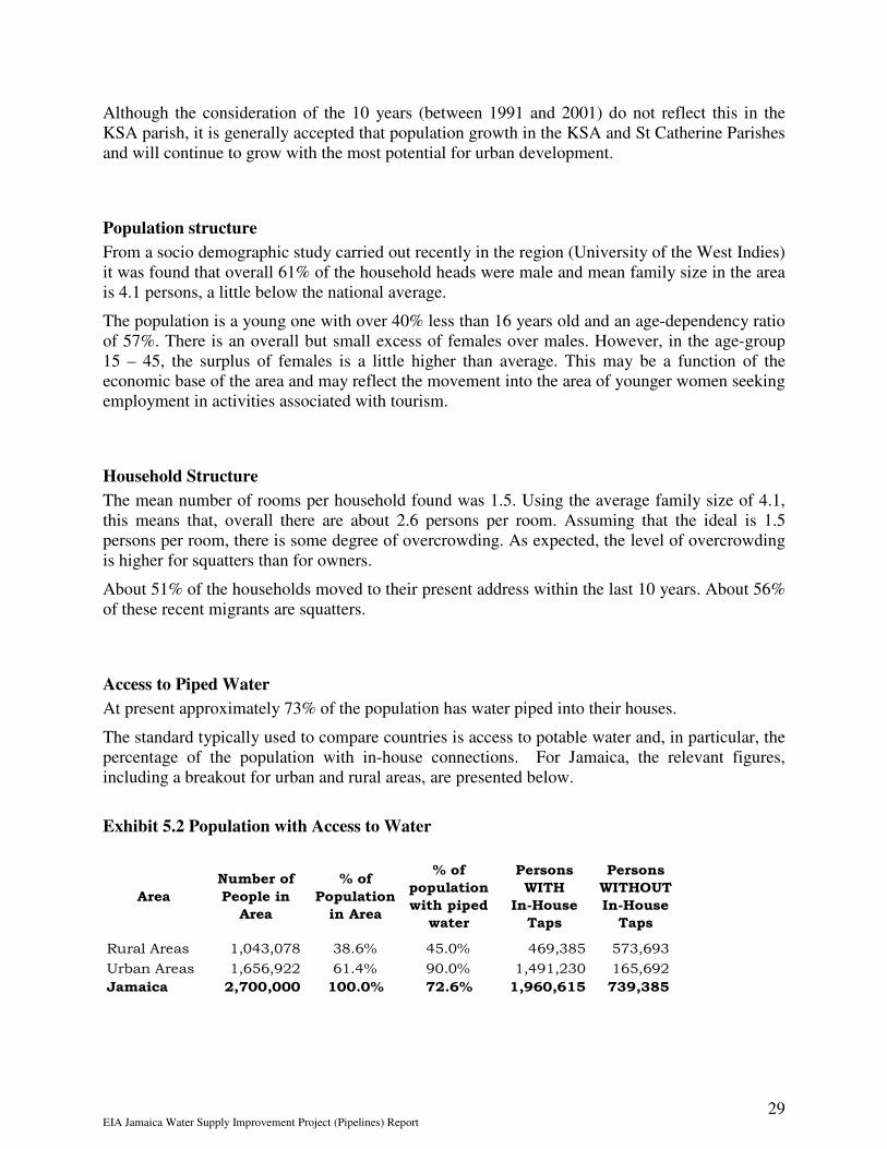
Access to Piped Water
At present approximately 73% of the population has water piped into their houses.
The standard typically used to compare countries is access to potable water and, in particular, the percentage of the population with in-house connections. For Jamaica, the relevant figures, including a breakout for urban and rural areas, are presented below.
Exhibit 5.2 Population with Access to Water
Area
Number of
People in
Area
% of
Population
in Area
% of
population
with piped
water
Persons
WITH
In-House
Taps
Persons
WITHOUT
In-House
Taps
Rural Areas 1,043,078 38.6% 45.0% 469,385 573,693
Urban Areas 1,656,922 61.4% 90.0% 1,491,230 165,692
Jamaica 2,700,000 100.0% 72.6% 1,960,615 739,385

EIA Jamaica Water Supply Improvement Project (Pipelines) Report 30
Employment
From the demographic study it was found that 41% of the population 14 and over were employed.
Land owning households contributed 36.7% of the total and 42% of employed persons while squatters contributed 42% of households and 44% of employed persons.
Exhibit 5.3 - Distribution of employed population by type of employment
Type of Employment % of employed persons
Employer
Self employed
Employee
5.1
44.0
50.7
Well over 80% of employed persons work full-time. Part-time work accounted for 7% of the population with seasonal and casual work accounting for 2% and 3% respectively.
5.2. Tourism
Jamaica’s economy has become increasingly dependent on tourism. As an industry tourism represents great growth potential since it increases foreign exchange earnings and expands employment opportunities. While tourism brings visitors to Jamaica in search of natural beauty and cultural attractions, the dramatic growth of the industry poses special problems to the national environment and culture. Tourism underscores the need to harmonise environmental, social and economic planning.
There is the growing danger of Jamaica becoming overly dependent on one sector which is subject to international perception of security, to seasonal fluctuations and economic uncertainties.
Exhibit 5.4 - Tourism Performance Indicators 1998-2002
INDICATORS 1998 1999 2000 2001 2002
% CHANGE
2001/2002
Foreign nationals 1,128,283 1,147,135 1,219,311 1,186,996 1,179,083 -0.7
Non-resident
Jamaicans 97,004 101,262 103,379 89,520 87,283 -2.5
Total Stop-Overs 1,225,287 1,248,397 1,322,690 1,276,516 1,266,366 -0.8
Cruise
passengers 673,690 764,341 907,611 840,337 865,419 3
TOTAL 1,898,977 2,012,738 2,230,301 2,116,853 2,131,785 0.7
Average Length
per Stay 11 10 10 10 10 0
Earnings
(US$M) 1,197 1,280 1,333 1,232 1,183 -4.1

EIA Jamaica Water Supply Improvement Project (Pipelines) Report 31
Exhibit 5.5 – Tourist Arrivals by Country
COUNTRY OF
ORIGIN 1999 2000 2001 2002
United States 870,019 942,561 916,681 925,629
Canada 100,338 107,492 111,158 97,413
United Kingdom 124,930 135,338 127,320 125,859
Other European 83,759 63,641 53,312 53,230
Caribbean 38,023 43,971 40,845 41,138
Latin America 15,635 14,703 14,815 11,864
Japan 8,411 7,779 7,859 4,664
Other 7,283 7,205 4,526 6,569
TOTAL 1,248,398 1,322,690 1,276,516 1,266,366
Room Inventory
The 2002 Price Waterhouse Coopers survey indicates that there are at least 15,358 hotel rooms in Jamaica at 31 March 2002. Of this total, 14,388 rooms are currently in use and 970, or 6.3% of the 15,358 are unavailable
Some12,450 rooms (86%) of the available rooms in Jamaica are located in the Montego Bay, Ocho Rios and Negril regions. Kingston and St. Andrew have some 1,220 rooms (7.9%). Kingston largely caters for business persons.

EIA Jamaica Water Supply Improvement Project (Pipelines) Report 32
6. EXISTING INFRASTRUCTURE AND UTILITIES
6.1. Water Supply Network
For a description of the existing water supply network, refer to Section 3 of this EIA where details are given in order for the proposed construction project (‘the Development’) to be read in context.
6.2. Sewerage Network
The pipelines that will be constructed will be going through rural areas where sewerage facilities do not exist. Habitations encountered along the route of these pipelines mainly have septic tanks or soakage pits.
6.3. Transportation Network and Traffic
Most of the roads where pipelines will be installed (replacement and new) are parochial roads in remote areas with very small traffic. Traffic on those parochial roads is limited to a small number of taxis and private motor cars and very few trucks and vans. It is not foreseen that there will be a major increase in traffic as a result of the proposed works. However, where short term interruptions are expected as a result of specific types of works, appropriate traffic management will be undertaken, in keeping with an overall traffic management plan that will be prepared.
These roads are managed by St. Catherine Parish Council and the KSAC.
The National Works Agency (NWA) has responsibility for major roads. Some of the roads where the Forest Hills/Red Hills water distribution maintenance will be undertaken are the responsibility of NWA.
6.4. Electricity Supply
The Jamaica is well served with electricity that is provided by the Jamaican Public Service Company. One of the larger generating plants is located in Kingston and the largest facility is located in St. Catherine.
The availability of electricity is not critical to the construction of the pipelines under the JWSIP-B.
6.5. Air Transport
Jamaica has two international airports, one located at Palisadoes in Kingston and the second located in Montego Bay, St. James. There are aerodromes in Kingston, Ocho Rios in St Ann and Negril in Westmoreland.
There will be minimal use of air transport during the pipeline construction.

EIA Jamaica Water Supply Improvement Project (Pipelines) Report 33
6.6. Telephone / Telecommunication
Jamaica is served by the Lime, Claro and Digicel Telecommunications networks recently upgraded in many areas through installation of new switching stations and fibre optic cables. Communication among personnel involved in the project using mobile phones and land line will be greatly facilitated by the high quality of the communication infrastructure.
6.7. Solid Waste Management
Residential wastes are estimated to be generated at a rate of approximately 0.6 kg per capita per day. Solid waste generated typically has a high organic content, while levels of metal, glass and paper appear to equate to levels observed elsewhere in the Caribbean. However, there is a trend towards an increase in the volume of wastes being generated consistent with the growth of tourism and the population in the region, as would be expected.
Responsibility for the collection of solid waste in the country is the responsibility of the National Solid Waste Management Authority (NSWMA) and waste collection services are provided free of charge to householders. The collection of waste from commercial premises is carried out at a price negotiated between a waste collection contractor and the owner.
The NSWMA manages a landfill in Riverton, located under 10 kilometres from the Ferry Pump Station. NSWMA allows the dispose of waste at this landfill at price that is negotiated with private contractors who collect and dispose waste.
6.8. Social facilities
All social facilities, schools, hospitals, libraries and other institutions are represented in the area as one may expect from Jamaica’s first largest city. Kingston.

EIA Jamaica Water Supply Improvement Project (Pipelines) Report 34
7. EVALUATION OF PREDICTED ENVIRONMENTAL IMPACTS
7.1. Introduction
Impact prediction involves the analysis of potential causes of change to the existing environment and a determination of likely effects. An assessment of the potential impacts of a development requires in the first instance a thorough list of all potential impacts, no matter how minor or short term, or whether they are direct, indirect or detailed. Identification requires application of a linkage concept whereby the following are appraised:
• the source and/or cause of the potential problem;
• the receptor of the impact;
• the way in which the effect is transmitted from the source to receptor (pathway); and
• the potential consequences.
Such an appraisal also requires the following to be assessed:
- Magnitude - the size/amount of the impact;
- Significance - the actual effects; and
- Extent - the areas likely to be affected.
In many instances, the appraisal mechanism is subjective, but is nonetheless based upon extensive professional judgment and experience and, and is backed by sound scientific and engineering reasoning.
This section details the assessment of potential environmental impacts for (a) Rio Cobre pipeline – section from New WTP to Ferry, (b) Pipeline from Ferry to the Rockpond Tank and (c) the Rehabilitation of the Forest Hill/Red Hills Water Distribution Network.
In the first instance an exhaustive list of potential impacts is presented in tabular form for each of the identified phases of development (Site Clearance and Preparation, Construction and Operation). Those impacts assessed as being potentially significant are then discussed further, or else are referenced to other areas of the text which relate to the appropriate discussion of the raised subject. Likely socio-economic impacts are presented in the proceeding section (Section 8.0).
7.2. Site Clearance and Preparation Phase
7.2.1. Impact Assessment
The site clearance and preparation phase concerns the clearance and removal of the existing vegetative cover as well as re-profiling, if necessary. Exhibit 11 summarized the appraisal of potential impacts.

EIA Jamaica Water Supply Improvement Project (Pipelines) Report 35
Exhibit 7.1 - Appraisal of Potential Environmental Impacts During Site Clearance & Preparation
Potential
Impact
Receptor Type of Nature Potential Comments
I N R D L Impact Significance
Loss of
vegetation
Flora x Negative LT, IR Minor See Section
7.2.2
Habitat loss Fauna x Negative LT, IR Minor See Section
7.2.2
Increased
water run-off
Hydrology x Negative LT, IR Minimal See Section
7.2.2
Erosion Soils x Negative LT, IR Minimal See Section
7.2.3
Noise and
vibration
Humans x Negative ST, R Minor See Section
7.2.4
Nuisance
Noise and
vibration
nuisance
Fauna
especially
birds
x Negative ST, R Minor See Section
7.2.4
Dust creation Air Quality x Negative ST, R Minimal See Section
7.2.4
Visual
impact
Humans x Negative LT, IR Minimal See Section
7.2.6
Increased
traffic
movements
Humans and
Air Quality
x x Negative ST, R Minimal See Section
7.2.7
Negative LT, IR Minimal See Section
7.2.5
Importance
Generation
of wastes
x xWater
resources and
ecology
I = International N = National R = Regional D = District L = Local LT = Long Term ST = Short Term IR =Irreversible R = Reversible
Potential Significance - refers to the anticipated impact based upon the discussions referred to.
EIA Jamaica Water Supply Improvement Project (Pipelines) Report 36
7.2.2. Discussion of Vegetation Loss
Potential Impacts - An unavoidable part of any development in general is the clearance and loss of areas of vegetation which currently characterise the site of the development area. Not only may vegetation be lost, but also faunal habitats may also be lost or at least partly destroyed. In addition, the removal of areas of vegetation could mean that the same degree of interception will no longer occur, and consequently increased run-off might be expected.
Baseline Surveys - the proposed route of the pipeline(s), and a walk over inspection of the potential site(s) confirmed that very little vegetation will be destroyed or damaged along the pipeline/route and the secondary roads.
Analysis of Potential Impact - The overall potential impact on vegetation is minimal, in particular because the replacement pipeline for the Rio Cobre pipeline will follow the route of the existing pipeline. As a result, most of the mature trees would have been removed at the time of the construction of the existing pipeline.
During the preparation for the installation of the pipeline from Ferry to Rockpond, the route will include a parochial road and areas where there is vegetation. A tree survey will be done to confirm the position, least likely to require removal of mature trees.
Mitigation - No special mitigation measures are deemed necessary other than retention of trees and shrubs, where possible on the potential sites for screening of the visual impact. Where the proposed route requires the removal of any vegetation, care will be taken to minimize the destruction or damage of trees.
Statement of Significance - The significance of the vegetation loss (where vegetation is still existing) during the site clearance (where necessary) is minimal.
7.2.3. Discussion of Soil Loss
Potential Impacts – Soil types develop over significant timescales, consequently these soils are not an unlimited resource, and could typically be lost or damaged during development activities.
Baseline Survey - Along the route of the pipeline insitu soils have been disturbed, are fill material (marl / crushed stone) or where the road is in fill on soft former mangrove or swampland, they are peat.
Analysis of Potential Impact - As may be apparent from the baseline survey, soils at the development site (s) are unlikely to be adversely affected by construction activities.
Mitigation - No mitigation measures are deemed necessary.
Statement of Significance - As most, if not all soils in which or on which construction takes place, are disturbed already the environmental impact of the construction activities is considered minimal.

EIA Jamaica Water Supply Improvement Project (Pipelines) Report 37
7.2.4. Discussion of Noise and Air Quality Issues
Potential Impacts - During the course of the clearance and site preparation works, noise will inevitably be generated due to the use of machinery and motorised equipment. Noise can have a significant effect on the environment and on the quality of life enjoyed by individuals and communities. The perception of noise may be reflected by many factors (acoustic and non-acoustic) but in general the impact in response to a noise depends on the level of noise, the margin by which it exceeds the background level, its spectral character and temporal variation. Other factors may also be important including time of day, day of the week, duration and other acoustic features.
Chippings and dust may be created through exposure of the surface soils and sands and through machinery movements. Dusts, particularly finer particulates, can present respiratory problems when inhaled, as well as potential allergic reactions. In addition, dusts can cause nuisance problems when redeposited.
Baseline Survey - Because of the anticipated short term nature of the work and the absence of any noise impacts the development will have when operational, a background noise level survey is not considered necessary for this impact assessment. No present significant noise impact, has been identified. No air quality monitoring data is available for the area, however given the absence of any significant industrial and commercial processes, it is considered that the air quality levels will be below the stipulations by WHO and NEPA.
Analysis of Potential Impact - The relatively short term nature and small scale of the works suggest that generated noise levels will not be excessive or cause any major long term nuisances or inconvenience. The works will however present a short term noise nuisance to the public and to the owners adjacent site. Due to the nature of the works, and the fact that significant fine particulates are unlikely to be generated, the local air quality is unlikely to be significantly affected unless construction of the pipeline is done by trenching machine.
Mitigation - No specific measures are to be employed except for the provision of mufflers on exhausts and standard restrictions to hours of site works, although it is recommended that provision should be made for water sprays to be available for use when dusts are being generated or at times of strong wind.
The material transported to the construction site will be covered and where appropriate wetted, to minimize dust nuisance. Similarly, care will be taken to minimize dust nuisance arising from the transport of waste material from the work sites.
Statement of Significance - The works are not considered to present a significant contribution to background noise levels and hence to the local or wider environment, except on a very short term scale. The local air quality will not be significantly impacted upon by the works.

EIA Jamaica Water Supply Improvement Project (Pipelines) Report 38
7.2.5. Discussion of Generated Wastes
Potential Impacts – Very little vegetation wastes will be generated during the clearing works as there will be little generation of general building waste. Disposal of any waste material will be transported to the Riverton lanfill, which is less than 10 km from the Ferry Pump Station.
Baseline Survey - Only one waste disposal site, which is located at Riverton serves the area..
Analysis of Predicted Impact - The wastes generated by the works are largely inorganic and will not be excessive, and if all were sent to landfill, it is not considered likely that the wastes will impact significantly on the Riverton landfill site. It is however important that the ultimate fate of the wastes be monitored so that they are not illegally disposed of.
Mitigation – Wastes are largely of an inorganic nature and if disposed to the existing landfill site, further mitigation measures are not deemed necessary.
Measures to ensure that waste materials from the Project are disposed at suitable licensed landfill sites will be taken. These will include engaging only reputable truckers and conducting appropriate spot checks to verify that disposal are done in accordance with the requirements of NEPA and other agencies
Statement of significance - If carefully managed and controlled, the generation of any significant wastes from the clearing works is considered unlikely to impact upon the local environment or put additional pressures on the current waste management situation for the area.
7.2.6. Discussion of Visual Impact
Potential Impact – the removal of vegetation where this becomes inevitable and subsequent redevelopment of the site will have a negative visual impact, particularly where new pipelines are constructed.
Baseline Survey – the existing Rio Cobre pipeline has been in operation for almost forty years. A new pipeline will be installed between the Ferry pump Station and the Rockpond tank and replacement pipelines will be constructed in sections of Forest Hills?Red Hills.
Analysis of Potential Impacts – Construction of the pipeline will only impact on the visual environment where the pipeline is not buried or it is constructed on pillars. Replacement of the existing Rio Cobre pipeline and the pipelines in the Forest Hills/Red Hills area will not change the visual impact that the existing pipelines have had on the environment over the past forty years. Most of the pipeline will be installed below ground anyhow.
Mitigation - Removal of any trees or vegetation along the alignment of the pipeline will impact on the visual environment. As already indicated, where the proposed route requires the removal of any vegetation, care will be taken to minimize the destruction or damage of trees. Replanting will be done where appropriate or specifically stipulated by the relevant authorities.
Statement of Significance – It is impossible to totally mitigate against the visual impact where it is necessary to construct pipeline above ground. However, pipeline construction above ground is

EIA Jamaica Water Supply Improvement Project (Pipelines) Report 39
widely practiced on the Island and its impact, particularly at the toe of the embankments or on culvert or brick walls is minimal.
7.2.7. Discussion of Potential Impact of Traffic
Baseline Survey - No traffic counts was done along the route of the pipeline.
Analysis of Potential Impact - During preparation for pipeline installation, there will be minimal impact on traffic will be impeded. Existing roadways and tracks, which are now being used as means of access for the maintenance of the existing pipelines, will be used during the preparation phase. Pipelines will be constructed in remote areas of St Catherine and St Andrew. Traffic on those parochial roads is limited to a small number of taxis and private motor cars and very few trucks and vans. It is not foreseen that there will be a major increase in traffic as a result of the proposed works. However, where short term interruptions are expected as a result of specific types of works, appropriate traffic management will be undertaken, in keeping with an overall traffic management plan that will be prepared
Statement of Significance – Work will mainly take place in areas where there is very little traffic. Steps can be easily taken to minimize traffic hold-ups in these areas by moving the alignment of the pipeline as far outside the shoulder of the road as is practicable. Overall however the impact is of short duration and is considered to be minor.

EIA Jamaica Water Supply Improvement Project (Pipelines) Report 40
7.3. Construction Phase
7.3.1. Impact Assessment
The construction phase concerns the actual construction of the project and development up until its subsequent opening and operation. Exhibit 12 summarizes the appraisal of potential impacts.
Exhibit 7.2 - Appraisal of Potential Environmental Impacts during Construction Works
Potential
Impact
Receptor Impact Nature Potential
Significance
Comments
I N R D L
Dust emissions Air quality x Negative ST, R Minor See Section 7.3.2
Noise and vibration Humans x Negative ST, R Minor See Section 7.3.3
Noise and vibration Fauna especially
birds
x Negative ST, R Major See Section 7.3.3
Congestion and over
use of roads
Road infrastructure x x Negative ST, R Minor See Section 7.3.4
Safety risk due to Humans, Fauna x x Negative ST, R Minor See Section 7.3.4
Congestion and use
of roads
Air quality x x Negative ST, R Minor See Section 7.3.4
Landscaping Flora and fauna x Positive LT Major Partly off-sets the
loss of flora and
fauna - See 7.2.2 &
7.2.6
Accidental spills or
leakages
Water resources No impact See Section 7.3.5
Surface water run-
off
Water resources x Negative ST, R Minimal See Section 7.3.6
Health & Safety risk Humans, fauna x Negative ST Minimal See Section 7.3.7
Waste generation Water resources x x Negative LT, IR Minor See Section 7.3.8
and ecology
Use of local
construction
materials
Flora, fauna
geology and air
quality
x x Negative LT, IR Minor See Section 7.3.9
Importance
I = International N = National R = Regional D = District L = Local LT = Long Term ST = Short Term IR = Irreversible R = Reversible
Potential Significance - refers to the anticipated impact based upon the discussions referred to.
7.3.2. Discussion of Air Quality Issues
Potential Impacts - Construction unavoidably creates dust during the course of site works due to material and vehicle movement and construction activities. Fine particles may also be lifted from exposed surfaces by the action of wind, although the extent and nature of the generated dusts is dependent upon the materials to be used.

EIA Jamaica Water Supply Improvement Project (Pipelines) Report 41
Dusts, particularly finer particulates, can present respiratory problems when inhaled, as well as potential allergic reactions. In addition, dusts can cause nuisance problems when redeposited.
Baseline Survey - No air quality monitoring data is available for the area however, given the absence of any significant industrial and commercial processes in the area, it is considered that the air quality will be good.
Analysis of Potential Impacts - Experience of construction projects suggests that, whilst dust generation will inevitably occur for short duration, its extent and impact will be minimal and of minor concern. Emissions to air will not lead to increases in gases in excess of the natural variation in the range of concentrations expected. Furthermore, the natural on site soils are of such a particle size distribution so as not to be easily airborne.
Mitigation - Provision should be made available for water sprays to be used when dusts are being generated or at times of strong wind. All materials stored or stockpiled on site should be adequately covered, and vehicles leaving the site should pass through wheel washes where practicable.
Statement of significance - Dusts will be generated during the course of the construction activities, however it is considered unlikely that ambient air quality standards will be exceeded. The generation of dusts is not considered be significant and will not present any long term problems or nuisances to the surrounding area, although temporary short term nuisances may be experienced in the local vicinity of the works.
7.3.3. Discussion of Noise and Vibration
Potential Impacts - Noise can have a significant effect on the environment and on the quality of life enjoyed by individuals and communities. The perception of noise may be reflected by many factors (acoustic and non-acoustic) but in general the impact in response to a noise depends on the level of noise, the margin by which it exceeds the background level, its spectral character and temporal variation. Other factors may also be important including time of day, day of the week, duration and other acoustic features. Vibrations, even very low magnitude, may be perceptible to people and can interfere with the satisfactory conduct of certain activities. Noise will be generated during the construction works by both the use of machinery, movement of materials and the movement of vehicles, and could cause a nuisance to local residents.
Baseline Survey - Because of the anticipated short term nature of the work and the absence of noise impacts the project will have when operational, a background noise level survey was not considered necessary for this impact assessment. No present significant noise impacts have been identified in the area.
Analysis of Predicted Impact - The short term nature and scale of the construction works suggest that generated noise levels will not be excessive or cause any major nuisances or inconvenience. The works are considered not to present a significant any impact in terms of noise and vibration generation. However, short term nuisance and inconvenience will be experienced by land residents.

EIA Jamaica Water Supply Improvement Project (Pipelines) Report 42
Mitigation - No specific measures are to be employed except standard restrictions to hours of site works, and the fitting of mufflers on construction equipment. The residents will be sensitized ahead of the commencement of works. A liaison person should be designated by NWC to relate with the residents during the works.
Statement of significance - The works are likely to present a significant but short term and temporary contribution to background noise levels, but are unlikely to affect the wider environment. No long term damage is likely to result from the anticipated levels of noise which will be generated by the works.
7.3.4. Discussion of Transport Issues
Potential Impacts - Increased traffic movements to and from the site will be an inevitable consequence of the construction works. Such movements will be due to material delivery, waste disposal and workers going to and from work. Potential problems resulting from such increased traffic movements include congestion of the existing road network, safety risks to humans, air quality deterioration due to vehicular exhaust emissions (nitrous oxides, carbon monoxide, hydrocarbons and particulates), excessive noise affecting both humans and the fauna (see Section 7.3.3), as well as wider scale implications due to the emission of greenhouse and ozone depleting exhaust gases.
Baseline survey - No traffic counts could be done along the route of the pipeline. A survey of air quality has not been undertaken as already discussed in Section 7.3.3, but given the site’s location and distance from significant industrial and urban centres, it is considered unlikely that an air quality problem currently exists. Ambient noise levels have also not been recorded as already described in Section 7.3.2.
Analysis of Potential Impact - Based upon experience of the road and transportation network serving the area, the direct creation of excessive traffic congestion due to the construction works is not anticipated. During pipeline installation through traffic will be impeded somewhat. Existing roadways and tracks, which are now being used as means of access for the maintenance of the existing pipelines, will be used during the pipeline replacement works. Pipelines will be constructed in remote areas of St Catherine and St Andrew. Traffic on those parochial roads is limited to a small number of taxis and private motor cars and very few trucks and vans. It is not foreseen that there will be a major increase in traffic as a result of the proposed works. However, where short term interruptions are expected as a result of specific types of works, appropriate traffic management will be undertaken, in keeping with an overall traffic management plan that will be prepared
Statement of Significance – Work will mainly take place in areas where there is very little traffic. Steps can be easily taken to minimize traffic hold-ups in these areas by moving the alignment of the pipeline as far outside the shoulder of the road as is practicable. Overall however the impact is of short duration and is considered to be minor.
The additional traffic movements on the local road network are not expected to result in the road becoming more dangerous than it currently is.
Mitigation - Restrictions on the movement of vehicles may be placed so as to avoid any anticipated peak levels, as well as phasing of traffic movements to and from the site so as to

EIA Jamaica Water Supply Improvement Project (Pipelines) Report 43
avoid potential convoys which could cause local scale congestion. In addition all trucks should not be over laden, and should be regularly serviced. Good driving practices will be required from all delivery drivers. When necessary, a suitable junction/access point is also needed off the highway to prevent local traffic congestion.
Wherever and whenever construction approaches on the road or potentially affects the traffic signage will have to be placed and formal flagmen / women employed in order to ensure the public safety.
Statement of Significance - The traffic movements are only considered likely to present a minor impact on the road network with respect to congestion and safety risks, and an overall minimal contribution to any deterioration in air quality. With careful consideration and implementation of the works programme, any potential impacts will be minimised.
7.3.5. Discussion of Potential Accidental Spills or Leakages
Potential Impacts - The principal chemicals held on the site during the construction site are likely to be vehicle fuel and paints. Spillage or escape of such compounds are likely to have an immediate impact upon the local water resources and consequently on the terrestrial and marine flora and fauna.
Baseline Surveys - The flora and fauna and hydrological situation at the site has been discussed already in Sections 5.5, 5.6 and 5.7. There is a requirement for proper storage of chemicals / materials.
Analysis of Potential Impacts - According to the program of works, spillages and leakages are not very likely to occur because there is almost no transportation of fuel or chemicals.
Mitigation - Void
Statement of Significance - Void
7.3.6. Discussion of Potential Surface Water Run-Off
Potential Impacts - Surface water run-off from the construction sites during all stages of the works, but particularly during the construction phase could cause potential impacts upon the local terrestrial and marine environment. Run-off directly into the sea could result in a deterioration of the marine water quality through carried sediments and/or chemical contaminants.
Baseline Survey – The existing roadway and tracks have provisions for drainage in some sections.
Analysis of Potential Impact – Where the pipeline is laid in high slope the backfill may be scoured out during heavy rain and deposit silt into natural drainage channels and hence to the river or the sea.
Mitigation - During the course of the construction works, temporary drainage channels should be constructed to encourage dispersal of meteoric waters. Storage and stockpiling of materials on the site should be away from drainage channels. Backfill of trenches in or near drains should be topped with rock fill to stop scour where drains have a gradient of 5% or over.

EIA Jamaica Water Supply Improvement Project (Pipelines) Report 44
Statement of significance - Run-off of waters from the site are considered unlikely to constitute a significant environmental impact providing appropriate measures are implemented during the duration of the construction works.
7.3.7. Discussion of the Health & Safety Risk to the Public from the Construction Works
Potential Impacts - Construction sites are hazardous environments due to a range of activities and works being undertaken, vehicle movements, electrical, mechanical equipment, craneage, presence of scaffolding etc. Open access to the construction site will undoubtedly result in injury and potentially fatal accidents.
Baseline Survey – Roads and highway have public access and must be controlled.
Analysis of Potential Impact - Potential accidents are not anticipated if the construction site is appropriately managed and controlled.
Mitigation – All construction workers should be advised of the dangers associated with construction work. They should be provided with suitable foot wear, hard hats, protective glasses and generally with safety equipment where appropriate. Trenches over 1.5 m deep or wherever soil conditions dictate should be shored and secured against accidental entry by public and where construction activities interfere with the movement of traffic, the site should be signed and controlled by trained flagmen/flagwomen and lit by night.
Statement of significance - Health and safety impacts to the public are not anticipated during the construction works provided all mitigating measures are strictly adhered to.
7.3.8. Discussion of the Generation of Wastes
Potential Impacts - Waste materials will inevitably be generated during the construction works. Such materials will require disposal to landfill. Landfill sites produce significant negative environmental impacts to water resources and ecology, particularly if poorly constructed and managed. Illegal or uncontrolled disposal of the wastes will create even greater environmental and potential public health concerns.
Baseline Survey - Only one waste disposal site, which is located at Riverton, currently serves the area, although alternative disposal sites are currently being appraised by NEPA.
Analysis of Potential Impact - The volumes of wastes generated by the works will not be excessive, and the nature of the wastes will generally be inert and therefore are unlikely to

EIA Jamaica Water Supply Improvement Project (Pipelines) Report 45
constitute a significant hazard. It is not considered likely that the wastes will impact significantly on the Riverton site. It is however important that the ultimate fate of the wastes is monitored so that they are not illegally disposed of.
Mitigation - It is recommended that a waste minimisation approach is adopted as part of the construction works. In addition, the fate of disposed wastes should be carefully monitored to ensure they are being legally land filled at a recognised controlled site.
Statement of significance - If carefully managed and controlled, the generation of any wastes from the construction works is considered unlikely to impact upon the local environment or put additional pressures on the current waste management situation for the area.
7.3.9. Discussion of the Requirement and Use of Local Building Materials
Potential Impacts - Construction materials will be required from the local area and indeed from elsewhere on the island. Obtaining such materials can have potentially adverse environmental effects such as dust creation, land take from quarrying works, dredging of sand, shale and gravel and the felling of trees to provide timber.
Baseline Survey - It is estimated that the development will require stone, sand, marl, concrete/blocks, steel and timber. These can largely be supplied from local sources, although the supply of sand is likely to be from Black River on the south coast of Jamaica.
Analysis of Potential Impact - Providing the materials are obtained from appropriately managed and licensed operations, significant environmental impacts are not expected. The sources of the local materials will not be specific to the construction of this project.
Mitigation - The sources of all required materials should be inspected prior to acquisition to confirm that they are legitimate operations.
Statement of significance - If carefully controlled, the requirement for local building materials is considered unlikely to significantly impact upon the local environment or indeed on the national environment.

EIA Jamaica Water Supply Improvement Project (Pipelines) Report 46
7.4. Operational Phase
7.4.1. Impact Assessment
Exhibit 7.3 - Appraisal of Potential Environmental Impacts during Operations
Potential
Impact
Receptor Impact Nature Potential Comments
I N R D L Significance
Waste generation Water
resources and
ecology
X X No impact
Visual impact Humans Negative LT, IR Minimal See Section
7.2.6
Water
requirements
Water
resources
X X No impact - -
Noise and
vibration
Humans and
fauna
X No impact - -
Accidental spills Water
resources
X No impact Water only
Traffic
generation
Infrastructure X X No impact -
No impact -
Importance
Sewage Water
resources
X X
I = International N = National R = Regional D = District L = Local LT = Long Term ST = Short Term IR = Irreversible R = Reversible
Potential Significance - refers to the anticipated impact based upon the discussions referred to.

EIA Jamaica Water Supply Improvement Project (Pipelines) Report 47
8. EVALUATION PREDICTED SOCIAL ECONOMIC IMPACTS
The social economic impact is a means of identifying or predicting the probable impacts of projects such as JWSIP. It is recognized that levels of impacts will occur at all stages of the project life-cycle – Preliminary Undertakings, Construction/Implementation and the Operation/Maintenance stage.
With this in mind, additional work will be done to better define some of these impacts in terms of their desirability, scale, duration in time and space, intensity or severity, cumulative or counter balancing.
(a) Some Project Benefits
The provision of water to areas where there either was none before and/or to areas which previously had intermittent supply or depended on tankered water can only have a positive impact on the social economics of the people in the Kingston Saint Andrew and St Catherine Parishes.
The JWSIP will benefit the population directly, enhance the living environment, open up new areas for development and hence provide work opportunities for local people.
The benefits of the project will include:
• Availability of sufficient production capacity for the KMA for the first time in decades
• Virtual elimination of major water lock-offs in the KMA, including during dry periods
• General improvements in service reliability and pressure levels
• Reduction in technical and commercial losses
• Increased number of residents in rural areas with access to reliable water supply
• Increased economic activity and spin-offs during the construction period as well as during the operating stages of the project.
(b) Land Acquisition
NWC will use its standard approach to the acquisition of lands for the Jamaica Water Supply Improvement Project. This approach involves making every attempt to locate and inform landowners that NWC is interested in acquiring all or part of their land and is desirous of acquiring by way of sale or lease. Where an owner is willing to deal with the NWC, an arms length transaction is negotiated with the owner on the basis of the market value of the property, as determined by a Chartered Valuer.
Where an owner cannot be located or is unwilling to sell to the NWC, the Commission will invoke the compulsory acquisition process as set out under the NWC Act and the Land Acquisition Act (see appendix 1) and will proceed as indicated under these Acts. The Acts provide for owners to be compensated at market value; where no agreement can be reached on compensation the Acts facilitate the matter being settled by the Court.
Where an owner cannot be located, arrangements are made to have monies paid into an escrow account

EIA Jamaica Water Supply Improvement Project (Pipelines) Report 48
9. ALTERNATIVES
In the case of the Jamaica Water Supply Improvement Project (Category B Works), the potential environmental impacts are minimal and the options for alternatives are few.
In fact, apart from supporting and sustaining further development and thus helping to increase the pressure of human activity on the environment, the project in itself is ultimately beneficial to the people of Jamaica.

EIA Jamaica Water Supply Improvement Project (Pipelines) Report 49
10. MITIGATION MANAGEMENT PLAN
10.1. Introduction
This section details the opportunities for reducing identified negative environmental impacts by mitigating for adverse effects of the project.
Typically, three forms of mitigation are identified; these are (a) avoidance, (b) reduction and (c) remedy. The following mitigation measures have already been discussed in Section 7, and are summarized for the different stages below.
Common to the site clearance and construction phase is the need to appoint an experienced independent environmental/safety supervisor on site who reports both to the contractor and the NWC / Ministry of Health / NEPA. This role could be combined with construction supervision.
10.2. Site Clearance and Preparation Phase
The following will be undertaken during the site clearance and preparation phases in an effort to identify and develop appropriate mitigation measures to reduce negative environmental impacts.
• A walk over survey of a terrestrial ecologist will be required for both the pipeline approaches;
• Minimisation of the volumes of waste generated. Any vegetation removed is to be shredded and used on site as mulch;
• Ensure vehicles are regularly serviced - to prevent unnecessary exhaust emissions;
• Control vehicle movements on and off the site;
• Ensure the site is appropriately signed to warn of the potential dangers;
• Ensure general good site management and health and safety awareness are employed;
• Check the local material sources/suppliers for legitamacy of operations.
10.3. Construction Phase
In addition to the points mentioned above, during the construction phase, it is necessary to action the following:
• Provision for water sprays - to control dust generation if necessary;
• All stockpiled materials to be suitably covered - to prevent dust generation by wind action;
• Restriction of work hours - to minimise the noise impact on local residents;
• Vehicles not to be over laden - thus preventing road damage;
• Vehicle movements to be phased to avoid peak hours – where construction interferes with traffic, use of proper signage and flagmen;
• Phase of vehicles to avoid convoys - and thus avoid local generation of congestion;

EIA Jamaica Water Supply Improvement Project (Pipelines) Report 50
• Requirement for good driving practices - to ensure they are from legal and controlled operations;
• Construct temporary drainage channels - to control the direction and movement of any run-off.
• Store/stockpile materials away from drainage channels.
10.4. Operational Phase
During operations, it is important that NWC keep the access to the pipeline.
11. ENVIRONMENTAL MANAGEMENT AND TRAINING
It is recommended that the Contractor organise an environmental awareness and health and safety training session for all his staff prior to commencement of the project and maintain strict standards throughout the execution of the works.

EIA Jamaica Water Supply Improvement Project (Pipelines) Report 51
12. ENVIRONMENTAL MONITORING PROGRAMME
12.1. Introduction
Many of the proposed environmental monitoring procedures have already been discussed and detailed in Sections 7 and 10, but are summarised below:
12.2. Monitoring During Site Clearance and Preparation
• Undertake checking of retained trees and vegetation by a suitably qualified person to ensure they have not been damaged by the works; and
• Undertake daily reviews of the volumes of wastes being generated and keep records relating to its ultimate disposal.
12.3. Monitoring During Construction Works
• Daily inspections as part of the construction works to ensure an appropriate quality of workmanship;
• Daily observations of the direction and strength of wind to control the release of dusts;
• Undertake daily inspections of delivery vehicles serving the site to ensure they are not overladen;
• Undertake daily reviews of the volumes of wastes being generated and keep records relating to its ultimate disposal;
• Monitor and approve the suppliers and sources of local materials to ensure they are legal; and
• Undertake checking of retained trees and vegetation in landscaped areas by a suitably qualified person to ensure they are not damaged and are responding to relocation and reinstatement.
12.4. Monitoring During Operations
Following completion of the works and commissioning of the new water supply system, it would be beneficial to review the cost benefit to NWC and to the economy of the country as a reference for planning and implementation of similar projects.
In particular the results of the unaccounted for water exercise would be relevant to this review and continued bulk metering, zonal metering and analyses of the customer database is therefore necessary.