kaaimansgat inlier: a keystone of the cape fold beltcrowe/downloads/maclennan_rowe… · of the...
TRANSCRIPT
Kaaimansgat Inlier: A Keystone of the Cape Fold Belt
Geological Society of South Africa
Western Cape Branch
End-of-Year Field Trip 29 November 2008
Scott Maclennan and Christie Rowe
Department of Geological Sciences, University of Cape Town
Meeting place: Spar parking lot, Main Road Villiersdorp 10am Saturday 29 November Directions: From Cape Town, take the N2 east across Cape Flats and up to
Sir Lowry’s Pass. After the pass, turn on the R321 toward Villiersdorp/ Theewaterskloof Dam. The R321 becomes Main Rd, Villersdorp and the Spar is on your left as you enter town.
Abstract: The geology of the Western Cape can be summarized in a few sentences. A Neoproterozoic marine sedimentary sequence was deformed in the Saldanian “orogeny”, intruded by the Cambrian Cape Granite Suite, exhumed and planed off, then buried under the Paleozoic Cape Basin, which was subsequently deformed by the ~ Permian Cape Orogeny. However, the details of the depositional environments and the tectonic setting of these deformations are still poorly understood. Understanding of the Saldanian deformation is hindered by poor exposure and structural overprinting of the later orogeny. According to plate tectonic reconstructions, the Cape region would have been interior to the Gondwana supercontinent during Permian time – not near a collisional margin as is the typical setting for fold-thrust belts. Finally, the geometry of the Cape Fold Belt is unique in that it makes a near 90° corner in the syntaxis region, where NNW-SSE trends of the western limb and the E-W trends of the southern limb meet. The Kaaimansgat Inlier, a small valley in the heart of the syntaxis region, is an excellent natural laboratory to explore these puzzles. Maclennan (2008) made a detailed structural and lithostratigraphic study of the Kaaimansgat valley of rocks below and above the unconformity.

Unique characteristics of the Cape Fold Belt
The Cape Fold Belt overprints an earlier fold belt represented by deformation of the Malmesbury Group sediments at ~550Ma – the Saldanian Orogeny. Partly due to poor outcrop, the structural history of the Malmesbury Group is poorly understood. Structures observed in the Malmesbury rocks today are the cumulative effect of two orogenies: the Saldanian and the Cape Orogenies.
The Kaaimansgat locality has relatively good exposure of Malmesbury rocks, and perfect exposure of the unconformity surface. Folding or faulting of the unconformity surface and basal Table Mountain Group can been taken to represent the local effects of the Cape Orogeny. Maclennan (2008) mapped and defined the geometry of the large-scale Cape-age dome in Kaaimansgat and back rotated Malmesbury structures to attempt to understand Saldanian structure in the area. In addition, he measured deformed reduction spots in the Malmesbury phyllites and was able to establish the orientation of the finite strain ellipse at three locations within the area.
Figure 14. Tectonostratigraphic correlation diagram for segments of the Gondwanian fold belt. The spatial arrangement of the columnsreflects the paleogeographic position (as shown in Fig. 15) of these once contiguous geological provinces along the paleo-Pacific marginof Gondwana. Tectonostratigraphy of Pensacola Mountains is after Storey et al. (1996); pre-Cape Supergroup data are established afterBarnett et al. (1997) and Armstrong et al. (1998). SPF—Schoemans Port Formation, KSG—Kansa Subgroup.
Figure from Curtis (2001).
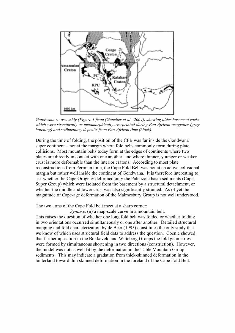
Gondwana re-assembly (Figure 1 from (Gaucher et al., 2004)) showing older basement rocks which were structurally or metamorphically overprinted during Pan-African orogenies (gray hatching) and sedimentary deposits from Pan-African time (black). During the time of folding, the position of the CFB was far inside the Gondwana super continent – not at the margin where fold belts commonly form during plate collisions. Most mountain belts today form at the edges of continents where two plates are directly in contact with one another, and where thinner, younger or weaker crust is more deformable than the interior cratons. According to most plate reconstructions from Permian time, the Cape Fold Belt was not at an active collisional margin but rather well inside the continent of Gondwana. It is therefore interesting to ask whether the Cape Orogeny deformed only the Paleozoic basin sediments (Cape Super Group) which were isolated from the basement by a structural detachment, or whether the middle and lower crust was also significantly strained. As of yet the magnitude of Cape-age deformation of the Malmesbury Group is not well understood. The two arms of the Cape Fold belt meet at a sharp corner:
Syntaxis (n) a map-scale curve in a mountain belt. This raises the question of whether one long fold belt was folded or whether folding in two orientations occurred simultaneously or one after another. Detailed structural mapping and fold characterization by de Beer (1995) constitutes the only study that we know of which uses structural field data to address the question. Coenie showed that farther upsection in the Bokkeveld and Witteberg Groups the fold geometries were formed by simultaneous shortening in two directions (constriction). However, the model was not as well fit by the deformation in the Table Mountain Group sediments. This may indicate a gradation from thick-skinned deformation in the hinterland toward thin skinned deformation in the foreland of the Cape Fold Belt.

Figure 1 from de Beer (1995).
Stop 1. Overlook The Peninsula Formation quartzites frame Kaaimansgat valley. The unconformity is located just below the outcrop of this quartzite. The Malmesbury Group metasediments outcrop in the valley floor, with the most resistant lithologies forming topographic highs. The Peninsula Formation is folded into a 030/210 orientated doubly plunging anticline. The eastern limb diverges from this trend, being closer to an easterly orientation. The overall structure of the Malmesbury Group is interpretated as being a large anticline that is S shaped, or curvilinear. This was interpreted from a gradual change in bedding orientation from NW-SE in the SE of the valley through N-S in the centre around to roughly E-W in the upper NE corner of the valley. Restoring Malmesbury Group structures to their pre-Cape orogeny orientation reveals that the structures were rotated during Cape folding into more of a NE trend, in alignment with the general trend of the syntaxis Stop 2. “Purple phyllite” and reduction spots in the Malmesbury Group A purple phyllite outcrops along the road cut. A normal fault divides these rocks from the basal beds of the Peninsula Formation, which consist of interbedded mudstones

and sandstones. This fault is roughly N orientated and dips steeply to the east. A fine grained purple fault gouge occurs within the normal fault plane. In the purple phyllite dark macroscopic grains of chloritoid are visible. This unit also contains small green ellipses, otherwise known as reduction spots and record the strain experienced by these rocks. This is because they are interpreted as starting off as perfect spheres and are the result of interactions of reducing and oxidizing fluids. Reduction spots are also present on the western limb of the Kaaimansgat Valley. Reduction spots on the western limb record ±60% shortening while the eastern limb shows ±50% shortening. Stop 3. Lithologic variation in the Malmesbury Group; and TMG basal conglomerates – Lunch Stop. Along the northern slopes of Kaaimansgat a thick conglomerate overlies an angular unconformity with the Malmesbury Group. It has a strong cleavage at its base and contains a variety of clasts. This grades into to the Peninsula Formation quartzites that contain only rounded vein quartz pebbles. The road cuts along the road up to Eagles Nest expose the interbedded sandstones and shales of the Malmesbury Group. Stop 4. Granitic intrusion boundary A large granitic intrusion is present all along the western side of Kaaimansgat Valley. For the most part it is almost completely altered, the only surviving primary mineral is quartz. Near the centre of the outcrop there is a body of much finer grained felsic material that has a strong cleavage. This was interpreted as being a heavily sheared part of the granite batholiths. Stop 5. Faulted unconformity, Graafwater Formation (or equivalent) and interesting MG lithologies. There is evidence for shearing along the unconformity and the thinly bedded Graafwater Formation above. This is evident in S-C fabrics in shale lenses and thinly bedded sandstones along and slightly above the unconformity. This movement always has a sense of shear towards the centre of the valley and so is interpreted as a result of layer parallel shearing during the Cape age folding. The observed shear senses do not indicate a large amount of displacement along the unconformity and the Cape orogeny was predominantly thick-skinned at this locality. Interbedded grits and shales are exposed here as well as the steeply south dipping contact with the Malmesbury sandstones Stop 6. (optional) Bedded sandstones in the Malmesbury, bedding cleavage intersections Bedding is hard to find in the Malmesbury Group sediments here owing to their metamorphic grade but the course sandstones contained a few localities where cross and graded bedding outcrop allowing for the determination of younging directions as well. Intersection lineations between bedding and cleavage show changing plunge directions. This was interpreted as being evidence for undulations of the major fold structure in the vertical and horizontal planes. Multiple deformation events are
required for the formation of the structures preserved in the Malmesbury Group, a proportion of which is attributable to the later Cape orogeny. References Cited: Belcher, R.W. and Kisters, A.F.M., 2003. Lithostratigraphic correlations in the
western branch of the Pan-African Saldania belt, South Africa: the Malmesbury Group revisited. South African Journal of Geology, 106: 327-342.
Curtis, M.L., 2001. Tectonic history of the Ellsworth Mountains, West Antarctica: Reconciling a Gondwana enigma. Geological Society of America Bulletin, 113(7): 939-958.
de Beer, C.H., 1995. Fold interference from simultaneous shortening in different directions: the Cape Fold Belt syntaxis. Journal of African Earth Sciences, 21(1): 157-169.
Ferré and Améglio, L., 2000. Preserved magnetic fabrics vs. annealed microstructures in the syntectonic recrystallised George granite, South Africa. Journal of Structural Geology, 22: 1199-1219.
Gaucher, C., Frimmel, H.E., Ferreira, V.P. and Poire, D.G., 2004. Vendian-Cambrian of western Gondwana: Introduction. Gondwana Research, 7(3): 659-660.
Germs, G.J.B., 1995. The Neoproterozoic of southwestern Africa, with emphasis on platform stratigraphy and paleontology. Precambrian Research, 73: 137-151.
Maclennan, S.A., 2008. Geology of the Kaaimansgat Inlier, Western Cape, University of Cape Town, Rondebosch, 67 pp.
Rozendaal, A., Gresse, P.G., Scheepers, R. and Le Roux, J.P., 1999. Neoproterozoic to early Cambrian crustal evolution of the Pan-African Saldania Belt, South Africa. Precambrian Research, 97: 303-323.
Scheepers, R., 1995. Geology, geochemistry and petrogenesis of Late Precambrian S-, I- and A-type granitoids in the Saldania belt, Western Cape Province, South Africa. Journal of African Earth Sciences, 21(1): 35-58.
Villaros, A., Stevens, G. and Buick, I.S., 2006. Origins of the S-type Cape Granites (South Africa). Geochimica et Cosmochimica Acta, 70(18): A673.

58
18
24 60
68
40
32
8830
72 52
78
64
20
1010
70
1278
25
24
22
88
26
38
28
45
27
30
60
24
80
58
4834
70
78
35
30
4636
42 70
20
8862
4420
74
50
72
28
88
24
25
2288
38
55
22
54
52
50
68
84
64
68
66
70 32
68
62
028
72
20
62
38
21021
16
30
10 80
f
f
220
23
14
50
37
32
52
35
50
033
258
194
62%50
52%70
52%
36
52%
30
1
2
3
4
6
5
Villiersdorp
0 1 2 km
Eagles Nest
N

Covered
Peninsula Formation
Basal TMG fluvial deposits
Malmesbury sandstones
Malmesbury sand/shales
Malmesbury phyllites
Cambrian intrusives
58
18
24 60
68
40
32
8830
72 52
78
64
20
1010
70
1278
25
24
22
88
26
38
28
45
27
30
60
24
80
58
4834
70
78
35
30
4636
42 70
20
8862
4420
74
50
72
28
88
24
25
2288
38
55
22
54
52
50
68
84
64
68
66
70 32
68
62
028
72
20
62
38
21021
16
30
10 80
f
f
220
23
14
50
37
32
52
35
50
033
258
194
62%50
52%70
52%
36
52%
30
Simplified from Maclennan (2008)
1
2
3
4
6
5
Villiersdorp
0 1 2 km
Eagles Nest
N
Strike of vertical cleavage
Younging direction
Syncline axis trend and plunge
Anticline axis trend and plunge
Intersection lineation trend and plunge
reduction spot trend, plunge and shortening
30
30
30
3050%