kamiskotia area - geology ontario
TRANSCRIPT
THESE TERMS GOVERN YOUR USE OF THIS DOCUMENT
Your use of this Ontario Geological Survey document (the “Content”) is governed by the terms set out on this page (“Terms of Use”). By downloading this Content, you (the
“User”) have accepted, and have agreed to be bound by, the Terms of Use.
Content: This Content is offered by the Province of Ontario’s Ministry of Northern Development and Mines (MNDM) as a public service, on an “as-is” basis. Recommendations and statements of opinion expressed in the Content are those of the author or authors and are not to be construed as statement of government policy. You are solely responsible for your use of the Content. You should not rely on the Content for legal advice nor as authoritative in your particular circumstances. Users should verify the accuracy and applicability of any Content before acting on it. MNDM does not guarantee, or make any warranty express or implied, that the Content is current, accurate, complete or reliable. MNDM is not responsible for any damage however caused, which results, directly or indirectly, from your use of the Content. MNDM assumes no legal liability or responsibility for the Content whatsoever. Links to Other Web Sites: This Content may contain links, to Web sites that are not operated by MNDM. Linked Web sites may not be available in French. MNDM neither endorses nor assumes any responsibility for the safety, accuracy or availability of linked Web sites or the information contained on them. The linked Web sites, their operation and content are the responsibility of the person or entity for which they were created or maintained (the “Owner”). Both your use of a linked Web site, and your right to use or reproduce information or materials from a linked Web site, are subject to the terms of use governing that particular Web site. Any comments or inquiries regarding a linked Web site must be directed to its Owner. Copyright: Canadian and international intellectual property laws protect the Content. Unless otherwise indicated, copyright is held by the Queen’s Printer for Ontario. It is recommended that reference to the Content be made in the following form: <Author’s last name>, <Initials> <year of publication>. <Content title>; Ontario Geological Survey, <Content publication series and number>, <total number of pages>p. Use and Reproduction of Content: The Content may be used and reproduced only in accordance with applicable intellectual property laws. Non-commercial use of unsubstantial excerpts of the Content is permitted provided that appropriate credit is given and Crown copyright is acknowledged. Any substantial reproduction of the Content or any commercial use of all or part of the Content is prohibited without the prior written permission of MNDM. Substantial reproduction includes the reproduction of any illustration or figure, such as, but not limited to graphs, charts and maps. Commercial use includes commercial distribution of the Content, the reproduction of multiple copies of the Content for any purpose whether or not commercial, use of the Content in commercial publications, and the creation of value-added products using the Content. Contact:
FOR FURTHER INFORMATION ON PLEASE CONTACT: BY TELEPHONE: BY E-MAIL:
The Reproduction of Content
MNDM Publication Services
Local: (705) 670-5691 Toll Free: 1-888-415-9845, ext.
5691 (inside Canada, United States)
The Purchase of MNDM Publications
MNDM Publication Sales
Local: (705) 670-5691 Toll Free: 1-888-415-9845, ext.
5691 (inside Canada, United States)
Crown Copyright Queen’s Printer Local: (416) 326-2678 Toll Free: 1-800-668-9938
(inside Canada, United States)

LES CONDITIONS CI-DESSOUS RÉGISSENT L'UTILISATION DU PRÉSENT DOCUMENT.
Votre utilisation de ce document de la Commission géologique de l'Ontario (le « contenu ») est régie par les conditions décrites sur cette page (« conditions d'utilisation »). En
téléchargeant ce contenu, vous (l'« utilisateur ») signifiez que vous avez accepté d'être lié par les présentes conditions d'utilisation.
Contenu : Ce contenu est offert en l'état comme service public par le ministère du Développement du Nord et des Mines (MDNM) de la province de l'Ontario. Les recommandations et les opinions exprimées dans le contenu sont celles de l'auteur ou des auteurs et ne doivent pas être interprétées comme des énoncés officiels de politique gouvernementale. Vous êtes entièrement responsable de l'utilisation que vous en faites. Le contenu ne constitue pas une source fiable de conseils juridiques et ne peut en aucun cas faire autorité dans votre situation particulière. Les utilisateurs sont tenus de vérifier l'exactitude et l'applicabilité de tout contenu avant de l'utiliser. Le MDNM n'offre aucune garantie expresse ou implicite relativement à la mise à jour, à l'exactitude, à l'intégralité ou à la fiabilité du contenu. Le MDNM ne peut être tenu responsable de tout dommage, quelle qu'en soit la cause, résultant directement ou indirectement de l'utilisation du contenu. Le MDNM n'assume aucune responsabilité légale de quelque nature que ce soit en ce qui a trait au contenu. Liens vers d'autres sites Web : Ce contenu peut comporter des liens vers des sites Web qui ne sont pas exploités par le MDNM. Certains de ces sites pourraient ne pas être offerts en français. Le MDNM se dégage de toute responsabilité quant à la sûreté, à l'exactitude ou à la disponibilité des sites Web ainsi reliés ou à l'information qu'ils contiennent. La responsabilité des sites Web ainsi reliés, de leur exploitation et de leur contenu incombe à la personne ou à l'entité pour lesquelles ils ont été créés ou sont entretenus (le « propriétaire »). Votre utilisation de ces sites Web ainsi que votre droit d'utiliser ou de reproduire leur contenu sont assujettis aux conditions d'utilisation propres à chacun de ces sites. Tout commentaire ou toute question concernant l'un de ces sites doivent être adressés au propriétaire du site. Droits d'auteur : Le contenu est protégé par les lois canadiennes et internationales sur la propriété intellectuelle. Sauf indication contraire, les droits d'auteurs appartiennent à l'Imprimeur de la Reine pour l'Ontario. Nous recommandons de faire paraître ainsi toute référence au contenu : nom de famille de l'auteur, initiales, année de publication, titre du document, Commission géologique de l'Ontario, série et numéro de publication, nombre de pages. Utilisation et reproduction du contenu : Le contenu ne peut être utilisé et reproduit qu'en conformité avec les lois sur la propriété intellectuelle applicables. L'utilisation de courts extraits du contenu à des fins non commerciales est autorisé, à condition de faire une mention de source appropriée reconnaissant les droits d'auteurs de la Couronne. Toute reproduction importante du contenu ou toute utilisation, en tout ou en partie, du contenu à des fins commerciales est interdite sans l'autorisation écrite préalable du MDNM. Une reproduction jugée importante comprend la reproduction de toute illustration ou figure comme les graphiques, les diagrammes, les cartes, etc. L'utilisation commerciale comprend la distribution du contenu à des fins commerciales, la reproduction de copies multiples du contenu à des fins commerciales ou non, l'utilisation du contenu dans des publications commerciales et la création de produits à valeur ajoutée à l'aide du contenu. Renseignements :
POUR PLUS DE RENSEIGNEMENTS SUR VEUILLEZ VOUS
ADRESSER À : PAR TÉLÉPHONE : PAR COURRIEL :
la reproduction du contenu
Services de publication du MDNM
Local : (705) 670-5691 Numéro sans frais : 1 888 415-9845,
poste 5691 (au Canada et aux États-Unis)
l'achat des publications du MDNM
Vente de publications du MDNM
Local : (705) 670-5691 Numéro sans frais : 1 888 415-9845,
poste 5691 (au Canada et aux États-Unis)
les droits d'auteurs de la Couronne
Imprimeur de la Reine
Local : 416 326-2678 Numéro sans frais : 1 800 668-9938
(au Canada et aux États-Unis)

Ministry ofNorthern Development and Mines
Ontario
Ontario Geological Survey Open File Report 5829
Geology of the Kamiskotia Area
1992


3268ISSN 0826-9580ISBN 0-7729-9870-1


Geology of the Kamiskotia Area
by
C.T. Barrie1
l Geologist, Precambrian Geoscience Section, Ontario Geological Survey
Manuscript approved for publication by B.O. Dressler, Acting Section Chief, Precambrian Geoscience Section, Ontario Geological Survey, January 20, 1992. Critical Reader: A. Fyon
This report is published with the approval of V.G. Milne, Director, Ontario Geological Survey.

Ministry ofNorthern Developmentand Mines
Ontario
ONTARIO GEOLOGICAL SURVEY
Open File Report 5829
Geology of the Kamiskotia Area
By
C.T. Barrie
1992
Parts of this publication may be quoted if credit is given. It is recommended that reference to this publication be made in the following form:
Barrie, C.T. 1992. Geology of the Kamiskotia area; Ontario Geological Survey, Open File Report 5829, 180p.
Queen's Printer for Ontario, 1992


Ontario Geological Survey
OPEN FILE REPORT
Open File Reports are made available to the public subject to the following conditions:
This report is unedited. Discrepancies may occur for which the Ontario Geological Survey does not assume liability. Recommendations and statements of opinions expressed are those of the author or authors and are not to be construed as statements of government policy.
This Open File Report is available for viewing at the following locations:
(1) Mines LibraryMinistry of Northern Development and Mines 8th floor, 77 Grenville Street Toronto, Ontario M7A 1W4
(2) The office of the Regional or Resident Geologist in whose district the area covered by this report is located.
Copies of this report may be obtained at the user's expense from a commercial printing house. For the address and instructions to order, contact the appropriate Regional or Resident Geologist's office (s) or the Mines Library. Microfiche copies (42x reduction) of this report are available for $2.00 each plus provincial sales tax at the Mines Library or the Public Information Centre, Ministry of Natural Resources, W-1640, 99 Wellesley Street West, Toronto.
Handwritten notes and sketches may be made from this report. Check with the Mines Library or Regional/Resident Geologist's office whether there is a copy of this report that may be borrowed. A copy of this report is available for Inter-Library loan.
This report is available for viewing at the following Regional or Resident Geologist's offices:
Cobalt - Box 230, Presley St, Cobalt, Ontario POJ ICO Timmins - 60 Wilson Ave., Timmins, Ontario P4N 2S7 Sudbury - 2nd HOOT, 159 Cedar St., Sudbury Ontario P3E 6A5
The right to reproduce this report is reserved by the Ontario Ministry of Northern Development and Mines. Permission for other reproductions must be obtained in writing from the Director, Ontario Geological Survey.
V.G. Milne, Director Ontario Geological Survey
111

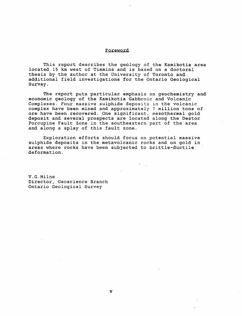
Foreword.
This report describes the geology of the Kamikotia area located 15 km west of Timmins and is based on a doctoral thesis by the author at the University of Toronto and additional field investigations for the Ontario Geological Survey.
The report puts particular emphasis on geochemistry and economic geology of the Kamikotia Gabbroic and Volcanic Complexes. Four massive sulphide deposits in the volcanic complex have been mined and approximately 7 million tons of ore have been recovered. One significant, mesothermal gold deposit and several prospects are located along the Destor Porcupine Fault Zone in the southeastern part of the area and along a splay of this fault zone.
Exploration efforts should focus on potential massive sulphide deposits in the metavolcanic rocks and on gold in areas where rocks have been subjected to brittle-ductile deformation.
V.G.MilneDirector, Geoscience BranchOntario Geological Survey


CONTENTS
PAGE
Abstract.. . . . . . . . . . . . . . . . . . . . . . . . . . . . . . . . . . . . . . . . . . . . . . . . . . . xviiIntroduction................................................ lPurpose.................................... . .. . . . . . . . . . . . . lLocation, Accessibility and Physiography.................. 2Previous Work......... . . . . . . . . . . . . . . . . . . . . . . . . . . . . . . . . . . . . 3Acknowledgements. . .. ... . . . . . . . . . . . . . . . . . . . . . . . . . . . . . . . . . . . 4
Geology 6 Regional Geological Setting.... . . . . . . . . . . . . . . . . . . . . . . . . . . . 6General Geology of the Kamiskotia Area... . . . . . . . . . . . . . . . . . 6
Kamiskotia Gabbroic Complex. . . . . . . . . . . . . ... . . . . . . . . . . . . . . 8Definition............................................ 8
Name, Historical Background......................... 8Choice of Lithodemic Rank.. . . . . . . . . . . . . . . . . . . . . . . . . . 9Physical Boundaries..... . . . . . . . . . .... .. ... ... ... ... . 10
Geology... . . . . . . . ... . . . . . . . . . . . . .. . .. . ... . . . ... . . . . . . . 10Contacts. . ... . ... . . . . . . . . . . . .. .. . . . .. .. .. . . . . . ... . . . 11Alteration.......................................... 13
Petrography......... . . . . . . . . . . . . . . . . . . . . . . . . . . . . . . . . . . 13Lower Zone.......................................... 13Middle Zone. .. .. .. . . . . . . . . . . . . . . . . . .... . . .. . . . . . . . . . 14Mixed Magma Outcrops..................... . . . . . . . . . . . 15Upper Zone. ... ... .. . . .. .. .. .... ... . . . . . . . . . . . . . . . . . . 15Granophyre.................. . . . . . . . . . . . . . . . . . . . . . . . . 16
Kamiskotia Volcanic Complex... . . . . . . . . . . . . . . . . . . . . . . . . . . 17Definition.. . . . . . . . . . . . . . . . . . . . . . . . . . . . . . . . . . . . . . . . . . . 17
Physical boundaries.... ... .. . . . . . . . . . . . . . . . . . . . . . . . . 17Geology.... ... .. .. . .. .. ... .... . . . . . . . . . . . . . . . . . . . . . . . . 18Petrography...........................................19
Lower Volcanic Suite.... . .. .. . . . . . . . . . . . . . . . . . . . . . . . . . . . 20Metasedimentary Rocks.................. . . . . . . . . . . . . . . . . . 20Granitoid Rocks................ . . . . . . . .................. 21Bristol Township Lamprophyre.Suite.. . . . . . . . . . . . . . . . . . . . . 22
Structure 23 Bedding and Layering, and Regional Folding................ 23Structural Fabric Analysis................................ 26
Results. . . . . . . . . . . . . . . . . . . . . . . . . . . . . . . . . . . . . . . . . . . . . . . . . 26Interpretation. . . . . . . . . . . . . . . . . . . . . . . . . . . . . . . . . .. . . . . . . . 28Summary..... . . . . . . . . . . . . . . . . . . . . . . . . . . . . . . . . . . . . . . . . . . . . 31
Geochronology 32 Results of U-Pb Geochronology.. .. . . . . . . . . . . . . . .. . ., . . . . . . . 32Sm-Nd and Rb-Sr Isochron and Regression Ages.............. 33Magmatic and Structural History........................... 35
Geochemistry.. . . . . . . . . . . . . . . ; . . . . . . . . . , . . . . . . . . . . . . . . . . . . . . . 35Alteration........... ...... ......... ... . .............. . . . . 36KGC Cumulates..............................................36KGC Chilled Rocks........... . . .. . . . . . . . . . . . . . . . . . . . . . . . . . . 39Granophyric Rocks .........................................41
vii


Kamiskotia Volcanic Complex.............. . . . . . . . . . . . . . . . . . 42Basalts, Evolved Basalts and Andesites..... . . . . . . . . . . . . . 42Rhyolites........................... . .. . . . . . . . . . . . . . . . . . 43
Lower Volcanic Suite.. . . . . . . . . . . . . . . . . . . . . . . . . . . . . . . . . . . . . 44Granitoid Rocks................... . . . . . . . . . . . . . . . . . . . . . . . . 44Bristol Township Lamprophyre Suite........................ 45Geochemical Modeling of KGC Magmatic Processes. ...... . . . . . 47
Phase Diagrams.......................... . . . . . . . . . . . . . . . . 48Mass Balance Calculations.. .. . . . . . . . . . ....... ....... ... . 48Assimilation - Fractional Crystallization Modeling...... 50
Nd Isotope Signatures.. . . . . . l . . . . . . . . . . . . . . ........ ....... 54Petrogenesis of the KGC, and KVC basalts.................. 55Petrogenesis of KVC rhyolites.............. . . . . . . . . . . . . .. . 57Petrogenesis of Bristol Township Lamprophyre Suite........ 61
Economic Geology. . . . . . . . . . . . . . . . . . . . . . . . . . . . . . . . . . . ... . . . . . . . 63Volcanogenic Cu-Zn Deposits... . . . . . . . . . . . . . . . . . . . . . . . . . . . . . 63
Kam-Kotia and Jameland Mines. . . . . . . . . . . . . . . . . . . . . . . . . . . . 64Canadian Jamieson Mine.. ... .. . . . . . . . . . . . . . . . . ... ..... . .. 66Genex Mine............... . .. . . . . . . . . . . . . . . . . . . . . . . . . . . . . 67
Mesothermal Au Deposits. .. . .. . . . . . . . . . . . . . ..... . . ..... . . . . 69Holmer Property... . . . . . . . . . . . . . . . . . . . . . . . . . . . . . . . . . . . . . . 69Au-REE Occurrence: The Croxall Property................. 70De Santis Property........... . . . . . . . . . . . . . . . . . . . . ....... 71
Magmatic Ni-Cu Occurrences............. . .. . . .. . . . . . . . . . . . . 72Western Whitesides Township Occurrences...............,. 72Bean Lake - Pirsson Lake Occurrences........ .......... . . 73Northwest Carscallen Township Occurrences........... . . . . 73
Potential for Mineralization....................... . . . . . . . 73Volcanogenic Cu-Zn Deposits... ...... ......... . . . . . . . . . . . 74Mesothermal Au Deposits............................... . . 75Magmatic Ni-Cu Occurrences....................... . . . . . . . 76
Discussion.. . . . . . . . . . . . . . . . . . . . . . . . . . . . . . . . . . . . . . . . . . . . . . . . . 77Gabbroic Complex - Granitoid Relationships
in the Southern Superior Province. .... ...... . . . . . . . . . . . . 77Chemical Comparison with other Synvolcanic
Mafic Intrusions in the Southern Superior Province..... 78Comparison with the Skaergaard Intrusion
and Eastern Iceland Volcanic Fields............... . . . . . 79Cogenesis of the KGC and KVC,
and Significance with Respect to VMS Deposits. . . . . . . . . . . 81Kamiskotia - Kidd Creek Relationships..................... 82Time - Stratigraphic Correlation
in the Southern Abitibi Subprovince... . . . . . . . . . . . . . . . . . . 83Late Transpression across the
Southern Superior Province.............................. 84Timing of Magmatism in the Southern Superior Province..... 84Late Thermal Events in the Kamiskotia Area.............. . . 86Comparison to Modern Tectonic Comparison to Modern Tectonic Settings
Synthesis... . .. . . . 88
References.................................................. 93
IX


LIST OF TABLES
Table 1. Lithologic units for the Kamiskotia area...... . . . . . . . . . . . . 116
Table 2. Summary of U-Pb geochronology............................. 119
Table 3. Summary of Rb-Sr and Sm-Nd isochron/regression ages....... 120
Table 4. Geochemistry of Kamiskotia cumulates......... . . . . . . . . . . . . . 121
Table 5. Geochemistry of gabbro chill samples and Kamiskotia basalts 126
Table 6. Geochemistry of the Lower volcanic suite.................. 127
Table 7. Geochemistry of granitoid rocks.. . . . . . . . . . . . . . . . . . . . . . . . . . 129
Table 8. Geochemistry of the Bristol Township lamprophyre suite.... 131
Table 9. Ni-Cu-PGE abundances in magmatic sulphide occurrences...... 134
Conversion Table 180
LIST OF FIGURES
Figure 1. Location map. 135
Figure 2. Distribution of outcrops in Kamiskotia area. 136
Figure 3. Example of density of Matachewan dikes in. Kamiskotia area. 137
Figure 4. Geology of the Kamiskotia Gabbroic Complex and nearby rocks. 138
Figure 5. Microprobe analyses for selected samples in the Kamiskotia Gabbroic 139 Complex.
Figure 6. Foliation map. 140
Figure 7. Foliation trajectory map. 141
Figure 8. Lineation map. 142
Figure 9. Apparent total mineral strain fabric map. 143
Figure 10. Location of U-Pb samples in western Abitibi Subprovince. 144
Figure 11. Summary of the U-Pb ages in the Kamiskotia - Kidd Creek area. 145
Figure 12. Locations of samples and traverses in the Kamiskotia Gabbroic Complex. 146
Figure 13. Petrographic traverse for cumulate rocks. 147
Figure 14. Mg', normative An, Ti02 and ?20 5 versus stratigraphic height. 148
Figure 15. Ni and Se versus stratigraphic height. 149
xi

Figure 16. Incompatible trace elements and trace element ratios: La, Yb, La/Yb, Zr, 15Q Y, Zr/Y; versus stratigraphic height.
Figure 17. Rare earth element profiles for Kamiskotia Gabbroic Complex rocks and 151 related basalts.
Figure 18. Geochemistry of Kamiskotia and Kidd Creek rhyolites. 152
Figure 19. Rare earth element profiles for selected granitoid rocks. 153
Figure 20. X-Y plots for Bristol Township lamprophyre suite 154
Figure 21. Rare earth element profiles for Bristol Township lamprophyre suite. 156
Figure 22. CMAS-type tetrahedron projections for Kamiskotia basalts. 157
Figure 23. Mass balance calculations using the REE. 158
Figure 24. X-Y plots for liquid compositions with AFC modeling curves. 159
Figure 25. Primitive mantle-normalized profiles for Kamiskotia Gabbroic Complex 160 average chill composition.
Figure 26. Geology of the Kam-Kotia mine. 161
Figure 27. Geology of the Canadian Jamieson mine property. 162
Figure 28. Geology of the Genex Mine area. 163
Figure 29. Geology of the Genex Mine. 164
Figure 30. Cross-section of A and H zones, Genex mine. 165
Figure 31. Cross-section of the C zone, Genex mine. 166
Figure 32. Geology of the Holmer gold property. 167
Figure 33. Geology of the De Santis gold property. 168
Figure 34. Geology of the Croxall gold-REE property. 169
Figure 35. Compilation of U-Pb ages for southern Superior Province by rock type. 170
Figure 36. Tectonic model for the Kamiskotia area and parts of the southwestern 171 Abitibi Subprovince.
Xlll


LIST OF PLATES
Plate 1. Kamiskotia gabbro cumulates............................... 173
Plate 2. Kamiskotia gabbro contact zone textures................... 174
Plate 3. Kamiskotia gabbro mixed magma outcrop textures............ 175
Plate 4. Photomicrographs of Kamiskotia intrusive rocks............ 176
Plate 5. Kamiskotia volcanic rock textures......................... 177
Plate 6. Deformation textures. . . . . . . . . . . . . . . ... . . . . . . . . . . . . . . . . . . . . . 178
Plate 7. Croxall property ultramafic lamprophyre suite............. 179
GEOLOGICAL MAP
Geology of the Kamiskotia Area, in back pocket Distict of Cochrane
Scale 1:50,000
XV

ABSTRACT
This report describes the geology, geochemistry, structural history and economic
geology of the Kamiskotia area, with particular emphasis on the Kamiskotia Gabbroic
and Volcanic Complexes. The area is located from 15 km to 40 km west of Timmins,
Ontario in the western Abitibi Subprovince.
The Kamiskotia Gabbroic Complex (KGC) is centrally located in the
Kamiskotia area. The KGC is a large (170 km2) tholeiitic intrusion and is divided
into four stratigraphic units. The Lower Zone is composed of adcumulus and
mesocumulus peridotite, troctolite, and gabbronorite, with Mg numbers from 73 to 86.
The Middle Zone is composed of mesocumulus gabbronorites, with Mg numbers from
60 to 74. The Upper Zone is composed of mesocumulus and orthocumulus
gabbronorites and ferroan gabbronorites, with Mg numbers from 37 to 64. Modal
layering is observed locally, in the Lower and Upper Zones. The fourth zone is a
quartz-bearing granophyre of intermediate to felsic composition, and is characterized
by granophyric textures and mariolitic cavities. It both overlies and is along strike
with Upper Zone cumulates. The mafic cumulates have flat REE patterns (Lajsj/YbN
- 0.4 - 2.6), with chondrite-normalized REE abundances (REE^) ranging from 0.6 - 2
for olivine-bearing Lower Zone adcumulates, to 10 - 25 for Upper Zone
orthocumulates. Europium anomalies are strongly positive for the Lower Zone and
diminish upsection to slightly negative for the highest stratigraphic level in the Upper
Zone. The granophyres have very high incompatible element contents, with most
samples containing 500 to 800 ppm Zr, REE^ = 100 to 200; and have nearly flat
REE patterns (LaN/YbN = 1.6 to 2.6) with strong negative Eu anomalies. Chilled
rocks have Mg numbers from 54 to 58, REEjsj = 20 to 30, and Lajsj/YbN ~ ^.8 to
1.2.
xvii


stratigraphy; 5) regional sub-horizontal, bulk north-south shortening that formed a non
penetrative east-west flattening fabric; with an element of 6) late, predominantly
dextral transpression, that formed high strain zones related to a splay of the western
Destor Porcupine Fault Zone (DPFZ) within the Lower volcanic suite; and 7)
emplacement of the Bristol Township lamprophyre suite along the DPFZ.
U-Pb ages from related studies help substantiate this chronology and aid in the
correlation of Kamiskotia rocks across the southern Abitibi Subprovince. Zircon ages
for the KGC and a KVC rhyolite are 2707 2 Ma and 2705 2 Ma, respectively. The
KVC rhyolite is 10 Ma younger than the chemically similar, massive sulphide-bearing
Kidd Creek rhyolite located 25 km to the northwest. Two of the granitoid intrusions
have zircon ages of 2696 2 Ma and 2694 4 Ma. Two zircon fractions from the
younger granitoid intrusion exhibit inheritance, with 207pb^206pb minimum ages up to
2926 Ma, indicating the presence of significantly older crust in this region. A
minimum age for the formation of the DPFZ in this area is given by a U-Pb garnet -
titanite age for a late-tectonic, garnetite dike, part of the Bristol Township
lamprophyre suite within the DPFZ, at 2687 3 Ma.
Four volcanogenic Cu*Zn Ag Au deposits in the KVC have been mined,
with >l million tons of ore recovered. One significant, mesothermal gold deposit and
several prospects are located along the DPFZ in the southeastern part of the
Kamiskotia area, and along a splay of the DPFZ in the Lower volcanic suite.
Exposed on one gold prospect are lamprophrye dikes that contain high rare earth
element (REE) concentrations (up to 0.43 wt.% RE2O3). Several areas in the Lower
Zone of the KGC have minor, low grade Ni-Cu concentrations, with very low platinum
group element (PGE) contents.
Exploration efforts should focus on the potential of Cu-Zn deposits in the KVC,
with particular emphasis on locating and exploring near synvolcanic faults, in areas
with strong chloritic alteration, and in the vicinity of incompatible element-enriched
xix

The Kamiskotia Volcanic Complex (KVC) overlies and is intruded by the KGC.
The KVC is comprised of a bimodal assemblage, including tholeiitic basalts and
subordinate basaltic andesites and andesites; and high silica rhyolites. Basalts occur as
massive and pillowed flows, and as pillow breccias, hyaloclastite and hyaloclastite tuffs,
with plagioclase phenocrysts up to 15 9fc locally. They have Mg numbers from 47 to 67,
REEN = 17 to 37, and Lajsf/YbN = 1-4 to 1.8. Rhyolites are pyroclastic tuffs,
agglomerates, welded tuffs and flow-lobes, and are generally quartz- and feldspar-
phyric. They generally have 300 to 400 ppm Zr, KEEN ~ 70 to 280, LaN/^N ~ 2
to 3. Basaltic andesites and andesites are similar in texture to the basalts, and are
notable for their discordant, dike- and sill-like masses that cut stratigraphy proximal to
massive sulphide deposits. They have Mg numbers from 31 to 47, and are unusually
enriched in their incompatible element contents, with 180 to 480 ppm Zr, REEjsf - 25
to 84, LaN/YbN s 1-2 to 2.8.
Geochemical modelling of the cumulate rocks and basalts using major and trace
elements and radiogenic isotope signatures, indicate that the KGC was derived from a
primitive parental magma that fractionated at low pressures. Rhyolitic compositions
may be derived from basaltic compositions by greater than 90*26 fractionation of of
mafic minerals, plagioclase and Fe-Ti oxide. There is no chemical or isotopic
evidence for assimilation of any chemically distinct or isotopically enriched crustal
material.
Field observations support the following sequence of magmatic and structural
events in the Kamiskotia area: 1) formation of the Lower volcanic suite,
stratigraphically below the KGC; 2) emplacement of the KGC and KVC; and coeval
intrusion of granitoid A in Turnbull Township into the crystallizing KGC; 3) regional,
bulk rotation about a sub-horizontal axis of this stratigraphy to form a northeast-facing
monocline; possibly synchronous with 4) emplacement of three large granitoid
intrusions, superimposing their respective contact strain aureoles or zones on the
xxi


basaltic andesite dikes, sills and flows. Gold exploration should concentrate in areas
where rocks have been subjected to late tectonic, brittle-ductile deformation, such as
the splay of the DPFZ in the Lower volcanic suite, and along the Kamiskotia Highway
fault north of the Canadian Jamieson Mine. The potential for significant Ni-Cu-PGE
mineralization in the KGC is considered poor for the following reasons: there is little
evidence for large-scale contamination by a more siliceous or oxide-rich crust,
generally the cause for sulphide immiscibility that leads to magmatic Ni-Cu deposits;
sulphide-bearing sulphide-poor, cumulus and pegmatitic rocks from across the intrusion
have very low platinum and palladium abundances. The potential for a bulk-tonnage,
low grade REE-gold deposit in the Bristol Township lamprophyre suite should be
considered, given that the lamprophyre suite is much more extensive than previously
recognized.
XXlll


INTRODUCTION
PURPOSE
This report describes the geology, geochemistry, geochronology, structural history and
economic geology of Late Archean rocks in the Kamiskotia area, with emphasis on the
Kamiskotia Gabbroic Complex (KGC) and the Kamiskotia Volcanic Complex (KVC).
Included within this report are formal definitions for the KGC and the KVC, using the
guidelines of the North American Commission on Stratigraphic Nomenclature (1983) (Table
1).
Large mafic-ultramafic intrusions such as the KGC are a main constituent of
Precambrian terranes, and they represent an important source for magmatic Ni-Cu-PGE and
Cr deposits (Windley 1976; Naldrett 1981). The majority of these intrusions are stratiform
and generally coeval with greenstone belt rocks, in contrast to the Bushveld Complex, South
Africa and the Great Dyke, Zimbabwe, which are significantly younger than their country
rocks. A feature common to many stratiform intrusions is their geologic setting at the
boundaries between regional granitoid and greenstone belt terranes. Examples are found in
the Murchison and Pietersburg belts of the Kaapvaal craton, South Africa and Swaziland
(e.g., Rooiwater igneous complex and other mafic-ultramafic sills of the Pietersburg Sequence,
and the Usushwana complex, Pongola Group), in the Rhodesian craton of Zimbabwe
(Mashaba and Shabani mafic-ultramafic complexes), and in the Pilbara block of Western
Australia (e.g., Munni Munni and Millindina complexes). Numerous examples are found
across the Superior Province, with particularly large ones in the Wabigoon Subprovince of
Northwestern Ontario (e.g., Mulcahy Lake and related intrusions; Bad Vermilion and Grassy
Portage intrusions), and in the Abitibi Subprovince of Ontario and Quebec (e.g., KGC,
Montcalm, Dore Lake, and Bell River complexes).

This report contributes to the understanding of the petrogenesis of Archean strata-
bound mafic-ultramafic intrusions, particularly those found at granitoid-greenstone boundaries,
in the context of greenstone belt tectonic evolution, with particular emphasis on the KGC.
For this study, lithologic and structural mapping of the KGC and surrounding granitoid-
greenstone rocks provides a foundation for geochemical studies. Precise chronologic
constraints on magmatic and tectonic events in the Kamiskotia area are provided by U-Pb
zircon, titanite and garnet geochronology. These events are placed within the well-
constrained sequence of tectonic events documented across the southern Abitibi Subprovince
and southern Superior Province. Supracrustal magmatic processes for the KGC are
investigated using detailed geochemical traverses of the cumulate stratigraphy and
geochemistry of the KVC. Primitive source characteristics are described for the KGC from
recent trace element and Nd isotope geochemistry studies (Barrie and Shirey, in prep.).
Additionally, post-crystallization thermal events are documented using internal Nd and Sr
isotope systematics.
This report also describes the KVC in terms of its physical volcanology and
geochemistry, and considers its close temporal and genetic relationship with volcanic massive
sulphide deposits, and the KGC.
Finally, the largest of the copper-zinc, lode gold, rare earth element and nickel-copper-
platinum group element mines, deposits and occurrences in the area are described, in light of
current metallogenetic concepts. Following these descriptions, suggestions are made for
future mineral exploration in the Kamiskotia area.
LOCATION, ACCESSIBILITY AND PHYSIOGRAPHY
The study area is located 15 to 40 km west of Timmins, Ontario. It encompasses the
area contained by Longs.81030' W to 82000' W and Lats.81022'30" N to 4803730" N, including
all of Whitesides, Carscallen, Massey, Turnbull, Cote and Robb townships and parts of Enid,

Fortune, Bristol, Jamieson, Frey and Godfrey townships, in the district of Cochrane (Figure
1). Principal access routes are from Highway 101 in the southeastern part, from the
Kamiskotia Highway (Highway 576) in the northeastern part, and from a major, east-west
logging road through the central part that intersects Highway 101. Many subsidiary, all-
weather logging roads are present throughout the study area, and in Robb Township,
numerous trails and winter roads cover the area south and southeast of Kamiskotia Lake.
Generalized outcrop locations and the locations of prominent esker ridges are given in
Figure 2. Also given in Figure 2, is the location of ground coverage for this study. Much of
the information for the eastern quarter of the map is compiled from previous studies listed
below. In Figure 3, the density of early Proterozoic Matachewan dikes is shown, which is
representative of their density for approximately half of the field area. Matachewan dikes
are not shown on the accompanying 1:50,000 geological map.
PREVIOUS WORK
Townships in the Kamiskotia area that have been mapped at a scale of 1:15,840 by
the Ontario Department of Mines: Bristol (Ferguson 1957a), Carscallen (Ferguson 1957b),
Whitesides (Leahy 1968), Cote (Bright and Hunt 1973); Robb and Jamieson (presented
together at 1:31,680: Middleton 1973a), Godfrey (Hogg 1954) and Turnbull and Godfrey
(presented together at 1:31,680: Middleton 1973b). The geology and mineral occurrences of
Turnbull and Godfrey townships have been described in an open file report (Middleton
1975), and ground magnetic survey maps have been published for Robb, Jamieson, Godfrey
and TurabuU townships (Middleton 1969, 1970, 1971a, 1971b). Middleton also produced a
geophysical report for Robb and Jamieson townships (Middleton 1973c) which describes the
prospecting and mining activities in these townships in detail. Wolfe produced a report and
an accompanying map on the geology and distribution of Ni, Cu and Co in the Kamiskotia
Gabbroic Complex (Wolfe 1970,1971). Pyke (1982) included the geology of the Kamiskotia

Volcanic Complex in his regional synthesis of the Timmins area. A series of high resolution
aeromagnetic maps were produced by the Ontario Geological Survey that cover the eastern
half of the area (Barlow 1988).
One master's thesis investigated the geochemistry of the Kamiskotia Volcanic Complex
(Hart 1984), and another has studied the Genex Cu deposit in Godfrey Township (Legault
1985). This geological report is accompanied by a map at a scale of 1:50,000, a structural
and U-Pb geochronologic study (Barrie and Davis 1990) and an Nd-Sr isotopic study (Barrie
and Shirey 1989) on the KGC and surrounding Archean rocks, which stem from doctoral
thesis work at the University of Toronto (Barrie 1990).
ACKNOWLEDGEMENTS
There are many people who have helped during the course of this project. Those who
were particularly helpful in the scientific research are: Tony Naldrett and Mike Gorton of
the University of Toronto, Don Davis of the Royal Ontario Museum (ROM); Steve Shirey of
the Department of Terrestrial Magnetism, Carnegie Institution of Washington, D.C. (DTM);
and Tony Green of Falconbridge, Limited. I also thank Tom Hart and Marc Legault for
permission to use geochemistry and figures from their M.Sc. theses.
In the field, I was accompanied by a number of Falconbridge Limited employees:
Mike Kerwin, Doug Hurst, Murray Jerome, Jamie Cecchetto, George MacTaggart, Paul Roos,
and Kim Wyotiuk. Their assistance and good humor are greatly appreciated. Additionally,
Dave Comba, Bob Stewart, Ted Barnett, Scott McLean, Paul Binney, and Phil Day all of
Falconbridge Limited were helpful in providing samples or logistical support. Others were
helpful by providing access to drill core or exploration properties, including Dr. Mathew
Blecha of Teck Explorations Limited, Dr. Stew Fumerton of Chevron Canada Resources,
Limited, and Jim Croxall, of Timmins, Ontario. I am grateful to Wil Doherty who provided
high quality ICP-MS data for several challenging, REE-enriched samples.
I would like to thank the following corporations and institutions for their support: the
Carnegie Institution of Washington, D.C., Falconbridge Limited, the Jack Satterley Laboratory
of the ROM, the University of Toronto, and Teck Explorations Limited.
I thank the following geologists of the Ontario Geological Survey for their reviews
which have improved this report: M. E. Cherry, J. A. Fyon, S. L. Jackson, and M. Sanborn-
Barrie.

GEOLOGY
REGIONAL GEOLOGICAL SETTING
The Kamiskotia area is located in the westernmost part of the Abitibi Subprovince of
the Superior Province (Figure 1). Late Archean metavolcanic, metasedimentary and intrusive
rocks of the Ontario portion of the Abitibi Subprovince (herein termed the western Abitibi
Subprovince) have been subjected to variable deformation and metamorphism.
Metamorphism ranges from sub-greenschist to middle amphibolite facies, with higher
metamorphic grade generally proximal to the margins of large felsic granitoid intrusions. The
geology and evolution of parts of the western Abitibi Subprovince have been described and
interpreted by numerous authors, most notably Dimroth et al. (1982, 1983a, 1983b), Pyke
(1982), Corfu et al. (1989), Jackson and Sutcliffe (1990) and Barrie and Davis (1990).
From U-Pb geochronology, Late Archean rocks of the western Abitibi Subprovince
range in age from 2747 ±2 Ma for the Pacaud Group metavolcanic rocks (Mortensen,
personal communication, 1989) south of Kirkland Lake, to 2673 H-6/-2 for an albitite dike in
the Mcintyre Mine of the Porcupine gold camp (Corfu et al. 1989). There is evidence for
older crustal rocks in the vicinity, from xenocrystic zircons in granitic rocks and lamprophyres
(Barrie and Davis 1990; Corfu et al., in prep.), from detrital zircons in the Pontiac
metasedimentary rocks (Gariepy et al. 1984), and, indirectly, from Nd isotopic signatures
(Barrie 1990). Late Archean rocks are cut by the Early Proterozoic Matachewan dikes,
which have U-Pb zircon and baddeleyite ages of approximately 2450 Ma (Heaman 1989)
(Table 2).
GENERAL GEOLOGY OF THE KAMISKOTIA AREA
The KGC is a large, deformed tholeiitic intrusive complex situated centrally in the
Kamiskotia area (Figure 4). It is overlain by, and in part gradational with, metavolcanic

rocks of the KVC; including basalt and rhyolite, and with volumetrically minor evolved basalt
and andesite, some of which occur as hypabyssal sills. The KVC hosts four volcanogenic
massive sulphide deposits (see Economic Geology section). KGC footwall rocks are
informally termed the Lower volcanic suite, which is capped by a 2 m thick cherty oxide-
sulphide iron formation. In a general sense, this stratigraphic succession is near-vertical and
faces to the north and east. Four granitoid masses composed of hornblende biotite tonalite
to granite, and locally rimmed with contact intrusive breccia, have intruded the stratigraphy
in the Kamiskotia area. These include granitoid A (Turnbull Township tonalite),
predominantly of tonalitic composition, which exhibits textures indicative of magma mixing
with fine-grained KGC rocks. Granitoid A is interpreted to have intruded the base or the
margin of the KGC during KGC crystallization (described below). Granitoid B (Cote
Township tonalite) is predominantly tonalitic, and has a well-developed foliation parallel to
its margin. Granitoids C and D, to the west and south of the KGC, are composed of several
discrete plutons that range in composition from trondhjemite-tonalite to granodiorite-granite.
Regional metamorphism up to the lower greenschist facies lias affected the stratigraphy,
except within l to 3 km of the granitoid - greenstone contacts that have well-developed
foliations, where the metamorphic grade is up to middle amphibolite facies.
A major ductile deformation zone is present to the east and south of granitoid D, with
a splay extending to the north of granitoid D through the Lower volcanic rocks. The
deformation zone may represent parts of the westernmost Destor-Porcupine Fault Zone
(DPFZ), a major fault boundary that extends hundreds of kilometres across the Abitibi
Subprovince. Alkalic magmatic activity, represented by a lamprophyre suite with allikitic
affinities, and mesothermal lode gold mineralization, are associated with the fault zone in this
region. The nortli-northwest-trending Matachewan mafic dike suite cuts all stratigraphy,
including deformed rocks in the DPFZ.
KAMISKOTIA GABBROIC COMPLEX
DEFINITION
In this report, the Kamiskotia Gabbroic Complex (KGC) is defined in accordance with
the North American Stratigraphic Code (1983). The purpose for a formal definition is to
provide stability in nomenclature for easy referencing, and for future studies on the KGC,
and for studies concerning lithostratigraphic and time-stratigraphic correlation in the western
Abitibi Subprovince. In order to define a rock unit, the Code requires a discussion of the
name, historical background and unit rank; descriptions of the rock types, physical
boundaries, shape, and other regional aspects including possible correlation with other rocks,
and the age and petrogenesis. In this section, the name, historical background and unit rank
are discussed, and descriptions of the physical boundaries and rock types are given; the other
aspects are discussed in detail elsewhere in this report.
Name, Historical Background
The name Kamiskotia is taken from Kamiskotia Lake and the Kamiskotia River, the
most prominent bodies of water in the map area. The first reference to this area and the
gabbroic rocks was in 1900, in William A. Parks' survey of Niven's Base Line, from Night
Hawk Lake to Missanabie Lake (Parks 1900). The following excerpts are from his report:
The Kamiskotaia- Sagaigan River enters the Mattagami on the west side, about six
miles below the three sandy portages. It is about 100 feet wide at its mouth but its
navigability is interrupted by rapids...On this portage occurs a peculiar hard schistose
rock, striking a little south of east. It presents various shades of pink and green,and
weathers out with white dots, owing to a decomposed feldspar. This rock runs up a

hill of considerable height (referring to rhyolites of Kamiskotia hill in Jamieson
Township)...
Kamiskotaia Lake is a fine body of water of from two to three miles in diameter, and
containing several rocky islands. The rock at the head of the river is hard massive
green to black rock, resembling diorite, but contains a large amount of quartz. Under
the microscope it shows decomposed plagioclase crystals and blebs of quartz, all
imbedded in a fine grained matrix, consisting largely of quartz with minute grains of a
dark alteration product. It is probably an altered quartz diorite... (altered KGC
quartz gabbro).
Kerr reported on his exploration in the Mattagami valley a few years later, and
attempted, without success, to change the name of the Kamiskotia River (Kerr 1906):
About four miles below Niven's second base the Mattagami receives a rather
considerable tributary from the west, which I have named the Coffey (Kamiskotia
River), the present Indian name, Kamiskotaia-Sagaigan, being altogether too cumbrous.
We ascended this river and some of its tributaries to Lake Kamiskotaia...
Choice of Lithodemic Unit Rank
The choke of "complex" as the lithodemic unit rank is based on several criteria. The
North American Stratigraphic Code (1983) defines "complex" as "an assemblage or mixture of
rocks of two or more genetic classes, igneous, metamorphic or sedimentary, with or without
highly complicated structure". The mafic cumulates and the granophyres of intermediate to
felsic composition are considered to represent two separate genetic classes of igneous rocks,
particularly considering the different magmatic processes that were operative during their

10
formation. (There is geochemical evidence that supports their comagmatic nature; see
Geochemistry section). "Complex" has been used for this intrusion consistently in the
literature (e.g., Wolfe 1970,1971; Middleton 1969,1970,1973c, 1975; Pyke 1982; Campbell et
al. 1981; 1982; 1984; Hart 1984, Legault 1985; Barrie 1990), although there has been
variation on the rock name given and the usage of capitalization. Additionally, the
Kamiskotia intrusive rocks have many similarities to well-known intrusions that are termed
complexes (e.g., Bushveld Complex, South Africa, Stillwater Complex, Montana, U.S.A.; Bell
River and Dor6 Lake Complexes, Quebec).
Physical Boundaries
The KGC occupies 170 km2, in northeastern Carscallen, northern Whitesides, eastern
and central Massey, northeastern Enid, central Cote, southern Robb, western and northern
Turnbull, and western Godfrey Townships (see 1:50,000 map). It is bounded to the south by
the Lower volcanic suite, to the west by granitoid C, to the north and east by the KVC; and
internally by granitoids A and B, in Turnbull and Cote townships, respectively. Contact
relationships with adjacent rock types are described below.
GEOLOGY
Terminology for the rocks of the KGC is from Irvine (1982). The majority of KGC
rocks are termed cumulates, defined as "an igneous rock characterized by a framework of
touching mineral crystals and grains that evidently were concentrated through fractional
crystallization of their parental magmatic liquids." (Irvine 1982). The packing of cumulus
crystals is described by the terms adcumulus (< 796 intercumulus minerals), mesocumulus (7
to 2596 intercumulus minerals), or orthocumulus (25 to 50+ 96 intercumulus minerals).
Cumulus processes are processes related to the deposition or growth of cumulus crystals or

11
grains, whereas postcumulus processes refer to processes that post-date cumulus processes,
and may be either pre- or post-solidus (Irvine 1982).
The KGC is subdivided into four zones on the basis of field and petrographic
observations and geochemistry: partly layered, olivine-bearing cumulates of the Lower Zone
(LZ) along the southern and western margin (Figure 4); gabbro-norite and anorthositic
gabbro-norite cumulates of the Middle Zone (MZ); partly layered, ferroan gabbro-norite,
anorthositic gabbro-norite and hornblende gabbro cumulates of the Upper Zone (UZ); and
granophyric rocks of intermediate and felsic composition above and along strike with the UZ
cumulates. The UZ - granophyre contact is irregular, with stoped blocks of partially
hybridized granophyric rock within chloritized, quartz-rich UZ gabbro locally (Hart 1984).
Facing directions within the LZ and the UZ are from cumulates with cross-bedding
structures, or from pyroxene-rich to plagioclase-rich gradations within individual cumulus
layers (Plates la, b). It is possible that a synform with a north-trending axis is present in the
southwestern KGC. Granitoids B, C and D represent antiformal structures, and in general
facing directions are away from their margins.
Contacts
Contacts with adjacent rocks exhibit a variety of textures. The adjacent rocks display
partial melt zones, and brecciated and agmatitic textures. In the KGC, textures related to
the presence or migration of volatiles are found within LZ rocks, and within roof pendants
and hybridized blocks of roof-rock material in the granophyre.
Along the southern boundary of the KGC, thermally metamorphosed pillow-shaped
structures are present within 100 m of the contact with Lower volcanic rocks (Plate 2a).
These textures are gradational with a zone 50 to 200 m wide of contorted, migmatites, with
local patches up to several square metres of strong epidote - chlorite -actinolite alteration in
basaltic and plagioclase-porphyritic basaltic material. The lower contact with KVC rhyolites

12
has similar migmatitic textures; also agmatitic textures, where partially melted rhyolite was
injected into quenched gabbroic material (similar to agmatitic textures in mixed magma
outcrops: Plate 3b).
Within the basal KGC, post-solidus or post-cumulus textures reflect the influence of
volatiles, apparently derived from partially melted wall rocks. At some localities, volatile-rich
fluids have penetrated along dilatent fractures (post-solidus?: Plate 2b); elsewhere fluids
apparently migrated along grain boundaries, and terminated in mushroom-like structures of
pegmatitic gabbro and haloes of epidote and clay minerals (post-cumulus?: Plate 2c). Drill
core that penetrated layered LZ in western Whitesides Township exhibits another unusual
texture, similar to the "tennis ball marker horizon" in the eastern Bushveld Complex. The
drill core has spherical, medium-grained plagioclase aggregates up to 10 cm in diameter,
within a matrix of sub-pegmatitic gabbronorite (Plate 2d). This phenomenon is interpreted
to have resulted from the aggregation of plagioclase in the presence of a "bridging liquid",
which coats loose cumulate phases and bonds them into spheres with minimum surface
tension at the base of the magma chamber (Lee and Sharpe 1979). The bridging liquid is
apparently a siliceous partial melt of footwall rocks (in this case, cherty iron formation, and
Lower volcanic suite rocks) that remains immiscible from the resident magma. Such
"bridging liquids" are used in the metallurgical industry to separate particulate matter from
melts (Lee and Sharpe 1979).
Blocks of felsic roof rock material have been described within the granophyre and
parts of the UZ, in Godfrey and Robb townships (Hogg 1954; Middleton 1975; Hart 1984).
These blocks have hybridized margins where they are in contact with more mafic intrusive
rocks. Blocks of diorite within the UZ in southern Robb Township south of Kamiskotia
Lake have textures similar to those found in the mixed magma outcrops in Turnbull
Township, where the felsic intrusive rocks are clearly distinguished from the granophyre on
the basis of trace element geochemistry. This area is reinterpreted as late injection of
tonalitic liquid into the crystallizing UZ rocks (see below).

13
Alteration
All KGC rocks have been subjected to varying degrees of post-solidus alteration. For
example, clinopyroxene is commonly partly or completely replaced by tremolite-actinolite and
hornblende, and plagioclase is commonly altered to sericite, chlorite and clay. Generally the
UZ cumulates are slightly altered, whereas the MZ and LZ cumulates are moderately
altered. Granophyre rocks are moderately to highly altered, with abundant chlorite in the
more intermediate compositions, and chlorite 4- epidote 4- sericite assemblages in felsic
granophyres. Except for rare sheared outcrops, primary textures are readily discerned in
outcrop and hand specimen. The following petrological descriptions emphasize the primary
cumulus and post-cumulus mineralogy as determined from outcrop, hand specimen, and
petrographic observations, supplemented by microprobe wavelength dispersive analyses of
minerals (reported in Barrie 1990). Microprobe mineral analyses are presented in Figure 5.
PETROGRAPHY
Lower Zone
The LZ is distinguished from other rocks of the KGC by the sporadic presence of
olivine as a cumulus phase, and by whole-rock Mg numbers that are generally > 75 (whole
rock Mg number = mol percent MgO7(MgO 4- FeO), with FeO = 0.85 FeOtotal)- Modal
layering and cross-bedding features are observed locally (Plates la,b). LZ rocks include
peridotite, troctolite, olivine gabbro, magnesian gabbronorite, and gabbroic anorthosite (Plate
le) as medium-grained meso- to adcumulate, with clinopyroxene, orthopyroxene, olivine and
plagioclase as cumulus phases. Chromite and sulphides occur sporadically in trace amounts
in the cumulates (Plate 4a), and the LZ hosts several minor occurrences of low grade, Ni-
14
Cu-sulphide mineralization. Olivine ranges in composition from FOJJ to Fog i; clinopyroxene
Mg numbers (mineral Mg number = mol percent MgO/MgO+FeOtotal) range from 77 to
82, and plagioclase ranges from Air/9 to Ang9 (Figure 5: samples A-D). Less primitive
orthocumulus to mesocumulus gabbroic rocks predominate along the southern contact
(sample F: Figure 5). A large outcrop (300 m by 300 m) of altered peridotite occurs stands
in high relief in northwest Carscallen and northeast Whitesides townships. The majority of
the outcrop is comprised of talc, serpentine, chlorite and magnetite; relict cumulus olivine is
observed locally. The margins of the outcrop are schistose, and contact relationships with
layered troctolites and olivine gabbros to the south, and gabbronorites to the north, are not
discernable. The peridotite outcrop is believed to be concordant with surrounding KGC
rocks.
Middle Zone
The MZ is comprised of gabbro, gabbronorite, anorthosite gabbro, and gabbroic
anorthosite as massive, medium- and coarse-grained mesocumulate to adcumulate, with
clinopyroxene, orthopyroxene and plagioclase as the cumulus phases. Ti-magnetite, ilmenite
and sulphides occur as accessory, intercumulus phases. Sub-pegmatitic and pegmatitic
textures are common. The majority of MZ rocks are cumulates that do not exhibit modal
layering; however, mafic enclaves of basaltic or fine-grained melagabbroic material are found
within anorthosite gabbro in northern Whitesides Township (Plate Id), and mixed magma
textures with granitoid A tonalite are present in western and northern Turnbull Township
(described below). For cumulus MZ rocks, plagioclase ranges in composition from Ari45 to
An70 and clinopyroxene Mg numbers range from 51 to 85 (samples G-I, Figure 5).

15
Mixed Magma Outcrops
A wide variety of mixed magma textures between MZ and UZ gabbroic and tonalitic -
granodiorite rocks occur over a l km by 5 km area, in western Turnbull Township (Figure
4). Agmatitic rocks with > 6096 felsic intrusive material are found near and within the
bounds of the granitoid A (Plates 3a, b). Well-preserved mafic pillow-shaped structures up
to l m by l m, with quenched rims that contain fine-grained radiating, acicular clinopyroxene
and plagioclase aggregates, are found within coarse-grained, felsic intrusive rocks (Plates 3c-f,
4a). The pillow-shaped structures have aphyric margins that grade into uniform, medium-
grained cores. In Robb Township south of Kamiskotia Lake, tonalitic and gabbroic material
are intercalated as alternating sill-like structures from l to 10 m thick. Here the grain size
in the gabbro becomes increasingly fine-grained toward the tonalitic sills, and the gabbro is
highly chloritic. These textures are similar to those found in well-documented mixed magma
zones in mafic intrusions, such as the Tigalak and Newark Island layered intrusions, Labrador
(Weibe and Wild 1983; Weibe 1987).
Upper Zone
The UZ is comprised of ferroan gabbronorite, quartz gabbro, hornblende gabbro and
hornblendite, as massive and layered, medium- and coarse-grained meso- and orthocumulate.
Plagioclase, clinopyroxene, orthopyroxene, pigeonite, and locally Ti-magnetite are cumulus
phases; apatite, and biotite occur as intercumulus phases (Plate 4b). Wolfe (1970) reported
hornblende gabbro and hornblendite outcrops in the southeastern part of the UZ.
Plagioclase commonly comprises greater than 70*26 of the mode, and several metre-thick
anorthosite layers (> 90*^ plagioclase) are observed locally. Inverted pigeonite with
clinopyroxene exsolution is common. Generally UZ rocks have a seriate texture and show no

16
petrographic evidence for post-cumulus overgrowths. Plagioclase compositions from
petrographic observations and microprobe analyses range from An46 to An^o; Mg numbers
for clinopyroxene and orthopyroxene range from 59 to 70, and 57 to 75, respectively (samples
J-L: Figure 5). Cumulus magnetite contains up to 2.5 wt.% V2O3 (Barrie 1990).
Granophyre
A wide variety of rocks are included in the granophyre zone, including diorite, quartz
diorite, quartz monzodiorite, granodiorite, tonalite, quartz monzonite quartz-feldspar porphyry,
and granite. These rocks are considered as one unit because the majority of them exhibit
granophyric textures (Plate 4c), and because of their similar high trace element abundances
(see geochemistry section). Hogg (1954) has provided the most detailed mapping and
petrologic descriptions of the granophyre zone. His units: "Intermediate Intrusives, Granite,
Granophyre, and Porphyritic Intrusives" are included in the granophyre zone of this report
(Figure 5). Contacts of granophyre zone rocks have irregular patterns. This is in part due to
felsic granophyres that grade into KVC rocks: Hogg (1954) noted that some felsic granophyre
rocks with layered spherulitic structures are gradational into rhyolites in northeastern Godfrey
Township. Granophyres of intermediate composition (diorite, quartz diorite), located in
northwestern Godfrey Township, are composed of acicular hornblende and actinolite, chlorite,
trellis-textured leucoxene after Ti-magnetite, and quartz and feldspar. Granophyres of felsic
composition (quartz monzodiorite, granodiorite, tonalite, quartz monzonite quartz-feldspar
porphyry, and granite) in northwest Godfrey and southeast Jamieson townships have fine
grained margins and granophyric and locally mariolitic textures in the interior.
17
KAMISKOTIA VOLCANIC COMPLEX
DEFINITION
The Kamiskotia Volcanic Complex (KVC) is defined here, in accordance with the
North American Stratigraphic Code (1983). The historical background, and reasons for the
choice of name and lithodemic unit rank are essentially the same as those mentioned above
for the KGC. Regional aspects, possible correlation with other rocks, and the age and
petrogenesis of these metavolcanic rocks are discussed in detail elsewhere in this report. In
this section, the descriptions of the physical boundaries and rock types are given.
Physical Boundaries
The KVC occupies 210 km2, in Carscallen, Bristol, a eastern Turnbull, western
Godfrey, southwestern Jamieson, southern Robb, and central Cote townships (see
accompanying 1:50,000 map, also Figure 5). It is bounded to the south by the Lower
volcanic suite; to the west by the KGC and granitoid A in Turnbull Township; to the north
and east by a line that is parallel to stratigraphy and extends from a point 2 km north of the
Kam-Kotia Mine to a point 2 km east of the Genex Mine, extending into western Loveland
Township to the north and toward central Bristol Township. This line represents a
demarcation between metavolcanic rocks with few ground or airborne geophysical conductors
to the west, and metavolcanic - metasedimentary rocks with numerous conductors to the east
(Barlow 1988). The boundaries are well-defined in outcrop where they are represented by
contacts with the KGC, but are less well-constrained in areas of poor exposure to the south,
east and north. These boundaries are slightly more restrictive than those proposed by
Middleton (1975). It is noted that the Reid Township rhyolite, with similar U-Pb age (see

18
Geochronology section) and geochemistry to KVC rhyolites, may be a distal airfall deposit
related to KVC magmatism.
GEOLOGY
The KVC is divided into two units: felsic rocks, composed of massive or poorly
bedded pyroclastic deposits with lesser block and ash flow material and flow -lobe complexes;
and mafic rocks, comprised of massive and pillowed flows, pillow breccias and hyaloclastite
tuffs and breccias. These units are observed to be intercalated on a scale of tens of metres
in several locations with excellent exposure: at Mt. Jamieson in Jamieson Township, and the
Shell outcrops 3 km to the northwest, and the Canadian Jamieson and Genex Mine
properties in Godfrey Township. This implies that some mafic and felsic units are coeval.
Felsic rocks predominate in Carscallen and southern Godfrey townships. A thick
sequence of pyroclastic tuffs and flows are present in Carscallen Township, with several
individual units having apparent thicknesses of hundreds of metres, divided by agglomeratic
units tens of metres in thickness. In northern Bristol Township, where exposures are poor,
descriptions of rocks in drill core indicate a significant component of mafic metavolcanic
rocks and lesser metasedimentary rocks. Some of the tuffs have fiamme-like textures that
may represent primary welding. In Godfrey and eastern Turnbull townships, several layers of
felsic agglomerates are present (Plate 5a), within massive, crystal-ash tuffs. A welded quartz-
crystal lapilli tuff in central southern Godfrey Township has unusual andesitic fragments with
quenched rims (Comba et al. 1986), suggesting that the andesitic material quenched during a
predominantly felsic pyroclastic eruption (Plate 5b). This provides additional evidence for
the coeval eruption and deposition of magmas of intermediate and felsic composition. In
Jamieson Township, rhyolite occurs in lobe-shaped flows (with restricted widths and
thicknesses on a scale of tens to hundreds of metres). These constitute most of the outcrop
ridges that extend from Mt. Jamieson, 3 km to the northeast (Comba et al. 1986). The lobe-
19
shaped rhyolite flows are interlayered with mafic flows. They are flow-banded, locally
spherulitic, and occur locally as hyaloclastite, with large amygdules or lithophysa up to 3 cm
in diameter. Spherulites may comprise up to 5096 of a rhyolite flow on a given outcrop
(Plate 5c).
KVC mafic rocks predominate in Robb Township, where a nearly uninterrupted, 2 km
stratigraphic thickness is present west of the Kam-Kotia Mine. In this area, massive and
pillowed basalts have relatively few amygdules (< 10^). Amygdules are larger and more
abundant along strike and upsection to the southeast in Godfrey Township. Thick, massive
flows and sills are more common along strike to the west, whereas thinner units, including
pillowed basalts and hyaloclastites are more common toward the southeast (Middleton
1973c). Mafic metavolcanic rocks on the well-exposed Canadian Jamieson Mine property
are: massive flows, pillowed flows (Plate 4d), some with amygdules up to 0.5 mm (comprising
up to 29fc of the rock), and pillow breccia and hyaloclastite. Mafic rocks at the Genex Mine
property are massive and pillowed flows, and pillow breccias.
PETROGRAPHY
Primary mineralogy in KVC rocks is in general difficult to discern due to alteration.
Less altered felsic tuffs and flows generally contain 5 to 159fc quartz phenocrysts; feldspar
phenocrysts are less common and range up to 1596. The matrix is aphanitic, and comprised
of sericite, chlorite, quartz, potassium-feldspar and clay minerals; trace phases may include
zircon, apatite, titanite, rutile, pyrite, and leucoxene after Ti-magnetite. In more altered
felsic rocks, these minerals and epidote and carbonate may be present. Spherules are
composed of fine-grained, radiating intergrowths of quartz and feldspar, with the feldspar
commonly altered to sericite and clay minerals.
Mafic rocks contain plagioclase phenocrysts up to 2096 locally, although > 1096
plagioclase phenocryst contents are rare. Primary mineralogy is particularly difficult to

20
determine in mafic rocks of the KVC. Hart (1984) reported that sericite and epidote
alteration of plagioclase does not allow for optical determination of their compositions. The
matrix is generally chlorite, altered feldspar, amphibole, carbonate, epidote, possibly pyroxene
and quartz; trace phases may include titanite, leucoxene after Ti-magnetite, and sulphide.
LOWER VOLCANIC SUITE
The Lower volcanic suite occurs in central Whitesides, and southern Carscallen and
Bristol townships. Rock types include massive and pillowed and mafic rocks, and
tuffaceous(?) rocks of intermediate and felsic composition. Mafic rocks predominate and
comprise approximately 809fc of the suite. At least one cherty sulphide-oxide iron formation
2 to 10 m thick is intercalated with the Lower volcanic suite (present in outcrop at the
southeast end of Carscallen Lake), and a separate iron formation conformably overlies the
suite. Ductile deformation is evident in many outcrops and obscures or obliterates primary
textures (See Structural Geology section). Where deformed, the mafic rocks are hornblende-
actinolite-plagioclase schists. Felsic rocks are principally tuffaceous and are comprised of
sericite, quartz, and feldspar and clay minerals. Strong chlorite alteration is prevalent in
felsic rocks below the iron formation in western Carscallen Township, and is similar in
appearance to syn-volcanic alteration generally attributed to sea-floor hydrothermal systems.
Carbonate fuchsite alteration is present adjacent to quartz - carbonate - sulphide veins that
cut deformed Lower volcanic suite rocks in several locations, including at the Union Mine
property (Figure 4).
METASEDIMENTARY ROCKS
Metasedimentary rocks are located in southern Bristol Township, and central
Carscallen and Whitesides townships. They are comprised of metagreywacke, argillite,

21
metachert, and oxide- sulphide-bearing iron formation. At the Holmer Mine property in
Bristol Township, the northeast part of the main outcrops is metagreywacke that consists of
metre-thick units with grains that grade from coarse sand-sized to silt-sized, indicating facing
directions to the south. These may represent thin turbidite deposits. Most iron formation
and metachert occur in several outcrops along strike, from southern Carscallen Township to
western Whitesides Township. This iron formation represents a single unit and contains up
to 259fc pyrite and 25*26 magnetite, either heavily disseminated through metachert or as
discrete layers up to 20 cm thick. In central Carscallen Township, this iron formation rests
conformably on pillowed basalts of the Lower volcanic suite, with magnetite and sulphide
interstitial to relatively unaltered basalt pillows locally. Iron formation is also present in
outcrop in southwestern Carscallen Township south of Carscallen Lake: this is believed to
represent a separate unit.
GRANITOID ROCKS
Granitoid rocks are quartz-bearing, leucocratic intrusive rocks that are not related to
the KGC or the KVC. They have been divided into four units. Three have been given
informal names for the 1:50,000 map: the Turnbull Township tonalite, the Cote Township
tonalite, and the Groundhog river tonalite (in Enid, Frey, and western Massey and
Whitesides townships). In this report, these granitoid masses are tormed granitoids A, B, C,
respectively; a fourth granitoid mass, in southern Whitesides and Carscallen townships, is
termed granitoid D (Figure 4). Other granitoid rocks are undifferentiated.
Granitoid A is characterized by mixed magma textures with chilled rocks of the KGC,
and exhibits a wide variety of textural and modal characteristics. It is predominantly
composed of medium-to coarse-grained tonalite and granodiorite, with lesser, quartz diorite,
quartz monzodiorite, quartz monzonite and granite, and local quartz-feldspar aplite and
pegmatite. Much of the granitoid A region is underlain by hybrid or agmatitic rocks where

22
KGC gabbroic material comprises blocks, fragments and pillow-like structures within a matrix
of granitoid rock (Plates 3a-f).
Granitoids B and C are comprised of medium- to coarse-grained quartz diorite,
tonalite, quartz monzodiorite, granodiorite, quartz monzonite, granite; and felsic aplite and
pegmatite dikes or masses. Both intrusions have well-developed flattening fabrics at their
margins, with prominent foliations and locally developed gneissic fabrics that parallel the
intrusion contacts. The margins are characterized by. intrusive breccia zones up to 3 km
thick which contain flattened, angular blocks of wall rock. In granitoid B, angular blocks of
anorthositic gabbro are found up to five km from the southern margin, and it appears that
much of the intrusion contains large inclusions of gabbro.
BRISTOL TOWNSHIP LAMPROPHYRE SUITE
An unusual lamprophyre suite is found within the DPFZ in southwestern Bristol
Township, on the Croxall and Holmer properties (Figure 4; see also Figures 32 and 34)
(Plate 7). For this report, the suite is informally named the Bristol Township lamprophyre
suite. The suite occurs within deformed and carbonate-altered metabasalts and
metasedimentary rocks. Recently exhumed exposures on the Croxall property have revealed
that the suite is greater than 60 m wide and has sub-vertical contacts. Ground magnetic
surveys suggest that the suite extends under glacial cover to the southwest for several
kilometres with widths up to l km. The suite is also present in outcrop 1.5 km to the
northeast of the Croxall property on the Holmer property, where trace-element enriched,
altered clinopyroxenites are found adjacent to and Au mineralization.
The Bristol Township lamprophyre suite is unique in its mineralogy and geochemistry
in the southern Superior Province. It is comprised of three principal lithologic types, with
mutually gradational and/or crosscutting relationships. The most abundant (SQVo of the
exposures) is biotite lamprophyre found at the margins of the suite, with the groundmass

23
comprised of fine-grained ferroan carbonate, serpentine, biotite and apatite as principal
constituents, and minor to trace amounts of potassium-feldspar, chlorite, magnetite,
baddeleyite, sulphate and sulphide comprising the remainder. The next most abundant
lithology (47*26 of the exposures) is a diopside-rich rock, comprised of medium- to very
coarse-grained diopside in a distinctive bladed crystal habit, with interstitial chessboard albite
(after potassium-feldspar), garnet, phlogopite, magnetite, and epidote. Garnetite and garnet-
rich feldspathic dikes are the third lithology of the lamprophyre suite (396 of the exposures).
These dikes contain from 796 to 85 96 red-brown garnet as fine-grained euhedra to very
coarse-grained masses. Initial microprobe analyses indicate high calcium and iron contents,
and ^ wt. 96 TiO2 and up to 3500 ppm Zr. This indicates that they are melanite-andradite
(with a kimzeyitic component), common to ultramafic lamprophyres (Rock 1986). Light
brown, anisotropic hydrogarnet or clinopyroxene is found rimming garnet, and is present up
to 309fc. Other minerals present are diopside, calcite, biotite, apatite; and minor potassium-
feldspar, tremolite, titanite, allanite, magnetite, and chlorite and sulphides. There is one
exposure of highly altered garnetite, with an octagonal-shaped, coarse-grained mineral
(garnet?) as the principal constituent in fine-grained matrix of chlorite, biotite, epidote,
magnetite, rutile and sulphides (pyrite, chalcopyrite). The garnet has been completely
replaced by fine-grained calcite and dolomite, potassium-feldspar, albite, sericite, and very
fine-grained rutile, baddeleyite and/or zircon.
STRUCTURE
BEDDING AND LAYERING, AND REGIONAL FOLDING
Facing directions are present in the metavolcanic strata and in KGC cumulates (Figure
4); In the Lower volcanic suite, facing directions from pillowed mafic metavolcanic rocks are
consistently to the north through Whitesides, Carscallen and Bristol townships. In several of

24
these outcrops, bedding is overturned and dips steeply to the south. Grain size gradations in
KVC pyroclastic crystal ash deposits indicate facing directions to the northeast in southern
Godfrey Township, and face east in recently stripped outcrops in central Godfrey Township.
These facing directions are consistent with well-exposed outcrops of KVC pillowed mafic
metavolcanic rocks, which are east-facing in central Godfrey Township, and face to the
northeast in northern part of this township, and in southern Robb and Jamieson townships.
Transposition of bedding has occurred in the vicinity, of the DPFZ, with a predominantly
dextral sense of displacement on the horizontal plane; and near the fault that parallels
Highway 576 near the Canadian Jamieson Mine, also with a dextral sense of displacement.
The transposed strata near the Canadian Jamieson were originally more north-facing prior to
transposition.
Facing directions in the KGC are based on modal gradations in layering, with "normal"
mafic to felsic gradation in cumulus minerals pointing up stratigraphy (Plate la). This is
generally the case in most intrusions that exhibit cumulate layering, although post-cumulus
processes may create the opposite effect, and layering in alkaline intrusions commonly
exhibits "reverse" gradations (Irvine 1982; Parsons 1979). Facing directions are also based on
cross-bedding features. In western Whitesides Township, Lower Zone cumulates have facing
directions to the east, with layering overturned and dipping steeply to the west (Plate Ib).
Facing directions are to the north in northeast Carscallen and northwest Massey townships.
Upper Zone cumulates show a consistent facing direction to the northeast in southern Robb
Township.
In a broad sense, the stratigraphy (Lower volcanic suite, metasedimentary rocks, KGC,
KFV) forms a regional monocline that faces to the north and northeast. Unfortunately thick
glacial deposits cover a substantial portion of the MZ, which prevents a more detailed
structural analysis in this area. Granitoids B, C, and D represent antiformal structures, and
in general facing directions are away from their margins. It is possible that a synform, with
a north-trending axis is present in the southwestern KGC. This would help explain the

25
apparent anomalous thickness of the KGC in the southern part. The apparent anomalous
thickness of the northern KGC in southern Robb Township may be due to a higher
proportion of felsic intrusive material than is mapped; bedrock in this area is also under
glacial cover.
Linear features in the Kamiskotia area that are apparent on the Timmins area
shadow-enhanced total magnetic field map (Barlow 1988) are presented on the accompanying
1:50,000 scale map. The shadow enhancement is designed to filter out the north-northwest-
trending Matachewan dikes in the area. Several linear features on the shadow-enhanced
magnetic map are interpreted to support or extrapolate significant geological features where
there is poor bedrock exposure. Firstly, one north-northwest-trending linear feature is
aligned with an offset of 2 km in a left-lateral sense, at the KGC - Lower volcanic suite
contact in Carscallen Township. This linear feature is interpreted to represent a continuation
of the fault that extends through western Turnbull Township into northwestern Robb
Township, with l to 2 km of sinistral displacement on the sub-horizontal plane. Secondly, an
oval, concentric magnetic pattern is apparent around granitoid B in Cote Township,
consistent with granitoid B representing the core of a dome-like or antiformal structure .
Thirdly, magnetic units in the Middle Zone of the KGC may form a steeply-plunging synform
that opens to the west-southwest. This feature is present immediately south of granitoid B,
in Massey Township, where there is a thick cover of glacial alluvium. (These features are
included on the 1:50,000 map.) And fourthly, a prominent, northwest-trending linear feature
extends from southeast Bristol Township to northwest Cote Township. This is interpreted to
represent a post-Kenoran mafic dike that is not present at the surface in the Kamiskotia
area.

26
STRUCTURAL FABRIC ANALYSIS
To determine the structural history of the Kamiskotia area, penetrative and non
penetrative foliations, lineations and L-S fabrics (Flinn 1965) were recorded, in the field in
addition to the bedding attitudes described above. The foliation fabrics (Figures 6, 7) are
primarily schistosity; however, gneissosity is present locally between the margins of granitoids
B and C, within amphibolite-grade Lower volcanic suite rocks and leucocratic tonalite lenses.
Lineations and L-S fabrics were recorded for outcrops with penetrative deformation wherever
possible (Figures 8, 9). The L-S fabric scheme qualitatively estimates the prolateness factor
of the strain ellipsoid by comparing the relative strength of lineation (L) with that of
foliation (S - schistosity) for minerals or mineral aggregates, assuming that their initial state
was quasi-spherical. For prolate strain ellipsoids, L> S with the maximum extension direction
parallel to the lineation measured in the field. When combined with regional lithologic,
foliation and lineation patterns, the L-S fabric scheme has been used with success to
discriminate between structural hypotheses in Archean terranes, particularly within and
adjacent to granitoid intrusions (e.g., Schwerdtner et al. 1983; Stott 1985).
Results
Two prominent features appear in planar fabric maps (Figures 6, 7): zones of foliation
that parallel the margins of granitoids B, C, and D; and east-trending foliations, particularly
in the KVC. The zones of foliation parallel to the margins of granitoids B, C, and D extend
up to 2 km to either side of the granitoid margins, and locally up to 5 km into the country
rocks. The intensity of penetrative deformation (Plates 6a,b) diminishes with distance from
the contacts. From the available outcrops, it appears that granitoid B is completely rimmed
27
by penetratively-deformed rocks. Fragments of gabbro and mafic metavolcanic rock are
found within the foliated margins of granitoids B and C.
The second prominent feature noted in the planar fabric maps is the pervasive E-W
foliation fabric across the Kamiskotia area, particularly in the metavolcanic rocks to the east
(Figures 6, 7). This fabric is generally non-penetrative and cuts directly across the strike of
the metavolcanic rocks. Furthermore it continues relatively undisturbed through granitoid A,
in contrast to foliations that parallel the contacts of the other felsic intrusions. (Penetrative
fabrics are confined to local, east-northeast- or east-southeast-trending high strain zones that
contain quartz pyrite veins in the region of granitoid A). The east-west foliation fabric is
most pervasive in the vicinity of base metal mineralization, where metavolcanic rocks that
have undergone hydrothermal alteration (sericite and chlorite alteration). In metavolcanic
rocks to the north, the fabric has a west-northwest trend; to the south, the foliations have a
west-southwest trend.
A consistent, shallow west-plunging stretching fabric is pervasive in the Lower volcanic
suite north of granitoid D, and at the C-D contact (Figures 8; 9). This fabric extends to the
east and merges with highly strained rocks within the westernmost extent of the DPFZ.
Accompanying this fabric is a reasonably consistent dextral sense of displacement (5
observations of dextral sense to l observation of sinistral sense) noted on the sub-horizontal
plane hi asymmetric, transposed fold hinges of siliceous material within strained Lower
volcanic suite rocks, and within shear zones in granitoid D (Plate 6d). Between granitoids B
and C, there are two prominent lineation trends, some plunging steeply to the north-
northeast along the northwest contact of granitoid C, and the other with a shallow northwest-
plunging orientation. Highly prolate (L> >S) fabrics are concentrated between granitoids B
and C, and along the northern contact of granitoid D, extending toward a part of the
westernmost DPFZ (Figure 11). Highly strained rocks also occur in ductile shear zones that
strike west-northwest with a dextral sense of displacement in KVC rocks near the Canadian
Jamieson Mine (Plate 6c).

28
Highly prolate fabrics are present on the Holmer property in southwest Bristol
Township. The Bristol Township lamprophyre suite on the adjacent Croxall property occurs
within deformed and carbonate-altered basalts in the DPFZ. The margins of the suite are
highly deformed, with a well-developed, sub-vertical flattening fabric that exhibits a
component of elongation locally. The central portion of the suite is nearly undeformed, but
is cut by sub-vertical shear zones up to 50 cm thick, and by brittle fractures with minor
displacements of up to 20 cm.
Interpretation
The planar foliation fabrics that parallel the margins of granitoids B and C define
contact strain zones; for granitoid D, where the fabric apparently encircles the intrusion, they
define a contact strain aureole. These features may be the result of granitoid emplacement
by diapirism and ballooning mechanisms. Schwerdtner et al. (1978) outlined three principal
features that characterize diapiric structures. Firstly, an inverse density stratification is
necessary for initial diapiric movement between a hot magma body and surrounding rocks.
This is a common feature for granitic basement rocks, although densities may change after
diapirism due to cooling of magma or an increase in metamorphism in the mantling material.
This would pertain to the Kamiskotia area, where denser gabbroic rock (q = 2.85 - 3.12
g/cc) is cut by felsic intrusive rocks (q ^ 2.52-2.96 g/cc for granite to quartz diorite; 2.33 -
2.57 g/cc for rhyolite to andesite liquids: Daly et al. 1966) at the base of the KGC.
Secondly, the plan of a diapiric structure should have a continuous, smooth oval outline.
This would pertain to granitoid B, and may also be the case for granitoids C and D,
considering their regional aeromagnetic signatures and topographic expressions.
(Unfortunately poor outcrop to the west and south of the mapped area limits the
interpretation of these criteria for parts of granitoids C and D.) Thirdly, subhorizontal
stretching fabrics should be present across the crest line of the diapiric structure. However

29
possible crest lines with a subhorizontal stretching fabric are not preserved or exposed for
these intrusions. Granitoids B, C, and D meet two of the three criteria for diapirism, and
they are interpreted to have been emplaced by diapiric processes.
As the flattening fabric in the margins of granitoids B, C, and D and in mantling
country rock is well-developed, ballooning may have occurred in addition to diapirism. After
partial crystallization at their margins, these intrusions may have expanded and ballooned in-
situ as more magma entered the chamber, producing a radial compressive force that would
create the observed tangential flattening fabric (e.g., Bateman 1985).
The fragments of gabbro and mafic metavolcanic rock within the foliated margins of
granitoids B and C suggests that stoping of adjacent country rock may have been an
operative process, in addition to diapirism and ballooning. Stoping is believed to be a
common intrusive mechanism during the final stages of granitoid emplacement at high crustal
levels (Bateman 1985), particularly by magmas with lower water contents (Marsh 1982).
The E-W foliation fabric may be a product of a late north-south compressional event
that effected much of the southern Superior Province (Stott et al. 1987). The deflection of
foliations away from an east-west trend in the metavolcanic rocks may be the result of a
competency contrast between locally altered metavolcanic rocks and the more competent,
relatively unaltered intrusions to the west. Within the contact strain zone of granitoid C, this
fabric is manifested as a weak, non-penetrative foliation or parting cleavage which locally
cuts the foliation produced by the emplacement of granitoid C. This provides evidence that
at least some north-south compression post-dated the emplacement of granitoid C.
Furthermore, the east-west fabric cuts across the strike of the subvertical KVC, indicating
that north-south compression postdated a passive, bulk crustal rotation of the stratigraphy,
that did not produce any rock fabric.
That granitoid A is cut by the east-west foliation fabric indicates that it was emplaced
in a manner entirely different from that of the other felsic intrusions. Granitoid A is
characterized by a variety of mixed magma textures with the basal part of the Middle Zone

30
of the KGC, indicating that it was emplaced during the solidification of the KGC and is
therefore contemporaneous with it. Possible flexures on the western side of granitoid A may
be related to strain from neighboring granitoid intrusions.
The two lineation trends between Granitoids B and C may be related to granitoid C
emplacement. The steep north-northeast-plunging lineations are consistent with an upward
diapiric movement of granitoid C with respect to the surrounding rocks. In laboratory
experiments of diapiric structures using Plasticine, Dixon (1975) noted that sub-vertical
prolate strain ellipsoids will develop along the flanks of diapiric structures of circular or oval
plan. Similar features have been documented at the margins of crescentic granitoid plutons
in northwestern Ontario (Schwerdtner et al. 1983). The shallow northwest-plunging lineations
are found within granitoid C, within its intrusive breccia zone and into the KGC near
granitoid B, overprinting any previous fabric formed from granitoid B emplacement. This
fabric may be a product of ballooning by granitoid C against a competent wall of granitoid '
B, creating a subhorizontal stress regime where the less competent mantling material was
attenuated parallel to the C axis of the strain ellipsoid. Alternatively, it may reflect strain
created by flow of magma/crystal mush within granitoid C after the formation of a gneissic
carapice and wall. Similar models have been proposed to explain subhorizontal stretching
fabrics in crescentic granitoid plutons (Schwerdtner et al. 1983).
The shallow, west-plunging stretching (elongation) fabric within the Lower volcanic
suite and in the margins of granitoid D may have been caused by several processes: 1)
emplacement of granitoid D, 2) bulk north-south shortening, or 3) ductile shear along a splay
of the DPFZ, possibly related to late north-south bulk shortening or transpression. Although
this west-plunging fabric is parallel to the margin of granitoid D, it extends eastward for 10
km past the nose of granitoid D and on into the DPFZ. As the contacts of granitoid D are
near vertical, it is unlikely that its contact strain effects would extend 10 km and beyond in
one direction. Bulk north-south shortening could produce this fabric between two competent
masses (granitoid D and the KGC) if, during deformation, the Lower volcanic suite was
31
confined by competent material above and below. However, the continuation of this strain
fabric in metavolcanic rocks to the east away from any competent intrusive masses argues
against pure north-south compression. The third process considered, related to ductile shear
along the DPFZ, is supported by the following structural and geological evidence. In
addition to merging with the structural fabric of the DPFZ, this prolate strain regime
predominates over any flattening fabric that could be attributed to granitoid D emplacement
or pure north-south compression. Furthermore, this deformation zone contains numerous
occurrences of lode gold mineralization, with syn- to posttectonic, quartz -
tourmaline 4-sulphide carbonate Au veins and associated carbonate alteration, similar to
occurrences found in the western DPFZ.
Summary
Based on geology and structural fabric analysis, the sequence of major magmatic and
tectonic events in the Kamiskotia area are interpreted as follows: 1) formation of the Lower
volcanic suite; 2) formation of the KGC-KVC, accompanied by coeval intrusion of granitoid
A into the KGC during solidification; 3) regional bulk rotation of the stratigraphy about a
sub-horizontal axis, to form a northeast-facing monocline; possibly accompanied by 4) diapiric
intrusion of granitoids B, C and D (timing with respect to each other ambiguous), imparting
their respective contact strain aureoles or zones on mantling material; 5) regional north-south
compression, probably in part synchronous with, but locally postdated by 6) ductile shear
along the western DPFZ, and a related splay through the Lower volcanic suite, that exhibits
a consistent sense of dextral displacement.
32
GEOCHRONOLOGY
Primary igneous ages from U-Pb geochronology, and primary and secondary ages from
Sm-Nd and Rb-Sr isochron systematics have been determined for Kamiskotia area rocks in
studies by Barrie (1990), Barrie and Davis (1990), and Barrie and Shirey (in prep.). In this
section, the results from these studies are reviewed, and then the chronologic constraints on
the magmatic and structural history of the area are discussed. Sample locations are marked
in Figure 10. Universal Transverse Mercator grid coordinates for the sample locations with
brief petrologic descriptions are provided in Appendix I.
Results of U-Pb Geochronology
A pegmatitic quartz gabbro sample taken from the Middle Zone of the KGC give an
age of 2707 2 Ma. A quartz- and feldspar-phyric flow-banded rhyolite sample of the
Kamiskotia rhyolite has an age of 2705 2 Ma. This age has an overlapping error with the
age for the KGC.
Samples of well-foliated tonalite were taken from the contact strain aureole of
Granitoid B (Cote Township tonalite) and the contact strain zone of Granitoid C
(Groundhog River tonalite). Zircons from granitoid C yield an age of 2696 1.5 Ma. One
titanite fraction, from the same sample is nearly concordant, with a 207pb^206pD age of
2692 5 Ma. One zircon fraction from granitoid B has a 207pty206pb age of 2926 Ma and
is 4.6^1 discordant. This most likely represents an inherited component. Four more analyses
of abraded, small zircon fractions are all slightly discordant, with 207pby206pb ages ranging
from 2704 Ma to 2693 Ma. One grain with a 207pb;206pb age of 2704 Ma may be
inherited from a slightly older component, and the preferred crystallization age is an average
of the three lower 207pb;206pb ages at 2694 4 Ma.

33
In an attempt to provide for time-stratigraphic correlation with other the felsic
volcanic rocks in region, U-Pb ages are reported for three felsic metavolcanic rocks hi the
Kidd Creek area, including the addition of one abraded, concordant fraction to previous
analyses of the Kidd Creek rhyolite by Nunes and Pyke (1981), and two new ages. For the
Kidd Creek rhyolite, the new age is more precise than the age previously reported, at
2717 2 Ma. Two other rhyolites, termed the Prosser (Township) rhyolite and the Reid
(Township) rhyolite, are quartz- and feldspar-phyric tuffaceous horizons intercalated with
metasedimentary rocks, located to the east and west of the Kidd Creek mine, respectively
(Figure 10). The Prosser rhyolite is 2716 4 Ma, and the Reid rhyolite is 2705 +5/-S Ma.
The Prosser rhyolite is coeval within error with the Kidd Creek rhyolite, whereas the Reid
rhyolite is coeval with the KGC and Kamiskotia rhyolite 40 km to the south-southwest.
U-Pb isotopic data for two garnet fractions and one titanite fraction from a garnetite
dike in the Bristol Township lamprophyre suite yield an age of 2687 3 Ma. The garnetite
dike is undeformed; however, the lamprophyre suite is deformed along its margins, with the
fabric parallel to the fabric in the DPFZ. The lamprophyre suite is interpreted to have
utilized the DPFZ as a conduit, thus the age represents a minimum age for the early
formation of the DPFZ in this area. The U-Pb system in garnet is apparently more resilient
than other isotopic systems (Rb-Sr, Ar-Ar, Sm-Nd) for whole rock suites and minerals
associated with lode Au mineralization within the DPFZ, which show evidence for resetting
or disturbance (Kerrich et al. 1987; Bell et al. 1989; Wong et al. 1989; Barrie 1990).
Sm-Nd and Rb-Sr Isochron and Regression Ages
Mineral separates for four whole rock samples were analyzed for Sm-Nd and Rb-Sr
isotopes to produce mineral - whole rock isochrons, which are summarized in Table 3.
These isotope systems are set at the time of crystallization, but may be reset during
subsequent metamorphic events. The Mcintyre l regression model (Mcintyre et al. 1966) has

34
been used to calculate regression lines for these data. If the regression has an MSWD
(mean square of the weighted deviates) of less than 3, the scatter in the data can be .
accommodated by analytical uncertainty, and the regression line is termed an isochron.
A seven point Sm-Nd isochron for rocks and mineral separates from the KGC and
KVC, including plagioclase and clinopyroxene analyses, has an age of 2710 +/-30 Ma (2-r),
in complete agreement with the KGC and KVC U-Pb ages. An isochron from Rb-Sr
analyses of a whole-rock KGC ferroan gabbro and clinopyroxene and zircon fractions derived
from the ferroan gabbro sample has an age of 2450 35 Ma. This age is identical within
error to three U-Pb discordia ages from regressions of baddeleyite and zircon fractions, all at
2452 +3/-2 Ma, from the Hearst - Matachewan mafic dike swarm (Heaman 1989); and one
baddeleyite fraction (2460 Ma: L. Heaman, personal communication, 1989) from a
Matachewan dike 12 km from this location.
Regression of isotope data for mineral separates from samples of granitoids B and C
produce ages younger than their zircon and titanite U-Pb ages in the Sm-Nd and Rb-Sr
systems. For the granitoid B, a whole rock - plagioclase - apatite i - apatite2 (two separate
apatite reactions) Sm-Nd isochron has an age of 2615 15 Ma, significantly younger than the
2696 4 Ma U-Pb age from the same rock. This age represents essentially a two point
isochron, controlled by the apatite fractions with their similar isotopic ratios, and the
precision of the age error should be considered with some caution. The Rb-Sr system does
not yield meaningful results, indicating that Rb or Sr or both were open to remobilization
after crystallization in this sample.
For granitoid C, regressions of the Sm-Nd and Rb-Sr data give ages that are identical
at 2530 35 Ma, younger than the U-Pb zircon age of 2696 2 Ma for the same sample, and
a U-Pb titanite 207pb^206pb minimum age of 2692 5 Ma. The agreement between the Sm-
Nd and Rb-Sr isotope systems is strong evidence that this age has geological significance.
Similar ages of 2530 Ma, 2508 Ma, and 2504 Ma have been reported for individual,

35
concordant metamorphic titanite grains in granulite and upper amphibolite grade rocks of the
nearby Kapuskasing Structural Zone 40 km to the west (Krogh et al. 1988).
Magmatic and structural history
A chronologic summary of the magmatism and deformation in the Kamiskotia - Kidd
Creek area based on the U-Pb data is presented in Figure 11. Three periods of magmatic
activity occurred at approximately 10 Ma intervals: felsic volcanism in the Kidd Creek area
from 2717 2 to 2716 4 Ma, volcanism and hypabyssal mafic and felsic intrusions at 2707 2
to 2705 2 Ma, and voluminous granitoid emplacement at 2696 1.5 to 2694 4 Ma. The
timing of deformation events, constrained by geologic relationships along with U-Pb ages, is
in part coincident with and related to the magmatism, with regional crustal warping between
2705 2 to 72694 4 Ma, and with contact strain aureole/zone development. N-S
compression postdated contact strain development for granitoid C. A minimum age for the
early formation of the DPFZ may be provided by a U-Pb age for the garnetite dike from the
Bristol Township lamprophyre suite, at 2687 3 Ma.
GEOCHEMISTRY
Major, trace and rare earth element analyses for KGC, KVC, Lower volcanic suite
rocks, granitoid rocks, and the Bristol Township lamprophyre suite are presented in this
section. Particular emphasis is given to the characteristics and petrogenesis of the KGC, and
its relationship to KVC basalts.

36
Alteration
Major and incompatible trace elements for the rock suites presented in this section
plot as coherent trends on inter-element variation diagrams, and are believed to represent
the primary compositions, despite post-solidus alteration and metamorphism. This is in
accord with studies on the mobility of major and trace elements in greenstone belt rocks that
have been subjected to greenschist facies metamorphism and normal surficial weathering
processes (Menzies et al. 1979; Ludden et al. 1982; Beswick 1982). Variation diagrams for
KGC cumulates and KVC basalts, K2O, Rb and Ba do not correlate well with elements of
similar geochemical affinities: therefore, little emphasis is placed on these elements in the
mafic rocks.
KGC Cumulates
Whole rock major and trace element compositions for 33 medium to coarse-grained
cumulus samples are given in Table 4 and located in Figure 12. They include four olivine-
bearing cumulates of the LZ: two peridotites (samples l and 2) and two troctolites (samples
3 and 4), other LZ cumulates (samples 15) and MZ cumulates (samples 16-23) which
constitute the Western Traverse, and UZ cumulates (samples 24-33) which constitute the
Northeastern Traverse (Figure 12). The samples are assigned a stratigraphic height by
projection along strike to the traverse lines. These heights have errors of approximately 5
m to 50 m, with larger errors for the UZ samples located far from the traverse lines.
Sample locations are given by Universal Transverse Mercator grid coordinates in Appendix
n.Samples 8, 9 and 10 were taken 3 to 5 m apart from the same outcrop of moderately
altered gabbronorite in the LZ as a test for trace element mobility. Their primary modes of

37
plagioclase, clinopyroxene and orthopyroxene respectively are estimated as: sample 8: 45-40-
20, sample 9:50-25-25, and sample 10:45-25-30. Their similar trace element geochemistry
suggests that the REE, the high field strength elements, V, Cr and Sr have not been
disturbed by post-solidus alteration or metamorphism. Variation in Se content is proportional
to modal clinopyroxene content, as Se partitions favorably into clinopyroxene (Irving 1978).
Ni is higher in sample 9; this may be due to trace amounts of sulphide not detected in hand
specimen or thin section.
The modes for the traverse samples are presented in Figure 13. These samples are
meso- and adcumulates, with anhydrous silicates comprising the bulk of the cumulus and
post-cumulus phases. One exception is sample 13 where hornblende comprises 11*26 of the
mode as a primary, post-cumulus phase. Magnetite, Ti-magnetite and ilmenite are
postcumulus phases in the Western Traverse, and they are both cumulus and post-cumulus
phases in the Northeastern Traverse. Biotite and apatite are present as post-cumulus phases
in sample 24; apatite may be a cumulus phase as well. Sulphides (pyrite, pyrrhotite,
chalcopyrite) occur as trace phases interstitial to the silicates" commonly in the olivine
cumulates in the Western Traverse. They also occur sporadically in the Northeastern
Traverse.
Whole rock Mg numbers and normative An, TiO2 and P2O5 contents versus
stratigraphic height are presented in Figure 14. Broadly, Mg numbers and normative An
contents decrease from 82-86 and 91-96, respectively in the olivine-bearing cumulates to 37-53
and 60-76, respectively for the upper four UZ cumulates. This is consistent with normal
fractionation and Fe-enrichment trends observed in many large layered intrusions such as the
Bushveld and Skaergaard complexes (Wager and Brown 1968). TiO2 and P2O5 are low in
LZ cumulates and increase sporadically in the MZ and UZ cumulates, reflecting the
presence of oxide phases and apatite, respectively.
Nickel contents are highest in LZ cumulates, consistent with the presence of olivine
and sulphide which strongly favor Ni (Figure 15). Scandium abundances are low in the

38
olivine-bearing cumulates and the majority of LZ rocks (Figure 15). Scandium partitions
favorably into clinopyroxene and oxide phases but not into olivine, orthopyroxene or
plagioclase under reasonable magmatic temperatures and oxygen fugacities (Lindstrom 1976).
In Figure 16, incompatible elements and incompatible element ratios are plotted
versus stratigraphic height. The abundances of the REE and high field strength elements in
cumulus rocks are in a general sense proportional to the amount of intercumulus liquid
trapped during post-cumulus crystallization. It is apparent from Figure 16 that the majority
of LZ cumulates have very low La, Yb, Zr and Y contents and thus contain low amounts of
intercumulus material: this is consistent with their adcumulus and mesocumulus textures. In
comparison, the MZ and UZ cumulates are relatively enriched in these elements. In the
MZ, more closely spaced samples from 2000 m to 3000 m show a consistent trend toward
lower concentrations upsection. Three samples at the base of the UZ decrease in
incompatible element abundances in a generally similar manner. This may reflect a decrease
in the mode of intercumulus phases upsection which is not detectable petrographically. In
both cases, Zr/Y follows the decrease in incompatible element contents; this may be due to
Y^ * behaving more compatibly in clinopyroxene than Zr^ * . Lanthanum in the MZ samples
remains relatively constant from 2000 to 3000 m, contrary to the behavior of the other trace
elements. One explanation for the constant La content would be that cumulus pyroxenes are
present in greater abundance where there is more trapped liquid. In the UZ, Yb, Zr and Y
increase from 1000 m to 2500 m, accompanied by a decrease in Mg number from 64 to 37-
52 (Figure 16), and corresponding decreasing Mg numbers in clinopyroxene and An contents
of plagioclase (samples G-I, Figure 5). These trace element trends in the UZ are consistent
with normal fractionation accompanied by assimilation of trace element-enriched siliceous
material (discussed in detail below).
The cumulates of all three zones have flat REE patterns, with Laj^/^N = 0.4 - 2.6,
and increasing total REE abundances upsection (Figure 17a, b). There is a strong negative
correlation between La^/Y^N an^ Se and clinopyroxene content, consistent with lower

39
for the light REE between clinopyroxene and basaltic liquids (Irving 1978). Europium
anomalies are positive in the LZ with Eu/Eu* of 1.2 to 5, and show a progressive depletion
upsection to Eu/Eu* of 0.8 to 0.85 for the upper four UZ cumulates. In general the REE
are consistent with enrichment due to fractionation of plagioclase and mafic phases from a
tholeiitic parent, accompanied by the addition of REE-enriched material (discussed below).
Except for the upper four UZ samples, the KGC cumulates have REE contents similar to
anorthosite gabbronorites from the Shawmere anorthosite of the Kapuskasing Structural
Zone (Simmons et al. 1980) and massive gabbros from the Bad Vermilion complex,
Northwestern Ontario (Ashwal et al. 1985. Their REE contents are distinct from ophiolitic
gabbro cumulates which are characterized by LREE-depletion (e.g., Pallister and Knight 1981
and references therein).
KGC Chilled Rocks
Geochemistry for KGC chilled samples and average compositions of KVC basalts and
evolved basalts are given in Table 5, and the sample locations are given in Appendix II.
There are several locations where chilled KGC gabbroic rocks are exposed. Samples
34-37 are from the mixed magma outcrops; sample 38 is from a contact with felsic
metavolcanic rocks that interdigitate with the KGC margin, where the felsic rocks show no
textural evidence of melting due to the juxtaposition of the hot gabbroic liquid (Figure 4).
Care was taken to ensure that no felsic material was included during sample collection.
These samples are composed of aphanitic basalt l to 2 cm in from the margin, to medium^
grained gabbro, 50 cm in from the contact. They have similar geochemical characteristics,
with Mg numbers from 54 to 58, TiO2 from 0.88 to 1.01 wt.%, and generally similar REE
and trace element compositions (Table 5).
Sample 34 has 8 to 12 times higher K2O, Ba and Rb contents, but less than half the
Sr content of an average of the other four samples. This may be attributed to preferential

40
diffusion of the alkalis and Ba from the adjacent felsic liquid into sample 34 during (and
after?) solidification. Experiments in basaltic liquids at 1200OC to 1400OC indicate that
initially, potassium diffuses much more rapidly than other melt species until the basalt has
contents of around 1.5 wt.% K2O, after which the basalt is buffered from further potassium
diffusion (Watson 1982). With their similar cation charge to radius ratios, Rb and Ba would
behave in a similar manner. In granitic melts, the rates of diffusion of the alkalis are known
to be two or more orders of magnitude greater than for more highly charged cations (e.g.,
Ce, Eu) under a wide range of temperatures (Jambon 1982).
Watson's experiments (1976) on element partitioning between coexisting mafic and
felsic melts indicate that the REE and HFS elements should partition into the less
polymerized mafic melt by factors of 3 to 13. Wholesale REE and HFS enrichment does
not seem likely for the KGC mixed magma chilled samples for two reasons. Firstly, whereas
their major element compositions are similar to N-type MORB, they have slightly lower
abundances of the REE and HFS elements in comparison to N-type MORB. Secondly, their
concentrations are nearly identical to sample 38, taken from outcrops away from the mixed
magma outcrops. It seems probable that mixed magma chill samples quenched rapidly
enough to prevent the diffusion of the REE and HFS elements from the felsic liquid under
liquid-liquid equilibrium conditions.
The REE for the KGC chill samples are plotted along with the range of the REE for
the LZ in Figure 17a. They have a restricted range, with flat REE profiles (LaN/Sm^ -
0.9 -1.3; Lajsj/YbN ~ ^ " ^^) at 15-20x chondritic values, and consistent negative Eu
anomalies. In comparison to southern Abitibi Subprovince basalts, these REE abundances
are most similar to parts of the lower Skead Group south of Kirkland Lake, Ontario (Figure
li in Capdevila et al. 1982). Many of the Skead Group basalts are interpreted as the
products of partial melting of a slightly depleted mantle where the degree of melting is
sufficiently high to leave only olivine and orthopyroxene in the residue, followed by minor
fractional crystallization of olivine and plagioclase (Capdevila et al. 1982). The KGC chill

41
samples are distinguished from LREE-depleted, N-type MORB (e.g., Schilling 1976; Frey et
al. 1974) and many ophiolite-related basalts (e.g., Pallister and Knight 1981 and references
therein) by their flat REE patterns and consistent Eu anomalies. They have flatter REE
patterns than the LREE-enriched parental ultramafic or basaltic liquids of the Bushveld
Complex (average CeN/Ybjsj ~ 12 and 3, respectively: Sharpe and Hulbert 1985) and the
majority of gabbronorite sills of the Stillwater Complex (average Lajsj/YbN = 3.5: samples 3-
10 in Helz 1985).
Granophyric Rocks
A brief characterization of the KGC felsic granophyric rocks is given here, based on
fourteen samples from Godfrey Township collected and analyzed by Hart (1984). Felsic
granophyres are characterized by high silica contents, (64.5 to 77.4 wt.% SiO2), low
magnesium contents (0.3 to 1.5 wt.% MgO), and relatively low alkali and alkaline earth
contents (2.5 to 5.6 wt.% Na2O, 0.3 to 2.6 wt.% K2O, 4 to 39 ppm Rb, 19 to 84 ppm Sr).
They have high REE contents (33 to 74 ppm La, n= 13) and flat REE patterns (Lajsj/YbN
= 1.6 to 2.6) with negative Eu anomalies, and very high zirconium contents (525 to 825 ppm,
The majority of granophyric rocks of intermediate composition are interpreted as
altered felsic granophyres. Ten samples from Godfrey Township analyzed by Hart (1984)
have incompatible element concentrations very similar to the felsic granophyric rocks, and
differ from them only in their lower silica contents (60 to 68 wt.% SiO2) and higher
magnesium contents (1.2 to 4.5 wt.%, n = 9). This may be attributed chlorite alteration,
probably related to sub-sea floor hydrothermal alteration (see Economic Geology section).

42
Kamiskotia Volcanic Complex
Basalts, and Basaltic Andesites and Andesites
Kamiskotia basalts are predominantly massive or pillowed flows that contain less than
159fc plagioclase and pyroxene phenocrysts. They have been divided into "primitive" and
"evolved" basalts on the basis of geochemistry by Hart (1984). The averages listed in Table
5 are from samples taken away from chlorite alteration zones related to Cu-Zn
mineralization (locations given in Hart 1984; and Barrie 1990). Kamiskotia primitive basalts
are mildly enriched in TiO2, P2^5, REE and HFS elements in comparison to the KGC chill
samples, and in comparison to N-MORB. "Evolved" basalts are comprised of basalts, basaltic
andesites and andesites, that are significantly enriched hi TiO2, ?2O5, REE and HFS
elements; they are transitional with highly enriched andesites similar in composition to
basaltic andesites and icelandites of eastern Iceland (e.g. Wood 1978). The "evolved" basalts
have flat REE patterns (average Lajsj/YbN ~ ^-^ anc^ ^O* respectively) with moderately
negative to no Eu anomalies (Figure 17c).
One of the andesitic fragments with apparent quenched margins from within KVC
welded rhyolite tuffs (Plate 5b) has been analyzed for major elements by XRF (same sample
as plotted in Figure 12 of Comba et al. 1986; P. Binney, Falconbridge Limited, personal
communication, 1988). The oxides for this sample are, in wt.%: SiO2 - 54.5, TiO2 - 2.15,
A12O3 = 12.8, Fe2O3 = 11.0, MgO ~ 1.9, MnO = 0.34, CaO = 5.19, Na2O ~ 2.25, K2O
- 2.9, P2O5 * 0.36, LOI = 6.23, and Total = 99.7. The Mg number for this sample is 34,
and Zr - 290 pprn, determined by a semi-quantitative, fast-count XRF method. This sample
has similar TiO2 and P2O5 contents, but higher potassium and LOI contents than the
incompatible element-enriched andesites described above.

43
Rhyolites
KVC rhyolites occur as quartz and feldspar-phyric pyroclastic flows, tuffs and
agglomerates, with phenocryst content up to 15*^?. Hart (1984) analyzed 15 rhyolite samples
taken away from hydrothermal alteration associated with the Cu-Zn deposits, in south
Jamieson and north Godfrey townships (also reported in Lesher et al. 1986). These samples
are characterized by high silica contents, with SiO2 ^ 71.9 to 78.6 wt.% (average of 74.8
wt.% SiO2, n - 14), and very high immobile, incompatible element contents, with La ^ 39
to 67 ppm, Yb = 7 to 18 ppm, Zr ^ 215 to 410 ppm, and Th = 6 to 11 ppm (i^ 15). The
rhyolites exhibit a range in K2O and Rb contents, with K2O ^ 2 to 9 wt.% and Rb = 30 to
130 ppm (n=15). Rhyolite samples with higher K2O and Rb contents are located from l to
2 km upsection to the northeast from the Canadian Jamieson and Genex Mine properties,
and are also within one km of the main Kamiskotia Highway fault. Rhyolite flows and
welded tuffs in central and southern Godfrey Township have similar chemical characteristics
with those to the north. The rhyolites in north Carscallen and southeast Turnbull townships
do not have as high abundances of these elements. However, they have identical
incompatible element ratios as those in Godfrey and Jamieson townships and are included as
part of the KVC (unpublished data).
Hart (1984) and Lesher et al. (1986) have noted that the incompatible element-
enriched chemistry of the KVC rhyolites is similar to the chemistry of Kidd Creek
agglomeratic rhyolites from the east outcrops of the Kidd creek mine site. One of the
notable characteristics for both Kamiskotia and Kidd Creek rhyolites is their relatively flat,
chondrite-nonnalized REE patterns with large negative Eu anomalies (Figure 18a). These
REE patterns are distinctive from many other felsic metavolcanic sequences in the southern
Superior Province, which generally have steeper chondrite-normalized REE patterns with
lower heavy REE contents (e.g., "Types FI" and "FIT: Figure 18b). Kamiskotia and Kidd

44
Creek rhyolites are also distinguished by their high Y contents (Figure 18c,d). In these
respects they are similar to rhyolites in Tertiary and Recent bimodal volcanic fields, such as
in the Basin and Range Province, U.S.A. (e.g., Coso volcanic field, California: Bacon et al.
1981; Kaiser Spring volcanic field, Arizona: Moyer and Esperanca: 1989); and in eastern
Iceland (e.g., eastern Iceland rift zone: Wood 1978; 1875 eruption of Askja volcano:
Macdonald et al. 1987).
Lower Volcanic Suite
Twelve samples from the Lower volcanic suite range in composition from basalts to
andesites; no felsic metavolcanic rocks were sampled (Table 6). The samples have from 43.8
to 59.6^o SiO2, and Mg numbers from 30 to 64. They have relatively low REE contents,
with La from 1.9 to 10.5 ppm, Yb from 0.6 to 3.6 ppm; and variable REE patterns, with
Lajsj/YbN from 0.6 to 4.3. The variable REE patterns along with a range in incompatible
element ratios is interpreted to reflect heterogeneous sources for the suite. It is possible that
several basalt samples which have chemical characteristics similar to KVC basalts or KGC
chilled samples, are part of the KVC (e.g., samples 84-72, 84-265, 86-12).
Granitoid Rocks
Major element analyses are reported for eleven granitoid samples taken from
granitoids A, B, C and D, and trace element analyses are given for six of these (Table 7).
On normative Q-A-P and Or-Ab-An diagrams, these rocks plot in the diorite, monzodiorite,
tonalite and granodiorite fields. Chondrite-normalized REE profiles for two samples from
granitoids A, B and C show distinguishable patterns (Figure 19). Samples of granitoid A,
from the mixed magma outcrops, have higher REE abundances and flat REE patterns, with
~ 2-9 anc* 6.3, and negative Eu anomalies. These REE patterns are similar in

45
character to KVC rhyolites, and KGC granophyre rocks, although they have lower
concentrations. These samples may represent KGC felsic liquids from that mixed with KGC
mafic liquids in the MZ, although it is noted that several other tonalitic samples of granitoid
A have much steeper REE patterns that cannot be related to the KGC-KVC suite (Barrie
1990). Samples of granitoid B have steeper patterns LaN/YbN = 6.3 and 7.9, with no Eu
anomalies. The major and trace element chemistry of the granitoid B samples is typical of
Archean tonalites that interpreted to be derived from partial melting of tholeiitic material
with hornblende and garnet in the residuum (e.g., Arth and Hanson 1975; Martin 1987).
Samples of granitoid C, taken from rocks in the contact strain zone, have relatively
low incompatible element contents; and steep REE patterns, with LaN/YbN - 14.9 and 15.9,
and slight positive Eu anomalies (Figure 19). These samples have a high modal content of
plagioclase and alkali feldspar, reflected in their high Na2O, K2O, Sr and Ba and Eu
contents (Table 6). The high alkali and alkaline earth but low incompatible element
contents can be explained either by two processes. Firstly, if the feldspars represent meso-
to adcumulus phases, then cumulus and/or post-cumulus processes, normally considered for
mafic cumulates, may have been active in granitoid C and led to the removal of incompatible
any element-enriched intercumulus liquid. A second process to explain the low incompatible
element contents is in-situ deformation.. If these rocks were deformed in-situ prior to total
consolidation during diapiric emplacement, then a filter-pressing effect may have squeezed
out any incompatible element-rich liquid.
Bristol Township Lamprophyre Suite
Geochemical analyses for fourteen samples (and one duplicate) of the Bristol
Township lamprophyre suite, and three samples of adjacent, altered basalts are given in
Table 8. Sample locations are given in Figures 32 and 34, and in Appendix H. Two biotite-
rich lamprophyres, three garnetite samples and one altered garnetite sample have been

46
analyzed by ICP-MS for the REE, after total dissolution was achieved with a lithium
metaborate flux.
The lamprophyre suite is characterized by very low silica contents (averaging 38.4
wt.% SiO2, r^ 14); high titanium and phosphorous contents (1.9 wt.% TiO2 and 2.4 wt.%
?2O5, n= 14) and very high, high field strength (HFS) and light REE contents (e.g., 970 ppm
Zr n=13; 157 ppm Y, n= 14; 40 ppm Th, n=13; 680 ppm Ce, n=6; 660 ppm Nd, n=6). The
biotite-rich lamprophyres have up to 6 wt.% P2O5, and up to 4.5 wt.% K2O, reflecting their
high apatite and biotite contents. The garnetite samples are highly enriched in TiO2, Zr and
the light REE. The altered garnetite samples are very highly enriched in these elements,
and also contain appreciable S and Cu (Table 8).
Selected major and trace elements are plotted versus zirconium in Figure 20. With its
high charge (*4) and small ionic radius (0.79 by 10*10 m), zirconium is a highly
incompatible element in the crystal structures of the common rock-forming silicates. Because
of this, zirconium is an excellent indicator of silicate mineral fractionation in most magmatic
systems. Additionally, it can be used to track HFS and light REE enrichment in certain
volatile-rich systems. Volatile activity is believed to have contributed to the HFS and light
REE enrichment in this lamprophyre suite, considering the high carbonate (and halogen:
unpublished data) contents in many of these rocks.
The MgO, Ni, K2O and ?2O5 contents all decrease with increasing Zr contents in the
lamprophyre suite (Figure 20a). Enrichment in Zr is accompanied by increasing TiO2, Y, Th
and S contents (Figure 20b). This is interpreted to reflect the fractionation of a magnesium-
rich silicate, possibly diopside, in addition to biotite and apatite fractionation. Diopside has
a mineral/liquid partition coefficient of l to 3, much lower than that of olivine at 10 to 20
or sulphide (200 or greater) in basaltic magmas (Irving 1978). Olivine or sulphide
fractionation would cause the nickel contents to drop precipitously. Titanium and yttrium are
present along with zirconium in the melanite garnets, and they form linear trends with
zirconium due to the addition of garnet in this suite. It is interesting to note that sulphur

47
and copper increase with zirconium, which suggests that the sulphide phases became
saturated and precipitated along with garnet, during the late stages in this system.
Chondrite-nonnalized REE profiles for six samples from the lamprophyre suite are
steep, with no Eu anomalies (Figure 21). They have LaN ~ 400 to 1500, Ndjsj - 350 to
2900, and Ybjsj ^ 5.5 to 19. The flattest pattern is also the most enriched sample, an altered
garnetite, with Lajsj/YbN ~ ^ anc* tne steePest pattern is for a biotite lamprophyre with
Lajxj/YbN ~ 90 (Figure 21). The patterns are elevated in comparison to tholeiitic and calc-
alkalic rocks, and are higher than most alkalic suites, including lamprophyres (Rock 1987).
They are similar to the patterns found in some fluorapatite-rich rocks found along the DFPZ
in Taylor Township (King and Kerrich 1987); and to some of the less enriched carbonatites
in the Oka Complex, Quebec (Eby 1975). They are similar to the patterns found in some
fluorapatite-rich rocks found along the DFPZ in Taylor Township (King and Kerrich 1987);
and to some of the less- enriched carbonatites in the Oka Complex, Quebec (Eby 1975).
They are also similar to estimates of average kimberlite, lamproite and metasomatic fluids
believed to be in equilibrium with richteriteic amphiboles from veined mantle nodules (e.g.,
Figure 4b in Menzies et al. 1987).
Geochemical Modeling of KGC Supracrustal Magmatic Processes
In this section, the relationships between the LZ, the upper UZ and their parental
liquid compositions, represented by the KGC chill rocks, and the Kamiskotia evolved basalts,
respectively are established. This is followed by assimilation-fractional crystallization (AFC)
modeling of the parental liquids using their trace element contents.

48
Chilled Compositions and Evolved Basalts as Parental Liquids: CMAS-Type Phase Diagrams
The phase relations and major element compositions of the KGC chill samples and
the evolved basalts suggest that they are parental to LZ and upper UZ cumulates,
respectively. The chill samples and evolved basalts are similar to abyssal basalts in their
major element geochemistry, and as such can be represented in the CMAS-type
diopside + olivine * plagioclase * silica tetrahedron of Walker et al. (1979). The chill samples
plot in the olivine- (samples 34-37) or orthopyroxene- (sample 38) saturated fields at one bar
(and fO2 at QFM buffer) when projected from plagioclase, and in the plagioclase-saturated
field when projected from silica (Figure 22). At atmospheric pressure, the average chill
composition would crystallize plagioclase at Angi-yg, orthopyroxene at Eng3-79 and olivine at
FO82-8Q* at ratios of approximately 6:3:1 (McBirney 1985, after Nathan and Van Kirk 1978).
These values and ratios compare favorably to LZ mineral compositions (Figure 5) and the
average LZ mode (60*26 plagioclase, 12*26 orthopyroxene, I39fc clinopyroxene, 169fc olivine).
The average Kamiskotia primitive and evolved basalts plot in the olivine, and the plagioclase
and olivine fields, respectively (Figure 22). The primitive basalt average would crystallize
olivine at Fog i. The evolved basalt average would crystallize orthopyroxene at En^9-65 and
plagioclase at Anf9 at a ratio of 4:1 at one atmosphere (McBirney 1985, after Nathan and
Van Kirk 1978), which closely approximates mineral compositions in the UZ (Figure 22).
Mass Balance Calculations Using the REE
If the major element geochemistry of the mixed magma and contact chill samples are
candidates for a LZ parental liquid, then mass balance calculations using trace elements
should provide supporting evidence for this relationship. One approach is to use mass

49
balance equations to estimate the REE content of the LZ cumulates using the average chill
composition, where:
ChillREE x (Bulk KD x ^cum * MTL) ~ CuniREE,
with ChillREE as the REE content in the average chill composition, Bulk KD as the bulk
distribution coefficient for the average cumulus mineralogy of the LZ, Maun and MTL as
the estimated average mass of the cumulate phases and trapped liquid hi the LZ cumulates,
respectively and CuniREE as tne average REE content of the LZ cumulates. The trapped
liquid composition is assumed to be the same as the chill composition, and density
differences between liquids and cumulates are considered insignificant. Models that use mass
balance calculations are highly dependent on the KDS chosen. For these calculations, the
values have been chosen conservatively, and are near the lowest of the range for
basalt/mineral Krjs in the literature. Using trapped liquid contents of O (Ci) and 5 (C2)^o,
the model LZ cumulates bracket the average LZ cumulate composition for the REE,
including the positive Eu anomaly (Figure 23). They closely approximate the overall slope of
the REE pattern, with LaN/Ybjsr = 1.01 and 1.05 respectively, in comparison to the average
LZ cumulate with LaN/YbN = 0.99.
A similar set of models have been calculated for the upper four UZ cumulates, using
the average evolved basalt as a model parental liquid (Figure 23). For these models, trace
amounts of cumulus apatite and Ti-magnetite are included in the average cumulus
mineralogy, the Kpj)s for orthopyroxene and plagioclase are slightly higher (see Appendix HI),
and trapped liquid contents of 10 (Ci) and 25 (C2^ are used (higher amounts of trapped
liquid which may be applicable to UZ orthocumulates would require lower REE contents in
the liquid: discussed below). As in the example above, the cumulate REE pattern (except
for Nd) is bracketed by the model cumulate compositions. For Ci and C2,
1.15 and 1.38 respectively in comparison to the average upper UZ cumulates with
50
- 1.21. These mass balance calculations indicate that LZ cumulates and upper UZ
cumulates may be derived from the KGC chill average and Kamiskotia evolved basalts
respectively, consistent with the phase relationships using the major elements described
above.
Assimilation - Fractional Crystallization Modeling
Variation diagrams are used to determine the nature of the supracrustal magma
chamber processes, with trace elements, and TiO2 and P2O5 contents plotted versus Zr on
the abscissa (Figure 24a - f). Zirconium is used to monitor trace element enrichment or
depletion as it behaves incompatibly in this system, forming coherent enrichment trends with
other incompatible elements (Th, Hf, Y, Yb). TiO2, ^2^5 Th, La and Eu contents all
increase systematically with increasing Zr.
Nickel (also MgO and Cr, not shown) is highest for the KGC chill rocks and
decreases systematically through the evolved basalts, with increasing Zr (Figure 24a).
However, the Ni contents of the primitive basalts are low. The low Ni contents may be
explained by the fractionation of olivine or sulphide which lowers the Ni content of the
liquid prior to extrusion of the primitive basalts. This would have to be followed by
recharge of a primitive liquid during fractionation before the extrusion of evolved basalts, in
order to explain the Ni and Zr contents in the evolved basalts, (e.g., sample 88-16 with 100
ppm Ni and 180 ppm Zr: Figure 24a: Barrie 1990). An alternative explanation, that the
evolved basalts are derived from a separate source with different trace element
characteristics, seems unlikely for several reasons. Firstly, the Kamiskotia primitive and
evolved basalts are intimately interbedded on a scale of tens of metres at different
stratigraphic levels, in several locations. Chemically-similar hypabyssal sills are found in the
footwall of the evolved basalts on the Canadian Jamieson property. Secondly, there is clear
evidence for the coexistence of magmas of intermediate (more fractionated equivalents of the

51
enriched basalts) and felsic composition in outcrop: trace element-enriched, quenched
andesitic globules are found within ignimbritic rhyolites in southern Godfrey Township
(Comba et al. 1986). One fragment of the enriched andesitic material has 54.5^0 SiO2,
2.159fc TiO2, G.36% ?2O5,290 ppm Zr and 120 ppm Y (unpublished data). And third, the
mass balance modeling between the evolved basalts and upper zone gabbros described above
infers a eogenetic relationship.
The trajectories marked on Figure 24 are for bulk assimilation-fractional crystallization
(AFC) models. An average of roof rock granophyre samples from Hart (1984) is used for
the material assimilated. This composition is used for two reasons. Firstly, there is field
evidence for partial assimilation of large granophyric blocks in and adjacent to the UZ
cumulates. Secondly, the granophyres are highly enriched in incompatible elements, and have
relatively flat REE patterns with negative Eu anomalies. Other material considered to be
assimilated are the mixed magma outcrop tonalites and granodiorites, and average Archean
continental crust compositions (Taylor and McLennan 1985; Shaw et al. 1986). However, all
of these have low incompatible element contents in comparison to the granophyre that would
require greater amounts of assimilation (increasing silica and K2O contents). Furthermore,
their ?2O5 contents are too low and their REE patterns are too steep which is not
consistent with the high ?2O5 contents and flat REE patterns of the Kamiskotia basaltic
andesites. Ratios of assimilation/fractionation used in the models range from O to 0.5.
Generally, assimilation/fractional crystallization rates for mafic-ultramafic systems range from
0.01 for pans of the Kiglapait intrusion, which is hosted in refractory gneisses and
anorthosites (DePaolo 198 la) to 0.5 for komatiites in supracrustal environments (Sparks
1986). Rates of 0.1 to 0.3 are considered normal for supracrustal tholeiitic intrusions
(DePaolo 1985; Sharpe 1986; Sparks 1986).
The AFC models with ratios of 0.1 to 0.3 work well for some of the elements, but
they do not approximate the enrichment for ?2O5. Assimilation of the granophyric rocks
with low ?2O5 contents depresses the enrichment due to fractionation. Furthermore even
52
small amounts of granophyre assimilation will cause significant increases in silica content
which are not observed.
Bulk fractionation of 70 to 8096 provides a reasonable approximation for these trends,
particularly Ni, ?2O5 and Th (Figure 24a, c, d). Deviations from the data may be due to
variation in the bulk Kj)s during fractionation. For TiO2, an increase in the bulk KD from
0.2 to 0.4 after 4Q^o fractionation, provides a close approximation of the data (Figure 24b).
This may reflect the onset of Fe-Ti oxide fractionation. Higher bulk KDS provide a better
fit for La and Eu also (Figure 24e). Higher Kps for the La and Eu could reflect minor
apatite fractionation and/or greater partitioning into plagioclase with decreasing An content
(Schnetzler and Philpotts 1970). If higher bulk Kps for the REE are necessary, then the
average evolved basalt composition may be too enriched to be parental to the upper UZ
cumulates (considering the mass balance calculations described above), and the upper UZ
cumulates may have been derived from a composition intermediate between the primitive
and evolved basalts.
Fractionation also explains decreasing Mg numbers and the relatively constant silica
contents. Bulk fractionation of 70 to 80*^ from the KGC average chill composition causes
Mg numbers to decrease from 56 to 29 to 30 (Nathan and Van Kirk 1978), within the range
for the evolved basalts (Hart 1984; Barrie 1990). Silica contents are enriched only slightly
during fractionation, in contrast to the five-fold enrichment in Zr. In general terms, if a bulk
KD for silica is estimated from SiO2(LZ) divided by SiO2(chill) at slightly less than unity,
then only slight silica enrichment would result, even at high levels of fractionation. This is a
well-known characteristic of tholeiitic fractionation trends, where Fe enrichment is
accompanied by essentially no silica enrichment in the liquid prior to significant Fe-Ti oxide
fractionation (e.g., Skaergaard Intrusion: Wager 1960; Hunter and Sparks 1987).
Other geochemical models for trace elements that may pertain to the Kamiskotia
magma system, but not considered in detail here, are fractionation-recharge and - discharge
models. In fractionation-recharge models, incompatible element enrichment and compatible

53
element depletion are enhanced in comparison to FC models due to higher degrees of
cumulates removed for a given volume of liquid in the system. Thus, their trajectories would
follow the fractionation-only trajectories in Figure 24 but extend to greater degrees of
enrichment for a given volume of residual liquid in the system (O'Hara 1977). If discharge
from the system is incorporated into the model, then enrichment or depletion may eventually
reach a steady state, as originally envisioned for mid-ocean ridge systems by O'Hara (1977).
Such a model could account for greater variation in incompatible element ratios (e.g.,
Zr/Hf), if the amount of magma discharged is small in comparison to the amount
fractionated (O'Hara 1977).
Trace element enrichment by two-liquid chemical diffusion and thermal (Soret)
diffusion should also be considered at Kamiskotia, as there is geologic and textural evidence
for the coexistence of mafic and felsic liquids in both intrusive and metavolcanic rocks.
Basalt flows and rhyolite tuffs interdigitate on a scale of metres in several locations, and
quenched andesitic enclaves are found within rhyolite crystal lithic tuffs at one location
(described in Geology section).
Two-liquid chemical diffusion models predict that the LILE prefer more polymerized
acidic liquids, and just the opposite for the HFS elements (Watson 1976; Ryerson and Hess
1978). However, the entire Kamiskotia suite (excepting one extremely fractionated
rhyodacite) shows normal enrichment trends with increasing SiO2 content, which would not
be the case if chemical diffusion were a dominant process. Thermal diffusion models predict
that the T .TT .F will generally partition into the hotter silicate liquid whereas most HFS
elements will partition in the opposite direction (Lesher 1986). For MORB compositions,
the REE are enriched by a factor of 2.5 under temperature gradients of 50-800C (at l GPa,
13800C to 15350C: Lesher 1986). This suggests that in addition to fractionation, thermal
diffusion may have been an operative process in the formation of the Kamiskotia evolved
basalts.

54
Nd Isotope Signatures
In a related study of Kamiskotia area rocks, Barrie and Shirey (in prep.) investigated
the geochemistry and Nd-Sr isotope systematics of several rock suites. They used
geochemistry and Nd isotopic compositions to characterize mantle and crustal sources, and to
provide constraints on petrogenetic models for tholeiitic, calc-alkalic and lamprophyric suites
in the Kamiskotia area. One of the purposes of the study was to identify and characterize
potentially distinct mantle and crustal sources for the supracrustal rocks using whole rock
geochemistry and Nd isotopic compositions. Previous trace element and radiogenic isotope
studies for Abitibi mantle-derived rocks have indicated that the mantle was variably depleted
in Sm/Nd, Rb/Sr, and U/Pb with respect to a reservoir with chondritic ratios for these
elements. When considered on a subprovince scale, mantle-derived Abitibi tholeiitic and
komatiitic intrusions appear uniformly depleted in their Nd and Sr isotopic compositions (e.g.,
Machado et al. 1986). However, other investigations have detected different isotopic
signatures (Basu et al. 1984), even within 'eogenetic' suites (Cattell et al. 1984), and mantle
heterogeneties have been found in Archean rocks elsewhere in the southern Superior
Province (Shirey and Hanson 1986). Crustally-derived Abitibi rocks show primitive and
slightly enriched Pb isotopic signatures (see Gariepy and Allegre 1985; for review), and
isotopic heterogenieties have been found in crustally-derived rocks in northwestern Ontario
(e.g., Hanson et al. 1971; Morrison et al. 1985; Shirey and Hanson 1986; Smith et al. 1987).
The KGC and KVC are represented by two ferroan gabbros, a dacitic granophyre, a
rhyolite and a basalt. The suite is characterized by relatively flat REE patterns and a
restricted range of CNdO) values (defined as the deviation in parts per 10,000 from a
chondritic uniform reservoir of the same age, with ages from U-Pb data) from 4-2.2 to 4-2.6.
This is essentially identical to the best estimates of the MORB-like, isotopically depleted
Abitibi mantle at 2.7 Ga (Dupre et al. 1984; Machado et al. 1986).
55
Three basalts of the Lower volcanic suite have flat to slightly light REE-enriched REE
patterns, with Ce/Yb ranging from 2.3 to 10.6, and ejvjdW values ranging from 4-1.7 to -J-3.0.
Lamprophyric rocks in the Kamiskotia are represented by dikes in the Montcalm
gabbroic complex, located 25 km west of the KGC; and the Bristol Township lamprophyre
suite (see Figure 4 for location). The lamprophyre samples are characterized by high Th,
light REE and ?2O5 values, and steep REE patterns. Both Montcalm lamprophyre dikes
have nearly identical eNd(t) values of H-2.8 and H-2.5. A garnetite sample from the Bristol
Township lamprophyre suite has a whole rock eNdW value of 4-1.0, slightly isotopically
enriched in comparison to the Abitibi mantle at 2.7 Ga.
Petrogenesis of the KGC Gabbros and KVC Basalts
The KGC average chill composition is compared to N-type MORB and Alexo
komatiites (located 140 km east of the Kamiskotia area, within the Abitibi Subprovince) on a
primitive mantle-normalized diagram (Figure 25). The elements are ordered according to
their compatibility with primitive mantle peridotite, with the most compatible elements to the
right. Generally, a melt formed from single stage partial melting would curve downward
toward the compatible elements to the right and would be flat toward the incompatible
elements at the left. A two stage model is required for the abundances of N-MORB, which
has a concave-down pattern. The first stage has approximately 1.59& melting that depletes
the mantle in the most incompatible elements, and the second stage has 8 to 10*26 partial
melting of the first stage residue (Hofmann 1988). For Alexo, Barnes (1984) and Brugmann
(1985) have noted that the elemental abundances (except K2O) also correspond to a two
stage model, with a higher degree of melting during the second stage (up to 40*^).
The KGC chill average has compatible element concentrations nearly identical to N-
MORB; however the incompatible elements exhibit a flat pattern (except for K2O, Rb and
Ba: see below). The most straightforward explanation is a derivation by single-stage partial

56
melting of a chemically primitive mantle. A first order approximation for the minimum
degree of single stage partial melting can be determined using a simplified equation for bulk
partial melting: F = CofC\, where F is the fraction of melt, Co is concentration in the
primitive mantle before melting and Q is the concentration of the element in the melt.
Using the 13 elements in Figure 26 from La to Lu, an average value for the KGC chill
average of IS.9% (l sigma = 2.696) partial melting is required; excluding P2O5, TiO2 and
Eu, 14.796 (n^O, l sigma ^ 1.296) partial melting is required.
This approximation does not account for fractionation that must have occurred, after
mantle melting and prior to emplacement. Negative Eu anomalies and liquidus phase
relationships (Nathan and Van Kirk 1978) for the KGC chill samples imply a previous history
of plagioclase fractionation. Furthermore, primitive magmas must be in equilibrium with
mantle olivine compositions of Fog^.QQ (Green 1970). Given the olivine - liquid
KDFe2 VMg of Q.30 - 0.33 (Roeder and Emslie 1970; Roeder 1974; Longhi et al. 1978), the
minimum Mg number for primitive magmas are 68-75. Using an FeO/FeOtotal Qf 0.9 which
is appropriate for mantle-derived magmas, the KGC chill average would have an Mg number
of 51. This is significantly lower than the minimum required for a primitive magma,
implying that olivine and possibly pyroxene fractionation occurred after mantle extraction in
addition to plagioclase. A reasonable estimate for the amount of fractionation can be made
by combining the average olivine-bearing adcumulate composition (samples 1-4: average Mg
number - 81, using FeO/FeOtotapO-9) with the KGC chill average to obtain a liquid in
equilibrium with mantle olivine. A 1:1 mix of these components produces a composition with
an Mg number of 70. This liquid would have 27.9 wt.% normative olivine (24.7 mol.96) and
a flat REE pattern at 9-10x chondrites. The degree of partial melting of primitive mantle
required to produce this composition would be 34*26 (using the partial melting equation and
the REE without Tb). The normative olivine content of this liquid and the degree of partial
melting can be used to estimate the temperature and pressure of anhydrous melting from a
57
spinel lherzolite primitive mantle composition. This corresponds to melling at 17 kbars
pressure and 15500C (Figure 9: Jacques and Green 1980).
An alternative explanation is that like the Alexo komatiites and N-MORB, the KGC
chill was derived from a mantle source that previously had been depleted hi the most
incompatible elements but has subsequently undergone enrichment to form, perhaps
fortuitously, the flat pattern on the primitive mantle-normalized diagram (Figure 25).
Selective enrichment would be due to either diffusion from the adjacent felsic liquids in the
mixed magma and contact chill outcrops (Watson 1976), which as previously discussed seems
unlikely, or by selective contamination en route through the lower crust as suggested by
Watson (1982). Selective contamination processes cannot be ruled out, although at present
there is no supporting experimental evidence for selective contamination involving HFS
elements in mafic liquids.
Petrogenesis of KVC rhyolites
Considering the exposures of coeval mafic and felsic, intrusive and extrusive rocks, the
Kamiskotia area is ideal for investigating the petrogenesis of high silica rhyolites in bimodal
(basalt-andesite and rhyolite) volcanic fields. For this discussion, high silica rhyolites are
defined as a suite of rhyolites having greater than 73 wt.% SiO2, high HFS and REE
contents, flat REE patterns with negative Eu anomalies, and Rb/Sr ratios greater than unity.
The petrogenesis of high silica rhyolites in bimodal volcanic fields like at Kamiskotia
is a contentious issue. There are two main hypotheses. The first hypothesis, proposed
particularly for high silica rhyolites of the Basin and Range Province, U.S.A., is that high
silica rhyolites represent partial melts of a felsic granulite source in the lower or middle
crust, and have undergone little or no modification by supracrustal magmatic processes (e.g.,
Doe et al. 1982; Christiansen et al. 1986). The second hypothesis is that high silica rhyolites
are the product of high degrees of fractional crystallization from a MORB-like, mantle partial

58
melt, possibly accompanied by significant assimilation of roof rock partial melts, and by
chemical and/or thermal diffusion-related enrichment processes within supracrustal magma
chambers. Variations of this hypothesis have been proposed by numerous authors for the
bimodal volcanic fields of eastern Iceland (e.g., Wood 1978; Macdonald et al. 1987; and by
Hart 1984) for the Kamiskotia rhyolites. A third hypothesis, involving the separation of an
immiscible, siliceous liquid from tholeiitic parent, has been proposed for rhyolites similar to
high silica rhyolites in the Uchi-Confederation Lake .area of the Superior Province (Thurston
and Fryer 1983). Experimental studies (e.g., Watson 1976) on coexisting basaltic and silicic
liquids indicate that incompatible elements will partition strongly into the mafic liquid, a
phenomena that is not observed at Uchi - Confederation Lakes in particular, or in bimodal
volcanic suites generally. Thus liquid immiscibility is not considered in this discussion.
The first hypothesis is proposed most elegantly for a variety high silica rhyolites, the
topaz rhyolites of the Basin and Range Province (e.g. Christiansen et al. 1986). Topaz
rhyolites are characterized by high silica contents, high F, Rb, U and Th contents, low Sr, Ba
and Eu contents, and flat REE patterns with strong negative Eu anomalies. Christiansen et
al. (1986) proposed that siliceous magmas with high F contents are the result of partial
melting of a metamorphosed felsic protolith, due to the passage of hot mafic magmas
through the lower or middle crust, with the decomposition of small amounts of F-rich biotite
to give high F contents. The siliceous melts then migrated into supracrustal magma
chambers, and extruded along with the contemporaneous mafic magmas. A similar
hypothesis has been proposed for a suite of Archean high silica rhyolites, those that overlie
the Bad Vermilion Anorthosite Complex in the Rainy River area of the southern Superior
Province. Shirey (1984) postulated that partial melting of a tonalitic source with a relatively
flat and elevated REE pattern, at either shallow or deep levels, as the most likely mechanism
to generate these rhyolites.
The second hypothesis is a combination of several shallow level magma chamber
processes: fractionation, assimilation of roof rock partial melts, and thermal/chemical

59
diffusion. Fractionation of olivine, two pyroxenes, plagioclase and an Fe-Ti oxide phase from
a Kilauea basalt (Mg number = 53), under hydrous conditions at l kbar, has been shown to
generate rhyolites nearly identical in major element geochemistry to the high silica rhyolites
of eastern Iceland (Spulber and Rutherford 1983). These experiments required 90*?fc
fractionation of these phases in cotectic proportions. A similar, high degree of fractionation
would account for incompatible element enrichment also. For example, using a reasonable
bulk partition for Ce of 0.2 over the range of magma compositions, a tenfold enrichment
from 12 ppm Ce (typical MORB) to 120 ppm Ce (average KGC rhyolites from Hart 1984)
requires greater than 90% equilibrium crystallization (using the equation: C\fCQ ^ 1/Krj) (1-
F), with Q the concentration in liquid remaining, Co the concentration in the liquid initially,
KD the bulk distribution coefficient, and F the fraction of system that is liquid).
If fractionation is the primary mechanism to produce the high silica rhyolites, then a
spectrum of volcanic rock compositions would be expected. This is clearly not the case for
most of the high silica rhyolites which are found in bimodal volcanic fields, including at
Kamiskotia. One explanation for the compositional gap found in the bimodal fields may be
provided in a petrologic and theoretical study of the Pleistocene to Recent Medicine Lake
Volcano, California (Groves and Donnelly-Nolan 1986). At Medicine Lake, a compositional
gap between andesites and rhyolites is explained by a three stage fractionation process from
a basaltic precursor. The first phases to fractionate were olivine, plagioclase and augite, and
then olivine was replaced by orthopyroxene and amphibole. This led to an andesitic liquid,
enriched in irori, titanium and phosphorous (and incompatible elements). Fractionation
continued with apatite and magnetite crystallization joining the plagioclase, augite and
amphibole, producing a liquid of rhyolite composition. Groves and Donnelly-Nolan (1986)
noted that during magnetite and apatite crystallization, fractionation proceeds over a limited
temperature interval (i.e., the liquidus surfaces have shallow slopes). Considering the rapid
change in liquid composition over such a restricted temperature interval, the possibility of
preserving an andesitic to rhyolitic liquid is diminished.
60
Fractionation from andesitic to rhyolitic liquids over a restricted temperature interval
should be accompanied by a rapid increase in volatile contents. High volatile contents can
aid chemical/thermal diffusion processes, which can lead to incompatible element enrichment
in siliceous systems, provided that the magma chamber is compositionally stratified and
convecting (e.g., Hildreth 1981).
Hart (1984) favored partial melting over fractionation as the principal mechanism to
produce the KVC rhyolites and the KGC granophyres. Using a fractional melting model,
and partition coefficients for andesitic liquids, Hart found that the REE concentrations in
model rhyolites were generally similar to a ten percent partial melt of a KVC primitive
basalt composition, or a thirty percent melting of a KVC evolved basalt. In both cases,
however, the resulting model rhyolite had significantly higher Ce/Yb ratios than the average
KVC rhyolites, and these models may not adequately represent the Kamiskotia system.
Radiogenic isotope studies can provide a way to distinguish between the mantle or
crustal origins for high silica rhyolites. The ideal locations for differentiating between mantle
and crustal sources are where old sialic basement is present, such as across much of the
Basin and Range Province. In a study of the Yellowstone bimodal volcanic field, Doe et al.
(1982) found that the initial Pb and Sr isotope ratios of basalts were significantly less
radiogenic than the coeval rhyolites. They interpreted the basalts as mantle-derived, and the
high silica rhyolites as partial melts of a siliceous lower crust, based principally on the Sr
isotope ratios. Halliday et al. (1989) obtained nearly the opposite results for the young (1.2
to 0.8 Ma) basalts and high silica rhyolites of the Long Valley Caldera, California. From a
detailed Nd-Sr-Pb isotopic study, they found that these rhyolites are relatively unradiogenic,
and identical to coeval, mantle-derived basalts. Other studies have found a spectrum of
isotopic ratios for high silica rhyolites, particularly in the Rb-Sr system (e.g., Bacon et al.
1984; Christiansen et al. 1986). (It is noted that a significant problem with the high Rb/Sr
ratios that characterize high silica rhyolites, and topaz rhyolites in particular, is that it is very

61
difficult to obtain accurate initial ratios, due to long, age-dependent extrapolations on
isochron diagrams.)
There is some evidence of an older sialic basement in the Kamiskotia area, from an
inherited zircon fraction in granitoid B, and from a regional Sm-Nd isotope study in the
Kamiskotia - Montcalm area (Barrie 1990; Barrie and Davis 1990). However, geochemical
and radiogenic isotope studies have shown that there is no evidence for assimilation or
contamination of an older sialic basement for any part of the KGC or the KVC (Barrie
1990). This provides supporting evidence to the field and geochronological data that support
a coeval, eogenetic relationship between mafic and felsic, intrusive and extrusive rocks in the
Kamiskotia area.
To summarize, there are several lines of evidence to support a coeval and eogenetic
relationship between the KVC high silica rhyolites and the KGC, with no involvement of an
older crustal component: 1) coeval, high precision U-Pb ages for KGC and KVC rhyolite
samples; 2) abundant field evidence for the coeval nature of the KVC rhyolites and basalts;
3) geochemical evidence for a eogenetic relationship between the KGC and KVC basalts;
and 4) initial Nd isotope ratios for KGC and KVC rocks that are compatible with a
derivation from a depleted mantle source, with no evidence for contamination from any
enriched crustal component. Fractionation-dominated magma chamber processes at low
pressures adequately explain the composition of the KVC rhyolites, although more rigorous
modeling is necessary to test this hypothesis. Partial melting of KVC basalts, and
chemical/thermal diffusion processes within the Kamiskotia magma chamber may have played
minor roles in the generation of the KVC rhyolites.
Petrogenesis of Bristol Township Lamprophyre suite
Perhaps the closest analogs to the Bristol Township lamprophyre suite are ultramafic
lamprophyres, and particularly those with alkaline affinities. Ultramafic lamprophyres (UML)

62
are characterized by their low SiO2, and high K, Sr, Ba, REE, Mg, Gr, Ni, and volatile
contents; they are distinguished from other lamprophyre types by an unusual mineralogy,
including olivine (FO92-78), phlogopite (rich in Ti, Fe3 * , Ba or F) and sodic amphiboles as
phenocrysts, and carbonates, feldspathoids, Ca-Fe-Ti-Zr garnets in groundmasses (Rock 1986;
1987). Allikites are a carbonate-rich variety of UMLs. Classic examples of allikites are
found at Aillik Bay, Labrador (Malpas et al. 1986); and associated with carbonatites at Oka,
Quebec (Treiman 1982) and Magnet Cove, Arkansas (e.g., Steele and Wagner 1979).
Ultramafic lamprophyres are rare: the only other UML rocks documented in the Superior
Province are the 1650 Ma McKellar Harbour dikes near Marathon, Ontario, (Platt et al.
1983), and biotite-olivine-carbonate dikes at the northern end of Lake Nipigon, believed to
be circa 1500 Ma (Sutcliffe 1988).
Many UMLs are believed to represent primary, mantle-derived magmas, generated at
depths of 100 to 150 km, probably derived from metasomatized, LREE-enriched mantle
material (e.g., Malpas et al. 1986; Rock 1986). The primary melts may have been extensively
modified by fractionation or interaction with alkali-and volatile-rich fluids (Rock 1986). It is
noted that the Bristol Township lamprophyre suite differs from most UML in that it is not
known to have Mg-rich olivine, high Ni and Cr contents, and it more enriched in the HFS
and REE than most UML (Rock 1986). In these aspects, it is similar to zones of P- and F-
rich metasomatism along the DPFZ, which have been compared with fenitization associated
with volatile-rich, mantle-derived alkaline magmas (King and Kerrich 1987). Additionally, it
is chemically and mineralogically similar to parts of the Oka carbonatite, Quebec, believed to
represent CO2-rich, upper mantle partial melts (Eby 1975).
A slightly enriched Nd isotopic signature of 4-1.0 (Barrie 1990) must be accounted for
when considering the ultimate source of the Bristol Township lamprophyre suite. One
possibility is that the suite was derived by magmatic or metasomatic processes, from a crustal
material 200 Ma older than the majority of rocks in the southern Abitibi Subprovince. This
would require a very efficient scavenging of REE from the crust into a melt/fluid in order to

63
account for the incompatible element enrichment of the lamprophyre suite. Two processes
that may account for this are CO2 fluid streaming through the lower crust during granulite
facies metamorphism (Newton 1987); and fluxing by an H2O-rich fluid derived from
subducting oceanic slabs (Sorensen and Grossman 1989). It is noted that there are no
known rock suites associated with subduction zones that are as enriched in the light REE as
the Bristol Township lamprophyre suite. A second possibility is that the lamprophyre suite
was derived from a part of the mantle that had undergone significant light REE enrichment,
approximately 200 Ma prior to the separation and emplacement of the lamprophyre suite
(Barrie 1990). At present, it is difficult to distinguish between isotopically enriched mantle,
or lower crustal sources for the lamprophyre suite.
ECONOMIC GEOLOGY
Volcanogenic Cu-Zn Au Ag mines and deposits, mesothermal Au deposits, magmatic
Ni-Cu occurrences and one REE occurrence are present in the Kamiskotia area (Figure 4).
This section describes the most economically significant of these mineral concentrations.
New assays and chemical data are provided for several Ni-Cu occurrences within the KGC,
and a previously undocumented REE occurrence in the Bristol Township lamprophyre suite.
VOLCANOGENIC Cu-Zn DEPOSITS
Four massive sulphide deposits hosted in the KVC have been mined for their Cu, Zn,
Ag Au contents: the Kam-Kotia mine, the Jameland mine, the Canadian Jamieson mine,
and the Genex mine (Figure 4). In general terms, all four orebodies have the following
characteristics: they are composed of several smaller lenses or masses of sulphide material;
the lenses or masses are generally within a restricted stratigraphic interval (< 150 m) at each
mine site: their host metavolcanic rocks are broadly correlatable from deposit to deposit;
64
their host rocks are predominantly mafic metavolcanic rocks, with subordinate felsic tuffs
located on the mine properties; and they exhibit strong chlorite alteration in the stratigraphic
footwall, and a more widespread sericite alteration pattern. The sulphide minerals for the
deposits are pyrite, pyrrhotite, chalcopyrite, sphalerite, and minor magnetite; trace galena has
been reported for the Kam-Kotia mine (Pyke and Middleton 1970). Interestingly,
incompatible element-enriched, basaltic andesite and andesite flows and sills, generally
uncommon in the KVC, are present at each mine property, in close proximity to the ore.
These rocks apparently postdate ore formation, as they are generally less-altered than other
KVC rocks, and they cut the other metavolcanic rocks and the orebodies locally. The
geochemistry of the basaltic andesites and andesites are described above (see Geochemistry
section).
Kam-Kotia and Jameland Mines
The Kam-Kotia mine is located hi eastern Robb Township (Figure 26; #1 in Figure
4). Pyritized, rhyolitic breccias and tuffs are the immediate host rocks to the mine, and
these are found within a sequence of predominantly mafic metavolcanic rocks which are
north-facing, have a strike of 3150, and dip 750N. Massive pyrite lenses up to 2 m in
thickness are exposed at the southern wall of the open pit. They are found within foliated
mafic metavolcanic rocks which have been subjected to strong chlorite and carbonate
alteration. Spherulitic rhyolite with apparent flow banding occurs in a prominent outcrop
within the southern half of the open pit. The following description of the orebody is
paraphrased from Somerville (1967), Pyke and Middleton (1970) and Binney (Falconbridge
Limited, personal communication, 1990):
The Kam-Kotia orebody consisted of seven lenses or irregular-shaped masses. The
mineralized zone appeared to be steeply dipping. It consisted of sk copper-rich lenses

65
and one zinc-rich lens that had a strike slightly more westerly than the host rocks, and
a plunge at 300NW. The lower lenses were predominantly massive sulphide, whereas
the upper lenses contained more stringer zone material (quartz - sulphide stockwork,
with 10 to 259fc sulphide). In general, copper was concentrated in closer to the
surface and zinc at depth. Chloritic and sericitic alteration halos are present and
surrounded the ore lenses. Andesite dike and sill-like masses apparently cut both ore
lenses and altered metavolcanic rocks (Figure. 26). The andesites are fine-grained, and
unmineralized, with well-defined chilled margins. Mineralization predated andesite
dike-sill emplacement and may have influenced their emplacement.
The Jameland mine is in Jamieson Township, 1.2 km to the southeast and along strike
with the Kam-Kotia mine (#2 in Figure 4). The following description of the orebody is
taken from Pyke and Middleton (1970) and Middleton (1973c):
The deposit was situated within sheared, chloritized and brecciated basalts,
andesites and rhyolite tuffs. The deposit consisted of ten lenses or irregular-shaped
masses, and in its entirety plunged 30 to 350 to the southeast. At the west end, the
orebody was a single lens with a horizontal width of 15 m, whereas 300 m to the east,
near the center of the zone, numerous sulphide masses are distributed over a
horizontal width of 100 m. As with the Kam-Kotia mine, stringer-type copper-rich ore
was confined to the upper lenses and massive zinc-rich ore to the lower lenses. A
zone of massive pyrite, without significant base metal content, occurs between the
Kam-Kotia and Jameland mines.
Ore from the Kam-Kotia mine was recovered briefly during World War II (186,000
tons (169,000 tonnes) recovered). The mine produced again from 1961-1972. During the
second period of mining, 6,436,000 tons (5,840,000 tonnes) were recovered (including minor

66
production from the Jameland deposit), with average grades of X.1% Cu, 1.296 Zn, and 0.1
ozVton Ag (totals of 143,351,665 Ibs (6.5 by 1()6 kg), 156,000,000 Ibs, (7.1 by 10^ kg) and
663,136 oz. (20600 kg), respectively; also 5604 oz. (174 kg) Au: Canadian Mines Handbooks
1961-1974).
Canadian Jamieson Mine
The Canadian Jamieson mine is located in northwest Godfrey Township (Figure 27,
and #3 in Figure 4). The orebody was situated within predominantly mafic metavolcanic
rocks that face to the northeast, with lesser rhyolite tuffs and flows(?). Basaltic andesites are
found 100 m south of the mill foundation (Figure 27). Shear zones up to l m wide and
ductile deformation in the metavolcanic rocks are present on the northeast outcrops.
Deformation is probably related to a major fault zone located 100 m to the northwest (at
130-1400, near-vertical: Figure 27), which postdated KVC formation and massive sulphide
mineralization. A description of the nimesite stratigraphy and of the orebody is given here,
based on the descriptions of Comba et al. (1986), and P. Binney and B. Filbey (Falconbridge
Limited, personal communication, 1985-1990):
From surface exposures, the base of the stratigraphic succession in Figure 27
consists of pillowed mafic flows that are intercalated with thin felsic ash beds, a mafic
fragmental unit and several, thin massive mafic flows or sills. Felsic lapilli tuff
overlies the mafic metavolcanic sequence, which is, in turn, overlain by a sulphidic,
iron carbonatized, mafic fragmental unit. The base of the south ore zone appears to
comprise a pyritic, cherty exhalite with stringer and colloform pyrite in a black,
siliceous matrix. The south ore zone is overlain by bleached and altered pillowed
mafic flows. These are in turn overlain by a spherulitic flow banded rhyolite and
lapilli tuff or flow breccia unit. All felsic units are sodium-depleted, iron-carbonatized,

67
and strongly foliated. A sulphide clast-bearing, iron-carbonatized, mafic fragmental
unit overlies the felsic metavolcanic rocks and forms an extension along strike to the
north ore zone. These rocks are capped by massive mafic flows, which have relatively
little alteration.
The orebody consisted of three strata-bound sulphide lenses; the south, central
and north zones. From observations made during underground mining, hanging all
rocks were usually barren, but footwall rocks were pyritic and locally contained
sufficient chalcopyrite to be mined. Zoning was recognized within individual
orebodies, which were copper-rich near their stratigraphic bases and more zinc-rich
near their tops. Footwall rocks have been altered to sericite and chlorite.
The Canadian Jamieson mine operated from 1966 to 1971, producing 816,000 tons
(740,000 tonnes) of ore averaging 2.496 Cu and 4.296 Zn (Northern Miner Handbooks, 1965-
1974).
Genex Mine
The Genex mine is located in central Godfrey Township (Figure 28, and #3 in Figure
4). The mine is located near a contact between KVC felsic breccia and mafic units: massive
and pillowed mafic metavolcanic rocks and mafic sills. The stratigraphy here is near-vertical
and faces to the east. Legault (1985) studied the geology and alteration associated with the
Genex deposit. He compiled the results of surface geological mapping with mine plans from
Genex Mines Limited (Figures 29, 30, 31). The following description is based largely on the
work of Middleton (1975) and Legault (1985):
Four synvolcanic felsic intrusions are present on the Genex property. They
have a general east-trend, perpendicular to stratigraphy, and range in apparent
68
thickness from 40 m to 150 m. They may represent synvolcanic rhyolite flow domes.
They taper to the east, and may be gradational with larger granophyric felsic intrusive
masses to the west. The synvolcanic felsic intrusions are physically and texturally
similar to nearby massive felsic metavolcanic rocks: both have spherulitic and flow-
banded margins, quartz and feldspar phenocrysts, local brecciated areas with flow
banded clasts, and xenoliths of mafic metavolcanic material. Three of the four
synvolcanic masses are strongly altered and mineralized, and one was the host rock for
some of the "H" stringer ore zone (described below). Large sill-like mafic bodies are
found stratigraphically below and above the Genex deposit (Figure 29). These rocks
are possible feeder dikes in the area. Some of these intrusions apparently truncate
patterns of alteration and mineralization that cross stratigraphy, but the intrusions are
not visibly altered or mineralized.
The deposit is divided into several zones, with the A, C, and H zones
comprising the most economic parts of the deposit (Figures 29,30, 31). The A and
H zones represent copper-rich, quartz stockwork stringer mineralization. They have a
strike that crosses stratigraphy, and are situated within in felsic metavolcanic breccia
and massive to pillowed mafic metavolcanic rocks. The C zone is conformable, and is
located at a contact between a mafic pillow breccia and a massive mafic intrusion.
Production at Genex was minor, with approximately 120,000 tons (109,000 tonnes) of
ore at 2.2*26 Cu recovered (Middleton 1975). Diamond drilling and underground exploration
indicated reserves of 133,000 tons (121,000 tonnes) with an average grade of Z.2% Cu, with
resources at 385,000 tons (349,000 tonnes) of 1.796 Cu by one estimate (Middleton 1975).

69
MESOTHERMAL Au DEPOSITS
Holmer Property
The Holmer gold property is located in southwest Bristol Township (Figure 32, and
#6 in Figure 4), within highly deformed rocks of the DFPZ, at a contact between mafic
metavolcanic rocks of the Lower volcanic suite, and metasedimentary rocks. The Bristol
Township lamprophyre suite occurs on the mine property, 50 southwest of the main shaft,
away from the gold mineralization (see Geochemistry section for description, and sample 89-5
in Table 8 for geochemical analysis).
The rocks on the property are variably deformed. Primary volcanic and sedimentary
textures are observed in less-deformed rocks in several locations. Hyaloclastite textures are
preserved 25 m southwest of the main shaft. Graded layering, with coarse sand-sized to silt-
sized grains are present in turbiditic metagreywacke, 60 m northeast of the main shaft.
Facing directions are difficult to determine in the metagreywacke, due to chlorite alteration
concentrated along fractures that parallel bedding. One bed, in which coarse to fine
gradation is observed, strikes 1050, dips 800S and faces to the south. Elsewhere, the rocks
are moderately to highly deformed. The most intense deformation is located in the nose of a
west-plunging fold hinge, manifested as rods or pencils (L> >S) of carbonatized
metasedimentary rock, 25 m northeast of the main shaft.
Mineralization is found in quartz 4- tourmaline 4- sulphide (pyrite, chalcopyrite, and minor
arsenopyrite, galena and sphalerite) veins and the adjacent, tourmalinized, carbonatized and
locally silicified metasedimentary and metavolcanic rocks.
The property has been investigated intermittently since 1911, with no known
production. Recent estimates of probable reserves range from 720,000 tons (650,000 tonnes)
at 0.124 oz. (3.85 gVton Au to 865,000 tons (785,000 tonnes) at 0.08 oz. (2.5 gVton Au

70
(Northern Miner Handbook, 1987-88; S. Fumerton, Chevron Resources Limited, personal
communication, 1989).
Au-REE Occurrence: The Croxall Property
The Croxall Au-REE property (also known as the Rusk property) is located 1.5 km to
the southwest of the Homier property (Figure 33, and #9 in Figure 4). The main showing
has excellent exposure of the Bristol Township lamprophyre suite along three trenches and
adjacent outcrops. (See Geology and Geochemistry sections for detailed descriptions of the
lamprophyre suite, and Table 8 for geochemical analyses). Lower volcanic suite metabasalts
are present on the northwestern part of the main showing, and continue to the west for
several kilometres. Excellent exposures of hyaloclastitic metabasalts are located 0.7 km to
the west of the main showing. Metasedimentary rocks are present to the east, and a granite
porphyry stock is located to the south-southeast (Ferguson 1957a).
Several of the Bristol Township lamprophyre suite samples are highly enriched in the
REE and Zr (Table 8). Sample 88-5, an altered garnetite dike, has total REE contents of
0.43 wt.% RE2O3, and 3070 ppm Zr. Preliminary microprobe work by D. Wark (Rensellaer
Polytechnical Institute, Troy, New York) indicates that the majority of the REE in garnetite
rocks are located in fluorine-rich apatites and epidotes, which have up to 9 and 13 wt.%
RE2O3, respectively. In general the melanite garnets have relatively low REE, with up to
0.15 wt.% Sm2O3 (only measurable REE), and they average approximately 3000 ppm Zr.
These rocks are possibly the most REE-enriched rocks of Archean age in the entire Superior
Province.
The property has been worked as a gold prospect intermittently since 1941, including
trenching, numerous blast pits, and 39 diamond drill holes. Gold mineralization occurs in
two areas. One area is a minor, stockwork quartz-sulphide vein network, within the north-
northeast part of the granite porphyry (J.C. Pederson, Highwood Resources unpublished

71
report). The second gold occurrence is the main showing, where hand samples up to 0.18
oz. (5.5 g)7ton Au have been reported, from quartz-carbonate-sulphide veins (LeBaron 1985).
De Santis Property
The De Santis property is located in southwest Turnbull Township (Figure 34, and
#10 hi Figure 4). The property lies entirely within the granitoid A region, and both KGC
gabbros and quartz-feldspar porphyry (granitoid A) are exposed. A north-trending
Matachewan dike cuts the gabbro and quartz-feldspar porphyry. The dike is parallel and
adjacent to the main quartz vein, which is up to 1.5 m in width at the surface, and also cuts
the gabbro and quartz-feldspar porphyry. The vein is generally barren of sulphide, but
contains up to 1.5% sulphides (pyrite, chalcopyrite) locally. The gabbro and quartz-feldspar
are locally deformed, with a well-developed flattening fabric parallel to the margins of vein,
near the shaft. Mineral tineations (alignment of actinolite-chlorite) on altered gabbro
surfaces are nearly horizontal, plunging 10O to the north. It is noted that the vein attitude,
along the trend of the adjacent Matachewan dike, is unusual: there are few quartz veins
having this orientation and with gold mineralization in the entire Porcupine District. (The
Lally Au property, located in east-central Turnbull Township, within the eastern margin of
the granitoid A region, is parallel to a north-trending Matachewan dike also: Middleton
1975). Considering the structural history of the Kamiskotia area, the vein may occupy a
dilational fracture that formed during a north-south compressional regime, the same stress
regime that was responsible for the predominant east-west fabric through the KVC and the
granitoid A region at approximately 2700 Ma to 2685 Ma (Figures 6, 7; see Structural
geology section).
The property was discovered in 1920 by Mr. P. De Santis. In 1923-1924, De Santis
recovered a total of 2.8 tonnes of hand-picked ore, with an average grade of 250 g/tonne
72
(Middleton 1975). The property has a shaft and several hundred metres of underground
workings. There has been no production since 1924.
MAGMATIC Ni-Cu OCCURRENCES
Several Ni-Cu (and very low PGE) sulphide occurrences are located within the more
magnesian cumulates of the KGC. The three most significant are termed the northwest
Carscallen occurrences, Bean Lake- Pirsson Lake occurrences, West Whitesides Township
occurrences, and correspond to numbers 10, 11, and 12, respectively in Figure 4. Samples
from these localities have been analyzed for Ni, Cu, Co, and in some cases S, Pt, Pd, Au,
and the remaining platinum group elements: Os, Ir, Ru, and Rh. These data are reported in
Table 9.
West Whitesides Township Occurrences
In central west Whitesides Township, 500 m west of the Kamiskotia River, eight
trenches and numerous drill holes have outlined sulphidic pods with low grade Cu-Ni
mineralization. The mineral occurrences are generally aligned parallel to the cumulate
banding in the host rocks, with trenches oriented east-west, parallel to a weakly developed,
non-penetrative structural fabric. A standard magmatic mineral assemblage of pyrrhotite,
chalcopyrite pentlandite and magnetite occur interstitial to silicate minerals in a net-texture,
and also injected into the host rock along jointing or fault planes locally. Graham (1931)
reported 0.6 wt.% Ni, in a pyrrhotite-rich grab sample from this area. Samples 86-321 to 86-
329 (Table 9) are considered representative of the mineralization in the trenches at surface;
they do not contain any appreciable base or precious metal values.

73
Bean Lake- Pirsson Lake Occurrences
Two low grade magmatic sulphide occurrences are present in central Whitesides
Township: one 0.5 km west of Bean Lake, and another 0.5 km west of Pirsson Lake. The
Bean Lake occurrence was visited for this study. Extensive stripping in 1955 exposed iron
formation, in contact with the base of the KGC. Sulphide mineralization occurs in both the
iron formation, and in the gabbro, 50 m to the north. Previous sampling of outcrop and drill
core in this area determined very low Cu, Ni and Au abundances in net-textured and semi-
massive sulphide (Wolfe 1970), although silver assays up to 3.3 oz. (100 gj/tonne have been
reported (Leahy 1968). Low base and precious metal values are found in one surface grab
sample in this study (e.g., sample 86-27: Table 9).
Northwest Carscallen Township Occurrences
Magmatic sulphide mineralization is found in northwest Carscallen Township and
northeast Whitesides Township, located immediately south of the prominent (stands in high
relief) peridotite outcrop hi the area. Here net-textured chalcopyrite and pyrrhotite are
present within altered olivine gabbro. Twelve diamond drill holes encountered disseminated
sulphides with low Cu and Ni values (Wolfe 1970). Samples 84-14a and 84-175 are typical of
the net-textured sulphide material; they have very low Ni, Cu and PGE contents (Table 9).
POTENTIAL FOR MINERALIZATION
In this section, the potential for the discovery of volcanogenic Cu-Zn deposits,
mesothermal Au deposits, REE deposits and magmatic Ni-Cu- PGE deposits is discussed.

74
Additionally, lithogeochemical exploration strategies for each of these deposit types is
outlined briefly.
Volcanogenic Cu-Zn Deposits
The potential for the discovery of volcanogenic Cu-Zn deposits in the Kamiskotia area
is considered high. The four deposits of the Kamiskotia Cu-Zn camp are located within the
KVC, within a stratigraphic sequence less than two km thick, of mixed mafic and felsic
metavolcanic rocks. Incompatible element-enriched basalts, basaltic andesites and andesites
are present in close proximity the massive sulphide lenses, forming footwall and hanging wall
flows and sills; relatively fresh andesite dikes and sills cut the lenses at the Kam-Kotia mine
(Pyke and Middleton 1970). These incompatible-element enriched mafic rocks have been
shown to be the product of high degrees of fractional crystallization in a tholeiitic system,
with the residual cumulus phases represented in the KGC to the south. High silica rhyolites
in the KVC may be the product of more advanced fractionation. The latent heat of
fractionation in high level magma chambers has been modeled quantatively by Cathles
(1983), who demonstrated that this mechanism is adequate to drive base metal-precipitating,
hydrothermal convection through overlying, volcanic strata.
Exploration for volcanogenic base metal deposits should focus on the KVC,
particularly where the stratigraphy is composed of mixed, coeval, incompatible element-
enriched mafic and felsic metavolcanic rocks. These areas should be characterized by
evidence for syn-volcanic faulting, and mineralogical (chlorite, sericite, pyrite addition) and
chemical (e.g., proximal sodium depletion,1 magnesium and iron enrichment) typical of low-
CO2 (e.g., carbonate and chloritoid not significant in Kamiskotia camp), volcanogenic massive
sulphide-precipitating hydrothermal systems.
75
Mesothermal Gold Deposits
The potential for mesothermal gold deposits is considered moderate. Efforts to locate
mesothermal gold mineralization in the Kamiskotia area should focus on late-tectonic
structures: along the DPFZ and south of granitoid D in Bristol and Denton townships; along
the splay of the DPFZ through the Lower volcanic suite in southern Carscallen and
Whitesides townships; or along the Kamiskotia highway fault, in north Godfrey and southern
Jamieson townships. The vast majority of gold mineralization in the southern Abitibi
subprovince is found along late-tectonic deformation zones (e.g., Colvine et al. 1988). North-
trending vein systems, such as at the De Santis and Lally properties, are considered less
prospective. They are interpreted to have developed during regional north-south
compression, prior to the late tectonic events in the Kamiskotia area.
Gold mineralization on the Hornier and Croxall properties, within the DPFZ, is
proximal to the incompatible element-enriched, Bristol Township lamprophyre suite. In this
respect, the mineralization is similar to gold mineralization associated with light REE- and
P2O5-enriched rocks in Taylor Township, and elsewhere along the DPFZ and Kirkland -
Larder fault zone to the south (King and Kerrich 1987). The gold-bearing quartz -
tourmaline veins cut the lamprophyre suite on the Croxall property, and are believed to be
genetically distinct from the lamprophyre suite. Both gold mineralization and light REE-
enrichment are believed to be produced during similar, regional tectonic processes, such as
late transpression and crustal underplating by mafic magmas, that affected the crust and
upper mantle in this region (discussed further below).
The potential for economic REE concentrations in the Bristol Township lamprophyre
suite is considered low to moderate, considering: 1) its high REE concentrations, of up to
0.43 wt.% RE2O3; 2) that the REE are principally in apatite, which is easily dissolved in
HC1; 3) and the size of the lamprophyre suite, interpreted from ground and air magnetic

76
surveys to extend for several kilometres. However, it is difficult to envisage competing with
current REE producers, such as deposits with bastnaesite (REE (CO3)F) as the primary
REE mineral. The carbonatite at Mountain Pass, California is an example of a primary
bastnaesite producer. The Mountain Pass deposit has approximately 31 million tonnes of
ore, and contains, on average, approximately 12*-^ bastnaesite (containing 74 wt.% RE2O3),
or an average grade of 8.9 wt.% RE2Os (O'Driscoll 1988).
Magmatic Ni-Cu-PGE Deposits
The potential for magmatic Ni-Cu-PGE deposits in the KGC is considered low. All
sulphide occurrences in the Lower Zone contain very low Cu, Ni and PGE contents.
Primary modal layering, an indictor of magma chamber processes that are favorable to reef-
type PGE mineralization (e.g., establishment of stable convection within the magma
chamber), is only poorly developed in the KGC. There are no known, stratiform horizons of
pegmatitic-textured gabbros in the KGC, such as those found in the Bushveld and Stillwater
Complexes. A reconnaissance program (52 samples), designed to test the potential for PGE
mineralization in pegmatitic gabbros of any type did not detect any significant enrichment in
Pt, Pd or Au (Barrie, unpublished data).
The low Ni, Cu and PGE contents are interpreted to be the result of limited and
passive contamination of KGC mafic liquids by footwall rocks. This is consistent with the
fractionation-dominated, geochemical trends in the KGC - KVC system (see Geochemistry
section). Assimilation of siliceous, iron-rich or sulphur-rich rocks by mafic - ultramafic
magmas causes sulphide immiscibility, and Ni, Cu and the PGE partition strongly into the
resulting immiscible sulphide liquid. Under turbulent flow conditions in the magma chamber,
the sulphide liquid can scavenge greater quantities in the siderophile elements and become
increasingly enriched in them (e.g., Naldrett 1981).
77
DISCUSSION
Gabbroic Complex - Granitoid Relationships in the Southern Superior Province
One of the notable features in the Kamiskotia area is the close temporal relationship
between voluminous tholeiitic magmatism followed by calc-alkaline magmatism. This
phenomenon has been documented by geological and/or geochronological studies across the
southern Superior Province: at the Bird River Sill, Manitoba (Trueman and Bannatyne 1982),
the Bad Vermilion Complex, Ontario (Ashwal et al. 1985), Mulcahy Lake and related
gabbroic intrusions, Ontario (Morrison et al. 1985), the Sturgeon Lake gabbro, Ontario
(Davis and Trowell 1982); Lac des Des and related intrusions, Ontario (Sutcliffe et al. 1989),
the Montcalm Gabbroic Complex, Ontario (Barrie and Naldrett 1989), the Bell River
Complex, Quebec (Sharpe 1968), and the Dore Lake Anorthosite, Quebec (Dimroth et al.
1986). It would appear that these relationships are widespread, and the process of nearly
coeval, voluminous mafic and felsic magma generation is integral to the development of
granitoid-greenstone terranes in the Superior Province.
For the Kakagi Lake - Savant Lake volcanic belt (KSVB) and the Wabigoon diapiric
axis in northwestern Ontario, Morrison et al. (1985) proposed that partial melting of a
slightly depleted mantle produced tholeiitic magmas, parental to supracrustal gabbroic
intrusions, and concurrent partial melting of overlying, young oceanic crust produced calc-
alkaline magmas, parental to major granitoid complexes. Both melting events were in
response to the same thermal event. They considered a migrating mantle plume as the most
plausible heat source. In contrast, Davis et al. (1988) suggested that tholeiitic metavolcanic
rocks of the lower KSVB evolved, for the most part, in an ensimatic, oceanic environment, in
the absence of older sialic material. They postulated that late calc-alkaline magmatism is the
product of an arc-like tectonic setting, related to partial melting above a southward-
subducting oceanic slab.
78
In the Kamiskotia area, trace element studies indicate that KGC parental magmas are
compatible with a 34^o bulk partial melt of a primitive mantle, whereas granitoid rocks may
be derived from partial melting of either a hydrated basaltic eclogite or reasonable lower
crustal compositions (Barrie 1990). Older sialic crust was at least partly involved in the calc-
alkaline magmatism that produced the regional granitoid complexes. For example, granitoid
B has one zircon population that shows inheritance from a crustal component at least 2926
Ma old. Further evidence is provided by Sm-Nd isotopic systematics for Kamiskotia area
rocks. Low, enriched ^NdW values of + 1.0 to -0.4 have been determined for two ^700 Ma
granitoids and a 2702 Ma ferroan gabbro sample in the region, implying the presence of an
enriched, older crustal reservoir (Barrie 1990). Elsewhere in the southern Abitibi
Subprovince, isotopic studies have provided indirect evidence for a sialic basement. For
example, a model 3.0 Ga crustal reservoir has been proposed for late granitoids in the
eastern Abitibi Subprovince, based on Pb-Pb isotope systematics (Gariepy and Allegre 1985).
Chemical Comparison of the KGC with Other Synvolcanic Intrusions of the Southern
Superior Province
The KGC is one of several late Archean, large mafic intrusions that underlie massive
sulphide-bearing, bimodal volcanic centres in the southern Superior Province, including the
Bad Vermilion, Bell River and Dore Lake complexes. At the Bad Vermilion Complex, the
majority of gabbros have flat REE patterns at 2 to lOx chondrites and positive Eu anomalies,
nearly identical to the MZ and lower UZ cumulates (Ashwal et al. 1985. The complex
intrudes into and is overlain by basalts similar to the Kamiskotia basalts that exhibit similar
fractionation trends, and by felsic metavolcanic rocks similar to the distinctive, trace element-
enriched Kamiskotia rhyolites (Hart 1984). The complex and related metavolcanic rocks
have CNdW ^ *2.0 1.4 (Ashwal et al. 1985), similar to but slightly less depleted than the
KGC Nd isotopic signature. Rocks of this region of the Superior Province are generally

79
slightly isotopically enriched with respect to the Abitibi-Wawa Subprovinces (Shirey and
Carlson 1988; Barrie and Shirey 1989). Detailed trace element and isotope geochemistry is
lacking for the Bell River and Dore Lake complexes. However by virtue of similar geologic
settings and similar geochemistry of overlying bimodal metavolcanic rocks (MacGeehan and
MacLean 1980; Ludden et al. 1984), it is probable that like the Bad Vermilion complex have
petrogenetic histories similar to the KGC.
Chemical and Tectonic Comparison of the KGC with the Skaergaard Intrusion, and the
KVC with Eastern Iceland Volcanic Rocks and Volcanic Rocks of the Galapagos Spreading
Center
Perhaps the closest modern analogs for the KGC and related basalts are found in rift-
related, tholeiitic magmatism represented by the Skaergaard Intrusion, East Greenland and
the bimodal volcanic fields of Eastern Iceland. The petrology and geochemistry of the
KGC's MZ and UZ overlaps with the Lower Zone and Middle Zone at Skaergaard, which is
renowned for its classic tholeiitic Fe-enrichment trend (Wager and Brown 1968). Estimates
of the liquid compositions based on mass balance calculations (Wager and Brown 1968;
Hunter and Sparks 1987) and nearby dike compositions (Brooks and Nielsen 1978) indicate
that the Skaergaard magma probably remained below SQVc SiO2 until magnetite precipitation,
at the top of the Lower Zone. Silica behaves in a similar manner in the Kamiskotia system.
Hunter and Sparks (1987) believed that as the Skaergaard magma continued to fractionate, it
produced Fe- (and Ti- and P2&5-) rich andesine liquids, parental to the apatite-bearing
Upper Zone, and finally rhyolitic liquids, parental to the Sandwich Zone horizon. The major
element trends of their model liquids are similar to the Kamiskotia basalt-evolved basalt-
andesite-rhyolite trends (Hart 1984; Barrie 1990).
Hunter and Sparks (1987) noted the similarities in major element chemistry between
their Skaergaard model liquids and several of the bimodal volcanic fields of Eastern Iceland.

80
They proposed that Iceland volcanic suites were the products of similar, fractionation-
dominated systems. The basalt-ferrobasalt-icelandite-rhyolite suite of the Askja 1875
eruption, believed to reflect a fractionation-dominated system (MacDonald et al. 1987), has
major and trace element characteristics similar to the Kamiskotia volcanic suite (Hart 1984).
Sigurdsson and Sparks (1981) and MacDonald et al. (1987) envisioned a dynamic,
compositionally stratified magma chamber beneath the Askja volcanic field. They postulated
that prior to the eruption, a ferrobasaltic liquid, which represents 60 to IQ^o fractionation of
parental, magnesian basaltic liquid, was present at the floor of the chamber, progressively
overlain by andesitic to rhyolitic liquids. If such a chamber ceased to erupt and crystallized
in situ, this could represent the KGC's UZ and granophyric cap of intermediate to felsic
composition.
The compositions of basalts, Fe-Ti basalts and rhyodacites at the 85OW propagating
ridge of the Galapagos Spreading Center, are also similar to the Kamiskotia suite. The
rocks at SS^W are too far from the Galapagos hot spot to reflect mantle plume
characteristics, so their petrology and geochemistry are believed to reflect a variation of mid-
ocean ridge magma chamber processes (Schilling et al. 1976; Verma et al. 1983). Mineral
compositions closely resemble the compositions in the KGC, and glass compositions follow
fractionation trends similar to the Kamiskotia basalts (Byerly 1980; luster et al. 1989). These
fractionation trends have been duplicated in experiments on Fe-Ti basalts at one-atmosphere,
but under more oxidizing conditions (Ni-NiO buffer) than would be expected by a closed
system, implying an interaction with oxidizing surroundings (luster et al. 1989). At
Kamiskotia, fractionation occurred at shallow levels, and may have been influenced by
extensive, and potentially oxidizing hydrothermal fluids that formed the contemporaneous
volcanogenic Cu-Zn deposits (Barrie and Davis 1990).

81
Cogenesis of the Kamiskotia Gabbroic Complex and Kamiskotia Volcanics, and Significance
with Respect to the Formation of Volcanogenic Massive Sulphide Deposits
That the KGC and the Kamiskotia rhyolite are coeval within geochronological error
strengthens geochemical arguments for their eogenetic relationship. The Kamiskotia felsic
metavolcanic rocks and the underlying KGC granophyric cap have nearly identical rare earth
element abundances, which implies that the rhyolites are eruptive equivalents of the
granophyre (Campbell et al. 1981). Both have distinctive high, flat chondrite-nonnalized
patterns with strong negative Eu anomalies, consistent with low pressure fractionation of
mafic phases and plagioclase. The rhyolites have been termed 'tholeiitic' rhyolites by
Campbell et al. (1982), or Type nib' rhyolites by Lesher et al. (1986). Kamiskotia basalts
were successfully modeled as fractionation products of a primitive MORB-like basalt, with
the residual phases represented in the KGC (Hart 1984). Sm-Nd isotope systematics are also
compatible with the cogenesis of the KGC and KVC: a 7-point, KGC-KVC whole rock and
mineral isochron has an age of 2730 30 Ma, in agreement with the U-Pb age, and all
samples have identical eNdW values within error (Barrie 1990).
The presence of metavolcanic-hosted massive sulphide deposits within a 2 km thick
stratigraphic level in the KVC is consistent with the coeval nature of the KGC and KVC.
During crystallization and cooling, the KGC was capable of providing the heat necessary to
drive hydrothermal convection cells that would leach metals from a volcanic pile and
precipitate them on the paleo- sea floor, given geologically reasonable permeability and
temperature constraints (Cathles et al. 1983). Hypabyssal gabbroic intrusions that underlie
massive sulphide-bearing 'tholeiitic' rhyolites are present elsewhere in the southern Superior
Province: the Bad Vermilion Complex overlain by the Gagne Lake deposits, Ontario (Poulsen
1984), the Bell River Complex and Matagami Lake district (MacGeehan and MacLean 1980),
numerous gabbro sills in the Noranda district, and the Dore Lake anorthosite overlain by the

82
Patino-Lamoine mine and other deposits (Guha et al. 1988). It seems likely that in these
areas, as in the Kamiskotia area, the gabbroic intrusions are synvolcanic, and they provided
the heat necessary for massive sulphide-precipitating hydrothermal systems.
Kamiskotia - Kidd Creek Relationships
Pyke (1978,1982) tentatively correlated the Kidd Creek rhyolite with Kamiskotia
rhyolites. He noted their similar geochemistry, the presence of massive sulphide
mineralization and their general stratigraphic position below the metasedimentary rocks of
the Tisdale Group in the Timmins area, and assigned them to the Upper Deloro Group. In
the OGS-MERQ (1983) lithostratigraphic map of the Abitibi Subprovince, both metavolcanic
piles are placed at the top of the Cycle III Volcanics, one of four cyclic metavolcanic
packages tentatively correlated across the Abitibi Subprovince.
The U-Pb ages reported in Barrie and Davis (1990) here indicate that modification is
necessary for the correlations of metavolcanic rocks for the western Abitibi Subprovince. It
is apparent that the Kidd Creek and Prosser rhyolites are at least 10 Ma older than the
KGC, the Kamiskotia rhyolite, and the Reid rhyolite 11 km to the west-northwest of the
Kidd Creek mine. The Kidd mega-agglomeritic flow-banded rhyolite sample and the
Kamiskotia flow-banded rhyolite sample both represent proximal volcanic facies and are
proximal to mine sites. In contrast, the Prosser and Reid samples are crystal-ash tuffs
intercalated with graphitic argillites, typical of distal, subaqueous volcanic facies. They may
represent crystal-ash deposits distal to the Kidd and Kamiskotia volcanic centers, respectively.
Samples of the more distal deposits have lower zirconium contents (Appendix I) and yielded
far fewer zircons. This may reflect crystal sorting during ash fall eruptions, which would be
consistent with their distal characteristics, or it may indicate that these eruptions tapped
relatively zircon-poor siliceous magmas.
83
Time - Stratigraphic Correlation of Volcanic Rocks Across the Southern Abitibi Subprovince
Corfu et al. (1989) reported an age for a proximal(?), banded rhyolite from the
Stroughton-Roquemaure Group of 2714 2 Ma, and a revised age for a dacitic unit in the
Hunter Mine Group to the east of the Ontario - Quebec border of 2713 2 Ma. These
samples were taken generally along strike from the Kidd Creek mine, to the east-southeast
75 km and 110 km, respectively. Thus, there is a consistent decrease in ages over this 110
km trend, from 2717 2 Ma at the minesite to 2713 2 Ma. This may imply that volcanism
migrated eastward over a 4 Ma period. Furthermore, the geochemistry of the tholeiitic mafic
metavolcanic rocks is similar from Kidd Creek to the Hunter Mine Group area (Pyke 1982;
Jensen and Pyke 1982), and the distinctive 'tholeiitic' rhyolite geochemistry of the Kidd Creek
rhyolite is found farther to the east along strike, in southeast Harker Township (Goodwin,
unpublished data). By comparison with the geology and geochemical modeling at
Kamiskotia, this would imply that the Kidd Creek - Hunter Mine Group trend may be
associated with hypabyssal mafic intrusions that haven't been noted in outcrop.
Four U-Pb ages for metavolcanic lithologies and one hypabyssal dunite sill to the east
of the Kamiskotia area are coeval to slightly younger than the KGC and Kamiskotia rhyolite,
from 2707 1.5 Ma to 2698 4 Ma (Corfu et al. 1989). These include rocks previously
included in the Upper Deloro, Tisdale, Skead, Larder Lake and Blake River Groups. The
upper Blake River Group metavolcanic rocks are similar to the KVC rocks in several
respects: they were deposited during active tectonism, with synvolcanic faulting (Gibson et al.
1989); they are bimodal; the rhyolites have similar, flat REE profiles with negative Eu
anomalies (Lesher et al. 1986); they are underlain by a sub-volcanic sill, the coeval (both at
2701 2 Ma: Corfu et al. 1989), and eogenetic (Paradis et al. 1988) Flavrian pluton, that has
magma mixing textures (Goldie 1978); and they are host to volcanogenic Cu-Zn deposits of
the Noranda camp. Considering these similarities, the KVC and upper Blake River Group
may have erupted in a similar tectonic settings.

84
Late Transpression Across the Southern Superior Province
Late north-south compression/transpression has been documented by structural and
geochronologic studies for areas across the southern and central Superior Province, at major
subprovince boundaries (Stott 1985; Corfu and Stott 1986; Stott et al. 1987; Davis et al.
1989) and within greenstone belts (Hubert et al. 1984; Dimroth et al. 1986; Hudleston et al.
1988). The majority of these studies have indicated that transcurrent motion on regional
east-west or west-northwest - east-southeast shear zones is in a dextral sense, whereas for
west-northwest - east-southeast shear zones, a sinistral motion is indicated. These
observations are compatible with a sub-horizontal stress regime oriented in a west-northwest
east-southeast sense (Stott et al. 1987). Dextral transcurrent motions along the Quetico -
Wawa and Quetico - Wabigoon Subprovince boundaries are tightly bracketed by U-Pb
analyses of deformed and undeformed rocks at 2689 to 2684 Ma and 2696 to 2686 Ma,
respectively (Corfu and Stott 1986; Davis et al. 1989). The timing and sense of displacement
along these subprovince boundaries are virtually identical to that in the Kamiskotia area.
The age of the Bristol Township lamprophyre suite is 2687 3 Ma, and is interpreted to have
.been emplaced after the formation of the DPFZ, but was subsequently deformed within it.
Late-stage, predominantly dextral transpression is recorded in the splay of the DPFZ, and
interpreted for the Kamiskotia Highway fault in the Kamiskotia area. This implies a
synchronous, crustal shortening event across 1200 km of the southern Superior Province at
approximately 2690 to 2685 Ma.
Timing of Late Archean Magmatism in the Southern Superior Subprovince
Figure 35 presents a compilation of high precision U-Pb ages for "Kenoran-aged"
magmatism in the southern Superior Province, designed to highlight the timing of different

85
rock types. In a sense, this compilation of U-Pb ages supersedes the compilation of Rb-Sr
whole rock isochron ages and K-AT mineral ages used in the original definition of the
Kenoran Orogeny, which has a mean age of 2480 Ma (Stockwell 1970). Rb-Sr and K-Ar
data most probably reflect cooling histories and/or later thermal events that have effected
the southern Superior Province (e.g., Beakhouse et al. 1988; York and Hyodo 1988; Barrie
1990).
All of the divisions are straightforward, with the exception of the division between
UUE'/LREE-enriched rocks and calc-alkalic intrusive rocks. The LBLE-TLREE-enriched
rocks are represented by alkalic metavolcanic rocks, shoshonitic ("calc-alkalic") lamprophyres,
and intermediate to felsic intrusions that are known to have a component of LJLE-/LREE-
enriched and/or alkalic affinity. Several of the intermediate to felsic intrusions are
predominantly silica-saturated and have Na2O -f K2O contents that do not clearly distinguish
them as alkalic; however, higher LILE and LREE contents coupled with high Cr, Ni and
MgO contents distinguish them from trondhjemite-tonalite or granodiorite-granite series
intrusions (e.g., Ottertail Lake pluton, Quetico Subprovince: Shirey and Hanson 1986).
From this compilation, calc-alkalic volcanism appears to have ended abruptly at 2695
to 2700 Ma: the youngest calc-alkalic metavolcanic rocks are found in the southern Abitibi
Subprovince (Krist Fragmental tuff: Corfu et al. 1989; upper Blake River Group: Mortensen
1987). From the few U-Pb ages available, tholeiitic and ultramafic magmatism also appear
to end at this time. Barrie and Davis (1990) speculated that this may be due to the
cessation of the subduction of an oceanic plate at 2695 to 2700 Ma.
The timing of calc-alkalic intrusive activity approximates a gaussian distribution with a
mean (n=58) at 2700 Ma. Gneissic rocks represent amphibolite to granulite grade calc-
alkalic intrusions, from the Kapuskasing Structural Zone and related rocks to the southwest.
Generally, their ages are younger than 2700 Ma. Corfu (1987) recognized that there may be
a progressive younging of the gneisses with depth, and discussed the possibility of magmatic
underplating by mantle-derived material (e.g., Bohlen 1987).

86
Evidence for Late Thermal Events in the Kamiskotia Area
Thermal events after crystallization have affected rocks in the Kamiskotia area and
reset both the Nd and Sr mineral systematics locally. As mentioned above, a Rb-Sr isochron
for the KGC ferroan gabbro whole rock and mineral separates agrees with U-Pb ages for the
Hearst-Matachewan dike swarm (Heaman 1989). This sample was taken 7 m away from a 6
m thick, vertical Matachewan dike in an area where the dikes are particularly densely spaced
at 200 m intervals on average. The Rb-Sr isochron age is interpreted as the age of
thermal/hydrothermal metamorphism due to the emplacement of the neighboring dike.
Delaney (1987) has reviewed heat transfer processes by conduction adjacent to cooling
vertical mafic dikes. For cases where the thermal properties of the dike and host rock are
identical, such as for Kamiskotia gabbroic rock and diabase dikes, the ambient temperature
at 1.2 dike widths would rise approximately 2000C. This would be in addition to the
temperature due to the geothermal gradient, and to heating from other Matachewan dikes
and sills in the vicinity. The presence of intergranular fluid would allow for slightly more
rapid heat transfer in crystalline igneous rocks (Hyodo, in prep.) and would aid Rb and Sr
diffusion. Resetting of the K-Ar system in hydrous phases up to 15 m from a 10 m thick
dike has been clearly documented (Hanes et al. 1988) and modeled by convection of fluids
adjacent to mafic dikes (York and Hyodo 1988, and Hyodo in progress). The Sm-Nd system,
generally considered more resistant to resetting than the Rb-Sr and K-AT systems has not
been disturbed for this sample. An internal, whole rock - plagioclase - clinopyroxene Sm-Nd
regression line for this sample has an age of 2700 30 Ma (MSWD ^ 8.0), in agreement
with the KGC-KVC Sm-Nd isochron, and the U-Pb ages for the KGC and KVC rhyolite.
The emplacement of the Hearst - Matachewan dike swarm represents a major
magmatic event after the stabilization of the Superior Province. It extends over greater than
250,000 km2 of the Superior Province, the second largest dike swarm of the Canadian Shield

87
and one of the largest on earth (Fahrig 1987). The studies of Phinney and Morrison (1988)i
provide evidence for extensive Matachewan-related tholeiitic magma chambers at upper to
mid-cnistal levels, which may have been capable of resetting the Rb-Sr system regionally.
Their experimental petrology on tholeiitic matrices of megacrystic basalts similar to
Matachewan dike matrix material indicated that Matachewan plagioclase compositions can be
reproduced only at pressures corresponding to depths of about 10 to 12 km. The thermal
effects of Hearst-Matachewan magmatism may have .been responsible for partially or
completely resetting Rb-Sr and K-AT ages for Archean rocks in a cryptic fashion, with no
detectable change in mineral assemblages. For example, Rb-Sr isochron ages for many
granitoids across the southern Superior Province are 2400 Ma to 2460 Ma (e.g., Frith and
Doig 1975; Birk and McNutt 1981; Clark and Cheung 1980); and Rb-Sr systematics of three
alteration zones along the Destor Porcupine and Larder Lake fault zones give regression ages
of 2390, 2410 and 2440 Ma (Kerrich et al. 1987).
Younger regression ages for two granitoid rocks in the Nd and Sr systems are older
than the emplacement age for the Hearst dike swarm. Particularly noteworthy are the
identical ages of 2530 Ma in the Nd and Sr systems for a sample from granitoid C, coeval
with U-Pb titanite ages at the base of the Kapuskasing Structural Zone (Krogh et al. 1988),
and more than 160 Ma younger than U-Pb zircon and titanite ages from the same sample.
The young Sm-Nd and Rb-Sr ages may reflect thermal events related to the late
addition of mantle-derived magmas into the lower crust of the southern Superior Province,
after most of the magmatic activity in the late Archean. In the southern Abitibi
Subprovince, radiogenic isotopic studies have investigated mineralization and alteration
associated with mesothermal Au systems (e.g., Wong et al. 1989; Bell et al. 1989) and
volcanogenic sulphide deposits (e.g., Maas et al. 1986; Schandl and Davis 1989). These
studies have documented posttectonic hydrothermal fluid migration related to late thermal
events from 2650 to 2400 Ma (see Bell et al. 1989 for a recent review). Crustal underplating
and the intrusion into lower and mid-crustal levels by mantle-derived magmas is one
88
mechanism that can adequately explain the late addition of heat to this region (Fyon et al.
1989; Barrie 1990). Crustal underplating has been called on to explain anti-clockwise P-T
paths documented in numerous granulite terranes, and is believed to be characteristic of
continental arc environments (Bohlen 1987). For thermal modeling of the nearby
Kapuskasing Structural Zone uplift, it is necessary to include regional uplift and continued
elevated heat input from the mantle between 2680 Ma and 2500 Ma (Percival et al. 1988).
This is consistent with the addition of mantle-derived magmas into the lower crust at 2530
Ma. Therefore, a continental arc environment would account not only for the igneous
characteristics of the Abitibi and Wawa Subprovinces, but the Kapuskasing Structural Zone
metamorphic and cooling histories as well (Percival et al. 1988).
Comparison to Modern Tectonic Settings: Synthesis
Perhaps the closest Phanerozoic analog to the tectonic setting of the KGC, considering
its close temporal relationship with regional calc-alkalic plutonism, is found in the continental
arc setting of the central Peruvian Andes. The vast Coastal Batholith of Peru exhibits classic
exposures of Mesozoic and Cenozoic intrusive rocks that have been exhumed by continued
uplift and erosion. The Coastal Batholith intruded into a tectonically thinned, extensional
marginal basin, (Atherton et al. 1983), underlain by a relatively dense basement, interpreted
to represent mantle or lower crustal material (Couch et al. 1981). A series of large (up to 5
km by 40 km), elongate gabbro to diorite intrusions comprise approximately 16*70 of the
Coastal Batholith (McCourt 1981, Regan 1985). Geologic relationships and geochronology
have shown that the gabbros predate the voluminous calc-alkaline magmatism. In the
Arequipa (southern) segment, the Early Gabbros, at 101-106 Ma, were followed by a series
of granitic intrusions at 37-101 Ma (Moore and Agar 1985; Mukasa 1986). There is
abundant textural evidence in the gabbros for syn-crystaUization deformation, volatile activity,
and net veining by granitic magmas to form hybrid rocks during consolidation (Regan 1985).

89
All of these textures are found within the KGC (Barrie 1990). Atherton et al. (1981) have
proposed that the parent magmas for the gabbros were olivine tholeiites, a product of partial
melting in a mantle wedge above a subducting slab, leaving behind a garnet-free residuum.
The partial melts were modified by olivine and clinopyroxene fractionation prior to
emplacement at mid- to upper crustal levels. Generally, calc-alkaline to mildly alkaline
granitoid rocks like those of the coastal batholith, may have parental magmas that were
derived by partial melting of amphibolide or ecolgitic, subducted oceanic crust, and hydrated
peridotitic upper mantle, respectively (Arth and Hanson 1975; Shirey and Hanson 1986). Pb
and Sr isotope studies indicate minimal interaction with older crustal material for Coastal
Batholith rocks (Barreiro and Clark 1984; Pitcher et al. 1985).
Other extensional tectonic settings are suggested through comparisons of the
geochemistry, physical volcanology and mineralization of the KVC. The geochemistry and
distinctive mixed magma textures in felsic pyroclastic rocks compare favourably to Askja,
Iceland volcanic rocks, representing a hot spot, mid-ocean rift setting; (Sigurdsson and Sparks
1981). The presence of Cu-Zn volcanogenic massive sulphide deposits at Kamiskotia is
commonly regarded to indicate subaqueous rifted settings (Cathles et al. 1983). This analogy
would apply for the older, Kidd Creek - Hunter Mine Group metavolcanic trend also.
Kamiskotia and Kidd Creek rhyolites are chemically and texturally similar to a number of
high silica rhyolite suites from bimodal fields in the extensional, back-arc setting the of the
Basin and Range (e.g., Crecraft et aL 1981, Bacon et al. 1981).
The trace element and isotopic signatures of the KGC and KVC are consistent with
geologic and U-Pb geochronological evidence for their formation hi an continental arc-like
regime. The bimodal KVC, with its massive sulphide mineralization, is typical of settings
generally considered to represent a rifted back-arc or arc tectonic regime (e.g., Cathles et al.
1983). The presence of older crustal rocks nearby (described above) would suggest that
rifting must have been within or proximal to an ensialic crust, possibly a continental margin.
One notable feature about the geochemistry of the KGC chill margins and basalt is their

90
MORB-like trace element signatures. The trace element contents of KGC chill margin rocks
are consistent with partial melting of a chemically primitive mantle peridotite at shallow
depths, and show little or no contamination by crustal components. Similarly, the Nd
isotopic signature for the entire Kamiskotia suite is consistent with a direct derivation from
the Abitibi depleted (in an isotopic sense) mantle with little or no interaction from enriched
crustal material. In modern continental arc settings such as in the central Peruvian Andes or
the Peninsular Ranges Batholith of Baja California, there is isotopic evidence that mantle-
derived tholeiitic magmas rose through the lithosphere with little or no interaction from
crustal material. Large gabbroic intrusions which represent the earliest intrusive rocks of the
Coastal Batholith were emplaced in a tectonically thinned, extensional marginal basin
(Atherton et al. 1983). Pb and Sr isotope studies indicate minimal interaction with older
crustal material for Coastal Batholith rocks (Barreiro and Clark 1984; Pitcher et al. 1985).
Large gabbroic intrusions in the Peninsular Ranges are slightly older and more isotopically
depleted than the majority of nearby granitoid plutons (Walawender 1976; Walawender and
Smith 1980; DePaolo 1981b).
The granitoid rocks were emplaced during times of extensional tectonics associated
with the KGC, and later during a more compressional regime. In this respect the granitoid
suite is similar to the Cretaceous Peninsular Ranges batholith of Baja California, the product
of arc magmatism formed during subduction of the Pacific plate under the North American
plate. Gromet and Silver (1987) found that tonalites and low-K granodiorites exhibit a
systematic increase in Ce/Yb from west to east, generally accompanied by an increase in ISF
values. These trends cannot be explained by high level fractionation of major and trace
silicate phases. They are consistent with partial melting of arc basalt under increasingly high
pressures, leaving behind gabbroic or amphibolide residue at low pressures to the west, and
an eclogitic residue to the east (Gromet and Silver 1987). The Kamiskotia granitoids have
Ce/Yb ratios most similar to the central and eastern granitoids of the Peninsular Ranges,
consistent with their derivation from a basaltic source at high pressures. Enriched Nd
91
isotopic signatures and generally higher Ce/Yb ratios for the central granitoids, which
represent a regional granitoid terrane that encompasses the greenstone belts of the southern
Superior Province, are consistent with derivation from an older basaltic source at greater
depths in this area. Further Nd isotopic studies of the regional granitoids are necessary to
test whether there are aerially distinct domains of older, enriched crust in the vicinity of the
southern Abitibi Subprovince and elsewhere in the southern Superior Province.
The late, predominantly transpressional regime represents a major change in tectonic
style in the Kamiskotia area and across the southern Superior Province. Transpressional
tectonics were at least in part responsible for the development of Superior Province-wide
structural discontinuities, and were generally coincident with alkaline magmatism (Frarey and
Krogh 1986; Corfu and Stott 1986; Corfu et al. (1989); Davis et al, (1989); Wyman and
Kerrich 1988; Barrie and Davis 1990). The close spatial association between major fault
structures and mantle-derived alkaline rocks in the southern Abitibi Subprovince implies that
at least locally, these faults served as conduits for alkaline magmas that extended to mantle
depths (Kerrich et al 1987; Wyman and Kerrich 1988).
Similar spatial and temporal relationships between mantle-derived alkalic rocks and
incipient transpressive regimes occur in Phanerozoic and modern arc settings, associated with
a transition between relative plate motions. A rapid transition from subduction and collision-
related calc-alkaline magmatism to alkaline magmatism in a transpressive regime has been
documented by a structural and geochemical study of dike swarms, accompanied by Rb-Sr
geochronology, for a part of the Pan-African belt in Mali (Liegois and Black 1987).
Quaternary alkalic volcanic centers in the Colima graben area, Mexico, represent the
transition from compressional to transpressional tectonics at the southern end of the San
Andreas fault system (Luhr and Carmichael 1981). Morrison (1980) determined that arc-
related shoshonite rocks are commonly associated with the termination of subduction or the
transition between two subduction regimes of different orientation in island arc and
continental arc settings. This infers that for the Kamiskotia area and the southern Superior
92
Province, late transpression may have been related to a sudden change in plate motions in
an Andean-type continental arc setting (Fig 37).

93
REFERENCES
Arth, J.G., and Hanson, G.N. 1975. Geochemistry and origin of the early Precambrian crust
of northeastern Minnesota; Geochimica et Cosmochimica Acta, v. 39, p.325-362.
Ashwal, L.D., Wooden, J.L., Phinney, W.C., and Morrison, D.A. 1985. Sm-Nd and Rb-Sr
isotope systematics of an Archean anorthosite and related rocks from the Superior
Province of the Canadian Shield; Earth and Planetary Science Letters, v. 74, p.338-
346. .
Atherton, M.P., McCourt, W J., Sanderson, L.M., and Taylor, W.P. 1981. The geochemical
character of the segmented Peruvian Coastal Batholith and associated volcanics; in
Origin of Granite Batholiths, Geochemical Evidence, Atherton, M.P., and Tarney, J.,
eds., Shiva Publ. Ltd., p.45-64.
Atherton, M.P., Pitcher, W.S., and Warden, V.1983. The Mesozoic marginal basin of central
Peru; Nature, v. 305, p.303-306.
Bacon, C.R., Macdonald, R., Smith, R.L., and Baedecker, P. A. 1981. Pleistocene high-silica
rhyolites of the Coso Volcanic Field, Inyo County, California; Journal of
Geophysical Research, v. 86, p.10223-10241.
Bacon, C.R., Kurasawa, H., Delevaux, M., Kistler, R., and Doe, B. 1984. Lead and strontium
isotopic evidence for crustal interaction and compositional zonation in the source
regions of Pleistocene basaltic and rhyolitic magmas of the Coso volcanic field,
California; Contributions to Mineralogy and Petrology, v. 85, p.366-375.
Barlow, R.B. 1988. Calculated second vertical derivative colour image from digital archives of
the Ontario Geological Survey, Timmins Area, Districts of Cochrane and
Timiskaming; Ontario Geological Survey, Map 81139, Geophysical/Geochemical
Series, scale 1:100 000.

94
Barnes, S.-J. 1984. The origin of the fractionation of platinum group elements in Archean
komatiites of the Abitibi greenstone belt, northern Ontario, Canada; unpublished
Ph.D. thesis, University of Toronto, 230 p.
Barreiro, B.A., and Clark, A.H. 1984. Lead isotopic evidence for evolutionary changes in
magma - crust interaction, Central Andes, southern Peru; Earth and Planetary
Science Letters, v. 69, p.30-42.
Barrie, C.T. 1990. Petrogenesis and tectonic evolution of the Kamiskotia and Montcalm
gabbroic complexes and adjacent granitoid greenstone belt terrane, western Abitibi
Subprovince, Ontario, Canada; Unpublished Ph.D. thesis, University of Toronto,
317 p.
Barrie, C.T. and Davis, D.W. 1990. Timing of magmatism and deformation in the Kamiskotia
- Kidd Creek area, western Abitibi Subprovince, Ontario, Canada; Precambrian
Research, v. 46, p.217'-240.
Barrie, C.T., and Naldrett, AJ. 1989. Geology and tectonic setting of the Montcal gabbroic
complex and Ni-Cu deposit, Western Abitibi Subprovince, Ontario, Canada; inMagmatic Sulphides: the Zimbabwe Volume, Prendergast, M.D., and Jones, M.J.,
eds., Institution of Mining and Metallurgy, London, p. 151-164.
Barrie, C.T., and Shirey, S.B. 1989. Geochemistry and Nd-Sr isotope systematics of the
Kamiskotia area, western Abitibi Subprovince, Canada: implications for mantle
processes during formation of the southern Superior craton; Workshop on the
Archean Mantle, Lunar and Planetary Institute, Houston, Texas, p.31-33.
Barrie, C.T. and Shirey, S.B. In preparation. Nd and Sr isotope systematics for the
Kamiskotia - Montcalm area: implications for the formation of Late Archean crust
in the western Abitibi Subprovince, Canada.
Basu, A.R., Gooodwin, A.M. and Tatsumoto, M., 1984. Sm-Nd study of Archean alkalic rocks
from the Superior Province of the Canadian Shield: Earth and Planetary Science
Letters, v.70 p.40-46.

95
Bateman, R. 1985. Aureole deformation by flattening around a diapir during in situ
ballooning: the Cannibal Creek Granite; Journal of Geology, v. 93, p.293-310.
Beakhouse, G.P., McNutt, R.H., and Krogh, T.E. 1988. Comparative Rb-Sr and U-Pb zircon
geochronology of late- to post-tectonic plutons in the Winnipeg River belt,
northwestern Ontario, Canada; Chemical Geology, v. 72, p.337-351.
Bell, K., Anglin, C.D., and Franklin, J.M. 1989. Sm-Nd and Rb-Sr isotope systematics of
scheelites: possible implications for the age and genesis of vein-hosted gold deposits;
Geology, v. 17, p.500-504.
Beswick, A. 1982. Some geochemical aspects of alteration, and genetic relations in komatiitic
suites; in Komatiites, Arndt, N.T., and Nesbit, E.G., eds., Allen Unwin, London,
p.283-308.
Birk, D., and McNutt, R.H. 1981. Geochronology of Wabigoon belt granitoids, northwestern
Ontario: Rb/Sr isochrons for seven late-tectonic plutons; Canadian Journal of Earth
Science, v. 18, p.157-175.
Bohlen, S.R. 1987. Pressure-temperature-time paths and a tectonic model for the evolution of
granulites; Journal of Geology, v. 95, p.617-632.
Bright, E.G., and Hunt, D.S. 1973. Cote Township, District of Cochrane; Ontario Department
of Mines map P.840.
Brooks, C.K., and Nielsen, T.F. 1978. Early stages in the differentiation of the Skaergaard
magma as revealed by a closely related suite of dike rocks; Lithos, v. 11, p. l-14.
Brugmann, G.E. 1985. Geochemistry of the noble metals and lithophile elements in komatiite
flows from Alexo, Canada, and Gorgona, Colombia; unpublished Ph.D. thesis,
Johannes Gutenberg-Universitat, Mainz, F.R.G., 261 p.
Byerly, G. 1980. The nature of differentiation trends in some volcanic rocks from the
Galapagos Spreading Center; Journal of Geophysical Research, v. 85, pg. 3797-3810.
Campbell, I.H., Coad, P., Franklin, J.M., Gorton, M.P., Scott, S.D., Sowa, J., and Thurston,
P.C. 1982. Rare earth elements in volcanic rocks associated with Cu-Zn massive

96
sulfide mineralization: preliminary report; Canadian Journal of Earth Sciences, v.
19, p.619-623.
Campbell, I.R., Franklin, J.M., Gorton, M.P., Hart, T.R., and Scott, S.D. 1981. The role of
subvolcanic sills in the generation of massive sulfide deposits; Economic Geology, v.
76, p.2248-2253.
Campbell, I.R., Lesher, C.M., Coad.?., Franklin, J.M., Gorton, M.P., and Thurston, P.C 1984.
Rare earth element mobility in alteration pipes below massive sulfide deposits;
Chemical Geology, v. 45, p. 181-202.
Capdevila, R., Goodwin, A.M., Ujike, O., and Gorton, M.P. 1983. Trace-element geochemistry
of Archean volcanic rocks and crustal growth in southwestern Abitibi belt, Canada;
Geology, v. 10, p.418-422.
Cathles, L.M., Guber, A.L., Lenagh, T.C. and Dudas, F.O. 1983. Kuroko-type massive
sulphide deposits of Japan: Products of an aborted Island-arc rift; in Economic
Geology Monograph 5, The Kuroko and related Volcanogenic Massive Sulphide
Deposits; Economic Geology Publishing Company, p.96-114.
Cattell, A., Krogh, T.E., and Arndt, N.T. 1984. Conflicting Sm-Nd whole rock and U-Pb
zircon ages for Archean lavas from Newton Township, Abitibi belt, Ontario; Earth
and Planetary Science Letters, v. 70, p.280-290.
Christiansen, E.H., Sheridan, M.F., and Burt, D.M. 1986. The geology and geochemistry of
Cenozoic topaz rhyolites from the western United States, Special Paper 25;
Geological Society of America, 82 p.
Clark, G.S., and Cheung, S.P. 1980. Rubidium - strontium ages from the Oxford Lake - Knee
Lake greenstone belt, northern Manitoba; Canadian Journal of Earth Science, v. 17,
p.560-568.
Comba, C.D.A., Binney, W.P., Stewart, R.D., Cunnison, K.M., and Mullen, D.V.
1986.Timmins, Ontario: Exceptional exposures of Archean subaerial and shallow

97
subaqueous volcanic rocks, and associated ore deposits; GAC-MAC 1986 Field Trip
Guidbook #5,25 p.
Corfu, F. 1987. Inverse age stratification in the Archean crust of the Superior Province:
evidence for infra-and subcrustal accretion from high resolution U-Pb zircon and
monazite ages; Precambrian Research, v. 36, p.259-275.
Corfu, F. and Grunsky, B.C. 1987. Igneous and tectonic significance of the Batchewana
greenstone belt, Superior Province: a U-Pb zircon and titanite study. Jour. Geology,
p.87-106.
Corfu, F., Jackson, S., and Sutcliffe, R., In preparation, U-Pb ages and tectonic significance
of Late Archean alkalic magmatism and non-marine sedimentation, Timiskaming
Group, Superior Province.
Corfu, F., Krogh, T.E., Kwok, Y. Y., Marmont, S. and Jensen, L.S. 1989. U-Pb zircon
geochronology in the southwestern Abitibi greenstone belt, Superior Province;
Canadian Journal of Earth Sciences, v. 26, p. 1747-1763.
Corfu, F. and Stott,'G.M. 1986. U-Pb ages for late magmatism and regional deformation in
the Shebandewan Belt, Superior Province, Canada; Canadian Journal of Earth
Sciences, v. 23, p.1075-1082.
Couch, R.W., Whitsett, R.M., and Hachu, B., and Briceno-Guarupe, L. 1981. Structures of
the continental margin of Peru and Chile; in Nazca Plate: crustal formation of
Andean convergence, Kulm. L., ed., Geological Society of America Memoir 154,
p.703-726.
Crecraft, H.R., Nash, W.P., and Evans, S.H. 1981. Late Cenozoic volcanism at Twin Peaks,
Utah: geology and petrology; Journal of Geophysical Research, v. 86, p. 10303-10320.
Daly, R.A., Manger, G.E., and Clark, S.P. 1966. Density of Rocks; Clark, S. P., ed., in
Handbook of Physical Constants, Geological Society of America Memoir 97, p. 19-
26.

98
Davis, D.W., and Edwards, G.R., 1982. zircon U-Pb ages from the Kakagi Lake area,
Wabigoon Subprovincec northwest Ontario, Canadian Journal of Earth Science, v.19,
p.1235-1245.
Davis, D.W., and Edwards, G.R., 1986. Crustal evolution of Archean rocks in the Kakagi
Lake area, Wabigoon Subprovince, Ontario, as interpreted from high precision U-
Pb geochronology. Canadian Journal of Earth Science, v.23, p. 182-192
Davis, D. W. Krogh, T.E., Hinzer, J. and Nakamura, E. 1985. Zircon dating of polycyclic
volcanism at Sturgeon Lake and implications for base metal mineralization.
Economic Geology, v.80, p. 1942-1952.
Davis, D.W., Poulsen, K.H. and Kamo, S.L. 1989. New insights into Archean crustal
development from geochronology in the Rainy Lake area, Superior Province,
Canada; Journal of Geology, v. 97, p.379-398.
Davis, D.W., Sutcliffe, R.H., Trowell, N.F. 1988. Geochronological constraints on the tectonic
setting of a late Archean greenstone belt; Precambrian Research, v. 39, p. 171-191.
Davis, D.W. and Trowell, N.F. 1982. U-Pb zircon ages from the eastern Savant Lake - Crow
Lake metavolcanic-metasedimentary belt, northwest Ontario; Canadian Journal of
Earth Sciences, v. 19, p.868-877.
Delaney, P.T. 1987. Heat transfer during emplacement and cooling of mafic dikes; in Mafic
dike swarms, Halls, H.C., and Fahrig, W.F., eds., Geological Association of Canada
Special Paper 34, p.31-46.
DePaolo, D.J. 198la. Trace element and isotopic effects of combined wallrock assimilation
and fractional crystallization; Earth and Planetary Science Letters, v. 53, p. 189-202.
198 Ib. A neodymium and strontium isotopic study of the Mesozoic calc-alkaline
granitic batholiths of the Sierra Nevada and Peninsular Ranges, California; Journal
of Geophysical Research, v. 86, p. 10470-10488.
1985. Isotopic studies of processes in mafic magma chambers: I. The Kiglapait
Intrusion, Labrador; Journal of Petrology, v. 26, p.925-951.

99
Dimroth, E., Imreh, L., Rocheleau, M., and Goulet, N. 1982. Evolution of the south-central
part of the Archean Abitibi Belt, Quebec. Part I: Stratigraphy and paleogeographic
model; Canadian Journal of Earth Sciences, v. 19, p. 1729-1758.
Dimroth, E., Imreh, L., Goulet, N. and Rocheleau, M. 1983a. Evolution of the south-central
part of the Archean Abitibi Belt, Quebec. Part II: Tectonic evolution and
geomechanical model; Canadian Journal of Earth Sciences, v. 20, p. 1355-1373.
1983b. Evolution of the south-central part of the Archean Abitibi Belt, Quebec. Part
III: Plutonic and metamorphic evolution and geotectonic model; Canadian Journal
of Earth Sciences, v. 20, p. 1374-1388.
Dimroth, E., Mueller, W., Heidelberg, R., Brisson, H., Poitras, A. and Rocheleau, M. 1986.
Diapirism during regional compression: the structural pattern in the Chibougamau
region of the Archean Abitibi belt, Quebec; Geologische Rundschau, v. 75, p.715-
736.
Dixon, J.M. 1975. Finite strain and progressive deformation in models of diapiric structures;
Tectonophysics, v. 28, p.89-124.
Doe, B.R., Leeman, W.P., Christiansen, R.L., and Hedge, C.E. 1982. Lead and strontium
isotopes and related trace elements and genetic tracers in the upper Cenozoic
rhyolite - basalt association of the Yellowstone Volcanic Field; Journal of
Geophysical Research, v. 4785-4806.
Dupre, B., Chauvel, C., and Arndt, N.T. 1984. Pb and Nd isotopic study of two Archean
komatiitic flows from Alexo, Ontario; Geochimica et Cosmochimica Acta, v. 48,
p.1965-1972.
Eby, G.N. 1975. Abundance and distribution of the rare-earth elements and yttrium in the
rocks and minerals of the Oka carbonitite complex, Quebec; Geochimica et
Cosmochimica Acta, v. 39, p.597-620.

100
Fahrig, W.F., 1987. The tectonic settings of continental mafic dike swarms: in Mafic diek
swarms, Hall, H.C. and Fahrig W.F., eds. Geological Association of Canada Special
Paper 34 P.331-348.
Ferguson, S.A. 1957a. Bristol Township, District of Cochrane; Ontario Department of Mines
map 1957-7.
1957b. Carscallen Township, District of Cochrane; Ontario Department of Mines map
P.23.
Flinn, D. 1965. On the symmetry principle and the deformation ellipsoid; Geological
Magazine, v. 102, p.36-45.
Frarey, M J., and Krogh, T.E. 1986. U-Pb zircon ages of late internal plutons of the Abitibi
and eastern Wawa subprovince, Ontario and Quebec; in Current Research, Geol.
Survey of Canada, Paper 86-1 A, p.43-48.
Frey, F.A., Bryan, W.B., and Thompson, G. 1974. Atlantic ocean floor: geochemistry and
petrology of basalts from legs 2 and 3 of the Deep Sea Drilling Project; Journal of
Geophysical Research, v. 79, p.5507-5527.
Frith, R.A., and Doig, R. 1975. Pre-Kenoran tonalitic gneisses in the Grenville province;
Canadian Journal of Earth Science, v. 12, p.844-849.
Fyon, J.A., Troop, D.G., Marmont, S., and Macdonald, A.J. 1989. Introduction of gold into
Archean crust, Superior Province, Ontario- Coupling between mantle-initiated
magmatism and lower crustal thermal maturation; in Economic Geology Monograph
6, Keays, R.R., Ramsay, R.H., and Groves, D.I., eds., p.479-491.
Gariepy, C., Allegre, C.J. 1985. The lead isotope geochemistry and geochronology of late-
kinematic intrusives from the Abitibi greenstone belt, and the implications for late
crustal evolution; Geochimica et Cosmochimica Acta, v. 49, p.2371-2383.
Gariepy, C., Allegre, C.J., and LaJoie, J. 1984. U-Pb systematics in single zircons from the
Pontiac sediments, Abitibi greenstone belt; Canadian Journal of Earth Science, v.
21, p.1296-1304.

101
Gibson, H.L., Watkinson, D.H., and Comba, C.D.A. 1989. Subaqueous phreatomagmatic
explosion breccias at Buttercup Hill, Noranda, Quebec; Canadian Journal of Earth
Sciences, v. 26, p.1428-1439.
Goldie, R. 1978. Magma mixing in the Flavrian pluton, Noranda area, Quebec; Canadian
Journal of Earth Sciences, v. 15, p. 132-144.
Graham, A.R. 1931. Groundhog - Kamiskotia area, District of Cochrane; Ontario Department
of Mines Geological report, v. 40, p.23-36..
Green, D.H. 1970. The origin of basaltic and nephelenitic magmas; Transactions of the
Leicester Literature and Philosophical Society, v. 64, p.28-54.
Gromet, L.P., and Silver, L.T. 1987. REE variations across the Peninsular Ranges batholith:
implications for batholithic petrogenesis and crustal growth in magmatic arcs;
Journal of Petrology, v. 28, p.75-125.
Grove, T., and Donnelley-Nolan 1986. The evolution of young silicic lavas at Medicine Lake
volcano, California: Implications for the origin of compositional gaps in calc-alkaline
series lavas; Contributions to Mineralogy and Petrology, v. 92, p.281-302.
Guha, J., Dube, B., Pilote, P., Chown, E., Archambault, G. and Bouchard, G. 1988. Gold
mineralization patterns in relation to the lithologic and tectonic evolution of the
Chibougamau mining district, Quebec, Canada; Mineralium Deposita, v. 23, p.293-
299.
Halliday, A.N., Mahood, G.A., Holden, P., Metz, J.M., Dempster, T.J., Davidson, J.P., 1989.
Evidence for long resdience times of rhyolitic magma in the Long Valley magmatic
system: the isotopic record in precaldera lavas of Glass Mountain, Earth and
Planetary Science Letters, v.94, p,274-290.
Hanes, J.A., Queen, M., and Archibald, D.A. 1988.40AT/39AT geochronology of dikes and
their contact aureoles in the Kapuskasing uplift; in Project Lithoprobe Kapuskasing
Structural Zone Workshop II, p. 165-172.

102
Hanson, G.N., Goldich, S.S., Arth, J.G., and Yardley, D.H. 1971. Age of the Early
Precambrian rocks of the Saganaga Lake - Northern Light Lake area, Ontario -
Minnesota; Canadian Journal of Earth Science, v. 8, p. 1110-1124.
Hart, T.R. 1984. The geochemistry and petrogenesis of a metavolcanic and intrusive sequence
in the Kamiskotia area; Timmins, Ontario; Unpublished M.Sc. thesis, University of
Toronto, 179 p.
Heaman, L.M. 1989. U-Pb dating of mafic dike swarms: what are the options? (abstract);
International Association of Volcanology and Chemistry of the earth's interior,
Santa Fe, New Mexico.
Hildreth, W. 1981. Gradients in silicic magma chambers: implications for lithospheric
magmatism; Journal of Geophysical Research, v. 86, p. 10153-10192.
Helz, R.T., 1985. Compositions of fine-grained mafic rocks from sills and dikes associated
with the Stillwater Complex; Montana Bureau of Mines and Geology Special
Publication 92, p.97-118.
Hoffman, E.L. Naldrett, AJ., Alcock, R.A. and Hancock, R.G.V., 1979. The Noble-Metal
Content of Ore in the Levack West and Little Stobie Mines, Ontario. Canadian
Mineralogist, v.17, p.437-451.
Hofmann, A.W. 1988. Chemical differentiation of the Earth: the relationship between mantle,
continental crust and oceanic crust; Earth and Planetary Science Letters, v. 90,
p.297-314.
Hogg, N. 1954. Geology of Godfrey Township; Ontario Department of Mines, v. 63, 55 p.
Hubert, C., Trudel, P. and Gelinas, L. 1984. Archean wrench fault tectonics and structural
evolution of the Blake River Group, Abitibi Belt, Quebec; Canadian Journal of
Earth Sciences, v. 21, p.1024-1032.
Hudleston, P.J., Schultz-Ela, D. and Southwick, D.L. 1988. Transpression in an Archean
greenstone belt, northern Minnesota; Canadian Journal of Earth Sciences, v. 25,
p.1060-1068.

103
Hunter, R.H., and Sparks, R.S.J. 1987. The differentiation of the Skaergaard Intrusion;
Contributions to Mineralogy and Petrology, v. 95, p 451-461.
Hyodo, H., in prep., Numerical modeling for Argon diffusion by conduction and convection in
crystalline rocks: Ph.D. thesis, University of Toronto.
Irvine, T.N. 1982. Terminology for layered intrusions; Journal of Petrology, v. 127-162.
Jackson, S.L., and Sutcliffe, R.H., in press, Central Superior Province geology: evidence for
allochthonous, ensimatic, southern Abitibi .greenstone belt; Canadian Journal of
Earth Sciences.
Jacques, A.L., and Green, D.H. 1980. Anhydrous melting of peridotite at 0-15 Kb pressure
and the genesis of tholeiitic basalts; Contributions to Mineralogy and Petrology, v.
73, p.287-310.
Jambon, A. 1982. Tracer diffusion in granitic melts: Experimental results for Na, K, Rb, Cs,
Ca, Sr, Ba, Ce, Eu to 13000C and a model of calculation; Journal of Geophysical
Research, v. 87, p. 10797-10810.
Jensen, L.S., and Pyke, D.R. 1982. Komatiites in the Ontario portion of the Abitibi Belt; in
Komatiites, Arndt, N.T., and Nisbet, E.G., eds., George Allan and Unwin, London,
p.147-157.
Juster, T.C., Grove, T.L., and Perfit, M.R. 1989. Experimental constraints on the generation
of FeTi basalts, andesites, and rhyodacites at the Galapagos Spreading Center, 850W
and 950W; Journal of Geophysical Research, v. 94, p.9251-9274.
Kerr, H.L. 1906. Exploration in the Mattagami Valley; in Report of the Bureau of Mines,
Ontario, p.116-135.
Kerrich, R., Fryer, B.J., King, R.W., Willmore, L.M., and van Rees, E. 1987. Crustal
outgassing and LILE enrichment in major lithoshpere structures, Archean Abitibi
greenstone belt: evidence on the source reservoir from strontium and carbon isotope
tracers; Contributions to Mineralogy and Petrology, v. 97, p. 156-168.

104
King, R.W., and Kerrich, R. 1987. Fluorapatite fenitization and gold enrichment in sheeted
. trondhjemites within the Destor-Porcupine fault Zone, Taylor Township, Ontario;
Canadian Journal of Earth Sciences, v. 24, p.479-502.
Krogh, T.E. and Turek, A., 1981. U-Pb zircon ages from the Gamitagama greenstone belt,
southern Superior Province. Canadian Journal of Earth Science, v.19, p.859-867.
Krogh, T.E., Heaman, L.M., and Machado, N. 1988. Detailed U-Pb chronology of successive
stages of zircon growth at medium and deep levels using parts of single zircon and
titanite grains; in Project Lithoprobe, Kapuskasing Structural Zone transect
Workshop, p.243.
Leahy, E.J. 1968. Whitesides Township, District of Cochrane; Ontario Department of Mines,
Map p.488.
LeBaron, P. 1985. Summary report on work performed on the Croxall option, Bristol and
Thorneloe townships; Noranda Exploration Company Limited assessment file report
15 p.
Lee, C.A, and Sharpe, M.R. 1979. Spheroidal pyroxenite aggregates in the Bushveld
Complex: a special case of silicate liquid immiscibility; Earth and Planetary Science
Letters, v. 44, p.295-310.
Legault, M.H. 1985. The geology and alteration associated with the Genex volcanogenic
massive sulphide deposit, Godfrey Township, Timmins, Ontario; unpubl. M.Sc.
thesis, Carleton University, 222 p.
Lesher, C.E. 1986. Effects of silicate liquid composition on mineral-liquid element
partitioning from Soret diffusion studies; Journal of Geophysical Research, v. 91,
p.6123-6141.
Lesher, C.M., Goodwin, A.M., Campbell, I.H. and Gorton, M.P. 1986. Trace-element
geochemistry of ore-associated and barren, felsic metavolcanic rocks in the Superior
Province, Canada; Canadian Journal of Earth Sciences, v. 23, p.222-237.
105
Liegois, J.P., and Black, R, 1987. Alkaline magmatism subsequent to collision in the Pan -
African belt of the Adrar des Iforas (Mali); in Fitton, J.G., and Upton, B., eds.,
Alkaline Igneous Rocks; Geological Society Special Publication #30, p.381-401.
Lindstrom D J. 1976. Experimental study of the partitioning of the transition metals between
clinopyroxene and coexisting silicate liquids; unpublished Ph.D. thesis, University of
Oregon, 188 p.
Longhi, J., Walker, D., and Hays, J.F. 1978. The distribution of Fe and Mg between olivine
and lunar basaltic liquids; Geochimica et Cosmochimica Acta, v. 42, p. 1545-1558.
Ludden, J.N., Francis, D., and Allard, G.0.1984. The geochemistry of the volcanic rocks of
the Chibougamau region of the Abitibi metavolcanic belt; in Chibougamau -
Stratigraphy and Mineralization: Guha, J., and Chown, E., eds., Canadian Institute
of Mining and Metallurgy Special Volume 34, p.20-34.
Ludden, J., Gelinas, C., and Trudel, P. 1982. Archean metavolcanics from the Rouyn -
Noranda district, Abitibi grenstone belt, Quebec. 2. Mobility of trace elements and
petrogenetic constraints; Canadian Journal of Earth Sciences, v. 19, p.2276-2287.
Luhr, J.F., and Carmichael, I.S.E. 1981. The Colima volcanic complex, Mexico: Part II: Late
Quaternary cinder cones; Contributions to Mineralogy and Petrology, v. 76, p. 127-
147.
Maas, R., McCulloch, M.T., Campbell, I.H., and Coad, P.R. 1986. Sm-Nd and Rb-Sr dating
of an Archean massive sulfide deposit: Kidd Creek, Ontario; Geology, v. 14, p.585-
588.
Macdonald, R., Sparks, R.S.J., Sigurdsson, H., Mattey, D.P., McGarvie, D.W., and Smith, R.L.
1987. The 1875 eruption of Askja volcano, Iceland: combined fractional
crystallization and selective contamination in the generation of rhyolitic magma;
Mineralogical Magazine, v. 51, p. 183-202.
MacGeehan, P.J. and MacLean, W.H. 1980. Tholeiitic basalt - rhyolite magmatism and
massive sulphide deposits at Matagami, Quebec; Nature, v. 283, p. 153-157.

106
Machado, N., Brooks, C, and Hart, S.R. 1986. Determination of initial sr7sr and
143^/144^(1 m primary minerals from mafic and ultramafic rocks: experimental
procedure and implications for the isotipic characteristics of the Archean mantle
under the Abitibi greenstone belt, Canada; Geochimica et Cosmochimica Acta, v.
50, p 2334-2348.
Malpas, J., Foley, S.F., and King, A.F. 1986. Petrology of the alkaline-ultrapotassic
lamprophyres of Aillik Bay, Labrador; Canadian Journal of Earth Sciences, v. 23,
p.1902-1918.
Marsh, B.D. 1982. On the mechanics of igneous diapirism, stoping and zone melting;
American Journal of Science, v. 282, p.808-855.
Martin, H. 1987. Petrogenesis of Archean trondhjemites, tonalites and granodiorites from
Eastern Finland: Major and trace element geochemistry; Journal of Petrology, v. 28,
p.921-953.
McBirney, A.R. 1985. Igneous Petrology; Freeman and Cooper, 600 p.
McCourt, W J. 1981. The geochemistry and petrography of the Coastal Batholith of Peru,
Lima segment; Journal of the Geological Society of London, v. 138, p.407-420.
Mcintyre, G.A., Brooks, A.C., Compston, W., and Turek, A., 1966. The statistical assessment
of Rb-Sr isochrons: Journal of Geophysical Research, v.71, p.5459-5468.
Menzies, M.A., Rogers, N., Tindle, A., and Hawkesworth, C J. 1987. Metasomatic and
enrichment processes in lithospheric peridotites, an effect of asthenosphere -
lithosphere interaction; in Mantle Metasomatism, Menzies, M.A., and Hawkesworth,
C J., eds., Academic Press, London, p.313-364.
Menzies, M., Seyfried, W., and Blanchard, D. 1979. Experimental evidence of rare earth
element immobility in greenstones; Nature, v. 282, p.398-399.
Middleton, R.S. 1969. Jamieson Township, District of Cochrane; Ontario Department of
Mines, Map P.521.
1970. Robb Township, District of Cochrane; Ontario Department of Mines, Map P.598.

107
1971a. Turnbull Township, District of Cochrane; Ontario Department of Mines, Map
P.638.
1971b. Godfrey Township, District of Cochrane; Ontario Department of Mines, Map
P.639.
1973a. Robb and Jamieson townships, District of Cochrane; Ontario Department of
Mines, Map 2255.
1973b. Turnbull and Godfrey townships, District of Cochrane; Ontario Department of
Mines, Map 2330.
1973c. Magnetic survey of Robb and Jamieson townships, District of Cochrane;
Ontario Department of Mines, Geophysical Report l, 56 p.
1975. Geology of Turnbull and Godfrey townships, District of Cochrane; Ontario
Geological Survey, Open File Report 5518,267 p.
Moore, N.D., and Agar, R.A. 1985. Variations along a batholith: the Arequipa segment of
the coastal Batholith of Peru; in Magmatism at a Plate Edge, the Peruvian Andes:
John Wiley ans Sons, N.Y., p.108-118.
Morrison, D.A., Davis, D.W., Wooden, J.L., Bogard, D.D., Maczuga, D.E., Phinney, W.C. and
Ashwal, L.D. 1985. Age of the Mulcahy Lake intrusion, northwest Ontario, and
implications for the evolution of greenstone - granite terrains; Earth and Planetary
Science Letters, v. 73, p.306-316.
Morrison, G. W. 1980. Characteristics and tectonic setting of the shoshonitic rock association;
Lithos, v. 13, p.97-108.
Mortensen, J.K. 1987. Preliminary U-Pb zircon ages for volcanic and plutonic rocks of the
Noranda - Lac Abitibi area, Abitibi Subprovince, Quebec; Geological Survey of
Canada, Paper 87-1A, p.581-590.
Mover, T.C., and Esperanca, S. 1989. Geochemical and isotopic complexities in bimodal
magma systems: the Kaiser Spring Volcanic Field, Arizona; Journal of Geophysical
Research, v.94, p.7841-7859.
108
Mukasa, S.B. 1986. Zircon U-Pb ages of super-units in the Coastal batholith, Peru:
Implications for magmatic and tectonic processes; Geological Society of America
Bulletin, v. 97, p.241-254.
Naldrett, AJ. 1981. Nickel sulfide deposits: classification, composition and genesis; Economic
Geology 75th Anniversary Volume, p.628-686.
Nathan, H.D., and Van Kirk, K. 1978. A model for magmatic crystallization; Journal of
Petrology, v. 19, p.66-94.
North American Commission on Stratigraphic Nomenclature, 1983. North American
Stratigraphic Code; American Association of Petroleum Geologists Bulletin, v. 67,
p.841-875.
Nunes, P.D. and Pyke, D.R. 1981. Time-stratigraphic correlation of the Kidd Creek orebody
with volcanic rocks south of Timmins, Ontario, as inferred from zircon U-Pb ages;
Economic Geology, v. 76, p.944-951.
O'Driscoll, M. 1988. Rare earths, enter the dragon; Industrial Minerals, v. 254, p.21-55.
O'Hara, M J. 1977. Geochemical evolution during fractional crystallization of a periodically
refilled magma chamber; Nature, v. 266, p.503-507.
OGS-MERQ 1983. Lithostratigraphic map of the Abitibi Subprovince; Ontario Geological
Survey/Ministre de 1'Energie et des Ressources, Quebec, scale 1:500 000.
Pallister, J.S., and Knight, RJ. 1981. Rare earth element geochemistry of the Samail ophiolite
near Ibra, Oman; Journal of Geophysical Research, v. 86, p.2673-2697.
Paradis, S., Ludden, J., and Gelinas, L. 1988. Evidence for contrasting compositional spectra
in comagmatic intrusive and extrusive rocks of the late Archean Blake River Group,
Abitibi, Quebec; Canadian Journal of Earth Sciences, v. 25, p. 134-144.
Parks, W.A. 1900. Nivin's base line, 1899; in Report of the Bureau of Mines, Ontario, p. 125-
142.
Parsons, 1.1979. The Klokken gabbro-syenite complex, south Greenland: cryptic variation and
origin of inversely graded layering; Journal of Petrology, v. 20, p.653-694.
109
Percival, J.A., Krogh, T.E., 1983. U-Pb zircon geochronology of the Kapuskasing structural
zone and vicinity in the Chapleau-Foleyet area, Ontario: Canadian Journal of Earth
Science v.20 p > 830-843.
Percival, J.A, Krogh, T.E., and Peterman, Z.E. 1988. When did the Kapuszasing Zone come
up?; in Project Lithoprobe Kapuskasing Structural Zone Transect Workshop, p.43-
48.
Phinney, W.C., and Morrison, D.A. 1988. Constraints on the environment of the Matachewan
dike intrusion (abstract): International Geological correlation Program 257 Annual
Meeting, Lund, Sweden, p.25.
Pitcher, W.S., Atherton, M.P., Cobbing, E.J., and Beckinsale, R.D. 1985. A model for the
Coastal Batholith; in Magmatism at a Plate Edge, the Peruvian Andes, Pitcher,
W.S., Atherton, M.P., Cobbing, EJ., and Beckinsale, R.D., eds., John Wylie and
Sons, New York, p.340-341.
Platt, R.G., Mitchell, R.H., and Holm, P.M. 1983. Marathon dikes: Rb-Sr and K-Ar
geochronology of ultrabasic lamprophyres from the vicinity of McKellar Harbour,
northwestern Ontario, Canada; Canadian Journal of Earth Sciences, v. 20, p.961-967.
Poulsen, K.H. 1984. The geological setting of mineralization in the Mine Centre-Fort Frances
Area- District of Rainy River; Ontario Geological Survey Open File Report 5512,
126 p.
Pyke, D.R. 1982. Geology of the Trmmins area, District of Cochrane; Ontario Geological
Survey, Report 219,141 p.
1978. Regional geology of the Timmins - Matachewan area, Districts of Cochrane and
Timiskaming; in Summary of Field Work, Ontario Geological Survey, Miscellaneous
Paper 82, p.73-77.
Pyke, D.R. and Middleton, R.S. 1970. Distribution and characteristics of the sulphide ores of
the Timmins area; Ontario Department of Mines, Miscellaneous Paper 41, 24p.
110
Regan, P.P. 1985. The early basic intrusions; in Magmatism at a Plate Edge The Peruvian
Andes, Pitcher, W.S., and Atherton, M.P., eds., John Wiley and Sons, N.Y., p.72-89.
Rock N. M.S. 1986.The nature and origin of ultramafic lamprophyres: alnoites and allied
rocks; Journal of Petrology, v. 27, p. 155-196.
1987. The nature and origin of lamprophyres: an overview; in Alkaline Igneous Rocks,
Fitton, J.G., and Upton, E.G., eds., Geological Society of London Special
Publication 30, p. 191-226.
Roeder, P.L. 1974. Activity of iron and olivine solubility in basaltic liquids; Earth and
Planetary Science Letters, v. 23, p.397-410.
Roeder, P.L., and Emslie, R.F. 1970. Olivine - liquid equilibrium; Contributions to
Mineralogy and Petrology, v. 29, p.275-289.
Ryerson, F.J., and Hess, P.C. 1978. Implications of liquid-liquid distribution coefficients to
mineral-liquid partitioning; Geochimica et Cosmochimica Acta, v. 44, p.611-624/
Schandl, E.S., and Davis, D.W., 1989. Are sericite/fuchsite and chlorite alterations related to
massive sulphide mineralization at th'e Kidd volcanic centre? Evidence from Pb-Pb
and U-Pb systematics of hydrothermal rutile: GAC-MAC Program with Abstracts
v.!4,p.A120.
Schilling, J.G., Anderson, R.N., and Vogt, P. 1976. Rare earth, Fe and Ti variations along the
Galapagos spreading centre, and their relationship to the Galapagos mantle plume;
Nature, v. 261, p.108-112.
Schnetzler, C.C., and Philpotts, J.A. 1970. Partition coefficients of rare earth elements
between igneous matrix material and rock-forming mineral phenocrysts- II;
Geochimica et Cosmochimica Acta, v. 34, p.331-340.
Schwerdtner, W.M., Stott, G.M. and Sutcliffe, R.H. 1983. Strain patterns of crescentic
granitoid plutons in the Archean greenstone terrain of Ontario; Journal of
Structural Geology, v. 5, p.419-430.

Ill
Schwerdtner, W.M., Sutcliffe, R.H., and Troeng, B. 1978. Patterns of total strain in the
crestal region of immature diapirs: Canadian Journal of Earth Sciences v.15 p. 1437-
1447.
Sharpe, J.I. 1968. Field relations of the Matagami area; Quebec Department of Natural
Resources, Geological Report #137,50 p.
Sharpe, M.R. 1986. Bushveld Complex - Excursion Guidebook; Institute for Geological
Research on the Bushveld Complex, Pretoria, 143 p.
Sharpe, M.R. and Hulbert, L. 1985. Ultramafic sills beneath the eastern Bushveld Complex:
mobilized suspensions of early lower zone comulates in a parental magma with
boninitic affinities; Economic Geology, v. 80, p.849-871.
Shaw, D.M., Cramer, J.J., Higgins, M.D., and Truscott, M.G. 1986. Composition of the
Canadian Precambrian Shield and the Conteniental Crust of the Earth; in Dawson,
J.B., Carswell, D.A., Hall, J., and Wedepohl, K.H., eds., 1986, The Nature of the
Lower Continental Crust: Geological Society Special Publication 24, p.275-282.
Shirey, S.B. 1984. The origin of Archean crust in the Rainy Lake area, Ontario; unpubl.
Ph.D. thesis, State University of New York at Stonybrook, 393 p.
Shirey, S.B., and Carlson, R.W. 1988. Pb and Nd isotopic constraints on crustal evolution in
the southern Superior Province and inferences for a heterogeneous Archean mantle
(abstract); GSA Abstracts with Programs, v. 20, p.A137.
Shirey, S.B., and Hanson, G.N. 1986. Mantle heterogeniety and crustal recycling in Archean
granite-greenstone belts: evidence from Nd isotopes and trace elements in the Rainy
Lake area, Superior Province, Ontario, Canada; Geochimica et Cosmochimica Acta,
v. 50, p.2631-2651.
Sigurdsson, H., and Sparks, R.S.J. 1981. Petrology and rhyolitic and mixed-magma ejecta from
the 1875 eruption of Askja, Iceland; Journal of Petrology, v. 22, p.41-84.

112
Simmons, E.G., Hanson, G.N., and Lumbers, S.B. 1980. Geochemistry of the Shawmere
Anorthosite Complex, Kapuskasing Structural Zone, Ontario; Precambrian Research,
v. 11, p.43-71.
Smith, P.E., Tatsumoto, M., and Farquhar, R.M. 1987. Zircon Lu-Hf systematics and the
evolution of the Archean crust in the southern Superior Province, Canada;
Contributions to Mineralogy and Petrology: v. 97, p.93-104.
Somerville, R. 1967. Kam-Kotia mine; Canadian Inst Min. Met. Guide Book for Centennial
Field Excursions Northwestern Quebec and Northern Ontario, p. 132-134.
Sorensen, S.S., and Grossman, J.N. 1989. Enrichment of trace elements in garnet
amphibolites from a paleo-subduction zone: Catalina Schist, southern California;
Geochimica et Cosmochimica Acta, v. 53, p.3155-3177.
Sparks, R.S.J. 1986. The role of crustal contamination in magma evolution through geological
time; Earth and Planetary Science Letters, v. 78, p.211-223.
Spulber, S.D., and Rutherford, M.J., 1982. The Origin of Rhyolite and Plagiogranite in
Oceanic Crust: An Experimental Study. Journal of Petrology, v.24, pt. l, p. 1-25
Steele, K.F., and Wagner, G.H. 1979. Relationship of the Murfreesboro kimberlite and other
igneous rocks of Arkansas, U.S.A.; in Kimberlites, Diatremes, and Diamonds: Their
Geology, Petrology and Geochemistry: Boyd, F.R., and Meyer, H.A., eds., American
Geophysical Union, Washington, p.71-91.
Stott, G.M. 1985. A structural analysis of the central part of the Archean Shebandawan
greenstone belt and a crescent-shaped granitoid pluton, northwestern Ontario;
Unpublished Ph.D. thesis, University of Toronto, 284 p.
Stott, G.M., Sanborn-Barrie, M. and Corfu, F. 1987. Major transpression events recorded
across Archean Subprovince boundaries in northwestern Ontario (abstract);
Yellowknife '87, Geological Association of Canada, Summer Field Meeting, Program
with Abstracts, p.26.

113
Streickeisen, A. 1976. To each plutonic rock its proper name, Earth Science Review, v.12 p.l-
33.
Sutcliffe, 1988. Geology of the Fletcher Lake Area, District of Thunder Bay; Ontario
Geological Survey Report 251, 64 p.
SutcUffe, R.H., Sweeney, J.M., and Edgar, A.D. 1989. The Lac des Iles Complex, Ontario:
petrology and platinum group element mineralization in an Archean mafic intrusion;
Canadian Journal of Earth Sciences, v. 26, p. 1408-1427.
Taylor, S.R., and McLennan, S.M. 1985. The Continental Crust: its Composition and
Evolution; Blackwell Scientific Publications, Oxford, 312 p.
Thurston, P.C., and Fryer, B.J. 1983. The geochemistry of repetitive cyclical volcanism from
basalt through rhyolite in the Uchi-Confederation greenstone belt, Canada;
Contributions to Mineralogy and Petrology, v. 83, p.204-226.
Treiman, A.H. 1982. The Oka Carbonitite Complex, Quebec: aspects of carbonitite
petrogenesis; unpubl. Ph.D.thesis, University of Michigan, 168 p.
Trueman, D.L., and Bannatyne, B.B., 1982. Chromite reserves and the geology of the Bird
River Sill, Manitoba: Manitoba Minerals Resourse Division Open File Report no. l
73 p.
Turek, A., Smith, P.E., and Van Schmus, W.R., 1982. Rb-Sr and U-Pb ages of volcanism and
granite emplacement in the Michipicoten belt - Wawa, Ontario: Canadian Journal
of Earth Science v.19 p.1608-1626.
Verma, S.P., Schilling, J.G., and Waggoner, D.G. 1983. Neodymium isotopic evidence for
Galapagos hotspot-spreading centre system evolution; Nature, v. 306, p.654-657.
Wager, L.R. 1960. The major element variation of the layered series of the Skaergaard
intrusion and a re-estimation of the average composition of the hidden layered
series and of the successive residual magmas; Journal of Petrology, v. l, p.364-398.
Wager, L.R. and Brown, G.M. 1968. Layered Igneous Rocks; Oliver and Boyd, Edinburgh,
588 p.
114
Walawender, M.J. 1976. Petrology and emplacement of the Los Pinos pluton, southern
California; Canadian Journal of Earth Science, v. 13, p. 1288-1320.
Walawender, M.J., and Smith, T.E. 1980. Geochemical and petrologic evolution of the basic
plutons of the Peninsular Ranges batholith, southern California; Journal of Geology,
v. 88, p.233-242.
Walker, D., Shibata, T., and DeLong, S.E. 1979. Abyssal tholeiites from the Oceanographer
Fracture Zone; Contributions to Mineralogy and Petrology, v. 70, p. 111-125.
Watson, E.B. 1976. Two liquid partition coefficients: experimental data and geochemical
implications; Contributions to Mineralogy and Petrology, v. 56, p. 119-134.
1982. Basalt contamination by continental crust: some experiments and models;
Contributions to Mineralogy and Petrology, v. 80, p.73-87.
Weibe, R.A 1987. Evidence for stratification of basic, silicic and hybrid magmas in the
Newark Island layered intrusion, Nain, Labrador; Geology, v. 15, p.349-352.
Weibe, R.A-, and Wild, T. 1983. Fractional crystallization and magma mixing in the Tigalak
layered intrusion, the Nain anorthosite complex, Labrador; Contributions to
Mineralogy and Petrology, v. 84, p.327-344.
Windley, B.F. 1976. Archean anorthosites: a review with the Fiskenasset Complex, west
Greenland as a model for interpretation; Geological Society of South Africa Special
Publication 3, p.319-322,
Wolfe, WJ. 1970. Distribution of copper, nickel, cobalt, and sulfur in mafic intrusive rocks of
the Kamiskotia - Whitesides area, District of Cochrane; Ontario Department of
Mines, Miscellaneous Report 44, 28 p.
1971. Kamiskotia - Whitesides area, District of Cochrane; Ontario Department of ines
map P.633.
Wong, L., Davis, D.W., Hanes, J.A., and Robert, F. 1989. An integrated U-Pb and Ar-Ar
geochronological study of the Archean Sigma gold deposit, Val D'Or, Quebec
(abstract); GAC-MAC Program with Abstracts, v. 14, p.A45.

115
Wood, D.A. 1978. Major and trace element variations in the Tertiary lavas of eastern Iceland
and their significance with respect to the Iceland geochemical anomaly; Journal of
Petrology, v. 19, p.393-436.
Wyman, D.A., and Kerrich, R. 1988. Alkaline magmatism, major structures, and gold
deposits: implications for greenstone belt gold metallogeny; Economic Geology, v.
83, p.454-461.
York, D., and Hyodo, H. 1988. Argon kinetics at a dike contact: ^Ai/^Ai laser step-
heating study (abstract); EOS Transactions, American Geophysical Union, v. 69,
p.518.
117
INTRUSIVE CONTACT
Turnbull Township tonalite (27077 Undifferentiated7a Quartz diorite, tonalite7b Quartz monzodiorite, granodiorite7c Quartz monzonite, granite7d Aplite, pegmatite7e Hybrid rocks, agmatite^
KAMISKOTIA VOLCANIC COMPLEX8 (Units 5, 6) FELSIC VOLCANIC ROCKS (2705 H-/-2 Mad )
6 Undifferentiated6a Rhyolite quartz-feldspar crystal tuffs and agglomerates 6b Welded quartz-feldspar rhyolite and dacite flows and tuffs 6c Spherulitic rhyolite flows 6d Tuffaceous volcaniclastic rocks
MAFIC VOLCANIC ROCKS 5 Undifferentiated 5a Massive and pillowed basalt 5b Basalt tuff, breccia 5c Plagioclase porphyritic basalt 5d Massive and pillowed basaltic andesite
INTRUSIVE CONTACT
KAMISKOTIA GABBROIC COMPLEX8 (Units 3, 4) MAFIC INTRUSIVE ROCKS (2707 +X-2 Ma)
4 Undifferentiated 4a Peridotite4b Troctolite and olivine gabbro4c Magnesian gabbronorite and gabbro (locally anorthositic) 4d Ferroan gabbronorite and gabbro (locally anorthositic) 4e Hornblende gabbro and hornblendite 4f Pegmatitic gabbro4g Chilled or agmatitic gabbro and gabbronorite^ 4h Gabbro and gabbroic anorthosite sills 4i Amphibolite, pyroxenite
FELSIC INTRUSIVE ROCKS 3 Undifferentiated3a Granophyric diorite, quartz diorite, tonalite 3b Granophyric quartz monzodiorite, granodiorite,
quartz monzonite, granite
116
TABLE 1. TABLE OF LITHOLOGIC UNITS IN THE KAMISKOTIA AREA.
LEGEND3 * b
PHANEROZOIC CENOZOICQUATERNARY
RECENTStream, lake and organic bog deposits
PLEISTOCENEEskers, drumlinoids, glacial till
UNCONFORMITY
PRECAMBRIAN PROTEROZOICMATACHEWAN MAFIC DIKES (circa 2450 Mac )
INTRUSIVE CONTACT
ARCHEAN
BRISTOL TOWNSHIP LAMPROPHYRE SUITE (2687 +/-1 Mad ) 11 Undifferentiatedlla Clinopyroxene - biotite -carbonate lamprophyre lib Garnetite
INTRUSIVE CONTACT
FELSIC INTRUSIVE ROCKS10 Undifferenti'atedlOa Quartz diorite, tonalitelOb Quartz monzodiorite, granodioritelOc Quartz monzonite, granitelOd Aplite, pegmatitelOe Intrusive breccia 6
INTRUSIVE CONTACTCote Township tonalite (2694 +X-4 Mad )
9 Undifferentiated9a Quartz diorite, tonalite9b Quartz monzodiorite, granodiorite9c Quartz monzonite, granite9d Aplite, pegmatite9e Intrusive breccia 6
INTRUSIVE CONTACT
Groundhog River tonalite (2696 +/-2 Mad )8 Undifferentiated8a Quartz diorite, tonalite8b Quartz monzodiorite, granodiorite8c Quartz monzonite, granite8d Aplite, pegmatite8e Intrusive breccia 6
118
INTRUSIVE CONTACT
METASEDIMENTARY ROCKS 2 Undiffcrenelated2a Oxide- and sulphide-bearing iron formation 2b Metagraywacke 2c Argillite 2d Metachert
LOWER VOLCANIC SUITE O2707 Ma) l Undifferentiated la Pillowed and massive basalt Ib Massive and tuffaceous andesite le Tuffaceous dacite and rhyolite Id Garnet amphibolite
NOTESa) Lithologic names are based on field and petrographic observations and geochemical classification following Streckeisen (1976).
b) Coding of rock types (e.g., numbers 1-11) is in chronologic order based on U-Pb geochronology and field relationships.
c) The age is from U-Pb zircon and baddeleyite data from a dike within the map area (L. Heaman, personal communication).
d) The U-Pb ages are from Barrie (1990) and Barrie and Davis (1990).
e) Intrusive breccia is composed of a matrix of felsic intrusive material (generally tonalitic or granodioritic) with angular to sub-rounded fragments of gabbro and basalt (and their metamorphosed equivalents) up to three meters in width.
f) Units 7e and 4g have textures that indicate magma mixing with between Turnbull Township tonalite and Kamiskotia Gabbroic Complex (KGC) liquids prior to crystallization and consolidation.g) The Kamiskotia Volcanic Complex (KVC) and the KGC are named formally using the North American Stratigraphic Code (1983) in this report. The KVC is intruded and is underlain by the KGC. The Complexes are interpreted to be eogenetic i.e., the KGC represents a residual magma chamber from which the KVC was derived.
119
AGES, FROM BARRIE AND DAVIS, 1990
REMARKS
XiPH
1P
fa HO W
r*"1 ^PHHlJ
SsDw
CM
CUr-i
XI•S
f— i
UJO.s10
CM1
^^-f
r*.oCM
X Xcu cur-l rH
a aE E0 0u oO CJ
-H -Ho cl-i eaXI UXI r-lea OO >ea eg
-H -H4J 4-1O OJ* ^ea ea
-H -HE Eea ea
*vj {vj
oO Pi2*5 ^
CN1•^
H^
in0r-CM
cu4-1
-r-l
r-l
O
^,
x:(X
5
titanite 207PbX206Pb minimum age.
.r-i in
1 1^s^ \.•t- -f
sO CMO\ ONsO sOCM CM
O•o•H04-)•HCeas.1a
uo
contains inheritance(?) .
m in^ CO CM
l l i"v. **x ^v.+ + +
^ oo oON ON ^so so soCM CM CM
CQ•a•Hou-HCealjo
CQO
one concordant analysis along with
four from sample 77-22 of
Nunes and Pyke (1980).
CM1•*^
Hr
f^•— lr^"CM
cu4-1•Hr-l
Or*~lx:
cucurH
CJ
•o•o•I-Is/j
tfO^
s^-
1•^^
sOr-H
r^.CN
cu4-1•Hi— 10r*~ix:cc;I.!
euCOwOVH
PH
PiPH
eni
in+ino1^CM
cu4-1•Hi— 10r*""
x:ex•o-H
CUK
cxex
al Transverse Mercator Grid coordinates in Append descriptions and whole rock geochemistry for each
s unless noted otherwise.
COrH
V^
•HcDJX^X)
•ocea^
o
CUVH300
•H[X4
C•H
T3CU4-)eao0
r— t
COcu
1— 1aE
C/)
u•H00O
1— 1orH
4J
CU
Q.
cuiHea
(-4
X•H•acCUo.c.^
c•H
cCU^
•H00
oea
r— l
*jj
.t-l
Co
•Huea
f— 13aoacoCJrH
•HM
EOJ-i
*4-H
CU
rH
Q
eacu00ea
1— 1r-l^J
.cur-l
c.Eeo
d otherwise. 2. Analyses listed in Table 1. All
cuuOcCOCOcurHC3
CO4JaCUu^CU4-1C
•H
rH
CU
a.ex3
j^O*M
eoeu00CO
r— l
r-l
^
^
otherwise. 3. Preferred age.
T3eu4JOC
eaCOcur- 1
C3
COco
•H4-1ea
r-H
3O.OCL
coo14
•HN
4-10
COCUeaj*-,
r—l
flQ
Cea

TABLE 3: SUMMARY OF Sm-Nd AND Rb-Sr AGES, FROM BARRIE (1990)
Rock Unit System Age (Ma) MSWD2 Initial Ratio
120
Kamiskotia Gabbroic and Volcanic Complex Rocksand Mineral Separates from a Kamiskotia Ferroan Gabbro
Sm-Nd 2710 +/- 30 2.77 0.50925 */- 4 Rb-Sr 2450 *- 35 0.42 0.70085 *- 4
Granitoid B: Cote Township Tonalite Whole Rock and Mineral Separates
Sm-Nd 2615 V~ 15 2.24
Granitoid C: Groundhog River TonaliteWhole Rock and Mineral Separates
Sm-Nd 2530 */- 35 14.0 Rb-Sr 2530 *- 35 8.7
0.50940 *- 2
0.50941 +/- 4 0.70124 *- 2
Garnetite Dike of Bristol Township Lamprophyre SuiteWhole Rock and Mineral Separates_____________ Sm-Nd 2500 +X- 160 0.37 0.50959 +/- 7 .
1. Ages and initial ratios with 2-sigma errors calculated using a Mcintyre l model least squares cubic regression program (Mcintyre et al 1966), with 2-sigma errors for l^Nd/l^Nd and 87sry86sr ^.000040, 147sm;144Nd = Q.3%, 87Rb786Sr ~ 2. Oft. 2. Ages with MSWD values O indicate geological scatter inside of of analytical error and represent isochrons. See text for discussion.

121
TABLE 4. GEOCHEMISTRY* OF KAMISKOTIA GABBROIC COMPLEX CUMULATES FROM BARRIE et a/., SUBMITTED.
Lower Zone-^ ----01 i vine-bearing cumulates---- Western Traverse-^123456 7
86-260 84-12 84-18 84-19 86-309 86-310 86-311Si02Ti02A1203Fe203MnOMgOCaONa20K20P20SLO I
44.30.077.369.670.09
25.903.290.090.030.029.39
40.70.059.8910.300.14
24.605.820.170.010.028.00
40.30.0721.706.310.1013.2011.800.640.060.025.85
38.10.0415.009.060.1320.808.260.190.050.028.39
48.10.1420.307.080.168.6111.301.520.330.022.70
43.00.1323.004.930.0710.8011.901.130.200.025.31
41.60.0621.406.650.0912.7010.901.010.210.015.00
Total 100.2 99.7 100.1 100.0 100.3 100.5 99.6
La 0.37 0.18 0.42 0.29 0.65 0.33 0.31Ce ... 0.4 0.6 0.4 2.2 0.9 0.8Nd 0.4 0.4 0.5Sm 0.15 0.11 0.15 0.09 0.33 0.22 0.13Eu ... 0.04 0.30 0.10 0.23 0.18 0.22TbYb 0.10 0.10 0.16 0.12 0.36 0.20 0.08Lu 0.02 0.02 0.03 0.02 0.05 0.02 0.01
Zr 22 5 ... 5 7 2Y 2 l ... 2 4 3 2Hf ... 0.1 0.1 0.1 ... 0.2Rb ... ... ... ... 6 5 9Sr 7 6 31 128 136 119 128Ba ... ... ... ... 74Se 5.6 7.1 4.7 5.0 17.4 7.8 4.5V 18 15 18 11.5 ... 45 17Cr 105 205 114 115 707 105 31Ni 1290 2300 400 680 370 540 820Co 114 97 59 92 40 43 73Zn 62 40 30 75 68 33 40
Mg'2 86 85 82 84 73 83 81
Height3 (m) 300 340 400
l Major elements by XRF at X-Ray Assay Laboratories, Toronto; trace elements by XRF and INAA at the University of Toronto: see Barrie (1990) for accuracy and precision of analyses. 2 Mg 7 = molecular percent MgO*100/ MgO+FeO, with Fe07FeO*Fe20s = 0.85. 3 Height -estimated- stratigraphic height from base of Western or Northeastern Traverses (Figure 12); see text for details. 4 Samples with TH prefix from Hart (1984).
122
TABLE 4, CONTINUED.
Si02Ti02A1203Fe203MnOMgOCaONa20K20P205LO ITotal
ppmLaCeNdSmEuTbYbLu
ZrYHfRbSrBaSeVCrNiCoZn
Mg'
Height
884-271a
49.90.1814.906.390.1210.7014.301.190.090.022.39100.2
0.441.30.8
0.440.230.1
0.620.09
106
0.3. . .94
* * *
46.01723831103850
79
(m) 400
984-271b
49.70.1815.806.050.1110.1014.101.480.250.022.31100.1
0.531.3. . .
0.380.230.1
0.460.08
105
0.2. . .98* *
40.31513533103510
78
401
1084-271C
49.80.1914.206.620.1311.3013.701.150.080.022.3199.5
0.401.50.9
0.360.220.1
0.470.09
106
* *
. * .
86* 4 *
39.61743811004040
79
402
1186-313
43.60.08
23.605.460.089.2512.201.180.030.024.93100.4
0.300.9. . .
0.190.18
* *
0.190.03" 3
2
. . .12530
6.34171
4303320
79
540
1286-315
42.90.09
20.806.060.0912.9011.101.270.100.025.00
100.3
0.311.6. . .
0.190.13
* *
0.160.03
42
. . .114* * *
8.1361086104959
83
660
1386-317
41.80.1117.008.240.1117.209.080.870.150.025.2399.8
0.321.2* * *
0.220.15
0.180.04
34
35537
8.340
1253806553
83
680
1486-316
43.00.09
20.306.420.0914.0010.601.270.110.023.9399.8
0.520.8* * *
0.210.15
0.150.03
82
0.25
10439
5.22664
5305015
83
710
123
TABLE 4, CONTINUED.
*c--Lower Zone Middle Zone--^
Si02Ti02A1203Fe203MnOMgOCaONa20K20P205LO ITotal
ppmLaCeNdSmEuTbYbLu
ZrYHfRbSrBaSeVCrNiCoZn
Mg'
Height (m)
1584-237
41.00.0921.005.410.0812.1010.700.860.160.029.00100.4
0.35
* * *
0.170.12
0.160.03
42
0.1
8619
6.339
2246004723
84
725
1684-226
48.00.2816.808.160.1510.308.443.090.250.024.54100.0
0.862.71.2
- 0.610.380.2
0.700.11
145
* *
10620
48.31802792206050
74
1250
1784-227
47.80.5515.2010.900.198.7410.102.440.200.023.0099.1
0.983.02.3
1.040.640.21.190.17
159
0.5
13730
40.42361652206080
64
2150
1884-219
48.80.4315.259.970.188.9611.801.540.300.012.89
100.1
0.48* 9
0.80.620.390.2
0.910.14
148
0.2
11440
40.42734452904410
67
2325
1986-295
49.51.16
15.6011.100.167.378.902.290.120.043.0899.3
0.992.52.4
0.880.770.2
0.830.12
108
0.6
18832
24.92033142303529
60
2550
2086-296
48.91.46
16.909.210.126.0411.502.510.190.022.9399.8
0.621.52.4
0.820.590.2
0.580.09
116
0.3
28841
31.82552107232
60
2700
2186-297
49.80.2615.409.940.188.4911.201.640.190.013.16100.3
0.571.91.7
0.600.510.2
0.890.14
78
0.3
13558
39.11932911504368
66
2875

124
TABLE 4, CONTINUED.
^-Middle Zone <- -Western Traverse
22 23 86-298 86-300
Si02Ti02A1203Fe203MnOMgOCaONa20K20P205LO I
50.30.2116.509.290.188.009.242.530.410.023.62
50.1- 0.1419.108.080.166.1410.702.510.120.023.31
Upper Zone- o Northeastern traverse-^
24 25 26 84-402 84-406 Tffi-150
49.61.11
14.2012.800.217.79
12.101.900.100.130.39
44.62.2913.7017.300.216.6011.101.650.110.02Q. 77
48.30.7619.879.550.155.3310.642.170.180.063.20
27 TH-172
46.80.38
22.507.640.106.0211.003.170.550.052.87
28TH-174
43.60.5311.4017.530.2114.008.020.790.050.054.63
100.3
ppmLaCeNdSmEuTbYbLu
ZrYHfRbSrBaSeVCrNiCoZn
Mg'
Height (m) 3000
100.4 100.3 98.4 100.2 101.1 100.8
0.551.41.1
0.470.46
. . .0.710.10
55
* * *
1016292
34.71172241503726
66
3000
0.631.2* . .
4 * *
0.370.1
0.420.06
23
* * .
* * *
18442
18.891
1012003765
69
3100
2.408.14.01.820.780.41.980.26
5320
1.4* * *
104300
48.8318307170455
58
100
0.762.62.6
1.000.570.21.250.21
2310
0.6
99200
52.18601972406130
46
275
1.304.12.4
0.740.590.2
0.710.15
167
0.52
14226
24.29 9 *
1309046
56
300
1.804.62.7
1.000.790.3
Q. 770.14
177
0.414
205148
17.3
* * *
40
64
1075
1.30* * *
2.30.770.390.2
0.900.16
228
0.61
6437
21.7
* * *
167
64
1150
125
TABLE 4, CONTINUED.
Si02Ti02A1203Fe203MnOMgOCaONa20K20P205LO ITotal
ppmLaCeNdSmEuTbYbLu
ZrYHfRbSrBaSeVCrNiCoZn
Mg 7
Height
2984-415
41.90.789.3719.500.2815.207.840.120.030.055.16100.2
0.912.21.3
0.600.320.2
0.760.13
156
0.3* * *
34
23.7219221630124150
64
(m) 1275
30TH-8547.80.7715.3010.530.098.338.462.470.230.026.77100.8
3.207.23.51.420.440.31.570.25
2112
0.49
15576
28.5* * *
* * *
1054 * *
64
1975
31TH-3750.11.08
14.6012.560.176.3210.201.780.630.172.75100.4
6.2018.311.73.101.030.7
2.820.45
11026
2.214
110189
39.2. * .
* * *
7051
53
2300
32TH-133
40.73.2011.5724.490.226.257.580.810.440.105.80101.2
2.307.0* *
1.680.940.41.940.34
36' 18
1.02275
12744.7
* * *
* * *
120102
37
2375
33TH-146
49.20.5617.4711.150.125.29
11.262.440.320.102.0299.9
3.3010.45.8
2.380.900.5
2.050.35
4519
1.15
11682
35.3. . .
* * *
5547
52
2500

126
TABLE 5. GEOCHEMISTRY* OF CHILLED GABBROS AND KAMISKOTIA BASALTS
wt.%Si02Ti02AT 203Fe203MnOMgOCaONa20K20P205LOI
ppmLaCeNdSmEuTbYbLu
ZrYHfUThTaRbSrBaSeVCrNiCoZn
3487-14
47.40.9216.0013.400.218.117.011.152.360.093.2399.9
5.0212.46.6
2.510.830.62.990.48
61231.60.10.5
8865
77042.52361941705468
3587-15
46.90.9016.0013.300.208.099.811.780.340.092.54
100.0
4.8312.87.7
2.630.750.5
3.080.49
6222
1.90.20.10.211
136110
44.923720017060
145
3687-18
47.30.9315.7014.100.207.499.641.780.180.092.70
100.1
3.7610.66.9
2.510.820.5
3.100.47
6123
1.70.10.10.211
13339
44.424322914058
145
3684-186
46.70.8815.6013.100.197.989.931.280.330.093.1699.2
3.8010.07.4
2.470.740.5
3.030.46
5522
1.80.10.40.210
11270
44.02393011706055
3786-285
49.71.0114.413.30.216.898.871.550.190.093.77100.0
5.5111.710.33.190.830.8
3.610.49
69311.80.20.40.3
18834
46.4344230804043
Prim.BasaltAveraae
50.11.3613.414.00.256.327.102.560.310.143.9699.3
7.3018.411.23.671.090.8
3.350.54
10230
2.6* * *
0.60.2
670
12140.0
* * *
* * *
42* * *
EvolvedBasalt
Averaae
49.22.4712.215.50.244.736.792.490.740.545.1099.3
14.537.225.17.132.301,5
5.870.90
30260
3.40.41.61.118
130285
38.03151394943
140
Mg' 57 58 56 58 54 49 42
* Kamiskotia primitive basalt average of samples TH-2, TH-8, TH-25, and TH-208 from Hart (1984); evolved basalt average of samples TH-225, TH- 233, TH-244 from Hart (1984), and 88-17, 88-18, 88-19 from Barrie, (1990). Locations for gabbro chill samples in Appendix II; see Hart (1984) and Barrie (1990) for other sample locations.

127
TABLE 6: GEOCHEMISTRY OF LOWER VOLCANIC SUITE MAFIC AND INTERMEDIATE VOLCANIC
ROCKS*, FROM BARRIE (1990)
Si02Ti02A1203Fe203MnOMgOCaONa20K20P205LO ITotal
ppmLaCeNdSmEuTbYbLu
ZrHfYNbTaThSeVSrBaRb
CrNiCuCoZnAu (ppb)
84-48.48.301. 16
13.5015.300.236.969.662.291.170.081.39
100.0
2.496. 1
5.902.480.690.42.690.41
651.3243
0.26.6
37.0
132270
16811248
40.2406
84-7249.000.8114.7012.700. 196.8712.701.330.320.061. 1699.8
2.486.4
4.601.970.750.42.200.32
461.4172
0.10.2
48.6259171908
32614878
53.8110
84-8655.100.9316.406.870. 103.426.443.651.220. 165.3599.6
8.8318.5
10.803.000.720.41.750.27
1112.0184
0.30.817.920915018033
1359858
16.420
84-13659.600.5612.8012.800.602.436.233.260.540.090.3999.3
8.9821.29.202. 180. 720.41.420.22
922/2143
0.41.4
17.211692
2501
2734914
16.270
84-21754.200.6515.8011.800.505.006.943.600.260. 121.31
100.2
4.887.0
4.301.400.660.2
1. 130. 19
230.4101
0. 10.2
23.6175222200
3
26510738
19.4323
84-26543.800.7014.4011.800. 188.068.750.880.610.0510.7099.9
1.906.0
3.601.450.620.31.400.23
401.413
0. 10. 1
34. 724889018
292195
551. 5130
5
Mg' 57 55 53 30 50 61
TABLE 6 CONTINUED.
128
86-6 86-7 86-12 86-93 86-306 86-307SiO2Ti02A1203Fe203MnOMgOCaONa20K20P205LO ITotal
ppmLaCeNdSmEuTbYbLu
ZrHfYNbTaThSeVSrEaRb
GrNiCuCoZnAu
Mg'
48.501.28
13.3016. 100.265.578.783.070.490. 101.7799.2
4.0714.29.503.061. 160.8
3.240.51
802.7284
0.30. 5
47.8
1189013
10580
54.0150
4
44
49.601.23
14.5016.000.255. 148. 183.440. 150. 101.2399.8
4.247.8
9. 103. 170.700. 5
3.440. 53
601.6192
0.20.3
52. 5
4058047
6937
36.8356
42
50.400.9713.6014.000.207. 139.961.650.390.071.3199.7
2.527.8
5.001.800.730.41.930.29
601.5192
0. 10.2
44. 6
89629
148220
46.4608
53
46.601.96
12.5020. 100.285.63
10.301. 150.350. 181.08
100. 1
1.242.51.700.580.390. 1
0.620.09
1240.241' 6
0.0
24.2
93
686170
42. 7110
6
39
52.400.5515.0010.200. 196.488.603.540.870.051.6299.5
10. 5027.417.904.801. 170.6
3.930.60
1604.23611
0.70.8
26.815913430018
120137
38.3125
59
53.400.2515.809.260. 157.449.732.360.250.021.47
100. 1
6.8717.4
11.603. 540.720. 7
3.630. 52
541. 7323
0. 10.2
28.0177118203
143162
39. 1
4
64
:See Appendix II for sample locations.

129
TABLE 7: GEOCHEMISTRY OF REGIONAL GRANOTOID ROCKS*, FROM BARRIE (1990)--Granitoid-A- --.Granitoid B- -Granitoid C--84-31 86-267 86-101 84-246 84-43 86-220
wt.%Si02Ti02AT 203Fe203MnOMgOCaONa20K20P205LOITotal
ppmLaCeNdSmEuTbYbLu
ZrHfYNbTaUThSrBaRb
CrNiCoZnSeV
68.10.3615.53.740.061.413.104.481.950.101.62
100.4
24.8049.018.44.491.081.2
2.650.46
1545.0178
1.41.18.8213
109087
22281432
9.046
69.50.3615.13.260.061.023.614.561.590.081.08
100.2
8.9719.18.42.400.550.8
2.090.31
1253.0227
0.90.63.822236555
6
762
6.2
73.90.3512.53.260.060.782.644.001.240.071.0099.8
13.7032.710.32.050.720.31.170.25
1835.01312
0.80.66.016054056
15
643
6.330
76.80.3211.63.010.040.630.743.620.820.061.5499.2
11.5025.312.22.050.660.31.230.19
1573:6114
0.70.31.417326039
70217126
5.1
71.40.1715.61.750.030.702.825.251.750.060.3999.9
5.8810.23.60.750.28
0.250.05
981.9
3
0.31.11.240562047
25
2801.7
9
71.90.1515.70.840.020.412.006.481.910.060.54100.0
3.3111.84.61.140.430.1
0.150.05
912.9
4
0.20.51.181164040
3
1.4
130
l
wt.%Si02Ti02A1203Fe203MnOMgOCaONa20K20P205LO I
31- di! 1 LU-IU D
84-174
75.30.1113.51.450.030.271.284.522.340.041.08
- -- ---ui
84-130
66.80.5914.64.550.071.453.084.511.610.151.31
di! 1 LU IU l
84-266
66.10.4515.73.760.061.704.004.861.310.131.62
84-01
67.40.3616.13.220.041.841.975.781.100:152.23
TOTAL 99.9 98.7 99.7 100.2
*Sample locations given in Appendix II.
TABLE 8. GEOCHEMISTRY OF BRISTOL TOWNSHIP LAMPROPHYRE SUITE AND NEARBY ROCKS.
88-3 88-4D 88-5 88-6
wt. XSi02Ti02A1203Fe203MgOMnOCaONa2OK20P205SLO IC02TOTAL*
ppmLaCePrNdSmEuGdTbDyHoErTrnYbLu
ZrYHfNbTaThUS rBaRbCs
CrNiCuCoZnSeV
ppbAuPtPd
36. 102.277.68
20.300.461.78
25.701.441. 162.320.591.65.6
99.9
234772156840188
46.41108.9
38.25.07
111.68.31.2
210016049183
44. 59.5998698302
bdl11
19039110bdl56
2--
32.601.354.4415.700. 1310.6016.900. 122.982.300.042.34.0799.6
133332
47.3202
35.89. 1324.82.28.61.082.30.31.0bdl
67264
bdlbdl11.20.711812200
9313
3277
9. 5491103634
bdl--
38.01. 173.8814. 111.00. 1520. 10.190.645.810.044.84. 7399.9
--------------
sai----
1293 1---
911431025292
---
35.02.389.7418.11.660.4323.70.991.020.290.613.62.91
97.5 '
218809155762128
27. 554.44.815.52. 124.00.73.80.7
120088-
24-
41-
3830-
28-
------
3bdlbdl
40.02.458.3418.91.380.4222.81.371.660.240.420.70.3398.7
165664133745187
42.91079.6
41.15.813
1.510.31.5
1586210-
15-
35-
1320-
30-
------
5bdlbdl
40.22.578.4018.71.490.4222.91.321.700.260.430.70.32
99. 1
155617127753189
43.4103
10.040.25.6
12. 11.69.51.5
1599204-
9-
38-
1318-
27-
----
.--
5bdlbdl
39.84.8510.810. 11.790. 1611.75.030.351.900.797.48.02
94.7
37712522441272302
64. 1190
19.596
16.3405.332
4.9
3070522-
17-
72-
1249-
6-
------
4bdlbdl
34.21.256.5413.612.00. 1313.90.064.522.020.079.78.99
98.0
9924836156
29.36.818.71.77.20.91.80. 10.90. 1
13823-
bdl-
12-
1150-
125
------
bdl--

TABLE 8, continued 132
89-9< Lamprophyre Suite
89-13 89-14 89-15wt.%Si02TiO2A12O3Fe203MgOMnOCaONa20K2OP205SLO IC02TOTAL*
ppmZrYNbThSrRb
NiCuCoZnSeV
37.81.253.8514.210.90. 1520.00.230.651.900.044.8
4. 7499.7
22474
bdl29
142511
914441025594
49.60.845.4211.88.790. 1914.62.6
0.202. 130.323.7
3.9600.2
26161
bdl17
566bdl
4991429822
147
35.22.2
4.7624. 19.720.2413.20.013. 161.070.666.3
6.04100.6 -
25445
bdl15
935107
8823768
18733
333
39.31.4811.5
124. 160.2213.24.772.700.780.189.4
7.9199.7
6351291654
140982
3134248912
247
49.60.9914.6 '9.5
2. 190.2213.54.850.861. 110.111.2
0.8998.7
3401292554
305020
235125789
208
42.50.825.6610. 18.700.2323.70.490.346.060.051.4
0.86100. 1
21879
bdl36
28647
27123813640175
37.64.3810.214.22.540. 1711.23.980.421.8
2.345.4
6.8594.2
3081569
986
13286
1212000
8817464
328
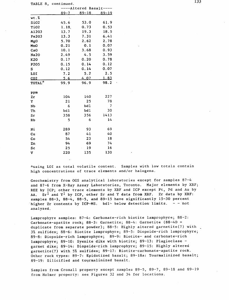
TABLE 8, continued. Altered Basalt -
89-7 89-18 89-19
133
wt.%Si02Ti02A1203Fe203MgOMnOCaONa20K20P205SLO IC02TOTAL*
ppmZrYNbThSrRb
NiCuCoZnSeV
45.61. 18.13.713.35.700.2110. 12.490. 170. 150. 127.25.6
99.9
104216
bdl358
5
28987549425
220
53.00.7319.37.312.620. 1
3.684.5
0.200. 140. 145.2
4.0796.9
14025
bdlbdl356
6
9341236919
135
61.90.5318.56.412.780.070.933.590.780. 120.072.51.8398.2
227787
301413
14
6940187416
130
*using LOI as total volatile content. Samples with low totals contain
high concentrations of trace elements and/or halogens.
Geochemistry from OGS analytical laboratories except for samples 87-4
and 87-6 from X-Ray Assay Laboratories, Toronto. Major elements by XRF;
REE by ICP; other trace elements by XRF and ICP except Pt, Pd and Au by
AA. Sr 1 and Y 1 by ICP, other Sr and Y data from XRF. Zr data by XRF:
samples 88-3, 88-4, 88-5, and 89-15 have significantly 15-30 percent
higher Zr contents by ICP-MS. bdl- below detection limits. - -hot
analyzed.
Lamprophyre samples: 87-4: Carbonate-rich biotite lamprophyre; 88-2:
Carbonate-apatite rock; 88-3: Garnetite; 88-4: Garnetite (88-4D =
duplicate from separate powder); 88-5: Highly altered garnetite(?) with
37o sulfides; 88-6: Biotite lamprophyre; 89-5: Diopside-rich lamprophyre;
89-8: Diopside-rich lamprophyre; 89-9: Biotite- and carbonate-rich
lamprophyre; 89-10: Syenite dike with biotite; 89-13: Plagioclase -
garnet dike; 89-14: Diopside-rich lamprophyre; 89-15: Highly altered
garnetite(?) with 57, sulfides; 89-17: Biotite-carbonate-apatite rock.
Other rock types: 89-7: Epidotized basalt; 89-18a: Tourmalinized basalt;
89-19: Silicified and tourmalinized basalt.
Samples from Croxall property except samples 89-5, 89-7, 89-18 and 89-19
from Holmer property: see Figures 32 and 34 for locations.
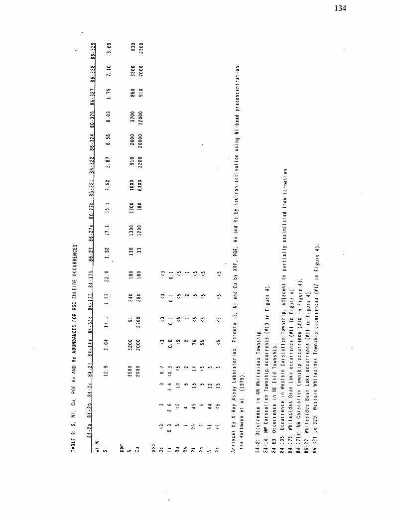
134
CO —* LO ^^ LO LO
— oo
CO ~-* LO
T3 O O OCSI
00
c c: — aa
0:01
XC
aj — '-

135
nstone
(UoOi
TJ'o"ECOk.
CD
^ea"cO)E
TJ O 0)ea092
V)to
cO0} T) COu. CDf-O)
I
O'co"3
Q.
E
o oCO
Figure 1. Location of the Kamiskotia area in the Superior Province, with major
subprovinces in the southern Superior Province labeled.

136
.~ E ^;--J7 ~ l'
Figure 2. Distribution of outcrops (Denoted in black) and major esker ridges (denoted
by v-arrays) in the Kamiskotia area.
Geology of Jamieson, Godfrey and northern Bristol townships (to east of irregular
Line) compiled from previously published maps. The townships are: Fo- Fortune; Co-
Cote; R- Robb; J- Jamieson; E- Enid; M-Massey; T- Turnbull; G- Godfrey; Fr- Frey;
W- Whitesides; Ca- Carscallen; B- Bristol. ,. -

137
CANADIAN JAMIESON MINE
Figure 3. Matachewan dikes in western Godfrey Township (after Middleton 197 Ib,
1973). Dike density typical for Kamiskotia area. North to top of figure.

138
3O•o c
-S3 o6cd
(Nb"G
5 c NU.2 o^6c3 M
c/3 ^O
C/J03•a coO)jo03C/3O) Oc COl—oUO
13CDc6
i-!
CDJ5 "o ffi
ocg2"oa3r*3CDcgxCOC CDaO)c2G O02 O"sea
CS3 -a03cea
CJ
ocsC!
N
2 o00-a cC3
W W Ptf03 XOt-,U o\ir^2 "oOc
e o 'c Dod b^
1 S3O cj^ Ccx S2 t^ 2W) 8
.i2 o
l dV) .J,Q 2W 01S ^7
oCU T-lr—1
i ^2 8.o oO a.
Kh
z o
J ILJ a,l Q.
2cg 2
5 g o^ cnfo^S5! 2=8 *
- lil "x ~ WQC W tr^aoQ 0 ^, v ^,, wLu .5 COOCD w ooNioJ ^~ ^55 B-S i 5 .2lS sil o^™ |5|
- 2 ^E^ S 3^5, gSt? x St 2-3c -g -f * -c a E™ COLU S O ^
O)C
J?C3
OJ^^ 2-— r?
inogS
T30C W Q)
f-|2" I-S2
is g^5 i 6
CD O
~ cW 2O i-^ 3 I 8< z
c o-±*- O) O c2 o'5g Sl 2

139
com t^ooco 11 ill xjQ
CD CO f-OO ,-0)LL..to in rococo "-
COk.o;0)E ^!i
S
t-loPu,(A d)"E,ErtV3
•Od)•t— i O
"d)C/3U.
**-lt/3d)t/3
"rt G rtd)
"3ij-d)Q. in•3x:abc
3Jd) >rt
d)X5 OPuCL*O
;ii/Sd)u-3aoE
k*cS6"d) u-± Oao21^-.
crao S*C-(
)-J2"3 o^o E xooT—— 1
d)V-rtt^d)
X5E3Cc/Trtj-id)
^G
C.2"55d) c aortE0 u.*y
*-M
Gcd
"rt o"Ed)j0"3 b•f-*cd)
•4—1
CcCJd)
-4—*'-G•4—*u. 0 C rt
•4—1
Cd)0u-d)O-k-l
^rt3CJ^wEd)rtV3U-d)
X3E3C
df in
J213/-^'abrtC-
.o"ON ONT— 1
.H *nu, rt
QQc"~*c d)^"ab1/3G
*— i-3co o
"rtCJ
^,"rtc rt
U-iOC^o*— (.9-'C oen d)-o•oG rtC/3G
^0•t— irt0O
*^^
JU"o- ErtOTJ

140
Eo
Figure 6. Foliation map. Outcrop exposure reflected by density of foliations. Bedrock in the region of granitoid B and the central KGC under glacial cover; bedrock hi region of southern KVC covered by poorly drained area. All foliations are near- vertical (900 ± 150). No preferred dip directions are evident across the region.
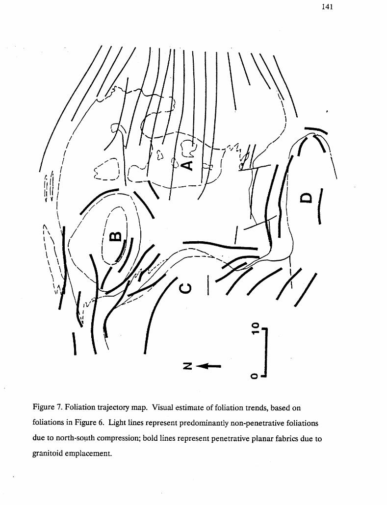
141
Figure 7. Foliation trajectory map. Visual estimate of foliation trends, based on
foliations in Figure 6. Light lines represent predominantly non-penetrative foliations
due to north-south compression; bold lines represent penetrative planar fabrics due to
granitoid emplacement.

142
k ^ 7
Figure 8. Mineral lineation map, with high strain zones marked with hatchured
pattern. Note that the western extent of the Destor Porcupine Fault Zone extends to the east and south of Granitoid D; a splay continues to the north within the Lower
volcanic suite.

143
\
E,*o
UJ (O
cdV-1)C
c/} C
cd
OCO.0 O
2 "oS3 Co
cd X)
^""^ coC C"S OC3 -t-*
CO— ao is*- ts"c -^O ^0t-. "^cd -1-3a ocd co
ci—i cdo ug- -5s. s*' ao ooUi (UJ* Sb cd

144
o oaco o
UJ (O
^ oo oui acl SUJ Z
i SS 25 22 UJO u-
S i
enz O
o u.Z < OC
U u.X
u.
zGCH
3
0uu
Z^.
|•z.i ooUloco.
eniCooac
GC
t-Z UJZQ HIen<UJ2OZ
wzo1-
oOjUl-laS
(O
a. i3
1
O
Figure 10. U-Pb sample locations, and general geology of the Kamiskotia - Kidd Creek area. KGC- Kamiskotia Gabbroic Complex; KR- Kamiskotia rhyolite of the Kamiskotia Volcanic Complex; GB- Granitoid B (Cote Township tonalite); GC- Granitoid C (Groundhog River tonalite); GAR- Garnetite of the Bristol Township lamprophyre suite; KCR- Kidd Creek Rhyolite; RR- Reid (Township) rhyolite; PR- Prosser (Township) rhyolite.

145
Aae Magmatic Events Deformation Events
2926 Ma
2717 V- 2 Ma, 2716 +6/-S Ma
^707 Ma
2707 V-2 Ma,2705 V-2 Ma,2706 V-2 Ma
2696 V-2 Ma
2694 Ma
2692 V-5 Ma
OLDER SIALIC CRUST (Inherited component in Granitoid C)
KIDD CREEK RHYOLITE, PROSSER RHYOLITE
LOUER MAFIC VOLCANICS, IRON FORMATION
KAMISKOTIA GABBROIC COMPLEX, KAMISKOTIA RHYOLITE, REID RHYOLITE, GRANITOID A
GRANITOID B
GRANITOID C (zircon)
GRANITOID D
ONSET OF REGIONAL CRUSTAL FOLDING
B CONTACT STRAIN DEVELOPMENT
C CONTACT STRAIN DEVELOPMENT NORTH-
SOUTH COMPRESSION
(?) THERMAL METAMORPHISM OR PROTRACTED COOLING (titanite, Granitoid C)
2687 V-3 Ma GARNETITE DIKE
TRANSPRESSION: DEVELOPMENT OF SHEAR ZONES ALONG THE HE STERN DE ST 'OR - PORCUPINE FAULT ZONE
l
Figure 11. Summary of the U-Pb ages in the Kamiskotia - Kidd Creek area.

146
Figure 12. Locations of samples and traverses. Sample locations given by Universal
Transverse Mercator grid coordinates in Appendix II.

147
S 2000-oN
11000
.2* i 3000 -O)
|2000
-1000CoN
20 40 60 80
plag mt+sulf
Figure 13. Petrographic traverse for cumulate rocks, ol -olivine; opx -orthopyroxene;
cpx -clinopyroxene; plag -plagioclase; hb -hornblende; mt H-sulf-magnetite and sulfide;
oc - olivine-rich cumulates. Traverse locations shown in Figure 12.

148
9SJ8ABJ1oo
-co
•^^-f
V*r
——— 1 ———
oooCMaun-7
——— i ————— OOO
iarlrln .
i — — v^^ i — —
OooCO
— —— - — T —————
0oo(N
7 ainniiAi
O0o'J~
o
-O
.O Oco .i
co goz
o .CO ^
-Q
LQ|o
LP 2
(oj)
Figure 14. KGC cumulates: whole rock magnesium number, normative anorthite
composition, TiO2 and ?2O5 versus stratigraphic height.
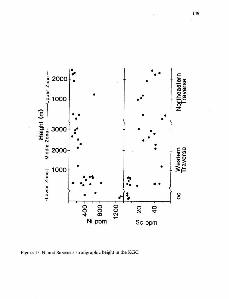
149
O)"S
1S 2000-OSIk.
^
|1000
'
i 3000M
5si
g3 2000-i
; 10005si
lDJ
*^
* .
^P
0 f
9t *
9
^h
• *
A
cL " CD CD•*- CO
CO 1-cd CDCD ^^•* /*rt
- 5 1-
Z
\ ' ^•*
**
*
* .
^•- *
.9 * ij
* * * 0 *
V
* .9
99
9
* .
-
-
^i
•* * *
^^ * l 9
^1 ^1'4 i i | i 1 i i i ii
E 02 *"Is >® co
- ^H
^Oo
888 g?rf CO OJ
Ni ppm Se ppm
Figure 15. Ni and Se versus stratigraphic height in the KGC.
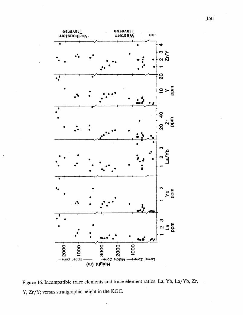
150
8SJ0ABJ1
o o oCM
O O O
-^A-
-•^-T-
CO
(uj)
8SJ9ABJXOQ
4** *41
o oCM
-co >
:O CM
. o
. o -t
CM
- CO
^6
- CM
- CO
o o o—— I-9U02 JQMO-|-
Figure 16. Incompatible trace elements and trace element ratios: La, Yb, La/Yb, Zr,
Y, Zr/Y; versus stratigraphic height in the KGC.
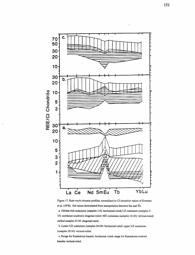
151
T3C O.c O
OUJ IJLJGC
53
1:
T—r
T——l—r
La Ce Nd SmEu Tb YbLu
Figure 17. Rare earth element profiles, normalized to CI chondrite values of Evensen
et aL (1978). Gd values determined from interpolation between Sm and Tb.
a. Olivine-rich cumulates (samples 1-4): horizontal-ruled; LZ cumulates (samples 5-
15): northeast-southwest diagonal-ruled; MZ cumulates (samples 16-23): vertical-ruled;
chilled samples 33-38 -diagonal-ruled.
b. Lower UZ cumulates (samples 24-29): horizontal ruled; upper LZ cumulates
(samples 30-34): vertical-ruled.
c. Range for Kamiskotia basalts: horizontal ruled; range for Kamiskotia evolved
basalts: vertical-ruled.

152
— ^*
Figure 18. REE and trace element plots for Kamiskotia and Kidd Creek rhyolites, and felsic metavolcanic rocks that are not known to be the host to Cu-Zn deposits (FI and FII) from the southern Superior Province, a. Rare earth element profiles for Kamiskotia and Kidd Creek; b.(La7Yb)N versus Ybfsj; c. Zr/Y versus Y; and c. Ti/100 - Zr/10 - Y ternary. After Lesher et al. 1986.
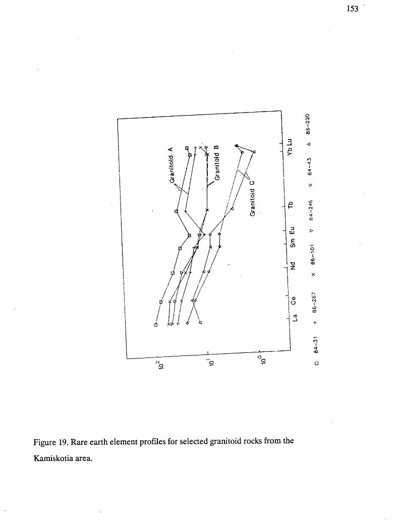
153
a -j.a
LU
CO
Figure 19. Rare earth element profiles for selected granitoid rocks from the
Kamiskotia area.

154
0 0 2 Sco to ^t ^ ^ CO CM T-1 1 1 1 1 1 1 1 1
1 EQ.
- zl Q J
-
o
-0 0 cP o -— r1 —— f —— "-] — ' — r1 —— —— S — ' — r-1 ——
0D)
1 5 o J"i
: o i
oO o^•v f*\ ^^ ^^
, 9 oi
1 i i i i i3 "33
. ~"
ID. o. oT4 0
o-
0 -
: o OD s : h 0 , , , dP ,
~ 1 ~" O- CM
^ O-
o
oO o o rp"
0 , o , , 0 "
CO
CM
COo
EQ. Q.
CO
N
CM
CM O CO CD CM CO CM T-
Figure 20. X-Y diagrams for Bristol Township lamprophyre suite. Biotite - carbonate - apatite lamprophyres- circles; garnetite samples- hexgons; altered garnetite samples- triangles, a. MgO, Ni, K2O and ?2®5 versus log Zr. b. TiO2, Y, Th, and S versus log Zr.
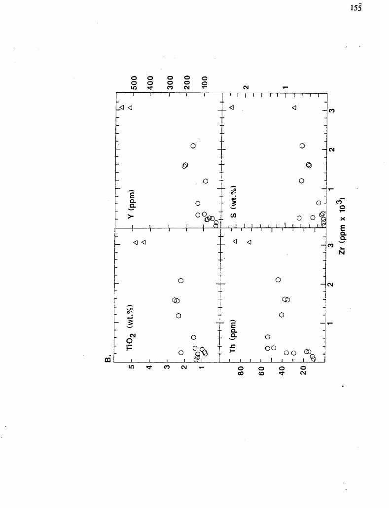
155
o oo oin t
o o oo o oCO CM r- CM
CQ
I II 1 1
-0 0
1 o J
i ^ :. o -
- E-a oii \ ' i "i i i i t
: o :
' I l 1 1 1 1 I I'll
-O -^ —
1 o J
: ^ :o
0^
- ? o-
" w 0 0 ^i t 1 i f i i 1 i i i Fi i i i 1 i li
^ 0 J
CO
CM
T-
CM
TOD
^- ^ o ~ 3
: Q l 'i
C2D 1i
O"E
a3- oH 00 ;
1 1 I 1 L7I 1 1 1 1 1 I 1 1 ^3
W *t CO CM T- OOOO CO (O *f CM
-
coo
a. a.
N

156
.o>
LU
OX
o
XJO
a ai
E W•DZ
oO
U UJ CC
0303
l00 03
X
lCO CO
0300
ao
-t-
•3- l
03
D
Figure 21. REE profiles for Bristol Township lamprophyre suite.

157
Figure 22. CMAS-type tetrahedron projections for KGC chill samples and Kamiskotia
basalt (RAS) and evolved basalt (E.BAS), after Walker et al. (1979). a. Projection
from plagioclase; b. projection from silica.
158
20
10-
5
oHj 50^C 30
20-1
JL-Ave. Chill
C 9: 5% T.L. C-,: 0% T.L Ave. LZ
Ave. Evol. Bas.
Ave. upper UZ
C2 : 25% T.L T.L
La Ce Nd SmEu Tb YbLu
Figure 23. Mass balance calculations using the REE. a. Model LZ cumulate
compositions from average KGC chill average composition, using percent trapped
liquid (Ci) and 59fc trapped liquid (C2). b. Model upper UZ cumulate compositions
from average Kamiskotia evolved basalt composition, using 10*2^ trapped liquid (Ci)
and 2596 trapped liquid (C2).

159
150-
Ni(ppm)
La
(ppm)
100 200 300 400 100 Zr (ppm)
200 300 400 500
Figure 24. X-Y plots for liquid compositions with AFC modeling curves. KGC chill
samples: dots; Kamiskotia "primitive" basalts: squares; Kamiskotia evolved basalts:
triangles. AFC curves using equations of DePaolo (1981) labeled by ratio of mass
assimilated (MA) to mass fractionated (MF), with O representing fractionation only.
Tick marks represent 10*26 fractionation increments; double-tick marks are for 809fc
fractionation. Assimilant used is average of 9 granites and tonalites from the KGC
granophyre, with 6 ppm Ni, 029 wt.% TiO2, 0.04 wt.% P2Os, 92 ppm Th, 58 ppm
La, 2.9 ppm Eu and 643 ppm Zr (Hart, 1984). Bulk KDS used: Ni: 2; TiO2: 02;
P2Os: 0.01; Th: 0.001; La: 0.1; Eu: 0.2; Zr: 0.01. For TiCb, La and Eu, secondary FC
curves from 100 ppm Zr use bulk KDS as labeled. Additional data from Hart (1984)
and Appendix V. a. Ni versus Zr. b. TiO2 versus Zr. c. ?2O5 versus Zr. d. Th versus Zr. e. La versus Zr. f. Eu versus Zr.

160
ooo oO KU5 CO
Figure 25. Primitive mantle-normalized profiles for Kamiskotia chill average in comparison to Alexo, Ontario komatiites (data from Brugmann, 1985; Barnes, 1984; and Whitford and Arndt, 1978), and average N-MORB. KGC chill average for Rb, Ba and K2O including sample 34 marked with open circles; without sample 34 marked in closed circles. Normalizing values and average N-MORB as listed in Hofmann (1988).

161
3 J* (Q
fr CL f
5: S. l
i PCo
Z -O O
O "7z
g
Figure 26. Geology of the number six mine level at Kam-Kotia Porcupine Mines
Limited. From Pyke and Middleton (1971).
Figure 27. Geology of the Canadian Jamieson mine property, slightly modified after Comba et al. (1986).
162
^•^\^ s\ *v#^^/^ c
CANADIAN JAMIESON MINE STRATIGRAPHY
LOT 9 .CONCESSION 3ZI GODFREY TOWNSHIP
IO 2O 3O 40
l5O
l
F

163
Ewljr to Middle Precambrian 01*6*** 4yk* Arch*** Strata
L*i* Oabbrotc fnlfutton
Mt-Jmmi-esofl Rhyolite formation
Malic formation
CycU 3 p(((ow*d ip m***
J* fti-*ceiM*? Ut*lc
pl!tow**J 10 ^*t*
tower Felsic fo
w***lv* to
Figure 28. Geology of the Genex Mine area. Slightly modified after Legault (1985).

164
Q)
OD CO
COD"c
O"2E®
'coCOCO
c oCOD
CO
'CDO)c
CO'o oCD
ID
O '(O
O'cCOo
Z ocuCOCO.0CO
Q
HSil;irHH:
i v- "
•o!EQ
3
w.
o"co
CDLL
> >**
x'
o^1COEMCO•o
CO•oO)
ECO
- -o
c03O."o5^0)-JE
CD "D
CO
CD
CO COCOE
n
oo "co
E •oCDt.CD*-
*9 c
W
Q.
O
CD
CO COCO5
Figure 29. Geology of the Genex Mine, 38 m level. Slightly modified after Legault
(1985).

165
Figure 30. Section of the H and A zones looking northeast. Slightly modified after
Legault (1985).

166
U
U
Figure 31. Section of the C zone, view looking north. Slightly modified after Legault (1985).
167
DIABASE
METASEDIMENTARY ROCKS
UndifferentiatedMetagray wackeQuartz * carbonate-rich
QUARTZ -CARBONATE ROCK
Undifferentiated With sulfides Tourmaline-rich
/tourmalinite
LAMPROPHYRE*
UndifferentiatedBiotite-richDiopside-rich
BASALT
UndifferentiatedEpidote-richQuartz -1- carbonate-rich
Figure 32. Geology of the Holmer gold property main outcrops. Quartz veins marked
in black.

168
CARBONATE - QUARTZ ROCK
LAMPROPHYRE SUITE
Unsubdivided Biotite-rich Garnet-rich/ garnetite Diopside-rich Feldspar-rich
Quartz - pyrite veins
Figure 33. Geology of the DeSantis gold property outcrops. Quartz vein marked in
black.

Access Road
\y
3 DIABASE
QUARTZ - FELDSPAR PORPHYRY
i GABBRO
Figure 34. Geology of the Croxall gold-REE property, with sample locations.

170
GNEISSIC
CALC-ALKALIC. INTRUSIVE
CALC-ALKALIC. EXTRUSIVE
U-Pb AGE (Ma)Figure 35. Histogram of high precision, U-Pb ages for the southern Superior Province
(excluding well-defined basement terrane ^780 Ma, and samples with complex U-Pb
data that do not clearly define primary igneous ages). The majority of these ages
have 2-iigma errors of ± 2 to 4 Ma. The 207pb7206pb ages for the detrital
sedimentary grains generally have significantly larger errors: see references for details.
Oneissic predominantly calc-alkalic intrusive rocks at amphibolite or granulite facies in
the Ka^tcirating (or related) terrane; LILEYLREE-enricbed: intrusive and extrusive
rocks, including one alkalic metavolcanic rock, an albitite dike, lampropbyres, and
monzodiorite-syenite-granodiorite intrusions with alkalic affinity (e^. Otto stock.
Kirkland Lake area); Tholeiitic, Ultramafic supracrustal tholeiitic intrusions and
related metavolcanic rocks, and one ultramafic dike; Calc-alkalic, Intrusive: tonalite-
trondbjemite and diorite-granodiorite-granite intrusions, quartz-feldspar porphyries
associated with gold mineralization, and sedimentary conglomerate clasts of these
compositions; Calc-alkalic, Extrusive: rhyolites and datites; Sedimentary Detrital:
for s;ngic zircon grains from metagraywackes and meta-arko&es. See text for discussion.
Data from: Barrie and Davis (1990); Barrie et aL (in prep.), Cattell et aL (1984);
Corfu, (1987); Corfu and Grunsky, (1986); Corfu and Stott (1986); Corfu et aL (in
press); Davis et aL (1985; 1989); Davis and Edwards (1982; 1986). Davis and Trowell
(1982); Frarey and Krogh (1986); Gariepy et aL (1984); Krogh and Turek (1981);
Moncnsen, (1987; and unpublished data); Nunes and Pyke (1981); this study; Turek et
aL (1982); and Percival and Krogh (1983).

171
EoI/I uJ^out V
*O inrt Q.•art
model for the Kamiskotia area
su,v•o•ub*a
•2 o
1E
4)
l?Ix8
. a) Generalized block diagram
uuc1Q.
JDa
2•3JO
o
oo 3SiE
tinental
8.E•ouc5s
Ma. Kamiskotia complex repre;
QO
r-4o
Sn^(Nrt
-C
iftu
1f*
al setting. KGC- Kamiskotia ga
cawu uJ*
^3C'i
JD
*0
V2 'l
81o'3i
5•2o
rocks of the KVC; KFV Kamisk
'53grt wEous1
u
12
1VEu(actf
otia granophyre; LMV- lower rr
•g
rt^Aoo 0">^^
U
5IV)
-Suia eq
•o wSuJ*
; shaded- sedimentary rocks; pa
'3M .0'53ob1
w
e"35.S•3VIWU9
Jid intrusions. Dashed line repr
ccb
i)cairtQ.
3rt •oaa u
jD
^OBrtE
T3
crustal rocks above and depletei
rtQ.p
J5*C2 -'5-aVc.
f"w
rtQ.
2rtrt
3V)aex JJ

"o
1#cd*So r~*o*soat 2690 Ma l
cd"ocd4)
JS"
\
0"5.
C?StouQNu.CuQQ" •o"o 'Hcd00
granitoid B; D-
03 j"-*"cd
o.^-3-oR
as in a;
o
L
idVI
'G"
HI•ajj,2^c,j* uOV)
O
6 Sj**cd S*
Larder Lake Bi
T3
jjd1252eaxir 1"•3,;d
00
1
P uA4-1O"!^t
ivolcanic roc
TO
*5
cks and alkalic
2JcoeH5?00
a ^t.~
t-,
u
1oa I/T4)U)
23"S
oo
rusions and
c-a
linantly granitoi
to 1o.ywcdo.So udio6
2"o "Scd t*UlsG
After volur
T3V
T3
rocks, unsubdivi
^o
112oE^c cd
1O
13OQ.
O'cO oV
52Q,Cc3^3
laS u•a cd c"O -u
ening and subdi
1.^^sopZ
.cement
C9"S.c5
.S^342c?Oto
JO
t33•oWod
lopment of 1
u>w
he region, with i
3 20cdi/i ocde"so-a ua.Dc'3ia
E oi
^g,y"S
JO
ing in metav
2•2
nd wrench-style
cdV?ugM
~3
c:.0'5*
u
30
Ocd
o"Ovo\^^
'?
cS•o
cd.2
ea

173
i/i2cd•3
uu
1k.
!B
f SiJS^
"cd"8Eo1 foscd
U Ol.ylrfS
Vfi.9(OU3
|r",42s
'oCO(2u
o1w
o3"8t"o.
0
oJs 0.
|"S2002J
gB2S
^o
oa oxoIs
MOs3
tecum
•co gScdoo u
1
1B
lli]?•aw •a u
jDt/3
SJDd. .aBO'3
W'•3
u1J3C3eao2•s•800•o w.2iS"35•so"S.
rt•oBM
(J
Q.3
.52
O"5o00
t2
5*-*so" x)•soo
-o
oC
131"oou•a2•6i!c
c5u
qu.c
10cd3E3
yoNo-a•oS

174

Plate 3. KGC mixed magma outcrop textures, western Turnbull Township, a. Medium-
grained gabbro cut by felsic dikes along brittle fractures, b. Agmatitic textured fine-
grained gabbro and felsic intrusion, c-f. Chilled gabbro liquid forming pillow-like
structures or irregular-shaped masses due to quenching in contact with cooler felsic
liquid.
176
usC T3•S o
CJ OS" g""S 5•9 ao 2I lII
o c "a* •ri^ 'b
ei u c1; .s *-S S Su 2 aS s 8O. o w
lil"V c .S-
" ". b
i l lO M 00
T3as
eo -—v
J S
o g oo o tea S ,WE 5 ^
2*
8? fe"5. S
6 J 31 i J82 - *"c G "o
"S. H S13 — "o
l S "i a ®
s ? i1^ S 'i(J ^ V
o l li. "s J.co M asb 3 2C 3 .2^- C —o c ^j.•p a c:E Q 02 d Q,o . o^ J r"* e? J0t) 4) 2S S -S-s ^ s
ao I
•g•c
P "S
l

177
j'-*3/*?^/* v5 yX-lfa*4/* ra
^
e l
2 S.a SH 0g "s1 *l JS T?
O.S1— c"S.c
2 H
o O S E
i!
.1 *Rt 31 -1O -^j
3 -t:
C Cw C
S 2 2 2
O -S T54) .2 Os B o
- -f S3S ^2 T3
•s S
04) pr* "*.S ul 2M.2 Kc oo .cs ai %

178
Plate 6. Deformation textures, a. Boudinaged blocks of Lower Zone gabbronorite in
migrnati tic rocks in western part of contact strain zone of graitoid B, Enid Township,
b. Chevron folds in mafic metavolcanic rocks? of the Lower volcanic suite, situated
between granitoids B and C northwest Massey Township, c. Ductile shear zone in
pillowed mafic metavolcanic rocks on the northeastern part of the Canadian Jamieson
mine property. Note possible pillow rims near hammer, now highly attenuated
Deformation intensity increases to left. These rocks occur 4 meters away from those
in photograph 5d. d. Small zone of ductile deformation in the eastern extent of
granitoid D. Undeformed granodiorite is progressively deformed toward quartz-
suJphide vein in center, with C fabric parallel to pens.

179
CONVERSION FACTORS FOR MEASUREMENTS IN ONTARIO GEOLOGICAL SURVEY PUBLICATIONS
Conversion from SI to Imperial
SI Unit Multiplied by Gives
Conversion from Imperial to Si
1 mm1 cm1 m1 m1 km
0.039 370.393 703.280840.049 709 70.621 371
inchesinchesfeetchainsmiles (
Ion2 l m2 l Ion2 l ha
lcm3 l m3 l m3
Imperial Unit
LENGTHl inch l inch l foot l chain
Multiplied by
25.423403048
20.1168l mile (statute) 1.609 344
0.155 O 10.763 9 0386 102.471 054
0.061 02 35.314 7
1.308 O
AREAsquare inches l square inch square feet l square foot square miles l square mile acres l acre
VOLUMEcubic inches l cubic inch cubic feet l cubic foot cubic yards l cubic yard
CAPACITY1 L 1 L 1 L
1.759 755 0.879877 0.219 969
pints quarts gallons
1 pint 1 quart 1 gallon
6.451 60.092 903 042.589 9880.404 685 6
16387 0640.028316850.764 555
0.5682611.136 522 .4.546090
MASS
CONCENTRATION l g/t 0.029 166 6 ounce (troy)/ l ounce (troy)/ 34.285 7142
ton (short) ton (short) l g/t 0.583 333 33 pennyweights/ l pennyweight/ 1.714 285 7
ton (short) ton (short)
OTHER USEFUL CONVERSION FACTORS
l ounce (troy) per ton (short) l pennyweight per ton (short)
Multiplied by 20.0 0.05
mmcm
rnm
km
cm2 m2
km2 ha
cm 3m 3 m 3
L L L
lglg1kg1kg1 t1kg1 t
0.035 273 960.032 150 752.204620.001 102 31.1023110.000984210.984 206 5
ounces (avdp)ounces (troy)pounds (avdp)tons (short)tons (short)tons (long)tons (long)
1 ounce (avdp) 28349 5231 ounce (troy) 31.103 476 81 pound (avdp) 0.453 592 371 ton (short) 907.184 741 ton (short) 0.907 184 741 ton (long) 1016.04690881 ton (long) 1.016 046 908 8
o
ookgkg
tkg
i
pennyweights per ton (shorl) ounces (troy) per ton (short)
Note: Conversion factors which are in bold tvpe are ejiact. The conversion factors have been taken from 01 l\a\\- been derived from factors given in the Metric Practice Guide for the Canadian Mining and Metallurgical l/tdus ines. published by the Mining Association of Canada in co-operanon with ilie Coal Association of Canmin
180
82 00'427000m.E87
4*gQOOf*.i 87
86
85
84
83
86
85
84
83

87
86
85
84
83
82 00'427000m.E. 462000m.E. 87
86
85
84
83
'VDENTO l/MEDGRAIVll l TF
C^Y'
57
56 82 00'
427000m.E.
LEGEND*,b
PHANEROZOIC CENOZOICQUATERNARY
RECENT ' ' -Stream, lake and organic bog deposits
PLEISTOCENEBakers, drumlinoids, glacial till
UNCONFORMITY
PRECAMBRIAN PROTEROZOIC
MATACHEWAN MAFIC DIKES (circa 2450 Mac : not shown on map; see figure 2)
Ontario GdoiogicrJ Survey MINES LIBRARY
JUN l l 1992 0PR. 5*2R
RECEIVED
INTRUSIVE CONTACT
ARCHEAN
BRISTOL TOWNSHIP LAMPROPHYRE SUITE (2687 V~3 11 Undifferentiatedlla Clinopyroxene - biotite lamprophyre lib Garnetite .
INTRUSIVE CONTACT
FELSIC INTRUSIVE ROCKS10 UndifferentiatedlOa Quartz diorite, tonalitelOb Quartz monzodiorite, granodioritelOc Quartz monzonite, granitelOd Aplite t pegmatitelOe Intrusive breccia6
INTRUSIVE CONTACTCote Township tonalite (2694 +X-4 Ma*)
9 Undifferentiated 9a Quartz diorite, tonalite 9b Quartz monzodiorite, granodiorite 9c Quartz monzonite, granite 9d Aplite, pegmatite 9e Intrusive breccia6
INTRUSIVE CONTACT
Groundhog River tonalite (2696 +X-2 Mad )8 UndifferentiatedSa Quartz diorite, tonalite8b Quartz monzodiorite, granodiorite8c Quartz monzonite, granite8d Aplite, pegmatite8e Intrusive breccia6 -
INTRUSIVE CONTACT
Turnbull Township tonalite (2707 Ma) ,7 Undifferentiated7a Quartz diorite, tonalite7b Quartz monzodiorite, granodiorite7c Quartz monzonite, granite7d Aplite, pegmatite7e Hybrid rocks, agmatite^
KAMISKOTIA VOLCANIC COMPLEX^/ 1* (Units 5, 6) FELSIC VOLCANIC ROCKS (2705 +X-2 Ma**)
6 Undifferentiated6a Rhyolite quartz-feldspar crystal tuffs and agglomerates 6b Welded quartz-feldspar rhyolite and dacite flows and tuffs 6c Spherulitic rhyolite flows 6d Tuffaceous volcaniclastic rocks
MAFIC VOLCANIC ROCKS 5 Undifferentiated5a Massive and pillowed basalt , 5b Basalt tuff, breccia 5c Plagioclase-porphyritic basalt 5d Massive and pillowed basaltic andesite
INTRUSIVE CONTACT
KAMISKOTIA GABBROIC COMPLEX9/(Units 3, 4) MAFIC INTRUSIVE ROCKS (2707 +X-2 Ma)
. 4 Undifferentiated4a Peridotite -' ' . ~ '4b Troctolite and olivine gabbro4c Magnesian gabbronorite and gabbro (locally anorthositic)4d Ferroan gabbronorite and gabbro (locally anorthositic}4e Hornblende gabbro and hornblendite4f Pegmatitic gabbro4g Chilled or agmatitic gabbro and gabbronorite^ '4h Gabbro and gabbroic anorthosite sills4i Amphibolite, pyroxenite
FELSIC INTRUSIVE ROCKS 3 Undifferentiated3a Granophyric diorite, quartz diorite, tonalite 3b Granophyric quartz monzodiorite, granodiorite,
quartz monzonite, granite
INTRUSIVE CONTACT
METASEDIMENTARY ROCKS , . : 2 Undifferentiated2a Oxide- and sulphide-bearing iron formation 2b Metagraywacke 2c Argillite , . 2d Metachert
LOWER VOLCANIC SUITE ^2707 Ma) l Undifferentiated la Pillowed and massive basaltIb Massive and tuffaceous andesite ~ " le Tuffaceous dacite and rhyolite ^ Id Garnet amphibolite
NOTES .a) Lithologic names are based on field and petrographic observations and geochemical classification following Streckeisen (1976).
b) Coding of rock types (e.g., numbers 1-11) is in chronologic order based on U-Pb geochronology and field relationships. Rock types noted by lighter type are subordinate to those in bold type, and generally as breccia or agmatitic blocks within the other rock types.
c) The age is from U-Pb zircon and baddeleyite data from a dike within the map area (L. Heaman, personal communication).
d) The 0-Pb ages are from Barrie (1990) and Barrie and Davis (1990).
e) Intrusive breccia is composed of a matrix of felsic intrusive material (generally tonalitic or granodioritic) with angular to sub-rounded fragments of gabbro and basalt (and their metamorphosed equivalents) up to three meters in width. ,
f) Units 7e and 4g have textures that indicate magma mixing with between Turnbull Township tonalite and Kamiskotia gabbro licpuids prior to crystallization and consolidation.
g) The Kamiskotia Gabbroic Complex (KGC) and Kamiskotia Volcanic Complex (KVC) are named formally using the North American Stratigraphic Code in the accompanying geologic report. The KGC both intrudes and is overlain by the KVC. The Complexes are interpreted to be genetically related, i.e., the KGC represents a residual magma chamber from which the KVC was derived.