karst in hong kong - ags (hk · typical required data marble quality designation (mqd) mqd is a...
TRANSCRIPT
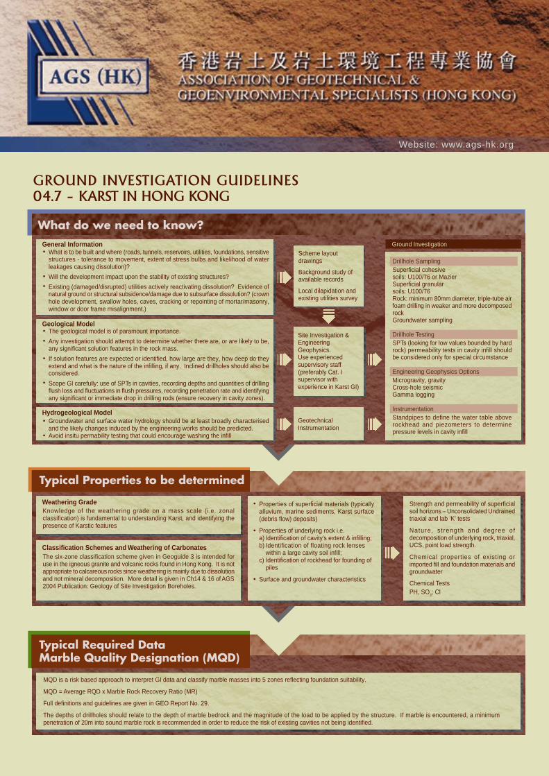
Typical Required DataMarble Quality Designation (MQD)
MQD is a risk based approach to interpret GI data and classify marble masses into 5 zones reflecting foundation suitability.
MQD = Average RQD x Marble Rock Recovery Ratio (MR)
Full definitions and guidelines are given in GEO Report No. 29.
The depths of drillholes should relate to the depth of marble bedrock and the magnitude of the load to be applied by the structure. If marble is encountered, a minimumpenetration of 20m into sound marble rock is recommended in order to reduce the risk of existing cavities not being identified.
GROUND INVESTIGATION GUIDELINES
04.7 – KARST IN HONG KONG
Website: www.ags-hk.org
What do we need to know?Ground Investigation
Typical Properties to be determined
General InformationWhat is to be built and where (roads, tunnels, reservoirs, utilities, foundations, sensitivestructures - tolerance to movement, extent of stress bulbs and likelihood of waterleakages causing dissolution)?
Will the development impact upon the stability of existing structures?
Existing (damaged/disrupted) utilities actively reactivating dissolution? Evidence ofnatural ground or structural subsidence/damage due to subsurface dissolution? (crownhole development, swallow holes, caves, cracking or repointing of mortar/masonry,window or door frame misalignment.)
The geological model is of paramount importance.
Any investigation should attempt to determine whether there are, or are likely to be,any significant solution features in the rock mass.
If solution features are expected or identified, how large are they, how deep do theyextend and what is the nature of the infilling, if any. Inclined drillholes should also beconsidered.
Scope GI carefully: use of SPTs in cavities, recording depths and quantities of drillingflush loss and fluctuations in flush pressures, recording penetration rate and identifyingany significant or immediate drop in drilling rods (ensure recovery in cavity zones).
Geological Model
Groundwater and surface water hydrology should be at least broadly characterisedand the likely changes induced by the engineering works should be predicted.Avoid insitu permability testing that could encourage washing the infill
Hydrogeological Model
Scheme layoutdrawings
Background study ofavailable records
Local dilapidation andexisting utilities survey
Site Investigation &EngineeringGeophysics.Use experiencedsupervisory staff(preferably Cat. Isupervisor withexperience in Karst GI)
GeotechnicalInstrumentation
Drillhole SamplingSuperficial cohesivesoils: U100/76 or MazierSuperficial granularsoils: U100/76Rock: minimum 80mm diameter, triple-tube airfoam drilling in weaker and more decomposedrockGroundwater sampling
Drillhole TestingSPTs (looking for low values bounded by hardrock) permeability tests in cavity infill shouldbe considered only for special circumstance
Engineering Geophysics OptionsMicrogravity, gravityCross-hole seismicGamma logging
InstrumentationStandpipes to define the water table aboverockhead and piezometers to determinepressure levels in cavity infill
Weathering GradeKnowledge of the weathering grade on a mass scale (i.e. zonalclassification) is fundamental to understanding Karst, and identifying thepresence of Karstic features
Classification Schemes and Weathering of CarbonatesThe six-zone classification scheme given in Geoguide 3 is intended foruse in the igneous granite and volcanic rocks found in Hong Kong. It is notappropriate to calcareous rocks since weathering is mainly due to dissolutionand not mineral decomposition. More detail is given in Ch14 & 16 of AGS2004 Publication: Geology of Site Investigation Boreholes.
Properties of superficial materials (typicallyalluvium, marine sediments, Karst surface(debris flow) deposits)
Properties of underlying rock i.e.a) Identification of cavity’s extent & infilling;b) Identification of floating rock lenses
within a large cavity soil infill;c) Identification of rockhead for founding of
piles
Surface and groundwater characteristics
Strength and permeability of superficialsoil horizons – Unconsolidated Undrainedtriaxial and lab ‘K’ tests
Nature, s t rength and degree o fdecomposition of underlying rock, triaxial,UCS, point load strength.
Chemical properties of existing orimported fill and foundation materials andgroundwater
Chemical TestsPH, SO
3; Cl
GIG04.7
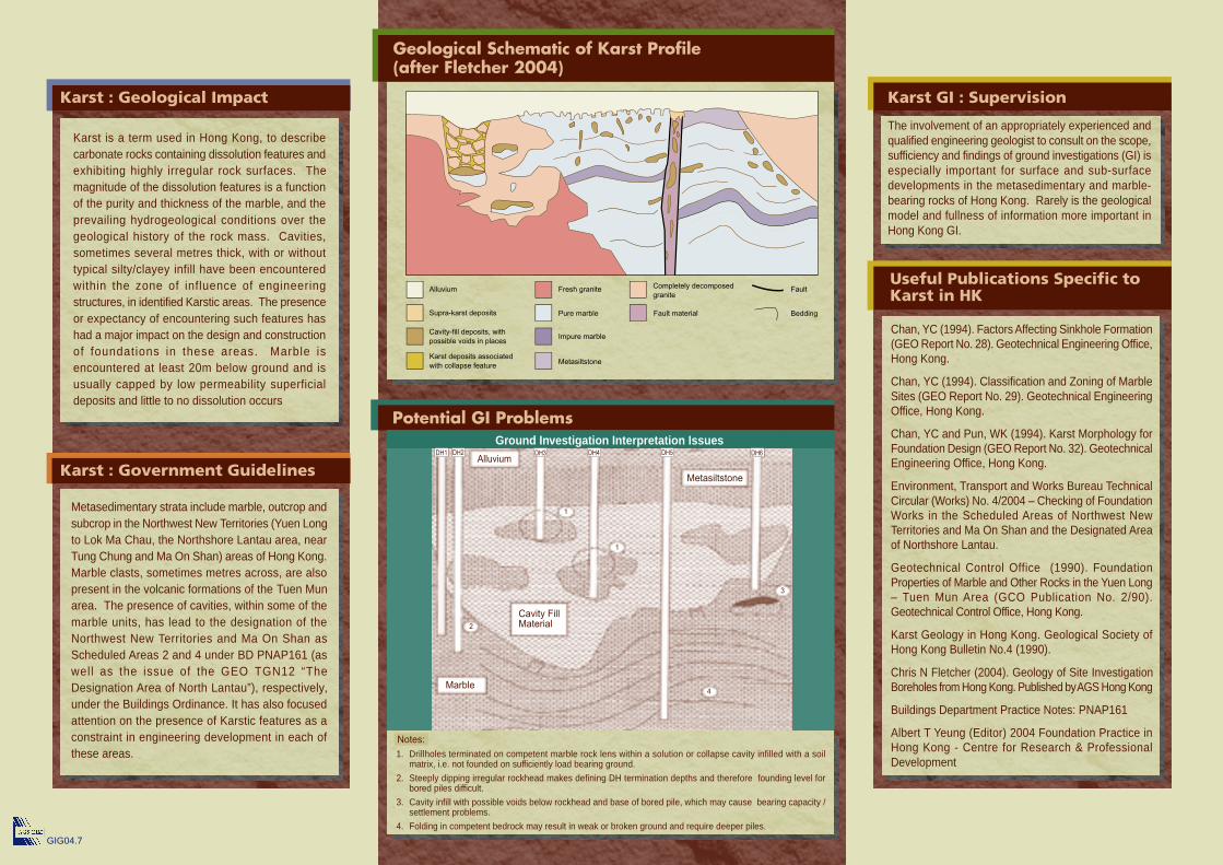
Karst : Government Guidelines
Karst : Geological Impact
Useful Publications Specific toKarst in HK
The involvement of an appropriately experienced andqualified engineering geologist to consult on the scope,sufficiency and findings of ground investigations (GI) isespecially important for surface and sub-surfacedevelopments in the metasedimentary and marble-bearing rocks of Hong Kong. Rarely is the geologicalmodel and fullness of information more important inHong Kong GI.
Chan, YC (1994). Factors Affecting Sinkhole Formation(GEO Report No. 28). Geotechnical Engineering Office,Hong Kong.
Chan, YC (1994). Classification and Zoning of MarbleSites (GEO Report No. 29). Geotechnical EngineeringOffice, Hong Kong.
Chan, YC and Pun, WK (1994). Karst Morphology forFoundation Design (GEO Report No. 32). GeotechnicalEngineering Office, Hong Kong.
Environment, Transport and Works Bureau TechnicalCircular (Works) No. 4/2004 – Checking of FoundationWorks in the Scheduled Areas of Northwest NewTerritories and Ma On Shan and the Designated Areaof Northshore Lantau.
Geotechnical Control Office (1990). FoundationProperties of Marble and Other Rocks in the Yuen Long– Tuen Mun Area (GCO Publication No. 2/90).Geotechnical Control Office, Hong Kong.
Karst Geology in Hong Kong. Geological Society ofHong Kong Bulletin No.4 (1990).
Chris N Fletcher (2004). Geology of Site InvestigationBoreholes from Hong Kong. Published by AGS Hong Kong
Buildings Department Practice Notes: PNAP161
Albert T Yeung (Editor) 2004 Foundation Practice inHong Kong - Centre for Research & ProfessionalDevelopment
Karst is a term used in Hong Kong, to describecarbonate rocks containing dissolution features andexhibiting highly irregular rock surfaces. Themagnitude of the dissolution features is a functionof the purity and thickness of the marble, and theprevailing hydrogeological conditions over thegeological history of the rock mass. Cavities,sometimes several metres thick, with or withouttypical silty/clayey infill have been encounteredwithin the zone of influence of engineeringstructures, in identified Karstic areas. The presenceor expectancy of encountering such features hashad a major impact on the design and constructionof foundations in these areas. Marble isencountered at least 20m below ground and isusually capped by low permeability superficialdeposits and little to no dissolution occurs
Metasedimentary strata include marble, outcrop andsubcrop in the Northwest New Territories (Yuen Longto Lok Ma Chau, the Northshore Lantau area, nearTung Chung and Ma On Shan) areas of Hong Kong.Marble clasts, sometimes metres across, are alsopresent in the volcanic formations of the Tuen Munarea. The presence of cavities, within some of themarble units, has lead to the designation of theNorthwest New Territories and Ma On Shan asScheduled Areas 2 and 4 under BD PNAP161 (aswell as the issue of the GEO TGN12 “TheDesignation Area of North Lantau”), respectively,under the Buildings Ordinance. It has also focusedattention on the presence of Karstic features as aconstraint in engineering development in each ofthese areas.
Potential GI Problems
Geological Schematic of Karst Profile(after Fletcher 2004)
Alluvium Fresh graniteCompletely decomposed
graniteFault
BeddingFault materialPure marble
Impure marble
Metasiltstone
Supra-karst deposits
Cavity-fill deposits, with
possible voids in places
Karst deposits associated
with collapse feature
Ground Investigation Interpretation Issues
Karst GI : Supervision
Drillholes terminated on competent marble rock lens within a solution or collapse cavity infilled with a soilmatrix, i.e. not founded on sufficiently load bearing ground.
Steeply dipping irregular rockhead makes defining DH termination depths and therefore founding level forbored piles difficult.
Cavity infill with possible voids below rockhead and base of bored pile, which may cause bearing capacity /settlement problems.
Folding in competent bedrock may result in weak or broken ground and require deeper piles.
1.
2.
3.
4.
DH1 DH2 DH3 DH4 DH5 DH6Alluvium
Cavity FillMaterial
Marble
Metasiltstone
1
2
3
4
Notes:
1