katherine to gove gas pipeline alcan gove pty limited€¦ · environment that may be affected by a...
TRANSCRIPT

ASSESSMENT REPORT 73
NORTHERN TERRITORY ENVIRONMENT PROTECTION AUTHORITY
KATHERINE TO GOVE GAS PIPELINE
ALCAN GOVE PTY LIMITED
October 2013

Table of Contents
NORTHERN TERRITORY ENVIRONMENT PROTECTION AUTHORITY
Abbreviations and Glossary ................................................................................................................. 1
Units and Symbols ................................................................................................................................ 3
Executive Summary .............................................................................................................................. 4
List of Recommendations..................................................................................................................... 7
1 Introduction ............................................................................................................................. 13
1.1 Environmental impact assessment process ................................................................ 13
1.2 Regulatory framework ................................................................................................. 14
1.3 Environmental impact assessment history .................................................................. 14
1.4 Ecologically sustainable development ........................................................................ 15
2 The Project .............................................................................................................................. 17
2.1 The Proponent ............................................................................................................. 17
2.2 Project objective .......................................................................................................... 17
2.3 Project location ............................................................................................................ 17
2.4 Pipeline specifications and components ..................................................................... 19
2.5 Schedule ...................................................................................................................... 22
2.6 Workforce and construction camps ............................................................................. 22
2.7 Construction ................................................................................................................ 23
2.8 Access ......................................................................................................................... 26
2.9 Rehabilitation ............................................................................................................... 26
2.10 Operation and decommissioning ................................................................................. 27
3 Regional Setting ..................................................................................................................... 28
3.1 Bioregions .................................................................................................................... 28
3.2 Ecologically sensitive habitats ..................................................................................... 28
3.3 Surface water resources ............................................................................................. 29
3.4 Groundwater resources ............................................................................................... 29
3.5 Socio-economic ........................................................................................................... 29
4 Environmental Impact Assessment ...................................................................................... 31
4.1 Introduction .................................................................................................................. 31
4.2 Summary of environmental issues .............................................................................. 32
4.3 Clarification of the Project ........................................................................................... 33
4.4 Ecology ........................................................................................................................ 36
4.5 Weeds ......................................................................................................................... 42
4.6 Trenching and fauna management ............................................................................. 43
4.7 Water ........................................................................................................................... 45
4.8 Road transport ............................................................................................................. 53
4.9 Historic and aboriginal cultural heritage ...................................................................... 53
4.10 Social Impact ............................................................................................................... 54
4.11 Defence ....................................................................................................................... 55
4.12 Economic considerations ............................................................................................ 56
4.13 Decommissioning ........................................................................................................ 57
4.14 Environmental Management Plans ............................................................................. 58
5 Conclusions ............................................................................................................................ 59
6 References .............................................................................................................................. 60
Appendix A ........................................................................................................................................... 61
Assessment Report 73
NORTHERN TERRITORY ENVIRONMENT PROTECTION AUTHORITY 1
Abbreviations and Glossary
AGP Amadeus Gas Pipeline
APIA Australian Pipeline Industry Association
BoM Bureau of Meteorology
CASA Civil Aviation Safety Authority
CEMP Construction Environmental Management Plan
CP Cathodic Protection
DLRM Department of Land Resource Management
DoD Australian Government Department of Defence
Draft EIS Draft Environmental Impact Statement
EA Act Environmental Assessment Act
EIA Environmental Impact Assessment
EIS Environmental Impact Statement
EMP Environmental Management Plan
EPBC Act Environment Protection and Biodiversity Conservation Act 1999
ESD Ecologically Sustainable Development
FIFO Fly-in Fly-out
GAL Gove Aluminium Ltd
HDD Horizontal Directional Drilling
HSE Health, Safety and Environment
HSE-MS Health, Safety and Environment Management System
ICN Industry Capability Network
IPA Indigenous Protected Areas
IPP Industry Participation Plan
KGGP Katherine to Gove Gas Pipeline
KP Kilometre Point
KTC Katherine Town Council
MLV Main Line Valves
MNES Matters of National Environmental Significance
NOI Notice of Intent

Assessment Report 73
NORTHERN TERRITORY ENVIRONMENT PROTECTION AUTHORITY 2
NLC Northern Land Council
NT Northern Territory of Australia
NT EPA Northern Territory Environment Protection Authority
OEMP Operational Management Plan
PCMP Provisional Cultural Heritage Management Plan
PVC Polyvinyl chloride
RAAF Royal Australian Air Force
RAAM Risk Assessment and Adaptive Management
RAR Review and Assessment Report
ROW Right of Way
SAAL Swiss Aluminium Australia Ltd
SCADA Supervisory Control and Data Acquisition
SEWPaC
Former Australian Government Department of Sustainability, Environment, Water, Population and Communities (now Department of the Environment)
SIMP Social Impact Management Plan
WCD Water Control District
WSAM Water Supply and Adaptive Management
4WD A vehicle capable of four wheel drive
the Australian Government Minister
The Australian Government Minister responsible for the Environment Protection and Biodiversity Conservation Act 1999
Environmental Impact Statement
The Environmental Impact Statement is comprised of the draft Environmental Impact Statement and the Supplement to the draft Environmental Impact Statement
the Minister Northern Territory Minister for Lands, Planning and the Environment
the Project Katherine to Gove Gas Pipeline
The Proponent
Alcan Gove Pty Limited or a related entity of Alcan Gove Pty Limited that is controlled and operated by Pacific Aluminium.
the/this Report
This Assessment Report 73 for the Katherine to Gove Gas Pipeline
Respondent Person or person(s) from the public or advisory bodies whom provide written comment on the Environmental Impact Statement
Assessment Report 73
NORTHERN TERRITORY ENVIRONMENT PROTECTION AUTHORITY 3
the Responsible Minister
Northern Territory Minister for Mines and Energy
the Supplement
The Supplement to the draft EIS
Units and Symbols
% percent
> greater than
ha hectare
km kilometre
km2 square kilometre
m metre
mm millimetre
ML megalitre
MPa megapascal
PJ petajoules
Assessment Report 73
NORTHERN TERRITORY ENVIRONMENT PROTECTION AUTHORITY 4
Executive Summary Environmental impact assessment (EIA) is the process of defining those elements of the environment that may be affected by a development proposal and analysing the risks associated with the identified potential impacts. This Assessment Report (the Report) assesses the environmental impact of the Katherine to Gove Gas Pipeline Project (the Project), proposed by Alcan Gove Pty Limited (the Proponent).
The Proponent proposes to construct and operate a buried 600km gas pipeline from a connection, up to 35km south of Katherine, to the alumina refinery located at Gove, north-east Arnhem Land, Northern Territory (NT). Power to the mine and refinery is currently generated from imported fuel oil. The Project would offer the Proponent access to a source of natural gas and help underpin the long-term energy supply to the operations at Gove.
The Katherine to Gove Gas Pipeline (KGGP) would consist of a buried, high-tensile steel pipe located in a 30m wide Right of Way (ROW). The location of the ROW would be within a 100m wide pipeline corridor. The proposed route would cross several waterways, roads and infrastructure corridors. Proposed specialised techniques for installing the pipeline at these locations include open-cut, horizontal boring and Horizontal Directional Drilling.
Supporting infrastructure would include access roads and above ground facilities, including scraper stations, main line valves, a meter station and compressor station. The pipeline coating, above ground pipe work, equipment and fittings would be designed for an operational life of 50 years.
The Project was assessed at the level of an Environmental Impact Statement (EIS) under the Environmental Assessment Act (EA Act). The Australian Government Minister responsible for the Environment Protection and Biodiversity Conservation Act 1999 agreed to accredit the assessment process under the EA Act for the purposes of assessing the Project.
The Northern Territory Environment protection Authority (NT EPA) has produced this Report as advice to the Minister for Lands, Planning and the Environment (the Minister) on the EIA of the Project. The Minister is required to give a copy of this Report to the Minister for Mines and Energy (the responsible Minister), together with any written comments made by the Minister in relation to this Report. The responsible Minister, taking into consideration this Report, will then make a determination as to whether or not a licence under the Energy Pipelines Act will be issued to the Proponent for the Project and if so, the conditions that may be applied.
Analysis by NT Government of the Notice of Intent for the Project identified a number of environmental risks. On the basis of these, it was determined that an EIS was required for the Project. Key risks that contributed to the decision included:
The size and scale of the proposal;
The potential impacts on protected flora and fauna;
The potential impacts on biodiversity from land clearing activities;
The potential disturbance to areas of conservation significance;
Increased demand and/or impacts on existing services and infrastructure, including roads, railways and water supplies;
Uncertainties associated with the method for installing the proposed KGGP at potentially significant habitats, watercourses, roads and infrastructure corridors;

Assessment Report 73
NORTHERN TERRITORY ENVIRONMENT PROTECTION AUTHORITY 5
The potential impacts of surface and/or groundwater extractions for water supply to the project;
The potential impacts associated with sourcing suitable rock, gravel and fill;
The potential risk to public and environmental health from localised discharges from the proposed development into watercourses and aquifers;
The potential impacts to stakeholders, including land holders and traditional owners; and
The potential social, cultural and economic impacts, including the risks of the project not realising its projected economic and social benefits.
Information requirements based upon identified risks were described in the EIS Guidelines for the Project and the Proponent submitted the draft EIS to address these requirements. The Proponent broadly categorised the respondent’s issues and concerns into the following topics for discussion in the Supplement to the draft EIS:
Further clarification of project description;
Construction of watercourse crossings;
Health and safety;
Management of weeds and feral animals;
Impacts on the Freshwater Sawfish;
Impacts on the Gouldian Finch;
Other conservation significant flora/fauna species (including those not considered) and management;
Impacts of noise on fauna and/or local communities;
Local employment; and
Detail in management plans.
The NT EPA considers that the environmental issues associated with the Project have been adequately identified. Appropriate environmental management of some of these issues has been resolved through the EIA process, while the remainder would be addressed through monitoring and management actions detailed in issue-based management plans under provisions of the Energy Pipelines Act.
The NT EPA considers that the Project can be managed in a manner that avoids unacceptable environmental impacts provided that the commitments, safeguards and recommendations detailed in the EIS, this Report and in the final management plans approved by the Department of Mines and Energy, are implemented and subject to regular reporting and compliance auditing.
A final Environmental Management Plan for the Project will be subject to review to the satisfaction of the relevant Northern Territory agencies prior to its incorporation into the pipeline and facility licence requirements. It is recommended that management plans also be developed in consultation with key stakeholders, including the Northern Land Council. The management plans will be working documents for the life of the Project and will require periodic review in the light of operational experience and changed circumstances.
Assessment Report 73
NORTHERN TERRITORY ENVIRONMENT PROTECTION AUTHORITY 6
Information gaps remaining from the EIA process require the Proponent, Government and the regional community to rely on intensive, post-assessment data collection, analyses and monitoring to determine the significance of, and appropriate responses to, potential impacts. These requirements are largely captured in the commitments made by the Proponent and recommendations in this Report. The ongoing risk analysis, environmental monitoring and management required from the Proponent must demonstrate that environmental impacts from the Project are no greater than those predicted in this assessment.
Assessment Report 73
NORTHERN TERRITORY ENVIRONMENT PROTECTION AUTHORITY 7
List of Recommendations Recommendation 1
The Proponent shall ensure that the Project is implemented in accordance with the environmental commitments and safeguards:
Identified in the Katherine to Gove Gas Pipeline Environmental Impact Statement (draft Environmental Impact Statement and Supplement to the draft Environmental Impact Statement); and
Recommended in this Assessment Report.
The Northern Territory Environment Protection Authority considers that all safeguards and mitigation measures outlined in the Environmental Impact Statement are commitments made by the Proponent.
Recommendation 2
The Proponent shall advise the Northern Territory Environment Protection Authority and the responsible Minister of any changes to the proposed action, in accordance with clause 14A of the Environmental Assessment Administrative Procedures.
Recommendation 3
The Proponent shall prepare and finalise the proposed Final Access Track and Construction Camp Summary Report as part of the Final Alignment Plan(s). The Final Alignment Plan(s) shall be submitted to the Northern Territory Environment Protection Authority prior to the commencement of construction activities associated with the Katherine to Gove Gas Pipeline.
The Final Access Track and Construction Camp Summary Report component of the Final Alignment Plan(s) should, at a minimum, indicate the final locations of access tracks and construction camps; access tracks and construction camps, or parts there-of, that are not required post-construction and detail how these would be rehabilitated following construction; and how impacts to Matters of National Environmental Significance have been avoided or minimised through site selection and how mitigation measures would be employed.
Recommendation 4
Access to, and the use of land and water resources or existing infrastructure required for the purposes of the Katherine to Gove Gas Pipeline, must be negotiated appropriately with the relevant Traditional Owners and non-Indigenous landowners to the satisfaction of the Department of Mines and Energy.
Recommendation 5
Should a decision be made to implement the proposed alternative alignment as the preferred alignment, the Proponent shall submit a variation to the Northern Territory Environment Protection Authority, in accordance with Recommendation 2 of this Report.
The Final Alignment Plan(s) should outline the reasons for implementing the alternative alignment as the preferred alignment. The Plan(s) should contain the completed proposed surveys (cultural heritage, flora and fauna, including habitat mapping for Gouldian Finch, Red Goshawk and other relevant species comprising Matters of National Environmental Significance). A discussion on how these will

Assessment Report 73
NORTHERN TERRITORY ENVIRONMENT PROTECTION AUTHORITY 8
be avoided or the impacts of the Project (such as blasting) on these areas would be minimised, would need to be approved prior to this alignment being used.
Recommendation 6
The Proponent shall engage a suitably qualified ecologist as a mitigation measure to identify important habitat ahead of construction of the 30m Right of Way, construction camp sites and other infrastructure. The ecologist should be appropriately skilled and have experience in the identification of fauna and habitat, especially those related to Matters of National Environmental Significance.
The Proponent shall engage a qualified ecologist at an appropriate stage of the Project (such as pegging of the Right of Way, selection of construction camps and access roads) to ensure that adequate time is available for the ecologist to confidently identify important habitats which are to be avoided.
Recommendation 7
The Proponent is to engage a qualified ecologist on site for pre-clearance pegging of the alignment of the 30m Right of Way, construction camp sites and access roads to minimise clearance of Salmon Gums, particularly those with suitable hollows. Additional measures to minimise impacts to the Gouldian Finch are to include:
reducing the width of the Right of Way where possible;
ensuring that the timing the removal of Salmon Gums avoids disturbance of active nests;
the building and installation of suitable nest-boxes to compensate for cleared Salmon Gums. The Northern Territory Environment Protection Authority notes that all nest-boxes should be of the type referenced in the Supplement; natural hollow logs with an attached rain and heat resistant breeding chamber because the type of nest-box utilised can greatly influence reproductive success. The amount of time that it is likely to take for naturally rehabilitated areas to form tree-hollows will need to be taken into account so that a suitable number of nest-boxes are installed to ensure that an overall high quality breeding habitat is provided where the habitat had been cleared; and
adjusting the alignment of the Right of Way so as to provide a 190m buffer distance from the proposed alignment to the waterhole at KP118.
In the absence of such information from additional further survey, the route, construction camp sites and access roads should be diverted to avoid all mapped stands of Salmon Gum of >1 ha in extent.
It is recommended that the Proponent prepare and implement a Terrestrial and Aquatic Fauna and Habitat Management Plan, which include contingencies to prevent the mortality of individual Gouldian finches.
The Proponent shall re-evaluate the risk assessment and proposed mitigation measures, including pipeline realignments, and define residual impacts, for the Gouldian Finch.
Before construction commences, the Proponent shall demonstrate to the satisfaction of the Northern Territory Environment Protection Authority that the Katherine to Gove Gas Pipeline will not lead to long-term impacts on the Gouldian Finch, based on the re-evaluation.
Assessment Report 73
NORTHERN TERRITORY ENVIRONMENT PROTECTION AUTHORITY 9
Recommendation 8
The Proponent shall re-evaluate the risk assessment for the Bare-rumped Sheath-tail Bat. The amended assessment should be provided to the Northern Territory Environment Protection Authority and the Australian Government Department of the Environment for further consideration before any impact to Bare-rumped Sheath-tail Bat habitat occurs.
Prior to construction commencing, the Proponent shall demonstrate to the satisfaction of the Northern Territory Environment Protection Authority that the Katherine to Gove Gas Pipeline Project will not lead to long-term impacts on the Bare-rumped Sheath-tail Bat.
The presence of the Bare-rumped Sheath-tail Bat in proposed camp sites is to be determined by the qualified ecologist, and areas of occupancy avoided.
Recommendation 9
Prior to selection of final pipeline alignment, the Proponent should engage a suitably qualified ecologist to verify and quantify sightings and nests of the Red Goshawk in the riparian habitats crossed by the Right of Way. This verification should be conducted at an appropriate time of year and inform final pipeline alignment to avoid these habitats (2km either side of the Right of Way) and quantify residual significant impact this Matter of National Environmental Significance.
Prior to selection of final pipeline alignment, construction camp sites and road access the Proponent should engage a suitably qualified ecologist to verify and quantify sightings and habitat (where possible) for the Northern Masked Owl and Northern Crested Shrike-tit in the Right of Way. This verification should inform final alignment and locations.
Prior to selection of final construction camp locations, the Proponent must ensure that sufficient survey effort by a suitable qualified ecologist has been undertaken to avoid construction camping areas occupied by Northern Masked Owl and Northern Crested Shrike-tit. Surveys of construction camping sites at the appropriate times of year should quantify residual significant impact to Matters of National Environmental Significance.
Recommendation 10
Monitoring and management of weeds along the operating pipeline corridor must be ongoing. The Final Weed Management Plan is to be submitted to the Department of Lands Resource Management for consideration and approval.
The Final Weed Management Plan should specify equipment and vehicle wash-down locations and a rationale for their selection. Washdown locations at all possible points of entry from the Katherine to Gove Gas Pipeline into Arnhem Land should be mandatory.
Recommendation 11
It is recommended that, in addition to the measures outlined in the Native fauna handling management procedure:
the length of open trench not exceed lengths capable of being practically inspected and cleared by the fauna handlers at any time;
the maximum length of the trench not exceed 60km in any case;
Assessment Report 73
NORTHERN TERRITORY ENVIRONMENT PROTECTION AUTHORITY 10
all fauna handlers, not just limited to the senior fauna hander, must:
o hold a valid permit to take or interfere with wildlife issued under the Territory Parks and Wildlife Conservation Act;
o be experienced in the identification of fauna and assessment of fauna condition.
a vet be on standby in the event that fauna are in need of medical treatment, such as from injury.
Recommendation 12
In the event that Horizontal Directional Drilling is not feasible for the nine nominated waterways identified in the Environmental Impact Statement, the Proponent is required to negotiate an alternative crossing technique with the Northern Territory Environment Protection Authority.
Recommendation 13
The Proponent shall:
not undertake open-cut trenching construction activities when waterways are in flow;
avoid or minimise blockages or restriction of flow; and
limit the duration of interference with or obstruction of any waterway to as short as practicably possible.
The Proponent will ensure that construction activities at waterway crossings are conducted as agreed by respective landowners and Government agencies, and in accordance with the management measures described in the approved Construction Environmental Management Plans, which forms part of the Pipeline Management Plan.
Recommendation 14
Surface or groundwater extraction for the Project need to be included in the Pipeline Management Plan for the consideration for approval under the Energy Pipelines Act.
Extraction of water for the Katherine to Gove Gas Pipeline will not exceed the threshold level equivalent to 20% of flow at any time in any part of a river.
The Proponent should provide; i) clear projected usage data on the amount of water (in total volume) being taken from impacted rivers, and ii) information on potential impacts on downstream Aboriginal communities who rely on these waterways for domestic usage.
Recommendation 15
The Proponent shall ensure that best-practice erosion and sediment control measures are fully implemented for all disturbed areas prior to the onset of the Wet season.
Erosion and sediment control measures, including monitoring and maintenance, should be implemented in accordance with the commitments made in the Environmental Impact Statement, and in the approved Construction and Operational Environmental Management Plans for the Project.

Assessment Report 73
NORTHERN TERRITORY ENVIRONMENT PROTECTION AUTHORITY 11
Recommendation 16
Hydrostatic test water should be:
irrigated onto a stable soil surface using appropriate protocols outlined in the Hydrostatic Test Water Management Plan;
discharged away from watercourses; and
disposed of on receiving ground not prone to erosion.
Should additives, such as biocides, be shown to be necessary for hydrostatic testing, the Proponent shall submit a detailed proposal on the intended use and disposal of waters containing additives. The Pipeline Management Plan should be amended to include a sub-plan for management of this disposal water. Any such proposal, including the sub-plan, shall be submitted to the Northern Territory Environment Protection Authority for approval prior to the use of additives.
Recommendation 17
A Traffic Management Plan and Road Maintenance Program are to be prepared in consultation with relevant stakeholders, including the Department of Transport and the Department of Infrastructure.
The Proponent shall ensure an appropriate road upgrade and maintenance schedule is in place, to the satisfaction of the Department of Transport, prior to construction.
Recommendation 18
A Cultural Heritage Management Plan is to be prepared in consultation with relevant stakeholders, including the Northern Land Council, to the satisfaction of the Heritage Branch of the Department of Lands Planning and the Environment and Aboriginal Areas Protection Authority prior to the commencement of any works. The plan must include procedures for ceasing works and contacting the Heritage Branch of the Department of Lands Planning and the Environment if archaeological objects are discovered during earthworks and construction activities.
The Proponent shall engage a qualified archaeologist as a mitigation measure to identify important cultural or heritage sites ahead of construction of the 30m Right of Way and infrastructure.
Recommendation 19
For the appropriate management of construction-related social risks, it is recommended that the Proponent form a Social Impact Reference Panel in consultation with the Department of the Chief Minister and the Department of Business, to review and revise the Project’s Social Impact Management Plan as required.
Recommendation 20
The Proponent must liaise with the Australian Government Department of Defence during all phases of the project to be aware of all possible interaction between Katherine to Gove Gas Pipeline and defence operations. Appropriate modelling of the plume rise and velocity predictions and details of conformance with Civil Aviation Safety Authority guideline requirements is to be completed and provided to the Australian Government Department of Defence.

Assessment Report 73
NORTHERN TERRITORY ENVIRONMENT PROTECTION AUTHORITY 12
Recommendation 21
The Proponent shall advise the Australian Government Department of Defence of any structures of the Katherine to Gove Gas Pipeline, where the top of the structure is: 30m or more above ground level within 30km of an aerodrome, or 45m or more above ground level elsewhere.
Recommendation 22
The Proponent shall prepare and submit a suitable Industry Participation Plan to the Department of Business and the Social Impact Reference Panel (see Recommendation 19) for consideration and approval. The approved Industry Participation Plan should form part of the Pipeline Management Plan for the Katherine to Gove Gas Pipeline Project.
Recommendation 23
A Provisional Decommissioning Plan must be included as part of the final Pipeline Management Plan for the Katherine to Gove Gas Pipeline.
The Provisional Decommissioning Plan must include contingency planning for early (including during construction) or unexpected closure, financial provisioning for both planned and sudden closure, and potential social as well as environmental impacts resulting from decommissioning and closure industry best practice and incorporates responsive dialogue with affected Indigenous people.
Within an appropriate period prior to decommissioning activities the Proponent shall finalise the Decommissioning Plan and submit it to the NT Government agencies responsible for the Energy Pipelines Act and Environmental Assessment Act, and the Australian Government Department responsible for the Environment Protection and Biodiversity Conservation Act 1999 for approval prior to the commencement of any decommissioning works.
Recommendation 24
The Proponent taking the proposed action is wholly responsible for implementation of all conditions of approval and mitigation measures contained in the Environmental Management Plan and must ensure all staff and contractors comply with all requirements of conditions of approval and mitigation measures contained in the Environmental Management Plan.
The Environment Management Plan, and sub-plans, should form part of the Pipeline Management Plan. In preparing each plan, the Proponent will include any additional measures for environmental protection and monitoring contained in this Assessment Report. The plans shall be referred to relevant Northern Territory agencies for review prior to finalisation.
Recommendation 25
The Proponent shall submit an annual Review and Assessment Report for the Katherine to Gove Gas Pipeline to the Northern Territory Environment Protection Authority in accordance with the provisions in the Environmental Management Plan. In addition to reporting environmental performance, and reviewing the effectiveness of the proposed environmental safeguards and mitigation measures, the Review and Assessment Report should include a discussion on the effectiveness of waterway crossing protection, erosion and sediment control measures and any rectification works undertaken or proposed.

Assessment Report 73
NORTHERN TERRITORY ENVIRONMENT PROTECTION AUTHORITY 13
1 Introduction Alcan Gove Pty Limited (the Proponent) proposes to construct and operate a buried 600km gas pipeline from a connection, up to 35km south of Katherine, to the alumina refinery located at Gove, north-east Arnhem Land, Northern Territory (NT). Power to the mine and refinery is currently generated from imported fuel oil. The Katherine to Gove Gas Pipeline Project (the Project) would offer the Proponent access to a source of natural gas and help underpin the long-term energy supply to the operations at Gove.
The Katherine to Gove Gas Pipeline (KGGP) would consist of a buried, high-tensile steel pipe located in a 30m wide Right of Way (ROW). The location of the ROW would be within a 100m wide pipeline corridor. The proposed route would cross several waterways, roads and infrastructure corridors. Proposed specialised techniques for installing the pipeline at these locations include open-cut, horizontal boring and Horizontal Directional Drilling (HDD).
Supporting infrastructure would include access roads and above ground facilities, including scraper stations, main line valves (MLV), a meter station and compressor station. The pipeline coating, above ground pipe work, equipment and fittings would be designed for an operational life of 50 years.
The purpose of this Assessment Report (this Report) is to identify and evaluate the Project’s risks to the environment and to recommend whether the risks are acceptable. This is achieved by identifying the potentially significant risks of an environmental impact occurring as a result of the Project components and activities, and evaluating the Proponent’s corresponding safeguards or prevention measures to remove or mitigate the risks. The contents of this Report form the basis of advice to the Minister for Lands, Planning and the Environment (the Minister) on the environmental impact assessment (EIA) of the Project and the acceptability of any residual risks to the environment.
1.1 Environmental impact assessment process The EIA process should:
identify potential impacts on the environment (where environment is defined broadly according to the Environmental Assessment Act (EA Act)); and
evaluate the risks of those impacts occurring.
Through the assessment of the environmental risks of the Project, the Proponent must demonstrate:
that these risks can be satisfactorily managed within acceptable levels, e.g. impacts would not result in long-term or irreversible environmental detriment; and
the effectiveness/feasibility of management measures in a precautionary/risk management framework.
That the assessment gives weighted consideration to:
values and risks;
estimation of the likelihood of success of preventative and remedial measures; and
the validity and comprehensiveness of programs established to provide ongoing measures of the environmental effects of the Project.
The assessment of environmental risk can be more reliably evaluated when there is a substantial baseline of relevant information. Where this information is limited or not

Assessment Report 73
NORTHERN TERRITORY ENVIRONMENT PROTECTION AUTHORITY 14
available, risk assessment is inevitably constrained and far less precise. In the absence of sufficient baseline information it is appropriate to use the precautionary principle to evaluate possible impacts. If potential impacts are understood with a reasonable level of certainty, monitoring programs can be better informed to detect impacts, and management measures can be more effectively targeted to address those impacts.
This Report evaluates the adequacy of commitments and environmental safeguards proposed by the Proponent to avoid or mitigate the risks of potential impacts identified in the EIA process. The safeguards may be implemented at various levels in the planning framework of a project and include (among other approaches):
Design and layout of components, such as construction camps, access roads and other infrastructure, associated with the Project;
Management of construction activities; and
Management of processes used in operation of the pipeline (e.g. inputs and outputs).
A list of commitments made by the Proponent is provided at Appendix O of the draft Environmental Impact Statement (draft EIS) and Chapter 1 of the Supplement to the draft EIS (the Supplement). Additional safeguards are recommended in this Report, where appropriate.
1.2 Regulatory framework Environmental assessment was undertaken in accordance with the requirements of the EA Act. The proposal was determined to be a controlled action under the Environment Protection and Biodiversity Conservation Act 1999 (EPBC Act)(Cth) as it was considered likely to have significant impacts on listed threatened species and communities and listed migratory species which are Matters of National Environmental Significance (MNES). The Project has been assessed under the EA Act by the Northern Territory Environment Protection Authority (NT EPA) on behalf of the Australian Government.
The NT EPA has produced this Report as advice to the Minister on the EIA of the Project. The Minister is required to give a copy of this Report to the Minister for Mines and Energy (the responsible Minister), together with any written comments made by the Minister in relation to this Report. The responsible Minister, taking into consideration this Report, will then make a determination as to whether or not a licence under the Energy Pipelines Act will be issued to the Proponent for the Project and if so, the conditions that may be applied.
The Australian Government Minister responsible for the EPBC Act (the Australian Government Minister) will need to consider the Project for an approval decision under the EPBC Act. This Report will inform the consideration.
The approvals and regulatory requirements for the Project are set out in Section 1.9 of the draft EIS.
1.3 Environmental impact assessment history On 5 November 2012, the former Northern Territory Environment Protection Agency received the Notice of Intent (NOI) for the Project for consideration under the EA Act. On 29 November 2012, the then Deputy Chief Executive of the Northern Territory Environment Protection Agency decided that the Project required assessment under the EA Act at the level of an Environmental Impact Statement (EIS).
On 4 November 2012, the Project was referred to the then Australian Government Department of Sustainability, Environment, Water, Population and Communities (SEWPaC) and on 3 December 2012 was determined to be a controlled action under the

Assessment Report 73
NORTHERN TERRITORY ENVIRONMENT PROTECTION AUTHORITY 15
EPBC Act. The Project was considered likely to have significant impacts on the following MNES that are protected under Part 3 of the EPBC Act:
Listed threatened species and communities (sections 18 & 18A); and
Listed migratory species (sections 20 & 20A);
On 9 April 2013, a delegate for the Australian Government Minister agreed to accredit the assessment process under the EA Act for the purposes of assessing the Project.
Draft guidelines covering matters to be addressed in the EIS were subject to a public review period between 7 and 31 December 2012. On 14 January 2013, a delegate for the NT EPA directed the Proponent to prepare the EIS addressing the matters set out in the final guidelines (NT EPA, 2013).
The draft EIS for the Project underwent an eight week public exhibition period commencing on 4 May 2013. Eleven submissions on the draft EIS were received from Government agencies and non-Government organisations. All submissions were forwarded individually to the Proponent. The Proponent prepared the Supplement as required under the EA Act to address the issues raised by the respondents. A list of submissions on the draft EIS, including the Proponent’s responses, are included at Appendix A of the Supplement.
On 12 September 2013, the NT EPA received and circulated the Supplement to Government advisory bodies and suitably qualified individuals and organisations for comment. This Report is based on a review of the draft EIS and the Supplement (collectively referred to as the EIS), and comments from the Proponent, non-Government respondents and Government advisory bodies on the EIS. The NT EPA prepared this Report and provided it to the Minister.
The EIA chronology and EIS documentation can be viewed on the KGGP project page of the NT EPA website at:
http://www.ntepa.nt.gov.au/environmental-assessments/assessment/register/katherine-to-gove-gas-pipeline
1.4 Ecologically sustainable development The Australian Government affirmed its commitment to sustainable development at United Nations conferences on environment and development, notably via the Rio Declaration and Agenda 21 in 1992 and the Johannesburg Declaration at the United Nations 2002 World Summit. Australia reaffirmed its commitment at the Summit to promote the integration of the three components of sustainable development—economic development, social development and environmental protection—as interdependent and mutually reinforcing pillars.
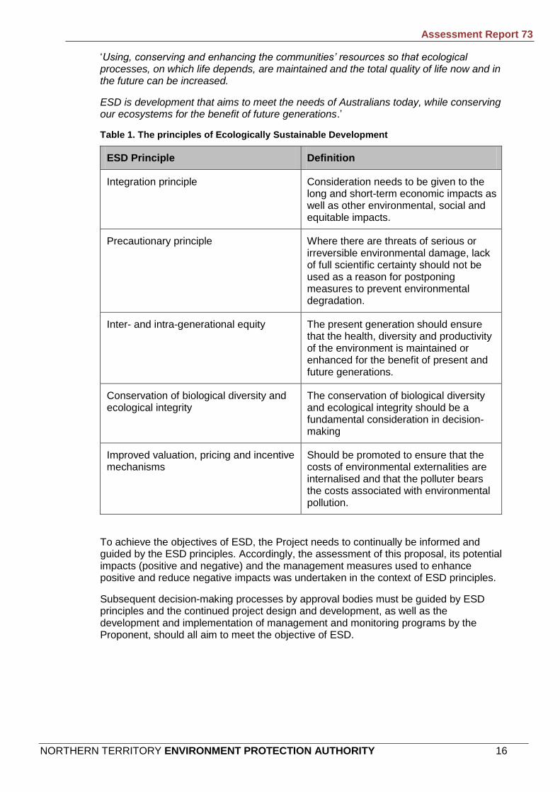
Australia developed the National Strategy for Ecologically Sustainable Development (ESD) identifying four national principles (Table 1). The Strategy identified ways to apply the principles to a range of industry sectors and issues such as climate change, biodiversity conservation, urban development, employment, economic activity, and economic diversity and resilience.
In December 1992 the NT Government endorsed the National Strategy and agreed, along with all other States and Territories, to the Intergovernmental Agreement on the Environment.
The Strategy defines ESD as:
Assessment Report 73
NORTHERN TERRITORY ENVIRONMENT PROTECTION AUTHORITY 16
‘Using, conserving and enhancing the communities’ resources so that ecological processes, on which life depends, are maintained and the total quality of life now and in the future can be increased.
ESD is development that aims to meet the needs of Australians today, while conserving our ecosystems for the benefit of future generations.’
Table 1. The principles of Ecologically Sustainable Development
ESD Principle Definition
Integration principle Consideration needs to be given to the long and short-term economic impacts as well as other environmental, social and equitable impacts.
Precautionary principle Where there are threats of serious or irreversible environmental damage, lack of full scientific certainty should not be used as a reason for postponing measures to prevent environmental degradation.
Inter- and intra-generational equity The present generation should ensure that the health, diversity and productivity of the environment is maintained or enhanced for the benefit of present and future generations.
Conservation of biological diversity and ecological integrity
The conservation of biological diversity and ecological integrity should be a fundamental consideration in decision-making
Improved valuation, pricing and incentive mechanisms
Should be promoted to ensure that the costs of environmental externalities are internalised and that the polluter bears the costs associated with environmental pollution.
To achieve the objectives of ESD, the Project needs to continually be informed and guided by the ESD principles. Accordingly, the assessment of this proposal, its potential impacts (positive and negative) and the management measures used to enhance positive and reduce negative impacts was undertaken in the context of ESD principles.
Subsequent decision-making processes by approval bodies must be guided by ESD principles and the continued project design and development, as well as the development and implementation of management and monitoring programs by the Proponent, should all aim to meet the objective of ESD.

Assessment Report 73
NORTHERN TERRITORY ENVIRONMENT PROTECTION AUTHORITY 17
2 The Project A detailed description of the Project is presented in Chapter 2 of the draft EIS and Chapter 3 of the Supplement. The following section provides an overview of the Project, and its components, that comprise the proposed action.
2.1 The Proponent The Proponent of the Project is Alcan Gove Pty Limited, or a related entity of Alcan Gove Pty Limited that is controlled and operated by Pacific Aluminium. The Proponent is a subsidiary of Swiss Aluminium Australia Ltd (SAAL) and Gove Aluminium Limited (GAL). SAAL and GAL are the participants in an unincorporated joint venture that owns the Gove bauxite mine and alumina refinery in the proportions of 70% (SAAL) and 30% (GAL) respectively.
Alcan Gove Pty Limited, SAAL and GAL are currently wholly owned subsidiaries within the Pacific Aluminium business unit of the Rio Tinto Group.
2.2 Project objective The objectives of the Project are to:
Provide an affordable energy solution for the Gove refinery;
Enable the Gove refinery operation to continue to contribute to the regional, Northern Territory and national economies;
Deliver an ESD that balances economic, ecological and social outcomes;
Reduce air emissions from the Gove refinery;
Comply with legislative requirements;
Avoid or mitigate environmental and social impacts; and
Rehabilitate the landform in disturbed areas to allow for continued land use in the area traversed by the pipeline and areas used for temporary infrastructure (such as construction camps and access tracks).
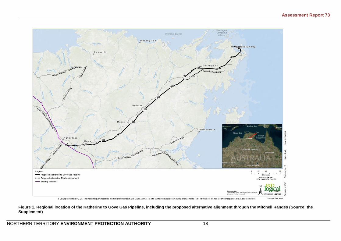
2.3 Project location The KGGP would tie-in (connect) with the existing Amadeus Gas Pipeline (AGP) at a location south of Katherine. There are currently two options for the tie-in location: the first option would be located approximately 20km south of Katherine; and the second option would be 13km south of the first option. A decision on the final tie-in location would be made during the design phase of the Project.
The KGGP route would extend east from the AGP tie-in location, crossing the Stuart Highway, and passing to the south of Beswick. The route would then curve to the north-east, passing close to Mainoru, Bulman and Nhulunbuy before reaching the Gove mine and refinery operations (Figure 1).
An alternative alignment for the pipeline corridor through a section of the Mitchell Ranges was provided in the Supplement. The proposed alternative alignment would divert from the alignment proposed in the draft EIS (the current alignment) at approximately Kilometre Point* (KP) 393, passing eastward to the south of Donydji and
* References to Kilometre Point (KP) relates to the given distance from the commencement of the KGGP at the tie-in with the AGP (KP0) based on the draft EIS, unless stated otherwise.
Assessment Report 73
NORTHERN TERRITORY ENVIRONMENT PROTECTION AUTHORITY 18
Figure 1. Regional location of the Katherine to Gove Gas Pipeline, including the proposed alternative alignment through the Mitchell Ranges (Source: the Supplement)

Assessment Report 73
NORTHERN TERRITORY ENVIRONMENT PROTECTION AUTHORITY 19
then following a north-easterly route across a low relief section of the Mitchell Ranges and reconnecting with the current alignment at approximately KP466.5 (Figure 1). The alternative alignment would be approximately 70km in length and, at its furthest, would be approximately 15km from the current alignment.
The Proponent is currently investigating the preferred alignment through the Mitchell Ranges. For the purpose of this Report the proposed alternative alignment is considered as an alternative only based on it being a contingency to the preferred route. The proposed alternative alignment is discussed further in Section 4.3.3 of this Report.
2.4 Pipeline specifications and components The KGGP would consist of a buried, 324mm high-tensile steel pipe located in a 30m wide ROW. The location of the ROW would be located within a 100m wide pipeline corridor. The KGGP would be capable of delivering 34PJ/year, operated to a maximum allowable operating pressure of 15.3MPa and would have a design life of 50 years (Table 2). Individual pipe lengths will be welded together onsite, field coated and buried with a minimum depth of cover of 750mm. Depth of cover will vary depending on the conditions of the terrain and the surrounding land use. Pipeline design specifications are provided in Table 2.
Table 2. Pipeline design specifications
Parameter Specification
Length 603km
Standard construction corridor width 30m
Area of disturbance (including access tracks and ancillary infrastructure)
Up to 2 316ha
Minimum depth of cover Typically 750mm, and 1 200mm or greater under waterway, rail and road crossings.
Nominal capacity 34PJ/year
Maximum outside diameter 324mm
Minimum wall thickness 6.4mm
Operating pressure 15.3MPa
Maximum allowable operating pressure (MAOP)
15.3MPa
Specific minimum yield stress 485MPa
Corrosion protection Impressed current
Design life 50 years
Pipeline monitoring system Supervisory Control and Data Acquisition Pipeline Monitoring System
A number of facilities would be required at intervals along the KGGP for safety, maintenance and pipeline integrity purposes. These facilities would include:
Meter station;
Compression station;
Main line valves;
Cathodic protection stations; and

Assessment Report 73
NORTHERN TERRITORY ENVIRONMENT PROTECTION AUTHORITY 20
Scraper stations.
The locations of the supporting infrastructure have yet to be specified for all components, as the locations are subject to further design considerations. The proposed locations for the infrastructure as provided in the draft EIS and Supplement are presented in Table 3.
Table 3. Proposed locations of supporting infrastructure for the Katherine to Gove Gas Pipeline
Meter station Main line valves Scraper stations Compressor station Cathodic
protection stations
Draft EIS
Suppl. Draft EIS
Suppl. Draft EIS Suppl. Draft EIS Suppl. Draft EIS
Suppl.
KP602.7 KP602.7 KP192.5 KP143 KP0.0 (Tie-in)
KP16* KP23.6 (King River)
KP16* N/A KP100
KP297.0 KP297 KP297.0 KP297.0 KP195
KP456.0 KP443 KP602.7 KP602.7 KP297
KP574.5 KP586 KP397
KP590.9 N/A KP505
* refers to alternate tie-in alignment to the AGP approximately 35km south of Katherine (second option) and associated
revised KPs
2.4.1 Meter station
A meter station would be installed at the Gove Let-Down Station within the existing Gove Refinery and would be used to measure the volume of gas exiting the pipeline. The meter station would include a gas analyser and flow computers that will provide information essential for commercial transactions associated with the supply of gas.
2.4.2 Main line valves
The MLV facilities would be required at intervals along the length of the pipeline as a safety measure to enable the isolation of sections of the pipeline in the event of an emergency or leak. The MLV facilities would be equipped with vent valves both upstream and downstream of the MLV to enable venting of the gas from an isolated section.
The MLV would be buried (apart from the operating handle and the vents that would be located above ground) and would be within a 12m by 16m security fenced area (2m high). There would be an additional enclosure housing the MLV vent, approximately 10m by 10m, located approximately 30m away from the MLV fence. The MLV would be manually operated, except for the valve at Nhulunbuy, which would be remotely operated.
2.4.3 Scraper stations
Scraper stations are above ground facilities that allow the manual introduction and retrieval of internal mobile inspection and cleaning tools, known as ‘pigs’, into and out of the pipeline during operation. The pigs are launched using the pig launcher, sent through the line using the pressure of the gas, and are retrieved from the pig receiver.
A scraper station will be installed at the pipeline tie-in to the AGP, KP297 and the Gove Let-Down Station. All scraper stations would include isolation valves that may be operated manually or remotely, controlled via a standard industry Supervisory Control and Data Acquisition (SCADA) system. Scraper stations would typically be located within a 20m by 30m fenced area, approximately 2m high, situated within the pipeline corridor or the Gove Refinery.

Assessment Report 73
NORTHERN TERRITORY ENVIRONMENT PROTECTION AUTHORITY 21
2.4.4 Compressor station
Compressor stations are primarily used to boost the pressure of gas, as the gas demand increases. One compressor station is proposed for the KGGP. The compressor station would be located in a cleared area of up to 500m by 500m of which approximately 180m by 230m would be graded and fenced, with a 15m buffer around the perimeter. The stack would be the highest component of the compressor station, at a height of approximately 12.5m.
Fencing of the compressor station is necessary to ensure authorised access and exclude stock. The station perimeter would be secured with a stock-proof fence, and the compressor facilities would be enclosed with a security fence, creating a buffer zone between the fences.
The 500m by 500m site for the compressor station would be cleared for construction. When operational, a compound of 260m by 210m would be maintained and kept free of vegetation to provide protection in the event of a bush fire.
The primary processes that are undertaken at a typical compressor station on receipt of gas from the upstream pipeline section include:
Gas filtering;
Compression of gas to a maximum outlet pressure of 15.3MPa;
Cooling the gas after compression and prior to pipeline delivery; and
Providing a venting facility for pipeline sections upstream and downstream, and for the compressor station itself.
The compressor station would be remotely operated. The compressor station would be designed to act as a stand-alone facility and would not require a 24 hour workforce presence on site. The compressor station would be situated at a location near Katherine (Table 3) and would house a maintenance base, thereby enabling workers to be on-site during normal work hours, if required, and allowing a rapid response to any maintenance situations associated with the compressor station and KGGP.
2.4.5 Cathodic protection stations
Cathodic protection (CP) is an electrical method of preventing pipe corrosion. Temporary CP would be applied during KGGP construction. At completion of pipeline construction, the temporary CP system would be disconnected and a permanent impressed current protection system would be commissioned and operated.
The impressed current system utilises a direct current supplied by an external power source to prevent the pipeline from corroding. The CP system places a negative voltage potential onto the pipe, and the positive from the controller is connected to an anode bed. The anode bed consists of a number of buried silicon/cast iron anodes placed in a petroleum coke backfill.
The remote CP stations would be contained within the ROW and would occupy an area of approximately 20m by 15m and would require an anode ground bed installation. The location of the anode ground beds are under investigation by the Proponent and may be located at up to 500m away from the ROW and would require a permanent 5m wide corridor for an access track and to lay a cable out to the ground bed. The ground bed would be a permanent installation for the life of the pipeline and would occupy an area of approximately 60m by 10m.
The draft EIS did not include the provision of remote CP station sites, as the CP stations were proposed to be co-located with the MLV sites. In the Supplement, the proposed
Assessment Report 73
NORTHERN TERRITORY ENVIRONMENT PROTECTION AUTHORITY 22
remote CP stations would be required at KPs 100, 195, 397, 505 and co-located at the MLV 2 facility site at KP297 (Table 3).
2.5 Schedule The EIS included the option of a one- or two-year build for the construction of the KGGP.
2.5.1 One-year build
Under a one-year build option, and depending on statutory approvals and weather conditions, construction would be undertaken between February 2014 and December 2014 with the majority of construction activities ramping up in March 2014 and peaking between July and August. Construction would be undertaken in two sections or ‘construction spreads’ primarily over the 2014 dry season and first gas delivery to Gove would be achieved by the first quarter 2015. The refinery is expected to be fully converted to gas in early 2016.
2.5.2 Two-year build
Under a two-year build option, and depending on statutory approvals and weather conditions, construction would commence in February 2014 and cease at the onset of the Wet season. Construction would recommence in February 2015 at the point of 2014 pipeline completion and would likely be completed by November 2015. The construction spread would commence at the Katherine end of the alignment (KP0) with the intention of completing as much of the KGGP construction as practicable within the Dry season (completion of 300-400km is anticipated). First gas delivery and full refinery conversion would likely occur in January 2016.
At the end of the 2014 build period, areas disturbed by the constructed pipeline would be reinstated and the constructed pipeline section made safe to the elements. Topsoils would be respread, hydrostatic tested sections would be connected together and any pipe ‘open ends’ would be sealed to prevent access of fauna, debris or dust.
The pipeline construction methodology between a one- and two-year build would not change other than the gas delivery date shifting by one year.
2.6 Workforce and construction camps The total workforce ‘man days’ to complete the KGGP are estimated to be similar for both the one- and two-year build options. Peak workforce numbers for the one-year build is estimated to be in the order of 980 workers with the two-year build the peak workforce numbers in each year is estimated to be in the order of 650 workers.
The construction roster is likely to be a 28 day work cycle followed by nine days rest, on a Fly-in Fly-out (FIFO) basis. The construction workforce would fly in and out of Katherine and Gove Airports. A range of potential shift change timings have been considered, ranging from all of the construction staff leaving simultaneously to progressive and staggered shift changes. Each working day would comprise a 12 hour shift during daylight hours.
The KGGP construction and installation activities are staggered and therefore not all the work crews would be needed at any one time. The workforce numbers would ramp up over a four week ‘mobilisation’ period. Similarly, the workforce would wind down during the ‘demobilisation’ period. It is expected that the construction resources would be suitable to allow each crew to undertake their component of the construction process at a rate of approximately 3 to 5km per day.
It is proposed that the majority of construction personnel would be accommodated in construction camps located along the pipeline route. The exception to this is likely to be the use of Katherine and Gove as bases for small numbers of personnel associated with construction and commissioning operations that are remote from construction camps.

Assessment Report 73
NORTHERN TERRITORY ENVIRONMENT PROTECTION AUTHORITY 23
The draft EIS indicated five temporary construction camps would be established to house and support workers during the construction of the KGGP. The number of construction camps proposed would remain the same under either a one- or two-year build for the Project.
All construction camps would have a footprint of 500m by 500m. Camps would be installed progressively throughout the build. Each construction camp would consist of approximately 120 transportable buildings and ancillary services for water storage, power generation, communications and maintenance facilities.
Existing cleared or degraded areas would be used as far as practicable for the siting of the construction camps but additional clearing for construction may be required. Camps at Beswick (KP72), Mainoru (KP193) Annie Creek (KP295) and Buckingham (KP447) have been identified in the EIS as possible locations. Specific siting of construction camps would be determined during the design phase of the Project.
2.7 Construction The sequence for the KGGP construction operations would be:
Survey and setting out;
Clear and grade to form the ROW;
Delivery of pipe to the ROW;
Bending of the pipe to follow the ground topography or the designed alignment;
Welding of the pipeline into sections to suit the pipeline centreline and natural obstacles, roads, rivers, creeks, fence lines, areas of inundations, tracks;
Field joint coating of the pipeline welds;
Trenching of the pipeline length;
Lowering of the pipeline sections into the trench including minor rivers, creeks, tracks;
Backfilling the sections of the lowered and laid pipeline including minor rivers, creeks, tracks;
Tie-in of the pipeline to the special sections pertaining to direction changes, tracks, roads, minor rivers, creeks, hydrostatic test tie-ins or other special sections; and
Reinstatements, replacing topsoils, replacing fence lines, reinstatements to track, minor river and creek banks, installation of CP beds.
Estimates under current construction scheduling indicate that the time between initial ground disturbance and reinstatement activities for the KGGP would be 12 to 16 working weeks.
2.7.1 Clearing and grading
The centreline of the KGGP route would be graded and levelled to the required gradient using graders, backhoes and bulldozers. Topsoil and associated seed stores would be stripped from the work area and stored separately from other stockpiled soil, for subsequent use in rehabilitation. Topsoil would be stored on either side of the corridor, away from fence lines, tracks, stock routes and existing or constructed drainage.

Assessment Report 73
NORTHERN TERRITORY ENVIRONMENT PROTECTION AUTHORITY 24
The draft EIS predicted that up to 2 200ha of native vegetation would be impacted during construction of the KGGP. Up to 1 365ha was anticipated to return to native woody vegetation over time through a combination of natural regrowth and active rehabilitation. The Proponent revised the total impact to vegetation in the Supplement and estimated that up to 2 316ha of native vegetation would be removed during construction of the KGGP (including the ROW, ancillary infrastructure, temporary construction camps and access tracks). The Proponent has predicted that up to 1 398ha is anticipated to return to native woody vegetation over time through a combination of natural regrowth and active rehabilitation.
Once the corridor has been cleared and graded, surveyors would mark the trench centreline and trenching would commence.
2.7.2 Trenching
A trench would be dug, into which the KGGP would be installed. The trench would be prepared using excavators, trenching machines, rock saws or by drilling and blasting as required by the nature of the ground. The term ‘open trench’ refers to the time after which a trench has been excavated and is left open prior to the laying of the pipeline and backfilling. The Proponent notes that the trench would be opened and closed as quickly as possible and may be open for up to three weeks while pipe installation occurs.
The length of open trench would be kept to the minimum necessary to allow for the pipe to be efficiently installed. The open trench would be exposed for a distance of approximately 40km in length (approximately nine working days of production) under good trenching conditions and up to 60km in more difficult (rocky) conditions.
2.7.3 Pipe preparation and laying
Stringing is the term used to describe the laying out of the pipe lengths in preparation for welding. The 17.6m (minimum average) long coated pipe lengths would be transported on extendable pipe trucks to the construction corridor from stockpile areas at Katherine and Gove. The pipe would be laid out adjacent to the trench and held off the ground on wooden skids to protect the pipe coating from damage.
Once the pipe is strung a line-up crew positions the pipe using side-booms and internal line-up clamps. Specialist construction crews undertake the welding phase of the Project. Each weld is subjected to a non-destructive test inspection to check for compliance to specification, thus ensuring the integrity of each weld. Following welding, joint coatings would be applied to the joints to prevent the pipeline from corroding. The weld joints would be grit blasted and coated using a suitable field coating system, which is compatible with the factory applied coating system.
The pipeline would cross over crests and sharp changes in horizontal direction. A specialised hydraulic pipe-bending machine would be used to bend some of the pipes to the shape required. Factory induction bends would be used for severe bends.
The trench will be ‘padded’ with sand or fine soil to a depth of around 150mm to ensure that sharp stones or rocky protrusions in the bottom of the trench do not damage the pipeline coating. In heavy rock areas it may be necessary to import sand from existing quarries or approved new borrow pits.
The pipe would be lowered into the trench using a series of side-booms. The side-booms would raise a section of pipe off the skids and lower it into the centre of the trench. Careful handling would be required during this operation to ensure that the external coatings are not damaged during the lowering-in process. Continuous coating tests would be carried out to ensure that any coating damage to the pipeline is detected and repaired prior to the pipeline being lowered into the trench.

Assessment Report 73
NORTHERN TERRITORY ENVIRONMENT PROTECTION AUTHORITY 25
Backfilling would commence following the lowering of the pipeline string into the trench. , A fine material would be placed on top of the pipe to act as ‘shading’ to ensure that the coating is not damaged by coarse materials and rocks.
The trench would be backfilled in the reverse order to which it was excavated using the stockpiled soil adjacent to the trench. The trench would be compacted using a rubber-tyred grader. It may be necessary to import material for backfilling where the pipeline passes through solid rock. However, trenching spoil would be used wherever possible. If additional material is required it would be sourced from borrow pits. At points where hydrostatic testing is to occur, approximately 50m of trench would be left open until testing has been completed.
2.7.4 Testing
Testing of the KGGP and ancillary components is an integral part of pipeline construction. Testing would generally take the following forms:
Testing materials prior to construction;
Testing of weld; and
Hydrostatic testing.
The manufacturers of materials and equipment would carry out quality assurance tests during manufacture of all items. Any items that fail the quality test would be marked and quarantined to ensure they are not used as part of the KGGP.
All welds would be checked in accordance with strict industry standards. Testing of welds would be carried out using x-ray techniques.
Hydrostatic testing would be used to determine the strength and leak tightness of a test section to establish that a pipeline is capable of withstanding the pressure for which it is designed and for leak tightness. The pipeline would be filled with water, pressurised to greater than normal operating pressure and then leak tested. It is proposed that the pipeline be tested in 11 test sections, averaging 55km. The longest test section expected would be approximately 100km.
2.7.5 Construction of crossings
The proposed KGGP route would cross several watercourses, roads and infrastructure corridors. Specialised techniques for installing the KGGP pipeline would be employed at crossing locations. Open-cut (trenching), HDD and horizontal boring would be the preferred construction methods to be used for crossings.
Sealed road crossings are proposed to be horizontally bored using an auger. Waste material from horizontal boring would be stockpiled, and re-used as a source of fill for other pipeline sections if appropriate, or otherwise disposed of in accordance with regulatory requirements or at a licenced facility. In addition to the sealed roads, it is proposed that the Melville Bay Road would be horizontally bored.
All unsealed road crossings are proposed to be excavated by open-cut method, subject to the approval of the relevant road authority. A trench would be excavated in a similar fashion to that employed for standard trenching. The welded pipe would be placed in the trench and the excavated material returned. The disturbed area is then reinstated. Vehicle access would be maintained across the trench by the use of bypasses or steel plates. Trenches would remain open for the shortest possible time period to minimise impacts on traffic. All road surfaces would be returned to a standard equal to that prior to construction. Appropriate signage and other traffic control measures would be employed to ensure safety at all times.
Assessment Report 73
NORTHERN TERRITORY ENVIRONMENT PROTECTION AUTHORITY 26
Depending on tie-in location to the AGP, the Alice Springs–Darwin rail line crossing is the only potential rail crossing. This crossing if required is proposed to be horizontally bored.
The method used at each watercourse crossing would be dependent on environmental factors, geotechnical constraints and stakeholder views in regards to the significance of the watercourse. Open-cut and HDD are the preferred construction methods.
HDD involves drilling a hole into the ground at one side of the crossing at a 10–15° angle and drilling a curved hole with the drill surfacing on the other side of the crossing. The hole acts like a tunnel through which the pipeline is threaded. Drilling is conducted by a specially designed drill rig and operated by a specialist contractor. The entry and exit pit of the HDD would be set to avoid riparian vegetation, to account for the profile of the watercourse and to not be damaged in flooding events.
The HDD method would be preferred where the long term stability of the crossing is of concern or for ecological reasons, particularly to protect significant riparian vegetation or conservation values. HDD would also be used at any watercourse that the construction contractor determines to be in flow by at the time of constructing the crossing.
Open-cut crossing would be the preferred method for any watercourse that is not in flow, as determined by the construction contractor at the time of constructing the crossing. Open-cut crossings would involve the excavation of a trench in a similar fashion to that employed for standard trenching. The trench would be excavated so that the minimum cover above the pipeline to the riverbed is 1 500 - 2 000mm depending on the size of the river. Following pipeline laying the trench would be backfilled, initially with a 150mm sand surround, followed by coarse silt free material or, depending on quality, the excavated material. Loose rocks or ‘rip-rap’ may be placed on the banks or in the stream to reduce the risk of erosion and seeding and seed mats would be placed along the slopes, if required. The cross sectional profile of watercourses subject to trenching would be reinstated to preconstruction condition.
The duration of the trench opening at open cut watercourse crossings is dependent on the size and complexity of the crossing and also the flow conditions at the time of construction. It is estimated that the duration of trench opening at the majority of crossings would be approximately 1 day with the maximum anticipated trench opening period estimated to be in the order of 3 days.
2.8 Access Access to the pipeline corridor, work areas and construction camps would be required. The majority of heavy equipment would be transported along existing roads, which are generally sealed or gravel. Maintenance would be required in particular areas to ensure that sections of roads, bridges and grids are capable of carrying the loads of pipe trucks and heavy equipment floats.
Although the Central Arnhem Road often parallels the proposed pipeline corridor, in many sections there is a distance of up to 25km between the road and the pipeline corridor. New access tracks would be constructed between the roads and the corridor to minimise the movement of heavy traffic and to allow permanent access for operational personnel once the pipeline is constructed. It is expected that approximately 230km of existing access tracks and 152km of new access tracks would be required during construction of the KGGP Project.
2.9 Rehabilitation Rehabilitation of disturbed areas would be undertaken as soon as possible following construction, during the work season and prior to the onset of the Wet season. The intended outcome of rehabilitation measures would be to ensure all areas disturbed

Assessment Report 73
NORTHERN TERRITORY ENVIRONMENT PROTECTION AUTHORITY 27
through construction are stable and returned to a condition consistent with existing land use.
Clean-up and rehabilitation measures would be applied to the pipeline corridor, access roads and construction camps in consultation with the relevant land holder/owner. Rehabilitation actions would depend on site specific considerations but would generally include:
Removal of construction and material waste;
Surface contouring;
Re-spreading topsoil;
Re-spreading cleared vegetation;
Re-seeding of grass species; and
Replanting vegetation in areas of high sensitivity (e.g. riparian zones or for landform stability)
Provision is proposed for vehicle access along the corridor following rehabilitation. This would be restricted to a single 4WD track adjacent to the pipeline. This area would be kept free of trees and shrubs, but grass coverage would be encouraged. The track would be used for commissioning and maintenance during pipeline operations.
It is anticipated that land users would be able to resume their previous activities on top of the KGGP providing that excavation activities are not undertaken and deep rooting vegetation does not establish.
2.10 Operation and decommissioning The KGGP and ancillary facilities would be operated, maintained and decommissioned in accordance with Australian Standard AS2885.3 and appropriate industry guidelines. Inspection and maintenance programs would be established to monitor the pipeline’s integrity and ensure that the public and property along the route are adequately protected during operation. A maintenance and operations base would be located near Katherine for central access to the pipeline and all facilities. All remote controlled functions would be directed from a centralised control room via a SCADA system. Specialised instrumentation would monitor operating parameters, equipment status and malfunction alarms at the remote facilities and present them to the operator via colour graphic displays.
Assessment Report 73
NORTHERN TERRITORY ENVIRONMENT PROTECTION AUTHORITY 28
3 Regional Setting Detailed descriptions of the physical, ecological and social aspects of the Project region are presented in Chapter 4 of the draft EIS. The following section provides a broad overview of the regional setting of the proposed action.
3.1 Bioregions The proposed KGGP traverses the Daly Basin, Gulf Fall and Uplands, Central Arnhem and Arnhem Coast bioregions.
The Daly Basin bioregion comprises gently undulating plains and scattered low plateau remnants on Palaeozoic sandstones, siltstones and limestones; and neutral loamy and sandy red earths. The most extensive vegetation type is open forest dominated by Darwin stringybark (Eucalyptus tetrodonta) and Darwin woolybutt (E. miniata) with perennial and annual grass understory.
The Gulf Fall and Uplands bioregions comprises undulating terrain with scattered low, steep hills on Proterozoic and Palaeozoic sedimentary rocks, often overlain by lateritised Tertiary material. Soils are mostly skeletal or shallow sands. The most extensive vegetation is woodland dominated by Darwin stringybark (E. tetrodonta) and variable-barked bloodwood (Corymbia dichromophloia) with spinifex understorey, and woodland dominated by Northern Box (E. tectifica) with tussock grass understorey.
The Central Arnhem bioregion comprises gently sloping terrain and low hills on Cretaceous sandstones and siltstones and lateritised Tertiary material; yellow earthy sands and shallow stony sands. The dominant vegetation is Darwin woolybutt (E. miniata) and Darwin stringybark (E. tetrodonta) open forests and woodlands with a dense grass understorey. Almost all of the bioregion is Aboriginal land.
The Arnhem Coast bioregion comprises a coastal strip extending from just east of Cobourg Peninsula to just north of the mouth of the Rose River in south-eastern Arnhem Land, and including many offshore islands. Coastal vegetation includes well developed heathlands, mangroves and saline flats, with some floodplain and wetland areas, most notably the extensive paperbark forest and sedgelands of the Arafura Swamp. Tertiary laterites are extensive on the Gove Peninsula. Inland from the coast, the dominant vegetation type is eucalypt tall open forest, typically dominated by Darwin woolybutt (E. miniata) and Darwin stringybark (E. tetrodonta), with smaller areas of monsoon vine forest and eucalypt woodlands.
Weed distribution in the pipeline region is generally related to environmental disturbances caused by the construction of roads and tracks, cattle grazing and feral animals. Weeds tend to be most prevalent on land under pastoral lease, and on the freehold properties in the Katherine region. In these areas infestations are generally concentrated around infrastructure such as water points, fence lines and tracks, and also along the banks of watercourses where cattle and feral animals tend to congregate. Weeds of National Significance (WONS) in the region include prickly acacia (Acacia nilotica), Parkinsonia (Parkinsonia aculeata), gamba grass (Andropogon gayanus), olive hymenachne (Hymenachne amplexicaulis), bellyache bush (Jatropha gossypifolia) and mimosa (Mimosa pigra).
3.2 Ecologically sensitive habitats Terrestrial and aquatic habitats with high conservation value and which are ecologically sensitive that occur along the pipeline route include:
Riparian corridors;
Monsoon vine forest patches;

Assessment Report 73
NORTHERN TERRITORY ENVIRONMENT PROTECTION AUTHORITY 29
Sandstone communities;
Wetlands;
Aquatic habitats; and
Habitats of threatened species.
3.3 Surface water resources The KGGP would pass through the upper section of the Daly River basin, the northern part of the Roper River basin, the central portion of the Goyder River basin and the upper Buckingham River basin between Katherine and Gove. The Daly River basin drains westwards to the Timor Sea, while the Roper River drains eastwards to the Gulf of Carpentaria and the Goyder River and Buckingham River basins drain northwards to the Arafura Sea. The proposed pipeline corridor would cross a total of 217 water courses of which approximately 28 are defined as major watercourses and the remaining 189 as minor watercourses.
Surface runoff is generally limited to the Wet, summer monsoon season, with most watercourses ceasing to flow during the mid to late Dry season. Perennial flow is mainly restricted to the larger rivers where baseflow is supplied from groundwater.
There are many wetlands in the region including permanent swamps, most notably the Arafura Swamp in Central Arnhem Land (which lies over 20km north of the project area) as well as seasonally inundated floodplains, permanent and semi-permanent freshwater lake systems and ephemeral saline lakes.
3.4 Groundwater resources The proposed KGGP easement traverses the following six groundwater management units:
Daly River Basin – Tindall Limestone.
Daly River Basin – Jinduckin Formation.
Proterozoic Sedimentary Rock (North East Northern territory).
Proterozoic Rocks low yielding (Bulman).
Proterozoic Sedimentary (Adelaide River).
McArthur Basin including Gove Water Control District (WCD).
3.5 Socio-economic The proposed KGGP route is predominantly located on Aboriginal Land Trust Land, across the Local Government Areas of East Arnhem Shire Council, the Roper Gulf Shire Council, the Katherine Town Council, and Nhulunbuy Corporation. Land use across the Project area is primarily traditional aboriginal uses, pastoral farming, mining and tourism uses.
Katherine serves as a service and tourist centre. A number of pastoral stations surround the town. The Royal Australian Air Force (RAAF) Base Tindal is located 15km south of Katherine. Its staff and accompanying families make up almost 25% of Katherine’s population.
The mining operations and township of Nhulunbuy are located on Aboriginal land, its tenure granted via a Special Mineral Lease and Special Purposes Leases. Nhulunbuy is a company-managed town, and is largely a service centre to the Gove bauxite mine,

Assessment Report 73
NORTHERN TERRITORY ENVIRONMENT PROTECTION AUTHORITY 30
alumina refinery and support industries. A number of local government services are located in Nhulunbuy and the town serves as a regional hub for communities in north-east Arnhem Land.
The area between Katherine and Nhulunbuy is sparsely populated apart from a number of small, predominantly Indigenous, communities located along, or near, the Central Arnhem Road. Natural and cultural resources hold significant value to these communities, particularly in relation to sacred sites and traditional lands. Traditional practices are valued highly.
In the northern most section, the proposed KGGP corridor traverses two Indigenous Protected Areas (IPA): Dhimurru IPA and the Laynhapuy IPA. Traditional Aboriginal owners have entered into a voluntary agreement with the Federal Government to promote and conserve the biodiversity and cultural values of these areas of land and sea.
Key socio-economic considerations for the Project include:
The towns of Katherine and Nhulunbuy recorded a population of 6 998 and 4 287 people respectively in 2011, while other communities along the pipeline route were small, and ranged in population between 105 and 889 people.
The Indigenous component of pipeline communities ranged between 75% and 100% of the total population. Katherine and Nhulunbuy had smaller Aboriginal populations, at 26% and 7% of the population respectively.
The study area recorded very young median ages (generally between 21 and 27 years), particularly in smaller Aboriginal communities.
Local communities had large households, when compared with Northern Territory averages.
Smaller communities along the pipeline route recorded low education and Grade 12 completion levels, while education in Katherine and Nhulunbuy was comparable with, or higher than, the Territory average.
Household income levels were significantly higher in Nhulunbuy ($2 565 per week) than in other pipeline communities where income levels were much lower than the Territory average.
Unemployment levels were very low in Nhulunbuy (less than 2%) and in Katherine (4%), compared to other pipeline communities where unemployment was significantly higher at up to 29%.

Assessment Report 73
NORTHERN TERRITORY ENVIRONMENT PROTECTION AUTHORITY 31
4 Environmental Impact Assessment
4.1 Introduction The purpose of this Report is to evaluate the Project and to determine whether it can proceed with acceptable environmental impacts. This is achieved by identifying the potentially significant risk of an environmental impact occurring as a result of the Project components and activities, and evaluating the Proponent’s corresponding safeguards or prevention measures to remove or mitigate the risks. Where the proposed safeguards are considered insufficient, or where a safeguard is deemed particularly important, recommendations are made to add to or emphasise commitments made by the Proponent.
The environmental acceptability of the Project is based on analysis of the following from the EIS:
Adequacy of information outlining the proposed action (particularly which components or activities are likely to impact the environment);
Adequacy of information on the existing environment (particularly environmental sensitivities);
Adequacy of information on the range and extent of potential impacts and the risks of those impacts occurring within the Project context; and
Adequacy of the proposed safeguards to avoid or mitigate potential impacts.
In this Report, the recommendations (in bold) are preceded by text that identifies concerns, suggestions and undertakings associated with the Project. For this reason, the recommendations should not be considered in isolation.
Minor and insubstantial changes are expected in the design and specifications of the Project following the conclusion of the EIA process. It will be necessary for approval mechanisms to accommodate subsequent changes to the environmental safeguards described in the EIS and recommendations in this Report. If the Proponent can demonstrate that changes are unlikely to significantly increase the risks of an impact on the environment, an adequate level of environmental protection may still be achieved by modifying the conditions attached to relevant statutory approvals governing the Project. Otherwise, further environmental assessment may be required.
Therefore, subject to decisions that permit the Project to proceed, the overarching recommendations of this Report are:
Recommendation 1
The Proponent shall ensure that the Project is implemented in accordance with the environmental commitments and safeguards:
Identified in the Katherine to Gove Gas Pipeline Environmental Impact Statement (draft Environmental Impact Statement and Supplement to the draft Environmental Impact Statement); and
Recommended in this Assessment Report.
The Northern Territory Environment Protection Authority considers that all safeguards and mitigation measures outlined in the Environmental Impact Statement are commitments made by the Proponent.
Assessment Report 73
NORTHERN TERRITORY ENVIRONMENT PROTECTION AUTHORITY 32
Recommendation 2
The Proponent shall advise the Northern Territory Environment Protection Authority and the responsible Minister of any changes to the proposed action, in accordance with clause 14A of the Environmental Assessment Administrative Procedures.
4.2 Summary of environmental issues Analysis by the NT Government of the NOI for the Project identified a number of environmental risks. On the basis of these, it was determined that an EIS was required for the Project. Key risks that contributed to the decision included:
The size and scale of the proposal;
The potential impacts on protected flora and fauna;
The potential impacts on biodiversity from land clearing activities;
The potential disturbance to areas of conservation significance;
Increased demand and/or impacts on existing services and infrastructure, including roads, railways and water supplies;
Uncertainties associated with the method for installing the proposed KGGP at potentially significant habitats, watercourses, roads and infrastructure corridors;
The potential impacts of surface and/or groundwater extractions for water supply to the project;
The potential impacts associated with sourcing suitable rock, gravel and fill;
The potential risk to public and environmental health from localised discharges from the proposed development into watercourses and aquifers;
The potential impacts to stakeholders, including land holders and traditional owners; and
The potential social, cultural and economic impacts, including the risks of the project not realising its projected economic and social benefits.
Information requirements based upon identified risks were described in the EIS Guidelines for the Project (NT EPA, 2013) and the Proponent submitted the draft EIS to address these requirements. The Proponent broadly categorised the respondent’s issues and concerns into the following topics for discussion in the Supplement:
Further clarification of project description;
Construction of watercourse crossings;
Health and safety;
Management of weeds and feral animals;
Impacts on the Freshwater Sawfish;
Impacts on the Gouldian Finch;
Other conservation significant flora/fauna species (including those not considered) and management;

Assessment Report 73
NORTHERN TERRITORY ENVIRONMENT PROTECTION AUTHORITY 33
Impacts of noise on fauna and/or local communities;
Local employment; and
Detail in management plans.
A number of issues and concerns identified through the EIA process were addressed by the Proponent to the satisfaction of respondents and advisory bodies and are not discussed further. The remainder of Section 4 discusses the important issues and concerns, based on potentially significant risk, raised throughout the EIA process and the Proponent’s commitments to address and manage these issues and concerns. Recommendations to complement or strengthen environmental management strategies and safeguards are provided.
4.3 Clarification of the Project
4.3.1 Finalisation of the project design
The EIS was relatively conceptual with much of the detailed decision-making for the pipeline construction, design and logistics to be determined during the design phase of the Project. A number of respondents identified that the EIS lacked detail and that some components could not be adequately assessed based on the information provided. In response, the Proponent acknowledged that “Where particular details of design, engineering, operation, etc. are not available at the time of review, approvals will generally be contingent on provision of these details prior to any activity with potentially significant environmental impacts and/or conditions imposed to ensure that environmental impacts related to these details will be manageable and acceptable.”
The NT EPA acknowledges the Proponent’s statement and notes that while more detailed information would have been beneficial, it was not possible for this information to be provided prior to the finalisation of this Report. For example, many of the project details, including the specific locations for some ancillary infrastructure (e.g. construction camps) and other works (e.g. access roads/tracks, laydown areas, machinery and vehicular parking, borrow pits), remain undetermined during the EIA timeframe.
In the absence of detailed information, the Proponent provided a Site Selection Protocol (Appendix U, draft EIS) to ensure that the detailed design of ancillary infrastructure or other works is within the predicted potential impacts of the Project, as assessed in the EIS. The Site Selection Protocol employs environmental constraints mapping to delineate areas of environmental, social and/or cultural sensitivity. These maps would be used during the design phase to inform potential locations of ancillary infrastructure and other works and evaluate potential additional impacts to confirm final placement.
Of particular concern to respondents was that access tracks and construction camps are expected to result in approximately 367ha of vegetation clearing, which has not been assessed during the EIA process, as the location of this infrastructure has yet to be specified. The Proponent proposed that “within six months of completion of construction, Pacific Aluminium will submit a Final Access Track and Construction Camp Summary Report... demonstrating how the access tracks/camps were designed and constructed to avoid and mitigate impacts...” With appropriate site selection and mitigation measures, the respondents were mostly satisfied that impacts to the environment would likely be acceptable. However, the NT EPA does not consider it appropriate for the Final Access Track and Construction Camp Summary Report to be provided after the completion of the works.
Recommendation 3
The Proponent shall prepare and finalise the proposed Final Access Track and Construction Camp Summary Report as part of the Final Alignment Plan(s). The

Assessment Report 73
NORTHERN TERRITORY ENVIRONMENT PROTECTION AUTHORITY 34
Final Alignment Plan(s) shall be submitted to the Northern Territory Environment Protection Authority prior to the commencement of construction activities associated with the Katherine to Gove Gas Pipeline.
The Final Access Track and Construction Camp Summary Report component of the Final Alignment Plan(s) should, at a minimum, indicate the final locations of access tracks and construction camps; access tracks and construction camps, or parts there-of, that are not required post-construction and detail how these would be rehabilitated following construction; and how impacts to Matters of National Environmental Significance have been avoided or minimised through site selection and how mitigation measures would be employed.
The Supplement also contained conflicting information regarding the use or avoidance of waterways with respect to access tracks. It was stated that “access tracks will, where practicable, avoid crossing waterways” but it stated elsewhere that the “temporary bridges across watercourses would allow movement of equipment and personnel to additional lengths of the ROW, reducing the need for some access tracks connecting to the Central Arnhem Road.” Commitments regarding areas of avoidance, such as waterway crossings, should be clarified in the Final Alignment Plan(s).
4.3.2 Above-ground infrastructure
The Project would include above ground infrastructure, which is described in more detail in Section 2.4 of this Report. Some of the infrastructure would require land external to the 30m ROW and 100m pipeline corridor. Unlike the majority of the access tracks or construction camps, which would mostly be rehabilitated after the construction phase of the Project, these facilities would be permanent structures for the life of the Project.
In all cases, the Proponent has committed to undertaking appropriate studies to ensure the final selected location does not impact on culturally, historically or ecologically sensitive areas and that permission is appropriately negotiated with landowners. The Proponent acknowledged that clearance from Traditional Owners to proceed outside the 30m ROW and 100m pipeline corridor for these works would be required if located on Aboriginal Land. Other approvals to access private land outside the 30m corridor may be required from non-Indigenous landowners.
Recommendation 4
Access to, and the use of land and water resources or existing infrastructure required for the purposes of the Katherine to Gove Gas Pipeline, must be negotiated appropriately with the relevant Traditional Owners and non-Indigenous landowners to the satisfaction of the Department of Mines and Energy.
For the purposes of this Report, ‘works’ is defined as any task which would require or cause any physical disturbance for the purposes of achieving an objective for the Project.
4.3.3 Alternative alignment
The Proponent has proposed to realign ~ 70km of the KGGP through a section of the Mitchell Ranges in the event that the Traditional Owners do not consent to the preferred alignment (Section 2.3). The Proponent provided a summary of the broad environmental values associated with the alternative alignment in section 5.15 of the Supplement and concluded that “the residual environmental impact for species of concern comprising Matters of NES have been assessed as unlikely to be significantly different for the alternative Mitchell Ranges alignment compared to the alignment proposed in the Draft EIS.” The Proponent acknowledges that the design details and baseline environmental information for the proposed alternative alignment of the pipeline are mainly conceptual at this stage.

Assessment Report 73
NORTHERN TERRITORY ENVIRONMENT PROTECTION AUTHORITY 35
The NT EPA did not consider the proposed alternative alignment through the Mitchell Ranges as a variation under clause 14A of the Environmental Assessment Administrative Procedures at this stage of the EIA, based on it being a contingency to the preferred route.
Should a decision be made to implement the alternative alignment as the preferred alignment, the Proponent has committed to undertaking further flora, fauna (including habitat mapping for Gouldian Finch, Red Goshawk and other relevant species comprising MNES) and cultural heritage surveys to inform management options. A report accompanying the Final Alignment Plan(s) would be submitted to the Australian Government Department of the Environment (formerly SEWPaC) and the NT EPA addressing how impacts to the following have been avoided or mitigated in the selection of the final alignment:
Vegetation representative of the Arnhem Plateau Sandstone Shrubland Threatened Ecological Community;
Known, likely or potential critical, regionally significant and/or locally restricted habitat for threatened and/or migratory species listed under the EPBC Act or Territory Parks and Wildlife Conservation Act; and
Sites of archaeological or cultural heritage significance (noting that the provisions of the Northern Territory Aboriginal Sacred Sites Act and Heritage Act in respect of Aboriginal sacred sites and declared heritage places and objects will apply and be complied with).
The Proponent has committed to proposing environmental offsets to mitigate the residual impact to the relevant matters in the event that any of the above matters are not able to be avoided through adjustments to the alignment or working width of the ROW.
The NT EPA notes that the proposed alternative alignment would reduce the number crossings of the Central Arnhem Road and potentially lessen the construction activity, traffic interruptions and management requirements in these road reserves. The proposed alternative alignment would be located up to 15km from the Central Arnhem Road where there is the potential for increased clearing of native vegetation to accommodate the ROW (208ha) and access tracks (not specified in the Supplement).
The proposed alternative alignment would cross the headwaters of the Maidjunga River and aquifers of the plateau region. This has not been assessed during the EIA process. The Proponent has indicated that the Maidjunga River is unlikely to provide suitable habitat for the Freshwater Sawfish and noted that the proposed point of crossing would be expected to be dry under usual Dry season conditions, concluding that loss of Freshwater Sawfish habitat arising from construction of the ROW within the alternative alignment is therefore unlikely.
Recommendation 5
Should a decision be made to implement the proposed alternative alignment as the preferred alignment, the Proponent shall submit a variation to the Northern Territory Environment Protection Authority, in accordance with Recommendation 2 of this Report.
The Final Alignment Plan(s) should outline the reasons for implementing the alternative alignment as the preferred alignment. The Plan(s) should contain the completed proposed surveys (cultural heritage, flora and fauna, including habitat mapping for Gouldian Finch, Red Goshawk and other relevant species comprising Matters of National Environmental Significance). A discussion on how these will be avoided or the impacts of the Project (such as blasting) on these areas would be minimised, would need to be approved prior to this alignment being used.

Assessment Report 73
NORTHERN TERRITORY ENVIRONMENT PROTECTION AUTHORITY 36
4.4 Ecology
4.4.1 Controlling provisions under the Environment Protection and Biodiversity Conservation Act 1999 (Cth)
The Project has been declared a controlled action under the EPBC Act. The controlling provisions are listed threatened species and communities (sections 18 and 18A) and listed migratory species (sections 20 and 20A).
In the EIS Guidelines (NT EPA, 2013), the NT EPA identified a list of species listed under the EPBC Act that are likely to occur on the pipeline route.
A search on the Australian Government’s Environmental Reporting Tool identified the potential presence of 20 listed threatened species and 18 migratory species listed under the EPBC Act. The NT EPA requested that the EIS quantify the Project’s impacts to these species, discuss how the impacts would be mitigated and outline whether the impacts (following mitigation) would be acceptable. Vegetation assessment was to be undertaken within a suitable buffer distance along the length of the project area, at an intensity appropriate to identify significant or sensitive vegetation types. Where identified, the extent of significant or sensitive vegetation types were to be mapped at an appropriate scale. The intent of the queries was to confirm that the survey timing corresponds with the optimum time to survey for EPBC Act listed species. Of primary concern were the potential impacts of the Project on the Gouldian Finch and Freshwater Sawfish. These requests were not addressed to the satisfaction of the NT EPA and are discussed in more detail in Section 4.4.2 and 4.7.3 of this Report. Following submission of the Supplement the critically endangered Bare-rumped Sheath-tail Bat was identified as an additional species of concern. The potential risks of the project on this species are discussed in this assessment report.
In response to the general concerns regarding the large area that is unsurveyed and the potential for important habitat for listed threatened and/or migratory species to be affected, the Proponent has committed in the Supplement that “at the time of survey and pegging of the 30m ROW within the 100m pipeline corridor, all opportunities to avoid identified habitat trees important for breeding of Gouldian Finch, Red Goshawk and Northern Crested Shrike-Tit will be undertaken by fine scale realignment of the ROW within the pipeline corridor. A qualified ecologist would be on-site to assist in identifying habitat trees and the appropriate position for the ROW within the pipeline corridor.”
The NT EPA is supportive of the Proponent’s commitment to engage a qualified ecologist. However, it is unclear whether this commitment is for the length of the pipeline. The Proponent only committed to having an ecologist at KP0-140 and near Bulman for Gouldian Finches but notes “the management approach to be taken when constructing the pipeline in areas of known Gouldian Finch breeding habitat will be applied across the entire KGGP project area wherever any Salmon Gums with potentially suitable nesting hollows are located”. Given the extent of potential habitat cleared for other MNES along the pipeline route and for access roads and construction camps the NT EPA considers that this mitigation measure should be applied for all unsurveyed proposed clearing.
Recommendation 6
The Proponent shall engage a suitably qualified ecologist as a mitigation measure to identify important habitat ahead of construction of the 30m Right of Way, construction camp sites and other infrastructure. The ecologist should be appropriately skilled and have experience in the identification of fauna and habitat, especially those related to Matters of National Environmental Significance.
The Proponent shall engage a qualified ecologist at an appropriate stage of the Project (such as pegging of the Right of Way, selection of construction camps and

Assessment Report 73
NORTHERN TERRITORY ENVIRONMENT PROTECTION AUTHORITY 37
access roads) to ensure that adequate time is available for the ecologist to confidently identify important habitats which are to be avoided.
4.4.2 Impacts on the Gouldian Finch
The respondents on the draft EIS raised a number of concerns about the impact to the Gouldian Finch and that these impacts require further quantification. In response, the Proponent provided substantially more information in Section 4.5 and 5.6 of the Supplement.
Overall, respondents considered that the EIS provided a reasonable consideration of the ecology and status of the Gouldian Finch, and the main factors associated with the Project that could have detrimental impacts upon it. However, the NT EPA considers that the EIS does not provide sufficient information to allow a reliable assessment of the risk and potential impact to the Gouldian Finch. This conclusion is primarily based on independent advice provided to the NT EPA by Professor Woinarski (Appendix A). The key concerns, deficiencies and recommendations are further described below.
4.4.2.1 Risks to breeding and nesting habitat
The Supplement provided an estimation that the Project would require the clearing of up to 101ha of breeding habitat along the ROW which would potentially result in significant residual impacts to the species. The Proponent made this conclusion based on the presence of a large population of Gouldian Finch at Beswick/Chambers River. Independent expert advice sought by the NT EPA supports this conclusion made by the Proponent in the Supplement. In addition, Professor Woinarski advises that the predictions made in the EIS are constrained by substantial information deficiencies.
To protect breeding habitat, the Proponent noted in the Site Selection Protocol would be implemented to avoid all known potential breeding habitat with the possible exception of one patch of trees at KP50. Information provided in the Supplement however, suggested that some areas of breeding habitat would be cleared and not avoided. If construction activities result in impacts to breeding habitat, the Proponent proposed the following mitigation measures:
Fine scale re-alignment of the pipeline location within the 100m pipeline corridor to try to avoid identified habitat trees (i.e. to minimise the loss of Salmon Gums containing hollows, and all Salmon Gums as determined by an on-site qualified ecologist, with such recommended re-alignment ‘subject to physical, technical and engineering constraints;
Consideration will be given to reducing the working width of the ROW in such areas to minimise the removal of identified habitat trees;
Consideration of the potential to prune branches rather than fell trees; and
Creating artificial nest boxes from hollows of cleared trees, such that there will be no net loss of breeding hollows.
The proposed use of nest boxes for Gouldian Finches has been used successfully in the East Kimberley Region of Western Australia (Brazill-Boast et al., 2013) and is likely to result in the temporary re-establishment of nesting sites for the species. The creation of artificial nest boxes may ensure there is an initial ‘no net loss of breeding hollows’. However, the clearing of breeding habitat will result in a long-term loss of nesting hollows unless nesting boxes are maintained. The NT EPA notes that all artificial nesting boxes should be of the type referenced in the Supplement; natural hollow logs with an attached rain and heat resistant breeding chamber because the type of nest-box utilised can greatly influence reproductive success. The amount of time that it is likely to take for naturally rehabilitated areas to form tree-hollows will need to be taken into account so

Assessment Report 73
NORTHERN TERRITORY ENVIRONMENT PROTECTION AUTHORITY 38
that a suitable number of nest-boxes are installed to ensure that an overall high quality breeding habitat is provided where the habitat had been cleared.
4.4.2.2 Risks of mortality during clearance of breeding habitat
Construction activities occurring between February and August have the potential to result in the mortality of nesting individuals. Professor Woinarski suggests that the risks associated with the mortality of individuals during clearing could have a potentially moderate impact. To mitigate the risk of mortality due to clearing activities, the Proponent is proposing to identify nesting hollows which have nests when the ROW is pegged and the pre-clearance surveys are undertaken. Once a nesting hollow has been identified, the Proponent is proposing to leave the tree in place until such time as the young have fledged and the nest is no longer in use.
The NT EPA notes while the mitigation measures would likely be effective at reducing the risk of mortality there may be occasions when multiple pairs are utilising the same tree for nesting purposes. The production of multiple clutches each season may mean that some trees are in use for at least a six month period and therefore there is an additional risk of mortality.
Independent expert advice notes that it is possible that noise and dust associated with clearing and construction activities may disturb individuals beyond the area of works. While the disturbances associated with dust and noise will be temporary the Proponent will mitigate impacts through a Noise and Vibration Management Plan and Air Quality Management.
The disturbance of vegetation and creation of new access roads and tracks increases the risk of new weeds and pests becoming established or the spread of existing incursions. The introduction or spread of weed/pest species has the potential to degrade habitat for the Gouldian Finch along the alignment by changing fire regimes and the presence of feed species. The EIS does not discuss the potential impacts associated with weeds/pest species on the Gouldian Finch. The NT EPA consider that the spread of weeds from the Project could potentially have moderate impacts to the species if not managed correctly. To mitigate and manage the risks associated with the introduction and spread of weeds into Gouldian Finch habitat, the NT EPA recommends that the Proponent develop and implement weed hygiene protocols in a Weed Management Plan for all construction and maintenance activities.
4.4.2.3 Risks to Wet Season foraging habitat
The EIS concluded that there would be a low impact to the Gouldian Finch associated with the loss of Wet season foraging habitat. Initially, the draft EIS proposed the loss of up to 703ha of Wet season foraging habitat. This estimate was revised to 378ha in the Supplement. With regard to the Wet season foraging habitat, the Proponents methodology for determining the amount of habitat took the broadest possible scope (at least one preferred perennial Wet season grass recorded). This maximises the amount of Wet season foraging habitat recorded within the ROW, but also maximises the amount of Wet season foraging habitat in the broader region, such that the Proponent found that approximately 80% of the surrounding area constituted Wet season foraging habitat using these methods. Preferred Wet season grasses are generally very patchily distributed throughout the landscape compared to the extensive tracts of sorghum or spear grass that are available in the Dry season, and Wet season foraging habitat is considered a key limiting resource for the Gouldian Finch (O’Malley, 2006).
Prof Woinarski supports the conclusion that the impact will be low but notes that it is difficult to predict the importance of an area for foraging habitat during the Wet season due to varying factors which determine the presence of particular food items (i.e. grass species composition and phenology). It is recommended that the Proponent reconsider this analysis in terms of the amount or number of Wet season foraging grasses that may
Assessment Report 73
NORTHERN TERRITORY ENVIRONMENT PROTECTION AUTHORITY 39
be biologically relevant for the Gouldian Finch, as it is unlikely that the occurrence of one grass species would necessarily represent Wet season foraging habitat of a quality that would be used by the Gouldian Finch. Therefore, it is unlikely that 80% of the surrounding region would constitute Wet season foraging habitat. This re-analysis could confirm or otherwise, the conclusion that suitable Wet season foraging habitat is abundant in the region or that it is not otherwise concentrated in the ROW to be cleared. It is the NT EPA’s view that based on the analysis provided, this conclusion cannot be confirmed. If this information is not provided it may be necessary to include assessment to quantify the residual significant impact to the Gouldian Finch.
4.4.2.4 Summary and recommendations
The commitments and monitoring program proposed in the EIS are broadly supported by the NT EPA but require strengthening. Any monitoring activities relating to the Gouldian Finch should be undertaken with a clear purposes, such as to improved understand of the use of the area by the species or to inform adaptive management of weeds, fire and other threats to the species. Monitoring itself does not constitute a mitigation measure.
Recommendation 7
The Proponent is to engage a qualified ecologist on site for pre-clearance pegging of the alignment of the 30m Right of Way, construction camp sites and access roads to minimise clearance of Salmon Gums, particularly those with suitable hollows. Additional measures to minimise impacts to the Gouldian Finch are to include:
reducing the width of the Right of Way where possible;
ensuring that the timing the removal of Salmon Gums avoids disturbance of active nests;
the building and installation of suitable nest-boxes to compensate for cleared Salmon Gums. The Northern Territory Environment Protection Authority notes that all nest-boxes should be of the type referenced in the Supplement; natural hollow logs with an attached rain and heat resistant breeding chamber because the type of nest-box utilised can greatly influence reproductive success. The amount of time that it is likely to take for naturally rehabilitated areas to form tree-hollows will need to be taken into account so that a suitable number of nest-boxes are installed to ensure that an overall high quality breeding habitat is provided where the habitat had been cleared; and
adjusting the alignment of the Right of Way so as to provide a 190m buffer distance from the proposed alignment to the waterhole at KP118.
In the absence of such information from additional further survey, the route, construction camp sites and access roads should be diverted to avoid all mapped stands of Salmon Gum of >1 ha in extent.
It is recommended that the Proponent prepare and implement a Terrestrial and Aquatic Fauna and Habitat Management Plan, which include contingencies to prevent the mortality of individual Gouldian finches.
The Proponent shall re-evaluate the risk assessment and proposed mitigation measures, including pipeline realignments, and define residual impacts, for the Gouldian Finch.
Before construction commences, the Proponent shall demonstrate to the satisfaction of the Northern Territory Environment Protection Authority that the

Assessment Report 73
NORTHERN TERRITORY ENVIRONMENT PROTECTION AUTHORITY 40
Katherine to Gove Gas Pipeline will not lead to long-term impacts on the Gouldian Finch, based on the re-evaluation.
4.4.3 Impacts on the Bare-rumped Sheath-tail Bat
The NT EPA identified that the terrestrial fauna survey in the draft EIS failed to adequately survey for the Bare-rumped Sheath-tail Bat Saccolaimus saccolaimus nudicluniatus and subsequently requested further information to address this deficiency. The species was acknowledged in the draft EIS as being recognised as a MNES, but then dismissed from consideration on the grounds that:
1. its preferred habitat is “rugged sandstone environments, typically where there are many caves, crevices or boulders”, and that this habitat is absent from the pipeline route;
2. the pipeline “lies well south of the few records of this species in the Northern Territory”.
Similar statements were given in the Supplement to justify no targeted survey for this species in the Mitchell Ranges area including the assertion that ‘there are no recent records from the Top End of the Northern Territory to even indicate whether the species still occurs in this region’.
Such statements are of concern to respondents given that there are several recent records widely-spaced across the Top End, including to the south of the pipeline route (Churchill, 2008; Milne et al., 2009; Milne and Pavey, 2011). In addition, the Bare-rumped Sheath-tail Bat occurs mostly in lowland areas, typically in a range of woodland, forest and open environments (Schulz and Thomson, 2007; Reardon et al., 2010; Dennis, 2012), such as those across the pipeline route. Almost all recorded roosts in Australia (i.e. of the listed subspecies S. s. nudicluniatus) are in tree hollows and it has no association with rugged sandstone environments, caves, crevices or boulders (Churchill 2008; Milne et al. 2009).
Given that this species is considered Critically Endangered under the EPBC Act, it is considered that this species has not yet been adequately assessed.
Recommendation 8
The Proponent shall re-evaluate the risk assessment for the Bare-rumped Sheath-tail Bat. The amended assessment should be provided to the Northern Territory Environment Protection Authority and the Australian Government Department of the Environment for further consideration before any impact to Bare-rumped Sheath-tail Bat habitat occurs.
Prior to construction commencing, the Proponent shall demonstrate to the satisfaction of the Northern Territory Environment Protection Authority that the Katherine to Gove Gas Pipeline Project will not lead to long-term impacts on the Bare-rumped Sheath-tail Bat.
The presence of the Bare-rumped Sheath-tail Bat in proposed camp sites is to be determined by the qualified ecologist, and areas of occupancy avoided.
4.4.4 Residual impact to Matters of National Environmental Significance
It is considered that the construction and operation of the Project will potentially result in significant residual impacts to MNES. Residual impacts are those that remain after avoidance and mitigation measures have been applied. The Supplement reported that 252ha of potential nesting habitat for the Red Goshawk will be cleared for the ROW and reiterated the conclusions of the draft EIS that “the proposed clearing does not affect a known important population and is unlikely to cause

Assessment Report 73
NORTHERN TERRITORY ENVIRONMENT PROTECTION AUTHORITY 41
any long-term impact on this species unless a currently unrecorded nesting area is disturbed”. The respondents agree with this conclusion and note that as the 252ha of potential nesting habitat for the Red Goshawk is largely unsurveyed, encountering nesting individuals is a definite possibility. Given the relatively low numbers of breeding birds, the removal of any nesting habitat is likely to significantly affect a breeding pair. The NT EPA notes that all measures to avoid and mitigate impacts to nesting habitat/trees for this species should be adopted. Field surveys of the ROW to verify nesting habitat for the Red Goshawk which will be destroyed after all avoidance and mitigation measures is necessary to quantify residual significant impact. In the absence of this field-verified quantification, the residual impact is considered to be in the order of 252ha.
Similarly, the Supplement identifies 1 068ha of potential nesting and foraging habitat for the vulnerable Northern Masked Owl that will be cleared for the pipeline. Given the relatively low numbers of breeding birds, affecting a breeding pair could be considered a significant residual impact. Field verification will assist to quantify the residual significant impact.
The location of the Project occurs within the known distribution of the Northern Crested Shrike-tit. Current knowledge of the species is depaurate and is based on few published location records since the mid 1970’s. In addition, published observations suggest that the species occurs at very low densities and possibly in small groups (Woinarski 2004). If the species is detected along the alignment there is potential that the site will provide habitat for an important population of the species. Field verification will assist to quantify the residual significant impact.
Field verification is considered necessary to provide greater detail and certainty regarding the effectiveness of the fine scale adjustment of the ROW and use of a field ecologist in avoiding nesting trees, as outlined above should be provided. In the absence of field verification, loss of habitat and residual impact will be calculated at the more conservative values identified as ‘potential habitat’.
Field verification ahead of identifying construction camp sites is considered especially important, given the significant area to be cleared, and the duration of occupation of these sites. A suitably qualified ecologist should identify appropriate methodologies to determine whether these species are present in proposed camp site prior to final sites being selected.
Recommendation 9
Prior to selection of final pipeline alignment, the Proponent should engage a suitably qualified ecologist to verify and quantify sightings and nests of the Red Goshawk in the riparian habitats crossed by the Right of Way. This verification should be conducted at an appropriate time of year and inform final pipeline alignment to avoid these habitats (2km either side of the Right of Way) and quantify residual significant impact this Matter of National Environmental Significance.
Prior to selection of final pipeline alignment, construction camp sites and road access the Proponent should engage a suitably qualified ecologist to verify and quantify sightings and habitat (where possible) for the Northern Masked Owl and Northern Crested Shrike-tit in the Right of Way. This verification should inform final alignment and locations.
Prior to selection of final construction camp locations, the Proponent must ensure that sufficient survey effort by a suitable qualified ecologist has been undertaken to avoid construction camping areas occupied by Northern Masked Owl and Northern Crested Shrike-tit. Surveys of construction camping sites at the

Assessment Report 73
NORTHERN TERRITORY ENVIRONMENT PROTECTION AUTHORITY 42
appropriate times of year should quantify residual significant impact to Matters of National Environmental Significance.
4.5 Weeds The spread of weeds along the KGGP route was considered to be a major risk of the Project. Weed propagules are likely to be picked up and transported through all stages of the Project. As traffic movements along access tracks and the pipeline corridor will be most frequent during the construction phase, this is likely to be the period of highest risk. During the operational phase the opportunity for weed transfer will be less frequent. However, traffic may be less easily managed during this time if access to the pipeline corridor by non-project vehicles is not properly restricted.
Respondents identified that the draft EIS appeared to underestimate the potential for weed incursion along the pipeline construction route and weed hygiene measures were not clear.
The Proponent acknowledged these concerns and provided additional weed management proposals in Section 6.2.7 of the Supplement. A commitment to collect additional baseline information as the Project progresses for target species, including gamba grass, grader grass, mission grass and prickly acacia, has been provided. The proposed approach would use a more detailed risk assessment and enhanced weed management strategies. The revision of the risk assessment and proposed management species implies that the potential impacts from weeds have now been assessed at a higher level and management measures changed accordingly. The respondents were mostly satisfied with the Proponent’s response and management options provided in the Supplement.
Effective, frequent preventative and management measures and thorough inspections and treatment will need to be ongoing to ensure weed species are not given the opportunity to propagate and establish. Vehicle washdown facilities would be a key mitigation measure and would need to be strategically placed and managed effectively for the life of the Project. Respondents identified entry to Arnhem Land as a point of focus for the placement of vehicle washdown facilities.
Further development of the weed management measures have been committed to by the Proponent. These measures would be developed in close consultation with relevant stakeholders and authorities, such as the Department of Land Resource Management (DLRM), the Northern Land Council (NLC), Dhimurru Aboriginal Corporation, Laynhapuy Homelands Association Incorporated, and other relevant land managers (including landholders, pastoralists and Landcare and ranger groups). The Proponent recognised that effective weed management is achieved through integrated and collaborative effort and envisages close cooperation with these groups. The final Weed Management Plan will form part of the Construction and Operational Environmental Management Plans.
Respondents were satisfied the comments previously submitted in regards to weeds have been acknowledged and a number of future actions to address these concerns have been incorporated. Responses to submissions, for example “ Pacific Aluminium intends to discuss arrangements and seek advice from DLRM… with respect to additional field weed information…” need to be implemented by the Proponent to ensure ‘future actions’ on the survey, collaboration and planning phases along the corridor are effective.
The NT EPA is satisfied that weed issues and concerns regarding the Project can be managed provided management measures documented by the Proponent in the Weed Management Plan of the Construction and Operational Environmental Management Plans. Monitoring in accordance with the commitments must be undertaken to assess the ongoing success of these measures.

Assessment Report 73
NORTHERN TERRITORY ENVIRONMENT PROTECTION AUTHORITY 43
Recommendation 10
Monitoring and management of weeds along the operating pipeline corridor must be ongoing. The Final Weed Management Plan is to be submitted to the Department of Lands Resource Management for consideration and approval.
The Final Weed Management Plan should specify equipment and vehicle wash-down locations and a rationale for their selection. Washdown locations at all possible points of entry from the Katherine to Gove Gas Pipeline into Arnhem Land should be mandatory.
4.6 Trenching and fauna management Excavation of a trench for the installation of the KGGP has the potential to act as a pitfall trap for fauna. The NT EPA requested further information regarding the terminology associated with open trench and the duration and distance of trench openings, where clear distinction was to be presented to distinguish dry land and waterways. The intent of the latter query was to establish an understanding of the duration and conditions in which fauna would be susceptible or vulnerable to falling into the trench. The fauna that fall into open trench during pipeline construction may be injured or killed as a result of the fall itself, or suffer stress, dehydration, or predation within the trench prior to their release.
The Proponent provided additional information in Section 6.2.10 and Appendix D of the Supplement. A highly detailed procedure for handling and managing native fauna (including those caught in trenches) was supplied by the Proponent that included some of the following measures:
As the 30 m right of way is cleared, material including vegetation, topsoil and excavated spoil are stockpiled parallel to the trench in heaps that may form a barrier to animals accessing the open trench.
Each team of two fauna handlers can manage 25 – 30km of trench. The length of open trench would be kept to the minimum necessary to allow for the pipe to be efficiently installed. Under good trenching conditions, the length of open trench is likely to be 40km while in more difficult trenching conditions, this is likely to extend to approximately 60km. The length of open trench will not exceed lengths capable of being practically inspected and cleared by the available fauna teams at any time.
Trench plugs and fauna exit ramps will be provided at both ends of trenches at intervals not exceeding 1km. Ramps allow larger, more mobile fauna to escape trenches.
Shelters will be provided at 250m spacing along all open sections of trench. Various shelter types and sizes are available; humid shelters comprising funnel traps with damp sawdust filled hessian sacks covering may be most useful for protecting and collecting small reptiles and mammals during the Dry season construction period. PVC pipes either shaded, or covered with damp sawdust filled hessian sacks will provide retreats for larger reptiles or mammals. A combination of shelters will be provided to allow smaller fauna to avoid predation by larger animals.
Subject to site specific assessment, water will be removed from areas at the base of the trench in circumstances where it is considered that the pooled water may significantly attract wildlife into the trench.

Assessment Report 73
NORTHERN TERRITORY ENVIRONMENT PROTECTION AUTHORITY 44
Pipes are to be inspected prior to welding and lowering-in to ensure no fauna are present. Fauna are to be removed by fauna handlers or encouraged to leave of their own accord.
Any open pipeline sections will be capped at end of shifts to prevent fauna entry.
Daily inspections of the open trench by trained fauna handling teams will be conducted within four hours of dawn, and will precede commencement of construction works. Inspections will comprise inspection of all shelters and of the trench base between shelters. Opportunistic observations may be made by other personnel while working around the trench, but only fauna handlers are to approach or handle fauna.
Daily trench monitoring of any open sections will continue throughout any breaks in construction.
In addition to daily trench inspections, activity based inspection of particular trench sections will be conducted prior to lowering in of pipes or backfilling.
Fauna is only to be removed from the trench or surrounds by the fauna handling teams. Large animals are to be herded to the nearest exit ramp. Shelters will be checked from the top of the trench (to avoid exposing staff to the confined space within the trench). Small animals within funnel traps will be retrieved by means of a rope attached to the trap. Other small fauna will be retrieved using long handled nets and hooks as required.
The condition of collected fauna will be assessed and they will be released, rehabilitated or euthanized as appropriate. Fauna fit for release will be relocated to suitable habitat as near as practicable to the site of capture. Fauna removed from the trench should generally be released immediately. Exceptions may occur for fauna that need care (e.g. rehydration), or those that cannot be confidently identified.
As required under the NT “Permit to Interfere with Protected Wildlife”, all fauna observed or removed from the trench will be identified to species, and their locality will be logged. Data will be provided to the DLRM for inclusion in the NT Fauna Atlas.
Data regarding the time of collection, and the type of shelter being used will also be collected to optimise fauna collection strategies throughout the project.
Any fauna found dead or euthanized will be appropriately preserved and lodged, with accompanying data in the collection of the Museum and Art Gallery of the Northern Territory.
Specialist fauna handlers would undertake daily monitoring of all lengths of open trench throughout the Project including both the main trench and tie-in sections to ensure timely removal of wildlife, to reduce the risk of injury or mortality. In addition, monitoring would be undertaken immediately prior to the lowering and laying of the pipeline into the trench to ensure that any fauna are removed by the specialised fauna handlers.
The NT EPA consider that appropriate mitigation measures are proposed in the EIS to reduce the risk to fauna from being trapped in open sections of the trench during construction. The NT EPA supports the Proponent’s commitment to ensure that the length of open trench will not exceed lengths capable of being practically inspected and cleared by the available fauna teams at any time. The Proponent provides assurances that there will be sufficient numbers of fauna handlers to cover the length of open trench and remove any trapped fauna daily.

Assessment Report 73
NORTHERN TERRITORY ENVIRONMENT PROTECTION AUTHORITY 45
Recommendation 11
It is recommended that, in addition to the measures outlined in the Native fauna handling management procedure:
the length of open trench not exceed lengths capable of being practically inspected and cleared by the fauna handlers at any time;
the maximum length of the trench not exceed 60km in any case;
all fauna handlers, not just limited to the senior fauna hander, must:
o hold a valid permit to take or interfere with wildlife issued under the Territory Parks and Wildlife Conservation Act;
o be experienced in the identification of fauna and assessment of fauna condition.
a vet be on standby in the event that fauna are in need of medical treatment, such as from injury.
4.7 Water As part of the construction of the Project, the Proponent intends to extract water at a number of rivers and aquifers and to cross up to 217 waterways between Katherine and Gove. A number of respondents, including the NT EPA, identified deficiencies in the draft EIS in relation to the information provided about water requirements; with the draft EIS being unclear on the exact requirements for water extraction or the level of disturbance likely to occur to waterways as a consequence of construction.
Further detail of the nature of waterway crossing techniques and mitigation measures to be applied to maintain bank stability and watercourse profile was requested. Respondents highlighted the sensitive nature of riparian and aquatic habitats to be traversed through the pipeline region and emphasised that construction techniques at waterway crossings must be of the highest standard. Concerns regarding potential impacts on the threatened Freshwater Sawfish were raised.
In response, the Proponent provided substantially more information in various sections of the Supplement. The most significant addition was the inclusion a Risk Assessment and Adaptive Management (RAAM) strategy for waterway crossings in Chapter 6 of the Supplement. Most respondents were satisfied that, if implemented properly, the RAAM strategy would broadly address their concerns for the selection of waterway crossing construction techniques at each waterway. However, not all concerns or information requests regarding risks to water resources were addressed to the satisfaction of the NT EPA and/or respondents. The remainder of Section 4.7 discusses the specific issues and concerns, based on potentially significant risk to water resources, and the Proponent’s commitments to address and manage these issues and concerns. Additional recommendations to complement or strengthen environmental management strategies and safeguards are provided.
4.7.1 Commencement of works
In the draft EIS the Proponent reported that “the Dry season typically commences in April. The actual cessation of the 2013/14 Wet season would be monitored and be followed by a buffer period to allow soil to dry out and watercourse flows to subside before construction commences. This would reduce the risk of delay.”
The NT EPA requested that the Proponent provide indicators or criteria that would be used to determine the ‘actual cessation of the 2013/14 Wet season’ in the Supplement. A definition of ‘buffer period’ and how the period would be enforced and/or managed was

Assessment Report 73
NORTHERN TERRITORY ENVIRONMENT PROTECTION AUTHORITY 46
sought. The intent of these queries was to assess if the Proponent had an appropriate framework to define the environmental conditions to commence construction activities. Of particular interest was how the Proponent intended to use the aforementioned information to inform scheduling and crossing activities to minimise the impact to waterway during construction.
The Proponent responded in the Supplement that the Bureau of Meteorology’s (BoM) consulting services would be used to ‘predict’ the cessation of the 2013/14 Wet season. The Proponent would engage the BoM to provide project specific forecasting services as the Project progresses and would be relied upon to indicate when the Wet season has ceased.
The Proponent reported that “the ground would need to dry out before construction commences”. The time between the end of the Wet season and commencement of construction was referred to as a ‘buffer period’. The buffer period would include the state of the waterways to be crossed by vehicles and equipment. To ensure the conditions are appropriate to commence construction, the buffer period will be enforced and/or managed by regular inspection of the site. If there are sections, which are slow to dry out, these will be skipped and the pipeline would be constructed after these slow to dry out sections are suitable.
The Proponent reported that the “current scheduling of construction is based on statistical median weather conditions across the project area”, as provided from the advice of the BoM’s consulting services. Based on this advice and preliminary reconnaissance of the project area during 2013, the Proponent is confident that the waterway crossings, not already identified as HDD crossings, would be dry or in low flow conditions, which would facilitate the use of standard open cut techniques of up to one day open trench/in-stream construction duration.
The contingencies in the event of an irregular Dry season or prolonged/larger than average Wet season are to delay the works accordingly.
4.7.2 Waterway crossings
Open-cut trenching and HDD were proposed in the draft EIS as the preferred construction methods for crossing waterways. Table 2-6 of the draft EIS, which listed the nine waterways proposed to be crossed by HDD and their associated justification, has been reproduced as Table 4 in this Report. Subject to further assessment, the remaining waterway crossing would be undertaken using the open-trenching method.
Table 4. Indicative Horizontal Directional Drilling river crossings (reproduced Table 2-6 from the draft EIS)
Waterway KP Justification for selection
King River 29.5 Deep and wide river channel with steep banks which could be difficult to stabilise and rehabilitate.
Waterhouse River 83.7 Riparian vegetation and in-stream habitat of conservation significance – potential for significant impacts if construction machinery is transported across multiple braided channels.
Mainoru River 209.5 Riparian vegetation and in-stream habitat of conservation significance – potential for significant impacts if construction machinery is transported across multiple braided channels.
Wilton River 259.5 Riparian vegetation of conservation significance.
Deep river channel with steep banks – specific attention is required to stabilise and rehabilitate.
Note that access road across the river, adjacent to proposed pipeline alignment, would be used to transport equipment across river.

Assessment Report 73
NORTHERN TERRITORY ENVIRONMENT PROTECTION AUTHORITY 47
Goyder River 360.5 Riparian vegetation and in-stream habitats of conservation significance - potential for significant impacts if construction machinery is transported across multiple braided channels.
Deep river channel with steep banks – specific attention is required to stabilise and rehabilitate.
Boggy Creek 511.5 Riparian vegetation and in-stream habitats of conservation significance.
Deep river channel.
Potential for impacts on hydrology of waterhole which has a small outflow.
Cato River 539.7 Riparian vegetation and in-stream habitats of conservation significance.
Giddy River 571.7 Riparian vegetation and in-stream habitats of conservation significance – potential for significant impacts on the vegetation island in the river channel.
Banks require specific attention to stabilise and rehabilitate.
Latram River 581.0 Known habitat of Pternandra coerulescens, a plant species listed as Vulnerable under NT legislation.
High level of recreational use as a waterway.
Riparian vegetation and in-stream habitat of conservation significance.
Many respondents supported the use of HDD crossing techniques and put forward the view that this technique should be used for more of the major river crossings (than the nine committed to in the draft EIS), rather than open-cut trenching techniques. The rationale for selecting these nine river crossings was questioned along with the criteria by which the constructor would determine whether other watercourses were ‘in-flow’ and therefore potentially also subject to consideration of HDD.
The Proponent has committed to crossing waterways to a high standard, using industry best practice methodologies. Each waterway would be studied in detail during field investigations prior to construction to confirm the most appropriate construction methodology and rehabilitation strategy to ensure the best environmental outcome is achieved. Field investigations would include assessment of existing soil/ground conditions, current river bank profile and condition, river flow levels, and vegetation assessment. The Proponent has committed to using the Australian Pipeline Industry Association (APIA) Code of Environmental Practice for Onshore Pipelines to guide the project on suitable crossing methodologies, reinstatement and rehabilitation measures.
The construction methodology to be applied at waterways, not identified as requiring HDD, would also be determined by the RAAM process throughout the design and construction of the Project. The RAAM approach would take into account:
Environmental conditions;
Social/cultural considerations;
Engineering factors;
Location specific factors relevant to each crossing; and
Ground conditions.
Should a watercourse (not already identified for HDD) be in flow at the time of construction, application of the RAAM strategy would initially consider delay of the crossing until dry/low flow crossing using standard open cut crossing technique could be accommodated. Where this is not possible (due to predicted weather conditions and

Assessment Report 73
NORTHERN TERRITORY ENVIRONMENT PROTECTION AUTHORITY 48
construction scheduling) the appropriate crossing technique for the watercourse will be determined by further applying the RAAM strategy.
The Proponent argued that “although HDD has considerable benefits in avoiding in-stream and riparian habitat, when compared to open cut techniques, this method is costly and usually proposed for major river crossings”. HDD could be limited by geotechnical or physical constraints and its adoption can introduce additional environmental risks such as management of drilling muds. The Proponent stated that in some cases additional access tracks (and associated vegetation clearing) would also be required to transport the HDD equipment from the Central Arnhem Road to the crossing site, which results in greater overall vegetation clearance and ground disturbance. The Proponent concluded that it is “incorrect to assume that in every circumstance, all environmental impacts from HDD are less than from trenching”.
The NT EPA acknowledges that HDD has the potential to introduce additional environmental considerations, including drill site sediment control, management of drill muds and other wastes, and a larger working area required on both sides of the waterways. However, the NT EPA considers that HDD techniques would produce a significantly superior environmental outcome, with regard to the potential impacts on aquatic systems associated with trenching major rivers. The excavation of the riparian corridor and river bed itself, diversion requirements, potential for downstream impacts to users and uses, and difficulty in achieving acceptable rehabilitation outcomes in aquatic and riparian systems would need to be key factors in determining waterway crossing methodologies. The NT EPA expects the Proponent to select the waterway crossing methodologies based on a balanced approach to the overall disturbance footprint with site-specific considerations.
The Proponent is confident that HDD at the crossings selected is feasible but geotechnical investigations are planned during the design phase of the Project to ensure suitable HDD design and construction techniques are employed specific to each crossing. In the event of the geology being unsuitable at the HDD crossing point, the Proponent has committed to considering the following options:
Change the location of the HDD crossing to a new location where there is more favourable geology;
Undertake the crossing by an ‘open cut’ method in controlled circumstances depending on the river flow – restricted working width would apply; and/or
Defer construction where possible until watercourse in low flow/dry and able to be crossed by ‘open cut’ methodology – restricted working width would apply.
An alternative crossing methodology would need to be employed that appropriately treats the specific issue should geotechnical or geological constraints render HDD of some of the nominated sites unfeasible. The NT EPA is satisfied that appropriate strategies have been developed. However, alternative crossing technique and/or location would need to be developed and agreed upon in consultation with all key stakeholders including the relevant government agencies as identified by the NT EPA.
Recommendation 12
In the event that Horizontal Directional Drilling is not feasible for the nine nominated waterways identified in the Environmental Impact Statement, the Proponent is required to negotiate an alternative crossing technique with the Northern Territory Environment Protection Authority.
4.7.3 Interference with or obstruction of waterways
Concerns were raised about the impact of flow diversion techniques on aquatic systems, with particular regards to minimising the impacts to Freshwater Sawfish. The Proponent
Assessment Report 73
NORTHERN TERRITORY ENVIRONMENT PROTECTION AUTHORITY 49
has indicated that “based on current scheduling and watercourse flow predictions, requirement for flow diversion at open cut trenching crossings is not anticipated and a risk assessment and adaptive management process has been developed including the option of delaying construction of crossings in flow, as advised by an independent Freshwater Sawfish expert.”
While it is noted that the Proponent proposes to apply an adaptive management process, and use site-specific decision criteria, the Proponent has not provided sufficient detail of the methods or clear commitments to ensure that impacts to the Freshwater Sawfish are minimised. In particular, the Proponent did not provide a definition of ‘minor flow’, nor provide detail regarding any diversions, flume pipes, barriers, partial weirs, temporary dams, pumps and blasting as requested by respondents. In the absence of the above information, interference with or obstruction of waterways during the construction of waterway crossings need to be detailed in the Construction Environmental Management Plan (CEMP), with specific information regarding the specifics of any diversion, flume pipes, barriers, partial weirs, temporary dams, or pumps to be used as part of the Project.
Recommendation 13
The Proponent shall:
not undertake open-cut trenching construction activities when waterways are in flow;
avoid or minimise blockages or restriction of flow; and
limit the duration of interference with or obstruction of any waterway to as short as practicably possible.
The Proponent will ensure that construction activities at waterway crossings are conducted as agreed by respective landowners and Government agencies, and in accordance with the management measures described in the approved Construction Environmental Management Plans, which forms part of the Pipeline Management Plan.
4.7.4 Taking or use of surface and groundwater
The Project would require the extraction of surface and groundwater for potable water for construction camps; HDD; dust suppression; weed washdown bays; compaction of trench backfill; hydrostatic testing and other miscellaneous purposes. The total volume of water required for the Project was estimated to be approximately 207-229ML.
The sources of water that would meet the Project demands were not fully determined in the draft EIS but the Proponent reported that the “preferred water supply source would be from surface water resources”. The Proponent subsequently identified the limitations of sourcing surface water during the Dry season, when surface water availability is highly variable. Groundwater and municipal water supplies were presented as alternative sources in some locations where Dry season flows may be too low for sustainable extraction. Groundwater would be sourced from existing or new bores, where possible. Where surface water or groundwater extraction cannot be undertaken or is of poor quality, water would be sourced from municipal supply at Katherine or Gove and trucked to the relevant location.
The Proponent acknowledged that there is limited data on resources for water extraction within the project area. In lieu of detailed information, the Proponent presented a Water Supply and Adaptive Management (WSAM) strategy for the supply of water for construction activities (section 7 of the draft EIS). The NT EPA is satisfied that the WSAM strategy broadly addresses the concerns regarding how water requirements would be determined and extraction managed throughout the construction of the Project.

Assessment Report 73
NORTHERN TERRITORY ENVIRONMENT PROTECTION AUTHORITY 50
The NT EPA agrees with the Proponent’s conclusion that “the total water needs of the project are not high, and water extraction would be temporary and generally of a short duration”. Nevertheless, detailed information on decision criteria associated with taking or use of surface and groundwater need to be included in the Pipeline Management Plan for approval.
The NT EPA questioned whether data provided in draft EIS were representative and reliable, and whether these data could reliably inform an understanding of the streamflow and characteristics for the waterway proposed for crossings and surface water extraction. The Proponent reported that “the gauge sites …. are generally located some distance away from the proposed crossing sites for the pipeline. Pacific Aluminium has commissioned flood studies to estimate design flood peak flows for watercourse crossing sites (HDD and open trench crossings). The flood studies will target catchment areas greater than 20km2 and will assist in buoyancy control design and scour estimation”. The NT EPA is supportive of the Proponent’s commitment to undertake site-specific studies to better understand the conditions of the waterways.
The streamflow of all waterways proposed for water extraction would be measured in the weeks prior to the proposed extraction to determine the existing conditions and suitability for extraction at that time. This work would include collection of simple flow calculations and use of low-tech gauges to obtain a better understanding of the Dry season flow behaviour of watercourses potentially subject to water extraction. Streamflow would be reported as stream discharge, calculated by multiplying the stream cross-section area by the velocity of flow.
Suitable locations for temporary streamflow monitoring would be selected by site inspection. Sites would be relatively straight, regular and stable with easy access for monitoring of water level. The cross-sections of waterways will be surveyed and a water level gauge board or an automatic recorder will be installed. Flow velocities will be measured or estimated using a float. Extraction volumes calculated using pump capacity and operating times.
The Proponent has acknowledged the difficulties in appropriate site selection for the determination of appropriate rating curves to determine extraction rates. Extraction from rivers will be limited to 20% of simultaneous flow. Given the temporary nature of the extraction, the NT EPA considers the method for developing extraction flows appropriate for the level of works required. Water level and associated extractions should be recorded and a summary of the extraction rates should ensure that the Proponent adheres to a 20% flow extraction.
While adaptive management plans and strategies may suit the overall aims of the Project and extraction may be limited to 20%, the Proponent has not demonstrated what effect this would have on downstream users during extraction. There is no evidence presented that indicates how much river water is used by downstream communities and how this consumption would be impacted by a 20% extraction. The NT EPA is not satisfied that this concern has been addressed and seeks the Proponent to provide a measure of how much water is required by downstream communities and whether or not the proposed 20% extraction will have a significant impact on the availability of this water to those communities. For example, any shortfall in domestic supplies, such as at Beswick and King River, should be provided.
Recommendation 14
Surface or groundwater extraction for the Project need to be included in the Pipeline Management Plan for the consideration for approval under the Energy Pipelines Act.
Extraction of water for the Katherine to Gove Gas Pipeline will not exceed the threshold level equivalent to 20% of flow at any time in any part of a river.
Assessment Report 73
NORTHERN TERRITORY ENVIRONMENT PROTECTION AUTHORITY 51
The Proponent should provide; i) clear projected usage data on the amount of water (in total volume) being taken from impacted rivers, and ii) information on potential impacts on downstream Aboriginal communities who rely on these waterways for domestic usage.
4.7.5 Erosion and sediment control
Any soil or river channel disturbance has the potential to lead to erosion and sedimentation. Vegetation clearing, vehicle movements and trenching activities, particularly in or near waterways, are potential erosion sources associated with the Project. High, intense rainfall in the region significantly increases erosion potential. Particularly sensitive areas include drainage areas, steep slopes with shallow soils, and areas with fragile soil types including sandy and sodic or dispersive soils. The consequences of this include increased sedimentation in waterways potentially impacting sensitive down-stream environments and in-stream habitat.
The risks of erosion are acknowledged in the EIS to be scouring of creek beds and banks during the initial Wet season flows prior to successful reinstatement, and soil erosion associated with the pipeline trench before revegetation, particularly at waterway approaches. All waterways would be rehabilitated after pipeline installation to prevent erosion of the trench line. Correct reinstatement is essential for the longevity of the pipeline in addition to ensuring minimal impact on the surrounding environment. The Proponent has committed to undertaking the following studies prior to construction, which would identify areas of potential inundation and susceptibility to erosion along the pipeline route:
Flood study;
River morphology/scour protection study;
Soil assessment and erosion/sediment control field investigation; and
Rehabilitation methods will be informed by these studies and ensure the appropriate methods are selected to minimise impact on the surrounding environment and prevent erosion of any trenched areas or crossings.
The Proponent has committed to reinstating the waterway crossings using the International Erosion and Sediment Control and other industry best practice guidelines, including APIA. The approach to waterways reinstatement including construction of erosion and scour protection measures shall aim to minimise alteration to the hydrodynamic profile of the waterway. The locations of the watercourse crossings would be selected to ensure they are appropriately located to avoid features that are likely to be more susceptible to erosion. A combination of erosion and scour protection measures are applied to each individual crossing, taking into account existing conditions at the time of construction, to achieve the final stabilisation and rehabilitation. The methodologies employed will be in accordance with the approved CEMP and will meet the requirements and conditions of the NT EPA and government regulatory agency.
Each waterway would be studied in detail during field investigations prior to construction to confirm the most appropriate construction methodology and rehabilitation strategy to ensure the best environmental outcome is achieved. Field investigations would include assessment of existing soil/ground conditions, current river bank profile and condition, river flow levels, and vegetation assessment.
Recommendation 15
The Proponent shall ensure that best-practice erosion and sediment control measures are fully implemented for all disturbed areas prior to the onset of the Wet season.

Assessment Report 73
NORTHERN TERRITORY ENVIRONMENT PROTECTION AUTHORITY 52
Erosion and sediment control measures, including monitoring and maintenance, should be implemented in accordance with the commitments made in the Environmental Impact Statement, and in the approved Construction and Operational Environmental Management Plans for the Project.
4.7.6 Hydrostatic test water
Hydrostatic testing of pipeline sections would be conducted to demonstrate pipeline strength and leak tightness. This would require large, single volumes of water to be pumped into sections of the completed pipeline. Hydrostatic testing would be undertaken upon completion of construction, after trench backfill, and prior to pipeline commissioning. Up to 46ML would be required for the hydrostatic testing of the entire KGGP.
Respondents sought clarification of the procedures for hydrostatic testing the pipeline, chemical composition of the resultant water and methods and risks of disposing the water.
The Proponent has committed to releasing hydrostatic test water to land for disposal in accordance with a Hydrostatic Test Water Management Plan (consistent with the Provisional Hydrology and Water Quality Plan at Appendix O of the draft EIS). The land disposal area would be located more than 100m from the nearest watercourse and the hydrostatic test water quality for release to land would comply with the limits set out in Table 7-7 of the draft EIS. The limits provided by the Proponent are reproduced from a study of hydrostatic test water conducted by CSIRO Manufacturing and Infrastructure Technology (Tjandraatmadja et al., 2005).
The NT EPA is satisfied that the Proponent has provided a broad framework for the management of hydrostatic test water. However, further content could have been provided to address the respondent’s concerns and the risks associated with the disposal of water. For example, the key focus on hydrostatic test water disposal is the potential impact of disposal on the receiving environment. A combination of the source water quality, nature of any additives (including biocides), the rate and method of application to land, and the robustness of the receiving ecosystem are the pivotal in determining the potential significance of the environmental impact from this action.
The Proponent does not expect that the addition of biocides to hydrostatic test water would be required for the KGGP. The internal pipe lining provides physical protection from bacterial corrosion. Biocides would only be added to hydrostatic test water when microbial levels in source water are elevated and damage to the pipe is a high probability. In general the effectiveness of a biocide is correlated to its toxicity to the environment, and so often requires treatment before disposal (Tjandraatmadja et al., 2005). Combinations of certain biocides with oxygen scavengers can enhance or reduce the toxicity compared to the use of either additive alone (Tjandraatmadja et al., 2005). Consequently, the selection of additives to be used is paramount to ensuring that environmental impact can be minimised.
Recommendation 16
Hydrostatic test water should be:
irrigated onto a stable soil surface using appropriate protocols outlined in the Hydrostatic Test Water Management Plan;
discharged away from watercourses; and
disposed of on receiving ground not prone to erosion.
Should additives, such as biocides, be shown to be necessary for hydrostatic testing, the Proponent shall submit a detailed proposal on the intended use and

Assessment Report 73
NORTHERN TERRITORY ENVIRONMENT PROTECTION AUTHORITY 53
disposal of waters containing additives. The Pipeline Management Plan should be amended to include a sub-plan for management of this disposal water. Any such proposal, including the sub-plan, shall be submitted to the Northern Territory Environment Protection Authority for approval prior to the use of additives.
4.8 Road transport The EIS identified road safety as an issue associated with increased traffic movement from construction vehicles on the Central Arnhem Road, and other roads. The increased frequency of vehicles and their combined weight over time also has the potential to damage the local roads and road verges. Safety implications and social impacts of construction traffic using public roads were also identified as a significant risk.
Generally the respondents were satisfied that the Proponent had dealt with issues of road transport and highlighted the major impacts on the road network. In addition to the measures proposed in the draft EIS, the Proponent has committed to preparing and submitting a Traffic Management Plan to the Northern Territory Government in February 2014. The Traffic Management Plan would assess and define various aspects including:
work zone traffic management;
traffic considerations;
road safety and maintenance;
approvals;
emergency arrangements;
traffic control devices;
risk assessment; and
control measures and specific traffic control plans.
Each construction activity has unique traffic requirements and an impact assessment and would need to be developed, quantified and appropriate consideration included in the Traffic Management Plan.
One respondent also noted that the Proponent’s contribution to road upgrades and maintenance was undefined in the draft EIS. The Proponent has committed to developing a Road Maintenance Program for the duration of the Project. The Department of Transport will be consulted as part of the development process.
The NT EPA is of the opinion that Project related usage will potentially impact the condition of NT Government roads.
Recommendation 17
A Traffic Management Plan and Road Maintenance Program are to be prepared in consultation with relevant stakeholders, including the Department of Transport and the Department of Infrastructure.
The Proponent shall ensure an appropriate road upgrade and maintenance schedule is in place, to the satisfaction of the Department of Transport, prior to construction.
4.9 Historic and aboriginal cultural heritage The potential impacts on cultural or heritage sites with respect to the Heritage Act and the Northern Territory Aboriginal Sacred Sites Act have largely been addressed through

Assessment Report 73
NORTHERN TERRITORY ENVIRONMENT PROTECTION AUTHORITY 54
the EIA process. Archaeological surveys have been completed for the majority of the pipeline ROW and commitments have been made for pre-clearance survey of the remaining unsurveyed sections of the ROW and other areas proposed to be disturbed. Surveys will assist in fulfilling obligations under the Heritage Act relating to the protection of archaeological sites and material and requirements for consent to disturb (if required). The implementation of the remaining surveys and the response in respect of mitigation or consent processes under the Heritage Act will be undertaken within the framework of the Cultural Heritage Management Plan and in consultation with the NLC and relevant Aboriginal traditional owners (see section 13.2.3 of the Draft EIS).
The Proponent reported in the draft EIS that archaeological surveys were yet to be conducted for two sections of the proposed pipeline in the Mitchell Ranges and approximately 15km of the route between Annie Creek and the Goyder River. The surveys were to be conducted in the 2013 Dry season and the results were to be included in the Supplement. The surveys were not provided as part of the Supplement.
The Proponent acknowledged that there is a high potential for archaeological sites to be located within those areas yet to be surveyed. In the absence of the archaeological surveys prior to the commencement of clearing or construction and sites are located and disturbed during the works, then breaches of the Heritage Act may occur and the Proponent would be liable. If sites are not identified prior to construction and are located during clearing/construction, the progress of the pipeline construction could be delayed while the heritage matters are dealt with.
The Proponent has developed a Provisional Cultural Heritage Management Plan (PCMP) which outlines a number of strategies for managing heritage sites. The PCMP appears to adequately address the mitigative measures that will be taken to manage heritage sites. The PCMP also includes a cultural heritage monitoring program which appears to adequately address the issues.
It is expected that archaeological surveys be conducted of the two sections of the proposed pipeline yet to be surveyed, once the route alignment has been finalised. The presence of an archaeologist during the pegging of the final route of the pipeline and during trenching of the pipeline will largely reduce the likelihood of having to cease construction works once the project has started to manage heritage sites that may have been previously unidentified.
Recommendation 18
A Cultural Heritage Management Plan is to be prepared in consultation with relevant stakeholders, including the Northern Land Council, to the satisfaction of the Heritage Branch of the Department of Lands Planning and the Environment and Aboriginal Areas Protection Authority prior to the commencement of any works. The plan must include procedures for ceasing works and contacting the Heritage Branch of the Department of Lands Planning and the Environment if archaeological objects are discovered during earthworks and construction activities.
The Proponent shall engage a qualified archaeologist as a mitigation measure to identify important cultural or heritage sites ahead of construction of the 30m Right of Way and infrastructure.
4.10 Social Impact The Project will potentially intersect a number of Government and non-government areas of social responsibility, including those relating to communities, infrastructure, resources, employment and industry participation.

Assessment Report 73
NORTHERN TERRITORY ENVIRONMENT PROTECTION AUTHORITY 55
The potential impacts on water extraction for Indigenous communities associated with water extraction have been discussed in Section 4.7.4 of this Report. It is acknowledged that the Proponent has engaged in consultation with the NLC with respect to social issues. The appropriate management of construction-related social risks will require the Proponent to continue to review and revise its Social Impact Management Plan (SIMP) in recognition of changes, or unanticipated impacts.
Recommendation 19
For the appropriate management of construction-related social risks, it is recommended that the Proponent form a Social Impact Reference Panel in consultation with the Department of the Chief Minister and the Department of Business, to review and revise the Project’s Social Impact Management Plan as required.
4.11 Defence The Australian Government Department of Defence (DoD) has a number of establishments and facilities located within the proximity of the Project, including:
RAAF Base Tindal (located 15km south of Katherine);
King River Remote Receiving site;
Nhulunbuy NORFORCE depot; and
Nhulunbuy radar facility.
The construction of service infrastructure, including the KGGP, on or adjoining DoD land was identified as having the potential to adversely impact on DoD capabilities and national security. In particular, RAAF Base Tindal is a strategically important airfield, which supports DoD operations and exercises in the north of Australia.
Comments on the draft EIS identified that the exhaust plume from the Compressor Station would be located beneath established aircraft flight paths, presenting a potential safety hazard. The respondent recommended that the vertical velocity of the exhaust plume be modelled by the Civil Aviation Safety Authority (CASA) to confirm it would not pose a safety risk to aircraft operating from RAAF Base Tindal.
The Proponent has committed to undertaking a plume rise assessment of the Compressor Station site in accordance with the CASA Guidelines for Plume Rise Assessment (CASA Advisory Circular AC139-5(1), 2012). The results of the assessment are expected to be available towards the end of 2013 and will be used to inform the detailed design of the compressor station to ensure CASA requirements are met. The Proponent has stated that the DoD would be advised of the proposed compressor design and location, plume velocity predictions and details of conformance with CASA guideline requirements.
Recommendation 20
The Proponent must liaise with the Australian Government Department of Defence during all phases of the project to be aware of all possible interaction between Katherine to Gove Gas Pipeline and defence operations. Appropriate modelling of the plume rise and velocity predictions and details of conformance with Civil Aviation Safety Authority guideline requirements is to be completed and provided to the Australian Government Department of Defence.
Airspace for the safe operation of aircraft in the vicinity of RAAF Base Tindal is protected by Defence (Areas Control) Regulations. The Regulations control the height of objects, including temporary structures, and the purpose for which they may be used within an
Assessment Report 73
NORTHERN TERRITORY ENVIRONMENT PROTECTION AUTHORITY 56
area of approximately 15km radius of the RAAF Base Tindal. This ensures that development does not become an obstruction to aircraft.
The Proponent has indicated that no telecommunication towers or masts are required for the operation phase of the Project and that no telecommunication towers would be erected within 15km of the boundary of the RAAF Base Tindal during the construction phase of the Project. Project communication towers, each approximately 30m above ground are anticipated to be located along the Central Arnhem Road at approximately 30km intervals. These towers would be installed pre-construction (currently early 2014) and will be removed upon completion of construction.
DoD indicated that the communication towers are unlikely to infringe the Regulation for RAAF Tindal. However, there is still a requirement that the RAAF Aeronautical Information Service be advised of all tall structures where the top of the structure is: 30m or more above ground level within 30km of an aerodrome, or 45m or more above ground level elsewhere.
Recommendation 21
The Proponent shall advise the Australian Government Department of Defence of any structures of the Katherine to Gove Gas Pipeline, where the top of the structure is: 30m or more above ground level within 30km of an aerodrome, or 45m or more above ground level elsewhere.
The Katherine Tindal Civilian Airport is located at RAAF Base Tindal. The Katherine Town Council (KTC) established a working agreement with the Tindal RAAF Base in the early 1990s for the joint usage of the airstrip and associated facilities.
Respondents expressed concern that the Katherine Tindal Civilian Airport culvert and apron can not support Boeing 737 sized aircraft without an infrastructure upgrade. The Proponent indicated that they have been in discussions with the KTC about the use of the Katherine Tindal Civilian Airport for the transportation of FIFO employees. The KTC has confirmed the airport does require an upgrade and is currently investigating partnership opportunities to facilitate the appropriate funds required for the upgrade.
The Proponent has acknowledged that smaller aircrafts at a more frequent rate may be required to transport FIFO workers for the Project. The Proponent has committed to investigating other methods of transport and frequency to understand the most appropriate approach for FIFO employees.
Respondents were satisfied that the Proponent has recognised the limitation of Katherine Tindal Civilian Airport to support Boeing 737 aircraft and has indicated that smaller aircraft at a more frequent rate may be required to transport FIFO workers. This approach is consistent with suggestion by respondents.
4.12 Economic considerations Overall, respondents on the draft EIS considered the framework for the Project's business, employment and economic development to be of an appropriate standard. The commitment to develop a local employment plan, a local procurement plan and local and indigenous employment targets were welcomed and encouraged. It was recommended that an Industry Participation Plan (IPP) be included in the EIS to fulfil the requirements of the NT Government's Building Northern Territory Industry Participation Policy.
In response, the Proponent has committed to preparing and submitting an IPP for the Project. The Proponent has also met with the Industry Capability Network (ICN) NT and has committed to be a part of the network.

Assessment Report 73
NORTHERN TERRITORY ENVIRONMENT PROTECTION AUTHORITY 57
Recommendation 22
The Proponent shall prepare and submit a suitable Industry Participation Plan to the Department of Business and the Social Impact Reference Panel (see Recommendation 19) for consideration and approval. The approved Industry Participation Plan should form part of the Pipeline Management Plan for the Katherine to Gove Gas Pipeline Project.
4.13 Decommissioning Decommissioning of the Project would likely occur approximately 50 years after start-up. The Project would be decommissioned in accordance with the legislation and guidelines prevailing at the end of the project life and in consultation with relevant stakeholders and regulatory authorities.
There are typically three options involved in the decommissioning of a pipeline. These are:
Removal;
Suspension; and
Left in situ.
Removal of the pipeline would not be environmentally preferable as it would involve excavation and considerable land disturbance. It is likely that the KGGP would remain buried (suspension or left in situ) at the end of the Project.
Both suspension and in situ options involve disconnecting the pipeline from the system. The suspension option involves filling the pipeline with an inert material, such as nitrogen, and maintaining as an operating pipeline. The in situ option involves disconnecting the pipeline from the CP system and leaving the pipeline to degrade. If the in situ option was adopted all above ground facilities and supporting structures would be removed and these areas reinstated.
A final decommissioning plan and rehabilitation program would be developed and implemented in consultation with landowners and relevant authorities at the time of decommissioning to ensure that the area is suitably rehabilitated. If the in situ option was adopted, the remaining disturbed areas along the ROW would be rehabilitated with the objective of returning the area to a condition consistent with the landholder’s intended use for the land.
A number of respondents were concerned that the closure and decommissioning of the Project was not considered in its entirety. A further comment by a respondent was that the consideration of later decommissioning requirements should be taken into account in the front-end design of the Project.
The NT EPA is satisfied that the Proponent has provided adequate commitments to address the decommissioning component of the Project.
Recommendation 23
A Provisional Decommissioning Plan must be included as part of the final Pipeline Management Plan for the Katherine to Gove Gas Pipeline.
The Provisional Decommissioning Plan must include contingency planning for early (including during construction) or unexpected closure, financial provisioning for both planned and sudden closure, and potential social as well as environmental impacts resulting from decommissioning and closure industry best practice and incorporates responsive dialogue with affected Indigenous people.
Assessment Report 73
NORTHERN TERRITORY ENVIRONMENT PROTECTION AUTHORITY 58
Within an appropriate period prior to decommissioning activities the Proponent shall finalise the Decommissioning Plan and submit it to the NT Government agencies responsible for the Energy Pipelines Act and Environmental Assessment Act, and the Australian Government Department responsible for the Environment Protection and Biodiversity Conservation Act 1999 for approval prior to the commencement of any decommissioning works.
4.14 Environmental Management Plans A number of provisional management plans have been considered through the course of the EIA process for the Project. The plans are broadly conceptual and have been termed ‘provisional’ by the Proponent in acknowledgement that as the Project enters the design and implementation phases there would be more specificity around the aspects of Project.
The Proponent employs a structured approach to the management of Health, Safety and Environment (HSE) issues via a formal and documented HSE management system (HSE-MS). Together with the ISO14001 certified Environmental Management System, which the Proponent has committed to implementing for the Project, this system would comprise the overarching tool for the management of environmental, health and safety issues. As a component of this system, the Proponent requires each KGGP contractor to have a suitable HSE-MS in place prior to commencing works. The Proponent would be responsible for ensuring the relevant contractor develops a fit-for-purpose CEMP and Operational Environmental Management Plan (OEMP) outlining the key HSE commitments and management measures, applying the ‘Plan, Do, Check and Adjust/Act’ execution methodology. Third party auditing to review and confirm compliance will be commissioned by the Proponent.
The NT EPA considers it essential to the performance of the Project that the requirements in management systems, plans and procedures are incorporated into the Proponent’s tendering and contracting procedures and that all contractors are fully aware of, and act in compliance with, relevant management plans. The information should be provided to all personnel as part of an induction process.
All management plans (CEMP and OEMP) and procedures developed for the Project must be finalised and approved by, or developed to, the satisfaction of relevant Government agencies and stakeholders within specified timeframes. It is recommended that, as a minimum, the NLC should be a key stakeholder to which management plans are submitted for comment prior to finalisation. These approved plans and procedures will be one of the primary tools by which the Proponent will implement management and monitoring commitments made in the EIS and the recommendations detailed in this Report.
Recommendation 24
The Proponent taking the proposed action is wholly responsible for implementation of all conditions of approval and mitigation measures contained in the Environmental Management Plan and must ensure all staff and contractors comply with all requirements of conditions of approval and mitigation measures contained in the Environmental Management Plan.
The Environment Management Plan, and sub-plans, should form part of the Pipeline Management Plan. In preparing each plan, the Proponent will include any additional measures for environmental protection and monitoring contained in this Assessment Report. The plans shall be referred to relevant Northern Territory agencies for review prior to finalisation.
The NT EPA requires the Proponent to include provisions in the EMP to submit a Review and Assessment Report (RAR) to the NT EPA. The RAR is an annual reporting

Assessment Report 73
NORTHERN TERRITORY ENVIRONMENT PROTECTION AUTHORITY 59
requirement for the duration of the construction phase of the Project and for the first year of operation of the KGGP. The RAR should demonstrate that environmental impacts from the Project are no greater than those predicted in this assessment through reporting performance of environmental aspects, including the effectiveness of the environmental safeguards and mitigation measures applied in respect of the Project, and an assessment of the accuracy of the forecasts of the environmental effects of the construction of the project. The EMP should include the annual reporting date consistent with the Project schedule.
Recommendation 25
The Proponent shall submit an annual Review and Assessment Report for the Katherine to Gove Gas Pipeline to the Northern Territory Environment Protection Authority in accordance with the provisions in the Environmental Management Plan. In addition to reporting environmental performance, and reviewing the effectiveness of the proposed environmental safeguards and mitigation measures, the Review and Assessment Report should include a discussion on the effectiveness of waterway crossing protection, erosion and sediment control measures and any rectification works undertaken or proposed.
5 Conclusions The NT EPA considers that the environmental issues associated with the Project have been adequately identified. Appropriate environmental management of some of these issues has been resolved through the EIA process, while the remainder would be addressed through monitoring and management actions detailed in issue-based management plans under provisions of the Energy Pipelines Act. The NT EPA considers that the Project can be managed in a manner that avoids unacceptable environmental impacts provided that the commitments, safeguards and recommendations detailed in the EIS, this Report and in the final management plans approved by the Department of Mines and Energy, are implemented and subject to regular reporting and compliance auditing.
The final EMP for the Project will be subject to review to the satisfaction of the relevant Northern Territory agencies prior to its incorporation into the pipeline and facility licence requirements. It is recommended that management plans also be developed in consultation with key stakeholders, including the NLC. The management plans will be working documents for the life of the Project and will require periodic review in the light of operational experience and changed circumstances.
Information gaps remaining from the EIA process require the Proponent, Government and the regional community to rely on intensive, post-assessment data collection, analyses and monitoring to determine the significance of, and appropriate responses to, potential impacts. These requirements are largely captured in the commitments made by the Proponent and recommendations in this Report. The ongoing risk analysis, environmental monitoring and management required from the Proponent must demonstrate that environmental impacts from the Project are no greater than those predicted in this assessment.
Assessment Report 73
NORTHERN TERRITORY ENVIRONMENT PROTECTION AUTHORITY 60
6 References Brazill-Boast J., Pryke, S.R. and Griffith, S.C. (2013) Provisioning habitat with custom-designed nest-boxes increases reproductive success in an endangered finch, Austral Ecology 31, 405-412.
Churchill, S. K. (2008). Australian bats. Second edition. Allen and Unwin, Crows Nest.
Dennis, A. J. (2012). Bare-rumped sheathtail bat, Saccolaimus saccolaimus nudicluniatus. In ‘Queensland’s threatened animals’. (Eds L. K. Curtis, A. J. Dennis, K. R. McDonald, P. M. Kyne and S. J. S. Debus.) p. 396. CSIRO Publishing, Collingwood.
Milne, D. J. and Pavey, C. R. (2011). The status and conservation of bats in the Northern Territory. In ‘The biology and conservation of Australasian bats’. (Eds B. Law, P. Eby, D. Lunney, and L. Lumsden.) pp. 208-225. Royal Zoological Society of New South Wales, Sydney.
Milne, D. J., Jackling, F. C., Sidhu, M. and Appleton, B. J. (2009). Shedding new light on old species identifications: morphological and genetic evidence suggest a need for conservation status review of the critically endangered bat Saccolaimus saccolaimus. Wildlife Research 36, 496-508.
Northern Territory Environment Protection Authority (NT EPA) (2013). Guidelines for the preparation of an environmental impact statement: Katherine to Gove Gas Pipeline, Alcan Gove Pty Limited. Department of Lands, Planning and the Environment, Darwin.
O’Malley, C. (2006). National Recovery Plan for the Gouldian Finch (Erythrura gouldiae). WWF-Australia, Sydney and Parks and Wildlife NT, Department of Natural Resources, Environment and the Arts, NT Government, Palmerston.
Reardon, T. B., Robson, S. K. A., Parsons, J. G. and Inkster, T. (2010). Review of the threatened status of microchiropteran bat species on Cape York Peninsula. South Australian Museum, Adelaide.
Schulz, M. and Thomson, B. (2007). National recovery plan for the bare-rumped sheathtail bat Saccolaimus saccolaimus nudicluniatus. Queensland Environmental Protection Agency, Brisbane.
Tjandraatmadja, G., Gould, S. and Burn, S. (2005). Analysis of hydrostatic test water. Final Report for APIA. CSIRO Manufacturing and Infrastructure Technology. Highett, Australia.
Woinarski, J.C.Z. (2004). National Multi-species Recovery plan for the Partridge Pigeon [eastern subspecies] Geophaps smithii smithii, Crested Shrike-tit [northern (sub)species] Falcunculus (frontatus) whitei, Masked Owl [north Australian mainland subspecies] Tyto novaehollandiae kimberli; and Masked Owl [Tiwi Islands subspecies] Tyto novaehollandiae melvillensis, 2004 - 2009. Northern Territory Department of Infrastructure Planning and Environment, Darwin.

Assessment Report 73
NORTHERN TERRITORY ENVIRONMENT PROTECTION AUTHORITY 61
Appendix A

Independent assessment of issues relating to the Gouldian Finch in the Draft Environmental Impact Statement, proposed Katherine to Gove gas pipeline.
Report to the Northern Territory Environment Protection Agency
John Woinarski
30 September 2013
Summary
This report provides an independent assessment of the Draft Environmental Impact Statement (May 2013) Proposed Katherine to Gove Gas Pipeline (Pacific Aluminium) and subsequent (September 2013) Supplement to the Draft Environmental Impact Assessment Proposed Katherine to Gove Gas Pipeline. This assessment is restricted to matters relating to the Gouldian Finch, a species considered a Matter of National Environmental Significance due to its listing as Endangered.
The draft EIS and Supplement reports that a relatively large population (amongst the largest known) of Gouldian Finches occurs in the vicinity (i.e. within 200 m) of the proposed development route. However, it does not provide sufficient information to allow reliable assessment of the extent of the impact of the proposed development upon this species. For example, on the available information, it is impossible to state or predict whether the number of Gouldian Finches breeding in the suitable habitat to be cleared is zero or thousands, and hence whether the detriment is negligible or significant.
In the absence of such crucial information, the Supplement instead uses the surrogate of breeding habitat. In this case, this is not an entirely unreasonable proposition, given that there may be narrow breeding habitat specificity for this species. But it is a sub-optimal approach and there may be little predictability in the occurrence of Salmon Gum patches and the presence and population size of Gouldian Finches. Furthermore, although broadly reasonable, there are some arguable premises in the Supplement’s estimation of the extent of suitable breeding habitat, and it is likely that the extent is larger than that claimed.
The Supplement proposes a set of mitigation measures, but mostly these are conditional rather than obligatory, and their overall benefit is likely to be limited, and far inferior to avoidance of impact through better route selection.
The Supplement proposes a monitoring program at one site, but this program is notably limited in duration and scope. No monitoring is proposed to assess the efficacy of the mitigation actions, some ongoing management actions, or the effectiveness of a proposed offset.
Appropriately, the Supplement accepts the need for an environmental offset. Assumptions underlying the scale of this offset appear to be overly optimistic, and consequently the scale is inadequate.
Recommendations
1. The Draft EIS and Supplement does not meet a primary purpose, to provide sufficient information to allow a reliable assessment of the risk and potential impact to a Matter of National Environmental Significance. Further survey is required to assess the extent to which potential breeding habitat in the pipeline route is being used for breeding by Gouldian Finches, and the size of such populations.
2. In the absence of such information from additional further survey, the route should be diverted to avoid all mapped stands of Salmon Gum of >1 ha in extent.
3. If neither Recommendation 1 nor 2 can be accommodated, the proposed mitigation measures need to be substantially strengthened and made mandatory rather than discretionary.
4. The proposed monitoring program is insufficient, and requires expansion in scope and duration.
5. The proposed offset is insufficient, and requires expansion in scope and duration.

Scope
As requested by NT EPA, the purpose of this assessment is to examine the Supplement to the draft Environmental Impact Statement (the Supplement) for the Katherine to Gove Gas Pipeline, NT and associated documentation to:
‘Critically evaluate the adequacy of information provided in the Katherine to Gove Gas Pipeline Supplement. Specifically … evaluate the risks to Gouldian Finch habitat that are likely to result from the construction and operation of the proposed pipeline (and) … discuss the adequacy of any mitigation and management options presented in the Supplement; and
Assist in the development of recommendations for inclusion in the Assessment Report (the presentation of the findings of the assessment undertaken by the NT EPA) on the acceptability of predicted impacts, proposed management measures and proposed monitoring and mitigation programs outlined in the Supplement.
In particular, evaluation should specifically focus on the classification used by the Proponent to identify habitat for the Gouldian Finch within the proposed construction corridor, and:
Whether all risks to the Gouldian finch and its habitat posed by activities related to the proposed action have been identified; and
The effectiveness of proposed mitigation and monitoring strategies in addressing these risks.’
Accordingly, this report considers the information presented in the Supplement (and other relevant documents) in relation to four matters:
(i) the likely impact on, and risks to, Gouldian Finches arising from the proposed project;
(ii) proposed mitigation measures;
(iii) proposed monitoring strategies; and
(iv) proposed offset actions.
Impacts on, and risks to, Gouldian Finches
The draft EIS and supplement provide a reasonable consideration of the ecology and status of the Gouldian Finch2, and the main factors associated with the proposed development that could have detrimental impacts upon it. The draft EIS and Supplement also appropriately note that at least one area affected by the proposed development is likely to currently support a significant subpopulation (based on proportion of the total population, as defined in the Gouldian Finch Recovery Plan: O’Malley 2006a).
The principal concerns relate to loss of breeding habitat (with not only long-term impacts but also potential direct and immediate mortality of nesting birds, eggs and young), loss of preferred water sources, and loss of lowland foraging areas (non-breeding areas). The proposed development may also have some short-term impacts due to dust, noise and contamination during construction, and longer-term indirect impacts relating to the potential of the pipeline disturbance route to foster spread of weeds and pests and to catalyse change in current fire regimes.
Here, I consider whether the Draft EIS and supplement has adequately evaluated the potential impact and risk associated with these components of the proposed development.
2 Although the unreferenced assertion that ‘pairs mate for life’ (Draft EIS Chapter 10, p. 10-31) is
incorrect: e.g. Tidemann et al. (1999, p. 195) reported that ‘no pair bonds were maintained across seasons’.

Such assessment would have been far more straightforward if the number of Gouldian Finches in the pipeline route could be calculated and expressed as a proportion of the total population size. However, the total population size remains difficult to resolve (Garnett et al. 2011), and apart from a few fleeting records of flocks of Gouldian Finches observed during the EIS assessment, the impact studies undertaken do not provide any robust information on the number of Gouldian Finches likely to be affected, or whether the proposed pipeline route dissects any breeding sites. It is a deficiency in the EIS (and Supplement) that there has been no direct assessment of whether or not Gouldian Finches have breeding sites in the proposed route and, if so, of the size of that breeding population. Given the clearly-defined characteristics of the breeding habitat (in this case, Salmon Gum Eucalyptus tintinnans), systematic searches for breeding Gouldian Finches in such areas should have been an essential foundation for any impact assessment.
Importance of the project area relative to total Gouldian Finch population size
In the absence of such systematic searches for breeding Gouldian Finches in suitable breeding habitat, information on the population size of Gouldian Finches in the potential impact area is largely limited to observations made (in the non-breeding season) over a 6 day period (10-15 November 2012) at a set of waterholes (Draft EIS Appendix D p. 69) east of Beswick near the Chambers River. At one of these sites (site 12), large flocks of Gouldian Finches were seen on both days of observation, with one count of 400 individuals (of which 40% were adult) with another 100 individuals observed at a nearby waterhole. Based on this limited sampling effort, this suggests a population size of at least 200 mature individuals in the vicinity. O’Malley (2006a) includes a listing (her Table 1) of 10 ‘key sites’ for Gouldian Finches, based on population size. The Chambers River site has a larger population than seven of those ‘key sites’ and – based on information presented in O’Malley (2006a) – is matched only by that of the Yinberrie Hills (150-250 adults), ‘Gibb River Road locations’ (100-200 adults) and Mornington Wildlife Sanctuary (100-200 adults). That is, the Chambers River area supports one of the largest known subpopulations of Gouldian Finch.
Subsequent to O’Malley’s (2006a,b) assessment, some additional observations of large flocks (>200 individuals) have been reported at additional sites (Garnett et al. 2011), but these have mostly (>80%) comprised juvenile birds. Based on a process of systematic assessments by a panel of experts, Garnett et al. (2011) estimated that the total current population of Gouldian Finches was 2400 mature individuals. Hence, on the very limited sampling effort undertaken, the draft EIS has demonstrated that the project area is likely to support at least 8% (i.e. 200/2400) of the total known population. The population in the project area, and its proportion of the total population, may well be substantially higher given the lack of systematic sampling throughout suitable habitat in the project area.
Loss of wet season foraging habitat
The draft EIS notes that three main habitat features are important for the Gouldian Finch: suitable breeding habitat (in this case, stands of hollow-bearing Salmon Gum Eucalyptus tintinnans), watersources, and habitat that provides wet season food resources (mostly grasses that seed relatively early). To a large extent, the EIS considers that the wet season habitat is widespread and not limiting, such that any loss of such habitat due to the proposed project would be of little or no consequence (e.g. Supplement p. 5-45). This is an arguable proposition, as the significance of any such loss may relate to its spatial juxtaposition relative to important breeding areas (i.e. a loss of wet season foraging habitat adjacent to a breeding site is likely to be substantially more detrimental than a loss of a comparable area well removed from a breeding site), and there are major differences in habitat suitability of lowland areas dictated by grass species composition (for example, with lowland patches supporting dense stands of Alloteropsis semialata likely to be a key resource for Gouldian Finches).
Loss of breeding habitat
Notwithstanding such uncertainty about the extent of impacts of loss of lowland wet season foraging habitats, it is likely that the most detrimental impacts of the proposed development are due to loss of nesting trees and breeding habitat, and the Draft EIS and Supplement focus particularly on this issue. In the absence of direct assessment of the location and size of breeding populations of Gouldian Finches, the EIS approach is to map potential breeding habitat. This is obviously a sub-optimal approach because there is much uncertainty about whether potentially suitable breeding habitat is being used by the finches, and, if used, the number of birds that may be breeding at any mapped area of suitable breeding habitat. Nonetheless, it is a broadly reasonable approach given the breeding habitat specificity of Gouldian Finches.
However, there are three main concerns with the approach taken: (i) assumption that breeding habitat suitability is dependent upon proximity to permanent water sources; (ii) assumption that – notwithstanding Gouldian Finch records in the mid-east of the project area (e.g. c. KP290-320: Draft EIS Chapter 10, Fig. 10-5, p 10-36) – the only breeding habitat that may be affected is in the west of the pipeline route (broadly KP0-140); and (iii) imprecision in breeding habitat delineation due to lack of ground-truthing.
The Draft EIS and Supplement asserts that Gouldian Finch habitat suitability is dependent upon proximity to permanent water sources, and consequently that any stand of Salmon Gum >4 km from the nearest permanent water source is unsuitable for breeding (e.g. Supplement p. 4-49). While Gouldian Finches do indeed drink daily and need access to water, there is no substantial evidence base for the assertion that breeding habitat suitability is determined by proximity to permanent water sources3. Given that the Gouldian Finch breeding season spans the period from the late Wet season to the mid Dry season (mostly March to August: Tidemann et al. 1999), water is mostly not limiting during this period; and the period in which permanence of water sources is important is in the late dry season, after the cessation of breeding. Hence, it is inappropriate to categorise as unsuitable for breeding those Salmon Gum patches that are >4 km from permanent water sources. The consequences of such deletion is apparent in comparison, for example, of Figures 4-21 and 4-22 in the Supplement, whereby some substantial areas of Salmon Gum patches (mapped in Figure 4-21) are rated as unsuitable as breeding habitat (Figure 4-22) simply because they are >4 km from permanent water. The proportional consequence of the application of this proximity-to-water filter is difficult to assess, but can be broadly indicated from Table 4-11 in the Supplement: this suggests that (including the current tie-in) the number of breeding habitat patches (in this portion of the pipeline route) would be increased (if including also water-remote Salmon Gum patches) by c. 30% and the total area by c. 50%: that is, the area of breeding habitat lost given in the Supplement (p. 4-60) as 33-101 ha, may be more likely to be c. 50-150 ha.
The Supplement notes that these estimates of area of suitable breeding habitat to be cleared (i.e. 33-101 ha) may be conservative, because they include patches of <1 ha, which may be too small to support breeding populations (e.g. Supplement p. 4-54). This may be a reasonable assumption, but it is not based on any robust evidence.
Other than for the targeted survey in the south-west of the pipeline route, the vegetation maps in the Draft EIS and Supplement (e.g. Appendix C of the Supplement) are largely unhelpful for assessing the extent of habitat suitable for Gouldian Finch breeding because they generally don’t designate the dominant eucalypt species (i.e. identify patches of Salmon Gum). Furthermore, although some additional surveys did identify patches of Salmon Gum in the alternative Mitchell Ranges route (e.g. Supplement p. 5-89), these patches were not sampled
3 O’Malley (2006b) and Tidemann (1996) note an association of ‘reliable’ dry season water sources in
close proximity to breeding habitat, but this is different to permanent water sources across the entire duration of the dry season.

for Gouldian Finches. The extent of suitable breeding habitat for Gouldian Finches, and the use of such habitat by Gouldian Finches, to the east of KP140 is largely unresolved.
The Supplement provides a reasonable consideration of the caveats involved in aerial sampling of breeding habitat suitability (Supplement p. 4-55): boundaries will be imprecise and there may be some mistaken identifications of tree species. This does not necessarily introduce any bias in the extent of breeding habitat to be cleared relative to the extent of nearby habitat that will be uncleared, but the lack of ground-truthing does mean that the reliability of the estimate of extent of suitable habitat to be cleared is not high. Furthermore, it seems cold comfort to increase this reliability following approval and clearing, as suggested in the Supplement: “Identification of actual habitat being used by Gouldian Finches in the area is outside the scope of this study and will be confirmed during and following construction of the pipeline” (p. 4-55).
There is a marked discordance between the Draft EIS (Chapter 10) and the Supplement in regard to the likely extent of clearing of breeding habitat. The Draft EIS notes that ‘impacts on the Gouldian Finch from the potential loss of one known group of scattered (potential) breeding trees from construction of the ROW is expected to be low and not have implications’ (p. 10-44) and ‘all known potential breeding habitat will be avoided with the possible exception of one patch of trees at KP50. Further Gouldian Finch resources mapping will be undertaken between KP0 and KP140 to confirm all other breeding habitat is able to be avoided’ (p. 10-47). The Supplement instead notes that substantial areas of breeding habitat will be dissected by the pipeline route, and that these areas will not be ‘avoided’.
To summarise, with respect to impacts upon Gouldian Finch breeding populations: (i) the EIS and Supplement present almost no information on the location and size of breeding populations along the pipeline route; (ii) but brief observations of large numbers of non-breeding birds indicate that there are important breeding populations in the general vicinity of the route in at least one area; (iii) in lieu of evidence about breeding populations, a reasonable attempt was made to map suitable breeding habitat; (iv) however this mapping invalidly (or at least arguably) deleted from consideration suitable water-remote habitat and hence under-estimates the potential extent of breeding habitat that will be cleared (but also the extent of suitable habitat that will be retained); (v) the mapping and estimation of extent of suitable habitat also excluded areas around Gouldian Finch records other than in the KP0-140 km segments, hence further under-estimating the likely loss of suitable breeding habitat (and hence of breeding population); and (vi) the actual mapping in the KP0-140 km segments has some substantial methodological caveats, such that the reliability of its estimates is not high. Collectively, these issues serve to substantially reduce confidence in and precision of, the assessment of impact: based on the evidence presented there may be no Gouldian Finches breeding in the habitat to be cleared or there may be thousands, and consequently the impact of this proposed development on this Matter of National Environmental Significance may be anywhere between negligible to close to catastrophic. A primary purpose of any environmental impact statement should be to narrow the bounds of predictability of such risks: this Draft EIS and its Supplement have notably failed in this requirement.
Proportionate loss of breeding habitat
There may be many or few Gouldian Finches currently breeding in Salmon Gums in the pipeline ROW. The argument given in the Supplement is that this number itself is relatively immaterial, because the habitat survey has demonstrated that there are large areas of suitable breeding habitat that will be unaffected by this development: i.e. proportionately any impact is small (the Supplement notes that <1% of what it defines as suitable breeding habitat within 2 km of the pipeline route will be cleared: pp. 4-59,60). Such argument could be based on two premises: (i) that individual birds that currently breed in the area to be cleared will move from that cleared area to breed in similar uncleared areas nearby (i.e. no net population loss), or (ii) that individual birds that currently breed in the area to be cleared will be effectively lost from the population, but their numbers are small relative to the breeding population in uncleared areas (i.e. net small population loss). Although at least premise (ii) may be reasonable, neither premise is supported by robust evidence. Detailed research on breeding site characteristics (Tidemann et al. 1992;

Brazill-Boast et al. 2011) has demonstrated that, within broad habitat types (such as Salmon Gum woodlands), Gouldian Finches may be highly selective in habitat features (e.g. slope, aspect, fire history) and nest site placement, such that some patches of Salmon Gum woodlands will be highly suitable and other patches not. Hence, simply assuming that large areas of Salmon Gum woodlands exist near but outside the pipeline route does not demonstrate that such areas will be suitable for, and used by, breeding Gouldian Finches: i.e. the proportional argument (only a small proportion of suitable habitat will be cleared, therefore the impacts are of little consequence) is weak.
Potential direct mortality due to clearing in breeding habitat
Influenced in part by rainfall patterning, Gouldian Finches have a long nesting season, typically between March to August. Within that breeding period, individual birds may have up to three successive clutches. More than one pair may breed in the same tree, not necessarily in synchrony. Nests may be difficult to find and to monitor activity. Hence, it is highly plausible (and should be an operating premise) that if a Salmon Gum in the pipeline route is being used for nesting by Gouldian Finches, then there will be eggs or young in that tree for at least a 6 month period, and that any clearing of that tree in that period will lead to direct mortality.
Subject to mitigation measures (see subsequent section), the proposed clearing and construction schedule (Supplement p. 1-4) of starting at the Katherine end of the route in February 2014 and progressing eastward to a c. mid-way point throughout the dry season of 2014, would appear to ensure that clearing of the major areas of potential Gouldian Finch habitat would coincide almost exactly with the breeding season, and hence maximise direct mortality.
Loss or degradation of important water sources
As appropriately note din the Draft EIS and Supplement, Gouldian Finches are reliant on water sources. Many individual water sources may be used regularly, but individual finches may also use different water sources on a daily or seasonal basis (depending in part on water characteristics of the individual water source, proximity to nesting, proximity to a shifting food resource, and predation or shelter characteristics around the water source) (Evans and Bougher 1987; Price et al. unpublished).
Over the c. 120 km of the pipeline route in which Gouldian Finch records are concentrated, the Draft EIS sampled 12 water points for Gouldian Finches over 43 hrs in the period 10-15 November 2012 (Draft EIS Appendix D, p. 69), and on this basis identified one water point (and nearby stretches) as important for Gouldian Finches. It is indeed appropriate that this water source (‘site 12’: KP117) is recognised as important and offered protection; however, the limited extent and timing of sampling ensures that many potentially comparably important water points have not been identified: the sampling to identify important water points for Gouldian Finches is inadequate.
The proposed project may affect water sources important to Gouldian Finches (and/or the likelihood of finches using that water), temporarily, due to de-watering, physical obstruction of flow, general disturbance near the water source, or contamination. These risks are relatively low.
Indirect impacts: dust, noise, pollution, fire, weeds, pests
The Draft EIS and Supplement provides no formal risk assessment of indirect impacts of the proposed project upon Gouldian Finches, but general assessments of likely impacts are provided in Section 10.7 of the Draft EIS.
It is possible that noise and dust associated with clearing and construction will affect Gouldian Finches beyond the direct footprint of the disturbance area, but this is likely to be trivial and temporary compared with the more lasting direct impact of the clearance itself. Accidental spills leading to pollution of water sources may have localised detrimental impacts, but are an unlikely event.
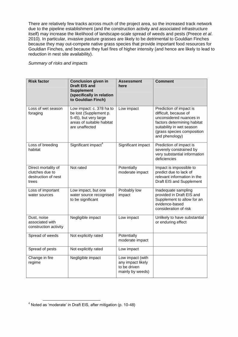
There are relatively few tracks across much of the project area, so the increased track network due to the pipeline establishment (and the construction activity and associated infrastructure itself) may increase the likelihood of landscape-scale spread of weeds and pests (Preece et al. 2010). In particular, invasive pasture grasses are likely to be detrimental to Gouldian Finches because they may out-compete native grass species that provide important food resources for Gouldian Finches, and because they fuel fires of higher intensity (and hence are likely to lead to reduction in nest site availability).
Summary of risks and impacts
Risk factor Conclusion given in Draft EIS and Supplement (specifically in relation to Gouldian Finch)
Assessment here
Comment
Loss of wet season foraging
Low impact: c. 378 ha to be lost (Supplement p. 5-45), but very large areas of suitable habitat are unaffected
Low impact Prediction of impact is difficult, because of unconsidered nuances in factors determining habitat suitability in wet season (grass species composition and phenology)
Loss of breeding habitat
Significant impact4 Significant impact Prediction of impact is
severely constrained by very substantial information deficiencies
Direct mortality of clutches due to destruction of nest trees
Not rated Potentially moderate impact
Impact is impossible to predict due to lack of relevant information in the Draft EIS and Supplement
Loss of important water sources
Low impact, but one water source recognised to be significant
Probably low impact
Inadequate sampling provided in Draft EIS and Supplement to allow for an evidence-based consideration of risk
Dust, noise associated with construction activity
Negligible impact Low impact Unlikely to have substantial or enduring effect
Spread of weeds Not explicitly rated Potentially moderate impact
Spread of pests Not explicitly rated Low impact
Change in fire regime
Negligible impact Low impact (with any impact likely to be driven mainly by weeds)
4 Noted as ‘moderate’ in Draft EIS, after mitigation (p. 10-48)

Mitigation program
The Draft EIS (notably within the Environmental Management Plan: Appendix O) and the Supplement (notably pp. 5-35-41) provide a series of mitigation actions that aim to reduce the general environmental impact of the proposal, and specifically to reduce impacts upon Gouldian Finches.
If appropriately implemented, these proposed mitigation actions are likely to reduce impacts, to some degree. The proposed mitigation measures are considered here in relation to the risk factors described above.
Loss of wet season foraging habitat
The major mitigation measure proposed here is the rehabilitation with native plant species of much of the cleared width of the pipeline route (and also of temporary camp sites etc.), with a total of c. 60% of cleared area to be eventually rehabilitated. The EMP (pp. 17-1 to 17-10) notes that native plant species will be used in this rehabilitation, and that ‘some areas may also be revegetated with native shrubs and trees, for example to … restore Gouldian Finch and other fauna habitat’ (Draft EIS, Appendix O (EMP) p. 17-2). Mitigation of loss of wet season foraging habitats for Gouldian Finches would be enhanced if instead there was an explicit commitment to re-stock preferentially (in appropriate habitats) those grass species that provide critical seed resources for Gouldian Finches during the wet season (such as Alloteropsis semialata).
Loss of breeding habitat
The Draft EIS states that breeding habitat considerations within the ancillary infrastructure Site Selection Protocols will ensure that no breeding habitat is affected by these developments (p. 10-47), and that ‘all known potential breeding habitat will be avoided with the possible exception of one patch of trees at KP50’ (p. 10-47). However, the additional habitat surveys described in the Supplement indicate instead that appreciably more breeding habitat will be cleared and not avoided. It instead notes some mitigation measures (pp. 5-38 to 5-41). For all areas containing suitable Salmon Gum habitat, these comprise:
(i) fine-scale re-alignment of the pipeline location within the 100 m pipeline corridor to try to avoid identified habitat trees (i.e. to minimise the loss of Salmon Gums containing hollows, and all Salmon Gums: Supplement p. 5-38), as determined by an on-site qualified ecologist, with such recommended re-alignment ‘subject to physical, technical and engineering constraints’ (Supplement p. 5-38);
(ii) ‘consideration will be given’ (Supplement pp. 3-7, 5-38) to reducing the working width of the ROW in such areas to minimise the removal of identified habitat trees;
(iii) ‘consideration’ of the potential to prune branches rather than fell trees; and
(iv) creating artificial nest boxes from hollows of cleared trees, such that there will be ‘no net loss of breeding hollows’ (Supplement p. 5-39).
These are generally appropriate mitigation measures that will somewhat reduce impacts. But all will be less effective than avoidance. Actions i, ii and iii are not mandatory and may well be little implemented in practice if other considerations are deemed more important. Action iv is sensible, but given the likely rate of destruction of hollows during the clearing process, it is most unlikely that post-felling salvage will recoup sufficient hollows to meet the ‘no net loss’ objective. Furthermore, nest boxes are likely to persist in the landscape for far less time than natural hollows (Lindenmayer et al. 2009), so any benefit may well be transient.
The rehabilitation program notes that ‘some areas may also be revegetated with native shrubs and trees, for example to … restore Gouldian Finch and other fauna habitat’ (Draft EIS, Appendix O (EMP) p. 17-2). Rather than noting that such actions ‘may’ occur, a preferable mitigation commitment would be to ensure that in cleared and disturbed areas with potential
breeding habitat for Gouldian Finches, rehabilitation with Salmon Gums was explicitly prescribed, and that such rehabilitation was carefully managed over at least a decadal scale.
In summary, the proposed mitigation actions are a positive step (particularly in their application for all areas with Salmon Gum woodlands across the pipeline route), but the implementation of most actions is highly categorical, discretionary and conditional (hence they may be totally ineffective), and one action (artificial nest boxes) is unlikely to redress the loss in the short term and to have little beneficial impact in the longer-term.
Potential direct mortality due to clearing in breeding habitat
The Supplement states (p. 5-39) that ‘during the pre-clearance survey and pegging of the ROW, the ecologist will identify any nesting hollows that are in active use by the Gouldian Finch. Salmon Gums that do not have nesting Gouldian Finches and are not able to be avoided through realignment or reducing the working width of the ROW will be immediately cleared ahead of the main clearing program’. This is an admirable sentiment, but it presents some practical difficulties. If such pre-clearance survey is undertaken before the breeding season (i.e. before c. January-February 2014), then it may lead to the perverse outcome of clearing all Salmon Gums in the prospective clearing area (because all will then be unoccupied by Gouldian Finches). If it occurs during the breeding season, it is likely to be impractical, because it takes considerable time to reliably confirm whether or not hollows are occupied by breeding Gouldian Finches.
Loss or degradation of important water sources
The Supplement (at section 6.2.3) outlines an operating protocol (Risk Assessment and Adaptive Management approach) towards construction at watercourses that minimises disruption of natural flows, and the Environmental Management Plan (Draft EIS, Appendix O, pp. 4-1 to 4-7) and Supplement (Section 6) describes a set of procedures and responses relating to groundwater use, disturbance to waterways and hydro-testing. These provide generally appropriate management and mitigation measures to reduce potential impacts upon Gouldian Finches relating to water sources. In particular, the commitment to not extract water from isolated (refuge) pools (Supplement p. 6-39) is appropriate.
The Supplement also recognises the importance of one particular water source (near KP118) that was recorded to be used by large flocks of Gouldian Finches, and proposes the mitigation measure of deviating the pipeline route within the existing corridor, such that its distance from the water source is increased by c. 30 m. (such that the distance from the waterhole to the centreline of the pipeline is c. 190 m). The intent of this mitigation is positive, but the increment is small.
Notwithstanding the very limited sampling of water sources across the route, no other specific operational protocol is given for mitigation should additional important watering sites for Gouldian Finches become apparent during construction.
Indirect impacts
As noted in the previous section, the indirect impact with potentially most serious consequences relates to the propensity of weeds to be spread during construction and subsequently along the pipeline route. The Supplement and EMP provides some general objectives relating to weeds, particularly in the Provisional Weed Management Plan (Draft EIS, Appendix O). With respect to risks for Gouldian Finch, the major issue here is associated with invasive grass species that fuel higher intensity fires, and it would be desirable for such species to be clearly recognised as high priority for biosecurity and control.
Monitoring program

The Supplement (pp. 5-43-44) amplifies specific monitoring activities for Gouldian Finches described briefly in the Draft EIS (e.g. Appendix O, p. 6-8). This monitoring activity focuses around the water source at KP118, and relates to the aims of estimating the size of this population, its local resource use and ecology, the establishments of impacts due to the project development, and identification of breeding sites. It is generally appropriately framed, but its interpretability will be substantially constrained by the absence of robust pre-impact monitoring. The Draft EIS (Appendix O, p. 6-8) also indicates that the monitoring investment will be very limited (three years post-construction, counts over 4-5 days per year, and within a 0.5 km2 area). Particularly given the recognised variability associated with Gouldian Finch monitoring (e.g. Price et al. unpublished; Ward and Voukolos 2009), this level is unlikely to produce meaningful results.
Furthermore, there appears to be no monitoring committed to the assessment of the effectiveness of most mitigation measures (e.g. use and persistence of artificial hollows), responses to disturbance (e.g. return of nesting Gouldian Finches to trees adjacent to cleared areas), offset performance or the success of rehabilitation actions that use grass and tree species favoured by Gouldian Finches.
Offset
The Supplement appropriately recognises that the residual detriment to Gouldian Finch breeding habitat5 is significant, and that such detriment should be offset. A preliminary description of this offset, and rationalisation of its amount, is given at pp. 5-44-49. It is recognised that any more detailed description of the offset will require further discussions with relevant landholders and agencies, so only broad considerations, relating to size and management actions, are given here. Without clear demarcation of the offset area (and knowledge that it includes viable population(s) of Gouldian Finches), the consideration is necessarily abstract.
The Supplement provides metrics to the DSEWPaC Offsets Calculator to derive an equivalence area. The values given for almost all of these metrics are arguable. As noted above, the impact area (area of cleared breeding habitat) is likely to be larger than the range given in the Supplement (33-101 ha), although some mitigation measures may result in reducing this area.
The Supplement (p. 5-48) suggests that the time period over which management (the stated enhanced fire regime) in the offset area will provide benefit is 3 years. Given the lack of provided information on current or proposed fire regimes, the lack of information on current impacts of fire, and that changes in fire regime may be unlikely to have substantial impacts in the short-term (i.e. <5 years), this assessment appears to be particularly optimistic.
The Supplement suggests (p. 5-48) that the offset will be funded for 10 years. This seems meagre, given the significance of the residual detriment.
The Supplement suggests (p. 5-48) that the current condition of the offset area is good (value 8/10) and equivalent to that of the impact area. It is difficult to assess this value given that there is no delineation of the proposed offset area.
The Supplement suggest (p. 5-48) that the quality of the offset area will decline if an offset is not implemented (from 8 to 7), notwithstanding that this scenario relates to continuation of the current management (which underpins the current quality score of 8).
The Supplement suggests (p. 5-48) that there is a 60% chance that over a 10-year period, the relatively unspecified management actions will result in an improvement in the habitat quality (and/or number of Gouldian Finches) in the offset area by 12.5% (i.e. from 8 to 9), notwithstanding risks associated with unplanned fire (or with offset-management fires resulting
5 The argument given that impacts on non-breeding habitat are not significant and hence need not be
offset, is accepted.

in increased area burnt), management capability, and uncertainty about whether fire is the major limiting factor for this population. This rating also appears to be optimistic.
The following Table provides parameter estimates that may be more plausible than that given in the Supplement, and the consequential effect on size of the offset area. A conclusion is that the proposed offset area is likely to be too small to redress the residual detriment.
Parameter Value given in Supplement
Value suggested here
Impact area 101 ha 150 ha
Time to ecological benefit 3 years 10 years
Time of offset benefit 10 years 20 years
Future quality of offset area without offset management
7 8
Confidence in result 60% 50%
Required offset area 931 ha 3606 ha
The suggested offset is narrowly based on fire management, particularly implementation of preventative early dry season burning. It may be appropriate to complement or supplement this with control actions on feral pigs, which may provide more additionality to existing actions and may be more effective (given the impacts of pigs on a preferred Gouldian Finch food source, Alloteropsis semialata: Crowley 2008).
Conclusions and Recommendations
The draft EIS and Supplement does not provide sufficient information to allow reliable assessment of the extent of the proposed development impact on the threatened Gouldian Finch. For example, on the available information, it is impossible to state or predict whether the number of Gouldian Finches breeding in the suitable habitat to be cleared is zero or thousands, and hence whether the detriment is negligible or significant. The Supplement suggests that these numbers may be determined during or after the construction of the development, an approach that appears to be counter to the purpose of the EIS process.
In the absence of such crucial information, the Supplement instead uses the surrogate of breeding habitat. In this case, this is not an entirely unreasonable proposition, given that there may be narrow breeding habitat specificity for this species. But it is a sub-optimal approach and there may be little predictability in the occurrence of Salmon Gum patches and the presence and population size of Gouldian Finches.
Furthermore, although broadly reasonable, there are some arguable premises in the Supplement’s estimation of the extent of suitable breeding habitat, and it is likely that the extent is larger than that claimed (although not necessarily proportionately larger relative to known comparable habitat that will not be cleared).
Notwithstanding the lack of most relevant data, the Supplement appropriately concludes that the proposed development is likely to have a significant impact on this Matter of National Environmental Significance. The Supplement appropriately proposes a set of mitigation measures, but mostly these are conditional rather than obligatory, and their overall benefit is likely to be limited, and far inferior to avoidance of impact through better route selection.
The Supplement proposes a monitoring program at one site, but this program is notably limited in duration and scope. No monitoring is proposed to assess the efficacy of the mitigation actions, some ongoing management actions, or the effectiveness of a proposed offset.
Appropriately, the Supplement accepts the need for an environmental offset, and provides some general preparatory information on such an offset. Assumptions underlying the scale of this offset appear to be overly optimistic, and consequently the scale is inadequate.
Recommendations
1. The Draft EIS and Supplement does not meet a primary purpose, to provide sufficient information to allow a reliable assessment of the risk and potential impact to a Matter of National Environmental Significance. Especially given that there is a reasonable possibility that this impact (loss of habitat supporting breeding populations) may be substantial and significant, further survey is required to assess the extent to which potential breeding habitat in the pipeline route is being used for breeding by Gouldian Finches, and the size of such populations.
2. In the absence of such information from additional further survey, the route should be diverted to avoid all mapped stands of Salmon Gum of >1 ha in extent.
3. If neither Recommendation 1 nor 2 can be accommodated, the proposed mitigation measures need to be substantially strengthened and made mandatory rather than discretionary.
4. The proposed monitoring program is insufficient, and requires expansion in scope and duration.
5. The proposed offset is insufficient, and requires expansion in scope and duration.
References
Brazill-Boast J., van Rooij E., Pryke S. R., and Griffith S. C. (2011). Interference from long-tailed finches constrains reproduction in the endangered Gouldian finch. Journal of Animal Ecology 80, 39-48.
Crowley, G. (2008). Cockatoo grass Alloteropsis semialata as a keystone species in northern Australia. Northern Territory Naturalist 20, 58-63.
Evans, S. M., and Bougher, A. R. (1987). The abundance of estrildid finches at waterholes in the Kimberley (WA). Emu 87, 124-127.
Garnett, S. T., Szabo, J. K., and Dutson, G. (2011). The action plan for Australian Birds 2010. (CSIRO
Publishing, Melbourne.)
Lindenmayer DB, Welsh A., Donnelly C, Crane M, Michael, D, Macgregor, C, McBurney L, Montague-Drake R, Gibbons P (2009). Are nest boxes a viable alternative source of cavities for hollow-dependent animals? Long-term monitoring of nest box occupancy, pest use and attrition. Biological Conservation 142, 33-42.
O’Malley, C. (2006a). National Recovery Plan for the Gouldian Finch (Erythrura gouldiae). (WWF-Australia, Sydney.)
O’Malley, C. (2006b). Background information. Appendix to National Recovery Plan for the Gouldian Finch (Erythrura gouldiae). (WWF-Australia, Sydney.)
Preece, N., Harvey, K., Hempel, C., and Woinarski, J.C.Z. (2010). Uneven distribution of weeds along extensive transects in Australia's Northern Territory points to management solutions. Ecological Management and Restoration 11, 127-134.
Price, O., Palmer, C., Hooper, D., Dostine, P., Lewis, M., and Woinarski, J. (unpublished). Evaluation of a population monitoring program for the endangered Gouldian Finch in the Yinberrie Hills, northern Australia.
Tidemann, S. C. (1996). Causes of the decline of the Gouldian Finch Erythrura gouldiae. Bird Conservation International 6, 49-61.

Tidemann S. C., Boyden J., Elvish R., Elvish J., and O’Gorman B. (1992). Comparison of the breeding sites and habitat of two hole-nesting estrildid finches, one endangered, in northern Australia. Journal of Tropical Ecology 8, 373-388.
Tidemann, S. C., Lawson, C., Elvish, R., Boyden, J., and Elvish, J. (1999). Breeding biology of the gouldian finch Erythrura gouldiae, an endangered finch of northern Australia. Emu 99, 191-199.
Ward, S., and Voukolos, M. (2009). Gouldian finch monitoring report – September 2009. (Department of Natural Resources, Environment, the Arts and Sport, Darwin.)