kent archaeological society is a registered charity number ... · eynsford castle : a...
TRANSCRIPT

http://kentarchaeology.org.uk/research/archaeologia-cantiana/
Kent Archaeological Society is a registered charity number 223382© 2017 Kent Archaeological Society
EYNSFORD CASTLE: A REINTERPRETATION OF ITS EARLY HISTORY IN THE LIGHT OF RECENT
EXCAVATIONS*
VALERIE HORSMAN
INTRODUCTION
Recent excavations at Eynsford Castle have revealed important new evidence regarding its origins and early development. This paper reviews the early history of the castle in the light of these results.
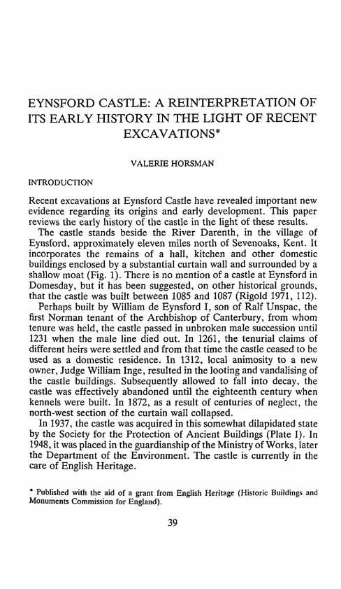
The castle stands beside the River Darenth, in the village of Eynsford, approximately eleven miles north of Sevenoaks, Kent. It incorporates the remains of a hall, kitchen and other domestic buildings enclosed by a substantial curtain wall and surrounded by a shallow moat (Fig. 1). There is no mention of a castle at Eynsford in Domesday, but it has been suggested, on other historical grounds, that the castle was built between 1085 and 1087 (Rigold 1971, 112).
Perhaps built by William de Eynsford I, son of Ralf Unspac, the first Norman tenant of the Archbishop of Canterbury, from whom tenure was held, the castle passed in unbroken male succession until 1231 when the male line died out. In 1261, the tenurial claims of different heirs were settled and from that time the castle ceased to be used as a domestic residence. In 1312, local animosity to a new owner, Judge William Inge, resulted in the looting and vandalising of the castle buildings. Subsequently allowed to fall into decay, the castle was effectively abandoned until the eighteenth century when kennels were built. In 1872, as a result of centuries of neglect, the north-west section of the curtain wall collapsed.
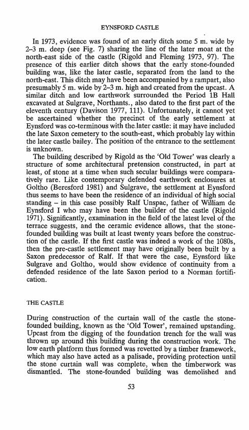
In 1937, the castle was acquired in this somewhat dilapidated state by the Society for the Protection of Ancient Buildings (Plate I). In 1948, it was placed in the guardianship of the Ministry of Works, later the Department of the Environment. The castle is currently in the care of English Heritage.
* Published with the aid of a grant from English Heritage (Historic Buildings and Monuments Commission for England).
39
VALERIE HORSMAN
N
Little qtMote
Saxon
v /
*
Eynsford <J*
<we'
bridge & lord
Church of St Martin
300m
Fig. 1. Location plan.
PREVIOUS EXCAVATIONS
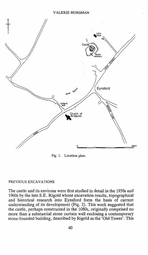
The castle and its environs were first studied in detail in the 1950s and 1960s by the late S.E. Rigold whose excavation results, topographical and historical research into Eynsford form the basis of current understanding of its development (Fig. 2). This work suggested that the castle, perhaps constructed in the 1080s, originally comprised no more than a substantial stone curtain wall enclosing a contemporary stone-founded building, described by Rigold as the 'Old Tower'. This
40
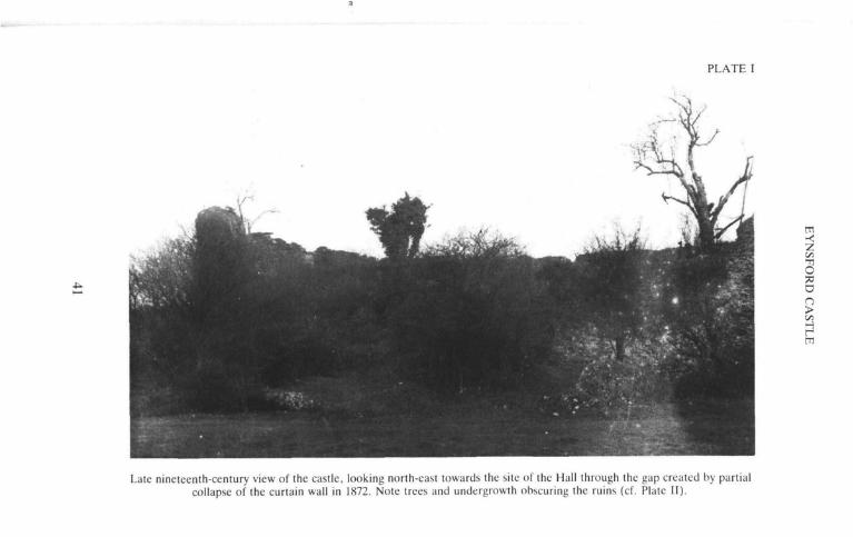
PLATE I
< z Vi -n O a a n > H H ffl
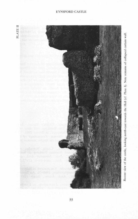
Late nineteenth-century view of the castle, looking north-east towards the site of the Hall through the gap created by partial collapse of the curtain wall in 1872. Note trees and undergrowth obscuring the ruins (cf. Plate II).

VALERIE HORSMAN
Solar Under
croft Kitchen
Undercroft O
of Hall
Great Kitchen Old
Tower
Tower
Bridge
100ft
25m
Fig. 2. Plan of the castle, showing its development according to Rigold: eleventh-century walls shown black; twelfth-century walls shown white; later work
shown hatched.
42

EYNSFORD CASTLE
building was partially surrounded by a low mound, contained within the curtain wall but separated from it by a gully or channel. At this time, Rigold suggested, the castle would have served as a place of observation and refuge associated with an unfortified manorial site probably at Little Mote nearby, to the north.
According to Rigold, the castle survived in this form until the early twelfth century when the 'Old Tower' was demolished and its remains buried under a clay-capped rubble platform. The present Hall and a number of other buildings were erected on top of this platform. At the same time, the curtain wall was heightened and a gatehouse inserted along its south-eastern line. An outbuilding recorded beyond this entrance might have been contemporary. Thus, the character of the castle changed from an occasionally occupied place of refuge to a private domain, possibly the inner bailey of a larger, as yet undefined complex lying to the south-east.
RECENT WORK
Recent investigations carried out in the early 1980s along the line of the fallen curtain wall, in advance of consolidation works by the Department of the Environment, have cast doubt on this interpreta-tion of the early history of the castle.
In November 1981, the Department of the Environment initiated a scheme to mark out the line of the collapsed north-west curtain wall as projected by Rigold. Prior to these works, excavation was undertaken to confirm this alignment and to determine whether any foundation courses of the wall survived in situ. These excavations showed the actual position of the inner face of the curtain wall to be c. 1 m. to the south-east of the line suggested by Rigold, clearly showing that later consolidation had altered and obscured its true line. The north-west part of the curtain wall was found to have collapsed in its entirety in 1872. It had originally stood on a foundation of thick alternating horizontally-bedded bands of crushed chalk and gravelly sand, laid in a trench and capped by a thick, but sometimes patchy skin of yellow mortar. Owing to its great depth this trench could not be fully emptied but was at least 2 m. deep. The base of the fallen curtain wall was found to be c. 1.75 m. thick. There was no evidence, in the area excavated, of the gully or channel between the curtain wall and the interior platform recorded by Rigold.
In 1983, further investigations were undertaken along the line of the fallen curtain wall to clarify the relationship of the curtain wall to the interior platform and to resolve the contradiction in the construc-
43

VALERIE HORSMAN
tion sequence suggested by comparing the results of the 1981 excavations with those of Rigold in 1966-67.!
Evidence from this second investigation suggested that the main part of the interior platform was contemporary with the curtain wall and may have been built with upcast from its foundation trench (Fig. 3). As Fig. 3 clearly shows, this trench was dug from an earlier ground surface sealed by the deposits forming the platform.
The curtain wall was built on the outer part of the foundation, leaving a 0.5 m. gap between the wall and the interior platform, perhaps to allow access to the inner face of the wall (Fig. 4). During construction, the earth platform must have been retained by a
SE NW
platform inner face
•
of waII i
original line of 38m OD
inner face falen of wall wa
mmg&m^mm§^m>
0 2m
Fig. 3. Cross-section, showing the relationship of the interior platform to the chalk-and-gravel wall foundation and the fallen wall. Note the slumping of the deposits forming the interior platform and the gravel packing preserving the original line of the inner face of the curtain wall (cf. Section 1 on Fig. 5).
1 The earth face now visible at Eynsford is in fact a 'veneer' hiding a modern concrete revetment. The insertion of this revetment necessitated the removal of part of the platform forming the castle mound to the line indicated by Section 2 on Fig. 5.
44

EYNSFORD CASTLE
temporary ffl timber—§ revetment |
ft:ii,:.t.*,-.-.'s v . . i i i . * ,v .* . * .« i
^original ground surface
interior platform
Fig. 4. a. Schematic cross-section, showing the temporary timber revetment erected to retain the side of the construction trench and the upcast forming the interior platform during building of the curtain wall. b. Schematic cross-section across the completed curtain wall, showing the interior platform. Note the slumping of the platform deposits and the replacement of the temporary
revetment by gravel packing.
45
VALERIE HORSMAN
temporary revetment, resting on the inner part of the foundation bed. On completion of the curtain wall, the revetment must have been removed and the space between the wall and the exposed face of the platform packed with silt and gravel. The north face of this packing sharply preserved the negative image or ghost of the inner face of the fallen curtain wall, although some slight slumping of the upper part of the earth platform occurred. No actual trace of the revetment was found, but it may be presumed to have been built of wood and strutted between the lower part of the wall and the face of the mound.
The foundation trench for the curtain wall was found to have been dug down through at least one metre of earlier earth layers including occupation debris scraped up and redeposited from elsewhere. Thus a deliberate terrace had been built out onto the flood plain of the River Darenth. Examination in the field of the latest deposit2
indicated that the trodden surface of this terrace represented at least twenty years of extensive occupation.
The apparent contemporaneity of the curtain wall and the lower part of the platform suggested that both were later than the stone-founded building partially buried within the mound, recorded by Rigold. This building, interpreted by Rigold as a tower, was there-fore already standing before the curtain wall was built and may have been contemporary with the latest surface of the terrace described above, found beneath the castle.
No small finds were recovered during the 1980s works. Full publication of the results was deferred until a reassessment of Rigold's work could be undertaken to resolve as far as possible the different interpretations of the castle's early development.
RE-INTERPRETATION OF RIGOLD'S FINDINGS
The re-assessment was based on Rigold's published reports and primary records (Rigold 1971; Rigold and Fleming 1973).3 The published reports provide a full record of the excavations in the castle and moat, together with a detailed analysis of the topography and history of the parish of Eynsford. A detailed structural and compara-tive study of the succession of the medieval timber bridges found
2 By Dr Richard McPhail of the Institute of Archaeology, London. 3 The primary records of Rigold's excavations are stored by the Historic Buildings
and Monuments Commission. Copies are held by the National Monument Record and may be consulted by appointment.
46
EYNSFORD CASTLE
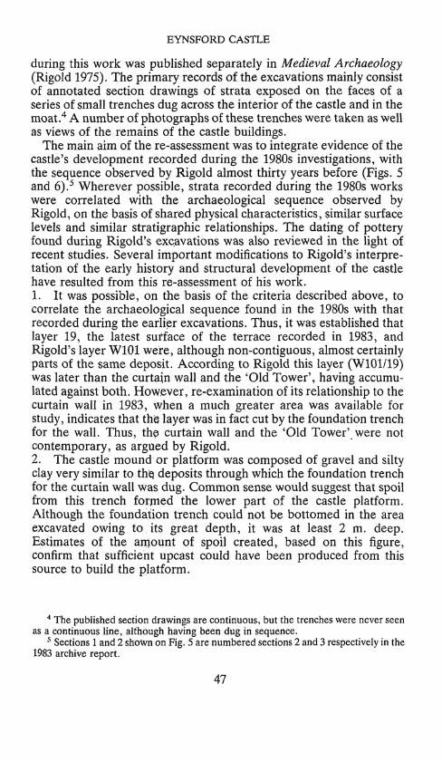
during this work was published separately in Medieval Archaeology (Rigold 1975). The primary records of the excavations mainly consist of annotated section drawings of strata exposed on the faces of a series of small trenches dug across the interior of the castle and in the moat.4 A number of photographs of these trenches were taken as well as views of the remains of the castle buildings.
The main aim of the re-assessment was to integrate evidence of the castle's development recorded during the 1980s investigations, with the sequence observed by Rigold almost thirty years before (Figs. 5 and 6).5 Wherever possible, strata recorded during the 1980s works were correlated with the archaeological sequence observed by Rigold, on the basis of shared physical characteristics, similar surface levels and similar stratigraphic relationships. The dating of pottery found during Rigold's excavations was also reviewed in the light of recent studies. Several important modifications to Rigold's interpre-tation of the early history and structural development of the castle have resulted from this re-assessment of his work. 1. It was possible, on the basis of the criteria described above, to correlate the archaeological sequence found in the 1980s with that recorded during the earlier excavations. Thus, it was established that layer 19, the latest surface of the terrace recorded in 1983, and Rigold's layer W101 were, although non-contiguous, almost certainly parts of the same deposit. According to Rigold this layer (W101/19) was later than the curtain wall and the 'Old Tower', having accumu-lated against both. However, re-examination of its relationship to the curtain wall in 1983, when a much greater area was available for study, indicates that this layer was in fact cut by the foundation trench for the wall. Thus, the curtain wall and the 'Old Tower' were not contemporary, as argued by Rigold. 2. The castle mound or platform was composed of gravel and silty clay very similar to the. deposits through which the foundation trench for the curtain wall was dug. Common sense would suggest that spoil from this trench formed the lower part of the castle platform. Although the foundation trench could not be bottomed in the area excavated owing to its great depth, it was at least 2 m. deep. Estimates of the amount of spoil created, based on this figure, confirm that sufficient upcast could have been produced from this source to build the platform.
4 The published section drawings are continuous, but the trenches were never seen as a continuous line, although having been dug in sequence.
5 Sections 1 and 2 shown on Fig. 5 are numbered sections 2 and 3 respectively in the 1983 archive report.
47

VALERIE HORSMAN
ysection 1
Fig. 5. Plan, showing the location of sections recorded by Rigold and Horsman. Note tone denoting the re-alignment of the curtain wall, based on results of the
1980s excavations, cf. Fig. 2.
4^ 38mOD .
north wall of
Great Kitchen
.,destruction debris / ' ' s
• - " - • • • ; J - •• r •-•-.. !•"-•-1 ** * * "•**"' *"""*",T •' pre-cast le" te'rrace .*-. i ' ''. ' •"
sw
castle platform
5m
ffl •z Vi •fl O
D
H
5 Fig. 6. Section 2, showing the face of the castle mound exposed during consolidation work in 1983 (see Fig. 5).
VALERIE HORSMAN
3. The trodden surface of layer W101/19, buried beneath the later platform, was exposed for at least twenty years before the castle was built. Thus, if the platform around the 'Old Tower' was indeed built with upcast from the foundation trench for the curtain wall, the 'Old Tower' must have been standing for at least twenty years when the castle was built. 4. Before the 'Old Tower' was demolished its mortar floor had silted up and cracked under damp, suggesting that it may have fallen into disuse before the raising of the platform, and hence also before the construction of the curtain wall. This period of disuse may have been contemporary with the construction of the curtain wall. Unfor-tunately, insufficient evidence survives to determine whether the 'tower' continued in use for a period of time after the curtain wall had been constructed or whether it was demolished immediately upon completion. 5. Given that the 'Old Tower' was part of an earlier settlement, predating the castle by some twenty years at least, there is no stratigraphic reason why the Hall and other domestic and out-buildings now visible within the defensive circuit should not have been part of the original plan of the castle, rather than a second-phase development, as suggested by Rigold. If so, the heightening of the curtain wall would represent a later structural alteration to the defensive circuit unrelated to the development of the interior of the castle. The present gatehouse may be contemporary with this later heightening of the wall having been added to the lower part. However, at this point, the outer face of the lower (original) wall is set forward with a flat facet, giving a thicker build. The introduction of a secondary entrance and gatehouse at a point where the original build was already varied could suggest that the earlier entrance, perhaps a gatehouse, stood on the same site. The purpose of an embrasure in the upper part of the north-eastern curtain wall, interpreted by Rigold as the original entrance to the castle, is unknown. 6. Re-examination of the bulk of the stratified pottery by Dr Alan Vince, of the Lincolnshire Archaeological Trust, in the light of recent pottery studies, has yielded significant results suggesting that the differentiation of the Hall complex from the curtain wall, 'Old Tower' and platform, proposed by Rigold on ceramic grounds, cannot be substantiated.^ It can also be suggested that all the pottery from the early structural phases of the castle (Rigold's Phases W, X
6 Dr Vince's report on the pottery is held in the archive at the H.B.M.C. and the N.M.R. and may be consulted by appointment.
50
EYNSFORD CASTLE
and Y) may be of eleventh-century date, though no earlier. This review of their dating suggests that the first phase (W) may have begun sometime in the early eleventh century, supporting the stratigraphic evidence (presented above) of a settlement predating the early Norman castle.
THE DEVELOPMENT OF EYNSFORD CASTLE
PRE-CASTLE SETTLEMENT
Eynsford Castle was built on the site of a stone-founded building dated no earlier than the beginning of the eleventh century. This building stood on an artificial terrace built out into the flood plain of the River Darenth. Evidence of occupation during construction of this terrace suggests there were several phases of land reclamation. The presence of a thick mortar band within the reclamation dumps suggests the construction of even older stone-founded buildings nearby, contemporary with the construction of the upper part of the terrace. These buildings may have stood in the vicinity of a late Saxon cemetery known to exist nearby to the south.7
The stone-founded building discovered by Rigold and known as the 'Old Tower' occupied the centre of that part of the terrace later enclosed by the curtain wall of the castle (Fig. 7). The full extent of this building is not known, but one wall may have been as much as 12.77 m. long. Other walling some 6 m. away, with a well-turret at the north-east corner, may have been part of the same structure. Although the north, west and east walls of the building did not survive, a south wall remained to its full height of c. 2.40 m., protected by the later earth platform thrown up when the curtain wall was built. Preserved in the top surface of the south wall was the seating for a wooden beam which, presumably, supported an upper storey or, more probably, the roof. The floor of the building was sunken approximately 1.50 m. below contemporary ground level: the building was thus partly subterranean. There is no direct evidence that the building was ever, as Rigold concluded, a tower. That conclusion stemmed from his belief that this building formed part of the earliest castle - a belief now known to be mistaken.
7 Remains of a cemetery, probably of Late Saxon date, were discovered to the south-east of the castle. An excavation was carried out by Mr S.R. Harker and Mr and Mrs J.M. Allan (Rigold 1971, 117, 137).
51

VALERIE HORSMAN
25m
Fig. 7. Plan of the remains of the 'Old Tower' found by Rigold. Black hachures indicate the line of the ditch pre-dating the castle moat. Open hachures reflect
the suggested alignment based on the position of the later castle moat.
52
EYNSFORD CASTLE
In 1973, evidence was found of an early ditch some 5 m. wide by 2-3 m. deep (see Fig. 7) sharing the line of the later moat at the north-east side of the castle (Rigold and Fleming 1973, 97). The presence of this earlier ditch shows that the early stone-founded building was, like the later castle, separated from the land to the north-east. This ditch may have been accompanied by a rampart, also presumably 5 m. wide by 2-3 m. high and created from the upcast. A similar ditch and low earthwork surrounded the Period IB Hall excavated at Sulgrave, Northants., also dated to the first part of the eleventh century (Davison 1977, 111). Unfortunately, it cannot yet be ascertained whether the precinct of the early settlement at Eynsford was co-terminous with the.later castle: it may have included the late Saxon cemetery to the south-east, which probably lay within the later castle bailey. The position of the entrance to the settlement is unknown.
The building described by Rigold as the 'Old Tower' was clearly a structure of some architectural pretension constructed, in part at least, of stone at a time when such secular buildings were compara-tively rare. Like contemporary defended earthwork enclosures at Goltho (Beresford 1981) and Sulgrave, the settlement at Eynsford thus seems to have been the residence of an individual of high social standing - in this case possibly Ralf Unspac, father of William de Eynsford I who may have been the builder of the castle (Rigold 1971). Significantly, examination in the field of the latest level of the terrace suggests, and the ceramic evidence allows, that the stone-founded building was built at least twenty years before the construc-tion of the castle. If the first castle was indeed a work of the 1080s, then the pre-castle settlement may have originally been built by a Saxon predecessor of Ralf. If that were the case, Eynsford like Sulgrave and Goltho, would show evidence of continuity from a defended residence of the late Saxon period to a Norman fortifi-cation.
THE CASTLE
During construction of the curtain wall of the castle the stone-founded building, known as the 'Old Tower', remained upstanding. Upcast from the digging of the foundation trench for the wall was thrown up around this building during the construction work. The low earth platform thus formed was revetted by a timber framework, which may also have acted as a palisade, providing protection until the stone curtain wall was complete, when the timberwork was dismantled. The stone-founded building was demolished and
53
VALERIE HORSMAN
replaced by the Hall and other domestic buildings, the curtain wall was heightened and a new gatehouse inserted into the defensive circuit.
Unfortunately, the periods of time which elapsed between the completion of the curtain wall, the demolition of the earlier stone-founded building and the construction of the present Hall cannot be determined on the existing evidence. Thus, three interpretations of the early development of the castle are possible. Firstly, that the stone-founded building remained in use for some time after the completion of the curtain wall, before being demolished and replaced by the Hall and ancillary stone buildings. A second possibility is that the stone-founded building may have been demolished and replaced by the Hall complex at the time that the curtain wall was built. A third option is that some other building, of which no trace survives, preceded the construction of the present Hall. Given that there is evidence to suggest that the stone-founded building was out of use by the time of its demolition (see above, p. 50), the first interpretation of the early development of the castle is perhaps the least probable. Since the upper heightened part of the curtain wall and the present Hall appear to share the common use of a pinker mortar, and to incorporate re-used Roman tiles for dressing rather than the tufa stone used in the lower (original) build of the wall, the third option may be the most likely. Architecturally, the Hall is not closely dateable, but a construction in the early twelfth, or even the late eleventh century, is not impossible.
The original entrance to the castle was, for reasons outlined above (p. 50), almost certainly on the site of the later gatehouse (see Fig. 2).
Eynsford is thus a fine example of an early curtain wall castle, perhaps incorporating from the outset a gatehouse and full range of stone domestic buildings, with a strengthening of its defences early in the twelfth century. Thereafter, the castle remained essentially unaltered until its abandonment in the fourteenth century. The present remains are therefore largely the ruins of the early Norman fortification (Plate II).
CONCLUSIONS
The preservation of a castle of this early date, relatively undisturbed by later building activity, is unusual. The discovery, on the same site, of an earlier flat, ditched settlement of unknown extent, with at least one high-status building partly of stone, is even more remarkable. Could this be a thegnly residence, perhaps the domicile of the
54
EYNSFORD CASTLE
-< —
g

VALERIE HORSMAN
predecessor of the first Norman lord? Mortar deposits found in earlier dumps suggest even longer continuity of high-status occupa-tion in the vicinity. The discovery of such a long archaeological sequence spanning the Conquest is rare. The nature of the site, unthreatened by development, and already held in guardianship, offers unrivalled opportunities for future study. These should not be left unexploited.
ACKNOWLEDGEMENTS
This project was undertaken for the Inspectorate of Ancient Mon-uments of the Department of the Environment, now the Historic Buildings and Monuments Commission. I would like to thank Mr Brian K. Davison for his practical help and advice during excavation and preparation of this report. Thanks are also due to Mr Peter Cardiff, Dr Richard McPhail and Dr Alan Vince. Drawings in this report are by Christine Milne. Special thanks to Mabel Friend, retired custodian of Eynsford Castle for constant support, hot soup and sandwiches during excavation in the freezing winter of 1981. This report would not have been possible without the original groundwork and insight of the late S.E. Rigold.
REFERENCES
Beresford 1981
Brown 1981
Davison 1972-3
Davison 1977
Horsman 1981
G. Beresford, 'Goltho Manor, Lin-colnshire: The Buildings and their sur-rounding Defences', in Brown 1981. (Ed.) R.A. Brown, Proceedings of the Battle Conference on Anglo- Norman Stu-dies IV, 1981. B.K. Davison, 'Castle Neroche: An abandoned Norman Fortress in South Somerset', Proc. Somerset Arch, and Nat. Hist. Soc, cxvi-cxvii (1972-3), 16-58. B.K. Davison, 'Excavations at Sulgrave, Northamptonshire, 1960-76: An Interim Report', Arch. Journ., cxxxiv (1977), 105-14. V. Horsman, Excavations at Eynsford Castle, unpublished archive report, Museum of London/ H.B.M.C, 1981.
56

EYNSFORD CASTLE
Horsman 1983 V. Horsman, Excavations at Eynsford Castle, unpublished archive report, Museum of London/H.B.M.C, 1983.
Rigold 1971 S.E. Rigold, 'Eynsford Castle and its Excavation', Arch. Cant., lxxxv (1971), 109-17.
Rigold 1975 S.E. Rigold, 'Structural Aspects of medieval Timber Bridges', Med. Arch., xix (1975), 0000.
Rigold and Fleming 1973 S.E. Rigold and A.J. Fleming, 'Eynsford Castle: The Moat and Bridge', Arch. Cant., lxxxviii (1973), 87-116.
57
