key movement, access, access and movement key streets and ... · b1 05 se rv i ng ctu traff...
TRANSCRIPT
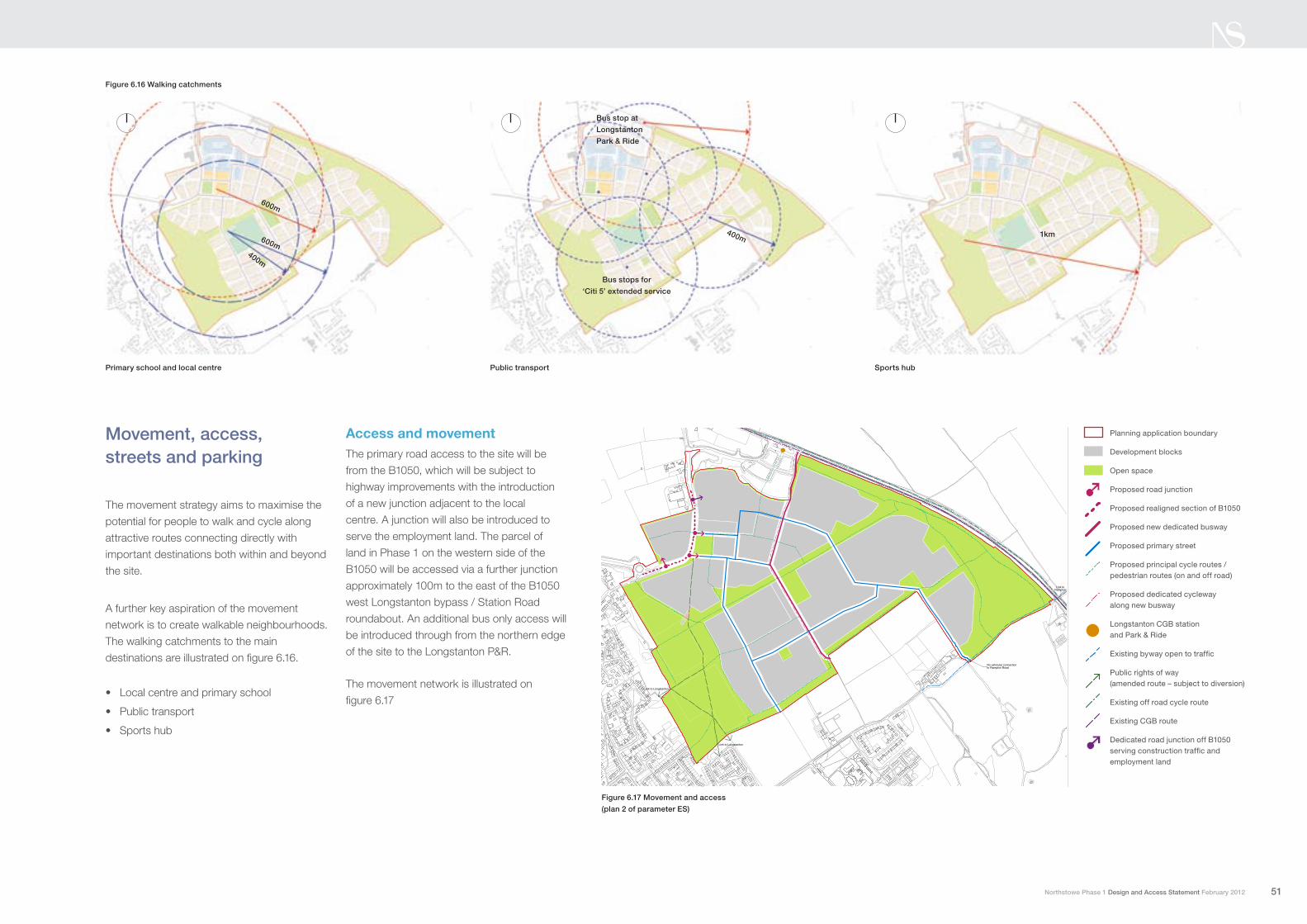
Movement, access, streets and parking
The movement strategy aims to maximise the
potential for people to walk and cycle along
attractive routes connecting directly with
important destinations both within and beyond
the site.
A further key aspiration of the movement
network is to create walkable neighbourhoods.
The walking catchments to the main
destinations are illustrated on figure 6.16.
Local centre and primary school•
Public transport•
Sports hub •
Access and movementThe primary road access to the site will be
from the B1050, which will be subject to
highway improvements with the introduction
of a new junction adjacent to the local
centre. A junction will also be introduced to
serve the employment land. The parcel of
land in Phase 1 on the western side of the
B1050 will be accessed via a further junction
approximately 100m to the east of the B1050
west Longstanton bypass / Station Road
roundabout. An additional bus only access will
be introduced through from the northern edge
of the site to the Longstanton P&R.
The movement network is illustrated on
figure 6.17
Figure 6.16 Walking catchments
Public transportPrimary school and local centre Sports hub
600m
600m400m
400m 1km
Feb 2012
Final
Parameters plan
Northstowe
1:5000@A3revision
drawn by
SWD
checked by
RB
Movement and access
Gallagher
Key
Everdene House Deansleigh Road Bournemouth BH7 7DU telephone 01202 421142 facsimile 01202 430055 email [email protected]
© Terence O’Rourke
0 50 100 200m25
Link to Longstanton
Link to Longstanton
Link toRampton
No vehicular connection to Rampton Road
Longstanton CGB station & park & ride
Existing byway open to traff ic
Proposed new dedicatedbusway
Proposed primary street
Public rights of way(amended route and subjectto diversion)
Proposed principal cycle/pedestrian routes(on and off road)
Existing off road cycle route
Existing CGB route
Proposed realigned sectionof B1050
Planning application boundary
Development blocks
Open space
Proposed dedicated cycleway along new busway
Proposed road junction
Dedicated road junction offB1050 serving constructiontraff ic & employment land
Plan 2
Figure 6.17 Movement and access
(plan 2 of parameter ES)
Feb 2012
Final
Parameters plan
Northstowe
1:5000@A3revision
drawn by
SWD
checked by
RB
Movement and access
Gallagher
Key
Everdene House Deansleigh Road Bournemouth BH7 7DU telephone 01202 421142 facsimile 01202 430055 email [email protected]
© Terence O’Rourke
0 50 100 200m25
Link to Longstanton
Link to Longstanton
Link toRampton
No vehicular connection to Rampton Road
Longstanton CGB station & park & ride
Existing byway open to traff ic
Proposed new dedicatedbusway
Proposed primary street
Public rights of way(amended route and subjectto diversion)
Proposed principal cycle/pedestrian routes(on and off road)
Existing off road cycle route
Existing CGB route
Proposed realigned sectionof B1050
Planning application boundary
Development blocks
Open space
Proposed dedicated cycleway along new busway
Proposed road junction
Dedicated road junction offB1050 serving constructiontraff ic & employment land
Plan 2
Planning application boundary
Development blocks
Open space
Proposed road junction
Proposed realigned section of B1050
Proposed new dedicated busway
Proposed primary street
Proposed principal cycle routes / pedestrian routes (on and off road)
Proposed dedicated cycleway along new busway
Longstanton CGB station and Park & Ride
Existing byway open to traffic
Public rights of way (amended route – subject to diversion)
Existing off road cycle route
Existing CGB route
Dedicated road junction off B1050 serving construction traffic and employment land
Bus stop at
Longstanton
Park & Ride
Bus stops for
‘Citi 5’ extended service
51Northstowe Phase 1 Design and Access Statement February 2012

6. Phase 1 master plan
Public transport Phase 1 will benefit from the Cambridgeshire Guided
Busway, providing ‘green travel’ for all residents at
the outset. Before the CGB run along the dedicated
busway this service will be accessed via the bus stop at
Longstanton Park & Ride. In addition, the local ‘Citi 5 Fen’
bus service will be extended to serve the development
with a route looping around the main primary streets
via the Longstanton Park & Ride and CGB station,
connecting to the proposed primary school and local
centre. The layout ensures that all residents will be within
400m walking distance of a bus stop. The location of bus
stops are shown on figure 6.16.
Pedestrians and cyclists Pedestrian and cycle routes have been designed to
be direct, safe, overlooked and free of unnecessary
obstacles such as excessive signage. A faster commuter
cycle route is provided along the dedicated busway
corridor which will continue through later phases of
Northstowe. Along the primary street a shared cycle and
pedestrian path runs parallel to the carriageway. There
are also shared cycle and pedestrian paths through the
greenways. Elsewhere cyclists will use the street network.
Wherever possible, connections to existing public rights
of way, the wider countryside, settlements to the east
and to Longstanton have been provided. The applicant is
also committed to upgrading existing footpaths between
Phase 1 and Longstanton, to ensure good connections to
existing and new facilities.
The philosophy of shared space at key public spaces will
be developed through the design code process.
Figure 6.18 Cycle routes
Key cycle routes
Cycle routes on primary street
Cycle route along dedicated busway
52 Northstowe Phase 1 Design and Access Statement February 2012

Dedicated buswayThe design speed of the dedicated busway will be
30mph. The primary streets, along which local buses will
run, will also be classified as 30mph, although speeds
will be reduced to 20mph through a combination of traffic
calming measures at important locations such as the
primary school or public squares. Secondary streets will
be traffic calmed and designed to provide safe and direct
pedestrian and cycle routes. The network as a whole will
achieve high levels of connectivity and legibility.
The busway corridor has been designed so that it can
run through the whole of Northstowe. As a key direct
route it will have a dedicated cycleway alongside which
will provide a convenient route for cyclists to travel
through Northstowe as well as linking with the CGB
cycleway route alongside Northstowe. At locations along
the corridor local residential roads will join the corridor
thereby providing access to the front of residential blocks.
These roads will not have any physical connection to the
busway thereby ensuring that local movements do not
affect the operation of buses.
There will be a limited number of primary road crossings
(see figure 6.19). These will be controlled by traffic signals,
which could also incorporate the local residential road
if necessary. The traffic signals will be designed so that
the primary road will receive most of the green time.
However, when a bus is approaching the junction the
traffic signals could change so that the bus receives
priority at the junction. This could be achieved either
by the technology currently operating on the CGB
or any other relevant detection system at the time of
implementation. Where appropriate the minor road also
needs to be included within this operation to ensure
that all movements are undertaken safely. Pedestrian
movements across the busway and the primary road can
be achieved within this staging strategy. Private vehicles
will not be permitted to join the busway at these crossing
points. This can be achieved by a design that prevents
the movements taking place with supporting signs and
markings to reinforce this.
Figure 6.19 Dedicated Busway plan – indicative layout
Signal Head
Red/Amber/Green
Pedestrian Head
Nearside signal and
Push Button
KEY
53Northstowe Phase 1 Design and Access Statement February 2012
Community park
Dedicated busway
Local road
Commuter cycle route
Staggered avenue
Junction where primary street crosses dedicated busway
Local road
BUS ONLYBUS ONLY
21.5m

6. Phase 1 master plan
The primary streets will provide the main vehicular
network within Phase 1 and a number of key facilities
such as the local centre and primary school are located
on this network. Along primary streets that run north
south, swales will run along one side of the carriageway
connecting with the main drainage ditches within the
greenways. For primary streets that run east-west a 2.5m
landscape strip with avenue trees will be incorporated
within the street profile.
The profile of all streets including secondary streets and
side streets / mews are illustrated on figure 6.21.
Figure 6.20 Street hierarchy
Street network A clear hierarchy of streets is proposed, reflecting key
movement routes and the distribution of land uses. These
are shown on figure 6.20 and comprise:
Dedicated busway• with separate parallel local roads
Primary streets •
Secondary streets•
Side streets / mews / private driveways•
Dedicated busway
Dedicated busway Central avenue FootwayLocal roadFootway Commuter
cycleway
3.5 storey3.5 storey
21.5m
5m3m3m2m 6.5m 2m
Figure 6.21 Street Profiles
dedicated busway
Primary street
Secondary street
Side street
Private driveways
Footways
54 Northstowe Phase 1 Design and Access Statement February 2012
dedicated busway
Primary street
Secondary street
Side street
Private driveways
Footways
dedicated busway
Primary street
Secondary street
Side street
Private driveways
Footways
Dedicated busway
Primary street / B1050
Secondary street
Side road
Private driveways
Footways

PrivatePrivate
2 / 2.5
storey
2.5 / 3
storey
dimension varies
8 to 11m
0.6 to
2.5m
0.6 to
2.5m
Side street
Road surface Footway PrivateFootway Parking /
grass verge
2.5 / 3
storey
2.5 / 3
storey
11.9m
2m2.4m5.5m2m
0.6 to
2.5m
0.6 to
2.5m
Secondary street
Primary street – north-south alignment with swale
FootwayCarriageway VergeCycleway /
footway
3 storey
Parking
2.4m 6.1m 3m 2m3.5m
3 storey
17m
Primary street – east-west alignment with treed avenue
FootwayCarriageway VergeCycleway /
footway
3 storey
Parking
2.4m 6.1m 2.5m 2m3.5m
3 storey
16.5m
55Northstowe Phase 1 Design and Access Statement February 2012
6. Phase 1 master plan
Highest level of street parkng along primary street
Medium level of on street parkingon secondary street
Lowest level of on street parkingon tertiary street
Parking for local centre
Staff parking for Primary school
Drop off and parking for primary school
Parking for employment
Parking courts for residential property
Predominantly on plot parking
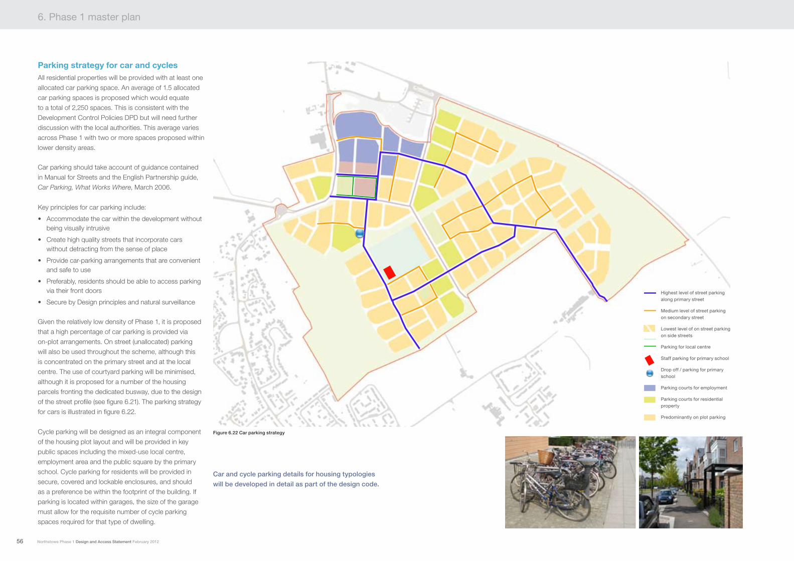
Parking strategy for car and cycles All residential properties will be provided with at least one
allocated car parking space. An average of 1.5 allocated
car parking spaces is proposed which would equate
to a total of 2,250 spaces. This is consistent with the
Development Control Policies DPD but will need further
discussion with the local authorities. This average varies
across Phase 1 with two or more spaces proposed within
lower density areas.
Car parking should take account of guidance contained
in Manual for Streets and the English Partnership guide,
Car Parking, What Works Where, March 2006.
Key principles for car parking include:
Accommodate the car within the development without •being visually intrusive
Create high quality streets that incorporate cars •without detracting from the sense of place
Provide car-parking arrangements that are convenient •and safe to use
Preferably, residents should be able to access parking •via their front doors
Secure by Design principles and natural surveillance •
Given the relatively low density of Phase 1, it is proposed
that a high percentage of car parking is provided via
on-plot arrangements. On street (unallocated) parking
will also be used throughout the scheme, although this
is concentrated on the primary street and at the local
centre. The use of courtyard parking will be minimised,
although it is proposed for a number of the housing
parcels fronting the dedicated busway, due to the design
of the street profile (see figure 6.21). The parking strategy
for cars is illustrated in figure 6.22.
Cycle parking will be designed as an integral component
of the housing plot layout and will be provided in key
public spaces including the mixed-use local centre,
employment area and the public square by the primary
school. Cycle parking for residents will be provided in
secure, covered and lockable enclosures, and should
as a preference be within the footprint of the building. If
parking is located within garages, the size of the garage
must allow for the requisite number of cycle parking
spaces required for that type of dwelling.
Car and cycle parking details for housing typologies
will be developed in detail as part of the design code.
Figure 6.22 Car parking strategy
56 Northstowe Phase 1 Design and Access Statement February 2012
Highest level of street parkng along primary street
Medium level of on street parkingon secondary street
Lowest level of on street parkingon tertiary street
Parking for local centre
Staff parking for Primary school
Drop off and parking for primary school
Parking for employment
Parking courts for residential property
Predominantly on plot parking
Highest level of street parking along primary street
Medium level of street parking on secondary street
Lowest level of on street parking on side streets
Parking for local centre
Staff parking for primary school
Drop off / parking for primary school
Parking courts for employment
Parking courts for residential property
Predominantly on plot parking

Figure 6.23 Illustrative sketch of dedicated busway
57Northstowe Phase 1 Design and Access Statement February 2012