kinvara local area plan - galway county council local area plan 2005-2011.pdf · adopted 23rd may...
TRANSCRIPT

Adopted 23rd May 2005
Kinvara Local Area Plan 2005 – 2011
COMHAIRLE CHONTAE NA GAILLIMHE GALWAY COUNTY COUNCIL
2
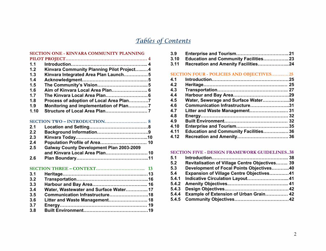
Tables of Contents
SECTION ONE - KINVARA COMMUNITY PLANNING PILOT PROJECT……………………………………………… 4 1.1 Introduction…………………………………………... 4 1.2 Kinvara Community Planning Pilot Project…...… 4 1.3 Kinvara Integrated Area Plan Launch……………. 5 1.4 Acknowledgment…………………………………..… 5 1.5 The Community’s Vision………………………….... 5 1.6 Aim of Kinvara Local Area Plan……………….….. 6 1.7 The Kinvara Local Area Plan………………………. 6 1.8 Process of adoption of Local Area Plan…………. 7 1.9 Monitoring and implementation of Plan……….… 7 1.10 Structure of Local Area Plan…………………….… 7 SECTION TWO – INTRODUCTION………………….…… 8 2.1 Location and Setting………………………………… 8 2.2 Background Information……………………………. 9 2.3 Kinvara Today………………………………………...10 2.4 Population Profile of Area…………………………. 10 2.5 Galway County Development Plan 2003-2009
and Kinvara Local Area Plan…………………….… 10 2.6 Plan Boundary………………………………………... 11 SECTION THREE – CONTEXT…………………………... 13 3.1 Heritage……………………………………………...… 13 3.2 Transportation………………………………………... 16 3.3 Harbour and Bay Area…………………………….... 16 3.4 Water, Wastewater and Surface Water…………... 17 3.5 Communication Infrastructure…………………….. 18 3.6 Litter and Waste Management…………………….. 18 3.7 Energy…………………………………………….…… 19 3.8 Built Environment………………………………….… 19
3.9 Enterprise and Tourism…………………………….. 21 3.10 Education and Community Facilities…………….. 23 3.11 Recreation and Amenity Facilities………………... 24 SECTION FOUR - POLICIES AND OBJECTIVES……..…. 25 4.1 Introduction…………………………………………… 25 4.2 Heritage……………………………………………..… 25 4.3 Transportation……………………………………….. 27 4.4 Harbour and Bay Area………………………………. 29 4.5 Water, Sewerage and Surface Water……………... 30 4.6 Communication Infrastructure…………………….. 31 4.7 Litter and Waste Management…………………..… 31 4.8 Energy…………………………………………………. 32 4.9 Built Environment…………………………………… 32 4.10 Enterprise and Tourism…………………………….. 35 4.11 Education and Community Facilities…………..… 36 4.12 Recreation and Amenity……………………………. 36 SECTION FIVE - DESIGN FRAMEWORK GUIDELINES..38 5.1 Introduction…………………………………………... 38 5.2 Revitalisation of Village Centre Objectives…….. 39 5.3 Development of Focal Points Objectives………... 40 5.4 Expansion of Village Centre Objectives……….… 41 5.4.1 Indicative Circulation Layout…………………….... 41 5.4.2 Amenity Objectives..………………………………... 41 5.4.3 Design Objectives...…………………………………. 42 5.4.4 Example of Extension of Urban Grain…………… 42 5.4.5 Community Objectives……………………………… 42
3
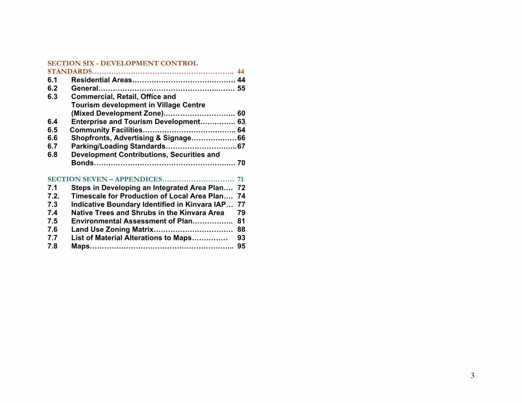
SECTION SIX - DEVELOPMENT CONTROL STANDARDS………………………………………………….. 44 6.1 Residential Areas…………………………….……… 44 6.2 General…………………………………………..……. 55 6.3 Commercial, Retail, Office and
Tourism development in Village Centre (Mixed Development Zone).……………………….. 60
6.4 Enterprise and Tourism Development…….…….. 63 6.5 Community Facilities………………………….…….. 64 6.6 Shopfronts, Advertising & Signage………….…… 66 6.7 Parking/Loading Standards…………………….….. 67 6.8 Development Contributions, Securities and
Bonds………………………………………………..… 70 SECTION SEVEN – APPENDICES………………………… 71 7.1 Steps in Developing an Integrated Area Plan…. 72 7.2. Timescale for Production of Local Area Plan…. 74 7.3 Indicative Boundary Identified in Kinvara IAP… 77 7.4 Native Trees and Shrubs in the Kinvara Area 79 7.5 Environmental Assessment of Plan…………….. 81 7.6 Land Use Zoning Matrix…………………………… 88 7.7 List of Material Alterations to Maps…………… 93 7.8 Maps…………………………………………………... 95
5
Section One – Kinvara Community Planning Pilot Approach
1.1 Introduction This section provides details of the Kinvara Community Planning Pilot Project and outlines the relationship between the community’s Integrated Area Plan and Galway County Council’s Local Area Plan. 1.2 Kinvara Community Planning Pilot Project With the introduction of the Local Government Planning and Development Act 2000, there is an increasing requirement on Planning Authorities to produce plans with greater public involvement and input. Recognising this fact, Galway County Council undertook a pilot project in partnership with the Kinvara community. The Kinvara Community Planning Project was developed as a response to concerns expressed by the local Community Council regarding the level, nature and extent of future development in the area. Towards the end of 2001, funding for the pilot project was secured by Galway County Council from a special “Initiatives Fund” provided by the Department of Environment and Local Government. The project was initiated in partnership with Kinvara Community Council. Within the Council, the project was a joint initiative between Forward Planning and Community and Enterprise, the Tipperary Institute was appointed to facilitate the process.
‘The way in which an area develops in the future is a matter of concern to many… If a plan for an area is to be truly meaningful to all those concerned and to meet the needs and aspirations of the various interests, it needs to be devised in a way that gives everyone an opportunity to say what they think from the defining of the issues to the final outcome.1 The pilot project has reflected such an approach as local people had effective involvement during all stages of the pilot project and explored options regarding the quality, nature and scale of development for their area. The process involved the preparation of the Kinvara Integrated Area Plan 2003 (IAP). This community plan sets out the community’s vision of how they wish Kinvara to develop over the next 10 years. It covers a range of issues and a community and multi-agency approach is required for its implementation. The community plan covers a much broader range of issues than Galway County Councils Local Area Plan. This covers the issues in the Plan that relate to the Councils functions, it is for a period of 6 years and is primarily concerned with physical/spatial development. It also gives a statutory status to proposals contained in the Kinvara Integrated Area Plan. Everyone in Kinvara village and hinterland was invited to become involved since they have an interest in how Kinvara
1 Kinvara Integrated Area Plan, August 2003.
6
develops. A major step in the process was the appointment of the Kinvara IAP Steering Group and task groups that reported back to this group. The Steering Group was charged with ensuring that the community plan was produced, that all the appropriate bodies were consulted and that local people were constantly involved in the process. A summary of the steps undertaken is outlined in Appendix 7.1. During this process the Integrated Area Plan was put to the Kinvara community, elected members and officials of Galway County Council to gain support and agreement. Once agreed, it was submitted to Galway County Council to form the basis of Galway County Councils Local Area Plan. 1.3 Kinvara Integrated Area Plan Launch Kinvara Community Council with the help of Galway County Council launched the community plan – the Kinvara Integrated Area Plan at the community centre on Wednesday 24th March 2004. The event was to celebrate achievements to date and invite community members to become involved in its implementation. Mayor Tim Rabbitte formally launched the community plan, over 200 local residents and representatives from various organisations attended the night and it was a great success. To explore options on how to implement the Plan, Mr. Billy Houlihan, County Architect, Cork County Council was invited to attend the launch as a guest speaker. He gave a talk on planning and development achievements in Clonakilty, Kinsale and other West Cork towns. An exhibition tracing Kinvara’s history and plans for the development of the community centre were also on display on the night.
1.4 Acknowledgment The people of the area, particularly those involved in the Kinvara IAP Steering Group and on task groups, gave hugely of their time, energy and expertise, as did the Tipperary Institute. Galway County Council wishes to thank all those involved in the community planning pilot project. Elected members from the Loughrea Electoral area and Planning and Development Strategic Policy Committee along with Council staff committed themselves fully and to the preparation and implementation of the pilot project. 1.5 The Community’s Vision The Kinvara Integrated Area Plan contains a vision for Kinvara over the next 10 years. This is to be realised by objectives and associated actions that are categorised into short, medium and ongoing/long term activities. Kinvara Community Council has taken overall responsibility for the support and monitoring of this Plan in partnership with Galway County Council and other agencies. The community vision is summarised in Figure 1.1, objectives and actions to realise the vision, along with the community planning process are outlined in the Integrated Area Plan, this document may be viewed on www.galway.ie. Further details of the community planning initiative are outlined in the document ‘Galway County Council, Kinvara and Eyrecourt lead the Way – Community Planning Experience’.

7
Figure 1.1 outlines a summary of the community vision as to the type of place the community would like to live in. Objectives and actions are outlined in the Kinvara Integrated Area Plan to realize this vision: Social / Community vision: To embrace the principles of equality, opportunity and participation in the context of a socially inclusive community. Economy / Enterprise vision: To promote balanced economic development and to ensure that all members of the community have adequate access to economic opportunities and outcomes. Infrastructure vision: To ensure that infrastructure developments complement the character of Kinvara’s natural and built environment and provide for the needs of the community in a coherent, phased, integrated and sustainable fashion. Culture vision: To acknowledge and to celebrate the richness of the diverse cultural activity and heritage and to ensure that the development of Kinvara takes place in a culturally inclusive and responsible manner. Environment and Heritage vision: To sustain, protect and improve the environment and heritage in such a manner so as to provide for the present and future needs of the community.
1.6 Aim of Kinvara Local Area Plan Galway County Council has had a direct and significant input into the preparation of the community’s plan. There is a shared responsibility between the community, County Council and other agencies to ensure that the spirit and essential elements of the Integrated Area Plan are realised. The aim of the Kinvara Local Area Plan is to take on board the community’s vision to the best ability of the County Council. This is achieved by providing a framework for actions that are within remit of the County Councils functions and the Planning and Development Acts. This Plan therefore sets out a strategy to manage change so that development is carried out in a planned manner. The aim is to have an integrated approach so that the pace of residential development is matched by the provision of social, educational, commercial and recreational facilities alongside the provision of infrastructure. While the Local Area Plan is for a period of six years from the date on which it is adopted it also provides a longer term strategic approach to the future development of the village. 1.7 The Kinvara Local Area Plan An advert was placed in local papers inviting the public to make submissions prior to the drafting of the Kinvara Local Area Plan. As the community’s plan formed the basis for the Local Area Plan, the public were invited to make submissions on the Integrated Area Plan prepared under the community

8
planning initiative (display period 24th October - 28th November 2003). The degree of overlapping between the Local Area Plan and the Integrated Area Plan has depended on consideration of the following: • All statutory requirements considered in the making of a
Local Area Plan, including government policy, • That a Local Area Plan must be consistent with the
objectives of the County Development Plan, • That proposals are consistent with the proper planning and
sustainable development of the area. The Local Area Plan is therefore based the following: • Planning and Development Acts 2000-2002, • County Development Plan 2003-2009, • Kinvara Integrated Area Plan 2003, • Subsequent survey work by Galway County Council, • A report on submissions received during the pre-draft
public display period. 1.8 Process of adoption of Local Area Plan The Planning and Development Act 2000 and Planning and Development (Amendment) Act 2002 provide the mechanism for the preparation and adoption of the Local Area Plan. (Appendix 7.2). Written submissions were invited by the 17th December 2004. The Local Area Plan with Material Alterations and Amendments was on public display between 16th March and 15th April 2005.
1.9 Monitoring and implementation of Plan Monitoring of progress in securing the objectives of this Plan shall take place. Galway County Council shall take steps that are in its powers and as may be necessary to implement the objectives of the Local Area Plan.

9
1.10 Structure of Local Area Plan This Plan consists of a written statement accompanied by a series of 5 maps. The layout is as follows: Section 1: Provided details of the community planning pilot
project and outlined the relationship between the community’s Integrated Area Plan and Galway County Council’s Local Area Plan
Section 2: Sets out background information on the development of Kinvara and presents a strategy within the context of the County Development Plan 2003-2009.
Section 3 Provides details on the existing situation and a summary of policies and objectives.
Section 4 Sets out policies of Galway County Council relating to future development of the village and specific objectives relating to actions which the Council intends to implement.
Section 5: Provides guidance to promote the revitalisation of the village centre and its expansion through the creation of additional streets.
Section 6 Sets out development control standards and requirements which will be applied to development in the village over the Plan period.
Section 7: Contains appendices including information on the likely significant effect on the environment on implementing the Plan.

10
Section Two – Introduction
N67N67N67N67N67N67N67N67N67
N18
N18
N18
N18
N18
N18
N18
N18
N18
ArdrahanArdrahanArdrahanArdrahanArdrahanArdrahanArdrahanArdrahanArdrahan
Kinvara
KilcolganKilcolganKilcolganKilcolganKilcolganKilcolganKilcolganKilcolganKilcolgan
ClarinbridgeClarinbridgeClarinbridgeClarinbridgeClarinbridgeClarinbridgeClarinbridgeClarinbridgeClarinbridge
Carn MórCarn MórCarn MórCarn MórCarn MórCarn MórCarn MórCarn MórCarn MórCastlegarCastlegarCastlegarCastlegarCastlegarCastlegarCastlegarCastlegarCastlegar
Galway City
OranmoreOranmoreOranmoreOranmoreOranmoreOranm oreOranm oreOranm oreOranmore
CraCraCraCrCrCrCrCrCr
PetePetePetePetePetePetePetePetePete
Gortc
Legend
Kinvara -Ardrahan (Local Roads)
Plan Boundary
National Primary Route (N18)
Kinvara - Gort (Local Roads)
Sea Link Route to Galw ay City
National Secondary Route (N67)
ProposedProposedProposedProposedProposedProposedProposedProposedProposed Realignment Realignment Realignment Realignment Realignment Realignment Realignment Realignment Realignment of N18 of N18 of N18 of N18 of N18 of N18 of N18 of N18 of N18
Ordnance Survey Ireland. All rights reserved.Licence number 2003/07CCMA/Galway County Council.%
Figure 2.1: Transport Links to and from Kinvara
This section looks at location and history. A number of sources were used including: Kinvara Integrated Area Plan, August 2003, Sean Spellissey’s book ‘The History of Galway – City & County’ 1999, Caoilte Breatnach’s book ‘Kinvara: A Seaport Town on Galway Bay’, 1997 and www.kinvara.com. 2.1 Location and Setting Kinvara is located in south County Galway and has developed around a natural harbour in Galway Bay. It is within the Loughrea Electoral Area and the District Electoral Division of Kinvara. The village is approximately 6 miles from Kilcolgan, the meeting point between the Galway to Limerick National Primary Route (N18) and the Kilcolgan to Tarbet National Secondary Route (N67). The N67 runs along the coastline and through the village. Kinvara is also approximately 6 miles to Ardrahan and 8.5 miles to Gort (Figure 2.1). Kinvara has a large catchment area stretching from the sea to the north, beyond the Clare border to the west, the New Line to the south and Ballyclery to the east. The village has evolved around the harbour reflecting the importance of the sea to this coastal community both as a local employer and for recreational activity. Kinvara is also a

11
market centre and has developed in more recent times as a tourist destination. It is also a gateway to the Burren which is renowned for its unique botanical, geological and archaeological features. As one enters Kinvara from Galway City the first sight of Kinvara is of the bay and then Dunguaire Castle. This opens onto a panoramic view. Along the pier road the setting of clusters of housing, trees and stonewalls beside the coast with the Burren in the background comes into view. Those who chose to visit by sea experience the character of Kinvara from a different perspective, as they are offered the view of the castle, village and surrounding area in one complete vista. Traditional sailing boats are often seen sailing in the bay or moored in the harbour. There is also an underground river that enters the sea in proximity to Dunguaire Castle. 2.2 Background Information Kinvara has survived through the years by adapting to the circumstances of the time. The earliest evidence of human habitation in the area is the ‘Rath Durlais’ fort which dates from the Iron Age. This fort is located next to the castle and is a National Monument site. Kinvara’s coastal location meant it was susceptible to attack and consequently the earliest buildings were defensive. The most prominent remains from this time are Dunguaire Castle. The Castle was built circa. 1520 by Ruairí Mór Darag O’Shaughnessy. It has become not just a symbol of Kinvara but also a symbol of the heritage of County Galway. Dunguaire Castle retains exceptional architectural elements from the sixteenth and seventeenth centuries particularly the two towers and the baun wall.
West of Dunguaire Castle, on Green Island are the ruins of what is thought to be Kinvara Castle. The first quay was built in Kinvara by James French in 1773. At this time wool was exported to France in exchange for large quantities of spirits, tobacco and tea and there was local trade with Galway City and Connemara. By the 1800’s Kinvara was booming. The town held two large sheep fairs in the spring and autumn and more land was being claimed for farming the potato. Corn and seaweed were exported and turf was imported. Such was the volume of trade that at any one time up to sixty boats could be moored in the harbour. Records of this time show that Kinvara was a thriving market town as well as a busy port. Prosperity ended with the Famine. By 1951 the population of Kinvara had fallen from 6,856 to 4,268. A third of the population either emigrated or died of fever and/or starvation. These times are remembered by the ruins of the Fever Hospital on Foy’s Hill, on the outskirts of Kinvara, where hundreds died and were buried in mass graves. Recovery, after the famine, was slow but by 1900 the quay was thriving again. Timber was exported, and blacksmiths and boat builders set up adjacent to the quay. Turf was brought in from Connemara and the boats returned with barley, a trade still celebrated today at the Crinniuí na mBád Festival. A road was laid in Kinvara in 1929, this diminished the role of the harbour. Goods now came by road and although Kinvara was no longer a trading port of any significance, it continued to

12
function as a market town. General economic decline resulted in emigration for many, especially in the 1950’s. As Kinvara has evolved the role of the village centre has changed. For example, in previous eras the harbour area was the busiest part of the village; nowadays while this area is still a working harbour, it is also used as a recreation and leisure facility for locals and tourists. Today the main commercial activities are located on the Main Street (part of the N67) running through the village. The market role of Kinvara has changed since the time of its first recorded market in 1615. In previous years market day was a major event in the area. In recent times shops have replaced the role of the market. A market still takes place in Kinvara weekly however this is not on the same scale as in previous times. 2.3 Kinvara Today Kinvara and its hinterland have prospered in recent years. The local economy of Kinvara supports a number and variety of jobs across a range of sectors. Today the economy supports three supermarkets and at least a dozen pubs and restaurants as well as businesses that include a hairdresser, pharmacy, building/hardware store, hotel and a specialist music shop. The Kinvara District Credit Union now has 1,500 members. In Kinvara and its hinterland there are approximately 40 businesses, including three e-businesses. Commuting also occurs to work opportunities in other towns and Galway City. Agriculture is the significant sector in the hinterland and there are approximately 235 small and medium type farms in Kinvara parish. They are involved in beef and dairy farming, sheep farming, market gardening and horticulture, organic
farming and horse production. There is also support within the community for the development of agri-tourism in the area. Tourism, however seasonal, plays a central role in sustaining the village economy and adds to the range of services available. This can be attributed to its scenic location, proximity to Galway City and tourist attractions such as Dunguaire Castle, the Burren and Trácht Beach. Kinvara’s festivals and the rich cultural/music tradition in the area also attract a number of tourists to the area. 2.4 Population Profile of Area The 1996 census recorded that Kinvara has a population of 432. In 2002 a small increase was recorded at 447 (3.5%). The Kinvara Integrated Area Plan outlined that the population of Kinvara should grow but no more than double over the next 10 years. Kinvara’s hinterland has increased significantly. For example, the 2002 census showed the population of Kinvara District Election Division (DED), covering an area of 3,276 hectares, increased by 7.5% to 945. Doorus DED, covering an area of 1,213 hectares, experienced a growth of almost 29% when its population rose to 517 in 2002. Table 2.1: Population Change in Kinvara Census Town
Year 1996 2002 Population 432 447 Increase - 15
% Change - +3.5 Source: Census of Population 2002

13
2.5 Galway County Development Plan 2003-2009 and Kinvara Local Area Plan The County Development Plan 2003-2009 provides an overall strategy on how the county will develop over a 6 year period. It was prepared in accordance with the provisions of the Acts and was adopted by elected representatives on behalf of the people of the County. The Planning and Development Acts require that the Local Area Plan for Kinvara is consistent with the County Development Plan. Kinvara and the County Settlement Strategy One of the major policy initiatives contained in the County Development Plan 2003-2009 is the County Galway Settlement Strategy. This aims to achieve balanced spatial development and provides a planning framework for the location of development and population over the six - year life span of the County Development Plan. The strategy identified a hierarchy of settlements for the area surrounding Galway city, (The Galway Transportation and Planning Study (G.T.P.S.) Area), Galway West and Galway East. Kinvara is identified in the 4th tier of the G.T.P.S. Settlement Hierarchy. Within the Plan period, 880 houses are allocated collectively to the 30 settlements on this tier. Policy 18 allows for a deviation of the allocated population of between 30% and 50% and states that regard will also be had to the rate of growth for each settlement. The community’s plan, which is for a period of 10 years, identified that up to 80 acres of additional land should be zoned for residential development. Approximately:
• 23 acres land is zoned village centre (mixed development), of which 9 acres remains undeveloped
• 32 acres land is zoned village centre (residential), of which 10 acres remains undeveloped
• 161 acres land is zoned residential, of which approximately 102 acres are undeveloped. 19 acres of undeveloped land are identified as residential (phase 2).
Sufficient lands are zoned to cater for the projected household/population growth allowing for a varying degree of density and choice. Having regard to the status of existing services and demands of other settlements within the fourth tier of the County Development Plan Settlement Hierarchy, the Council will endeavour to facilitate the identified housing demand in a manner that is environmentally sensitive and that reflects the development of Kinvara as a village. To facilitate the implementation of the strategy, settlements shall be monitored during the lifetime of the County Development Plan.2 2.6 Plan Boundary The Plan boundary was identified following an analysis of the following:
• Indicative Boundary identified in Kinvara IAP (duration of plan 10 years) (See Appendix 7.3),
• Duration of Local Area Plan for 6 years, • Location of Kinvara on the 4th tier of the County
Development Plan Settlement Hierarchy,
2 Section 2.6 of the County Development Plan 2003-2009
14
• Historic settlement pattern and analysis of how the village has developed,
• Extent of developed land, • Location of existing services, • Existing public water supply and • Existing and proposed sewerage network, • Lands with development potential (within reason), • Landscape sensitivity ratings in the area, • Visual sensitivity of the coastline across the bay from
the village.
While the communities Integrated Area Plan is for 10 years, the Local Area Plan is for 6 years. This timeframe is specified in the Planning and Development Acts. The indicative boundary identified in the Kinvara IAP will be considered along with the capacity of undeveloped lands in the review of the Local Area Plan. Development is promoted within the Local Area Plan boundary, notwithstanding where speed limits are outside this boundary. Any development outside the Local Area Plan boundary comes under the provisions set out in the County Development Plan 2003-2009.

15
Section Three – Context
3.1 Heritage The character of the area is defined by its low-lying terrain and sheltered shoreline. A wide variety of diverse habitats are present, including the bay, shoreline, rocky outcrops, and old pasture and hedgerow systems. Stone walls are a significant feature of the landscape and add to the character of the area. Under the Landscape Sensitivity Rating in the County Development Plan, Kinvara and its hinterland are classified as Class 2 (Moderate Sensitivity) Class 3 (High Sensitivity) and Class 4 (Special Sensitivity). Kinvara Bay and some surrounding lands are designated as a proposed Natural Heritage Area (NHA) and candidate Special Area of Conservation (cSAC) The Bay is also designated as part of the ‘Inner Galway Bay SPA’ (Map 2). 3 The village and its surrounding hinterland are also rich in archaeological sites and monuments. These are listed in Table
3 The National Parks and Wildlife Service under the auspices of the Department of the Environment, Heritage and Local Government are responsible for the designation of NHAs, SACs and SPAs. The designation of sites is a continuing process as boundaries are revised and adjusted and new sites are added. Galway County Council will take cognisance of any revisions and adjustments as furnished by the DoEHLG.
3.1 and are afforded special protection under Section 12 of the National Monuments (Amendment Act), 1994 (Map 2)4. Seven structures are included in the Record of Protected Structures for County Galway (Table 3.2, Map 3). This record may be amended by the addition of entries. The inclusion of a structure in the Record of Protected Structures does not preclude appropriate use or development of the structure, however any proposal shall have to consider its impact on the structure and its setting. The community is very proactive in increasing awareness about Kinvara's heritage and are involved in a number of heritage projects. For example, a habitat inventory report undertaken by Keville and O’Sullivan was part of the Kinvara Integrated Area Plan; also Kinvara Community Heritage Group developed a heritage trail and published the Kinvara Heritage Trail pamphlet with the support of the Heritage Council. A mosaic entitled Amhrán na Mara was designed and made by pupils from Seamount College with the help of a local artist. This represents the impact of the sea on the lives of the people of Kinvara. Kinvara Community Council was awarded a heritage award from Galway County Council in association
4 It should be noted that in some instances Protected Structures & Recorded Monuments may be afforded dual protection, they may be afforded protection under the Planning Acts as a Protected Structure and also under the National Monuments (Amendment) Act, 1994. Therefore, it is important to undertake a cross referencing of both the RPS and RMP.

16
with Bord Gáis for this outdoor community art project in 2003. In addition, conservation works have been carried out by the community in a phased manner to St Colman’s Church on the outskirts of the village. Local expertise and traditional skills have been used to achieve this and the works have been supported by the DoEHLG, Galway County Council and the Heritage Council. The Local Area Plan aims to sustain, protect and improve Kinvara’s heritage in partnership with the community by respecting the setting and character of the village and protecting areas listed under protection. The Plan also promotes the retention and planting of native trees and shrubs as they have a higher wildlife value, tend to grow more successfully and result in continuity of the landscape.
Figure 3.1: The Castles Source: Kinvara Integrated Area Plan 2003, Appendices.
Table 3.1: Recorded Monuments in Kinvara Monument No. Sheet No. Townland Classification GA113-123 113 Dungory West Promontory Fort GA113-124 113 Dungory West Tower House GA113-125 113 Dungory West Tower House GA113-136 113 Kinvara (Kiltartan By) Windmill GA113-139 113 Kinvara (Kiltartan By) Church and Graveyard GA113-140 113 Kinvara (Kiltartan By) Graveyard GA113-143 113 Kinvara (Kiltartan By) Mansion GA113-144 113 Kinvara (Kiltartan By) Mansion
Source: Recorded Monuments Archaeological Survey of Ireland
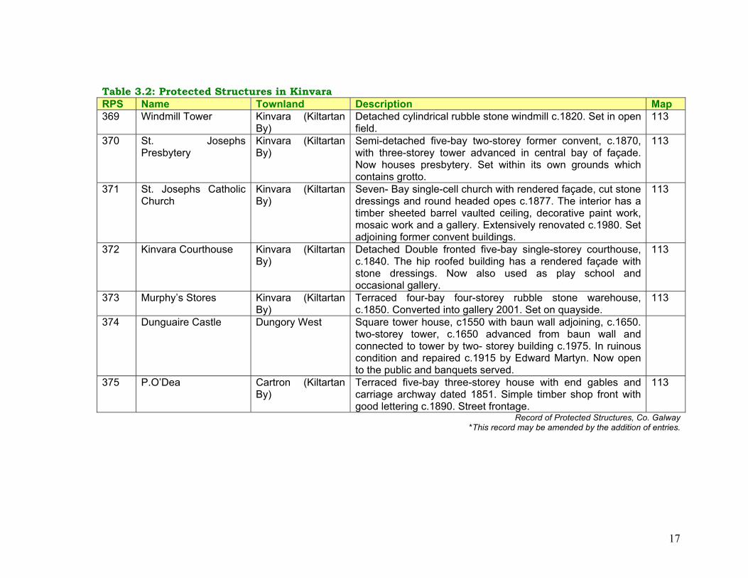
17
Table 3.2: Protected Structures in Kinvara RPS Name Townland Description Map 369 Windmill Tower Kinvara (Kiltartan
By) Detached cylindrical rubble stone windmill c.1820. Set in open field.
113
370 St. Josephs Presbytery
Kinvara (Kiltartan By)
Semi-detached five-bay two-storey former convent, c.1870, with three-storey tower advanced in central bay of façade. Now houses presbytery. Set within its own grounds which contains grotto.
113
371 St. Josephs Catholic Church
Kinvara (Kiltartan By)
Seven- Bay single-cell church with rendered façade, cut stone dressings and round headed opes c.1877. The interior has a timber sheeted barrel vaulted ceiling, decorative paint work, mosaic work and a gallery. Extensively renovated c.1980. Set adjoining former convent buildings.
113
372 Kinvara Courthouse Kinvara (Kiltartan By)
Detached Double fronted five-bay single-storey courthouse, c.1840. The hip roofed building has a rendered façade with stone dressings. Now also used as play school and occasional gallery.
113
373 Murphy’s Stores Kinvara (Kiltartan By)
Terraced four-bay four-storey rubble stone warehouse, c.1850. Converted into gallery 2001. Set on quayside.
113
374 Dunguaire Castle Dungory West Square tower house, c1550 with baun wall adjoining, c.1650. two-storey tower, c.1650 advanced from baun wall and connected to tower by two- storey building c.1975. In ruinous condition and repaired c.1915 by Edward Martyn. Now open to the public and banquets served.
375 P.O’Dea Cartron (Kiltartan By)
Terraced five-bay three-storey house with end gables and carriage archway dated 1851. Simple timber shop front with good lettering c.1890. Street frontage.
113
Record of Protected Structures, Co. Galway *This record may be amended by the addition of entries.

18
3.2 Transportation Kinvara is situated on the controlled Kilcolgan to Tarbet National Secondary Route (N67). A network of local roads also link Kinvara to Doorus, Mountscribe, Gort, Ardrahan and North Clare. As part of the ongoing roads improvement programme, the realignment of the N18 has been identified 4 miles to the east of the village (Figure 2.1). Kinvara’s location on the National Secondary Route brings traffic through the village particularly during the tourist season. To facilitate the growth of Kinvara and improve accessibility for locals and visitors, there is a need for improved traffic management and circulation, environmental enhancements and the development of car and bus parking facilities. The Plan outlines policies and objectives to improve traffic management in the village, for example, it contains proposals to develop a safe and integrated transport network, traffic calming measures and have safe routes to schools. It also proposes to improve and further pedestrian routes that link different lands uses, thereby encouraging walking as an alternative to the car. Car parking provision is on street and at private developments. There is also a small private car park across the road from the castle. The Plan aims to improve parking management and develop parking facilities convenient to the village centre at the rear of the Market Square and possibly at the harbour. It is also recommended that any parking proposals are sensitively designed to integrate into the surrounding. The introduction of traffic management bylaws for car parking will also be investigated.
The Plan also contains a proposal to expand the village core in a consolidated manner through the creation of additional streets to the rear of Market Square and Main Street. This is detailed in section 3.8, 4.9 and section 5 of the Plan, this proposal will also improve traffic circulation,
Public Transport The Bus Éireann No. 50 bus service serves the village, it provides transport to Galway four times Monday to Saturday and from Galway five times. Transport is provided to and from Galway twice on Sundays via this service. It is recommended that further development of public transportation services are examined in the context of a separate project for the area. 3.3 Harbour and Bay Area Prior to road improvements most people came and went to Kinvara by boat, trade also took place by boat with Galway City and Connemara. The harbour area has always being a focal point. The pier itself, green areas and buildings add to the distinct character of this coastal village. To increase its profile, the Plan contains proposals to develop this focal point as a working harbour for social and leisure use. This is to be achieved primarily through the preparation of a harbour scheme to manage protect and enhance the harbour in consultation with stakeholders and in a sensitive manner. The scheme includes proposals to provide facilities for a working harbour and for leisure use and further explore options for the development of the harbour. Proposals are also included to develop a civic space at the junction with the Main

19
Street, this space would incorporate a drop off/collection point for buses. In addition, the report ‘Water Based Tourism – A Strategic Vision for Galway, April 20025’ supports the development of Kinvara as a destination for appropriate water based events. Further details on this are included in section 3.9 relating to enterprise and tourism.
Figure 3.2: The Harbour Area Source: Kinvara Integrated Area Plan 2003, Appendices.
05 This report was prepared for a consortium of agencies in collaboration with Ireland West Tourism, agencies included Galway County Council.
3.4 Water, Wastewater and Surface Water Kinvara is served by the Kinvara Public Water Supply. The source is not adequate to serve the needs of Kinvara within the period of the Local Area Plan, however it is intended that water will be supplied by the Gort Regional Water Supply Scheme. This scheme is identified under the Water Services Investment Programme 2003-2005 and is to start in 2005. Effluent from the village is disposed of either by the public sewerage network, with direct discharge to the sea or by private wastewater treatment systems/septic tanks. The Kinvara Integrated Area Plan identified that the current water quality of Kinvara Bay limits the potential participation and enjoyment by the community and visitors in water borne leisure activities. Kinvara Bay is part of the Galway Bay NHA/SAC Complex. Under the Shellfish Water Regulations the Bay is designated as ‘shellfish water’. Currently waters of the bay do not conform with the standards required by these regulations. The quality of the water has deteriorated over the years due to point and defuse sources of pollution. To address these deficiencies the community identified that: A sewerage treatment plant is required. A Preliminary Report for a new secondary sewerage treatment plant6 and improvements to the sewerage network was commissioned and completed on behalf of Galway County Council. The scheme is designed so that tertiary facilities could be facilitated if required in the future. The Preliminary Report was 6 The scheme has a design capacity of 2,123 P.E. Source: Galway County Councils Assessment of Needs Document, October 2003.
20
submitted to the DoEHLG and the Council is awaiting approval to proceed with the scheme. The Kinvara Sewerage Scheme has been included in the Water Services Investment Programme 2004 – 2006 and is to commence in 2006. Galway County Council shall endeavour to meet the target of the Water Services Investment Programme and have the scheme completed within the lifetime of this Plan. Under the EU Water Framework Directive Ireland is required to ensure that all waters including rivers, lakes, esturies, coastal waters and groundwaters achieve “good status by 2015. Galway County Council is the coordinating authority for the Western River Basin District, which includes the Kinvara area and its catchment. A Western River Basin Catchment Management Plan will be prepared which will detail the pressures on the water bodies within the catchment and set out mitigation measures to be implemented. The Kinvara Local Area Plan contains policies and objectives to encourage the revitalisation of the village centre through refurbishment and further development of the area within the catchment area of the existing sewerage network defined as the area between the National school and Convent road to the west, Seamount College to the east and the old water tower on the Gort Road to the south. Development of a more substantial nature will be required to provide treatment in accordance with EPA Wastewater Treatment Manuals, the requirements set out in section 4.5 and section 6.2 of the Plan. Surface water within the village is collected into the existing sewerage network or privately disposed of within a site. Plans to upgrade the system include provision for a separate collections system for surface water within the catchment area of the existing sewerage network.
3.5 Communication Infrastructure Kinvara is served by Eircom via digital exchange. Mobile telecommunication operators also cover the area. The community is currently examining the development of a Group Broadband Scheme (GBS) for Kinvara. The development of Information and Communication Technologies (ICT) is considered a key factor in facilitating social and economic progress. This Plan aims to facilitate the development of communication infrastructure in a manner that does not detract from residential amenities, environmental quality and public health. 3.6 Litter and Waste Management Waste management in the County is governed by the Connaught Waste Management Plan 2001. Best practice waste management recommends that as much waste as possible is dealt with by reduction, reuse and recycling and with as little as possible remaining to be disposed of. A bring bank facility for green, brown and clear glass and beverage cans is located in a lay-by off the N67 and near the school. Segregated dry waste including paper, cardboard, plastics, tetrapak and food cans is collected every second week by private contractors. Galway County Council is working with the private operators in County Galway to ensure that the segregated collection system is extended to include organic waste. Construction and demolition waste is also collected by private contractors in the area. The Plan aims to support the provision of waste infrastructure at locations which
21
will not adversely affect residential amenities. The Council also intends to provide the necessary information for reduction, reuse and recycling of waste from residential and commercial premises including details on waste segregation, waste management, packaging, construction and demolition waste. There is great awareness and community involvement in maintaining Kinvara and presenting a clean and attractive environment. For example, through tidy town initiatives, promoting anti-litter and clean up activities and through the Green School Programme. In 2004, St Josephs National School achieved a Green Flag Award for their achievements in this programme. 3.7 Energy A high percentage of the energy sources currently used in Kinvara are non-renewable and cause significant damage to the environment. Initiatives and measures for reducing the energy requirements of buildings and encouraging the development of renewable energy sources are strongly supported. Such measures must be consistent with other policies and objectives in the plan. The development of energy infrastructure is identified as a key factor for economic development. The Plan aims to seek a balance between the need to maintain and develop energy infrastructure while having regard to amenities, protected areas and sensitive landscape. 3.8 Built Environment
Kinvara has been identified on the fourth tier of the G.T.P.S. Settlement Hierarchy in the County Development Plan 2003-2009. A scale of growth that reflects the status of Kinvara as a village on this tier is promoted.
The urban form of Kinvara has evolved through time and contributes to the character and local distinctiveness of the area. Development that is integrated into the urban form and does not detract from the character of the area is promoted. The principal characteristics of Kinvara’s urban form were identified in the Kinvara Integrated Area Plan 2003. They are: Topographical: The changing elevations of the land within Kinvara and its surrounding area provide interest and variation within the built form. Street form: In general Kinvara’s street pattern, with the exception of the harbour area, is of relatively narrow winding streets that provide an unfolding pattern of views and experiences. In addition, there are a number of nodes such as squares and similar open areas that provide a sense of arrival for the pedestrian. Building Form: One of the characteristic features of Kinvara is that, generally, buildings in the central part of the village are of simple shapes and have narrow frontages. This gives a vertical feeling to the buildings within the village. In addition, the roof profiles and building heights give a high degree of variation in the skyline profile of the village. Building Materials: The building materials used in Kinvara are a mixture of slate, stone, plaster and wood as well as the occasional use of thatch.

22
Figure 3.3: Kinvara Village Source: Kinvara Integrated Area Plan 2003, Appendices.
The Plan aims to revitalise and enhance the village centre. This is to be achieved through a number of measures including encouraging the renewal of derelict sites, backland areas and street infill in a manner that is sympathetic to the character of the surrounding area. The commercial core of the village has been identified as Main Street, Harbour area, the streets linking these areas and around the Market Square. Further commercial activity in this area is promoted along with the development of the Harbour area and Market Square as focal points. This Plan aims to, where appropriate and within financial constraints, enhance the village centre through environmental improvements and the provision of a satisfactory level of car parking. It is also proposed to expand the village on lands to the rear of the Market Square and Main Street through the creation of additional streets. Lands in this area have also been identified for community, recreation and amenity uses. Housing The Kinvara Integrated Area Plan stated that as developments have taken place in Kinvara, social and affordable housing provision has not kept pace with mainstream developments. There was a very obvious sense within the community of a commitment to social issues and a belief that nobody within Kinvara should experience marginalisation. This is in line with the aims of Galway County Councils Housing Strategy which

23
sets out recommendations to meet existing and future housing demands for everyone.7 In addition, the village’s easy access to Galway and other towns means commuters and people looking for second homes have come to Kinvara. This has resulted in a concern for the lack of affordable housing in the village, particularly for young people. The Plan aims to ensure that locals are given due consideration in the development of housing. New residential development will be considered in the context of the existing settlement pattern. The Plan promotes the permanent occupancy of the village centre, high density within the village centre (mixed development) zone, medium density within the village centre (residential) zone and clustered type housing in remaining residential areas. The Plan also promotes that all new residential developments make provision for managed open space, play space and other informal recreational facilities. 3.9 Enterprise and Tourism The Kinvara Integrated Area Plan identified that in the past due to the combination of its location and natural resource base, Kinvara exhibited many characteristics of a sustainable entity and was able to support a broad range of enterprises. Policy changes in agriculture allied to resource management issues, changing markets and transport practices meant that for a good part of the last century Kinvara became increasingly economically dependent on outside resources. It is likely that in the immediate future this dependency will remain (for 7 The County Galway Housing Strategy was adopted on the 12th October 2001
example Galway city based employment opportunities). This, together with the seasonal nature of tourism will largely determine Kinvara’s social and economic development patterns. There is renewed interest in areas such as healthcare, holistic medicine, recreational and activity based holidays to suggest that further enterprise activities in these or similar areas should be supported. The existence of several e-businesses in the locality indicates the opportunity for such enterprise in the area. This Plan recommends that small-scale enterprise development be accommodated within Kinvara. Approximately 12.1 acres has been designated for enterprise of which 11.6 acres are undeveloped, 2.4 acres have been designated for tourism related development. Cottage industries in residential areas shall also be considered on their own merits through the development control process. In more recent times Kinvara has developed as a tourist destination. This can be attributed to factors including Kinvara’s scenic and coastal location, its proximity to Galway City and the Burren, the presence of Dunguaire Castle, the hosting of festivals, Kinvara’s reputation for music and good cuisine, surrounding countryside and proximity to Trácht beach. The village has potential to further develop as a destination and a base for visiting the surrounding area, it is envisaged that tourism development will contribute to the social and economic development of the village. The Plan aims to realize the tourism potential of Kinvara in a sensitive and sustainable manner. For example, Dunguaire Castle is a symbol for Kinvara and County Galway. Therefore the Plan aims to strengthen tourism links between the village and castle and develop the amenity value of this area.

24
Mechanisms to achieve this include the provision of improved parking facilities at both locations together with a walkway linking them. Tourism related services are primarily encouraged within the village centre, the Plan also allows for the development of a country market at the Market Square and appropriate tourism and parking facilities at Dunguaire Castle. Kinvara hosts 2 main festivals. Cruinniú na mBád - The Gathering of the Sails celebrates what used to be the main stay in Kinvara, the exchange of turf and goods. During the festival turf is brought in from An Chreathrú Rua - Carraroe on traditional boats - the hooker, gleoteóg and pucan and a number of sporting events take place in the bay. An Tarab Bo -a traditional music festival runs in conjunction with this event. Fleadh na gCuach – The Cuckoo Festival celebrates Kinvara’s culture through poetry, song, dance and literature. This takes place throughout the village including outdoors, public houses and in the community centre. The Plan supports the development of these local festivals and events in recognition of the contribution they make. In addition, the report ‘Water Based Tourism – A Strategic Vision for Galway, April 20028’ supports the development of Kinvara as a destination for appropriate water based events. It recommends that ‘in line with the Galway Coastal Audit, priority should be given to improving access to the water and providing mooring facilities for visiting boats. Private sector operators should be encouraged to establish a cluster of water based tourism products and activities, ideally linked to 8 This report was prepared for a consortium of agencies in collaboration with Ireland West Tourism, agencies included Galway County Council.
accommodation in and around Kinvara’. The report specifically suggests that water based tourism should build on the annual Cruinniú na mBád Festival – The Gathering of the Sails by encouraging further gatherings of traditional crafts and appropriate shore based events.
Figure 3.4: Sailing Boats moored in Kinvara Bay Source: Kinvara Integrated Area Plan 2003, Appendices.

25
3.10 Education and Community Facilities There is one playgroup in Kinvara village, located in the Courthouse. Additionally there is one national school, St Joseph’s National School. In September 2004 this school has approximately 180 pupils and has plans to extend. Doorus and Northampton national schools also serve Kinvara and the surrounding area, Doorus National School also contains a playgroup. The village is served by a secondary school for girls, Seamount College, in September 2004 this school has approximately 230 pupils. Boys travel to Gort for their secondary education. Night classes are held in Seamount College during the school year and there are plans to develop a life long learning programme. The Kinvara Integrated Area Plan outlined that the population of Kinvara is continuing to grow at a steady rate, this fact along with the population growth of surrounding areas, points to the need for an increased range of educational facilities over the coming years. In particular the IAP envisaged that second level educational opportunities should be available to boys as well as girls who live in the area. It outlined that options available include an expansion of the present school or the provision of a new second level institution with a broad range of facilities that can be accessed by the community at large for educational and recreational needs. This Plan therefore allows for both scenarios, it facilitates the provision and expansion of education facilities at locations where optimum community benefit can be gained. Education facilities that are integrated with the development of sport and leisure facilities are also promoted. The Plan also outlines proposals to develop safe and integrated transport routes and drop off and collection points at schools.
St. Josephs Church, national school and the community centre, which are important community facilities, are centrally located within the village. St. Colman’s Church, located on the outskirts is used once a week and for events such as concerts. Kinvara is also linked to other settlements in the provision of community services, for example the Church of Ireland in Ardrahan also serves Kinvara. The Plan contains proposals to facilitate the development of community facilities at central locations. In particular the Kinvara Integrated Area Plan outlines that the community centre is used for a wide range of activities such as school plays, recreational activities, community meetings, sale events etc. During the preparation of the community plan, the need for redevelopment of the community centre which could cater for an increased range of activities was often referred to. This has lead to a drive by the community to raise funds for the development of the community centre, which can better accommodate community requirements. The Local Area Plan contains an objective to facilitate the development of the community centre on its current site or in its vicinity.
Approximately 17.5 acres have been zoned for community facilities of which 7.5 acres are undeveloped. The development of recreation use linked with education facilities, for example playing pitches are permitted on land zoned for community facilities.

26
3.11 Recreation and Amenity Facilities The Kinvara Integrated Area Plan observed that in the past the bay area was the main focal point of recreational activity for locals and visitors to the area. It envisages that the harbour and bay area would once again become the main focal point of recreational activities within the village, this would be complemented by other recreational opportunities. This is dependent on the development of the Kinvara Sewerage Scheme and harbour management. Policies and objectives are contained in this Plan to achieve this aim. Kinvara Bay, Dunguaire Castle and surrounds provide a very attractive entrance to Kinvara on the Galway approach. Taking this, the protected status of structures and the bay and the visual amenity of the area into consideration, the Plan seeks to improve public access where possible along the coast and promote this areas amenity value in a sensitive manner. This proposal involves the development of a walk along the bay linking the castle to the village. This could in time become part of a longer pedestrian route linking Kinvara to Trácht Beach and Tarrea Pier. Land has also been identified for the development of a village park at a central location to the rear of Market Square. A range of recreation and amenity facilities available in Kinvara were identified in the Kinvara Integrated Area Plan. For example, a number of different activities take place at the community centre including badminton, Irish dancing, music
lessons, kickboxing, Karate and drama, the Youth Club and Brownies. There are GAA, soccer and hockey clubs, the GAA has its own premises on the outskirts of the village. Other recreational activities include walking and sailing. The Plan promotes the development of a child friendly environment and contains policies and objectives to promote and develop the recreation potential of the village in co-operation with all stakeholders. Approximately 8 acres have been zoned for recreation and amenity facilities. The development of a children’s playground and recreation and amenity uses such as a playing pitch is also permitted within most land use zoning categories.

27
SECTION FOUR - POLICIES AND OBJECTIVES 4.1 Introduction This section outlines the policies and objectives in relation to the future development of Kinvara. They support policies and objectives outlined in the County Development Plan 2003-2009, in some cases they are additional to those identified in this Plan. Policies and objectives are categorized, commencing with those relating to heritage then infrastructure and facilities to support development, it concludes with those related to the development of different land uses. 4.2 Heritage 4.3 Transportation 4.4 Harbour and Bay Area 4.5 Water, Sewerage and Surface Water 4.6 Communication Infrastructure 4.7 Litter and Waste Management 4.8 Energy 4.9 Built Environment 4.10 Enterprise and Tourism 4.11 Education and Community Facilities 4.12 Recreation and Amenity Section 4 is to be read in conjunction with accompanying maps (Appendix 7.7), Section 5 Design Framework Guidelines and Section 6 Development Control Standards. Where policy is not provided the Planning Authority shall refer to the County Development Plan 2003-2009.
4.2 Heritage Policies 4.2.1 Manage, protect and enhance the natural, built and
cultural heritage of Kinvara where possible. 4.2.2 Maintain and protect views around Kinvara Bay which
enhance the setting of the village. 4.2.3 Protect and conserve habitats and species that have
been identified in the Habitat Directive, Birds Directive, Wildlife Act 2000 or which may be issued during the lifetime of this Plan.
4.2.4 Promote the retention of individual trees and groups of trees, hedgerows, stonewalls and other associated habitat and landscape features where possible.
4.2.5 Protect and conserve ecological networks and prevent loss and fragmentation of ecological corridors, e.g. along and interconnecting the coast and watercourses.
4.2.6 Promote greater habitat and species biodiversity through the planting of trees and shrubs native to the Kinvara area.
4.2.7 Where boundaries have to be removed and are to be replaced, replace with boundary types similar to those removed, for example, masonry stone walls.
4.2.8 Protect and preserve archaeological sites, including underwater archaeological sites, which have been identified subsequent to the publication of the Record of Monuments and Places.
4.2.9 Protect structures included in the Record of Protected Structures (RPS) that are of special architectural, historical, archaeological, artistic, cultural, scientific,

28
social or technical interest, together with the integrity of their character and setting.
4.2.10 Prohibit developments which would destroy or damage, or cause inappropriate change to protected sites / monuments, structures and designated sites.
4.2.11 Respect built environment features which add to the character of the village.
4.2.12 Protect quality architectural details such as traditional shop fronts and signs, original windows, limestone doorcases.
4.2.13 Safeguard Dunguaire Castle and its immediate environs to ensure its survival.
4.2.14 Consult with the Heritage Section of the DoEHLG in relation to proposed developments affecting protected structures, sites / monuments and designated sites.
4.2.15 Consult with the National Parks and Wildlife Service of the DoEHLG in relation to any proposed developments in or near designated sites.
4.2.16 Encourage the creation, development and maintenance of green corridors where possible.
4.2.17 Protect and conserve surface water features as open water bodies and prevent the creation of barriers to species movements.
4.2.18 Set new development back from watercourses. 4.2.19 Protect bats and their roosts, in particular in the
redevelopment and demolition of existing buildings.
Objectives H1 Provide guidance to the community in the
implementation of a heritage awareness programme. H2 Require residential developments to reflect Kinvara’s
cultural heritage by the use of local place names, or topographical features as appropriate and to
incorporate townland names from the locality as far as possible.
H3 Ensure that there is greater habitat and species diversity through the planting of trees, shrubs and hedges indigenous to the Kinvara area (including those identified in appendix 7.4) in public and private places.
H4 Protect views identified in Map 2. H5 Where lands are zoned for development, regard shall
be given to views of the Burren, the coast and other significant aspects and the creation of vistas.
H6 Protect designated sites (cSAC’s, SPA’s, NHA’s) on Map 2, and any future sites designated in the lifetime of the Plan, and other important biodiversity areas.
H7 Protect sites and monuments included in the Record of Monuments and Places (RMP) identified in Table 3.1 and Map 2.
H8 Protect structures included in the Record of Protected Structures (RPS), identified in Table 3.2 and Map 3.
H9 Take cognisance of built environment features which contribute to the local character of the area (Map 3).
H10 Seek to retain trees which add to the local character of the area.
H11 Liaise with stakeholders including the ESB and NRA to ensure that important views and the setting of the village is protected.
H12 Investigate the possibility of controlled access to the ruins of St Colman's Church.

29
4.3 Transportation Policies 4.3.1 Facilitate improved transport links serving Kinvara. 4.3.2 Improve entrances to Kinvara through road
improvements, landscaping and maintenance of grass verges, where resources permit.
4.3.3 Co-operate with transport providers and community groups in the development of an integrated transport network.
4.3.4 Facilitate movement of people and goods into, through and out of Kinvara at a safe pace.
4.3.5 Expand the village core in a consolidated manner through the creation of new streets near the village centre.
4.3.6 Encourage a better environment for pedestrians and cyclists through:
• Providing a choice for making journeys, • Promoting walking and cycling as an
alternative to the car particularly for short journeys,
• Developing footpaths and ensuring that they are suitable for those with special mobility needs,
• Encouraging new pedestrian routes to link residential areas to different land uses,
• Improving signage. 4.3.7 Improve traffic management through:
• Improving traffic circulation, • Developing public parking facilities, • Providing loading and unloading facilities, • Improving road signage.
4.3.8 Ensure all new developments are properly located in terms of traffic safety.
4.3.9 Ensure all new developments are adequately served by car parking, disabled parking and cycling facilities.
4.3.10 Encourage the provision of underground car parking where appropriate in central areas where it would not conflict with residential amenity, geological and archaeological sensitivities or traffic safety.
4.3.11 Promote and facilitate greater ease of traffic movement and safe routes to schools in partnership with the local schools.
4.3.12 Ensure that schools have safe drop off /collection facilities for pedestrians, vehicles and cyclists and adequate and appropriately located staff parking facilities.
Objectives: T1 Improve road signage. T2 Improve car parking management within the village
centre and explore possibility of a ‘pay and display system’.
T3 Provide disabled car parking facilities with ease of access at appropriate locations throughout the village.
T4 Reserve routes to facilitate the creation of new streets near the village centre.
T5 Reserve access points for the future development of backlands.
T6 Reserve lands to the rear of Market Square for the development of a car park.
T7 Develop a coastal walk along the bay linking Dunguaire Castle with the village centre in co-operation with stakeholders. The walkway shall be carefully designed so as to ensure safety and assimilation onto the landscape and enhance public amenity of the coastal
30
setting. T8 Examine the possible redesign of roadway
intersections which meet at the Post Office and the junction of the N67 and R347 (linking Kinvara to Ardrahan).
T9 Require a safety audit in respect to stone walls on public roads.
T10 Assess additional traffic management measures including:
• Traffic calming measures such as the development of shared surface areas at Market Square and the Harbour Area,
• Pedestrian crossings, • The provision of cycle ways, • Traffic management bylaws for car parking (one
side parking, parking controls, loading bays) in tandem with the development of parking facilities and pay and display facilities,
• Increased car/bus parking across from Dunguaire Castle.
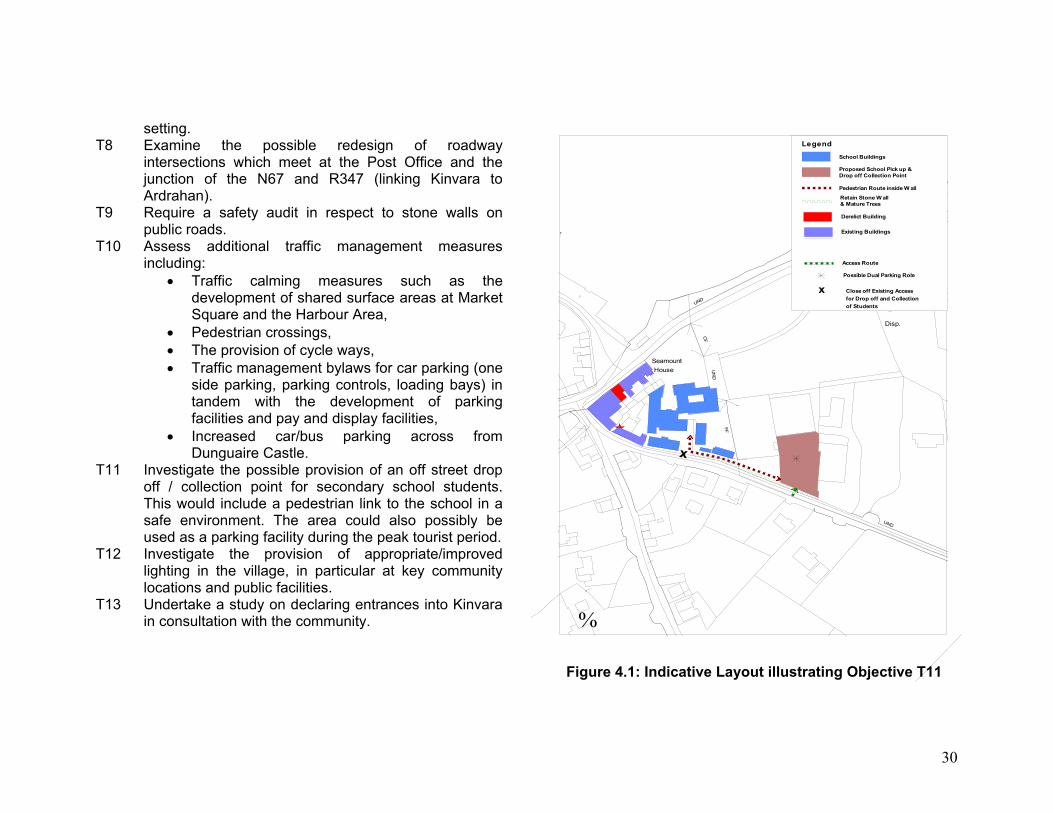
T11 Investigate the possible provision of an off street drop off / collection point for secondary school students. This would include a pedestrian link to the school in a safe environment. The area could also possibly be used as a parking facility during the peak tourist period.
T12 Investigate the provision of appropriate/improved lighting in the village, in particular at key community locations and public facilities.
T13 Undertake a study on declaring entrances into Kinvara in consultation with the community.
UND
Disp.
Seamount House
HWMHWMHWM
UN
D
FF
UND
CF
PO
nvarra
x
%
Legend
Possible Dual Parking Role
Access Route
Existing Buildings
Region
Derelict Building
Proposed School Pick up & Drop off Collection Point
Pedestrian Route inside W all
Retain Stone W all& Mature Trees
School Buildings
xxxxxxxxx Close off Existing AccessClose off Existing AccessClose off Existing AccessClose off Existing AccessClose off Existing AccessClose off Existing AccessClose off Existing AccessClose off Existing AccessClose off Existing Accessfor Drop off and Collectionfor Drop off and Collectionfor Drop off and Collectionfor Drop off and Collectionfor Drop off and Collectionfor Drop off and Collectionfor Drop off and Collectionfor Drop off and Collectionfor Drop off and Collectionof Studentsof Studentsof Studentsof Studentsof Studentsof Studentsof Studentsof Studentsof Students
Figure 4.1: Indicative Layout illustrating Objective T11

31
4.4 Harbour and Bay Area
Policies 4.4.1 Manage, protect and enhance the seaside character of
Kinvara. 4.3.2 Develop this area as a village focal point. 4.3.3. Develop it as a working harbour and for social and
leisure use in consultation with the local community and stakeholders.
4.3.4 Any development proposal shall have regard to residential amenities of the area, the character of the harbour, the conservation status of the bay and scientific grounds for this status.
Objectives
HB1 Prepare a Harbour Scheme in an environmentally sensitive manner to manage, protect and enhance the harbour in consultation with statutory bodies and stakeholders (including community, County Council Marine Section, Heritage Division DoEHLG, Dept Marine & Natural Resources, NPWS).
HB2 Provide adequate infrastructure at the harbour including power points, water and waste disposal facilities.
HB3 Provide clear signage and markings for access to slip way and harbour.
HB4 Reconfigure an area to the front of the quay to revise road layout and provide a shared surface space.
HB5 Resurface road and improve on street car parking. HB6 Improve accessibility for disabled persons. HB7 Demarcate green area with new kerb and seating.
HB8 Develop a civic space area (shared surface) at the junction to the Main Street. Include seating at this location.
HB9 Provide a bus drop-off/collection point near junction to Main Street.
HB10 In the preparation of this scheme consider the development of the following:
• Mooring facilities north west of the harbour, • Appropriate water based activities, building on
the boating tradition, • The possibility of developing a car park as part
of mooring facility.

32
Seamou House
PO
Mooring Posts
Kinvarra
Quay
(in ruins)Church
HB9HB9HB9HB9HB9HB9HB9HB9HB9HB8HB8HB8HB8HB8HB8HB8HB8HB8
HB4HB4HB4HB4HB4HB4HB4HB4HB4
HB10HB10HB10HB10HB10HB10HB10HB10HB10
Kinvara
%
Figure 4.2: Indicative Layout illustrating Harbour Objectives
4.5 Water, Wastewater and Surface Water Policies 4.5.1 Facilitate the continued provision of a potable water
supply to all new and existing developments within the Plan area boundary.
4.5.2 Develop a new wastewater collection and treatment system with secondary treatment facilities for Kinvara.
4.5.3 Develop a separate surface water collection system that is adequate to cater for maximum flood levels.
4.5.4 Protect nature designations and protected species through assessing the implications of any developments in the village on their resource value.
4.5.5 Prohibit any proposed development which would pose an unacceptable threat to the capacity of water, wastewater and surface water infrastructure.
4.5.6 Ensure that commercial and industrial premises discharging wastewater are operating under and in accordance with a wastewater discharge licence.
4.5.7 Ensure that all existing small scale and individual wastewater treatment plants are adequately sized, installed and maintained.
Objectives
WS1 Ensure that the Kinvara Sewerage Scheme is completed during the lifetime of this Plan.
WS2 Ensure the new wastewater treatment is of a standard allowing for sustainable management of water quality in the receiving SAC/NHA/SPA complex and designated shellfish waters.
WS3 New developments, of small infill, refurbishment, extension to existing development or similar nature, within the catchment area of the existing sewerage

33
network may be connected directly to the existing sewer. This is to facilitate the objective of revitalising the village centre.
WS4 Development of a more substantial nature, other than set out above, either inside or outside of this area will be required to provide treatment in accordance with EPA Wastewater treatment manuals and development control standards (section 6.2.4).
WS5 Ensure all new developments served by public sewer are constructed with separate surface and foul water sewers to assist and optimise the use of the existing collection system and any future wastewater sewage system.
WS6 Ensure future developments within the Plan boundary make provision for connection to the new wastewater treatment system.
WS7 Implement a monitoring programme to assess the impact of development on the bay’s water quality.
WS8 Ensure that the proposed water supply from the Gort Regional Water Supply Scheme is implemented within the lifetime of the Plan.
WS9 Have regard to the objectives and implement recommendations of the forthcoming Western River Basin Management Plan.
4.6 Communication Infrastructure Policies 4.6.1 Facilitate Information Communication Technologies
including the development of broadband infrastructure. 4.6.2 Achieve a balance between facilitating the provision of
telecommunications services in the interests of social and economic progress and sustaining residential amenities, environmental quality and public health.
Objective
CI1 The location of masts close to schools and residential
areas will be discouraged. 4.7 Litter and Waste Management Policies: 4.7.1 Develop Kinvara as a minimum waste community. 4.7.2 Promote waste reduction and new methods relating to
waste management through reduction, re-use, recycling and composting.
4.7.3 Ensure that new developments provide adequate storage facilities for segregated waste. Such facilities should be visually unobtrusive.
4.7.4 Maintain Kinvara’s image as a clean environmentally friendly town.
4.7.5 Support anti-litter and clean up activities including the Tidy Town and National Spring Clean events.
Objectives:
LW1 Provide information on reduction, reuse, recycling and collection methods for all types of waste.

34
LW2 Ensure that waste infrastructure is developed to serve the area.
LW3 Provide information to schools through the Green Schools program and develop program.
LW4 Provide information on the role of the Community Warden.
LW5 Provide information to the public on water management and measures to protect natural water bodies.
4.8 Energy
Policy 4.8.1 Support the renewal and development of energy
infrastructure, having regard to residential amenities and landscape sensitivities.
4.8.2 Promote energy conservation measures and facilitate innovative building design that promotes efficiency and the use of renewable energy sources.
Objectives
E1 Provide information on cost-effective energy conservation measures and renewable energy technologies, including the use of passive solar design principals, solar panels and geothermal heat pumps.
E2 Provide information to community on the development of a community heating system.
E3 In order to improve the energy efficiency of building designs developers will be required to ensure that all new developments incorporate passive solar design techniques. Techniques that should be incorporated include: • Orientation of dwellings such that the rooms with
the highest heating requirements (living and dining
areas) are within +/- 25% of due south. Windows to the north to be minimised,
• Provision of adequate spacing to minimise shading, • Design of landscaping to provide shelter from
prevailing wind, • Use of compact building forms • Use of sustainable construction materials and
technologies. 4.9 Built Environment
General Policies
4.9.1 Promote the revitalisation of the village centre in a manner that is sympathetic to the character of its surrounds through:
• Promoting the redevelopment of derelict, obsolete and brownfield sites,
• Encouraging the strengthening of the streetscape and continuity of the urban grain9,
• Encouraging the development of backlands where proposals contribute to and enhance the character of the village. Only proposals that are part of an Action Plan for a specific area will be considered,
• Exercising Council powers vested under the Derelict Sites Act.
4.9.2 Ensure that existing buildings which contribute to the character of the area are refurbished rather than demolished. Consideration may only be given to demolition where it is demonstrated that a proposal is
9 Urban Grain is determined by the pattern of plot divisions, building form and building line. An example is highlighted on figure 5.4.

35
structurally unsound, have a otherwise sustainable valid reason for its removal.
4.9.3 Ensure that new development and redevelopment respects and complements the existing character of an area in terms of scale, height, layout, grouping, function, design and materials.
4.9.4 Expand the village through the creation of new streets to the rear of Market Square and Main Street.
4.9.5 When considering courtyard or car park developments surrounded by buildings, require front and rear façades to be treated with equal prominence and design aesthetics.
4.9.6 Seek to improve the overall streetscape/physical environment in the village centre, for example through encouraging underground wiring, appropriate street furniture and through environmental improvements.
4.9.7 Encourage commercial development and services for tourists to locate within the village centre.
4.9.8 Require all developments to take into account the residential amenity of existing residential areas (in particular amenities affected by noise or traffic).
Residential Policies
4.9.9 Encourage development of an appropriate density, scale and population that reflects the status of the Kinvara on the fourth tier of the County Galway Development Plan Settlement Hierarchy.
4.9.10 Encourage the permanent occupancy of residential areas within the village centre to maintain its vibrancy.
4.9.11 Discourage the subdivision of existing town houses into multiple premises to facilitate a mix of development, a family friendly environment and the permanent occupancy of the village centre.
4.9.12 Ensure that there is an effective mix of commercial and residential development along the streetscape in the village centre (mixed development) zone in the interest of commercial vitality.
4.9.13 Ensure that new residential developments make provision for managed open space, play space and other informal recreational facilities.
4.9.14 The following density guidelines shall apply (refer also to development standards in section 6.1) • High density on land zoned village centre (mixed
development) • Medium density on land zoned village centre
(residential) • Outside this area, further residential development
will be based on the cluster concept. 4.9.15 Proposals for single houses in residential areas will
only be considered where they do not compromise the development of backlands or integration of new development into the village.
4.9.16 Ensure that people with an intrinsic connection to the area are given due consideration in the development of housing.
4.9.17 For all residential developments, require a minimum of 25% of the total number of units be made available for people who qualify for essential housing need as defined by the County Development Plan 2003 -2009.
Housing Strategy
4.9.18 Promote a socially inclusive community open to other cultures, languages and groups within society
4.9.19 Facilitate the development of an appropriate mix of housing opportunities including rental, social, shared ownership and affordable housing.

36
4.9.20 Give preference to local people in the allocation of Council housing and accommodation.
4.9.21 Ensure that appropriate units are developed in the housing market for the elderly, people with disabilities and other special needs as close as practically possible to the village centre. Objectives
BE1 Take cognisance of the principles in the Design Framework Guidelines outlined in section 5.
BE2 Prepare a scheme to enhance Market Square in consultation with stakeholders that shall: • Promote the enhancement of buildings facing
Market Square, • Promote a mix of residential and commercial
development, • Consider the following:
- The extension of Market Square hence creating a second square. These areas to be framed by buildings,
- The development of a shared surface in both Squares,
- The inclusion of space for the development of a country market on designated days.
BE3 Provide where funds permit, environmental improvements, improved accessibility and car parking provision.
BE4 Examine all applications for retail development in the context of the ‘Retail Planning Guidelines’ by the DoELG. This will be augmented by the Retail Strategy, which the Council is preparing.
BE5 Require developers to take cognisance of the natural features that define the character of site in the context of
its surrounding environment (including topography, aspect, foliage, geological features).
BE6 Require developers to make appropriate provision for recreation and amenity infrastructure equal to the needs of the development and as an integral element of their proposals. A special levy may be required to enable the development of appropriate amenity areas off site under powers set out in the Development Contribution Scheme.
BE7 Require Action Plans for development of backlands, in the Market Square area and to the rear of Main Street (as outlined in section 5).
BE8 Encourage residential development in village centre zones and residential land (phase 1) having regard to the village ethos and without being unreasonably inconsistent with the County Development Plan Settlement Strategy
BE8 Designate lands as residential (phase 2) which shall remain undeveloped until the County Development Plan Settlement Strategy is reviewed.
BE9 Implement the provisions of Part V of the Planning and Development Acts and Housing Strategy on lands designated for mixed development (village centre zoning) and residential development. The County Housing Strategy forms part of and is to be read in conjunction with this Plan.
BE10 Identify and acquire appropriate lands for social and affordable housing as necessary.
BE11 Identify a site for housing for the elderly as close as practically possible to the village centre.
BE12 Provide social and affordable housing in accordance with substantiated eligible need.

37
4.10 Enterprise and Tourism Policies 4.10.1 Encourage the development of appropriate enterprise
and tourism developments including those traditional to the area.
4.10.2 Co-operate with state agencies, employers and industry in the development of an increased range of employment opportunities at appropriate locations.
4.10.3 Facilitate the expansion of existing enterprises while having regard to the amenity of neighbouring properties.
4.10.4 Ensure that enterprise and tourism schemes are appropriately sited, landscaped and screened.
4.10.5 Consider cottage industries in residential areas on their own merits through the development control process. Any proposal shall have minimum environmental impacts and have regard to the amenity of adjoining properties.
4.10.6 Realise the tourist potential of Kinvara’s rich heritage in a sensitive and sustainable manner.
4.10.7 Co-operate with Ireland West Tourism, the community and other stakeholders in the development of sustainable tourism products.
4.10.8 Support local festivals / events in recognition of the contribution they make to the development of Kinvara.
4.10.9 Facilitate the development of good quality accommodation, services and activities for tourists in appropriate areas.
4.10.10 Strengthen tourism links between the village and castle. 4.10.11 Support the recommendations of report ‘Water Based
Tourism – A Strategic Vision for Galway’, April 2002. 4.10.12 Support the development of walkways embracing focal
buildings and the heritage of Kinvara and its hinterland.
Objectives ET1 Service and assist, where resources permit, land
identified for enterprise and tourism development. ET2 Identify a site for enterprise development. ET3 Identify a site for appropriate tourism and parking
facilities at Dunguaire Castle. ET4 Provide public toilet facilities at a suitable site in the
village centre. ET5 Develop a strategy for information signage for Kinvara.
Strategy to include guidance on appropriate information signage at the Market Square and Harbour area and Dunguaire Castle.
ET6 Liaise with stakeholders in preparing and marketing a Tourism Action Plan aimed at the promotion and development of sustainable tourism.
ET7 Provide guidance to the community who intend to investigate opportunities for the development of exhibition and studio space.

38
4.11 Education and Community Facilities Policies 4.11.1 Facilitate the development of education facilities in
Kinvara to meet the principal education needs of the community including special needs, second level and adult education needs.
4.11.2 Seek the development of community facilities that will meet the needs of all its population.
4.11.3 Co-operate with the community and bodies including school authorities, religious orders and the Western Health Board in the provision of education and community facilities at appropriate locations.
4.11.4 Facilitate the provision of adequate, affordable and registered childcare facilities in a sustainable manner that: • Is compatible with land use & transportation
policies, • Promotes local economic development, • Recognises the role of such facilities in addressing
disadvantage. 4.11.5 Have regard to the provisions of the ‘Childcare
Facilities, Guidelines for Planning Authorities’ (Published by the DoELG, June 2001).
4.11.6 Support voluntary bodies and groups, in recognition of the vital role that they play within the village.
Objectives
EC1 Support the community in realising actions in the Kinvara Integrated Area Plan 2003 within the remit of the Council’s functions and where resources permit.
EC2 Reserve lands for the provision and expansion of education and community facilities in a central location
where optimum community benefit can be gained (Map 4).
EC3 Facilitate the development of the community centre on its current site or in its vicinity.
4.12 Recreation and Amenity 4.12.1 Co-operate with developers, sports clubs, schools and
the community in promoting and developing the recreational potential of the village.
4.12.2 Promote the development of a child friendly environment for children of all ages.
4.12.3 Ensure that sufficient lands are available for recreation and amenity.
4.12.4 Seek to improve public access where possible to and along the coast and promote its amenity value in a sensitive manner.
4.12.5 Promote and facilitate safe routes to recreation facilities, including to GAA facilities.
4.12.6 Protect land zoned for recreation and amenity
purposes from inappropriate development. Within such areas only very limited development, directly related to amenity and leisure uses will be permitted.
4.12.7 Resist the loss of existing public or private recreational open space unless alternative recreational facilities are provided in a suitable location, or it can be demonstrated that there is no longer sufficient demand to sustain the facility.
4.12.8 Confine games / recreational activity, which could give rise to loss of amenity including elevated levels of noise, to a location, which would not create disturbance to residents or have a negative impact on the

39
conservation status of protected sites/monuments, structures and nature designations.
Objectives RA1 Develop a coastal walk along the bay in an
environmentally sensitive manner that is safe and assimilated into the landscape in consultation with all stakeholders.
RA2 Investigate the provision of a children’s play ground incorporating a civic space in the village centre in consultation with stakeholders.
RA3 Encourage and facilitate suitable facilities for teenagers at appropriate locations.
RA4 Develop, where funds permit, recreation and tourism facilities such as footpaths, picnic sites, viewing sites in special amenity areas and amenity walks.
RA5 Develop lands zoned for recreation and amenity as a park. A special levy may be required to enable the development of these lands under powers set out in the Development Contribution Scheme.
RA6 Facilitate the development of recreation and amenity infrastructure, for example, playing pitches that are linked with education facilities
.

40
SECTION FIVE - DESIGN FRAMEWORK GUIDELINES
5.1 Introduction This design framework provides guidance to promote the revitalisation of the village centre and its expansion. Other important objectives include maintaining and enhancing the character of Kinvara, improving urban design and the development of an integrated transport network. While guidelines are indicative, any development proposal shall take cognisance of the principles outlined. The Planning Authority recommends pre-planning meetings to examine development in the area, the principles shall be clearly defined at these stages. The framework is sub-divided into three sub-sections: 5.2 Revitalisation and enhancement of village centre 5.3 The development of focal points within the village
• The Harbour Area as a Primary Focal Point • The Market Square as a Secondary Focal Point
5.4 The expansion of the village centre on lands to the rear of the Market Square and Main Street and the development of a mix of facilities.
The section is to be read in conjunction with Map 5, Section 4 outlining Council policy and Section 6 outlining Development Control Standards.

41
5.2 Revitalisation of Village Centre Objectives 5.2.1 Section 4.9 outlines a policy to promote the revitalisation
of the village centre in a manner that is sympathetic to the character of its surrounds. To support this, the Council shall facilitate the redevelopment of derelict, obsolete and brownfield sites (including those identified on Map 5) that positively contribute to the village.
5.2.2 The Plan also encourages the development of backlands where proposals contribute to and enhance the character of the village (including on lands identified in Map 5). Only proposals that are part of an action plan will be considered. An example of an opportunity for backland development is highlighted in figure 5.1. An action plan for this area should consider the following: • Action Plan requirements outlined in section 6.2.9
development control standards, • The provision of a local access route to facilitate
future development with no through traffic, • Have regard to residential amenity and privacy of
adjoining property, • Take cognizance of potential archaeology as the site
is adjacent to the graveyard, • Facilitate access for pedestrians, • Any pedestrian access through the graveyard should
be low impact and not necessitate any form of digging,
• The creation of clearly defined shared space/open space areas with vistas.
5.2.3 The Council shall also promote the use of shared surfaces on backland developments within the village centre An example of this would be a courtyard style development. The aim is to create a living environment where use of space predominates over use for vehicular traffic.
Gda
Sand & Shingle
GraveYard
Main Street
Stn
%
Legend
Low Impact Pedestrian Access
Potential Area for Backland Development
Potential Pedestrain Route
Figure 5.1: Example of Opportunity for Backland Development
Figure 5.1: Example of Opportunity for Backland Development

42
5.3 Development of Focal points Objectives 5.3.1 The Harbour Area – Primary Focal Point The harbour is a focal point of the village. The quays, green area and buildings add to the distinct character of the village. To increase its profile, it is recommended that this area be developed as a working harbour and for social and leisure use. Section 4.4 outlines policies and objectives to enhance this area as a primary focal point within the village (page 29-30).
Figure 5.2: The Harbour Area Source: Kinvara Integrated Area Plan 2003, Appendices.
Market Square – Secondary Focal Point There is opportunity to enhance the Market Square, hence creating a dynamic counterpoint to the harbour area. Section 4.9 contains proposals to enhance this area and investigate the possibility of extending the square hence creating a second square (page 34). The aim is to promote a mix of commercial and residential development and for the area to be a living and active space, day and night.
Figure 5.3: Market Square 5.4 Expansion of Village Centre Objectives The Plan promotes the expansion of the village centre on lands to the rear of the Market Square and Main Street. The aim is to extend the urban grain in a manner that takes into account the topographical features of the area and develop a mix of facilities including residential, commercial, community and amenity facilities. Map 5 outlines an indicative layout for the expansion of the village centre. While these guidelines are

43
indicative, any development proposal shall take cognisance of the principles outlined. Only proposals that are part of an action plan and do not detract from the vitality of the existing village centre will be considered. 5.4.1 Indicative Circulation Layout DF 1 Primary Access Objective
To ensure the creation of an additional street which utilizes the existing contour and field patterns.
DF 2 Secondary Access Objective To link DF1 to Main street via a secondary street through the Square.
DF 3 Local Access Objective To ensure provision is made to access lands for future development.
DF 4 Pedestrian links To develop a series of pedestrian ways to link different land uses.
DF 5 Cycle Ways To integrate cycle ways along additional streets. DF 6 Car/bus parking
To provide a car/bus parking area that is overlooked and framed by buildings of high civic design quality.
5.4.2 Amenity DF7 Development of Park Given the topographical and geological features in the area, it is an objective to develop a park in this area. Any action plan must include a landscaped proposal for amenity / park development, having regard to heritage policies and objectives. A special levy may be required to contribute to the development of amenity space under powers set out in the Development Contribution Scheme.
5.4.3 Design DF 8 Extension of Urban Grain at Square and Along
Additional Street (DF1 and DF2) • It is an objective that lands in these areas are
developed as an extension of the urban grain. Favoured development should take the form of mixed development fronting the street, with residential development to the rear. Buildings should be designed to:
• Have regard to the character of the historic core by having a continuous building edge to provide enclosure and street definition,
• Use corner / marker buildings to define the urban structure and accentuate corners,
• Utilise existing contours in this area to form the character of any development,
• Provide variation of character between different parts based on different types of space, building design and materials which are appropriate to the area,
• Investigate opportunities to create set back enclosures to provide passive open space and break the monotony of the streetscape.
5.4.4 Example of Extension of Urban Grain Here follows an example of how the urban grain can be strengthened and extended, while taking cognizance of features that define the character of the site. An action plan for the development of backlands in the area should consider the following: • Action Plan requirements outlined in section 6.2.9
development control standards,

44
• Have regard to residential amenity and privacy of adjoining property,
• Retain stone wall as identified in figure 5.4, • The provision of a local access route to facilitate
future development with no through traffic, • Buildings to frame shared space/open space areas
and vistas, • Have adequate car park facilities to serve
development proposal, consideration may be given to underground parking,
• Explore options to extend pedestrian network (leading to the Market Square).
5.4.5 Community Objectives DF9 Lands for additional Community Facilities
It is an objective to reserve lands for the development of additional community and sports facilities. The edge of these lands should be defined along the street, for example by buildings or landscaping.
Seamo House
PO
Mooring Posts
UND
(in ruins)Church
CF
DC
F
Legend
Existing Streetscape
Potential Pedestrain Route
Retain Stone Wall
Shared spaceLineRedevelopment Opportunity
Potential to enhance Urban Grain
Existing Urban Grain
Figure 5.4 : Indicative Example of Extension of Urban Grain.
Figure 5.4: Indicative Example of Extension of Urban Grain
45
SECTION SIX - DEVELOPMENT CONTROL STANDARDS Section 6 outlines standards for which planning permission is necessary under the Planning and Development Acts 2000-2002 and Planning Regulations 2001. Applicants will need to consider regulation and guideline publications when preparing a planning application. Development proposals may also be subject to other regulations and statutes that cover fire, building regulations etc. Pre-planning meetings with Planning Officials prior to the submission of planning applications are useful to clarify policies and issues for the Council and the developer. Discussions that take place do so without prejudice to the decision of Galway County Council. Development proposals that are consistent with the policies and objectives of the plan will not necessarily be permitted. Development control standards are set out under the following headings: 6.1 Residential Areas 6.2 General 6.3 Commercial/ Retail and Tourism Development in
Village Centre (Mixed Development) Zone 6.4 Enterprise and Tourism Development 6.5 Community Facilities 6.6 Shopfronts, Advertising and Signage 6.7 Parking and Loading Requirements 6.8 Development Contributions, Securities and Levies Where standards are not provided the Planning Authority shall refer to the County Development Plan 2003-2009.
6.1. Residential Areas 6.1.1 Introduction The Residential Density Guidelines for Planning Authorities promotes higher residential densities which make the optimal use of existing zoned and serviced land in preference to greenfield development which can be costly to service and not have adequate residential facilities in place. The benefits of increased densities should be recognised, briefly these may be summarised as: • More economic use of existing infrastructure and
serviced land. • Reduced need for the development of ‘greenfield’ sites,
urban sprawl and ribbon development. • Reduced need for investment in new infrastructure. • Better access to existing services and facilities. • More sustainable commuting patterns. The main provisions of these guidelines have been incorporated into the Local Area Plan in a manner appropriate to circumstances for Kinvara village. Prescribed densities in isolation have limited control over the quality of the residential environment, a mixture of dwellings, their density, form, material and colour strongly influence the quality of this environment. The Planning Authority will therefore adjudicate residential development proposals on their merits having regard to overall density (plot ratio and site coverage) together with other standards including adequate daylight, privacy, general storage space, open space, landscaping, parking areas, provision for disabled people, life cycle adaptability and informal surveillance of external spaces. The Planning Authority reserves the right to determine appropriate standards for each specific application.

46
6.1.2 Dwelling Mix Different types and sizes of housing units are needed to provide a choice within each development. New development should include a range of housing types. They should be arranged so as to compliment each other, the site and surrounding environment and provide some contrast in form and scale. As a general rule, no more than 15 dwellings should be built in any one location. Varying height, frontages, colour and materials, a degree of distinctiveness and local identity should also be incorporated into designs. Developers are encouraged to examine the need to include the element of affordable housing in their plans or any need for special accommodation for elderly or disabled people. This should be examined with the Housing and Planning Sections of Galway County Council at the concept stages of the proposed development and have regard to Part V of the Planning and Development Acts and the County Housing Strategy.
Consideration should be given to a range of houses, suitable for a number of types of users including first time buyers, single people, couples, families and the elderly. Proposals for dwellings designed specifically to provide home working will be considered sympathetically by the Planning Authority provided they are an integral part of the design and will not be detrimental to the amenity of others and have minimum environmental impacts.
6.1.3 Plot Ratio Increased Densities in Village Centre (Mixed Development) and Village Centre (Residential) In circumstances of residential development within these areas density will be applied using plot ratio10. As a general rule, a plot ratio of 1 shall apply within the village centre (mixed development) and 0.75 in village centre (residential). However the Planning Authority may use its discretion in permitting variation where it is considered appropriate and complies with the principles of sustainable development. Development proposals shall take cognisance of the existing urban fabric and natural features that define the character of site in the context of its surrounding environment (including topography, aspect, foliage, geological features). The use of traditional design, local materials and techniques on all buildings is encouraged. Protection and respect for the existing amenities and the character of the area is important. As a means of increasing the density the positioning semi-detached and detached dwellings closer together, will not be considered appropriate.
*Minor extensions which infringe plot ratio or site coverage limits may be permitted where the Planning Authority accepts that they are necessary for the satisfactory operation of the buildings.
10 Plot ratio is the relationship between site area and the total floor area of the buildings erected on it and is calculated by dividing the gross floor area of the building by the site area. The gross floor area is the sum of all floor space within the external walls of the building(s), excluding plant, tank rooms, basement storage areas (where floor to ceiling height is less than 2.2m) and parking areas. In the case of a group of buildings within a common curtilage the floor area will be aggregated.

47
Residential Area Residential development will be based on the cluster concept. Central to the concept is that housing and associated public open spaces are designed as an integrated whole that reflect and respond to the scale and nature of Kinvara’s built environment. In particular that achieve of the overall goal of ensuring a design approach that is appropriate in scale and detailing and that enhances the experience of being in Kinvara shall be sought. In addition, design approaches shall be much as to eliminate development of a scale, layout or design that is more appropriate to the edges of large urban centres. The creation of high quality housing, attractive public open spaces and a sense of community shall take priority in design considerations. New development shall follow the principles below: • Development shall take cognisance of the natural
features that define the character of site in the context of its surrounding environment (including topography, aspect, foliage, geological features). In responding to these factors developments shall preserve all existing vegetation and built boundary and other landscape elements. In addition they shall take into account the pattern of development in the vicinity and in particular the way in which development has responded to the area’s topographical characteristics. Variations from these requirements will be permitted only where it can be demonstrated that there is no practical way of incorporating them into an appropriate layout.
• Individual clusters should generally not exceed 8 dwellings per acre.
• The form of new development should follow the natural contours of the ground and shall not appear regular or linear. In particular, developments shall seek to reflect the organic pattern of development that has largely characterised the emergence of the built form of Kinvara.
• Dwellings should not be located on a ridgeline, the roof level should be sited below the ridgeline. These measures should allow the natural contours of the land to assimilate development.
• The details of individual building design are of great importance in establishing the character of individual buildings as well as larger development’s For example, attention shall be given to doors, roof details and windows to reduce the visual impact of development and increase its contribution to the urban character of the area.
• Developments of more than fifteen dwellings shall, in general, be divided into distinct and identifiable clusters. Each group of houses should have its own visual identity with variations and separation from other clusters being achieved by layout, siting, building lines, house design, external finishes, colour, hard and soft landscaping and house size.
• All design proposals shall respect the design approaches of the area. While modern design approaches will not be prohibited provided they respect the traditional local design approaches, the use of traditional design, local materials and techniques on all buildings will generally be viewed favourably by the Planning Authority.
• Housing designs shall address orientation and sun-path so as to maximise amenity, daylight and the benefits of passive solar gain to domestic heating.
• Consideration shall be given to the retention of trees, groups of trees, stonewalls and other landscape features where possible.
• Where boundaries have to be removed and are to be replaced, they shall be replaced with boundary types similary to those removed, for example, masonary stone walls.

48
• Respond to natural features or views or vistas to enrich the layout and orientation of housing shall be such to maximise the benefit of such features provided the other requirements of this Plan are taken into account.
• Roads, cycle ways and pedestrian pathways shall be laid out so that they contribute to linking the development to the rest of the locality and other residential areas.
• In the interests of security, all areas used by the public such as open spaces, roads and footpaths shall be overlooked by housing where possible. In particular, public open spaces shall be incorporated into the design so that they are addressed by the front elevations of dwellings.
• Landscaping proposals shall be considered at the initial planning stage in order to obtain the maximum benefit from existing features and to ensure the incorporation of landscaping considerations into the overall design approach. Landscaping shall be used, inter alia, to break up and soften the development's visual impact and assist in integrating the development into the topography.
• Landscaping proposals shall incorporate the planting of native species which have a high biodiversity value (see appendix 7.4).
• Suburban type wall, entrance and suburban buildings shall, in general, not be incorporated in the design approach of new developments
• Brightly coloured or multi-coloured brick or panel paving which is out of character with an area shall not be incorporated into the design proposals for housing developments.
• Where appropriate development proposals shall Have regard to ‘Design Guidelines for the Single Rural House’ the ‘Galway Clustered Housing Design Guidelines’ available for consultation or any revised
versions thereof published within the period of the Plan.
6.1.4 Site Coverage Site coverage11 prevents over-development of the site thus safeguarding sunlight and daylight. Site coverage shall not normally exceed 80% in village centre (mixed development) and 70% in village centre (residential). *Minor extensions which infringe site coverage limits may be permitted where the Planning Authority accepts that they are necessary for the satisfactory operation of the buildings. 6.1.5 Landscaping Considerations Landscaping is an integral part of any development and there is a need to ensure that existing trees, especially along field boundaries, are protected and integrated into the development, where appropriate. The potential of existing site features should be fully explored and the planning applications should include an accurate landscape survey plan. Wherever possible, existing healthy trees should be protected and retained. Where the trees are to be located in rear gardens of new dwellings, the building should normally be sited at least 7 metres beyond the spread of the tree.
Developments should include new trees within the site, the number to be agreed prior to development. Gardens areas should be adequately landscaped. Rear gardens should be treated with a 300 millimetre minimum cover of consolidated topsoil where shrub planting is proposed, 100 millimetre where grass areas are proposed. It may be a requirement in some cases that compacted areas be broken up and
11This is expressed as a percentage, determined by dividing the total site area by the ground floor area of the building

49
rubble/plastic/glass shall be removed as part of the site preparation. The developer will be responsible for the grading, hard landscaping, planting and further development of any open space, including the provision of pedestrian paths and other facilities. The developer will be required to provide roadside trees, street planting and screen planting, where necessary. A careful balance is necessary between quick growing species for early maturity and longer lived trees which may reach their peak in up to 100 years time. Planting of native species including those listed in Appendix 7.4 will be encouraged. The landscape plan and the selection of plant species should consider low maintenance species. Generally single trees require more expert attention that those in composite groups, which are less vulnerable to damage. Formal, single tree lines have little effect as screen belts or buffers and for this reason groupings of young native trees will be encouraged.
Security by means of a financial bond may be required to ensure that a landscaping plan is adequately implemented. Developers should consult with the Planning Authority at an early stage in relation to landscaping and planting proposals.
6.1.6 Public Open Space
Public open space provision is of paramount importance for the enjoyment and amenity of residents of any settlement. The Planning Authority is committed to the promotion and enhancement of a hierarchy of public open space throughout the village and will encourage the provision of links and connections between open spaces. Parks and playing fields will be provided at a rate of 1 hectare per 1000 population, the provision of which will be funded from the open space element of development contributions scheme. The public open space requirement in residential areas is a minimum of 10-15% of
total site area. Within the village centre (mixed development) zone this shall be 10%. Regard shall be had to the section 6.12 to 6.14 of the document ‘Galway Clustered Housing Design Guidelines’ in the development of open space. To promote the quality of the residential environment and help enhance security, it is always preferable that gardens should not back onto common open space, rear access footpath or parking areas. To reduce risk of crime, open spaces should be directly overlooked by the fronts of dwellings and should have informal surveillance provided by drivers and cyclists using the road network.
Children’s play areas will be encouraged, where small spaces are incorporated into the design and layout, provided they are overlooked so that some degree of supervision may take place.
Open Spaces should be completed and made available for use in tandem with the completion of houses. In open spaces to be used as playing areas, sand based surfaces should be provided in order to facilitate all weather activities.
Where large open spaces are provided a suitable boundary treatment that reflects the characteristics of the area shall be provided, including kerbing, low walls and/or landscaping. A boundary wall is required where open space is adjacent to a public road.
Where there is a difficulty in meeting the open space requirement, or where it is considered by the Planning Authority that the provision of open space requirement in a particular area is not in the interests of the proper planning and sustainable development of the area, the Planning Authority may choose one of the following options:

50
• That the developer makes a financial contribution towards the provision of an open space by the County Council elsewhere (as provided in Section 48 of the 2000 Act), or, the Planning Authority may consider arrangements whereby appropriate community facilities may be provided in lieu of the developers open space requirements.
• The Planning Authority may require that the open space provision of any development be located in a specific area in order to assemble open space quantities of satisfactory size, or to protect/ enhance the existing features of the area.
In calculating the area of open space, roads, footpaths, grass margins and other grass areas of incidental open space shall not qualify for open space assessment. In large developments, a range of public open space sizes and types should be provided to cater for active and passive recreational needs as well as creating variety in the development.
In the event of a site requiring a treatment plant, the percolation area will not be allowed in public open space areas. 6.1.7 Private Open Space
The provision of adequate private open space is essential to the enjoyment and amenity of any residential development. It is important that private open space is provided such that it is free from undue observation. In village centre (mixed development) and village centre (residential) zones, site coverage and plot ratio shall primarily govern the development of the site. Proposals may also refer to the following guidelines that were set out in document ‘Galway Clustered Housing Design Guidelines’:
• 3/4/5 bed houses minimum 60-70 square metres behind the building line
• 1/2 bed houses minimum 50 square metres behind the building line
• 2/3 bed apartment minimum 15-20 square metres when unit is in or close to village centre
• 1 bed apartment minimum 10 square metres when units is in or close to village centre
• 2/3 bed apartment minimum 20-40 square metres when unit is located at village edge
• 1 bed apartment minimum 20 square metres when unit is located at village edge
In the Village Centre zones, private open space to the front of houses or apartments may only need to be a narrow buffer strip of hard landscaping, a change in surface texture or colour or an area to accommodate climbing shrubs or window boxes. Private open space for apartment developments may be provided in the form of balconies or roof gardens, or in the case of ground floor apartments as small gardens. However balconies facing directly onto the street will be discouraged. Consideration should be given to the orientation of balconies, which must be designed as an integral part of the building’s composition and they shall respect the villagecape context and surrounding amenities. Roof gardens shall require a secure boundary, be properly landscaped and shall be designed and located so not to interfere with the privacy of adjoining residential properties. In cases where a high quality environment is provided in shared courtyards or gardens, a reduced minimum private area behind the building line can be considered. Terraces, balconies and courtyard spaces can supplement the standard front and rear garden.
In the residential zone, gardens should be designed to allow for the planting of trees and shrubs to enhance the visual character of the area. Low hedges, fences and walls may be

51
needed to deter intruders or provide a safe environment for children. The Planning Authority will wish to agree details of enclosure design to ensure these contribute to the overall quality of design. 6.1.8 Privacy The protection of privacy of the occupants of residential properties is an important element of the quality of a residential environment and is a key consideration where new development is proposed adjacent to existing properties.
Layouts should seek to minimise overlooking between dwellings and provide adequate space for privacy. The amount of space considered appropriate will vary according to the location, context and characteristic of the site. Generally first floor windows shall not directly overlook adjoining lands from above ground floor level by less that 11 metres. If development is over two storeys, a greater distance may be required. Windows serving halls and landings do not impact to the same degree on privacy as balconies and living rooms. Where the development abuts the private garden areas of existing properties, a separation distance greater that 20 metres will generally be appropriate to minimise overlooking with a minimum of 10 metres between the rear of new houses and the common boundary. This may need to be altered in the case of a sloping site. Where balconies or living rooms are provided on upper floors of residential units, a minimum distance of approximately 15 metres should be provided between the rear of residential units and common boundaries. Flexibility may be afforded where a high degree of amenity and privacy has been illustrated. 6.1.9 Apartments
Generally, the development of apartments will only be acceptable in the Village Centre. Apartment developments should make a positive contribution to streetscape design and provide an ample level of amenity for their residents. The building design, height and site layout shall have due regard to the character and amenities of the surrounding environment. Blocks higher than surrounding properties will be considered on their merits but uncharacteristically high structures will not be permitted where they are considered to interfere with the scale, amenity or visual quality of existing developments. Apartment developments shall be of high quality design, incorporating satisfactory car parking standards and adequate functional space to accommodate bicycle parking and refuse storage areas for the use of all residents. Each apartment shall be “self-contained”, i.e. there shall be only one door to each flat from communal passageway and shall be provided with its own W.C. and bathroom. Adequate internal storage areas will also be required within each unit. Developments should incorporate common spaces, terraces, courtyards and incorporate spaces which are designed so as to provide a safe and pleasant environment. In a case where accommodation is being provided over a business which is in separate occupation, a separate access should be provided. Where infill development is proposed a reduction in the levels of communal private open space will be considered acceptable where developments are considered to include appropriate building design and suitable landscaping of communal areas or where a specified alternative open space exists in the area which can be identified as serving the needs of the residents. In some cases a contribution to open space for active recreation being provided in the area may be required in accordance with the development standards and the

52
Development Contribution Scheme made by the Planning Authority. Car parking spaces are not considered as part of private open space provision. Consideration shall be given to the needs of disabled people in the location, layout and design of communal facilities and in the future adaptation of existing units to meet the needs of the disabled. A suitable passenger lift should be provided, in
accordance with Technical Guidance Document M of the Building Regulations 2000. The Guidelines on Residential Developments in Urban Renewal Tax Designated Incentive Areas DoELG 1995 sets out minimum internal space standards. Permission will not normally be granted where unit sizes are less than dimensions outlined. Each wall of each habitable room should be at least 2.4m long. The ceiling height should be at least 2.2m.
Table 6.1 Internal Layout Standards * Note: Where figures are not given, flexibility is given to architect / designer.
Apartment/ Unit Bedsit /Studio One Bedroom (2 bedspaces)
Two Bedroom Apartment (3 bedspaces)
Three Bedroom Apartment (5 bedspaces)
Living Area Kitchen Area Dining Area Bathroom Bedroom Double Bedroom Single Storage Area Circulation Area Total Floor Area
11m2
9m2 (included in Kitchen area) 3m2 (Shower) - (included in living area) 1.5m2 - 30m2
11m2
5m2 4m2 - 10.2m2 N/A 1.5m2 - 38m2
13m2
5m2 6m2 - 10.2m2 6.5m2 2.5m2 - 55m2
15m2 6m2 8m2 - 10.2m2 6.5m2 3.5m2 - 70m2

53
6.1.10 Courtyards The development of courtyards will be considered, and innovative design of urban space encouraged within the village centre (mixed development) and village centre (residential) zones. Access to courtyards should be through arches in order to avoid breaking the existing street frontages. In the case of courtyard developments, open space provision should be in accordance with recommendations outlined in section 6.1.6 and 6.1.7. 6.1.11 Building Lines It is the aim of the Planning Authority to maintain as far as possible the existing building lines within the village of Kinvara creating a sense of continuity and defining the urban edge. The Planning Authority will encourage the creation of a continuous building line along a street edge Increased setbacks may be necessary to provide greater amenity. They may also be provided for safety of road users and residents. Building lines may be relaxed to accommodate innovative design which can positively enhance the streetscape, incorporate key landscape features into the development layout, provide important areas of public open space or facilitate traditional building form with open courtyards. In the case of clustered type developments in the residential zone, the layout should not appear regular or linear and have regard to the recommendations outlined in section 6.1.3. 6.1.12 ‘Granny Flats’ The demand for these types of units has increased greatly in recent years and are recognised by the Planning Authority as
fulfilling a necessary housing need.12 Granny flats may be permitted by the Planning Authority where there is ample capacity within the site to accommodate them, they form an extension of the existing residential unit, they do not prejudice the amenity of the original development and are not sold as a separate dwelling to the original residential unit. Granny flats that are separate units will be discouraged. The floor area of the unit shall not normally exceed the equivalent of 25% of the floor area of the existing house. 6.1.13 Residential Development Names Name plates shall be provided on all residential developments and shall reflect local characteristics and associations. Name plates shall be agreed with the Planning Authority prior to the commencement of development. The Planning Authority shall encourage the use of traditional lettering carved onto local materials such as indigenous rocks for such name plates. The developments name should convey a sense of place that is particular to Kinvaras cultural heritage by the use of local place names, or topographical features as appropriate and to incorporate townland names from the locality as far as possible. In order to assist the public and the postal authorities all houses shall be provided with numbers which shall be visible from the adjoining roadway. 6.1.14 Management Companies The procedure for the management and completion of housing developments should normally be in accordance with Local Authority’s ‘Taking in Charge Policy for Private Housing Developments’ (February 1999) or any revised versions thereof published within the period of the Plan. However, when it is proposed that the residential development is not to be 12 Granny flat is considered to be residential accommodation a butting or on lands of a main residence for a maturing member of the family.

54
taken in charge by the Local Authority, then the developer must set up a management company. All residents of the development must become members of this management company. Details of the Management Company must be agreed with the Planning Authority prior to any development taking place. 6.1.15 Traveller Halting Sites Consideration may be given to the accommodation of appropriately scaled and designed traveller halting sites within Kinvara. Site acquisition, design and administration shall be carried out in accordance with requirements outlined in the County Development Plan 2003-2009. 6.1.16 Temporary Dwellings, Caravans etc. Temporary dwellings are taken to include caravans, chalets, mobile homes and huts. The Planning Authority shall prohibit the use of temporary dwellings for permanent residential purposes on the grounds that such structures are generally unsuitable for permanent human habitation. Exceptions will, however, be made in dealing with acute housing emergencies. In this case, any permission granted will be for a limited period only and such temporary homes should not be obtrusively sited. The placing of caravans and temporary structures on isolated sites will not be allowed to proliferate. 6.1.17 Car Parking Grouped parking is preferred as it provides greater flexibility and a more efficient use of land. It should be provided at the rate of 1.5 spaces per unit. Otherwise car parking is required at a rate of 2 space per dwelling unit. In the case of small one-bedroom units 1 car parking space per unit may be acceptable. In the case of units with a floor area in excess of 250 square metres 3 off-street car parking spaces per unit
may be required. In the Village Centre or other areas where the provision of on site car parking would not be feasible or appropriate for urban design reasons a contribution will be levied in lieu of car parking. Further guidelines on the provision of car parking in residential areas are contained in the document Galway Clustered Housing Design Guidelines and section 6.7. 6.1.18 Pedestrian/Cycle Facilities To help reduce the use of cars locally and encourage walking and cycling, routes for pedestrian and cyclists should be laid out and designed to link as directly as possible to facilities like schools and local shops. Routes should have the easiest negotiable gradients taking into account the special needs of people whose mobility is impaired. A number of dedicated pedestrian and cyclists access routes should be considered in developments where vehicular access is limited. All existing pedestrian routes should be preserved and expanded upon where possible. Sufficient bicycle parking should be provided in any residential development. It is recommended that 1 bicycle parking space be provided for every dwelling or apartment and should be in close proximity to all residential dwellings. (See also Section 6.7) 6.1.19 Roads within Residential Areas The design standards required for carriage, gradients, cycle ways, footpaths, roads and services vary according to the scale, intensity, layout, design and location of any proposed development. The requirements of the Planning Authority in relation to road layout and development will be based on • the ‘DMRB – Road Geometry Handbook’ (NRA
December, 2000)’ and ‘Traffic Management

55
Guidelines 2003’ from the DoEHLG • ‘Galway Clustered Housing Design Guidelines’ or any
revised versions thereof published within the period of the Plan.
Copies of the above documents will be available for consultation at the Planning Office. The Planning Authority may provide additional guidance documents within the period of the Plan. 6.2 General 6.2.1 Introduction This section relates to all residential, commercial, retail, office, enterprise, tourism and community development. 6.2.2 Building Height Numerous buildings of varying height define the urban fabric Kinvara. Within the village centre zones consideration may be given to development in which an increase in roof height is proposed, especially where this provides added definition to the streetscape. It is important that consideration is given to the height of any proposed new structures so that they are successfully integrated into the existing built fabric. The following factors will need to be taken into account in the determination of all proposals: • Height of the proposed development relative to
surrounding structures. • Successful integration of the proposed development
into the character of surrounding environment. • The degree to which the proposed development would
overlook surrounding structures. • The degree to which the proposed development would
impact on natural daylight of surrounding properties.
• The degree to which the proposed development would impact on existing views whether listed or not.
• The degree to which a building would impact on protected sites and monuments, structures and other designations.
• The extent to which the building detracts from important landmarks.
• The degree of obtrusion of the impact on the skyline. In particular, care will be required in the treatment of roof-tops and all machine/mechanical rooms will need to be adequately screened or designed as an integral part of the building.
• The effect of the building on the microclimate in the immediate vicinity.
6.2.3 Infrastructural Service Standards In general, applications for housing developments on unserviced lands within the Plan boundary will be regarded as premature. Where water and/or sewerage infrastructure is privately provided, the type and design shall be in compliance with the standards set by the Planning Authority. All sewerage systems should conform with the proper planning and sustainable development of the area and public health standards. Septic tanks, individual and/or group schemes will be required to connect to the public sewerage scheme when it is provided. 6.2.4 Treatment Systems & Minimum Distances
Where it is not possible to connect to a public sewerage system, larger development proposals will be dependant on ‘on site’ treatment systems and shall have regard to the minimum distances required under the ‘EPA Wastewater Treatment Manuals – Treatment Systems for Small

56
Communities Business, Leisure Centres and Hotels’ (see Table 6.2). Layout of development shall not be dictated in isolation by these minimum distances. They shall be read in conjunction with the objectives to encourage appropriate design, density, scale of development and respect the heritage of the village (See Section 5). This is in order; • To ensure the achievement of higher densities and
more economical use of suitably zoned lands, • To enable the achievement of higher quality layout &
design standards, which is dictated by urban design principles and planning goals, rather the engineering requirements alone.
A requirement for larger sites may be necessary until such time as public sewerage is available. Where the land is suitably zoned, this requirement may serve to phase development proposals. Treatment systems shall be designed so that they can make the connection to the public sewer Once mains sewerage is made available, effluent disposal shall be connected to such mains and the proposed treatment works shall be fully decommissioned to the satisfaction of the County Council. Following satisfactory decommissioning the remainder of the suitably zoned lands on site may be considered for development. Having regard to the above, the Planning Authority will primarily encourage grouped treatment plant proposals to serve numerous developments rather than allowing individualised treatment plants to proliferate in a piecemeal manner.
Table 6.2 Recommended Minimum Distances from Treatment Systems:
System Size Population Equivalent
Approx. Number of
Houses served
Distance from existing
development (m) 10-40 2-10 28 41-60 11-15 31 61-80 16-20 34
81-100 21-25 37 101-120 26-30 40 121-140 31-35 43 141-160 36-40 46
> 161 >41 50 Note: *These recommended distances should be used as a guide to avoiding odour and noise nuisance from a wastewater treatment system. In addition, for a system size of > 81 p.e., at least 30 metres of the distance specified in Table 6.2 should be in the possession of the operator of the treatment system. ** The design and installation of the percolation area must conform with the requirements set out in the ‘EPA Wastewater Treatment Manuals – Treatment Systems for Single Houses’. For larger developments the ‘EPA Wastewater Treatment Manuals – Treatment Systems for Small Communities Business, Leisure Centres and Hotels’ shall apply or any document which supersedes them. For individual dwelling proposals, conventional septic tank/ treatment systems (including percolation area) properly installed and maintained are satisfactory where suitable subsoil conditions exist. It shall be noted that even where a house already exists, the installation of a septic tank system or other on-site wastewater treatment system always requires planning permission. The design and installation of a septic tank and percolation area must conform with the requirements

57
set out in the ‘EPA Wastewater Treatment Manuals – Treatment Systems for Single Houses’. In all cases, trial hole and percolation tests must be assessed, designed and certified by a competent person and in accordance with EPA manuals. In all cases, it is a requirement of Galway County Council that treated effluent must pass through a percolation area / polishing filter after treatment. Where suitable subsoil conditions do not initially exist, site development works may improve the subsoil conditions and make the subsoil suitable in certain circumstances. If the subsoil conditions cannot be improved then other systems may be able to treat the wastewater to the required standard. The Planning Authority will refuse permission for a septic tank / treatment system if there is a risk of water pollution or contamination of water supplies, or where there is evidence of undue proliferation or excessive concentration of septic tank / treatment systems. The following will be requirements of Planning Permission; • Maintenance contracts for proprietary treatment
systems. • Design calculations supporting the selection of a
particular size and type of plant. • Certification that septic tanks have been desludged in
accordance with EPA guidelines.
A developer can find out more about the requirements for percolation areas from the Environment Section of Galway County Council.
6.2.5 Discharge Licence A discharge licence is not required for discharges of domestic effluent from a single house to a public sewer or to ground via a septic tank / treatment system and percolation area. Section 16 of the WPA Acts outlines that a licence is required to discharge trade effluent to the public sewer. If a business of any type is connected to the sewer it is likely that a licence is required. All effluent discharges to water bodies (such as river, lakes drains or sea) or groundwater bodies, except for small domestic discharges to groundwater, require licensing under section 4 of the Acts. Galway County Council does not allow any point discharges to a water body. The onus is on the person to apply to the Environment Section of the County Council for a licence. Failure to comply may result in prosecution. A licence application should be made prior to construction and a licence in place before any discharge occurs. Where a development requires a discharge licence, the developer should contact the Environment Section of Galway County Council prior to the submission of a planning application. 6.2.6 Surface Water Surface water shall be collected and discharged through a silt trap and oil receptor prior to its discharge. Full details of surface water collection and disposal shall be furnished to the Planning Authority with any application for planning permission. Developers will be required to provide separate surface water drainage systems.

58
6.2.7 Groundwater Protection Development works shall have regard to the preservation of groundwater and surface water quality during all stages of construction. Development which is proposed in close proximity to the sea / underground river shall be required to submit measures to reduce and prevent risk of pollution, both during construction and after completion of the scheme. 6.2.8 Storage Suitable provision for general storage space should be planned in all developments. Externally accessible space should also be considered for storing garden equipment and tools, as well as play equipment and bicycles. Refuse storage space should be externally accessible be large enough to allow for the separation of recyclable waste. In some schemes refuse storage space may be provided communally enclosed in a carefully designed building integrated within the overall development. Apartment developments must make provision for the segregated storage of waste at the point where the waste is aggregated before collection from the block. At a minimum, space should be allowed for three containers (one each for compostable waste, dry segregated waste and residual waste) which are adequately sized to store the quantities of waste generated by the occupants of the apartment block. Storage provisions should make allowances for collection on fortnightly or monthly basis. These areas shall be well ventilated and adequately screened so as not to detract from the visual amenity of the overall development.
6.2.9 Backlands Development The development of backland sites13 can in some cases conflict with the established pattern of development in the village centre resulting in uncoordinated piecemeal development. It can also result in missed opportunities. The Council will consider backland development where they are part of a Action Plan for a specific area and where it can be demonstrated that the proposed development assimilates with and complements the existing character of the village. Action Plans shall consider the following: • Have regard to this Plans policies and objectives,
development control standards and the County Settlement Strategy,
• Be designed sensitively in terms of scale, height, layout, grouping, design and materials,
• Consider density of development, site coverage, overlooking and overshadowing,
• Have regard to the context of buildings in the vicinity, • Have varied design and usable and overlooked open
space, • Have regard to site specific considerations, • Incorporate a phasing programme where considered
appropriate for the construction and completion of the development,
• Consideration should also be given to entrances, circulation, open spaces, services and communal facilities.
13 Backland developments is generally described as lands with no existing road frontage.

59
6.2.10 Infill Development Infill development shall be encouraged within the village centre on appropriate sites where it makes good use of existing services and makes a positive contribution to streetscape quality without compromising the amenity of adjoining properties. Where this is demonstrated to be the case, the Planning Authority may consider the relaxation of standards otherwise applied to new developments (inc car parking, open space). Each development will be considered individually on its merits. 6.2.11 Redundant and Derelict buildings In the case of derelict/ semi-ruinous buildings generally, the Planning Authority shall encourage their redevelopment for commercial, residential or economic purposes. In practice the redevelopment of these buildings will be permitted where they: • Can be adequately services, • Have their original walls largely intact. 6.2.12 Building Regulations The Planning Authority will ensure that the construction of new buildings, extensions and material alterations to buildings comply with the Building Control Regulations, 1997 and the Building Regulations, 1997-2002. They require developers to have regard to: • Complying with technical guidance documents issued
by the DoEHLG on Building Regulations in 1997 - 2002.
• Informing the Planning Authority of the date of commencement of development within a period of not less than fourteen days and not more than twenty-eight days before development commences.
• Obtaining a fire safety certificate where applicable (a private dwelling house does not require a fire safety certificate).
6.2.13 Disabled Access The Planning Authority will require that the layout and design of all proposed development and the refurbishment of existing development gives consideration to the needs of the disabled. Where buildings are intended for public use, the Planning Authority will require that the design is in accordance with: • Access for the Disabled – Minimum Design Criteria’,
published by the National Rehabilitation Board, 1988, • ‘Building for Everyone 2000’, published by the National
Disability Authority and, • Part M of the Building Regulations ‘Access for People
with Disabilities’ 2000. In general, building design should allow full access to the building for all disabled persons, whether employees, visiting members of the public or otherwise. It should be noted that Part M of the building regulations requires that private dwellings are accessible and provide basic facilities for people with disabilities. 6.2.14 Ducting of Public Utilities and Services The Planning Authority will normally require that all wires, cables and pipes for the provision of public utility services shall be ducted underground to preserve the amenity and visual character of an area, and in the interests of public safety.

60
6.2.15 Nature Designations Where development lies within or adjacent to designated sites, a developer shall contact the National Parks & Wildlife Services, part of the DoEHLG, prior to the submission of an application. An environmental assessment of the impact of the proposed development on the conservation status of the designated site may be required. 6.2.16 Archaeological Heritage / Recorded Monuments Planning applications for new development, redevelopment, any ground works, refurbishment, restoration etc. within a 30m radius of a recorded monument must be accompanied by an archaeological report, which will be undertaken by a licensed archaeologist. The report must take account of the archaeological heritage of the area and the need for archaeological mitigation. This archaeological report will be considered by the Planning Authority and the Development Application section of the DoEHLG. All planning applications shall have regard to the ‘Archaeology and Development: Guidelines for good practice for Developers’. This document is available for consultation at the Planning Office. 6.2.17 Architectural Heritage / Protected Structures As a minimum requirement, the Planning Authority shall require planning applications for works on Protected Structures or Proposed Protected Structures to have regard to the following: • Galway County Council’s ‘Architectural Survey and
Assessment Best Practice Guide’. • The Conservation Guidelines issued by the DoEHLG.
• The ‘Architectural Heritage Protection Guidelines for Local Authorities’ issued by the DoEHLG.
These documents are available for consultation at the Planning Office. 6.3 Commercial, Retail, Office and Tourism Development in Village Centre (Mixed Development) 6.3.1 Introduction It is important to note that all commercial, retail and tourism development must abide by many of the development standards requirements mentioned in section 6.1 and the standards set out in 6.2. These standards include public open space, landscaping considerations, pedestrian/disabled access, ground water protection, building regulations, discharge licence requirements, infrastructural and conservation objectives. Therefore, it is in the interests of the developer to consult these development standards in order to satisfy the requirements of the Local Area Plan. 6.3.2 Village Centre (Mixed Development) Zone A mix of retail, commercial, office, tourism and residential uses are encouraged in this area. Retail uses are encouraged at ground floor level on main shopping streets with office or residential uses over. The Pl anning Authority will consider proposals for developments where the proposal is not considered detrimental to the existing village core. Retail Impact Assessments may be required by the Planning Authority to substantiate such developments. The Planning Authority may insist on a residential content in proposed developments in the village centre (mixed development) zone.

61
Site coverage shall not normally exceed 80 per cent within the Village Centre (mixed development), the standard plot ratio is 1. However, the Planning Authority may use its discretion in varying this where it is considered appropriate and in the interests of the proper planning and sustainable development of the area. The Planning Authority will also be guided by the DoELG ‘Retail Planning, Guidelines for Planning Authorities’ December 2000 and the County Development Plan 2003-2009. This will be augmented by the county retail strategy which the council are preparing. 6.3.3 Bars/Night Clubs In order to maintain an appropriate mix of uses and protect night time amenities in the village the Planning Authority will, through the appropriate use of its development control powers, prevent an excessive concentration of any of these uses in a particular area and shall ensure that the intensity of any proposed use is in keeping with both the character of the area and with adjoining businesses, when development proposals are being considered. The following issues shall be taken into account in the assessment of the application of the above use: • Noise at the boundaries will be carefully monitored and
noise insulation measures will be required at the time the submission of the planning application. Other effects of the development on the amenity of nearby residents must be assessed prior to the granting of planning permission.
• The importance of safeguarding the vitality and viability of the village centre and maintaining a vibrant mix of uses.
• The Planning Authority shall insist that proper litter control measures be in place prior to the opening of any premises.
Façade design will be carefully controlled by the Planning Authority and in particular the type and degree of advertising signage and lighting. The design shall respect the character of the streets and the buildings. 6.3.4 Food Preparing Premises All food preparing premises will require a grease trap. A developer can find out more about this requirement from the Environment Section of Galway County Council. 6.3.5 Hot Food Take-Aways A proliferation of hot food take-aways will not be permitted in any area. Regard will be had to the impact of hot-food take-aways on the amenities in the area, including noise, odour and litter. The Planning Authority may impose restrictions on opening hours of hot food take-aways as a condition of planning permission. 6.3.6 Petrol Filling Stations Where filling or service stations are proposed, adequate measures must be implemented to integrate them into their surroundings. No filling or service stations will be permitted in locations where by reason of appearance, traffic or fumes they would injure the amenities of an area. The essential purpose of petrol stations is to provide facilities for the sale of fuels for vehicles. However, permission will be granted for ancillary retail uses involving goods related to the motor trade. In addition, in areas not already serviced by convenience shops, permission may be granted for small shops retailing confectionery, groceries and newspapers. The net area devoted to such sales shall not normally exceed 65 square metres.

62
All external lighting should be directed away from the public road and a proliferation of large illuminated signs will not be permitted. Any car wash proposals will require a discharge licence. 6.3.7 Automatic Teller Machines (ATMs) The Planning Authority will control the locations of ATMs. It will have regard to the building into which it will be set and its effect on the overall character of the building, in particular protected structures. ATMs shall be designed to fit discreetly into the original building and shall be designed for disabled access. The design and location must be such that they are safe and easily accessible. Canopies, signs and logos shall be discreetly incorporated into the overall design. Regard will be had to litter prevention. In general, they will not be permitted in locations where queuing would cause obstruction or hazard. . 6.3.8 Canopies & Awnings The erection of canopies will require planning permission. The use of plastic canopies over windows will be discouraged. Where shading is required traditional retractable awnings are considered suitable. 6.3.9 Security Screens The use of metal security grills or shutters will be discouraged. Where it is essential to use such shutters, these should be open grilled, and should be affixed to the inside of the window, or preferably behind the display area. The installation of roller shutters requires planning permission. The use of the public footpath for security stanchions or roller shutter fixings is not acceptable.
6.4 Enterprise and Tourism Development 6.4.1 Introduction Many of the development standards, which are relevant have been dealt with in the previous sections. These standards include public open space, landscaping considerations, pedestrian/disabled access, ground water protection, building regulations, discharge licence requirements, infrastructural and conservation objectives. Therefore, it is in the interests of the developer to consult these development standards in order to satisfy the requirements of the Local Area Plan. 6.4.2 Lands Designated for Enterprise Development Small scale enterprise development is encouraged on land designated for enterprise development. The following standards and requirements shall be considered: • Generally the plot ratio shall be 0.5 and the site
coverage 70%. • Development shall be designed to a high standard. • A detailed landscaping plan shall be submitted with any
such planning application. (See previous section outlining Landscaping and Landscape Considerations).
• A minimum open space requirement of 15% will be required and provided such that it may function as an effective amenity area. In situations where effective open space cannot be provided on site, a contribution will be payable in lieu or other arrangement similar to that employed in the provision of open space in residential areas will be required. (See previous section outlining Public Open Space considerations).
• Parking areas shall be clearly delineated within the site boundaries. Spaces for vehicles for the disabled shall be located close to the main entrances to premises.
• There shall be ample room for delivery vehicles to circulate within the site boundaries without the need to

63
reverse onto the public road. Loading and unloading areas shall be specifically delineated within the site boundaries.
• A charge may be levied by the Planning Authority in lieu of parking spaces except where it can be demonstrated that parking is adequately provided for elsewhere or that the spaces are not required, e.g. shift workers.
• Signage shall be kept to a scale appropriate to the development. Details of any proposed signage shall be included with any such planning application. (see also section 6.6)
• Where in exceptional circumstances, security fencing is erected forward of the front building line it shall be set behind a landscaped mound of at least 2m in width. Security fencing shall be palisade or chain link type, plastic coated and have an appropriate colour.
• Adequate screening shall be provided through the use of planting and landscaping at the site boundaries. Earth mounding may be required in certain circumstances.
• Surfaces within the curtilage of the site shall be hard wearing, dust free and durable material.
• Adequate provision should be made for storage of goods and materials within the building or in a designated storage area.
• Provision shall be made on site in a screened compound for short term waste and segregation storage pending collection and disposal.
• In the case of developments for two or more buildings, a uniform design for boundary fences, roof profiles and building lines is essential.
• Operation hours will be controlled where they are likely to result in harm to environmental amenities including residential amenity.
• Noise levels shall not exceed 55dB (a) Leq when measured at the boundary of the site.
• Consideration should be given to the access of backlands in the layout and design of a development.
• The layout and design may be subject to a Action Plan to be approved by the Planning Authority.
6.4.3 Tourism Development Tourism development is primarily encouraged within the village centre (mixed development) zone and the provisions set out in section 6.3 shall apply Dunguaire Castle is considered to be an important local and regional asset. A site has been designated for appropriate tourism and parking facilities across from Dunguaire Castle Any future development proposals within this area shall be subject to an action plan to be approved by the Planning Authority. This shall consider the following: • Have regard to the protected status of Dunguaire
Castle and its environs, • Be of an appropriate scale so that it does not detract
from the commercial role of the village centre, • Consider increased car and bus parking, • Examine the possible redesign of roadway
intersections at the junction of the N67 and R347 (linking Kinvara to Ardrahan).
Pre-planning meetings to examine development proposals are recommended. Any development proposals shall examine the issues outlined above in order to maintain and enhance the unique character of the area.

64
6.5 Community Facilities 6.5.1 Introduction Lands identified for community facilities provide for a range of uses including future educational and community facilities and playing pitches. Many of the development standards, which are relevant to have been dealt with in the previous sections. These standards include public open space, landscaping considerations, pedestrian/disabled access, ground water protection, building regulations, discharge licence requirements, infrastructural and conservation objectives. Therefore, it is in the interests of the developer to consult these development standards in order to satisfy the requirements of the Local Area Plan. 6.5.2 Schools A minimum size of 0.6 hectares of land must be provided for primary schools with up to three class units and increasing in line with an increase in class units. Provision must be made within the site for adequate car parking and informal hard surfaces play areas for organised sport activities. Secondary schools shall provide for a range of sports facilities either through designated hard and soft surface areas and or through the provision of a multi-functional hall. Where on site treatment facilities are proposed, provision must be made for on site treatment facilities in the site size. 6.5.3 Crèches/Play Schools The Western Health Board regulates childcare in the County. All crèche facilities must register with the health board and are then monitored by a pre-school officer. The Department of Justice and Law Reform provides the funding for the provision
of a crèche facility but does not include funding for the purchase or rent of a site. The DoELG Planning Guidelines for Childcare Facilities 2001 state that crèche facilities are required in all housing developments at a level of one for 75 residential units. Residential estates of this size and magnitude are not appropriate in Kinvara village. It is proposed by the Planning Authority in principle to make provision for crèche facilities in the village based on the cumulative number of new residential dwellings built within the plan area boundary. Applications for crèches and play schools within the plan area boundary will be favorably considered if the location causes no undue hazard, traffic congestion or adversely affect the amenity of adjoining areas. They should include: • Details of proposed opening times, • Proposed number and age range of children, • Proposed number of staff having regard to the
Childcare (Pre-School Services) Regulations 1996 and the Childcare (Pre-School Services) (Amendment) Regulations 1997,
• Internal floor area devoted to such use, excluding areas such as kitchens, toilets, sleeping and other ancillary areas,
• Car parking arrangements, for both parents and staff members (see section 6.7),
• Include suitable facilities for outdoor playing areas, secure fencing and gates.
The Planning Authority may grant a temporary permission of between 1-5 years to assess the impact of crèche and playschool developments on their surroundings.

65
6.5.4 Care Facilities A change of use from residential development to a care facility for more than six persons with an intellectual or physical disability will require planning permission. Regard will be had to accessibility, traffic and proximity to retail areas in the determination of such applications. 6.5.5 Nursing Homes Privately run nursing homes provide an essential service for the elderly and the infirm. The Planning Authority will, subject to protecting residential amenity, consider the location of nursing homes in residential areas and on sites considered adequate in size to cater for all generated needs of the development. Where on site treatment facilities are proposed, provision must be made for on site treatment facilities within the site boundary. The following car parking standards shall apply to such developments: • 1 space for each resident staff member, • 1 space for every 2 non-resident staff members at peak
hours, • 1 space for every 4 residents. The Western Health Board regulates nursing homes in the County. Part of this remit involves the issuing of licenses for the treatment of waste. Consultation with the WHB and the Environment Section of Galway County Council is required prior to the making of a planning application.
6.6. Shopfronts, Advertising & Signage 6.6.1 Introduction This section relates to all residential, commercial, retail, office, enterprise, tourism and community development. 6.6.2 Shop fronts The following considerations will apply in relation to existing and new shop fronts: • In general the need to change old shop fronts will be
carefully considered, as it is the policy of the Planning Authority to preserve and retain traditional shop fronts of character.
• The repair, restoration and replacement of shop fronts must be sympathetically carried out to protect the architectural character of the village.
• Where existing shop fronts are of no special merit, total replacement is acceptable. The design of new shop fronts shall relate to the architectural characteristics of the building of which it forms part.
• New shop front designs must respect the scale and proportion of the streetscape by maintaining the existing grain of development along the street and respecting the appropriate plot width. Large expanses of undivided glass will generally not be permitted.
• Compatibility with individual buildings and with the streetscape will be considered more important than uniformity among the branches of one company.
• The process of trading through an opening in a building façade without a shop front will not be permitted.
• The use of loud music to attract attention to a shop will not be permitted.
• Lettering should be either hand painted or individually mounted in proportion to the size of the fascia.
• Maintenance of upper floors of village centre buildings and highlighting of details will be encouraged.

66
6.6.2 Advertising and Signage The Planning Authority accepts that advertising is an integral part of commercial and enterprise development. However, in considering applications for advertising structures, it remains the primary concern of the Planning Authority to protect the essential character of the village. Control will be exercised to prevent clutter in any location and to limit the number of signs on any building. The Planning Authority is opposed to advertisements in residential areas, on or near buildings of architectural or historical importance, adjacent to amenity and recreational areas or in open space areas. Proposals for signs and advertising structures must: • Be in scale and harmony with the surrounding
environment, signage shall not be permitted to exceed 15% of the façade of the building, however, where the façade exceeds 250m2, then signage shall not exceed 10% of the façade,
• Not interfere with the safety and free flow of traffic, • Not obscure traffic signs, • Not impair the amenities of the area, • Not interfere with windows or other features of a
building façade, and • Not project, in whole or part, above the eaves of the
building or obtrude on the skyline.
Monument signs are to be favoured instead of free-standing signs. Free-standing advertising structures, such as sandwich boards, which require a license under Section 254 of the Planning and Development Act 2000 and Section 201 of the Planning and Development Regulations 2001, will not be allowed on footpaths or in pedestrian areas where they have the potential to cause an obstruction and may be a hindrance, particularly to disabled persons. Where locations are considered suitable, advertising panels may be permitted on builder’s hoardings for a specified period.
Fingerpost signs The system for fingerpost signs, which relate to premises, and are located away from major routes, will operate on the following basis: A single pole will be allowed at the road junction apart from any County Council statutory directional sign. • A maximum of 4 no. signs shall be allowed on the pole, • No establishment may have more than one fingerpost
sign. Illumination Internally illuminated plastic signs will generally be discouraged. Any external illumination to an existing or a proposed development shall be directed away from the public road so as not to cause glare or a traffic hazard. Details of any such lighting shall be furnished to the Planning Authority as part of any planning application. 6.7 Parking/Loading Standards 6.7.1 Car Parking Standards Car parking should not dominate the built environment. All parking facilities should be well lit, open to natural surveillance and have obvious pedestrian routes. Table 6.4 outlines car parking standards for various classes of development. Where a standard is not given for a particular use, the car-parking requirement will be based on the nearest use included in the table. The Council will encourage the provision of parking spaces through grouped and dual use parking provision where peak demands do not coincide. In these instances the full parking requirement set out in the table may not be necessary. In addition sufficient space will be required within the curtilage of the site for all service vehicles involved in the operation of the business or building.

67
Where there is a difficulty in providing surface car parking spaces or where it is considered in the interest of urban design principles, underground parking in appropriate locations will be considered where it would not conflict with residential amenity, geological and archaeological sensitivities or traffic safety. Where this is unfeasible or unsuitable for planning reasons the Planning Authority shall require the developer make a financial contribution towards the provision of car parking facilities by the Council elsewhere (as provided by Sections 34 and 48 of the Planning and Development Act 2000). This situation will apply in particular to village centre infill or redevelopment projects. In dealing with planning applications for a change of use or for replacement buildings, an allowance will be given for the former site use in calculating the car parking requirements generated by new development. A flexible application of the car parking standards will be considered for infill development. The minimum car parking space shall be laid out as follows: • Parking bay: 5 metres x 2.5 metres. • Width of aisle for 90 degree parking: 6.1 metres. • Width of aisle for 60 degree parking: 4.9 metres. • Width of aisle for 45 degree parking: 3.6 metres. • Width of aisle for less than 45 degree and parallel
parking: 3.6 metres. 6.7.2 Loading Bays & Service Facilities In addition to the general car parking standards, service parking space will be required for vehicles involved in the operation of business activities such as the delivery, collection of goods and the carrying out of repair and maintenance services. Each new premise proposed for office, commercial or enterprise use must include within the curtilage of the building one or more loading bays of an adequate size to cater
for its specific needs and the requirement of the type of vehicle serving the premises. 6.7.3 Design & Layout of Parking Areas Parking and service spaces must be located on site so as to prevent street obstruction and should be located where possible to the rear and side of buildings and in such a manner to ensure minimal injury to the amenity of adjoining premises. Where parking is allowed in sight of the general public, adequate screening or landscape must be provided to reduce the impact of parked cars. When considering car park developments surrounded by buildings, the Planning Authority shall require front and rear facades to be treated with equal prominence and design aesthetics. 6.7.4 Cycle Facilities The provision of cycle parking facilities will be encouraged where possible at central locations, public buildings and amenity facilities. Bicycle stands should be provided in a secure location convenient to a development or employee entrance. Where stands cannot be provided on-site, a contribution may be required towards the provision of public cycle stands.
Table 6.3 Bicycle Parking Standards
Type of Development Relevant standards Enterprise / Commercial Development
25% of the number of car parking spaces
Primary Schools 1 stand for every 5 students
Secondary Schools 1 stand for every 4 students

68
6.7.5 Disabled Parking Reasonable Provision shall be made in all car parking areas for the disabled. This parking shall be provided in close proximity to entrance points of the premises and shall have a minimum size of 5 metres x 3.3 metres. Where two bays for the disabled are provided side by side, two bays may share the extra 0.9 metres width. All disabled parking bays shall be clearly delineated and marked with the international symbol.

69
Table 6.4
Car Parking Standards Type of Development Relevant car parking standards
House and Flats Grouped parking @ 1.5 spaces per dwelling unit otherwise 2 car spaces per dwelling unit except small one bedroom flats where one space per unit is required
Shops 1 car space per 20 m2 of gross floor space Supermarkets and large stores 1 car space per 20 m2 of gross floor space Office 1 car space per 25 m2 of gross floor space Industry 3 car spaces per 100 m2 of gross floor space Warehousing (non retail) 1 car space per 50 m2 of gross floor space Theatres, Cinema and Stadia 1 car space per four seats Hotels (Excluding restaurant, bars, conference centre, function rooms)
1 car space per bedroom
Lounge bars 1 car space per 8 m2 of public floor space Restaurants 1 car space for every 10 m2 of public floor space Ballroom, dance halls, clubs, function rooms. 1 car space per 10 m2
Conference Centre 1 car space per 20 m2 Guesthouse (excluding function rooms or bars)
1 car space per bedroom
Cash and Carry 1 car space per 100 m2 Banks 5 car spaces per 100 m2
Crèches 1 space per employee plus 0.2 spaces per child or adequate set down collection area to service the facility which meets road safety requirements
Take-Aways 3 spaces per unit Cafes 1 space per 5 m2 dining area Playing Fields 15 car spaces per pitch Schools 1 car space per classroom Nursing homes See section 6.5.5.
Note: Large complex developments may be assessed separately with regard to the specific circumstances.

70
6.8.1 Development Contributions Galway County Council has prepared a Development Contribution Scheme under Section 48 of the Planning and Development Act 2000. This came into effect on the 8th March 2004. The scheme provides that conditions may be included requiring the payment of contribution in respect to public infrastructure and facilities benefiting development in the area, that is provided, or that it is intended will be provided, by or on behalf of Galway County Council. Copies of the scheme are available at the Planning office and on www.galway.ie. Regard shall be had this scheme and any other such scheme as may be published by the Council. 6.8.2 Securities, Bonds The Planning Authority will require developers to provide a security for the proper completion of proposals with particular emphasis on large residential developments.

71
SECTION SEVEN - APPENDICES

72
Appendix 7.1 Steps in Developing an
Integrated Area Plan
Source: ‘Galway County Council, Kinvara and Eyrecourt Lead the Way – Community Planning Experience’ . Document prepared
by Tipperary Institute and Galway County Council.

73
APPENDIX 7.1: STEPS IN DEVELOPING AN INTEGRATED AREA PLAN 1. Contracting Phase: Contact with the community
established and funding arranged. A contract between the Local Authority and Tipperary Institute signed. Seminars held for Council staff.
2. Pre-development Phase: Identify key organisations in the area. Identify essential service providers. A socio-economic profile conducted.
Marginalised groups identified 3. Data collection: Background data collected.
Data about local needs and priorities collected via focus group meetings/other methods.
4. Establishment of a Procedures for group Steering Group: appointment made.
Responsibilities defined. Appointment of members in consultation with community
5. Capacity building of the Group development work. Steering Group: Skills training in
communication, networking, action planning, data collection and analysis and planning and environment.
6. Establishment of VisionsThemes based on data and Objectives: collection developed.
Ideal scenarios and practical
steps to realise them documented. Newsletter and public consultation on proposals.
7. Establishment Members recruited from the Task Groups: community and statutory
agencies. Research on topics carried out. Regular meetings to decide on action points.
8. Drafting Stage: Development of proposals in line with national development policies and guidelines. Meetings between steering group members and council officials to finalise/agree proposals.
9. Validation: Publication of the final draft and copies available to the public.
10. Approval: Meetings with Galway Co. Council and Kinvara community to discuss the plan and gain official approval.
Plan submitted to Council. 11. Implementation: Structures established.
Gaining community support and membership of implementation groups. Preparation of Local Area Plan.

74
Appendix 7.2 Timescale for Production of
Local Area Plan
Source: Planning and Development Act 2000 and Planning and Development (Amendment) Act 2002

75
APPENDIX 7.2 - TIMESCALE FOR THE PRODUCTION OF A LOCAL AREA PLAN Step 1: Public Consultation, Surveys, Plan Preparation No time frame set out in Planning Legislation
• The Planning Authority is required to consult with the public before preparing a Local Area Plan.
• Consultations are recommended with local residents, public sector agencies, non-governmental agencies, local community groups and commercial and business interests within the area.
• A Planning Authority must consult with Uduras na Gaeltachta in relation to Local Area Plans within the Gaeltacht.
• After consideration of any matters arising from the consultations and survey work the draft Local Area Plan is prepared.
Step 2: Publication of Notice Week 1-Week6
• As soon as may be after the consultation but before the making, amending or revoking a Local Area Plan, the Planning Authority must : - Send notice of the proposal to an Bord
Pleanála and prescribed bodies (and where applicable it shall enclose a copy of the proposed Plan or amended Plan).
- Publish notice of the proposal in one or more newspapers circulating in the area.
• The notice must state: - That the Planning Authority proposes to
make, amend or revoke a Local Area Plan.
- That a copy of the proposal may be inspected at stated locations for a period of not less than 6 weeks.
- The submissions or observations received within the stated period, in respect of the proposal will be taken into consideration.
Step 3a: Adoption of Local Area Plan (assuming no changes to Draft Plan).
• Not later than 12 weeks after giving notice, the Manager shall prepare a Report on any Submissions or Observations received and submit this Report to the Elected Members for their consideration.
• Within 6 weeks of receiving this Report the Members may make the Local Area Plan (assuming no changes to Draft Plan).
By Week 18 the above must have taken place
Step 3b: Adoption of Local Area plan (Where the members of the Council propose to modify or vary the Plan, this will constitute a Material Alteration). Where Material Alterations are proposed, the Planning Authority must:
• Not later than 3 weeks after the making of any Material Alterations or Variations to the Plan, the Planning Authority must publish notice of the

76
proposed changes in one or more newspapers circulating in the area.
• The notice must state: - That the Material Alterations or Variations may
be inspected at stated locations for a period of not less than 4 weeks.
- Submissions or Observations with respect to the changes only, received within the stated period will be taken into consideration before the making of the Plan.
• Not later than 8 weeks after giving notice of the proposed Alteration or Variation, the Manager shall prepare a Report on the Submissions received and submit the Report to the Members of the Council.
• The elected members consider the proposed Variation or Modification and the Manager’s Report.
• 6 weeks after the Members receive the Report, the Local Area Plan is adopted.
Step 4: After adoption of Local Area Plan After adoption, the Planning Authority shall send a copy of the Local Area Plan to any bodies consulted at the pre-draft stage. It shall also send a copy to An Bord Pleanála and where appropriate any prescribed bodies.

77
Appendix 3 Indicative Boundary Identified in
Kinvara Integrated Area Plan 2003
Source: Kinvara Integrated Area Plan 2003.

78
79
Appendix 7.4 Native Trees and Shrubs in the
Kinvara Area
Source: ‘Natural Heritage Guidelines’, Kinvara Integrated Area Plan 2003, Appendix 22.

80
APPENDIX 7.4: NATIVE TREES & SHRUBS IN KINVARA AREA
Common Name Scientific Name Irish Name Site suitabilityBriar/Bramble Rubus
Fruticosus agg. Dris
Tolerates a wide range of soils.
Hazel Corylus avellana Coll Does not like acid soils. Will tolerate some shade. Prefers heavies fertile soil
Ivy Hedera helix Eidhneán Tolerates a wide range of soils.
Yew
Taxus baccata Iúr Prefers well drained alkaline soils and is tolerant of shade
Dog Rose Rosa canina Rós Does not like wet soils or exposed sites. Prefers calcareous to neutral soils.
Holly llex aquifolium Cuileann A very hardy species. Does not like wet, poorly drained soils. Tolerant or exposed sites and shade.
Juniper Juniperus communis
Grows in rocky areas and is very tolerant of exposure.
Common Name Scientific Name Irish Name Site suitability Ash Fraxinus
excelsior Fuinnseóg Does not like
waterlogged sites. Prefers well-drained neutral to alkaline soils
Irish Whitebeam Sorbus hibernica Does not like very wet sites. Prefers alkaline soils. Tolerates coastal exposure.
Elder Sambucus nigra Trom
Prefers nutrient rich soils. Hardy
Crab Apple Malus sylvestris Cran fia-úill Prefers neutral to alkaline soils, but thrives in all fertile including heavy soils.
Blackthorn Prunus spinosa Draighean Does not like very wet conditions. Prefers open, sunny conditions Tolerates a wide range of soils.
Hawthorn Crataegus monogyna
Sceach geal Does not thrive in wet or very acid soils. Among hardiest and most adaptable trees

81
Appendix 7.5 Environmental Assessment
of Plan

82
APPENDIX 7.5 – ENVIRONMENTAL ASSESSMENT OF PLAN 1. Introduction Section 19 of the Planning and Development Act, 2000 requires Planning Authorities to include in their Plans information on ‘the likely significant effects on the environment of implementing the Plan’. In fulfilment of this requirement, the following information assesses the potential impact if the Policies and Objectives of the Plan are implemented. The benefit of this process is that it: • Allows alternative policies to be assessed, • Adverse effects to be minimised, • Positive benefits to be identified, • Monitoring measures to be identified. This Environmental Assessment is addressed under the following headings: 2. Kinvara Local Area Plan 3. Environmental Factors likely to be Affected 4. Assessment 5. Alternative
2. Kinvara Local Area Plan The County Development Plan Settlement Strategy has identified Kinvara in the 4th tier of the G.T.P.S. Settlement Hierarchy. Sufficient lands are zoned to cater for the projected household/population growth allowing for a varying degree of density and choice. A scale of growth that reflects the status of Kinvara as a village on this tier is promoted. The Plan aims to revitalise and enhance the village, develop the Harbour Area as primary focal point and Market Square as a secondary focal point. A mix of residential densities have been identified and the Plan contains proposals to develop and expand the village in a integrated manner. Small-scale enterprise development and appropriate home based enterprise is encouraged, the Plan also aims to realize the tourism potential of Kinvara in a sensitive and sustainable manner. Proposals are provided to facilitate the development of community and recreational facilities at central locations and promote the amenity value of the coast in a sensitive manner. Residential areas must also make provision for managed open space, play space and other informal recreational facilities. To facilitate the development of the village, proposals are contained in the Plan to improve infrastructure including water, wastewater and waste infrastructure and develop a safe and integrated transport network. The development of infrastructure is considered a key factor in the development of Kinvara. The Plan aims to facilitate this while having regard to amenities, protected areas and landscape

83
sensitivities. Public awareness on creating a minimum waste environment and energy conservation is promoted. The Plan also contains proposals to improve and further pedestrian routes linking residential areas to shops, schools and workplaces, thereby encouraging walking as an alternative to the car. 3. Environmental Factors likely to be Affected It is considered that the factors which are most likely to be affected by the implementation of the Kinvara Local Area Plan are: 3.1 Human Beings (including population, economic and
social activity) 3.2 Natural Built and Cultural Heritage 3.3 Water 3.4 Sustainable Transportation 3.5 Waste Management and Sustainable Energy The following indicates the likely effects on each of the above factors and measures which will mitigate such effects. 4. Assessment 4.1 Human Beings Current status The 1996 census recorded that Kinvara has a population of 432. In 2002 a small increase was recorded at 447 (3.5%). The village acts as a local service centre and has developed in more recent times as a tourist destination. The village’s easy access to Galway and other towns means
commuters and people looking for second homes have come to Kinvara. This has resulted in a concern for the lack of affordable housing in the village, particularly for young people. The local economy of Kinvara supports a number and variety of jobs, they are mainly retail, tourism enterprise and community services related. Agriculture is the significant sector in the hinterland. Community facilities in the area are significant assets and contribute to its character and function of the village. Links are also evident with other settlements in the provision of services, for example, secondary school education facilities for boys in Gort and employment opportunities in Galway. Likely significant effects • An increase in population during the period of the plan, • Increased demand for employment and social services, • Increased traffic within the village and in commuting to
outside employment sources and community facilities, • Expansion of commercial, retail, tourism and enterprise
services • Increased demand for infrastructure, • Increased demand for open space, community,
recreation and amenity facilities. Mitigation measures • Facilitate new development in a manner that is
environmentally sensitive and that reflects the status of Kinvara as a village in the County Settlement Hierarchy,
• Enhancement of village centre through environmental improvements,

84
• Provision of guidelines to revitalise and expand the village in a integrated manner,
• Improved architectural and eco-efficient design in buildings.
• Development of integrated transportation network, • Provision of lands for community, recreation and
amenity uses at central locations including a village park,
• Facilitate local employment and small scale enterprise opportunities,
• Provision of infrastructure while having regard to amenities, protected areas and sensitive landscape,
• Provision of usable open space, walking and cycling routes within new residential areas.
4.2 Natural, Built and Cultural Heritage
Current status Kinvaras heritage and setting contributes to the character and local distinctiveness of the area. The village is located around a natural harbour in Galway Bay, with agricultural lands and the Burren in the background. Under the Landscape Sensitivity Rating in the County Development Plan, the area is classified as Class 2 (Moderate Sensitivity) Class 3 (High Sensitivity) and Class 4 (Special Sensitivity). The character of the area is defined by its low-lying terrain and sheltered shoreline. A wide variety of diverse habitats are present, including the bay, shoreline, rocky outcrops, and old pasture and hedgerow systems. Stone walls are a significant feature of the landscape and provide a habitat for invertebrates which in turn are a food source for birds and mammals. Trees and scrub (comprising mainly of
blackthorn, hazel and hawthorn) also provide a habitat. The village is also a gateway to the Burren which is renowned for its unique botanical, geological and archaeological features. There is also an underground river that enters the sea in proximity to Dunguaire Castle. Kinvara Bay and some surrounding lands are designated as a proposed Natural Heritage Area (NHA) and candidate Special Area of Conservation (cSAC) The Bay is also designated as part of the ‘Inner Galway Bay SPA’. The village and its surrounding hinterland are also rich in archaeological sites and monuments which are afforded protection under the National Monuments Act 1994. The built environment has evolved through time and contributes to the character and local distinctiveness of the area. Seven structures are included in the Record of Protected Structures for County Galway. There is also a rich cultural/music tradition in the area and a number of festivals take place annually celebrating Kinvaras past and local traditions. Likely significant effects • Loss of habitat biodiversity, • Loss of grassland flora, • Some tree, hedgerow and stonewall removal, • Disruption of field patterns and reduction of agricultural
land, • Disturbance of protected areas, • Development pressure in areas where there are views
of value, • New development being out of harmony with setting of
historic buildings and amenity spaces, • Loss of character of older streetscape,

85
• Loss of local distinctiveness. Mitigation measures • Programme on awareness of heritage to be undertaken, • Features which contribute to the local character of area
identified, • Promotion of greater habitat and species biodiversity
through the planting of trees and shrubs native to area, • Promote retention of landscape features, significant
trees and hedgerows to be retained by means of conditions to planning permissions,
• Professional assessment required prior to commencement of development in sensitive areas,
• Protection of nature designations, recorded monuments and protected structures through assessing the implications of any developments in the village on their resource value,
• Protection of views which enhance the setting of the village,
• Provision of new recreation and amenity areas, • Provision and encouragement of new green ways and
landscape views, • Promotion of amenity value of coast in a
environmentally sensitive manner, • Require development to be of sensitive architectural
design, respect and complement the existing character of an area,
• Ensure that existing buildings are rehabilitated rather than demolished and new ones constructed where possible to retain character of area,
• Removal of derelict and disused village centre sites, • Enhancement of village through environmental
improvements,
• Have residential developments names to reflect Kinvara’s cultural heritage,
• Local Festivals supported in environmentally sensitive manner.
4.3 Water Current status Kinvara is served by the Kinvara Public Water Supply. The source is not adequate to serve the needs of Kinvara within the period of the Local Area Plan, however it is intended that water will be supplied by the Gort Regional Water Supply Scheme. Effluent from the village is disposed of either by the public sewerage network, with direct discharge to the sea or by private wastewater treatment systems/septic tanks. Kinvara Bay and some surrounding lands are designated as a proposed Natural Heritage Area (NHA) and candidate Special Area of Conservation (cSAC) The Bay is also designated as part of the ‘Inner Galway Bay SPA’. Under the Shellfish Water Regulations the Bay is designated as ‘shellfish water’. Currently waters of the bay do not conform with the standards required by these regulations. The quality of the water has deteriorated over the years due to point and defuse sources of pollution. Likely significant effects • Increased discharge of effluent to Kinvara Bay, • Increased discharge to groundwaters and major aquifer
with high vulnerability, • Reduced water quality in the receiving SAC/NHA/SPA
complex and designated shellfish waters,

86
• Works associated with renewal/repair of pipelines, • Increased water abstraction.
Mitigation measures • Provision of new wastewater collection and treatment
system within lifetime of Plan, • Implementation of a monitoring programme to assess
the impact of development on the bay’s water quality, • Consultation with Environment Section on relevant
planning applications, • Control of development which would pose an
unacceptable threat to water quality and infrastructure, • Have regard to the recommendations of the forthcoming
Western River Basin Catchment Management Plan that shall investigate sources of pollution and recommend measures to mitigate them,
• Public education programme on water management and measures to protect natural water bodies.
4.4 Sustainable Transportation Current status Kinvara is situated on the controlled Kilcolgan to Tarbet National Secondary Route (N67). A network of local roads also link Kinvara to Doorus, Mountscribe, Gort, Ardrahan and North Clare. As part of the ongoing roads improvement programme, the realignment of the N18 has been identified 4 miles to the east of the village. Car parking provision is on street and at private developments. There is also a small private car park across the road from the castle. The Bus Éireann No. 50 bus service serves the village. The harbour area has always being a focal point and is used as a working harbour and for leisure use.
Likely significant effects • Increased demand for transport and increased vehicular
movements, • Increased traffic and parking difficulties within the village
particularly during the tourist season and festivals, • Traffic congestion in village centre, • Loss of local distinctiveness.
Mitigation measures • Improvements in transportation network including
development of an integrated transport network, traffic management and circulation improvements, environmental enhancements and safe routes to schools,
• Creation of more user-friendly environment for cyclists and pedestrians,
• Better access for people with disabilities, • Improved parking management and provision of parking
facilities convenient to the village centre, • Expansion of village core in a consolidated manner
through the creation of additional streets, • Development of Harbour Area and Market Square as
focal points in consultation with stakeholders and in a sensitive manner,
• Have transportation proposals sensitively designed to integrate into the surrounding.
87
4.5 Waste Management and Sustainable Energy There is great awareness and community involvement in maintaining Kinvara and presenting a clean and attractive environment. In addition a bring bank facility is located in a lay-by off the N67 and near the school. Segregated dry waste is collected every second week by private contractors. Construction and demolition waste is also collected by private contractors in the area. The development of waste and energy infrastructure is also considered a key factor in facilitating social and economic progress. Likely significant effects • Increased waste produced, • Litter pollution, • Works associated with provision of infrastructure, • Increased energy usage, • Disturbance to heritage and character of area, • Loss of local distinctiveness. Mitigation measures • Public awareness programme on waste management
and energy conservation, • Provision of infrastructure while having regard to
amenities, protected areas and sensitive landscape, • Improved architectural and eco-efficient design in
buildings.
5. Alternative The implication of continuing as before has been examined. Decisions made without a Local Area Plan being in place would lead to individual applications being assessed on their own merits. A ‘plan led’ approach is recognised as the best option for a co-ordinated approach and the proper planning and sustainable development of the area.
.

88
Appendix 7.6 Land Use Zoning Matrix

89
APPENDIX 7.6 - LAND USE ZONING OBJECTIVES AND ZONING MATRIX
Areas zoned within the Local Area Plan are for those uses in particular areas for particular purposes as defined in the Planning Acts. The matrix table outlines the zoning objective for each area of the village and indicates the uses which may or may not be considered under each objective identified in the Plan. It is acknowledged that this is not an exhaustive list of potential land use zones which may be proposed. Development proposals will be expected to be compatible with this land use zoning matrix. However, in certain circumstances further consideration may be given to particular uses which would provide benefit to the wider community of Kinvara which are in the interest of the proper planning and sustainable development of the area. These uses will also be required to demonstrate that they are consistent with the Plans development standards and the Plans requirements on public health, traffic safety, residential amenity, Heritage, design and visual amenity.
Permitted in Principle (/) Land uses designated under each zoning objective as
‘Permitted in Principle’ are generally acceptable, subject to compliance with the relevant policies, standards and requirements set out in the Plan.
Open for Consideration (O) Land uses shown as ‘Open for Consideration’ are uses that
are to be considered acceptable in principle in all parts of the relevant use zone. However, such uses may be acceptable in circumstances where the general objectives for the zone and the permitted or existing uses as well as being in the interests of the proper planning and sustainable development of the area.
Not Permitted (X) Land uses that are not indicated as ‘Permitted in Principle’ or
‘Open for Consideration’ will not normally be permitted. ‘ Other Uses Proposed land uses not listed in the matrix will be considered
on the merits of the individual planning application, the general policies and zoning objectives for the area including the proper planning and sustainable development of the area.

90
USE R R(VC) VC E TE RA CF Advertisements and Advertising Structures
X 0 / / O X O
Agricultural Buildings 0 0 X X X X X Agri-Tourism 0 0 O X X X X Agri-Business 0 0 O / X X X ATM X 0 / O O X O Bank / Building Society X O / X X X O Bed and Breakfast O O O X X X X Buildings for the health, Safety and welfare of public
O O / X X X 0
Café 0 O / O 0 X O Car Park O / / O O X O Casual trading X X O X X X X Car Dismantling Facility X X X 0 X X X Community Facility / / / X X X / Chemist X O / X X X O Construction and Demolition (C&D) Waste Recycling Centre
X X X O X X X
Childcare Facilities (Crèche/ Nursery)
O O / O X X /
Cultural Use O / / X O O O Childrens Playgrounds / / / X X O / Club House and Associated Facilities
O / / X X X
/
Commercial Garage 0 / / / X X X Doctor/ Dentist O O / X X X O Entertainment X O / O O X O Education O O / O X X / Enterprise Centre/units X O O / X X X Funeral Home X O O X X X O Gym X O / O X X O
KEY / Permitted in principle O Open for consideration X Not normally permitted R Residential (Phase 1 & 2) R(VC) Residential (Village Centre) VC Village Centre(Mixed
Development) E Enterprise TE Tourism Enterprise RA Recreation and Amenity CF Community Facilities

91
USE R R(VC) VC E TE RA CF Holiday Home / / / X X X X Home Based Economic Activities (cottage enterprise)
0 0 O X X X X
Hostel 0 O / X X X X Hotel O O / X X X X Leisure facility 0 O / O X X O Library 0 O / X X X / Office Residential 0 O / X X X X All Other Offices X O / 0 X X X Open Space / / / / / / / Private Garage (non-commercial)
/ 0 O X X X X
Place of Public Worship 0 O / X X X / Public House 0 0 / X X X X Playing Pitch / 0 0 / X O / Public Service Installation 0 0 / / O X X Recycling Facility (E.g Bring Banks, civic amenity site or centralised composting facility)
/ / / O X X /
Residential / / / X X X O Residential Institution O O O X X X O Restaurant 0 0 / O 0 X X Retirement Home/ Nursing Home
0 0 O X X X O
Shop (comparison) X / / O X X X Shop (convenience) O* = small neighbourhood sized shop only
O* O / X O* X X
Take-away O O / X X X X Veterinary Surgery O O O O X X X
KEY / Permitted in principle O Open for consideration X Not normally permitted R Residential (Phase 1 & 2) R(VC) Residential (Village Centre) VC Village Centre(Mixed
Development) E Enterprise TE Tourism Enterprise RA Recreation and Amenity CF Community Facilities