km3net11 - intranet.nioz.nl · in january 2011 r/v meteor (university of hamburg, germany) sailed...
TRANSCRIPT

Reference: van Haren, H., 2011. Cruise report KM3NeT11: R/V Meteor cruise M83/4, 24 January-06
February 2011, NIOZ, 41 pp.
Cruise Report
KM3NeT11
R/V Meteor cruise M83/4
24 January – 06 February 2011 Valetta – Valetta (Malta)
Hans van Haren
(with contributions from participants)
NIOZ Royal Netherlands Institute for Sea Research, P.O. Box 59, 1790 AB Den Burg, the Netherlands
2
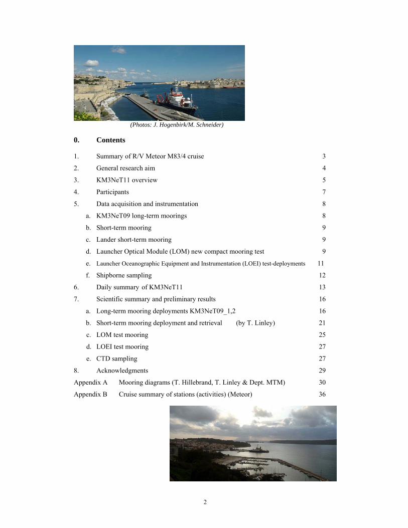
(Photos: J. Hogenbirk/M. Schneider) 0. Contents 1. Summary of R/V Meteor M83/4 cruise 3
2. General research aim 4
3. KM3NeT11 overview 5
4. Participants 7
5. Data acquisition and instrumentation 8
a. KM3NeT09 long-term moorings 8
b. Short-term mooring 9
c. Lander short-term mooring 9
d. Launcher Optical Module (LOM) new compact mooring test 9
e. Launcher Oceanographic Equipment and Instrumentation (LOEI) test-deployments 11
f. Shipborne sampling 12
6. Daily summary of KM3NeT11 13
7. Scientific summary and preliminary results 16
a. Long-term mooring deployments KM3NeT09_1,2 16
b. Short-term mooring deployment and retrieval (by T. Linley) 21
c. LOM test mooring 25
d. LOEI test mooring 27
e. CTD sampling 27
8. Acknowledgments 29
Appendix A Mooring diagrams (T. Hillebrand, T. Linley & Dept. MTM) 30
Appendix B Cruise summary of stations (activities) (Meteor) 36
3
1. Summary of R/V Meteor M83/4 cruise
In January 2011 R/V Meteor (University of Hamburg, Germany) sailed to the Ionian Sea
(part of the Eastern basin of the Mediterranean Sea), mainly to perform several tests for the
future cubic kilometer neutrino telescope KM3NeT. The research cruise was commissioned by
NIOZ Royal Netherlands Institute for Sea Research and Nikhef, the Dutch National Institute
for Subatomic physics, Amsterdam. Nikhef is the main contributor to European Project
KM3NeT in the Netherlands, with minor contributors NIOZ and KVI (University Groningen).
The Dutch contribution to KM3NeT is funded via a large investment program in the realm of
ESFRI by NWO, the Netherlands Organization for the advancement of scientific research.
The purpose of the M83/4 cruise was to perform several test-deployments of
moored instrumentation at two of the proposed KM3NeT sites, ‘NEMO’ east of Sicily
Italy around 36.5°N, 15.8°E and ‘NESTOR’ west of Πελοπόννησος Greece around 36.5°N,
21.5°E. For better understanding of the internal wave field, optical, current and
temperature variations over the period of a year, two long moorings were deployed in
December 2009. They consist of a top-buoy at around 900 m holding a 75 kHz
Acoustic Doppler Current Profiler (ADCP) and 5 acoustic current meters distributed
along the mooring line, with concentration in the lower 700 m above the bottom. This
‘near-bottom’ layer is further investigated using between 60 and 100 NIOZ
temperature sensors at 1 m distance and each mooring holds a glass sphere with two
small Photo Multiplier Tubes. For short-term investigations of near-bottom fauna a
lander has been deployed and recovered four times for the duration of about a day
each. Every 1 minute photographs are taken of the environment around a fish-bait,
showing abundance of life. Additional Conductivity Temperature Depth (CTD)-
profiles were obtained, distributed over the sites. Two newly designed compact
mooring have been launched and tested. The 2.02 m diameter sphere ‘LOM’ holding
37 glass spheres of 17″-diameter unrolled two 700-m lines with 25 glass spheres in
between and surfaced freely. The compact Launcher for Oceanographic Equipment
and Instruments (LOEI) unrolled a 1000 m line with 3 current meters from the surface
downward. Both tests were satisfactory.
The cruise was quite successful, despite some adverse ropes in the ship’s
propulsion.
4
2. General research aim.
KM3NeT
KM3NeT, a European deep-sea research infrastructure, will host a neutrino
telescope with a volume of at least one cubic kilometer at the bottom of the
Mediterranean Sea that will open a new window on the Universe. The telescope will
search for neutrinos from distant astrophysical sources like gamma ray bursters,
supernovae or colliding stars and will be a powerful tool in the search for dark matter
in the Universe. An array of thousands of optical sensors will detect the faint light in
the deep sea from charged particles originating from collisions of the neutrinos and the
Earth. The facility will also house instrumentation from Earth and marine sciences for
long term and on-line monitoring of the deep sea environment and the sea bottom at
depths of several kilometers. Presently, several MEuro EU-funding is granted to
design and prepare the KM3NeT structure. Eventually, 150-250 MEuro is needed to
actually build the telescope. Proposed sites are in the Northern Hemisphere, to
compliment the IceCube-telescope in Antarctica, in the Mediterranean Sea where
sufficiently deep waters are found within several tens of kilometers from coasts. Three
sites are selected: ANTARES near Toulon France, NEMO east of Sicily Italy,
NESTOR west of Peloponessos Greece.
KM3NeT-Esfri The NWO investment programme for large European Structures has granted
Nikhef-Amsterdam, NIOZ-Texel and KVI-Groningen 8.8 MEuro to set-up the dutch
part of KM3NeT. This financial support is the first national funding in hopefully many
more to come within the KM3NeT-consortium.
KM3NeT11 cruise The purpose of the KM3NeT11 cruise in the Ionian Sea is to perform several test-
deployments and to recover two long-term moorings. For better understanding of the
internal wave field, optical, current and temperature variations over a period of a year,
long moorings have been deployed at both NEMO and NESTOR sites. For short-term,
near-bottom investigations two short lander/moorings are deployed and recovered
several times. Additionally, Conductivity Temperature Depth (CTD)-yoyo are
executed for further hydrographic and topographic support-data, respectively. Two
different compact moorings are launched and tested a few times.
5
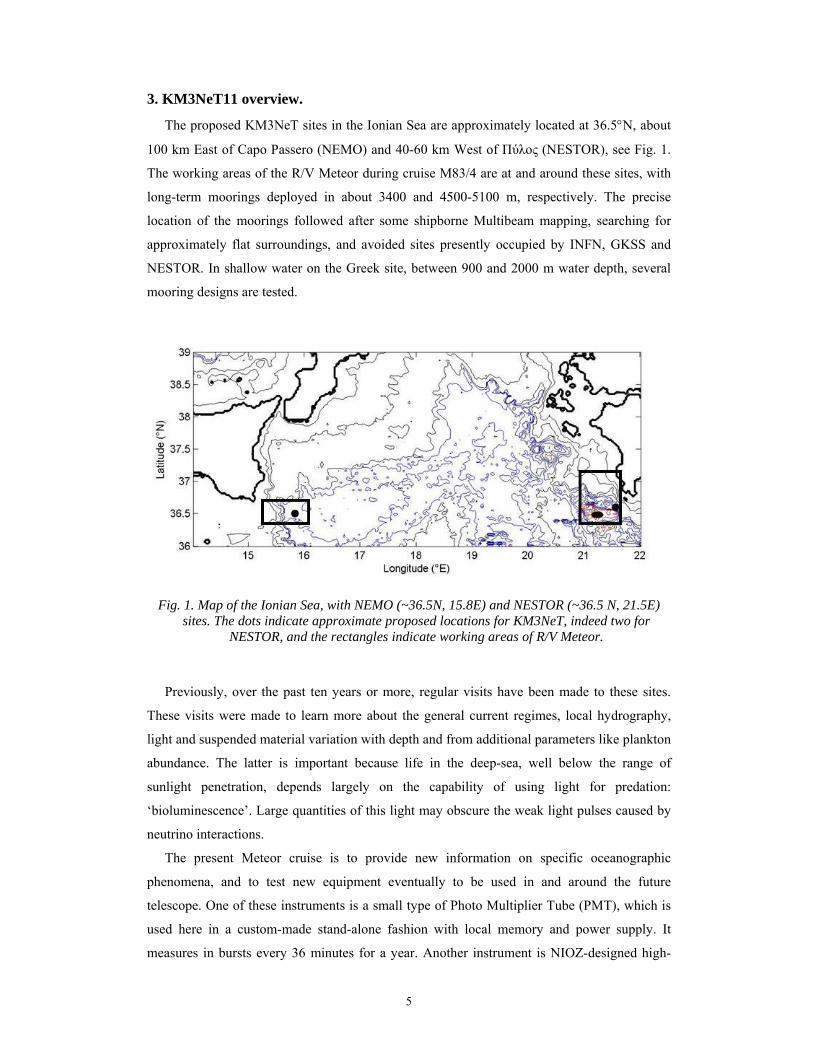
3. KM3NeT11 overview.
The proposed KM3NeT sites in the Ionian Sea are approximately located at 36.5°N, about
100 km East of Capo Passero (NEMO) and 40-60 km West of Πύλος (NESTOR), see Fig. 1.
The working areas of the R/V Meteor during cruise M83/4 are at and around these sites, with
long-term moorings deployed in about 3400 and 4500-5100 m, respectively. The precise
location of the moorings followed after some shipborne Multibeam mapping, searching for
approximately flat surroundings, and avoided sites presently occupied by INFN, GKSS and
NESTOR. In shallow water on the Greek site, between 900 and 2000 m water depth, several
mooring designs are tested.
Fig. 1. Map of the Ionian Sea, with NEMO (~36.5N, 15.8E) and NESTOR (~36.5 N, 21.5E) sites. The dots indicate approximate proposed locations for KM3NeT, indeed two for
NESTOR, and the rectangles indicate working areas of R/V Meteor.
Previously, over the past ten years or more, regular visits have been made to these sites.
These visits were made to learn more about the general current regimes, local hydrography,
light and suspended material variation with depth and from additional parameters like plankton
abundance. The latter is important because life in the deep-sea, well below the range of
sunlight penetration, depends largely on the capability of using light for predation:
‘bioluminescence’. Large quantities of this light may obscure the weak light pulses caused by
neutrino interactions.
The present Meteor cruise is to provide new information on specific oceanographic
phenomena, and to test new equipment eventually to be used in and around the future
telescope. One of these instruments is a small type of Photo Multiplier Tube (PMT), which is
used here in a custom-made stand-alone fashion with local memory and power supply. It
measures in bursts every 36 minutes for a year. Another instrument is NIOZ-designed high-
6
resolution temperature sensor that may become mounted outside and perhaps inside the
telescope-array. It has been specifically designed to study the internal wave field, and
KM3NeT provides the unique opportunity to study deep-ocean internal waves in a 3-D
fashion, despite its rather course vertical resolution. Another means that may be further
developed in the future is deep-ocean photography of fauna. During the present cruise this
photography is used very near (1-2 m from) the bottom only, which is outside the range of the
future neutrino telescope that has planned instrumentation between 100 and about 700 m from
the bottom. The photography provides new information for specific marine biology studies.
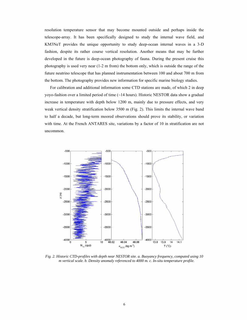
For calibration and additional information some CTD stations are made, of which 2 in deep
yoyo-fashion over a limited period of time (~14 hours). Historic NESTOR data show a gradual
increase in temperature with depth below 1200 m, mainly due to pressure effects, and very
weak vertical density stratification below 3500 m (Fig. 2). This limits the internal wave band
to half a decade, but long-term moored observations should prove its stability, or variation
with time. At the French ANTARES site, variations by a factor of 10 in stratification are not
uncommon.
Fig. 2. Historic CTD-profiles with depth near NESTOR site. a. Buoyancy frequency, computed using 10
m vertical scale. b. Density anomaly referenced to 4000 m. c. In-situ temperature profile.
7
4. Participants.
Institute Name NIOZ-FYS Hans van Haren (PI) NIOZ-FYS Theo Hillebrand NIOZ-FYS Anna Rabitti NIOZ-FYS Roald van der Heide NIOZ-MEE Margriet Hiehle NIOZ-MTE Martin Laan NIOZ-MTI Johan van Heerwaarden
NIOZ-MTM Lorendz Boom NIOZ-MTM Yvo Witte
Nikhef/UAmsterdam Els de Wolf Nikhef/UUtrecht Paul Kooijman
Nikhef Jelle Hogenbirk Nikhef Eric Heine
Oceanlab Aberdeen UK Thomas LinleyLEGI/Coriolis Grenoble F Louis Gostiaux
INFN Bologna I Annarita Margiotta Demokritos Athens Gr Dimitris Lenis
Nestor Pylos Gr Tassos Belias
NIOZ departments FYS physical oceanography MEE marine ecology MTE electronics MTI fine mechanics instrumentation MTM sea technology
8
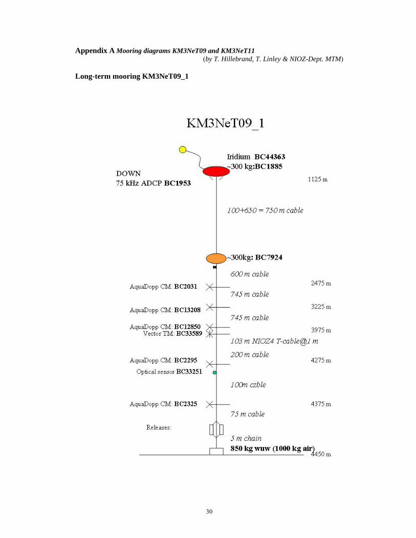
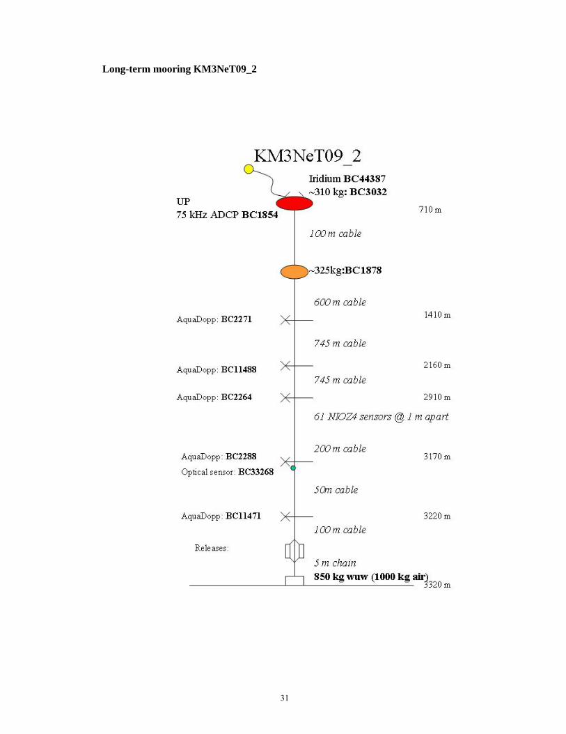
5. Data acquisition and instrumentation (see Appendix A for mooring diagrams).
a. KM3NeT09 long-term moorings Both large NIOZ-moorings (KM3NeT09_1 and _2 at NESTOR and NEMO sites,
respectively) have two ellipse-shaped buoyancy elements near the top, of which the upper one
also holds an Iridium-satellite beacon. All instrumentation in the line is self-contained, with
batteries and memory. An up- or downward looking 75 kHz ADCP is mounted in the top-
buoy. The ADCP acoustically estimates currents every 10 m over a maximum vertical range of
600 m, upward from 700 m at NEMO and downward from 1100 m at NESTOR. They sample
once per 900 s (15 min). Deeper below, five current meters are mounted, all acoustic Nortek
AquaDopp that also sample once per 900 s. In the depth range of future KM3NeT antennas 61
and 104 new NIOZ-4 accurate temperature sensors are mounted at 1 m intervals on a 65 and
104 m long cable, respectively. These sensors measure at 1 Hz. At each mooring, some 100-
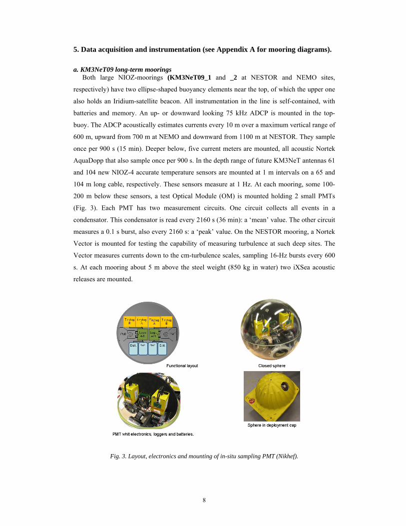
200 m below these sensors, a test Optical Module (OM) is mounted holding 2 small PMTs
(Fig. 3). Each PMT has two measurement circuits. One circuit collects all events in a
condensator. This condensator is read every 2160 s (36 min): a ‘mean’ value. The other circuit
measures a 0.1 s burst, also every 2160 s: a ‘peak’ value. On the NESTOR mooring, a Nortek
Vector is mounted for testing the capability of measuring turbulence at such deep sites. The
Vector measures currents down to the cm-turbulence scales, sampling 16-Hz bursts every 600
s. At each mooring about 5 m above the steel weight (850 kg in water) two iXSea acoustic
releases are mounted.
Fig. 3. Layout, electronics and mounting of in-situ sampling PMT (Nikhef).

9
German institute GKSS Geesthacht near Hamburg requested attempt to recover a single
mooring, approximately 1000 m in length at 4500 m, NESTOR site. The mooring consists of
several glass spheres and biofouling panels. It has been under water for about 3 years now.
The release responded a year and two years ago, but did not surface.
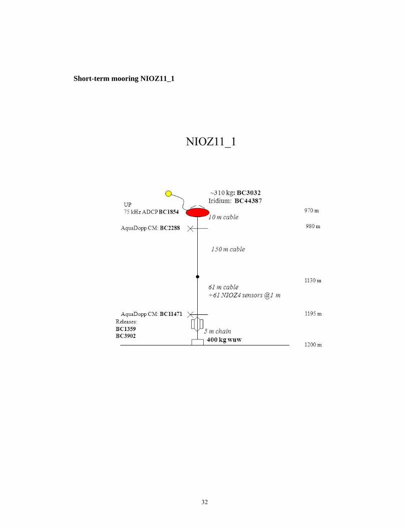
b. Short-term mooring
A single small NIOZ-mooring (NIOZ11_1) is deployed once for a week above a moderate
sloping bottom near the test-deployment site. It provides current and temperature /internal
wave information around 1000 m, using two acoustic Nortek AquaDopp current meters and 61
NIOZ4-thermistors.
c. Lander short-term mooring OceanLab moorings OL11_1,…,_4 (1 at NEMO and 3 at NESTOR, respectively) is a free-
falling bottomlander intended to become deployed and recovered after about 24 hours. The
lander's main purpose is time-lapse photography of animals that are attracted to a whole
ungutted mackerel bait. The camera (Kongsberg 5M pixel digital stills camera and flash
unit) looks about 2 m down on a reference cross with the bait at the centre. The camera is
manually setup to best capture objects in this plane. An image is taken every minute with a
single fire of flash.
The lander also has a SeaGuard recording platform with an Aanderaa Doppler current
meter and SeaBird CTD. It takes readings every 300 s. The current data is used to estimate the
dispersal of the scent of the bait and can be used to make estimates of local fish abundance.
Deployment is a swift operation, although descent to, say, 4000 m takes some time due to
its relatively slow sinking speed of about 0.5 m s-1. Its recovery is slightly faster, mainly
because its ascent-speed of nearly 1 m s-1 and its radio beacon and flag for quick visibility
once at the surface.
d. Launcher Optical Module (LOM) new compact mooring test NIOZ built a new concept mooring for compacting a single string holding glass spheres,
which eventually is designed to be launched with 10-15 strings attached to a single sea-floor
cable. The entire design is to minimize the number of underwater-connectors, quick
deployment of multiple mooring-strings and minimal drag.
A single string has two 4-mm Dyneema-fibre lines for support and one 6 mm tube holding
all electric cabling. Thirty-one small PMTs will eventually be held in one, presently 17″, glass-
sphere, the OM. A string holds twenty OMs that are presently separated by approximately 30
m. The OMs are mounted ‘naked’ in between the two lines without further supporting or
protecting materials. For compact mooring deployment, the entire nearly 700 m long string
and five empty glass spheres for top-buoyancy are mounted in a 2.02 m diameter aluminum
10
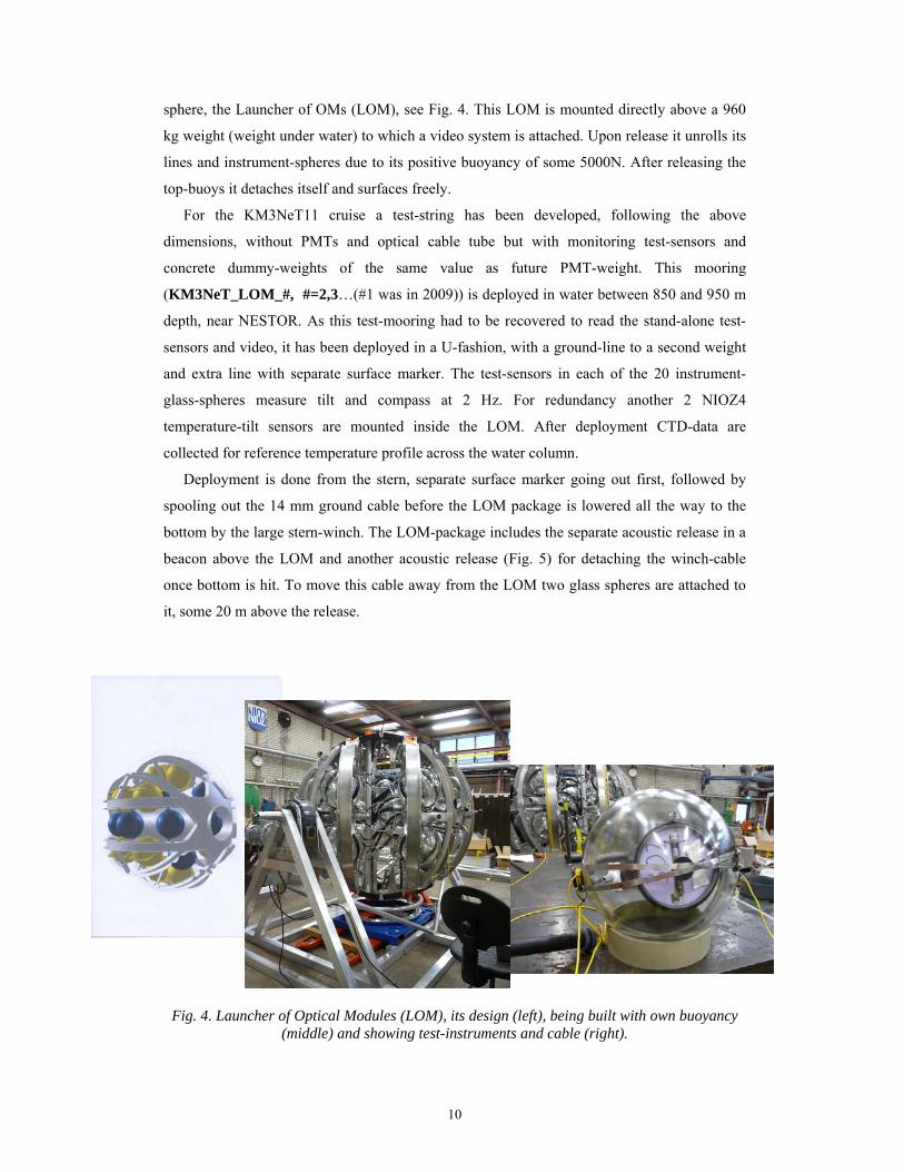
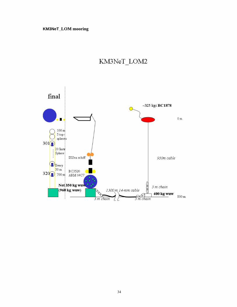
sphere, the Launcher of OMs (LOM), see Fig. 4. This LOM is mounted directly above a 960
kg weight (weight under water) to which a video system is attached. Upon release it unrolls its
lines and instrument-spheres due to its positive buoyancy of some 5000N. After releasing the
top-buoys it detaches itself and surfaces freely.
For the KM3NeT11 cruise a test-string has been developed, following the above
dimensions, without PMTs and optical cable tube but with monitoring test-sensors and
concrete dummy-weights of the same value as future PMT-weight. This mooring
(KM3NeT_LOM_#, #=2,3…(#1 was in 2009)) is deployed in water between 850 and 950 m
depth, near NESTOR. As this test-mooring had to be recovered to read the stand-alone test-
sensors and video, it has been deployed in a U-fashion, with a ground-line to a second weight
and extra line with separate surface marker. The test-sensors in each of the 20 instrument-
glass-spheres measure tilt and compass at 2 Hz. For redundancy another 2 NIOZ4
temperature-tilt sensors are mounted inside the LOM. After deployment CTD-data are
collected for reference temperature profile across the water column.
Deployment is done from the stern, separate surface marker going out first, followed by
spooling out the 14 mm ground cable before the LOM package is lowered all the way to the
bottom by the large stern-winch. The LOM-package includes the separate acoustic release in a
beacon above the LOM and another acoustic release (Fig. 5) for detaching the winch-cable
once bottom is hit. To move this cable away from the LOM two glass spheres are attached to
it, some 20 m above the release.
Fig. 4. Launcher of Optical Modules (LOM), its design (left), being built with own buoyancy (middle) and showing test-instruments and cable (right).
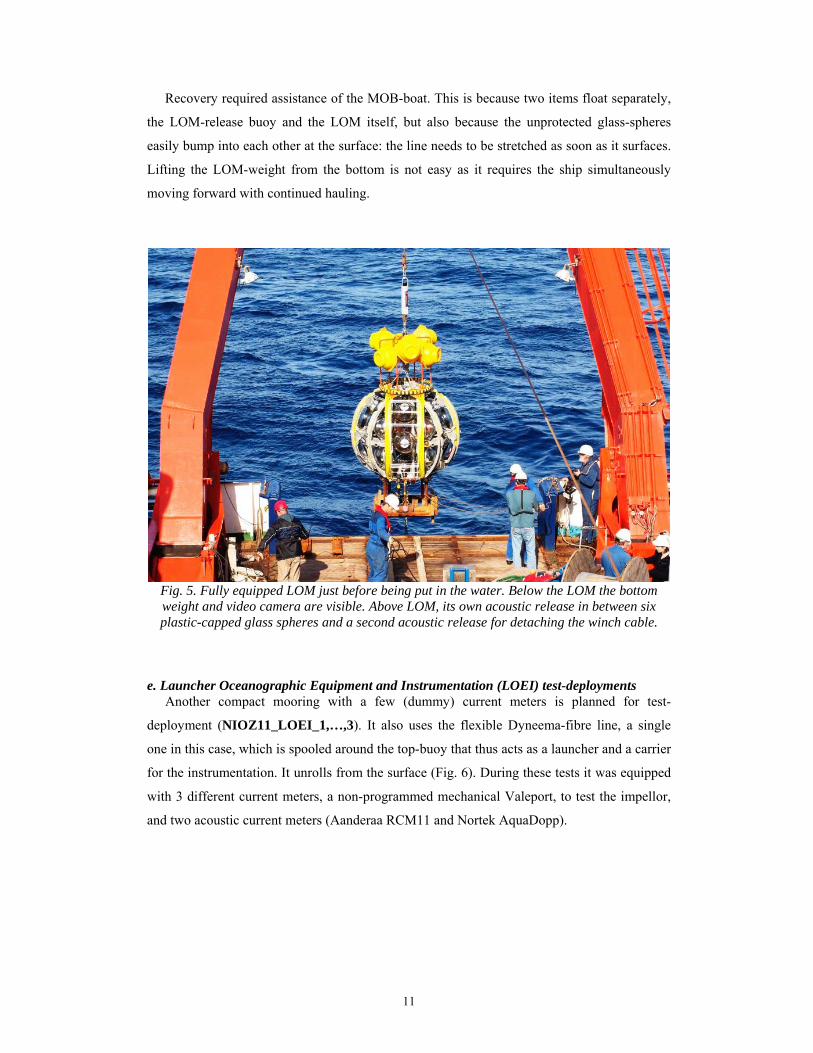
11
Recovery required assistance of the MOB-boat. This is because two items float separately,
the LOM-release buoy and the LOM itself, but also because the unprotected glass-spheres
easily bump into each other at the surface: the line needs to be stretched as soon as it surfaces.
Lifting the LOM-weight from the bottom is not easy as it requires the ship simultaneously
moving forward with continued hauling.
Fig. 5. Fully equipped LOM just before being put in the water. Below the LOM the bottom weight and video camera are visible. Above LOM, its own acoustic release in between six plastic-capped glass spheres and a second acoustic release for detaching the winch cable.
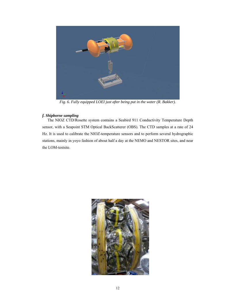
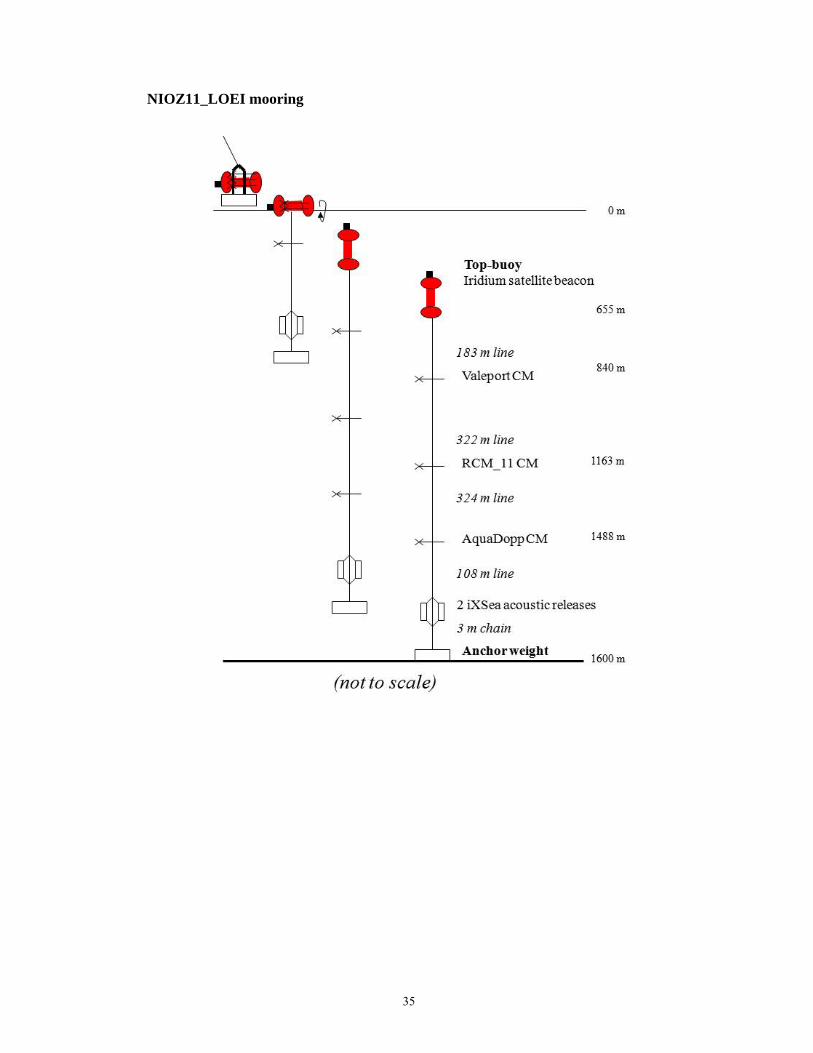
e. Launcher Oceanographic Equipment and Instrumentation (LOEI) test-deployments
Another compact mooring with a few (dummy) current meters is planned for test-
deployment (NIOZ11_LOEI_1,…,3). It also uses the flexible Dyneema-fibre line, a single
one in this case, which is spooled around the top-buoy that thus acts as a launcher and a carrier
for the instrumentation. It unrolls from the surface (Fig. 6). During these tests it was equipped
with 3 different current meters, a non-programmed mechanical Valeport, to test the impellor,
and two acoustic current meters (Aanderaa RCM11 and Nortek AquaDopp).
12
Fig. 6. Fully equipped LOEI just after being put in the water (R. Bakker).
f. Shipborne sampling
The NIOZ CTD/Rosette system contains a Seabird 911 Conductivity Temperature Depth
sensor, with a Seapoint STM Optical BackScatterer (OBS). The CTD samples at a rate of 24
Hz. It is used to calibrate the NIOZ-temperature sensors and to perform several hydrographic
stations, mainly in yoyo fashion of about half a day at the NEMO and NESTOR sites, and near
the LOM-testsite.
13
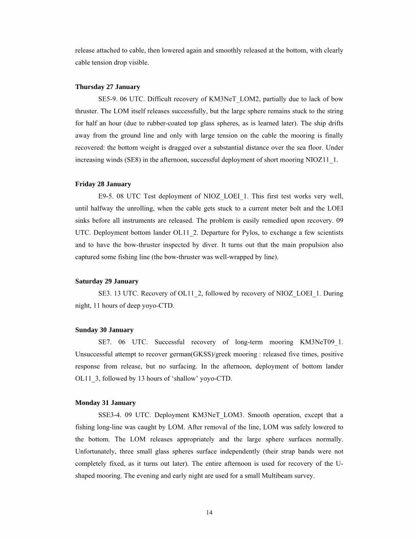
6. Daily summary of KM3NeT11.
Fig. 7. KM3NeT11 cruise track (M. Hiehle).
Monday 24 January
10:00 LT (09 UTC). Departure from Valetta, Malta. NE1-2, calm weather. First
station at NEMO site: deployment of bottom lander OL11_1 in the afternoon. Near the lander
11 h deep yoyo-CTD during night.
Tuesday 25 January
NNE4. 7 UTC. Recovery of long-term mooring KM3NeT09_2. Surfacing of the
mooring without problems. However, nearly the entire mooring is covered by a “cannizzi”
fishing line, which hampers the intake of the instruments and mooring line. Worst of all, the
line drifts into the bow thruster, which we cannot use from this moment on (until repair in
Pylos later in the week). In the afternoon OL11_1 succesfully recovered. Transfer to Nestor
site.
Wednesday 26 January
NW3. 15 UTC. Deployment KM3NeT_LOM2. Entire operation from the stern,
smoothly, until iXSea cable release refuses. LOM brought back to deck and NIOZ-Benthos
14
release attached to cable, then lowered again and smoothly released at the bottom, with clearly
cable tension drop visible.
Thursday 27 January
SE5-9. 06 UTC. Difficult recovery of KM3NeT_LOM2, partially due to lack of bow
thruster. The LOM itself releases successfully, but the large sphere remains stuck to the string
for half an hour (due to rubber-coated top glass spheres, as is learned later). The ship drifts
away from the ground line and only with large tension on the cable the mooring is finally
recovered: the bottom weight is dragged over a substantial distance over the sea floor. Under
increasing winds (SE8) in the afternoon, successful deployment of short mooring NIOZ11_1.
Friday 28 January
E9-5. 08 UTC Test deployment of NIOZ_LOEI_1. This first test works very well,
until halfway the unrolling, when the cable gets stuck to a current meter bolt and the LOEI
sinks before all instruments are released. The problem is easily remedied upon recovery. 09
UTC. Deployment bottom lander OL11_2. Departure for Pylos, to exchange a few scientists
and to have the bow-thruster inspected by diver. It turns out that the main propulsion also
captured some fishing line (the bow-thruster was well-wrapped by line).
Saturday 29 January
SE3. 13 UTC. Recovery of OL11_2, followed by recovery of NIOZ_LOEI_1. During
night, 11 hours of deep yoyo-CTD.
Sunday 30 January
SE7. 06 UTC. Successful recovery of long-term mooring KM3NeT09_1.
Unsuccessful attempt to recover german(GKSS)/greek mooring : released five times, positive
response from release, but no surfacing. In the afternoon, deployment of bottom lander
OL11_3, followed by 13 hours of ‘shallow’ yoyo-CTD.
Monday 31 January
SSE3-4. 09 UTC. Deployment KM3NeT_LOM3. Smooth operation, except that a
fishing long-line was caught by LOM. After removal of the line, LOM was safely lowered to
the bottom. The LOM releases appropriately and the large sphere surfaces normally.
Unfortunately, three small glass spheres surface independently (their strap bands were not
completely fixed, as it turns out later). The entire afternoon is used for recovery of the U-
shaped mooring. The evening and early night are used for a small Multibeam survey.
15
Tuesday 01 February
ESE5. 06 UTC. Recovery of OL11_3, followed by a CTD-thermistor string
calibration. In the afternoon deployment of NIOZ_LOEI_2. This time the unrolling is smooth
and perfect.
Wednesday 02 February
SE3-ESE5. 06 UTC. Recovery of NIOZ_LOEI_2, followed by deployment of bottom
lander OL11_4. In the afternoon deployment of NIOZ_LOEI_3.
Thursday 03 February
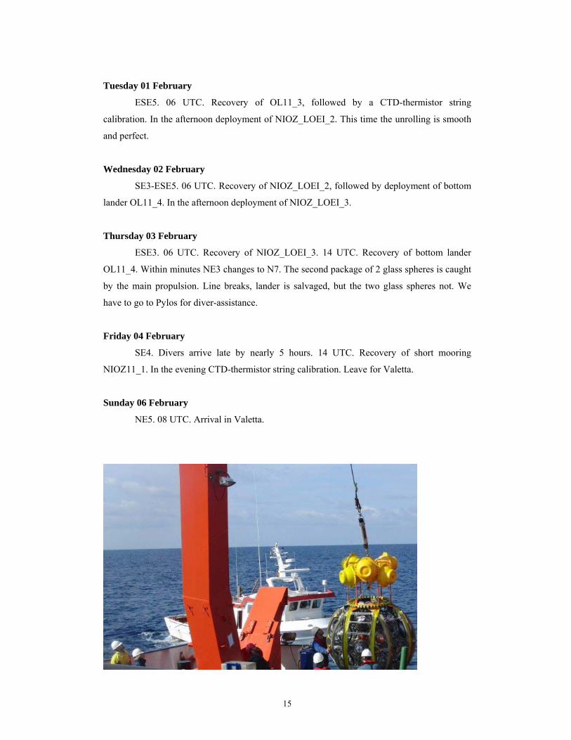
ESE3. 06 UTC. Recovery of NIOZ_LOEI_3. 14 UTC. Recovery of bottom lander
OL11_4. Within minutes NE3 changes to N7. The second package of 2 glass spheres is caught
by the main propulsion. Line breaks, lander is salvaged, but the two glass spheres not. We
have to go to Pylos for diver-assistance.
Friday 04 February
SE4. Divers arrive late by nearly 5 hours. 14 UTC. Recovery of short mooring
NIOZ11_1. In the evening CTD-thermistor string calibration. Leave for Valetta.
Sunday 06 February
NE5. 08 UTC. Arrival in Valetta.
16
7. Scientific summary and preliminary results
The M83/4 cruise knew a substantial mooring program, varying from recovery of yearlong
moorings, via short-term lander deployments&recoveries to a number of newly designed
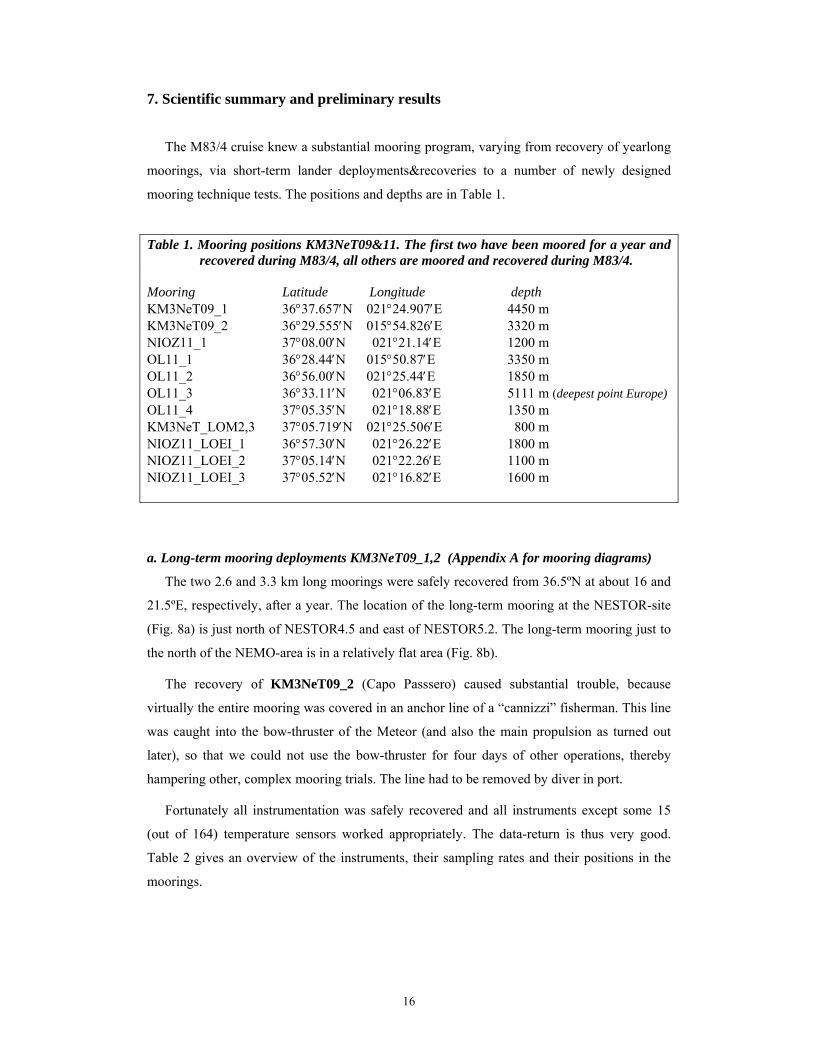
mooring technique tests. The positions and depths are in Table 1.
Table 1. Mooring positions KM3NeT09&11. The first two have been moored for a year and
recovered during M83/4, all others are moored and recovered during M83/4. Mooring Latitude Longitude depth KM3NeT09_1 36°37.657′N 021°24.907′E 4450 m KM3NeT09_2 36°29.555′N 015°54.826′E 3320 m NIOZ11_1 37°08.00′N 021°21.14′E 1200 m OL11_1 36°28.44′N 015°50.87′E 3350 m OL11_2 36°56.00′N 021°25.44′E 1850 m OL11_3 36°33.11′N 021°06.83′E 5111 m (deepest point Europe) OL11_4 37°05.35′N 021°18.88′E 1350 m KM3NeT_LOM2,3 37°05.719′N 021°25.506′E 800 m NIOZ11_LOEI_1 36°57.30′N 021°26.22′E 1800 m NIOZ11_LOEI_2 37°05.14′N 021°22.26′E 1100 m NIOZ11_LOEI_3 37°05.52′N 021°16.82′E 1600 m
a. Long-term mooring deployments KM3NeT09_1,2 (Appendix A for mooring diagrams)
The two 2.6 and 3.3 km long moorings were safely recovered from 36.5ºN at about 16 and
21.5ºE, respectively, after a year. The location of the long-term mooring at the NESTOR-site
(Fig. 8a) is just north of NESTOR4.5 and east of NESTOR5.2. The long-term mooring just to
the north of the NEMO-area is in a relatively flat area (Fig. 8b).
The recovery of KM3NeT09_2 (Capo Passsero) caused substantial trouble, because
virtually the entire mooring was covered in an anchor line of a “cannizzi” fisherman. This line
was caught into the bow-thruster of the Meteor (and also the main propulsion as turned out
later), so that we could not use the bow-thruster for four days of other operations, thereby
hampering other, complex mooring trials. The line had to be removed by diver in port.
Fortunately all instrumentation was safely recovered and all instruments except some 15
(out of 164) temperature sensors worked appropriately. The data-return is thus very good.
Table 2 gives an overview of the instruments, their sampling rates and their positions in the
moorings.
17
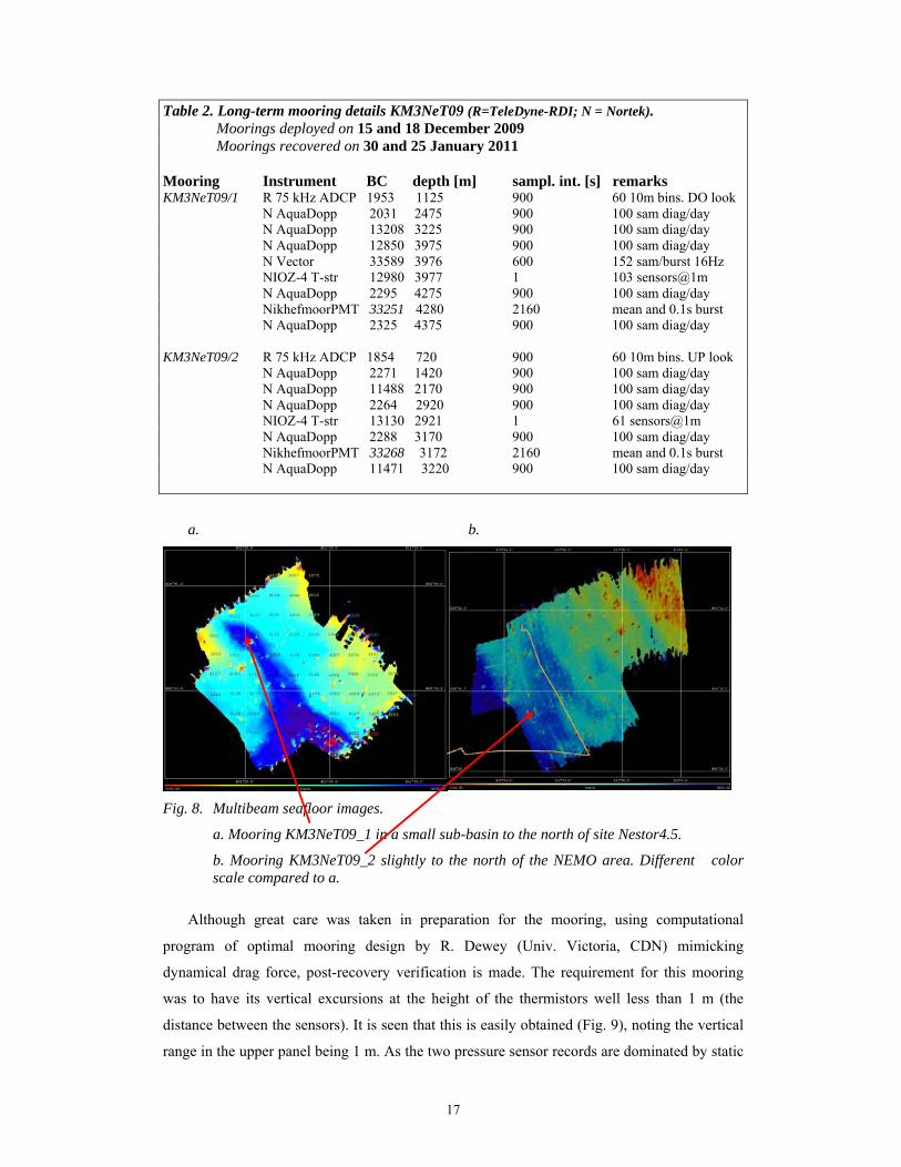
Table 2. Long-term mooring details KM3NeT09 (R=TeleDyne-RDI; N = Nortek). Moorings deployed on 15 and 18 December 2009 Moorings recovered on 30 and 25 January 2011 Mooring Instrument BC depth [m] sampl. int. [s] remarks KM3NeT09/1 R 75 kHz ADCP 1953 1125 900 60 10m bins. DO look
N AquaDopp 2031 2475 900 100 sam diag/day N AquaDopp 13208 3225 900 100 sam diag/day N AquaDopp 12850 3975 900 100 sam diag/day N Vector 33589 3976 600 152 sam/burst 16Hz NIOZ-4 T-str 12980 3977 1 103 sensors@1m N AquaDopp 2295 4275 900 100 sam diag/day NikhefmoorPMT 33251 4280 2160 mean and 0.1s burst N AquaDopp 2325 4375 900 100 sam diag/day
KM3NeT09/2 R 75 kHz ADCP 1854 720 900 60 10m bins. UP look N AquaDopp 2271 1420 900 100 sam diag/day N AquaDopp 11488 2170 900 100 sam diag/day N AquaDopp 2264 2920 900 100 sam diag/day NIOZ-4 T-str 13130 2921 1 61 sensors@1m N AquaDopp 2288 3170 900 100 sam diag/day NikhefmoorPMT 33268 3172 2160 mean and 0.1s burst N AquaDopp 11471 3220 900 100 sam diag/day
a. b.
Fig. 8. Multibeam seafloor images.
a. Mooring KM3NeT09_1 in a small sub-basin to the north of site Nestor4.5.
b. Mooring KM3NeT09_2 slightly to the north of the NEMO area. Different color scale compared to a.
Although great care was taken in preparation for the mooring, using computational
program of optimal mooring design by R. Dewey (Univ. Victoria, CDN) mimicking
dynamical drag force, post-recovery verification is made. The requirement for this mooring
was to have its vertical excursions at the height of the thermistors well less than 1 m (the
distance between the sensors). It is seen that this is easily obtained (Fig. 9), noting the vertical
range in the upper panel being 1 m. As the two pressure sensor records are dominated by static

18
barotropic surface semidiurnal tide of 0.1 m amplitude and meso-scale (sub-inertial 10-50 day
periodic) variations of similar amplitude, in contrast with horizontal currents being dominated
by inertial motions, it is safely said that artificial mooring motions are below noise level (~0.1
m) and well within the required range.
Fig. 9. KM3NeT09/1 mooring motion verification. Upper panel. Pressure with mean values subtracted, measured by current meters above (blue) and below (red) the NIOZ-thermistors. Lower panel. Corresponding spectra (arbitrary scale) of time series in upper panel (same colours), with in black the (white noise) difference spectrum. In purple kinetic energy spectrum. Denoted frequencies: f = inertial, N = buoyancy, M2 = semidiurnal lunar tidal.
The currents at both long-term mooring sites are quite comparable: they are dominated by
inertial and mesoscale (10-30 day periodic) motions, with weak semidiurnal tides (Figs 10,11).
A major difference between the two is the amplitude: nearly twice as large at NEMO (Fig. 10;
maximum current speed 0.14 m s-1 at 400 mab, m above the bottom), compared to NESTOR
(Fig. 11; identical scales as Fig. 10; |U|max = 0.08 m s-1). At NESTOR the weak spectral peak in
the vertical current at the inertial frequency f is more clearly visible than at NEMO. This
implies general weaker stratification at NESTOR which turns inertial motions, purely
horizontal in infinitely strong stratification, away from gravity towards the earth rotational
vector. The aspect (variance) ratio |w|/|u| ~ 0.1, so that |w| ~ 0.01 m s-1 are expected.

19
Fig. 10. KM3NeT09/2 currents at great depths around the cable with NIOZ-thermistors: time series of current speed (upper panel: blue (400 mab); red (150 mab)) and spectra (lower panel; horizontal kinetic energy (blue (400 mab); red (150 mab)), vertical current variance (black (400 mab); green (150 mab))).
Fig. 11. As Fig. 10, but for KM3NeT09/1.
20
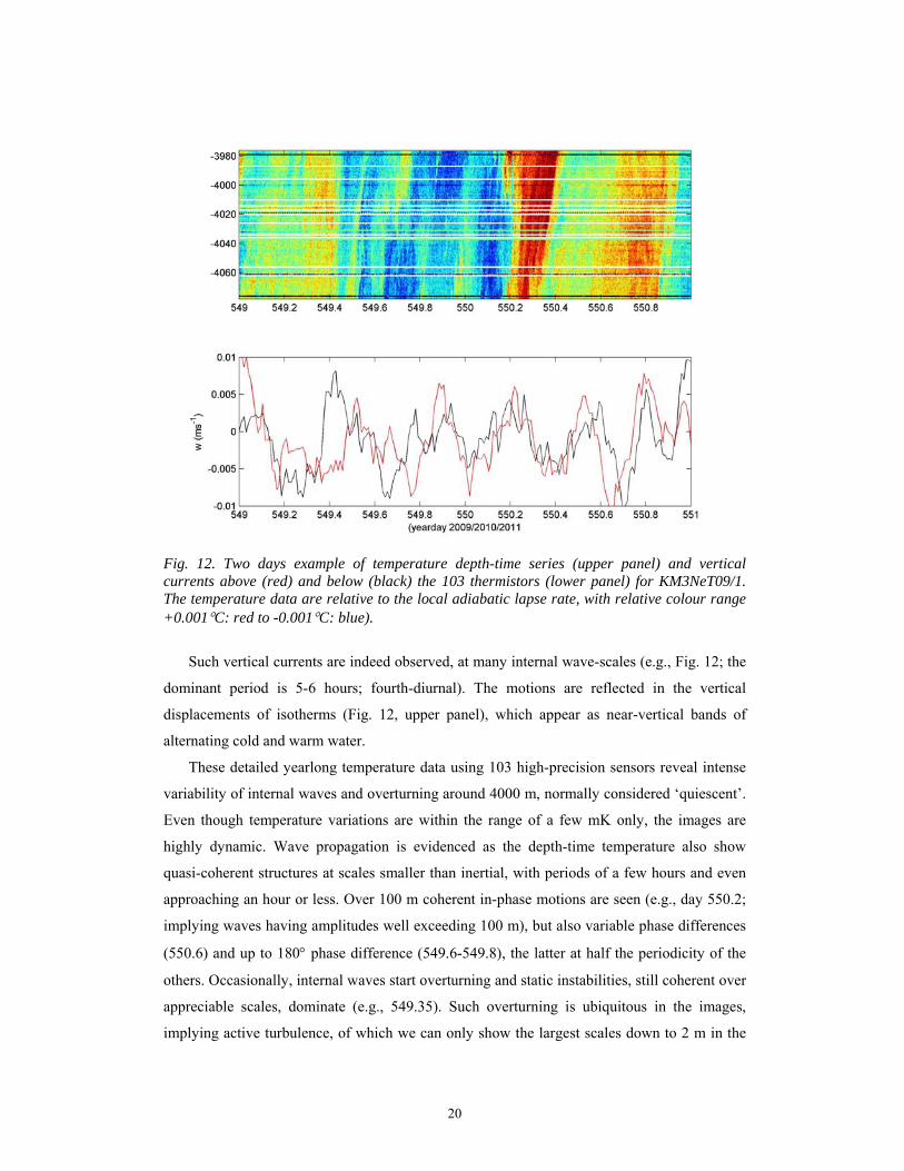
Fig. 12. Two days example of temperature depth-time series (upper panel) and vertical currents above (red) and below (black) the 103 thermistors (lower panel) for KM3NeT09/1. The temperature data are relative to the local adiabatic lapse rate, with relative colour range +0.001°C: red to -0.001°C: blue).
Such vertical currents are indeed observed, at many internal wave-scales (e.g., Fig. 12; the
dominant period is 5-6 hours; fourth-diurnal). The motions are reflected in the vertical
displacements of isotherms (Fig. 12, upper panel), which appear as near-vertical bands of
alternating cold and warm water.
These detailed yearlong temperature data using 103 high-precision sensors reveal intense
variability of internal waves and overturning around 4000 m, normally considered ‘quiescent’.
Even though temperature variations are within the range of a few mK only, the images are
highly dynamic. Wave propagation is evidenced as the depth-time temperature also show
quasi-coherent structures at scales smaller than inertial, with periods of a few hours and even
approaching an hour or less. Over 100 m coherent in-phase motions are seen (e.g., day 550.2;
implying waves having amplitudes well exceeding 100 m), but also variable phase differences
(550.6) and up to 180° phase difference (549.6-549.8), the latter at half the periodicity of the
others. Occasionally, internal waves start overturning and static instabilities, still coherent over
appreciable scales, dominate (e.g., 549.35). Such overturning is ubiquitous in the images,
implying active turbulence, of which we can only show the largest scales down to 2 m in the
21
vertical. The association of these overturns with internal waves is evident, as near-inertial
(20.1 hour periodic) motions are the main driving force.
b. Short-term mooring deployment and retrieval (by T. Linley)
Four lander deployments OL11_1…4 were completed during which 54, 191, 247 and 242
photo-images were taken, respectively. The images were focused on the scavenging of near-
bottom fauna species on a whole un-gutted mackerel bait. Additionally near-bottom currents
were measured every 5 minutes, and every 0.5 minute during OL11_3. The lander deployment
and recovery operation was generally a smooth operation, except for the last one. During the
final recovery a sudden squall increased wind speed once the lander was on the surface. With
its beam to the wind the vessel partially passed over the lander and became entangled in the
mooring line. This potentially disastrous situation was soon brought under control by the
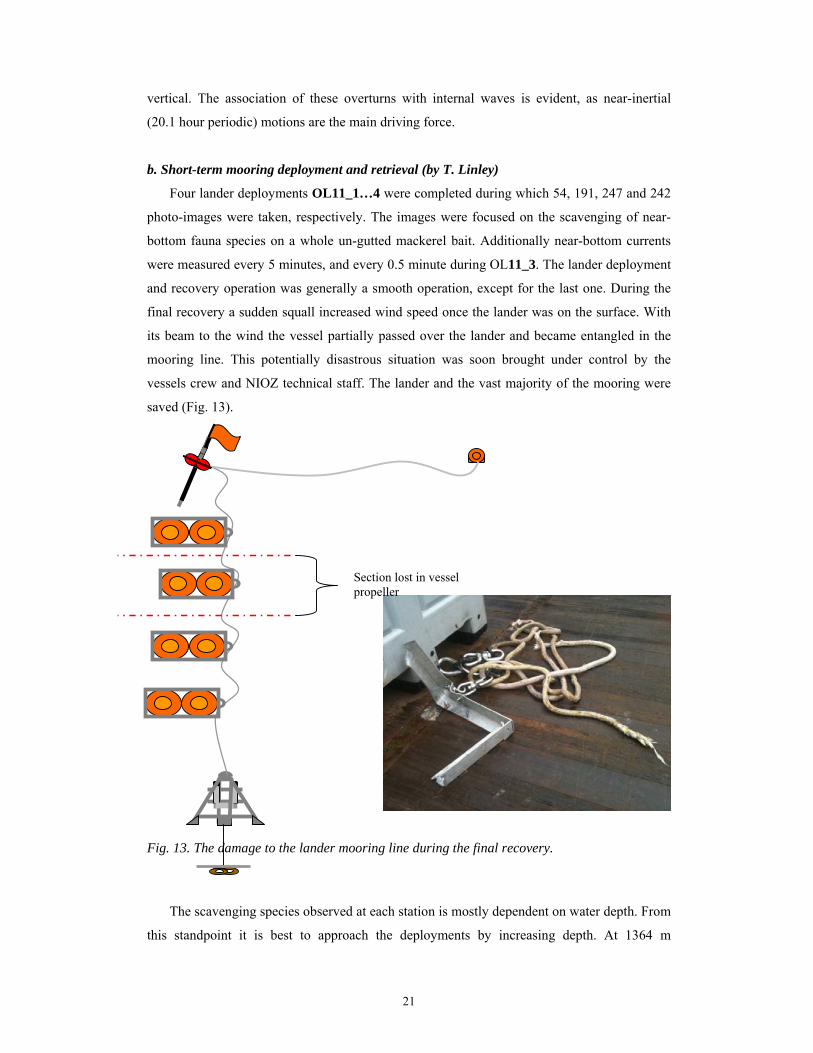
vessels crew and NIOZ technical staff. The lander and the vast majority of the mooring were
saved (Fig. 13).
Fig. 13. The damage to the lander mooring line during the final recovery.
The scavenging species observed at each station is mostly dependent on water depth. From
this standpoint it is best to approach the deployments by increasing depth. At 1364 m
Section lost in vessel propeller
22
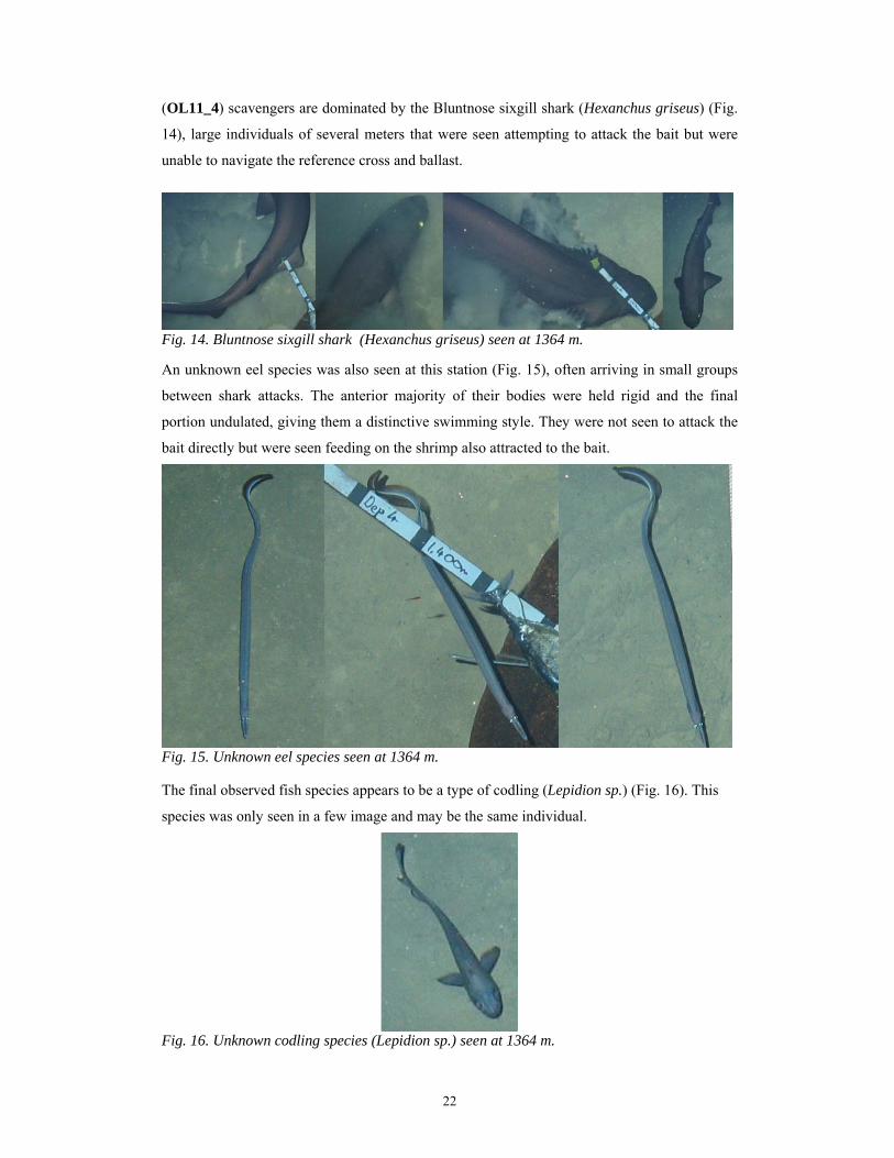
(OL11_4) scavengers are dominated by the Bluntnose sixgill shark (Hexanchus griseus) (Fig.
14), large individuals of several meters that were seen attempting to attack the bait but were
unable to navigate the reference cross and ballast.
Fig. 14. Bluntnose sixgill shark (Hexanchus griseus) seen at 1364 m. An unknown eel species was also seen at this station (Fig. 15), often arriving in small groups
between shark attacks. The anterior majority of their bodies were held rigid and the final
portion undulated, giving them a distinctive swimming style. They were not seen to attack the
bait directly but were seen feeding on the shrimp also attracted to the bait.
Fig. 15. Unknown eel species seen at 1364 m. The final observed fish species appears to be a type of codling (Lepidion sp.) (Fig. 16). This
species was only seen in a few image and may be the same individual.
Fig. 16. Unknown codling species (Lepidion sp.) seen at 1364 m.

23
The only invertebrate species seen was the deep-water shrimp Acanthephyra eximia (Fig. 17).
This proves to be a very successful scavenging species and is seen at all subsequent stations.
Fig. 17; the deep-water shrimp Acanthephyra eximia seen at 1364 m. Deployment OL11_2 at 1841m was still within the range of shark species. Individuals that
were seen were smaller than above; approximately 0.4 m (Fig. 18). Further analysis is needed
to determine if these are juveniles of H.griseus.
Fig. 18. Small unknown shark species seen at 1841 m. What is likely the same codling species as above was also seen here (Fig. 19).
Fig. 19. Unknown codling species (Lepidion sp.) seen at 1841 m. The invertebrate fauna once again included A.eximia, but also included a crab species (Fig.
20). A single individual eventually found the bait and fed for the remainder of the deployment.
Fig. 20. Unknown crab species seen at 1841 m.

24
Deployment OL11_1 exceeded 3,000 m water depth and thus the range of shark species. At
this (NEMO) site the only fish species seen was the Mediterranean grenadier Coryphaenoides
mediterraneus (Fig. 21). The only visible invertebrate was once again the deep-water shrimp
A.eximia. Both in species composition and abundance this site closely resembled the
deployment the previous year at 4,203m. There appears no strong change in scavenging fauna
between 3396 and 4203m.
Fig. 21. the Mediterranean grenadier Coryphaenoides mediterraneus, the only fish at 3396 m. Deployment OL11_3 represents the deepest deployment during this project and indeed the
deepest deployment possible in European waters. The images recovered may represent some
of the first. In the species present this deployment resembles all of those beyond 3000 m. It
contains only C.mediterraneus (Fig. 22) and A.eximia (Fig. 23) although each is present in
reduced numbers. C.mediterraneus appears even more stunted in size.
Fig. 22. Mediterranean grenadier Coryphaenoides mediterraneus: only fish seen at 5111 m.
Fig. 23. Deep-water shrimp Acanthephyra eximia: only invertebrate species seen at 5111 m.

25
All these deployments revealed a very clean silt/sand seabed with little visible infauna or
detritivours, supporting that this is a highly oligotrophic area. OL11_3, the deepest, showed a
strikingly uniform and undisturbed seabed.
c. LOM test mooring
Test-mooring KM3NeT_LOM_2…3 was deployed two times in about 900 m on a
smooth slope with a clean silty bottom just north of NESTOR sites (Table 1 for position). The
overboard operation of the U-shaped mooring encountered some difficulty the first time. The
LOM itself was smoothly lowered at 0.5 m s-1 using the large ship’s winch, which was easily
released after touchdown and brought back to the surface. During recovery of the U-shaped
mooring against the wind the LOM-weight was dragged over the bottom for a considerable
amount of time causing quite some tension in the relatively thin surface marker line. Also, the
speed through the water with the trail of glass spheres behind the ship turned out too high, so
that a few boulders were damaged. Learning from the first experience, the second recovery
went smoother.
On the whole, the LOM-deployment was successful. Like in the trial a year ago, in the two
attempts during this cruise a complete string was put upright on the sea floor, without a single
twist or rotation: all compass/tilt sensors point in the same direction and the individual glass
spheres do not deviate from the vertical (green) more than 10° (Fig. 24). In both attempts, the
inherently unstable motion of the big sphere during the rapid unwinding causes it to rotate
around its vertical axis. Up to 4 complete rotations were counted (Fig. 25; the first deployment
3.5) and during both deployments 1 twist. As soon as the big sphere stopped unwinding, either
escaping as it should during the second deployment or stuck for half an hour due to a rubber
coated top-glass sphere during the first one, the entire string back-rotated completely,
including releasing the twist (a snap in the movies). Potentially, the twist could damage a
future optical cable, but it has been proven that if such cable is loosely attached to one of the
string lines, it will always stay on the outside of a twist thus remaining unharmed (Fig. 26).
The somewhat renewed release mechanism worked flawlessly. The main process of
unwinding went rapidly even though two glass spheres were damaged (first time one of the
rubber-paint coated glass spheres of the top got stuck during its release; second time a glass
sphere was damaged during recovery). In general, the recovery (which is of course not
common practice when such string is put in place as a neutrino telescope), caused most
trouble, damaging material during the first recovery especially. It is better to sail slowly
forward 0.5-1 knots, with the string gentle behind the ship as during the second recovery.
Also, the rewinding of the entire LOM-big sphere was cumbersome on board. This caused a
less perfect winding, less perfect mounting glass spheres (causing 3 escaping) and hence a less
perfect deployment the second attempt. Future reloading of spheres should be done onshore.

26
Fig. 24. Movie-still at the end of unwinding ascent of big sphere (KM3NeT_LOM_3), showing the vectors of 14 (out of 20) of the individual instrumented glass spheres. One vector is off due
to a bad (noisy) sensor; missing sensors had different problems (L. Gostiaux).
Fig. 25. Number of complete rotations of individual compass/tilt sensors, grouped in the three main axes of large sphere (KM3NeT_LOM_3). In nearly 5 minutes ascent is completed; after release of big sphere the entire string is completely back-rotated in approximately the same
amount of time, by chance (L. Gostiaux).
Fig. 26. Two twisted lines (yellow) and a fake-optical cable (white) attached to one of them.
27
d. LOEI test mooring
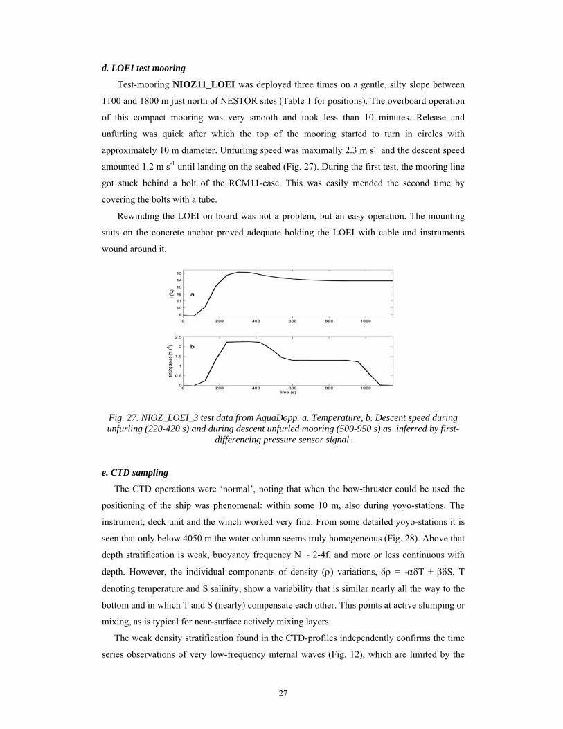
Test-mooring NIOZ11_LOEI was deployed three times on a gentle, silty slope between
1100 and 1800 m just north of NESTOR sites (Table 1 for positions). The overboard operation
of this compact mooring was very smooth and took less than 10 minutes. Release and
unfurling was quick after which the top of the mooring started to turn in circles with
approximately 10 m diameter. Unfurling speed was maximally 2.3 m s-1 and the descent speed
amounted 1.2 m s-1 until landing on the seabed (Fig. 27). During the first test, the mooring line
got stuck behind a bolt of the RCM11-case. This was easily mended the second time by
covering the bolts with a tube.
Rewinding the LOEI on board was not a problem, but an easy operation. The mounting
stuts on the concrete anchor proved adequate holding the LOEI with cable and instruments
wound around it.
Fig. 27. NIOZ_LOEI_3 test data from AquaDopp. a. Temperature, b. Descent speed during unfurling (220-420 s) and during descent unfurled mooring (500-950 s) as inferred by first-
differencing pressure sensor signal. e. CTD sampling
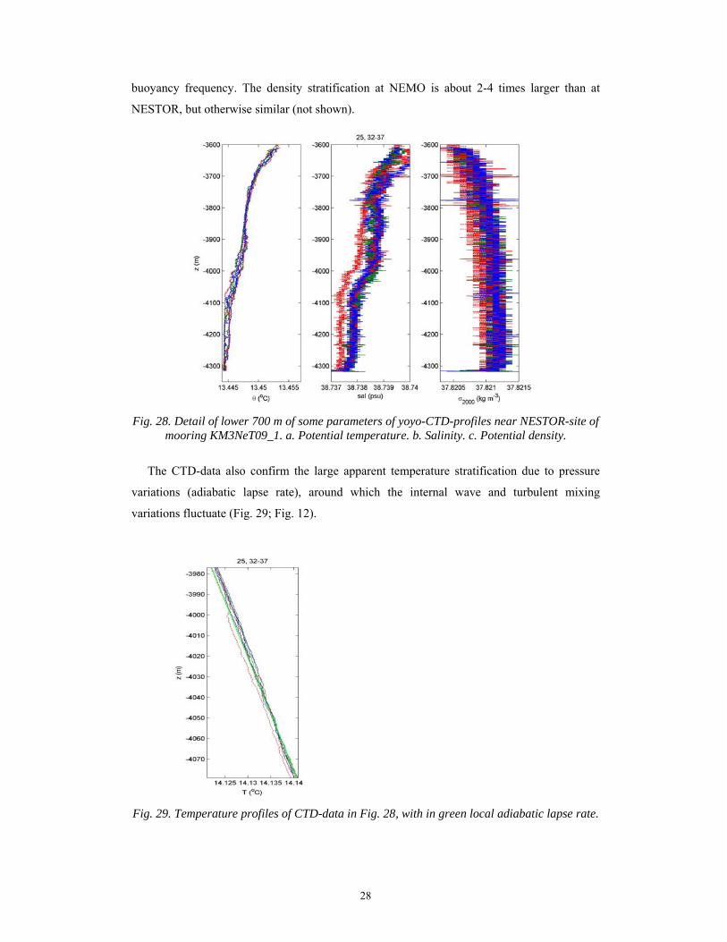
The CTD operations were ‘normal’, noting that when the bow-thruster could be used the
positioning of the ship was phenomenal: within some 10 m, also during yoyo-stations. The
instrument, deck unit and the winch worked very fine. From some detailed yoyo-stations it is
seen that only below 4050 m the water column seems truly homogeneous (Fig. 28). Above that
depth stratification is weak, buoyancy frequency N ~ 2-4f, and more or less continuous with
depth. However, the individual components of density (ρ) variations, δρ = -αδT + βδS, T
denoting temperature and S salinity, show a variability that is similar nearly all the way to the
bottom and in which T and S (nearly) compensate each other. This points at active slumping or
mixing, as is typical for near-surface actively mixing layers.
The weak density stratification found in the CTD-profiles independently confirms the time
series observations of very low-frequency internal waves (Fig. 12), which are limited by the
28
buoyancy frequency. The density stratification at NEMO is about 2-4 times larger than at
NESTOR, but otherwise similar (not shown).
Fig. 28. Detail of lower 700 m of some parameters of yoyo-CTD-profiles near NESTOR-site of
mooring KM3NeT09_1. a. Potential temperature. b. Salinity. c. Potential density.
The CTD-data also confirm the large apparent temperature stratification due to pressure
variations (adiabatic lapse rate), around which the internal wave and turbulent mixing
variations fluctuate (Fig. 29; Fig. 12).
Fig. 29. Temperature profiles of CTD-data in Fig. 28, with in green local adiabatic lapse rate.
29
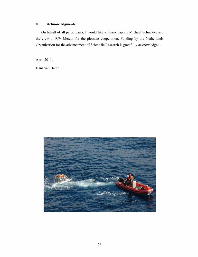
8. Achnowledgments
On behalf of all participants, I would like to thank captain Michael Schneider and
the crew of R/V Meteor for the pleasant cooperation. Funding by the Netherlands
Organization for the advancement of Scientific Research is gratefully acknowledged.
April 2011, Hans van Haren
30
Appendix A Mooring diagrams KM3NeT09 and KM3NeT11 (by T. Hillebrand, T. Linley & NIOZ-Dept. MTM)
Long-term mooring KM3NeT09_1
31
Long-term mooring KM3NeT09_2
32
Short-term mooring NIOZ11_1

33
Bottom lander mooring OL11_1…4
Pair of 17” vacuum spheres mounted in an aluminium frame
Dahn buoy with flag, radio-beacon and strobe Pellet buoy on floating rope
Lander frame
Ballast and reference cross
34
KM3NeT_LOM mooring
35
NIOZ11_LOEI mooring
36
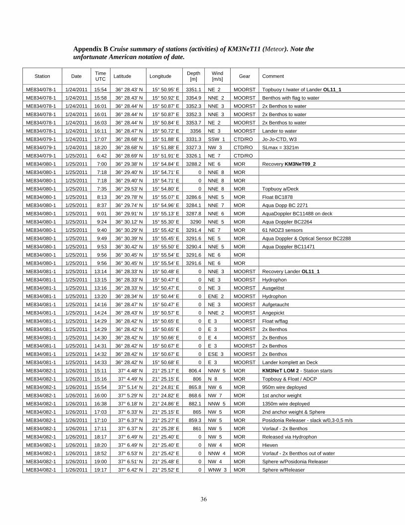
Appendix B Cruise summary of stations (activities) of KM3NeT11 (Meteor). Note the unfortunate American notation of date.
Station Date Time UTC Latitude Longitude Depth
[m] Wind [m/s] Gear Comment
ME834/078-1 1/24/2011 15:54 36° 28.43' N 15° 50.95' E 3351.1 NE 2 MOORST Topbuoy t /water of Lander OL11_1
ME834/078-1 1/24/2011 15:58 36° 28.43' N 15° 50.92' E 3354.9 NNE 2 MOORST Benthos with flag to water ME834/078-1 1/24/2011 16:01 36° 28.44' N 15° 50.87' E 3352.3 NNE 3 MOORST 2x Benthos to water ME834/078-1 1/24/2011 16:01 36° 28.44' N 15° 50.87' E 3352.3 NNE 3 MOORST 2x Benthos to water ME834/078-1 1/24/2011 16:03 36° 28.44' N 15° 50.84' E 3353.7 NE 2 MOORST 2x Benthos to water ME834/078-1 1/24/2011 16:11 36° 28.47' N 15° 50.72' E 3356 NE 3 MOORST Lander to water ME834/079-1 1/24/2011 17:07 36° 28.68' N 15° 51.88' E 3331.3 SSW 1 CTD/RO Jo-Jo-CTD, W3 ME834/079-1 1/24/2011 18:20 36° 28.68' N 15° 51.88' E 3327.3 NW 3 CTD/RO SLmax = 3321m ME834/079-1 1/25/2011 6:42 36° 28.69' N 15° 51.91' E 3326.1 NE 7 CTD/RO ME834/080-1 1/25/2011 7:00 36° 29.38' N 15° 54.84' E 3288.2 NE 6 MOR Recovery KM3NeT09_2
ME834/080-1 1/25/2011 7:18 36° 29.40' N 15° 54.71' E 0 NNE 8 MOR ME834/080-1 1/25/2011 7:18 36° 29.40' N 15° 54.71' E 0 NNE 8 MOR ME834/080-1 1/25/2011 7:35 36° 29.53' N 15° 54.80' E 0 NNE 8 MOR Topbuoy a/Deck ME834/080-1 1/25/2011 8:13 36° 29.78' N 15° 55.07' E 3286.6 NNE 5 MOR Float BC1878 ME834/080-1 1/25/2011 8:37 36° 29.74' N 15° 54.96' E 3284.1 NNE 7 MOR Aqua Dopp BC 2271 ME834/080-1 1/25/2011 9:01 36° 29.91' N 15° 55.13' E 3287.8 NNE 6 MOR AquaDoppler BC11488 on deck ME834/080-1 1/25/2011 9:24 36° 30.12' N 15° 55.30' E 3290 NNE 5 MOR Aqua Doppler BC2264 ME834/080-1 1/25/2011 9:40 36° 30.29' N 15° 55.42' E 3291.4 NE 7 MOR 61 NIOZ3 sensors ME834/080-1 1/25/2011 9:49 36° 30.39' N 15° 55.45' E 3291.6 NE 5 MOR Aqua Doppler & Optical Sensor BC2288 ME834/080-1 1/25/2011 9:53 36° 30.42' N 15° 55.50' E 3290.4 NNE 5 MOR Aqua Doppler BC11471 ME834/080-1 1/25/2011 9:56 36° 30.45' N 15° 55.54' E 3291.6 NE 6 MOR ME834/080-1 1/25/2011 9:56 36° 30.45' N 15° 55.54' E 3291.6 NE 6 MOR ME834/081-1 1/25/2011 13:14 36° 28.33' N 15° 50.48' E 0 NNE 3 MOORST Recovery Lander OL11_1
ME834/081-1 1/25/2011 13:15 36° 28.33' N 15° 50.47' E 0 NE 3 MOORST Hydrophon ME834/081-1 1/25/2011 13:16 36° 28.33' N 15° 50.47' E 0 NE 3 MOORST Ausgelöst ME834/081-1 1/25/2011 13:20 36° 28.34' N 15° 50.44' E 0 ENE 2 MOORST Hydrophon ME834/081-1 1/25/2011 14:16 36° 28.47' N 15° 50.47' E 0 NE 3 MOORST Aufgetaucht ME834/081-1 1/25/2011 14:24 36° 28.43' N 15° 50.57' E 0 NNE 2 MOORST Angepickt ME834/081-1 1/25/2011 14:29 36° 28.42' N 15° 50.65' E 0 E 3 MOORST Float w/flag ME834/081-1 1/25/2011 14:29 36° 28.42' N 15° 50.65' E 0 E 3 MOORST 2x Benthos ME834/081-1 1/25/2011 14:30 36° 28.42' N 15° 50.66' E 0 E 4 MOORST 2x Benthos ME834/081-1 1/25/2011 14:31 36° 28.42' N 15° 50.67' E 0 E 3 MOORST 2x Benthos ME834/081-1 1/25/2011 14:32 36° 28.42' N 15° 50.67' E 0 ESE 3 MOORST 2x Benthos ME834/081-1 1/25/2011 14:33 36° 28.42' N 15° 50.68' E 0 E 3 MOORST Lander komplett an Deck ME834/082-1 1/26/2011 15:11 37° 4.48' N 21° 25.17' E 806.4 NNW 5 MOR KM3NeT LOM 2 - Station starts ME834/082-1 1/26/2011 15:16 37° 4.49' N 21° 25.15' E 806 N 8 MOR Topbouy & Float / ADCP ME834/082-1 1/26/2011 15:54 37° 5.14' N 21° 24.81' E 865.8 NW 6 MOR 950m wire deployed ME834/082-1 1/26/2011 16:00 37° 5.29' N 21° 24.82' E 868.6 NW 7 MOR 1st anchor weight ME834/082-1 1/26/2011 16:38 37° 6.18' N 21° 24.86' E 882.1 NNW 5 MOR 1350m wire deployed ME834/082-1 1/26/2011 17:03 37° 6.33' N 21° 25.15' E 865 NW 5 MOR 2nd anchor weight & Sphere ME834/082-1 1/26/2011 17:10 37° 6.37' N 21° 25.27' E 859.3 NW 5 MOR Posidonia Releaser - slack w/0,3-0,5 m/s ME834/082-1 1/26/2011 17:11 37° 6.37' N 21° 25.28' E 861 NW 5 MOR Vorlauf - 2x Benthos ME834/082-1 1/26/2011 18:17 37° 6.49' N 21° 25.40' E 0 NW 5 MOR Released via Hydrophon ME834/082-1 1/26/2011 18:20 37° 6.49' N 21° 25.40' E 0 NW 4 MOR Hieven ME834/082-1 1/26/2011 18:52 37° 6.53' N 21° 25.42' E 0 NNW 4 MOR Vorlauf - 2x Benthos out of water ME834/082-1 1/26/2011 19:00 37° 6.51' N 21° 25.48' E 0 NW 4 MOR Sphere w/Posidonia Releaser ME834/082-1 1/26/2011 19:17 37° 6.42' N 21° 25.52' E 0 WNW 3 MOR Sphere w/Releaser
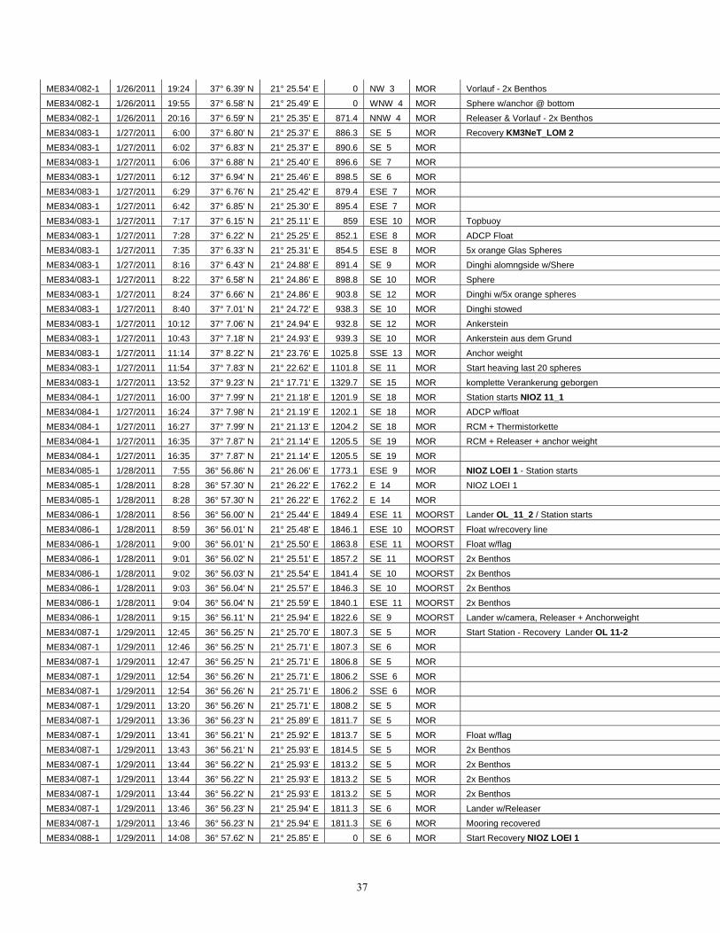
37
ME834/082-1 1/26/2011 19:24 37° 6.39' N 21° 25.54' E 0 NW 3 MOR Vorlauf - 2x Benthos ME834/082-1 1/26/2011 19:55 37° 6.58' N 21° 25.49' E 0 WNW 4 MOR Sphere w/anchor @ bottom ME834/082-1 1/26/2011 20:16 37° 6.59' N 21° 25.35' E 871.4 NNW 4 MOR Releaser & Vorlauf - 2x Benthos ME834/083-1 1/27/2011 6:00 37° 6.80' N 21° 25.37' E 886.3 SE 5 MOR Recovery KM3NeT_LOM 2
ME834/083-1 1/27/2011 6:02 37° 6.83' N 21° 25.37' E 890.6 SE 5 MOR ME834/083-1 1/27/2011 6:06 37° 6.88' N 21° 25.40' E 896.6 SE 7 MOR ME834/083-1 1/27/2011 6:12 37° 6.94' N 21° 25.46' E 898.5 SE 6 MOR ME834/083-1 1/27/2011 6:29 37° 6.76' N 21° 25.42' E 879.4 ESE 7 MOR ME834/083-1 1/27/2011 6:42 37° 6.85' N 21° 25.30' E 895.4 ESE 7 MOR ME834/083-1 1/27/2011 7:17 37° 6.15' N 21° 25.11' E 859 ESE 10 MOR Topbuoy ME834/083-1 1/27/2011 7:28 37° 6.22' N 21° 25.25' E 852.1 ESE 8 MOR ADCP Float ME834/083-1 1/27/2011 7:35 37° 6.33' N 21° 25.31' E 854.5 ESE 8 MOR 5x orange Glas Spheres ME834/083-1 1/27/2011 8:16 37° 6.43' N 21° 24.88' E 891.4 SE 9 MOR Dinghi alomngside w/Shere ME834/083-1 1/27/2011 8:22 37° 6.58' N 21° 24.86' E 898.8 SE 10 MOR Sphere ME834/083-1 1/27/2011 8:24 37° 6.66' N 21° 24.86' E 903.8 SE 12 MOR Dinghi w/5x orange spheres ME834/083-1 1/27/2011 8:40 37° 7.01' N 21° 24.72' E 938.3 SE 10 MOR Dinghi stowed ME834/083-1 1/27/2011 10:12 37° 7.06' N 21° 24.94' E 932.8 SE 12 MOR Ankerstein ME834/083-1 1/27/2011 10:43 37° 7.18' N 21° 24.93' E 939.3 SE 10 MOR Ankerstein aus dem Grund ME834/083-1 1/27/2011 11:14 37° 8.22' N 21° 23.76' E 1025.8 SSE 13 MOR Anchor weight ME834/083-1 1/27/2011 11:54 37° 7.83' N 21° 22.62' E 1101.8 SE 11 MOR Start heaving last 20 spheres ME834/083-1 1/27/2011 13:52 37° 9.23' N 21° 17.71' E 1329.7 SE 15 MOR komplette Verankerung geborgen ME834/084-1 1/27/2011 16:00 37° 7.99' N 21° 21.18' E 1201.9 SE 18 MOR Station starts NIOZ 11_1
ME834/084-1 1/27/2011 16:24 37° 7.98' N 21° 21.19' E 1202.1 SE 18 MOR ADCP w/float ME834/084-1 1/27/2011 16:27 37° 7.99' N 21° 21.13' E 1204.2 SE 18 MOR RCM + Thermistorkette ME834/084-1 1/27/2011 16:35 37° 7.87' N 21° 21.14' E 1205.5 SE 19 MOR RCM + Releaser + anchor weight ME834/084-1 1/27/2011 16:35 37° 7.87' N 21° 21.14' E 1205.5 SE 19 MOR ME834/085-1 1/28/2011 7:55 36° 56.86' N 21° 26.06' E 1773.1 ESE 9 MOR NIOZ LOEI 1 - Station starts ME834/085-1 1/28/2011 8:28 36° 57.30' N 21° 26.22' E 1762.2 E 14 MOR NIOZ LOEI 1 ME834/085-1 1/28/2011 8:28 36° 57.30' N 21° 26.22' E 1762.2 E 14 MOR ME834/086-1 1/28/2011 8:56 36° 56.00' N 21° 25.44' E 1849.4 ESE 11 MOORST Lander OL_11_2 / Station starts
ME834/086-1 1/28/2011 8:59 36° 56.01' N 21° 25.48' E 1846.1 ESE 10 MOORST Float w/recovery line ME834/086-1 1/28/2011 9:00 36° 56.01' N 21° 25.50' E 1863.8 ESE 11 MOORST Float w/flag ME834/086-1 1/28/2011 9:01 36° 56.02' N 21° 25.51' E 1857.2 SE 11 MOORST 2x Benthos ME834/086-1 1/28/2011 9:02 36° 56.03' N 21° 25.54' E 1841.4 SE 10 MOORST 2x Benthos ME834/086-1 1/28/2011 9:03 36° 56.04' N 21° 25.57' E 1846.3 SE 10 MOORST 2x Benthos ME834/086-1 1/28/2011 9:04 36° 56.04' N 21° 25.59' E 1840.1 ESE 11 MOORST 2x Benthos ME834/086-1 1/28/2011 9:15 36° 56.11' N 21° 25.94' E 1822.6 SE 9 MOORST Lander w/camera, Releaser + Anchorweight ME834/087-1 1/29/2011 12:45 36° 56.25' N 21° 25.70' E 1807.3 SE 5 MOR Start Station - Recovery Lander OL 11-2
ME834/087-1 1/29/2011 12:46 36° 56.25' N 21° 25.71' E 1807.3 SE 6 MOR ME834/087-1 1/29/2011 12:47 36° 56.25' N 21° 25.71' E 1806.8 SE 5 MOR ME834/087-1 1/29/2011 12:54 36° 56.26' N 21° 25.71' E 1806.2 SSE 6 MOR ME834/087-1 1/29/2011 12:54 36° 56.26' N 21° 25.71' E 1806.2 SSE 6 MOR ME834/087-1 1/29/2011 13:20 36° 56.26' N 21° 25.71' E 1808.2 SE 5 MOR ME834/087-1 1/29/2011 13:36 36° 56.23' N 21° 25.89' E 1811.7 SE 5 MOR ME834/087-1 1/29/2011 13:41 36° 56.21' N 21° 25.92' E 1813.7 SE 5 MOR Float w/flag ME834/087-1 1/29/2011 13:43 36° 56.21' N 21° 25.93' E 1814.5 SE 5 MOR 2x Benthos ME834/087-1 1/29/2011 13:44 36° 56.22' N 21° 25.93' E 1813.2 SE 5 MOR 2x Benthos ME834/087-1 1/29/2011 13:44 36° 56.22' N 21° 25.93' E 1813.2 SE 5 MOR 2x Benthos ME834/087-1 1/29/2011 13:44 36° 56.22' N 21° 25.93' E 1813.2 SE 5 MOR 2x Benthos ME834/087-1 1/29/2011 13:46 36° 56.23' N 21° 25.94' E 1811.3 SE 6 MOR Lander w/Releaser ME834/087-1 1/29/2011 13:46 36° 56.23' N 21° 25.94' E 1811.3 SE 6 MOR Mooring recovered ME834/088-1 1/29/2011 14:08 36° 57.62' N 21° 25.85' E 0 SE 6 MOR Start Recovery NIOZ LOEI 1
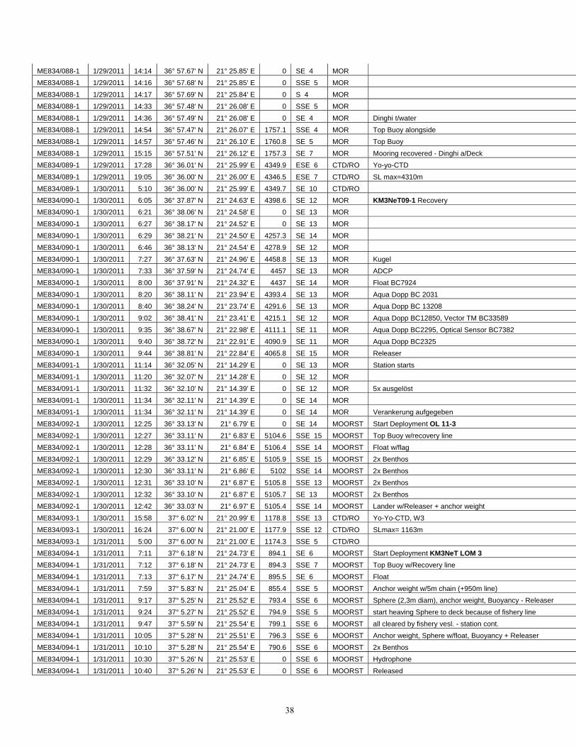
38
ME834/088-1 1/29/2011 14:14 36° 57.67' N 21° 25.85' E 0 SE 4 MOR ME834/088-1 1/29/2011 14:16 36° 57.68' N 21° 25.85' E 0 SSE 5 MOR ME834/088-1 1/29/2011 14:17 36° 57.69' N 21° 25.84' E 0 S 4 MOR ME834/088-1 1/29/2011 14:33 36° 57.48' N 21° 26.08' E 0 SSE 5 MOR ME834/088-1 1/29/2011 14:36 36° 57.49' N 21° 26.08' E 0 SE 4 MOR Dinghi t/water ME834/088-1 1/29/2011 14:54 36° 57.47' N 21° 26.07' E 1757.1 SSE 4 MOR Top Buoy alongside ME834/088-1 1/29/2011 14:57 36° 57.46' N 21° 26.10' E 1760.8 SE 5 MOR Top Buoy ME834/088-1 1/29/2011 15:15 36° 57.51' N 21° 26.12' E 1757.3 SE 7 MOR Mooring recovered - Dinghi a/Deck ME834/089-1 1/29/2011 17:28 36° 36.01' N 21° 25.99' E 4349.9 ESE 6 CTD/RO Yo-yo-CTD ME834/089-1 1/29/2011 19:05 36° 36.00' N 21° 26.00' E 4346.5 ESE 7 CTD/RO SL max=4310m ME834/089-1 1/30/2011 5:10 36° 36.00' N 21° 25.99' E 4349.7 SE 10 CTD/RO ME834/090-1 1/30/2011 6:05 36° 37.87' N 21° 24.63' E 4398.6 SE 12 MOR KM3NeT09-1 Recovery ME834/090-1 1/30/2011 6:21 36° 38.06' N 21° 24.58' E 0 SE 13 MOR ME834/090-1 1/30/2011 6:27 36° 38.17' N 21° 24.52' E 0 SE 13 MOR ME834/090-1 1/30/2011 6:29 36° 38.21' N 21° 24.50' E 4257.3 SE 14 MOR ME834/090-1 1/30/2011 6:46 36° 38.13' N 21° 24.54' E 4278.9 SE 12 MOR ME834/090-1 1/30/2011 7:27 36° 37.63' N 21° 24.96' E 4458.8 SE 13 MOR Kugel ME834/090-1 1/30/2011 7:33 36° 37.59' N 21° 24.74' E 4457 SE 13 MOR ADCP ME834/090-1 1/30/2011 8:00 36° 37.91' N 21° 24.32' E 4437 SE 14 MOR Float BC7924 ME834/090-1 1/30/2011 8:20 36° 38.11' N 21° 23.94' E 4393.4 SE 13 MOR Aqua Dopp BC 2031 ME834/090-1 1/30/2011 8:40 36° 38.24' N 21° 23.74' E 4291.6 SE 13 MOR Aqua Dopp BC 13208 ME834/090-1 1/30/2011 9:02 36° 38.41' N 21° 23.41' E 4215.1 SE 12 MOR Aqua Dopp BC12850, Vector TM BC33589 ME834/090-1 1/30/2011 9:35 36° 38.67' N 21° 22.98' E 4111.1 SE 11 MOR Aqua Dopp BC2295, Optical Sensor BC7382 ME834/090-1 1/30/2011 9:40 36° 38.72' N 21° 22.91' E 4090.9 SE 11 MOR Aqua Dopp BC2325 ME834/090-1 1/30/2011 9:44 36° 38.81' N 21° 22.84' E 4065.8 SE 15 MOR Releaser ME834/091-1 1/30/2011 11:14 36° 32.05' N 21° 14.29' E 0 SE 13 MOR Station starts ME834/091-1 1/30/2011 11:20 36° 32.07' N 21° 14.28' E 0 SE 12 MOR ME834/091-1 1/30/2011 11:32 36° 32.10' N 21° 14.39' E 0 SE 12 MOR 5x ausgelöst ME834/091-1 1/30/2011 11:34 36° 32.11' N 21° 14.39' E 0 SE 14 MOR ME834/091-1 1/30/2011 11:34 36° 32.11' N 21° 14.39' E 0 SE 14 MOR Verankerung aufgegeben ME834/092-1 1/30/2011 12:25 36° 33.13' N 21° 6.79' E 0 SE 14 MOORST Start Deployment OL 11-3
ME834/092-1 1/30/2011 12:27 36° 33.11' N 21° 6.83' E 5104.6 SSE 15 MOORST Top Buoy w/recovery line ME834/092-1 1/30/2011 12:28 36° 33.11' N 21° 6.84' E 5106.4 SSE 14 MOORST Float w/flag ME834/092-1 1/30/2011 12:29 36° 33.12' N 21° 6.85' E 5105.9 SSE 15 MOORST 2x Benthos ME834/092-1 1/30/2011 12:30 36° 33.11' N 21° 6.86' E 5102 SSE 14 MOORST 2x Benthos ME834/092-1 1/30/2011 12:31 36° 33.10' N 21° 6.87' E 5105.8 SSE 13 MOORST 2x Benthos ME834/092-1 1/30/2011 12:32 36° 33.10' N 21° 6.87' E 5105.7 SE 13 MOORST 2x Benthos ME834/092-1 1/30/2011 12:42 36° 33.03' N 21° 6.97' E 5105.4 SSE 14 MOORST Lander w/Releaser + anchor weight ME834/093-1 1/30/2011 15:58 37° 6.02' N 21° 20.99' E 1178.8 SSE 13 CTD/RO Yo-Yo-CTD, W3 ME834/093-1 1/30/2011 16:24 37° 6.00' N 21° 21.00' E 1177.9 SSE 12 CTD/RO SLmax= 1163m ME834/093-1 1/31/2011 5:00 37° 6.00' N 21° 21.00' E 1174.3 SSE 5 CTD/RO ME834/094-1 1/31/2011 7:11 37° 6.18' N 21° 24.73' E 894.1 SE 6 MOORST Start Deployment KM3NeT LOM 3 ME834/094-1 1/31/2011 7:12 37° 6.18' N 21° 24.73' E 894.3 SSE 7 MOORST Top Buoy w/Recovery line ME834/094-1 1/31/2011 7:13 37° 6.17' N 21° 24.74' E 895.5 SE 6 MOORST Float ME834/094-1 1/31/2011 7:59 37° 5.83' N 21° 25.04' E 855.4 SSE 5 MOORST Anchor weight w/5m chain (+950m line) ME834/094-1 1/31/2011 9:17 37° 5.25' N 21° 25.52' E 793.4 SSE 6 MOORST Sphere (2,3m diam), anchor weight, Buoyancy - Releaser ME834/094-1 1/31/2011 9:24 37° 5.27' N 21° 25.52' E 794.9 SSE 5 MOORST start heaving Sphere to deck because of fishery line ME834/094-1 1/31/2011 9:47 37° 5.59' N 21° 25.54' E 799.1 SSE 6 MOORST all cleared by fishery vesl. - station cont. ME834/094-1 1/31/2011 10:05 37° 5.28' N 21° 25.51' E 796.3 SSE 6 MOORST Anchor weight, Sphere w/float, Buoyancy + Releaser ME834/094-1 1/31/2011 10:10 37° 5.28' N 21° 25.54' E 790.6 SSE 6 MOORST 2x Benthos ME834/094-1 1/31/2011 10:30 37° 5.26' N 21° 25.53' E 0 SSE 6 MOORST Hydrophone ME834/094-1 1/31/2011 10:40 37° 5.26' N 21° 25.53' E 0 SSE 6 MOORST Released

39
ME834/094-1 1/31/2011 11:12 37° 5.20' N 21° 25.58' E 0 SSE 5 MOORST 2x Benthos ME834/094-1 1/31/2011 11:16 37° 5.18' N 21° 25.59' E 0 SSE 5 MOORST Releaser ME834/095-1 1/31/2011 12:00 37° 5.10' N 21° 25.66' E 0 SSE 3 MOORST Recovery KM3NeT LOM 3
ME834/095-1 1/31/2011 12:00 37° 5.10' N 21° 25.66' E 0 SSE 3 MOORST Hydrophon ME834/095-1 1/31/2011 12:00 37° 5.10' N 21° 25.66' E 0 SSE 3 MOORST Mooring ausgelöst ME834/095-1 1/31/2011 12:01 37° 5.10' N 21° 25.66' E 0 SSE 3 MOORST Hydrophone ME834/095-1 1/31/2011 12:10 37° 5.09' N 21° 25.66' E 0 S 4 MOORST Sphere + Buoyancy at surface ME834/095-1 1/31/2011 12:12 37° 5.09' N 21° 25.66' E 0 SSE 4 MOORST Dinghi ME834/095-1 1/31/2011 12:29 37° 5.48' N 21° 25.53' E 796.4 SSE 2 MOORST Buoyancy ME834/095-1 1/31/2011 12:30 37° 5.50' N 21° 25.53' E 796.9 SSE 2 MOORST 3x glass sphere (small) ME834/095-1 1/31/2011 12:40 37° 5.61' N 21° 25.56' E 801.9 ESE 2 MOORST Sphere (2,3m diam) ME834/095-1 1/31/2011 13:09 37° 5.90' N 21° 25.16' E 848 S 1 MOORST Topbuoy + Float alongside ME834/095-1 1/31/2011 13:17 37° 5.91' N 21° 25.06' E 854.2 SSE 2 MOORST Top Buoy + Float ME834/095-1 1/31/2011 14:14 37° 5.66' N 21° 25.36' E 819.2 S 4 MOORST 1. Anchor weight ME834/095-1 1/31/2011 15:00 37° 5.50' N 21° 25.47' E 806.6 S 5 MOORST 5x glass sphere at surface ME834/095-1 1/31/2011 15:17 37° 5.95' N 21° 25.43' E 827.7 S 5 MOORST Dinghi w/5x glass sphere ME834/095-1 1/31/2011 15:29 37° 6.28' N 21° 25.40' E 850.9 S 4 MOORST 2. Anchor weight + chain ME834/095-1 1/31/2011 15:40 37° 6.57' N 21° 25.43' E 869.3 S 4 MOORST start heaving remaining 17 spheres ME834/095-1 1/31/2011 16:58 37° 8.59' N 21° 25.46' E 957.4 W 2 MOORST 17 spheres on deck ME834/096-1 1/31/2011 17:48 37° 3.93' N 21° 25.01' E 1044.9 SSE 3 MB rwK = 360 ME834/096-1 1/31/2011 18:24 37° 7.04' N 21° 25.01' E 934.4 N 2 MB rwK=270° ME834/096-1 1/31/2011 18:31 37° 7.18' N 21° 24.50' E 971.7 NNW 2 MB rwk=180° ME834/096-1 1/31/2011 19:10 37° 3.88' N 21° 24.29' E 1116.1 SE 6 MB rwK=270° ME834/096-1 1/31/2011 19:18 37° 3.92' N 21° 23.54' E 1213.2 SSE 3 MB rwK000° ME834/096-1 1/31/2011 19:54 37° 7.16' N 21° 23.54' E 1029 NNW 3 MB rwK=270° ME834/096-1 1/31/2011 20:00 37° 7.17' N 21° 23.03' E 1065.3 N 4 MB rwk=180° ME834/096-1 1/31/2011 20:38 37° 3.93' N 21° 22.89' E 1272.9 N 5 MB rwK=270° ME834/096-1 1/31/2011 20:44 37° 3.83' N 21° 22.38' E 1356.7 NNW 4 MB rwK=000° ME834/096-1 1/31/2011 21:20 37° 6.99' N 21° 22.21' E 1125.6 NE 4 MB rwK=270° ME834/096-1 1/31/2011 21:27 37° 7.17' N 21° 21.71' E 1162.3 NE 5 MB rwK=180° ME834/096-1 1/31/2011 22:05 37° 4.01' N 21° 21.50' E 1382.5 ENE 4 MB rwK=270° ME834/096-1 1/31/2011 22:13 37° 3.93' N 21° 20.84' E 1527 ENE 3 MB rwk=000° ME834/096-1 1/31/2011 22:50 37° 6.95' N 21° 20.80' E 1214.6 ENE 5 MB rwk=270° ME834/096-1 1/31/2011 23:03 37° 7.07' N 21° 20.13' E 1239.8 E 4 MB rwk=180° ME834/096-1 1/31/2011 23:40 37° 4.01' N 21° 20.06' E 1595.4 ESE 5 MB Distance d=29,9nm ME834/097-1 2/1/2011 6:10 36° 33.27' N 21° 7.06' E 0 ESE 11 MOR Start recovery OL 11-3
ME834/097-1 2/1/2011 6:14 36° 33.27' N 21° 7.06' E 0 ESE 11 MOR ME834/097-1 2/1/2011 6:18 36° 33.27' N 21° 7.06' E 5106.6 ESE 11 MOR ME834/097-1 2/1/2011 7:43 36° 33.27' N 21° 7.06' E 5106 ESE 10 MOR ME834/097-1 2/1/2011 7:52 36° 33.13' N 21° 7.00' E 5102.7 ESE 10 MOR Mooring alongside ME834/097-1 2/1/2011 8:16 36° 33.21' N 21° 6.52' E 5190 ESE 10 MOR Flag ME834/097-1 2/1/2011 8:19 36° 33.24' N 21° 6.44' E 5106.4 ESE 10 MOR 1st buoyancy ME834/097-1 2/1/2011 8:20 36° 33.25' N 21° 6.41' E 5109.7 ESE 11 MOR 2nd buoyancy ME834/097-1 2/1/2011 8:20 36° 33.25' N 21° 6.41' E 5109.7 ESE 11 MOR 3rd buoyancy ME834/097-1 2/1/2011 8:21 36° 33.27' N 21° 6.37' E 5105.8 ESE 10 MOR 4th buoyancy ME834/097-1 2/1/2011 8:23 36° 33.30' N 21° 6.30' E 5105.4 ESE 9 MOR ME834/098-1 2/1/2011 8:34 36° 33.31' N 21° 6.12' E 5105.4 ESE 11 CTD W3 ME834/098-1 2/1/2011 10:16 36° 33.31' N 21° 6.13' E 5107 ESE 8 CTD SLmax = 5098m ME834/098-1 2/1/2011 12:30 36° 33.33' N 21° 6.12' E 5106 SE 8 CTD ME834/099-1 2/1/2011 15:45 37° 5.10' N 21° 22.00' E 2233.6 SSW 4 MOORST LOEI_2 Launch Ocean Experiment Instrument (Spirale Mooring
ME834/099-1 2/1/2011 15:46 37° 5.10' N 21° 22.00' E 2265.2 SSW 4 MOORST Sliped ME834/099-1 2/1/2011 15:53 37° 5.08' N 21° 21.97' E 2225.7 S 4 MOORST submerged abt. 60mtr. North of the ship
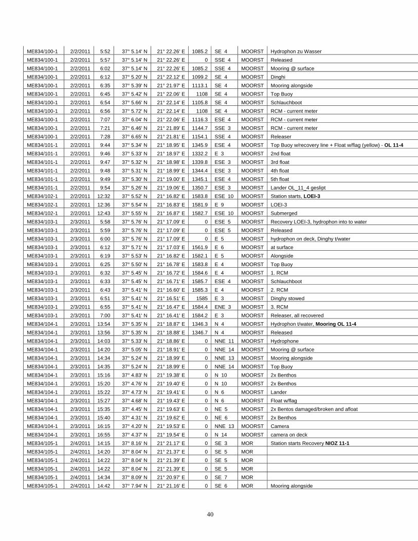
40
ME834/100-1 2/2/2011 5:52 37° 5.14' N 21° 22.26' E 1085.2 SE 4 MOORST Hydrophon zu Wasser ME834/100-1 2/2/2011 5:57 37° 5.14' N 21° 22.26' E 0 SSE 4 MOORST Released ME834/100-1 2/2/2011 6:02 37° 5.14' N 21° 22.26' E 1085.2 SSE 4 MOORST Mooring @ surface ME834/100-1 2/2/2011 6:12 37° 5.20' N 21° 22.12' E 1099.2 SE 4 MOORST Dinghi ME834/100-1 2/2/2011 6:35 37° 5.39' N 21° 21.97' E 1113.1 SE 4 MOORST Mooring alongside ME834/100-1 2/2/2011 6:45 37° 5.42' N 21° 22.06' E 1108 SE 4 MOORST Top Buoy ME834/100-1 2/2/2011 6:54 37° 5.66' N 21° 22.14' E 1105.8 SE 4 MOORST Schlauchboot ME834/100-1 2/2/2011 6:56 37° 5.72' N 21° 22.14' E 1108 SE 4 MOORST RCM - current meter ME834/100-1 2/2/2011 7:07 37° 6.04' N 21° 22.06' E 1116.3 ESE 4 MOORST RCM - current meter ME834/100-1 2/2/2011 7:21 37° 6.46' N 21° 21.89' E 1144.7 SSE 3 MOORST RCM - current meter ME834/100-1 2/2/2011 7:28 37° 6.65' N 21° 21.81' E 1154.1 SSE 4 MOORST Releaser ME834/101-1 2/2/2011 9:44 37° 5.34' N 21° 18.95' E 1345.9 ESE 4 MOORST Top Buoy w/recovery line + Float w/flag (yellow) - OL 11-4 ME834/101-1 2/2/2011 9:46 37° 5.33' N 21° 18.97' E 1332.2 E 3 MOORST 2nd float ME834/101-1 2/2/2011 9:47 37° 5.32' N 21° 18.98' E 1339.8 ESE 3 MOORST 3rd float ME834/101-1 2/2/2011 9:48 37° 5.31' N 21° 18.99' E 1344.4 ESE 3 MOORST 4th float ME834/101-1 2/2/2011 9:49 37° 5.30' N 21° 19.00' E 1345.1 ESE 4 MOORST 5th float ME834/101-1 2/2/2011 9:54 37° 5.26' N 21° 19.06' E 1350.7 ESE 3 MOORST Lander OL_11_4 geslipt ME834/102-1 2/2/2011 12:32 37° 5.52' N 21° 16.82' E 1583.8 ESE 10 MOORST Station starts, LOEI-3
ME834/102-1 2/2/2011 12:36 37° 5.54' N 21° 16.83' E 1581.9 E 9 MOORST LOEI-3 ME834/102-1 2/2/2011 12:43 37° 5.55' N 21° 16.87' E 1582.7 ESE 10 MOORST Submerged ME834/103-1 2/3/2011 5:58 37° 5.76' N 21° 17.09' E 0 ESE 5 MOORST Recovery LOEI-3, hydrophon into to water ME834/103-1 2/3/2011 5:59 37° 5.76' N 21° 17.09' E 0 ESE 5 MOORST Released ME834/103-1 2/3/2011 6:00 37° 5.76' N 21° 17.09' E 0 E 5 MOORST hydrophon on deck, Dinghy t/water ME834/103-1 2/3/2011 6:12 37° 5.71' N 21° 17.03' E 1561.9 E 6 MOORST at surface ME834/103-1 2/3/2011 6:19 37° 5.53' N 21° 16.82' E 1582.1 E 5 MOORST Alongside ME834/103-1 2/3/2011 6:25 37° 5.50' N 21° 16.78' E 1583.8 E 4 MOORST Top Buoy ME834/103-1 2/3/2011 6:32 37° 5.45' N 21° 16.72' E 1584.6 E 4 MOORST 1. RCM ME834/103-1 2/3/2011 6:33 37° 5.45' N 21° 16.71' E 1585.7 ESE 4 MOORST Schlauchboot ME834/103-1 2/3/2011 6:43 37° 5.41' N 21° 16.60' E 1585.3 E 4 MOORST 2. RCM ME834/103-1 2/3/2011 6:51 37° 5.41' N 21° 16.51' E 1585 E 3 MOORST Dinghy stowed ME834/103-1 2/3/2011 6:55 37° 5.41' N 21° 16.47' E 1584.4 ENE 3 MOORST 3. RCM ME834/103-1 2/3/2011 7:00 37° 5.41' N 21° 16.41' E 1584.2 E 3 MOORST Releaser, all recovered ME834/104-1 2/3/2011 13:54 37° 5.35' N 21° 18.87' E 1346.3 N 4 MOORST Hydrophon t/water, Mooring OL 11-4
ME834/104-1 2/3/2011 13:56 37° 5.35' N 21° 18.88' E 1346.7 N 4 MOORST Released ME834/104-1 2/3/2011 14:03 37° 5.33' N 21° 18.86' E 0 NNE 11 MOORST Hydrophone ME834/104-1 2/3/2011 14:20 37° 5.05' N 21° 18.91' E 0 NNE 14 MOORST Mooring @ surface ME834/104-1 2/3/2011 14:34 37° 5.24' N 21° 18.99' E 0 NNE 13 MOORST Mooring alongside ME834/104-1 2/3/2011 14:35 37° 5.24' N 21° 18.99' E 0 NNE 14 MOORST Top Buoy ME834/104-1 2/3/2011 15:16 37° 4.83' N 21° 19.38' E 0 N 10 MOORST 2x Benthos ME834/104-1 2/3/2011 15:20 37° 4.76' N 21° 19.40' E 0 N 10 MOORST 2x Benthos ME834/104-1 2/3/2011 15:22 37° 4.73' N 21° 19.41' E 0 N 6 MOORST Lander ME834/104-1 2/3/2011 15:27 37° 4.68' N 21° 19.43' E 0 N 6 MOORST Float w/flag ME834/104-1 2/3/2011 15:35 37° 4.45' N 21° 19.63' E 0 NE 5 MOORST 2x Bentos damaged/broken and afloat ME834/104-1 2/3/2011 15:40 37° 4.31' N 21° 19.62' E 0 NE 6 MOORST 2x Benthos ME834/104-1 2/3/2011 16:15 37° 4.20' N 21° 19.53' E 0 NNE 13 MOORST Camera ME834/104-1 2/3/2011 16:55 37° 4.37' N 21° 19.54' E 0 N 14 MOORST camera on deck ME834/105-1 2/4/2011 14:15 37° 8.16' N 21° 21.17' E 0 SE 3 MOR Station starts Recovery NIOZ 11-1 ME834/105-1 2/4/2011 14:20 37° 8.04' N 21° 21.37' E 0 SE 5 MOR ME834/105-1 2/4/2011 14:22 37° 8.04' N 21° 21.39' E 0 SE 5 MOR ME834/105-1 2/4/2011 14:22 37° 8.04' N 21° 21.39' E 0 SE 5 MOR ME834/105-1 2/4/2011 14:34 37° 8.09' N 21° 20.97' E 0 SE 7 MOR ME834/105-1 2/4/2011 14:42 37° 7.94' N 21° 21.16' E 0 SE 6 MOR Mooring alongside
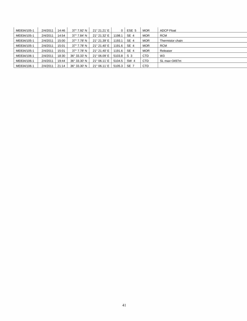
41
ME834/105-1 2/4/2011 14:46 37° 7.92' N 21° 21.21' E 0 ESE 5 MOR ADCP Float ME834/105-1 2/4/2011 14:54 37° 7.84' N 21° 21.32' E 1198.1 SE 4 MOR RCM ME834/105-1 2/4/2011 15:00 37° 7.78' N 21° 21.39' E 1193.1 SE 4 MOR Thermistor chain ME834/105-1 2/4/2011 15:01 37° 7.78' N 21° 21.40' E 1191.6 SE 4 MOR RCM ME834/105-1 2/4/2011 15:01 37° 7.78' N 21° 21.40' E 1191.6 SE 4 MOR Releaser ME834/106-1 2/4/2011 18:30 36° 33.33' N 21° 06.09' E 5103.8 S 3 CTD W3 ME834/106-1 2/4/2011 19:44 36° 33.30' N 21° 06.11' E 5104.5 SW 4 CTD SL max=3497m ME834/106-1 2/4/2011 21:14 36° 33.30' N 21° 06.11' E 5105.3 SE 7 CTD