knottingley power project · page 5 february 2013 t ä 2.1. overview 2.1.1. it is proposed to...
TRANSCRIPT
Knottingley Power Project
Preliminary Environmental Information Report
February 2013
Knottingley Power Limited

Knottingley Power ProjectPreliminary Environmental Information Report
Page 1 February 2013
TABLE OF CONTENTS
1. INTRODUCTION 21.1. Knottingley Power Limited 21.2. Knottingley Power Project 21.3. Need for the Development 31.4. Consenting Regime 31.5. Preliminary Environmental Information 4
2. DESCRIPTION OF THE PROPOSED KNOTTINGLEY POWER PROJECT 52.1. Overview 52.2. Site Location and Surroundings 52.3. Description of Proposed CCGT Power Plant 142.4. Gas Pipeline 192.5. Proposed Programme 23
3. PRELIMINARY ENVIRONMENTAL INFORMATION 253.1. CCGT Power Plant 253.2. Gas Pipeline 41
4. GLOSSARY 515. FIGURES 53
CCGT Power Project Location Plan 54Indicative CCGT Power Plant Layouts 56Gas Pipeline Route 59Water Pipelines Route 61

Knottingley Power ProjectPreliminary Environmental Information Report
Page 2 February 2013
1.1. Knottingley Power Limited
1.1.1. Knottingley Power Limited (hereafter KPL) is the development company which proposes to build and operate a natural gas fired Combined Cycle Gas Turbine (CCGT) power plant in Knottingley, West Yorkshire. KPL’s ultimate parent company is ESB.
1.1.2. ESB is a state-owned electricity company based in Ireland with a portfolio of investment projects across the world. ESB currently has projects in over 35 countries, including the UK, Europe, Middle East, Asia and Africa.
1.1.3. ESB has been in the British energy market since the early 1990s as developer and owner of Corby Power Limited in Northamptonshire (350MW) and the 842MW CCGT plant at Marchwood near Southampton. ESB will also commence construction in late 2012 of the 860MW CCGT plant at Carrington, near Manchester.
1.1.4. ESB also builds and operates renewable generation projects. In the UK, ESB owns West Durham windfarm (24MW), Fullabrook Down windfarm (66MW) and Mynydd Y Betws windfarm (37.5MW) which is under construction.
1.1.5. For details of these and other ESB projects please visit: http://www.esb.ie.
1.2. Knottingley Power Project
1.2.1. The Knottingley Power Project will be capable of generating up to 1,500MW (approximately) of electricity, equivalent to the annual electricity consumption of about two million homes.
1.2.2. The major elements of the Knottingley Power Project are described below.
Combined Cycle Gas Turbine Power Plant, Cooling Water Infrastructure and Electrical Grid Connection
1.2.3. KPL intends to develop a CCGT Power Plant with capacity to generate up to 1,500 MW (approximately) of electricity on the site of a former chemical works east of Knottingley in West Yorkshire.
1.2.4. Cooling water infrastructure to convey water from the River Aire is the most likely option to cool the steam condensers which form part of the CCGT Power Plant although the Aire and Calder Canal will also be considered if suitable.
1.2.5. The electricity generated by the CCGT power plant will be exported to the National Grid Electricity National Transmission System. Connection to the National Transmission System will involve an overhead line connection from the new substation on the power plant site to the existing 400kV overhead line (OHL) approximately 250m to the east. Two existing towers on the 400kV overhead line will be replaced with two new towers to be located adjacent to the current locations.
Gas Pipeline
1.2.6. The CCGT power plant will be fuelled by a supply of natural gas.
1.2.7. The supply of natural gas will be taken from a new underground Gas Pipeline (together with associated infrastructure, principally an Above Ground Installation AGI)) which will be constructed between the CCGT power plant site and the National Grid Gas National Transmission System.
1.2.8. The new underground Gas Pipeline will be approximately 8 kilometres (km) in length.
Knottingley Power ProjectPreliminary Environmental Information Report
Page 3 February 2013
1.3. Need for the Development
1.3.1. The development of the Knottingley Power Project is required in order to contribute towards ensuring reliability of electricity supply in the UK. Generating electricity from renewable energy sources can help the UK to meet their carbon-reduction commitments. However renewable sources alone cannot be relied upon to meet demand at all times as they are intermittent energy sources.
1.3.2. To ensure that there is reliability of supply, the electricity generation mix needs to have a balance of electricity generating technologies which produce stable and controllable amounts of electricity continuously.
1.3.3. Within this scenario, gas-fuelled electricity generating technologies can play a significant role in maintaining the UK’s reliability of supply, whilst also producing stable and controllable amounts of electricity.
1.3.4. In the second Annual Energy Statement (AES) (November, 2011), the Department of Energy and Climate Change (DECC) directed the need to build a new energy portfolio through securing investment in the UK energy sector and building power plants that will “fuel our future prosperity, and the infrastructure that will deliver it”.
1.3.5. In line with this the AES acknowledged the need for gas to continue to feature strongly in the energy mix, and also stated that while it is important that businesses play their part in the transition to a low-carbon economy, it is important to also remain competitive.
1.4. Consenting Regime
1.4.1. As the Knottingley Power Project will have an approximate generating capacity up to 1,500MW (approximately) it will require a Development Consent Order (DCO) under Section 31 of the Planning Act 2008, as it represents a Nationally Significant Infrastructure Project (NSIP) that is above the 50MW threshold for power stations. The Knottingley Power Project will also include an above ground connection to an existing 400kV National Grid power line and this is also a Nationally Significant Infrastructure Project (NSIP) as it is above the 132kV threshold for above ground electric lines.
1.4.2. An application will be submitted to the Planning Inspectorate’s (PINS) National Infrastructure Directorate. PINS role will be to consider and make recommendations to the Secretary of State who will determine the application. To support the application an Environmental Impact Assessment (EIA) will be prepared. Other documents will also be prepared to support the DCO application. These will include:
Statement of Community Consultation (SoCC);
Consultation Strategy;
Consultation Report;
Explanatory Memorandum – this will address the agreed provisions or conditions that will apply to the Knottingley Power Project;
Book of Reference – this outlines those with a land interest and affected persons;
Environmental Statement (ES);
Statement of Common Ground
Flood Risk Assessment (FRA);
Statement of Matters covered by the Environmental Protection Act 1990 Section 79(1);
Sustainability Statement; and
Knottingley Power ProjectPreliminary Environmental Information Report
Page 4 February 2013
Various plans of the Site and the proposed development: to include the application area, land boundary, proposed layout.
1.5. Preliminary Environmental Information
1.5.1. Pursuant to Sections 2 and 10(b) of the EIA Regulations, Preliminary Environmental Information (PEI) must be made available for consultation under Section 47 of the Planning Act 2008. The PEI is presented in this PEI Report (PEIR) which has been revised and updated as new information became available over the period leading up to the submission of the DCO application.
1.5.2. The PEIR indicates the key items of environmental information and issues that have been addressed. In summary, the PEIR outlines the following by each environmental topic:
Baseline description summary;
Proposed approach and surveys to be undertaken;
Initial outcomes; and,
Further environmental information provided to Section 47 Consultees during the Pre-Application stage.
Knottingley Power ProjectPreliminary Environmental Information Report
Page 5 February 2013
2.1. Overview
2.1.1. It is proposed to develop a CCGT Power Plant on a site located to the east of Knottingley, West Yorkshire on a 20 hectare site that includes the former Oxiris Chemical Works and adjoining agricultural land.
2.1.2. The Knottingley Power Project comprises a number of components which include the power plant, cooling water infrastructure, electrical grid connection and the gas pipeline. These are grouped under two main headings as follows:
Power Plant: A CCGT with a capacity to generate up to 1,500 MW (approximately) of electricity on the site of a former chemical works and agricultural land east of Knottingley in West Yorkshire. Cooling water infrastructure will form part of this application. The electricity generated by the CCGT power plant will be exported to the National Grid Electricity National Transmission System by means of a short connection to an existing 400kV overhead line approximately 250m to the east of the site. The connection to the National Grid Electricity National Transmission System will also be part of this application. These elements of the Knottingley Power Project (CCGT power plant, cooling water infrastructure and connection to electricity grid) are referred to as the CCGT Power Plant. The location of the Power Plant Site is shown in the figure CCGT Power Project Location Plan which is presented in the Figures section.
Gas Pipeline and Associated Infrastructure: The CCGT power plant will be fuelled by a supply of natural gas. The natural gas will be taken from a new underground Gas Pipeline which will be constructed between the CCGT Power Plant site and the National Grid Gas National Transmission System. The new underground Gas Pipeline will be approximately 8 km in length, and will run from the CCGT power plant site to a new Above Ground Installation which will be constructed near Gateforth (adjacent to the National Grid Gas National Transmission System pipeline). The proposed route of the underground Gas Pipeline, and the associated corridor which was presented previously in the Environmental Scoping Report, is shown in the figure Gas Pipeline Route and Assessment Corridor which is presented in the Figures section.
2.2. Site Location and Surroundings
Power Plant Site Selection
2.2.1. The proposed site offers a number of advantages that make it suitable for power generation.
2.2.2. These include,
The close proximity of the existing 400kV overhead line situated within 250 m to the east of the power plant site;
The proximity to the Gas National Transmission System within 8 km of the site;
The industrial setting of the site.
Availability of sufficient land designated for energy generation use in the local planning policy;
Transport infrastructure that will accommodate construction traffic by road; other options such as canal and rail will be investigated;

Knottingley Power ProjectPreliminary Environmental Information Report
Page 6 February 2013
Proximity to a cooling water supply from the river Aire or the Aire and Calder Canal; and
Redevelopment of a brownfield former chemical works is expected to be feasible at reasonable cost.
2.2.3. It is therefore considered that the proposed site is very suitable for the intended use of power generation.
2.2.4. As part of its strategic development planning, ESB has undertaken extensive research into sites suitable for development of CCGT projects. Through consultation with National Grid, the Knottingley location was identified as an area of the electricity network where demand for new generation and minimal new overhead line infrastructure would allow connection of new generation in a reasonable timescale.
2.2.5. Greenfield sites close to the existing National Grid infrastructure were considered. However, national planning policy and local planning policy aim to protect the countryside for its intrinsic value and encourage development of brownfield sites such as the former chemical works site at Knottingley, where possible.
2.2.6. The project location is shown in the figure below.
Project Location
Knottingley Power ProjectPreliminary Environmental Information Report
Page 7 February 2013
Description of the Power Plant Site
2.2.7. The Power Plant Site will include the power generation equipment and substation and will be located on the former chemical works and agricultural area to the east of the development site. The area is outlined clearly in the figures CCGT Power Plant Indicative Site Layouts presented in the Figures section.
Site History and Existing Use
2.2.8. Historically the site had comprised agricultural fields, which were divided by Common Lane which continues to exist as a track through the site. Based on information provided by former chemical works employees and from maps published by the Ordnance Survey (OS) it is understood that development of a chemical works on western part of the site was commenced by Yorkshire Tar Distillers in 1949 on land that had previously been in agricultural usage.
2.2.9. The chemical plant operated continuously until it was demolished in 2009. The north-western part of the site now consists of vacant derelict land including areas of hardstanding. There are also occasional small derelict buildings near the former chemical works entrance. The eastern and southern parts of the site continue to comprise agricultural fields.
2.2.10. Further information on the Site, as well as the wider Indicative Red Line Boundary area will be included in the baseline description provided for each of the specialist environmental assessments. A detailed site description, including information relating to site history, will be presented in the ES.
Power Plant Site Surroundings
2.2.11. The proposed power plant site is bound by the Aire and Calder Navigation Canal to the north and Kellingley Colliery to the north east. A railway line runs along the southern boundary of the power plant site. Agricultural land bound the power plant site to the south and west. The power plant site is within the administrative boundary of Wakefield Metropolitan District Council (Wakefield MDC), Wakefield Metropolitan MDC and the boundary of Selby District Council (Selby DC) lies 70m to the north east. In addition the site lies within North Yorkshire County Council (North Yorkshire CC).
2.2.12. The proposed power plant site lies approximately 3 km to the east of Knottingley town centre, 7 km north east of Pontefract town centre, approximately 9.5 km south east of Castleford, 13 km south west of Selby town centre and 24 km south east of Leeds town centre.
2.2.13. The closest residential dwellings are located within 100m of the north of the Site.
2.2.14. Brockadale as well as Fairburn and Newton Ings are the nearest Sites of Special Scientific Interest (SSSI) to the Knottingley Power site at approximately 5.3 km to the south and 6 km to the north west respectively.
Gas Pipeline Route Selection
2.2.15. When considering the main alternatives for the route of the Gas Pipeline, an initial area of consideration was used, roughly bounded by the M62, A1 / A162, A63 and A19.
2.2.16. The initial area of consideration is shown below.

Knottingley Power ProjectPreliminary Environmental Information Report
Page 8 February 2013
AERIAL PHOTOGRAPH SHOWING THE INITIAL AREA OF CONSIDERATION
Alternative Options for Gas Supply
2.2.17. From a technical / engineering perspective, identification of potential routes for the Gas Pipeline began with establishing the optimal point at which to take gas from the existing UK National Grid Gas System.
2.2.18. The UK National Grid Gas System is split into two parts:
The National Transmission System, also known the United Kingdom Transmission System (UK-T); and,
The Local Distribution System, also known as the United Kingdom Distribution System (UK-D).

Knottingley Power ProjectPreliminary Environmental Information Report
Page 9 February 2013
National Transmission System
2.2.19. The National Transmission System represents the infrastructure designed to transmit gas around the country, and is the backbone of the UK gas infrastructure reaching all points of mainland Britain.
2.2.20. National Transmission System infrastructure is generally larger pipelines (greater than 24 inches / 600 mm in diameter) operating at high pressure (approximately 70 bar g).
2.2.21. Two 1200 mm high pressure steel pipelines are the nearest National Transmission System pipelines to the proposed CCGT power plant site. These are:
Feeder 29 (Pannal to Asselby); and,
Feeder 7 (Pannal to Asselby Duplicate).
2.2.22. Feeder 29 was commissioned for use on the National Transmission System in 2008, and was introduced to reinforce a section of Feeder 7. Feeder 29 pipeline passes less than 7 km from the CCGT power plant site at its nearest point.
2.2.23. Feeder 7 is located north of Feeder 29, and presents another option to connect to the National Transmission System. However, Feeder 7 is 15 km away from the CCGT power plant site and therefore, would only be considered if capacity in Feeder 29 was unavailable.
2.2.24. The location of Feeder 29 (and the location of Feeder 7) is shown below. The National Transmission System pipelines are shown in pink and the location of the CCGT power plant site is indicated by the red marker.
2.2.25. The nearest possible National Transmission System connection to the south has not been considered as this is over 50 km away near to Newark-on-Trent.
NATIONAL TRANSMISSION SYSTEM SHOWING THE ROUTEING OF FEEDER 7 AND FEEDER 29
2.2.26. The National Transmission System connects into the Local Distribution System, which distributes the gas supply to where it is required.

Knottingley Power ProjectPreliminary Environmental Information Report
Page 10 February 2013
Local Distribution System
2.2.27. The Local Distribution System is comprised of generally smaller pipelines (less than 24 inches / 600 mm in diameter) operating at lower pressure (approximately less than 50 bar g).
2.2.28. To connect the CCGT power plant to the Local Distribution System, the presence of a suitably high pressure and large diameter pipeline in the local area is required. There are two high pressure / large diameter pipelines (belonging to the Local Distribution System) in the area of consideration. These are:
The ‘Knottingley to Chapel Haddlesey’ line; and,
The ‘Barwick to Knottingley’ line.
2.2.29. The ‘Knottingley to Chapel Haddlesey’ line supplies gas to the Knottingley Above Ground Installation (AGI), and the ‘Barwick to Knottingley’ line transports gas away from Knottingley AGI.
2.2.30. The Knottingley AGI is situated approximately 700 m to the north west of the proposed CCGT power plant site and can be seen below.
LOCAL DISTRIBUTION SYSTEM SHOWING THE KNOTTINGLEY AGI
LEGEND
High Pressure Pipeline
Medium Pressure Pipeline
Low Pressure Pipeline
2.2.31. This shows that (apart from the high pressure / large diameter pipelines) at the Knottingley AGI gas is supplied to:
A 200 mm high pressure pipeline that feeds into a 300 mm low pressure pipeline; and
A 450 mm medium pressure pipeline.
Knottingley Power ProjectPreliminary Environmental Information Report
Page 11 February 2013
Evaluation of Options for Gas Supply
2.2.32. The above options for gas supply were evaluated based on a qualitative analysis of their strengths and weaknesses. The evaluation considered a number of factors, including: technical; planning; land ownership; environmental; and, cost.
2.2.33. The evaluation indicated that the options for gas supply from the National Transmission System were preferred.
Alternative Gas Pipeline Routes
2.2.34. Based on an option for gas supply from the National Transmission System, five alternative routes were identified. The five alternative routes were:
Route 1:Route 1 takes a northerly exit from the CCGT power plant site, heading immediately under the Aire and Calder Navigation Canal and the A645 (Weeland Road). Route 1 then turns north-east and continues on to Kellington. At Kellington, Route 1 turns towards the north, but is still heading in a roughly north-east direction. Route 1 then crosses the River Aire, and continues north-east towards the National Transmission System. The connection to the National Transmission System would be made south of Gateforth, off Pale Lane.
Route 1A:Route 1A takes a northerly exit from the CCGT power plant site, heading immediately under the Aire and Calder Navigation Canal and the A645 (Weeland Road). Route 1A turns north-east and follows Route 1A for approximately 400 m before turning north, thus diverging away from Route 1. Route 1A crosses the River Aire, and continues north towards the National Transmission System. The connection to the National Transmission System would be made near to Gateforth Hall, south of Hambleton.
Route 2:Route 2 takes an easterly exit from the CCGT power plant site, and continues east to cross Beal Lane. Route 2 then turns north to cross the Aire and Calder Navigation Canal. Route 2 continues north, before joining and following Route 1. The connection to the National Transmission System would be made south of Gateforth, off Pale Lane.
Route 2A:Route 2A is similar to Route 2, but proposes a different option for crossing the Aire and Calder Navigation Canal.
Route 2B:Route 2B is similar to Route 2, but proposes a different route for crossing the River Aire.
Alternative Connection Points (to the National Grid National Gas Transmission System)
2.2.35. As described above, Feeder 29 is considered to present the best option for connection to the National Transmission System. Based on this consideration, and in order to minimise the number of probable crossings, only a short section of Feeder 29 was considered. This short section falls between the A63 and the A19. A connection to Feeder 29 at this point would represent the shortest distance between the CCGT power plant site and Feeder 29, and would also limit the number of major crossings that must be considered.
2.2.36. Based on this, there are two potential options for connection to the National Transmission System. These are:
NTS Connection Option 1: Connection to the National Transmission System near to the Gateforth Hall, south of Hambleton.

Knottingley Power ProjectPreliminary Environmental Information Report
Page 12 February 2013
NTS Connection Option 2: Connection to the National Transmission System south of Gateforth, off Pale Lane.
2.2.37. These options for connection to the National Transmission System are shown below.
LOCATIONS OF THE POTENTIAL CONNECTION POINTS TO THE NATIONAL DISTRIBUTION SYSTEM
LEGEND
National Transmission
System Pipeline
Potential Connection
Point
Alternative Termination Points (i.e. Entrance Point on the CCGT Power Plant Site)
2.2.38. Given there are no suitable options for a connection (to the National Grid National Transmission System) to the south, a southerly location for the entrance point for the Gas Pipeline on the CCGT power plant site is not considered. Likewise, as land to the west may be reserved for possible residential / light industrial applications, a westerly location for the entrance point for the Gas Pipeline on the CCGT power plant site is not considered.
2.2.39. Therefore, northerly and easterly locations for the entrance point for the Gas Pipeline on the CCGT power plant site were considered. These locations are shown below.

Knottingley Power ProjectPreliminary Environmental Information Report
Page 13 February 2013
LOCATIONS OF THE POTENTIAL PIPELINE ENTRY POINTS AT THE CCGT POWER PLANT SITE
Evaluation of Alternative Gas Pipeline Routes (including Connection Points and Termination Points)
2.2.40. Based on the above alternative Gas Pipeline routes, alternative connection points (to the National Grid National Gas Transmission System) and alternative termination points(i.e. entrance point on the CCGT power plant site), a further evaluation of options for gas supply was undertaken.
2.2.41. The evaluation was undertaken based on a high-level qualitative analysis of their strengths and weaknesses. Again, the evaluation considered a number of factors, including: technical; planning; land ownership; environmental; and, cost.
2.2.42. During the evaluation, it was found that Routes 1A and 2B would cross an area currently being considered under a separate application for Planning Permission. Therefore, Routes 1A and 2B were discounted.
2.2.43. Accordingly, Routes 1, 2 and 2A were taken forward into the Environmental Scoping Report and Public Consultations for further consideration.
2.2.44. A second further evaluation was undertaken following the receipt of the Environmental Scoping Opinion, the completion of Stage 1 of the Public Consultations and further investigation (including more detailed consideration of technical / planning / land ownership / environmental / cost issues). Again, the evaluation was undertaken based on a qualitative analysis of their strengths and weaknesses. During the second further evaluation, Routes 2 and 2A were discounted.
2.2.45. Accordingly, Route 1 (and its associated connection point and termination point) was selected as it represents the preferred option.
Gas Pipeline Route Evolution and Refinement
2.2.46. Over the course of the EIA process, the route of the Gas Pipeline has evolved and a number of minor route refinements have been made.

Knottingley Power ProjectPreliminary Environmental Information Report
Page 14 February 2013
2.2.47. A summary of the initial minor route refinements are:
At the CCGT power plant site, minor route refinements have been undertaken such that the Gas Pipeline and the preferred entrance point for the Gas Pipeline on the CCGT power plant site are aligned;
To the north of the A645 (Weeland Road), minor route refinements have been undertaken due to the Gas Pipeline crossing land with Development Potential;
At Beal Carrs, minor route refinements have been undertaken such that the route of the Gas Pipeline is further to the east, thus avoiding the centre of the Beal Carrs area;
To the north of Birkin Road, minor route refinements have been undertaken based on the proposed turbine locations of the Prowind Wind Farm ; and,
South of Tom’s Wood, the minor refinements have been made to the location of the AGI based on Land Owner discussions.
2.2.48. In addition to these initial route refinements, it should be noted that further (minor) route refinements may occur at the detailed design stage. There further (minor) route refinements would be a result of: further Stakeholder Consultation; further Land Owner / Land Occupier negotiations; accuracy of existing pipeline / services / utilities information; and, additional ground investigations. As such, any further (minor) route refinements would be limited and take place within the application / survey area covered by the EIA.
Gas Pipeline Route Surroundings
2.2.49. The proposed route of the Gas Pipeline would pass through the administrative boundaries of Wakefield MDC and Selby DC.
2.2.50. Further description of the proposed route surroundings is provided in Section 2.4.
2.3. Description of Proposed CCGT Power Plant
Overview
2.3.1. The Knottingley Power Plant will generate up to 1,500 MW of electricity from the use of natural gas. The CCGT Power Plant elements include the power generation process and the water cooling infrastructure as described below.
Fuel Type and Source
2.3.2. Natural gas will be taken from an offtake on the National Grid Gas National Transmission System. This will then be transported to the CCGT power plant via a gas pipeline.
Power Generation Process
2.3.3. There are two alternative power plant configurations for the development possible, as follows,
- Three 500MW (approx.) power units (1500MW total approximately)
- Two 600MW (approx.) power units (1200MW total approximately)
The alternative layouts are shown in the figures CCGT Power Plant Indicative Site Layoutspresented in the Figures section.
2.3.4. The power plant will be located on the former chemical works area and on agricultural land to the east of the proposed site. The power plant will consist of two 600MW (approx.) units or three 500MW (approx.) units. Each unit will include combustion and power generation equipment.

Knottingley Power ProjectPreliminary Environmental Information Report
Page 15 February 2013
2.3.5. In each gas turbine combustor, gas will be mixed with compressed air and burned. The hot combustion gases will expand, rotating the turbine blades at high speed. This in turn will drive generators to produce electricity for the national grid.
2.3.6. The hot exhaust gases from the gas turbine contain significant amounts of recoverable energy. The gases will be passed through the heat recovery boiler to produce steam. The high pressure steam will then be used to drive a steam turbine which will generate further electricity. The waste gases will be expelled to the atmosphere via a stack.
2.3.7. Each power unit may have an individual stack. Pollutants (oxides of nitrogen and carbon monoxide) are emitted at relatively low concentrations.
2.3.8. The term ‘combined cycle’ refers to the use of two processes (thermodynamic cycles) to produce electricity. The burning of natural gas in a gas turbine is the first. The recovery of heat from the waste gases to produce steam to drive a steam turbine is the second. Together, these processes capture much more of the energy in the gas. Modern CCGT plants of this kind represent advanced generating technology as they offer high operating efficiencies and low emissions.
2.3.9. A schematic of the power generation process associated with the Knottingley Power Project is provided below in Diagram 1.
Diagram 1: Schematic of the Power Generation Process
Knottingley Power ProjectPreliminary Environmental Information Report
Page 16 February 2013
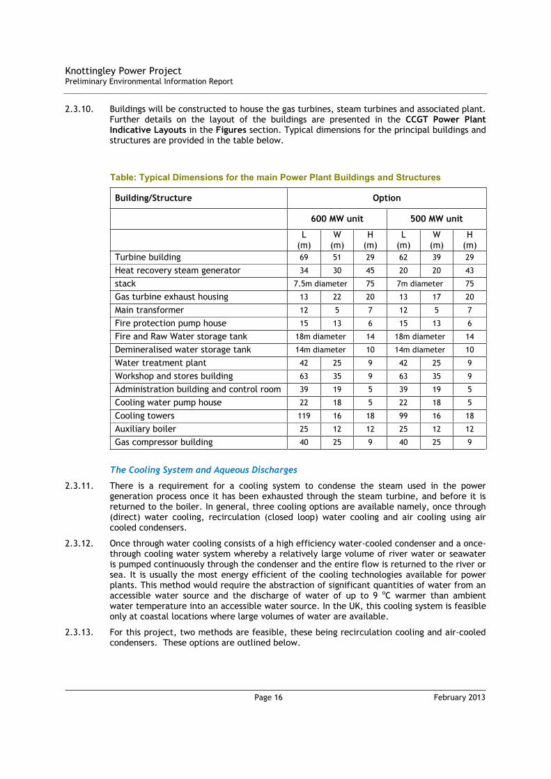
2.3.10. Buildings will be constructed to house the gas turbines, steam turbines and associated plant. Further details on the layout of the buildings are presented in the CCGT Power Plant Indicative Layouts in the Figures section. Typical dimensions for the principal buildings and structures are provided in the table below.
Table: Typical Dimensions for the main Power Plant Buildings and Structures
Building/Structure Option
600 MW unit 500 MW unit
L (m)
W(m)
H(m)
L(m)
W(m)
H(m)
Turbine building 69 51 29 62 39 29
Heat recovery steam generator 34 30 45 20 20 43
stack 7.5m diameter 75 7m diameter 75
Gas turbine exhaust housing 13 22 20 13 17 20
Main transformer 12 5 7 12 5 7
Fire protection pump house 15 13 6 15 13 6
Fire and Raw Water storage tank 18m diameter 14 18m diameter 14
Demineralised water storage tank 14m diameter 10 14m diameter 10
Water treatment plant 42 25 9 42 25 9
Workshop and stores building 63 35 9 63 35 9
Administration building and control room 39 19 5 39 19 5
Cooling water pump house 22 18 5 22 18 5
Cooling towers 119 16 18 99 16 18
Auxiliary boiler 25 12 12 25 12 12
Gas compressor building 40 25 9 40 25 9
The Cooling System and Aqueous Discharges
2.3.11. There is a requirement for a cooling system to condense the steam used in the power generation process once it has been exhausted through the steam turbine, and before it is returned to the boiler. In general, three cooling options are available namely, once through (direct) water cooling, recirculation (closed loop) water cooling and air cooling using air cooled condensers.
2.3.12. Once through water cooling consists of a high efficiency water-cooled condenser and a once-through cooling water system whereby a relatively large volume of river water or seawater is pumped continuously through the condenser and the entire flow is returned to the river or sea. It is usually the most energy efficient of the cooling technologies available for power plants. This method would require the abstraction of significant quantities of water from an accessible water source and the discharge of water of up to 9 oC warmer than ambient water temperature into an accessible water source. In the UK, this cooling system is feasible only at coastal locations where large volumes of water are available.
2.3.13. For this project, two methods are feasible, these being recirculation cooling and air-cooled condensers. These options are outlined below.

Knottingley Power ProjectPreliminary Environmental Information Report
Page 17 February 2013
2.3.14. A recirculation cooling system consists of a closed loop whereby cooling water is circulated through the condenser and cooled in a hybrid cooling tower. Cooling water is lost to the system by evaporation and a proportion is discharged to control the build up of suspended solids. These losses are replaced by abstraction from a water body such as a nearby river. The abstraction requirements for a recirculation cooling system are less than 5% that required for once through cooling. The discharge temperature would typically be no greater than 9 oC warmer than ambient water temperature. The hybrid nature of the cooling structure results in a water vapour plume being visible for a limited number of hours per year under certain climatic conditions.
2.3.15. A recirculation cooling system requires the construction of an intake and outfall structure. There are several options for the abstraction and discharge of cooling water, which include:
a) Abstraction from and discharge to the River Aire. This would involve dual pipelines of approximately 1 km in length. This is the preferred option.
b) Abstraction from and discharge to the Aire and Calder Navigation Canal requiring a very short pipeline;
c) Abstraction from the Aire and Calder Navigation Canal and discharge to the River Aire which would involve a single pipeline of approximately 1 km in length;
d) Abstraction from the River Aire and discharge to the Aire and Calder Navigation Canal which would involve a single pipeline of approximately 1 km in length
2.3.16. For the preferred option a), the route of the cooling water pipelines (abstraction and return) would run parallel to the gas pipeline in the same corridor over much of their length before routing north over the final 200m approximately to the River Aire. The cooling water pipelines will be included as associated development in the DCO application for the Knottingley Power Project.
2.3.17. The proposed route for the cooling water pipelines is shown in the figure Water Pipelines Route. The route starts at the CCGT power plant site, and exits the site to the north and under the Aire and Calder Navigation Canal. This crossing will be made using a trenchless technique, such as a Horizontal Directional Drill (HDD).
2.3.18. The route then continues north to cross the A645 (Weeland Road). This is the only major road crossing. The A645 (Weeland Road) is a busy road and therefore, it has been assumed at this point that the best approach for this crossing would be an Auger Bore.
2.3.19. The route continues north, then heads sharply north-east passing under a 400kV overhead power line, including: a major transmission line of 400kV. The route then heads north to the pump house a short distance from the river Aire.
2.3.20. As far as possible, water pipelines will be constructed by conventional methods such as trenching and using trenchless techniques at canal/road crossings. The selection of the most appropriate method will be based on environmental and economic factors. The location of the return outfall will also be based on thermal plume dispersion modelling which will also be agreed with consultees, including the Environment Agency.
2.3.21. Air cooled condensers work on a similar basis to the radiator in motor car. Fans draw ambient air through an array of tubes carrying exhaust steam from the steam turbine where it cools and condenses and is returned to the boiler. This method results in reduced plant efficiency, thereby increasing fuel consumption and the emission of exhausts gases for each unit of electricity produced.
2.3.22. Air cooled condensers require no water intake or discharge and result in no visible plume. The advantage of this method is it avoids any potential issues associated with water cooled systems (water abstraction, treatment, discharge and potential contamination of the steam water circuit). However, the disadvantage with air cooled condensers is that they are less thermally efficient particularly during the summer months.
Knottingley Power ProjectPreliminary Environmental Information Report
Page 18 February 2013
2.3.23. KPL considers that a recirculation cooling system comprises BAT (Best Available Technique) at this location due to its efficiency balanced against water availability and environmental effects. The justification of recirculation cooling as BAT will be provided in the application for an Environmental Permit which will be submitted to the Environment Agency.
2.3.24. The quality and temperature of the water discharged back will be carefully controlled.
2.3.25. An application to abstract water from the river Aire (water abstraction licence application) was submitted to the Environment Agency in December 2012.
Electricity Export
2.3.26. A new Gas Insulated Switchgear (GIS) substation will be constructed at the north eastern corner of the site. This will enable the electricity generated by the power station to be transmitted to the National Grid.
2.3.27. A new electricity connection will be required to allow electricity generated by the power station to be exported to National Grid’s electricity transmission network. The electricity generated by the CCGT Power plant will be exported to the national grid by means of a short connection approximately 250m long to an existing 400kV overhead line near the site. The connection will require the replacement of two existing NG towers (pylons) which will be located adjacent to the towers they replace, on land to the east of power plant site adjacent to the substation. The connection to the NG will be included in the DCO application for the Knottingley Power Project.
Carbon Capture
2.3.28. It is proposed to design the Knottingley Power Project to be Carbon-Capture Ready (CCR) since it exceeds the 300MWe threshold for the consideration of Carbon Capture Readiness as outlined in NPS EN-2. A Carbon Capture Readiness Report is being undertaken and will be submitted with the final Environmental Statement (ES)
2.3.29. The CCGT Power Plant Indicative Layout in Figures shows that approximately 7 ha of land to the west of the proposed location for the power plant on the site has been made available for the future installation of a Carbon Capture Plant (CCP), if required.
2.3.30. An economic feasibility study will be presented with the DCO application to estimate the indicative cost of retrofitting CCS to the Knottingley plant. This will estimate approximate CO2 permit prices, guaranteed over the lifetime of the plant, which would result in the cost of generating electricity from such a plant being less than a standard CCGT (without CCS). It is considered that the analysis will demonstrate the conditions when it is economically feasible for CCS to be retrofitted to the proposed CCGT.
2.3.31. The ultimate decisions on the CCS solution will be taken at the appropriate time, considering such matters as the contemporaneous legislation, proven technology, best practices and economic feasibility as are relevant.
Combined Heat and Power
2.3.32. In preparing the DCO application, due regard will be give to the Department of Energy and Climate Change (DECC) guidance on section 36 of the Electricity Act 1989 applications1. In essence, the DCO application will demonstrate that KPL has explored the opportunities to develop Combined Heat and Power (CHP), including community heating schemes.
1 Information to Accompany Notifications Under Section 14(1) of the Energy Act 1976 and Applications Under Section 36 of The Electricity Act 1989, Department of Trade and Industry, March 2001

Knottingley Power ProjectPreliminary Environmental Information Report
Page 19 February 2013
2.3.33. A CHP investigation will be undertaken as part of the DCO application which will involve identifying and contacting potential CHP users in the local area. This will initially be based on examining a map around the power plant based on a predetermined economic radius for heat transportation. Should any potential uses be identified, a ‘heat map’ of the local area would be produced incorporating community, commercial and industrial heat uses and opportunities. Within this ‘heat map’ area the identified users would then be classified into user sectors. Community opportunities would mainly consider residential and housing opportunities. Commercial opportunities would include any hotels, leisure centres, large corporate buildings, hospitals, universities, prisons, defence installations and accommodation complexes. Industrial opportunities would be readily identified by the industrial sector of those industries inside the ‘heat map’ radius.
2.4. Gas Pipeline
Overview
2.4.1. The CCGT power plant will be fuelled by a supply of natural gas.
2.4.2. The supply of natural gas will be taken from a new underground Gas Pipeline (together with associated infrastructure, principally an AGI) which will be constructed between the CCGT power plant site and the National Grid Gas National Transmission System.
2.4.3. The new underground Gas Pipeline will be approximately 8 km in length.
2.4.4. The Gas Pipeline will be included as associated development in the DCO application for the KPP.
Detailed Gas Pipeline Route Description
2.4.5. The proposed route for the Gas Pipeline is shown in the Figure: Gas Pipeline Route and Assessment Corridor.
2.4.6. The following provides a detailed description of the proposed route of the Gas Pipeline from a south to north direction, from the CCGT power plant site to the connection point to the National Transmission System.
2.4.7. The crossings are defined as follows:
RX – Road Crossing;
RLX – Railway Crossing;
WX – Water Crossing; and
MX – Miscellaneous Crossing2.
2.4.8. A number of public footpaths are also crossed. These are referenced in the text where relevant.
2.4.9. The route begins at the CCGT power plant site and heads immediately north and under the Aire and Calder Navigation Canal (WX1). This crossing will be made using a trenchless technique, such as a Horizontal Directional Drill (HDD).
2.4.10. The route then continues north to cross the A645 (Weeland Road) (RX2). This is the only major road crossing. Though the A645 (Weeland Road) is single carriageway, it is heavily used and therefore an open cut approach for this crossing would be disruptive. Therefore, it has been assumed at this point that the best approach for this crossing would be an Auger Bore.
2 Miscellaneous Crossings covers existing buried and overhead pipelines / services / utilities.

Knottingley Power ProjectPreliminary Environmental Information Report
Page 20 February 2013
2.4.11. The route continues north, then heads sharply north-east passing under four overhead power lines, including: a major transmission line of 400 kV (MX3); a local transmission line of 66 kV (MX4); and, two local transmission lines of 33 kV (MX5) (MX6).
2.4.12. The route then approaches the west side of Kellingley Farm and passes between the main area of the Farm and the Fishery Area. The route crosses a farmer’s track, which contains a waste water pipeline (RX7), and it has been assumed at this point that the best approach for this crossing would be an Auger Bore.
2.4.13. The route then heads north-east crossing a ditch (WX8), which would be best approached using an Open Cut method.
2.4.14. The route continues north-east to cross Common Lane (RX9) and New Lane (RX10). It has been assumed at this point that the best approach for these crossings would be an Auger Bore.
2.4.15. The route then crosses two local transmission lines of 33 kV (MX11) and 66 kV (MX12), and leads into the crossing of Beal Lane (RX13). Whilst this is a country road, the volume of traffic normally experienced would mean that an open cut approach for this crossing would be disruptive. Therefore, it has been assumed that the best approach for this crossing would be an Auger Bore.
2.4.16. The next crossing is of a farmers track (RX14) in Beal Carrs, west of Kellington. This is likely to be an Open Cut crossing as it does not appear to connect any public access.
2.4.17. The route then takes a slight turn north, but is still heading in a roughly north-east direction to cross Marsh Drain (WX15). This drain includes a flood barrier. It has been assumed at this point that the best approach for this crossing would be an Auger Bore. This would ensure no interaction with the flood barrier.
2.4.18. The route continues north-east to cross a track (RX16). It has been assumed that the best approach for this crossing would be an Open Cut method.
2.4.19. The route then approaches and crosses the River Aire (WX17). This is a major water crossing, and this crossing will be made using a trenchless technique such as HDD.
2.4.20. The route then continues in a more northerly direction and crosses farmers track (RX18) and a field drain known as The Fleet (WX19). It has been assumed that the best approach for RX18 would be an Open Cut method, and the best approach for WX19 would be an Auger Bore.
2.4.21. The route continues north towards Birkin Road passing under two overhead transmission lines. The first being a major transmission line of 400 kV (MX20) and the second being a local transmission line of 66 kV (MX21).
2.4.22. The route then crosses Birkin Road (RX22). It has been assumed that the best approach for this crossing would be an Auger Bore.
2.4.23. The route then continues north and crosses the Local Distribution System 600 mm high pressure steel pipeline (the ‘Knottingley to Chapel Haddlesey’ line) (MX23). It has been assumed that the best approach would be to Auger Bore this crossing to avoid any interference.
2.4.24. The route then crosses Royd’s Road (RX24), which is a farmer’s track. It has been assumed that the best approach for this crossing would be an Open Cut method.
2.4.25. At this point, the route skirts the extents of the area under an application for Planning Permission for the Prowind Woodlane Windfarm.
2.4.26. The route then crosses two ditches (WX25 and WX26). It has been assumed at this point that the best approach for these crossings would be an Open Cut method.

Knottingley Power ProjectPreliminary Environmental Information Report
Page 21 February 2013
2.4.27. The connection to the National Transmission System (via the AGI) is made just after the crossing of Pale Lane (RX27). It has been assumed that the best approach for this crossing would be an Auger Bore.
The Above Ground Installation
2.4.28. The AGI will be an un-manned facility. The AGI will comprise two separate compounds: one compound owned and operated by National Grid; and, one compound owned and operated by KPL. Accordingly, the overall AGI facility will likely comprise the following:
National Grid Compound Infrastructure (including: connection to National Transmission System Number 29 Feeder pipeline; isolation joint to electrically isolate the KPL pipework from the National Grid pipework; standby generator socket; Gas Vents; Emergency Shutdown Device (ESD); Instrument Kiosk; and, above ground pipework);
KPL Compound Infrastructure (including: PIG launcher (which allows an intelligent pig to run through the gas pipeline to conduct online inspection); standby generator socket; Gas Vents; Emergency Shutdown Device (ESD); Instrument Kiosk; and, above ground pipework); and,
Common AGI Infrastructure (including: fencing for security purposes; Security Lighting and CCTV; and Landscaping and Biodiversity (to be undertaken in consultation with the Local Planning Authority) to ensure the AGI blends in).
2.4.29. Each compound will be enclosed by a steel security fence approximately 2.7 m high. Furthermore, both compounds will be located within the overall AGI site enclosed by a stock-proof fence. There will be two double-gated entrances (one for the National Grid Compound and one for the KPL Compound). There will be emergency personnel exit gates for both compounds. Approximately 4.5 m high lighting columns will be erected to provide illumination should maintenance works be necessary in hours of darkness. These will also provide support for the CCTV cameras. Therefore, the equipment within the AGI (with the exception of lighting columns) will be no higher than 3 m.
2.4.30. A small car parking area may be installed outside the gated entrance.
2.4.31. Landscaping will be planted in order to screen the AGI. This will be agreed with Local Planning Authority.
Safety
2.4.32. Safety is of fundamental importance during every stage of planning, routing, design, construction and subsequent operation of a high pressure gas pipeline. As such, a number of appropriate safety considerations have been considered to ensure compliance with the requirements of the Health and Safety Executive (HSE) and ensure safe operation of the Gas Pipeline.
Design / Construction / Operation / Decommissioning
Design
2.4.33. The Gas Pipeline will be designed, constructed and tested to comply with the Institute of Gas Engineers’ (IGE) Recommendations on Transmission and Distribution Practice – IGE/TD/1: Edition 5, 2009 – Steel Pipelines and Associated Installations for High Pressure Gas Transmission (Pipeline Design Standard IGE/TD/1).
2.4.34. The Gas Pipeline will be constructed from high-grade welded steel pipe and will likely be sized up to 600 mm diameter (nominal). The Gas Pipeline will have a Maximum Incidental Pressure of 93.5 barg and a Maximum Operating Pressure of 85 barg.
Knottingley Power ProjectPreliminary Environmental Information Report
Page 22 February 2013
2.4.35. The standard gas pipeline wall thickness will comply with the requirements of IGE/TD/1, which defines the minimum safe separation distance between a high pressure gas pipeline and normally inhabited buildings / major roads / major railways. This minimum safe separation distance is known as the Building Proximity Distance (BPD). If normally inhabited buildings / major roads / major railways are closer than 1 BPD (i.e. the gas pipeline is in an area where additional protection is required), thicker wall steel pipe (known as proximity pipe) will be used. The exact locations and lengths of where thicker wall steel pipe will be used will be confirmed throughout the assessment and detailed design stages.
2.4.36. The Gas Pipeline will be buried to a depth of cover which is in accordance with the Pipeline Design Standard IGE/TD/1 and Recognised Industry Standards. For example, depths of cover will be:
No less than 1.2 m in agricultural land;
No less than 2 m under road crossings; and
No less than 1.7 m under water crossings.
Construction
2.4.37. The majority of environmental impacts arising from the development of gas pipelines (and their associated infrastructure) occur during construction. The following describes the standard methods which are likely to be required in full or in part during the construction of the proposed Gas Pipeline. These construction methods represent proven methods that have been developed over many years from experience on similar projects.
2.4.38. Construction of an underground gas pipeline is typically by a pipeline "spread". This is defined as the unit of manpower, plant and equipment necessary to construct an underground gas pipeline, from surveying the route through to reinstatement of the land.
2.4.39. All construction activities are undertaken within a temporarily fenced-off strip of land, which is referred to as the "working width". The working width will typically be 26 to 30 m wide, with the gas pipeline offset from the centre line to allow for construction access.
2.4.40. Access to the “working width” will be at defined points to be agreed by the Local Planning Authority and Land Owners / Land Occupiers (including existing service / utility owners). Points of access will be carefully controlled and signposted.
2.4.41. The “working width” may be increased in size adjacent to special crossings (i.e. road crossings / rail crossings/ river crossings) to provide additional working areas and / or storage for construction materials / construction equipment / construction plant. Conversely, the “working width” may be decreased in size in areas of environmental sensitivity or in close proximity to existing services / utilities.
2.4.42. During construction of the Gas Pipeline, construction activities will normally be progressed in the following order:
Pre-construction activities (i.e. fencing, hedgerow removal, land drainage schemes);
Top-soil Stripping;
Pipe Stringing;
Welding and Joint Coating;
Trenching and Laying;
Gas Pipeline Commissioning (i.e. Cleaning, Gauging, Testing); and
Permanent Re-instatement.
Knottingley Power ProjectPreliminary Environmental Information Report
Page 23 February 2013
2.4.43. It should be noted that these construction activities will only be progressed once agreement has been obtained for access, and specific restrictions and procedures have been confirmed (with the Local Planning Authority and Land Owners / Land Occupiers).
2.4.44. Further details of construction activities will be provided in the ES.
Construction Techniques
2.4.45. In addition to the typical construction activities, special teams will be set up by the appointed Construction Contractor to undertake any works associated with road / rail / water crossings and other crossings which require some variation from the standard methods. These works are defined as “special crossings”.
2.4.46. At “special crossings”, the standard construction procedure is adapted to suit each site's specific needs, and to satisfy the requirements of the relevant authorities and Land Owners / Land Occupiers.
2.4.47. Accordingly, in addition to the more standard ‘open cut’ construction technique, typical special crossing construction techniques include:
Auger Boring;
Tunnelling; and
HDD.
2.4.48. Further details of construction techniques will be provided in the ES.
Operation
2.4.49. After full commissioning of the Gas Pipeline, it will be operated and maintained in such a manner as to keep it safe and in good condition.
2.4.50. The operation / maintenance of the Gas Pipeline will be carried out in accordance with the requirements of the Pipeline Design Standard IGE/TD/1. Protective measures inherent to the design, together with regular monitoring, will ensure that major risk to the Gas Pipeline is virtually eliminated and so unlikely to cause damage.
2.4.51. Regular monitoring is normally carried out in the following ways:
Periodic visual monitoring;
Pipeline Internal Gauge (PIG) Survey; and
Cathodic Protection monitoring.
2.4.52. Further details of operation will be provided in the ES.
Decommissioning
2.4.53. The Gas Pipeline will be decommissioned when it reaches the end of its useful life.
2.4.54. At that time detailed decommissioning procedures will be produced in line with prevailing best practice.
2.4.55. Based on current best practice, it is likely that the Gas Pipeline will be left in place and stabilised as lifting could cause a greater disturbance to the environment.
2.5. Proposed Programme
2.5.1. The proposed overall programme, comprising construction/operation/decommissioning dates, is as follows:
Start of Construction: 2015
Commissioning of CCGT Power Plant: 2017
Knottingley Power ProjectPreliminary Environmental Information Report
Page 24 February 2013
Full Operation of CCGT Power Plant: 2018
Decommissioning (assuming 25 year operation): 2043
2.5.2. These dates have been selected to tie in with the expected timescales for the DCO decision and commercial negotiations. The construction of the above ground power line connection to the 400kV line, the gas pipeline and water pipelines is expected to take approximately one year. Construction works on the gas and water pipelines will be arranged In a co-ordinated manner to minimise the impact on landowners and the public.
Knottingley Power ProjectPreliminary Environmental Information Report
Page 25 February 2013
3.1. CCGT Power Plant
3.1.1. PEI relating to the CCGT Power Plant is presented in Table 2.

Knot
ting
ley
Pow
er P
roje
ctPr
elim
inar
y En
viro
nmen
tal I
nfor
mat
ion
Repo
rt
Page
26
F
ebru
ary
2013
Tabl
e 2:
Pre
limin
ary
Envi
ronm
enta
l Inf
orm
atio
n re
latin
g to
the
CC
GT
Pow
er P
lant
Site
Envi
ronm
enta
l To
pic
Base
line
Des
crip
tion
Sum
mar
y Pr
opos
ed A
ppro
ach
/ Su
rvey
s
Init
ial O
utco
mes
Furt
her
Prel
imin
ary
Envi
ronm
enta
l Inf
orm
atio
n to
be
pro
vide
d in
Pre
-app
licat
ion
to S
ecti
on 4
7 Co
nsul
tees
Plea
se n
ote,
all
Prel
imin
ary
Envi
ronm
enta
l Inf
orm
atio
n, in
clud
ing
that
pre
sent
ed b
elow
and
fur
ther
PEI
as
deta
iled
in C
olum
n 5
of t
his
Tabl
e, w
ill b
e m
ade
avai
labl
e to
Sec
tion
47
cons
ulte
es a
t a
num
ber
of p
ublic
eve
nts
Air
Qua
lity
Wak
efie
ld M
DC
and
Selb
y D
C as
sess
air
qua
lity
in t
heir
are
a w
ith
resp
ect
to t
he N
atio
nal A
ir
Qua
lity
Stan
dard
s (N
AQS)
.
Wak
efie
ld M
DC
has
decl
ared
nin
e Ai
r Q
ualit
y M
anag
emen
t Ar
eas
(AQ
MAs
) to
con
trol
and
red
uce
conc
entr
atio
ns o
f ni
trog
en
diox
ide
in p
arts
of
the
Dis
tric
t.
Selb
y D
C ha
s no
t de
sign
ated
any
AQ
MAs
.
Wak
efie
ld M
DC
carr
ies
out
an
exte
nsiv
e ai
r qu
alit
y m
onit
orin
g pr
ogra
mm
e fo
r th
e ar
ea,
incl
udin
g a
num
ber
of lo
cati
ons
in t
he v
icin
ity
of t
he S
ite.
Th
e se
lect
ion
of s
uita
ble
back
grou
nd
air
qual
ity
conc
entr
atio
ns t
o be
us
ed in
the
ass
essm
ent
will
be
disc
usse
d an
d co
nfir
med
wit
h W
akef
ield
MD
C an
d Se
lby
DC.
D
ata
on s
ubst
ance
s w
hich
are
no
t m
onit
ored
by
the
Dis
tric
t w
ill b
e ob
tain
ed f
rom
sui
tabl
e na
tion
al s
urve
ys a
nd r
epor
ted
on
the
Dep
artm
ent
for
Envi
ronm
ent,
Foo
d an
d Ru
ral
Affa
irs
(DEF
RA)
UK
Air
No
base
line
air
qual
ity
mon
itor
ing
is
prop
osed
. Th
e ai
r qu
alit
y as
sess
men
t w
ill f
ollo
w
the
EA d
ocum
ents
Hor
izon
tal
Gui
danc
e N
ote
H1
– An
nex
(f)3 a
nd
“Air
dis
pers
ion
mod
ellin
g re
port
re
quir
emen
ts f
or d
etai
led
air
disp
ersi
on m
odel
ling”
4 . It
will
co
mpr
ise
a re
view
of
ambi
ent
air
qual
ity
and
a de
taile
d at
mos
pher
ic
disp
ersi
on m
odel
ling
stud
y of
the
st
ack
emis
sion
s.
The
mod
ellin
g as
sess
men
t w
ill
esti
mat
e co
ncen
trat
ions
of
NO
x,ni
trog
en d
ioxi
de a
nd c
arbo
n m
onox
ide
at s
ensi
tive
rec
epto
rs u
sing
th
e em
issi
on li
mit
s as
spe
cifi
ed in
the
IE
D,
Anne
x V.
Stac
k he
ight
of
75m
sel
ecte
d.
No
exce
edan
ces
of a
ir q
ualit
y ob
ject
ives
for
the
pro
tect
ion
of
hum
an h
ealt
h w
ere
fore
cast
.
Max
imum
pro
cess
con
trib
utio
n to
ni
trog
en a
nd a
cid
depo
siti
on a
t na
tion
ally
des
igna
ted
habi
tat
site
s w
ould
not
exc
eed
the
rele
vant
cri
tica
l loa
d.
Road
tra
ffic
em
issi
ons
duri
ng
cons
truc
tion
and
ope
rati
onal
ph
ases
wer
e sc
reen
ed o
ut u
sing
EP
UK
crit
eria
.
Cum
ulat
ive
impa
cts
wer
e de
emed
not
to
be s
igni
fica
nt.
The
resu
lts
of t
he im
pact
as
sess
men
t w
ill b
e pr
esen
ted
and
disc
usse
d w
ith
Sect
ion
47
cons
ulte
es.
Pote
ntia
l mit
igat
ion
mea
sure
s w
ill b
e id
enti
fied
as
an o
utco
me
of t
his
asse
ssm
ent
and
pres
ente
d as
opt
ions
dur
ing
cons
ulta
tion
for
di
scus
sion
.
3En
viro
nmen
t Ag
ency
, H
1 En
viro
nmen
tal R
isk
Asse
ssm
ent
H1
Anne
x (f
), D
ecem
ber
2011
.4
En
viro
nmen
t Ag
ency
, Ai
r di
sper
sion
mod
ellin
g re
port
req
uire
men
ts (
for
deta
iled
air
disp
ersi
on m
odel
ling)
.

Knot
ting
ley
Pow
er P
roje
ctPr
elim
inar
y En
viro
nmen
tal I
nfor
mat
ion
Repo
rt
Page
27
F
ebru
ary
2013
Envi
ronm
enta
l To
pic
Base
line
Des
crip
tion
Sum
mar
y Pr
opos
ed A
ppro
ach
/ Su
rvey
s
Init
ial O
utco
mes
Furt
her
Prel
imin
ary
Envi
ronm
enta
l Inf
orm
atio
n to
be
pro
vide
d in
Pre
-app
licat
ion
to S
ecti
on 4
7 Co
nsul
tees
In
form
atio
n Re
sour
ce (
UK
AIR)
w
ebsi
te (
http
://u
k-ai
r.de
fra.
gov.
uk/)
and
oth
er
rele
vant
dat
a so
urce
s.
Ther
e ar
e a
num
ber
of
desi
gnat
ed h
abit
at s
ites
wit
hin
15km
of
the
site
bou
ndar
y.
Emis
sion
s fr
om t
he p
ropo
sed
CCG
T pl
ant
will
nee
d to
be
such
th
at t
hey
do n
ot h
ave
a si
gnif
ican
t im
pact
on
loca
l ai
r qu
alit
y, in
par
ticu
lar
at t
he
AQM
As a
nd h
abit
at s
ites
Noi
se a
nd
Vibr
atio
n It
was
ant
icip
ated
tha
t th
e ba
selin
e no
ise
envi
ronm
ent
cont
ains
mod
erat
e no
ise
leve
ls
duri
ng t
he d
ay a
nd lo
w n
oise
le
vels
dur
ing
the
nigh
t. N
oise
so
urce
s in
the
are
a in
clud
e ro
ad
traf
fic,
rai
l and
rur
al a
ctiv
itie
s.
A ba
selin
e no
ise
surv
ey w
as
unde
rtak
en f
or lo
cati
ons
repr
esen
tati
ve o
f th
e ne
ares
t se
nsit
ive
rece
ptor
s.
This
dat
a w
ill b
e us
ed t
o un
dert
ake
mod
ellin
g to
an
alys
e th
e po
tent
ial i
mpa
cts
of t
he
prop
osed
pow
er p
lant
on
the
nois
e se
nsit
ive
rece
ptor
s cl
ose
to t
he S
ite.
The
nois
e as
sess
men
t co
nclu
ded
that
the
bac
kgro
und
nois
e le
vel
(LA9
0) d
urin
g th
e ni
ght
peri
od
was
gen
eral
ly d
omin
ated
by
dist
ant
traf
fic
nois
e fr
om t
he
M62
. T
he e
xcep
tion
to
this
was
w
here
the
pla
nt o
n th
e ad
jace
nt
coal
min
e si
te c
ontr
olle
d th
e ba
ckgr
ound
noi
se le
vel.
Noi
se f
rom
the
indu
stri
al a
rea
to
the
wes
t of
the
pro
pose
d si
te
was
aud
ible
dur
ing
mea
sure
men
t on
the
wes
tern
par
t of
the
sit
e.
How
ever
, th
e tr
affi
c no
ise
was
ge
nera
lly d
omin
ant
at t
his
posi
tion
.
Back
grou
nd n
oise
leve
ls
mea
sure
d du
ring
day
tim
e m
easu
rem
ents
whe
re in
flue
nces
by
a v
arie
ty o
f ot
her
sour
ces,
in
clud
ing
trac
tors
and
loca
l in
dust
rial
act
ivit
ies.
How
ever
,
The
impa
ct o
f no
ise
and
vibr
atio
n on
ter
rest
rial
ec
olog
ical
rec
epto
rs,
as w
ell a
s no
ise
sens
itiv
e re
side
ntia
l re
cept
ors
will
be
cons
ider
ed a
nd
pres
ente
d du
ring
con
sult
atio
n.
Pote
ntia
l mit
igat
ion
mea
sure
s w
ill b
e di
scus
sed
wit
h Se
ctio
n 47
co
nsul
tees
.
Knot
ting
ley
Pow
er P
roje
ctPr
elim
inar
y En
viro
nmen
tal I
nfor
mat
ion
Repo
rt
Page
28
F
ebru
ary
2013
Envi
ronm
enta
l To
pic
Base
line
Des
crip
tion
Sum
mar
y Pr
opos
ed A
ppro
ach
/ Su
rvey
s
Init
ial O
utco
mes
Furt
her
Prel
imin
ary
Envi
ronm
enta
l Inf
orm
atio
n to
be
pro
vide
d in
Pre
-app
licat
ion
to S
ecti
on 4
7 Co
nsul
tees
th
e di
stan
t tr
affi
c no
ise
still
ge
nera
lly c
ontr
olle
d th
e LA
90 a
t m
ost
loca
tion
s.
Agai
n, a
n ex
cept
ion
to t
his
was
to
the
nort
h ea
st o
f th
e si
te,
whe
re t
he
coal
min
e pl
ant
clea
rly
dom
inat
ed t
he b
ackg
roun
d le
vel.
In a
ddit
ion,
loca
l veh
icle
m
ovem
ents
on
Wee
land
Roa
d co
ntri
bute
d to
the
bac
kgro
und
leve
l at
the
mon
itor
ing
posi
tion
on
Wee
land
Roa
d.
Noi
se f
rom
win
d in
the
tre
es w
as
audi
ble
at t
imes
dur
ing
the
dayt
ime
and
was
pau
sed
out
whe
n in
trus
ive.
Dur
ing
the
dayt
ime
mea
sure
men
t co
nduc
ted
near
the
coa
l min
e si
te it
was
no
t po
ssib
le t
o re
mov
e th
e no
ise
from
rus
tlin
g le
aves
. T
his
nois
e w
as c
onst
ant
and
ther
efor
e in
flue
nced
the
mea
sure
d LA
90.
It
is p
ropo
sed
to a
dopt
the
ba
ckgr
ound
leve
l mea
sure
d at
th
is lo
cati
on o
n th
e Su
nday
. In
divi
dual
noi
se e
vent
s fr
om li
ght
plan
es,
trai
ns,
loca
l veh
icle
m
ovem
ents
and
ani
mal
s w
ere
sign
ific
ant,
but
wer
e no
t co
nsis
tent
eno
ugh
to im
pact
the
LA
90.
Th
ese
mon
itor
ing
resu
lts
will
fe
ed in
to a
noi
se m
odel
of
the
prop
osed
fac
ility
and
the
impa
ct
of p
redi
cted
noi
se le
vels
will
be
asse
ssed
wit
h re
spec
t to
exi
stin
g

Knot
ting
ley
Pow
er P
roje
ctPr
elim
inar
y En
viro
nmen
tal I
nfor
mat
ion
Repo
rt
Page
29
F
ebru
ary
2013
Envi
ronm
enta
l To
pic
Base
line
Des
crip
tion
Sum
mar
y Pr
opos
ed A
ppro
ach
/ Su
rvey
s
Init
ial O
utco
mes
Furt
her
Prel
imin
ary
Envi
ronm
enta
l Inf
orm
atio
n to
be
pro
vide
d in
Pre
-app
licat
ion
to S
ecti
on 4
7 Co
nsul
tees
no
ise
leve
ls in
the
are
a. I
n th
e co
ntex
t of
the
exi
stin
g no
ise
envi
ronm
ent,
it is
ant
icip
ated
th
at it
will
be
poss
ible
to
inco
rpor
ate
suit
able
mit
igat
ion
mea
sure
s in
to t
he d
esig
n an
d op
erat
ion
to e
nsur
e th
at t
he
prop
osed
fac
ility
will
not
ge
nera
te n
oise
leve
ls t
hat
wou
ld
lead
to
sign
ific
ant
impa
ct a
t th
e se
nsit
ive
rece
ptor
s du
ring
co
nstr
ucti
on o
r op
erat
ion.
Terr
estr
ial
Ecol
ogy
The
base
line
surv
ey a
rea
cove
rs
an e
xten
sive
are
a of
agr
icul
tura
l la
nd in
ara
ble,
or
gras
s-pr
oduc
tion
use
bet
wee
n th
e Ai
re
and
Cald
er N
avig
atio
n to
the
no
rth
and
a ra
ilway
to
the
sout
h.
It is
leve
l and
low
-lyi
ng w
ith
ditc
hes
rath
er t
han
hedg
es
form
ing
man
y of
the
fie
ld
boun
dari
es.
It in
clud
es a
maj
or
brow
n-fi
eld
site
whe
re in
dust
rial
bu
ildin
gs h
ave
been
dem
olis
hed
at t
he e
nd o
f Co
mm
on L
ane.
The
su
rvey
are
a ca
n be
div
ided
into
tw
o m
ain
sect
ions
; Th
e de
mol
ishe
d Ch
emic
al W
orks
sit
e an
d Fa
rmla
nd.
The
re a
re n
o st
atut
ory
or n
on-s
tatu
tory
de
sign
ated
sit
es w
ithi
n th
e si
te
boun
dary
. T
he c
lose
st s
tatu
tory
de
sign
ated
sit
e is
Fai
rbur
n an
d N
ewto
n In
gs S
SSI,
whi
ch li
es
appr
oxim
atel
y 4.
8 k
m n
orth
wes
t of
the
sit
e.
A fu
rthe
r SS
SI k
now
n as
Bro
ckad
ale
is a
ppro
xim
atel
y 5.
5 km
. T
here
are
six
loca
l non
-
The
terr
estr
ial e
colo
gy a
sses
smen
t w
as c
arri
ed o
ut in
201
0-20
11 w
ith
addi
tion
al a
utum
n pa
ssag
e bi
rd
surv
eys
com
plet
ed in
late
sum
mer
/ au
tum
n of
201
2 an
d ex
amin
es t
he
habi
tats
and
spe
cies
of
natu
re
cons
erva
tion
con
cern
, su
ch a
s am
phib
ians
, bi
rds,
mam
mal
s an
d re
ptile
s.
A de
sk s
urve
y w
as u
nder
take
n du
ring
20
10 t
o co
llate
and
rev
iew
bas
elin
e ec
olog
ical
dat
a to
iden
tify
kno
wn
ecol
ogic
al c
onst
rain
ts s
uch
as
stat
utor
y or
non
-sta
tuto
ry s
ite
desi
gnat
ions
, or
kno
wn
site
s fo
r pr
otec
ted
spec
ies.
.Ad
diti
onal
dat
a w
as g
athe
red
in M
ay 2
012
from
the
W
est
York
shir
e Ec
olog
y an
d th
e N
orth
an
d Ea
st Y
orks
hire
Eco
logi
cal
Dat
a Ce
ntre
as
wel
l as
and
from
a lo
cal
orni
thol
ogis
t w
ho t
he W
akef
ield
M
etro
polit
an B
orou
gh C
ounc
il re
com
men
ded
cont
acti
ng.
The
dat
a re
view
als
o in
clud
ed a
rev
iew
of
info
rmat
ion
on t
he a
rea
give
n in
The
M
igra
tion
Atl
as:
Mov
emen
t of
the
No
dire
ct im
pact
s on
sta
tuto
ry o
r no
n-st
atut
ory
desi
gnat
ed s
ites
ar
e an
tici
pate
d.
In a
ddit
ion,
th
ere
will
be
no-i
ndir
ect
impa
cts
(i.e
. ai
r em
issi
ons
or
dist
urba
nce)
to
stat
utor
y or
non
-st
atut
ory
desi
gnat
ed s
ites
in t
he
surr
ound
ing
area
. T
he h
abit
ats
on s
ite
are
gene
rally
spe
cies
-po
or e
ithe
r as
soci
ated
wit
h th
e fa
rmla
nd w
hich
has
bee
n ag
ricu
ltur
ally
impr
oved
, or
as
soci
ated
wit
h th
e de
mol
ishe
d Ch
emic
al W
orks
suc
h as
are
as o
f ha
rd-s
tand
ing
and
rude
ral
vege
tati
on.
The
veg
etat
ion
of
high
est
ecol
ogic
al v
alue
and
ev
en t
hat
is o
f on
ly lo
cal
impo
rtan
ce a
re t
he a
reas
of
sem
i-ru
dera
l gra
ssla
nd a
nd
patc
hes
of m
arsh
y gr
assl
and
on
the
form
er C
hem
ical
Wor
ks
(the
se a
reas
will
be
clea
red
as
part
of
the
rem
edia
tion
wor
ks)
and
area
s of
pla
nted
woo
dlan
d an
d sc
rub
are
arou
nd t
he f
orm
er
The
resu
lts
of t
he im
pact
as
sess
men
t w
ill b
e pr
esen
ted
and
disc
usse
d w
ith
Sect
ion
47
cons
ulte
es.
The
resu
lts
of t
he P
hase
1
Hab
itat
Sur
vey
and
Prot
ecte
d Sp
ecie
s Su
rvey
s w
ill b
e us
ed t
o en
sure
tha
t co
nstr
ucti
on
acti
viti
es a
re d
esig
ned
and
posi
tion
ed in
a m
anne
r th
at
min
imis
es d
amag
e to
eco
logy
.
Such
mea
sure
may
incl
ude
prov
idin
g m
etho
d st
atem
ents
for
w
orks
and
pro
vidi
ng a
dvic
e on
th
e be
st c
onst
ruct
ion
peri
ods
to
min
imis
e im
pact
s on
eac
h sp
ecie
s.
In a
ddit
ion,
a C
EMP
will
be
dev
elop
ed a
nd im
plem
ente
d to
man
age
envi
ronm
enta
l iss
ues
asso
ciat
ed w
ith
cons
truc
tion
.
For
exam
ple
for
bird
s m
easu
res
will
be
take
n to
min
imis
e th
e lik
elih
ood
of d
istu
rban
ce,
inju
ry
or m
orta
lity
of n
esti
ng b
irds
, th
eir
eggs
and
chi
cks
in a
ll ha
bita
ts w
ill b
e un
dert
aken
. Fo
r

Knot
ting
ley
Pow
er P
roje
ctPr
elim
inar
y En
viro
nmen
tal I
nfor
mat
ion
Repo
rt
Page
30
F
ebru
ary
2013
Envi
ronm
enta
l To
pic
Base
line
Des
crip
tion
Sum
mar
y Pr
opos
ed A
ppro
ach
/ Su
rvey
s
Init
ial O
utco
mes
Furt
her
Prel
imin
ary
Envi
ronm
enta
l Inf
orm
atio
n to
be
pro
vide
d in
Pre
-app
licat
ion
to S
ecti
on 4
7 Co
nsul
tees
st
atut
ory
site
s w
ithi
n 2
km o
f th
e si
te.
The
clo
sest
of
thes
e,
Will
owga
rths
Sit
e of
Spe
cial
In
tere
st li
es a
ppro
xim
atel
y 36
0 m
to
the
nort
h of
the
pro
pose
d CC
GT
site
. T
he H
umbe
r Fl
ats,
M
arsh
es a
nd C
oast
SPA
is
appr
oxim
atel
y 21
km
fro
m t
he
site
.
Bird
s of
Bri
tain
and
Irel
and,
Wer
nham
et
al (
2002
). G
ener
al d
etai
ls o
f th
e ha
bita
t ty
pe a
nd m
ore
spec
ific
tar
get
note
s of
are
as o
f pa
rtic
ular
not
e w
ere
mad
e. T
he d
esk
stud
y hi
ghlig
hted
the
ne
ed f
or n
eed
for
mor
e de
taile
d su
rvey
s fo
r ba
ts,
bree
ding
bir
ds,
pass
age
bird
s, w
inte
r bi
rds,
gre
at
cres
ted
new
ts,
rept
ile,
wat
er v
ole
and
otte
r. I
n ad
diti
on d
etai
led
bota
nica
l sur
veys
of
habi
tats
of
note
w
ere
also
com
plet
ed.
wor
ks.
No
evid
ence
of
Badg
ers
was
fo
und.
Th
e tw
o bu
ildin
gs o
n th
e si
te a
re
not
suit
able
for
roo
stin
g ba
ts a
nd
none
of
the
tree
s pr
esen
t on
the
si
te h
ave
feat
ures
sui
tabl
e fo
r ro
osti
ng b
ats.
Giv
en t
he lo
w
num
bers
of
bats
pre
sent
and
the
sc
ale
of im
pact
s on
line
ar
feat
ures
in t
he c
onte
xt o
f th
e w
ider
are
a, it
is u
nlik
ely
that
th
ere
will
be
any
long
-ter
m
impa
cts
on l
ocal
bat
pop
ulat
ions
.Li
ttle
Plo
ver
is c
onfi
rmed
as
bree
ding
wit
hin
the
stud
y ar
ea
foot
prin
t in
are
as o
f pr
evio
usly
de
velo
ped
land
. S
kyla
rk w
as
reco
rded
in a
reas
of
impr
oved
gr
assl
and,
how
ever
as
thes
e ar
eas
are
sub-
opti
mal
(as
the
y ar
e in
tens
ivel
y fa
rmed
and
he
avily
gra
zed)
it is
ant
icip
ated
th
at S
kyla
rk b
reed
s in
the
su
rrou
ndin
g ar
ea a
nd u
ses
the
site
for
for
agin
g. Tr
ee S
parr
ow
a Bo
CC /
red
-lis
t sp
ecie
s w
as
reco
rded
dur
ing
both
the
br
eedi
ng a
nd w
inte
r bi
rdsu
rvey
s.
Tree
Spa
rrow
s ar
e an
un
com
mon
res
iden
t to
Yor
kshi
re
and
the
pres
ence
of
up t
o fi
ve
bird
s on
all
thre
e vi
sits
lead
s to
th
e co
nclu
sion
tha
t th
ey a
re a
pr
obab
le b
reed
ing
spec
ies
usin
g EO
AC c
rite
ria.
H
owev
er,
ther
e is
ac
tual
ly n
owhe
re s
uita
ble
for
this
spe
cies
to
bree
d on
sit
e an
d
rept
iles
site
cle
aran
ce w
orks
will
fo
llow
a M
etho
d S
tate
men
t with
an
eco
logi
cal c
lerk
of w
orks
and
w
ill in
volv
e st
rimm
ing
of s
uita
ble
habi
tat t
o m
ake
area
s of
sui
tabl
e ha
bita
t uns
uita
ble
for r
estin
g an
d fo
ragi
ng re
ptile
s. T
hese
m
easu
res
will
ens
ure
no re
ptile
s ar
e ki
lled
or d
istu
rbed
dur
ing
wor
ks.
In a
ddit
ion,
the
res
ults
of
the
Phas
e 1
Hab
itat
Sur
vey
and
Prot
ecte
d Sp
ecie
s Su
rvey
s w
ill b
e us
ed t
o re
com
men
d m
itig
atio
n /
mon
itor
ing
that
may
be
nece
ssar
y to
pre
vent
har
m t
o va
lued
eco
logi
cal r
ecep
tors
/
Prot
ecte
d Sp
ecie
s, f
or e
xam
ple
prov
idin
g an
inpu
t in
to t
he
land
scap
e de
sign
pro
posa
ls f
or
the
bund
are
a an
d al
ong
the
Aire
an
d Ca
lder
Can
al (
and
incl
udin
g ar
eas
of W
et W
oodl
and
a Se
lby
LBAP
/ U
K BA
P ha
bita
t),
prov
idin
g in
put
into
the
ligh
ting
des
ign
to
min
imis
e im
pact
s on
bat
s an
d ad
visi
ng o
n an
y ha
bita
t m
anag
emen
t of
land
scap
ed a
reas
to
enc
oura
ge t
heir
fut
ure
use
by
prot
ecte
d sp
ecie
s.
Knot
ting
ley
Pow
er P
roje
ctPr
elim
inar
y En
viro
nmen
tal I
nfor
mat
ion
Repo
rt
Page
31
F
ebru
ary
2013
Envi
ronm
enta
l To
pic
Base
line
Des
crip
tion
Sum
mar
y Pr
opos
ed A
ppro
ach
/ Su
rvey
s
Init
ial O
utco
mes
Furt
her
Prel
imin
ary
Envi
ronm
enta
l Inf
orm
atio
n to
be
pro
vide
d in
Pre
-app
licat
ion
to S
ecti
on 4
7 Co
nsul
tees
th
ey p
roba
bly
bree
d at
Cal
der
Gra
nge
Farm
to
the
nort
h of
the
Ai
re a
nd C
alde
r N
avig
atio
n. T
he
The
build
ings
dur
ing
the
pass
age
bird
sur
veys
in 2
012
wer
e re
cord
ed a
s be
ing
used
by
nest
ing
Barn
Sw
allo
w a
nd a
n in
acti
ve n
est
(pro
babl
y Bl
ackb
ird)
was
als
o re
cord
ed.
Th
ere
will
be
a lo
ss o
f di
rect
loss
of
13
ha o
f agr
icul
tura
lly im
prov
ed
gras
slan
d w
hich
may
be
used
by
bird
s in
win
ter f
or ro
ostin
g an
d fe
edin
g. H
owev
er th
ere
is a
larg
e ex
tent
of a
gric
ultu
rally
gra
ssla
nd
imm
edia
tely
to th
e so
uth
of th
e si
te w
hich
cou
ld b
e us
ed b
y w
inte
ring
bird
s.
A sm
all t
o m
ediu
m p
opul
atio
n of
Ad
ult
Gre
at C
rest
ed N
ewts
wer
e fo
und
in w
ater
fea
ture
s on
sit
e (w
ithi
n th
e ar
eas
whe
re
rem
edia
tion
wor
ks w
ill b
e un
dert
aken
).
To f
acili
tate
thi
s pr
oces
s an
Eur
opea
n Pr
otec
ted
Spec
ies
Lice
nce
has
been
gr
ante
d to
allo
w h
abit
at
clea
ranc
e an
d tr
ansl
ocat
ion
of
new
ts f
rom
are
as d
ue t
o be
los
t by
the
rem
edia
tion
into
adj
acen
t no
n-af
fect
ed a
reas
. T
hese
are
as
will
be
fenc
ed f
rom
the
cle
ared
si
te t
o pr
even
t ne
wts
re-
ente
ring
th
e pr
opos
ed C
CGT
site
.
Low
pop
ulat
ions
of
Gra
ss S
nake
w
ere
obse
rved
at
a sm
all n
umbe
r of
sur
vey
loca
tion
s.
Evid
ence
indi
cati
ng t
hat
Ott
er

Knot
ting
ley
Pow
er P
roje
ctPr
elim
inar
y En
viro
nmen
tal I
nfor
mat
ion
Repo
rt
Page
32
F
ebru
ary
2013
Envi
ronm
enta
l To
pic
Base
line
Des
crip
tion
Sum
mar
y Pr
opos
ed A
ppro
ach
/ Su
rvey
s
Init
ial O
utco
mes
Furt
her
Prel
imin
ary
Envi
ronm
enta
l Inf
orm
atio
n to
be
pro
vide
d in
Pre
-app
licat
ion
to S
ecti
on 4
7 Co
nsul
tees
ha
bitu
ally
use
the
are
a w
as
foun
d al
ong
the
cana
l.
No
evid
ence
of
Wat
er V
oles
was
fo
und
duri
ng t
he s
urve
y.
Aqua
tic
Ecol
ogy
The
Will
ow G
arth
loca
l nat
ure
rese
rve,
adm
inis
tere
d by
Yo
rksh
ire
Wild
life
Trus
t, li
es
appr
oxim
atel
y 0.
5 km
to
the
nort
h of
the
sit
e. T
he n
atur
e re
serv
e is
not
cov
ered
by
any
spec
ific
wild
life
and
habi
tat
desi
gnat
ions
. H
owev
er,
the
enti
re a
rea
of Y
orks
hire
doe
s lie
w
ithi
n a
Nit
rate
Vul
nera
ble
Zone
(N
VZ).
No
dire
ct a
quat
ic
conn
ecti
on is
sho
wn
betw
een
the
prop
osed
sit
e an
d W
illow
Gar
th
natu
re r
eser
ve.
Ther
e ar
e 7
Aqua
tic
Biod
iver
sity
Ac
tion
Pla
n 20
07 s
peci
es
reco
rded
wit
hin
the
10km
squ
are
SE52
bet
wee
n 19
80 a
nd 2
012
The
fish
pop
ulat
ion
is t
ypic
al o
f th
e ar
ea r
iver
wit
h br
eam
, pe
rch,
gud
geon
, tr
out,
eel
s,
carp
, ch
ub,
rudd
, pi
ke a
nd
tenc
h.
The
ther
mal
plu
me
has
been
m
odel
led
usin
g CO
RMIX
, a
stan
dard
th
erm
al p
lum
e m
odel
. Th
e im
pact
s of
th
e th
erm
al e
fflu
ents
and
bio
cide
use
id
enti
fied
will
be
used
to
plan
a
surv
ey in
volv
ing
bent
hic
sam
plin
g w
ould
be
unde
rtak
en t
o ch
arac
teri
se
pote
ntia
lly a
ffec
ted
area
s an
d in
form
an
ass
essm
ent
of li
kely
impa
ct.
The
cond
ense
r co
olin
g sy
stem
for
th
e po
wer
sta
tion
will
em
ploy
a
reci
rcul
atio
n co
olin
g sy
stem
in
corp
orat
ing
hybr
id c
oolin
g to
wer
s w
ith
wat
er a
bstr
acti
on
and
disc
harg
e fr
om t
he R
iver
Ai
re li
kely
to
be t
he a
ppro
ach
adop
ted.
An
ass
essm
ent
of t
he
likel
y im
pact
s an
d po
ssib
le
mit
igat
ion
is c
urre
ntly
bei
ng
fina
lised
. An
alt
erna
tive
sou
rce
of w
ater
fo
r co
olin
g is
the
Air
e an
d Ca
lder
ca
nal a
djac
ent
to t
he s
ite.
An
asse
ssm
ent
of t
he s
uita
bilit
y of
th
is o
ptio
n w
ill b
e as
sess
ed.
The
impa
ct o
f th
e w
ater
ab
stra
ctio
n an
d di
scha
rge
on
aqua
tic
ecol
ogic
al r
ecep
tors
will
be
con
side
red
and
pres
ente
d du
ring
con
sult
atio
n.
Pote
ntia
l mit
igat
ion
mea
sure
s w
ill b
e di
scus
sed
wit
h Se
ctio
n 47
co
nsul
tees
.
The
prop
osed
des
ign
and
exte
nt
of t
he s
uita
ble
sam
plin
g pl
an t
o be
impl
emen
ted
to b
e ag
reed
. Th
e re
sult
s of
thi
s w
ill a
lso
be
cons
ulte
d on
wit
h Se
ctio
n 47
co
nsul
tees
.
Wat
er
Reso
urce
s Th
e Kn
otti
ngle
y Po
wer
Pla
nt s
ite
is lo
cate
d on
fla
t la
nd
appr
oxim
atel
y 30
0m t
o th
e so
uth
of t
he R
iver
Air
e. T
he f
lat
plai
n is
dra
ined
by
seri
es o
f sm
all
chan
nel a
nd c
ross
ed b
y th
e Ai
re
and
Cald
er N
avig
atio
n, w
hich
fo
rms
the
nort
hern
sit
e bo
unda
ry.
A de
sk b
ased
ass
essm
ent
of b
asel
ine
cond
itio
ns a
t th
e Si
te,
in t
erm
s of
hy
drol
ogy
and
hydr
ogeo
logy
will
be
unde
rtak
en.
This
ass
essm
ent
will
be
info
rmed
by
cons
ulta
tion
wit
h ke
y st
akeh
olde
rs a
nd e
vide
nced
whe
re
poss
ible
thr
ough
a S
ite
wal
kove
r in
spec
tion
. As
sess
men
t of
ris
k to
wat
er a
nd s
oil
Whi
lst
floo
d m
odel
ling
indi
cate
s th
at t
he s
ite
will
not
flo
od d
urin
g 10
0 ye
ar e
vent
som
e la
nd r
aise
is
likel
y to
be
nece
ssar
y to
ens
ure
that
the
Pow
er s
tati
on c
an
rem
ain
oper
atio
nal d
urin
g m
ore
seve
re e
vent
s.
The
resu
lts
of t
he a
sses
smen
t w
ill b
e pr
esen
ted
to S
ecti
on 4
7 co
nsul
tees
. FR
A re
sult
s w
ill a
lso
be
pres
ente
d.

Knot
ting
ley
Pow
er P
roje
ctPr
elim
inar
y En
viro
nmen
tal I
nfor
mat
ion
Repo
rt
Page
33
F
ebru
ary
2013
Envi
ronm
enta
l To
pic
Base
line
Des
crip
tion
Sum
mar
y Pr
opos
ed A
ppro
ach
/ Su
rvey
s
Init
ial O
utco
mes
Furt
her
Prel
imin
ary
Envi
ronm
enta
l Inf
orm
atio
n to
be
pro
vide
d in
Pre
-app
licat
ion
to S
ecti
on 4
7 Co
nsul
tees
Th
e En
viro
nmen
t Ag
ency
flo
od
map
indi
cate
s th
at t
he s
ite
is
loca
ted
in f
lood
zon
e 2
(med
ium
fl
ood
prob
abili
ty).
Mod
ellin
g un
dert
aken
by
JBA
cons
ulti
ng in
20
09 c
onfi
rms
that
sit
e w
ill n
ot
floo
d du
ring
100
yea
r ev
ent
even
w
ith
clim
ate
chan
ge im
pact
s.
The
site
is u
nder
lain
by
mud
ston
e ov
erla
in b
y gl
acia
l sa
nds.
The
mud
ston
e is
like
ly t
o be
rel
ativ
ely
impe
rmea
ble;
ho
wev
er t
he s
ands
are
cla
ssif
ied
by t
he E
A as
a S
econ
dary
A
aqui
fer.
The
sit
e is
not
how
ever
lo
cate
d in
or
clos
e to
any
sou
rce
prot
ecti
on z
ones
.
envi
ronm
ents
fro
m t
he p
ropo
sed
deve
lopm
ent
will
be
carr
ied
out
base
d on
Inst
itut
e of
Env
iron
men
tal
Man
agem
ent
and
Asse
ssm
ent
(IEM
A)
guid
ance
. Ri
sk w
ill b
e de
fine
d by
cl
assi
fyin
g se
nsit
ivit
y of
the
rec
eivi
ng
envi
ronm
ent
and
dete
rmin
ing
crit
eria
fo
r im
pact
mag
nitu
de r
elat
ing
to a
ra
nge
of w
ater
and
soi
l pr
oces
ses.
A
sepa
rate
Flo
od R
isk
Asse
ssm
ent
(FRA
) w
ill b
e pr
epar
ed in
line
wit
h Pl
anni
ng P
olic
y St
atem
ent
25 (
PPS2
5)
guid
ance
. Th
is w
ill b
e ba
sed
on
prev
ious
mod
ellin
g by
JBA
and
dat
a pr
ovid
ed b
y th
e EA
Geo
logy
and
So
ilsTh
e si
te c
ompr
ises
the
for
mer
ch
emic
al w
orks
in t
he w
est
and
agri
cult
ural
land
in t
he s
outh
and
ea
st;
the
site
is b
ound
ed b
y a
cana
l on
its
nort
hern
bou
ndar
y.
The
form
er c
hem
ical
wor
ks w
as
deve
lope
d fr
om 1
949
onw
ards
on
land
tha
t ha
d pr
evio
usly
bee
n in
ag
ricu
ltur
al u
sage
. T
hrou
ghou
t th
e hi
stor
y of
the
che
mic
al
wor
ks p
rodu
ctio
n fo
cuss
ed o
n su
lphu
r ba
sed
com
poun
ds a
nd
arom
atic
hyd
roca
rbon
s.
Prod
ucti
on c
ease
d in
200
8 an
d de
mol
itio
n of
the
che
mic
al w
orks
bu
ildin
gs t
o fl
oor
slab
leve
l was
co
mpl
eted
in 2
009.
The
site
is u
nder
lain
by
soils
tha
t co
mpr
ise
prin
cipa
lly o
f sa
nds
and
An e
xten
sive
sit
e in
vest
igat
ion
has
been
com
mis
sion
ed a
cros
s th
e si
te,
wit
h a
focu
s on
the
che
mic
al w
orks
ar
ea.
The
aim
of
whi
ch is
to
esta
blis
h th
e cu
rren
t so
il an
d gr
ound
wat
er
qual
ity
at t
he s
ite.
The
ass
essm
ent
wor
ks w
ill in
corp
orat
e hi
stor
ical
dat
a on
the
sit
e in
clud
ing
that
in p
ublic
da
taba
ses.
Ari
sing
fro
m t
he
asse
ssm
ent
a re
med
iati
on s
trat
egy
will
be
deve
lope
d.
Both
the
as
sess
men
t m
etho
dolo
gy a
nd t
he
rem
edia
tion
str
ateg
y w
ill b
e ag
reed
w
ith
the
EA.
The
ass
essm
ent
will
fo
llow
EA
best
pra
ctic
e gu
idan
ce f
or
asse
ssm
ent
of c
onta
min
atio
n in
En
glan
d.
The
asse
ssm
ent
of t
he s
ite
will
als
o co
nsid
er im
pact
s th
e si
te m
ay h
ave
on
Rem
edia
tion
sha
ll be
und
erta
ken
at t
he f
orm
er c
hem
ical
wor
ks a
s ag
reed
wit
h th
e EA
to
faci
litat
e th
e de
velo
pmen
t of
the
pro
pose
d po
wer
sta
tion
. T
he p
urpo
se o
f th
is r
emed
iati
on w
ill m
itig
ate
futu
re r
isks
to
hum
an h
ealt
h an
d w
ater
s fr
om t
he c
onta
min
atio
n le
gacy
of
the
form
er c
hem
ical
w
orks
.D
urin
g co
nstr
ucti
on o
f th
e po
wer
pl
ant
risk
s th
at a
rise
fro
m t
he
man
agem
ent
of s
oil a
nd
grou
ndw
ater
will
be
man
aged
.
The
resu
lts
of t
he a
sses
smen
t of
ge
olog
y an
d so
ils w
ill b
e pr
esen
ted
and
disc
usse
d w
ith
Sect
ion
47 c
onsu
ltee
s.
Knot
ting
ley
Pow
er P
roje
ctPr
elim
inar
y En
viro
nmen
tal I
nfor
mat
ion
Repo
rt
Page
34
F
ebru
ary
2013
Envi
ronm
enta
l To
pic
Base
line
Des
crip
tion
Sum
mar
y Pr
opos
ed A
ppro
ach
/ Su
rvey
s
Init
ial O
utco
mes
Furt
her
Prel
imin
ary
Envi
ronm
enta
l Inf
orm
atio
n to
be
pro
vide
d in
Pre
-app
licat
ion
to S
ecti
on 4
7 Co
nsul
tees
gr
avel
s, t
hese
str
ata
are
cons
ider
ed t
o be
a m
inor
aq
uife
r. U
nder
lyin
g th
e so
il is
a
clay
/mud
ston
e fo
rmat
ion
that
do
es n
ot c
onta
in s
igni
fica
nt
grou
ndw
ater
. In
tur
n un
derl
ying
th
e cl
ay/m
udst
one
form
atio
n is
a
dolo
mit
ised
lim
esto
ne f
orm
atio
n th
at r
epre
sent
s a
prin
cipa
l (s
igni
fica
nt)
aqui
fer.
Coa
l m
easu
res
that
inco
rpor
ate
wit
h w
orka
ble
coal
sea
ms
are
pres
ent
bene
ath
the
site
. It
is
unde
rsto
od t
hat
the
wor
kabl
e co
al s
eam
s ar
e at
dep
th o
f gr
eate
r th
an 6
00m
bel
ow g
roun
d le
vel a
nd h
ave
been
wor
ked
out
to s
ome
exte
nt.
Past
inve
stig
atio
ns a
t th
e si
te
have
indi
cate
d th
at t
he s
hallo
w
grou
ndw
ater
ben
eath
the
ch
emic
al w
orks
par
t of
the
sit
e ha
s be
en c
onta
min
ated
.
How
ever
, th
e ex
tent
of
this
co
ntam
inat
ion
is t
houg
ht t
o be
co
nfin
ed t
o th
e ch
emic
al w
orks
fo
ot p
rint
. T
he E
A ac
cept
ed t
he
surr
ende
r of
the
che
mic
al w
orks
en
viro
nmen
tal p
erm
it in
200
9 on
th
e ba
sis
that
gro
undw
ater
qu
alit
y ha
d no
t di
sim
prov
ed
sinc
e th
is is
sue
of t
hat
perm
it.
geol
ogic
al r
esou
rces
, su
ch a
s co
al,
and
visv
ersa
.
Land
scap
e an
d Vi
sual
Th
e si
te c
ompr
ises
the
for
mer
O
xiri
s Ch
emic
al W
orks
and
ag
ricu
ltur
al la
nd.
Com
mon
La
ne,
a tr
ack,
cro
sses
the
ce
ntra
l par
t of
the
sit
e, b
ut t
his
does
not
com
pris
e a
Publ
ic R
ight
An a
sses
smen
t of
the
pot
enti
al
land
scap
e an
d vi
sual
impa
cts
will
be
carr
ied
out.
The
app
roac
h us
ed w
ill e
ba
sed
on r
elev
ant
guid
ance
(e.
g. T
he
Gui
delin
es f
or L
ands
cape
and
Vis
ual
Impa
ct A
sses
smen
t, L
ands
cape
The
prop
osed
dev
elop
men
t w
ill
com
pris
e a
seri
es o
f st
ruct
ures
, th
e la
rges
t/ta
llest
com
pone
nts
will
com
pris
e th
e st
ack(
s) a
nd
heat
rec
over
y st
eam
gen
erat
or
build
ing
(cur
rent
ly a
ntic
ipat
ed t
o
The
deta
iled
scop
e of
the
la
ndsc
ape
and
visu
al a
sses
smen
t (i
nclu
ding
vie
wpo
ints
to
be u
sed,
ph
otom
onta
ge lo
cati
ons
etc)
will
be
pre
sent
ed a
nd d
iscu
ssed
and
ag
reed
wit
h Se
ctio
n 47
Knot
ting
ley
Pow
er P
roje
ctPr
elim
inar
y En
viro
nmen
tal I
nfor
mat
ion
Repo
rt
Page
35
F
ebru
ary
2013
Envi
ronm
enta
l To
pic
Base
line
Des
crip
tion
Sum
mar
y Pr
opos
ed A
ppro
ach
/ Su
rvey
s
Init
ial O
utco
mes
Furt
her
Prel
imin
ary
Envi
ronm
enta
l Inf
orm
atio
n to
be
pro
vide
d in
Pre
-app
licat
ion
to S
ecti
on 4
7 Co
nsul
tees
of
Way
. T
here
is a
Pub
lic R
ight
of
Way
(fo
otpa
th)
to t
he w
est
of
the
site
, bu
t th
is d
oes
not
exte
nd in
to a
ny p
art
of t
he s
ite
area
. Th
e cl
oses
t re
side
ntia
l pr
oper
ties
to
the
site
are
; th
ose
loca
ted
on t
he e
aste
rn e
dge
of
Knot
ting
ley,
dis
pers
ed p
rope
rtie
s al
ong
the
A645
to
the
nort
h of
th
e si
te a
nd N
earp
ark
Farm
to
the
sout
h, a
nd K
ellin
gley
to
the
nort
h ea
st.
Th
ere
are
no n
atio
nal l
ands
cape
de
sign
atio
ns w
ithi
n th
e si
te o
r pr
opos
ed s
tudy
are
a (5
km).
O
ther
rel
evan
t de
sign
atio
ns
incl
ude
a lo
cally
impo
rtan
t La
ndsc
ape
Area
, G
reen
Bel
t,
Regi
ster
ed p
arks
and
Gar
dens
an
d G
reen
Bel
t.
Inst
itut
e an
d In
stit
ute
of
Envi
ronm
enta
l Man
agem
ent
and
Asse
ssm
ent,
2nd
Edi
tion
, 20
02)
be 7
0m a
nd 5
0m t
all
resp
ecti
vely
). T
he r
elat
ivel
y fl
at,
open
nat
ure
of t
he t
erra
in
is li
kely
to
mea
n el
emen
ts o
f th
e pr
opos
ed d
evel
opm
ent
will
be
seen
at
num
erou
s lo
cati
ons
wit
hin
the
surr
ound
ing
land
scap
e an
d in
rel
atio
n to
var
ious
vis
ual
rece
ptor
s.
The
asse
ssm
ent
will
incl
ude
an
asse
ssm
ent
of t
he c
umul
ativ
e ef
fect
of
exis
itin
g an
d pr
opos
ed
deve
lopm
ent
in t
he v
icin
ity
of
the
prop
osed
sit
e.
cons
ulte
es.
Was
te
Man
agem
ent
Base
d on
info
rmat
ion
avai
labl
e th
e si
te is
cur
rent
ly d
erel
ict
and
was
pre
viou
sly
an o
ld c
hem
ical
w
orks
sit
e. T
he w
aste
m
anag
emen
t lic
ence
for
the
ch
emic
al w
orks
has
bee
n su
rren
dere
d an
d th
e la
nd w
as
cons
ider
ed a
s no
n co
ntam
inat
ed.
Ther
e ar
e cu
rren
tly
no b
uild
ings
on
sit
e th
us it
is a
ssum
ed t
hat
base
line
cond
itio
ns a
t th
e si
te
are
not
gene
rati
ng a
ny w
aste
.
It is
pro
pose
d th
at a
des
k ba
sed
asse
ssm
ent
will
be
unde
rtak
en t
o in
clud
e th
e id
enti
fica
tion
of
rele
vant
le
gisl
atio
n, s
ourc
es o
f in
form
atio
n an
d lo
cal s
trat
egie
s an
d pl
ans.
Co
nsid
erat
ion
will
als
o be
giv
en t
o so
lid w
aste
ari
sing
s du
ring
the
co
nstr
ucti
on,
oper
atio
nal a
nd
deco
mm
issi
onin
g ph
ase
of t
he p
ower
st
atio
n. F
or a
ll w
aste
s co
mpl
ianc
e w
ith
the
was
te h
iera
rchy
(e.
g.
redu
ce,
reus
e, r
ecyc
ling,
rec
over
y an
d/or
dis
posa
l) w
ill a
lso
be
dem
onst
rate
d.
An a
sses
smen
t of
the
like
ly
impa
cts
of t
he w
aste
ari
sing
s du
ring
the
con
stru
ctio
n,
oper
atio
nal a
nd d
ecom
mis
sion
ing
phas
es o
f th
e de
velo
pmen
t ha
s be
en u
nder
take
n an
d po
ssib
le
mit
igat
ions
will
be
prop
osed
.
Mea
sure
s w
ill b
e ad
opte
d to
en
sure
tha
t w
aste
dur
ing
the
cons
truc
tion
, op
erat
ion
and
deco
mm
issi
onin
g ph
ases
of
the
pow
er s
tati
on is
man
aged
ap
prop
riat
ely
and
effe
ctiv
ely.
A
Site
Man
agem
ent
Plan
will
be
prep
ared
and
impl
emen
ted
to
man
age
cons
truc
tion
was
te o
n
The
resu
lts
of t
he w
aste
m
anag
emen
t as
sess
men
t w
ill b
e pr
esen
ted
and
disc
usse
d w
ith
Sect
ion
47 c
onsu
ltee
s.
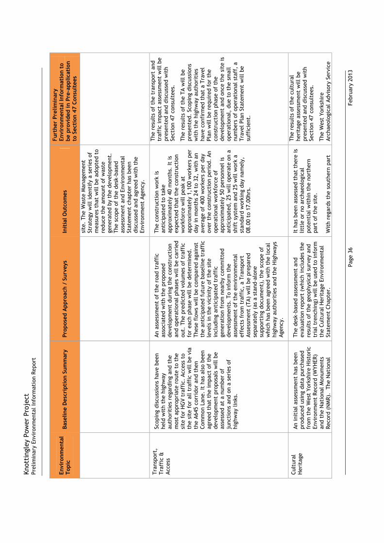
Knot
ting
ley
Pow
er P
roje
ctPr
elim
inar
y En
viro
nmen
tal I
nfor
mat
ion
Repo
rt
Page
36
F
ebru
ary
2013
Envi
ronm
enta
l To
pic
Base
line
Des
crip
tion
Sum
mar
y Pr
opos
ed A
ppro
ach
/ Su
rvey
s
Init
ial O
utco
mes
Furt
her
Prel
imin
ary
Envi
ronm
enta
l Inf
orm
atio
n to
be
pro
vide
d in
Pre
-app
licat
ion
to S
ecti
on 4
7 Co
nsul
tees
si
te.
The
Was
te M
anag
emen
t St
rate
gy w
ill id
enti
fy a
ser
ies
of
mea
sure
s th
at w
ill b
e ad
opte
d to
re
duce
the
am
ount
of
was
te
gene
rate
d by
the
dev
elop
men
t.
The
scop
e of
the
des
k-ba
sed
asse
ssm
ent
and
Envi
ronm
enta
l St
atem
ent
chap
ter
has
been
di
scus
sed
and
agre
ed w
ith
the
Envi
ronm
ent
Agen
cy.
Tran
spor
t,
Traf
fic
&
Acce
ss
Scop
ing
disc
ussi
ons
have
bee
n he
ld w
ith
the
high
way
au
thor
itie
s re
gard
ing
and
the
mos
t ap
prop
riat
e ro
ute
to t
he
site
for
HG
V tr
affi
c. A
cces
s to
th
e si
te f
or a
ll tr
affi
c w
ill b
e vi
a th
e A6
45 c
orri
dor
and
then
Co
mm
on L
ane.
It h
as a
lso
been
ag
reed
tha
t th
e im
pact
of
the
deve
lopm
ent
prop
osal
s w
ill b
e as
sess
ed a
t a
num
ber
of
junc
tion
s an
d on
a s
erie
s of
hi
ghw
ay li
nks.
An a
sses
smen
t of
the
roa
d tr
affi
c as
soci
ated
wit
h th
e pr
opos
ed
deve
lopm
ent
duri
ng t
he c
onst
ruct
ion
and
oper
atio
nal p
hase
s w
ill b
e ca
rrie
d ou
t. T
he p
redi
cted
vol
umes
of
traf
fic
for
each
pha
se w
ill b
e de
term
ined
.
Thes
e fl
ows
will
be
com
pare
d ag
ains
t th
e an
tici
pate
d fu
ture
bas
elin
e tr
affi
c le
vels
in t
he v
icin
ity
of t
he s
ite
incl
udin
g an
tici
pate
d tr
affi
c ge
nera
tion
fro
m n
earb
y co
mm
itte
d de
velo
pmen
ts.
To in
form
the
as
sess
men
t of
the
env
iron
men
tal
effe
cts
from
tra
ffic
, a
Tran
spor
t As
sess
men
t (T
A) w
ill b
e pr
epar
ed
sepa
rate
ly (
as a
sta
nd-a
lone
su
ppor
ting
doc
umen
t),
the
scop
e of
w
hich
has
bee
n ag
reed
wit
h th
e lo
cal
high
way
aut
hori
ties
and
the
Hig
hway
s Ag
ency
.
The
cons
truc
tion
wor
k is
an
tici
pate
d to
tak
e ap
prox
imat
ely
40 m
onth
s. It
is
expe
cted
tha
t th
e co
nstr
ucti
on
wor
kfor
ce w
ill p
eak
at
appr
oxim
atel
y 1,
100
wor
kers
per
da
y in
mon
ths
24 t
o 32
, w
ith
an
aver
age
of 4
00 w
orke
rs p
er d
ay
over
the
con
stru
ctio
n pe
riod
. An
op
erat
iona
l wor
kfor
ce o
f ap
prox
imat
ely
50 p
erso
nnel
is
anti
cipa
ted,
25
will
ope
rate
on
a sh
ift
syst
em a
nd 2
5 w
ill w
ork
a st
anda
rd w
orki
ng d
ay n
amel
y,
08.0
0 to
17.
00hr
s.
The
resu
lts
of t
he t
rans
port
and
tr
affi
c im
pact
ass
essm
ent
will
be
pres
ente
d an
d di
scus
sed
wit
h Se
ctio
n 47
con
sult
ees.
The
resu
lts
of t
he T
A w
ill b
e pr
esen
ted.
Sco
ping
dis
cuss
ions
w
ith
the
high
way
aut
hori
ties
ha
ve c
onfi
rmed
tha
t a
Trav
el
Plan
will
be
requ
ired
for
the
co
nstr
ucti
on p
hase
of
the
deve
lopm
ent
and
once
the
sit
e is
op
erat
iona
l, d
ue t
o th
e sm
all
num
bers
of
oper
atio
nal s
taff
, a
Trav
el P
lan
Stat
emen
t w
ill b
e su
ffic
ient
.
Cult
ural
H
erit
age
An in
itia
l ass
essm
ent
has
been
pr
oduc
ed u
sing
dat
a pu
rcha
sed
from
the
Wes
t Yo
rksh
ire
His
tori
c En
viro
nmen
t Re
cord
(W
YHER
) an
d th
e N
atio
nal M
onum
ents
Re
cord
(N
MR)
. T
he N
atio
nal
The
desk
-bas
ed a
sses
smen
t an
d ev
alua
tion
rep
ort
(whi
ch in
clud
es t
he
resu
lts
of t
he g
eoph
ysic
al s
urve
y an
d tr
ial t
renc
hing
) w
ill b
e us
ed t
o in
form
th
e Cu
ltur
al H
erit
age
Envi
ronm
enta
l St
atem
ent
Chap
ter.
It h
as b
een
asse
ssed
tha
t th
ere
is
littl
e or
no
arch
aeol
ogic
al
pote
ntia
l wit
hin
the
nort
hern
pa
rt o
f th
e si
te.
Wit
h re
gard
s th
e so
uthe
rn p
art
The
resu
lts
of t
he c
ultu
ral
heri
tage
ass
essm
ent
will
be
pres
ente
d an
d di
scus
sed
wit
h Se
ctio
n 47
con
sult
ees.
The
Wes
t Yo
rksh
ire
Arch
aeol
ogic
al A
dvis
ory
Serv
ice

Knot
ting
ley
Pow
er P
roje
ctPr
elim
inar
y En
viro
nmen
tal I
nfor
mat
ion
Repo
rt
Page
37
F
ebru
ary
2013
Envi
ronm
enta
l To
pic
Base
line
Des
crip
tion
Sum
mar
y Pr
opos
ed A
ppro
ach
/ Su
rvey
s
Init
ial O
utco
mes
Furt
her
Prel
imin
ary
Envi
ronm
enta
l Inf
orm
atio
n to
be
pro
vide
d in
Pre
-app
licat
ion
to S
ecti
on 4
7 Co
nsul
tees
H
erit
age
List
for
Eng
land
was
al
so v
iew
ed.
The
Con
serv
atio
n O
ffic
ers
at W
akef
ield
Cou
ncil
and
Selb
y D
istr
ict
Coun
cil w
ere
also
con
sult
ed f
or in
form
atio
n on
Co
nser
vati
on A
reas
and
Lis
ted
Build
ings
wit
hin
the
stud
y ar
ea.
Th
is s
tudy
has
rev
eale
d th
at t
he
site
is n
ot in
clud
ed w
ithi
n a
Wor
ld H
erit
age
Site
or
Cons
erva
tion
Are
a, n
or a
re t
here
an
y Sc
hedu
led
Mon
umen
ts,
Regi
ster
ed P
arks
and
Gar
dens
, Re
gist
ered
Bat
tlef
ield
s or
Lis
ted
Build
ings
wit
hin
the
site
bo
unda
ry.
How
ever
, th
ere
are
reco
rded
ar
chae
olog
ical
fea
ture
s on
the
so
uthe
rn p
art
of t
he S
ite.
Fu
rthe
rmor
e, t
here
is t
he
pote
ntia
l for
arc
haeo
logi
cal
rem
ains
to
be p
rese
nt b
elow
gr
ound
whe
re t
he s
ite
has
rem
aine
d in
agr
icul
tura
l use
.
Follo
win
g th
e re
sult
s of
the
des
k-ba
sed
asse
ssm
ent
the
Wes
t Yo
rksh
ire
Arch
aeol
ogic
al
Advi
sory
Ser
vice
s (W
YAAS
) re
ques
ted
that
a g
eoph
ysic
al
surv
ey f
ollo
wed
by
tria
l tr
ench
ing
be c
arri
ed o
ut o
n th
e no
rth-
east
, ea
ster
n an
d so
uthe
rn
part
s of
the
sit
e (c
ompr
isin
g of
th
e fi
elds
) to
det
erm
ine
the
natu
re a
nd e
xten
t of
the
cr
opm
arks
and
any
oth
er
unre
cord
ed r
emai
ns.
The
The
asse
ssm
ent
of n
atio
nally
im
port
ant
feat
ures
wit
hin
an
exte
nded
5km
stu
dy a
rea
will
be
incl
uded
in t
he C
ultu
ral H
erit
age
Envi
ronm
enta
l Sta
tem
ent
Chap
ter.
Rece
nt c
orre
spon
denc
e (J
anua
ry/F
ebru
ary
2013
) w
ith
the
Wes
t Yo
rksh
ire
Arch
aeol
ogy
Advi
sory
Se
rvic
e (W
YAAS
) ha
s ad
vise
d th
at
stri
p m
ap a
nd r
ecor
d w
ill b
e re
quir
ed
on t
he s
outh
-wes
tern
par
t of
the
sit
e w
here
line
ar f
eatu
res
wer
e co
nfir
med
fr
om t
he t
rial
tre
nchi
ng
inve
stig
atio
ns.
It h
as b
een
conf
irm
ed
wit
h W
YAAS
tha
t th
e st
rip
map
and
re
cord
sur
vey
will
be
plan
ning
co
ndit
ion
and
will
be
requ
ired
pos
t-de
term
inat
ion.
Addi
tion
al s
urve
ys m
ay b
e re
quir
ed t
o be
und
erta
ken
on t
he f
ield
to
the
east
of
the
sit
e in
rel
atio
n to
the
pro
posa
ls
to m
ove
the
pylo
ns.
of t
he s
ite,
it is
dif
ficu
lt t
o as
sess
the
pot
enti
al f
or t
his
part
of
the
sit
e, d
ue t
o th
e na
ture
of
the
feat
ures
and
lack
of
any
dati
ng e
vide
nce.
Ther
e is
a p
oten
tial
for
ar
chae
olog
ical
rem
ains
to
be
pres
ent
on t
he f
ield
to
the
east
of
the
sit
e (w
here
the
pyl
ons
are
prop
osed
to
be m
oved
).
(WYA
AS)
will
be
cons
ulte
d re
gard
ing
the
natu
re o
f th
e st
rip
map
and
rec
ord
(on
the
sout
h-w
este
rn p
art
of t
he s
ite)
and
the
su
rvey
s on
the
fie
ld t
o th
e ea
st
of t
he s
ite
boun
dary
.
Engl
ish
Her
itag
e w
ill b
e co
nsul
ted
in r
elat
ion
to t
he
impa
cts
on n
atio
nally
impo
rtan
t fe
atur
es id
enti
fied
wit
hin
the
exte
nded
stu
dy a
rea.
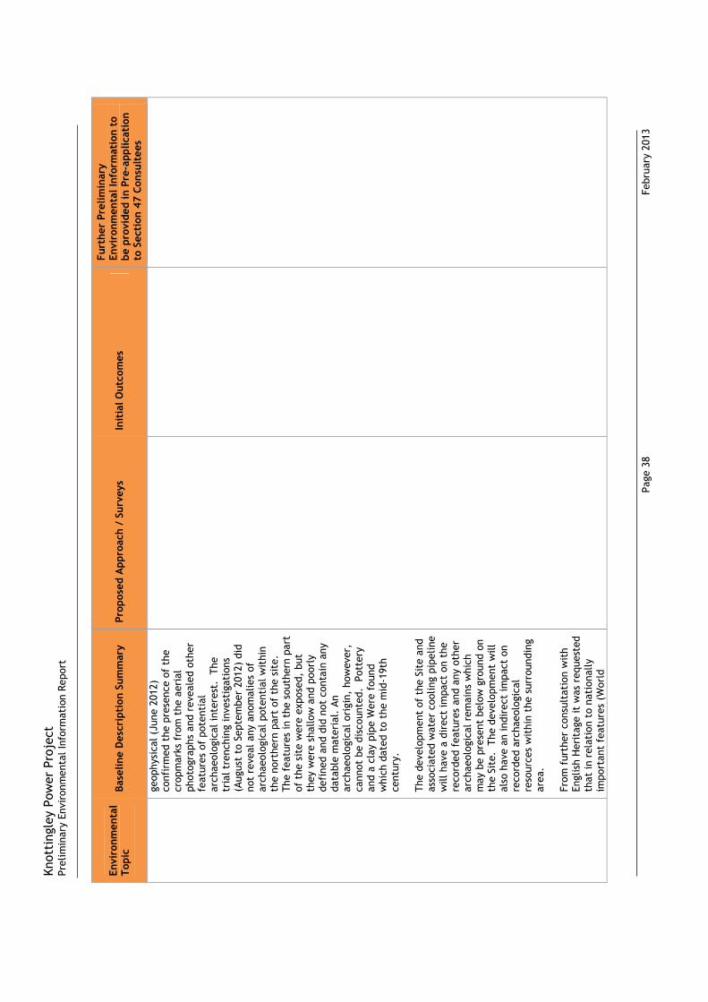
Knot
ting
ley
Pow
er P
roje
ctPr
elim
inar
y En
viro
nmen
tal I
nfor
mat
ion
Repo
rt
Page
38
F
ebru
ary
2013
Envi
ronm
enta
l To
pic
Base
line
Des
crip
tion
Sum
mar
y Pr
opos
ed A
ppro
ach
/ Su
rvey
s
Init
ial O
utco
mes
Furt
her
Prel
imin
ary
Envi
ronm
enta
l Inf
orm
atio
n to
be
pro
vide
d in
Pre
-app
licat
ion
to S
ecti
on 4
7 Co
nsul
tees
ge
ophy
sica
l (Ju
ne 2
012)
co
nfir
med
the
pre
senc
e of
the
cr
opm
arks
fro
m t
he a
eria
l ph
otog
raph
s an
d re
veal
ed o
ther
fe
atur
es o
f po
tent
ial
arch
aeol
ogic
al in
tere
st.
The
tr
ial t
renc
hing
inve
stig
atio
ns
(Aug
ust
to S
epte
mbe
r 20
12)
did
not
reve
al a
ny a
nom
alie
s of
ar
chae
olog
ical
pot
enti
al w
ithi
n th
e no
rthe
rn p
art
of t
he s
ite.
Th
e fe
atur
es in
the
sou
ther
n pa
rt
of t
he s
ite
wer
e ex
pose
d, b
ut
they
wer
e sh
allo
w a
nd p
oorl
y de
fine
d an
d di
d no
t co
ntai
n an
y da
tabl
e m
ater
ial.
An
arch
aeol
ogic
al o
rigi
n, h
owev
er,
cann
ot b
e di
scou
nted
. P
otte
ry
and
a cl
ay p
ipe
Wer
e fo
und
whi
ch d
ated
to
the
mid
-19t
h ce
ntur
y.
The
deve
lopm
ent
of t
he S
ite
and
asso
ciat
ed w
ater
coo
ling
pipe
line
will
hav
e a
dire
ct im
pact
on
the
reco
rded
fea
ture
s an
d an
y ot
her
arch
aeol
ogic
al r
emai
ns w
hich
m
ay b
e pr
esen
t be
low
gro
und
on
the
Site
. T
he d
evel
opm
ent
will
al
so h
ave
an in
dire
ct im
pact
on
reco
rded
arc
haeo
logi
cal
reso
urce
s w
ithi
n th
e su
rrou
ndin
g ar
ea.
From
fur
ther
con
sult
atio
n w
ith
Engl
ish
Her
itag
e it
was
req
uest
ed
that
in r
elat
ion
to n
atio
nally
im
port
ant
feat
ures
(W
orld

Knot
ting
ley
Pow
er P
roje
ctPr
elim
inar
y En
viro
nmen
tal I
nfor
mat
ion
Repo
rt
Page
39
F
ebru
ary
2013
Envi
ronm
enta
l To
pic
Base
line
Des
crip
tion
Sum
mar
y Pr
opos
ed A
ppro
ach
/ Su
rvey
s
Init
ial O
utco
mes
Furt
her
Prel
imin
ary
Envi
ronm
enta
l Inf
orm
atio
n to
be
pro
vide
d in
Pre
-app
licat
ion
to S
ecti
on 4
7 Co
nsul
tees
H
erit
age
Site
s, S
ched
uled
M
onum
ents
, Li
sted
Bui
ldin
gs
(Gra
de I
II*,
II),
Regi
ster
ed P
arks
an
d G
arde
ns,
Regi
ster
ed
Batt
lefi
elds
and
Con
serv
atio
n Ar
eas)
the
stu
dy a
rea
be
expa
nded
to
5km
rad
ius
of t
he
site
bou
ndar
y.
Soci
o -
Econ
omic
s Th
e lo
cal a
rea
has
a hi
stor
y of
gl
ass
man
ufac
turi
ng a
nd
indu
stri
al a
ctiv
itie
s. T
here
are
a
num
ber
of e
xist
ing
pow
er p
lant
s in
the
are
a, in
clud
ing
Eggb
orou
gh,
Ferr
ybri
dge
and
Dra
x.
The
CCG
T po
wer
pla
nt s
ite
was
pr
evio
usly
the
sit
e of
an
indu
stri
al w
orks
, w
hich
was
de
com
mis
sion
ed in
200
0.
In
addi
tion
to
this
a f
orm
er c
ollie
ry
was
als
o pr
evio
usly
sit
uate
d to
th
e no
rth
of t
he s
ite
and
Gal
e Co
mm
on (
a re
clai
med
pul
veri
sed
fuel
ash
(PF
A) t
ip)
is s
itua
ted
to
the
sout
h of
the
sit
e. T
he s
ite
is
bord
ered
by
a ra
ilway
line
to
the
sout
h an
d im
med
iate
ly t
o th
e no
rth
is t
he A
ire
and
Cald
er
Nav
igat
ion
Cana
l.
The
near
est
curr
ent
resi
dent
ial p
rope
rtie
s ar
e w
ithi
n 10
0m o
f th
e no
rth
of t
he
CCG
T po
wer
pla
nt s
ite .
The
asse
ssm
ent
of s
ocio
-eco
nom
ic
impa
cts
will
incl
ude
cons
ider
atio
n of
th
e fo
llow
ing:
Esti
mat
es o
f em
ploy
men
t le
vels
;
An e
stim
ate
of c
onve
rtin
g te
mpo
rary
em
ploy
men
t in
to f
ull-
tim
e eq
uiva
lent
s (F
TEs)
(i.
e. a
n es
tim
ate
whi
ch e
quat
es
cons
truc
tion
act
ivit
y as
soci
ated
w
ith
the
gas
pipe
line
to
perm
anen
t fu
ll-ti
me
jobs
);
An e
stim
ate
of s
pend
ing
gene
rate
d by
em
ploy
ees
(bas
ed o
n re
sear
ch
by Y
ouG
ov f
rom
200
5);
The
vari
atio
n in
the
flu
x of
w
orke
rs,
whi
ch m
ay a
lter
the
de
man
d fo
r se
rvic
es a
nd f
acili
ties
in
the
are
a; a
nd
Effe
cts
on t
ouri
sm,
incl
udin
g to
lo
cati
on o
f PR
oW (
incl
udin
g fo
otpa
ths,
bri
dlew
ays
and
byw
ays)
.
The
mos
t up
to
date
pub
licly
ava
ilabl
e da
ta w
ill b
e so
ught
fro
m c
ensu
s m
ater
ial,
loca
l rep
orts
and
web
site
s.
Dur
ing
cons
truc
tion
, th
ere
may
be
som
e di
srup
tion
to
serv
ices
(s
uch
as e
lect
rici
ty,
gas,
wat
er
or t
elec
omm
unic
atio
ns)
due
to
the
pres
ence
of
unde
rgro
und
cabl
es.
The
pre
senc
e of
the
se
unde
rgro
und
cabl
es w
ould
no
rmal
ly b
e id
enti
fied
pri
or t
o th
e st
art
of c
onst
ruct
ion,
and
th
eref
ore
such
sur
veys
wou
ld
likel
y to
be
carr
ied
out
by t
he
Cons
truc
tion
Con
trac
tor.
Dur
ing
cons
truc
tion
, em
ploy
men
t op
port
unit
ies
will
be
crea
ted
for
suit
ably
qua
lifie
d lo
cal
cont
ract
ors
whi
ch w
ould
hav
e be
nefi
ts f
or t
he lo
cal
com
mun
itie
s.
D
urin
g op
erat
ion,
the
re m
ay b
e m
inor
pos
itiv
e im
pact
s, w
ith
staf
f re
quir
ed f
or m
aint
enan
ce,
insp
ecti
on a
nd m
onit
orin
g of
the
ga
s pi
pelin
e.
Dur
ing
deco
mm
issi
onin
g, it
is n
ot
expe
cted
tha
t th
ere
will
be
impa
cts
to s
ocio
-eco
nom
ics .
The
resu
lts
of t
he s
ocio
econ
omic
as
sess
men
t w
ill b
e pr
esen
ted
and
disc
usse
d w
ith
Sect
ion
47
cons
ulte
es.

Knot
ting
ley
Pow
er P
roje
ctPr
elim
inar
y En
viro
nmen
tal I
nfor
mat
ion
Repo
rt
Page
40
F
ebru
ary
2013
Envi
ronm
enta
l To
pic
Base
line
Des
crip
tion
Sum
mar
y Pr
opos
ed A
ppro
ach
/ Su
rvey
s
Init
ial O
utco
mes
Furt
her
Prel
imin
ary
Envi
ronm
enta
l Inf
orm
atio
n to
be
pro
vide
d in
Pre
-app
licat
ion
to S
ecti
on 4
7 Co
nsul
tees
A
heal
th r
isk
asse
ssm
ent
is c
urre
ntly
be
ing
prep
ared
tha
t se
eks
to id
enti
fy
pote
ntia
l act
ual a
nd p
erce
ived
hea
lth
effe
cts
asso
ciat
ed w
ith
the
deve
lopm
ent.
Th
is is
bei
ng
unde
rtak
en w
ith
the
use
of
cons
ulta
tion
wit
h lo
cal h
ealt
h co
nsul
tees
to
ensu
re t
he a
ppro
ach
and
mat
rix
appr
oach
is c
onsi
sten
t w
ith
the
requ
irem
ents
of
the
loca
l ar
ea.
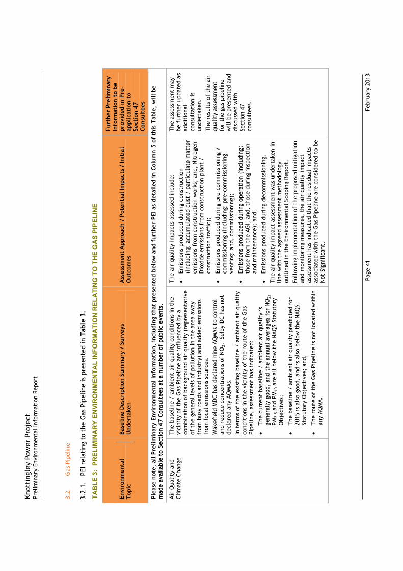
Knot
ting
ley
Pow
er P
roje
ctPr
elim
inar
y En
viro
nmen
tal I
nfor
mat
ion
Repo
rt
Page
41
F
ebru
ary
2013
3.2.
Gas
Pipe
line
3.2.
1.PE
I rel
atin
g to
the
Gas
Pip
elin
e is
pre
sent
ed in
Tab
le 3
.
TAB
LE 3
: PR
ELIM
INA
RY
ENVI
RO
NM
ENTA
L IN
FOR
MA
TIO
N R
ELA
TIN
G T
O T
HE
GA
S PI
PELI
NE
Envi
ronm
enta
l To
pic
Base
line
Des
crip
tion
Sum
mar
y /
Surv
eys
Und
erta
ken
Ass
essm
ent
App
roac
h /
Pote
ntia
l Im
pact
s /
Init
ial
Out
com
es
Furt
her
Prel
imin
ary
Info
rmat
ion
to b
e pr
ovid
ed in
Pre
-ap
plic
atio
n to
Se
ctio
n 47
Co
nsul
tees
Plea
se n
ote,
all
Prel
imin
ary
Envi
ronm
enta
l Inf
orm
atio
n, in
clud
ing
that
pre
sent
ed b
elow
and
fur
ther
PEI
as
deta
iled
in C
olum
n 5
of t
his
Tabl
e, w
ill b
e m
ade
avai
labl
e to
Sec
tion
47
Cons
ulte
es a
t a
num
ber
of p
ublic
eve
nts.
Air
Qua
lity
and
Clim
ate
Chan
ge
The
base
line
/ am
bien
t ai
r qu
alit
y co
ndit
ions
in t
he
vici
nity
of
the
Gas
Pip
elin
e ar
e in
flue
nced
by
a co
mbi
nati
on o
f ba
ckgr
ound
air
qua
lity
(rep
rese
ntat
ive
of t
he g
ener
al le
vels
of
pollu
tion
in t
he a
rea
away
fr
om b
usy
road
s an
d in
dust
ry)
and
adde
d em
issi
ons
from
loca
l em
issi
ons
sour
ces.
Wak
efie
ld M
DC
has
decl
ared
nin
e AQ
MAs
to
cont
rol
and
redu
ce c
once
ntra
tion
s of
NO
2.
Selb
y D
C ha
s no
t de
clar
ed a
ny A
QM
As.
In
ter
ms
of t
he e
xist
ing
base
line
/ am
bien
t ai
r qu
alit
y co
ndit
ions
in t
he v
icin
ity
of t
he r
oute
of
the
Gas
Pi
pelin
e, a
sses
smen
t ha
s in
dica
ted:
The
curr
ent
base
line
/ am
bien
t ai
r qu
alit
y is
ge
nera
lly g
ood,
and
the
ann
ual a
vera
ges
for
NO
2,PM
2.5
and
PM10
are
all
belo
w t
he N
AQS
Stat
utor
y O
bjec
tive
s;
The
base
line
/ am
bien
t ai
r qu
alit
y pr
edic
ted
for
2015
is a
lso
good
, an
d is
als
o be
low
the
NAQ
S St
atut
ory
Obj
ecti
ves;
and
,
The
rout
e of
the
Gas
Pip
elin
e is
not
loca
ted
wit
hin
any
AQM
A.
The
air
qual
ity
impa
cts
asse
ssed
incl
ude:
Emis
sion
s pr
oduc
ed d
urin
g co
nstr
ucti
on
(inc
ludi
ng:
accu
mul
ated
dus
t /
part
icul
ate
mat
ter
emis
sion
s fr
om c
onst
ruct
ion
wor
ks;
and,
Nit
roge
n D
ioxi
de e
mis
sion
s fr
om c
onst
ruct
ion
plan
t /
cons
truc
tion
tra
ffic
);
Emis
sion
s pr
oduc
ed d
urin
g pr
e-co
mm
issi
onin
g /
com
mis
sion
ing
(inc
ludi
ng:
pre-
com
mis
sion
ing
vent
ing;
and
, co
mm
issi
onin
g);
Emis
sion
s pr
oduc
ed d
urin
g op
erat
ion
(inc
ludi
ng:
thos
e fr
om t
he A
GI;
and
, th
ose
duri
ng in
spec
tion
an
d m
aint
enan
ce);
and
,
Emis
sion
s pr
oduc
ed d
urin
g de
com
mis
sion
ing.
The
air
qual
ity
impa
ct a
sses
smen
t w
as u
nder
take
n in
lin
e w
ith
the
agre
ed a
sses
smen
t m
etho
dolo
gy
outl
ined
in t
he E
nvir
onm
enta
l Sco
ping
Rep
ort.
Fo
llow
ing
impl
emen
tati
on o
f th
e pr
opos
ed m
itig
atio
n an
d m
onit
orin
g m
easu
res,
the
air
qua
lity
impa
ct
asse
ssm
ent
has
indi
cate
d th
at t
he r
esid
ual i
mpa
cts
asso
ciat
ed w
ith
the
Gas
Pip
elin
e ar
e co
nsid
ered
to
be
Not
Sig
nifi
cant
.
The
asse
ssm
ent
may
be
fur
ther
upd
ated
as
addi
tion
al
cons
ulta
tion
is
unde
rtak
en.
The
resu
lts
of t
he a
ir
qual
ity
asse
ssm
ent
for
the
gas
pipe
line
will
be
pres
ente
d an
d di
scus
sed
wit
h Se
ctio
n 47
co
nsul
tees
.

Knot
ting
ley
Pow
er P
roje
ctPr
elim
inar
y En
viro
nmen
tal I
nfor
mat
ion
Repo
rt
Page
42
F
ebru
ary
2013
Envi
ronm
enta
l To
pic
Base
line
Des
crip
tion
Sum
mar
y /
Surv
eys
Und
erta
ken
Ass
essm
ent
App
roac
h /
Pote
ntia
l Im
pact
s /
Init
ial
Out
com
es
Furt
her
Prel
imin
ary
Info
rmat
ion
to b
e pr
ovid
ed in
Pre
-ap
plic
atio
n to
Se
ctio
n 47
Co
nsul
tees
Noi
se a
nd V
ibra
tion
Th
e ex
isti
ng n
oise
bas
elin
e of
the
pro
pose
d ro
ute
of
the
Gas
Pip
elin
e la
rgel
y co
nsis
ts o
f no
ise
from
: ag
ricu
ltur
al w
orki
ng in
the
fie
lds;
veh
icle
s pa
ssin
g al
ong
loca
l roa
ds;
trai
ns;
win
d in
the
tre
es a
nd
folia
ge;
and,
occ
asio
nal p
lane
s pa
ssin
g ov
erhe
ad.
A
Base
line
Noi
se S
urve
y w
as u
nder
take
n to
qua
ntif
y th
e ex
isti
ng n
oise
leve
ls a
t se
ven
near
by s
elec
ted
Noi
se S
ensi
tive
Rec
epto
rs (
NSR
s).
D
urin
g th
e Ba
selin
e N
oise
Sur
vey,
a n
umbe
r of
sho
rt-
term
att
ende
d m
easu
rem
ents
wer
e us
ed t
o qu
anti
fy
the
ambi
ent
nois
e cl
imat
e an
d ve
rify
the
nat
ure
of
nois
e so
urce
s us
ing
appl
icab
le g
uida
nce.
Th
e sh
ort-
term
sam
plin
g m
etho
d w
as u
nder
take
n at
the
se
lect
ed N
SRs
loca
tion
s.
The
shor
t-te
rm a
tten
ded
mea
sure
men
ts w
ere
take
n at
eac
h se
lect
ed N
SR
loca
tion
s ov
er t
he c
ours
e of
24
hour
s be
twee
n th
e 26
Ju
ly 2
012
and
27 J
uly
2012
. T
o gi
ve r
epre
sent
ativ
e ba
ckgr
ound
noi
se le
vels
for
bot
h da
y-ti
me
and
nigh
t-ti
me
peri
ods,
a m
inim
um o
f th
ree
mea
sure
men
ts
wer
e ta
ken
repr
esen
ting
the
fol
low
ing
peri
ods:
Day
-tim
e (0
7:00
unt
il 19
:00)
;
Even
ing
(19:
00 u
ntil
23:0
0);
and,
Nig
ht (
23:0
0 un
til 0
7:00
).
At t
he t
ime
of t
he B
asel
ine
Noi
se S
urve
y it
was
not
ed
that
the
pro
pose
d ro
ute
of t
he G
as P
ipel
ine
is
pred
omin
atel
y ru
ral a
nd n
ot h
eavi
ly p
opul
ated
. A
s su
ch (
and
unlik
e ur
ban
area
s),
nois
e fr
om r
oad
traf
fic
is n
ot a
ntic
ipat
ed t
o ch
ange
sig
nifi
cant
ly b
etw
een
wee
kday
and
wee
kend
per
iods
.
The
nois
e an
d vi
brat
ion
impa
cts
asse
ssed
incl
ude:
Noi
se a
nd v
ibra
tion
fro
m c
onst
ruct
ion
acti
viti
es;
Noi
se f
rom
pre
-com
mis
sion
ing
acti
viti
es;
Noi
se a
nd v
ibra
tion
dur
ing
oper
atio
n;
Noi
se a
nd v
ibra
tion
fro
m d
ecom
mis
sion
ing
acti
viti
es;
and,
Noi
se f
rom
con
stru
ctio
n /
oper
atio
nal /
de
com
mis
sion
ing
traf
fic
(on
both
str
ateg
ic a
nd
loca
l roa
ds).
Th
e no
ise
and
vibr
atio
n im
pact
ass
essm
ent
was
un
dert
aken
in li
ne w
ith
the
agre
ed a
sses
smen
t m
etho
dolo
gy o
utlin
ed in
the
Env
iron
men
tal S
copi
ng
Repo
rt.
Fo
llow
ing
impl
emen
tati
on o
f th
e pr
opos
ed m
itig
atio
n an
d m
onit
orin
g m
easu
res,
the
noi
se a
nd v
ibra
tion
im
pact
ass
essm
ent
has
indi
cate
d th
at t
he r
esid
ual
impa
cts
asso
ciat
ed w
ith
the
Gas
Pip
elin
e ar
e co
nsid
ered
to
be N
ot S
igni
fica
nt.
The
asse
ssm
ent
may
be
fur
ther
upd
ated
as
addi
tion
al
cons
ulta
tion
is
unde
rtak
en.
The
resu
lts
of t
he
nois
e an
d vi
brat
ion
asse
ssm
ent
for
the
gas
pipe
line
will
be
pres
ente
d an
d di
scus
sed
wit
h Se
ctio
n 47
co
nsul
tees
.
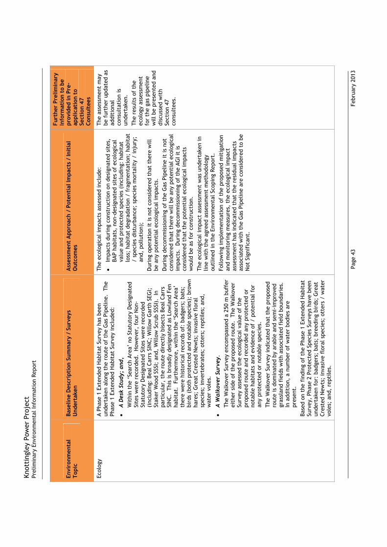
Knot
ting
ley
Pow
er P
roje
ctPr
elim
inar
y En
viro
nmen
tal I
nfor
mat
ion
Repo
rt
Page
43
F
ebru
ary
2013
Envi
ronm
enta
l To
pic
Base
line
Des
crip
tion
Sum
mar
y /
Surv
eys
Und
erta
ken
Ass
essm
ent
App
roac
h /
Pote
ntia
l Im
pact
s /
Init
ial
Out
com
es
Furt
her
Prel
imin
ary
Info
rmat
ion
to b
e pr
ovid
ed in
Pre
-ap
plic
atio
n to
Se
ctio
n 47
Co
nsul
tees
Ecol
ogy
A Ph
ase
1 Ex
tend
ed H
abit
at S
urve
y ha
s be
en
unde
rtak
en a
long
the
rou
te o
f th
e G
as P
ipel
ine.
Th
e Ph
ase
1 Ex
tend
ed H
abit
at S
urve
y in
clud
ed:
A D
esk
Stud
y; a
nd,
W
ithi
n th
e ‘S
earc
h Ar
ea’
no S
tatu
tory
Des
igna
ted
Site
s w
ere
reco
rded
. H
owev
er,
four
Non
-St
atut
ory
Des
igna
ted
Site
s w
ere
reco
rded
(i
nclu
ding
: Be
al C
arrs
SIN
C; W
illow
Gar
th S
EGI;
St
aker
Woo
d SS
SI;
and,
Will
ow S
crub
SSS
I).
In
part
icul
ar,
the
rout
e di
rect
ly b
isec
ts B
eal C
arrs
SI
NC.
Thi
s is
bro
adly
des
igna
ted
as L
owla
nd F
en
habi
tat.
Fur
ther
mor
e, w
ithi
n th
e ‘S
earc
h Ar
ea’
ther
e w
ere
hist
oric
al r
ecor
ds o
f: b
adge
rs;
bats
; bi
rds
(bot
h pr
otec
ted
and
nota
ble
spec
ies)
; br
own
hare
s; G
reat
Cre
sted
New
ts;
inva
sive
flo
ral
spec
ies;
inve
rteb
rate
s; o
tter
s; r
epti
les;
and
, w
ater
vol
es.
A W
alko
ver
Surv
ey.
The
Wal
kove
r Su
rvey
enc
ompa
ssed
a 2
50 m
buf
fer
eith
er s
ide
of t
he p
ropo
sed
rout
e. T
he W
alko
ver
Surv
ey a
sses
sed
the
ecol
ogic
al v
alue
of
the
prop
osed
rou
te a
nd r
ecor
ded
any
prot
ecte
d or
no
tabl
e ha
bita
ts a
nd e
vide
nce
of /
pot
enti
al f
or
any
prot
ecte
d or
not
able
spe
cies
.
The
Wal
kove
r Su
rvey
indi
cate
d th
at t
he p
ropo
sed
rout
e is
dom
inat
ed b
y ar
able
and
sem
i-im
prov
ed
gras
slan
d fi
elds
wit
h as
soci
ated
fie
ld b
ound
arie
s.
In a
ddit
ion,
a n
umbe
r of
wat
er b
odie
s ar
e pr
esen
t.
Ba
sed
on t
he f
indi
ng o
f th
e Ph
ase
1 Ex
tend
ed H
abit
at
Surv
ey,
Phas
e 2
Prot
ecte
d Sp
ecie
s Su
rvey
s ha
ve b
een
unde
rtak
en f
or:
badg
ers;
bat
s; b
reed
ing
bird
s; G
reat
Cr
este
d N
ewts
; in
vasi
ve f
lora
l spe
cies
; ot
ters
/ w
ater
vo
les;
and
, re
ptile
s.
The
ecol
ogic
al im
pact
s as
sess
ed in
clud
e:
Impa
cts
duri
ng c
onst
ruct
ion
on d
esig
nate
d si
tes,
BA
P ha
bita
ts,
non-
desi
gnat
ed s
ites
of
ecol
ogic
al
valu
e an
d pr
otec
ted
spec
ies
(inc
ludi
ng:
habi
tat
loss
; ha
bita
t de
grad
atio
n /
frag
men
tati
on;
habi
tat
/ sp
ecie
s di
stur
banc
e; s
peci
es m
orta
lity
/ in
jury
; an
d, p
ollu
tion
);
Dur
ing
oper
atio
n it
is n
ot c
onsi
dere
d th
at t
here
will
be
any
pot
enti
al e
colo
gica
l im
pact
s.
D
urin
g de
com
mis
sion
ing
of t
he G
as P
ipel
ine
it is
not
co
nsid
ered
tha
t th
ere
will
be
any
pote
ntia
l eco
logi
cal
impa
cts.
Dur
ing
deco
mm
issi
onin
g of
the
AG
I it
is
cons
ider
ed t
hat
the
pote
ntia
l eco
logi
cal i
mpa
cts
wou
ld b
e as
for
con
stru
ctio
n.
Th
e ec
olog
ical
impa
ct a
sses
smen
t w
as u
nder
take
n in
lin
e w
ith
the
agre
ed a
sses
smen
t m
etho
dolo
gy
outl
ined
in t
he E
nvir
onm
enta
l Sco
ping
Rep
ort.
Fo
llow
ing
impl
emen
tati
on o
f th
e pr
opos
ed m
itig
atio
n an
d m
onit
orin
g m
easu
res,
the
eco
logi
cal i
mpa
ct
asse
ssm
ent
has
indi
cate
d th
at t
he r
esid
ual i
mpa
cts
asso
ciat
ed w
ith
the
Gas
Pip
elin
e ar
e co
nsid
ered
to
be
Not
Sig
nifi
cant
.
The
asse
ssm
ent
may
be
fur
ther
upd
ated
as
addi
tion
al
cons
ulta
tion
is
unde
rtak
en.
The
resu
lts
of t
he
ecol
ogy
asse
ssm
ent
for
the
gas
pipe
line
will
be
pres
ente
d an
d di
scus
sed
wit
h Se
ctio
n 47
co
nsul
tees
.

Knot
ting
ley
Pow
er P
roje
ctPr
elim
inar
y En
viro
nmen
tal I
nfor
mat
ion
Repo
rt
Page
44
F
ebru
ary
2013
Envi
ronm
enta
l To
pic
Base
line
Des
crip
tion
Sum
mar
y /
Surv
eys
Und
erta
ken
Ass
essm
ent
App
roac
h /
Pote
ntia
l Im
pact
s /
Init
ial
Out
com
es
Furt
her
Prel
imin
ary
Info
rmat
ion
to b
e pr
ovid
ed in
Pre
-ap
plic
atio
n to
Se
ctio
n 47
Co
nsul
tees
Wat
er R
esou
rces
H
ydro
geol
ogy
The
bedr
ock
geol
ogy
whi
ch u
nder
lies
the
prop
osed
ro
ute
is c
ompo
sed
of t
he R
oxby
For
mat
ion
(to
the
sout
h w
est)
and
the
She
rwoo
d Sa
ndst
one
Gro
up (
to
the
nort
h ea
st).
The
se a
re c
lass
ifie
d as
a S
econ
dary
Aq
uife
r –
A an
d Pr
inci
pal A
quif
ers
resp
ecti
vely
. T
he
supe
rfic
ial d
epos
its
(i.e
. th
e m
ost
rece
nt,
unco
nsol
idat
ed g
eolo
gica
l dep
osit
s of
the
Qua
tern
ary
age)
whi
ch li
e on
top
of
the
bedr
ock
are
eith
er
desi
gnat
ed a
s Se
cond
ary
Aqui
fer
– A
(to
the
sout
h-w
est)
or
Unp
rodu
ctiv
e St
rata
(to
the
nor
th-e
ast)
.
Ther
e is
one
Gro
undw
ater
Dis
char
ge C
onse
nt a
nd 1
4 G
roun
dwat
er A
bstr
acti
on L
icen
ces
(at
2 bo
reho
le
loca
tion
s) w
ithi
n 50
0 m
of
the
prop
osed
rou
te.
H
ydro
logy
Th
e w
ater
cou
rses
/ w
ater
bod
ies
whi
ch h
ave
the
pote
ntia
l to
be im
pact
ed b
y th
e pr
opos
ed r
oute
.
Thes
e in
clud
e: t
he R
iver
Air
e; t
he A
ire
and
Cald
er
Nav
igat
ion;
The
Fle
et;
IDB
drai
ns /
dit
ch n
etw
orks
ex
tens
ive
priv
ate
drai
nage
/ d
itch
net
wor
ks;
and,
po
nds
/ w
etla
nd a
reas
(in
clud
ing
Beal
Car
rs).
Th
ere
are
seve
n Su
rfac
e W
ater
Dis
char
ge C
onse
nts
and
4 Su
rfac
e W
ater
Abs
trac
tion
Lic
ence
s w
ithi
n 50
0 m
of
the
prop
osed
rou
te.
The
wat
er r
esou
rces
impa
cts
asse
ssed
incl
ude:
Impa
cts
duri
ng c
onst
ruct
ion
on h
ydro
geol
ogy
(inc
ludi
ng:
impa
cts
on G
roun
dwat
er S
ourc
es;
impa
cts
on G
roun
dwat
er D
isch
arge
Con
sent
s; a
nd,
impa
cts
on G
roun
dwat
er A
bstr
acti
on L
icen
ces)
an
d hy
drol
ogy
(inc
ludi
ng:
impa
cts
on H
igh
Impo
rtan
ce w
ater
cou
rses
/ w
ater
bodi
es;
impa
cts
on M
ediu
m Im
port
ance
wat
er c
ours
es /
w
ater
bodi
es;
impa
cts
on L
ow Im
port
ance
wat
er
cour
ses
/ w
ater
bodi
es;
impa
cts
due
to
inte
rrup
tion
s to
late
ral d
rain
age
/ su
rfac
e w
ater
dr
aina
ge;
impa
cts
on S
urfa
ce W
ater
Dis
char
ge
Cons
ents
; im
pact
s on
Sur
face
Wat
er A
bstr
acti
on
Lice
nces
; an
d, im
pact
s on
hyd
rolo
gy in
ter
ms
of
wat
er q
ualit
y);
Impa
cts
duri
ng p
re-c
omm
issi
onin
g ac
tivi
ties
;
Impa
cts
duri
ng o
pera
tion
; an
d,
Impa
cts
duri
ng d
ecom
mis
sion
ing.
Th
e as
sess
men
t w
as u
nder
take
n in
line
wit
h th
e ag
reed
ass
essm
ent
met
hodo
logy
out
lined
in t
he
Envi
ronm
enta
l Sco
ping
Rep
ort.
In
addi
tion
, fu
rthe
r co
nsul
tati
on h
as b
een
unde
rtak
en w
ith
the
Envi
ronm
ent
Agen
cy a
nd t
he c
onsu
ltan
ts t
o th
e In
tern
al D
rain
age
Boar
d.
Fo
llow
ing
impl
emen
tati
on o
f th
e pr
opos
ed m
itig
atio
n m
easu
res,
the
ass
essm
ent
has
indi
cate
d th
at t
he
resi
dual
impa
cts
asso
ciat
ed w
ith
the
Gas
Pip
elin
e ar
e co
nsid
ered
to
be N
ot S
igni
fica
nt.
The
asse
ssm
ent
may
be
fur
ther
upd
ated
as
addi
tion
al
cons
ulta
tion
is
unde
rtak
en.
The
resu
lts
of t
he
wat
er r
esou
rces
as
sess
men
t fo
r th
e ga
s pi
pelin
e w
ill b
e pr
esen
ted
and
disc
usse
d w
ith
Sect
ion
47
cons
ulte
es.
Knot
ting
ley
Pow
er P
roje
ctPr
elim
inar
y En
viro
nmen
tal I
nfor
mat
ion
Repo
rt
Page
45
F
ebru
ary
2013
Envi
ronm
enta
l To
pic
Base
line
Des
crip
tion
Sum
mar
y /
Surv
eys
Und
erta
ken
Ass
essm
ent
App
roac
h /
Pote
ntia
l Im
pact
s /
Init
ial
Out
com
es
Furt
her
Prel
imin
ary
Info
rmat
ion
to b
e pr
ovid
ed in
Pre
-ap
plic
atio
n to
Se
ctio
n 47
Co
nsul
tees
Wat
er R
esou
rces
(F
lood
Ris
k)
The
prop
osed
rou
te w
ill (
for
the
mos
t pa
rt)
cros
s ag
ricu
ltur
al la
nd t
hat
is a
t si
gnif
ican
t ri
sk o
f fl
oodi
ng
(lan
d cl
assi
fied
by
the
Envi
ronm
ent
Agen
cy a
s ei
ther
ly
ing
in F
lood
Zon
e 2
or F
lood
Zon
e 3)
.
The
floo
d ri
sk a
sses
smen
t in
clud
ed c
onsi
dera
tion
of:
Impa
cts
from
flu
vial
flo
odin
g fr
om t
he R
iver
Air
e an
d tr
ibut
arie
s du
ring
con
stru
ctio
n /
oper
atio
n (i
nclu
ding
the
pot
enti
al f
or t
he n
egat
ive
buoy
ancy
of
the
Gas
Pip
elin
e to
be
disr
upte
d) /
de
com
mis
sion
ing;
Ope
rati
onal
flo
odin
g (i
nclu
ding
: fr
om t
he
Dev
elop
men
t on
to a
djac
ent
site
s; f
rom
adj
acen
t si
tes;
and
, fr
om g
roun
dwat
er s
ourc
es).
The
asse
ssm
ent
was
und
erta
ken
in li
ne w
ith
the
agre
ed a
sses
smen
t m
etho
dolo
gy o
utlin
ed in
the
En
viro
nmen
tal S
copi
ng R
epor
t. I
n ad
diti
on,
furt
her
cons
ulta
tion
has
bee
n un
dert
aken
wit
h th
e En
viro
nmen
t Ag
ency
and
the
con
sult
ants
to
the
Inte
rnal
Dra
inag
e Bo
ard.
Follo
win
g im
plem
enta
tion
of
the
prop
osed
mit
igat
ion
mea
sure
s, t
he a
sses
smen
t ha
s in
dica
ted
that
the
re
sidu
al im
pact
s as
soci
ated
wit
h th
e G
as P
ipel
ine
are
cons
ider
ed t
o be
Not
Sig
nifi
cant
.
The
asse
ssm
ent
may
be
fur
ther
upd
ated
as
addi
tion
al
cons
ulta
tion
is
unde
rtak
en.
Knot
ting
ley
Pow
er P
roje
ctPr
elim
inar
y En
viro
nmen
tal I
nfor
mat
ion
Repo
rt
Page
46
F
ebru
ary
2013
Envi
ronm
enta
l To
pic
Base
line
Des
crip
tion
Sum
mar
y /
Surv
eys
Und
erta
ken
Ass
essm
ent
App
roac
h /
Pote
ntia
l Im
pact
s /
Init
ial
Out
com
es
Furt
her
Prel
imin
ary
Info
rmat
ion
to b
e pr
ovid
ed in
Pre
-ap
plic
atio
n to
Se
ctio
n 47
Co
nsul
tees
Geo
logy
and
Soi
ls
Land
scap
e an
d T
opog
raph
y Th
e ro
ute
of t
he G
as P
ipel
ine
is p
redo
min
antl
y fl
at.
Ac
cord
ing
to O
rdna
nce
Surv
ey M
aps
of t
he a
rea,
the
ro
ute
lies
appr
oxim
atel
y 10
m A
OD
. T
he p
ropo
sed
rout
e cr
osse
s la
nd w
hich
is c
lass
ifie
d as
Gra
de 3
un
der
the
DEF
RA A
gric
ultu
ral l
and
Clas
sifi
cati
on.
G
eolo
gy a
nd S
oils
Th
e be
droc
k ge
olog
y w
hich
und
erlie
s th
e pr
opos
ed
rout
e is
com
pose
d of
the
Rox
by F
orm
atio
n (t
o th
e so
uth
wes
t) a
nd t
he S
herw
ood
Sand
ston
e G
roup
(to
th
e no
rth
east
). T
he s
uper
fici
al g
eolo
gy a
nd s
oils
al
ong
the
prop
osed
rou
te is
com
pose
d of
: gl
acio
lacu
stri
ne c
lay
over
lain
by
natu
rally
wet
, cl
ayey
, lo
amy
soils
(at
the
ext
rem
e so
uth
wes
t an
d no
rth
east
); a
lluvi
al s
and,
silt
s an
d cl
ays
over
lain
by
natu
rally
wet
, cl
ayey
, lo
amy
soils
(in
the
sou
th w
est
of t
he p
ropo
sed
rout
e an
d ar
ound
the
Riv
er A
ire)
; an
d, g
laic
iofl
uvia
l san
d an
d gr
avel
ove
rlai
n by
fre
ely
drai
ning
, sl
ight
ly a
cid
sand
y so
ils.
M
inin
g an
d G
roun
d St
abil
ity
Curr
entl
y, n
o op
enca
st o
r un
derg
roun
d m
inin
g oc
curs
al
ong
the
prop
osed
rou
te.
How
ever
, Ke
lling
ley
Colli
ery
rem
ains
ope
rati
onal
and
has
a li
cenc
e fo
r un
derg
roun
d m
inin
g al
ong
the
prop
osed
rou
te.
La
ndfi
ll H
isto
ry /
Con
tam
inat
ion
The
Envi
roch
eck
Repo
rt c
onta
ined
fou
r re
cord
s of
la
ndfi
ll si
tes
nam
ed S
and
Qua
rry
at B
eal.
In
add
itio
n,
Land
Ow
ner
cons
ulta
tion
has
rep
orte
d tw
o re
cord
s of
ill
egal
land
fill
/ w
aste
fac
iliti
es.
The
geol
ogy
and
soils
impa
cts
asse
ssed
incl
ude:
Impa
cts
from
con
stru
ctio
n ac
tivi
ties
(in
clud
ing:
im
pact
s on
geo
logy
; im
pact
s on
soi
ls;
and,
im
pact
s on
hum
an h
ealt
h (d
ue t
o co
ntam
inat
ion)
);
Impa
cts
from
ope
rati
on (
incl
udin
g: im
pact
s on
ge
olog
y an
d so
ils;
impa
cts
from
geo
logy
and
soi
ls;
impa
cts
due
to m
inin
g an
d gr
ound
sta
bilit
y; a
nd
impa
cts
on h
uman
hea
lth
(due
to
cont
amin
atio
n));
an
d,
Impa
cts
from
dec
omm
issi
onin
g ac
tivi
ties
.
The
geol
ogy
and
soils
impa
ct a
sses
smen
t w
as
unde
rtak
en in
line
wit
h th
e ag
reed
ass
essm
ent
met
hodo
logy
out
lined
in t
he E
nvir
onm
enta
l Sco
ping
Re
port
.
Follo
win
g im
plem
enta
tion
of
the
prop
osed
mit
igat
ion
and
mon
itor
ing
mea
sure
s, t
he g
eolo
gy a
nd s
oils
im
pact
ass
essm
ent
has
indi
cate
d th
at t
he r
esid
ual
impa
cts
asso
ciat
ed w
ith
the
Gas
Pip
elin
e ar
e co
nsid
ered
to
be N
ot S
igni
fica
nt.
The
asse
ssm
ent
may
be
fur
ther
upd
ated
as
addi
tion
al
cons
ulta
tion
is
unde
rtak
en.
The
resu
lts
of t
he
geol
ogy
and
soils
as
sess
men
t fo
r th
e ga
s pi
pelin
e w
ill b
e pr
esen
ted
and
disc
usse
d w
ith
Sect
ion
47
cons
ulte
es.
Knot
ting
ley
Pow
er P
roje
ctPr
elim
inar
y En
viro
nmen
tal I
nfor
mat
ion
Repo
rt
Page
47
F
ebru
ary
2013
Envi
ronm
enta
l To
pic
Base
line
Des
crip
tion
Sum
mar
y /
Surv
eys
Und
erta
ken
Ass
essm
ent
App
roac
h /
Pote
ntia
l Im
pact
s /
Init
ial
Out
com
es
Furt
her
Prel
imin
ary
Info
rmat
ion
to b
e pr
ovid
ed in
Pre
-ap
plic
atio
n to
Se
ctio
n 47
Co
nsul
tees
Land
scap
e an
d Vi
sual
La
ndsc
ape
Base
line
In
ter
ms
of N
atio
nal L
ands
cape
Cha
ract
er A
reas
:
Nea
r to
the
CCG
T po
wer
pla
nt s
ite,
the
rou
te f
alls
w
ithi
n N
atio
nal C
hara
cter
Are
a (N
CA)
30:
Sout
hern
Mag
nesi
um L
imes
tone
; an
d,
Nea
r to
the
AG
I sit
e, t
he r
oute
fal
ls w
ithi
n N
CA
39:
Hum
berh
ead
Leve
ls.
In
ter
ms
of L
ocal
Lan
dsca
pe C
hara
cter
Are
as:
Nea
r to
the
CCG
T po
wer
pla
nt s
ite
(in
Wak
efie
ld
MD
C),
the
rout
e pa
sses
thr
ough
‘th
e Li
mes
tone
Es
carp
men
t’;
and,
Nea
r to
the
AG
I sit
e (i
n Se
lby
DC)
, th
e ro
ute
pass
es t
hrou
gh ‘
the
Rive
r Ai
re C
orri
dor’
.
Vis
ual
Base
line
Vi
ews
from
the
nor
th in
clud
e th
ose
from
: G
atef
orth
; Be
al;
and,
Bir
kin.
Vie
ws
are
mai
nly
acro
ss f
lat
agri
cult
ural
land
. T
he e
xist
ing
Kelli
ngle
y Co
llier
y is
vi
sual
ly p
rom
inen
t.
View
s fr
om t
he w
est
incl
ude
thos
e fr
om:
Birk
in;
Beal
; Su
tton
; an
d, K
nott
ingl
ey.
Vie
ws
are
mai
nly
acro
ss
flat
agr
icul
tura
l lan
d.
The
resi
dent
ial a
rea
of
Knot
ting
ley,
wit
h th
e ex
isti
ng K
ellin
gley
Col
liery
and
Eg
gbor
ough
Pow
er S
tati
on a
re v
isua
lly p
rom
inen
t
View
s fr
om t
he s
outh
incl
ude
thos
e fr
om:
Knot
ting
ely;
Kel
lingl
ey;
Eggb
orou
gh;
Kelli
ngto
n an
d W
est
Had
dles
ey.
Vie
ws
are
mai
nly
acro
ss f
lat
agri
cult
ural
land
. T
he e
xist
ing
Kelli
ngle
y Co
llier
y an
d Fe
rryb
ridg
e Po
wer
Sta
tion
are
vis
ually
pro
min
ent.
Vi
ews
from
the
eas
t in
clud
e th
ose
from
: Ke
lling
ley;
Eg
gbor
ough
; Ke
lling
ton;
and
, W
est
Had
dles
ey.
Vie
ws
are
mai
nly
acro
ss f
lat
agri
cult
ural
land
. T
he e
xist
ing
Kelli
ngle
y Co
llier
y an
d Fe
rryb
ridg
e Po
wer
Sta
tion
are
vi
sual
ly p
rom
inen
t.
The
land
scap
e an
d vi
sual
impa
cts
asse
ssed
incl
ude:
Impa
cts
duri
ng c
onst
ruct
ion
(inc
ludi
ng t
hose
re
lati
ng t
o: t
he s
tora
ge o
f m
ater
ials
at
the
Cons
truc
tion
Con
trac
tors
Tem
pora
ry S
tora
ge
Com
poun
ds /
Pip
e St
orag
e Ya
rds;
the
pre
senc
e of
fe
ncin
g al
ong
the
wor
king
wid
th;
the
rem
oval
of
hedg
erow
/ v
eget
atio
n ac
ross
the
wor
king
wid
th;
the
esta
blis
hmen
t of
land
dra
inag
e sc
hem
es;
tops
oil /
sub
soil
stri
ping
, in
clud
ing
the
stor
age
of
tops
oil /
sub
soil;
pip
e-st
ring
ing
/ w
eldi
ng a
nd
join
t co
atin
g; t
renc
hing
and
layi
ng;
the
mov
emen
t of
mac
hine
ry a
nd la
rge
scal
e eq
uipm
ent;
the
po
ssib
ility
tha
t th
ere
may
be
tem
pora
ry t
raff
ic
man
agem
ent
betw
een
cons
truc
tion
sit
es;
the
poss
ibili
ty t
hat
ther
e m
ay b
e so
me
tem
pora
ry
clos
ure
of s
ome
publ
ic p
aths
; th
e po
ssib
ility
tha
t th
ere
may
be
som
e te
mpo
rary
div
ersi
on a
pplie
d to
so
me
publ
ic p
aths
; an
d, r
eins
tate
men
t /
repl
anti
ng w
orks
);
Impa
cts
duri
ng o
pera
tion
(in
clud
ing:
the
pre
senc
e of
the
AG
I; a
nd,
the
pres
ence
of
aeri
al p
ipel
ine
mar
kers
/ c
atho
dic
prot
ecti
on p
osts
/ M
4 m
ark
post
s);
and,
Impa
cts
duri
ng d
ecom
mis
sion
ing.
Th
e la
ndsc
ape
and
visu
al im
pact
ass
essm
ent
was
un
dert
aken
in li
ne w
ith
the
agre
ed a
sses
smen
t m
etho
dolo
gy o
utlin
ed in
the
Env
iron
men
tal S
copi
ng
Repo
rt.
Fo
llow
ing
the
impl
emen
tati
on o
f th
e pr
opos
ed
mit
igat
ion,
the
land
scap
e an
d vi
sual
impa
ct
asse
ssm
ent
has
indi
cate
d th
at t
he r
esid
ual i
mpa
cts
asso
ciat
ed w
ith
the
Gas
Pip
elin
e ar
e co
nsid
ered
to
be
Not
Sig
nifi
cant
.
The
asse
ssm
ent
may
be
fur
ther
upd
ated
as
addi
tion
al
cons
ulta
tion
is
unde
rtak
en.
The
resu
lts
of t
he
land
scap
e an
d vi
sual
as
sess
men
t fo
r th
e ga
s pi
pelin
e w
ill b
e pr
esen
ted
and
disc
usse
d w
ith
Sect
ion
47
cons
ulte
es.

Knot
ting
ley
Pow
er P
roje
ctPr
elim
inar
y En
viro
nmen
tal I
nfor
mat
ion
Repo
rt
Page
48
F
ebru
ary
2013
Envi
ronm
enta
l To
pic
Base
line
Des
crip
tion
Sum
mar
y /
Surv
eys
Und
erta
ken
Ass
essm
ent
App
roac
h /
Pote
ntia
l Im
pact
s /
Init
ial
Out
com
es
Furt
her
Prel
imin
ary
Info
rmat
ion
to b
e pr
ovid
ed in
Pre
-ap
plic
atio
n to
Se
ctio
n 47
Co
nsul
tees
Tran
spor
t, T
raff
ic
and
Acce
ss
Base
line
cond
itio
ns w
ere
esta
blis
hed
in r
elat
ion
to:
Exis
ting
or
plan
ned
traf
fic
/ tr
ansp
ort
/ ac
cess
lin
ks;
Like
ly a
cces
s pr
ovis
ions
for
con
stru
ctio
n /
oper
atio
n /
deco
mm
issi
onin
g of
the
Gas
Pip
elin
e (a
nd t
he a
ssoc
iate
d ba
selin
e Tr
ansp
ort
Net
wor
k Ca
paci
ty /
Saf
ety)
; an
d,
Esti
mat
ed t
raff
ic g
ener
ated
as
a re
sult
s of
co
nstr
ucti
on /
ope
rati
on /
dec
omm
issi
onin
g of
the
G
as P
ipel
ine
(and
the
ass
ocia
ted
base
line
Tran
spor
t N
etw
ork
Capa
city
/ S
afet
y).
The
traf
fic,
tra
nspo
rt a
nd a
cces
s im
pact
s as
sess
ed
incl
ude:
Impa
cts
due
to t
he r
oute
of
the
Gas
Pip
elin
e an
d th
e ro
ute
of e
xist
ing
or p
lann
ed t
raff
ic /
tra
nspo
rt
/ ac
cess
link
s;
Impa
cts
due
to a
cces
s pr
ovis
ions
for
con
stru
ctio
n /
oper
atio
n /
deco
mm
issi
onin
g of
the
Gas
Pi
pelin
e; a
nd
Impa
cts
due
to t
raff
ic g
ener
ated
as
a re
sult
of
the
cons
truc
tion
/ o
pera
tion
/ d
ecom
mis
sion
ing
of t
he
Gas
Pip
elin
e.
The
traf
fic,
tra
nspo
rt a
nd a
cces
s im
pact
ass
essm
ent
was
und
erta
ken
in li
ne w
ith
the
agre
ed a
sses
smen
t m
etho
dolo
gy o
utlin
ed in
the
Env
iron
men
tal S
copi
ng
Repo
rt.
In a
ddit
ion,
fur
ther
con
sult
atio
n w
as
unde
rtak
en w
ith
the
Hig
hway
s Ag
ency
, N
orth
Yo
rksh
ire
Coun
ty C
ounc
il an
d W
akef
ield
MD
C.
Fo
llow
ing
impl
emen
tati
on o
f th
e pr
opos
ed m
itig
atio
n an
d m
onit
orin
g m
easu
res,
the
tra
ffic
, tr
ansp
ort
and
acce
ss a
sses
smen
t ha
s in
dica
ted
that
the
res
idua
l im
pact
s as
soci
ated
wit
h th
e G
as P
ipel
ine
are
cons
ider
ed t
o be
Not
Sig
nifi
cant
(in
the
long
ter
m).
The
asse
ssm
ent
may
be
fur
ther
upd
ated
as
addi
tion
al
cons
ulta
tion
is
unde
rtak
en.
The
resu
lts
of t
he
tran
spor
t an
d tr
affi
c
asse
ssm
ent
for
the
gas
pipe
line
will
be
pres
ente
d an
d di
scus
sed
wit
h Se
ctio
n 47
co
nsul
tees
.
Knot
ting
ley
Pow
er P
roje
ctPr
elim
inar
y En
viro
nmen
tal I
nfor
mat
ion
Repo
rt
Page
49
F
ebru
ary
2013
Envi
ronm
enta
l To
pic
Base
line
Des
crip
tion
Sum
mar
y /
Surv
eys
Und
erta
ken
Ass
essm
ent
App
roac
h /
Pote
ntia
l Im
pact
s /
Init
ial
Out
com
es
Furt
her
Prel
imin
ary
Info
rmat
ion
to b
e pr
ovid
ed in
Pre
-ap
plic
atio
n to
Se
ctio
n 47
Co
nsul
tees
Cult
ural
Her
itag
e /
Arch
aeol
ogy
Land
scap
e an
d T
opog
raph
y Th
e ro
ute
of t
he G
as P
ipel
ine
is p
redo
min
antl
y fl
at.
Ac
cord
ing
to O
rdna
nce
Surv
ey M
aps
of t
he a
rea,
the
ro
ute
lies
appr
oxim
atel
y 10
m A
OD
. In
add
itio
n, it
is
note
d th
at t
he p
ropo
sed
rout
e cr
osse
s ar
eas
that
may
ha
ve im
port
ant
pale
oenv
iron
men
tal d
epos
its.
Cu
ltur
al H
erit
age
/ Ar
chae
olog
ical
Sit
es
Ther
e ar
e no
sta
tuto
ry d
esig
nate
d si
tes
/ bu
ildin
gs
alon
g th
e pr
opos
ed r
oute
. H
owev
er,
ther
e ar
e a
num
ber
of d
esig
nate
d si
tes
/ bu
ildin
gs w
ithi
n th
e su
rrou
ndin
g ar
ea.
In t
erm
s of
non
-sta
tuto
ry
desi
gnat
ed s
ite,
the
mai
n fa
ctor
to
cons
ider
is t
he
pote
ntia
l for
bur
ied
cult
ural
her
itag
e /
arch
aeol
ogic
al
feat
ures
alo
ng t
he p
ropo
sed
rout
e w
ithi
n th
e w
orki
ng
wid
th /
wor
king
cor
rido
r.
Sum
mar
y of
Cul
tura
l H
erit
age
/ Ar
chae
olog
ical
Ba
ckgr
ound
Pre-
His
tori
c –
Ther
e is
no
dire
ct e
vide
nce
of p
re-
hist
oric
act
ivit
y in
the
pro
pose
d w
orki
ng w
idth
/
wor
king
cor
rido
r, h
owev
er t
here
is e
vide
nce
that
th
e su
rrou
ndin
g ar
ea w
as e
xplo
ited
;
Bron
ze A
ge /
Iron
Age
/ R
oman
– T
here
is
evid
ence
tha
t th
e su
rrou
ndin
g ar
ea w
as e
xplo
ited
;
Med
ieva
l – T
he v
illag
es o
f Ke
lling
ton,
Gat
efor
th
and
Wes
t H
addl
esey
are
bel
ieve
d to
hav
e m
edie
val o
rigi
ns.
In a
ddit
ion,
Bea
l, B
irki
n,
Kelli
ngle
y an
d Kn
otti
ngle
y al
so s
how
a t
enem
ent
patt
ern
that
is li
kely
to
have
med
ieva
l ori
gins
;
Indu
stri
al –
The
mai
n ch
ange
s w
as t
he f
urth
er
deve
lopm
ent
of r
oads
and
set
tlem
ents
, an
d th
e op
enin
g of
the
Air
e an
d Ca
lder
Nav
igat
ion.
Mod
ern
–The
mai
n ch
ange
s ar
e th
e ex
pans
ion
of
Knot
ting
ley,
and
the
dev
elop
men
t of
Kel
lingl
ey
Colli
ery.
In li
ne w
ith
prev
ious
exp
erie
nce
the
over
all
asse
ssm
ent
stra
tegy
was
bas
ed o
n a
stag
ed a
ppro
ach
com
pris
ing
four
mai
n el
emen
ts,
incl
udin
g:
Elem
ent
1 –
Arch
aeol
ogic
al D
BA;
Elem
ent
2 –
Targ
eted
Pha
se 1
Geo
phys
ical
Sur
vey;
Elem
ent
3 –
Targ
eted
Pha
se 1
Eva
luat
ion
Tren
chin
g; a
nd,
Elem
ent
4 –
Phas
e 2
Geo
phys
ical
Sur
vey.
The
cult
ural
her
itag
e /
arch
aeol
ogic
al im
pact
s as
sess
ed in
clud
e:
Impa
cts
duri
ng c
onst
ruct
ion.
Dur
ing
oper
atio
n it
is n
ot c
onsi
dere
d th
at t
here
will
be
any
pot
enti
al c
ultu
ral h
erit
age
/ ar
chae
olog
ical
im
pact
s.
Dur
ing
deco
mm
issi
onin
g of
the
Gas
Pip
elin
e it
is n
ot
cons
ider
ed t
hat
ther
e w
ill b
e an
y po
tent
ial c
ultu
ral
heri
tage
/ a
rcha
eolo
gica
l im
pact
s. D
urin
g de
com
mis
sion
ing
of t
he A
GI i
t is
con
side
red
that
the
po
tent
ial c
ultu
ral h
erit
age
/ ar
chae
olog
ical
impa
cts
wou
ld b
e as
for
con
stru
ctio
n.
Th
e as
sess
men
t w
as u
nder
take
n in
line
wit
h th
e ag
reed
ass
essm
ent
met
hodo
logy
out
lined
in t
he
Envi
ronm
enta
l Sco
ping
Rep
ort.
In
add
itio
n, f
urth
er
cons
ulta
tion
has
bee
n un
dert
aken
wit
h En
glis
h H
erit
age,
Nor
th Y
orks
hire
Cou
nty
Coun
cil a
nd W
est
York
shir
e Ar
chae
olog
y Ad
viso
ry S
ervi
ces.
Follo
win
g im
plem
enta
tion
of
the
prop
osed
mit
igat
ion
mea
sure
s, t
he a
sses
smen
t ha
s in
dica
ted
that
the
re
sidu
al im
pact
s as
soci
ated
wit
h th
e G
as P
ipel
ine
are
cons
ider
ed t
o be
Not
Sig
nifi
cant
. T
he p
ropo
sed
mit
igat
ion
and
mon
itor
ing
mea
sure
s co
mpr
ise
a M
itig
atio
n an
d M
onit
orin
g St
rate
gy in
clud
ing
prop
osal
s fo
r fu
rthe
r cu
ltur
al h
erit
age
/ ar
chae
olog
ical
fi
eldw
orks
.
The
asse
ssm
ent
may
be
fur
ther
upd
ated
as
addi
tion
al
cons
ulta
tion
is
unde
rtak
en.
The
resu
lts
of t
he
cult
ural
her
itag
e as
sess
men
t fo
r th
e ga
s pi
pelin
e w
ill b
e pr
esen
ted
and
disc
usse
d w
ith
Sect
ion
47
cons
ulte
es.

Knot
ting
ley
Pow
er P
roje
ctPr
elim
inar
y En
viro
nmen
tal I
nfor
mat
ion
Repo
rt
Page
50
F
ebru
ary
2013
Envi
ronm
enta
l To
pic
Base
line
Des
crip
tion
Sum
mar
y /
Surv
eys
Und
erta
ken
Ass
essm
ent
App
roac
h /
Pote
ntia
l Im
pact
s /
Init
ial
Out
com
es
Furt
her
Prel
imin
ary
Info
rmat
ion
to b
e pr
ovid
ed in
Pre
-ap
plic
atio
n to
Se
ctio
n 47
Co
nsul
tees
Soci
o-Ec
onom
ics
The
curr
ent
/ ex
isti
ng s
ocio
-eco
nom
ic b
asel
ine
cond
itio
ns w
ere
esta
blis
hed
wit
h re
gard
s to
:
Popu
lati
on (
the
loca
l po
pula
tion
s of
Wak
efie
ld
and
Selb
y st
and
at a
ppro
xim
atel
y 32
5,60
0 an
d 82
,900
res
pect
ivel
y (b
ased
on
2010
est
imat
es).
O
ver
the
10 y
ear
peri
od b
etw
een
2000
and
201
0 th
e po
pula
tion
s of
Wak
efie
ld a
nd S
elby
hav
e in
crea
sed
by a
ppro
xim
atel
y 3.
6 pe
r ce
nt a
nd
9.4
per
cent
res
pect
ivel
y);
Skill
s an
d Ed
ucat
ion
(app
roxi
mat
ely
39.3
per
cen
t of
peo
ple
in W
akef
ield
and
45.
8 pe
rcen
t of
peo
ple
in S
elby
are
qua
lifie
d to
at
leas
t N
VQ L
evel
3.
Th
ese
valu
es a
re lo
wer
tha
n th
e pe
rcen
tage
s fo
r bo
th t
he Y
orks
hire
and
Hum
ber,
and
Gre
at
Brit
ain)
;
Labo
ur F
orce
and
Em
ploy
men
t (o
f th
e ec
onom
ical
ly a
ctiv
e po
pula
tion
, th
e nu
mbe
r of
pe
ople
who
are
in e
mpl
oym
ent
in W
akef
ield
is
69.1
per
cen
t an
d in
Sel
by is
75.
7 pe
r ce
nt.
The
se
are
slig
htly
hig
her
than
the
rat
es in
Yor
kshi
re a
nd
Hum
ber
67.9
per
cen
t;
Land
Use
and
Ope
n Sp
ace;
and
Leis
ure
and
Recr
eati
on /
Tou
rism
(th
e m
ajor
ity
of
the
land
alo
ng t
he r
oute
of
the
Gas
Pip
elin
e is
pr
ivat
ely
owne
d an
d as
suc
h fo
rmal
rec
reat
iona
l ar
eas
are
limit
ed.
O
ccup
atio
nal P
rofi
le (
In W
akef
ield
the
larg
est
prop
orti
on o
f th
e po
pula
tion
is e
mpl
oyed
in p
ublic
ad
min
istr
atio
n, e
duca
tion
and
hea
lth)
. In
Sel
by,
the
larg
est
prop
orti
on o
f th
e po
pula
tion
is e
mpl
oyed
in
man
ufac
turi
ng,
follo
wed
by
dist
ribu
tion
, ho
tels
and
re
stau
rant
s).
The
soci
o-ec
onom
ic im
pact
s w
ill b
e fe
lt in
the
fo
llow
ing
area
s:
Loca
l Eco
nom
y (i
nclu
ding
: pr
ocur
emen
t of
loca
l su
pplie
s /
empl
oym
ent
impa
ct o
n th
e la
bour
m
arke
t /
addi
tion
al lo
cal s
pend
ing)
;
Land
Use
and
Ope
n Sp
ace;
and
Leis
ure
and
Recr
eati
on /
Tou
rism
.
The
soci
o-ec
onom
ic im
pact
ass
essm
ent
was
un
dert
aken
in li
ne w
ith
the
agre
ed a
sses
smen
t m
etho
dolo
gy o
utlin
ed in
the
Env
iron
men
tal S
copi
ng
Repo
rt.
Fo
llow
ing
impl
emen
tati
on o
f th
e pr
opos
ed m
itig
atio
n an
d m
onit
orin
g m
easu
res,
the
soc
io-e
cono
mic
impa
ct
asse
ssm
ent
has
indi
cate
d th
at t
he r
esid
ual i
mpa
cts
asso
ciat
ed w
ith
the
Gas
Pip
elin
e ar
e co
nsid
ered
to
be
Neg
ligib
le t
o M
inor
Ben
efic
ial.
The
asse
ssm
ent
may
be
fur
ther
upd
ated
as
addi
tion
al
cons
ulta
tion
is
unde
rtak
en.
The
resu
lts
of t
he
soci
oeco
nom
ic
asse
ssm
ent
for
the
gas
pipe
line
will
be
pres
ente
d an
d di
scus
sed
wit
h Se
ctio
n 47
co
nsul
tees
.

Knottingley Power ProjectPreliminary Environmental Information Report
Page 51 February 2013
Term Definition AES Annual Energy Statement
AGI Above Ground Infrastructure
AQMAs Air Quality Management Areas
BAT Best Available Technique)
BPD Building Proximity Distance
CCGT Combined Cycle Gas Turbine
CCP Carbon Capture Plant
CCR Carbon-Capture Ready
CCS Carbon Capture Storage
CHP Combined Heat and Power
CO Carbon Monoxide
CO2 Carbon Dioxide
CRTN Calculation of Road Traffic Noise
DCO Development Consent Order
DECC Department of Energy and Climate Change
DMRB Design Manual for Roads and Bridges
EA Environment Agency
EIA Environmental Impact Assessment
ES Environmental Statement
ESB Electricity Supply Board
ESR Environmental Scoping Report
FRA Flood Risk Assessment
FRA Flood Risk Assessment
FTE Full Time Equivalent
GIS Gas Insulated Switchgear
GIS Gas Insulated Switchgear
GRF Gas Receiving Facility
HVZ Nitrate Vulnerable Zone
IEMA Institute of environmental Management and Assessment
IGE Institute of Gas Engineers
IGE/TD/1 Recommendations on Transmission and Distribution Practice – IGE/TD/1: Edition 5, 2009 - Steel Pipelines and Associated Installations for High Pressure Gas Transmission
IPC Infrastructure Planning Commission
km kilometres
KPL Knottingley Power Limited
kV Kilovolt
LCA Landscape Character Area

Knottingley Power ProjectPreliminary Environmental Information Report
Page 52 February 2013
Term Definition m Metre
mm millimetre
MW Mega Watt MWe Mega Watt equivalent
NAQS National Air Quality Standards
NMR National Monuments Record
North Yorkshire CC North Yorkshire County Council
NOx Oxides of Nitrogen oC Degrees centrigrade
OHL Overhead Line
PEI Preliminary Environmental Information
PINS Planning Inspectorate
Selby DC Selby District Council
SINC Site of Interest for Nature Conservation
SoCC Statement of Community Consultation
SSSI Sites of Special Scientific Interest
TA Transport Assessment
UK-D The Local Distribution System, also known as the United Kingdom Distribution System UK-T The National Transmission System, also known the United Kingdom Distribution System
Wakefield MDC Wakefield Metropolitan District Council
WYAAS West Yorkshire Archaeological Advisory Service
WYHER West Yorkshire Historic Environment Record
Knottingley Power ProjectPreliminary Environmental Information Report
Page 53 February 2013

Knottingley Power ProjectPreliminary Environmental Information Report
Page 54 February 2013
CCGT Power Project Location Plan

Dat
e:S
cale
:S
heet
:
Des
igne
d:
Dra
wn:
App
rove
d:
Che
cked
:
Title
:
Site
/Pro
ject
:
Clie
nt:
Tel:
44-(
0)16
1-20
0-50
00Fa
x:44
-(0)
161-
200-
5001
A3
Man
ches
ter T
echn
olog
y C
entre
Oxf
ord
Roa
dM
anch
este
r M1
7ED
06/0
3/20
13
Plot Date:07/03/2013 09:54:54Z:\Oil & Gas\8.0 - Projects\8.1 - Live\3511480 - Knottingley - Route Selection Study and Planning Consent\Phase 2\DWG\Section 42 Drawings\ESBI-KPL-PA-001_20000.dwg File Name:
Tickle, Mark Login:
App
Chk
By
Des
crip
tion
Dat
eR
ev
Project Number:Revision: Drawing Number:
Pro
ject
Num
ber:
Rev
isio
n:D
raw
ing
Num
ber:
AE
SB
I/KP
L/P
A/0
01N
/A
N/A
1:20
,000
B.W
.
A.J
.
B.W
.
M.T
.
SIT
E L
OC
ATI
ON
PLA
N (A
)
PO
WE
R L
TDK
NO
TTIN
GLE
Y
N
Lege
nd:-
Pro
pose
d 40
0kV
OH
L
Pro
pose
d W
ater
Pip
elin
e R
oute
Pro
pose
d G
as P
ipel
ine
Rou
te
Pro
pose
d Lo
catio
n of
Pum
ping
Sta
tion
Pro
pose
d Lo
catio
n of
AG
I
KP
L S
ite P
lot
0050
0
SC
ALE
1:2
0000
@ A
3
1000
m
Rep
rodu
ced
from
'10k
Ras
ter D
ata'
by
perm
issi
on o
f Ord
nanc
e S
urve
y
All
right
s re
serv
ed. R
efer
ence
num
ber 1
0001
998.
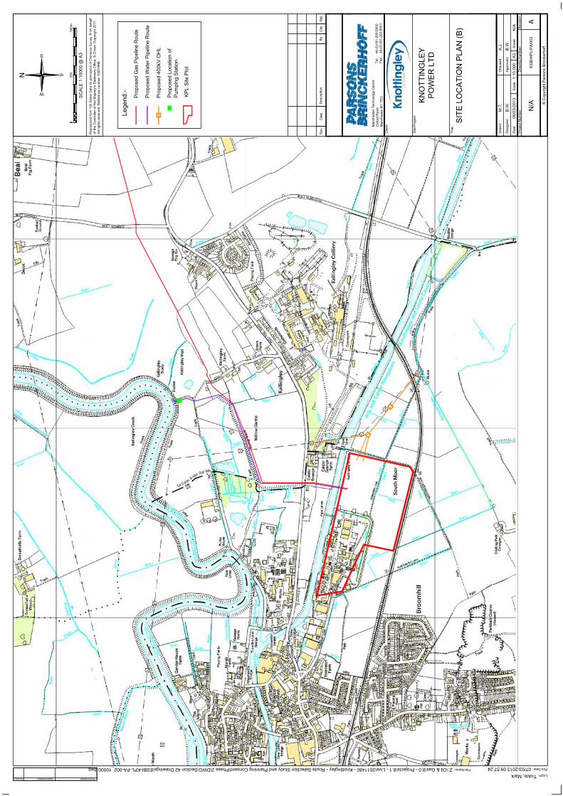
Dat
e:S
cale
:S
heet
:
Des
igne
d:
Dra
wn:
App
rove
d:
Che
cked
:
Title
:
Site
/Pro
ject
:
Clie
nt:
Tel:
44-(
0)16
1-20
0-50
00Fa
x:44
-(0)
161-
200-
5001
A3
Man
ches
ter T
echn
olog
y C
entre
Oxf
ord
Roa
dM
anch
este
r M1
7ED
06/0
3/20
13
Plot Date:07/03/2013 09:57:24Z:\Oil & Gas\8.0 - Projects\8.1 - Live\3511480 - Knottingley - Route Selection Study and Planning Consent\Phase 2\DWG\Section 42 Drawings\ESBI-KPL-PA-002_10000.dwg File Name:
Tickle, Mark Login:
App
Chk
By
Des
crip
tion
Dat
eR
ev
Project Number:Revision: Drawing Number:
Pro
ject
Num
ber:
Rev
isio
n:D
raw
ing
Num
ber:
AE
SB
I/KP
L/P
A/0
02N
/A
N/A
1:10
,000
B.W
.
A.J
.
B.W
.
M.T
.
SIT
E L
OC
ATI
ON
PLA
N (B
)
PO
WE
R L
TDK
NO
TTIN
GLE
Y
N
Lege
nd:-
Pro
pose
d 40
0kV
OH
L
Pro
pose
d W
ater
Pip
elin
e R
oute
Pro
pose
d G
as P
ipel
ine
Rou
te
Pro
pose
d Lo
catio
n of
Pum
ping
Sta
tion
KP
L S
ite P
lot
Rep
rodu
ced
from
'10k
Ras
ter D
ata'
by
perm
issi
on o
f Ord
nanc
e S
urve
y
All
right
s re
serv
ed. R
efer
ence
num
ber 1
0001
998.
0025
0
SC
ALE
1:1
0000
@ A
3
500m

Knottingley Power ProjectPreliminary Environmental Information Report
Page 56 February 2013
Indicative CCGT Power Plant Layouts
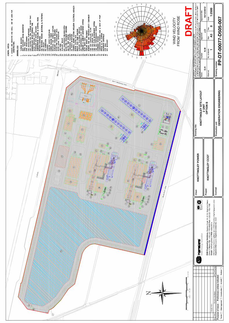


Knottingley Power ProjectPreliminary Environmental Information Report
Page 59 February 2013
Gas Pipeline Route

Dat
e:S
cale
:S
heet
:
Des
igne
d:
Dra
wn:
App
rove
d:
Che
cked
:
Title
:
Site
/Pro
ject
:
Clie
nt:
Tel:
44-(
0)16
1-20
0-50
00Fa
x:44
-(0)
161-
200-
5001
A3
Man
ches
ter T
echn
olog
y C
entre
Oxf
ord
Roa
dM
anch
este
r M1
7ED
07/0
3/20
13
Plot Date:07/03/2013 14:16:35Z:\Oil & Gas\8.0 - Projects\8.1 - Live\3511480 - Knottingley - Route Selection Study and Planning Consent\Phase 2\DWG\Section 42 Drawings\ESBI-KPL-PA-007_30000.dwg File Name:
Tickle, Mark Login:
App
Chk
By
Des
crip
tion
Dat
eR
ev
Project Number:Revision: Drawing Number:
Pro
ject
Num
ber:
Rev
isio
n:D
raw
ing
Num
ber:
AE
SB
I/KP
L/P
A/0
07N
/A
N/A
1:30
,000
B.W
.
A.J
.
B.W
.
M.T
.
GA
S P
IPE
LIN
E P
LAN
KE
Y
PO
WE
R L
TDK
NO
TTIN
GLE
Y
N
Lege
nd:-
Pro
pose
d G
as P
ipel
ine
Rou
te
Pro
pose
d Lo
catio
n of
AG
I
Rep
rodu
ced
from
'10k
Ras
ter D
ata'
by
perm
issi
on o
f Ord
nanc
e S
urve
y
All
right
s re
serv
ed. R
efer
ence
num
ber 1
0001
998.
KP
L S
ite P
lot
SC
ALE
1:3
0000
@ A
3
GA
S P
IPE
LIN
E P
LAN
(1)
500
1000
m0
GA
S P
IPE
LIN
E P
LAN
(2)
GA
S P
IPE
LIN
E P
LAN
(3)
A07
/03/
2013
Firs
t Iss
ueM
.T.
A.J
.B
.W.
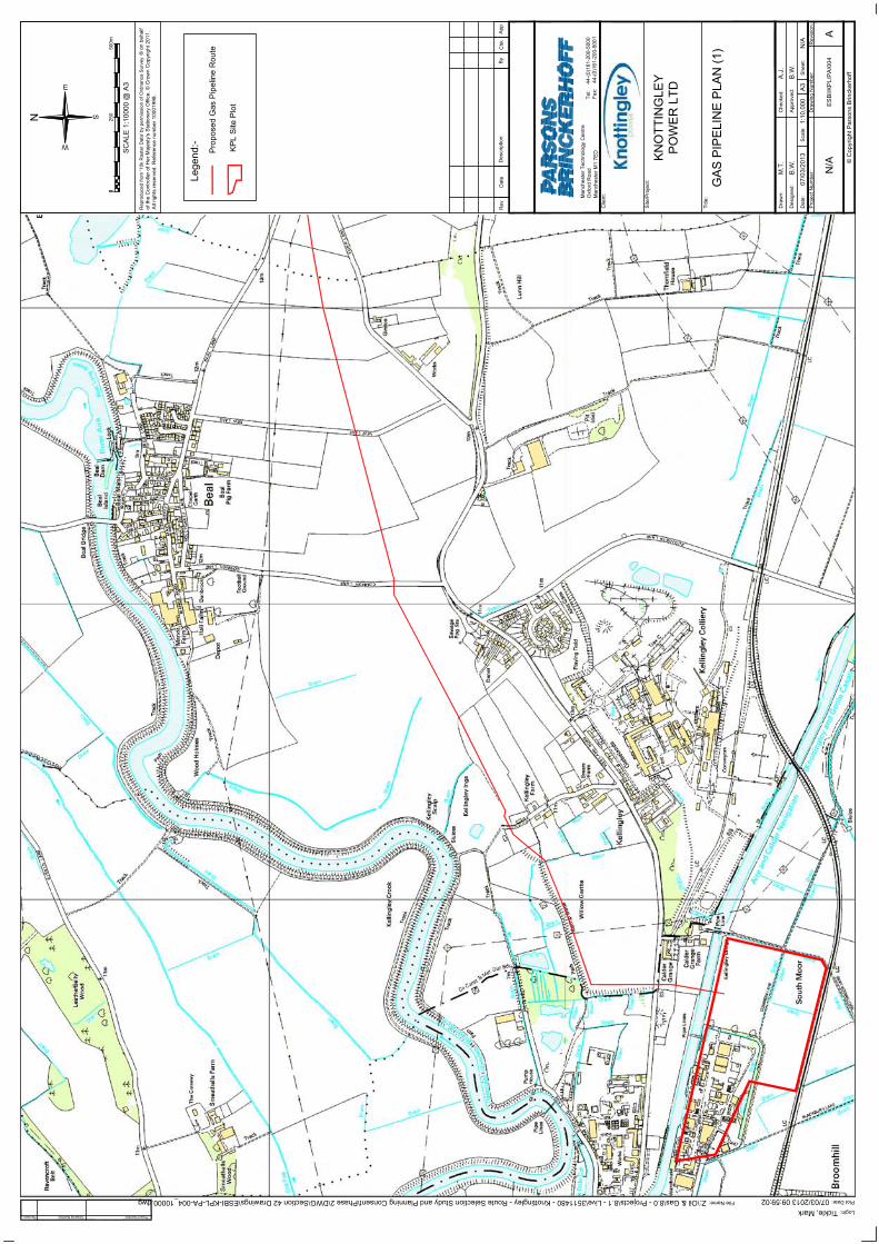
Dat
e:S
cale
:S
heet
:
Des
igne
d:
Dra
wn:
App
rove
d:
Che
cked
:
Title
:
Site
/Pro
ject
:
Clie
nt:
Tel:
44-(
0)16
1-20
0-50
00Fa
x:44
-(0)
161-
200-
5001
A3
Man
ches
ter T
echn
olog
y C
entre
Oxf
ord
Roa
dM
anch
este
r M1
7ED
07/0
3/20
13
Plot Date:07/03/2013 09:59:02Z:\Oil & Gas\8.0 - Projects\8.1 - Live\3511480 - Knottingley - Route Selection Study and Planning Consent\Phase 2\DWG\Section 42 Drawings\ESBI-KPL-PA-004_10000.dwg File Name:
Tickle, Mark Login:
App
Chk
By
Des
crip
tion
Dat
eR
ev
Project Number:Revision: Drawing Number:
Pro
ject
Num
ber:
Rev
isio
n:D
raw
ing
Num
ber:
AE
SB
I/KP
L/P
A/0
04N
/A
N/A
1:10
,000
B.W
.
A.J
.
B.W
.
M.T
.
GA
S P
IPE
LIN
E P
LAN
(1)
PO
WE
R L
TDK
NO
TTIN
GLE
Y
N
Lege
nd:-
Pro
pose
d G
as P
ipel
ine
Rou
te
Rep
rodu
ced
from
'10k
Ras
ter D
ata'
by
perm
issi
on o
f Ord
nanc
e S
urve
y
All
right
s re
serv
ed. R
efer
ence
num
ber 1
0001
998.
KP
L S
ite P
lot
0025
0
SC
ALE
1:1
0000
@ A
3
500m

Dat
e:S
cale
:S
heet
:
Des
igne
d:
Dra
wn:
App
rove
d:
Che
cked
:
Title
:
Site
/Pro
ject
:
Clie
nt:
Tel:
44-(
0)16
1-20
0-50
00Fa
x:44
-(0)
161-
200-
5001
A3
Man
ches
ter T
echn
olog
y C
entre
Oxf
ord
Roa
dM
anch
este
r M1
7ED
07/0
3/20
13
Plot Date:07/03/2013 09:59:42Z:\Oil & Gas\8.0 - Projects\8.1 - Live\3511480 - Knottingley - Route Selection Study and Planning Consent\Phase 2\DWG\Section 42 Drawings\ESBI-KPL-PA-005_10000.dwg File Name:
Tickle, Mark Login:
App
Chk
By
Des
crip
tion
Dat
eR
ev
Project Number:Revision: Drawing Number:
Pro
ject
Num
ber:
Rev
isio
n:D
raw
ing
Num
ber:
AE
SB
I/KP
L/P
A/0
05N
/A
N/A
1:10
,000
B.W
.
A.J
.
B.W
.
M.T
.
GA
S P
IPE
LIN
E P
LAN
(2)
PO
WE
R L
TDK
NO
TTIN
GLE
Y
N
Lege
nd:-
Pro
pose
d G
as P
ipel
ine
Rou
te
Rep
rodu
ced
from
'10k
Ras
ter D
ata'
by
perm
issi
on o
f Ord
nanc
e S
urve
y
All
right
s re
serv
ed. R
efer
ence
num
ber 1
0001
998.
0025
0
SC
ALE
1:1
0000
@ A
3
500m

Dat
e:S
cale
:S
heet
:
Des
igne
d:
Dra
wn:
App
rove
d:
Che
cked
:
Title
:
Site
/Pro
ject
:
Clie
nt:
Tel:
44-(
0)16
1-20
0-50
00Fa
x:44
-(0)
161-
200-
5001
A3
Man
ches
ter T
echn
olog
y C
entre
Oxf
ord
Roa
dM
anch
este
r M1
7ED
07/0
3/20
13
Plot Date:07/03/2013 10:00:22Z:\Oil & Gas\8.0 - Projects\8.1 - Live\3511480 - Knottingley - Route Selection Study and Planning Consent\Phase 2\DWG\Section 42 Drawings\ESBI-KPL-PA-006_10000.dwg File Name:
Tickle, Mark Login:
App
Chk
By
Des
crip
tion
Dat
eR
ev
Project Number:Revision: Drawing Number:
Pro
ject
Num
ber:
Rev
isio
n:D
raw
ing
Num
ber:
AE
SB
I/KP
L/P
A/0
06N
/A
N/A
1:10
,000
B.W
.
A.J
.
B.W
.
M.T
.
GA
S P
IPE
LIN
E P
LAN
(3)
PO
WE
R L
TDK
NO
TTIN
GLE
Y
N
Lege
nd:-
Pro
pose
d G
as P
ipel
ine
Rou
te
Pro
pose
d Lo
catio
n of
AG
I
Rep
rodu
ced
from
'10k
Ras
ter D
ata'
by
perm
issi
on o
f Ord
nanc
e S
urve
y
All
right
s re
serv
ed. R
efer
ence
num
ber 1
0001
998.
KP
L S
ite P
lot
0025
0
SC
ALE
1:1
0000
@ A
3
500m

Knottingley Power ProjectPreliminary Environmental Information Report
Page 61 February 2013
Water Pipelines Route

Dat
e:S
cale
:S
heet
:
Des
igne
d:
Dra
wn:
App
rove
d:
Che
cked
:
Title
:
Site
/Pro
ject
:
Clie
nt:
Tel:
44-(
0)16
1-20
0-50
00Fa
x:44
-(0)
161-
200-
5001
A3
Man
ches
ter T
echn
olog
y C
entre
Oxf
ord
Roa
dM
anch
este
r M1
7ED
06/0
3/20
13
Plot Date:07/03/2013 09:58:12Z:\Oil & Gas\8.0 - Projects\8.1 - Live\3511480 - Knottingley - Route Selection Study and Planning Consent\Phase 2\DWG\Section 42 Drawings\ESBI-KPL-PA-003_10000.dwg File Name:
Tickle, Mark Login:
App
Chk
By
Des
crip
tion
Dat
eR
ev
Project Number:Revision: Drawing Number:
Pro
ject
Num
ber:
Rev
isio
n:D
raw
ing
Num
ber:
AE
SB
I/KP
L/P
A/0
03N
/A
N/A
1:10
,000
B.W
.
A.J
.
B.W
.
M.T
.PIP
ELI
NE
PLA
NC
OO
LIN
G W
ATE
R
PO
WE
R L
TDK
NO
TTIN
GLE
Y
N
0025
0
SC
ALE
1:1
0000
@ A
3
500m
Rep
rodu
ced
from
'10k
Ras
ter D
ata'
by
perm
issi
on o
f Ord
nanc
e S
urve
y
All
right
s re
serv
ed. R
efer
ence
num
ber 1
0001
998.
Lege
nd:-
Pro
pose
d W
ater
Pip
elin
e R
oute
Pro
pose
d Lo
catio
n of
Pum
ping
Sta
tion
KP
L S
ite P
lot