ku-ring-gai council depot site masterplan€¦ · ku-ring-gai council depot site masterplan ......
TRANSCRIPT

KU-RING-GAI COUNCIL DEPOT SITE MASTERPLAN
Allen Jack+Cottier Architects Pty Ltd ABN 53 003 782 250
59 Buckingham Street Surry Hills NSW 2010 AUSTRALIA ph +61 2 9311 8222 fx +61 2 9311 8200 www.architectsajc.com
1-7 CARLOTTA AVENUE, GORDON
Adopted by Council on 5th April 2005
Level 1, 5 Wilson Street Newtown NSW 2042 AUSTRALIAph +61 2 9557 5533 fx +61 2 9519 8323 www.oculus.com.au
PREPARED FOR KU-RING-GAI COUNCIL

TABLE OF CONTENTS
1.0 INTRODUCTION 11.1 Local Context 11.2 Site 31.3 Aim and Purpose of this Masterplan 41.4 Relationship to Ku-ring-gai Multi-Unit Housing Development Control Plan 55 (DCP 55) 41.5 Relationship to Planning Instruments 41.6 Structure of this Masterplan 41.7 When to use this Masterplan 51.8 Vision 51.9 Objectives 61.10 Illustrative Masterplan and Perspectives 7
2.0 DESIGN PRINCIPLES 122.1 Landscape Character 122.2 Topography and Solar Access 142.3 Stormwater Management 162.4 Vegetation 182.5 Public and Private Open Space 202.6 Circulation 232.7 Street Character 252.8 Neighbourhood Amenity and Views 282.9 Special Site Edges 302.10 Built Form 32
3.0 DEVELOPMENT CONTROLS AND GUIDELINES 35
3.1 PUBLIC DOMAIN 403.1.1 Streetscape 403.1.2 Public Open Space Uses 413.1.3 Landscape Character 413.1.4 Stormwater Management 413.1.5 Paving 413.1.6 Playground and Street Furniture 413.1.7 Lighting 413.1.8 Public Art 41

3.2 PRIVATE DOMAIN 423.2.1 Communal Open Space 423.2.2 Private Open Space 423.2.3 Setbacks 423.2.4 Site Edges 433.2.5 Deep Soil Zones 433.2.6 Landscape Requirements 433.2.7 Site Drainage and Stormwater Control 443.2.8 Building Envelopes 443.2.9 Building Height 443.2.10 Building Depth and Length 443.2.11 Building Separation and Privacy 453.2.12 Site Coverage 453.2.13 Access and Carparking 453.2.14 Solar Access and Overshadowing 453.2.15 Ground Level Activities 453.2.16 Residential Unit Mix 453.2.17 Building Articulation and Expression 463.2.18 Acoustics 463.2.19 Contamination 463.2.20 Impact Protection Zone 46
APPENDIX 47A Tree Survey Table 47B Solar Access Studies - Shadows in Plan 49C Solar Access Studies - Sun’s Eye View 50
TABLE OF CONTENTS

PG 1
Site Aerial
Local Context - Topography
1.1 Local Context
The existing Ku-ring-gai Council Depot Site is located in Gordon at 1 – 7 Carlotta Avenue adjacent Mona Vale Road to the north and Sydney’s northern rail line to the west. To the east and south is an existing residential neighbourhood characterised by interwar housing on large lots within well landscaped garden and a significant tree canopy.
The site sits on a slope between the Pacific Highway located along the ridgeline to the east and the Garigal National Park and its creek system in the valley to the east. The location of the site on the upper slope reveals significant views to the surrounding residential neighbourhoods and their bushland setting. The hydrology of the area follows the topography to the creek system highlighting the importance of on-site stormwater management.
MCINTYNTYRE
STT
RD
WAY
HIGHW
A
TST
FITZSIMONONS
PL
ALAY
PL
MAN
DALA
WALALTO
NCC
L
BUBURGOYNE
LA
YTHW
AY
PATHW
LAN
ELA
N
PLR
METZLERPATHW
AY
PATH
HW
AYPA
THW
MT.W
ILLIA
MST
PLPL
WILTLT
ONN
CLL
AAAVAVEAVEAVEEAVEAVEAVEAVEAVEAVEAVEAVEAVEAVEEAAAAAA
ST
OYNEURGOYNE
BURGO
LANE
PEARSON
AVE
CARLOT
LOTTA
AVAVE
MT.WILLIAWILLIAM
MT.WW
ILLIAM
MERRIWA
PACIFIC
MO
NA
MO
NA
ALE
VA
EYASH
LEY
GR
DDDDRD
GARDDEN
SQQUARE
HIGHLAN
DS
EAVE
HHIGHLANNDS
ANANAT
OL
OL
AVECARLOTTA
OTTA
CARLOTT
ST
MIN
NSS
STST
ST
WADE
W
KHARTOUM
LANE
PARK
LANE
ORD
RADFO
ELANE
HAMCLIPSHA
STJ
SN
SN
SN
SNNNNNNNNNNNNNNN
HN
ST.JOH
PACI
CIFIC
RON
A
WERO
PARK
HIGHW
AY
KHARTOUM
STST JST.JOHNS
MCCINTYRRE
EANEAAALALALALALALALALALALALLLLL
NE
LANE
6.1W
LANE
6.1W
PL
ROBERTRO
AVE
STT
STT
ST
DUUMARESQ
EVEVVVAVAVAVAVAVAVAVAVAVAVAVAVAVAAAAAAAAAAVAVAVAAAAAAAA
AVE
AVE
120120120120120120
120120120120
110110110110
80808080
1001001001000
90909090
100100100100
110110110110
2020202012012012122220
120120120120
2020120120120120120120120120
110110110110
100100100100
1201201212120120120120
130130130130
120120120120120120
120120120120120120120120
120120120120120120
11121212012012012012
1101101101100
100100100100
120120120120
10101010110110111110
120120120120
110110110110
100100100100 100
100100100
90909090
90909090
000000000000000000000000000000000000000000002222121200000000000000000000000000000000000022221212
110110110110
100100100100
110110110110
00 10 2020 505050505050505050 10 2020 505050505050505050 10 2020 505050505050505050 10 2020 5050
1.0 INTRODUCTION

PG 2
Local Context - Access
Local Context - Landuse
The landuse and built form in the area clearly relates to the overall topography and street hierarchy. The main street typology and commercial area of Gordon is located along the Pacific Highway, while larger footprint commercial development is located adjacent the intersection of the Pacific Highway and Mona Vale Road. Residential areas are located along the slope between the highway and the valley. The site itself has recently been rezoned for multi-unit housing. The site is current used as a council depot.
The site is within walking distance of the Gordon village centre along the Pacific Highway and it is approximately 700m from the Gordon rail station. A pedestrian tunnel from Mt William Street leads directly to the centre. Alternatively pedestrians can access the centre and station via a footpath along Mona Vale Road or through the adjacent neighbourhood.
120
120
110
100
90
100
110
120
120
120
110
120
130
120
120
120
120
110
100
120
110
0
110
MCINTYRE
ST
RD
HIGHW
AYST
FITZSIMONS
MAN
DALA
Y PL
WALTO
NC
L
BURGOYNE
LA
LAN
E
PL
METZLERPATHW
AY
PATH
WAY
MT.W
ILLIA
MST
PL
WILT
ON
CL
AV
ST
BURGOYNE
LANE
PEARSON
AVE
CARLOTTA
AVE
MT.WILLIAM
MT.W
ILLIAM
MERRIWA
PACIFIC
MO
NA
VALE
ASHLEY
GR
RD
GARDEN
SQUARE
HIGHLAN
DS
AVE
HIGHLANDS
ANATOL
AVECARLOTTA
CARLOTTA
ST
MINNS
ST
ST
WADE
KHARTOU
M
LANE
PARK
LANE
RADFORD
LANE
CLIPSHAM
ST.JOHNS
PACIFIC
WERO
NA
PARK
HIGHW
AY
KHARTOU
M
ST.JOHNS
MCINTYRE
LA
LANE
6.1W
LANE
6.1W
PL
ROBERT
AVE
ST
ST
ST
DUMARESQ
AV
AVE
AVE
9090
100100 100100
9090
PATHWAY
PATHWAY
0000
00 10 2020 50 100 150 2000
120
120
110
80
100
90
100
110
120
120
120
110
100
120
130
120
120
120
120
110
100
120
110
120
110
120
110
100
110
MCINTYRE
ST
RD
HIGHW
AYST
FITZSIMONS
MAN
DALA
Y PL
WALTO
NC
L
BURGOYNE
LA
LANE
PL
METZLERPATHW
AY
PATHWAY
MT.W
ILLIAMST
PL
WILTON
CL
AVE
ST
BURGOYN
E
LANE
PEARSON
AVE
CARLO
TTA
AVE
MT.WILLIAM
MT.W
ILLIAM
MERRIWA
PACIFIC
MONA
VALE
ASHLEY
GR
RD
GARDEN
SQUARE
HIGHLANDS
AVE
HIGHLANDS
ANATOL
AVECARLOTTA
CARLOTTA
ST
MINNS
ST
ST
WADE
KHARTOU
M
LANE
PARK
LANE
RADFORD
LANE
CLIPSHAM
ST.JOHNS
PACIFIC
WERONA
PARK
HIGHWAY
KHARTOU
M
ST.JOHNS
MCINTYRE
LA
LANE
6.1W
LANE
6.1W
PL
ROBERT
AVE
ST
ST
ST
DUMARESQ
AV
AVE
AVE
00120
120
9090
100100 100100
9090
PATHWAY
PATHWAY
400m walk
800m
walk
00 10 2020 50 100 150 2000
1.0 INTRODUCTION

PG 3
1.2 Site
The existing council depot site is approximately 1.6 ha in area and organised in a series of terraces with:• a garbage depot and carpark located
on the lowest terrace along Carlotta Avenue,
• a series of workshop buildings and supporting external asphalted area located on the next higher terrace, and
• concrete storage bins, sheds and large asphalted areas located on the highest terrace at the rear of residential properties.
Vegetation on the site is concentrated along the site edges with some scattered planting within the carpark and central area of the site. An embankment along Carlotta Avenue provides an attractive landscape buffer between the depot functions on the site and the adjacent neighbourhood.
MONA VALE ROAD
CARLOTTA AVENUE
MT W
ILLIAM
STREET
PACIFIC HIGHWAY
DEMOLISHED BUILDING
EXISTING TREES
KEY
MONA VALE ROAD
CARLOTTA AVENUE
MT W
ILLIAM
STREET
PACIFIC HIGHWAY
1.0 INTRODUCTION

PG 4
1.3 Aim and Purpose of this Masterplan
The Masterplan for 1-7 Carlotta Avenue, Gordon provides Council with a mechanism for describing the potential development of this site. It identifies design objectives and includes site specific controls. These refine existing principles and controls embodied within Ku-ring-gai DCP 55 and Ku-ring-gai LEP 194.
The purpose of the Masterplan is to guide redevelopment of the site as a high quality medium density residential precinct responsive to the significant landscape setting of Gordon.
1.4 Relationship to Ku-ring-gai Multi-Unit Housing Development Control Plan 55 (DCP 55)Council has adopted this Masterplan as site specific development controls applying to the site under section 7.4 of DCP 55.
Development on the site is to be in accordance with the design principles, development controls and guidelines contained in this Masterplan as well as the objectives and controls contained in DCP 55. In the event of any inconsistency between this Masterplan and DCP 55, this Masterplan will prevail to the extent of any inconsistency.
1.5 Relationship to Other Planning Instruments
This Masterplan must be read in conjunction with any Environmental Planning Instrument or Policy that affects the site. These include, but may not be limited to, the following:• SEPP 65 – Design Quality of Residential Flat
Development• SEPP Building Sustainability Index - BASIX
2004 (24 June 2004) • LEP 194 – Ku-ring-gai Planning Scheme
Ordinance• DCP 55 – Multi-Unit Housing – Railway
Corridor and St Ives Centre (December 2004)
• DCP 47 - Water Management Development Control Plan (March 2004)
• DCP 43 – Car Parking Development Control Plan (November 1998)
1.6 Structure of this Masterplan
This Masterplan is structured in three sections.
• IntroductionThis section includes a description of the local context and existing site. It explains the aim and purposes of the Masterplan, its relationship to other planning regulations and policies, the organisation of the Masterplan and the use of the Masterplan. A vision for the site is articulated and supported by objectives and illustrative drawings.
• Design PrinciplesThis section explains the design rational behind the illustrative Masterplan and the supporting development controls and guidelines. Each topic describes the existing character and the proposed design solutions. Design principles direct the overall site layout, its relationship to the context, and the resulting built form and landscape intent.
• Development Controls and GuidelinesThe development controls and guidelines are divided into two sections: those that create or define the public domain and those that control the form and resolution of the private domain. Public domain controls relate to the public open space, streetscapes and the building edges that define these spaces. The private domain relates to communal and private opens spaces, built form, amenity and environmental performance.
1.0 INTRODUCTION

PG 5
1.7 When to use this Masterplan
Ku-ring-gai Council is the authority for the adoption of the Masterplan and the consent authority for a development application relating to the site.
Development applications should demonstrably contribute to the achievement of the objectives, design principles, development controls and guidelines of this Masterplan.
Proponents should consult this Masterplan at the earliest stages of design in order to ensure the compatibility of development proposals with the desired outcomes of the site.
Prior to lodging a development application, applicants are encouraged to discuss their proposals with Ku-ring-gai Council planners. Pre-lodgement meetings are an important part of the development assessment process as they assist in identifying potential challenges at an early stage and they provide valuable opportunity for council officers to convey to potential applicants the requirements and intent of the Masterplan.
1.8 Vision
The site at 1-7 Carlotta Avenue will be a tranquil residential precinct framing a new local bushland park and playground. The proposed park is the centrepiece of the site and responds to the water cycle in innovative and visible ways in the public domain through the use of bio-retention swales.
The proposed landscape, the dominant visual element of the site, is the fabric that knits the new development into the existing neighbourhood. The landscape weaves itself between buildings creating green fingers that will link the upper terraces and cascade down the site to connect with the lower parkland.
The buildings will sit harmoniously in this landscaped framework. Building material and colours will be predominantly warm, earthy, recessive tones that allow the landscape to dominate.
1.0 INTRODUCTION

PG 6
1.9 Objectives • To provide Council with a masterplan vision
and site specific controls that will enable the future redevelopment of the site as a high quality medium density residential precinct.
• To provide design principles, building envelopes, development controls and guidelines that are readily adaptable into a specific development proposal.
• To protect the high level of amenity to adjacent residential properties and to ensure a high level of amenity for occupants of new development.
• To promote a high quality landscape design that contributes to the landscape character of the local neighbourhood and protects the tree canopy of Ku-ring-gai.
• To promote high quality building design that acknowledges the residential character of the neighbourhood while promoting appropriate contemporary design solutions.
• To provide a minimum of ten percent public open space on the site that is well designed and easily accessible to the local community.
• To ensure communal and private open space are high quality, easily accessible and provide passive and active recreational activities for residents.
• To ensure stormwater is managed on-site and that site- retention and recycling is incorporated into the landscape and building design.
• To promote development that delivers better practice environmental performance and reduces energy and material consumption.
• To promote housing diversity though a range of unit types and sizes.
• To promote safety and security through site layout, building design and landscape design.
• To minimise impact of vehicular access and circulation by utilising existing site access locations and providing a legible on-site vehicular circulation system.
• To ensure that the carpark is concealed underground and behind development and where exposed due to topographic constraints, is integrated into the overall building and landscape design.
• To minimise the negative impact of the rail corridor on new housing through site layout, apartment layout and acoustic construction.
1.0 INTRODUCTION
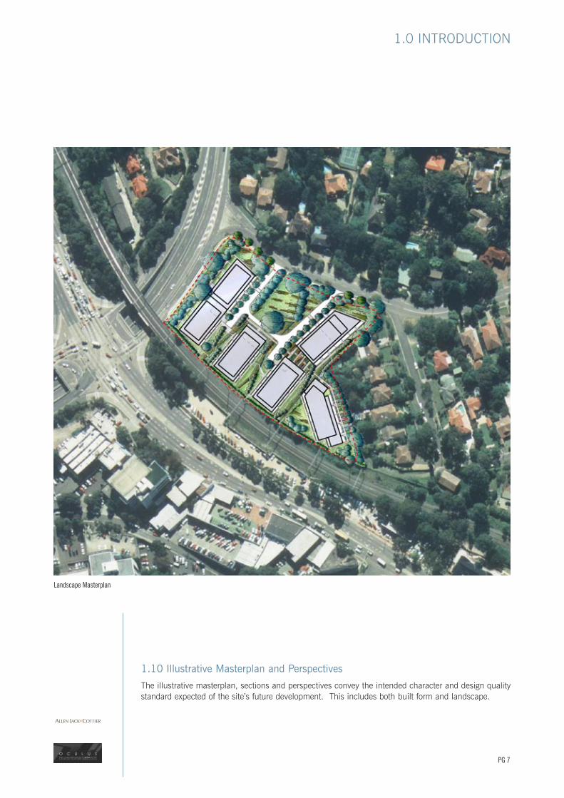
1.10 Illustrative Masterplan and Perspectives
The illustrative masterplan, sections and perspectives convey the intended character and design quality standard expected of the site’s future development. This includes both built form and landscape.
Landscape Masterplan
PG 7
1.0 INTRODUCTION

Section AA
Section CC
Section BB
Section DD
PG 8
B
D
A
C
1.0 INTRODUCTION

Bird’s Eye View of Site from North East
PG 9
1.0 INTRODUCTION

View from Carlotta Avenue
PG 10
1.0 INTRODUCTION

View of New Public Park
PG 11
1.0 INTRODUCTION