ku-ring-gai town centres heritage conservation area ... · ku-ring-gai town centres heritage...
TRANSCRIPT

Ku-ring-gai Town CentresHeritage Conservation Area Inventory Sheet
Item No
YARABAH AVENUE HERITAGE CONSERVATION AREAItem Name
Heritage Conservation AreaItem Type
Yarabah Avenue is significant as part of a 1920s subdivision which retains its inter-war character ofsingle storey Inter-war California Bungalows, including the remarkable heritage-listed bungalowNebraska designed by architect Alexander S Jolly at 17 Yarabah Avenue.
The name Ku-ring-gai comes from the Kuringgai or Guringai Aboriginal language group of the peoplewho inhabited the area from Port Jackson north across Broken Bay and beyond Brisbane Water. Thename has been adopted for both the Local Government area and the adjacent National Park to thenorth. There were two bands of the Guringai in what is now the Ku-ring-gai Local Government area:the Garrigal or Carigal people, who lived around West Head, and the Terramerragal, who lived in theTurramurra area.A ridge-top pathway made by the Guringai people was the route followed by what is now the PacificHighway through Ku-ring-gai.Within six weeks of the arrival of the British First Fleet in Sydney in 1788, Governor Phillip wentexploring around Broken Bay, and commented on the friendliness of the Aboriginal people. However,when he returned a year later, all except those too sick with smallpox fled from him. By 1790, over halfof the Guringai nation had been wiped out by smallpox. By the 1840s, most of the Aboriginal peoplehad disappeared from Pittwater and their traditional lands had been taken over by white settlers. SomeGuringai survivors of the small pox epidemic formed what was known to the British colonists as theBroken Bay tribe led by Bungaree, who was notable for completing the first circumnavigation ofAustralia with Matthew Flinders in 1801-02. Another notable Guringai person in the early contactperiod was Bennelong’s wife Barangaroo, who was noted in colonist’s records for her strongpersonality.Today, there are over 800 culturally significant Aboriginal sites found in Ku-ring-gai National Park,including rock engravings, rock shelter drawings, paintings and stencils, axe grinding grooves andshell middens, and Aboriginal people live throughout Sydney metropolitan area.There are around 100 recorded Aboriginal sites in the Ku-ring-gai LGA and large areas are considered
PART DRAFT HCA 15
HistoricalSummary
Alternative Item Name
Building settlements towns and citiesNational Historic ThemesTowns, suburbs and villagesState Historic Theme 1
State Historic Theme 2State Historic Theme 3State Historic Theme 4
Federation, Inter-warKey Historical Periods
TownscapeCategory
Refer to mapPrimary Address
Ku-ring-gaiLocal Govt. area
The Yarabah Avenue Heritage Conservation Area encompasses Heritage Items at Nos. 724 and 726Pacific Highway, and properties at Nos. 1 to 17 Yarabah Avenue (No. 17 Yarabah Avenue beingheritage listed), and Nos. 2 to 16 Yarabah Avenue
Boundaries
Urban AreaGroup Collection
Summary Statement of Significance
KU-RING-GAI TOWN CENTRES HERITAGE CONSERVATION AREAS INVENTORY
38
Ku-ring-gai Town CentresHeritage Conservation Area Inventory Sheet
All houses within the area are face brick, however some have been painted. Roofs are generally unglazedterracotta tiled, however replaced with concrete roof tiling in a few instances, and windows are timber framed,either casements or double-hung.
Yarabah Avenue is a curved street coming off the Pacific Highway, turning and descending to theintersection with Bushlands Avenue. Houses on the northern and eastern sides are generally sitedabove street level, those on the southern and western sides of the street below street level. Nofootpaths. Concrete kerbing, relatively wide street with mixed street tree planting.Built character: largely intact single storey inter-war California Bungalows including the heritage-listedNebraska at 17 Yarabah Avenue (designed by architect Alexander Stewart Jolly). Nos. 724 & 728Pacific Highway are a pair of heritage-listed Federation Queen Anne style houses.
Materials
All houses within the Heritage Conservation Area are contributory.
The Yarabah Avenue Heritage Conservation Area is of historical significance as an intact portion of a1920s subdivision.
Association with the architect Alexander Stewart Jolly, designed of the heritage-listed Nebraska atNo. 17 Yarabah Avenue.
Yarabah Avenue is of aesthetic significance as an intact streetscape of a 1920s residentialsubdivision, interesting for its curving street pattern.
Paint to face brickwork and replacement of terracotta roof tiling with concrete roof tiles has occurred ina few cases.
to have high potential for unrecorded sites. These sites are still important to Aboriginal people living inthe region and there are many Aboriginal people and local residents actively working to protect thesesites and promote the rich Aboriginal heritage of the area.The earliest European settlement in Ku-ring-gai was along the major roads, and was generally rural innature. During the 19th century, timber getting and orchards were major activities, and a few villaswere built which are still extant (for example in the 1880s Grandview on Pymble Hill, 1178 PacificHighway, the former orange orchard of which now forms part of the grounds of PLC school). RobertPymble (commemorated in the suburb name), was an early timber-getter and orchardist who settled inPymble in the 1820s and and Robert McIntosh (commemorated in McIntosh Street Gordon) asanother notable early orchardist of Ku-ring-gai.The North Shore Railway line was established in 1890, and subdivision of orchards and large estatesfor residential development near the railway stations proceeded thereafter. The location of stationsalong the railway defined the focus of the Ku-ring-gai Town Centres and neighbourhood areas (withthe exception of St. Ives, which developed on Mona Vale Road at a later stage). The railway line wasduplicated in 1909, electrified in 1928. The subsequent opening of the Sydney Harbour Bridge in1932 led to a major shift of Sydney’s elite (the business owners and managers, the doctors, solicitors,architects, artists, politicians) to the north shore, and particularly Ku-ring-gai, from other areas ofSydney (particularly Ashfield, Burwood and Strathfield).Yarabah Avenue is was subdivided as the Harnorm Estate subdivision, a resubdivision of the 1921Open View Estate, and developed during the 1920s.
PhysicalCondition
Modifications
Description
HistoricalSignificance
Historical Assoc Significance
AestheticSignificance
Social Significance
TechnicalResearch
KU-RING-GAI TOWN CENTRES HERITAGE CONSERVATION AREAS INVENTORY
39

Ku-ring-gai Town CentresHeritage Conservation Area Inventory Sheet
Yarabah Avenue Heritage Conservation Area is representative 1920s residential subdivision.
Ku-ring-gai Urban Conservation Area Study – Stage 2 and 2(a) December 2002, Godden MackayLogan
C. Kemp, Paul Davies Pty Ltd Architects, Heritage ConsultantsAuthorship
1. Protection of Significance(a) Subdivision:- Require a Curtilage assessment as part of any Heritage Impact Assessment to accompany anapplication for further subdivision of sites within the HCA, with particular emphasis on the impact ofsubdivision on garden settings(b) Key Historical Period significant and contributory development:- retain one storey Inter-war period residences, heritage-listed and contributory, in Yarabah Avenue- retain one and two storey Federation period residences at Nos. 724 and 726 Pacific Highway- maintain characteristic building alignments- retain form- retain finishes and detail, including face brickwork to Federation period and Inter-war periodhouses. Encourage chemical stripping of paint from face brickwork.- encourage replacement of concrete roof tiling with unglazed terracotta Marseilles pattern roof tiling- Front fences: retain original front fences. Discourage use of brush fencing and high brick wallsabove 1.6m in height. Encourage use of low brick front fencing or hedging in lieu of fencing inYarabah Avenue.
2. Redevelopment of neutral sites:Note: all sites within this Heritage Conservation Area are contributory.
3. Enhance significance of the Heritage Conservation Area- maintain and enhance street tree planting
4. Car Parking- do not allow construction of garages or carports on the street alignment of properties- garages and carports are to be located behind the building line, and preferably to the rear of themain building on each site
5. Landscaping- Encourage maintenance and establishment of gardens to houses including substantial trees andshrubs - limit paving and hard surfacing, particularly to front gardens
6. View Protection- development within the Gordon Town Centre at the northern end of Yarabah Avenue and at No.728 Pacific Highway, adjacent to the Heritage Conservation Area, should be restricted to one to twostoreys in height and incorporate a landscape buffer particularly along property boundaries adjacentto the Heritage Conservation Area, to soften potential impacts
7. Heritage Items and Potential Heritage Items:- protect the listed Heritage items within the Heritage Conservation Area: Nebraska 17 YarabahAvenue, and Nos. 724 and 726 Pacific Highway.
Identified as part of a National Trust Urban Conservation Area in 1996.
RecommendedManagement
Ku-ring-gai Town Centres Heritage Conservation Areas Review Paul Davies Pty Ltd September 2008
Listings
StudyDetails
Significance
Rarity
Representativeness
References
KU-RING-GAI TOWN CENTRES HERITAGE CONSERVATION AREAS INVENTORY
40

Item No.
YARABAH AVENUE HERITAGE CONSERVATION AREA
Inventory SheetsKu-ring-gai Town Centres Heritage Conservation AreasOctober 2008
Item Name
Image 1 1928 Water Board block plan showing Har-norm Avenue (laterrenamed Yarabah Avenue with Gertrude Avenue, laterBushlands Avenue at top)
Image 2 Open View Estate subdivision Gordon, 1921 showing Har-Norm Avenue (later Yarabah Avenue)
Image3 Yarabah Avenue from Bushlands Avenue Image 4 5 Yarabah Avenue
Image 5 15 Yarabah Avenue Image 6
41
Ku-ring-gai Town CentresHeritage Conservation Area Inventory Sheet
Item No
PYMBLE HEIGHTS HERITAGE CONSERVATION AREAItem Name
Heritage Conservation AreaItem Type
A largely intact portion of the 1892 Pymble Heights Estate subdivision encompassing a large numberof heritage items, particularly and intact Victorian, Federation and Inter-war period housing. The groupof heritage items at Nos. 35-45 Grandview Street and 2 Wellesley Road (Corner Grandview Street)illustrate the transition from Victorian to Federation period architectural styles.
The name Ku-ring-gai comes from the Kuringgai or Guringai Aboriginal language group of the peoplewho inhabited the area from Port Jackson north across Broken Bay and beyond Brisbane Water. Thename has been adopted for both the Local Government area and the adjacent National Park to thenorth. There were two bands of the Guringai in what is now the Ku-ring-gai Local Government area:the Garrigal or Carigal people, who lived around West Head, and the Terramerragal, who lived in theTurramurra area.A ridge-top pathway made by the Guringai people was the route followed by what is now the PacificHighway through Ku-ring-gai.Within six weeks of the arrival of the British First Fleet in Sydney in 1788, Governor Phillip wentexploring around Broken Bay, and commented on the friendliness of the Aboriginal people. However,when he returned a year later, all except those too sick with smallpox fled from him. By 1790, over halfof the Guringai nation had been wiped out by smallpox. By the 1840s, most of the Aboriginal peoplehad disappeared from Pittwater and their traditional lands had been taken over by white settlers. SomeGuringai survivors of the small pox epidemic formed what was known to the British colonists as theBroken Bay tribe led by Bungaree, who was notable for completing the first circumnavigation ofAustralia with Matthew Flinders in 1801-02. Another notable Guringai person in the early contactperiod was Bennelong’s wife Barangaroo, who was noted in colonist’s records for her strongpersonality.Today, there are over 800 culturally significant Aboriginal sites found in Ku-ring-gai National Park,including rock engravings, rock shelter drawings, paintings and stencils, axe grinding grooves andshell middens, and Aboriginal people live throughout Sydney metropolitan area.There are around 100 recorded Aboriginal sites in the Ku-ring-gai LGA and large areas are considered
PART DRAFT HCA 17
HistoricalSummary
Alternative Item Name
Building settlements towns and citiesNational Historic ThemesTowns, suburbs and villagesState Historic Theme 1
State Historic Theme 2State Historic Theme 3State Historic Theme 4
Victorian, Federation, Inter-warKey Historical Periods
TownscapeCategory
Refer to mapPrimary Address
Ku-ring-gaiLocal Govt. area
The Pymble Heights Heritage Conservation Area encompasses properties at Nos. 35-45 GrandviewStreet, 2-14 Wellesley Avenue, 2 & 4 Mocatta Avenue, Nos. 11 and 11A King Edward Street, Nos. 10-24 King Edward Street, Nos.16-20 Church Street, and Nos. 5-9 Station Street, Pymble.
Boundaries
Urban AreaGroup Collection
Summary Statement of Significance
KU-RING-GAI TOWN CENTRES HERITAGE CONSERVATION AREAS INVENTORY
42

Ku-ring-gai Town CentresHeritage Conservation Area Inventory Sheet
Grandview Street: runs parallel to the railway. Wide street, with the railway on the southern side,concrete kerbing on both sides. Slopes down from intersection with Pacific Highway. View of railwayplatform from the street. The retail/commercial section of the street (western end) is predominantly 2storey c. 1920s shops, in various states of alteration, plus two larger commercial buildings, c. 1980s.The eastern end is dominated by a group of late 19th century and early 20th century heritage-listedhouses.Station Street: Relatively wide steep street, concrete kerbing both sides, footpath only on westernside, scattered street trees.Church Street, King Edward Street, Mocatta Avenue, Wellesley Street: relatively wide streets withconcrete kerbing both sides, scattered and mixed street trees.Built character: The area encompasses a group of heritage items in Grandview Street, which include
to have high potential for unrecorded sites. These sites are still important to Aboriginal people living inthe region and there are many Aboriginal people and local residents actively working to protect thesesites and promote the rich Aboriginal heritage of the area.The earliest European settlement in Ku-ring-gai was along the major roads, and was generally rural innature. During the 19th century, timber getting and orchards were major activities, and a few villaswere built which are still extant (for example in the 1880s Grandview on Pymble Hill, 1178 PacificHighway, the former orange orchard of which now forms part of the grounds of PLC school). RobertPymble (commemorated in the suburb name), was an early timber-getter and orchardist who settled inPymble in the 1820s and and Robert McIntosh (commemorated in McIntosh Street Gordon) asanother notable early orchardist of Ku-ring-gai.The North Shore Railway line was established in 1890, and subdivision of orchards and large estatesfor residential development near the railway stations proceeded thereafter. The location of stationsalong the railway defined the focus of the Ku-ring-gai Town Centres and neighbourhood areas (withthe exception of St. Ives, which developed on Mona Vale Road at a later stage). The railway line wasduplicated in 1909, electrified in 1928. The subsequent opening of the Sydney Harbour Bridge in1932 led to a major shift of Sydney’s elite (the business owners and managers, the doctors, solicitors,architects, artists, politicians) to the north shore, and particularly Ku-ring-gai, from other areas ofSydney (particularly Ashfield, Burwood and Strathfield).Station Street was the western boundary of D.D. Mathew’s 800-acre land grant of 1838 and of thePymble Heights subdivision of 1892, a later re-issue of an earlier subdivision.On 21 September 1883 Thomas Walker Esq. of Concord lodged a Primary Application for 15 acres ofland fronting Lane Cove Road adjacent to Edward Hacking’s farm. Section A was subdivided into 23lots as the Roseville Estate, many of the lots accessed by the newly formed Roseville Avenue (laterrenamed Wellesley Road).“The first land transaction of the subdivision was on 1 November 1892 when William McKeown soldlots 5 to 15 to the Rev. Paul Clipsham. This meant that Rev. Clipsham owned all the land in thesubdivision on the western side of Roseville Avenue (now Wellesley Road) from Grandview to ChurchStreet. The Rev. Clipsham was living in the immediate area from at least 1893: he was included in theWesleyan Church records for Pymble from 1893 and was listed on the electoral roll in RosevilleAvenue (now Wellesley Road) from 1894.” (Harvey, Jennifer, unpublished draft article Pymble)
Between 1904 and 1905 four houses were listed in the Sand’s Directory in Roseville Avenue (nowWellesley Road) including Aldboro (now No. 2 Wellesley Road), on the corner of Grandview Street,constructed c. 1893.“In November 1892 William Henry McKeown subdivided the remainder of his land and advertised it forsale as the Pymble Heights Estate....The boundaries were Station Street to the west and the earlierRoseville Estate and Stoney Creek Road to the east....When the subdivision was first promoted onlyHope and Church Streets serviced the area. Church Street had been named after the MethodistChurch, which was located on the eastern side of Stoney Creek Road. By 1895 seven of the ten lotssouth of Church Street had been reconfigured to make twenty-four smaller lots. Edwards and EmilyStreets were formed: these were later known as King Edward Street....By 1898 the Sand’s directorylisted five households in the area.” (Harvey, Jennifer, unpublished draft article Pymble)
Description
KU-RING-GAI TOWN CENTRES HERITAGE CONSERVATION AREAS INVENTORY
43
Ku-ring-gai Town CentresHeritage Conservation Area Inventory Sheet
Late 19th century dwellings in Grandview Street have rendered brick walls, later housingpredominantly brick walls. Roofs are variously slate, unglazed terracotta tiled or concrete tiled, withunglazed terracotta tiling predominant. Windows are timber-framed either casements or double hung,except to late 20th century housing, which often feature aluminium framed windows.
large late 19th century houses, and a number of substantial Federation-period heritage items inStation Street, Church St and Wellesley Road, along with larger numbers of inter-war period housesand a small number of late 20th century houses. The southern side of Church Street, while not intact,includes one listed heritage item (corner King Edward St) and faces a large group of heritage items onthe northern side of Church Street.
Materials
The designated area is largely intact in representing the key historical development periods - Victorian,Federation and Inter-war - with the exception of houses on properties from 9 Station St (Corner ChurchSt) and at Nos 16-20 Church Street, which are predominantly modern and not contributory. This areahas, however, been included within the Heritage Conservation Area as it faces heritage items on theopposite side of Church Street.
The Pymble Heights Heritage Conservation Area is of historical significance as a late 19th centurysubdivision which retains largely intact development from the 1880s through to the Inter-war period.
The Pymble Heights Heritage Conservation Area is of aesthetic significance for its collection of late19th century to Federation period heritage items, particularly the continuous group of heritage itemsfrom 35-45 Grandview Street and 2 Wellesley Road (corner Grandview Street), and its largely intact(with the exception of Church Street) streetscapes of Federation to Inter war period housing, whichoccupy hilly topography rising from Grandview Street to Church Street.
The Pymble Heights Heritage Conservation Areas contains a rare intact and continuos group of late19th Century to Federation period heritage items at Nos. 35-45 Grandview St and 2 Wellesley Road(corner Grandview Street).The Pymble Heights Heritage Conservation Area is representative of residential development from thelate 19th century to the Inter-war period.
Some housing within the area has been replaced with modern housing particularly along ChurchStreet. Some Federation and Inter-war houses are now inappropriately roofed in concrete roof tiles.
1. Protection of Significance(a) Subdivision:- Require a Curtilage assessment as part of any Heritage Impact Assessment to accompany anapplication for further subdivision of sites within the HCA, with particular emphasis on the impact ofsubdivision on garden settings(b) Key Historical Period significant and contributory development:
Identified as part of a National Trust Urban Conservation Area in 1996.
RecommendedManagement
Ku-ring-gai Town Centres Heritage Conservation Areas Review Paul Davies Pty Ltd September 2008
Listings
PhysicalCondition
StudyDetails
Modifications
HistoricalSignificance
Historical Assoc Significance
AestheticSignificance
Social Significance
TechnicalResearch Significance
Rarity
Representativeness
KU-RING-GAI TOWN CENTRES HERITAGE CONSERVATION AREAS INVENTORY
44
Ku-ring-gai Town CentresHeritage Conservation Area Inventory Sheet
Ku-ring-gai Urban Conservation Area Study – Stage 2 and 2(a) December 2002, Godden MackayLoganPymble unpublished Draft article, Jennifer Harvey, Ku-ring-gai Historical Society
C. Kemp, Paul Davies Pty Ltd Architects, Heritage ConsultantsAuthorship
- retain one and two storey Victorian, Federation and Inter-war period residences, heritage-listed andcontributory- maintain characteristic building alignments- retain form- retain finishes and detail, including face brickwork to Federation period and Inter-war periodhouses. Encourage chemical stripping of paint from face brickwork where painted.- encourage replacement of concrete roof tiling with unglazed terracotta Marseilles pattern roof tilingwhere inappropriate retiling has occurred- encourage retention of slate roofing- Front fences: retain original front fences. Discourage use of brush fencing and high brick wallsabove 1.6m in height. Encourage use of low brick front fencing or hedging in lieu of fencing in KingEdward Street and Church Street, particularly for modern houses.
2. Redevelopment of neutral sites:- encourage interpretation of earlier subdivision patterns- respect scale and form of contributory development- respect building line of contributory development- encourage use of brickwork not rendered or painted finishes- encourage contemporary detail- provide landscape screening and softening- recognise the collective precedents and impacts of each proposal- avoid flat reflective monotonous glazed facades- develop an approach for new development to enhance existing heritage character of the area- encourage low brick front fencing or hedging in lieu of fencing to modern or infill housing in the area
3. Enhance significance of the Heritage Conservation Area- maintain and enhance street tree planting
4. Car Parking- do not allow construction of garages or carports on the street alignment of properties- garages and carports are to be located behind the building line, and preferably to the rear of themain building on each site
5. Landscaping- Encourage maintenance and establishment of gardens to houses including substantial trees andshrubs - limit paving and hard surfacing, particularly to front gardens
6. View Protection- development within the Pymble Town Centre in particular in King Edward Street and at Nos 1A and3 Station Street, adjacent to the Heritage Conservation Area, should be restricted to one to twostoreys in height and incorporate a landscape buffer particularly along property boundaries adjacentto the Heritage Conservation Area, to soften potential impacts
7. Heritage Items and Potential Heritage Items:- protect the listed Heritage items within the Heritage Conservation Area:Willendon/Coolagalla 45 Grandview Street; Mountain View/Wanganui 43 Grandview Street; Dahinda41 Grandview Street; Corinda/Burra Bru/Boreba 39 Grandview Street; Ku-ring-gai 35 GrandviewStreet; Aldboro 2 Wellesley Road (Corner Grandview Street); Alister Brae 24 King Edward Street(corner Church St); The Maples 5A Station Street.
References
KU-RING-GAI TOWN CENTRES HERITAGE CONSERVATION AREAS INVENTORY
45
Item No.
PYMBLE HEIGHTS HERITAGE CONSERVATION AREA
Inventory SheetsKu-ring-gai Town Centres Heritage Conservation AreasOctober 2008
Item Name
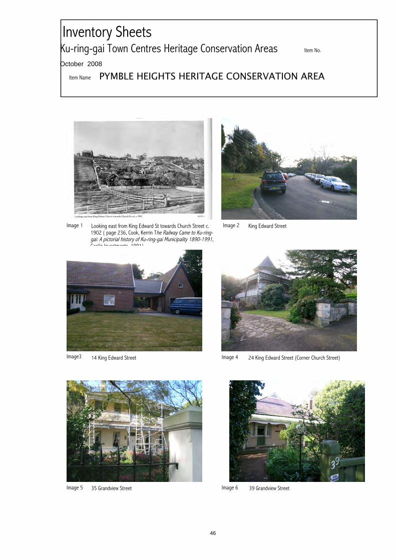
Image 1 Looking east from King Edward St towards Church Street c.1902 ( page 236, Cook, Kerrin The Railway Came to Ku-ring-gai: A pictorial history of Ku-ring-gai Municipality 1890-1991,Genlin Investments, 1991)
Image 2 King Edward Street
Image3 14 King Edward Street Image 4 24 King Edward Street (Corner Church Street)
Image 5 35 Grandview Street Image 6 39 Grandview Street
46

Item No.
PYMBLE HEIGHTS HERITAGE CONSERVATION AREA
Inventory SheetsKu-ring-gai Town Centres Heritage Conservation AreasOctober 2008
Image 7
43 Grandview Street
Image 8
Willdendon, 45 Grandview Street
Image 9
6 Wellesley Road
Image 10
Image 12Image 11
47
Ku-ring-gai Town CentresHeritage Conservation Area Inventory Sheet
Item No
THE PARK ESTATE HERITAGE CONSERVATION AREAItem Name
Heritage Conservation AreaItem Type
The Park Estate Heritage Conservation Area is historically and aesthetically significant as an intactportion of the Park Estate subdivision associated with Robert Pymble and his descendants, for RobertPymble Park, and as an area of fine substantial houses of the Federation and the Inter-war period, in avariety of architectural styles, many of which are listed heritage items and exemplars of their variousarchitectural styles.
The name Ku-ring-gai comes from the Kuringgai or Guringai Aboriginal language group of the peoplewho inhabited the area from Port Jackson north across Broken Bay and beyond Brisbane Water. Thename has been adopted for both the Local Government area and the adjacent National Park to thenorth. There were two bands of the Guringai in what is now the Ku-ring-gai Local Government area:the Garrigal or Carigal people, who lived around West Head, and the Terramerragal, who lived in theTurramurra area.A ridge-top pathway made by the Guringai people was the route followed by what is now the PacificHighway through Ku-ring-gai.Within six weeks of the arrival of the British First Fleet in Sydney in 1788, Governor Phillip wentexploring around Broken Bay, and commented on the friendliness of the Aboriginal people. However,when he returned a year later, all except those too sick with smallpox fled from him. By 1790, over halfof the Guringai nation had been wiped out by smallpox. By the 1840s, most of the Aboriginal peoplehad disappeared from Pittwater and their traditional lands had been taken over by white settlers. SomeGuringai survivors of the small pox epidemic formed what was known to the British colonists as theBroken Bay tribe led by Bungaree, who was notable for completing the first circumnavigation ofAustralia with Matthew Flinders in 1801-02. Another notable Guringai person in the early contactperiod was Bennelong’s wife Barangaroo, who was noted in colonist’s records for her strongpersonality.Today, there are over 800 culturally significant Aboriginal sites found in Ku-ring-gai National Park,including rock engravings, rock shelter drawings, paintings and stencils, axe grinding grooves andshell middens, and Aboriginal people live throughout Sydney metropolitan area.
PART DRAFT HCA 17
HistoricalSummary
Alternative Item Name
Building settlements towns and citiesNational Historic ThemesTowns, suburbs and villagesState Historic Theme 1
State Historic Theme 2State Historic Theme 3State Historic Theme 4
Federation, Inter-warKey Historical Periods
TownscapeCategory
Refer to mapPrimary Address
Ku-ring-gaiLocal Govt. area
The Park Estate Heritage Conservation Area boundary runs around the southern, eastern and westernsides of Robert Pymble Park, along the northwestern side of Alma Street, along Graham Avenue toTelegraph Road, and along Telegraph Road to No. 11 Telegraph Road. It encompasses Robert PymblePark and the north-western side of Alma Street from No.6-10 Alma Street, Nos. 5-17 Graham Avenue,Nos. 11 to 29 Telegraph Road, and Nos. 18 to 40 Park Avenue, 2-19 Taunton Street and 1-17 TauntonStreet, specifically excluding battleaxe lots accessed from the western end of Taunton Street.
Boundaries
Urban AreaGroup Collection
Summary Statement of Significance
KU-RING-GAI TOWN CENTRES HERITAGE CONSERVATION AREAS INVENTORY
48
Ku-ring-gai Town CentresHeritage Conservation Area Inventory Sheet
Predominantly face brickwork for Federation and Inter-war housing with slate or terracotta tile roofingand timber framed windows, casement or double hung.
Alma Street: Long street of variable topography (hilly). No street planting except for low shrubs, grass,agapanthus and similar in narrow verges. Narrow carriageway. Concrete kerbs both sides. A hillystreet with steep rises and dips.Graham Avenue: a gently curved street with oleander bushes in verge near intersection with AlmaStreet, little other street planting other than grass. No footpaths. Concrete kerbs both sides. Somelarge trees in front gardens.Park Crescent: Unusual “U” shaped street wrapping around Robert Pymble Park. Narrow carriageway,some soft edges, some concrete kerbing, and no footpaths, parking both sides. Little street planting.Taunton Street: narrow straight dead end street. Concrete kerbing both sides, narrow grassed vergeswith low planting and few street trees.Telegraph Road: wide street with grassed verges, concrete kerbing, footpaths on both sides. MatureLondon planes as street trees.Built Character: The area’s large 1890s villa estates were further subdivided in the inter-war period forthe construction of substantial houses, many fine examples of inter-war architectural styles on theheights above Robert Pymble Park (northern side of Park Crescent, Taunton Street, Graham Street)and along Telegraph Road. The area encompasses a group of heritage items along Telegraph Road;not least the State Heritage Register listed Eric Pratten house (corner Graham Avenue and TelegraphRoad), and also No. 11 Telegraph Road, Robert Pymble’s house (a Federation Queen Anne stylehouse now on a battleaxe lot built by a descendant of the original Robert Pymble), and considered apotential heritage item.
Materials
The Park Heritage Conservation Area is largely intact, with a scatter of non-contributory (neutral)buildings, some grouped along Station Street. There are 41 properties within the area (excludingRobert Pymble Park), only 13 of which are classified as neutral.
There are around 100 recorded Aboriginal sites in the Ku-ring-gai LGA and large areas are consideredto have high potential for unrecorded sites. These sites are still important to Aboriginal people living inthe region and there are many Aboriginal people and local residents actively working to protect thesesites and promote the rich Aboriginal heritage of the area.The earliest European settlement in Ku-ring-gai was along the major roads, and was generally rural innature. During the 19th century, timber getting and orchards were major activities, and a few villaswere built which are still extant (for example in the 1880s Grandview on Pymble Hill, 1178 PacificHighway, the former orange orchard of which now forms part of the grounds of PLC school). RobertPymble (commemorated in the suburb name), was an early timber-getter and orchardist who settled inPymble in the 1820s and and Robert McIntosh (commemorated in McIntosh Street Gordon) asanother notable early orchardist of Ku-ring-gai.The North Shore Railway line was established in 1890, and subdivision of orchards and large estatesfor residential development near the railway stations proceeded thereafter. The location of stationsalong the railway defined the focus of the Ku-ring-gai Town Centres and neighbourhood areas (withthe exception of St. Ives, which developed on Mona Vale Road at a later stage). The railway line wasduplicated in 1909, electrified in 1928. The subsequent opening of the Sydney Harbour Bridge in1932 led to a major shift of Sydney’s elite (the business owners and managers, the doctors, solicitors,architects, artists, politicians) to the north shore, and particularly Ku-ring-gai, from other areas ofSydney (particularly Ashfield, Burwood and Strathfield).The Park Estate was originally part of Robert Pymble’s land grant of 1823, bounded by the west sideof Station Street. Robert Pymble Park was used as a recreation area from c. 1900, though not officiallygazetted as a park until 1921.
PhysicalCondition
Modifications
Description
KU-RING-GAI TOWN CENTRES HERITAGE CONSERVATION AREAS INVENTORY
49
Ku-ring-gai Town CentresHeritage Conservation Area Inventory Sheet
The Park Estate Heritage Conservation Area is of historical significance as a late 19th centurysubdivision which retains largely intact development from the Federation and Inter-war periods.
The Park Estate Heritage Conservation Area has strong association with the Pymble family, as itencompasses Robert Pymble Park and the home of Robert Pymble III and his wife Ellen (Nellie)Pymble (11 Telegraph Road). The area also includes other homes with significant historicalassociations:- Eloura 21 Telegraph Road, c. 1896, built by Dr. Walter William Joseph O'Reilly (1847-1919)andlived in by his family, including his daughter Dr. Susannah Hennessy O’Reilly (1881-1960). The familyran a medical practice at Pymble (see http://www.adb.online.anu.edu.au/biogs/A110105b.htm?hilite=dr%3Bo%27reilly for details).Dr. Walter O’Reilly petitioned for the street in which he built his house to be named Telegraph Road.- Dunallie, 14 Taunton Street, used as Pymble Boy’s College during the 1930s
The Park Estate Heritage Conservation Area is considered to be of high aesthetic significance for itsfine collection of substantial Federation and Inter-war housing, including fine examples of theFederation Queen Anne, Federation Arts & Crafts, Inter-war Old English, Inter-war CaliforniaBungalow, Inter-war Functionalist and Inter-war Georgian Revival styles, including the followingnotable buildings: State Heritage Register listed Eric Pratten house Coppins (designed by architectWalter Burley Griffin) at 29 Telegraph Road (corner Graham Avenue); 36 Park Crescent, a fine Inter-war Functionalist style house; Dunallie 14 Taunton Street, a fine Federation Queen Anne style housewith a turret in the southwestern corner overlooking houses fronting Park Crescent to Robert PymblePark; Rushall 3 Taunton Street, a fine Federation Queen Anne style house; 9 Graham Avenue, a fineInter-war Old English style house; Eloura 21 Telegraph Road, a c. 1896 Federation Queen Anne stylehouse; Caidmurra 17 Telegraph Road, a large Federation Arts & Crafts style house, and 15Telegraph Road, a large Federation Queen Anne style house. The topography also adds to the area’saesthetic significance, as the land rises from Robert Pymble Park to the north, resulting in the area’shouses overlooking the park. Houses on the even side of Taunton Street overlook the houses in ParkCrescent below.
Robert Pymble Park has social significance as a focus of local leisure activities.
The area is rare for its fine collection of substantial house in a variety of Federation and Inter-wararchitectural styles, and for its topography and relationship with Robert Pymble Park, resulting inhousing overlooking the park beyond Park Crescent, which fronts the park.The area contains a fine collection of Federation and Inter-war housing which is representative of avariety of architectural styles of these periods.
Station Street and 13 Telegraph Road (the house at 13 Telegraph Road replacing a community hallconstructed in 1901 by Ellen (Nellie) Pymble, wife of Robert Pymble III, who resided at 11 TelegraphRoad. The hall was demolished in 1951).
1. Protection of Significance(a) Subdivision:- Require a Curtilage assessment as part of any Heritage Impact Assessment to accompany anapplication for further subdivision of sites within the HCA, with particular emphasis on the impact of
Identified as part of a National Trust Urban Conservation Area in 1996.
RecommendedManagement
Ku-ring-gai Town Centres Heritage Conservation Areas Review Paul Davies Pty Ltd September 2008
Listings
StudyDetails
HistoricalSignificance
Historical Assoc Significance
AestheticSignificance
Social Significance
TechnicalResearch Significance
Rarity
Representativeness
KU-RING-GAI TOWN CENTRES HERITAGE CONSERVATION AREAS INVENTORY
50

Ku-ring-gai Town CentresHeritage Conservation Area Inventory Sheet
subdivision on garden settings(b) Key Historical Period significant and contributory development:- retain one and two storey Federation and Inter-war period residences, heritage-listed andcontributory- maintain characteristic building alignments- retain form- retain finishes and detail, including face brickwork to Federation period and Inter-war periodhouses. Encourage chemical stripping of paint from face brickwork where painted.- encourage replacement of concrete roof tiling with unglazed terracotta Marseilles pattern roof tilingwhere inappropriate retiling has occurred- encourage retention of slate roofing- Front fences: retain original front fences. Discourage use of brush fencing and high brick wallsabove 1.6m in height.
2. Redevelopment of neutral sites:- encourage interpretation of earlier subdivision patterns- respect scale and form of contributory development- respect building line of contributory development- encourage use of brickwork not rendered or painted finishes- encourage contemporary detail- provide landscape screening and softening- recognise the collective precedents and impacts of each proposal- avoid flat reflective monotonous glazed facades- develop an approach for new development to enhance existing heritage character of the area- encourage low brick front fencing or hedging in lieu of fencing to modern or infill housing in the area
3. Enhance significance of the Heritage Conservation Area- maintain and enhance street tree planting
4. Car Parking- do not allow construction of garages or carports on the street alignment of properties- garages and carports are to be located behind the building line, and preferably to the rear of themain building on each site
5. Landscaping- Encourage maintenance and establishment of gardens to houses including substantial trees andshrubs - limit paving and hard surfacing, particularly to front gardens
6. View Protection- development within the Pymble Town Centre in Telegraph Road, Park Crescent, and battleaxeblocks accessed from the western end of Taunton Street, adjacent to the Heritage ConservationArea, should be restricted to two storeys in height and incorporate a landscape buffer particularlyalong property boundaries adjacent to the Heritage Conservation Area, to soften potential impacts- the impact of any proposal to increase the height of houses at Nos. 18-40 Park Crescent on viewsbetween Robert Pymble Park and houses at 2-18 Taunton Street should be carefully assessed.Negative impacts on these view lines should be avoided.
7. Heritage Items and Potential Heritage Items:- protect the listed Heritage items within the Heritage Conservation Area:State Heritage Register listed Eric Pratten house Coppins ,29 Telegraph Road (corner GrahamAvenue); 36 Park Crescent; Rushall 3 Taunton Street; 9 Graham Avenue; Eloura 21 TelegraphRoad; Caidmurra 17 Telegraph Road; and 15 Telegraph Road.- Undertake further heritage assessment of the following properties within the Heritage ConservationArea which are considered potential heritage items: Dunallie 14 Taunton Street (used as PymbleBoy’s College in the 1930s); and Toodyay formerly Hayden Dell, 11 Telegraph Road, former home ofRobert Pymble III and his wife Ellen (Nellie).
KU-RING-GAI TOWN CENTRES HERITAGE CONSERVATION AREAS INVENTORY
51

Ku-ring-gai Town CentresHeritage Conservation Area Inventory Sheet
LoganRobert Pymble’s House unpublished article, Jennifer Harvey, Ku-ring-gai Historical Society
C. Kemp, Paul Davies Pty Ltd Architects, Heritage ConsultantsAuthorship
References
KU-RING-GAI TOWN CENTRES HERITAGE CONSERVATION AREAS INVENTORY
52

Item No.
THE PARK ESTATE HERITAGE CONSERVATION AREA
Inventory SheetsKu-ring-gai Town Centres Heritage Conservation AreasOctober 2008
Item Name
Image 1 View of north side of Park Crescent and houses in TauntonStreet across Robert Pymble park
Image 2 North side of Park Crescent
Image3 Taunton Street from Alma Street Image 4 Graham Avenue from Alma Street
Image 5 24 Park Crescent, with turret of house at 14 Taunton Streetvisible behind
Image 6 22 Park Crescent
53

Item No.
THE PARK ESTATE HERITAGE CONSERVATION AREA
Inventory SheetsKu-ring-gai Town Centres Heritage Conservation AreasOctober 2008
Image 7
36 Park Crescent
Image 8
40 Park Crescent
Image 9
2 Taunton Street
Image 10
10 Taunton Street
Image 12
14 Taunton Street Dunallie
7 Taunton Street
Image 11
54

Item No.
THE PARK ESTATE HERITAGE CONSERVATION AREA
Inventory SheetsKu-ring-gai Town Centres Heritage Conservation AreasOctober 2008
Image 13
17 Taunton Street
Image 14
5 Graham Avenue
Image 15
9 Graham Avenue
Image 16
11 Graham Avenue
Image 17 Image 18
55