la mitigation performance analysis2 - fema.gov · to obtain additional copies of this document, ......
TRANSCRIPT

PERFORMANCE ANALYSIS
March 5, 2002
Prom
otin
g M
itiga
tion
in L
ouis
iana
:
Federal Emergency Management Agency and the State of Louisiana
Prepared for Federal Emergency Management Agency Region VI Federal Regional Center, Rm. 206 800 North Loop 288 Denton, TX 76201-3698

TABLE OF CONTENTS
i
Letter from FEMA..............................................................................................................................ii
Section 1 O N E Introduction ..............................................................................................................1
Section 2 T W O Mitigation Performance Analysis...............................................................................3
East Baton Rouge Parish Code Enforcement and Acquisition................................3 City of Denham Springs: Demonstration Elevations ...............................................6 Ascension Parish: Elevation and Acquisitions ........................................................8 Jefferson Parish: Acquisitions ................................................................................10 St. Charles Parish: Drainage Projects ....................................................................12 St. James Parish: Drainage Projects .......................................................................14 City of Covington: Elevations and Acquisition.....................................................17 City of Slidell: Acquisitions and Second-Story Conversion..................................21 City of Mandeville: Elevations, Acquisitions, and Ordinances .............................23 Terrebonne Readiness & Assistance Coalition (TRAC): Community
Education Program.....................................................................................30
Section 3 T H R E E Determining Avoided Damages ............................................................................... 32
Section 4 F O U R Acknowledgements ................................................................................................. 35
To obtain additional copies of this document, please contact the GPO Publications Order Division at 202-512-1800, or toll free, at 866-512-1800, between 7:30 a.m. and 4:30 p.m. eastern time. Or fax your request to 202-512-2250.

Letter from FEMA
ii
MITIGATION WORKS. This simple statement encapsulates the numerous experiences in which States and communities realize their best vision: that of being safer, stronger, and more sustainable places in which to live through the implementation of mitigation strategies.
Mitigation is any sustained action taken to reduce or eliminate long-term risk to people and property from natural hazards and their effects. FEMA’s Hazard Mitigation Grant Program (HMGP) is a powerful resource in the combined effort by Federal, State, and local government, as well as private industry and homeowners, to end the cycle of repetitive disaster damage.
Throughout its history and numerous natural disasters, the State of Louisiana has been committed to mitigation. Each new disaster is proving to be less damaging to people, property, and the environment due to various mitigation activities implemented across the state.
Tropical Storm Allison flooded nearly all of south Louisiana with three months of rain in three days. The storm provided a new opportunity to evaluate the effectiveness of recent mitigation investments by Federal, State and local government. This report explores 11 projects where mitigation proved particularly effective. By reviewing the basis on which Federally funded mitigation activities were approved, the performance analysis details the damages avoided or financial savings that resulted from these activities. In documenting their successful mitigation activities, Louisianans are encouraged to continue their mitigation efforts and inspire other communities to do the same.
Tropical Storm Allison also provided an opportunity for FEMA Region IV to commit staff and resources to aid FEMA Region VI in managing the disaster. State and local officials deserve recognition for this nearly seamless transition. In times of disaster, it serves well to have helpful neighbors.
Louisiana communities continue to grow more resilient through Federal, State, local, and private partnerships which confront the constant threat of natural disasters. Mitigation activities enable our communities to heal faster and stronger, and be better prepared to face the next disaster.
William Carwile Colonel Michael Brown Federal Coordinating Officer Governor’s Authorized Representative FEMA Disaster 1380-DR-LA State of Louisiana Janet Lamb Daniel Falanga Deputy Federal Coordinating State Hazard Mitigation Officer Officer – Mitigation State of Louisiana FEMA Disaster 1380-DR-LA
SECTIONONE Introduction
1
1 . S e c t i o n 1 O N E I n t r o d u c t i o n
The unique topography of Louisiana is a virtual nervous system of rivers, lakes, lagoons, reservoirs, bayous, and coastal estuaries. Typically shallow, Louisiana’s turbid waterways spawn a huge fishing and seafood industry. Fueled by tourists and directly linked to the rich cultural diversity of the state, the maritime industries must maintain the highest level of efficient operation before, during, and after a natural disaster.
In a sense, Louisiana is the floodplain of the nation. Louisiana waterways drain two thirds of the continental United States. Precipitation in New York, the Dakotas, even Idaho and the Province of Alberta, finds its way to Louisiana’s coastline. Pre-existing high land is often the result of natural levees developing along the banks of historical or present-day waterways.
Despite massive improvements to reduce the impacts of severe weather in the last 100 years, flooding is a constant threat. The State of Louisiana has more flood insurance claims than any other state in the country. Leading the nation, Louisiana has more than 18,000 repetitively flooded structures. Repetitive loss structures are the largest drain on the National Flood Insurance Program (NFIP).
As part of the National Repetitive Loss Strategy, FEMA has ranked all repetitive loss structures. The top 10,000 repetitive loss structures nationwide have received repetitive flooding to the extent that flood claims equal or exceed the value of these structures or, as is the case for most of Louisiana’s structures, have experienced four or more losses in the last 10 years. Of these top 10,000 structures nationwide, over 3,000 are in Louisiana, more than any other state. Furthermore, the top two parishes (or counties) in terms of repetitive loss structures are in Louisiana: Jefferson Parish and Orleans Parish, both part of the New Orleans Metropolitan area.
Louisiana has made excellent progress over the last 5 years in addressing repetitive loss issues. The State has:
?? Established and implemented a written State Mitigation Strategy.
?? Established mitigation programs and processes which avoided damages from Tropical Storm Allison in more than a dozen Louisiana communities.
?? In more than a dozen repetitive loss communities, completed hazard mitigation plans which maintained quality of life for these communities after Tropical Storm Allison.
?? Focused all existing Flood Mitigation Assistance (FMA) and much of Hazard Mitigation Grant Program (HMGP) Funding on repetitive loss reduction.
?? Established repetitive loss reduction as the highest priority of the State Hazard Mitigation Team.
In addition to mitigation, flood prevention is enhanced through regulatory programs such as the Community Rating System (CRS). To date, 38 Louisiana communities have joined CRS, an insurance rating system similar to that of the national fire rating system. Any community, which chooses to perform and achieve certain tasks designated by FEMA to further reduce the probability of flood losses, is eligible for discounted flood insurance rates. Under the CRS, flood insurance premiums are adjusted to reflect community activities that reduce flood damage to existing buildings, manage development in areas not mapped by the NFIP, protect new buildings beyond the minimum NFIP protection level, help insurance agents obtain flood data, and help people obtain flood insurance. Each community is ranked on a scale of 1 to 10, with 1 being the
SECTIONONE Introduction
2
highest achievement. For each lower rate attained, the citizens in that community receive a 5 percent flood insurance premium discount.
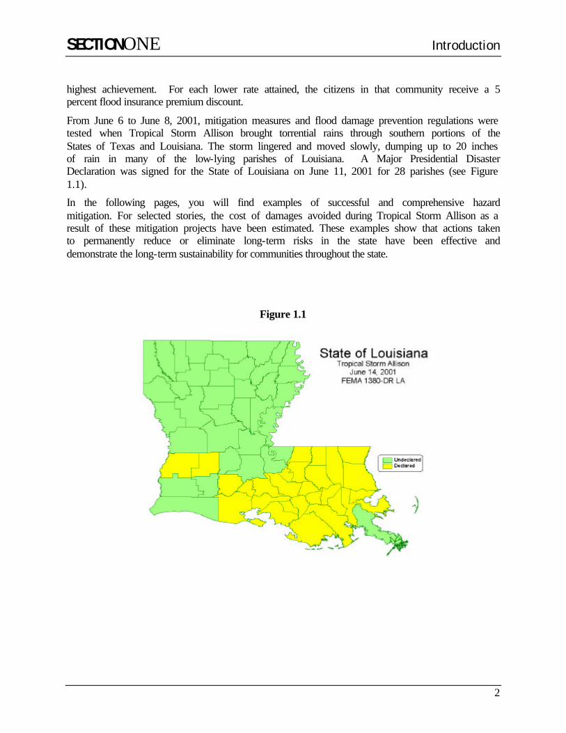
From June 6 to June 8, 2001, mitigation measures and flood damage prevention regulations were tested when Tropical Storm Allison brought torrential rains through southern portions of the States of Texas and Louisiana. The storm lingered and moved slowly, dumping up to 20 inches of rain in many of the low-lying parishes of Louisiana. A Major Presidential Disaster Declaration was signed for the State of Louisiana on June 11, 2001 for 28 parishes (see Figure 1.1).
In the following pages, you will find examples of successful and comprehensive hazard mitigation. For selected stories, the cost of damages avoided during Tropical Storm Allison as a result of these mitigation projects have been estimated. These examples show that actions taken to permanently reduce or eliminate long-term risks in the state have been effective and demonstrate the long-term sustainability for communities throughout the state.
Figure 1.1
SECTIONTWO Mitigation Performance Analysis
East Baton Rouge Parish 3
2 . S e c t i o n 2 T W O M i t i g a t i o n P e r f o r m a n c e A n a l y s i s
EAST BATON ROUGE PARISH CODE ENFORCEMENT AND ACQUISITION
East Baton Rouge Parish
Hazard Mitigation Grant Recipient
Yes
Community Rating System Rating
7
Population 412,852
Number of Repetitive Losses
667
Inches of Rain from T.S. Allison
19.66
Number of Insured Structures (1)
17,064
Insurance in Force (1) $1,826,058,900
Annual Premiums Paid (1) $6,059,510
Number of Claims Paid (1) 5,348
Amount of Claims Paid (1) $60,226,155
Total Cost of Project(s) $122,580 (1) As of December 31, 2000
East Baton Rouge Parish is located in southeast Louisiana on the east bank of the Mississippi River, north of New Orleans. The Parish is in the alluvial valley of the Mississippi River, where the land is generally flat and at low elevations. East Baton Rouge Parish has many natural waterways and manmade canals that are subject to periodic flooding.
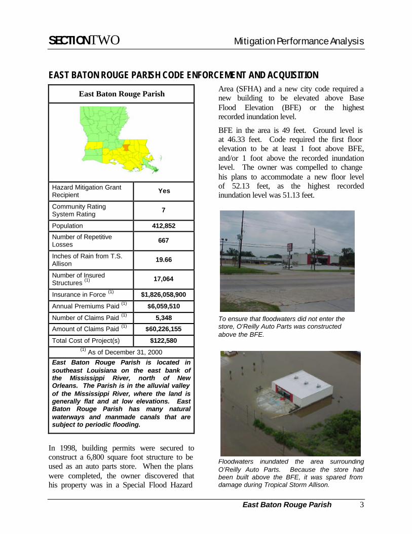
In 1998, building permits were secured to construct a 6,800 square foot structure to be used as an auto parts store. When the plans were completed, the owner discovered that his property was in a Special Flood Hazard
Area (SFHA) and a new city code required a new building to be elevated above Base Flood Elevation (BFE) or the highest recorded inundation level.
BFE in the area is 49 feet. Ground level is at 46.33 feet. Code required the first floor elevation to be at least 1 foot above BFE, and/or 1 foot above the recorded inundation level. The owner was compelled to change his plans to accommodate a new floor level of 52.13 feet, as the highest recorded inundation level was 51.13 feet.
To ensure that floodwaters did not enter the store, O’Reilly Auto Parts was constructed above the BFE.
Floodwaters inundated the area surrounding O’Reilly Auto Parts. Because the store had been built above the BFE, it was spared from damage during Tropical Storm Allison.

SECTIONTWO Mitigation Performance Analysis
East Baton Rouge Parish 4
A rear view of O’Reilly Auto Parts shows the 8-foot foundation wall, which prevented flooding during Tropical Storm Allison.
The fill needed to elevate the building had to come from a location in that particular flood zone area to minimize changes to the floodplain. The rear of the building was built on an eight-foot foundation wall and the sloping parking lot on two sides was elevated with fill. A retaining wall built on the east side of the building protected the structure from high water in that direction.
The cost of elevation was approximately $150,000. The building cost another $350,000, bringing the total construction cost to approximately a half-million ($500,000) dollars. Inventory in the auto parts store ranges from $300,000 to $500,000.
Floodwaters from Tropical Storm Allison rose to over 5 feet in the area surrounding O’Reilly Auto Parts. Had the business been at street level it would have suffered extensive damage. It is estimated that the damages from Tropical Storm Allison would have cost as much as half the structural value of the building and much of the value of the contents. These costs are conservatively estimated to be approximately $285,000. Therefore, by spending $150,000 to elevate, the business saved more than $285,000 after just one flood. If the loss had been an insured loss,
that $285,000 would have been paid from the flood insurance program. In addition to these costs, employees would have had been idled and customers would have been inconvenienced and possibly lost to competitors.
The KFC, located next door to O’Reilly Auto Parts store, was also constructed above the BFE.
Although surrounded by water, the KFC had no water in the building. Once floodwaters receded, KFC immediately resumed operations.
Another flood mitigation approach the Parish has taken is to acquire homes in especially flood-prone areas. Herbert and Diana Brooks owned one such flood-prone home. When they bought their home, they were aware of flooding problems in the neighborhood. They were unaware,

SECTIONTWO Mitigation Performance Analysis
East Baton Rouge Parish 5
however, of an acquisition program proposed for the area.
A year after the Brooks moved into the house, Mrs. Brooks was talking to a neighbor who lived across the street. The neighbor told her about the buyout program. Mrs. Brooks obtained the telephone number of Mr. Brian Harmon, Director of Public Works for the City of Baton Rouge, East Baton Rouge Parish, with the intentions of contacting him if they ever considered moving.
The neighbors talked about how past storms had always resulted in floods to their neighborhood and that it was certain to happen again. Their persistent concern prompted Mrs. Brooks to call Mr. Harmon and she learned that their house, with five previous flood claims, was in the top 30 homes slated for acquisition in the Hazard Mitigation Grant Program (HMGP).
After five previous flood insurance claims, this home was acquired and removed from the cycle of repetitive losses.
The Brooks’ decision to participate in the acquisition program was based partly on stories from their neighbors about three previous floods that affected their house; one flood was deep enough to be up to the rooftop.
What the neighbors had predicted proved to be true. Only two weeks after Mr. and Mrs. Brooks moved out of their residence, Tropical Storm Allison arrived and caused flooding in the neighborhood and in many parts of southern Louisiana. Their now vacant home had 5 feet of water inside it! The Acquisition Program saved the Brooks from losing everything. “We are so grateful and thank God for being so fortunate!”
When we asked Mrs. Brooks how she would describe the program she had high praise for Brian Harmon. “He did everything to make the transition a pleasant experience, and the negotiations were very easy!”
Previous claims to this property totaled $154,644.63. The appraised value was $121,080.00. The total project cost for this house was $122,580.00, with the HMGP share being $91,935.00 or 75 percent.
The Brooks now reside in a new neighborhood, high and dry, and love their new home.

SECTIONTWO Mitigation Performance Analysis
City of Dehham Springs 6
CITY OF DENHAM SPRINGS: DEMONSTRATION ELEVATIONS
City of Denham Springs
Hazard Mitigation Grant Recipient
Yes
Community Rating System Rating
9
Population 8,757
Number of Repetitive Losses
170
Inches of Rain from T.S. Allison
14.07
Number of Insured Structures
1,364
Insurance In-Force (1) $121,582,900
Annual Premiums Paid (1) $635,704
Number of Claims Paid (1) 1,230
Amount of Claims Paid (1) $16,763,954
Total Cost of Project(s) $596,404 (1) As of December 31, 2000
Denham Springs, Louisiana, a suburb of Baton Rouge, has a long history of flood damage and was a logical choice for a flood mitigation project. Located in the heart of the Amite River Basin, where the Amite and Comite rivers meet, Denham Springs has experienced 24 major floods since 1953. In 1983, Denham Springs was subjected to record flooding, which was classified as a 50-year event. During that event, the Amite River crested at a high of 41.5 feet, 12.5 feet above flood stage.
When a group of flood victims sought help from the Amite River Basin Drainage and
Water Conservation District in bringing a slab elevation contractor to Louisiana to raise their homes, the odds were against them. Funding (FEMA’s Hazard Mitigation Grant Program dollars for Hurricane Andrew) was limited; the feasibility in Louisiana was unproven; and there was no experience at the State government level in administering a program for retrofitting private property.
However, the Amite River Basin Drainage and Water Conservation District applied for and received a demonstration grant from the Louisiana Office of Emergency Preparedness to elevate five structures and conduct an educational program on the benefits of elevation.
The specific intent of this project was to eliminate flood damages, and to induce voluntary adoption of retrofitting through elevation, by making elevation a practical and desirable floodproofing option for the individual structure owner.
An educational program was targeted both at flood victims who might utilize the technology and at Louisiana house movers who might adopt the technology, thus making it available locally.
Early during the grant application process, the Commission sought the cooperative participation of other local agencies and institutions. The Louisiana Cooperative Extension Service at Louisiana State University entered into a contractual agreement with the Commission to conduct educational programs and to assist in the coordination of the project. The Extension Service utilized its array of educational outlets to get the word out about the project, including press releases, video news releases which were aired statewide, and annual

SECTIONTWO Mitigation Performance Analysis
City of Dehham Springs 7
updates to the Louisiana Floodplain Management Association.
At the time of this project, the technology for elevating monolithic slab structures without substantial damage was not available to individual flood victims, principally because the nearest contractor employing the necessary techniques was located in Florida.
A contractor from Michigan experienced in raising structures with attached foundations was selected in 1994. Five structures were raised an average of 6.7 feet above grade during 1994-95. The total cost for the demonstration project was approximately $596,404, which averaged nearly $66 per square foot. Under the cost sharing formula established for the pilot project, the local matching funds, including in-kind services were approximately 61 percent, leaving a Federal contribution of 39 percent. Owners paid the bulk of the local share, which was approximately 52 percent.
Tropical Storm Allison arrived in the Baton Rouge metropolitan area on June 5, 2001, dumping nearly 18 inches of rain in only 3 days. Denham Springs received 14.07 inches of rain plus drainage from the Amite River Basin. Although the flood stage was not a record high at 38.24 feet, the deluge caused severe flooding and even flash flooding in some neighborhoods.
“When the Amite River and its tributary, the Comite River, flood at the same time—as they did in this 2001 event—we are in a lot of trouble,” said James E. DeLaune, mayor
of Denham Springs. Citizens were heard to say, “The anxiety doesn’t end until the rain stops.”
A total of 75 homes and six businesses experienced flood damage, but the elevated structures of the flood-mitigation pilot project were spared. As the first Louisiana community to support a structure-raising pilot program with the utilization of hazard-mitigation funds, Denham Springs is a successful case that illustrates the cost-effective benefits of a hazard mitigation program.
This home was elevated above the BFE so that it would never again suffer flood damages.
Ripple Chiropractic Clinic sits high and dry after Tropical Storm Allison dumped 14 inches of rain on Denham Springs.
According to a structural inventory provided by the U.S. Army Corps of Engineers, there are over 12,000 structures on slab foundations in the 500-year floodplain of the Amite Basin.

SECTIONTWO Mitigation Performance Analysis
Ascension Parish 8
ASCENSION PARISH: ELEVATION AND ACQUISITIONS
Ascension Parish
Hazard Mitigation Grant Recipient
Yes
Community Rating System Rating
9
Population 76,627
Number of Repetitive Losses
221
Inches of Rain from T.S. Allison
23.29
Number of Insured Structures (1)
3,595
Insurance in Force (1) $360,209,300
Annual Premiums Paid (1) $1,105,016
Number of Claims Paid (1) 1,270
Amount of Claims Paid (1) $10,530,160
Total Cost of Project(s) $466,667 (1) As of December 31, 2000
Ascension Parish is located directly east of East Baton Rouge Parish along the Mississippi River. The Parish is low-lying and traversed by many canals and bayous. One such waterway is Bayou Manchac, which has many homes located along its banks.
In 1975, Evan Long purchased his home along Bayou Manchac, located in Prairieville, Louisiana.
During excessive rain events, overflow from the Amite River expands into the many canals and bayous throughout the Amite River Basin, damaging roads, drainage
systems, and associated structures. In 1977, unusually heavy rains fell on the Louisiana Coast, causing a 4-foot overflow of Bayou Manchac. Evan Long lost everything he owned. He had just purchased the land and a house trailer for $7,000. The contents were estimated at about $3,000.
The rear structure experienced severe flooding during Tropical Storm Allison while the pole home served as a safe haven for residents along the bayou impacted by the storm.
Mr. Long obtained a Small Business Loan (SBA) for approximately $15,000, which covered the $5,000 still owed on the loan for the property. With tips he learned from a professor at Louisiana State University, (LSU), Evan decided to build a pole house, using poles similar to those used for telephone poles. They were 35 feet long, driven 8 feet into the ground, and set in reinforced concrete. The main house was placed 9 feet above ground level and constructed with treated pine and cypress. The cost of materials was approximately $10,000. After poles were set and contractors completed framing of the home, Mr. Long, along with several of his friends, completed the project. The stairway leading up to Mr. Long’s balcony has the handrail on the inside (toward the house), leaving the outside open so boaters can have easy access during a storm.

SECTIONTWO Mitigation Performance Analysis
Ascension Parish 9
Since 1977, the area under Mr. Long’s home has flooded nine times. These floods have been similar to the one that destroyed his home in 1977. Assuming the floods were similar, the damages suffered in 1977 ($10,000) would have been repeated nine times. Conservatively, the damages avoided from Tropical Storm Allison are estimated at $7,000; however, damages avoided since 1978, when Mr. Long built his pole house, are estimated to be at least $90,000. Thus, the $10,000 investment to build his pole house has saved an estimated $90,000 in damages so far. In addition, the current appraisal value for Mr. Long’s home is approximately $50,000 for the structure alone. Placing a value on safety and prevention of loss of life is not possible; to Mr. Long, these savings are priceless.
Evan’s home was completed by 1978 and has withstood eight separate floods with some water levels reaching nearly to the main house first floor level. He has suffered no losses in any of the floods. “We have everything down to a science,” says Evan. “We know just what to do with the things down below!” “A lot of the neighbors evacuate to my house and we just wait it out.”
In 1999, Ascension Parish applied for and received Federal assistance to acquire flood-prone homes. Three such homes have been targeted for acquisition due to their numerous flood losses.
The Granger home was bounded by Bayou Manchac to the north and west and a swamp to the east. It had flooded five times with as much as 3 feet of water. Claims had totaled over $106,000 and the cost of each successive loss became higher. The Grangers agreed to participate in the buyout program and the home was purchased for $102,000. The in-kind contribution by the Parish of $22,357 provided the demolition and administration services.
A home located on Butch Gore Road had flooded at least five times since 1977 with standing water as high as 32 inches. Flood insurance claims totaled over $100,000.00. Through the buyout program, the home was acquired by the Parish for $111,350. In-kind contributions by the Parish were $13,100.
The third home that was acquired during this project had flooded seven times in less than 8 years. Floodwaters were as high as 16 inches in the home and damages totaled over $105,000. The Parish bought this home for $111,700, and contributed $13,100 in in-kind services.
.
The Parish acquired and demolished the Granger home through the FMA Program.
This is the site of the Granger home, which had experienced five flood events. It has now been removed from the repetitive loss cycle.

SECTIONTWO Mitigation Performance Analysis
Jefferson Parish 10
JEFFERSON PARISH: ACQUISITIONS
Jefferson Parish
Hazard Mitigation Grant Recipient
Yes
Community Rating System Rating
8
Population 455,466
Number of Repetitive Losses
5,286
Inches of Rain from T.S. Allison
21.3
Number of Insured Structures (1)
84,486
Insurance in Force (1) $10,511,220,100
Annual Premiums Paid (1) $34,661,854
Number of Claims Paid (1) 41,207
Amount of Claims Paid (1) $452,413,411
Total Cost of Project(s) $965,702 (1) As of December 31, 2000
Jefferson Parish, located adjacent to Orleans Parish, has repeatedly experienced damages caused by flooding. Between 1978 and 1995, the NFIP paid over 15,000 claims in Jefferson Parish. The Parish has more repetitive losses than any other county in the nation. Flood damages can be attributed to extreme low elevations ranging from 8 to 12 feet above mean sea level. The only portions of Jefferson Parish that are not located in the 100-year floodplain are those areas that are protected by a levee, dike, or other structures, which are subject to failure during larger floods.
In 1995, prompted by the flood in May of that year, Jefferson Parish applied for and received a grant from the Hazard Mitigation
Grant Program (HMGP) to acquire and demolish homes in flood-prone areas. Four areas were noted to have the highest number of flood losses. These were Dumonde Subdivision, West Esplanade Avenue, David Drive, and Walter Road.
Dumonde Subdivision experienced flooding four times in the 10 years prior to the May 1995 flood. Damages from these four floods totaled $768,875. Flooding in the subdivision could be traced to two properties and the wooden fence behind them, which acted as a barrier to drainage flow from the subdivision. The Parish proposed to acquire these properties and demolish them, thereby greatly improving overland flow from the neighborhood and reducing flooding.
Heavy equipment removes a repetitive loss structure, which will no longer be a drain on the NFIP.
To restore proper drainage, two homes and the surrounding wooden fence, which acted as a barrier to surface runoff, were acquired and demolished.
SECTIONTWO Mitigation Performance Analysis
Jefferson Parish 11
The West Esplanade Canal area experienced frequent flooding. Four properties were particularly affected by the flooding. Two of the homes had 12 inches of standing water during the May 1995 flood. The properties were located on a narrow strip of land between West Esplanade Avenue and the canal. To alleviate flooding problems, the homeowners brought in fill material, which would then wash into the canal, reducing the capacity of the canal. Claims paid to these four properties totaled more than $540,000 during the 10 years prior to the May 1995 flood. Acquisition of these homes eliminated repetitive losses and restored the drainage system to its original capacity.
The average loss to the four properties between 1985 and 1995 was approximately $175,000; therefore, this can be estimated as the damages avoided due to Tropical Storm Allison. Since, on average, this area floods every three to five years, similar savings will occur in the future.
The David Drive area, known for repeated flooding, was becoming blighted due to the frequent flooding and land settling problems. Water in homes was as high as 6 inches during the May 1995 flood. Two homes were chosen to be acquired and demolished. The claims that had been paid on the two properties totaled $187,616. Once the houses had been removed, the
property was used for a right turn lane, which improved traffic flow and allowed for more storage capacity for rainwater.
The Walter Road area is another area that has a history of flooding. The one home acquired in this portion of the project had 42 inches of water in it in 1995. Additionally, neighboring homes being rebuilt were using 5 feet of fill material, worsening flooding for those structures below that level. The subject property had flooded three times prior to the May 1995 flood. Damages from the May 1995 flood alone totaled $131,240.
The target areas selected for acquisition through this project were those that would provide the most benefit to the community and to the individual homeowner. The structures that were acquired were those that hindered drainage and increased the flooding of other homes.
In all cases, the homes that were acquired were experiencing a cumulative effect from the flooding. The inability to fully repair the damage was increasing with each flood event. In fact, the continued cost of repair was greater than the value of many of the homes. The removal of these especially flood-prone structures and the structures that were a hindrance to proper drainage has eliminated National Flood Insurance Program (NFIP) claims for the acquired homes and greatly reduced repetitive losses in the four areas.

SECTIONTWO Mitigation Performance Analysis
St. Charles Parish 12
ST. CHARLES PARISH: DRAINAGE PROJECTS
St. Charles Parish
Hazard Mitigation Grant Recipient
Yes
Community Rating System Rating
9
Population 48,072
Number of Repetitive Losses
469
Inches of Rain from T.S. Allison
17.0
Number of Insured Structures (1)
8,501
Insurance in Force (1) $1,163,740,500
Annual Premiums Paid (1) $3,194,065
Number of Claims Paid (1) 3,198
Amount of Claims Paid (1) $72,682,880
Total Cost of Project(s) $2,192,520 (1) As of December 31, 2000
St. Charles Parish is located just to the northwest of the City of New Orleans. Its low-lying, flat terrain is split by the Mississippi River, creating an East Bank and a West Bank. Both banks experience frequent flooding due to the flat terrain.
From 1989 to 1995, the East Bank of St. Charles Parish experienced three Federal disasters, two of which were major flooding events. In 1989, 1,000 homes were flooded in Ormond Subdivision, which uses a forced drainage and ring levee system. Following this flood, a pump station [Ormond II - 196 cubic feet per second (cfs)] was installed to
increase the capacity already existing at Ormond I (392 cfs) pump station. In 1995, a storm similar to the 1989 event occurred and flooded 500 homes in Ormond. The estimated cost of damages associated with the 1995 flood totaled $24,687,620.
A Pump Station located in Ormond Subdivision. Six-foot diameter pumps move water from the area at approximately 392 cfs.
Flooding in the Ormond area was attributed to ponding of runoff between the Mississippi River levee and railroad track embankments. Ponding occurred when the capacity of the pump stations and culverts was exceeded during heavy rainfall.
To remedy this problem, the Parish, using grant money from the Hazard Mitigation Grant Program (HMGP) (75 percent federal share), increased pump capacity at the
In South Louisiana, elevations are highest close to the Mississippi River and its tributaries. With distance away from the waterways, elevations decrease significantly. Developments located in low-lying areas often use ring levees and forced drainage to protect from flooding and hasten surface runoff.

SECTIONTWO Mitigation Performance Analysis
St. Charles Parish 13
Ormond II pump station by 200 cfs and completed a jack and bore at the railroad track embankment to increase culvert size using three 60-inch culverts.
Jack and bores are an effective means of increasing drainage through a levee or embankment, which otherwise would impede surface runoff. The technique includes boring through the side of the embankment to replace undersized and damaged pipes with larger culverts. Storm water will then drain faster, reducing the likelihood of ponding and flooding of homes.
Jack and bore through railroad embankment to decrease damming of storm water runoff.
The success of this project may be measured by the effects of Tropical Storm Allison on Ormond Estates. In the past, 17 inches of rain might have caused up to a foot of water in homes. Such was not the case during Tropical Storm Allison, in which no Ormond Estates homes were flooded. Although tropical Storm Allison floodwaters may not have reached the levels experienced in 1995, which caused more than $24,000,000 in damages to 500 homes, it is estimated that at least $7,150,000 in damages might have occurred. Therefore, the mitigation project avoided at least $7,150,000 in damages this time and may avoid millions more in the future.

SECTIONTWO Mitigation Performance Analysis
St. James Parish 14
ST. JAMES PARISH: DRAINAGE PROJECTS
St. James Parish
Hazard Mitigation Grant Recipient Yes
Community Rating System Rating 8
Population 21,216
Number of Repetitive Losses
4
Inches of Rain from T.S. Allison 19.59
Number of Insured Structures (1) 333
Insurance in Force (1) $40,150,700
Annual Premiums Paid (1) $93,801
Number of Claims Paid (1) 37
Amount of Claims Paid (1) $292,598
Total Cost of Project(s) $1,333,050 (1) As of December 31, 2000
St. James Parish, located in South Louisiana, has had its share of flooding problems. With its flat terrain and low elevation, there is no place for floodwaters to drain. Fortunately, the Parish has found a cost efficient and very effective means of mitigating these flooding problems. The solution has been a number of drainage projects, which entail, in most cases, regrading of ditches, placement or replacement of culverts, and filling of ditches.
Through the State and Federal Hazard Mitigation Grant Programs, St. James Parish received funding to replace damaged and undersized culverts. The State or Federal funding was 50 to 75 percent of the total project cost. The life span of culverts in St.
James Parish averaged only 10 years due to saltwater intrusion from the Gulf of Mexico, which deteriorated the galvanized culverts. To alleviate this problem, the Parish replaced damaged culverts with asphalt-coated culverts. They also installed new culverts where once there were only open ditches. This reduced maintenance problems immensely.
These drainage projects have been highly successful, as evidenced by recent Tropical Storm Allison. In June 2001, the St. James area received approximately 20 inches of rain over a 3-day period. In the past, this amount of rainfall would have caused as much as 10 inches of water in homes. However, during Tropical Storm Allison, all homes within the mitigation project sites stayed dry.
Central Canal, located in the Town of Gramercy, used to flood on a regular basis, affecting 500 residential and commercial structures with an estimated value of $50 million and 2,000 residents.
The drainage system, which provides an outfall for approximately 700 acres of residential, commercial, and agricultural properties, had damaged, undersized culverts and inadequate ditches.
Maintenance problems associated with ditches were alleviated when a new underground drainage system was installed.
SECTIONTWO Mitigation Performance Analysis
St. James Parish 15
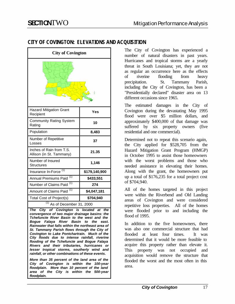
The Parish replaced culverts to alleviate the flooding in the area. Since the project’s completion in November of 1994, no flooding has occurred in this area. The total project cost was $68,198.
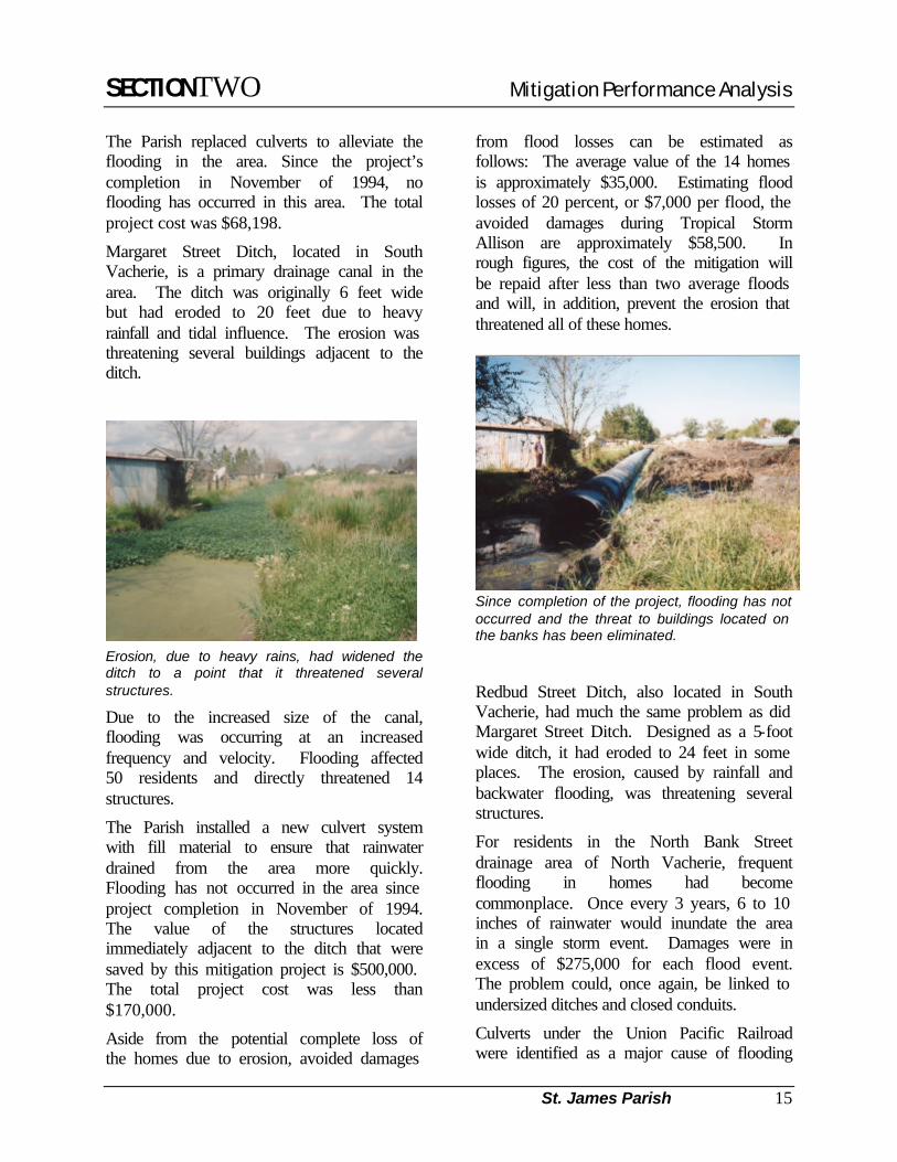
Margaret Street Ditch, located in South Vacherie, is a primary drainage canal in the area. The ditch was originally 6 feet wide but had eroded to 20 feet due to heavy rainfall and tidal influence. The erosion was threatening several buildings adjacent to the ditch.
Erosion, due to heavy rains, had widened the ditch to a point that it threatened several structures.
Due to the increased size of the canal, flooding was occurring at an increased frequency and velocity. Flooding affected 50 residents and directly threatened 14 structures.
The Parish installed a new culvert system with fill material to ensure that rainwater drained from the area more quickly. Flooding has not occurred in the area since project completion in November of 1994. The value of the structures located immediately adjacent to the ditch that were saved by this mitigation project is $500,000. The total project cost was less than $170,000.
Aside from the potential complete loss of the homes due to erosion, avoided damages
from flood losses can be estimated as follows: The average value of the 14 homes is approximately $35,000. Estimating flood losses of 20 percent, or $7,000 per flood, the avoided damages during Tropical Storm Allison are approximately $58,500. In rough figures, the cost of the mitigation will be repaid after less than two average floods and will, in addition, prevent the erosion that threatened all of these homes.
Since completion of the project, flooding has not occurred and the threat to buildings located on the banks has been eliminated.
Redbud Street Ditch, also located in South Vacherie, had much the same problem as did Margaret Street Ditch. Designed as a 5-foot wide ditch, it had eroded to 24 feet in some places. The erosion, caused by rainfall and backwater flooding, was threatening several structures.
For residents in the North Bank Street drainage area of North Vacherie, frequent flooding in homes had become commonplace. Once every 3 years, 6 to 10 inches of rainwater would inundate the area in a single storm event. Damages were in excess of $275,000 for each flood event. The problem could, once again, be linked to undersized ditches and closed conduits.
Culverts under the Union Pacific Railroad were identified as a major cause of flooding

SECTIONTWO Mitigation Performance Analysis
St. James Parish 16
and the Railroad agreed to replace them. At the same time, the Parish replaced over 2,000 feet of undersized and damaged culverts. Inundation in this area has not occurred since the project was completed in August of 1998.
A total of 78 homes and 18 commercial structures, with an estimated value of $14.8 million, received flood relief. The total project cost was $72,500.
Inadequate, high-maintenance ditches were replaced with culverts to eliminate flooding problems.
Through all of these projects, the Parish has used its own engineering staff and work crews to design and construct the drainage system, thereby meeting its in-kind contribution to the project and reducing costs to the taxpayers. To ensure that properly sized culverts continue to be used during construction or replacement, a standard culvert program has been implemented whereby the Parish will provide installation services to citizens. Additionally, the Parish passed an ordinance requiring developers to build roads at or above the BFE. These proactive approaches by the Parish have served to alleviate the flooding problems there and reduce the number of repetitive loss structures in the Parish to four.
“We used a common-sense approach to our flooding problems. We sought the most economical solution to relieve the greatest number of residents. And it worked! There has been no flooding in these areas since the drainage projects were completed!”
Mr. Jody Chenier Director of Operations
SECTIONTWO Mitigation Performance Analysis
City of Covington 17
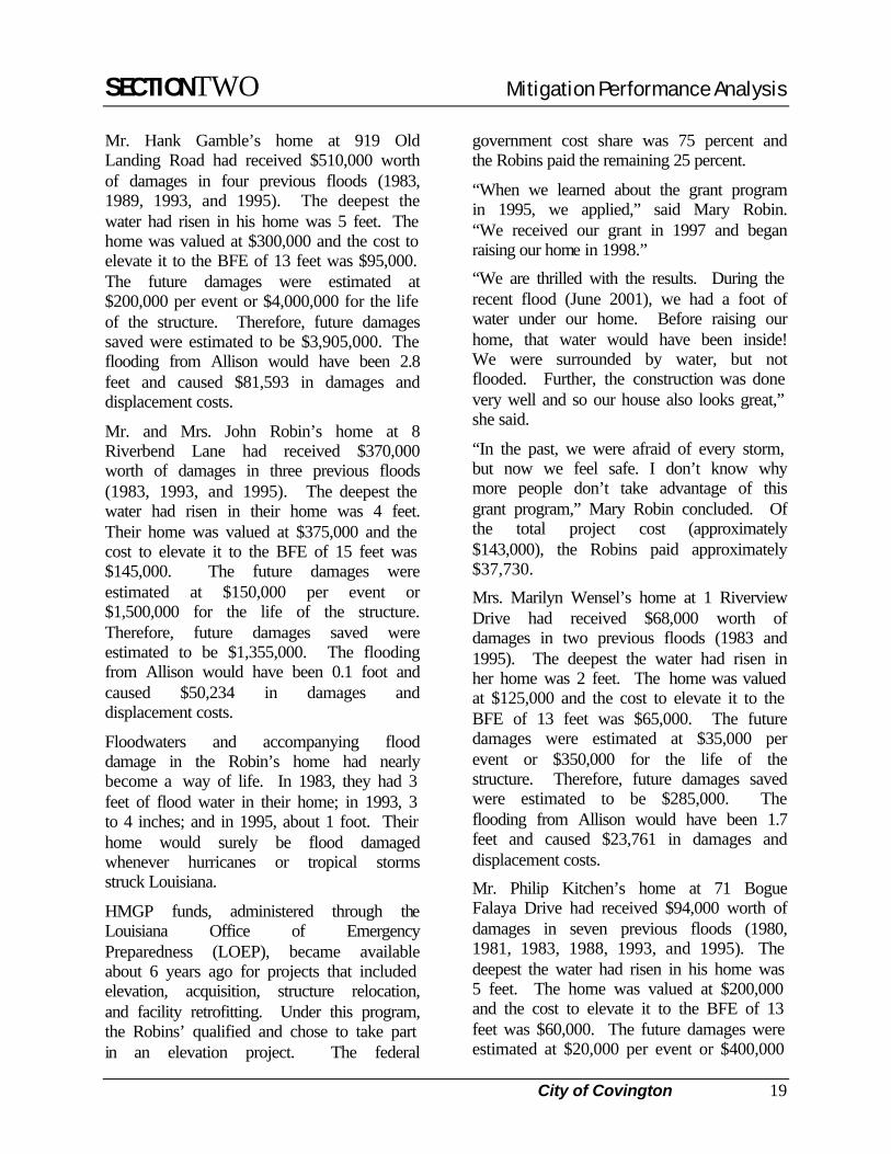
CITY OF COVINGTON: ELEVATIONS AND ACQUISITION
City of Covington
Hazard Mitigation Grant Recipient
Yes
Community Rating System Rating
10
Population 8,483
Number of Repetitive Losses
37
Inches of Rain from T.S. Allison (in St. Tammany)
21.35
Number of Insured Structures
1,146
Insurance In-Force (1) $179,140,900
Annual Premiums Paid (1) $433,551
Number of Claims Paid (1) 274
Amount of Claims Paid (1) $4,047,181
Total Cost of Project(s) $704,940 (1) As of December 31, 2000
The City of Covington is located at the convergence of two major drainage basins: the Tchefuncte River Basin to the west and the Bogue Falaya River Basin to the east. Rainwater that falls within the northeast area of St. Tammany Parish flows through the City of Covington to Lake Pontchartrain. Much of the City floods due to intense rainfall, riverine flooding of the Tchefuncte and Bogue Falaya Rivers and their tributaries, hurricanes or lesser tropical storms, southerly wind and rainfall, or other combinations of these events.
More than 35 percent of the land area of the City of Covington is within the 100-year floodplain. More than 10 percent of the land area of the City is within the 500-year floodplain.
The City of Covington has experienced a number of natural disasters in past years. Hurricanes and tropical storms are a yearly threat in South Louisiana; yet, they are not as regular an occurrence here as the effects of riverine flooding from heavy precipitation. St. Tammany Parish, including the City of Covington, has been a "Presidentially declared" disaster area on 13 different occasions since 1965.
The estimated damages in the City of Covington during the devastating May 1995 flood were over $5 million dollars, and approximately $400,000 of that damage was suffered by six property owners (five residential and one commercial).
Determined not to repeat this scenario again, the City applied for $528,705 from the Hazard Mitigation Grant Program (HMGP) in October 1995 to assist those homeowners with the worst problems and those who needed assistance in elevating their homes. Along with the grant, the homeowners put up a total of $176,235 for a total project cost of $704,940.
All of the homes targeted in this project were within the Riverbend and Old Landing areas of Covington and were considered repetitive loss properties. All of the homes were flooded prior to and including the flood of 1995.
In addition to the five homeowners, there was also one commercial structure that had flooded at least four times. It was determined that it would be more feasible to acquire this property rather than elevate it. This property was not occupied and acquisition would remove the structure that flooded the worst and the most often in this area.

SECTIONTWO Mitigation Performance Analysis
City of Covington 18
For the homes, elevation was determined to be the most practical and least costly method of alleviating flood hazards, while also reducing any negative environmental impacts. Elevation of the five residential structures would allow flood waters from the scenic stream to continue to flow through the area, and more expensive drainage work would not be needed to alter the watercourse.
Mr. and Mrs. Leicester Landon’s home at 7 Riverbend Lane had received $75,000 worth of damages in two previous floods (1993 and 1995). The deepest the water had reached in their home was 14 inches. Their home was valued at $300,000 and the cost to elevate it to the BFE of 16 feet was estimated to be $112,300. The future damages were estimated at $30,000 per event or $300,000 for the life of the structure. Therefore, future damages saved were estimated to be $187,700, although the flooding during Allison would not have reached the structure.
The Landon’s home before elevation.
Mrs. Landon explained that they applied for and received an HMGP grant to raise their home, which was accomplished in 1999. Although they had experienced 14 inches of floodwater in their home during one flood, the flood of 1983 had done the most damage when repairs and content replacement costs were in excess of $60,000.
The Landons received HMGP funds in the amount of $82,725. Their 25 percent share was $27,573.
The Landons added a beautiful façade to the front of their home at the conclusion of the elevation project.
The rear of the home was left open allowing a view of the elevation method.
“My husband, a veterinarian, had recently retired and we didn’t need the extra expense, but raising our home has taken a real load off our minds. Although it was inconvenient to have to be out of our home during the major part of the construction, it was worth it! We are so relieved.”
Joyce Landon Homeowner
SECTIONTWO Mitigation Performance Analysis
City of Covington 19
Mr. Hank Gamble’s home at 919 Old Landing Road had received $510,000 worth of damages in four previous floods (1983, 1989, 1993, and 1995). The deepest the water had risen in his home was 5 feet. The home was valued at $300,000 and the cost to elevate it to the BFE of 13 feet was $95,000. The future damages were estimated at $200,000 per event or $4,000,000 for the life of the structure. Therefore, future damages saved were estimated to be $3,905,000. The flooding from Allison would have been 2.8 feet and caused $81,593 in damages and displacement costs.
Mr. and Mrs. John Robin’s home at 8 Riverbend Lane had received $370,000 worth of damages in three previous floods (1983, 1993, and 1995). The deepest the water had risen in their home was 4 feet. Their home was valued at $375,000 and the cost to elevate it to the BFE of 15 feet was $145,000. The future damages were estimated at $150,000 per event or $1,500,000 for the life of the structure. Therefore, future damages saved were estimated to be $1,355,000. The flooding from Allison would have been 0.1 foot and caused $50,234 in damages and displacement costs.
Floodwaters and accompanying flood damage in the Robin’s home had nearly become a way of life. In 1983, they had 3 feet of flood water in their home; in 1993, 3 to 4 inches; and in 1995, about 1 foot. Their home would surely be flood damaged whenever hurricanes or tropical storms struck Louisiana.
HMGP funds, administered through the Louisiana Office of Emergency Preparedness (LOEP), became available about 6 years ago for projects that included elevation, acquisition, structure relocation, and facility retrofitting. Under this program, the Robins’ qualified and chose to take part in an elevation project. The federal
government cost share was 75 percent and the Robins paid the remaining 25 percent.
“When we learned about the grant program in 1995, we applied,” said Mary Robin. “We received our grant in 1997 and began raising our home in 1998.”
“We are thrilled with the results. During the recent flood (June 2001), we had a foot of water under our home. Before raising our home, that water would have been inside! We were surrounded by water, but not flooded. Further, the construction was done very well and so our house also looks great,” she said.
“In the past, we were afraid of every storm, but now we feel safe. I don’t know why more people don’t take advantage of this grant program,” Mary Robin concluded. Of the total project cost (approximately $143,000), the Robins paid approximately $37,730.
Mrs. Marilyn Wensel’s home at 1 Riverview Drive had received $68,000 worth of damages in two previous floods (1983 and 1995). The deepest the water had risen in her home was 2 feet. The home was valued at $125,000 and the cost to elevate it to the BFE of 13 feet was $65,000. The future damages were estimated at $35,000 per event or $350,000 for the life of the structure. Therefore, future damages saved were estimated to be $285,000. The flooding from Allison would have been 1.7 feet and caused $23,761 in damages and displacement costs.
Mr. Philip Kitchen’s home at 71 Bogue Falaya Drive had received $94,000 worth of damages in seven previous floods (1980, 1981, 1983, 1988, 1993, and 1995). The deepest the water had risen in his home was 5 feet. The home was valued at $200,000 and the cost to elevate it to the BFE of 13 feet was $60,000. The future damages were estimated at $20,000 per event or $400,000
SECTIONTWO Mitigation Performance Analysis
City of Covington 20
for the life of the structure. Therefore, future damages saved were estimated to be $340,000. The flooding from Allison would have been 2.0 feet and caused $60,000 in damages and displacement costs.
Mr. Charles Hurston’s commercial structure at 626 East Gibson Street had received $65,000 worth of damages in three previous floods. The deepest the water had risen in the structure was 2.5 feet. The building was valued at $75,000 and the cost to elevate it to the BFE of 18 feet was $60,000. The future damages were estimated at $30,000 per event or $900,000 for the life of the structure. Therefore, future damages saved were estimated to be $820,000.
“We have had almost a half dozen successful house-raising grant projects in Covington. Without exception, the homeowners have been very pleased with the results. In each case, the home owner has paid the 25% local share portion of the elevation costs.”
Jarme Martino Manager of HMGP Grants for
Covington.

SECTIONTWO Mitigation Performance Analysis
City of Slidell 21
CITY OF SLIDELL: ACQUISITIONS AND SECOND-STORY CONVERSION
City of Slidell
Hazard Mitigation Grant Recipient
Yes
Community Rating System Rating
9
Population 25,695
Number of Repetitive Losses
170
Inches of Rain from T.S. Allison
21.35
Number of Insured Structures (1)
6,455
Insurance in Force (1) $744,818,100
Annual Premiums Paid (1) $2,737,509
Number of Claims Paid (1) 2,239
Amount of Claims Paid (1) $31,154,163
Total Cost of Project(s) $460,000 (1) As of December 31, 2000
The City of Slidell is located approximately 30 miles north of New Orleans, Louisiana. Annual rainfall in Slidell, as in all of South Louisiana, exceeds that for most parts of the United States. Within the past 80 years there have been six storms in the Slidell area that have exceeded the “one hundred year” flood mark established by the U.S. National Weather Service.
The Carollo Drive area experienced repetitive flooding through the 1980s and early 1990s. In April of 1995, homes had 6 inches of standing water. A month later
these homes flooded again with up to 18 inches of water.
The Carollo Drive area drainage problem was linked to undersized culverts and ditches and inadequate pump stations. To remedy this problem, the City determined that the four most repetitively flooded properties should be acquired and demolished. The vacant lots were then used to construct a retention pond that would drain to Carollo Drive when the water level would allow. The retention pond provides the capacity to contain heavy rainfall.
Where four repetitive loss structures once stood, a retention pond was built to contain heavy rainfall.
In addition to the retention pond, an interceptor ditch was constructed to divert surface runoff to an existing large pipeline that feeds into a nearby pump station. This ditch can quickly drain the surface runoff that created many of Carollo Drive’s problems.
Slidell applied through the Hazard Mitigation Grant Program (HMGP) to construct the retention pond and interceptor ditch and to acquire and demolish the four homes. The total project cost was $460,000. Of that, the City’s share was 35 percent, or $161,000.
SECTIONTWO Mitigation Performance Analysis
City of Slidell 22
The success of this project can be measured by recent Tropical Storm Allison. Although the area received over 21 inches of rain, there was only one home on Carollo Drive that flooded. That home was located adjacent to the retention pond and is on the list to be acquired and demolished.
The City of Slidell has now passed an ordinance that new homes built in the Carollo Drive area must be elevated above the BFE. This ordinance, along with the acquisition/retention pond project, has significantly reduced the flooding problem in this area.
Residential lot being prepared for construction by the addition of fill material.
A completed home, which was built above the BFE.
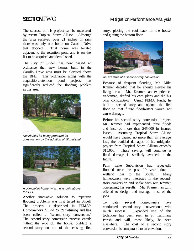
Another innovative solution to repetitive flooding problems was first tested in Slidell. The process is described in FEMA’s Homeowners Guide to Retrofitting and has been called a “second-story conversion.” The second-story conversion process entails cutting the roof off the house, building a second story on top of the existing first
story, placing the roof back on the house, and gutting the bottom floor.
An example of a second-story conversion
Because of frequent flooding, Mr. Mike Kramer decided that he should elevate his living area. Mr. Kramer, an experienced tradesman, drafted his own plans and did his own construction. Using FEMA funds, he built a second story and opened the first floor so that future floodwaters would not cause damage.
Before his second story conversion project, Mr. Kramer had experienced three floods and incurred more than $45,000 in insured losses. Assuming Tropical Storm Allison would have caused no more than an average loss, the avoided damages of his mitigation project from Tropical Storm Allison exceeds $15,000. These savings will continue as flood damage is similarly avoided in the future.
Palm Lake Subdivision had repeatedly flooded over the past 10 years due to wetland loss to the South. Many homeowners were interested in the second-story conversion and spoke with Mr. Kramer concerning his results. Mr. Kramer, in turn, offered to design and manage most of the jobs.
To date, several homeowners have conducted second-story conversions with much success. Expanded use of this technique has been seen in St. Tammany Parish and will, most likely, be seen elsewhere. The cost of a second story conversion is comparable to an elevation.

SECTIONTWO Mitigation Performance Analysis
City of Mandeville 23
CITY OF MANDEVILLE: ELEVATIONS, ACQUISITIONS, AND ORDINANCES
City of Mandeville
Hazard Mitigation Grant Recipient Yes
Community Rating System Rating
9
Population 10,489
Number of Repetitive Losses 27
Inches of Rain from T.S. Allison 21.35
Number of Insured Structures
2,785
Insurance In-Force (1) $438,347,000
Annual Premiums Paid (1) $1,142,609
Number of Claims Paid (1) 365
Amount of Claims Paid (1) $3,346,484
Total Cost of Project(s) $629,500 (1) As of December 31, 2000
The City of Mandeville is located in St. Tammany Parish on the north shore of Lake Pontchartrain. This area has many old homes and businesses that lend to the historic nature of the area. Approximately 80 percent of the City is mapped as Special Flood Hazard Area (SFHA). The outfall for all the streams in this parish is Lake Pontchartrain. The lake is subject to tidal influence as well as southerly winds that can cause flood waters to back up into the developed areas. The majority of flooding occurs when there is a strong southerly wind and intense rainfall over the land. When these two forces meet, the result is backwater flooding along all of the drainage arteries.
A prosperous town on the north shore of Lake Pontchartrain, Mandeville, Louisiana experienced two hurricanes and three major storms between the years 1991 and 2000. Hurricane Andrew, in 1992, damaged primarily the older section of town. Following Hurricane Andrew, Mandeville obtained Federal funds to rebuild the lakeshore seawall. Major flooding occurred in Mandeville in 1993, 1994, and 1995, with flood waters exceeding 8 feet deep in many locations. In the Golden Glen community alone, 160 homes suffered damage. The City had over $300,000 in damages from a near miss by Hurricane Georges in the fall of 1998.
Following the 1995 flood, the city developed a Master Plan to address any type of natural disaster. A survey of 3,800 residents was conducted to determine problem flood areas and identify vulnerable neighborhoods. Maps of these areas were used in development of a Capitol Project program.
Actual estimates of property damage caused by the May flood to five badly flooded homes totaled $605,000. One residence, not included in this project, had already been elevated. Residents indicated that they also lost workdays from a minimum of 7 days to a maximum of 30 days due to the flood. Among all of these households, 183 work days were lost, totaling approximately $28,000 in lost wages and work productivity. All of these families were displaced from their home, but only two had to pay rent. Rental payments totaled $7,800 for these two families.
Mandeville applied for and received funds through the Hazard Mitigation Grant Program (HMGP) in 1995 in the amount of $379,662. These funds were used, along with a local match of $126,555, to mitigate

SECTIONTWO Mitigation Performance Analysis
City of Mandeville 24
the repetitive flood losses of the Golden Glen neighborhood. Golden Glen, a 119-lot subdivision, was developed in the early 1970s. Approximately half of the subdivision is located within a 100-year or 500-year floodplain. The scope of this project included elevating three homes and acquiring and demolishing another home.
Home in Golden Glen that was elevated above the BFE.
Mr. and Mrs. Keith Craik were the first to have their home elevated. Their 4,500-square-foot home at 110 Katherine Parkway had flooded twice, in April and May of 1995, and they suffered $78,000 in flood damages. During the May flood, they had 3 feet of water in the house.
Ms. Craik said that elevating their home was the best decision they ever made. Since elevating their home, they have not flooded once. Because two previous floods caused $78,000 in flood damages (or an average loss of $39,000), it is estimated that Tropical Storm Allison would have caused approximately $39,000 in damages to the Craik home if they had not elevated it. Through their mitigation efforts, this $39,000 loss was avoided.
In addition to acquisitions and elevations, the City has adopted planning guidelines that establish spacious lot sizes with landscape requirements which were enacted
to preserve existing trees and vegetation and to replace trees lost through development. Low-rise, landscaped monument signs have been adopted to minimize visual clutter.
One of Mandeville’s newest subdivisions, the Sanctuary Subdivision, is located between Interstate 12 and Lake Pontchartrain.
As one drives along the West Causeway Approach, it could be easy to miss the stately homes in this subdivision if not for the impressive business office and guardhouse at the entrance.
Unlike most boulevards leading into upscale developments, the Sanctuary’s main street is heavily treed and blends in nicely with the surrounding landscape.
Entrance to the Sanctuary Subdivision.
Mr. Joe Mistich, Public Works Director for Mandeville, explained that just about the time that this development was being planned nearly 4 years ago, the City changed
“Not only did the value of our home double, but so did our useable space. We really enjoy the area under our house. It made a nice place to park our cars. It’s so nice not to have to worry about picking up the furniture when it rains hard.”
Mrs. Diane CraikHomeowner

SECTIONTWO Mitigation Performance Analysis
City of Mandeville 25
its land use ordinances limiting the amount of fill that could be placed in the floodplain.
When fill is added to the floodplain, it reduces the flood storage capacity of the area and thus causes the flood waters to rise faster.
Several options exist to avoid using fill to raise the floor elevation of newly constructed homes. These include construction on pilings and perimeter foundation construction over crawlspaces.
Mr. Mistich said that it is not the City’s intention to dictate the style of foundations used by developers. They just want to make sure that the floodplain is left open. The developer of the Sanctuary opted to use perimeter foundations.
The typical method of hauling in a “mountain” of dirt to raise the height of the floor on new construction above the Base Flood Elevation (BFE) causes other problems too. In addition to reducing the capacity of the floodplain, it causes more trees to be removed. By removing the trees, the associated leaf litter is reduced, thereby decreasing soil quality and stability.
The City’s fill ordinance only allows up to 24 inches of fill under the roof-shed area of a house or driveway. If more than 24 inches
is needed, the fill must be retained in a perimeter foundation or the structure must be placed on piers.
As a result of this ordinance, the homes in the Sanctuary are elevated above the BFE in a manner that protects the floodplain and retains valuable trees.
Mandeville’s citizens have also found a way to help themselves. A group of 38 volunteers formed the City of Mandeville Drain Team. The Drain Team assists the Department of Public Works by monitoring over 150 miles of drainage arteries in their neighborhoods.
These citizens lend assistance through physical efforts by cleaning debris from the ditches and catch basins during wet and dry weather. Members receive yellow rain suits with the City of Mandeville insignia on them to help keep them dry while monitoring the drainage.
Congressman Vittor receives honorary Drain Team uniform as he lends his support to the program.
Monthly and quarterly meetings are held with these members and members of the City Staff for regular updates.
“This development is an excellent example of how, with proper planning, people can live in harmony with nature. Allowing the floodplains to serve their natural purpose just makes good sense.”
Joe Mistich,Public Works Director

SECTIONTWO Mitigation Performance Analysis
City of Mandeville 26
Drain Team members discuss ways to keep the drains flowing.
The meetings consist of a presentation given by Mr. Glenn Craddock, Assistant Superintendent of Streets and Drainage, and Mr. Roy Geoghegan, Field Inspector for the City. These presentations show “hot spots” in the neighborhoods in an attempt to educate the members as to how they can help in their Zones. The members are also kept abreast of all current and upcoming events and projects in which the City is participating.
During Tropical Storm Allison, Beau Rivage Subdivision was flooding. When the Drain Team began checking the ditches, they discovered a child’s ball stuck in a critical drainage culvert. Once removed, the water began to recede. Once again, the drainage team had come to the rescue.
Beau Rivage Subdivision flooding before a ball was removed from a culvert by a Drain Team member allowing the water to flow
CITY OF MANDEVILLE: DRY FLOODPROOFING
Regardless of acquisition and elevation programs that may be available in a community, some structures will inevitably continue to be located in hazardous locations. There should be alternatives available to avoid damages from floods for homeowners who, for numerous reasons, may not be able to participate in such programs. In some cases, a structure may not be structurally sound enough to be elevated or, for a variety of reasons, the
homeowners may not want to sell. Fortunately, there is an alternative.
Dry floodproofing is a process that completely seals the exterior of a building to prevent the entry of floodwaters. Dry floodproofing involves sealing all openings below the flood level and relies on the walls of the structure to keep water out. Because the walls are exposed to flood waters and the pressures they exert, dry floodproofing is
“You just wouldn’t believe what an impact this team has on keeping the water flowing during storms. Their biggest job is keeping the balls and garbage can lids out of the culverts.”
Mr. Glenn Craddock, Assistant Superintendent of Streets and Drainage

SECTIONTWO Mitigation Performance Analysis
City of Mandeville 27
practical only where flood depths are low (no more than 3 feet).
NOTE: Dry floodproofing a residential structure will not bring a substantially damaged or improved structure into compliance with the NFIP.
Floodproofing is also an excellent choice for historic buildings and for areas in which the capital investment in the existing urban infrastructure requires continued occupation of a hazardous location. In these situations, floodproofing can be indispensable.
Such was the case with two restaurants located on the lakefront of Lake Pontchartrain. Bechac’s and RIP’s restaurants were both historic structures and the State Historic Preservation Office had strict guidelines on what could be done to the structures.
RIP’s after floodproofing. A brick veneer was used to cover the waterproof membrane.
The main cause of flooding on these two structures was heavy rain occurring along with a strong southerly wind on the lake. The water from the lake would “push” up into the rivers and bayous and not let the rainwater drain. This would result in ponding in the floodplain areas. Both of the structures had received 6 to 12 inches of floodwaters on numerous occasions due to this type of rain event. Bechac’s was a priority for some type of mitigation because
it was one of the targeted 107 highly repetitively flooded structures in Louisiana.
RIP’s, with an estimated value of $700,000, had a history of 11 flood claims totaling $94,055. RIP’s was floodproofed using a waterproof membrane covered by bricks for a total project cost of $200,000.
Bechac’s, with an estimated value of $1.5 million, had a history of four flood claims totaling $35,175. Bechac’s was floodproofed using a coating of a polyethylene material, which was painted to allow the structure to maintain its original appearance. The floodproofing was completed for a total project cost of $190,000.
Bechac’s after floodproofing. After painting, the waterproof membrane could not even be seen.
Since the floodproofing, both structures have avoided damages from at least two floods. When Tropical Storm Allison blew ashore, RIP’s had approximately 1 foot of rising tide water outside its floodproofed doors, but the only water that got in was about an inch that blew in through a window and was mopped up.
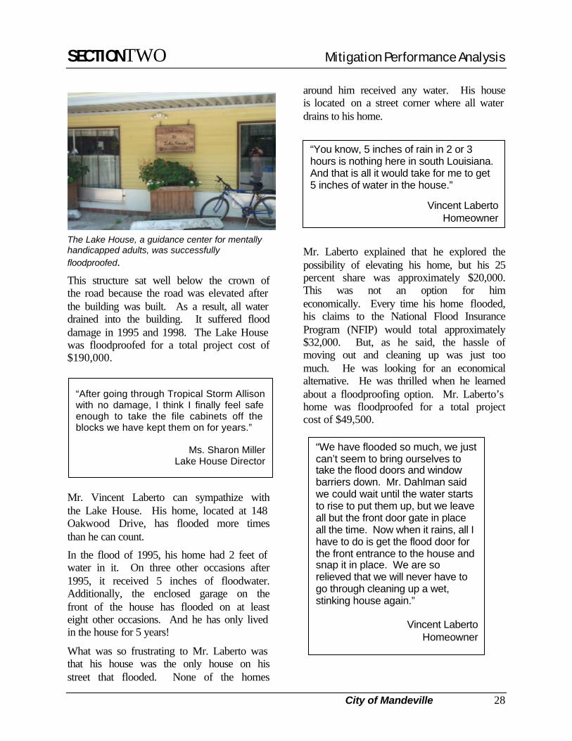
Another commercial structure that was successfully floodproofed in Mandeville is the Lake House, a guidance center for mentally handicapped adults, located just two blocks from the north shore of Lake Pontchartrain.
SECTIONTWO Mitigation Performance Analysis
City of Mandeville 28
“We have flooded so much, we just can’t seem to bring ourselves to take the flood doors and window barriers down. Mr. Dahlman said we could wait until the water starts to rise to put them up, but we leave all but the front door gate in place all the time. Now when it rains, all I have to do is get the flood door for the front entrance to the house and snap it in place. We are so relieved that we will never have to go through cleaning up a wet, stinking house again.”
Vincent LabertoHomeowner
The Lake House, a guidance center for mentally handicapped adults, was successfully floodproofed.
This structure sat well below the crown of the road because the road was elevated after the building was built. As a result, all water drained into the building. It suffered flood damage in 1995 and 1998. The Lake House was floodproofed for a total project cost of $190,000.
Mr. Vincent Laberto can sympathize with the Lake House. His home, located at 148 Oakwood Drive, has flooded more times than he can count.
In the flood of 1995, his home had 2 feet of water in it. On three other occasions after 1995, it received 5 inches of floodwater. Additionally, the enclosed garage on the front of the house has flooded on at least eight other occasions. And he has only lived in the house for 5 years!
What was so frustrating to Mr. Laberto was that his house was the only house on his street that flooded. None of the homes
around him received any water. His house is located on a street corner where all water drains to his home.
Mr. Laberto explained that he explored the possibility of elevating his home, but his 25 percent share was approximately $20,000. This was not an option for him economically. Every time his home flooded, his claims to the National Flood Insurance Program (NFIP) would total approximately $32,000. But, as he said, the hassle of moving out and cleaning up was just too much. He was looking for an economical alternative. He was thrilled when he learned about a floodproofing option. Mr. Laberto’s home was floodproofed for a total project cost of $49,500.
“After going through Tropical Storm Allison with no damage, I think I finally feel safe enough to take the file cabinets off the blocks we have kept them on for years.”
Ms. Sharon MillerLake House Director
“You know, 5 inches of rain in 2 or 3 hours is nothing here in south Louisiana. And that is all it would take for me to get 5 inches of water in the house.”
Vincent LabertoHomeowner
SECTIONTWO Mitigation Performance Analysis
City of Mandeville 29
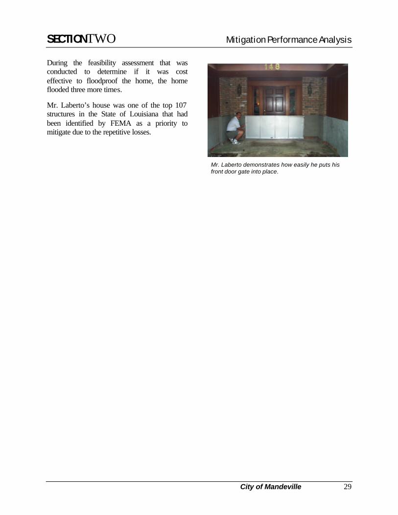
During the feasibility assessment that was conducted to determine if it was cost effective to floodproof the home, the home flooded three more times.
Mr. Laberto’s house was one of the top 107 structures in the State of Louisiana that had been identified by FEMA as a priority to mitigate due to the repetitive losses.
Mr. Laberto demonstrates how easily he puts his front door gate into place.

SECTIONTWO Mitigation Performance Analysis
Terrebonne Parish 30
TERREBONNE READINESS & ASSISTANCE COALITION (TRAC): COMMUNITY EDUCATION PROGRAM
Terrebonne Parish
Hazard Mitigation Grant Recipient
Yes
Community Rating System Rating 9
Population 104,503
Number of Repetitive Losses (unincorporated areas)
578
Inches of Rain from T.S. Allison (3 days) 40.37
Number of Insured Structures
7,117
Insurance In-Force (1) $640,198,400
Annual Premiums Paid (1) $2,766,685
Number of Claims Paid (1) 4,422
Amount of Claims Paid (1) $57,266,031
Total Cost of Project(s) $1,000,000 (1) As of December 31, 2000
Terrebonne Parish is located 57 miles southwest of New Orleans and is the second largest Parish in Louisiana. It borders the Gulf of Mexico, and Lafourche, Assumption, and St. Mary Parishes. Despite its status as Louisiana's second largest parish, more than 90 percent of Terrebonne is wetlands or covered by open water (permanently or seasonally) - a true coastal wetlands environment.
Traditional vocations in Terrebonne Parish are fishing, hunting, trapping, sugarcane farming, boat building, and more recently, oil and gas production and support activities.
In the wake of Hurricane Andrew, which hit Louisiana in August 1992, thousands of South Louisiana residents were left with severely damaged homes — or no homes at all. The residents, especially those in Terrebonne Parish - needed help rebuilding their lives and preparing for future disasters.
Peggy Case and Velma Watson, co-administrators of the Terrebonne Readiness and Assistance Coalition (TRAC), realized that to implement a successful disaster recovery effort, they would need to enlist the help of community organizations. To do so, they recruited 28 local community organizations, including emergency management associations, religious groups and hospitals, to serve as partners in their efforts. Together, TRAC and its partners focused on rebuilding the community and preparing residents for future emergencies.
TRAC is a non-profit organization whose mission is to assist individuals, families, and communities to prepare for and recover from disasters through educational outreach activities provided in conjunction with a coalition of churches, governmental groups, and civic organizations.
Traditionally, community-based and faith-based organizations such as TRAC dissipate after the long-term recovery issues have been achieved in a particular disaster-stricken community. What is remarkable about TRAC is that they have managed to fiscally keep their operations going for over 8 years. They continue to meet the unmet needs of the community’s most vulnerable people.
Just recently, after Tropical Storm Allison, TRAC was able to conduct an unmet needs meeting within days of the storm. Due to their year-around preparations and contacts, 26 people attended this meeting. In
SECTIONTWO Mitigation Performance Analysis
Terrebonne Parish 31
addition, volunteer labor from local churches was immediately available. TRAC received 400 boxes of groceries (each box fed a family of four for a week) and 300 clean-up kits within days of the disaster.
In Louisiana, vulnerability is exhibited geographically, culturally, and economically. In the area served by TRAC, primarily coastal parishes, the coastline is eroding at a rate of 25 square miles every year. Many of the people in this area have language barriers and are poverty stricken.
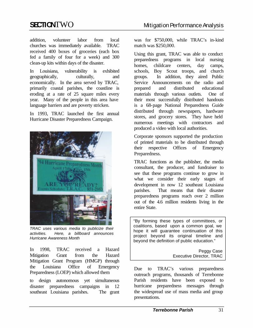
In 1993, TRAC launched the first annual Hurricane Disaster Preparedness Campaign.
TRAC uses various media to publicize their activities. Here, a billboard announces Hurricane Awareness Month
In 1998, TRAC received a Hazard Mitigation Grant from the Hazard Mitigation Grant Program (HMGP) through the Louisiana Office of Emergency Preparedness (LOEP) which allowed them
to design autonomous yet simultaneous disaster preparedness campaigns in 12 southeast Louisiana parishes. The grant
was for $750,000, while TRAC’s in-kind match was $250,000.
Using this grant, TRAC was able to conduct preparedness programs in local nursing homes, childcare centers, day camps, schools, Boy Scout troops, and church groups. In addition, they aired Public Service Announcements on the radio and prepared and distributed educational materials through various outlets. One of their most successfully distributed handouts is a 68-page National Preparedness Guide distributed through newspapers, hardware stores, and grocery stores. They have held numerous meetings with contractors and produced a video with local authorities.
Corporate sponsors supported the production of printed materials to be distributed through their respective Offices of Emergency Preparedness.
TRAC functions as the publisher, the media consultant, the producer, and fundraiser to see that these programs continue to grow in what we consider their early stages of development in now 12 southeast Louisiana parishes. That means that their disaster preparedness programs reach over 2 million out of the 4.6 million residents living in the entire State.
Due to TRAC’s various preparedness outreach programs, thousands of Terrebonne Parish residents have been exposed to hurricane preparedness messages through the widespread use of mass media and group presentations.
“By forming these types of committees, or coalitions, based upon a common goal, we hope it will guarantee continuation of this project beyond its original timeline and beyond the definition of public education.”
Peggy CaseExecutive Director, TRAC
SECTIONTHREE Determining Avoided Damages – A Summary
32
3 . S e c t i o n 3 T H R E E D e t e r m i n i n g A v o i d e d D a m a g e s – A S u m m a r y
The mitigation projects outlined in Section 2 were included because they were funded 75 percent by FEMA’s Hazard Mitigation Grant Program and the properties were in the area affected by Tropical Storm Allison. To quantify the real savings of the HMGP mitigation programs, it is important to determine, after real events, what savings in fact accrued because of the HMGP project—how an elevated house, a relocated building, or a floodproofed commercial structure was impacted less because of the project. Only when we compare real events to completed projects can we determine project effectiveness.
A requirement of the HMGP regulations is that a benefit/cost analysis must be performed for each project included in a grant application. The reason for this is to help the State of Louisiana set project priorities and to complete projects whose benefits exceed the project costs. The method used to determine avoided damages draws on much of the same information used in the benefit/cost analysis, except actual flood depths and damages incurred for the real event are used to determine the effectiveness of the mitigation measure in avoiding damages.
For most of the specific projects included in this study, there were no flood elevations from Tropical Storm Allison available to use in determining avoided damages. To develop some level of confidence that the past projects were in fact beneficial in reducing damages, the project team:
1. determined flood elevations for this tropical storm in a small neighborhood in Covington, Louisiana. This neighborhood was selected because the five properties were close together so they should have experienced nearly the same flood event from Allison. All five properties were on the same Flood Insurance Rate Map. There was substantial information available on these properties, such as value, elevation project cost, Base Flood Elevations (BFE) for each property, and the height to which each house was elevated. Surveyors also provided elevations of the original lowest floor (which was still visible) and the lowest adjacent grade.
2. used anecdotal information from property owners about the depth of flooding and losses from past similar events before mitigation activities had been completed on their properties to determine the probable avoided damages from Tropical Storm Allison. This information was available from seven other communities, from which the team was able to assess avoided damages.
Flooding from Allison at the properties analyzed for this report would have created water depths ranging from –1.2 feet (water would have been 1.2 feet below the original lowest floor, thus no flooding would have occurred) to +5 feet. Based on flood depth-damage history supplied by FEMA and the Federal Insurance Administration (FIA), calculated damages to these properties from Allison would have totaled over $7 million for building damage, content damage, and the cost of temporary housing for displaced residents. This one potential loss from approximately a 20-year storm is more than twice the total mitigation costs for these projects.
The following table shows the details of the avoided damages discussion above.

SECTIONTHREE Determining Avoided Damages – A Summary
33
Property Depth of Flooding1
(ft)
Estimated Losses2 Mitigation Costs3
Covington
7 Riverbend Lane –1.2 0 $112,300 8 Riverbend Lane 0.1 $50,234 $145,000 1 Riverview Drive 1.7 $23,761 $65,000
919 Old Landing Rd. 2.8 $81,593 $95,000 71 Bogue Falaya Dr. 2.0 $41,945 $60,000
Mandeville - Craik 1 $39,000 $87,000 Slidell - Kramer 1 $15,000 $80,000 St. James – Margaret St. 1 $58,500 $170,000
St. Charles – Ormond Pump 1 $7,150,000 $2,192,520 Jefferson – 4 properties N/A $70,000 $429,000
Ascension - Long 4 $7,000 $10,000
East Baton Rouge – O’Reilly Auto Parts
5 $285,000 $150,000
TOTAL $7,822,033 $3,595,820
1 depth of flooding is the difference between the Tropical Storm Allison high water mark at or near the property and the top of the lowest floor of the pre-elevated house; elevations shown to only 1 significant digit are estimated from high water marks.
2 losses include building damage, contents damage, and displacement costs caused by the flooding, and were determined from FIA depth-damage charts.
3 costs are in 1996 dollars used in the original benefit/cost analysis.
Losses were determined by using percent losses for the given depth of flooding from the FIA depth-damage chart. This loss was multiplied by the replacement value of the house. The replacement value was obtained from the Marshall & Swift Residential Cost Handbook. This calculated loss was then compared with previous losses for similar depths of flooding to determine if the calculated loss was in line with experience.
The calculation sheet that follows is from FEMA’s benefit/cost computer program. The costs and avoided damages from this one 20-year event have been aggregated into a project total. If, as a whole, all of the projects have been elevated or protected such that they are 80% effective for a 100-year event, then the lower-bound project benefit/cost ratio is greater than 1.00. In other words, for all of these projects, based on the limited data used in this analysis, the project benefits exceed the costs.
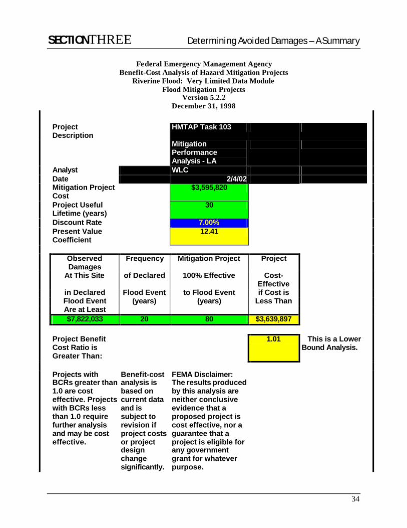
SECTIONTHREE Determining Avoided Damages – A Summary
34
Federal Emergency Management Agency Benefit-Cost Analysis of Hazard Mitigation Projects
Riverine Flood: Very Limited Data Module Flood Mitigation Projects
Version 5.2.2 December 31, 1998
Project Description
HMTAP Task 103
Mitigation Performance Analysis - LA
Analyst WLC Date 2/4/02 Mitigation Project
Cost $3,595,820
Project Useful Lifetime (years)
30
Discount Rate 7.00% Present Value
Coefficient 12.41
Observed
Damages Frequency Mitigation Project Project
At This Site of Declared 100% Effective Cost-Effective
in Declared Flood Event to Flood Event if Cost is Flood Event (years) (years) Less Than Are at Least $7,822,033 20 80 $3,639,897 Project Benefit
Cost Ratio is Greater Than:
1.01 This is a Lower Bound Analysis.
Projects with
BCRs greater than 1.0 are cost effective. Projects with BCRs less than 1.0 require further analysis and may be cost effective.
Benefit-cost analysis is based on current data and is subject to revision if project costs or project design change significantly.
FEMA Disclaimer: The results produced by this analysis are neither conclusive evidence that a proposed project is cost effective, nor a guarantee that a project is eligible for any government grant for whatever purpose.
SECTIONFOUR Acknowledgements
35
4 . S e c t i o n 4 F O U R A c k n o w l e d g e m e n t s
Brian Harmon, Director, Department of Public Works Baton Rouge, East Baton Rouge Parish, LA
Paul Allain, Manager, O’Reilly Auto Parts
Baton Rouge, LA
Diana Brooks, Homeowner Baton Rouge, LA
James DeLaune, Mayor, City of Denham Springs
Denham Springs, LA
Charles “Chuck” Vincent, Building Official Denham Springs, LA
Melanie Brumfield, Administrative Assistant
Denham Springs, LA
Evan Long, Homeowner Prairieville, LA
Steven M. Fall, P.E. Director of Department of Public Works/Wastewater
St. Charles Parish, LA
Lawrence “Lee” Zeringue, Assistant Engineer, Department of Public Works St. Charles Parish
Jody Chenier, Director of Operation
St. James Parish, LA
Mr. and Mrs. Leicester Landon, Homeowners Covington, LA
Mr. and Mrs. John Robin, Homeowners
Covington, LA
Jarme Martino, Manager of HMGP Grants Covington, LA
Martin Bruno, Planning Director
Slidell, LA
Joseph Mistich, Director, Department of Public Works Mandeville, LA
SECTIONFOUR Acknowledgements
36
Wayne Berggren, Building Inspector/Floodplain Coordinator Mandeville, LA
Mr. Glenn Craddock, Assistant Superintendent of Streets and Drainage
Mandeville, LA
Mr. and Mrs. Vincent Laberto, Homeowner Mandeville, LA
Mr. and Mrs. Keith Craik, Homeowner
Mandeville, LA
Peggy Case, Co-administrator, TRAC Terrebonne Parish, LA
Velma Watson, Co-administrator, TRAC
Terrebonne Parish, LA
Aegis Innovative Solutions, LLC Baton Rouge, LA