lake hazar basin: a negative flower structure on the east
TRANSCRIPT

Lake Hazar Basin: A Negative Flower Structure on theEast Anatolian Fault System (EAFS), SE Turkey
ERCAN AKSOY1, MURAT ‹NCEÖZ1 & AL‹ KOÇY‹⁄‹T2
1 F›rat University, Department of Geological Engineering, TR–23119 Elaz›¤, Turkey2 Middle East Technical University, Department of Geological Engineering, Active Tectonics and Earthquake
Research Laboratory, TR–06531 Ankara, Turkey (E-mail: [email protected])
Abstract: The East Anatolian Fault System (EAFS) is a 30-km-wide, 700-km-long and NE-trending sinistral strike-slip megashear belt between the Anatolian platelet in the northwest and African-Arabian plates in the southeast. Itis located between Karl›ova County in the NE and Karatafl (Adana)-Samanda¤ (Antakya) in the SW. In the LakeHazar region, the EAFS consists of five fault zones. These are, from north to south, the Elaz›¤ fault zone, theUluova fault zone, the Sivrice fault zone, the Ad›yaman fault zone and the Lice-Çermik fault zone; in previousstudies only the Sivrice fault zone has been reported to be part of the EAFS. The 2–4-km-wide and 180-km-longSivrice fault zone contains the master fault of the system. It bifurcates into several sub-fault zones and isolatedfaults resulting in a 5-km-wide, 32-km-long, active lensoidal depression bounded by a series of short to long andcurved fault segments with considerable amounts of normal-slip component, particularly on the southern margin.This strike-slip depression was previously reported and interpreted to be a classical pull-apart basin or rhomb-graben basin originating from a left step-over located in the northeastern corner of Lake Hazar. In contrast to thisearlier interpretation, our detailed field geological mapping of active faults indicates that there is no any left step-over at the northeast corner of Lake Hazar. In lieu of this, the master fault of the EAFS bifurcates into two sub-strands nearby Kartaldere village in the east which then run in a SW direction across Lake Hazar resulting in twosub-parallel lensoidal depressions separated by an intervening horst. This strike-slip geometry is here termed anegative flower structure. This interpretation is supported by basin-ward curved boundary faults with considerablenormal-slip component of movement and by the bathymetry of Lake Hazar.
Back-tilted fault blocks, uplifted and dissected Plio–Quaternary terrace conglomerates, fan-delta deposits andassociated syn-sedimentary structures indicate that neotectonic infill of the basin has accumulated under theinfluence of a strike-slip tectonic regime. The left-lateral strike-slip amount and the vertical throw amountaccumulated along the Sivrice fault zone are 9 ± 1 km and 1317 ± 10 m, respectively. These values yield strike-and vertical-slip rates of 4 mm/yr and 0.5 mm/yr, respectively, along the Sivrice fault zone. However, the slip ratesalong the EAFS must be greater because the EAFS around Lake Hazar consists of five fault zones which all sharethe slip rate
Key Words: East Anatolian Fault System, Lake Hazar basin, negative flower structure, Turkey
Hazar Gölü Havzas›: Do¤u Anadolu Fay Sistemi (DAFS) Üzerinde Bir Negatif Çiçek Yap›s›, GD Türkiye
Özet: Do¤u Anadolu Fay Sistemi (DAFS) kuzeybat›da Anadolu ve güneydo¤uda Arap-Afrika levhalar› aras›nda yeralan, ortalama 30 km genifllikte, 700 km uzunlukta ve KD-gidiflli, sol yanal do¤rultu at›ml› büyük bir makaslamakufla¤›d›r. DAFS kuzeydo¤uda Karl›ova ilçesi ile güneybat›da Karatafl (Adana)–Samanda¤ (Antakya) aras›nda yeral›r. Hazar Gölü bölgesinde, DAFS befl fay kufla¤›ndan oluflur. Bunlar kuzeyden güneye do¤ru Elaz›¤, Uluova,Sivrice, Ad›yaman ve Lice-Çermik fay kuflaklar›d›r. Halbuki önceki çal›flmalarda, DAFS, yaln›zca Sivrice fay kufla¤›olarak tan›t›lm›flt›r. 2–4 km geniflli¤inde ve 180 km uzunlu¤undaki Sivrice fay kufla¤› DAFS’nin ana fay›n› içerir vebirkaç alt fay kufla¤› ile çok say›da tekil faya ayr›l›r; böylece 5 km genifllikte, 32 km uzunlukta, kenarlar› önemlimiktarda normal at›m bilefleni olan, k›sa ve uzun bir seri fay segmenti ile s›n›rlanm›fl, günümüzde büyümesinisürdüren, mercek biçimli bir çöküntü oluflturur. Do¤rultu at›ml› bu fay çöküntüsü, daha önce, DAFS’nin ana fay›n›n,Hazar gölünün kuzeydo¤u köflesinde sola s›çramas›yla oluflmufl, klasik bir çek-ay›r havza ya da eflkenar dörtgenbiçimli bir graben havzas› olarak yorumlan›p rapor edilmifltir. Bu görüflün aksine, aktif faylar›n ayr›nt›l› haritalamas›ve faylar›n geometrisi (da¤›l›m biçimi ve birbirleriyle iliflkisi) ana fay›n, Hazar Gölü kuzeydo¤u köflesinde solas›çrama yapmad›¤›n› aç›kça ortaya koymufltur. Bunun yerine, ana fay, daha do¤uda yer alan Kartaldere köyüyak›nlar›nda iki alt kola ayr›lmakta ve bu iki alt kol güneybat› yönünde Hazar Gölü boyunca güneybat›ya do¤rudevam ederek, birbirinden bir yükselti ile ayr›lan, yar› paralel ve mercek biçimli iki çöküntünün oluflumuna yol
Turkish Journal of Earth Sciences (Turkish J. Earth Sci.), Vol. 16, 2007, pp. 319–338. Copyright ©TÜB‹TAK
319

LAKE HAZAR BASIN, SE TURKEY
320
Introduction
Strike-slip basins are structural depressions caused by arange of movement complexities along strike-slip faultzones. The general term ‘pull-apart basin’ in this area wasfirst suggested by Burchfiel & Stewart (1966) based onthe term ‘Rhombochasm’ of Carey (1958). A number offield works have subsequently been carried out on strike-slip basins in California (e.g., Hill & Dibble 1953; Crowell1974a, b; Harding 1976; Sylvester & Smith 1976;Christie-Blick & Biddle 1985) which have attracted theattention of structural geologists worldwide. In additionduring the last 30 years, a number of experimental andfield studies have been carried out on the origin andevolutionary history of strike-slip basins (e.g., Ballance &Reading 1980; Rodgers 1980; Schubert 1980; Ayd›n &Nur 1982, 1985; Mann et al. 1983; Biddle & Christie-Blick 1985; Harding 1985; Manspeizer 1985; Koçyi¤it1988, 1989; Ingersoll & Busby 1995; McClay & Dooley1995; Nilsen & Sylvester 1995; Rahe et al. 1998).
Two well-known strike-slip fault systems are theNorth Anatolian dextral strike-slip fault system and theEast Anatolian sinistral strike-slip fault system. Theintervening Anatolian platelet has been escaping in WSWdirection between these faults towards the easilysubductable oceanic crust of the African Plate since LatePliocene (~ 2.6 Ma) (Hempton 1987; Koçyi¤it et al.2001). It has also been suggested that the active tectonicsof Turkey is being dominated by the continuing westwardescape of an Anatolian block along these same structures(fiengör et al. 1985). A number of strike-slip basins ofdissimilar geometry have developed on these two strike-slip fault systems including the Sea of Marmara,Adapazar›, Düzce, Bolu, Yeniça¤a, Çerkefl-Ilgaz, Tosya,Havza, Niksar, Kazova, Suflehri, Gölova, Erzincan on theNAFS, and the Bingöl, Lake Hazar and Gölbafl› basins on
the EAFS (e.g., Ayd›n & Nur 1982; Hempton et al. 1983;Barka & Hancock 1984; Hempton & Dunne 1984;fiengör et al. 1985; Crampin & Evans 1986; Koçyi¤it,1988, 1989, 1990, 1996; Tutkun & Hancock 1990;Bozkurt & Koçyi¤it 1996; Westaway & Arger 1996;Görür et al. 1997; Okay et al. 1999).
One of the well-developed strike-slip basins located onthe EAFS is the Lake Hazar basin. It was previouslystudied and interpreted to be a classical pull-apart basincaused by left-stepover of the master fault at the easterntip of the basin (Hempton & Dunne 1984). In contrast tothis latter interpretation, the Lake Hazar basin seems tobe a negative flower structure rather than a classic pull-apart basin or rhomb-graben basin or rhombochasm(Burchfiel & Stewart 1966; Robert & Hatcher 1990)based on the bathymetry of Lake Hazar, the strike-slippattern of margin-boundary faults, and strike-slipcomplexities developed in and around the Lake Hazarbasin. A major aim of the present paper is to present newfield data on the origin of the Lake Hazar strike-slip basinand discuss its origin in the light of new field data andprevious literature. As in the case of both the NAFS andthe EAFS, fault segments comprising these twomegashear belts have not been mapped in detail. Thissituation has lead to a series of misinterpretations of faultgeometry, propagation and related basin formation aswell as age and slip rate estimates on the fault segments.For this reason, the second aim of this paper is to presentnew data on total displacement, slip rate and propagationof fault segments together with their detailed fieldgeological map.
Tectonic Setting
Turkey is a seismically active and geologically complicatedarea within in the Eastern Mediterranean seismic belt
açmaktad›r. Do¤rultu at›ml› bu yeni geometri burada negatif çiçek yap›s› olarak yorumlan›p adlanm›flt›r. Bu yorumayn› zamanda, önemli miktarda normal at›m bilefleni olan ve havzaya do¤ru iç bükey kenar faylar› ve HazarGölü’nün batimetrisi taraf›ndan da desteklenmektedir.
Yükseltilmifl ve parçalanm›fl Pliyo–Kuvaterner yafll› taraça çak›ltafllar›, geriye faya do¤ru e¤imlenmifl faybloklar›, fay-denetimli yelpaze tortullar› ve onlar›n sedimantasyonla yafl›t iç yap›lar› bu fasiyeslerin do¤rultu at›ml›bir tektonik rejimin denetiminde çökeldi¤ini göstermektedir. Sivrice fay kufla¤› boyunca birikmifl olan sol yanaldo¤rultu at›m miktar› ve düfley at›m miktar› s›rayla 9 ± 1 km ve 1317 ± 10 m olarak ölçülmüfltür. Bu de¤erler,Sivrice fay kufla¤› üzerindeki y›ll›k yanal ve düfley kayma h›zlar›n›n s›rayla 4 mm/y›l ve 0.5 mm/y›l oldu¤unugösterir. Ancak, DAFS üzerindeki kayma h›zlar› bu de¤erlerden çok daha büyüktür, çünkü DAFS, Hazar Gölübölgesinde, befl fay kufla¤›ndan oluflmakta ve kayma h›zlar› yaln›z Sivrice fay kufla¤› taraf›ndan de¤il, tüm faykuflaklar› taraf›ndan bölüflülmektedir.
Anahtar Sözcükler: Do¤u Anadolu Fay Sistemi, Hazar Gölü havzas›, negatif çiçek yap›s›, Türkiye
(Figure 1a). The geological complexity is shaped by fold-thrust fault belts, strike-slip faults and related basinformations. These characteristics of mainland Turkeyform a natural laboratory for observing deformationduring intracontinental convergence and tectonic escape(Dewey et al. 1986). This geologically complicateddeformation pattern of Turkey has been formed by thedemise of the Tethyan seaway, the Bitlis Ocean, betweenIndian Ocean and Mediterranean Sea, and by continent-continent collision of northerly moving Arabian plate andthe Eurasian plate in the Late Serravalian (fiengör &Y›lmaz 1981; Dewey et al. 1986). These authors acceptthis as the initiation age of the neotectonic regime inTurkey. After final collision and formation of the Bitlissuture zone, the N–S-directed intracontinentalconvergence between the Arabian and Eurasian platescontinued over a time period of ~9 Ma. This transitionalperiod between the contractional palaeotectonic and thestrike-slip neotectonic regimes has resulted in a series ofdeformations associated with thickening of crust,regional tectonic uplift, E–W-trending folds, thrust toreverse faults, resetting of new drainage system, thedisappearance of marine conditions, the development ofshort to long stratigraphic gaps and predominantly calc-alkaline volcanic activitity (e.g., fiengör & Kidd 1979;Innocenti et al. 1980; Dewey et al. 1986; fiaro¤lu &Y›lmaz 1987; Y›lmaz et al. 1987; Ercan et al. 1990;Koçyi¤it & Beyhan 1998; Koçyi¤it et al. 2001). Thecontractional deformation and development of fold-thrustbelts continued until the Late Pliocene, and was thenreplaced by the emergence of a neotectonic contractional-extensional regime (dominantly strike-slip faulting-related tectonics) evidenced by occurrence of a series ofinversions in deformational style, types of geologicalstructures, the nature of sedimentation and basinformation, geochemical characteristics of the volcanicactivity (e.g., from calc-alkali nature to dominantly alkalicomposition), and the nature of seismic activity triggeredby formation of two intracontinental transform faultboundaries (North Anatolian dextral strike-slip fault andthe East Anatolian sinistral strike-slip fault systems) andwest–southwestward escaping Anatolian platelet alongthese two megashears (e.g., Hempton 1987; Koçyi¤it &Beyhan 1998; Y›lmaz et al. 1998; Koçyi¤it et al. 2001).Hence the initiation age of strike-slip dominatedneotectonism in eastern Turkey is Late Pliocene (Koçyi¤itet al. 2001).
The present-day neotectonic configuration of Turkeyand its neighborhood is shaped mostly by the NAFS andthe EAFS. The easternmost tip of the NAFS runs furthereast of the Karl›ova near to the west of Nemrut volcanoand is therefore about 1600 km long and a few km to100 km wide (owing to its wide-spread bifurcationaround Sea of Marmara). It runs in an approximatelyE–W direction across northern Turkey and forms theboundary between the Eurasian plate in the north and theAnatolian platelet in the south. The EAFS is on average 30km wide, and a 700 km long approximately NE-trendingsinistral megashear located between Karl›ova in thenortheast and Karatafl to Samanda¤ counties in thesouthwest (Figure 1a) (Arpat & fiaro¤lu 1972; Koçyi¤it etal. 2003). These two megashear belts meet in theKarl›ova transform-transform triple junction (fiengör1980). The active strike-slip deformation and relatedfeatures, very high seismic activity and the westwardmigration of activity defined by the occurrence of asuccession of devastating earthquakes along the NAFS inthe last century has attracted attention of a number ofboth native and foreign scientists and made it one of thebest-known tectonic structures in world. The EAFS is notso well known as the NAFS, although it has similardeformational characteristics and seismicity. A number ofdetailed geological and seismological works have beencarried out on the EAFS (e.g., Arpat & fiaro¤lu 1972;Seymen & Ayd›n 1972; Gülen et al. 1987; fiaro¤lu et al.1987; Perinçek et al. 1987; Tatar 1987; Perinçek &Çemen 1990; Taymaz et al. 1991; Herece & Akay 1992;Lyberis et al. 1992; fiaro¤lu et al. 1992; Reilinger et al.1997; Ambraseys & Jackson 1998; Rojay et al. 2001;Güneyli 2002; Nalbant et al. 2002; Çetin et al. 2003;Gürsoy et al. 2003; Koçyi¤it et al. 2003; Ergin et al.2004; Kaya 2004). However, works dealing with strike-slip complexities and basin formation are very limited(e.g., Hempton & Dunne 1984; Muehlberger & Gordon1987; Westaway & Arger 1996; Koçyi¤it 2003). Inaddition, the NAFS is capable of producing devastatingearthquakes with magnitude 7 and greater. With theexception of the Bingöl-Karl›ova section, the remainder isin the nature of a seismic gap for at least a time slice of130 years (Ambraseys & Jackson 1998; Güneyli 2002;Koçyi¤it et al. 2003; Çetin et al. 2003). Such zones arepossible sites of future destructive earthquakes. For thesereasons, this present paper focuses on strike-slipcomplexities to the segmentations and basin formationwith special emphasize on the origin of the Lake Hazarbasin.
E. AKSOY ET AL.
321

LAKE HAZAR BASIN, SE TURKEY
322
025
km
BF
EFZ
SFZ
DF
GF
LÇFZ
Ank
ara
Bla
ck S
ea
010
020
0 km
Me
dit
err
an
ea
n S
ea
Aegean Sea
An
ato
lian
B
lock
Ara
bia
n P
late
Afr
ica
n P
late
a
Fig
ure
1b
Eu
rasi
an
Pla
te
KFZ
Keb
an D
am
Kar
akay
a D
am
Ata
türk
Dam
1
2
3 4
5
67
8
AFZ
UFZ
PF
ELA
ZIÐ
BÝN
GÖ
L
Yarp
uzlu
Lake
Haz
ar
40o
39o
Siv
rice
Pal
u
N
N
L E
G E
N D
settl
emen
t
strik
e-sl
ip fa
ult
strik
e-sl
ip fa
ult
with
rev
erse
com
pone
nt
strik
e-sl
ip fa
ult
with
nor
mal
com
pone
nt1
Bin
göl p
ull-a
part
bas
in
2K
arak
oçan
pul
l-apa
rt b
asin
3K
ovan
cýla
r pu
ll-ap
art b
asin
4P
alu
basi
n
5E
lazý
ð pu
ll-ap
art b
asin
6La
ke H
azar
bas
in
7H
azar
pul
l-apa
rt b
asin
8M
alat
ya b
asin
basi
n fil
l
KG
FZ
AF
Z: A
dýya
man
faul
t zon
eB
F: B
aski
l fau
ltB
SZ
: Bitl
is S
utur
e Z
one
DF
: Doð
anlý
faul
tD
SF
S: D
ead
Sea
Fau
lt
S
yste
mE
AF
S: E
ast A
nato
lian
Fau
lt S
yste
mE
FZ
: Ela
zýð
faul
t zon
eG
F: G
enç
faul
tLÇ
FZ
: Lic
e-Ç
erm
ik fa
ult z
one
KF
Z: K
arak
oçan
faul
t
zon
eK
GF
Z: K
arlýo
va-G
öynü
k
fa
ult z
one
PF
: Per
tek
faul
tN
AF
S: N
orth
Ana
tolia
n
F
ault
Sys
tem
SF
Z: S
ivric
e fa
ult z
one
UF
Z: U
luov
a fa
ult z
one
b
EA
FS
BS
Z
NA
FS
Fig
ure
2
Çev
rimpý
nar
39o
DSFS
Figu
re 1
.(a
)Si
mpl
ified
map
sho
win
g m
ajor
pla
tes
and
thei
r bo
unda
ry f
aults
in t
he E
aste
rn M
edite
rran
ean
regi
on a
nd lo
catio
n of
the
stu
dy a
rea;
(b)
sim
plifi
ed n
eote
cton
ic m
apsh
owin
g m
ajor
fau
lt zo
nes
and
stri
ke-s
lip b
asin
s co
mpr
isin
g th
e Ea
st A
nato
lian
Faul
t Sy
stem
(EA
FS)
in t
he L
ake
Haz
ar a
nd B
ingö
l reg
ion
(Aft
er K
oçyi
¤it
et a
l.20
03).

Stratigraphy
The pre-Pliocene rocks exposed in the Lake Hazar basinand its neighborhood are here termed basement rocks(Figure 2). They consist of Palaeozoic–Mesozoic Pötürgemetamorphics, Jurassic–Lower Cretaceous Gulemanophiolites, Senonian Elaz›¤ igneous rocks,Maastrichtian–Upper Paleocene Hazar and the MiddleEocene Maden Group. Detailed information on thebasement rocks may be found in Hempton (1985),Sungurlu et al. (1985), Herece & Akay (1992), Aksoy
(1993), and Çelik (2003). The Plio–Quaternary basin fill,accumulated under the control of margin-boundary faultsof the Lake Hazar basin and are here considered to beneotectonic units (Figure 3). They rest with angularunconformity on the erosional surface of older basementrocks and consist mainly of, from bottom to top,travertines, braided stream deposits, fault terracedeposits, lacustrine deposits, braided stream to deltaplain deposits, fan-delta deposits and marsh deposits(Figure 3a). Their various characteristics are described inmore detail below (Figures 2 & 3).
E. AKSOY ET AL.
323
2000
2171
2052
1908
1647
2347
Uslu
HAZAR BASIN
LAKE HAZAR BASIN
PALU BASIN
Lake Hazar
Keban Dam
Karakaya Dam
ADIYAM
AN FAULT
Z.
GSFS
GSFS UKFS
alluvial fan
basement rockspre-Pliocene
basin fill and travertinePlio-Quaternary
strike-slip fault
strike-slip fault with normal component(teets on down-thrown block)
strike-slip fault with reverse component(barbs on upthrown block)
A
A'
B
B'
AA'
line of cross-section
1
2
1 sampling site
bc
b location of measured section
MASTAR MOUNTAIN
KGFS
Sarbun HillSÝVRÝCE FAULT Z.
Karaçalý
Kösebayýr
Sivrice
Kürk
ULUOVA FAULT Z.
Gölardý
Gezin
Kumyazý
Kavallý fault
Gözeli faultK
arataþtepe f.
Kürk S.
Zýkkým S.
N
KGFS: Kartaldere-Gölardý fault set
UKFS: Uslu-Karaçalý fault set
neotectonic units
5 km
39 30'
38 30'
38 15'
39 15'
Küçükova
Kartaldere
GSFS: Gezin-Sivrice fault set
ELAZIÐ BASIN
Figure 11b
Figure 6b
Figures 10a & b
Figures 6a & 11a
IÞIKTEPE BASIN
Figure 2. Neotectonic map of the Lake Hazar region.

LAKE HAZAR BASIN, SE TURKEY
324
mar
sh
0 m
10
20
fa
ult
terr
ace
lake
bra
ide
d s
tre
am
d
elt
a p
lain
fa
nd
elt
aa
lluvi
al
f
an
HO
LO
CE
NE
bra
ide
dst
rea
m
PL
EI
ST
OC
EN
E L
ATE
PLI
OC
EN
E
HO
LO
CE
NE
fan
d
elt
a
de
po
sit
s
0 m
1 HO
LO
CE
NE
0 m
1
flu
via
l
de
po
sit
s
a
b c
NE
OT
EC
TO
NI
C
U
NI
TS
(B
AS
IN
F
IL
L)
basement rocks
travertine
pre-Pliocene
Gilbert type cross-bedded
trough and planar cross-bedded
current rippled sandstoneand siltstone
Figure 3. (a) Generalized stratigraphical column of the Lake Hazar basin infill; (b) measured section of fan-delta deposits from theSaklıdere fan-delta on the southwestern corner of the Lake Hazar; (c) measured section of fluvial deposits in the Kürkstream. See Figure 2 for location of b and c.

Travertines
These occur in a series of fault-parallel isolated outcropsranging from tens of m2 to a few km2 in the southwestof Kartaldere village where the master fault of the EAFSbifurcates into two main strands (Figure 2). However,they are more spread on the northern strand than thesouthern one. Travertines overly unconformably olderophiolitic rocks and occur in terrace and channel types butare not fissure and banded in pattern. They consist of thinand porous laminae and are up to 25 m in total thickness.They are Plio–Quaternary in age; some are still activelygrowing in a natural response to fault activity.
Fault Terrace Deposits
These mostly occur in an uplifted and perched patternalong the downthrown blocks of the southern margin-boundary faults of the Lake Hazar basin. However, it wasnot possible to plot them on the map due to the scale ofmap used during the field geological mapping. Terracedeposits are unsorted and loose to weakly consolidatedconglomerates deposited by debris flows. They consist ofvarious-size (boulder-block, cobble, pebble) of angularsediment set in a sandy-silty matrix. They arePlio–Quaternary in age and measure 50 m in thickness.
Fan-Delta Deposits
These are one of the widespread deposits of the basin fill.Fan-delta deposits are products of two different drainagesystems: (a) relatively high-angle marginal drainagesystem or transverse drainage system, and (b) low-angleaxial drainage system. Indeed, the main factorscontrolling both these drainage systems and the deltadevelopments are a slope angle of 3° (Dunne & Hempton1984) and active faults; the latter are evidenced by theoccurrence of soft-sedimentary deformational features inHolocene sediments. The marginal drainage system-dependent fan-deltas are exposed on both the northernand the southern fault-controlled margins of the LakeHazar basin. However, they are better developed on thesouthern margin than on the northern one. Fan-deltasobserved along the southern margin are small in size andcharacterized by bottom-set beds, fore-set beds and top-set beds of Gilbert-type cross-beds (Figure 3). Fore-setbeds dip 30° towards north into the basin. Bedscomprising Gilbert-type cross-beds consist of angular to
semi-rounded and imbricate cobbles–pebbles up to 15 cmin diameter which alternate with sinusoidal sand ripplesand slumps.
The axial drainage system is represented by runningwaters flowing in approximately NE- and SW-directionsinto the Lake Hazar basin. Two of streams comprisingthis drainage system are the Z›kk›m stream located in thenortheast and the Kürk stream in the southwest of thebasin (Figure 2). The axial drainage system-dependentfan-deltas are characterized by combined mouth bardeposits accumulated at the mouths of these fault-parallel-flowing streams with low slope angle. In general,the drainage basin of the second system is much widerthan the first system.
Nearby the source areas of the fault-parallel-flowingKürk stream, coarse-grained braided river deposits aredominant and consist of thick-bedded, unsorted, roundedto semi-rounded sediments accumulated by debris flows.In general, away from the source area or close to thelake, low-gradient streams comprising the axial drainagesystem first grade into fan plains and then into straightor slightly sinusoidal isolated distributary channels. Inthese depositional settings, a delta plain sedimentassemblage, composed of braided fan plain and lacustrinecoastal facies, is dominant. At the mouth of thedistributary channels large, combined, gentle and fine-grained mouth bar sediments are deposited. Currentripples included in the channel deposits indicatetransportation from SW to NE. The other widespreadlithofacies accompanying to the mouth bar deposits is thefine-grained, dark coloured and organic material-richmarsh facies, which consists of silt, clay and mud. Insidethe present-day channels, gravel to rubble bars formed byseasonal floods have accumulated. Alternation of well-sorted finer sand, silt and clay of dissimilar thickness isthe diagnostic facies of the distal part of the delta.Consequently, contemporaneous development of twodifferent delta sedimentations along the coastal areas ofthe Lake Hazar basin implies a tectonic control on thesedimentation.
Alluvial Fans
In the northeastern terrestrial part of the Lake Hazarbasin, a number of fault-parallel and diverse-sized alluvialfans occur (Figure 2). The proximal parts of these fansconsist of weakly bedded to loose, coarse-grained,
E. AKSOY ET AL.
325

unsorted, sand-supported sediments accumulated bydebris flows. Clast sizes in these sediments ranges from afew mm to 1 m in diameter. The medial parts of the fansconsist of sand-sized and well-bedded sediments. Thedistal parts of the alluvial fans are characterized byalluvial plain deposits composed of thin-bedded tolaminated, finer sand, silt and dark brown clays. The totalthickness of the alluvial fans measures 5 m and they areHolocene in age (Figure 3b).
Morphotectonics
The Lake Hazar basin is an about 5-km-wide (maximum),32-km-long and NE-trending lensoidal depressionoriginated from strike-slip complexities and sinistralstrike-slip faulting pattern. It narrows towards its NE andSW tips, and the 20-km-long central part is occupied byLake Hazar with an average depth of 60 m (Biricik 1993)(Figure 4). However, based on the bathymetric mappingcarried out by Huntington (1902) and Biricik (1993), themaximum water depths are 210 m and 89 m,respectively. Lake Hazar is divided into two long, narrowand fault-parallel troughs separated by an intervening sillelevated by the sub-strands of the master fault of theEAFS (Figure 4). In addition, the water surface elevationabove sea level is 1240 m. The highest points at bothmargins of the Lake Hazar basin are the 2347 m highSarbun Hill at the southern margin and the 2171 m highMastar Mountain at the northern margin of the basin,i.e., the relief between the deepest point of the basinfloor and the highest points at the margins are 1317 mand 1141 m, respectively (Figure 4). The southernmargin of the Lake Hazar basin displays a well-developedand basinward-facing step-like morphology due to theconsiderable amount of normal slip component along themargin-boundary faults. However owing to the highgradient transverse drainage system shaping thesouthern margin, this morphotectonic pattern is highlydissected (Figures 2 & 5). In particular the southernmargin of Lake Hazar basin is surrounded by a thick andweakly consolidated fan-apron deposit formed bycoalescence of older isolated fans covering areas of 1–2km2. However, the Upper Pliocene–Lower Quaternarydeposits are also overlain by a series of fault-parallel,smaller and isolated Holocene fans with apices adjacent tothe basin margin-boundary faults. These morphotectonicfeatures suggest that the basin margins have experiencedan alternation of quiet and active phases of tectonic
activity during the evolution of the Lake Hazar basin. Thisis also evidenced by the boulder-block conglomerates andfiner sandstone, siltstone and mudstone alternationsseparated by a number of intervening long and short-term erosional gaps. One of the other morphotectonicfeatures shaping particularly the southern margin of thebasin is the uplifted and dissected fault terraces boundedby margin-boundary faults displaying northerly facingstep-like morphology and slickensides. In places slopes ofyoung fans measure up to 18° as a natural response tothe increasing slope and high rate of deposition controlledby the active margin-boundary faults. Accordingly, aseries of strike-slip related morphotectonic features arewell-exposed along the whole margin of Lake Hazar basinand its neighbourhood. These features include fault-parallel to obliquely orientated pressure ridges, shutterridges, compressional and releasing types of doublebends, lensoidal sag-ponds, long and narrow morphologictroughs, S-shaped deflection to offset stream courses,hanging valleys, beheaded streams and fault valleys(Figure 6a, b ).
Sivrice Fault Zone (SFZ)
In and around the Lake Hazar basin, the EAFS was firstsub-divided into five major fault zones by Koçyi¤it(2003). These are, from north to south, the Elaz›¤ faultzone (EFZ), the Uluova fault zone (UFZ), Sivrice faultzone (SFZ), the Ad›yaman fault zone (AFZ) and the Lice-Çermik fault zone (LÇFZ) (Figure 1b). The Lake Hazarbasin is located on the central Sivrice fault zone and thispaper focuses only on faults comprising the Sivrice faultzone described in detail below.
This is a 2–6-km-wide, 180-km-long and NE-trendingsinistral strike-slip fault zone located between PaluCounty in the northeast and Yarpuzlu County in thesouthwest (Figure 1b). The SFZ also contains the masterfault of the EAFS, and consists of three fault sets (Gezin-Sivrice fault set, Kartaldere-Gölard› fault set, Uslu-Karaçal› fault set) and a number of isolated faults ofdissimilar size, nature and lengths (Figure 2). It alsocontains a number of short and obliquely-orientated faultsegments in the nature of R and R’ (Figure 7) althoughthese fault segments were not mapped because of theirscale. The SFZ is also seismically very active as evidencedby both the 3 May 1874 ground rupture-forminghistorical earthquake sourced from the reactivation of the
LAKE HAZAR BASIN, SE TURKEY
326

E. AKSOY ET AL.
327
strik
e-sl
ip fa
ult
strik
e-sl
ip fa
ult w
ith n
orm
al c
ompo
nent
(tee
ts o
n do
wn
thro
wn
bloc
k)st
rike-
slip
faul
t with
rev
erse
com
pone
nt(b
arbs
on
upth
row
n bl
ock)
K
S
G
ADIYAMAN FAULT Z.
SÝV
RÝC
E F
AU
LT Z
.
ULU
OVA
FA
ULT
Z.
Kavallý
fault
Göz
eli f
ault
GS
FS
GS
FSU
KFS
MAS
TAR
MO
UN
TAIN
KG
FS
Sar
bun
Hill
GS
FS
: Gez
in-S
ivric
e fa
ult s
etK
GF
S: K
arta
lder
e-G
ölar
dý fa
ult s
etU
KF
S: U
slu-
Kar
açal
ý fau
lt se
t
G: G
ezin
K: K
öseb
ayýr
S: S
ivric
e
N
35
7075
80502520
10
5 km
38 3
0'
2500
m
2250
2000
1750
1500
1250
1000
750
500
m
Kar
açal
ý fau
ltHaz
arba
bafa
ult
Küç
ükov
a fa
ult
Ayd
ýn fa
ult
Gez
in fa
ult
Tepe
cik
faul
t
39 3
0'
39 1
5'
Karataþtepe fa
ult
Figu
re 4
.Si
mpl
ified
neo
tect
onic
and
bat
hym
etri
c m
aps
of t
he L
ake
Haz
ar b
asin
.

Palu-Gezin section of the master fault (Ambraseys &Jackson 1998; Güneyli 2002), and the occurrence ofseismicity-induced soft-sedimentary deformationalfeatures, such as the asymmetric folds, small-scalenormal faults, sand intrusions, water escape or loadstructures, cycloids, flame-like structures, stretched andsegmented clayey silt beds deformed into irregularwaveforms and surrounded by very fine-grained sands(Hempton & Dewey 1983). These soft-sedimentary
deformation features occur as intercalations within aHolocene sedimentary package, and are separated byseveral undeformed (regularly-bedded) sedimentaryhorizons of dissimilar thickness in the distal part of a fan-apron deposit near the northeastern coastal plain of theLake Hazar basin. Such kinds of young soft sedimentarydeformational features have recently been attributed toground rupture-forming historical earthquakes (Hempton& Dewey 1983; Vanneste et al. 1999).
LAKE HAZAR BASIN, SE TURKEY
328
1200
1000
1600
1400
1800
2000
(m)
NNW SSE
1200
1600
1400
1000
NNW SSE
(m)
(a)
(b)
pre-Pliocenebasement rocks
Plio-Quaternarybasin fill
A-A' section
B-B' section
Uslu-Karaçalý fault set (UKFS)
Gezin-Sivrice fault set (GSFS)
Gezin-Sivrice fault set (GSFS)
Kartaldere-Gölardýfault set (KGFS) northern sub-strand
southern sub-strand
F F
FF NSS
SSSF
F
F F
F F
F
F
block moving towards observer
block moving away from observer
master strike-slip faultF
secondary fault with normal-slip component
1 km
1 km
(NSS)(SSS)
Figure 5. Geological cross sections showing typical step-like topography of the (a) northeastern and (b) southwestern margins andrelated negative flower structure of the Lake Hazar basin.

Gezin-Sivrice Fault Set (GSFS). This is the 2–4-km-wide, 180-km-long and NE-trending sinistral strike-slipfault set located between Palu in the northeast andYarpuzlu in the southwest (Figure 1b). The GSFS consistsof a series of parallel and sub-parallel fault segments(Figure 6a). The most significant fault segment is themaster fault of the EAFS. It enters into the area ofinvestigation in Palu in the northeast and runs in a SWdirection up to 1 km southwest of the village ofKartaldere, where it bifurcates into two sub-strands,namely the southern sub-strand and the northern sub-strand (Figures 2, 6a & 8). The northern sub-strandfollows the same direction and enters into Lake Hazar 1km north of the town of Gezin, and continues across LakeHazar up to the north of Sivrice County, where itreappears on land; finally it runs in the same direction upto near east of Kösebay›r village, where it meets theKavall› isolated fault and terminates (Figures 2 & 4).Older basement rocks such as the Jurassic–LowerCretaceous Guleman ophiolite and the UpperCretaceous–Paleocene Hazar Complex are tectonicallyjuxtaposed with the Plio–Quaternary basin fill along itslength and it also cuts across basin fill, in places.
Structural analysis of the growth faults measured atstation 1 (Figure 2) formed in tectonically controlledbasin fill reveals a localized extension in a ENE–WSWdirection (Figure 9a).
E. AKSOY ET AL.
329
Küçükovavillage
Küçükova fault
Tepecik faultp
p
t
Aydýn faultGezin fault
Gezin
Lake Hazar
Hazarbaba fault Salýk stream
Karaçalý fault
Hazarbaba hillSarbun hill
a
b
Figure 6. (a) Field photograph showing some of well-exposed strike-slip faulting related morphotectonic features. P– pressure ridge, t–morphotectonic trough (northeastern terrestrial tip of the Lake Hazar basin, view to S); (b) field photograph showing step-likemorphology, basinward-facing steep fault scarp and S-shaped bended and deflected stream course (Salık stream bed) indicating anactive sinistral strike-slip faulting in the Lake Hazar region (southern margin of the Lake Hazar basin, view to S). See Figure 2 forlocations of field photographs.
T : thrust and reverse fault
s 1(N
15 E
)
s3 (N75 W)
R
R'
PT
TN
N
s 1
s3
PDZ(N60 E)
N
R: synthetic Riedel shearR': antithetic Riedel shear
P : secondary synthetic shear
N: normal faultPDZ: principal displacement zone 1s 3sand
0
0
0
: principal stress axes
Figure 7. Plan view of geometric relations between structures(Ramsay 1967) formed during a simple shear deformationhistory with shear parallel to the Sivrice fault zone.

LAKE HAZAR BASIN, SE TURKEY
330
Gezin
Kartaldere
LAKEHAZAR
NORTHERN SUB STRAND (NSS) (Küçükova fault)
SOUTHERN SUB STRAND (SSS)
(Gezin fault)Gezin restraining
bendN
Figure 8. General views of the sub-strands of the master fault and a well-developed restraining bend (Gezin restraining bend) in thenortheastern part of the Lake Hazar basin on the ASTER image.
(b)(a)
SITE 2
: 255 /82
: 345 /00
: 075 /08
SITE 1
1s
2s
3s
0 0
0 0
0 0
: 199 /12
: 063 /74
: 291 /11
1s
2s
3s
0 0
0 0
0 0
extension
compression
sinistral strike-slip fault
dextral strike-slip fault
normal fault
Figure 9. Lower hemisphere, equal area projection of principal stress axes constructed from fault-slip data using the Inversion Method(Angelier 1994). Fault-slip data from basin infill deposits in site 1 (a) and Jurassic–Upper Cretaceous ophiolitic rocks in site 2(b). See Figure 2 for locations.

E. AKSOY ET AL.
331
The southern sub-strand runs in a SW direction for 8km distance, then results in a 2-km-long contractionaldouble bend, namely the Gezin restraining bend, near tothe SSE of the town of Gezin (Figure 8) where it entersinto Lake Hazar and runs in a SW direction up to 0.7 kmsouth of Sivrice County. It then reappears on land andfollows the same direction in and outside of the studyarea (Figures 2 and 4). The northeastern section of thesouthern sub-strand was previously termed to be the‘Sivrice-Sincik fault’ by Herece & Akay (1992) and the‘Gezin Fault’ by Güneyli (2002) and Çetin et al. (2003).In the northeast, it tectonically juxtaposes the Hazarcomplex with the basin fill, while it cuts through theGuleman ophiolites and Maden Group in the southwest.Palaeostress analysis of slip-plane data obtained onslickensides preserved on ophiolitic rocks along the faultreveals localized NNE–SSW contraction (station 2 inFigure 2; Figure 9b).
Kartaldere–Gölard› Fault Set (KGFS). This is an about4-km-wide, 22-km-long and N60°E-trending fault setlocated around the villages of Kartaldere and Gölard›(Figure 2). SSE of Gölard›, the KGFS bends slightly southand bifurcates into a series of parallel, sub-parallel andcurved fault segments resulting in a horsetail structureand basinward-facing step-like morphology associatedwith the evolution of the Lake Hazar basin. The northernsub-strand and the KGFS determine and shape thenortheastern part of the Lake Hazar basin (Figure 2).
Uslu–Karaçal› Fault Set (UKFS). This is the 4-km-wide, 25-km-long fault set located between Uslu village in
the southwest and 5 km southwest of the town of Gezinin the northeast (Figure 2). The UKFS consists of anumber of diverse-sized, northwesterly curved to steeplydipping fault segments. Along the south–southwestmargin of the Lake Hazar basin, these fault segmentsdisplay a back-tilted and basin-ward facing step-likemorphology and well-preserved slickensides with a rakeof up to 25° suggesting a considerable normal-slipcomponent (Figures 6b & 10a, b). The UKFS occurswithin the basement rocks, and shapes thesouth–southwestern margin of the Lake Hazar basin.
There are also a series of short (5 km) and long (18km), and approximately NW-trending isolated faults inthe nature of secondary right-lateral strike-slip faults(R’). They mostly occur along the northwestern margin ofthe Lake Hazar basin and divide this section of the basininto a series of southwesterly-tilted blocks. Two of theseisolated fault segments are the Karatafltepe and theKavall› faults (Figure 2).
Age, Displacement and Slip Rate on the Sivrice FaultZone
The sedimentary fill accumulated under the control ofmargin-boundary faults of the Lake Hazar basin consistsmostly of weakly consolidated to loose fault terracedeposits, fan-delta deposits, travertines and alluvial fans.They are nearly flat-lying and rest with angularunconformity on an erosional surface of deformed(folded and reverse faulted) basement rocks of pre-Late
a b
Figure 10. Field photographs showing close-up views of slickensides with a rake of up to 25° on the fault segments comprising the Uslu-Karaçalıfault set. See Figure 2 for locations of field photographs.

LAKE HAZAR BASIN, SE TURKEY
332
Pliocene age (Kerey & Türkmen 1991; Aksoy 1993; Çelik2003). Therefore, the age of the neotectonic fill of theLake Hazar basin must be younger than Middle Pliocene,possibly Plio–Quaternary.
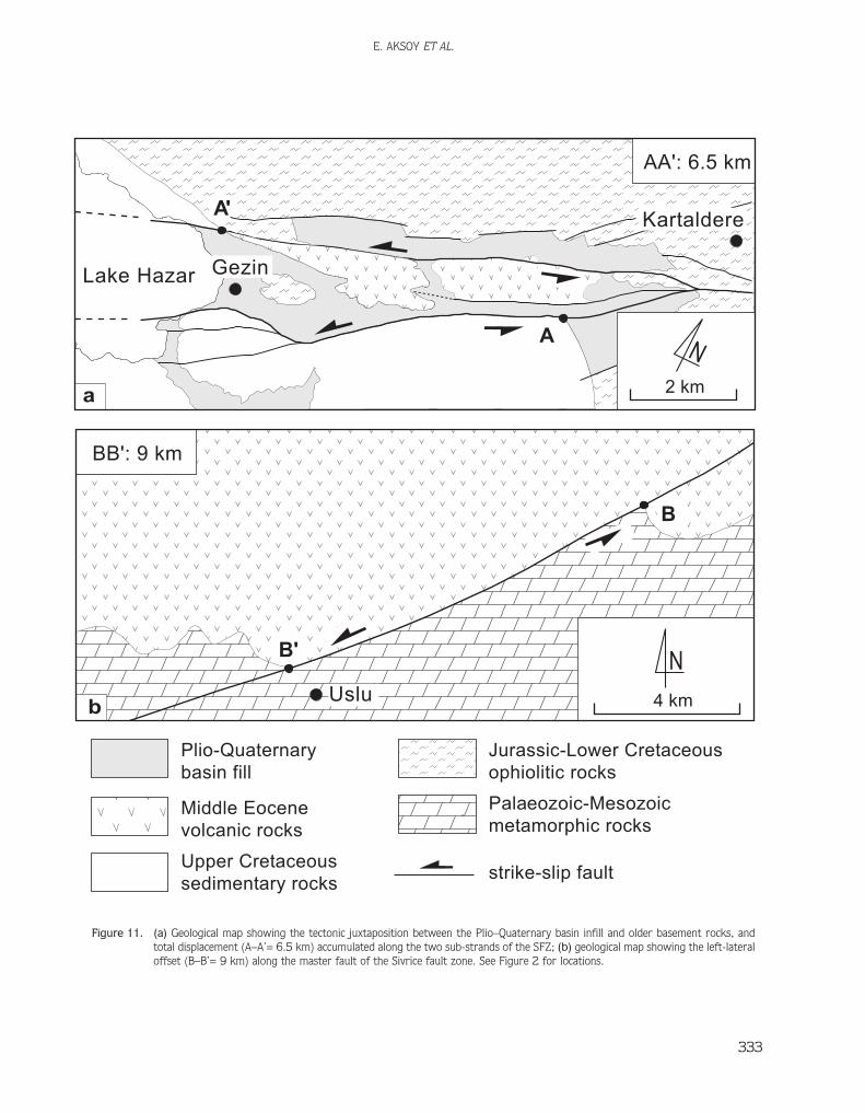
In previous works (Arpat & fiaro¤lu 1972, 1975;Hempton 1985; Herece & Akay 1992; Turan 1993;Turan & Gürocak 1997; Özdemir & ‹nceöz 2003) it hasbeen reported that the total left-lateral displacementaccumulated on the master strand of the Sivrice faultzone ranges from 9 km to 27 km, based on both thestructural and geomorphological markers such as offsetformation boundaries and drainage systems. In thepresent study it has been observed and measured to be6.5 to 9 km, respectively, based on the offset formationboundaries in the west and east of the Lake Hazar basin(Figure 11). The 9 km total displacement wasaccumulated during the Plio–Quaternary (~2.6 Ma) andyields a left-lateral slip rate of approximately 4 mm/yr. Ofcourse, the slip rate along the Sivrice fault zone may besignificantly greater than this value, because it representsthe slip rate on the master strand only; the SFZ consistsof a number of parallel to sub-parallel secondary faultsegments that also share slip along the Sivrice fault zone(Figures 2 & 4).
In the same way, the faults comprising the SFZ arenot entirely pure strike-slip in nature. This is evidenced bythe negative flower structure nature of the Lake Hazarbasin and its particularly southern margin-boundaryfaults displaying step-like morphology and slickensideswith slip lines raking at 25° and also indicating a normalcomponent (Figures 6b & 11). As has been explained inforegoing chapters, this is also supported by the greatelevation difference (1317 and 1141 m, respectively)between the floor of the Lake Hazar basin and peaks ofits both margins. Consequently, the total verticaldisplacement along the SFZ is 1317 m, and yields avertical slip rate of ~ 0.4 to 0.5 mm/ yr.
Discussion and Conclusions
In general, the Lake Hazar basin is a ~5-km-wide, 32-km-long and NE-trending strike-slip basin locatedbetween Kartaldere in the NE and Kösebay›r in the SW(Figure 2). Its northeastern and southwestern parts areterrestrial, but its central part is occupied by waters ofLake Hazar. The main bulk of the basin is located on twosub-strands of the master fault of the EAFS. The
northeastern part of the northern sub-strand and thesouthwestern part of the southern sub-strand werepreviously termed as the offset parts of a single masterfault by Hempton & Dunne (1984) (Figure12a). Theyhave also interpreted this geometrical relationship to be astrike-slip complexity in the nature of a left step-over, onwhich the Lake Hazar basin has nucleated and developedinto a classical pull-apart basin (Figure 12). In contrast totheir observation and interpretation, the fault geometryobtained by our detailed field geological mapping of activefaults, and from the bathymetric map (Biricik 1993) ofLake Hazar indicate that the master fault of the EAFSbifurcates into two sub-strands 1 km southwest ofKartaldere (Figure (8), and they run without resulting inany left step-over across Lake Hazar up to Kösebay›rvillage in the west (Figures 2, 4 & 13 a). In this newframe, the Lake Hazar basin seems to be a fault wedgetype of pull-apart basin originated from subsidence of anintervening block bounded by two sub-strands of themaster fault (Crowell 1974a). Thus, the Lake Hazar basinhas originally nucleated on these two sub-strands of themaster fault, and evolved into its present-dayconfiguration in terms of both the sub-strands and theother subordinate fault segments with considerablenormal-slip components (Figures 5, 6b & 13). Hence theLake Hazar basin is a negative flower structure (Figures5 & 13) rather than a classical pull-apart basin or rhombgraben basin (Figure 12).
Around the Lake Hazar basin, the EAFS is about 75km in width, and consists of one isolated fault and fivefault zones. These are, from north to south, the Baskilfault (BF), the Elaz›¤ fault zone (EFZ), the Uluova faultzone (UFZ), the Sivrice fault zone (SFZ), the Ad›yamanfault zone (AFZ) and the Lice-Çermik fault zone (LÇFZ)(Figure 1). Based on the structural markers (offsetformation boundaries), the total left-lateral strike-slipamount accumulated on the master strand of the EAFSwas observed and measured as 9 ± 1 km. This valueyields a slip rate of about 4 mm/yr but the slip rate alongthe EAFS must be greater than this because it is sharedby the other four fault zones and one isolated faultcomprising the EAFS (Figure 1). In the same way, at bothmargins of the Lake Hazar basin, the faults comprisingthe EAFS are not entirely pure strike-slip in nature. Thisis evidenced by the negative flower structure nature ofthe Lake Hazar basin, and its southern margin-boundaryfaults (SFZ) displaying step-like morphology and
E. AKSOY ET AL.
333
N4 kmUslu
Upper Cretaceoussedimentary rocks
Middle Eocenevolcanic rocks
strike-slip fault
Jurassic-Lower Cretaceousophiolitic rocks
Palaeozoic-Mesozoicmetamorphic rocks
Plio-Quaternarybasin fill
BB': 9 km
AA': 6.5 km
N2 km
Lake Hazar
Kartaldere
Gezin
b
a
B'
B
A'
A
Figure 11. (a) Geological map showing the tectonic juxtaposition between the Plio–Quaternary basin infill and older basement rocks, andtotal displacement (A–A’= 6.5 km) accumulated along the two sub-strands of the SFZ; (b) geological map showing the left-lateraloffset (B–B’= 9 km) along the master fault of the Sivrice fault zone. See Figure 2 for locations.

slickensides with slip lines making a rake of 25° (Figures6b & 11). Based on the great elevation difference (1317and 1141 m, respectively) between the floor of the LakeHazar basin and peaks on both margins, the total verticaldisplacement along the SFZ is estimated as 1317 ± 10 m.This value yields a vertical slip rate of ~ 0.4 to 0.5 mm/yron the Sivrice fault zone alone.
Acknowledgements
We are indebted to Editor-in-chief Erdin Bozkurt andanonymous referees for their valuable scientificcomments and constructive critics that improved thequality of the revised manuscript. Dr. John D.A. Piperkindly edited the English of the final text.
LAKE HAZAR BASIN, SE TURKEY
334
ba
NW SE
NW
SE
5 km
100
300
500
700
N
c
master fault
secondary fault
probable fault
Figure 12. (a) Map showing faults which control the structure of the Lake Hazar basin (Hempton & Dunne 1984); (b) schematic NW–SE cross-section of the basin; (c) neotectonic and bathymetric map of the Lake Hazar basin (Huntington 1902).

E. AKSOY ET AL.
335
b
ELAZIÐ BASINPALU BASIN
LAKE HAZAR BASIN
(negative flo
wer stru
cture)
Kösebayýr
SÝVRÝCE
GEZÝN
Kartaldere
Ntroughs
5 km
a
fault
probable fault
Figure 13. (a) Map showing the master fault and its sub-strands which control the negative flower structure of the Lake-Hazar basin; (b)sketch block diagram illustrating the structural evolution of the active Lake Hazar basin. Arrows show the relative motion senseson the fault segments.
References
AKSOY, E. 1993. Elazı¤ batı ve güneyinin genel jeolojik özellikleri[General geological characteristics of western and southern Elazı¤region]. Turkish Journal of Earth Sciences 2, 113–123 [inTurkish with English abstract].
AMBRASEYS, N.N. & JACKSON, J.A. 1998. Faulting associated withhistorical and recent earthquakes in the Eastern Mediterraneanregion. Geophysical Journal International 133, 390–406.
ANGELIER, J. 1994. Faults slip analysis and palaeostress reconstruction.In: HANCOCK, P.L. (ed), Continental Deformation. Pergamon,Oxford, 53–101.
ARPAT, E. & fiARO⁄LU, F. 1972. The East Anatolian Fault System:thoughts on its development. Mineral Research and ExplorationInstitute (MTA) of Turkey Bulletin 78, 33–39.
ARPAT, E. & fiARO⁄LU, F. 1975. Some significant recent tectonic events inTurkey. Geological Society of Turkey Bulletin 18, 91–101 [inTurkish with English abstract].
AYDIN, A. & NUR, A. 1982. Evolution of pull-apart basins and their scaleindependence. Tectonics 1, 91–105.
AYDIN, A. & NUR, A. 1985. The types and role of step-overs in strike-sliptectonics. In: BIDDLE, K.T. & CHRISTIE-BLICK, N. (eds), Strike-SlipFaulting and Basin Formation. Society of EconomicPaleontologists and Mineralogists, Special Publication 37, 35–44.
BALLANCE, P.F. & READING, H.G. 1980. Sedimentation in Oblique-slipMobile Zones. International Association of Sedimentologists,Special Publication 4.
BARKA, A. & HANCOCK, P.L.1984. Neotectonic deformation patterns inthe convex-northwards arc of the North Anatolian Fault Zone. In:DIXON, J.E. & ROBERTSON A.H.F. (eds), The Geological Evolution ofthe Eastern Mediterranean. Geological Society, London, SpecialPublications 17, 763–774.
BIDDLE, K.T. & CHRISTIE-BLICK, N. 1985. Strike-slip Faulting and BasinFormation. Society of Economic Paleontologists andMineralogists, Special Publication 37.
B‹R‹C‹K, A.S. 1993. Hazar (Gölcük) Gölü depresyonu (Elazı¤) [Hazar(Gölcük) Lake depression (Elazı¤)]. Türkiye Co¤rafya Dergisi 28,45–63 [in Turkish].
BOZKURT, E. & KOÇY‹⁄‹T, A. 1996. The Kazova basin: an active negativeflower structure on the Almus Fault Zone, a splay fault system ofthe North Anatolian Fault Zone, Turkey. Tectonophysics 265,239–254.
BURCHFIEL, B.C. & STEWART, J. 1966. ‘Pull-apart’ origin of the centralsegment of Death Valley, California. Geological Society of AmericaBulletin 77, 439–442.

CAREY, S.W. 1958. A tectonic approach to continental drift. In: CAREY,S.W. (convenor), Continental Drift – A Symposium, Hobart,University of Tasmania, 177–355.
ÇEL‹K, H. 2003. Mastar Da¤ı (Elazı¤ GD’su) Çevresinin Stratigrafik veTektonik Özellikleri [Stratigraphical and Tectonic Characteristicsof Master Mountain and Adjacent Area (SE of Elazı¤)]. PhDThesis, Fırat University [in Turkish with English abstract,unpublished].
ÇET‹N, H., GÜNEYL‹, H. & MAYER, L. 2003. Palaeoseismology of the Palu-Lake Hazar segment of the East Anatolian Fault Zone, Turkey.Tectonophysics 374, 163–197.
CHRISTIE-BLICK, N. & BIDDLE, K.T. 1985. Deformation and basinformation along strike-slip faults. In: BIDDLE, K.T. & CHRISTIE-BLICK, N. (eds), Strike-Slip Faulting and Basin Formation. Societyof Economic Paleontologists and Mineralogists, SpecialPublications 37, 1–34.
CRAMPIN, S. & EVANS, R. 1986. Neotectonics of the Marmara region.Journal of the Geological Society, London 143, 343–348.
CROWELL, J.C. 1974a. Origin of Late Cenozoic basins in southernCalifornia. In: DICKINSON, W.R. (ed), Tectonics and Sedimentation.Society of Economic Paleontologists and Mineralogists, SpecialPublications 22, 190–204.
CROWELL, J.C. 1974b. Sedimentation along the San Andreas fault,California. In: DOTT, R.H. & SHAVER, R.H. (eds), Modern andAncient Geosynclinal Sedimentation. Society of EconomicPaleontologists and Mineralogists, Special Publications 19,292–303.
DEWEY, J.F., HEMPTON, M.R., KIDD, W.S.F., fiARO⁄LU, F. & fiENGÖR, A.M.C.1986. Shortening of continental lithosphere: the neotectonics ofEastern Anatolia – a young collision zone. In: COWARD, M.P. &RIES, A.C. (eds), Collisional Tectonics. Geological Society, London,Special Publications 19, 3–36.
DUNNE, L. & HEMPTON, M.R. 1984. Deltaic sedimentation in the LakeHazar pull-apart basin, south-eastern Turkey. Sedimentology 31,401–412.
ERCAN, T., FUJITANI, T., MADSUDA, J.I., NOTSUT, K., TOKEL, S. & UI, T.1990. Do¤u ve Güneydo¤u Anadolu Neojen–Kuvaternervolkaniklerine iliflkin yeni Jeokimyasal, radiometrik ve izotopikverilerin yorumu [Interpretation of new geochemical, radiometricand isotopic data from Neogene–Quaternary volcanics of east-southeast Anatolia]. Mineral Research and Exploration Institute(MTA) of Turkey Bulletin 110, 143–164 [in Turkish with Englishabstract].
ERG‹N, M., AKTAR, M. & EY‹DO⁄AN, H. 2004. Present-day seismicity andseismotectonics of the Cilician Basin: Eastern MediterranianRegion of Turkey. Bulletin of the Seismological Society of America94, 930–939.
GÖRÜR, N., ÇA⁄ATAY, M.N., SAKINÇ, M., SÜMENGEN, M., fiENTÜRK, K.,YALTIRAK, C. & TCHAPALYGA, A.1997. Origin of the Sea of Marmaraas deduced from Neogene to Quaternary palaeogeographicevolution of its frame. International Geology Review 39,342–352.
GÜLEN, L., BARKA, A. & TOKSÖZ, M.N. 1987. Continental collision andrelated complex deformation; Marafl triple junction andsurrounding structures in SE Turkey. Hacettepe University, EarthSciences 14, 319–336.
GÜNEYL‹, H. 2002. Do¤u Anadolu Fay Sistemi, Palu-Hazar GölüSegmentinin Neotektoni¤i ve Palaeosismolojisi [Neotectonics andPalaeoseismology of Palu-Lake Hazar Segment of East AnatolianFault System]. PhD Thesis, Çukurova University [in Turkish withEnglish abstract, unpublished].
GÜRSOY, H., TATAR, O., PIPER, J.D.A., HEIMANN, A. & MESCI, L. 2003.Neotectonic deformation linking the East Anatolian and Karatafl-Osmaniye intracontinental transform fault zones in the Gulf of‹skenderun, southern Turkey, deduced from palaeomagneticstudy of the Ceyhan-Osmaniye volcanics. Tectonics 22, Art. No.1067
HARDING, T.P. 1976. Tectonic significance and hydrocarbon trappingconsequences of sequential folding synchronous with San Andreasfaulting, San Joaquin Valley, California. American Association ofPetroleum Geologists Bulletin 60, 356–378.
HARDING, T.P. 1985. Seismic characteristics and identification ofnegative flower structures, positive flower structures, andpositive structural inversion. American Association of PetroleumGeologists Bulletin 63, 1016–1058.
HEMPTON, M.R. 1985. Structure and deformation history of the Bitlissuture near Lake Hazar, southeastern Turkey. Geological Societyof American Bulletin 96, 233–243.
HEMPTON, M.R. 1987. Constraints on Arabian plate motion andextensional history of Red Sea. Tectonics 6, 687–705.
HEMPTON, M.R. & DEWEY, J.F. 1983. Earthquake-induced deformationalstructures in young lacustrine sediments, East Anatolian Fault,Southeast Turkey. Tectonophysics 98, T7–T14.
HEMPTON, M.R. & DUNNE, L.A. 1984. Sedimentation in pull-apart basins:active examples in eastern Turkey. Journal of Geology 92,513–530.
HEMPTON, M.R., DUNNE, L.A. & DEWEY, J.F. 1983. Sedimentation in activestrike-slip basin, Southeastern Turkey. Journal of Geology 91,401–412.
HERECE, E. & AKAY, E. 1992. Karlıova-Çelikhan arasında Do¤u Anadolufayı [East Anatolian Fault between Karlıova and Çelikhan].Abstracts, 9th Petroleum Congress of Turkey, 361–372.
HILL, M.L. & DIBBLE, T.W. 1953. San Andreas, Garlock and Big Pinefaults, California. Geological Society of America Bulletin 64,443–458.
HUNTINGTON, E. 1902. The valley of the upper Euphrates River and itspeople. Geological Society of America Bulletin 34, 301–318.
INGERSOLL, R.V. & BUSBY, C.J. 1995. Tectonics of sedimentary basins. In:BUSBY, C.J. & INGERSOLL, R.V. (eds), Tectonics of SedimentaryBasins. Blackwell Science, 1–51.
INNOCENTI, F., PISA, R., MAZZUOLI, C., PASQUARE, G., SERRI, G. & VILLARI, L.1980. Geology of the volcanic area north of Lake Van (Turkey).Geological Rundschau 69, 292–322.
KEREY, ‹.E. & TÜRKMEN, ‹. 1991. Palu formasyonunun(Pliyosen–Kuvaterner) sedimentolojik özellikleri, Elazı¤ do¤usu[Sedimentology of Palu formation (Pliocene–Quaternary), east ofElazı¤]. Geological Society of Turkey Bulletin 34, 21–26 [inTurkish with English abstract].
KAYA, A. 2004. Gezin (Maden-Elazı¤) çevresinin jeolojisi [Geology ofGezin region (Maden-Elazı¤)]. Pamukkale Üniversitesi,Mühendislik Bilimleri Dergisi 10, 41–50 [in Turkish with Englishabstract].
LAKE HAZAR BASIN, SE TURKEY
336

KOÇY‹⁄‹T, A. 1988. Tectonic setting of the Geyve basin: age and totaloffset of the Geyve fault zone, East Marmara, Turkey. METU,Journal of Pure and Applied Sciences 21, 81–104.
KOÇY‹⁄‹T, A. 1989. Suflehri basin: an active fault-wedge basin on theNorth Anatolian Fault Zone, Turkey. Tectonophysics 167, 13–29.
KOÇY‹⁄‹T, A. 1990 Tectonic setting of the Gölova basin: total offset ofthe North Anatolian fault zone, E. Pontides, Turkey. AnnalesTectonicae IV, 155–170.
KOÇY‹⁄‹T, A. 1996. Superimposed basins and their relations to recentstrike-slip fault zone: a case study of the Refahiye superimposedbasin adjacent the North Anatolian transform fault, northwesternTurkey. International Geology Review 38, 701–713.
KOÇY‹⁄‹T, A. 2003. Segmentation and near future seismicity of the EastAnatolian Fault System. Abstracts, International Workshop on theNorth Anatolian, East Anatolian and Dead Sea Fault System:Recent Progress in Tectonics and Palaeoseismology, 31 August to12 September 2003, METU (Ankara, Turkey), p. 7.
KOÇY‹⁄‹T, A. & BEYHAN, A. 1998. A new intracontinental transcurrentstructure: the Central Anatolian Fault Zone, Turkey.Tectonophysics 284, 317–336.
KOÇY‹⁄‹T, A., AKSOY, E. & ‹NCEÖZ, M. 2003. Basic NeotectonicCharacteristics of the Sivrice Fault Zone in the Sivrice-Palu area,East Anatolian Fault System (EAFS), Turkey. Excursion GuideBook, International Workshop on the North Anatolian, EastAnatolian and Dead Sea Fault Systems: Recent Progress inTectonics and Palaeoseismology, 31 August to 12 September2003, METU (Ankara, Turkey).
KOÇY‹⁄‹T, A., YILMAZ, A., ADAMIA S. & KULOSHVILI, S. 2001. Neotectonics ofEast Anatolian Plateau (Turkey) and Lesser Caucasus: implicationfor transition from thrusting to strike-slip faulting. GeodinamicaActa 14, 177–195.
LYBERISS, N., YÜRÜR, T., CHOROWICZ, J., KASAPO⁄LU, E. & GÜNDO⁄DU, N.1992. The East Anatolian Fault: an oblique collision belt.Tectonophysics 204, 1–15
MANSPEIZER, W. 1985. The Dead Sea Rift: Impact of climate andtectonism on Pleistocene and Holocene sedimentation. In: BIDDLE,K.T. & CHRISTIE-BLICK, N. (eds), Strike-Slip Faulting and BasinFormation. Society of Economic Paleontologists andMineralogists, Special Publications 37, 143–158.
MANN, P., HEMPTON, M.R., BRADLEY, D.C. & BURKE, K. 1983. Developmentof pull-apart basins. Journal of Geology 91, 529–554.
MCCLAY, K. & DOOLEY, T. 1995. Analogue models of pull-apart basins.Geology 23, 711–714.
MUEHLBERGER, W.R. & GORDON, M.B. 1987. Observation on thecomplexity of the East Anatolian Fault, Turkey. Journal ofStructural Geology 9, 899–903
NALBANT, S., MCCLUSKY, J., STEACY, S. & BARKA, A. 2002. Stressaccumulation and increased seismic risk in eastern Turkey. Earthand Planetary Science Letters 195, 291–298.
NILSEN, T.H. & SYLVESTER, A.G. 1995. Strike-slip basins. In: BUSBY, C.J.& INGERSOLL, R.V. (eds), Tectonics of Sedimentary Basins.Blackwell Science Publications, 425–457.
OKAY, A., DEM‹RBAfi, E., KURT, H., OKAY, N. & KUfiÇU ‹. 1999. An activedeep marine strike-slip basin along the North Anatolian Fault inTurkey. Tectonics 18, 129–148.
ÖZDEM‹R, M.A & ‹NCEÖZ, M. 2003. Do¤u Anadolu Fay Zonunda (Karlıova-Türko¤lu arasında) akarsu ötelenmelerinin tektonik verilerlekarflılafltırılması [Comparison of river offsets and tectonic dataalong the East Anatolian Fault Zone in the area between Karlıovaand Türko¤lu]. Afyon Kocatepe Üniversitesi Sosyal BilimlerDergisi V, 89–114 [in Turkish with English abstract].
PER‹NÇEK, D. & ÇEMEN, ‹. 1990. The structural relationship between theEast Anatolian and Dead Sea fault zones in southeastern Turkey.Tectonophysics 172, 331–340.
PER‹NÇEK, D., GÜNAY, Y. & KOZLU, H. 1987. New observations on strike-slip faults in East and Southeast Anatolia. The Seventh BiannualPetroleum Congress of Turkish Association of PetroleumGeologists, Ankara, Proceedings, 89–103.
RAHE, B., FERRIL, D.A. & MORRIS, A.P. 1998. Physical analog modeling ofpull-apart basin evolution. Tectonophysics 285, 21–40.
RAMSAY, J.G. 1967. Folding and Fracturing of Rocks. McGraw-Hill Book,New York.
REILINGER, R.E., MCCLUSKY, S.C., ORAL, M.B., KING, R.W. & TOKSÖZ, M.N.1997. Global Positioning System measurements of present-daycrustal movements in the Arabia-Africa-Eurasian plate collisionzone. Journal of Geophysical Research 102, 9983–9999.
ROBERT, D. & HATCHER, J.R. 1990. Structural Geology. Merrill PublishingCompany, London.
RODGERS, D.A. 1980. Analysis of pull-apart basin development producedby en echelon strike-slip faults. In: BALLANCE, P.F. & READING, H.G.(eds), Sedimentation in Oblique-slip Mobile Zones. InternationalAssociation of Sedimentologists, Special Publications 4, 27–41.
ROJAY, B., HEIMANN, A. & TOPRAK, V. 2001. Neotectonic and volcaniccharacteristics of the Karasu fault zone (Anatolia, Turkey): thetransition zone between the Dead Sea transform and the EastAnatolian fault zone. Geodinamica Acta 14, 197–212.
SCHUBERT, C. 1980. Late Cenozoic pull-apart basins, Bocono fault zone,Venezuelan Andes. Journal of Structural Geology 2, 463–468.
fiARO⁄LU, F. & YILMAZ Y. 1987. Do¤u Anadolu’da Neotektonik dönemdekijeolojik evrim ve havza modelleri [Geological evolution and basinmodels of East Anatolia during neotectonic period]. MineralResearch and Exploration Institute (MTA) Bulletin of Turkey 107,73–94 [in Turkish with English abstract].
fiARO⁄LU, F., EMRE, Ö. & BORAY, A. 1987. Türkiye’nin Diri Fayları veDepremsellikleri [Active Faults of Turkey and Their EarthquakePotential]. Mineral Research and Exploration Institute (MTA) ofTurkey Report no. 8174 [in Turkish, unpublished].
fiARO⁄LU, F., EMRE, Ö. & KUfiÇU, ‹. 1992. The East Anatolian Fault Zoneof Turkey. Annales Tectonicae 6, 99–125.
SEYMEN, ‹. & AYDIN, A. 1972. Bingöl deprem fayı ve bunun KuzeyAnadolu Fay Zonu ile iliflkisi [Bingöl earthquake fault and itsrelation to North Anatolian Fault Zone]. Mineral Research andExploration Institute (MTA) of Turkey Bulletin 79, 1–8 [inTurkish with English abstract].
fiENGÖR, A.M.C. 1980. Türkiye’nin Neotektoni¤inin Esasları[Fundamentals of Neotectonics of Turkey]. Conference Series,Geological Society of Turkey 2 [in Turkish].
fiENGÖR, A.M.C. & KIDD, W.S.F. 1979. Post-collisional tectonics of theTurkish-Iranian plateau and a comparison with Tibet.Tectonophysics 55, 361–376.
fiENGÖR, A.M.C. & YILMAZ, Y. 1981. Tethyan evolution of Turkey: a platetectonic approach. Tectonophysics 75, 181–241.
E. AKSOY ET AL.
337

fiENGÖR, A.M.C., GÖRÜR, N. & fiARO⁄LU, F. 1985. Strike-slip faulting andrelated basin formation in zones of tectonic escape: Turkey as acase study. In: BIDDLE, K.T. & CHRISTIE-BLICK, N. (eds), Strike-SlipFaulting and Basin Formation. Society of EconomicPaleontologists and Mineralogists, Special Publications 37,227–264.
SUNGURLU, O., PER‹NÇEK, D., KURT, G., TUNA, E., DÜLGER, S., ÇEL‹KDEM‹R, E.& NAZ, H. 1985. Elazı¤-Hazar-Palu alanının jeolojisi [Geology ofElazı¤-Hazar-Palu area]. Petrol ‹flleri Genel Müdürlü¤ü Dergisi29, 83–191 [in Turkish with English abstract].
SYLVESTER, A.G. & SMITH, R.R.1976. Tectonic transpression andbasement-controlled deformation in San Andreas fault zone,Salton Trough, California. American Association of PetroleumGeologists Bulletin 30, 2081–2102
TATAR, Y. 1987. Elazı¤ bölgesinin genel tektonik yapıları ve Landsatfoto¤rafları üzerine yapılan bazı gözlemler [Structures of Elaz›¤region and observations on Landsat images]. HacettepeUniversity, Yerbilimleri 14, 295–308.
TAYMAZ, T., EY‹DO⁄AN, H. & JACKSON, J. 1991. Source parameters of largeearthquakes in the East Anatolian Fault Zone (Turkey).Geophysical Journal International 106, 537–550
TURAN, M. 1993. Elazı¤ yakın civarındaki bazı önemli tektonik yapılar vebunların bölgenin jeolojik evrimindeki yeri [Tectonic structuresaround Elazı¤ and their significance in the geologic evolution ofthe region]. Proccedings, A. Suat Erk Jeoloji Simpozyumu (2–5Eylül 1991, Ankara), 193–204 [in Turkish with English abstract].
TURAN, M. & GÜROCAK, Z. 1997. Sivrice (Elazı¤) civarında Do¤u AnadoluFay Zonu’nun tektonik özellikleri [Tectonic characteristics of EastAnatolian Fault Zone around Sivrice (Elazı¤)]. Proceedings, 20. YılJeoloji Sempozyumu, Selçuk Üniversitesi Mühendislik-MimarlıkFakültesi Jeoloji Mühendisli¤i Bölümü, 465–477 [in Turkish withEnglish abstract].
TUTKUN, S.Z. & HANCOCK, P.L. 1990. Tectonic landforms expressingstrain at the Karlıova continental triple junction (E Turkey).Annales Tectonicae IV, 182–195.
VANNESTE, K., MEGHRAOUI, M. & CAMBELBEECK, T. 1999. Late Quaternaryearthquake-related deformation along the Belgian portion of theFeldbiss Fault, Lower Rhine Graben System. Tectonophysics 309,57–79.
WESTAWAY, R. & ARGER, J. 1996. The Gölbaflı Basin, southeasternTurkey: a complex discontinuity in a major strike-slip fault zone.Journal of the Geological Society, London 153, 729–743.
YILMAZ, Y., fiARO⁄LU, F. & GÜNER, Y. 1987. Initiation of theneomagmatism in East Anatolia. Tectonophysics 134, 177–194.
YILMAZ, Y., GÜNER, Y. & fiARO⁄LU, F. 1998. Geology of the Quaternaryvolcanic centres of the East Anatolia. Journal of Volcanology andGeothermal Research 85, 173–210.
LAKE HAZAR BASIN, SE TURKEY
338
Received 24 November 2005; revised typescript received 12 October 2006; accepted 25 January 2007