lake sturgeon in manitoba – a summary of current … · 6 the nelson river sturgeon board...
TRANSCRIPT
1
Lake Sturgeon in ManitobaA Summary of Current Knowledge
2016
2
1.0 INTRODUCTION 4
1.1 Lake Sturgeon Biogeography and Biology 4
1.2 Historical and Contemporary Trends 5
1.3 Lake Sturgeon Management in Manitoba 6
2.0 WHAT WE KNOW ABOUT LAKE STURGEON POPULATIONS IN MANITOBA 8
2.1 Churchill River 8Saskatchewan Border to Missi Falls CS 8Lower Churchill River (Missi Falls CS to Hudson Bay) 9
2.2 Saskatchewan River 11Saskatchewan Border to Grand Rapids GS 11
2.3 Nelson River 11Playgreen Lake to Whitemud Falls 13Whitemud Falls to Kelsey GS 14Kelsey GS to Kettle GS 15Kettle GS – Long Spruce GS 16Long Spruce GS – Limestone GS 17Limestone GS – Hudson Bay 17
2.4 Hayes River 18
2.5 Red-Assiniboine rivers 19Assiniboine River 19Red River 20
2.6 Lake Winnipeg (including tributaries downstream of impassible barriers) 21
2.7 East-side Tributaries of Lake Winnipeg 22
2.8 Winnipeg River 22Ontario/Manitoba Border – Pointe du Bois GS 23Pointe du Bois GS – Slave Falls GS 24Slave Falls GS – Seven Sisters GS 25Seven Sisters GS – McArthur GS 25McArthur GS – Great Falls GS 26Great Falls GS – Pine Falls GS 26
3
3.0 WHAT WE KNOW ABOUT LAKE STURGEON ECOLOGY IN MANITOBA 27
3.1 Habitat 27
3.2 Spawning 28
3.3 Early life history (egg, larval and young-of-the-year) 30
3.4 Juvenile life history 31
3.5 Adult life history 32
3.6 Recruitment patterns (year-class strength) 33
3.7 Stocking 33
3.8 Upstream passage 36
3.9 Downstream passage 36
3.10 Population structuring 37
4.0 CONCLUSION 39
5.0 REFERENCES 40
4
1.0 INTRODUCTION
Following rapid and severe population declines during the past 150 years, increasing focus has been placed on recovering Lake Sturgeon (Acipenser fulvescens) populations in Manitoba. Since approximately 1990, many parties including Manitoba Sustainable Development (MSD; formerly Manitoba Conservation and Water Stewardship (MCWS)), Department of Fisheries and Oceans (DFO), Manitoba Hydro, several sturgeon management groups, and multiple academic institutions have been involved in research and recovery efforts. Particularly within the past 15 years, the ecological understanding of Lake Sturgeon in Manitoba has improved considerably, and more is known about the status and trajectory of some of the most vulnerable populations. While Lake Sturgeon recovery initiatives in Manitoba are ongoing, the breadth of knowledge has increased to the point where a summary is warranted.
1.1 LAKE STURGEON BIOGEOGRAPHY AND BIOLOGY
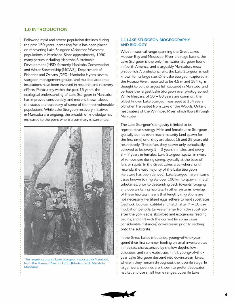
With a historical range spanning the Great Lakes, Hudson Bay and Mississippi River drainage basins, the Lake Sturgeon is the only freshwater sturgeon found in North America, and is arguably Manitoba’s most unique fish. A prehistoric relic, the Lake Sturgeon is well known for its large size. One Lake Sturgeon captured in the Roseau River, reported to be 4.5 m and 184 kg, is thought to be the largest fish captured in Manitoba, and perhaps the largest Lake Sturgeon ever photographed. While lifespans of 50 – 80 years are common, the oldest known Lake Sturgeon was aged at 154 years old when harvested from Lake of the Woods, Ontario, headwaters of the Winnipeg River which flows through Manitoba.
The Lake Sturgeon’s longevity is linked to its reproductive strategy. Male and female Lake Sturgeon typically do not even reach maturity (and spawn for the first time) until they are about 15 and 25 years old, respectively. Thereafter, they spawn only periodically; believed to be every 1 – 3 years in males, and every 3 – 7 years in females. Lake Sturgeon spawn in rivers of various size during spring, typically at the base of falls or rapids. In the Great Lakes area (where, until recently, the vast majority of the Lake Sturgeon literature has been derived), Lake Sturgeon are in some cases known to migrate over 100 km to spawn in natal tributaries, prior to descending back towards foraging and overwintering habitats. In other systems, overlap of these habitats means that lengthy migrations are not necessary. Fertilized eggs adhere to hard substrates (bedrock, boulder, cobble) and hatch after 7 – 10 day incubation periods. Larvae emerge from the substrate after the yolk-sac is absorbed and exogenous feeding begins, and drift with the current (in some cases considerable distances) downstream prior to settling onto the substrate.
In the Great Lakes tributaries, young-of-the-year spend their first summer feeding on small invertebrates in habitats characterized by shallow depths, low velocities, and sand-substrate. In fall, young-of-the-year Lake Sturgeon descend into downstream lakes, wherein they remain throughout the juvenile stage. In large rivers, juveniles are known to prefer deepwater habitat and use small home ranges. Juvenile Lake
The largest captured Lake Sturgeon reported in Manitoba, from the Roseau River in 1903. (Photo credit: Manitoba Museum)
5
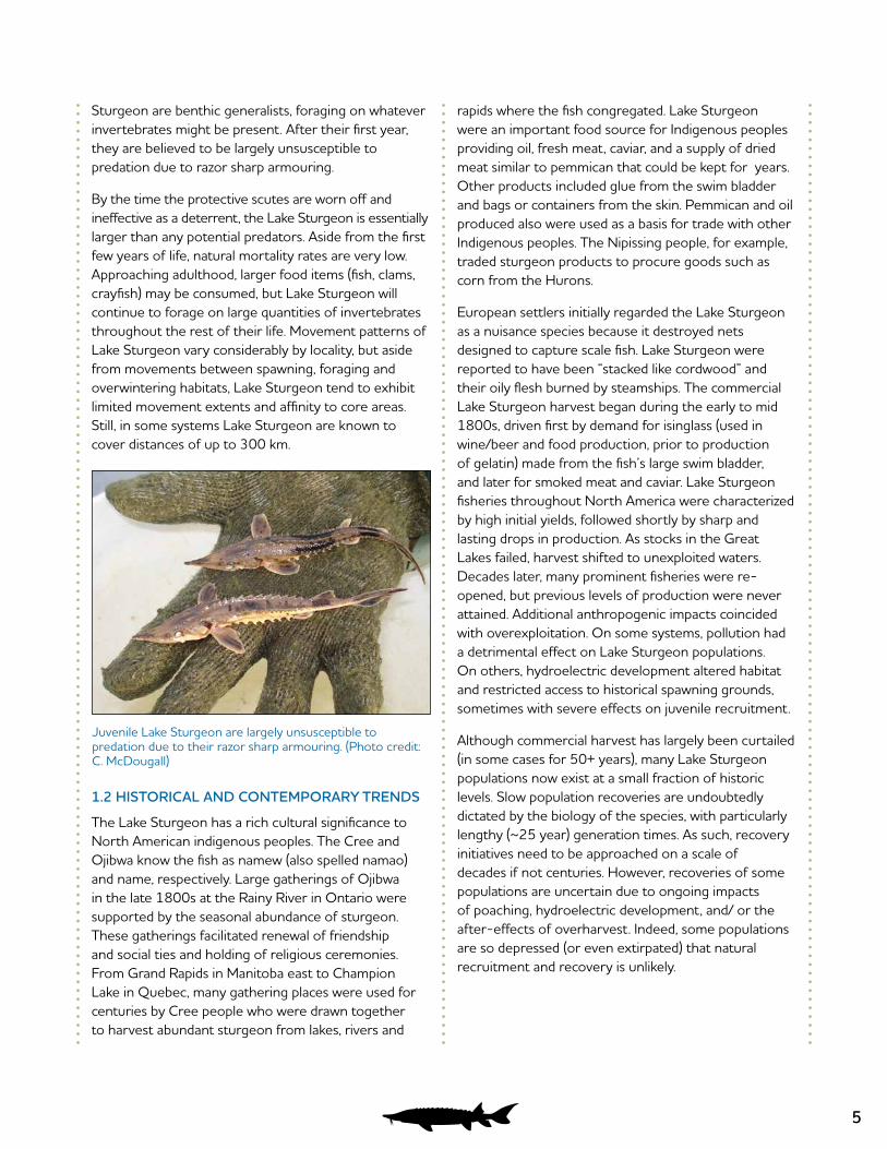
Juvenile Lake Sturgeon are largely unsusceptible to predation due to their razor sharp armouring. (Photo credit: C. McDougall)
Sturgeon are benthic generalists, foraging on whatever invertebrates might be present. After their first year, they are believed to be largely unsusceptible to predation due to razor sharp armouring.
By the time the protective scutes are worn off and ineffective as a deterrent, the Lake Sturgeon is essentially larger than any potential predators. Aside from the first few years of life, natural mortality rates are very low. Approaching adulthood, larger food items (fish, clams, crayfish) may be consumed, but Lake Sturgeon will continue to forage on large quantities of invertebrates throughout the rest of their life. Movement patterns of Lake Sturgeon vary considerably by locality, but aside from movements between spawning, foraging and overwintering habitats, Lake Sturgeon tend to exhibit limited movement extents and affinity to core areas. Still, in some systems Lake Sturgeon are known to cover distances of up to 300 km.
1.2 HISTORICAL AND CONTEMPORARY TRENDS
The Lake Sturgeon has a rich cultural significance to North American indigenous peoples. The Cree and Ojibwa know the fish as namew (also spelled namao) and name, respectively. Large gatherings of Ojibwa in the late 1800s at the Rainy River in Ontario were supported by the seasonal abundance of sturgeon. These gatherings facilitated renewal of friendship and social ties and holding of religious ceremonies. From Grand Rapids in Manitoba east to Champion Lake in Quebec, many gathering places were used for centuries by Cree people who were drawn together to harvest abundant sturgeon from lakes, rivers and
rapids where the fish congregated. Lake Sturgeon were an important food source for Indigenous peoples providing oil, fresh meat, caviar, and a supply of dried meat similar to pemmican that could be kept for years. Other products included glue from the swim bladder and bags or containers from the skin. Pemmican and oil produced also were used as a basis for trade with other Indigenous peoples. The Nipissing people, for example, traded sturgeon products to procure goods such as corn from the Hurons.
European settlers initially regarded the Lake Sturgeon as a nuisance species because it destroyed nets designed to capture scale fish. Lake Sturgeon were reported to have been “stacked like cordwood” and their oily flesh burned by steamships. The commercial Lake Sturgeon harvest began during the early to mid 1800s, driven first by demand for isinglass (used in wine/beer and food production, prior to production of gelatin) made from the fish’s large swim bladder, and later for smoked meat and caviar. Lake Sturgeon fisheries throughout North America were characterized by high initial yields, followed shortly by sharp and lasting drops in production. As stocks in the Great Lakes failed, harvest shifted to unexploited waters. Decades later, many prominent fisheries were re-opened, but previous levels of production were never attained. Additional anthropogenic impacts coincided with overexploitation. On some systems, pollution had a detrimental effect on Lake Sturgeon populations. On others, hydroelectric development altered habitat and restricted access to historical spawning grounds, sometimes with severe effects on juvenile recruitment.
Although commercial harvest has largely been curtailed (in some cases for 50+ years), many Lake Sturgeon populations now exist at a small fraction of historic levels. Slow population recoveries are undoubtedly dictated by the biology of the species, with particularly lengthy (~25 year) generation times. As such, recovery initiatives need to be approached on a scale of decades if not centuries. However, recoveries of some populations are uncertain due to ongoing impacts of poaching, hydroelectric development, and/ or the after-effects of overharvest. Indeed, some populations are so depressed (or even extirpated) that natural recruitment and recovery is unlikely.

6
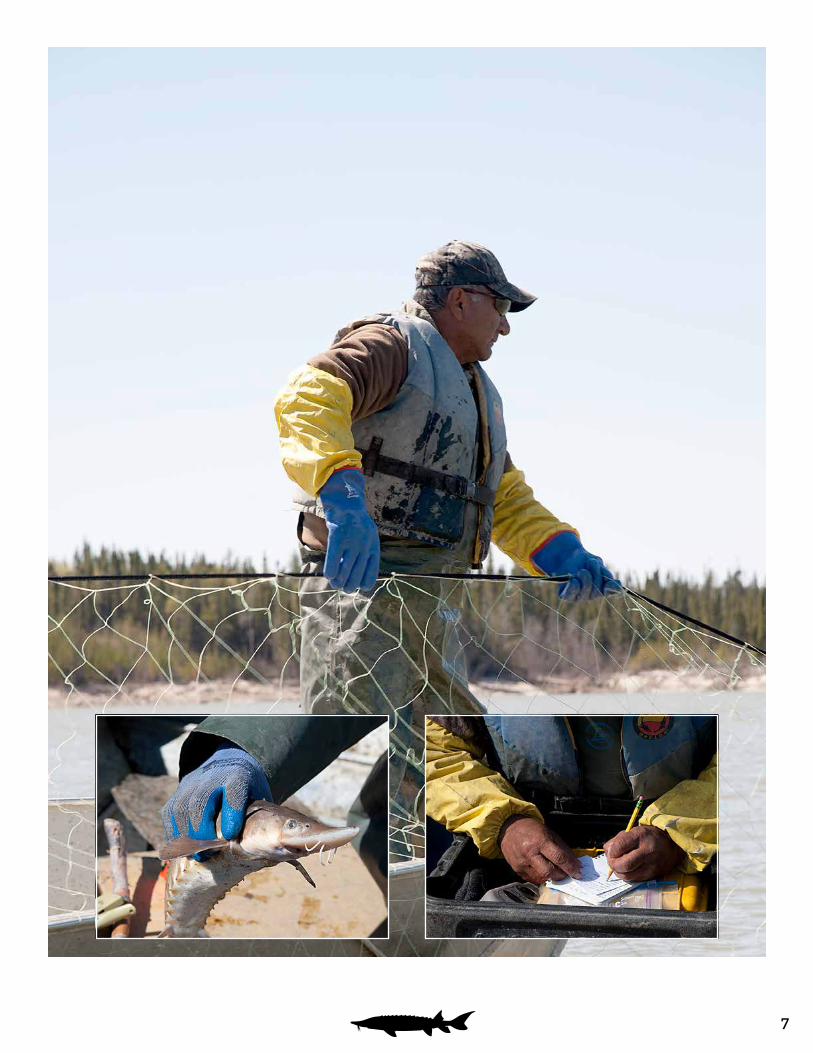
The Nelson River Sturgeon Board captures and tags Lake Sturgeon annually to monitor the population in the Nelson River near the Landing River.
1.3 LAKE STURGEON MANAGEMENT IN MANITOBA
Manitoba Sustainable Development (MSD) is responsible for the management of Lake Sturgeon populations in Manitoba. The Lake Sturgeon Management in Manitoba strategy document was developed by MSD in 1992, and updated in 1997. The most recent version (Lake Sturgeon Management Strategy) was released in 2012 (MCWS 2012). Manitoba’s broad Lake Sturgeon management goals are:
• To ensure that existing populations are protected from depletion, and;
• In areas with suitable habitat, restore Lake Sturgeon populations to levels where they can be considered stable and self-sustaining.
Goals of various other stakeholder organizations within Manitoba are similar and supportive of MSD’s goals.
The Nelson River Sturgeon Board (NRSB) formed in 1993, following the negotiated settlement of a Northern Flood Agreement claim, in response to declining Nelson River Lake Sturgeon populations. The Board acts in an advisory capacity for the upper Nelson River, between Lake Winnipeg and the Kelsey Generating Station (GS). The NRSB is funded by Manitoba Hydro, Indigenous and Municipal Relations, and supplemented by provincial and federal grants. The objectives of the NRSB are:
• Conservation and enhancement of Lake Sturgeon stocks in the upper Nelson River,
• Providing the information and means to manage the harvest of sturgeon to meet the subsistence need of the people of the area, now and in the future, and;
• Establishing funding and administrative mechanisms to implement the above objectives.
The Saskatchewan River Sturgeon Management Board (SRSMB), formed in 1998, acts in an advisory capacity on sturgeon management for the Saskatchewan River between the E.B. Campbell and Grand Rapids dams. The SRSMB is or has been funded by SaskPower, Manitoba Hydro, Saskatchewan Watershed Authority, Saskatchewan Environment, Manitoba Sustainable Development, Saskatchewan Northern Affairs, and the Saskatchewan Fish and Wildlife Development Fund. The SRSMB has short and long term goals:
• To prevent further decline of the sturgeon population, and to develop and co-ordinate a recovery plan (short term), and;
• To have a Saskatchewan River Lake Sturgeon population between E. B. Campbell HS and Grand Rapids GS that is self-sustaining and capable of supporting traditional uses of local Indigenous people (long term).
In 2008, Manitoba Hydro developed a comprehensive Lake Sturgeon Stewardship and Enhancement Plan (LSSEP) to consolidate and build upon past efforts and guide new programs. The vision of the LSSEP is: “To maintain and enhance Lake Sturgeon populations in areas affected by Manitoba Hydro’s operations, now and in the future.” This vision will be achieved by ensuring that Manitoba Hydro’s current activities do not contribute to a decline or jeopardize the sustainability of sturgeon populations in Manitoba.
The Kischi Sipi Namao Committee (KSNC, formerly the Lower Nelson River Sturgeon Stewardship Committee) was established in 2013 and its membership includes Fox Lake Cree Nation, York Factory First Nation, Tataskweyak Cree Nation, War Lake First Nation, Shamattawa First Nation, Keeyask Hydropower Limited Partnership, Manitoba Hydro, and Manitoba Sustainable Development (non-voting member). The committee is “committed to implementing measures to protect and enhance sturgeon populations in the Lower Nelson River from Kelsey Generating Station to Hudson Bay” (LNRSSC 2013). The KSNC has completed their Sturgeon Stewardship Plan which includes the committee’s vision, goals and strategies. The committee is currently working on the strategies in their 2016-2017 Work Plan, which will help them achieve their primary goals of gathering and sharing information, youth involvement, and bringing people and communities together.
7
8
2.0 WHAT WE KNOW ABOUT LAKE STURGEON POPULATIONS IN MANITOBA
The following section summarizes what is known about the various Lake Sturgeon populations in Manitoba. Both the Department of Fisheries and Oceans (Cleator et al. 2010a-e) and Manitoba Sustainable Development (MCWS 2012) have produced summaries similar to those presented herein, chronicling the demise of many populations and discussing population status and trajectory of each. A considerable amount of research has been conducted in recent years that has improved the knowledge of Lake Sturgeon ecology in Manitoba, and has partially addressed some of the major population data gaps. While the principal objective of this section is to summarize and concisely present recent or otherwise overlooked information, for context, it is also necessary to reiterate information previously referred to by Cleator et al. (2010a-e) and
MCWS (2012). Lake Sturgeon inhabit Manitoba’s largest river systems, ranging across the width of the province, and from the Canada/US border in the south to Churchill in the north. Summaries for the various systems in which Lake Sturgeon occur are presented.
2.1 CHURCHILL RIVER
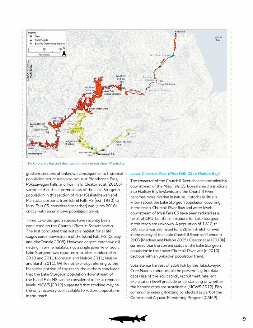
The Churchill River flows over 1,600 km from headwaters at Churchill Lake, Saskatchewan to the community of Churchill, Manitoba where it enters Hudson Bay. The Churchill River drains ~281,300 km2 (Rosenberg et al. 2005), with a basin stretching west into Alberta. The lower ~800 km of the river flows through the province of Manitoba. The Missi Falls Control Structure (CS; est. 1977), located at the outlet of Southern Indian Lake, is the only hydroelectric structure found on the Manitoba portion of the Churchill River and is operated by Manitoba Hydro. However, the Island Falls Hydroelectric Station (HS) located upstream in Saskatchewan influences Churchill River flow in Manitoba. The Missi Falls CS was constructed as part of the Churchill River Diversion (CRD) project, which directs flow from the lower Churchill River into the Rat/Burntwood system to provide additional flow for Manitoba Hydro generating stations located on the Burntwood and Nelson rivers (Manitoba Hydro 2013). In addition to Churchill, the communities of Mathias Colomb Cree Nation at Pukatawagan, Marcel Colomb Cree Nation at Lynn Lake and O-Pipon-Na-Piwin Cree Nation at Southern Indian Lake lie along the banks of the Churchill River. Lake Sturgeon were known to be harvested from the Churchill River intermittently from 1938 to 1990 (Stewart 2009). However, commercial harvest records do not disclose a level of production that would be necessary to decimate populations (MCWS 2012). Lake Sturgeon commercial harvest records are likely incomplete and therefore underestimated, and it is suspected that Churchill River records may have been grouped with the Saskatchewan River fishery (MCWS 2012).
Saskatchewan Border to Missi Falls CS
This section of the Churchill River consists of several large shield lakes (Sisipuk, Pukatawagan, Granville and Southern Indian) interspersed with relatively short riverine sections. Granville Falls, which consists of a near vertical drop of about 7.6 m (Denis and Challies 1916), is certainly a barrier to upstream movement. High
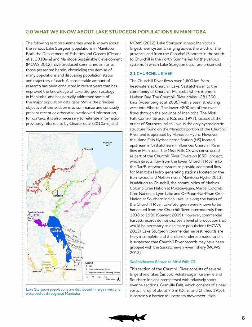
Lake Sturgeon populations are distributed in large rivers and waterbodies throughout Manitoba.
9
gradient sections of unknown consequence to historical population structuring also occur at Bloodstone Falls, Pukatawagan Falls, and Twin Falls. Cleator et al. (2010b) surmised that the current status of the Lake Sturgeon population in this section of river (Saskatchewan and Manitoba portions, from Island Falls HS [est. 1930] to Missi Falls CS, considered together) was (circa 2010) critical with an unknown population trend.
Three Lake Sturgeon studies have recently been conducted on the Churchill River in Saskatchewan. The first concluded that suitable habitat for all life stages exists downstream of the Island Falls HS (Cooley and MacDonald 2008). However, despite extensive gill netting in prime habitats, not a single juvenile or adult Lake Sturgeon was captured in studies conducted in 2010 and 2011 (Johnson and Nelson 2011; Nelson and Barth 2011). While not explicitly referring to the Manitoba portion of the reach, the authors concluded that the Lake Sturgeon population downstream of the Island Falls HS can be considered to be at remnant levels. MCWS (2012) suggested that stocking may be the only recovery tool available to restore populations in this reach.
Lower Churchill River (Missi Falls CS to Hudson Bay)
The character of the Churchill River changes considerably downstream of the Missi Falls CS. Boreal shield transitions into Hudson Bay lowlands, and the Churchill River becomes more riverine in nature. Historically, little is known about the Lake Sturgeon population occurring in this reach. Churchill River flow and water levels downstream of Missi Falls CS have been reduced as a result of CRD, but the implications for Lake Sturgeon in this reach are unknown. A population of 1,812 +/- 508 adults was estimated for a 28 km stretch of river in the vicinity of the Little Churchill River confluence in 2003 (Maclean and Nelson 2005). Cleator et al. (2010b) surmised that the current status of the Lake Sturgeon population in the Lower Churchill River was (c. 2010) cautious with an unknown population trend.
Subsistence harvest of adult fish by the Tataskweyak Cree Nation continues to the present day, but data gaps (size of the adult stock, recruitment rate, and exploitation level) preclude understanding of whether the harvest rates are sustainable (MCWS 2012). Fish community index gillnetting conducted as part of the Coordinated Aquatic Monitoring Program (CAMP),
The Churchill, Rat and Burntwood rivers in northern Manitoba.
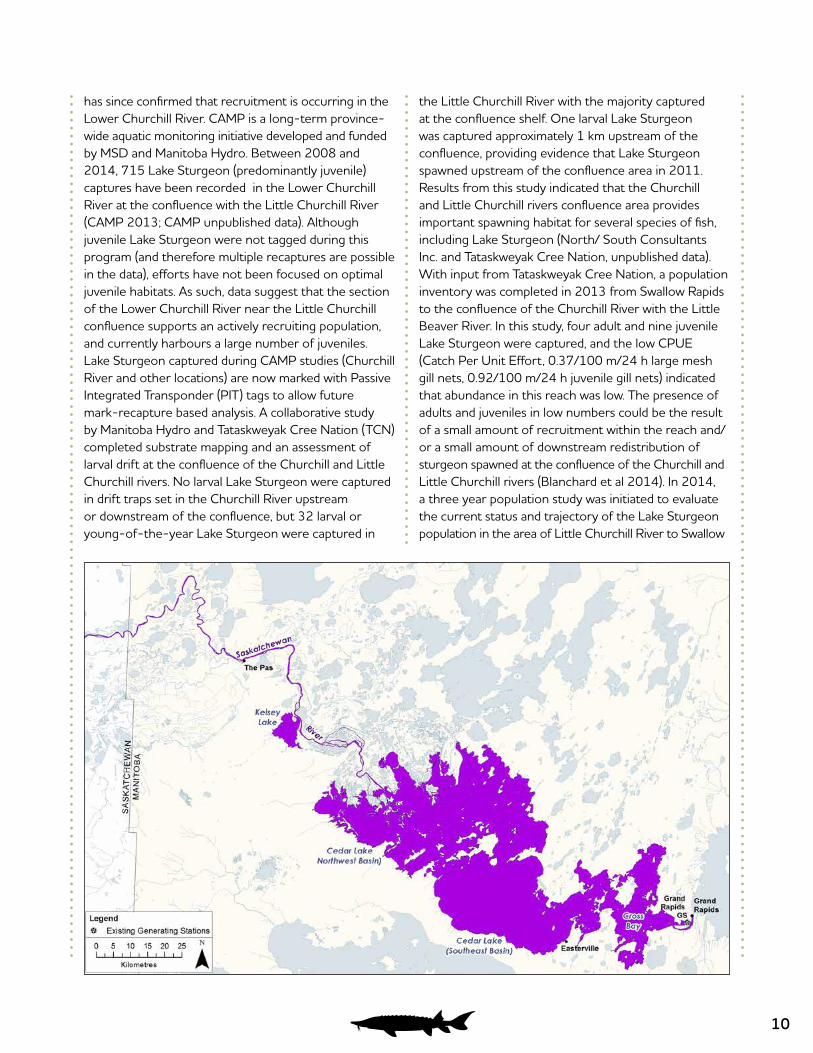
10
has since confirmed that recruitment is occurring in the Lower Churchill River. CAMP is a long-term province-wide aquatic monitoring initiative developed and funded by MSD and Manitoba Hydro. Between 2008 and 2014, 715 Lake Sturgeon (predominantly juvenile) captures have been recorded in the Lower Churchill River at the confluence with the Little Churchill River (CAMP 2013; CAMP unpublished data). Although juvenile Lake Sturgeon were not tagged during this program (and therefore multiple recaptures are possible in the data), efforts have not been focused on optimal juvenile habitats. As such, data suggest that the section of the Lower Churchill River near the Little Churchill confluence supports an actively recruiting population, and currently harbours a large number of juveniles. Lake Sturgeon captured during CAMP studies (Churchill River and other locations) are now marked with Passive Integrated Transponder (PIT) tags to allow future mark-recapture based analysis. A collaborative study by Manitoba Hydro and Tataskweyak Cree Nation (TCN) completed substrate mapping and an assessment of larval drift at the confluence of the Churchill and Little Churchill rivers. No larval Lake Sturgeon were captured in drift traps set in the Churchill River upstream or downstream of the confluence, but 32 larval or young-of-the-year Lake Sturgeon were captured in
the Little Churchill River with the majority captured at the confluence shelf. One larval Lake Sturgeon was captured approximately 1 km upstream of the confluence, providing evidence that Lake Sturgeon spawned upstream of the confluence area in 2011. Results from this study indicated that the Churchill and Little Churchill rivers confluence area provides important spawning habitat for several species of fish, including Lake Sturgeon (North/ South Consultants Inc. and Tataskweyak Cree Nation, unpublished data). With input from Tataskweyak Cree Nation, a population inventory was completed in 2013 from Swallow Rapids to the confluence of the Churchill River with the Little Beaver River. In this study, four adult and nine juvenile Lake Sturgeon were captured, and the low CPUE (Catch Per Unit Effort, 0.37/100 m/24 h large mesh gill nets, 0.92/100 m/24 h juvenile gill nets) indicated that abundance in this reach was low. The presence of adults and juveniles in low numbers could be the result of a small amount of recruitment within the reach and/or a small amount of downstream redistribution of sturgeon spawned at the confluence of the Churchill and Little Churchill rivers (Blanchard et al 2014). In 2014, a three year population study was initiated to evaluate the current status and trajectory of the Lake Sturgeon population in the area of Little Churchill River to Swallow
The Saskatchewan River in western Manitoba.

11
Rapids. In summer 2014, CPUE of adult Lake Sturgeon was 4.3/100 m/24 hr, demonstrating that Lake Sturgeon abundance is high in the confluence area. Fish ages ranged from 2 – 42 years (Dolce Blanchard and Barth 2015). In 2015, 348 adult Lake Sturgeon were captured, 93 of which were recaptures of previous tagging efforts. A preliminary population estimate using 2014 and 2015 large mesh gillnetting data was calculated to be 1,573±172 Lake Sturgeon in this area (Ambrose and McDougall 2016). In summer 2010, a 45 km stretch of river (~25 km downstream of Billard Lake and ~20 km upstream and downstream of Fidler Lake) was surveyed with large mesh gillnets. Only one Lake Sturgeon was captured, and catch per unit effort indicated that adult Lake Sturgeon abundance in this stretch was very low (North/South Consultants [NSC] 2011).
2.2 SASKATCHEWAN RIVER
The Saskatchewan River proper begins at the confluence of the South Saskatchewan and North Saskatchewan rivers in the province of Saskatchewan and flows ~550 km prior to emptying into Lake Winnipeg. It drains an area of ~335,900 km2 (Rosenberg et al. 2005), including the vast majority of southern and central Alberta, and a considerable portion of Saskatchewan. The lower ~290 km of the Saskatchewan River flows through the province of Manitoba. The communities of The Pas, Chemawawin Cree Nation at Easterville and Grand Rapids lie along its banks. The Grand Rapids GS [est. 1960], located at the end of the river’s course, is the only hydroelectric structure on the Manitoba portion of the river, however the E.B. Campbell HS located upstream in Saskatchewan influences flow patterns in Manitoba. Commercial Lake Sturgeon harvest was first reported from the Saskatchewan River in 1898, and 511,698 kg were harvested in Manitoba over the next century, although primarily at the onset of the fishery (Stewart 2009). Lake Sturgeon commercial harvest records are likely incomplete and therefore underestimated (Stewart 2009). However, it is suspected that Churchill River commercial fishing records may have been grouped with the Saskatchewan River fishery (MCWS 2012), which complicates interpretation of these data.
Saskatchewan Border to Grand Rapids GS
The Saskatchewan River enters the province of Manitoba as a large, meandering, low-gradient single channel. It flows 120 km before branching into a large delta and becoming Cedar Lake, which serves as the Grand Rapids
GS reservoir. The Grand Rapids GS operates on a peaking and ponding schedule, meaning that there is some short-term variation in water-levels upstream of the station; however, these variations are relatively minor due to the size of the reservoir; water levels within Cedar Lake typically vary by <1.5 m annually (Manitoba Hydro unpublished data). The tail-end of the population decline in this section of the Saskatchewan River is well-documented, and is summarized in Wallace (1991) and Cleator et al. (2010e). By 2000, Lake Sturgeon abundance had declined considerably based on fisheries surveys conducted between Cumberland House (upstream in the province of Saskatchewan) and The Pas (Wallace and Leroux 1999). Lake Sturgeon are known to move between the Manitoba and Saskatchewan portions of the River, and spawning may only occur downstream of the E.B. Campbell HS (MCWS 2012). Cleator et al. (2010e) surmised that the current status of the Lake Sturgeon population in this section of river (Saskatchewan and Manitoba portions, from E.B. Campbell HS to the Grand Rapids GS, considered together) was (c. 2010) critical with a stable population trend.
Annual monitoring studies have been conducted by the SRSMB in recent years, although data reports have not been published. A 10-Year Management Plan Review summarized that although recent analysis suggests that the population may be stable, there was little evidence that it was increasing (NSC 2012a). Although stocking was conducted from 1999-2007, the effective contribution to year-class strength has not been determined (NSC 2012a). Harvest surveys conducted on the Saskatchewan River at The Pas indicated that harvests may not have been sustainable in 2001 and 2002 (NSC 2003). Current harvest levels are not known. In 2015, gill nets were set from E.B. Campbell HS to Cedar Lake in deep water areas which have been shown to be preferred habitat for juvenile Lake Sturgeon. A total of 149 Lake Sturgeon were captured, indicating a healthy population in this reach with successful spawning and recruitment of juveniles and abundant rearing habitat (Nelson and Johnson 2016).
2.3 NELSON RIVER
The Nelson River begins at the outlet of Lake Winnipeg, flowing ~650 km and dropping 217 m in elevation prior to emptying into Hudson Bay. The Nelson River funnels water from the Winnipeg, Saskatchewan and Red rivers, as well as a multitude of smaller rivers which flow into Lake Winnipeg, and has a drainage basin of ~1,093,442 km2
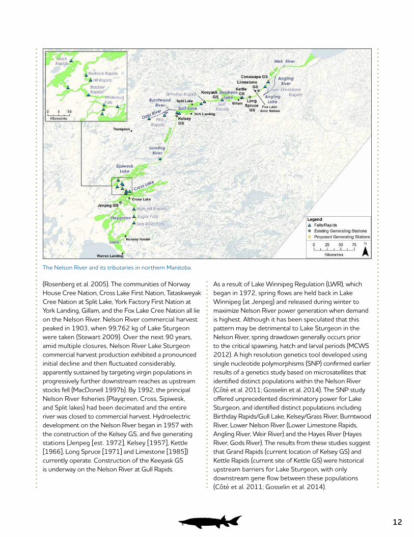
12
(Rosenberg et al. 2005). The communities of Norway House Cree Nation, Cross Lake First Nation, Tataskweyak Cree Nation at Split Lake, York Factory First Nation at York Landing, Gillam, and the Fox Lake Cree Nation all lie on the Nelson River. Nelson River commercial harvest peaked in 1903, when 99,762 kg of Lake Sturgeon were taken (Stewart 2009). Over the next 90 years, amid multiple closures, Nelson River Lake Sturgeon commercial harvest production exhibited a pronounced initial decline and then fluctuated considerably, apparently sustained by targeting virgin populations in progressively further downstream reaches as upstream stocks fell (MacDonell 1997b). By 1992, the principal Nelson River fisheries (Playgreen, Cross, Sipiwesk, and Split lakes) had been decimated and the entire river was closed to commercial harvest. Hydroelectric development on the Nelson River began in 1957 with the construction of the Kelsey GS, and five generating stations (Jenpeg [est. 1972], Kelsey [1957], Kettle [1966], Long Spruce [1971] and Limestone [1985]) currently operate. Construction of the Keeyask GS is underway on the Nelson River at Gull Rapids.
As a result of Lake Winnipeg Regulation (LWR), which began in 1972, spring flows are held back in Lake Winnipeg (at Jenpeg) and released during winter to maximize Nelson River power generation when demand is highest. Although it has been speculated that this pattern may be detrimental to Lake Sturgeon in the Nelson River, spring drawdown generally occurs prior to the critical spawning, hatch and larval periods (MCWS 2012). A high resolution genetics tool developed using single nucleotide polymorphisms (SNP) confirmed earlier results of a genetics study based on microsatellites that identified distinct populations within the Nelson River (Côté et al. 2011; Gosselin et al. 2014). The SNP study offered unprecedented discriminatory power for Lake Sturgeon, and identified distinct populations including Birthday Rapids/Gull Lake, Kelsey/Grass River, Burntwood River, Lower Nelson River (Lower Limestone Rapids, Angling River, Weir River) and the Hayes River (Hayes River, Gods River). The results from these studies suggest that Grand Rapids (current location of Kelsey GS) and Kettle Rapids (current site of Kettle GS) were historical upstream barriers for Lake Sturgeon, with only downstream gene flow between these populations (Côté et al. 2011; Gosselin et al. 2014).
The Nelson River and its tributaries in northern Manitoba.
13
Playgreen Lake to Whitemud Falls
The uppermost reach of the Nelson River is approximately 160 km long, and begins at Warren Landing at the northern end of Lake Winnipeg. This reach is dominated by two large and shallow lakes (Playgreen and Cross), that are dotted with many rocky reefs. Riverine habitat is also bedrock controlled. Three man-made channels supplement the natural outflow in the vicinity of Playgreen Lake to reduce a bottleneck effect for flood control on Lake Winnipeg and optimization of hydroelectric power generation. Downstream of Playgreen Lake, the Nelson River branches into two channels; a western channel historically referred to as “God’s River” and an eastern channel referred to as “Sea River”. The Jenpeg GS is located on the western channel, immediately upstream of Cross Lake. On a short-term scale, the Jenpeg GS operates as “run-of-the-river”, passing flows as they are received. But as noted above, Lake Winnipeg water levels are regulated at Jenpeg on an annual interval. The eastern channel is unregulated, and contains numerous rapids including Sea (River) Falls and Sugar Falls. The eastern channel flows through Pipestone Lake, prior to merging with the western channel in Cross Lake. Two channels exit Cross Lake, and significant hydraulic gradients at Whitemud Falls and Eves Falls mark the downstream extent of the reach. Whitemud Falls is believed to be a complete barrier to upstream movement, but passage over Eves Falls may be possible under certain flow conditions (MCWS 2012). Lake Sturgeon were historically common in this reach. Based on archaeological evidence, Lake Sturgeon fishing was a part of the prehistoric and early historic subsistence economy in the Sea River Falls area (Petch 1992). Meticulous Hudson Bay Company Archive records show that, along with Lake Whitefish, Lake Sturgeon comprised the bulk of the subsistence fish harvest of indigenous people in the Norway House area during the mid 19th Century (Northern Lights Heritage Services 1994). Although commercial harvest records do not always differentiate locations, Playgreen and Cross lakes were known to be harvested (Skaptason 1926; Stewart 2009) and it is assumed that much of the reach was targeted (and largely decimated) during the early days of the Manitoba commercial fisheries (McDougall and Pisiak 2012).
In response to populations being deemed nearly extirpated during the early 1990s, stocking initiatives were undertaken by the NRSB, using brood-stock
collected from the Landing River tributary (located downstream of this reach). From 1994 to 2015 107,699 fingerlings (age-0), 4,446 yearlings (age-1), 51 age-2 sturgeon, and an estimated 523,000 larvae were stocked into the upper Nelson River including Sea Falls, Jenpeg, Sipiwesk Lake, Cross Lake, and Little Playgreen Lake. A minimal amount of targeted subsistence harvest occurs downstream of the Jenpeg GS and in Eves Rapids (MCWS 2012). Cleator et al. (2010a) surmised that the status of the Lake Sturgeon population in the Playgreen Lake to Whitemud Falls reach was (c. 2010) critical with an increasing trajectory due to stocking. To evaluate the success of the stocking initiative, the NRSB and Manitoba Hydro (LSSEP) collaborated on Lake Sturgeon inventory studies in the Sea Falls to Sugar Falls area (a 19 km stretch) annually from 2012 to 2015. Results of these studies indicated that stocking has resulted in the re-establishment of a small juvenile population between Sea Falls and Sugar Falls (McDougall and Pisiak 2012). Relative recruitment success results (based on PIT tag recaptures and growth chronology interpretation) indicated that fish stocked at age-1 comprised the vast majority of the Lake Sturgeon between Sea Falls and Sugar Falls (McDougall and Pisiak 2012, McDougall and Pisiak 2014, McDougall and Nelson 2015, McDougall and Nelson 2016). Although the survival (and/or retention) of age-0 stocked fish is considerably lower than for fish stocked at age-1 (or older), there were indications of modest contributions of age-0 or larval stocked fish (McDougall and Nelson 2016). In the 2015 inventory, 94.6% of sturgeon captured possessed hatchery PIT tags (McDougall and Nelson 2016).
In 2015, an experiment was conducted in the Sea Falls to Sugar Falls reach to examine retention of Lake Sturgeon stocked directly into deepwater habitats versus released from shore. Both acoustic telemetry and mark-recapture results provided strong evidence that survival/retention was not different between the two release methods (McDougall and Nelson 2016). Pipestone Lake (~30 km downstream of Sugar Falls, previously extirpated) has also been surveyed to evaluate success of stocking initiatives in this reach of the Nelson River. Results indicated a low density of juvenile Lake Sturgeon in this formerly extirpated reach (McDougall and Pisiak 2014), suggesting downstream dispersal immediately after stocking and significant growth of stocked age-1 individuals in Pipestone Lake (Aiken and McDougall 2016).
14
In a juvenile Lake Sturgeon inventory conducted in 2014 on Little Playgreen Lake, 30 Lake Sturgeon were caught, 27 of which had hatchery PIT tags (Burnett and McDougall 2015). Of these 27, 24 of the fish are from the 2013 cohort, stocked as yearlings in spring of 2014, while the other 3 Lake Sturgeon were likely from the 2012 cohort (1 of which was raised at the hatchery, the other 2 were raised in school aquariums; Burnett and McDougall 2015). Most of the sturgeon caught during this inventory had not experienced their first winter which can be difficult for young sturgeon however, they had grown substantially post-release. Stocked age-1 or age-2 Lake Sturgeon have made a substantial contribution to the re-establishment of a juvenile Lake Sturgeon population in Little Playgreen Lake (Burnett and McDougall 2015).
Cross Lake consists of many islands separated by narrow channels, most often with steep bedrock shorelines, as well as large off current bays (Henderson et al. 2015). The substrate is primarily clay and silt/clay but in areas of higher flow (such as the narrow channels, and the thalweg) the substrate is bedrock/cobble/gravel/sand (Henderson et al. 2015). Surveys of spawning adults downstream of Jenpeg Generating Station (GS) resulted in the capture of 26 Lake Sturgeon in 2014 (CPUE of 0.12 LKST/100m/24h) and 22 Lake Sturgeon in 2015 (CPUE of 0.06 LKST /100m/24). In 2014, a substantial proportion of those captured were juveniles, despite the use of large mesh gill nets to target spawning adults. One pre-spawn male and 3 post-spawn males were captured in 2014 (Henderson et al. 2015). In 2015, one of these males was again captured in spawning condition, and a ripe female was also captured (Bell et al. 2016). The capture of these fish in pre-spawning/spawning/post-spawning condition suggests that some reproduction (and possibly in situ recruitment) is occurring downstream of Jenpeg GS. The adults and subadults captured in these studies were smaller in size, suggesting that we may expect to see a future increase in the spawning stock. Spring subsistence harvest was observed downstream of Jenpeg GS during both years of study (Henderson et al. 2015, Bell et al. 2016)
Due to the relatively high number of juveniles captured downstream of Jenpeg Generating Station during the spring spawning surveys, it was surprising that the fall juvenile survey completed in 2015 captured only 34 juvenile Lake Sturgeon (CPUE 0.7 LKST/100m/24 h)
(Bell et al. 2016). The majority of juvenile Lake Sturgeon captured were observed to have weak or absent fin ray annuli which suggests that they were hatchery reared and released at age-1. One juvenile had a PIT tag which identified it as having been originally stocked at age-1 in the Sea Falls reach in May 2014. The remaining juveniles were assigned to either the 2010 or 2011 cohort based on their fin ray annuli (Bell et al. 2016).
Whitemud Falls to Kelsey GS
The Whitemud Falls to Kelsey GS reach of the Nelson River is approximately 220 km long. Downstream of Whitemud Falls (and Eves Falls), the two channels flow swiftly through shield bedrock, with several sets of rapids occurring prior to the channels merging in Sipiwesk Lake. Sipiwesk is a large lake characterized by irregular shorelines and a multitude of bedrock islands and reefs. Backwatering from the Kelsey GS (downstream) extends to the upstream end of the lake. Downstream of Sipiwesk, the Nelson River runs long and straight for about 150 km prior to reaching the Kelsey GS. This stretch is deep, and although several historical rapids have been inundated by backwatering from the Kelsey GS, moderate to high flow conditions still predominate. The Kelsey GS typically operates as run-of-the-river, passing flows as they are received with little short-term fluctuation in flow or water levels. The decline of Lake Sturgeon populations in this reach is well chronicled (Sunde 1961; Sopuck 1987; MacDonald 1998; Cleator et al. 2010a; MCWS 2012). The broad consensus is that this reach supported a very large population historically, prior to being decimated by overharvest. By 1993, a primary spawning run to the Landing River tributary (located downstream of Sipiwesk Lake) had been so reduced by harvest (commercial and subsistence) that sometimes only a few adults were observed annually, where hundreds used to be the norm. The establishment of the NRSB and the invoking of a Conservation Closure of sturgeon harvest (1994 - present) for the Landing River area occurred in response to Landing River issues (MCWS 2012). There has also been concern that changes to the flow regime caused by LWR may have impacted Lake Sturgeon in this reach (MCWS 2012). The amount of aquatic habitat available during the open-water season is lower than pre-LWR levels, which could reduce food resources (Cleator et al. 2010a). However, growth rates in Lake Sturgeon were similar in the 1990s to those observed in the 1950s, prior to LWR and construction of Kelsey GS in 1957 (Macdonald 1998).

15
As of 2010, this reach likely contained fewer than 1,300 adult Lake Sturgeon (Cleator et al. 2010a), a decline of 80-90% compared to 1960s levels, by which time commercial harvest was well underway. Between 1994 and 2011, a total of 16,465 fingerlings (Landing River progeny) were stocked, mainly at Duck Rapids (MCWS 2012). Cleator et al. (2010a) surmised that the status of Lake Sturgeon populations in Whitemud Falls to Kelsey GS reach was (c. 2010) cautious with a stable or possibly increasing trajectory. Captures of smaller fish (presumed to be predominantly wild) in recent years indicate recruitment, possibly tied to closure of the commercial fishery (MCWS 2012). The NRSB and Manitoba Hydro (LSSEP) collaborated to complete a juvenile inventory study in the vicinity of the Landing River in 2013. Erratic recruitment patterns are evident, but all strong year classes link back to years in which stocking was not conducted in the vicinity, substantiating previous suspicions of natural recruitment (Groening et al 2014). The inlets of Sipiwesk Lake were inventoried in fall 2015, and although catch rates were low, no Lake Sturgeon captured possessed hatchery PIT tags, indicating in-situ spawning and recruitment (Henderson et al. 2016). Substrate in the Redrock Rapids reach is dominated by clay substrate while the substrate in the Duck Lake is more varied (bedrock, boulder, cobble, gravel and sand in varying abundance) (Henderson et al. 2016).
Kelsey GS to Kettle GS
The Kelsey GS to Kettle GS reach of the Nelson River is ~150 km in length. It is dominated by several large lakes (Split, Clark, Gull and Stephens) separated by high-gradient riverine sections. Downstream of the Kelsey GS, the Nelson River splits into two channels and flows through bedrock before emptying into Split Lake. The Burntwood and Odei rivers empty into the western arm of Split Lake. Clark Lake, located just downstream of Split Lake is separated from Gull Lake by a ~25 km riverine section which includes a significant hydraulic drop at Birthday (Overflow) Rapids. Downstream of Gull Lake, the Nelson River again pitches at Gull Rapids (the site of Keeyask GS), before becoming Stephens Lake, the Kettle GS reservoir. The Kettle GS operates on a peaking and ponding schedule, passing more flow when hydroelectric demand is high, and storing water in the large Stephens Lake reservoir when demand is low. The large volume of Stephens Lake effectively minimizes the effects of peaking and ponding on water level fluctuation on a short-term scale; even on an annual
scale, forebay water levels typically vary by less than 1 m (Manitoba Hydro unpublished data).
By the time the Nelson River fishery was closed in 1960, the Lake Sturgeon population in this area was considered to have been depleted (MCWS 2012). The Kelsey GS prevents upstream movement of Lake Sturgeon, but genetic differentiation of populations upstream and downstream indicates that the sharp 6 m hydraulic drop (Grand Rapid; Denis and Challies 1916) was a historical barrier to upstream movement and gene flow (Côté et al. 2011, Gosselin et al. 2014). Backwatering from the Kettle GS caused extensive flooding upstream as far as Gull Rapids, meaning that the hydraulic drop present today is less than it would have been historically. Furthermore, this backwatering dramatically altered the character of the Gull Rapids to Kettle GS stretch, which was previously a confined riverine section of moderate gradient (Denis and Challies 1916).
The vast majority of current knowledge about Lake Sturgeon in this reach stems from environmental studies completed by Manitoba Hydro related to the Keeyask GS. Mark-recapture tagging as well as acoustic telemetry studies indicate that adult Lake Sturgeon tend to remain in the various water bodies in which they have been captured, but some movements (both upstream and downstream) at Gull Rapids and Birthday Rapids have been observed (Barth and Mochnacz 2004; Barth 2005; Barth and Murray 2005; Barth and Ambrose 2006; Barth and MacDonald 2008; MacDonald 2008; 2009; Michaluk and MacDonald 2010; MacDonald and Barth 2011; Hrenchuk and McDougall 2012).
Based on data collected from the aforementioned studies as well as tagging conducted in Split Lake during the 1990s, another study initiated by Manitoba Hydro explicitly addressed population size (and trajectory) in this reach. Mean regional population estimates for Lake Sturgeon in the Clark Lake to Gull Rapids population ranged from 344 to 1,275 between 2001 and 2009 (Nelson and Barth 2012). Mean population estimates for the Upper Split Lake population ranged from 183 to 654 between 2001 and 2009. There was no clear increasing or decreasing trend for either population, and it was noted that the precision of the estimates will improve over time, as additional monitoring data are incorporated and local resource user tag returns become available (Nelson and Barth 2012). Juvenile Lake Sturgeon (including age-0, a.k.a. young-of-the-year)
16
have been captured in several discrete locations in the reach, including the riverine section between the Kelsey GS and Split Lake, on the Burntwood River downstream of First Rapids, in Gull Lake, and at the upstream end of Stephens Lake (MacDonald 2008; 2009; Michaluk and MacDonald 2010). Based largely on adult population data (in a preliminary form) and juvenile results, Cleator et al. (2010a) surmised that the status of the Lake Sturgeon population in the Kelsey GS to Kettle GS reach was (c. 2010) cautious with an unknown trajectory.
Recently, increased emphasis has been placed on understanding the juvenile life stage in this reach. Results indicate generally low juvenile abundance in the Burntwood River, while the Gull Lake and Stephens Lake juvenile segments are dominated by a single strong cohort, produced in 2008 (Henderson and Pisiak 2012). Using a newly developed high resolution genetics tool based on single nucleotide polymorphisms, the contribution of parents to the juveniles captured in Gull Rapids was evaluated. It was determined that, particularly in the Gull Rapids juveniles, there is a high contribution of a small number of parents (Gosselin et al. 2014). With other factors affecting recruitment, this could result in the vastly different cohort strengths that have been observed in Gull Lake and in other Boreal Shield rivers (Gosselin et al. 2014, McDougall et al. 2014a).
Kettle GS – Long Spruce GS
The Kettle GS to Long Spruce CS (a.k.a. Long Spruce Forebay) section of the Nelson River is ~16 km long. The upstream portion has retained some of its riverine character, but daily fluctuation of flow occurs due to peaking and ponding operations controlled at the Kettle GS. The downstream portion has been strongly altered by backwatering from the Long Spruce GS. Water levels typically vary on a weekly basis, decreasing from Monday through Friday prior to increasing on the weekend. At the upstream end of the forebay, water levels fluctuated within a 0.81 to 1.71 m range during the open-water season; at the downstream end of the reservoir, fluctuations are more muted, varying from 0.35 to 0.70 m during the same period (Manitoba Hydro unpublished data).
Nothing is known historically about Lake Sturgeon in this reach (Cleator et al. 2010). Given that almost the entire section was high gradient (Denis and Challies 1916), it is uncertain whether it provided much useable habitat prior to hydroelectric development. Cleator et al. (2010a) surmised, based on forebay monitoring
studies predominantly completed by Manitoba Hydro, that the status of the Lake Sturgeon population in the Kettle GS to Long Spruce GS was (c. 2010) critical with an unknown trajectory.
Studies completed under the Manitoba Hydro LSSEP reassessed the spawning and juvenile segments of the population in this reach (Lavergne 2012; Lavergne and Barth 2012). In spring 2012, only six adult (and one juvenile) Lake Sturgeon were captured near the base of the Kettle GS powerhouse and spillway, while in fall 2012, only ten juveniles were captured in the middle portion of the reach, echoing the results of previous monitoring studies (Swanson et al. 1988; 1990; 1991; Ambrose et al. 2008; 2009). It was reasoned that the low number of Lake Sturgeon available to spawn annually is one factor likely to be limiting population growth in the reach (Lavergne and Barth 2012). Although the majority of Lake Sturgeon captured in the Long Spruce Forebay over the years have been younger than the age of the forebay, it is unclear if recruitment has occurred successfully within this stretch (Lavergne and Barth 2012), or if individuals present are solely immigrants from upstream of the Kettle GS. Survived downstream passage at the Kettle GS has been documented (Hrenchuk and McDougall 2012), so immigration appears to be at least somewhat influential. Population supplementation (either via stocking or downstream movement of fish from upstream locations) may be required to yield population growth (Lavergne and Barth 2012); however, two issues may be compounding factors. First, if patterns are consistent with those observed in the Winnipeg River (McDougall et al. 2013a), contiguous deepwater habitat throughout the mid to lower portions of this small reservoir (and a lack of natural movement restrictors) means that entrainment of middle life stages (juveniles and subadults) through the Long Spruce GS may occur at a high rate. Second, it is unclear whether suitable habitat to support all life stages of Lake Sturgeon exists within the forebay (MCWS 2012). The results of HSI modeling for Lake Sturgeon spawning downstream of Kettle GS suggest that there are large quantities of habitat suitable for spawning when constrained only by velocity, depth and substrate. The addition of flow direction and distance decreases the estimated suitable spawning habitat area, but habitat still appears to be present in sufficient quantities as to not limit the spawning success of Lake Sturgeon in the area (Sutton and McDougall 2016).
17
Long Spruce GS – Limestone GS
The Long Spruce GS to Limestone GS (a.k.a. Limestone Forebay) reach of the Nelson River is 23 km long. The nature of the Limestone Forebay mirrors that of the Long Spruce Forebay. The upstream portion of the reach has retained some of its riverine character, but daily fluctuation of flow occurs due to peaking and ponding operations controlled at the Kettle GS. The downstream portion has been strongly altered by backwatering from the Limestone GS. Water levels typically also vary on a weekly basis, decreasing from Monday through Friday, prior to increasing on the weekend (Cleator et al. 2010a). In general, water levels fluctuation mirrors the pattern observed in the Kettle GS – Long Spruce GS reach (see above). Aside from anecdotal reports, nothing is known about Lake Sturgeon use of this reach historically (Cleator et al. 2010a). Much of the reach was moderately graded (Denis and Challies 1916), so it is uncertain whether it provided much useable habitat prior to hydroelectric development. Lake Sturgeon have been captured herein that are younger than the age of impoundment, but it is considered unlikely that there is a self-sustaining population (MCWS 2012). Cleator et al. (2010a) surmised, based on forebay monitoring studies predominantly completed by Manitoba Hydro, that the status of the Lake Sturgeon population in the Long Spruce GS to Limestone GS reach was (c. 2010) critical with an unknown trajectory.
In 2007, Manitoba Hydro initiated a study to determine habitat use and movement patterns of juvenile and subadult Lake Sturgeon in the Limestone Forebay. Following capture (downstream of Limestone GS), 16 Lake Sturgeon were implanted with acoustic transmitters and released (off-current) at the upstream end of the Limestone Forebay (Ambrose et al. 2009). Over the next two years, these fish were tracked (during the open-water seasons) with an array of stationary acoustic receivers, deployed throughout the Limestone Forebay, as well as downstream in the lower Nelson River to monitor downstream passage. Habitat use varied over time. Movements throughout the forebay were observed, but in 2007, fish tended to use the upper sections where more riverine type habitat occurs (Ambrose et al. 2009). In 2008, the majority of detections occurred in the middle and lower sections of the reservoir. By the end of the 2010 open-water season (when tags were nearing expiry), eight of the sixteen transferred fish were definitively known to have
passed downstream through the Limestone GS; four in 2007 and four in 2008 (further study details in Section 3.9) (Pisiak et al. 2011).
Limestone GS – Hudson Bay
The Limestone GS – Hudson Bay reach of the Nelson River consists of ~100 km of moderate gradient riverine habitat, prior to becoming intermittently saline (dependant on Nelson River flow volumes and tidal influence) in the vicinity of Port Nelson. Short-term flow and water level fluctuations are common in this stretch of river, due to the influence of peaking and ponding operations at the Kettle GS located upstream. Downstream of Limestone GS, extensive dewatering occurs on a daily basis, and the effect on Lake Sturgeon populations is not understood (MCWS 2012). While commercial records do not differentiate locations enough to say for certain, historical harvest was likely minimal from this area, primarily due to access difficulties. After 1970, the lower Nelson River (downstream from Kettle GS to Hudson Bay) was considered a separated management area, from which almost no harvest occurred. Because of this, and reasoned impacts of extensive hydroelectric development, it was concluded that there were few Lake Sturgeon in this reach (MCWS 2012).
Accessibility in this area improved in the early 1990s with the construction of the Conawapa road. Environmental studies commissioned by Manitoba Hydro as part of planning for the Conawapa GS which began during the 1990s revealed that the Lake Sturgeon population in this section of river was much larger than previously thought (MacDonell 1995; 1997a; 1998; Barth and MacDonell 1999; Holm et al. 2006; Ambrose et al. 2008; 2009; 2010a; 2010b; Pisiak et al. 2011). Spawning locations at the Weir River, Angling River, and Lower Limestone Rapids have been confirmed, and an extensive mark-recapture data set dating back to the 1990s produced a population estimate of 5,467 (95% CI: 3,768-8,018) adults for 2004/2005 for the reach of river extending from the Angling River to Deer Island (NSC, unpublished data, in Cleator et al. [2010a]). A concentration of juveniles has been located in the vicinity of Jackfish Island, essentially the only large area (~3 km2) in the lower Nelson River where deepwater (>10 m) and lower water velocities predominate (Ambrose et al. 2010a). One juvenile (age-2) was captured in the Hudson Bay estuary with limited effort (Holm and Bernhardt 2011), but it is

18
unclear to what extent juveniles use this area. Cleator et al. (2010a) surmised that the status of the Lake Sturgeon population in the Limestone GS to Hudson Bay reach was (c. 2010) healthy with an unknown trajectory. Harvest on the lower Nelson River has increased since the construction of the Conawapa Road (MCWS 2012).
Mark-recapture methods have revealed that Nelson River Lake Sturgeon move upstream into Angling Lake, and at least occasionally, through the Nelson River estuary and far upstream into the Hayes River system (Ambrose et al. 2010b; Klassen 2012).
2.4 HAYES RIVER
The Hayes River system is located in the north-eastern corner of the province, and includes the Fox, Bigstone, and Gods rivers, which are tributaries to the Hayes River proper. The Hayes River is ~485 km long, flowing northeast through a series of lakes before emptying into Hudson Bay. While the upper reaches of the Hayes River and its various tributaries feature pool/riffle streams, and deep shield lakes, the lower portion of the system is fast flowing and shallow, cutting through the Hudson Bay
lowlands. The system has not been developed, but was commercially fished for short durations. However, it was never depleted to the severity of Manitoba’s other major river systems (MCWS 2012). The last commercial Lake Sturgeon fishing license was for the Fox River, which closed in 1999. A population study initiated by Manitoba Hydro estimated a Fox River population, between Great Falls and Rainbow Falls, of 646 +/- 334 adults during 2004/2005 (Pisiak and MacLean 2007).
Relatively little is known about Hayes River Lake Sturgeon, but populations are believed to be healthy. However, issues may result if harvest pressures increases, since productivity (and carrying capacity) of these rivers is expected to be low (MCWS 2012). As noted previously, Lake Sturgeon tagged in the lower Nelson River have been recaptured in the Hayes River system (Ambrose et al. 2010b; Klassen 2012), but recent high-resolution genetic results have shown that the Nelson and Hayes River populations are genetically distinct (Gosselin et al. 2014). Interestingly, the same study indicated that Lake Sturgeon captured in the lower Hayes River proper and those captured in the lower Gods River are not genetically differentiated, suggesting
The Hayes River and its tributaries in northern Manitoba.
19
a degree of historical population connectivity (Gosselin et al. 2014). Lake Sturgeon have been captured in every year that fish community index gillnetting has been conducted as part of the Coordinated Aquatic Monitoring Program (CAMP) (annually since 2008), capturing from 15-80 Lake Sturgeon in a sampling period (CAMP, unpublished data).
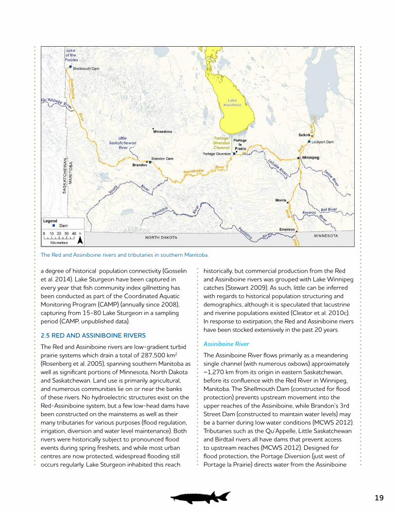
2.5 RED AND ASSINIBOINE RIVERS
The Red and Assiniboine rivers are low-gradient turbid prairie systems which drain a total of 287,500 km2 (Rosenberg et al. 2005), spanning southern Manitoba as well as significant portions of Minnesota, North Dakota and Saskatchewan. Land use is primarily agricultural, and numerous communities lie on or near the banks of these rivers. No hydroelectric structures exist on the Red-Assiniboine system, but a few low-head dams have been constructed on the mainstems as well as their many tributaries for various purposes (flood regulation, irrigation, diversion and water level maintenance). Both rivers were historically subject to pronounced flood events during spring freshets, and while most urban centres are now protected, widespread flooding still occurs regularly. Lake Sturgeon inhabited this reach
historically, but commercial production from the Red and Assiniboine rivers was grouped with Lake Winnipeg catches (Stewart 2009). As such, little can be inferred with regards to historical population structuring and demographics, although it is speculated that lacustrine and riverine populations existed (Cleator et al. 2010c). In response to extirpation, the Red and Assiniboine rivers have been stocked extensively in the past 20 years.
Assiniboine River
The Assiniboine River flows primarily as a meandering single channel (with numerous oxbows) approximately ~1,270 km from its origin in eastern Saskatchewan, before its confluence with the Red River in Winnipeg, Manitoba. The Shellmouth Dam (constructed for flood protection) prevents upstream movement into the upper reaches of the Assiniboine, while Brandon’s 3rd Street Dam (constructed to maintain water levels) may be a barrier during low water conditions (MCWS 2012). Tributaries such as the Qu’Appelle, Little Saskatchewan and Birdtail rivers all have dams that prevent access to upstream reaches (MCWS 2012). Designed for flood protection, the Portage Diversion (just west of Portage la Prairie) directs water from the Assiniboine
The Red and Assiniboine rivers and tributaries in southern Manitoba.
20
River into Lake Manitoba, and is likely a barrier to upstream movement. Also owing to this structure, Lake Sturgeon now have the potential to colonize Lake Manitoba, a large lake from which Lake Sturgeon were not historically known (MCWS 2012). A recent capture report suggests this is the case.
Lake Sturgeon historically ranged throughout much of the Assiniboine River and its tributaries, and it is believed that the Little Saskatchewan, Souris and Qu’Appelle rivers may have provided important spawning habitat prior to the species being extirpated from the river (Cleator et al. 2010c). Between 1996 and 2008, brood-stock collected from the Winnipeg, Saskatchewan and Nelson rivers were used to facilitate the re-introduction of approximately 16,683 Lake Sturgeon (4,000 fry, 12,416 fingerlings, 205 yearlings, 55 juveniles, and 7 adults) into the Assiniboine River near Brandon. A total of 280 angler reported captures (between 1998 and 2002) seems to indicate that stocking has
been relatively successful (Cleator et al. 2010c); these fish appear to be ranging throughout much of the river, having been recaptured by anglers as far upstream as the Qu’Appelle River in Saskatchewan and downstream as far as Spruce Woods Provincial Park (MCWS 2012). Cleator et al. (2010c), albeit referring only to the stretch of the Assiniboine river upstream of the Portage Diversion, surmised that the natural population is extirpated, while the status (c. 2010) of the stocked population is critical and increasing. A LSSEP population inventory conducted on the Assiniboine River in fall 2013 captured 23 juveniles (427 – 531 mm fork length) and 7 subadults/adults (820 – 1040 mm) in two deeper (2.5 – 6 m) areas just downstream of the Brandon industrial sector (Aiken et al. 2013).
Red River
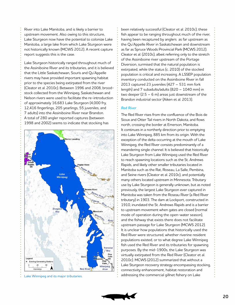
The Red River rises from the confluence of the Bois de Sioux and Otter Tail rivers in North Dakota, and flows north, crossing the border at Emerson, Manitoba. It continues in a northerly direction prior to emptying into Lake Winnipeg, 885 km from its origin. With the exception of the delta occurring at the mouth of Lake Winnipeg, the Red River consists predominantly of a meandering single channel. It is believed that historically Lake Sturgeon from Lake Winnipeg used the Red River to reach spawning locations such as the St. Andrews Rapids, and likely other smaller tributaries located in Manitoba such as the Rat, Roseau, La Salle, Pembina, and Seine rivers (Cleator et al. 2010c), and potentially many others located upstream in Minnesota. Tributary use by Lake Sturgeon is generally unknown, but as noted previously, the largest Lake Sturgeon ever captured in Manitoba was taken from the Roseau River (a Red River tributary) in 1903. The dam at Lockport, constructed in 1910, inundated the St. Andrews Rapids and is a barrier to upstream movement when gates are closed (normal mode of operation during the open-water season), and the fishway that exists there does not facilitate upstream passage for Lake Sturgeon (MCWS 2012). It is unclear how populations that historically used the Red River were structured, whether riverine resident populations existed, or to what degree Lake Winnipeg fish used the Red River and its tributaries for spawning purposes. By the mid-1900s, the Lake Sturgeon was virtually extirpated from the Red River (Cleator et al. 2010c). MCWS (2012) summarized that without a Lake Sturgeon recovery strategy encompassing stocking, connectivity enhancement, habitat restoration and addressing the commercial gillnet fishery on Lake Lake Winnipeg and its major tributaries.
21
Winnipeg, population recovery is unlikely. Extensive stocking has been undertaken in the Red River system upstream in Minnesota, and several recaptures of tagged Lake Sturgeon on both the Red River and Lake Winnipeg have been reported (MCWS 2012). Cleator et al. (2010c) surmised that the natural population in the Red River is extirpated, while the status (c. 2010) of the stocked population is critical and increasing. There has been no directed Lake Sturgeon research conducted in the Manitoba portion of the Red River in recent years.
2.6 LAKE WINNIPEG (INCLUDING TRIBUTARIES DOWNSTREAM OF IMPASSIBLE BARRIERS)
Lake Winnipeg is the largest lake in Manitoba, and the eleventh largest freshwater lake on Earth, covering an area of 24,514 km2. It consists of a generally shallow south basin, and a much larger and deeper north basin, which is joined by a deep narrow channel. Lake Winnipeg is bordered to the east by the Boreal Shield and to the
west by the Boreal Plains, and has a catchment basin of ~984,000 km2. Numerous small communities lie on the banks of Lake Winnipeg. Several large tributaries (Winnipeg, Saskatchewan, Red/Assiniboine rivers) and other smaller ones (Bloodvein, Pigeon, Berens and Poplar rivers) harbour lake Sturgeon populations, but historical population structuring patterns are unknown. Dams (for hydroelectric generation or navigational purposes) now exist near the mouth of each aforementioned large tributaries while potentially impassable falls or rapids exist near the mouths on smaller east-side tributaries (MCWS 2012). The Lake Sturgeon population in Lake Winnipeg was decimated by commercial harvest during the late 1800s and early 1900s. In the first 20 years of the fishery, the total reported commercial harvest exceeded 2.8 million kg (Stewart 2009). From 1905 to 1910, annual catches declined precipitously from 272,100 kg to only 13,699 kg, and the fishery was closed. Amid periodic openings and subsequent closures, low levels of production continued into the 1970s.
In recent years, three Lake Sturgeon have been reported captured in the Hecla Island area (D. Kroeker, pers. comm. in Cleator et al. 2010c), and seven Lake Sturgeon which were tagged and released in the Red River system in Minnesota have been recaptured (Cleator et al. 2010c). Similar to the assessment for Red River populations, MCWS (2012) summarized that population recovery is unlikely without a strategy encompassing stocking, connectivity enhancement, habitat restoration and addressing the commercial gillnet fishery on Lake Winnipeg. Cumulative downstream movement of Lake Sturgeon resident in Lake Winnipeg tributaries (Winnipeg, Saskatchewan, Red/Assiniboine rivers and various smaller east-side systems) might eventually repopulate Lake Winnipeg (MCWS 2012), but it is unclear how long this would take. Cleator et al. (2010c) surmised that the current status of the Lake Sturgeon population in Lake Winnipeg (including the Winnipeg River below the Pine Falls GS) was (c. 2010) cautious with an unknown population trend.
Index gillnetting was conducted downstream of the Pine Falls GS in 2013 as part of environmental monitoring related to Manitoba Hydro station repairs. A total of 54 Lake Sturgeon were captured downstream of Pine Falls GS with relatively little gillnet effort. Most sturgeon were captured in spring (n=38), of which many (n=22) were classified as ripe males in spawning condition (Lowden and Queen 2013).
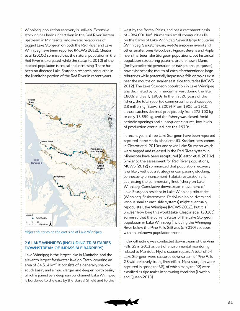
Major tributaries on the east side of Lake Winnipeg.
22
2.7 EAST-SIDE TRIBUTARIES OF LAKE WINNIPEG
The Bloodvein, Pigeon, Berens and Poplar rivers all empty into the east side of Lake Winnipeg and are known to contain Lake Sturgeon populations. All are unregulated, and habitat has remained relatively pristine. Each flows through Boreal Shield, and consists of a mixture of riverine and lacustrine habitat. Numerous falls and rapids occur on each system, and as mentioned previously, it is unclear how Lake Winnipeg/tributary populations were historically structured. In this regard, MCWS (2012) noted that the Lake Sturgeon that spawned in tributary mouths might have been Lake Winnipeg resident fish. Communities occurring on the eastside tributaries include Berens River, Little Grand Rapids and Pauingassi First Nation (both on Berens River), Bloodvein First Nation and Poplar River First Nation. With the exception of the Ontario portion of the Berens River system, these rivers have not been subject to commercial harvest or affected by industrial development (MCWS 2012). Subsistence harvest is known to occur in all of them (Dick 2006). The Round Lake portion of the Pigeon River was estimated to have a population of 800-1,000 fish, with very few
spawning females (Dick 2006), but little else is known about Lake Sturgeon populations in these rivers. Cleator et al. (2010c) surmised that the current status of the Lake Sturgeon population in the east-side tributaries (each was denoted its own management unit) was, in general, (c. 2010) unknown with unknown population trends. The lone exception would be the Berens River population, which based on data from the Ontario portion of the river, warranted a cautious status with an increasing population trend (Cleator et al. 2010c). There has been no directed Lake Sturgeon research conducted on east-side tributaries of Lake Winnipeg in recent years.
2.8 WINNIPEG RIVER
The Winnipeg River flows 260 km from its outlets at Lake of the Woods, Ontario, prior to emptying into Lake Winnipeg at Traverse Bay. The Winnipeg River has a drainage basin of 135,800 km2, the majority of which lies in the province of Ontario and the state of Minnesota, and provides the largest single inflow to Lake Winnipeg (Rosenberg et al. 2005). Historically, the river consisted of a series of deep shield lakes, connected
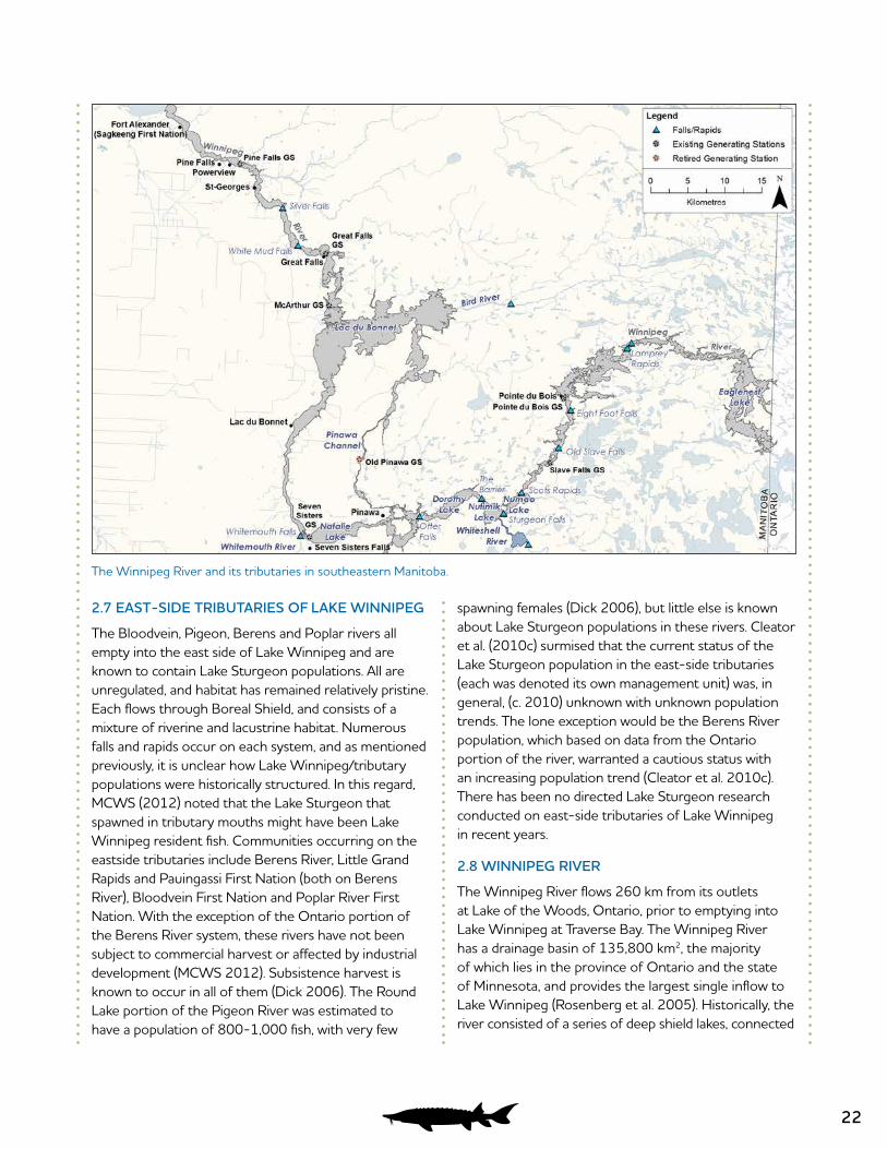
The Winnipeg River and its tributaries in southeastern Manitoba.

23
by riverine sections of varying length. Communities along the banks of the Winnipeg River in Manitoba include Pointe du Bois, Pinawa, Seven Sisters, Lac du Bonnet, Great Falls, St. George, Powerview, Pine Falls and the Sagkeeng First Nation at Fort Alexander. Numerous cottage developments also exist. The Winnipeg River plunges 105 m over its course, and much of the drop was historically concentrated at the sites of large falls and rapids (Johnston 1915). Due to its stepped-gradient profile and its proximity to Manitoba’s booming population centers, the Winnipeg River was coveted by hydroelectric planners during the late 1800s (Bateman 2005). In 1903, construction began on the Pinawa Dam, which was retired in 1951. Six other stations (Pointe du Bois, Slave Falls, Seven Sisters, McArthur, Great Falls and Pine Falls) constructed between 1909 and 1954 are currently operated by Manitoba Hydro on the Manitoba portion of the Winnipeg River. These stations are predominantly “run-of-the-river”, passing flows as they are received with little short-term variation in flow or water levels. However, Winnipeg River flow is regulated at the outlets of Lake of the Woods, Ontario, as well as on the English River tributary (also upstream in Ontario), balancing interests of multi-jurisdictional stakeholders (LWCB 2002).
The Winnipeg River was subject to a large commercial Lake Sturgeon harvest (Stewart 2009). However, geographical specifics are generally unknown, complicating the understanding of historical populations. Stewart (2009) reported an initial Lake Sturgeon harvest of 78,835 kg taken from the Winnipeg River in 1910/11, and Harkness (1980) reported that this catch came from Lac du Bonnet. Harvest was also reported from 1930 to 1948 (135,437 kg), and again from 1957 to 1960 (28,799 kg) (Stewart 2009). In total, the Winnipeg River reported Lake Sturgeon harvest was 253,071 kg, although it was noted that records are likely incomplete (Stewart 2009). In 1993, a conservation closure on sturgeon harvesting (including subsistence harvest) was invoked from the Manitoba/Ontario border downstream to the Pine Falls GS. Stocking has been conducted in several reaches of the Winnipeg River for research and management purposes, but little is known about the outcomes (MCWS 2012).
It is largely uncertain how Winnipeg River Lake Sturgeon populations were historically structured, and to what degree hydroelectric development has fragmented populations that were likely (at least in
some locations) being impacted by commercial harvest at the same time the various generating stations were constructed. However, Lake Sturgeon upstream and downstream of the Slave Falls GS were recently found to be genetically differentiated, with diversity patterns being consistent with one-way (upstream to downstream) gene flow at the historic site of Old Slave Falls (McDougall 2011a). Owing to a high rate of upstream contribution to the downstream population, genetic results of this study raised questions about historical versus contemporary rates of downstream gene flow in the Winnipeg River, and the possibility that differentiation between populations upstream and downstream of the Slave Falls GS may actually be diminishing due to the contribution of upstream fish to the downstream population (McDougall 2011a).
In general, more is known about Lake Sturgeon populations in the Winnipeg River than other localities in Manitoba. Much of the ecological knowledge of the species in Manitoba stems from Manitoba Hydro funded scientific research and environmental monitoring studies recently conducted in the Winnipeg River. It has been suggested that, in stark contrast to the pattern of hydroelectric dams causing habitat and population fragmentation on low gradient river systems, development on the Winnipeg River may actually have increased Lake Sturgeon population and habitat connectivity, via inundation of large falls/rapids which could have been historical barriers to upstream movement and gene flow (McDougall 2011a). Coordinated through Manitoba Hydro’s LSSEP, sample collection is currently underway to facilitate a high resolution genetics study (similar to the one conducted on the Nelson River, Gosselin et al. 2014) which can, among other things, be used to definitively address if/where other historical barriers to gene flow and population structuring existed on the Winnipeg River prior to hydroelectric development.
Ontario/Manitoba Border – Pointe du Bois GS
The uppermost reach of the Winnipeg River in Manitoba stretches ~45 km from the Ontario border to the Pointe du Bois GS (Figure 9). The upper portion of this reach is dominated by Eaglenest Lake, which straddles the Manitoba/Ontario border. Upstream of the border, another ~35 km of lacustrine type habitat occurs, bounded by the Whitedog Falls Station. Downstream of Eaglenest Lake is a long riverine stretch defined by Halliday and Lamprey Rapids; backwatering from the
24
Pointe du Bois GS partially inundated Lamprey Falls (historical designation based on a pronounced hydraulic gradient; Johnston 1915), and formed the Pointe du Bois GS forebay, which dominates the lower portion of the reach. Eaglenest Lake was at one time reported to be the best sturgeon fishing ground in southern Manitoba (McLeod 1943).
Environmental studies related to the Pointe du Bois Spillway Replacement Project and the CAMP program have provided most of the recent information on Lake Sturgeon populations in the Manitoba portion of this reach (McDougall et al. 2008a; 2008b; McDougall and MacDonell 2009; Koga and MacDonell 2010; CAMP 2013; Larter and Parker 2014). These studies confirm the presence of Lake Sturgeon, but indicate a low abundance of adults in this area. In a collaborative study between Manitoba Hydro and Manitoba Sustainable Development, a juvenile inventory was completed in 2014 where 18 juvenile and 1 subadult Lake Sturgeon were caught (Henderson and McDougall 2015), indicating a low abundance of juveniles in this area. Despite directed efforts, no evidence has been found to suggest that spawning currently occurs at Lamprey Rapids. A detailed habitat survey completed in 2013 concluded that the potential spawning habitat in this reach is limited, but that suitable habitat for young-of-the-year, subadults, and foraging habitat for adults is available within the reach (Larter and Parker 2014). Recent studies by the Ontario Ministry of Natural Resources (OMNR) indicate that spawning does occur below generating stations located in Ontario (M. Duda, OMNR pers. comm. in MCWS 2012). A juvenile inventory completed in the Ontario portion of this reach in 2014 captured a number of young-of-the-year sturgeon, confirming that spawning is occurring upstream of the Manitoba portion of this reach (Henderson and McDougall 2015).
Fish community gillnet surveys suggest that juvenile abundance is low in the section between Pointe du Bois and Lamprey Rapids (compared to other Winnipeg River impoundments), but a proper juvenile survey focused on deepwater habitats throughout the reach has not been conducted, and therefore juvenile abundance may be underestimated. Cleator et al. (2010d) surmised that the status of the Lake Sturgeon population upstream of Pointe du Bois GS (as far as the Whitedog Falls Station on the Winnipeg River and
the Caribou Falls Station on the English River tributary) was (c. 2010) critical with an unknown or possibly decreasing population trend.
Both Manitoba Hydro and MSD have identified that a focused inventory study should be conducted in the near future to address the juvenile life stage data gap in this reach. In 2013, a juvenile habitat survey initiated by Manitoba Hydro confirmed that suitable deepwater habitats are plentiful in this reach (Larter and Parker 2014). In fall 2013, one Lake Sturgeon, which was approaching adult size when it was tagged immediately upstream of the Pointe du Bois GS during 2011, was reported captured by a local resource user far upstream in Ontario (J. Peacock, OMNR, pers. comm.), which suggests some degree of population connectivity.
Pointe du Bois GS – Slave Falls GS
The Pointe du Bois GS to Slave Falls GS reach of the Winnipeg River (a.k.a. the Slave Falls Reservoir) is ~10 km long. The effects of backwatering from the Slave Falls GS extend upstream to the Pointe du Bois GS, having inundated both Old Slave and Eight Foot Falls (whose names reflect pre-impoundment conditions), as well as a high gradient section that occurred between Pointe du Bois and Eight Foot Falls historically (Johnston 1915). The Slave Falls Reservoir is generally characterized by low-moderate velocities, an abundance of deepwater, and variety of inorganic substrates.
Little is documented about Lake Sturgeon abundance and population trends in this reach prior to the early- 1990s. The abundance of Lake Sturgeon within this reach during the mid to late 1990s was assessed using MSD data, generating mean population estimates ranging from 360 – 1,100 adults (Block 2001).
As part of environmental monitoring in relation to the Pointe du Bois Spillway Replacement Project, Manitoba Hydro commissioned a series of studies (McDougall et al. 2008a; 2008b; McDougall and MacDonell 2009; Koga and MacDonell 2010; 2011; 2012; Gillespie and MacDonell 2013; Koga et al. 2013) which have markedly improved the understanding of Lake Sturgeon populations in this reach. Mark-recapture data collected in the Slave Falls Reservoir between 2006 and 2009 was used to generate a population estimate of 2,131 adults (95% CI: 1,443 – 3,167) (Manitoba Hydro 2011). Even the most recent estimate, considered alone, indicates an increasing trajectory (P. Nelson, North/
25
South Consultants, pers. comm.). Given other recent observations related to spawning and juvenile recruitment in the Slave Falls Reservoir, this is certainly possible.
Large congregations of adult Lake Sturgeon have been observed annually downstream of the Pointe du Bois GS, and egg deposition consistently occurs near the base of the tailrace and spillway. Considerable larval hatch and extensive (up to 9 km) larval drift has also been documented, and juvenile Lake Sturgeon are abundant in the plentiful deepwater habitats. Anglers frequently target Lake Sturgeon at the base of the Pointe du Bois GS and anecdotal reports suggest that angling pressure has increased in recent years, particularly during spring spawning. Catch-and-release regulations apply (MCWS 2012). Based on the aforementioned study results, and MSD unpublished data, Cleator et al. (2010d) surmised that the current status of the Lake Sturgeon population in the Pointe du Bois GS to Slave Falls GS reach was (c. 2010) healthy with a stable or increasing population trend.
Academic research funded by Manitoba Hydro has examined movement patterns of juveniles, subadults and adults within the Slave Falls Reservoir, and resulting entrainment susceptibility patterns and downstream passage at the Slave Falls GS (McDougall 2011a; McDougall et al. 2013a; McDougall et al. 2014b; McDougall et al. 2014c)). The results of these studies are discussed in detail in Section 3.0. Monitoring for the Pointe du Bois Spillway Replacement Project is ongoing, and is focused on potential alterations to spawning habitat, resulting egg deposition and viability patterns, larval hatch, and subsequent juvenile recruitment.
Slave Falls GS – Seven Sisters GS
The Slave Falls GS to Seven Sisters GS reach (a.k.a. the Seven Sisters Reservoir) is ~40 km long, and is characterized by a series of shield lakes separated by short riverine sections. The Whiteshell River empties into this stretch of the Winnipeg River at Nutimik Lake. Backwatering from the Seven Sisters GS inundated several historical falls/rapids and caused some flooding in the lower reaches, but the upstream portion has retained much of its historic character.
Little is documented about Lake Sturgeon abundance and population trends in this reach prior to the early- 1980s, when concern over populations arose and a long-term monitoring program was initiated (MCWS
2012). Adult population estimates based on Manitoba Fisheries Branch tagging data generated in the mid to late 1990s ranged from 2,998 (95% CI: 1,143 – 13,101) to 27,374 (95% CI: 5,317 – 32,687) (Block 2001). Based on long-term unpublished population monitoring data and interim results of academic research (discussed below), MCWS (2012) concluded that year-class strength has improved since the conservation closure. Similarly, Cleator et al. (2010d) surmised that the current status of the Lake Sturgeon population in the Slave Falls GS to Seven Sisters GS reach was (c. 2010) healthy with a stable or increasing population trend.
To support the Pointe du Bois Spillway Replacement Project, Manitoba Hydro initiated studies from 2007 to 2010 to examine spawning behaviour immediately downstream of the Slave Falls GS (McDougall et al. 2008a; McDougall and MacDonell 2009; Koga and MacDonell 2010; 2011). Large congregations of adults were observed, and egg deposition was documented at the base of the tailrace and spillway.
Through the Lake Sturgeon Memorandum of Understanding (MOU) between Manitoba Hydro and the Province of Manitoba, the population of Lake Sturgeon in Nutimik and Namao lakes was evaluated. The population was estimated to be 28,207, with the vast majority of the population comprised of juveniles (population estimate for adults is 6,289) (Memorandum of Understanding Respecting Lake Sturgeon Annual Report 2014).
Academic research funded by Manitoba Hydro investigated various aspects of Lake Sturgeon ecology in the Seven Sisters Reservoir between 2006 and 2011 (Barth 2011; Labadie 2011; Sparks 2011; Henderson 2013). Results of these studies are discussed in detail in Section 3.0, but from a Seven Sisters Reservoir population standpoint, juvenile Lake Sturgeon are abundant in this reach (Barth 2011). Results from adult movement and larval drift studies confirmed suspicions that Sturgeon Falls is at least an intermittent spawning location (Labadie 2011; Henderson 2013).
Seven Sisters GS – McArthur GS
The Seven Sisters GS to McArthur GS reach (a.k.a. the McArthur Reservoir) is ~35 km long. The upstream portion is riverine, while the downstream portion is dominated by Lac du Bonnet, which is a large lake of
26
moderate depth. Backwatering from the McArthur GS raised water levels and reduced velocities throughout the reach. Two significant tributaries, the Whitemouth River and Bird River, empty into this reach.
Commercial harvest records provide insight into historical Lake Sturgeon demographics in this area. As previously noted, the 1910/1911 commercial harvest of 78,835 kg came from Lac du Bonnet, which suggests that a very large population existed here historically (Harkness 1980). Based on angler capture reports, interim academic research, and results of unpublished MSD experimental netting programs, Cleator et al. (2010d) surmised that the current status of the Lake Sturgeon population in the Seven Sisters GS to McArthur GS reach was (c. 2010) cautious with an unknown population trend.
Academic research funded by Manitoba Hydro was conducted downstream of the Seven Sisters GS between 2008 and 2010 (Hrenchuk 2011), and is discussed in more detail in Section 3.0. Results of these studies indicate that the adult population is comprised of at least several hundred individuals (which is still likely a small fraction relative to historic levels), spawning occurs in the Seven Sisters GS tailrace and spillway channel, and that juvenile recruitment is occurring within the reach (Hrenchuk 2011). In a population inventory in the Lac du Bonnet reach of the Winnipeg River in 2015, 219 Lake Sturgeon were captured, of which 11 were previously tagged. (LKST MOU Annual Report, 2015). In 2011, under low flow conditions, habitat was documented at known or potential Lake Sturgeon spawning sites on the Winnipeg River, including immediately downstream of Seven Sisters GS. Georeferenced digital photographs were taken and bathymetric surveys were completed (McDougall and Gillespie 2012).
McArthur GS – Great Falls GS
The McArthur GS – Great Falls GS reach (a.k.a. the Great Falls Reservoir) is ~8.5 km long, making it the smallest Winnipeg River impoundment. The entire reach is riverine in nature, although backwatering from the Great Falls GS has raised water levels in the lower portion of the reach, and inundated Grand du Bonnet Falls, which was located in the middle of the reach.
Little is known about Lake Sturgeon populations occurring in this reach historically, and only recently has directed research occurred. Cleator et al. (2010d)
surmised that the current status of the Lake Sturgeon population in the McArthur GS to Great Falls GS reach was (c. 2010) unknown with an unknown population trend.
Studies completed through Manitoba Hydro’s LSSEP since 2010 have improved understanding of populations within the McArthur GS to Great Falls GS reach. Adult population and spawning related gillnetting indicates that adult abundance in this reach is very low (Murray and Gillespie 2011; Henderson and McDougall 2012). However, an inventory study revealed that juvenile Lake Sturgeon were moderately abundant in the upper portion of the reach, indicating that recruitment is occurring despite very low adult abundance (McDougall 2011b).
Great Falls GS – Pine Falls GS
The Great Falls to Pine Falls GS reach (a.k.a. the Pine Falls Reservoir) is ~22.5 km long. The entire reach is riverine, although backwatering from the Pine Falls GS raised water levels and inundated Silver Falls and Maskwa Rapids. To ease a flow bottleneck, a channel was blasted through White Mud Falls, which altered flow patterns and water-levels at and upstream of White Mud Falls.
Little is known about Lake Sturgeon populations occurring in this reach historically, and only recently has any directed research occurred. Cleator et al. (2010d) surmised that the current status of the Lake Sturgeon population in the Great Falls GS to Pine Falls GS reach was (c. 2010) unknown with an unknown population trend.
Studies completed through Manitoba Hydro’s LSSEP since 2010 have improved the understanding of populations within the Great Falls GS to Pine Falls GS reach. Adult population and spawning related gillnetting indicates that adult abundance in this reach is low (Murray and Gillespie 2011), but evidence of spawning behaviour has been found at White Mud Falls and also downstream of the Great Falls GS Henderson and McDougall 2012). A juvenile inventory study revealed that juvenile Lake Sturgeon were moderately abundant within the reach, indicating that recruitment is occurring despite low adult abundance (McDougall 2011b). In a fisheries assessment study completed in 2013, three Lake Sturgeon were captured immediately upstream of the Pine Falls Generating Station in spring (Lowden and Queen 2013).
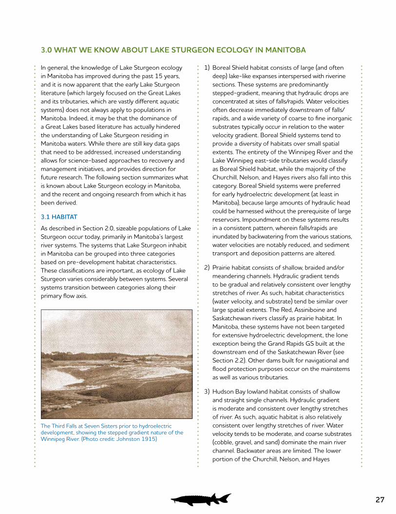
27
3.0 WHAT WE KNOW ABOUT LAKE STURGEON ECOLOGY IN MANITOBA
In general, the knowledge of Lake Sturgeon ecology in Manitoba has improved during the past 15 years, and it is now apparent that the early Lake Sturgeon literature (which largely focused on the Great Lakes and its tributaries, which are vastly different aquatic systems) does not always apply to populations in Manitoba. Indeed, it may be that the dominance of a Great Lakes based literature has actually hindered the understanding of Lake Sturgeon residing in Manitoba waters. While there are still key data gaps that need to be addressed, increased understanding allows for science-based approaches to recovery and management initiatives, and provides direction for future research. The following section summarizes what is known about Lake Sturgeon ecology in Manitoba, and the recent and ongoing research from which it has been derived.
3.1 HABITAT
As described in Section 2.0, sizeable populations of Lake Sturgeon occur today, primarily in Manitoba’s largest river systems. The systems that Lake Sturgeon inhabit in Manitoba can be grouped into three categories based on pre-development habitat characteristics. These classifications are important, as ecology of Lake Sturgeon varies considerably between systems. Several systems transition between categories along their primary flow axis.
1) Boreal Shield habitat consists of large (and often deep) lake-like expanses interspersed with riverine sections. These systems are predominantly stepped-gradient, meaning that hydraulic drops are concentrated at sites of falls/rapids. Water velocities often decrease immediately downstream of falls/rapids, and a wide variety of coarse to fine inorganic substrates typically occur in relation to the water velocity gradient. Boreal Shield systems tend to provide a diversity of habitats over small spatial extents. The entirety of the Winnipeg River and the Lake Winnipeg east-side tributaries would classify as Boreal Shield habitat, while the majority of the Churchill, Nelson, and Hayes rivers also fall into this category. Boreal Shield systems were preferred for early hydroelectric development (at least in Manitoba), because large amounts of hydraulic head could be harnessed without the prerequisite of large reservoirs. Impoundment on these systems results in a consistent pattern, wherein falls/rapids are inundated by backwatering from the various stations, water velocities are notably reduced, and sediment transport and deposition patterns are altered.
2) Prairie habitat consists of shallow, braided and/or meandering channels. Hydraulic gradient tends to be gradual and relatively consistent over lengthy stretches of river. As such, habitat characteristics (water velocity, and substrate) tend be similar over large spatial extents. The Red, Assiniboine and Saskatchewan rivers classify as prairie habitat. In Manitoba, these systems have not been targeted for extensive hydroelectric development, the lone exception being the Grand Rapids GS built at the downstream end of the Saskatchewan River (see Section 2.2). Other dams built for navigational and flood protection purposes occur on the mainstems as well as various tributaries.
3) Hudson Bay lowland habitat consists of shallow and straight single channels. Hydraulic gradient is moderate and consistent over lengthy stretches of river. As such, aquatic habitat is also relatively consistent over lengthy stretches of river. Water velocity tends to be moderate, and coarse substrates (cobble, gravel, and sand) dominate the main river channel. Backwater areas are limited. The lower portion of the Churchill, Nelson, and Hayes
The Third Falls at Seven Sisters prior to hydroelectric development, showing the stepped gradient nature of the Winnipeg River. (Photo credit: Johnston 1915)
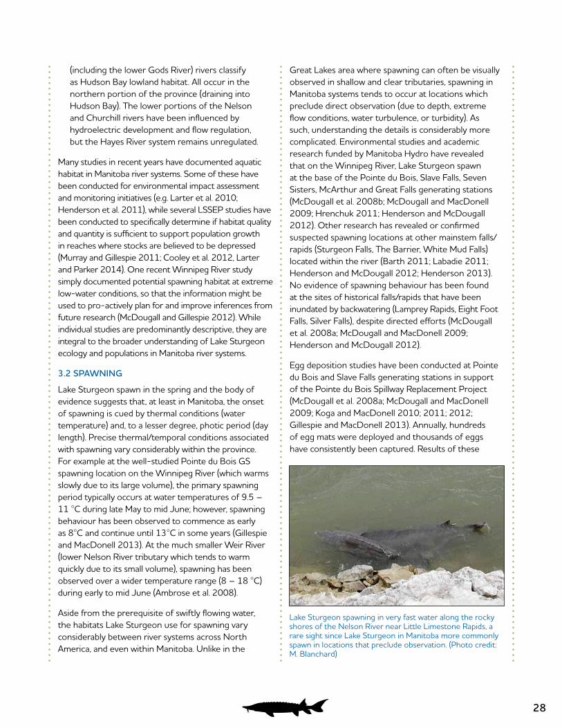
28
(including the lower Gods River) rivers classify as Hudson Bay lowland habitat. All occur in the northern portion of the province (draining into Hudson Bay). The lower portions of the Nelson and Churchill rivers have been influenced by hydroelectric development and flow regulation, but the Hayes River system remains unregulated.
Many studies in recent years have documented aquatic habitat in Manitoba river systems. Some of these have been conducted for environmental impact assessment and monitoring initiatives (e.g. Larter et al. 2010; Henderson et al. 2011), while several LSSEP studies have been conducted to specifically determine if habitat quality and quantity is sufficient to support population growth in reaches where stocks are believed to be depressed (Murray and Gillespie 2011; Cooley et al. 2012, Larter and Parker 2014). One recent Winnipeg River study simply documented potential spawning habitat at extreme low-water conditions, so that the information might be used to pro-actively plan for and improve inferences from future research (McDougall and Gillespie 2012). While individual studies are predominantly descriptive, they are integral to the broader understanding of Lake Sturgeon ecology and populations in Manitoba river systems.
3.2 SPAWNING
Lake Sturgeon spawn in the spring and the body of evidence suggests that, at least in Manitoba, the onset of spawning is cued by thermal conditions (water temperature) and, to a lesser degree, photic period (day length). Precise thermal/temporal conditions associated with spawning vary considerably within the province. For example at the well-studied Pointe du Bois GS spawning location on the Winnipeg River (which warms slowly due to its large volume), the primary spawning period typically occurs at water temperatures of 9.5 – 11 °C during late May to mid June; however, spawning behaviour has been observed to commence as early as 8°C and continue until 13°C in some years (Gillespie and MacDonell 2013). At the much smaller Weir River (lower Nelson River tributary which tends to warm quickly due to its small volume), spawning has been observed over a wider temperature range (8 – 18 °C) during early to mid June (Ambrose et al. 2008).
Aside from the prerequisite of swiftly flowing water, the habitats Lake Sturgeon use for spawning vary considerably between river systems across North America, and even within Manitoba. Unlike in the
Great Lakes area where spawning can often be visually observed in shallow and clear tributaries, spawning in Manitoba systems tends to occur at locations which preclude direct observation (due to depth, extreme flow conditions, water turbulence, or turbidity). As such, understanding the details is considerably more complicated. Environmental studies and academic research funded by Manitoba Hydro have revealed that on the Winnipeg River, Lake Sturgeon spawn at the base of the Pointe du Bois, Slave Falls, Seven Sisters, McArthur and Great Falls generating stations (McDougall et al. 2008b; McDougall and MacDonell 2009; Hrenchuk 2011; Henderson and McDougall 2012). Other research has revealed or confirmed suspected spawning locations at other mainstem falls/rapids (Sturgeon Falls, The Barrier, White Mud Falls) located within the river (Barth 2011; Labadie 2011; Henderson and McDougall 2012; Henderson 2013). No evidence of spawning behaviour has been found at the sites of historical falls/rapids that have been inundated by backwatering (Lamprey Rapids, Eight Foot Falls, Silver Falls), despite directed efforts (McDougall et al. 2008a; McDougall and MacDonell 2009; Henderson and McDougall 2012).
Egg deposition studies have been conducted at Pointe du Bois and Slave Falls generating stations in support of the Pointe du Bois Spillway Replacement Project (McDougall et al. 2008a; McDougall and MacDonell 2009; Koga and MacDonell 2010; 2011; 2012; Gillespie and MacDonell 2013). Annually, hundreds of egg mats were deployed and thousands of eggs have consistently been captured. Results of these
Lake Sturgeon spawning in very fast water along the rocky shores of the Nelson River near Little Limestone Rapids, a rare sight since Lake Sturgeon in Manitoba more commonly spawn in locations that preclude observation. (Photo credit: M. Blanchard)
29
studies indicate (at least at these locations) that hydraulics are primarily responsible for determining precisely where spawning takes place. In general, egg deposition occurs in or very close to turbulent, high-velocity turbine discharges or spillway outflows which vary (by year) from small trickles, to intense torrents. Based on a pronounced pattern of diminishing returns with distance, it is apparent that Lake Sturgeon tend to move upstream to the base of physical or energetic barriers (powerhouse infrastructure or spillway rapids) prior to depositing their eggs, some of which may drift small distances downstream prior to settling out. Substrates in the areas where deposition occurs tend to be dominated by bedrock and/or coarse aggregates (boulder/cobble), and a wide-range of depths (2 – 20 m) are used.
Based on the egg deposition results observed at Pointe du Bois GS, a Habitat Suitability Index (HSI) model was developed (NSC 2012b). A three variable (flow, depth, substrate) model consistent with the literature grossly overestimated the quantity of habitat in which egg deposition (spawning) occurred, but incorporation of “distance from physical or energetic barrier” and “flow direction” variables improved the model considerably; the “distance” variable limited overestimation of suitable habitat in the downstream direction, and the “Flow Direction” variable eliminated back eddy environments that had suitable depths, velocities and substrates but did not yield eggs. Application of the Pointe du Bois GS HSI model to the Slave Falls GS area showed relatively good agreement with observed egg deposition, but the predictive capability of the model was somewhat reduced due to greater water depth availability and because eggs were found at depths greater than are available at the Pointe du Bois GS (NSC 2012b). Similarly, a HSI model was developed for the area downstream of the Kettle GS using a combination of five variables (velocity, depth, substrate, flow direction and distance from barrier). Results suggest that in general, large quantities of habitat are considered suitable when constrained only by velocity, depth and substrate. The addition of flow direction and distance decreases estimated habitat area, but habitat still appears to be present in sufficient quantities as to not limit the spawning success of Lake Sturgeon in the area (Sutton and McDougall 2016).
Research in the Seven Sisters GS area determined that adult Lake Sturgeon moved extensively between the powerhouse tailrace and spillway channel areas
(which are physically separated by a large rock groyne) during the pre-spawn period (Hrenchuk 2011). However, spawning behaviour, egg deposition and subsequent larval hatch only occurred below the spillway during years of high flow (spill conditions), while the powerhouse tailrace was used for spawning regardless of spillway operation (Hrenchuk 2011).
Spawning has also been studied in the Nelson River (MacDonell 1995; 1997a; 1998; Barth and MacDonell 1999; Barth and Mochnacz 2004; Barth and Murray 2005; Holm et al. 2006; Ambrose et al. 2008; 2009; 2010a; 2010b; Pisiak et al. 2011). Here again, Manitoba Hydro has funded the vast majority of the research. Unlike in the Winnipeg River, both mainstem and tributary spawning is known to occur. In the mainstem, egg deposition has been confirmed at the Lower Limestone Rapids; here, it occurs intermittently, apparently in relation to flow conditions in the river. In low flow years when water-level fluctuations result in dewatering of the rapids, there has been no evidence of larval hatch, but the lack of eggs in dewatering surveys suggests that spawning has not actually occurred. In years of high flows, when areas of dewatering are reduced, spawning behavior and egg deposition have been observed along flow margins (including shorelines), and larvae have been captured in drift traps. Based on captures of large numbers of ripe fish, spawning behaviour is also known to occur at Birthday Rapids. It is suspected that there is appropriate spawning habitat at other mainstem falls/ rapids which have not been studied (e.g. Sea Falls, Whitemud Falls, Eves Rapids, Bladder Rapids, Long Rapids, Gull Rapids), but inferences are complicated both by the depressed state of several populations (i.e., it is conceivable that so few fish remain that ripe males and females may not interact during a given spawning season), and logistical difficulties associated with sampling such a torrid river.
Nelson River tributary spawning is known at the Landing, Burntwood, Weir, and Angling rivers (MacDonell 1995; MacDonald 2009; Ambrose et al. 2010a; MCWS 2012). At the Weir River, the precise location of spawning varies annually (by up to ~3 km), and appears to be influenced by a combination of river discharge and Nelson River stage (MacDonell 1995;1997a; 1998; Holm et al. 2006; Ambrose et al. 2007). When the Nelson River is at a high stage, the mouth of the Weir River becomes backwatered and spawning appears to generally occur further upstream
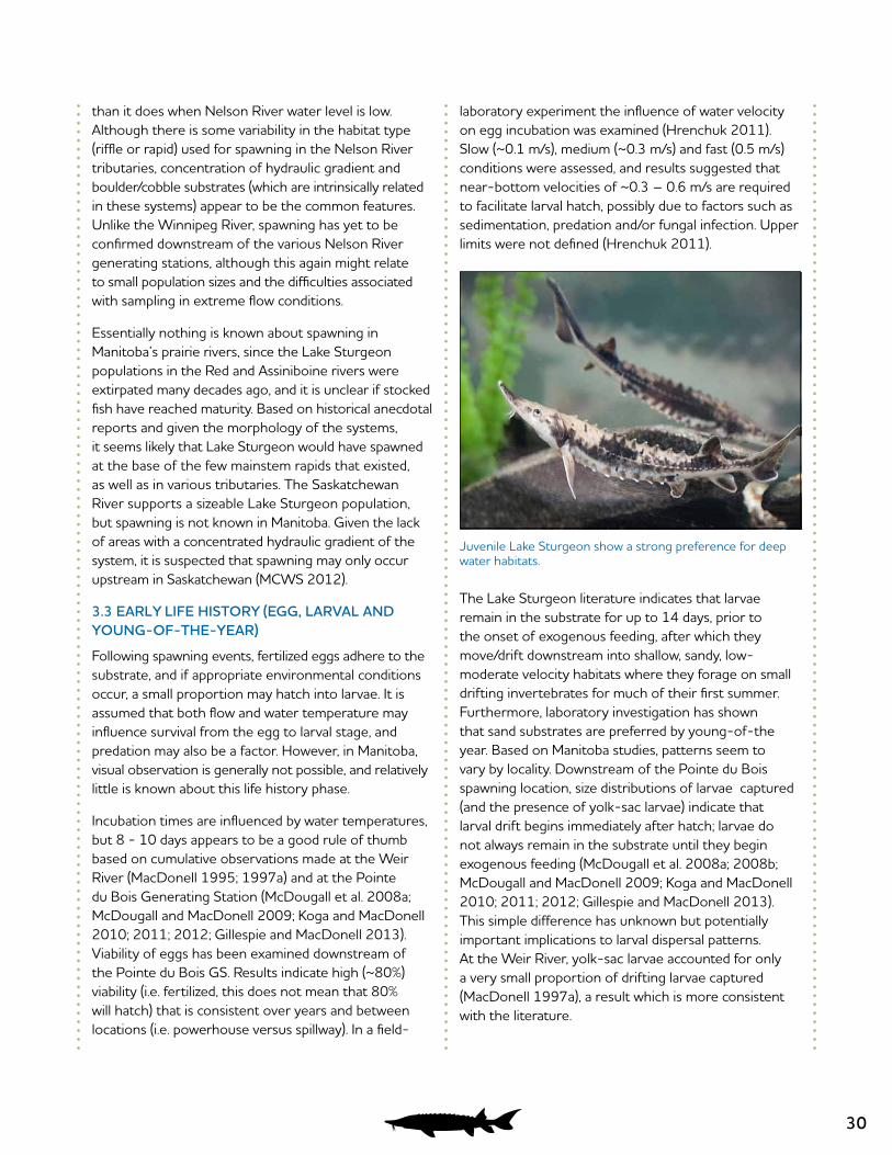
30
than it does when Nelson River water level is low. Although there is some variability in the habitat type (riffle or rapid) used for spawning in the Nelson River tributaries, concentration of hydraulic gradient and boulder/cobble substrates (which are intrinsically related in these systems) appear to be the common features. Unlike the Winnipeg River, spawning has yet to be confirmed downstream of the various Nelson River generating stations, although this again might relate to small population sizes and the difficulties associated with sampling in extreme flow conditions.
Essentially nothing is known about spawning in Manitoba’s prairie rivers, since the Lake Sturgeon populations in the Red and Assiniboine rivers were extirpated many decades ago, and it is unclear if stocked fish have reached maturity. Based on historical anecdotal reports and given the morphology of the systems, it seems likely that Lake Sturgeon would have spawned at the base of the few mainstem rapids that existed, as well as in various tributaries. The Saskatchewan River supports a sizeable Lake Sturgeon population, but spawning is not known in Manitoba. Given the lack of areas with a concentrated hydraulic gradient of the system, it is suspected that spawning may only occur upstream in Saskatchewan (MCWS 2012).
3.3 EARLY LIFE HISTORY (EGG, LARVAL AND YOUNG-OF-THE-YEAR)
Following spawning events, fertilized eggs adhere to the substrate, and if appropriate environmental conditions occur, a small proportion may hatch into larvae. It is assumed that both flow and water temperature may influence survival from the egg to larval stage, and predation may also be a factor. However, in Manitoba, visual observation is generally not possible, and relatively little is known about this life history phase.
Incubation times are influenced by water temperatures, but 8 - 10 days appears to be a good rule of thumb based on cumulative observations made at the Weir River (MacDonell 1995; 1997a) and at the Pointe du Bois Generating Station (McDougall et al. 2008a; McDougall and MacDonell 2009; Koga and MacDonell 2010; 2011; 2012; Gillespie and MacDonell 2013). Viability of eggs has been examined downstream of the Pointe du Bois GS. Results indicate high (~80%) viability (i.e. fertilized, this does not mean that 80% will hatch) that is consistent over years and between locations (i.e. powerhouse versus spillway). In a field-
laboratory experiment the influence of water velocity on egg incubation was examined (Hrenchuk 2011). Slow (~0.1 m/s), medium (~0.3 m/s) and fast (0.5 m/s) conditions were assessed, and results suggested that near-bottom velocities of ~0.3 – 0.6 m/s are required to facilitate larval hatch, possibly due to factors such as sedimentation, predation and/or fungal infection. Upper limits were not defined (Hrenchuk 2011).
The Lake Sturgeon literature indicates that larvae remain in the substrate for up to 14 days, prior to the onset of exogenous feeding, after which they move/drift downstream into shallow, sandy, low-moderate velocity habitats where they forage on small drifting invertebrates for much of their first summer. Furthermore, laboratory investigation has shown that sand substrates are preferred by young-of-the year. Based on Manitoba studies, patterns seem to vary by locality. Downstream of the Pointe du Bois spawning location, size distributions of larvae captured (and the presence of yolk-sac larvae) indicate that larval drift begins immediately after hatch; larvae do not always remain in the substrate until they begin exogenous feeding (McDougall et al. 2008a; 2008b; McDougall and MacDonell 2009; Koga and MacDonell 2010; 2011; 2012; Gillespie and MacDonell 2013). This simple difference has unknown but potentially important implications to larval dispersal patterns. At the Weir River, yolk-sac larvae accounted for only a very small proportion of drifting larvae captured (MacDonell 1997a), a result which is more consistent with the literature.
Juvenile Lake Sturgeon show a strong preference for deep water habitats.
31
To examine characteristics of larval drift in the Winnipeg River, Henderson (2013) deployed transects of bottom-set, mid-column, and surface drift traps, and determined that bottom-set traps accounted for >95% of total captures. Similarly, larval captures in surface drift-traps set downstream of the Pointe du Bois spawning site have been orders of magnitude less than catches from bottom-set drift traps (McDougall et al. 2008b; McDougall and MacDonell 2009). Larvae drift up to 9 km in the Slave Falls Reservoir (Koga and MacDonell 2010), but patterns (including passive or active behavioural elements) and in particular the speculated influence of flow on these patterns has yet to be determined (Barth 2011; McDougall et al. 2013a). Ultimately, larval Lake Sturgeon settle out and the young-of-the-year phase begins, but when, where and why this occurs remains unknown. Indeed, the life history needs at the onset of exogenous feeding are poorly understood, but local hatchery work substantiates the belief this is a critical period (C. Klassen, Manitoba Hydro, pers. comm.). In the Winnipeg River, larval drift occurs over 3 – 4 week period (McDougall et al. 2008b; McDougall and MacDonell 2009; Henderson 2013). Several months later (August – October), young-of-the-year have grown to sizes of 80 – 100+ mm, and can thereafter be sampled in bottom-set gill nets. Unlike in the Great Lakes tributaries, young-of-the-year in Manitoba’s large riverine systems (i.e., the Winnipeg and Nelson rivers) have been captured primarily in habitats characterized by moderate to deep water (5 – 35 m) and low velocities. Substrates over which young-of-the- year have been captured include sand, but also bedrock, boulder, cobble, gravel, clay, and silt, with no clear pattern of selection emerging (McDougall et al. 2008b; McDougall and MacDonell 2009; McDougall 2011b; Henderson 2013). One notable situation is the Great Falls Reservoir, where both habitat mapping and a juvenile inventory study were completed. Herein, it is evident that juvenile recruitment is occurring within the reach (McDougall 2011b), despite the absence of large patches of sand-dominated substrate within the system (Murray and Gillespie 2011).
As diet analysis for young-of-the-year requires lethal sampling methods, it has not often been investigated. However, a young-of-the-year Lake Sturgeon sampled in fall from the lower Nelson River had primarily consumed amphipods (Haustoriidae) and a single chironomid (Ambrose et al. 2010), while a young-of-the-year captured in the Slave Falls
Reservoir during fall had consumed a large quantity of small invertebrates, the vast majority being chironomids (McDougall and MacDonell 2009).
3.4 JUVENILE LIFE HISTORY
In recent years, Manitoba Hydro has funded academic research to examine the juvenile (of which larger individuals may also be referred to as subadults) life history phase, which even 10 years ago represented a large gap in our understanding of Manitoba populations. It is now clear that at least in large riverine systems (such as the Winnipeg and Nelson rivers), juveniles show a strong preference for deepwater (>10 m) habitats (at least during the open-water season), with substrate and water velocity criteria being far less important (Barth et al. 2009; McDougall and MacDonell 2009; Barth et al. 2011; McDougall 2011a; McDougall 2011b; Sparks 2011; McDougall et al. 2013b; 2013c). Telemetry and mark-recapture studies conducted in the Seven Sisters and Slave Falls reservoirs on the Winnipeg River have revealed that movement patterns of juveniles are highly restricted to areas of contiguous deepwater habitat, defined by shallow river narrows which frequently sub -divide the river (Barth et al. 2011; McDougall et al. 2013a). Home-range size tends to approach the length of river occurring between river narrows, and it is apparent that year-round habitat requirements can be met in short (0.4 – 1.5 km) stretches of river (Barth et al. 2011; McDougall et al. 2013a). In Stephens Lake, on the Nelson River, open water movement extents of juvenile Lake Sturgeon tended to correlate with the reservoir transition zone, suggesting a slightly different type of restricted movement pattern (McDougall et al. 2013b; 2013c). However, use of downstream main-channel habitat (dominated by silt) by a small proportion of tagged fish was observed, always in relation to the old-river channel during the open-water season. Most (if not all) tracked individuals vacated the reservoir transition zone as winter progressed, likely due to ice conditions (scouring resulting from ice build-up at Gull Rapids occurs at depths of >17 m, 4.5 km downstream) and flows being unsuitable for overwintering (McDougall et al. 2013c). Also during winter, several tracked juveniles used shallow (<9 m) backwatered habitats far from the old-river channel. During spring, tracked individuals moved back upstream and again used the reservoir transition zone extensively throughout the open-water season. In concert, these results suggested a spatial shift in seasonal habitat use patterns in this system (McDougall et al. 2013c).
32
Diet of juvenile Lake Sturgeon is known to vary considerably on a seasonal basis, and also between geographically close sections of the Winnipeg River. In the Seven Sisters Reservoir, three types of insect larva (Trichoptera [caddis fly], Diptera [house fly] and Ephemeroptera [mayfly]) comprised over 97% of prey items recovered via gastric lavage (Barth et al. 2013). This pattern did not vary between fish across a wide juvenile size range, but did vary by substrate type over which the fish were captured. Relative abundance of these three prey items in stomach contents also varied by month. Diptera was the most common prey item in May, while Trichoptera was the most common prey item in both June and July, and stomachs were empty in October. Markedly different results were observed in the Slave Falls Reservoir located just upstream (McDougall and MacDonell 2009). During sampling conducted in October, gut contents were recovered from over half of the juveniles sampled. Ephemeroptera larva was the dominant dietary component for the vast majority of fish. However, Hirudinidae (leeches) and Trichoptera larvae were also the largest components for individual fish. Small numbers of Crustacea (e.g. crayfish), Mollusca (e.g. clams) and Annelida (segmented worms) were also consumed. The diet of 12 juvenile Lake Sturgeon captured from the lower Nelson River in fall, 2008, was primarily comprised of Trichoptera, Diptera and Crustacea, and to a lesser extent Annelida, Ephemeroptera, and Rainbow Smelt (Ambrose et al. 2010).
Owing to restricted movement patterns resulting in behaviourally isolated subpopulations and likely a combination of factors including variable fish density, forage availability, and water-velocity influenced energetics, growth rate of juveniles varies (sometimes greatly) between geographically close sections of both the Winnipeg (Barth 2011; Hrenchuk 2011; McDougall2011a; McDougall 2011b; Sparks 2011; Koga et al. 2013) and Nelson rivers (McDougall and Pisiak 2012); this pattern has yet to be reported elsewhere, and the current paradigm in the literature suggests that latitude and air temperature are the driving factors behind Lake Sturgeon growth rates. Contrary to previous suspicions that backwatered forebay habitats in the Winnipeg River may be unsuitable for juveniles (Block 2001), recent research has revealed juvenile growth rates are highest in these areas, suggesting that they are indeed suitable and perhaps underutilized relative to their carrying capacity (Barth 2011;
McDougall 2011a; McDougall 2011b; Sparks 2011; Koga et al. 2013). It appears that the tendency of Lake Sturgeon to spawn towards the upstream end of the various reservoirs, a non-random distribution of age-0 Lake Sturgeon following larval drift, and restricted movement patterns at the juvenile and subadult life stages result in Lake Sturgeon distributions that tend to be skewed towards the upper reaches of the Winnipeg River impoundments (Barth 2011; McDougall 2011a; McDougall 2011b).
Comparatively little is known about juvenile ecology in Manitoba’s prairie rivers. During the Assiniboine River inventory conducted in fall 2013, water levels were low and depths were generally <1 m. Juvenile Lake Sturgeon were found only in deeper pools (2.5 – 6 m) located downstream of Brandon (Aiken et al. 2013). It is suspected that there may be differences between juvenile movement patterns in shield and prairie river systems, reflecting available habitat, and in particular the role of natural movement restrictors (shallow high-velocity river narrows) which are common in shield systems but rare in prairie rivers.
3.5 ADULT LIFE HISTORY
Lake Sturgeon transition from juveniles into adults slowly, and males typically reach maturity earlier and at smaller sizes than females. In the Great Lakes region, males are thought to mature at ~15 years and females at ~25 years of age. Maturity timelines are generally unknown for Manitoba Lake Sturgeon populations. However, in the well-studied Slave Falls Reservoir population, it is obvious that both sexes mature at sizes much smaller than would be expected based on the Great Lakes dominated literature. Mature males measuring 800 –850 mm (fork length) are common (McDougall et al. 2008a; 2008b; McDougall and MacDonell 2009), and ripe males as small as 640 - 720 mm and only 8 years old have been captured (McDougall 2011a). Anecdotal evidence suggests that size at maturity may vary between proximally close sections of the Winnipeg River, as the spawning populations downstream of the Slave Falls GS and the Seven Sisters GS tend to be comprised of much larger males and females (McDougall and MacDonell 2009; Hrenchuk unpublished data), although differences could be confounded by past exploitation.
In recent years, academic research funded by Manitoba Hydro has also investigated the adult life stage, with a particular focus on movement patterns. In the
33
Winnipeg River, adult Lake Sturgeon are known to ascend and descend through the same river narrows through which juveniles tend not to (Labadie 2011; McDougall 2011a), and as such may use longer stretches of river. However, adult movements through river narrows generally occur infrequently, interspersed throughout the open-water season (McDougall 2011a). Winter home-ranges tend to consist of a subset of open-water areas used, as opposed to distinct habitats (Labadie 2011). As has been noted elsewhere, there is much variation in the movement patterns of individual adults, with some individuals displaying affinity to small sections of river, while others move and utilize sections of river up to 15 km long without apparent preference (Labadie 2011; McDougall 2011a).
Movement patterns also appear to vary considerably by system. In the lower Nelson River, adult Lake Sturgeon are frequently known to travel distances of >50 km. Using the Nelson/Hayes shared estuary as a movement corridor, Nelson River individuals have been relocated in the Gods River (a tributary of the Hayes River) >340 km from where they were marked (Ambrose et al. 2010a; Ambrose et al. 2010b; Klassen 2012). However, other Nelson River Lake Sturgeon display sedentary behavior and have been known to remain in an area no larger than a few square kilometers (e.g., in Angling Lake) for over three years (Swanson et al. 1991).
3.6 RECRUITMENT PATTERNS (YEAR-CLASS STRENGTH)
In recent years, recruitment patterns have been a focus of Manitoba Hydro funded research and environmental monitoring. For the most part, Lake Sturgeon in Manitoba waters can be aged accurately at least until ~15 years of age, although certain sub-populations are so slow-growing that definition between annuli is lost somewhat earlier, making ageing interpretation less certain (Barth 2011; McDougall 2011a). However, with these rare exceptions, juvenile Lake Sturgeon from Manitoba waters can be aged very accurately, as a recent study involving known age fish confirmed (McDougall and Pisiak 2012). Results indicate that Lake Sturgeon year-class strength is variable if not erratic (on an annual basis) in all the Winnipeg River and Nelson River populations in which it has been studied. Juvenile recruitment patterns were examined in the Great Falls and Pine Falls reservoirs (McDougall 2011b). The year-class strength distribution in the Great Falls Reservoir was indicative of erratic recruitment during
the 2002 – 2011 period, and although the pattern appeared to be somewhat dampened in the Pine Falls Reservoir (i.e., recruitment was somewhat more consistent), stronger and weaker year classes were certainly evident. Year-class strength distributions between the Great Falls and Pine Falls reservoirs were found to be highly correlated (+), which was interpreted as evidence that environmental factors (e.g., water flow, temperature and inclement weather conditions) which would be essentially identical in both reaches during the critical spawning, egg development and/or larval drift periods, had driven patterns of erratic recruitment. However, the lack of significant correlation between year-class strength distributions and historical Winnipeg River May or June flows suggests that flow was not the sole determinant of year-class strength (McDougall 2011b). Evidence of variable recruitment has also been observed downstream of the Seven Sisters GS, but no correlation with historical flows during spawn or hatch could be determined (Hrenchuk 2011).
Even in the Slave Falls and Seven Sisters reservoirs, which support large and healthy spawning stocks, there is evidence of erratic recruitment, with both strong and very weak (missing) year-classes (Barth 2011; Henderson 2013; Koga et al. 2013). In the Slave Falls Reservoir, three of the past ten years (2007, 2011, 2012) appear to have resulted in year-class failures (C. McDougall, pers. comm.). On the Nelson River, the juvenile segment of the populations present in Gull and Stephens lakes are currently dominated by a single strong cohort, produced in 2008 (Henderson and Pisiak 2012). While the latter situation is likely cause for concern, considering the life history strategy of the species (late maturation and many spawning events over each fish’s long lifespan), Lake Sturgeon populations should be well-suited to overcome periodic year-class failures and erratic recruitment (McDougall 2011b).
3.7 STOCKING
Stocking has been conducted for research and management purposes in the Saskatchewan, Winnipeg, Nelson and Assiniboine rivers, and also in the Minnesota portion of the Red River system. In many cases, there has been little formal evaluation of the success of these initiatives. On the Red River, anglers have reported capturing Lake Sturgeon (with tags linking them to Minnesota stockings) with increased frequency in recent years (MCWS 2012). On the formerly extirpated Assiniboine River, stocking was conducted between

34
1996 and 2008. Lake Sturgeon angling captures in the Assiniboine River have increased in recent years, with large (adult sized) Lake Sturgeon being frequently reported by the Travel Manitoba “Master Angler” program. As size may be a proxy for maturity, it is conceivable that reproduction of stocked fish may be imminent. As mentioned in Section 2.5, an LSSEP inventory study was undertaken to capture Lake Sturgeon, and use ageing methods (i.e., cohort identification) to look for evidence of reproduction (Aiken et al. 2013). A total of 23 juveniles (427 – 531 mm fork length) and seven subadults/adults (820 – 1040 mm) were captured in two deeper (2.5 – 6 m) holes found just downstream of the Brandon industrial sector. Ageing analysis revealed complicated and inconsistent growth patterns (atypical compared to other Manitoba localities), precluding confident estimates of age, particularly for juveniles. Owing to ageing imprecision and speculation of potential systematic ageing error, no conclusive evidence of reproduction by stocked fish was found; rather, it seemed more likely that the juveniles captured link back to fingerlings (n = 7,900) stocked in 2008 (Aiken et al. 2013).
The NRSB and LSSEP collaborated on annual juvenile Lake Sturgeon inventories in the formerly extirpated Sea Falls – Sugar Falls reach of the Nelson River from 2012 to 2015 to evaluate the success of stocking initiatives. This reach was stocked with larval (n=87,770), fingerling (age-0, n=34,925), yearling (age-1, n=3,831), and age-2 (n=26) Lake Sturgeon from 1994 to 2015 (McDougall and Nelson 2016). The juvenile inventories captured 91 individual Lake Sturgeon in 2012 (CPUE of 1.4 LKST/100m/24h in juvenile gangs), 152 Lake Sturgeon in 2013 (CPUE of 2.16 LKST/100m/24h), 172 in 2014 (CPUE of 2.09 LKST/100m/24h), and 406 in 2015 (CPUE of 7.6 LKST/100m/24h in juvenile gangs) (McDougall and Pisiak 2012, McDougall and Pisiak 2014, McDougall and Nelson 2015, McDougall and Nelson 2016). In 2015, Lake Sturgeon captured in juvenile gangs exceeded all other species combined. The increased CPUE and the increased relative abundance suggest that juvenile Lake Sturgeon abundance has increased considerably in this reach, which could be attributed to high survival and retention of age-1 and age-2 fish stocked in recent years (McDougall and Nelson 2016). Higher survival and retention of Lake Sturgeon stocked at age-1+ (compared to age-0) observed
in this population (McDougall and Pisiak 2012) has resulted in a shift in stocking efforts towards rearing Lake Sturgeon to age-1 prior to release. In 2015, nine fish from the 2013 cohort were captured that lacked PIT tags, suggesting a modest contribution of Lake Sturgeon stocked as age-0 (or larvae) as well (McDougall and Nelson 2016). In 2015, 53 of the 406 individual Lake Sturgeon captured had previously been captured between 2012 and 2014. Over the four years of study, 93 individuals were captured in multiple sampling years, often (54.5% of the time) recaptured within 1 km of the initial (or previous) capture location (McDougall and Nelson 2016).
A total of 3,760 individuals marked with hatchery PIT tags have been released into the Sea Falls to Sugar Falls reach after being reared to age-1 or age-2, and 543 (14.4%) of these have been recaptured during field inventories conducted between 2012 and 2015. Recaptures of sufficient numbers of sturgeon from three cohorts (2007, 2010, 2011) allowed for the estimation of survival/retention from age-1 to age-2. The estimated survival/retention from age-1 to age-2 for the 2007 cohort ranged from 0.53 to 0.85 (for details see McDougall and Nelson 2016), for 2010 cohort the estimate was 0.18, and the 2011 estimate was 0.07. Age-2+ annual survival/retention was estimated to be 1.0 for all three cohorts examined (McDougall and Nelson 2016).
Lake Sturgeon stocking is an important conservation tool for enhancing depleted populations, or for re-establishing populations where Lake Sturgeon have been extirpated. (Photo credit: C. Klassen)
35
In 2015 a study was completed in the Sea Falls to Sugar Falls reach to examine whether a deepwater release of Lake Sturgeon may improve retention of stocked Lake Sturgeon (McDougall and Nelson 2016). Lake Sturgeon stocked at Sea Falls in May 2015 were either released along the shore near Sea Falls (n=390) as they have been in the past, or released directly into deep water (approximately 4.5 km downstream (n=392) via a deepwater release cage. All Lake Sturgeon were implanted with PIT tags, and a subset of those released were implanted with acoustic transmitters (n=15 for each of the two release locations) that enabled researchers to track movement post stocking using an array of acoustic receivers. The movement patterns of individual Lake Sturgeon varied, with some moving upstream and some moving downstream before settling into an area. Many fish remained in the same area for extended periods (weeks to months). In general, movement patterns were consistent with other studies in Manitoba that have found that juvenile Lake Sturgeon tend to stay within sections of contiguous deepwater habitat (Barth et al. 2011, McDougall et al. 2013a; McDougall et al. 2014b, McDougall and Nelson 2016). There was no difference in retention for shore released or deepwater released Lake Sturgeon (McDougall and Nelson 2016).
In a University of Manitoba academic study funded by Manitoba Hydro, artificially propagated 2008 cohort Lake Sturgeon were released as fall fingerlings (n = 10,000) or spring yearlings (n = 415) to determine the influence of age-at-release on recapture rate, downstream movement and growth (Klassen 2014). Overall, 51 individuals were recaptured and identified as hatchery-reared fish from previously applied fin clips and/or Passive Integrated Transponder (PIT) tags during 2009 and 2010 gillnetting efforts. Relative recapture rate was 24 times higher for spring yearlings versus fall fingerlings. However, patterns were site specific; the ratios for fish released into Dorothy and Numao lakes were 144 and 5.5 times as high, respectively, in both cases favouring spring yearlings. Lake Sturgeon released as yearlings also displayed higher site fidelity to the lakes in which they were stocked (100% versus 71% for fall fingerlings). When recaptured at age-2, spring yearlings were larger (338.9 mm on average) than fall fingerlings (301.4 mm on average). Overall, the condition of hatchery-reared individuals was similar between the two stages stocked, and comparable to wild juveniles of similar total lengths.
Evaluation of stocking initiatives is complicated because it is hard to differentiate stocked from wild fish. PIT tags applied prior to release into the wild allow identification of unique individuals, but fish need to be reared to sizes large enough to allow for implantation and initial retention. Oxytetracycline has been used to mass-mark other species of fish, but analysis of bands deposited in fin ray annuli becomes increasingly difficult over time as tissues compress, making it largely prohibitive for a species as long lived as Lake Sturgeon. As a cost efficient mass marking technique for small hatchery reared progeny does not yet exist, Manitoba Hydro funded academic research to develop a technique to mark larval lake sturgeon using unique stable isotopes (G. Anderson, University of Manitoba, pers. comm.). Immersion of juvenile Lake Sturgeon in known concentrations of the stable, non-radioactive isotope of strontium (86Sr) demonstrated 100% marking effectiveness in 185 day old fish immersed for 10 days. Effectiveness in 100 day old fish was greater than 90% and for 12 day old fish was less than 50% over a similar immersion time. Importantly, this isotopic signature persisted in the fin rays of 75% of 100 day old fish for at least 550 days post immersion. This tool will enable marking of Lake Sturgeon that are too small to be marked with tagging methods that are typically used for larger fish. Genetic methods also can be used to identify stocked versus wild fish; parentage identification can be achieved using the suite of microsatellite genetic markers currently available (C. McDougall, pers. comm.), and the Nelson River genetics study indicates that more useful sibship assignment routines based on SNP markers are highly accurate (Gosselin et al. 2014).
While the use of hormones such as Ovaprim® have been used to improve the efficiency and success rate of lake sturgeon spawn taking operations elsewhere in North America, there was concern in northern Manitoba communities because of the potential for induced fish to be captured and consumed by subsistence fishers. Manitoba Hydro funded academic research related to the use of hormones for inducing brood stock gamete extraction. Monitored over a 4 week period, blood and muscle sex steroid concentration following hormone injections never significantly exceeded the values at capture (i.e. levels in wild spawners), suggesting there would be no increased risk associated with consumption of induced fish after they were released (Genz et al.2014). Gamete viability
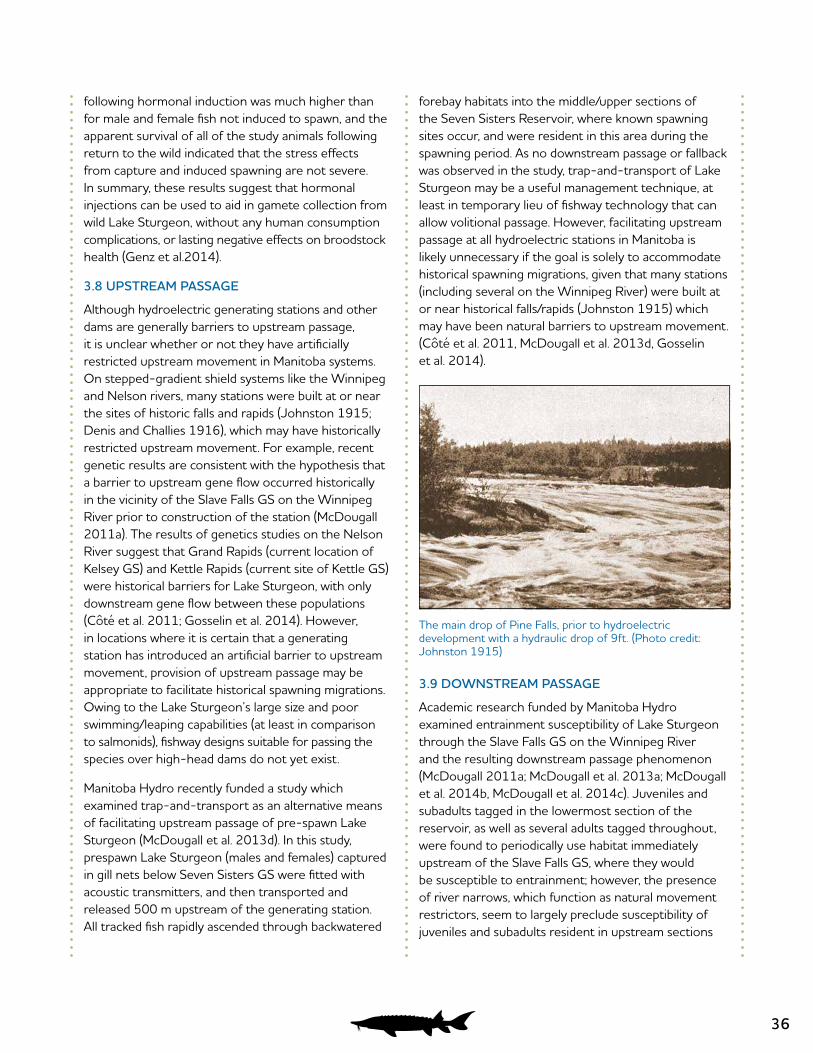
36
following hormonal induction was much higher than for male and female fish not induced to spawn, and the apparent survival of all of the study animals following return to the wild indicated that the stress effects from capture and induced spawning are not severe. In summary, these results suggest that hormonal injections can be used to aid in gamete collection from wild Lake Sturgeon, without any human consumption complications, or lasting negative effects on broodstock health (Genz et al.2014).
3.8 UPSTREAM PASSAGE
Although hydroelectric generating stations and other dams are generally barriers to upstream passage, it is unclear whether or not they have artificially restricted upstream movement in Manitoba systems. On stepped-gradient shield systems like the Winnipeg and Nelson rivers, many stations were built at or near the sites of historic falls and rapids (Johnston 1915; Denis and Challies 1916), which may have historically restricted upstream movement. For example, recent genetic results are consistent with the hypothesis that a barrier to upstream gene flow occurred historically in the vicinity of the Slave Falls GS on the Winnipeg River prior to construction of the station (McDougall 2011a). The results of genetics studies on the Nelson River suggest that Grand Rapids (current location of Kelsey GS) and Kettle Rapids (current site of Kettle GS) were historical barriers for Lake Sturgeon, with only downstream gene flow between these populations (Côté et al. 2011; Gosselin et al. 2014). However, in locations where it is certain that a generating station has introduced an artificial barrier to upstream movement, provision of upstream passage may be appropriate to facilitate historical spawning migrations. Owing to the Lake Sturgeon’s large size and poor swimming/leaping capabilities (at least in comparison to salmonids), fishway designs suitable for passing the species over high-head dams do not yet exist.
Manitoba Hydro recently funded a study which examined trap-and-transport as an alternative means of facilitating upstream passage of pre-spawn Lake Sturgeon (McDougall et al. 2013d). In this study, prespawn Lake Sturgeon (males and females) captured in gill nets below Seven Sisters GS were fitted with acoustic transmitters, and then transported and released 500 m upstream of the generating station. All tracked fish rapidly ascended through backwatered
forebay habitats into the middle/upper sections of the Seven Sisters Reservoir, where known spawning sites occur, and were resident in this area during the spawning period. As no downstream passage or fallback was observed in the study, trap-and-transport of Lake Sturgeon may be a useful management technique, at least in temporary lieu of fishway technology that can allow volitional passage. However, facilitating upstream passage at all hydroelectric stations in Manitoba is likely unnecessary if the goal is solely to accommodate historical spawning migrations, given that many stations (including several on the Winnipeg River) were built at or near historical falls/rapids (Johnston 1915) which may have been natural barriers to upstream movement. (Côté et al. 2011, McDougall et al. 2013d, Gosselin et al. 2014).
3.9 DOWNSTREAM PASSAGE
Academic research funded by Manitoba Hydro examined entrainment susceptibility of Lake Sturgeon through the Slave Falls GS on the Winnipeg River and the resulting downstream passage phenomenon (McDougall 2011a; McDougall et al. 2013a; McDougall et al. 2014b, McDougall et al. 2014c). Juveniles and subadults tagged in the lowermost section of the reservoir, as well as several adults tagged throughout, were found to periodically use habitat immediately upstream of the Slave Falls GS, where they would be susceptible to entrainment; however, the presence of river narrows, which function as natural movement restrictors, seem to largely preclude susceptibility of juveniles and subadults resident in upstream sections
The main drop of Pine Falls, prior to hydroelectric development with a hydraulic drop of 9ft. (Photo credit: Johnston 1915)
37
(McDougall et al. 2013a). Mean annual entrainment rates were estimated at 2.9% (range: 0 –4.4) for adults tagged throughout the reservoir, and 21.1% (range: 19.3 – 22.9) for subadults tagged in the lowermost section of the reservoir (McDougall et al. 2014b). No juvenile entrainment was observed.
Fine-scale movement tracking revealed that downstream passage frequently occurred via bottom-draw regulating sluices located at the northeast end of the powerhouse, and movements in the vicinity of the main spillway were related to bathymetry (McDougall et al. 2014b). At least ten of eleven (91%) of the observed downstream passage events were determined to have been survived (the remaining fish was conservatively assigned an “unknown” survival status). Results suggested management initiatives could exploit the Lake Sturgeon’s bottom-oriented nature to facilitate safe downstream passage, with bottom-draw sluices likely providing an effective solution analogous to surface-flow outlets used for passing surface-oriented juvenile salmonids (McDougall et al. 2014b).
Length-at-age analysis, supported by genetic methods, revealed that 15.2% of the Lake Sturgeon between 525 and 750 mm (fork length) captured in the 6 km stretch of river downstream of Slave Falls were fast-growing outliers, reasoned to have passed downstream through the Slave Falls GS (McDougall 2011a). As such, there is strong evidence to suggest that due to a high rate of survived downstream passage, the influence of upstream immigrants to the downstream population is influential from both genetic and demographic perspectives.
Mark-recapture and acoustic telemetry data also indicate that survived downstream movements of Lake Sturgeon also occur through other Winnipeg River (McDougall and MacDonell 2009; K. Kansas, Manitoba Fisheries Branch, pers. comm.) and Nelson River generating stations (Pisiak et al. 2011; Hrenchuk and Barth 2013). In one study, large juveniles captured in the lower Nelson River were transferred into the Limestone Forebay, and 8 of 16 (50%) passed downstream through the Limestone GS over the course of a three year acoustic monitoring program (Pisiak et al. 2011). Five of eight Lake Sturgeon passed downstream via turbine units, and at least four of these fish were believed to have survived passage. The fate of the fifth fish could not be determined.
3.10 POPULATION STRUCTURING
Within the province of Manitoba, Lake Sturgeon population structuring between rivers is well-known. A study conducted by Ferguson and Duckworth (1997) found genetic differences, based on mitochondrial DNA, among watersheds and/or rivers, and these results influenced the partitioning of Designatable Units (DUs) throughout Canada (COSEWIC 2006). More recent studies based on microsatellite markers and single nucleotide polymorphisms confirm genetic differentiation between Lake Sturgeon stocks in various Manitoba rivers (Kjartanson 2009; Côté et al. 2011; Gosselin et al. 2014); however, Lake Sturgeon have not been sampled in all waterbodies they currently inhabit (e.g., East-side Lake Winnipeg tributaries), in some cases because Lake Sturgeon were extirpated long ago (e.g., Red and Assiniboine rivers). As such, there are still some historical and contemporary data gaps related to broad-scale population structuring within the province. Population structure in Lake Winnipeg, with its many large tributaries that continue to support riverine resident populations (e.g., Winnipeg, Saskatchewan, Pigeon, Berens etc.), is particularly intriguing, but due in large part to over-exploitation and subsequent extirpation of Lake Sturgeon from the lake itself, that question will likely never be answered because genetic signatures of any sub-groups have now almost certainly been lost. Indeed, an extreme level of exploitation (i.e., to the point of extirpation) may confound genetic analysis of within watershed population structure. For example, in a river system where populations were historically structured, if populations in lower reaches were decimated by harvest and populations in upstream reaches were not, cumulative downstream redistribution might eventually repopulate downstream reaches. However, the genetic signature of the upstream populations would, in this case, overwhelm or altogether replace the historic signature of the downstream reach. At worst, such a pattern could lead to the erroneous conclusion of one historically intermixed population.
Until recently, the prevailing (but largely unsubstantiated) notion was that Lake Sturgeon historically moved unimpeded throughout individual river systems, and that construction of hydroelectric and navigational dams has resulted in population fragmentation and confinement. This may be true in some systems; however, given the poor swimming/ leaping capability of the species in combination with the presence of historical falls/rapids (potential barriers to upstream movement and gene flow)
38
on many shield rivers in Manitoba, the potential for adults to “home” to spawning sites (as thought to occur in the Great Lakes region), and a strong tendency for middle to late life stages (juveniles, subadults and adults) to resist downstream redistribution and remain resident in subsections of large riverine systems (despite connected access to a much greater quantity of habitat), there is potential for population structuring within watersheds in Manitoba. It is a common misconception that it is impossible to address historical population genetic patterns within watersheds where dams have been in place for many decades, but genetic differences develop over generations, and because the life history strategy of the Lake Sturgeon is defined by delayed maturation and long generation times (~25 years), genetic patterns observed today reflect historic factors, as opposed to contemporary ones such as fragmentation and overexploitation (Côté et al. 2011; McDougall 2011a; Gosselin et al. 2014). Even for dams constructed over 100 years ago (e.g., Pointe du Bois GS on the Winnipeg River), not enough time (generations) has passed for genetic differences caused by fragmentation to have accumulated.
In the context of interpreting population genetics results, Lake Sturgeon populations show relatively low-levels of genetic differentiation compared to other fish species. Again, this is related at least in part to long generational times; it will take longer for genetic differences (and adaptation) of Lake Sturgeon to occur, than for a species that has a generation time of 5 years or less (e.g. salmon). Further, more subtle population structure will likely occur within a watershed compared with patterns between watersheds, especially if any degree of one-way (i.e. downstream) gene-flow is present. As such, more markers and/or larger sample sizes may be required to detect subtle (but still biologically relevant) patterns that
might exist within a given river. Failure to find genetic differences using a low-resolution set of genetic markers and small sample sizes should not, without other information, be interpreted as evidence of a single inter-mixed population, although there may be temptations to draw such conclusions.
As described in sections 2.3 and 2.8, evidence for historical population structuring within Manitoba rivers has thus far been observed in two localities where it has been objectively studied; the Nelson and Winnipeg rivers (Cote et al. 2011, McDougall 2011a; Gosselin et al. 2014). The Nelson River single nucleotide polymorphism (SNP) study provided unprecedented discriminatory power for Lake Sturgeon populations, and identified six distinct populations including Gull Lake/Birthday Rapids, Kelsey/Grass River, Burntwood River, the lower Nelson River (including Lower Limestone Rapids, Angling River, Weir River), the Hayes River, and the Churchill River (Gosselin et al. 2014). Lake Sturgeon from the Gods River were not genetically distinct from the sturgeon in the Hayes River (Gosselin et al. 2014). Analysis indicated that gene flow between Gull Lake and the lower Nelson River is minimal, and only in the downstream direction (Gosselin et al. 2014). The populations within the Nelson River were historically restricted to one-way gene flow by natural barriers including Grand Rapids (current site of Kelsey GS, but prior to construction was a 6.1 m drop) and Kettle Rapids (current site of Kettle GS, but prior to construction was a 23.8 m drop) (Denis and Challies 1916; Gosselin et al. 2014). The identification of a historically structured meta-population in the Nelson River refutes the hypothesis that there were migrations of Lake Sturgeon that spanned the entire length of the Nelson River (Gosselin et al. 2014).
39
4.0 CONCLUSION
Many organizations have been involved in Lake Sturgeon research and recovery efforts over the past 15 years. As a direct result of these combined efforts, much more is now known about the Lake Sturgeon populations in Manitoba, even compared to what was known at the time of the 2006 COSEWIC assessment that designated the majority of Lake Sturgeon populations in Manitoba as endangered. In many areas, the Lake Sturgeon populations are now showing signs of improvement rather than decline, and in areas where little had been known even five years ago, we now have substantial information on the population and available habitat.
In addition to significantly improving our understanding of populations and potentially limiting factors over the past 15 years, research initiatives have provided valuable knowledge on the ecology of Lake Sturgeon in Manitoba. In the past, the vast majority of literature on Lake Sturgeon has been based on work completed in the Great Lakes. Due to the lack of information on the local (Manitoba) ecology of Lake Sturgeon, observations of Lake Sturgeon ecology in the Great Lakes were applied to populations in Manitoba, in some cases inappropriately. Research initiatives have identified that some aspects of Lake Sturgeon ecology in Manitoba differ from observations in the Great Lakes, and can even be specific to regions within Manitoba.
The significant knowledge gained over the past 15 years on the population and local ecology of Lake Sturgeon in Manitoba will be invaluable for future science-based decisions regarding the recovery and management of populations.
40
5.0 REFERENCES
Aiken, J.K. and C.A. McDougall. 2016. Upper Nelson River juvenile Lake Sturgeon inventories, 2015: Pipestone Lake. A Lake Sturgeon Stewardship and Enhancement Program report prepared for Manitoba Hydro by North/South Consultants, Inc., 56 p.
Aiken, J.K., M.D. Alperyn, C.A. McDougall. 2013.Results of Assiniboine River Lake Sturgeon investigations, 2013. A Lake Sturgeon Stewardship and Enhancement report prepared for Manitoba Hydro by North/South Consultants. Winnipeg, MB. 46 p.
Ambrose, K.M. and C.A. McDougall. 2016. Results of Lake Sturgeon population studies conducted in the lower Churchill River between the Little Churchill River and Swallow Rapids, Summer 2015. A Lake Sturgeon Stewardship and Enhancement Program report prepared for Manitoba Hydro by North/South Consultants, Inc., 55 p.
Ambrose, K.M., C.A. McDougall, P.A. Nelson, L. Murray and D.S. MacDonell. 2007.Results of the 2005 fish community investigations focusing on lake sturgeon. A report prepared for Manitoba Hydro by North/South Consultants Inc., 176 p.
Ambrose, K.M., D.J. Pisiak, P.A. Nelson and D.S. MacDonell. 2010a. Results of the 2008 fish community investigations focusing on lake sturgeon in the Conawapa study area. A report prepared for Manitoba Hydro by North/South Consultants Inc., 150 p.
Ambrose, K.M., D.J. Pisiak, P.A. Nelson and D.S. MacDonell. 2010b. Results of the 2009 fish community investigations focusing on lake sturgeon in the Conawapa study area. A report prepared for Manitoba Hydro by North/South Consultants Inc., 89 p.
Ambrose, K.M., L. Murray, P.A. Nelson and D.S. MacDonell. 2008. Results of the 2006 fish community investigations focusing on lake sturgeon in the Conawapa study area. A report prepared for Manitoba Hydro by North/South Consultants Inc., 217 p.
Ambrose, K.M., L. Murray, P.A. Nelson and D.S. MacDonell. 2009. Results of the 2007 fish community investigations focusing on lake sturgeon in the Conawapa study area. A report prepared for Manitoba Hydro by North/South Consultants Inc., 297 p.
Barth, C.C. 2005. Lake Sturgeon Investigations in the Keeyask Study Area, 2002. A report prepared for Manitoba Hydro by North/South Consultants Inc., Winnipeg, Manitoba. 115 p.
Barth, C.C. 2011. Ecology, behavior, and biological characteristics of juvenile lake sturgeon, Acipenser fulvescens, within an impounded reach of the Winnipeg River, Manitoba, Canada. Ph.D. Thesis. University of Manitoba, Department of Biological Sciences, Winnipeg, MB. 206 p.
Barth, C.C. and K.M. Ambrose. 2006. Lake Sturgeon Investigations in the Keeyask Study Area, 2004. A report prepared for Manitoba Hydro by North/South Consultants Inc., Winnipeg, Manitoba. 91 p.
Barth, C.C. and D.S. MacDonell. 1999. Lower Nelson River lake sturgeon spawning study, Weir River, 1998. A report prepared for Manitoba Hydro by North/South Consultants Inc., 59 p.
Barth, C.C. and J.E. MacDonald. 2008. Lake Sturgeon Investigations in the Keeyask Study Area, 2005. A report prepared for Manitoba Hydro by North/South Consultants Inc., Winnipeg, Manitoba. 50 p.
Barth, C.C. and L. Murray. 2005. Lake Sturgeon Investigations in the Keeyask Study Area, 2003. A report prepared for Manitoba Hydro by North/South Consultants Inc., Winnipeg, Manitoba. 111 p.
Barth, C.C. and N.J. Mochnacz. 2004. Lake Sturgeon investigations in the Gull (Keeyask) Study Area, 2001. A report prepared for Manitoba Hydro by North/South Consultants Inc., Winnipeg, Manitoba. 130 p.
Barth, C.C., S.J. Peake, P.J. Allen, and W.G. Anderson. 2009. Habitat utilization of juvenile lake sturgeon, Acipenser fulvescens, in a large Canadian river. Journal of Applied Ichthyology 25(2): 18-26.
41
Barth, C.C., W. G. Anderson, S. J. Peake, P. Nelson. 2013. Seasonal variation in the diet of juvenile lake sturgeon, Acipenser fulvescens, in the Winnipeg River, Manitoba, Canada. Journal of Applied Ichthyology 29: 721 – 729.
Barth, C.C., W.G. Anderson, L.M. Henderson, and S.J. Peake. 2011. Home range size and seasonal movement of juvenile lake sturgeon in a large river in the Hudson Bay drainage basin. Transactions of the American Fisheries Society 140(6): 1629-1641.
Bateman, L. 2005. A history of hydroelectric power development in Manitoba. IEEE Canadian Review Winter 2005: 22-25.
Bell, J., L.M. Henderson and C.A. McDougall. 2016. Results of Lake Sturgeon investigations below the Jenpeg Generating Station, spring and fall 2015. A Lake Sturgeon Stewardship and Enhancement Program report prepared for Manitoba Hydro by North/South Consultants, Inc., 71 p.
Blanchard, M.A., C. Parker and C.A. McDougall 2014.Results of Lake Sturgeon investigations conducted in the Churchill River between Swallow Rapids and the confluence with the Little Beaver River, June 2013. A Lake Sturgeon Stewardship and Enhancement Program report prepared for Manitoba Hydro by North/South Consultants, Inc.
Block, D. 2001. Growth estimates, habitat use, and ecology of the lake sturgeon, Acipenser fulvescens Rafinesque, from Round Lake and mature reservoirs in the Winnipeg River. M.Sc. Thesis. University of Manitoba, Department of Zoology, Winnipeg, MB. 171 p.
Burnett, D.C. and C.A. McDougall. 2015. Upper Nelson River juvenile Lake Sturgeon inventories, 2014: Little Playgreen Lake. A Lake Sturgeon Stewardship and Enhancement Program report prepared for Manitoba Hydro by North/South Consultants Inc., Winnipeg, Manitoba.
Cleator, H., K.A. Martin, T.C. Pratt and D. Macdonald. 2010a.Information relevant to a recovery potential assessment of Lake Sturgeon: Nelson River populations (DU3). DFO Canadian Science Advisory Secretariat Document 2010/082. vi + 33 p.
Cleator, H., K.A. Martin, T.C. Pratt and D. Macdonald. 2010b. Information relevant to a recovery potential assessment of Lake Sturgeon: western Hudson Bay populations (DU1). DFO Canadian Science Advisory Secretariat Document 2010/080. vi + 26 p.
Cleator, H., K.A. Martin, T.C. Pratt, B. Bruederlin, M. Erickson, J. Hunt, D. Kroeker, D. Leroux, L. Skitt and D. Watkinson. 2010c.
Information relevant to a recovery potential assessment of Lake Sturgeon: Red-Assiniboine rivers – Lake Winnipeg populations (DU4). DFO Canadian Science Advisory Secretariat Document 2010/083. vi + 38 p.
Cleator, H., K.A. Martin, T.C. Pratt, C. Barth, B. Corbett, M. Duda and D. Leroux. 2010d. Information relevant to a recovery potential assessment of Lake Sturgeon: Winnipeg River-English River populations (DU5). DFO Canadian Science Advisory Secretariat Document 2010/084. vi + 34 p.
Cleator, H., K.A. Martin, T.C. Pratt, R. Campbell, M. Pollock and D. Watters. 2010e. Information relevant to a recovery potential assessment of Lake Sturgeon: Saskatchewan River populations (DU2). DFO Canadian Science Advisory Secretariat Document 2010/081. vi + 36 p.
Cooley, P. and J. MacDonald. 2008.Lake Sturgeon habitat on the Churchill River near Island Falls Generating Station. A report prepared for Saskatchewan Power Corporation by North/South Consultants Inc., 85 p.
Cooley, P.M., T.J. Sutton, and E. Fishkin. 2012. Lake sturgeon habitat assessment in the Winnipeg River between Seven Sisters dam and Lac du Bonnet, 2011. A Lake Sturgeon Stewardship and Enhancement Program report prepared for Manitoba Hydro by North/South Consultants Inc., Winnipeg, MB. 40 p.
Coordinated Aquatic Monitoring Pilot Program (CAMP). 2013. Three Year Summary Report. Report prepared for Manitoba Water Stewardship/Manitoba Hydro CAMP MOU Working Group by North/South Consultants Inc., Winnipeg, MB.
COSEWIC (Committee on the Status of Endangered Wildlife in Canada). 2006. COSEWIC assessment and update status report on the Lake Sturgeon Acipenser fulvescens in Canada. COSEWIC, Ottawa.
Côté, G., P.A. Nelson, and L. Bernatchez. 2011. Population Genetics of Lake Sturgeon from the Churchill, Nelson, and Hayes Rivers. A report prepared for Manitoba Hydro by Université Laval and North/South Consultants Inc., Winnipeg, Manitoba. 65 pp.
42
Denis, L.G. and J.B. Challies. 1916. Water Powers of Manitoba, Saskatchewan and Alberta. Commission of Conservation Canada. Toronto, Canada. 334 p.
Dick, T. 2006. Lake Sturgeon studies in the Pigeon and Winnipeg Rivers and Biota Indicators. A report prepared for Manitoba Hydro. 429 p.
Dolce Blanchard, L.T. and C.C. Barth. 2015.Results of Lake Sturgeon population studies conducted in the lower Churchill River between The Fours and Swallow Rapids, Summer 2014 - Year 1. A Lake Sturgeon Stewardship and Enhancement Program report prepared for Manitoba Hydro by North/South Consultants Inc., Winnipeg, Manitoba. 49p.
Ferguson, M.M., and G.A. Duckworth. 1997. The status and distribution of lake sturgeon, Acipenser fulvescens, in the Canadian provinces of Manitoba, Ontario and Quebec: a genetic perspective. Environmental Biology of Fishes 48: 299 – 309.
Genz, J., C. A. McDougall, D. Burnett, L. Arcinas, S. Khetoo and W. G. Anderson. 2014.Induced spawning of wild-caught adult Lake Sturgeon: assessment of hormonal and stress responses, gamete quality and survival. Journal of Applied Ichthyology 30 (6):1565-1577.
Gillespie, M.A. and D.S. MacDonell. 2013. Results of Lake Sturgeon egg deposition and larval drift monitoring below Pointe du Bois Generating Station, 2012. A report prepared for Manitoba Hydro by North/South Consultants Inc., Winnipeg MB. 68 p.
Gosselin, T., P. A. Nelson, C.A. McDougall and L. Bernatchez. 2014Population genomics of Lake Sturgeon (Acipenser fulvescens) in the Nelson and Hayes rivers. A Report Prepared for Manitoba Hydro.
Groening, L.D., J.K. Aiken and C.A. McDougall. 2014.Upper Nelson River juvenile Lake Sturgeon inventories, 2013: The Landing River area. A Lake SturgeonStewardship and Enhancement Program report prepared for Manitoba Hydro by North/South Consultants, Inc. 49 p.
Harkness, W.J.K. 1980. Report on the sturgeon situation in Manitoba. Winnipeg, MB. Report #80 3.
Henderson, L.M. 2013. Larval drift characteristics, habitat requirements and environmental determinants of year-class strength in wild age-0 Lake Sturgeon, Acipenser fulvescens, within a large impounded river. M.Sc. Thesis. University of New Brunswick, Canadian Rivers Institute, Fredericton, NB. 101 p.
Henderson, L.M. and C.A. McDougall. 2012. Lake sturgeon spawning investigations in the Great Falls and Pine Falls reservoirs – spring, 2011. A Lake Sturgeon Stewardship and Enhancement report prepared for Manitoba Hydro by North/South Consultants Inc., Winnipeg, MB. 34 p.
Henderson, L.M. and D.J. Pisiak. 2012. Results of young-of-the-year and subadult lake sturgeon investigations in the Keeyask Study Area, spring and fall 2011. A report prepared for Manitoba Hydro by North/South Consultants Inc., Winnipeg, Manitoba. 46 p.
Henderson, L.M., C.C. Barth, J.E. MacDonald, and S.J. Garner. 2011. Results of a coarse scale habitat inventory in the upper Split Lake area, fall 2010. A report prepared for Manitoba Hydro by North/South Consultants Inc., Winnipeg, Manitoba.
Henderson, L.M., T.J. Sutton and C.A. McDougall. 2015.Lake Sturgeon Spawning and Habitat Investigations below the Jenpeg Generating Station, Spring 2014. A Lake Sturgeon Stewardship and Enhancement Program report prepared for Manitoba Hydro by North/South Consultants Inc., Winnipeg, Manitoba. 55p.
Henderson, L.M. and C.A. McDougall. 2015.Results of Lake Sturgeon investigations in the Winnipeg River between the Ontario border and Pointe du Bois Generating Station, 2014. A Lake Sturgeon Stewardship and Enhancement Program report prepared for Manitoba Hydro by North/South Consultants Inc., Winnipeg, Manitoba. 64p.
Henderson, L.M., T.J. Sutton and C.A. McDougall. 2016. Nelson River juvenile Lake Sturgeon inventories, 2015: Sipiwesk Lake inlets. A Lake Sturgeon Stewardship and Enhancement Program report prepared for Manitoba Hydro by North/South Consultants, Inc., 56 p.
Holm, J., K. Ambrose, and D.S. MacDonell. 2006. Conawapa Generation Project: results of the 2004 fish community investigations focusing on lake sturgeon. A report prepared for Manitoba Hydro by North/South Consultants Inc., 145 p.
43
Holm, J. and W.J. Bernhardt. 2011. Results of the 2006 fish community investigations in the Nelson River estuary. A report prepared for Manitoba Hydro by North/South Consultants Inc., Winnipeg, Manitoba. 25 p.
Hrenchuk, C.L. 2011. Influences of water velocity and hydropower operations on spawning site choice and recruitment success of Lake Sturgeon, Acipenser fulvescens, in the Winnipeg River. M.Sc. Thesis. University of New Brunswick, Fredericton, NB. xiii + 138 pp.
Hrenchuk, C.L. and C.A. McDougall 2012. Adult Lake Sturgeon investigations in the Keeyask Study Area, 2011. A report prepared for Manitoba Hydro by North/South Consultants Inc., Winnipeg, Manitoba. 167 p.
Hrenchuk, C.L. and C.C. Barth 2013. Adult Lake Sturgeon investigations in the Keeyask Study Area, 2012. A report prepared for Manitoba Hydro by North/South Consultants Inc., Winnipeg, Manitoba. 167 p.
Johnson, M.W. and P.A. Nelson. 2011. Lake Sturgeon population assessment in the Churchill River near the Island Falls Hydroelectric Station, spring 2011. A report prepared for Saskatchewan Power Corporation by North/South Consultants Inc., Winnipeg, MB. 72 p.
Johnston, J.T. 1915. Report on the Winnipeg River power and storage investigations. Water Resources Paper No. 3. Volume I. Department of the Interior Canada, Dominion Water Power Branch, Ottawa, On. 400 p.
Kjartanson, S. 2009. Population structure and genetic diversity of lake sturgeon, Acipenser fulvescens, in Canada: evaluation of designatable units for conservation. MSc Thesis. University of Toronto, Toronto, Ontario. 123 p.
Klassen, C.N. 2012. Results of the 2011 Gods River lake sturgeon spawning and movement investigation. A draft report prepared for Manitoba Hydro by North/South Consultants Inc., 32 p.
Klassen, C.N. 2014.Growth rate and size variability among juvenile Lake Sturgeon, Acipenser fulvescens: implications for recruitment. Ph.D. Thesis. University of Manitoba, Department of Biological Sciences, Winnipeg, MB. 182 p.
Koga, E. and D.S. MacDonell. 2010. Results of lake sturgeon studies on the Winnipeg River in the vicinity of Pointe du Bois generating station - 2009. A report prepared for Manitoba Hydro by North/South Consultants Inc., Winnipeg, MB. 209 p.
Koga, E. and D.S. MacDonell. 2011. Results of lake sturgeon studies on the Winnipeg River in the vicinity of Pointe du Bois generating station - 2010. A report prepared for Manitoba Hydro by North/South Consultants Inc., Winnipeg, MB. 104 p.
Koga, E. and D.S. MacDonell. 2012. Results of lake sturgeon studies on the Winnipeg River in the vicinity of Pointe du Bois Generation Station – 2011. A report prepared for Manitoba Hydro by North/South Consultants Inc., Winnipeg, MB. 80 p.
Koga, E., C. A. McDougall, and D. S. MacDonell. 2013. Results of juvenile Lake Sturgeon monitoring in the Slave Falls Reservoir, 2012. A report prepared for Manitoba Hydro by North/South Consultants Inc., Winnipeg, MB. 69 p.
Labadie, H. 2011. Growth patterns and movements of adult lake sturgeon (Acipenser fulvescens) in a deep impounded river. M.Sc. Thesis, University of New Brunswick, Department of Biology, Fredericton, NB. 115 p.
Lake of the Woods Control Board (LWCB). 2002. Managing the water resources of the Winnipeg River drainage basin. Ottawa, Ontario. Online source. Retrieved from: http://www.lwcb.ca/permpdf/LWCBBrochure2002Nov.pdf (April 2013).
Larter, J., P. Cooley, and T. Sutton. 2010. Depth, substratum, and aquatic macrophyte distributions: Lamprey Rapids to Slave Falls GS tailrace. A report prepared for Manitoba Hydro by North/South Consultants Inc., Winnipeg, MB. 51 p.
Larter, J. and C.M. Parker. 2014.Lake Sturgeon habitat on the Winnipeg River: Pointe du Bois GS to the Manitoba/Ontario border. A report prepared for Manitoba Hydro by North/South Consultants Incl, Winnipeg, MB. 61 p.
44
Lavergne, S.C. 2012. Lake Sturgeon spawning investigation in the Long Spruce forebay, spring 2012. A Lake Sturgeon Stewardship and Enhancement Program report prepared for Manitoba Hydro by North/South Consultants Inc., Winnipeg, MB. 27 p.
Lavergne, S.C. and C.C. Barth. 2012. Inventory of the Lake Sturgeon population in the Long Spruce forebay, September 2012. A Lake Sturgeon Stewardship and Enhancement Program report prepared for Manitoba Hydro by North/South Consultants Inc., Winnipeg, MB. 39 p.
Lowden, M. And L. Queen. 2013. Pine Falls Generating Station Environmental Assessment: Fisheries Technical Report. Prepared for Manitoba Hydro by AAE Tech Services Inc., Winnipeg, MB. 197 p.
Lower Nelson River Sturgeon Stewardship Committee (LNRSSC). 2013. Lower Nelson River Sturgeon Stewardship Agreement: Committee Terms of Reference.
Macdonald, D. 1998. Nelson River sturgeon studies, 1993-1997. Five year unpublished report for the Nelson River Sturgeon Co-Management Board by Manitoba Department of Natural Resources, Thompson, MB. 44 p.
MacDonald, J.E. 2008. Lake Sturgeon Investigations in the Keeyask Study Area, 2006. A report prepared for Manitoba Hydro by North/South Consultants Inc., Winnipeg, Manitoba. 95 p.
MacDonald, J.E. 2009. Lake Sturgeon Investigations in the Keeyask Study Area, 2007-2008. A report prepared for Manitoba Hydro by North/South Consultants Inc., Winnipeg, Manitoba. 100 p.
MacDonald, J.E. and C.C. Barth. 2011. Lake Sturgeon Investigations in the Keeyask Study Area, Spring 2010. A report prepared for Manitoba Hydro by North/South Consultants Inc., Winnipeg, Manitoba. 64 p.
MacDonell, D.S. 1995. Lower Nelson River Lake Sturgeon spawning study, Weir River – 1994. A report prepared for Manitoba Hydro by North/South Consultants Inc., 31 p.
MacDonell, D.S. 1997a. Lower Nelson River lake sturgeon spawning study – Weir River, 1996. A report prepared for Manitoba Hydro by North/South Consultants Inc., 47 p.
MacDonell, D.S. 1997b. The Nelson River lake sturgeon fishery from the perspective of the bayline communities of Pikwitonei, Thicket Portage, and Wabowden. MNRM Thesis. University of Manitoba, Winnipeg, Manitoba. ix + 173 pp.
MacDonell, D.S. 1998. Lower Nelson River lake sturgeon spawning study Weir River – 1997. A report prepared for Manitoba Hydro by North/South Consultants Inc., 61 p.
Maclean, B.D. and P.A. Nelson. 2005. Population and Spawning Studies of Lake Sturgeon (Acipenser fulvescens) at the confluence of the Churchill and Little Churchill Rivers, Manitoba, Spring 2003. A report prepared for Manitoba Hydro by North/South Consultants Inc., Winnipeg, Manitoba. 56 p.
Manitoba Conservation and Water Stewardship (MCWS). 2012. Manitoba lake sturgeon management strategy – 2012. Manitoba Conservation and Water Stewardship, Fisheries Branch. 59 p.
Manitoba Hydro. 2011.Pointe du Bois Spillway Replacement Project: Environmental Impact Statement, June 2011. 550 p.
Manitoba Hydro. 2013. Water Regimes & Levels: Churchill River Diversion.
McDougall, C.A. 2011a. Investigating downstream passage of Lake Sturgeon, Acipenser fulvescens, through a Winnipeg River generating station. M.Sc. Thesis. University of Manitoba, Winnipeg, Manitoba. x + 175 p.
McDougall, C.A. 2011b. Results of juvenile Lake Sturgeon inventories in the Great Falls and Pine Falls reservoirs – Fall, 2011. A Lake Sturgeon Stewardship and Enhancement Program report prepared for Manitoba Hydro by North/South Consultants Inc., Winnipeg, Manitoba. 46 p.
45
McDougall, C.A. and D.J. Pisiak. 2012. Results of a Lake Sturgeon inventory conducted in the Sea Falls to Sugar Falls reach of the Nelson River – Fall, 2012. A Lake Sturgeon Stewardship and Enhancement Program report prepared for Manitoba Hydro by North/South Consultants Inc., Winnipeg, Manitoba. 46 p.
McDougall, C.A. and D.S. MacDonell. 2009. Results of lake sturgeon studies in the Slave Falls Reservoir and Pointe du Bois forebay - 2008. 2009. A report prepared for Manitoba Hydro by North/South Consultants Inc., Winnipeg, MB. 254 p.
McDougall, C.A. and M.A. Gillespie. 2012. Habitat documentation at potential Winnipeg River spawning locations - Fall, 2011. A Lake Sturgeon Stewardship and Enhancement Program report prepared for Manitoba Hydro by North/South Consultants Inc., Winnipeg, MB. 63p.
McDougall, C.A., C.L. Hrenchuk, and C.C. Barth. 2013b. Results of juvenile Lake Sturgeon movement and utilization studies in Stephens Lake, 2011. A report prepared for Manitoba Hydro by North/South Consultants Inc., Winnipeg, MB. 93 p.
McDougall, C.A., C.L. Hrenchuk, and C.C. Barth. 2013c. Results of Juvenile Lake Sturgeon Movement Studies in Stephens Lake - October 2011 to October 2012. A report prepared for Manitoba Hydro by North/South Consultants Inc., Winnipeg, MB. 39 p.
McDougall, C.A., C.L. Hrenchuk, W.G. Anderson, and S.J. Peake. 2013d. The rapid upstream migration of pre-spawn Lake Sturgeon following trap-and-transport over a hydroelectric generating station. North American Journal of Fisheries Management 33: 1236 - 1242.
McDougall, C.A., D.S. MacDonell, D.F. Hudd, and L. Murray. 2008a. Results of lake sturgeon studies in the Slave Falls Reservoir and Pointe du Bois forebay - 2007. A report prepared for Manitoba Hydro by North/South Consultants Inc., Winnipeg, MB. 234 p.
McDougall, C.A., P. Graveline, and D.S. MacDonell. 2008b. Preliminary investigations of lake sturgeon spawning and habitat utilization in the Slave Falls Reservoir and Pointe du Bois forebay - 2006. A report prepared for Manitoba Hydro by North/South Consultants Inc., Winnipeg, MB. 88 p.
McDougall, C.A. and D.J. Pisiak. 2014.Upper Nelson River Juvenile Lake Sturgeon Inventories, 2013: Sea Falls - Sugar Falls and the Pipestone Lake Area. A Lake Sturgeon Stewardship and Enhancement Program report prepared for Manitoba Hydro by North/South Consultants Inc., Winnipeg, Manitoba. 105p.
McDougall, C.A and P.A. Nelson. 2015. Upper Nelson River juvenile Lake Sturgeon inventories, 2014: Sea Falls – Sugar Falls. A Lake Sturgeon Stewardship and Enhancement Program report prepared for Manitoba Hydro by North/South Consultants Inc., Winnipeg, Manitoba. In Preparation.
McDougall, C.A. and P.A. Nelson. 2016. Upper Nelson River juvenile Lake Sturgeon inventories, 2015: Sea Falls to Sugar Falls. A Lake Sturgeon Stewardship and Enhancement Program report prepared for Manitoba Hydro by North/South Consultants, Inc., 71 p.
McDougall, C.A., P.J. Blanchfield, S.J. Peake, and W.G. Anderson. 2013a. Movement patterns and size-class influence entrainment susceptibility of Lake Sturgeon in a small hydroelectric reservoir. Transactions of the American Fisheries Society 142(6): 1508-1521.
McDougall, C.A., S.J. Peake, and W.G. Anderson. 2014b.Downstream passage of Lake Sturgeon through a Hydroelectric Generating Station: passage route determination, survival, and fine-scale movements to North American Journal of Fisheries Management. 34(3):546-558.
McDougall, C.A., D.J. Pisiak, C.C. Barth, M.A. Blanchard, D.S. MacDonell and D. Macdonald. 2014a.Relative recruitment success of stocked age-1 vs age-0 lake sturgeon (Acipenser fulvescens Rafinesque, 1817) in the Nelson River, northern Canada. Journal of Applied Ichthyology 30(6):1451-1460.
McDougall, C.A., C.C. Barth, J.K. Aiken, L.M. Henderson, M.A. Blanchard, K. Ambrose, C.L. Hrenchuk, M.A. Gillespie and P.A. Nelson. 2014d.
How to sample juvenile Lake Sturgeon (Acipenser fulvescens Rafinesque 1817), in Boreal Shield rivers using gillnets, with an emphasis on assessing recruitment patterns. Journal of Applied Ichthyology 30(6): 1402-1415.
McDougall, C.A., P.J. Blanchfield and W.G. Anderson. 2014c.Linking movements of lake sturgeon (Acipenser fulvescens Rafinesque, 1817) in a small hydroelectric reservoir to abiotic variables. Journal of Applied Ichthyology 30(6): 1149-1159.
46
McLeod, J.A. 1943. Preliminary investigations of eight lakes in the Whiteshell Forest Reserve. Manitoba Department of Mines and Natural Resources, Game and Fisheries Branch. 8 p.
Memorandum of Understanding Respecting Lake Sturgeon between Government of Manitoba and Manitoba Hydro-Electric Board. 2014.
Annual Report.Michaluk, Y. and J.E. MacDonald. 2010.
Lake Sturgeon Investigations in the Keeyask Study Area, 2009. A report prepared for Manitoba Hydro by North/South Consultants Inc., Winnipeg, Manitoba. 83 p.
Murray, L. and M.A. Gillespie. 2011. Lake sturgeon inventory and habitat assessment - Winnipeg River from McArthur to Pine Falls, 2010. A Lake Sturgeon Stewardship and Enhancement Program report prepared for Manitoba Hydro by North/South Consultants Inc., Winnipeg, MB. 52 p.
Nelson, P.A. and C.C. Barth. 2011. Results of a Lake Sturgeon population assessment conducted in the Churchill River near the Island Falls Hydroelectric Station. A report prepared for Saskatchewan Power Corporation by North/South Consultants Inc., Winnipeg, MB. 43 p.
Nelson, P.A. and C.C. Barth. 2012. Abundance of Lake Sturgeon in the Keeyask Study Area: 1995 to 2011. A report prepared for Manitoba Hydro by North/South Consultants Inc., Winnipeg, MB. 36 p.
Nelson, P.A. and M. Johnson. 2016. Saskatchewan River Sturgeon Management Board: Juvenile Lake Sturgeon Surveys 2015. A report prepared for SaskPower and Manitoba Hydro by North/South Consultants, Inc., 56 p.
Northern Lights Heritage Services. 1994. Norway House domestic fisheries: a historical review. A report prepared for North/South Consultants Inc. 26 p.
North/South Consultants (NSC). 2003. Saskatchewan River Lake Sturgeon Harvest Surveys 2001-2002. A report prepared for the Saskatchewan River Sturgeon Management Board by North/South Consultants Inc., Winnipeg, MB. 43 p.
North/South Consultants (NSC). 2011. Churchill River Lake Sturgeon Inventory 2010. A Lake Sturgeon Stewardship and Enhancement Report prepared for Manitoba Hydro by North/South Consultants Inc., Winnipeg, MB. 24 p.
North/South Consultants (NSC). 2012a. Saskatchewan River Sturgeon Management Board: Ten-Year Management Plan Review. A report prepared for the Saskatchewan River Sturgeon Management Board by North/South Consultants Inc., Winnipeg, MB. 31 p.
North/South Consultants (NSC). 2012b. Spawning Habitat Suitability Modeling at Pointe du Bois with an emphasis on Lake Sturgeon. A report prepared for Manitoba Hydro by North/South Consultants Inc., Winnipeg, MB. 26 p + appendices.
Petch, V. 1992. A preliminary indication of isinglass harvested in the Norway House Area, 1832 – 1892. A report prepared for North/South Consultants Inc. by Northern Lights Heritage Services. 6 p.
Pisiak, D.J. and B. MacLean. 2007. Population studies of Lake Sturgeon (Acipenser fulvescens) in the Fox River, Manitoba, Summer 2004. A report prepared for Manitoba Hydro by North/South Consultants Inc., Winnipeg, Manitoba. 42 p.
Pisiak, D.J., L.T. Dolce Blanchard, and D.S. MacDonell. 2011. Results of the 2010 Fish community investigations focusing on lake sturgeon in the Conawapa Study Area. A report prepared for Manitoba Hydro by North/South Consultants Inc., Winnipeg, MB. 82 p.
Rosenberg D.M., P.A. Chambers, J.M. Culp, W.G. Franzin, P.A. Nelson, A.G. Salki, M.P. Stainton, R.A. Bodaly, and R.W. Newbury. 2005.
Nelson and Churchill Rivers. In Rivers of North America. Editors: A.C. Benke, and C.E. Cushing. Elsevier. pp: 853-902.Skaptason, J.B. 1926.
The fish resources of Manitoba. Industrial Development Board of Manitoba. Winnipeg, MB. 43 p.Sopuck, R.D. 1987.
A study of the Lake Sturgeon (Acipenser fulvescens) in Sipiwesk Lake area of the Nelson River, Manitoba: 1976-1977. Manitoba Natural Resources Manuscript Report #87-2. 50 p.
47
Sparks, K. 2011. Metapopulation structure and subadult lake sturgeon ecology in an impounded section of the Winnipeg River. M.Sc. Thesis. University of New Brunswick, Department of Biology, Fredericton, NB. 105p.
Stewart, D.B. 2009. Historical harvests of lake sturgeon (Acipenser fulvescens) from western Canada. A report prepared for Fisheries and Oceans Canada by Arctic Biological Consultants, Winnipeg,
Sunde, L.A. 1961. Growth and reproduction of the Lake Sturgeon (Acipenser fulvescens Rafinesque) of the Nelson River in Manitoba. M.Sc. Thesis, University of British Columbia, Vancouver, BC. 93 p.
Sutton, T.J. and C.A. McDougall. 2016. Assessment of Lake Sturgeon Spawning Habitat Suitability below the Kettle Generating Station. A Lake Sturgeon Stewardship and Enhancement Program report prepared for Manitoba Hydro by North/South Consultants, Inc., 66 p.
Swanson, G.M., K.R. Kansas, and R.A. Remnant. 1988. A report on the fisheries resources of the lower Nelson River and the impacts of hydroelectric development, 1987 data. Manitoba Natural Resources, Fisheries Branch Report No. 88-13, 295 p.
Swanson, G.M., K.R. Kansas, and S.M. Matkowski. 1990. A report on the fisheries resources of the lower Nelson River and the impacts of hydroelectric development, 1988 data. Manitoba Natural Resources, Fisheries Branch Report No. 90-18. 260 pp.
Swanson, G.M., K.R. Kansas, S.M. Matkowski, and P. Graveline. 1991. A report on the fisheries resources of the lower Nelson River and the impacts of hydroelectric development, 1989 data. Manitoba Natural Resources, Fisheries Branch Report No. 91-03. 248 p.
Wallace, R.G. 1991. Species recovery plan for Lake Sturgeon on the Lower Saskatchewan River (Cumberland Sound area). Fisheries Branch, Saskatchewan Parks and Renewable Resources. Regina, SK. Fisheries Technical Report 91-3. 51 p.
Wallace, R.G. and D.R. Leroux. 1999. Lake Sturgeon in the lower Saskatchewan River: radiotracking and index fishing, 1994-1997. Interprovincial Sturgeon Steering Committee. Fish and Wildlife Technical Report 99-4. 83 p.

For more information please contact [email protected]