land and water use. topics rangeland urban land development public and federal lands mining ...
TRANSCRIPT

Land and Water Use

Topics Rangeland Urban Land Development Public and Federal Lands Mining Fishing Global Economics

Rangeland

Rangeland Vast natural
landscapes with different vegetation including tall and short grasslands, chaparral, scrubland, woodlands, and wetlands
Covered in natural vegetation and often used as grazing lands

Rangelands Rangelands are about 40% of the land in the US
Nearly 80% of the land in the west Only 7% on the east coast

Value of Rangelands Source of grazing for livestock and wildlife
Low input, fully renewable food production Source of high quality water, clean air, and
open space Setting for recreation
Fishing, hunting, camping, hiking, nature experiences
Used for agriculture, mining, and living communities
Habitat for many game and non-game animals
Habitat for diverse array of natural plants
Overgrazing Occurs when plants are exposed for too
long without sufficient recovery periods. Plants that are overgrazed lose their
stored energy and die Root dieback can add nutrients to the soil and
improve water retention Plants are over grazed when it is regrazed
before the roots recover Overgrazing slows root growth by 90%

Consequence of overgrazing Pastures are less productive Soils have less organic matter and are less
fertile Soil porosity is decreased Infiltration and moisture holding capacity
of the soil drops Desired plants become stressed and
weedier species thrive Biodiversity decreases by reducing native
vegetation

Consequence of overgrazing Erosion can occur Riparian (river banks, stream beds) can be
destroyed and increase silting Eutrophication due to cattle waste Balance of ecosystem is threatened
through predator control programs Diseases can thrive Sustainability of the land is threatened

Desertification Conversion of marginal rangeland or
cropland to more desert type land Caused by:
Overgrazing Soil erosion Prolonged drought Climate change

Steps of desertification1. Overgrazing results in animals eating all
available plant life2. Rain washes away trampled soil3. Wells, springs, and other water sources dry up4. Remaining vegetation dies or is taken for
firewood5. Weeds unsuitable to grazing take over6. Ground becomes unsuitable for seed
germination7. Winds and dry heat blow away the topsoil


Federal Rangeland Management Jurisdiction through Forest Service and
Bureau of Land Management (BLM) Before 1995: policies determined by
rancher advisory boards After 1995: resource advisory council was
formed by member of many groups with many interests
40% of federal grazing permits are owned by 3% (~2000) of all livestock operators True cost =~$10 - $20 per animal per day

Methods of rangeland management1. Controlling the number and distribution of
livestock so that the carrying capacity is not exceeded
2. Restoring degraded rangeland3. Moving livestock from one area to
another to allow the rangeland to recover4. Fencing off riparian areas to reduce
damage to these sensitive areas5. Suppressing the growth of invasive plant
species

Methods of rangeland management6. Replanting barren rangeland with native
grass seed to reduce soil erosion7. Providing supplemental feed at selected
sites8. Locating water holes, water tanks, and
salt blocks at strategic points that do not degrade the environment

Conservation concerns Land administered by the BLM is inhabited
by 219 species of wildlife
Livestock grazing is the fifth rated threat to endangered plant species, fourth leading threat to endangered wildlife, and number one threat to endangered species in arid regions

Urban Land Development

Planned Development In US
76 million residential buildings 5 million commercial buildings
Use: 1/3 of the energy 2/3 of the electricity
Energy needs ½ of sulfur dioxide 1/4 of nitrous oxide 1/3 of carbon dioxide

Green buildings and cities Focus on systems approach Include:
Energy conservation through government and private rebates, tax incentives, and other less-polluting forms of energy
Resource-efficient building techniques and materials
Indoor air quality Water conservation through use of xeriscaping Designs that minimize waste while utilizing
recycled materials

Green buildings and cities Include:
Placing buildings whenever possible near public transportation hubs that use a multitude of venues such as light rail, subways, and park and rides
Creating environments that are pedestrian friendly by incorporating parks, green-belts, and shopping areas in accessible areas
Preserving historical and cultural aspects of the community while at the same time blending into natural feeling and aesthetics of a community

Suburban sprawl and urbanization Urbanization = the movement of people form
rural areas to cities and the changes that accompany it
Greatest urbanization in Asia and Africa Reasons for the move:
Access to jobs Easier access to health care Mechanization of agriculture Access to education
Nations with most rapid increase in urbanization are those with the most rapid economic growth

Pros of urbanization Uses less land – less
impact on the environment
Better education delivery system
Mass transit systems reduce reliance on fossil fuels – shorter commute
Better sanitation Recycling systems are
more efficient
Large numbers of people generate higher tax revenues
Urban areas attract industry due to availability of raw materials, distribution networks, customers, and labor pool
Much pollution comes from point sources – enables focused remediation techniques

Cons of urbanization More concentrated
impact on the land Overcrowded schools Commuting times are
longer because infrastructure cannot keep up with growth
Sanitiation systems have greater volumes of waste to deal with
Solid-waste build up is more pronounced – landfill space is scarce and costly
Large number of poor strain social services – wealthier people move to suburbs and decreases the tax base
High population densities lead to higher crime rates
Population increase may be greater than job growth rate
Pollution levels are high
Transportation and Infrastructure Transportation can be via roadways or
water channels
Areas without transportation infrastructure suffer ecosystem impacts Degraded environment due to off-roading People take multiple paths through the
environment instead of just one

Federal Highway System ~160,000 miles of roadway important to
nations economy, defense, and mobility Receive federal funding but are owned,
built, and operated by the states Taxes
18 cents/ gallon of gas 25 cents/ gallon of diesel Tax on heavy vehicles
Federal Highway System Continued Serves all major US cities Interstates go through downtown areas
and facilitate urban sprawl Virtually all goods and services go involve
the highways system at some point in time

Impact of an efficient and well maintained highways system Less pollution: less stop and go traffic = less
pollution Reduced green house gasses: reduced congestion
= less greenhouse gas emissions Improve fuel economy and reduce dependence
on foreign oil: fueled economy (mpg) is reduced in traffic Modest improvements would save 1 billion gallons of
fuel each year Improve the economy: interstates return $6 for
every $1 invested Improve the quality of life: allow products to be
distributed more efficiently

Canals and Channels Channel (straight) –
narrow body of water that connect two larger bodies of water
Can be natural or constructed Need dredging because
of silting

Channels Channels frequented by ships are
maintained by the Department of the Interior
Monitored and policed by the Coast Guard
Smaller channels are maintained by state and local governments

Suez Canal 163 mile canal
connect the Red Sea and the Mediterranean
Allows water transport between Europe and Asia without going around Africa
8% of the world’s shipping goes through the Suez Canal

Panama Canal 48 mile canal
connecting the Pacific Ocean with the Atlantic
Allows water transport without going around South America

Lake Gatun An artificial lake created to help traffic on
the Panama Canal Deforestation has lead to rapid run off of
rain and erosion of the slopes The lake needs to be dredged to maintain its
depth Shortfall in the dry season threatens the lake’s
capacity

Roadless Areas and Ecosystem Impact Roadless areas are a haven for fish and
wildlife interior species that have suffered habitat loss in other areas
Provide habitat to 1600+ threatened or endangered species
Protects watersheds Roadless rule protects 60 million acres or
31% of National Forest systems – 2% of total land area

Public and Federal Lands

Management – BLM Manages:
1/8 of the United States (262 million acres) 300 million acres of subsurface mining
resources Wildlife management and preservation on 400
million acres Mostly in western US and Alaska Grasslands, forests, high mountains, arctic
tundra, deserts Resources: energy, mineral, timber, forage,
wild horse and burro populations, fish and wildlife habitats, wilderness, areas, archeological, paleontological, and historical sites

National Parks World wide: over 1,100
Most do not receive protection from poachers, loggers, miners, and farmers due to cost involved

U.S. National Parks 84 million acres (4 million in private
ownership) Threatened by:
large numbers of visitors Congestion eroded trails noise pollution pollution from autos and visitors introduction of invasive species off road vehicles commercial activities

Solution to national park issues Reducing amount of private land within national
parks Providing education programs to the public Setting quotas on attendance through advanced
reservation Adopting a fee that covers costs Banning off-road vehicles Banning autos and providing buses to control traffic Providing tax incentives to property owners near
parks to use land grants Conducting periodic and detailed wildlife and plant
inventories

Laws relevant to national parks Wilderness act (1964) Wild and scenic rivers act (1968) Food Security Act (1985): a.k.a
“Swampbuster” contains provisions to discourage the conversion of wetlands into non-wetland areas. Also created system for farmers to regain lost federal benefits if they restore converted wetlands.

Wildlife Refuges 1st: Pelican Island, 4-acres off the coast of
Florida in 1903 to protect breeding birds First created to protect wildlife that was
over hunted Bison, birds
System developed piecemeal in response to wildlife crisis

National Wildlife Refuge Consists of:
547 refuges 93+ million acres
Managed by Fish and Wildlife Service
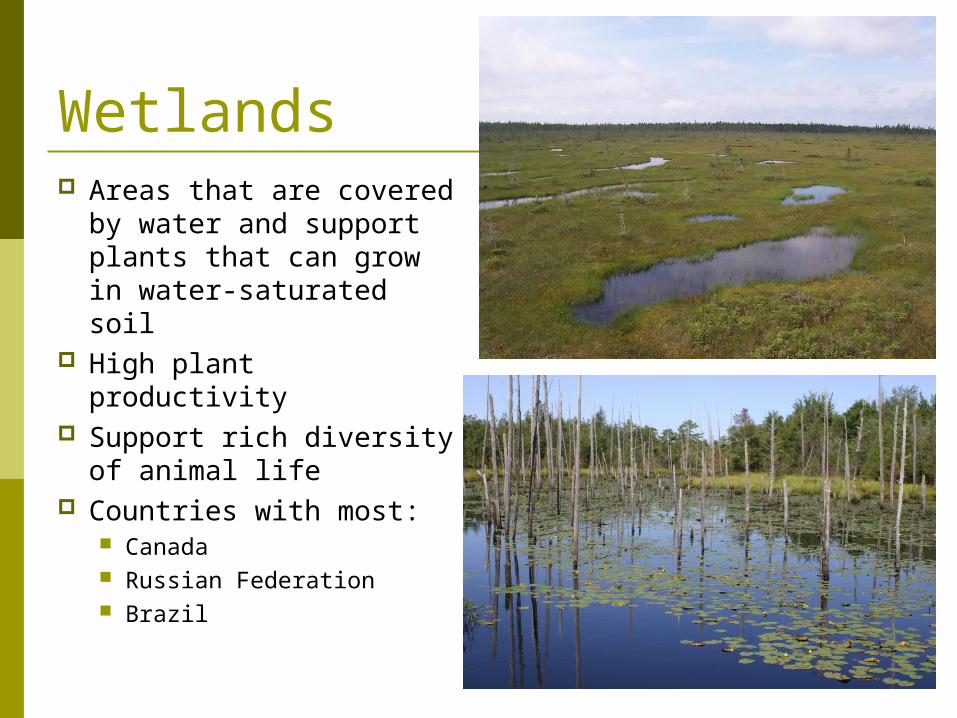
Wetlands Areas that are covered
by water and support plants that can grow in water-saturated soil
High plant productivity Support rich diversity
of animal life Countries with most:
Canada Russian Federation Brazil

Value of wetlands Natural water purification systems Stabilize shorelines and reduce damage by
storm surges Reduce the risk of flooding Reduce salt water intrusion Habitat for many species during all or part
of their life cycle

Types of Wetlands Fen
Has a continuous source of ground water rich in magnesium and calcium (alkaline or basic)
Water is from glacial deposits Ground is impermeable to water so water sits
on the surface Bog
Accumulates acidic peat In cold and temperate climates Low in nutrients and highly acidic Carnivorous plants adapted

Habitat Loss In US, wetlands used to cover 10% of the
land; now they only cover 5% Most in Louisiana and Florida
90% of habitat loss is due to conversion to agriculture or urban development
1/3 of all endangered species in US spend part of their life in a wetland

Wilderness areas Wild or primitive portions of national
forests, parks, and wildlife refuges where little to no human activity occurs
Wilderness Act created National Wilderness Preservation System
Encompasses a wide variety of ecosystems throughout the country