land parcel location via quick response (qr) code · land parcel location via quick response (qr)...
TRANSCRIPT

Land Parcel Location Via Quick Response (QR) Code, (6861) Jaafar Jasmee, Suriati Juhari and Roslina Idris (Malaysia) FIG Congress 2014 Engaging the Challenges – Enhancing the Relevance Kuala Lumpur, Malaysia 16-21 June 2014
1/16
Land
Land Parcel Location Via
Quick Response (QR) Code
Jasmee JAAFAR, Suriati JUHARI, Roslina IDRIS and Mohammed Yaziz AHMAD, Malaysia
Key words: Certified Plan, Land Title, QR code, Google Earth/Maps SUMMARY
Locating land parcel physically on the ground based on Certified Plan (CP) or land title is time consuming and costly. With the advent of Information and Communications Technology (ICT), an innovation towards locating land parcel automatically on the Google Earth with the aid of Quick Response (QR) code is introduced. In this study, selected information from the CP and land title are encoded towards the preparation of a QR code. The QR code is then placed on the respective CP and land title document. With the aid of Smartphone the QR code can be decoded and the location of the land parcel will be displayed on the Google Earth/Maps. This innovation will be of great advantage to a diversity of land related activities. The accuracy of locating the land parcel on the Google Earth/Maps is assessed using known points and it is found that the positioning accuracy is less than ±10 meters. With this accuracy, navigating to the land parcel physically on the ground could be done with ease. Furthermore, with the embedded QR code on CP and land title, locating land parcels could be done almost from anywhere, anytime all year round (24/7/365). In this study, various types of available barcode are being discussed as well as the proposed type of encoder and decoder to be used. An outlined towards the creation and decoding of the QR code will be presented and the prototype results will be portrayed.

Land Parcel Location Via Quick Response (QR) Code, (6861) Jaafar Jasmee, Suriati Juhari and Roslina Idris (Malaysia) FIG Congress 2014 Engaging the Challenges – Enhancing the Relevance Kuala Lumpur, Malaysia 16-21 June 2014
2/16
Land
Land Parcel Location Via
Quick Response (QR) Code
Jasmee JAAFAR, Suriati JUHARI, Roslina IDRIS and Mohammed Yaziz AHMAD, Malaysia
1. INTRODUCTION Information for land ownership in Malaysia basically is in the form of Certified Plan (CP) and land title. CP is prepared based on the cadastral survey where the demarcation of boundary marks is carried out with high accuracy (DSMM, 2009). CP depicts the position of boundary marks in a known coordinate system which includes, among others the information such as the bearings and distances between surveys points for the land parcel. The validity of CP in Malaysia is indisputable where it is endorsed by the Department of Survey and Mapping Malaysia (DSMM, 2009). On the other hand, the preparation and registration of land title in Malaysia are under the jurisdiction of the State Authority (ILBS, 2007). Alienated land in Malaysia holds a land title. A land title is a legal document of ownership comprising of related information for the land parcel. CP and land title serves a diversity of applications such as surveying works and land development activities respectively. The drawbacks of both CP and land title is to locate the land parcel physically by a third party. At present, a search for adequate information should be carried out at the respective DSMM office at the State level, in order to determine the position of the land parcel prior to the site visit. This might involve retrieving adjacent information to the land parcel of interest from the standard sheet (JUPEM, 2005). With the advent of Information and Communications Technology (ICT), this paper presents an integration of Quick Response (QR) code (Tan, 2008, Malati, 2011, NSTP, 2012, & Rajina, 2012) and Google Earth/Maps platform (Eric, 2011) towards locating land parcel automatically. This will eventually enhance the parcel based information (CP and land title) dramatically and would be of high advantage to a diversity of applications.
2. DATASET AND SOFTWARE The dataset and major software used in this study are; - Certified Plan and land title, and - QR code encoder and decoder software.

Land Parcel Location Via Quick Response (QR) Code, (6861) Jaafar Jasmee, Suriati Juhari and Roslina Idris (Malaysia) FIG Congress 2014 Engaging the Challenges – Enhancing the Relevance Kuala Lumpur, Malaysia 16-21 June 2014
3/16
Land
2.1 Certified Plan (CP) and Land title
Figure 1 and 2 shows an example of the CP and land title used in this study. The CP and land title belongs to the Universiti Teknologi MARA situated in the city of Shah Alam in the District of Petaling under the jurisdiction of Selangor State, Malaysia.
Figure 1: Certified Plan (PA 99558) for Universiti Teknologi MARA
Referring to Figure 1, basically the information on PA 99558 (Pelan Akui (PA) also refers to CP in Malaysia) consists of lot number (Lot 53), District and State of which the land parcel is located. With these available information, the difficulty of locating the land parcel physically do exist, as for additional information such as the existence of adjacent road names and other

Land Parcel Location Via Quick Response (QR) Code, (6861) Jaafar Jasmee, Suriati Juhari and Roslina Idris (Malaysia) FIG Congress 2014 Engaging the Challenges – Enhancing the Relevance Kuala Lumpur, Malaysia 16-21 June 2014
4/16
Land
related landmarks are not available. Even though in all CPs, the plane coordinates are depicted for selected boundary marks, a process of transformation to WGS (World Geodetic System) is needed before it can be used to find its location on Google Map (Google, 2013). Furthermore, if the coordinates are in the local State plane coordinate system (DSSM, 2009) a series of transformation to obtain the WGS coordinates is needed and these processes are beyond the layman capabilities.
As for the land title issued by the State Authority (State land office) (Figure 2), the land ownership and status will be the main information stated on the land title. After all, the main objectives of the land title are to keep the record of the land ownership and for taxation purposes. However, the copy of the CP (PA) for the land parcel is also shown on the land title. Therefore, with the limited information on the CP and land title alike, locating the land parcel physically will then be a tedious task.
Figure 2: Land title for Universiti Teknologi MARA
2.2 QR code
QR code is the abbreviation for Quick Respond code and it is a trademark for a type of matrix barcode (or two-dimensional barcode) initially designed for the automotive industry in Japan

Land Parcel Location Via Quick Response (QR) Code, (6861) Jaafar Jasmee, Suriati Juhari and Roslina Idris (Malaysia) FIG Congress 2014 Engaging the Challenges – Enhancing the Relevance Kuala Lumpur, Malaysia 16-21 June 2014
5/16
Land
(Denso, 2010). It should be noted that, at present, the usage of barcode is free. In order to generate the QR code for the parcel based information (CP and land title), a brief discussion on barcodes and its usage is summarized. Figure 3 shows the different types of barcode.
Figure 3: The types of 1D and 2D barcode (Jun et al., 2010)
Referring to Figure 3, the usage of 1D and 2D barcodes are broadly discussed by Jun et al., (2010). In general, the 1D barcodes (linear) uses a different width of lines and spaces to represent the stored information graphically.
As for the 2D barcodes, which include the QR code, the information is stored with the aid of symbol types of stack and matrix to represent the information (Jun et al., 2010). In conclusion, the 1D barcode place emphasize on ‘product identification’ while the 2D barcodes with greater data storage (Figure 4) emphasizes on ‘product description’. In this study, the usage of QR code seems to be more appealing for representing the CP and land title information. Furthermore, the readability of 1D barcodes is less superior in compared to the 2D barcode (Jun et al., 2010).
Figure 4: 2D barcodes

Land Parcel Location Via Quick Response (QR) Code, (6861) Jaafar Jasmee, Suriati Juhari and Roslina Idris (Malaysia) FIG Congress 2014 Engaging the Challenges – Enhancing the Relevance Kuala Lumpur, Malaysia 16-21 June 2014
6/16
Land
The usage of QR code via Smartphone is growing. In the third quarter of the year 2011, 44 000 codes were generated, compared to just 17 000 in the third quarter of 2010. The 44 000 codes are accounted for more than 400 000 scans combined and gradually increase to 39% over 2010 (Joe, 2012 & Rachid, 2012).
In Malaysia, Perodua (Melati, 2011) utilized the QR codes in its print aids, Air-Asia tickets and recently 100 Plus manufacture, which plastered mini QR code on its 500ml bottles, to link it with a promotional contest (Rajina D., 2012). The capabilities of QR code in marketing and advertising is highly appreciable. The black and white two dimensional barcode technologies have been utilized in our market.
With respect to surveying & mapping industry in Malaysia, the cadastral section of DSSM has utilized the 2D barcode, known as Portable Data File for its administrative and management purposes. The scanned barcode attached to the cadastral plan consist of 16 items as portrayed below;
Figure 5 shows an example of the information retrieved by using the 2D barcode scanner on cadastral plan. However, the information retrieved is solely for administrative purpose and its purpose is not to locate land parcel position on the ground.

Land Parcel Location Via Quick Response (QR) Code, (6861) Jaafar Jasmee, Suriati Juhari and Roslina Idris (Malaysia) FIG Congress 2014 Engaging the Challenges – Enhancing the Relevance Kuala Lumpur, Malaysia 16-21 June 2014
7/16
Land
Figure 5: Information retrieves from the DSSM code
There are various QR code encoders that can be found in the market. In this study, in order to generate the QR code, a test for performance based on readily available QR code software consisting of Free Creator (SMP-Soft, 2013), Zint Barcode Studio 2.4 (Softpedia, 2013) and Kaywa (Kaywa, 2013) are carried out (Table 1). Based on the result obtained in Table 1, the Zint Barcode Studio 2.4 (Softpedia, 2013), released under the GNU General Public License Version 3 is chosen due to its capability.
Table 1: Capabilities of 3 QR code generator
As for the QR code decoder, the NeoReader QR & Barcode Scanner (NeoMedia, 2013) is used. This decoder can be downloaded from the internet with no cost. This decoder is chosen as it is proven in this study to decode the information from the generated QR code accurately. 3. METHODOLOGY The steps taken to accomplish the task in the creation of the respective QR codes are shown in Figure 6.

Land Parcel Location Via Quick Response (QR) Code, (6861) Jaafar Jasmee, Suriati Juhari and Roslina Idris (Malaysia) FIG Congress 2014 Engaging the Challenges – Enhancing the Relevance Kuala Lumpur, Malaysia 16-21 June 2014
8/16
Land
Figure 6: Generating the QR code for CP and land title
Referring to Figure 6, selected information from the CP such as the CP No, lot no, location, survey file, land title no and transformed coordinate for a selected boundary mark in WGS 84 are stored in the QR code.
Even though the hard copy of the CP does contain this information, it is recommended that these information are stored again in the QR code. This will permit the sharing of information through QR codes in the near future and for security purposes. As for the land title, the QR code will store a different set of information such as, the land title number, CP number, area, land category, location and the WGS coordinate for selected boundary mark. In this study, due to limitations of the decoder, only one coordinate representing the land parcel boundary mark is used for positioning purposes. At present, an ongoing research is being conducted to represent the whole parcel utilizing the KML-format (Keyhold Markup Language) and smartphone capabilities on the google earth in the near future.
As an example the following information is stored in the CP QR code. CP No: PA 99558 Lot No: 53 Location: Selangor, Daerah Petaling, Bandar Shah Alam, Seksyen 1 Survey File: PUBLSEL. 177-3003 Land Office:PTD.P.2/BSA.646/85 & PTD.P.2/93 Standard Sheet: 91-B Surveyor: Jasmee Jaafar Date: 19/05/05 ………….etc
As for the land title, part of the information stored in the land title QR code is shown below. Land Title: GRN 96517 CP No: PA99558 Lot No: Lot 35 Area: 18567 Land Category: Building

Land Parcel Location Via Quick Response (QR) Code, (6861) Jaafar Jasmee, Suriati Juhari and Roslina Idris (Malaysia) FIG Congress 2014 Engaging the Challenges – Enhancing the Relevance Kuala Lumpur, Malaysia 16-21 June 2014
9/16
Land
File: PTG/BPT/SEL2/63/06 (P) Standard Sheet: 91-B Location: Selangor, Daerah Petaling, Bandar Shah Alam, Seksyen 1 …….etc
It should be noted that, the process of creating the text file for QR code creation is expected to be tedious. In this study, it is found that, by using portable scanner the process could be carried out with ease. Furthermore, minimum interaction in typing of information is carried out since most of the information is scanned from the original documents. This will eventually reduce the risk of coding in wrong information. Figure 7 shows the QR code generated for both CP and land title used in this study, respectively.
a) CP with QR Code b) Land title with QR code
Figure 7: The generated QR code placed on CP and Land Title
4. RESULT AND DISCUSSION

Land Parcel Location Via Quick Response (QR) Code, (6861) Jaafar Jasmee, Suriati Juhari and Roslina Idris (Malaysia) FIG Congress 2014 Engaging the Challenges – Enhancing the Relevance Kuala Lumpur, Malaysia 16-21 June 2014
10/16
Based on the QR code generated, it is then decoded using NeoReader QR & Barcode Scanner (NeoMedia, 2013). The decoded message includes a text line that is capable of utilizing the stored coordinates with the Google Maps platform automatically towards locating the land parcel position. In this study, the location on Google Earth/Maps (Figure 8) is based on the QR code decode from the dataset (Figure 7).
Figure 8: Location of the land parcel
In order to assess the reliability of locating the land parcel correctly based on the derived WGS 84 coordinates. Eight known points (point A to point F) on the ground and its respective position on the Google Earth are identified. Table 2 shows the discrepancies between the known points and the coordinates of the same points derived from the CP displayed on Google Earth. It should be pointed out that the points are located at various town situated in the North, South, East and West of Peninsular Malaysia. The points selected are to represent the error (discrepancies) expected throughout Peninsular Malaysia.
Table 2: The difference in latitude and longitude of two tested points

Land Parcel Location Via Quick Response (QR) Code, (6861) Jaafar Jasmee, Suriati Juhari and Roslina Idris (Malaysia) FIG Congress 2014 Engaging the Challenges – Enhancing the Relevance Kuala Lumpur, Malaysia 16-21 June 2014
11/16
Note: The approximate conversion adopted in this study is: 1” = 30 meter.
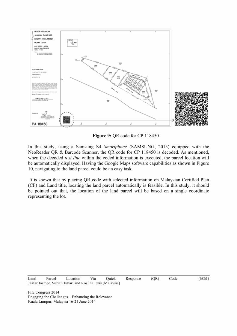
Referring to Table 2, it is shown that the difference in distance computed for the tested points are less than ±10 meters. It is known that, the accuracy of handheld GPS is within ±10 m. Therefore, navigating to the land parcel using handheld GPS or Smartphone with GPS capabilities seems feasible. In the near future, more points will be used to assess the accuracy of the positioning. Further testing is also carried out using the QR code generated for a CP which is 500 km north from Universiti Teknologi MARA where the study is conducted. The land parcel is in the State of Kelantan, Malaysia. Figure 9 shows the generated QR code for CP 118450 at the lower left corner.
Land Parcel Location Via Quick Response (QR) Code, (6861) Jaafar Jasmee, Suriati Juhari and Roslina Idris (Malaysia) FIG Congress 2014 Engaging the Challenges – Enhancing the Relevance Kuala Lumpur, Malaysia 16-21 June 2014
12/16
Figure 9: QR code for CP 118450
In this study, using a Samsung S4 Smartphone (SAMSUNG, 2013) equipped with the NeoReader QR & Barcode Scanner, the QR code for CP 118450 is decoded. As mentioned, when the decoded text line within the coded information is executed, the parcel location will be automatically displayed. Having the Google Maps software capabilities as shown in Figure 10, navigating to the land parcel could be an easy task. It is shown that by placing QR code with selected information on Malaysian Certified Plan (CP) and Land title, locating the land parcel automatically is feasible. In this study, it should be pointed out that, the location of the land parcel will be based on a single coordinate representing the lot.

Land Parcel Location Via Quick Response (QR) Code, (6861) Jaafar Jasmee, Suriati Juhari and Roslina Idris (Malaysia) FIG Congress 2014 Engaging the Challenges – Enhancing the Relevance Kuala Lumpur, Malaysia 16-21 June 2014
13/16
Figure 10: Location of the land parcel and route information
However, once again, it should be pointed out that, an ongoing research is carried out by utilizing the Keyhole Markup Language (KML) file format towards displaying automatically the whole land parcel on the Google Earth/Maps. With this capability in the near future, locating the land parcel as well as assisting ground surveying works would be of great advantage.
5. CONCLUSION
In this study, an innovation utilizing the QR code towards storing spatial information and locating the land parcel automatically on the Google Earth/Maps is shown. With the acceptance of the proposed QR code to be embedded on CPs (Certified Plan) and land title, it will eventually catalyst a diversity of related activities such as land evaluation, mortgages, construction and expected to generate a new set of revenues for DSSM and land office. An automation in locating the land parcel as proposed using QR code will eventually save time and manpower. Furthermore, with the increase usage of Smartphone, the land parcel position of interest could now be retrieved from anywhere at any time throughout the year. Lastly, the most important advantage of tagging QR code on CP and land title is that, it will act as a security measure where counterfeiting could now be avoided, as the digital output for the QR code could be compared with the information portrayed on the hardcopy.

Land Parcel Location Via Quick Response (QR) Code, (6861) Jaafar Jasmee, Suriati Juhari and Roslina Idris (Malaysia) FIG Congress 2014 Engaging the Challenges – Enhancing the Relevance Kuala Lumpur, Malaysia 16-21 June 2014
14/16
Acknowledgement
The authors would like to thank the Department of Survey and Mapping Malaysia (DSMM) for providing the technical and valueble support in the study.
REFERENCES Denso Wave Incorporated, 2010. Answer to your Questions about the QR code. QRcodes.com, Japan, http://www.denso-wave.com/qrcode/qrstandard-e.html, (retrieve 17/2/2012).
DSSM (Department of Surveying and Mapping Malaysia), 2009. Circular KPUP bil.6: Garis Panduan Amalan Kerja Ukur Kadaster dalam persekitaran eKadaster, pp. 58-65, Jabatan Ukur Dan Pemetaan Malaysia (JUPEM), Malaysia, http://www.jupem.gov.my/index.php?action=pekeliling (Retrieve 3/3/2012). Eric E., 2011. QR Code GIS solutions for mapping technologies, post on September 13th, 2011 in Exending The Reach of Geospatial Education. http://www.geo-jobe.com/blog/2011/09/13/qr-code-gis-solutions-for-mapping-technologies/ (Retrieve 1/3/2012). Google, 2013. Importing your data: Google Earth Projection ©2013 Google https://support.google.com/earth/answer/148110?hl=en ILBS (International Law Book Services), 2007. Kanun Tanah Negara 1965 [Akta 56/1965]. ISBN:967-89-0114-5. Publish by Golden Books Centre Sdn. Bhd. No.14, 1st Floor, Lorong Bunus Enam, Off Jalan Masjid India, 50100 Kuala Lumpur. Printed by Ganesh Printing Works Sdn. Bhd. Penang. Joe W., 2012. QR Codes For Dummies. Published by John Wiley & Sons, Inc. 111 River Street, Hoboken, New Jersey 07030-5774. JUPEM, 2005.Edisi Khas Ulang Tahun Jabatan Ukurdan Pemetaan Malaysia: 120 JUPEM 1885-2005. Perpustakaan Peta Negara Malaysia. Book No.H02708. Jun C. C, Yu C. H. & Hsien J. K., 2010. A Novel Secret Sharing Technique Using QR Code, Volume (4) : Issue (5) International Journal of Image Processing (IJIP), Taiwan. Kaywa A. G, 2013, Kaywa QR code © 2003-2013 Kaywa AG Technoparkstrasse 1, 8005 Zurich, Switzerland, http://qrcode.kaywa.com/ (retrieve 15/9/2013). Malati S., 2011. Perodua wishes Deepavali the smart way, Malaysia, the Art and Science of connecting with consumers, marketing-interactive.com, http://www.marketing-interactive.com/news/29145 (retrieve 15/02/2012).
Land Parcel Location Via Quick Response (QR) Code, (6861) Jaafar Jasmee, Suriati Juhari and Roslina Idris (Malaysia) FIG Congress 2014 Engaging the Challenges – Enhancing the Relevance Kuala Lumpur, Malaysia 16-21 June 2014
15/16
NeoMedia Technologies, Inc., 2013. 100 W Arapahoe Avenue, Suite 9 Boulder, CO 80302 USA, Copyright © 2013 NeoMedia https://play.google.com/store/apps/details?id=de.gavitec.android&hl=en (retrieve 15/9/2013). NSTP, 2012. Amazement, wonder greets ‘talking’ to NST, The New Straits Times Press (Malaysia) Berhad, media Prima Company, printed on Thursday, February 23rd, 2012, http://www.nstp.com.my/?p=412 (retrieve 30/2/2012). Rachid J.D., 2012. QR Codes: A Growing Trend in Marketing. The network journal magazine, printed on Friday, February 24, 2012, http://www.tnj.com/news/business/qr-codes-growing-trend-marketing (retrieve 5/03/2012). SMP-Soft, 2013. Free QR Create, Copyright © 2007-2013 SMP-Soft.com, http://www.smp-soft.com/products/freeqrcreator.html. Softpedia, 2013. Zint Barcode Studio 2.4.3.0 © 2001 - 2013 Softpedia. Softpedia Editor's Review for Zint Barcode Studio, Post on November 19th, 2013 in Softpedia. Developer Robin Stuart <[email protected]>. BSD License, GNU General Public License version 3.0 (GPLv3), United Kingdom. http://www.softpedia.com/get/Others/Miscellaneous/Zint-Barcode-Studio.shtml. Rajina Dhillon, 2012. Decoding The QR code, News Analysis, Advertising Marketing Magazine, Malaysia, marketing -interactive.com, http://www.marketing-interactive.com/news post on January 2012. SAMSUNG, 2013. Samsung S4 life companion, Copyright© 1995-2013 All rights reserved. http://www.samsung.com/my/consumer/mobile-devices/smartphone/android-os/GT-I9500ZWAXME (Retrived 8/8/2013). Tan J. S., 2008. QR code article by Executive Director, EPC global Singapore Council Chairman, Automatic Data Capture Technical Committee, synthesis journal 2008, Singapore. http://www.findthatfile.com/search53627714hPDF/downloaddocumentsThree_QR_Code.pdf.htm (Retrieve 4/3/2012).

Land Parcel Location Via Quick Response (QR) Code, (6861) Jaafar Jasmee, Suriati Juhari and Roslina Idris (Malaysia) FIG Congress 2014 Engaging the Challenges – Enhancing the Relevance Kuala Lumpur, Malaysia 16-21 June 2014
16/16
CONTACTS
Jasmee Jaafar Centre of Studies Surveying Science and Geomatics Faculty of Architecture, Planning and Surveying Universiti Teknologi MARA Malaysia (UiTM) 40450, Shah Alam MALAYSIA 0176758318 [email protected] Suriati Juhari Centre of Studies Surveying Science and Geomatics Faculty of Architecture, Planning and Surveying Universiti Teknologi MARA Malaysia (UiTM) 40450, Shah Alam MALAYSIA 0162788444 [email protected] Roslina Idris Centre of Studies Surveying Science and Geomatics Faculty of Architecture, Planning and Surveying Universiti Teknologi MARA Malaysia (UiTM) 40450, Shah Alam MALAYSIA 0125073001 [email protected] Mohammed Yaziz Ahmad Centre of Studies Surveying Science and Geomatics Faculty of Architecture, Planning and Surveying Universiti Teknologi MARA Malaysia (UiTM) 40450, Shah Alam MALAYSIA +603-5544 4457 [email protected]