land tenure and property rights impact evaluation tool · land tenure and property rights impact...
TRANSCRIPT
1
SEPTEMBER 2013
LAND TENURE AND PROPERTY RIGHTS
IMPACT EVALUATION
TOOL
LAND TENURE AND PROPERTY RIGHTS IMPACT EVALUATION TOOL 2
The Impact Evaluation Tool was prepared by Tetra Tech on behalf of USAID, under the Property Rights and
Resource Governance Program under the Prosperity, Livelihoods and Critical Ecosystems (PLACE) Indefinite
Quantity Contract (IQC) Contract No. EPP-I-00-06-00008-00, Task Order 002.
For more information about this tool, please contact:
Dr. Gregory Myers, Division Chief, Land Tenure and Property Rights, E3/LTRM, USAID,
Dr. Mark Freudenberger, Senior Technical Advisor/Manager, Property Rights and Resource
Governance Program, Tetra Tech, [email protected].
LAND TENURE AND PROPERTY RIGHTS
IMPACT EVALUATION
TOOL
SEPTEMBER 2013
DISCLAIMER
The author’s views expressed in this publication do not necessarily reflect the views of the
United States Agency for International Development or the United States Government.

LAND TENURE AND PROPERTY RIGHTS IMPACT EVALUATION TOOL i
CONTENTS
ACRONYMS AND ABBREVIATIONS ......................................................................................... iii
PREFACE ............................................................................................................................................... v
INTRODUCTION ............................................................................................................................ vii
1.0 Impact Evaluation Tool ........................................................................................................... 1
1.1 WHY CONDUCT A LAND TENURE AND PROPERTY RIGHTS IMPACT
EVALUATION? ............................................................................................................ 1
1.2 HOW DOES THE LTPR IMPACT EVALUATION TOOL WORK? .............. 2
1.3 UNDERSTANDING IMPACT .................................................................................. 2
1.4 A ROADMAP OF THE IMPACT EVALUATION TOOL .................................. 5
2.0 DEFINING THE EVALUATION PAR ................................................................................ 9
2.1 WHAT TO ASSESS? ................................................................................................. 10
2.2 ON WHICH PRINCIPAL OUTCOMES? ............................................................ 11
2.3 TIMEFRAME ................................................................................................................ 15
2.4 SCALE ........................................................................................................................... 15
2.5 TIME .............................................................................................................................. 15
2.6 THE EVALUATION TEAM ..................................................................................... 16
2.7 SCOPE CHECKLIST ................................................................................................. 17
2.8 USAID WASHINGTON AND MISSION SUPPORT ....................................... 18
2.9 FINALIZING THE SCOPE OF WORK AND BUDGET ................................. 19
3.0 PLANNING ............................................................................................................................. 21
3.1 GETTING STARTED ................................................................................................ 22
3.2 REVIEWING OR CONSTRUCTING CONCEPTUAL MAPS ....................... 22
3.3 SELECTING INDICATORS .................................................................................... 24
3.4 DECIDING ON INFORMATION SOURCES .................................................... 27
3.5 SELECTING STAKEHOLDERS AND METHODS ............................................ 29
3.6 COMPLETING WORK PLANS AND ALLOCATING RESOURCES .......... 32
4.0 DESIGNING METHODS AND IMPLEMENTATION .................................................. 35
4.1 DESIGNING METHODS ......................................................................................... 38
4.2 GATHERING SECONDARY SOURCE INFORMATION ON
INDICATORS AND CAUSAL FORCES ............................................................. 43
4.3 CONSULTING WITH COMMUNITIES AND OTHER KEY
INFORMANTS ........................................................................................................... 45
5.0 ANALYZING, REPORTING, AND LEARNING ........................................................... 49
5.1 ANALYZING INFORMATION ............................................................................. 49
5.2 REPORTING RESULTS ............................................................................................ 52
5.3 CATALYZING LEARNING .................................................................................... 53
5.4 PROMOTING TRANSPARENCY AND SHARING FINDINGS ................... 54

ii LAND TENURE AND PROPERTY RIGHTS IMPACT EVALUATION TOOL
ANNEX A: CONCEPTUAL MAPS AND INDICATORS ....................................................... 55
ANNEX B: TEMPLATE FOR INDICATOR SELECTION ....................................................... 61
ANNEX C: WORK PLAN FOR ACQUISITION OF SECONDARY SOURCE
INFORMATION (TEMPLATE) ........................................................................................... 67
ANNEX D: WORK PLAN FOR ACQUISITION OF PRIMARY SOURCE
INFORMATION (TEMPLATE) ........................................................................................... 71
ANNEX E: TEMPLATE FOR RECORDING CHANGE IN INDICATOR STATES .......... 75
TEMPLATE FOR RECORDING CHANGE IN INDICATOR STATES .................... 77
ANNEX F: EXAMPLES OF ALTERNATIVE CAUSALITY MAPS AND OUTCOME
MAPS ........................................................................................................................................ 79
ANNEX G: EXAMPLE OF evaluation REPORT TABLE OF CONTENTS .......................... 83

LAND TENURE AND PROPERTY RIGHTS IMPACT EVALUATION TOOL iii
ACRONYMS AND
ABBREVIATIONS
ANOVA Analysis of Variance
CAIMAN Conservation in Areas Managed by Indigenous Groups Project
DD Difference-in-Difference method
DEC Development Experience Clearinghouse
HIV/AIDS Human Immunodeficiency Virus/Acquired Immune Deficiency Syndrome
IDP Internally Displaced Person
IQC Indefinite Quantity Contract
KII Key Informant Interview
KM Knowledge Management
LOE Level of Effort
LTD Land Tenure and Property Rights Division
LTPR Land Tenure and Property Rights
M&E Monitoring and Evaluation
NRM Natural Resource Management
PPL/LER Bureau for Policy, Planning, and Learning's Office of Learning, Evaluation, and Research
PRRGP Property Rights and Resource Governance Program
RFA Request for Applications
RFP Request for Proposals
SAIP Situation Assessment and Intervention Planning
SOW Statement of Work
USAID United States Agency for International Development
USG United States Government


LAND TENURE AND PROPERTY RIGHTS IMPACT EVALUATION TOOL v
PREFACE
Resource tenure and property rights challenges are present in almost every country where the United States
Agency for International Development (USAID) works. In many countries, tenure and property rights
problems are so grave that they create political instability, violence, population displacement, famine, and
environmental destruction, which significantly undermine or prevent successful implementation of many
USAID programs. Over the last decade the demand to address property rights issues has increased from both
USAID field missions and host country governments. The increase in demand is due, in part, to a growing
awareness among development practitioners of the role played by property rights (and natural resource access
and use) in economic growth, governance, and conflict and resource management.
USAID and its partners have learned a great deal over the last three decades about the relationship between
property rights and economic growth, productivity, and to a lesser extent, natural resource management and
conflict. There are several important lessons learned from the last decade of research and policy work on
property rights with a particular emphasis on land and resource tenure.
1. Land tenure and property rights (LTPR) systems are fundamental to a wide variety of
development outcomes. Secure land tenure improves food security, economic growth, and natural
resource management and reduces the impacts of conflict and climate change. Securing the rights of
women, youth and vulnerable populations and broadening their access to resources complements and
deepens the impact of interventions aimed at improving these outcomes. This is the case for people
across the economic spectrum from smallholder farmers to urban manufacturers. An effective land
governance and property rights system is fundamental to the broad process of economic and political
development.
2. Weak land governance systems limit economic growth; threaten good natural resource
management; often promote conflict; and pose special problems for vulnerable groups,
including minorities, indigenous people, the poor, and women. Recognition of customary rights to
land resources and the devolution of management authority improves land and resource governance and
is crucial to sustainable natural resource management. Although many countries have effective and secure
land governance and property rights systems, in numerous places, systems and rights are weak. The
results of these weaknesses include conflict over land and resources, corruption associated with poorly
functioning land governance systems, resource degradation, and limited economic growth.
3. In development programming, property rights are most frequently dealt with in the context of
land tenure reform, but they are increasingly being addressed through more integrated projects.
Programming decisions made in a variety of sectors that consider land tenure can have profound impacts
on land use and natural resource management, agricultural systems, and infrastructure development.
4. Too often, LTPR reforms are measured in terms of outputs rather than impacts (e.g., measuring
the number of land titles that have been issued as opposed to focusing on market performance and
investment increases, reduced conflict, or improved use of sustainable management practices). This focus
on outputs prevents USAID from fully understanding the efficacy and potential cross-sectoral benefits of
its property rights reforms and programs. A greater emphasis on impact evaluation is needed.
vi LAND TENURE AND PROPERTY RIGHTS IMPACT EVALUATION TOOL
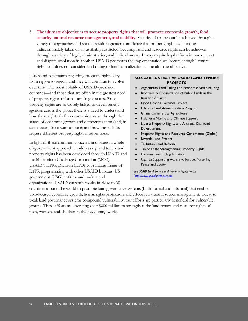
BOX A: ILLUSTRATIVE USAID LAND TENURE
PROJECTS
Afghanistan Land Titling and Economic Restructuring
Biodiversity Conservation of Public Lands in the
Brazilian Amazon
Egypt Financial Services Project
Ethiopia Land Administration Program
Ghana Commercial Agriculture
Indonesia Marine and Climate Support
Liberia Property Rights and Artisanal Diamond
Development
Property Rights and Resource Governance (Global)
Rwanda Land Project
Tajikistan Land Reform
Timor Leste Strengthening Property Rights
Ukraine Land Titling Initiative
Uganda Supporting Access to Justice, Fostering
Peace and Equity
See USAID Land Tenure and Property Rights Portal
(http://www.usaidlandtenure.net)
5. The ultimate objective is to secure property rights that will promote economic growth, food
security, natural resource management, and stability. Security of tenure can be achieved through a
variety of approaches and should result in greater confidence that property rights will not be
indiscriminately taken or unjustifiably restricted. Securing land and resource rights can be achieved
through a variety of legal, administrative, and judicial means. It may require legal reform in one context
and dispute resolution in another. USAID promotes the implementation of “secure enough” tenure
rights and does not consider land titling or land formalization as the ultimate objective.
Issues and constraints regarding property rights vary
from region to region, and they will continue to evolve
over time. The most volatile of USAID-presence
countries—and those that are often in the greatest need
of property rights reform—are fragile states. Since
property rights are so closely linked to development
agendas across the globe, there is a need to understand
how these rights shift as economies move through the
stages of economic growth and democratization (and, in
some cases, from war to peace) and how these shifts
require different property rights interventions.
In light of these common concerns and issues, a whole-
of-government approach to addressing land tenure and
property rights has been developed through USAID and
the Millennium Challenge Corporation (MCC).
USAID’s LTPR Division (LTD) coordinates issues of
LTPR programming with other USAID bureaus, US
government (USG) entities, and multilateral
organizations. USAID currently works in close to 30
countries around the world to promote land governance systems (both formal and informal) that enable
broad-based economic growth, human rights protection, and effective natural resource management. Because
weak land governance systems compound vulnerability, our efforts are particularly beneficial for vulnerable
groups. These efforts are investing over $800 million to strengthen the land tenure and resource rights of
men, women, and children in the developing world.

LAND TENURE AND PROPERTY RIGHTS IMPACT EVALUATION TOOL vii
INTRODUCTION
A FRAMEWORK FOR LAND TENURE AND PROPERTY RIGHTS
USAID has developed a suite of tools and methodologies designed to enhance the understanding and
programming of LTPR challenges and activities to advance USG strategic objectives in a number of areas,
including food security, global climate change, conflict mitigation and women’s economic empowerment.
This body of work has been highly experimental, consultative, and developmental and has grown
commensurate with growth of US investments in this sector.1
This work includes four components as summarized below, and are meant to be mutually re-enforcing as illustrated in Figure 1: LTPR Framework.
1. The LTPR Framework serves
as the overarching conceptual
methodology tying together
overarching themes, definitions,
tools, assessments, designs, and
training programs that USAID
uses to improve LTPR
programming and capacity
building. The Framework also
includes:
LTPR Matrixes—A
Methodology for determining
USAID-recommended
interventions for different asset
and social classes (e.g., men and
women); and a methodology for
identifying constraints and
opportunities.
LTPR Intervention
Sequencing of land tenure and land reforms tailored to each country, region, or project context that
leads to stronger and more efficient property rights systems. Beyond identifying interventions to address
LTPR constraints, sequencing in addition requires assessment of appropriate scale, timing, and ordering.
The LTPR Glossary is a guide to key LTPR terms and concepts, gathered from frequently cited
international references.
1 This body of work updates tools that were originally produced under the Lessons Learned: Property Rights and Natural Resource Management
contract.
FIGURE 1. LTPR FRAMEWORK
viii LAND TENURE AND PROPERTY RIGHTS IMPACT EVALUATION TOOL
2. LTPR Assessment Tools—A Methodology for Assessing LTPR Constraints and Interventions—includes two tools to guide USAID mission programming:
LTPR Situation Assessment and Intervention Planning (SAIP) Tool, which is a diagnostic and programming tool to help USAID missions understand and assess LTPR issues and determine how these contribute to or impede realization of strategic objectives; and
LTPR Impact Evaluation Tool, which provides a methodology for designing evaluations to determine
the outcomes and impacts of land and natural resource tenure and property rights programming, whether
as a project’s main focus or a component of a broader set of goals.
In addition to these Framework and assessments tools, USAID has developed:
3. LTPR Training materials, which include short courses and other trainings to transfer knowledge and best practices about land tenure and property rights and strengthen LTPR knowledge, capacity, and understanding of USG program staff and implementing partners. Curriculum may be found on the LTPR web portal at www.USAIDlandtenure.net; and,
4. LTPR Knowledge Management, which consists of USAID Program Briefs on land tenure projects,
LTPR Country Profiles, Issues Briefs, films, and LTRP research. This can be found at the USAID Land
Tenure and Property Rights Portal (www.usaidlandtenure.net), which serve as the foundation for LTPR
knowledge management within the Agency.
The intended audiences for all of these tools are USAID missions, USAID Washington Bureau staff, and
other USG personnel who seek to understand how property rights issues may be affecting program
outcomes, how to design interventions that can help address those issues, and how to evaluate the impacts of
those programs to inform new program development. The tools may likewise prove useful to a range of
development practitioners outside the USAID sphere who encounter property rights challenges in their work
and seek to understand and address them more effectively.
LTPR MATRIX: A TOOL FOR VISUALIZING THE LTPR UNIVERSE
As early as 2004, USAID felt the need for a conceptual framework that would simply and eloquently help
USAID and contractors identify and assess LTPR issues (constraints) and “toolboxes” of interventions to
address those constraints. Land tenure and property rights is concerned with questions of access to land and
natural resources, the distribution of rights to those resources within society, the security of tenure held by
various individuals and groups over these resources, and the sustainability of their use.
LAND TENURE AND PROPERTY RIGHTS IMPACT EVALUATION TOOL ix
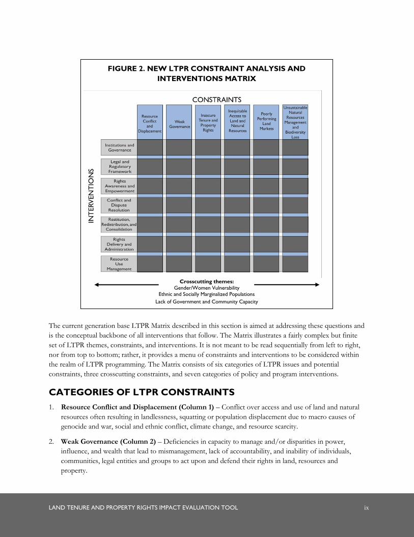
The current generation base LTPR Matrix described in this section is aimed at addressing these questions and
is the conceptual backbone of all interventions that follow. The Matrix illustrates a fairly complex but finite
set of LTPR themes, constraints, and interventions. It is not meant to be read sequentially from left to right,
nor from top to bottom; rather, it provides a menu of constraints and interventions to be considered within
the realm of LTPR programming. The Matrix consists of six categories of LTPR issues and potential
constraints, three crosscutting constraints, and seven categories of policy and program interventions.
CATEGORIES OF LTPR CONSTRAINTS
1. Resource Conflict and Displacement (Column 1) – Conflict over access and use of land and natural
resources often resulting in landlessness, squatting or population displacement due to macro causes of
genocide and war, social and ethnic conflict, climate change, and resource scarcity.
2. Weak Governance (Column 2) – Deficiencies in capacity to manage and/or disparities in power,
influence, and wealth that lead to mismanagement, lack of accountability, and inability of individuals,
communities, legal entities and groups to act upon and defend their rights in land, resources and
property.
FIGURE 2. NEW LTPR CONSTRAINT ANALYSIS AND
INTERVENTIONS MATRIX
Crosscutting themes:
Gender/Women Vulnerability Ethnic and Socially Marginalized Populations
Lack of Government and Community Capacity

x LAND TENURE AND PROPERTY RIGHTS IMPACT EVALUATION TOOL
3. Insecure Tenure and Property Rights (Column 3) – The consequence of inadequate rights awareness
or the perception of having too few rights, inadequate duration of rights, or inability to protect rights
from encroachment by others due to problems of open access, weak governance, rights inequality, weak
statutory and customary tenures, and expropriation without fair compensation.
4. Inequitable Access to Land and Natural Resources (Column 4) – Disparities in access and control
over resources between classes and gender that are often affiliated with poverty and social strife and
result in problems of landlessness, uneconomical and fragmented holdings, squatting, informal
settlements, and weak and unsustainable livelihoods.
5. Poorly Performing Land Markets (Column 5) – Absent/weak sales, rentals, sharecropping, and
exchanges that restrict the transfer of resources between willing sellers, buyers, lessors, and renters
thereby constraining economic growth, or that fail to serve the poor and disadvantaged due to imperfect
information, lack of capital, unequal bargaining power, or risk of distressed sales.
6. Unsustainable Natural Resources Management and Biodiversity Loss (Column 6) –
Overharvesting or degradation of land, water, forests, pasture, and wildlife resulting in unsustainable use
and biodiversity loss, or in the context of minerals, environmental degradation and practices that abuse or
usurp the rights of communities/miners due to weak property rights and governance systems.
Crosscutting Constraints:
7. Gender/Women Vulnerability (Crosscutting) – This constraint category further nuances other
constraint columns in the matrix by asking the question of LTPR constraints for whom, and addresses
discrimination in property rights, land access, land markets, and ability to sustain natural resource
management by women and men.
8. Ethnic and Socially Marginalized Populations (Crosscutting) – The constraint categories to the left
in the matrix are further nuanced in this constraints column by the questions of LTPR constraints to
marginalized and disenfranchised populations including among others HIV/AIDS affected households,
pastoralist societies, indigenous populations, and post-conflict and climatically vulnerable populations
discriminated against or left behind by political and economic change, or needing LTPR support or
protection in face of political, economic and climatic shocks.
9. Lack of Government and Community Capacity (Crosscutting) – This constraints category relates to
the identification and development of human capital in service to land property rights reforms.
CATEGORIES OF LTPR INTERVENTIONS
1. Institutions and Governance (Row 1) – Institutional arrangements that improve the governance of
property rights from central to local levels by establishing rule of law, devolving authority, decentralizing
decision making, ensuring impartiality of the judiciary, providing for citizen participation, and ensuring
accountable and democratic governance.
2. Legal and Regulatory Framework (Row 2) – Interventions that provide individuals, groups,
communities, or legal entities with important legal rights of ownership, usufruct, exclusion, and
transferability, and typically focus on legal and regulatory reforms that increase clarity of rights,
strengthen rights ownership, and provide for legal recourse and due process.
LAND TENURE AND PROPERTY RIGHTS IMPACT EVALUATION TOOL xi
3. Rights Awareness and Empowerment (Row 3) – Interventions aimed at raising citizen awareness and
understanding of their property rights as well as the procedures and facilities available to claim, defend
and enforce those rights. Illustrative interventions include mass media, human capacity training,
communication strategies and informational meetings targeting beneficiaries.
4. Conflict and Dispute Resolution (Row 4) – Formal and informal conflict mediation and dispute
resolution strategies and mechanisms aimed at mediating conflict, resolving disputes, dispelling or
averting violence, providing effective legal recourse and enabling compensation in the event of
resettlement and public takings.
5. Restitution, Redistribution, and Consolidation (Row 5) – Land reform and resettlement to redress
land concentration, privatize ownership, restitute rights, resettle displaced populations, or consolidate
small, fragmented units into larger ones with the aim of redressing historical injustices and achieving a
more fair, equitable, and productive land and agrarian structure.
6. Rights Delivery and Administration (Row 6) – Effective and low-cost land administration
interventions that connecting rights to land, resources and property in law with the exercise of those
rights in practice and focus on improving the effectiveness and reach of government in support of rights
registration, land demarcation, surveying, mapping, and cadastral development.
7. Resource Use Management (Row 7) – Strengthened property rights and governance to improve land
and natural resources management, conservation and bio-diversity protection, or land use planning for
municipal/urban development, and include such interventions as participatory decision-making, zoning,
trusts, conservancies, protected areas and co-management models.
The Matrix in Figure 2 serves as the template for regularizing and developing empirical overlays for five
natural and human resource domains in Figure 3:
Land Tenure and Property Rights;
Freshwater Lakes, Rivers, and Groundwater;
Minerals;
Trees and Forests; and
Women, Land, and Resources.
Each of these overlays is a standalone Matrix. Other domains are possible: pastures, wildlife, fisheries, and
coastal areas. The overlay approach allows expandability by adding additional overlays in the future (e.g.,
coastal areas) as demand warrants.

xii LAND TENURE AND PROPERTY RIGHTS IMPACT EVALUATION TOOL
MATRIX OVERLAYS
In this report, Sections 1.0 to 6.0 populate the Land Tenure and Property Rights Matrix with salient issues and key
interventions, and link these to information sources for easy reference. Annex C provides summary tables on
issues and interventions extracted from the overlay which serve as useful tools for training exercises or as
“quick sheets” when undertaking assessments. Overlays and quick sheets for resource domains can be found
in the following documents, all developed under the USAID Property Rights and Resource Governance Task
Order:
Overlay 1: Land Tenure and Property Rights Matrix ;
Overlay 2: Freshwater Lakes, Rivers, and Groundwater Matrix ;
Overlay 3: Minerals Matrix ;
Overlay 4: Trees and Forests Matrix ; and
Overlay 5: Women, Land, and Resources Matrix.
Each overlay is organized into chapters (see Sections 1.0 to 6.0) centered around constraint categories which:
Provide an overview of issues and sub-issues related to respective constraints;
Describe various policy and program interventions USAID recommends bundled according to intervention categories;
FIGURE 3. LTPR CONSTRAINT ANALYSIS AND INTERVENTIONS MATRIX
LAND TENURE AND PROPERTY RIGHTS IMPACT EVALUATION TOOL xiii
Explain how the Food and Agriculture Organization of the United Nations (FAO)’s Voluntary Guidelines on the Responsible Governance of Tenure of Land, Fisheries and Forests in the Context of National Food Security addresses the constraint (where applicable); and
Include a list of related reading for each topic.
USAID programmatic recommendations are guided by the following principles:
Land tenure and property rights systems that recognize, record, and administer a multiplicity of statutory
and customary land tenure and property rights, whether held by individuals, groups or legal entities;
Land tenure and property rights systems that protect the rights of women and other marginalized groups
in society;
Fully participatory processes to define, delimit, record, and administer land tenure and property rights
and obligations;
Market-mediated approaches to provide access to land;
Land governance systems that are reasonably accessible, in terms of location and cost, to all members of
society;
Land governance systems that allow and support the creations of transparent and effective land markets,
including land sales, leases, and the use of easements and other mechanisms; and
The equitable application of laws, regulations, and administrative practices for all market participants.
Importantly, the US government does not support the following: Expropriations and forcible
evictions/relocations (or the use of compulsory purchase/resumption) that violate rights to due process
and do not award prompt, adequate and effective compensation or that take private property for private
purpose.”
Whether for trainings, assessments, or project designs, there is a programmatic need to order the “universe”
of possible LTPR issues and interventions. The LTPR Matrix and overlays address this need. The process of
using the Matrix and overlays to examine LTPR issues and constraints generally comprises the following
steps:
1. Use the Matrix and overlays to clarify or identify key issues; for example, land conflict created by disagreements over tribal/clan boundaries.
2. Identify categories of policy and programmatic interventions suited to addressing the constraints under the appropriate toolbox of interventions.
3. Within the toolbox of interventions, identify specific USAID-recommended policy and programmatic interventions (i.e., the tools). For example, within the toolbox entitled Legal and Regulatory Framework, one might consider granting legal recognition of customary institutions in land law or policy to address land conflict created by clan disagreements. Within the toolbox of Rights Delivery and Administration, one might recommend community land demarcation as an appropriate intervention to connect rights in law to specific boundaries of community land.
4. Each of the five overlays can be used individually or in combination, as in a landscape, watershed, or ecosystem assessment.

xiv LAND TENURE AND PROPERTY RIGHTS IMPACT EVALUATION TOOL
The specific interventions mentioned in the Matrix and overlays, while illustrative, nonetheless serve to
accelerate or expand thinking when needing to conduct “how to” courses and transfer knowledge in training
programs, help to target or focus questions or lines of enquiry when conducting LTPR assessments, or
recommend appropriate intervention strategies whether by way of making recommendations or formulating
project designs. The Matrix is thus the conceptual framework for ordering and clarifying thinking on LTPR
constraints and interventions, and the causal linkages between them.

LAND TENURE AND PROPERTY RIGHTS IMPACT EVALUATION TOOL 1
1.0 IMPACT EVALUATION
TOOL
1.1 WHY CONDUCT A LAND TENURE AND PROPERTY RIGHTS
IMPACT EVALUATION?
USAID is placing increasing emphasis on programming that strengthens land and natural resource tenure and
property rights as part of supporting larger economic development objectives. USAID projects designed to
increase land tenure security, address weakness in the land law and regulatory environment, or promote
biodiversity through strengthening community rights to natural resources are among those that reflect this
renewed emphasis. In most instances, evidence on the strengths and weaknesses of specific land tenure and
property rights (LTPR) interventions is readily available in the form of internal or external project
performance evaluations. What is lacking, however, is a uniform and systematic approach that moves beyond
LTPR project performance evaluation and focuses on measuring the impact of pilot projects or projects
testing new development hypotheses to inform future LTPR programming. Without an approach to assessing
the impact of LTPR interventions, USAID risks losing the opportunity to identify factors that helped shape
landmark LTPR successes, distill important lessons, and understand how interventions can be scaled up or
replicated in future LTPR programs to maximize impact.
The LTPR Impact Evaluation Tool presented here targets USAID missions as well as LTPR and Impact
Evaluation professionals hired to carry out an assessment. It can easily be adapted for use by other US
government (USG) agencies, or even other donors, engaged in programming of LTPR interventions.
The tool aims to:
1. Measure project/intervention effectiveness, relevance, and efficiency.
2. Enhance Agency’s learning from LTPR project interventions and outcomes to refine design and introduce improvements into future programs.
3. Permit missions to share and learn from the experiences of other country missions.
4. Bolster the Agency’s effectiveness in meeting both project and broader institutional goals.
Although the tool is designed to be used with the assistance of outside consultants, it encourages the
involvement of USAID, including mission staff in the actual implementation of the tool to enrich the learning
potential. Adopting a common methodology shared by all USAID missions can help ensure that important
aspects in the evaluation of LTPR interventions are not overlooked, and a shared approach facilitates cross-
comparison of impact findings.

2 LAND TENURE AND PROPERTY RIGHTS IMPACT EVALUATION TOOL
1.2 HOW DOES THE LTPR IMPACT EVALUATION TOOL WORK?
The LTPR Impact Evaluation Tool is designed to evaluate the outcomes and impacts of land and natural
resource tenure and property rights programming, whether this is a project’s focus or a component of a
broader set of goals. The tool is intended to be applied prior to the close of a project (typically 18 months or
more before the project’s conclusion) so that the findings may be available to inform future LTPR
programming.
This tool is a companion to the LTPR Situation Assessment and Intervention Planning (SAIP) Tool. A
rigorous Impact Evaluation may only be conducted when planning for the evaluation has been carried out
during the project design phase in the form of mapping the flow of anticipated outputs, outcomes, and
impacts; undertaking a baseline assessment; and establishing a monitoring and evaluation (M&E) system to
track performance during the project’s lifetime. The SAIP Tool provides guidelines for carrying out these
steps and therefore establishes a firm foundation for using this tool to assess project impacts. Given that
many LTPR projects will have already been designed without the benefit of the SAIP Tool, the Impact
Evaluation Tool provides guidelines for assessing both projects that utilized the SAIP Tool and those that
have otherwise collected baseline data on project outcomes and impacts. To assess attribution between LTPR
interventions and observed outcomes, the tool relies on the comparison of treatment and control groups, as
well as triangulation of quantitative and qualitative data collected through semi-structured interviews, rapid
appraisal methods, focus groups, and short questionnaires.
The methodology described in this tool calls for a team of four to six persons (including a logistics
coordinator), depending on the number and size of the interventions and the timeframe of the assessment.
The involvement of at least one USAID staff member engaged in LTPR programming (but not involved in
implementing the project under review) has the potential to considerably deepen learning drawn from the
evaluation and thereby enhance a mission’s capacity to respond appropriately to evaluation findings.
The evaluation should take approximately five to six weeks to complete, with the team spending one week to
plan, three to four in the field, and one week to wrap up and draft the final report. The cost of an evaluation
will depend in large part on the scale of the intervention(s) being assessed and the number of objectives and
corresponding indicators chosen. The larger the scale of the project or program, it is likely the evaluation will
be more costly. Nevertheless, costs may range somewhere between $150,000 and $250,000.
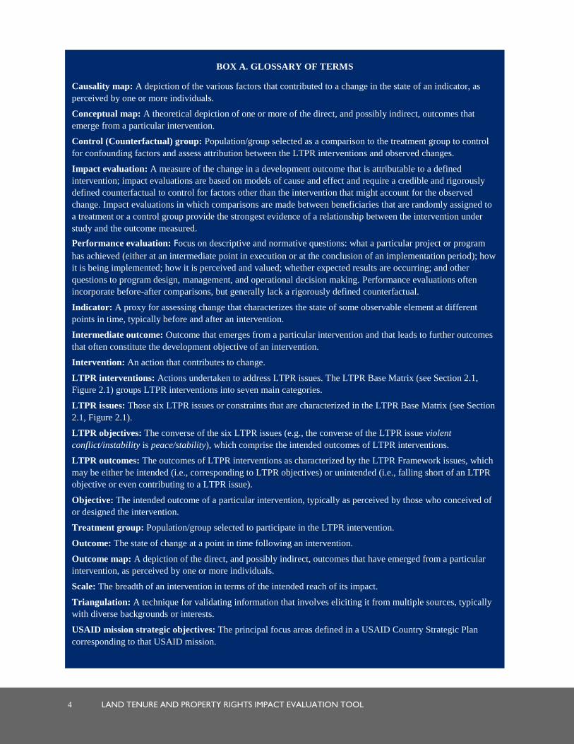
Box A provides a series of terms and their corresponding definitions that the reader can use as a handy
reference when a term seems unfamiliar or unclear. Where these terms have been used in other publications
and materials, their meanings may not be the same as the definitions provided for the purposes of this tool.
Therefore, reference to the glossary in Box A is recommended as the reader proceeds through the tool.
1.3 UNDERSTANDING IMPACT
Most LTPR projects conduct Performance Evaluations to measure what a particular project or program
has achieved, how it is being implemented, how it is perceived and valued, whether expected results are
occurring, and other questions that are pertinent to program design, management, and operational decision
making. In projects where a new intervention is being piloted or a development hypothesis is being tested, the
USAID 2011 Evaluation Policy requires implementation of a rigorous Impact Evaluation to measure the
change in a development outcome that is attributable to a defined intervention. Impact evaluations are based
on models of cause and effect, and as opposed to Performance Evaluations, require a credible and rigorously
defined counterfactual to control for factors other than the intervention that might account for the observed

LAND TENURE AND PROPERTY RIGHTS IMPACT EVALUATION TOOL 3
change.2 This tool follows USAID’s 2011 Evaluation Policy guidelines for conducting rigorous Impact
Evaluations, supplemented with additional tested qualitative techniques for evaluating change and assessing
attribution.
2 See USAID. January 2011. Evaluation: Learning From Experience, USAID Evaluation Policy. USAID: Washington, DC. Available at
http://transition.usaid.gov/evaluation/USAIDEvaluationPolicy.pdf
4 LAND TENURE AND PROPERTY RIGHTS IMPACT EVALUATION TOOL
BOX A. GLOSSARY OF TERMS
Causality map: A depiction of the various factors that contributed to a change in the state of an indicator, as
perceived by one or more individuals.
Conceptual map: A theoretical depiction of one or more of the direct, and possibly indirect, outcomes that
emerge from a particular intervention.
Control (Counterfactual) group: Population/group selected as a comparison to the treatment group to control
for confounding factors and assess attribution between the LTPR interventions and observed changes.
Impact evaluation: A measure of the change in a development outcome that is attributable to a defined
intervention; impact evaluations are based on models of cause and effect and require a credible and rigorously
defined counterfactual to control for factors other than the intervention that might account for the observed
change. Impact evaluations in which comparisons are made between beneficiaries that are randomly assigned to
a treatment or a control group provide the strongest evidence of a relationship between the intervention under
study and the outcome measured.
Performance evaluation: Focus on descriptive and normative questions: what a particular project or program
has achieved (either at an intermediate point in execution or at the conclusion of an implementation period); how
it is being implemented; how it is perceived and valued; whether expected results are occurring; and other
questions to program design, management, and operational decision making. Performance evaluations often
incorporate before-after comparisons, but generally lack a rigorously defined counterfactual.
Indicator: A proxy for assessing change that characterizes the state of some observable element at different
points in time, typically before and after an intervention.
Intermediate outcome: Outcome that emerges from a particular intervention and that leads to further outcomes
that often constitute the development objective of an intervention.
Intervention: An action that contributes to change.
LTPR interventions: Actions undertaken to address LTPR issues. The LTPR Base Matrix (see Section 2.1,
Figure 2.1) groups LTPR interventions into seven main categories.
LTPR issues: Those six LTPR issues or constraints that are characterized in the LTPR Base Matrix (see Section
2.1, Figure 2.1).
LTPR objectives: The converse of the six LTPR issues (e.g., the converse of the LTPR issue violent
conflict/instability is peace/stability), which comprise the intended outcomes of LTPR interventions.
LTPR outcomes: The outcomes of LTPR interventions as characterized by the LTPR Framework issues, which
may be either be intended (i.e., corresponding to LTPR objectives) or unintended (i.e., falling short of an LTPR
objective or even contributing to a LTPR issue).
Objective: The intended outcome of a particular intervention, typically as perceived by those who conceived of
or designed the intervention.
Treatment group: Population/group selected to participate in the LTPR intervention.
Outcome: The state of change at a point in time following an intervention.
Outcome map: A depiction of the direct, and possibly indirect, outcomes that have emerged from a particular
intervention, as perceived by one or more individuals.
Scale: The breadth of an intervention in terms of the intended reach of its impact.
Triangulation: A technique for validating information that involves eliciting it from multiple sources, typically
with diverse backgrounds or interests.
USAID mission strategic objectives: The principal focus areas defined in a USAID Country Strategic Plan
corresponding to that USAID mission.

LAND TENURE AND PROPERTY RIGHTS IMPACT EVALUATION TOOL 5
1.4 A ROADMAP OF THE IMPACT EVALUATION TOOL
The LTPR Impact Evaluation Tool comprises a series of sequential steps for evaluating the impact of LTPR
interventions using the two conceptual approaches described in Section 1.3. These steps are clustered into
four main stages:
1. Defining the evaluation parameters (Section 2),
2. Planning for the evaluation (Section 3),
3. Implementing the evaluation (Section 4), and
4. Analyzing and learning from the findings (Section 5).
Section 2 provides guidance on how to characterize the scope of the evaluation through defining some key
parameters:
Purpose,
LTPR intervention(s) to be assessed,
Outcome parameters against which interventions are to be assessed,3,4
Timeframe of the evaluation, and
General methods to be employed by the evaluation.
Section 3 turns to the planning necessary for an Impact Evaluation, beginning with defining and selecting
one to three indicators for each of the chosen outcome parameters. The focus then shifts to identifying the
information sources and methods the team will use to conduct an empirical investigation of impact.
This tool relies on both primary and secondary sources of information to characterize change, understand the
factors contributing to it, and triangulate the information to uncover plausible cause and effect associations.
Section 4 guides the team in designing methods for and implementing the Impact Evaluation. Whether it
is the review of published material or consultation with communities and other key informants, a central
objective of this step is the production of illustrative maps that represent the two entry points of the Impact
Evaluation discussed in Section 1.3. One set of maps depicts the multiple changes or outcomes seen to
emerge from the LTPR intervention(s) being assessed. The other highlights the various forces contributing to
change in each outcome parameter. The two different types of maps are produced for each source consulted.
Section 5 concludes with guidelines on the analysis of information emerging from the impact study.
Drawing on elements of the analysis, the key components of an Impact Evaluation report are presented. The
tool concludes with methods designed to enhance the learning potential of the Impact Evaluation and
involve USAID, including mission staff in analyzing the findings and their implications for developing future
LTPR interventions.
Figure 1.1 on the following page illustrates the flow of steps involved in undertaking the Impact Evaluation
and can be regularly referenced to clarify the process and track progress. At the end of each of the five
sections is a summary of the steps contained in that section. These can be used as quick refreshers once a
team has read through the entire tool.
3 Identifying outcomes and timeframe is important for characterizing change in a defined set of outcomes over a period of time. Once these
changes are captured, the team can then examine the different forces that contributed to each change beyond simply the intervention of
interest. Neglecting to consider these different causal factors would lead to bias in attributing outcomes to the LTPR intervention.
4 This does not preclude later identifying additional outcome parameters that may emerge as relevant, as the assessment progresses.

6 LAND TENURE AND PROPERTY RIGHTS IMPACT EVALUATION TOOL
Several annexes are also included to assist the Agency and the impact team in carrying out the assessment.
Annex A provides guidelines for uncovering the hypotheses that link LTPR interventions and their
objectives, thereby revealing the anticipated impact of LTPR interventions and enabling selection of
intermediate outcomes. Annex B offers an instrument for indicator selection. Annexes C and D are
frameworks for developing work plans for collecting secondary source and primary source information,
respectively. Annex E provides a template for recording changes in indicator states, Annex F provides
examples of useful systems for data collection, and Annex G provides a sample table of contents for an
evaluation report.

LAND TENURE AND PROPERTY RIGHTS IMPACT EVALUATION TOOL 7
FIGURE 1.1. PROCESS FOR CARRYING OUT AN LTPR IMPACT EVALUATION
Design appropriate
methodologies
Identify sources of
secondary
information
Select indicators for
agreed outcomes
Identify primary
sources
Obtain
secondary
information
Draft work
plans for
collecting
primary and
secondary
source
information
Conduct
fieldwork
and
construct
maps Analyz
e maps
and
data
Draft report
and provide
to USAID
Share
preliminary
findings
with
USAID
Review
SOW and
project
documents
Design
conceptual
map
Develop
SOW;
provide
project
documents
Section 5: Analyzing,
Reporting, and Learning
Section 3: Planning Section 4: Designing Methods
and Implementation
Impact Evaluation Team
responsible
USAID
responsible
Disseminate
report
online and
via DEC
Section 2: Defining the
Evaluation Parameters


LAND TENURE AND PROPERTY RIGHTS IMPACT EVALUATION TOOL 9
2.0 DEFINING THE
EVALUATION
PARAMETERS
Impact evaluations are carried out for a variety of reasons, including testing development hypotheses, sharing
information and reporting, promoting accountability, determining whether or what kind of follow-up
interventions are needed, and creating a learning environment. The Agency may want to understand why
certain project successes and/or failures were experienced and which components were most and least
effective in achieving the Agency’s objectives. USAID headquarters may be interested in understanding the
relative effectiveness of a mission’s projects and sharing lessons learned with other missions. It may also want
to use the findings to produce guidelines for designing future projects that will better contribute to project
objectives and mission Strategic Objectives, or that are more responsive to the priorities expressed by project
constituents.
At the outset of the assessment, USAID will want to develop a Scope of Work (SOW) or Request for
Proposals (RFP) that defines some key parameters up front to help steer the way for planning the
assessment. Among the most important of these are (1) the purpose of the assessment, (2) the
intervention(s) to be assessed, (3) the outcomes against which intervention performance is to be evaluated,
SUMMARY OF STEPS: DEFINING THE KEY PARAMETERS OF THE IMPACT EVALUATION
1. Identify the LTPR intervention(s) to be evaluated.
2. Select the LTPR, other project outcomes, and strategic outcomes based on the objectives associated with
the LTPR interventions.
3. Determine the timeframe of the assessment, specifying a pre-intervention year and a post-intervention
year (usually the present year).
4. Decide on the scale at which the impact evaluation will be conducted.
5. Assess how much time is needed to carry out the evaluation.
6. Determine how many team members are needed and their skill mix in light of the types of LTPR
interventions to be assessed, the extent of sites to be covered, the time provided, and the budget ceiling,
if one exists.
7. Prepare the budget and finalize the scope of work (SOW).
8. Assemble project documents to be provided to the impact evaluation team and identify any other needed
support that the USAID mission will supply.

10 LAND TENURE AND PROPERTY RIGHTS IMPACT EVALUATION TOOL
(4) the timeframe of the assessment, and (5) the methodological approach to be used. Being precise in these
five parameters will enable the team to meet the Agency’s learning objectives and avoid investing resources
investigating issues that are less relevant to USAID. Once these five parameters are identified, other elements
of the SOW or RFP can be formulated, including the team composition, study timeframe, and budget. The
following lays out a series of steps for gaining clarity on these issues prior to undertaking the Impact
Evaluation.
2.1 WHAT TO ASSESS?
The object of evaluation will typically be one or more LTPR interventions undertaken by USAID alone or
together with other donors. An intervention is often distinct from a project or program. Here it refers to a
single type of LTPR action within a larger USAID project, such as land registration and titling or reform of
land conflict resolution mechanisms, while a USAID project typically comprises multiple interventions. The
LTPR Base Matrix (Figure 2.1) provides examples of various types of LTPR interventions.5 This matrix and
other matrix overlays corresponding to different natural resources (trees and forests; freshwater lakes, rivers,
and groundwater; and minerals) and gender can be found on the USAID LTPR web portal at:
http://usaidlandtenure.net.
FIGURE 2.1. LAND TENURE AND PROPERTY RIGHTS BASE MATRIX
5 The LTPR Base Matrix was originally developed as a conceptual tool for carrying out an assessment of the current status of LTPR issues in
a country, known as a Situation Assessment. An LTPR Situation Assessment—described in the LTPR SAIP Tool—provides a snapshot of the
present day LTPR situation. By contrast, an Impact Assessment explicitly tries to identify cause and effect relationships.
Crosscutting themes:
Gender/Women Vulnerability
Ethnic and Socially Marginalized Populations Lack of Government and Community Capacity
LAND TENURE AND PROPERTY RIGHTS IMPACT EVALUATION TOOL 11
The evaluation team will need to have a clear understanding from USAID of which intervention(s) will serve
as the object of the assessment. In one case, it could be a single intervention within a USAID project.
Alternatively, the Agency may be interested in the impact of one type of intervention implemented by one or more
USAID projects, perhaps along with various donor and/or government projects. An example of this could be
related or coordinated efforts by multiple donors to train staff and otherwise strengthen human resource
capacity among personnel responsible for urban tenure regularization. Another object of an evaluation might
be multiple types of LTPR interventions implemented under one project, such as a project that combined policy and legal
changes, raising public awareness on rights, and providing legal aid to farmers and the landless. This last
option is likely to be the most common object of assessment, and the most challenging (see Box B).
2.2 ON WHICH PRINCIPAL OUTCOMES?
An Impact Evaluation is a process of examining what change occurred over time in a particular outcome of
interest (e.g., HIV infection among women), what the influencing factors were, and what the relative
contribution of the intervention was to the change process as compared to other causal factors. Interventions
along with a host of other variables are the causes of multiple outcomes or changes in the state of something.
An Impact Evaluation seeks to tease out the relationships between causes and change and understand the
relative influence of interventions on the outcomes one cares about (objectives) as compared with various
other causes through comparing treatment groups with counterfactual, or control groups.
In identifying the principal outcomes against which impact is to be assessed, USAID can draw on specific
project objectives (or “results”) and Strategic Objectives.6 These two can sometimes be extracted from
the project’s USAID Results Framework if LTPR interventions were the chief component of the project. If
project planning was carried out using the LTPR SAIP Tool, the project objectives is typically depicted in the
conceptual map developed in the intervention planning process and these will include LTPR objectives
6 In general, USAID will be interested in assessing the impact of LTPR interventions on so-called “higher-order objectives” of the project
(e.g., improved capacity to access the judicial system to help resolve property disputes) rather than “outputs” (e.g., number of individuals
trained on how to access the courts). Achievement of outputs and other lower-order objectives are likely to already have been assessed
through project M&E, and described in project reports and end-of-project evaluations.
BOX B. THE CHALLENGES OF ASSESSING A PROJECT VERSUS AN INTERVENTION
Assessing the entirety of one or more USAID projects that comprise different LTPR interventions, possibly
implemented at different times or even in different localities, will be especially complex when trying to draw
specific conclusions. This is because each type of intervention within the project can be associated with
several different outcomes, each of which is influenced by a host of other variables, including other
interventions. Because different types of interventions may produce contrasting effects on the same outcome
parameter, attributing an outcome change to a project or projects conflates the effects of different intervention
components. For example, policy changes may provide greater opportunities for women to access land, but
public awareness and legal aid may be strongly biased in favor of men. Therefore, distilling the net effect of a
suite of interventions––in this example, on gender equity––adds to the complexity. This tool helps to manage
that complexity by guiding the user to consider each intervention separately when analyzing the hypothetical
chains of outcomes emerging from them, and selecting the relevant outcomes against which to assess impact.
Hence, if multiple LTPR interventions are to be assessed, the steps in this tool will need to be carried out for
each intervention. However, during the Impact Evaluation itself, it is critical to be attentive to how the
integration and sequencing of interventions (not only the interventions themselves) contributed to each of the
outcomes being tracked.

12 LAND TENURE AND PROPERTY RIGHTS IMPACT EVALUATION TOOL
drawn from the LTPR Matrix, USAID Strategic Objectives, and intermediate objectives linking these. Also,
because the SAIP Tool guides project planners to undertake a baseline assessment of indicators associated
with these different types of objectives, projects designed using the SAIP Tool will not only have a defined
set of principal outcomes for the Impact Evaluation, but established indicators for assessing those outcomes,
and information on the pre-project state of those indicators for both treatment and control groups.
For projects that have not been designed using the SAIP Tool, it will be necessary to identify the strategic and
other objectives associated with the intervention(s) for which impact is being assessed, and reformulate these
objectives as outcome parameters by giving them a neutral character. For example, if the objectives of the
project were to reduce violent conflict, increase tenure security, and raise agricultural productivity, the
outcome parameters of interest would be degree of stability, tenure security, and agricultural productivity.
Stability and tenure security outcomes correspond to LTPR issues (or constraints) while agricultural
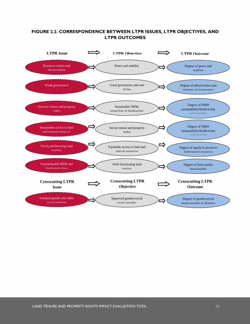
productivity may correspond to a mission Strategic Objective. Figure 2.2 shows the correspondence between
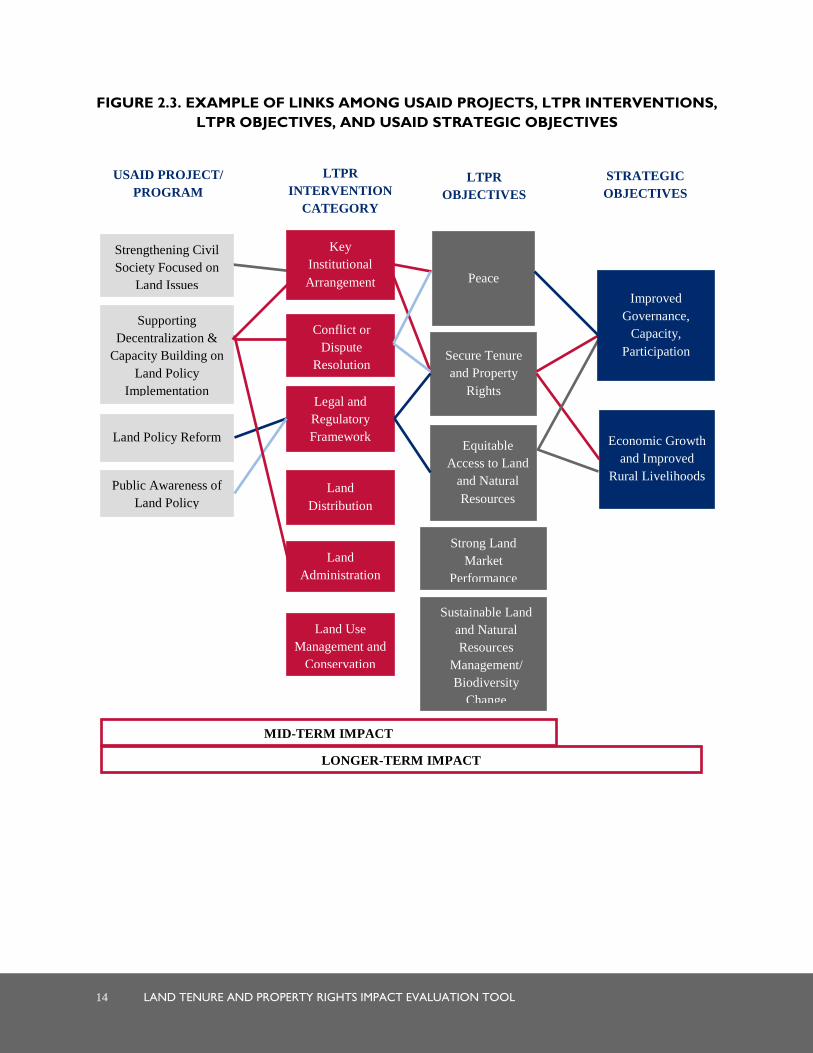
LTPR issues or constraints, LTPR objectives, and LTPR outcomes. Figure 2.3 offers a visual example of the
theoretical relationships among sample USAID projects, their intervention components, LTPR (project)
objectives, and USAID Strategic Objectives. Useful sources for identifying the project and USAID Strategic
Objectives are project RFPs, project proposals, implementation plans, and progress reports.
In identifying outcomes, one must consider the scale of the intervention(s) being assessed. The more
localized an intervention, the more difficult and tenuous it will be to connect it causally with macro-level
outcomes. It makes little sense to try to assess the contribution of a small pilot project on higher-order
objectives and outcomes such as nationwide economic growth and national poverty indices. However, one
could potentially gather information on average yield changes for important crops in the project area or
differences in local consumption practices and health status as criteria for assessing local project impact.
Selected principal outcomes should roughly correspond with the scale of the intervention being assessed.
Outcomes are not necessarily shared equally by all groups experiencing them. Tenure security, for example,
may increase for men, while it becomes weaker for women. The incidence of conflict and displacement may
increase sharply among minority indigenous populations while affecting majority groups to a much lesser
extent. Often it will be important to disaggregate outcomes to
understand and draw attention to potential differential impacts
experienced by those who are frequently marginalized by LTPR
(and other) interventions. Similarly, it will often be important to
assess project objectives specifically associated with improving
gender equality or empowering vulnerable groups. LTPR projects
designed using the SAIP Tool will most likely have such objectives, formulating indicators to measure
progress in realizing such objectives, and gathering baseline information on those indicators from treatment
and control groups.
Selected principal outcomes
should roughly correspond with
the scale of the intervention
being assessed.
LAND TENURE AND PROPERTY RIGHTS IMPACT EVALUATION TOOL 13
FIGURE 2.2. CORRESPONDENCE BETWEEN LTPR ISSUES, LTPR OBJECTIVES, AND
LTPR OUTCOMES
LTPR Objective LTPR Outcome LTPR Issue
Crosscutting LTPR
Objective
Crosscutting LTPR
Outcome
Crosscutting LTPR
Issue
Peace and stability
Sustainable NRM,
protection of biodiversity
Secure tenure and property
rights
Equitable access to land and
natural resources
Well-functioning land
market
Good governance and rule
of law
Improved gender/social
group equality
Resource conlict and
displacement
Insecure tenure and property
rights
Inequitable access to land
and natural resources
Unsustainable NRM and
biodiversity loss
Poorly performaing land
markets
Weak governance
Unequal gender and other
social relations
Degree of equity in access to
land/natural resources
Degree of land market
functionality
Degree of peace and
stability
Degree of NRM
sustainability/biodiversity
conservation
Degree of NRM
sustainability/biodiversity
conservation
Degree of effectiveness and
integrity of governance
Degree of gender/social
group equality or disputes
14 LAND TENURE AND PROPERTY RIGHTS IMPACT EVALUATION TOOL
FIGURE 2.3. EXAMPLE OF LINKS AMONG USAID PROJECTS, LTPR INTERVENTIONS,
LTPR OBJECTIVES, AND USAID STRATEGIC OBJECTIVES
Peace
Secure Tenure
and Property
Rights
Equitable
Access to Land
and Natural
Resources
Strong Land
Market
Performance
Sustainable Land
and Natural
Resources
Management/
Biodiversity
Change
Key
Institutional
Arrangement
Conflict or
Dispute
Resolution
Legal and
Regulatory
Framework
Land
Distribution
Land
Administration
Land Use
Management and
Conservation
Economic Growth
and Improved
Rural Livelihoods
Strengthening Civil
Society Focused on
Land Issues
Supporting
Decentralization &
Capacity Building on
Land Policy
Implementation
Land Policy Reform
Public Awareness of
Land Policy
MID-TERM IMPACT
LONGER-TERM IMPACT
USAID PROJECT/
PROGRAM
LTPR
INTERVENTION
CATEGORY
LTPR
OBJECTIVES
STRATEGIC
OBJECTIVES
Improved
Governance,
Capacity,
Participation

LAND TENURE AND PROPERTY RIGHTS IMPACT EVALUATION TOOL 15
Regardless of whether the project included objectives specific to gender, it is highly recommended that the
selected principal outcomes for the Impact Evaluation include measures of gender equality through the
inclusion of gender-sensitive indicators and the disaggregation of all person-level indicators by sex. For
example, a project centered on improving access to customary justice might examine women’s access
specifically in relation to men through gender-disaggregating indicators selected to measure access. Such a
project might also want to assess the extent to which women in particular engaged as customary justice
authorities before and after the project, even if the project did not set out to increase their participation in the
authority structures. Assessing the influence of projects on gender not only helps uncover whether projects
are inadvertently having negative impacts on gender relations, but is also indicative of the growing importance
USAID is placing on projects positively contributing to gender equality.
2.3 TIMEFRAME
The timeframe for the evaluation refers to the range of time over which change will be assessed. To ensure
the required data for conducting the Impact Evaluation are available, planning for the Impact Evaluation
must be incorporated in every phase of the LTPR project or intervention. For example, treatment and control
groups must be selected and baseline data from each group collected at the start of the project prior to
launching LTPR interventions. The Impact Evaluation Tool should be applied 18 months before the end of
the project/intervention to allow time for design, implementation, analysis, and dissemination of findings
before the project closes.
2.4 SCALE
Because the size and scope of projects are highly variable, the Agency will need to consider the scale of the
analysis to be undertaken. Projects that involve a discrete set of LTPR interventions implemented in a few
easily accessible regions are likely to permit assessment of the full range of LTPR activities. At the other end
of the spectrum, evaluation of a project that incorporates multiple sets of LTPR interventions implemented in
different parts of the country cannot fit comfortably into two weeks of fieldwork, especially if accessing some
project areas is time consuming or challenging.
Considering the likely budget ceiling of the assessment, decisions will need to be made about where the
Impact Evaluation should be targeted. Since baseline data will need to be collected from both treatment and
control groups prior to the implementation of interventions, these decisions will need to be made early on in
the project/intervention design phase. For a project implemented in several parts of the country, the Agency
may wish to consider narrowing the analysis to two to three areas where the physical, socioeconomic, and/or
the institutional landscape contrast significantly, and select one comparable control site for each treatment
site. Or, if different packages of LTPR interventions were introduced in different sites, two to three treatment
sites (and a counterfactual control site for each) could be selected where the LTPR approach was significantly
different. Doing so provides the opportunity to learn what kinds of intervention approaches might work
better and under what conditions.
2.5 TIME
The Impact Evaluation can generally be carried out during a period of four to six weeks, depending on the
scale of the evaluation (as noted above) and the size of the team (see next section), or approximately 24–36
days of level of effort (LOE) per team member. In general, the team will need:
16 LAND TENURE AND PROPERTY RIGHTS IMPACT EVALUATION TOOL
Seven to nine days to review the project documentation and undertake the necessary planning for the evaluation prior to arrival in country;
Twelve to twenty days to conduct fieldwork in country and analyze the information to extract preliminary findings;
Five to seven days to write the report, plus two additional days assigned to the team leader to finalize the report;
Two travel days for international consultants;
Ten to twenty-five days for the logistics coordinator, depending on whether s/he will accompany the team on field visits; and
Three days of administrative/editing support.
Time requirements will be greater if the team needs to address any gaps in the SOW or any lack of necessary
documents to be reviewed at the outset (see Section 2.9 for recommended documentation to supply to the
team).
2.6 THE EVALUATION TEAM
With the fundamental parameters of the Impact Evaluation
defined, USAID can make important practical decisions about
team composition and the cost of the Impact Evaluation.
The interventions and selected principal outcomes suggest
important areas of expertise that would benefit the evaluation
team, and therefore should be used to guide the selection of
team members. Knowledge and experience with land tenure
issues will inevitably be important, but more specific
qualifications such as gender, land administration, or conflict
expertise may also be essential. When assessing expertise needs,
attention should be paid to the types of interventions and
selected outcomes for assessing impact, ensuring that the
relevant LTPR expertise is present on the team. At least one
team member should have a firm grounding in conceptual and methodological issues of quantitative and
qualitative Impact Evaluation and experience in applying and analyzing their data, including econometric data
analysis. This individual is typically the team leader and is responsible for keeping the team on track with the
methodology. At least one team member should have strong knowledge of the political and organizational
landscape of the country of interest; this person is preferably based in the country where the evaluation will
take place. Where possible, the evaluation should attempt to build local capacity by involving local
consultants in key roles, or supporting partner organizations, civil society, or government to undertake such
evaluations and use the results generated. To ensure objectivity, the evaluation teams should be led by outside
experts, and no implementing partner or USAID staff member involved in the project under evaluation
should be involved in evaluating its own activities.
An evaluation team leader should be designated in the SOW. S/he should be responsible for preparing the
team, identifying and assembling critical reading materials, leading the planning and implementation of the
assessment, and serving as the liaison with USAID/Washington and the mission. To the extent possible,
evaluation specialists with appropriate expertise from partner countries, but not involved in project
implementation, will lead and/or be included in evaluation teams.
The involvement of at least one
USAID staff member engaged in
LTPR programming but not
involved in the project under
evaluation has the potential to
considerably deepen learning
drawn from the assessment and
thereby enhance the Agency’s,
including the mission’s capacity to
respond appropriately to
assessment findings.

LAND TENURE AND PROPERTY RIGHTS IMPACT EVALUATION TOOL 17
The involvement of at least one USAID staff member engaged in LTPR programming (but not in the project
or intervention being evaluated) has the potential to considerably deepen learning drawn from the evaluation
and thereby enhance the Agency’s capacity to respond appropriately to evaluation findings. Finally, recruiting
a person to coordinate the team’s fieldwork logistics and gather information from secondary sources has
proven essential. Such a person should be familiar with the landscape of actors with whom the team will want
to consult, ranging from central government offices to local beneficiaries, and able to schedule interviews or
arrange for government, civil society, and/or community workshops. S/he should also be familiar with the
different locations under evaluation and able to accompany them and provide support for the duration of the
assessment.
The ideal team size is four to six members, including the logistics coordinator. The size will depend on
decisions made about the number and complexity of interventions, scale of the assessment, and time. For
example, an evaluation involving interventions in three far-flung sites will either necessitate a larger team that
can break off into pairs during fieldwork or a longer time period.
2.7 SCOPE CHECKLIST
Box C provides a list of key questions to assist the Agency in developing a SOW for the LTPR Impact
Evaluation. Table 2.1 offers an example of an SOW checklist to enable quick review of its key components.
Reference to these can help ensure all elements of the scoping exercise are included and well defined.
TABLE 2.1. SAMPLE SCOPE OF WORK CHECKLIST
SCOPE COMPONENTS EXAMPLE
Purpose
Contribute to mission’s understanding of the degree of success and failure of rural land titling
projects in Laos.
Share findings with other missions undertaking rural titling projects.
Use findings to design future LTPR projects that will contribute effectively to USAID project and
institutional goals as well as the priorities of project participants.
Intervention(s) to Assess
and Their Scale
USAID-led titling project covering 82 communities in 3 rural regions of Laos, one of which included
the participation of AusAID. Two of the three projects included support for titling, registration, and
alternative dispute resolution. The third region included these interventions, plus a public awareness
campaign targeting women to inform them about the implications of the program.
Principal Outcomes,
including Project/LTPR
Objectives and Mission
Strategic Objectives
Project objectives: How did the LTPR interventions of interest contribute to (1) tenure security of
female and male members of households that received titles, (2) distribution of rural land by
gender and wealth category, and (3) land market performance?
Mission Strategic Objectives: How did the LTPR interventions of interest contribute to (1) food
BOX C. KEY QUESTIONS FOR DEVELOPING THE SCOPE OF WORK
1. Why is the evaluation being done? Or, who wants to know what?
2. What does the Agency hope to achieve by carrying out the evaluation?
3. Which LTPR interventions within a project or program will be evaluated?
4. What were the principal objectives of the project, including LTPR and USAID Strategic Objectives? What
outcomes correspond to these objectives?
5. Over what time period will impacts be evaluated?
6. At what scale is the impact evaluation to be conducted?
7. Considering the scale of the evaluation and the types of interventions and outcomes being assessed, how
many team members are needed and what qualifications should they have?
8. What does the scale of the assessment and team composition imply for the cost of the assessment?

18 LAND TENURE AND PROPERTY RIGHTS IMPACT EVALUATION TOOL
SCOPE COMPONENTS EXAMPLE
security of households and tenants, (2) agricultural productivity, (3) political stability, and (4)
poverty?
Timeframe 2003 to present
Scale
Five communities each in two of the three rural regions where the LTPR interventions were
implemented. One of the regions included the awareness campaign targeted to women, while the
other did not.
Time
1 May 2012–31 July 2012, including a total of 31 days per team member (8 days for planning; 15
days for fieldwork and data analysis; 6 days for report writing; and 2 travel days for international
consultants). Two additional days assigned to the team leader.
Team Composition
5 members, including 1 consultant with expertise on Impact Evaluation and participatory methods
(team leader), 1 consultant with expertise in land tenure and administration, 1 gender specialist, 1
member of the mission staff from the Economic Growth division, and 1 logistics coordinator [specify
names, affiliations, and positions].
Anticipated Cost Budget based on estimated LOE; international and domestic travel costs, local transportation,
accommodations, and per diem; communications; and equipment and materials.
2.8 USAID WASHINGTON AND MISSION SUPPORT
Once the evaluation team has been identified and before they begin their work, the Agency—including the
relevant USAID mission—should assemble the necessary documentation for the team, to build their
knowledge of the intervention(s) and implement the tool effectively. Having this information available on the
team’s first day of work will allow the members to become familiar with the project and its LTPR
components and enable them to move directly to the planning stage outlined in the next section.
Useful information sources to provide to the team include:
Documents and reports on intervention or project objectives, budget, target treatment and
control groups, strategies, and implementation. If the project was designed using the SAIP Tool, the
Program Design Report is essential for framing the Impact Evaluation and includes conceptual maps, which
depict anticipated LTPR intervention outcomes and their sequencing. Results of other project planning
tools can also be useful. Additional documents providing such information may include project
RFPs/requests for applications (RFAs), the project’s USAID Results Framework, project preparation
documents, project progress reports, project work plans, and project performance monitoring plans, as
well as any pre-project feasibility, environmental, and/or social Impact Assessments.
Information on actual intervention or project achievements and failures, their direct effects on
the target treatment/control groups, and other intended and unintended outcomes.7 These can
often be found in progress reports, final reports, and project evaluation reports.
Documentation of any M&E of LTPR interventions or project implementation and outcomes, as
well as the M&E Report prepared to design the M&E system if the project was developed using the
SAIP Tool.
7 The team should carefully assess how much value to accord to speculations about such outcomes, especially the more indirect or distant
they are from the LTPR action itself and if they are based on the perceptions of only one or a few individuals. This is because many other
factors may have contributed to those outcomes other than the project. This attribution problem is one that this tool attempts to address
through triangulating perceptions from key informants about the reasons for change in selected outcome parameters.

LAND TENURE AND PROPERTY RIGHTS IMPACT EVALUATION TOOL 19
The findings of an LTPR Situation Assessment if one was carried out using the SAIP Tool or
otherwise. If conducted recently, it may also be useful for populating indicators or in identifying
intervention stakeholders. Results of other diagnostic assessments of the property rights situation can
likewise be helpful.
Finally, an in-briefing with the USAID mission should be conducted upon team arrival to clarify the
objectives of the Impact Evaluation and expectations for deliverables, and to provide any additional advice to
the team prior to embarking on the evaluation and traveling to the field sites.
2.9 FINALIZING THE SCOPE OF WORK AND BUDGET
With the foundations of the evaluation in place, the SOW can be finalized and a preliminary budget prepared.
The cost of an evaluation will depend in large part on the breadth and scale of the LTPR interventions being
assessed, the number of persons on the team, and the length of the evaluation exercise. However, for projects
with a strong focus on learning from pilot projects and hypothesis testing, it is advised that 10-15 percent of a
project budget be set aside for conducting the impact evaluation. As a rough guideline, the LOE of team
members should be broken down as follows: 15 percent for planning activities; 70 percent for empirical
investigation, data analysis, and presentation of preliminary findings to USAID; and 15 percent for report
preparation. While some time spent in the country of interest is essential, it may be possible to carry out some
of the planning, preliminary information gathering, and final report writing out of country. This can be a
critical cost savings if some of the team members reside outside the country of interest.
Budget items should include consultant time, travel costs, local transportation, accommodation and per diems
in country, communications costs (including translation), equipment, and materials. Contingency budgets
should be included to enable flexibility to accommodate unforeseen circumstances and needs. If the
evaluation exercise is operating under a fixed budget constraint, decisions will need to be made as to whether
the SOW can be adequately achieved within the cost bounds and how much should be allocated to different
components and activities. If the budget requirements exceed the anticipated budget available for the
assessment, the SOW may need to be revised to achieve a better fit.
In the next stage, the reins of the Impact Evaluation are passed to the evaluation team responsible for
developing work plans that spell out the specific tasks involved and their corresponding timeframe. Once
specific plans are in place, however, on-the-ground realities often shake up old assumptions. The team should
be flexible and willing to regularly review their work plan and make needed revisions, even during the
implementation stage.

LAND TENURE AND PROPERTY RIGHTS IMPACT EVALUATION TOOL 21
3.0 PLANNING
From this point forward, the tool describes the steps to be carried out by the evaluation team. The planning
phase described in this section begins with the team reviewing the SOW and the project documentation
provided by USAID, and either reviewing or developing “conceptual maps.”8 These are graphical
representations of the links between LTPR interventions, and project and strategic objectives that were
conceived at the time of project design. If the LTPR interventions were designed using the SAIP Tool, then
8 If the team has not received the project documentation described in Section 2.9, the team leader should contact the Agency to request its
delivery. It will be very difficult for the team to undertake the necessary planning without this documentation (especially the Program
Design Report and conceptual maps contained therein, or the project RFP or RFA in lieu of these documents).
SUMMARY OF STEPS: PLANNING
Selecting outcome indicators
1. Prepare a list of all outcomes of interest chosen in the scoping exercise.
2. Review project baseline assessments that were carried out to identify which, if any, indicators were used
to measure the selected outcomes.
3. Assign a set of multiple indicators for each outcome.
4. Investigate the existence of secondary source data on indicators for both the pre-intervention year and the
present for treatment and control communities, and the location and anticipated cost of gathering it.
5. Select one to three best-bet indicators for each outcome of interest, based on the analysis provided by
Annex B.
Deciding on information sources
1. Using the template in Annex C, devise a work plan for assembling information from secondary sources.
2. Identify primary sources based on respondents targeted by baseline assessments, the scale of the
intervention(s), information gathered on the project, the LTPR situation, and consultations with USAID
including the mission. Primary sources should include a mix of project beneficiaries, others affected by the
project, non-stakeholder resource persons, and members of the control group.
3. Devise a work plan for gathering information from primary sources (Annex D).
Deciding on methods
1. Considering the source of information (individuals, groups, or communities), scale of the interventions and
outcomes being assessed, and the methods applied, select the best mix of survey methods, rapid appraisals,
and interviews.
2. Methods should be selected with consideration of empirical strength of findings, relevance to future
programming, and emphasis on learning and local capacity building to undertake such evaluations.
Completing work plans and allocating resources
1. Agree on impact team member responsibilities for conducting surveys, appraisals, and interviews (Annex D).
2. Schedule interviews and carry out logistical planning to organize appraisals.
3. Finalize the Impact Evaluation work plan for gathering primary source information (Annex D) and allocate
budgetary resources according to the parameters established in work plans for gathering secondary and
primary source information (Annexes C and D).
22 LAND TENURE AND PROPERTY RIGHTS IMPACT EVALUATION TOOL
these conceptual maps will be contained in the Program Design Report. Otherwise, the impact evaluation
team will have to construct these maps based on other documents that suggest the logical link between the
intervention(s) and different orders of objectives (outputs, outcomes and impacts) associated with that
intervention. Doing so will enable the team to identify the assumed process of change that would be triggered
by the LTPR interventions and the chain of outcomes anticipated in the process of achieving project and
Strategic Objectives.
The conceptual maps will allow the team to identify and agree on a final set of outcomes for assessment, so
they can then select indicators that reflect those outcomes, an essential step for characterizing a given
outcome change. This is followed by defining the information sources that the evaluation will draw on and
the methods for implementation. These steps enable the team to finalize their work plan and allocate
available budgetary resources accordingly.
3.1 GETTING STARTED
Before getting underway with the planning of the Impact Evaluation, the technical and regional bureaus
should contact USAID’s Bureau for Policy, Planning, and Learning's Office of Learning, Evaluation, and
Research (PPL/LER) as necessary to discuss any aspects of the evaluation that depart from the USAID
Evaluation Policy, or if necessary, to obtain clearance on exceptions to the requirement of public disclosure of
evaluation findings. Once USAID has consulted with the PPL/LER and drafted a SOW for the assessment,
the evaluation team members should take the opportunity to review:
The Impact Evaluation Tool in full (including annexes); 9
The SOW for the assessment;
Statement regarding conflict of interest (for external evaluations, team members should disclose any
existing conflict of interest relative to the project being evaluated); and
The project documentation provided.
A time for the team to meet, whether in person or by teleconference, will allow team members to become
acquainted with one another and appreciate each other’s skill sets.10 It will also provide an opportunity for
team members to discuss the tool methodology, scope, and project documentation to share interpretations of
the information they have read, raise any concerns, and identify any important information gaps and issues
that may be resolved by contacting the Agency. To the extent possible, the team should seek to work through
the planning steps together, or to assign planning tasks and meet regularly to coordinate. Hence, one product
of this first meeting will be a schedule of how the team will spend their time, whether together or apart, prior
to going to the field. A close review of this section will provide the necessary fodder to complete this task.
3.2 REVIEWING OR CONSTRUCTING CONCEPTUAL MAPS
Based on the guidelines provided in the previous section, the SOW should identify 1) the LTPR interventions
for which USAID would like to assess impact, and 2) the objectives (or principal outcomes) against which
9 Along with technical members of the team, the logistics coordinator should also review the tool to help him/her understand the types of
primary and secondary sources to be accessed and how to convey the purpose of proposed meetings when contacting key informants.
10 The team that piloted an earlier version of this tool suggested circulating team members’ resumes among the group prior to this initial
meeting.
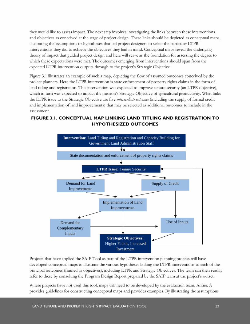
LAND TENURE AND PROPERTY RIGHTS IMPACT EVALUATION TOOL 23
they would like to assess impact. The next step involves investigating the links between these interventions
and objectives as conceived at the stage of project design. These links should be depicted as conceptual maps,
illustrating the assumptions or hypotheses that led project designers to select the particular LTPR
interventions they did to achieve the objectives they had in mind. Conceptual maps reveal the underlying
theory of impact that guided project design and here will serve as the foundation for assessing the degree to
which these expectations were met. The outcomes emerging from interventions should span from the
expected LTPR intervention outputs through to the project’s Strategic Objective.
Figure 3.1 illustrates an example of such a map, depicting the flow of assumed outcomes conceived by the
project planners. Here the LTPR intervention is state enforcement of property rights claims in the form of
land titling and registration. This intervention was expected to improve tenure security (an LTPR objective),
which in turn was expected to impact the mission’s Strategic Objective of agricultural productivity. What links
the LTPR issue to the Strategic Objective are five intermediate outcomes (including the supply of formal credit
and implementation of land improvements) that may be selected as additional outcomes to include in the
assessment.
FIGURE 3.1. CONCEPTUAL MAP LINKING LAND TITLING AND REGISTRATION TO
HYPOTHESIZED OUTCOMES
Projects that have applied the SAIP Tool as part of the LTPR intervention planning process will have
developed conceptual maps to illustrate the various hypotheses linking the LTPR interventions to each of the
principal outcomes (framed as objectives), including LTPR and Strategic Objectives. The team can then readily
refer to these by consulting the Program Design Report prepared by the SAIP team at the project’s outset.
Where projects have not used this tool, maps will need to be developed by the evaluation team. Annex A
provides guidelines for constructing conceptual maps and provides examples. By illustrating the assumptions
LTPR Issue: Tenure Security
Demand for Land
Improvements
Supply of Credit
Implementation of Land
Improvements
Demand for
Complementary
Inputs
Strategic Objectives:
Higher Yields, Increased
Investment
Use of Inputs
Intervention: Land Titling and Registration and Capacity Building for
Government Land Administration Staff
State documentation and enforcement of property rights claims
24 LAND TENURE AND PROPERTY RIGHTS IMPACT EVALUATION TOOL
about the links between the interventions and the LTPR project and strategic outcomes, the maps depict a set
of intermediate outcomes that can be included in the evaluation.11
Using the conceptual maps, the team will want to consider whether to select any intermediate outcomes as
part of the Impact Evaluation, in addition to the principal outcomes already selected. The advantage of doing
so is that it enables testing of whether the hypothesized links between interventions and objectives exist in
practice and pinpoint where assumptions might deviate from actual practice. However, their inclusion will
add to the number of questions put to primary sources and the amount of information sought from
secondary sources. If several principal outcomes have already been selected, then this may not be practical.
It is also important to understand that, in the chain of hypothesized causality, the more distant an outcome is
from the LTPR intervention, the more challenging evaluation can be. This is because there are more
intermediate outcomes and intervening variables that will come into play. Yet, often it is these “higher-order”
outcomes that are of most interest to the Agency when assessing the impact of LTPR interventions.
After the team has selected outcomes using the conceptual maps, the team should vet these with USAID to
ensure that 1) the maps accurately represent the hypotheses and assumptions underlying the choice of LTPR
interventions,12 and 2) they are in agreement with the selection of any intermediate outcomes to include in the
assessment.
3.3 SELECTING INDICATORS
Indicators act as road signs that tell project designers if an intervention or project is on track as designed. The
outcomes are typically multidimensional. While they are real reflections of goals, they are often too
multifarious to capture change adequately or efficiently. For example, the intent of an intervention may be
about improving the well-being of persons who suffer from inadequate resources to live above a standard
considered “decent.” However, the outcome well-being
has many components, as do the resources that
contribute to a decent life. Although it may fail to account
for some of the people whose lives designers may want
to help improve, assigning an indicator such as the
number or percent of persons surviving on less than $2
per day to capture insufficient well-being allows for less
costly and unwieldy gathering of data to form indicators
of the outcomes desired. The more simple and precise
an indicator, the easier it will be to collect information
on it and assess impact.
If the LTPR interventions being assessed were developed using the SAIP Tool, the M&E report for the
project should contain the selected indicators for the different anticipated outcomes of the project and
targeted for inclusion in the baseline assessment and M&E. In general, USAID will be interested in assessing
the impact of LTPR interventions on so-called “higher-order objectives” of the project (e.g., improved
11 Often a project’s Results Framework is indicative of these assumptions, and the sub-results contained in the framework correspond to
intermediate outcomes of particular project interventions.
12 Even if the conceptual maps were the basis of program design and contained in the Program Design Report, it is possible that deviations
from the original conception of the project were made or that theories about the anticipated outcomes may have changed.
All impact assessments should include
several gender-specific and sex-
disaggregated indicators that seek to
measure whether the project had a
positive, negative, or neutral impact on
gender equality. This reflects USAID’s
core commitment to advancing gender
equality in all of its programming.
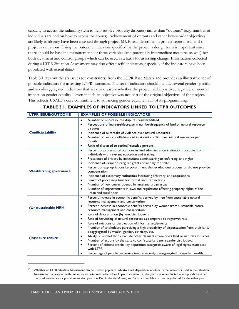
LAND TENURE AND PROPERTY RIGHTS IMPACT EVALUATION TOOL 25
capacity to access the judicial system to help resolve property disputes) rather than “outputs” (e.g., number of
individuals trained on how to access the courts). Achievement of outputs and other lower-order objectives
are likely to already have been assessed through project M&E, and described in project reports and end-of-
project evaluations. Using the outcome indicators specified by the project’s design team is important since
there should be baseline measurements of these variables (and potentially intermediate measures as well) for
both treatment and control groups which can be used as a basis for assessing change. Information collected
during a LTPR Situation Assessment may also offer useful indicators, especially if the indicators have been
populated with actual data.13
Table 3.1 lays out the six issues (or constraints) from the LTPR Base Matrix and provides an illustrative set of
possible indicators for assessing LTPR outcomes. The set of indicators should include several gender-specific
and sex-disaggregated indicators that seek to measure whether the project had a positive, negative, or neutral
impact on gender equality—even if such an objective was not part of the original objectives of the project.
This reflects USAID’s core commitment to advancing gender equality in all of its programming.
TABLE 3.1. EXAMPLES OF INDICATORS LINKED TO LTPR OUTCOMES
LTPR ISSUE/OUTCOME EXAMPLES OF POSSIBLE INDICATORS
Conflict/stability
Number of land/resource disputes registered/filed
Perceptions of increase/decrease in number/frequency of land or natural resource
disputes
Incidence of outbreaks of violence over natural resources
Number of persons killed/injured in violent conflict over natural resources per
month
Ratio of displaced to settled/resettled persons
Weak/strong governance
Percent of professional positions in land administration institutions occupied by
individuals with relevant education and training
Prevalence of bribery by institutions administering or enforcing land rights
Incidence of illegal or irregular grants of land by the state
Percent of expropriations by government that evaded due process or did not provide
compensation
Incidence of customary authorities facilitating arbitrary land acquisitions
Length of processing time for formal land transactions
Number of new courts opened in rural and urban areas
Number of improvements in laws and regulations affecting property rights of the urban and rural poor
(Un)sustainable NRM
Percent increase in economic benefits derived by men from sustainable natural resource management and conservation
Percent increase in economic benefits derived by women from sustainable natural
resource management and conservation
Rate of deforestation (by year/district/etc.)
Rate of harvesting of natural resources as compared to regrowth rate
(In)secure tenure
Rate of evictions or destruction of informal settlements
Number of landholders perceiving a high probability of dispossession from their land,
disaggregated by wealth, gender, ethnicity, etc.
Ability of landholder to exclude other claimants from one’s land or natural resources
Number of actions by the state to confiscate land per year/by district/etc.
Percent of citizens within key population categories aware of legal rights associated
with LTPR
Percentage of people perceiving tenure security, disaggregated by gender, wealth,
13 Whether an LTPR Situation Assessment can be used to populate indicators will depend on whether 1) the indicators used in the Situation
Assessment correspond with one or more outcomes selected for Impact Evaluation, 2) the year it was conducted corresponds to either
the pre-intervention or post-intervention year specified in the timeframe, and 3) data is available or can be gathered for the other year.
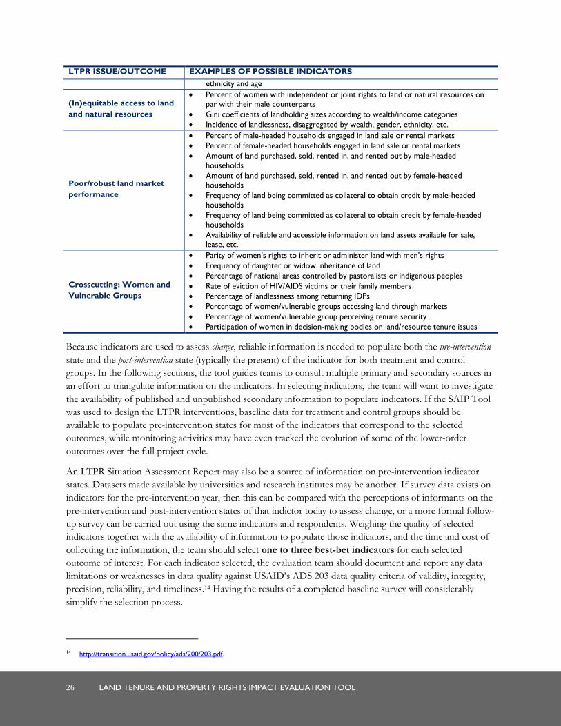
26 LAND TENURE AND PROPERTY RIGHTS IMPACT EVALUATION TOOL
LTPR ISSUE/OUTCOME EXAMPLES OF POSSIBLE INDICATORS
ethnicity and age
(In)equitable access to land
and natural resources
Percent of women with independent or joint rights to land or natural resources on
par with their male counterparts
Gini coefficients of landholding sizes according to wealth/income categories
Incidence of landlessness, disaggregated by wealth, gender, ethnicity, etc.
Poor/robust land market
performance
Percent of male-headed households engaged in land sale or rental markets
Percent of female-headed households engaged in land sale or rental markets
Amount of land purchased, sold, rented in, and rented out by male-headed
households
Amount of land purchased, sold, rented in, and rented out by female-headed households
Frequency of land being committed as collateral to obtain credit by male-headed
households
Frequency of land being committed as collateral to obtain credit by female-headed
households
Availability of reliable and accessible information on land assets available for sale, lease, etc.
Crosscutting: Women and
Vulnerable Groups
Parity of women’s rights to inherit or administer land with men’s rights
Frequency of daughter or widow inheritance of land
Percentage of national areas controlled by pastoralists or indigenous peoples
Rate of eviction of HIV/AIDS victims or their family members
Percentage of landlessness among returning IDPs
Percentage of women/vulnerable groups accessing land through markets
Percentage of women/vulnerable group perceiving tenure security
Participation of women in decision-making bodies on land/resource tenure issues
Because indicators are used to assess change, reliable information is needed to populate both the pre-intervention
state and the post-intervention state (typically the present) of the indicator for both treatment and control
groups. In the following sections, the tool guides teams to consult multiple primary and secondary sources in
an effort to triangulate information on the indicators. In selecting indicators, the team will want to investigate
the availability of published and unpublished secondary information to populate indicators. If the SAIP Tool
was used to design the LTPR interventions, baseline data for treatment and control groups should be
available to populate pre-intervention states for most of the indicators that correspond to the selected
outcomes, while monitoring activities may have even tracked the evolution of some of the lower-order
outcomes over the full project cycle.
An LTPR Situation Assessment Report may also be a source of information on pre-intervention indicator
states. Datasets made available by universities and research institutes may be another. If survey data exists on
indicators for the pre-intervention year, then this can be compared with the perceptions of informants on the
pre-intervention and post-intervention states of that indictor today to assess change, or a more formal follow-
up survey can be carried out using the same indicators and respondents. Weighing the quality of selected
indicators together with the availability of information to populate those indicators, and the time and cost of
collecting the information, the team should select one to three best-bet indicators for each selected
outcome of interest. For each indicator selected, the evaluation team should document and report any data
limitations or weaknesses in data quality against USAID’s ADS 203 data quality criteria of validity, integrity,
precision, reliability, and timeliness.14 Having the results of a completed baseline survey will considerably
simplify the selection process.
14 http://transition.usaid.gov/policy/ads/200/203.pdf.
LAND TENURE AND PROPERTY RIGHTS IMPACT EVALUATION TOOL 27
3.4 DECIDING ON INFORMATION SOURCES
This tool draws on both primary data gathered through empirical investigation and secondary information
from documents and publications. As such, the team needs to agree on which secondary sources of
information will be used and which informants will be chosen as primary sources for gathering information
on indicators and causal forces. To the extent possible, the team will want to use the same sources of
information for measuring indicators as were used in the baseline study and apply the same indicators and
methods for gathering impact evaluation data.
Documents and databases. The team now embarks on a research exercise to determine what secondary
information exists to populate the selected best-bet indicators. It may be helpful to list the selected indicators
and note for each: the sources of information for populating its pre-intervention state and present state, the
team member responsible for retrieving the information, and the timeframe for gathering it. When it exists,
baseline information gathered prior to a project’s launch is the most valuable source of information for
populating pre-intervention indicators. Likewise, if an LTPR Situation Assessment was recently undertaken,
this is a useful starting point for gathering information to capture the present state of outcome indicators.
Published documents can also offer information on perceived causes contributing to outcomes and their
indicators. Typical sources include articles from newspapers, magazines, web pages, or scholarly journals, as
well as recent books. Mission staff should be consulted about available local sources of information and how
they can be reviewed. Annex C provides a template to guide planning for gathering secondary source
information on indicators and causes.
Although information gathered through project M&E will typically not include measures associated with
strategic and other higher-order objectives, they will usually include data associated with lower-order project
objectives and possibly LTPR objectives. Moreover, since this information is gathered while the project is
ongoing, it will not allow for comparison of pre-intervention and present states of indicators. However, M&E
findings can help identify trends in meeting lower-order objectives that provide the foundation for achieving
higher-order objectives. If M&E findings suggest that certain lower-order objectives were not met, then one
can associate problems in achieving higher-order objectives with these failures. By contrast, if lower-order
objectives were fulfilled, any shortfalls in meeting higher-order objectives are likely to have emerged from
flawed assumptions in the assumed links between lower-order and higher-order outcomes or from other
influential factors that the project may not have anticipated.
People. When it comes to identifying informants to consult for qualitative data, the individuals and
communities targeted in the baseline assessment should be accorded the highest priority. If the team elects to
enrich the assessment by consulting with individuals beyond those included in the baseline, information
gathered on the project and LTPR context should provide a basis with which to identify key stakeholders
affected by the intervention(s), persons from relevant government offices and agencies, and civil society and
other nongovernmental organizations with an interest in the project, and non-stakeholder resource persons.
A major determinant of who should be consulted is the scale of the intervention(s). A project confined to the
local or micro level will rely heavily on communities affected by the project and local government
personnel.15 This will also be the case if the scope of the evaluation is limited to a particular area. A project at
15 Often, actors at a national or regional scale (e.g., ministry staff) are unaware of projects implemented at a local level, or at least the nature
of changes that occurred at that level as a result of the project.
28 LAND TENURE AND PROPERTY RIGHTS IMPACT EVALUATION TOOL
the meso (e.g., multi-district) or macro (e.g., multi-provincial or national) level is more apt to draw input from
a sample of affected communities, regional or national politicians and officials, donors, and civil society
organizations operating at a regional or national scale. Regardless of scale, however, there should be a balance
between project beneficiaries, other affected or interested parties (including mission staff), and resource
persons. USAID mission staff should be consulted on possible stakeholders to include, and if a LTPR
Situation Assessment has been prepared, it should also be reviewed for the same purpose.
It is recommended that at least half of the project stakeholders be drawn from the intended beneficiaries
(treatment group) of the intervention and include both women and men, and different wealth classes.
Because interventions are nearly always directed at improving their lives in some way, the manner in which
intended beneficiaries perceive and value change is of special importance. However, it is also critical to
consult with other affected parties within the treatment group, such as indirect beneficiaries of the
intervention, those who have been negatively affected or whose expectations were not realized, and those
who otherwise have a direct interest in the project. These are all stakeholders. Where there is conflict over
LTPR issues and interventions, it is important that the different sides are represented. In addition, the
evaluation team may also wish to consult with members of the control group to allow for further comparison
of differences emerging between the two groups.
Gender is an important consideration in stakeholder selection. Women and men face different constraints—
socially, economically, and politically—and often experience their environments and interventions differently.
Projects adopting gender-neutral approaches have sometimes been found to inadvertently ignore the needs of
women and girls, sometimes even to inflict harm on them. The team should strive to consult men and
women of different age classes equally, and perhaps even oversample women for projects that specifically
seek to target women or improve gender equity. In all cases, the team’s objective is to ensure a balance of
perspectives is represented in the final selection.
In the case of non-stakeholder resource persons, the team will want to identify persons with either a broad
knowledge of a country’s (or locale’s) situation or a profound knowledge of a particular outcome indicator
and its determinants. These may include representatives of producer associations, civil society groups,
university research programs, government departments, research institutes, or even local representatives of
other donor organizations active in the country. The more diverse the experience and perspectives of the
resource persons, the better.
It is difficult to say exactly how many actors should be consulted for qualitative analysis, since this will
depend greatly on who was targeted in the baseline assessment, the number and diversity of the selected
outcomes and indicators, and their distance in the causal chain from the interventions being assessed.
Likewise, it will depend on the amount of time and resources budgeted for the assessment. However, the
range should probably be somewhere between 25 and 40 key informants. Since first choices are not always
available, the team may wish to identify alternates for each informant that closely resemble the original
choices in terms of knowledge and perspectives.
In addition to the sources of qualitative data sources described above, household surveys from treatment and
control groups will provide an important source of quantitative data essential for measuring project/
intervention impact and assessing attribution. The survey sample size should be large enough to ensure 95
percent confidence +/-3 percent error. The actual number of households needed to meet this level of
confidence will vary according to the population size of treatment and control groups and the distribution of
targeted demographic groups if a stratified sample is employed. It is essential that the evaluation team follow

LAND TENURE AND PROPERTY RIGHTS IMPACT EVALUATION TOOL 29
the same sampling methodology as was used in the baseline survey to allow for valid statistical analysis and to
compare observed differences between treatment and control groups.
3.5 SELECTING STAKEHOLDERS AND METHODS
Based on the scale of the evaluation exercise, outcomes selected, and the evaluation budget, the team will
need to decide on an appropriate combination of data collection methods to employ. While impact
evaluations require the collection of quantitative data (typically through household surveys), the LTPR Impact
Evaluation Tool injects additional rigor through a recognized technique known as triangulation, where both
quantitative data and qualitative data are collected from a diverse group of stakeholders for additional analysis
of “why” and “how” observed changes have occurred from the perspectives of the beneficiaries. The team
should seek to follow up with the same individuals and communities targeted by the baseline assessment and
apply the same data collection questions and methods to ensure as much consistency as possible in
comparing pre-intervention and present indicator states.
If the intervention(s) sought to have an impact mainly at the local or micro level, household surveys of
treatment and control groups triangulated with interviews with local actors and/or rapid appraisal workshops
are likely to be feasible and appropriate. Economic performance data and other statistics will probably not be
available at the local level, necessitating greater reliance on survey findings and key informants to glean
information on changes in outcome parameters. Semi-structured interviews and rapid appraisal methods
should target communities, local government authorities, and other stakeholders present at the local level, and
are discussed further below.
At a meso level, the approach could involve surveying individuals or households within the treatment and
control groups and interviewing a sample of local and regional leaders, authorities, and government and
nongovernmental institutions to triangulate quantitative findings.
When interventions are undertaken at a macro (usually national) level, representative samples are drawn from
a vast pool of communities, further challenging the selection process. Alternatively, if communities have
representative organizations at higher scales, these organizations could also be sampled for surveys and
triangulated with participatory workshops or focus groups, as well as interviews with local actors. Interviews
with relevant ministry officials, implementing agencies, donor organizations, and civil society organizations
may also be conducted to triangulate quantitative findings. National-level indicators on economic growth,
agricultural production, income distribution, and the like are frequently available for different years and may
be useful as a basis for quantitative analysis.

30 LAND TENURE AND PROPERTY RIGHTS IMPACT EVALUATION TOOL
TABLE 3.2. PREFERRED DATA GATHERING METHODS BASED ON THE SCALE OF
LTPR INTERVENTIONS
INTERVENTION SCALE
MICRO MESO MACRO
Household surveys in treatment/
control sites
Rapid appraisal methods with
target communities
Semi-structured interviews with
target communities, local authorities, and other local-level
stakeholders
Surveys of households or individuals in
select communities
Rapid appraisal methods with select
target communities
Semi-structured interviews with local
actors in selected communities, and with regional stakeholders
Regional data for some indicators
(check availability)
Surveys of households or
individuals in representative
sample of communities and/or
within representative organizations
at higher scales
Rapid appraisal methods with
select target communities
Semi-structured interviews with local and regional actors in sample
areas, and with national
stakeholders
National-level data for some
indicators (check availability)
This tool discusses three methods for eliciting information from primary sources and guides the team in
selecting the most appropriate mix of these, noting once again that the same methods for collecting data on
pre-intervention indicators should be used for gathering information on the indicator’s present state. All
impact assessments will require the collection of quantitative data, typically through household surveys. In
addition to quantitative survey data, qualitative data may be collected through rapid appraisal methods. Rapid
appraisals are designed to elicit information from communities or other groups in an interactive fashion that
encourages participation and learning. Communication with individuals is facilitated by semi-structured
interviewing, a technique designed to engage key informants in a conversation on the subject matter, while
still pursuing a consistent inquiry. Focus group interviews, a similar technique, can be used with small
groups. If resources for the evaluation are limited, it may be possible to have focus group interviews
substitute for more comprehensive community consultations using rapid appraisal workshops.
Household surveys. Baseline data collection methods should be re-employed for gathering present day
states of indicators from the same treatment and control sample and using the same survey instrument and
survey methods, thereby enabling the team to assess changes in those indicators. Even if the team uses survey
methods to assess indicator change, it does not obviate the need to validate those changes (or lack thereof)
with respondents or to employ more open-ended questions to gauge their perceptions about corresponding
causal factors. Likewise, questions corresponding to the second stage of inquiry—investigating the perceived
outcomes emerging from the LTPR intervention(s)—will also need to be included in the follow-up
questionnaires. Care must be taken to interview both male and female members of households, and to target
households of vulnerable groups. Gender and vulnerable group considerations should also guide the selection
of enumerators. To allow for cost and time savings, electronic data collection using mobile devices may be
implemented. Data acquired through baseline and follow-up surveys can be supplemented by information
gathered from appraisals and interviews using recall data.
In addition, to include the perspectives of beneficiaries on change and its causes, the team should employ
either rapid appraisals or focus group interviews in a sample of communities that represent contrasting
characteristics. In cases where communities may have difficulty evaluating changes in macro phenomena, the
team may want to consider employing indicators more appropriate to their knowledge. For example, in the
case of evaluating changes in equity of landholdings, asking about changes in the proportion of landholdings
in the area above and below certain hectare specifications and the causes will probably be easier to
LAND TENURE AND PROPERTY RIGHTS IMPACT EVALUATION TOOL 31
comprehend than inquiring about changes in national Gini coefficient indices. At the meso scale, the balance
can shift to include more community-directed methods but should still rely heavily on interviews with other
stakeholders and resource persons. At the local level, rapid appraisal and focus group methods targeting
communities may dominate, but non-community sources need to be tapped as well. However, if the scope of
the Impact Evaluation is narrowed to understand only localized outcomes of a project, an in-depth
consultation exercise may not be necessary. Instead, a single rapid appraisal workshop could be undertaken,
bringing together local stakeholders and resource persons. Alternatively, a survey of project beneficiaries may
be sufficient to assess impact.
Appraisals and interviews. Both appraisal and interview techniques employ two stages of inquiry. In the
first stage, the focus is exclusively on characterizing the change in the selected indicators, reasons contributing
to the change, and their relative weight. To avoid biasing the informants toward attributing changes to the
intervention(s), no mention of it is made at this stage. Also, the less associated the interviewer is with the
intervention(s), the less likely s/he is likely to elicit bias from the interviewee. The objective of this initial stage
of inquiry is to produce an evaluation of the change in each of the selected outcome indicators and a set of
causes explaining each of the outcome indicator changes. This method is presented in Section 4.3.
A second stage of inquiry follows and seeks to avoid overlooking unexpected outcomes emerging from LTPR
interventions. This subsequent tier elicits perceptions about the specific impact of the intervention and
necessarily follows the previous inquiry to avoid predisposing the informant about the forces influencing
change. Here, the objective is to produce a set of outcomes illustrating the multiple effects of the
intervention, a technique explained in Section 4.3.
In the case of interviewing groups or applying rapid appraisal methods, consideration should be taken of the
needs and sensitivities of women and other vulnerable groups. In mixed male-female groups, women may be
less outspoken or defer to men, eclipsing women’s perspectives of change and factors contributing to change.
The same can also be true for certain vulnerable groups, who may feel intimidated in the presence of more
dominant or powerful groups and refrain from actively participating in the assessment. In some cases, female
facilitators may be more successful at eliciting responses from women’s groups, especially on more sensitive
topics like intra-household control rights over land and other assets. Oppressed groups are likely to be most
at ease with persons who bear no relation to their oppressors.
In addition, the team should also consider some of the possible tradeoffs in selecting one method over
another, as well as how methods can be adapted to minimize their potential shortfalls. Table 3.3 provides a
brief overview of some of the pros and cons of these different methods that may be useful for the team to
consider.
Regardless of the method chosen, many practical aspects will need to be considered, such as whether
interpretation services will be needed, transport arrangements, accommodation arrangements, provision of
meals or snacks at workshops, etc. Together with the lists of communities and other informants the team
would like to meet, these other matters should be discussed with the logistics coordinator prior to arrival in
the field. The team will also want to share the results of the planning phase with USAID, including the
relevant mission to get their input and assess feasibility. What may make sense to a team of outsiders and
contribute to a robust Impact Evaluation can also sometimes have political implications that the mission may
wish to avoid— and the team may need to be sensitive to these issues.
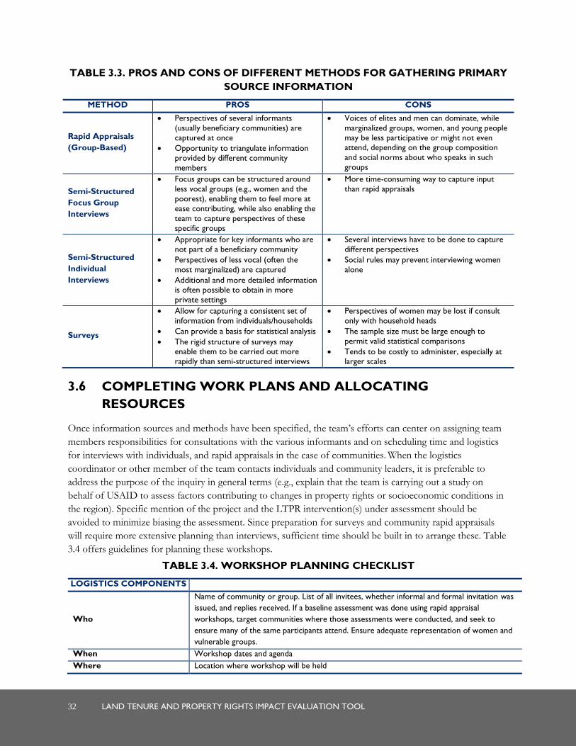
32 LAND TENURE AND PROPERTY RIGHTS IMPACT EVALUATION TOOL
TABLE 3.3. PROS AND CONS OF DIFFERENT METHODS FOR GATHERING PRIMARY
SOURCE INFORMATION
METHOD PROS CONS
Rapid Appraisals
(Group-Based)
Perspectives of several informants
(usually beneficiary communities) are
captured at once
Opportunity to triangulate information
provided by different community
members
Voices of elites and men can dominate, while
marginalized groups, women, and young people
may be less participative or might not even attend, depending on the group composition
and social norms about who speaks in such
groups
Semi-Structured
Focus Group
Interviews
Focus groups can be structured around
less vocal groups (e.g., women and the
poorest), enabling them to feel more at
ease contributing, while also enabling the
team to capture perspectives of these
specific groups
More time-consuming way to capture input
than rapid appraisals
Semi-Structured
Individual
Interviews
Appropriate for key informants who are
not part of a beneficiary community
Perspectives of less vocal (often the
most marginalized) are captured
Additional and more detailed information is often possible to obtain in more
private settings
Several interviews have to be done to capture
different perspectives
Social rules may prevent interviewing women
alone
Surveys
Allow for capturing a consistent set of
information from individuals/households
Can provide a basis for statistical analysis
The rigid structure of surveys may enable them to be carried out more
rapidly than semi-structured interviews
Perspectives of women may be lost if consult
only with household heads
The sample size must be large enough to
permit valid statistical comparisons
Tends to be costly to administer, especially at larger scales
3.6 COMPLETING WORK PLANS AND ALLOCATING
RESOURCES
Once information sources and methods have been specified, the team’s efforts can center on assigning team
members responsibilities for consultations with the various informants and on scheduling time and logistics
for interviews with individuals, and rapid appraisals in the case of communities. When the logistics
coordinator or other member of the team contacts individuals and community leaders, it is preferable to
address the purpose of the inquiry in general terms (e.g., explain that the team is carrying out a study on
behalf of USAID to assess factors contributing to changes in property rights or socioeconomic conditions in
the region). Specific mention of the project and the LTPR intervention(s) under assessment should be
avoided to minimize biasing the assessment. Since preparation for surveys and community rapid appraisals
will require more extensive planning than interviews, sufficient time should be built in to arrange these. Table
3.4 offers guidelines for planning these workshops.
TABLE 3.4. WORKSHOP PLANNING CHECKLIST
LOGISTICS COMPONENTS
Who
Name of community or group. List of all invitees, whether informal and formal invitation was
issued, and replies received. If a baseline assessment was done using rapid appraisal
workshops, target communities where those assessments were conducted, and seek to
ensure many of the same participants attend. Ensure adequate representation of women and
vulnerable groups.
When Workshop dates and agenda
Where Location where workshop will be held

LAND TENURE AND PROPERTY RIGHTS IMPACT EVALUATION TOOL 33
LOGISTICS COMPONENTS
Facilitators Names of team members responsible for facilitating workshops (at least two). Name of any
persons contracted specifically for this purpose.
Materials
Depends on whether the exercises will be done on paper or on the ground. Materials may
include large rolls of paper, markers, masking tape, numerous 8”x5”cards, colored
stickers/colored tacks/beans/stones, stapler, pens, notebooks for participants, large cork
boards, a camera for photographing exercise outputs. Facilitators should provide the list.
Transportation Arrangements for roundtrip ground transportation between participants’ homes/offices and
the workshop site
Accommodation Location and contact information of overnight accommodation and transport to facility, if
needed
Meals, snacks, water Arrangements for meals, snacks, and water during the workshops
Budget Breakdown of expenses and anticipated total cost of the workshop
At this point, the team is able to build in plans for collecting primary source information into the Impact
Evaluation work plan developed in Section 3.3 for secondary source information. They can specify planned
actions and team member responsibilities for collecting primary source information and projecting associated
costs to ensure that plans conform to the available resources.
Useful questions for planning are:
1. Based on the scale of the evaluation, which methods are likely to be most appropriate in generating
objective, replicable, and reliable data? Do special considerations need to be taken for working with
women or other vulnerable groups (e.g., planning separate groups or engaging female facilitators)?
2. Given the budget available for the assessment, how extensively and intensively can the methods be
applied? Approximately how many households, communities, government authorities, nongovernmental
organizations, and other stakeholders will be surveyed/consulted in the assessment?
3. Who will probably spend what time, doing what, and where?
4. What are critical unknowns and flexibility requirements? How can they be accommodated, while still
working within the budget?
Annex D provides a template for this exercise. Although the team should strive to work within the timeframe
and budget parameters originally established in the scope of work, the planning undertaken by the team may
reveal whether additional resources or time are required to produce a quality assessment.

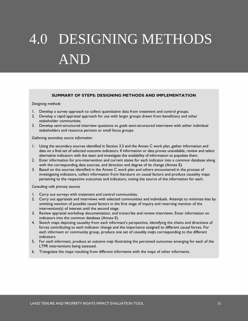
LAND TENURE AND PROPERTY RIGHTS IMPACT EVALUATION TOOL 35
4.0 DESIGNING METHODS
AND
IMPLEMENTATION
WITH DECISIONS MADE
ABOUT WHICH
INFORMATION
SOURCES TO TAP AND
HOW TO DO SO,
METHODS CAN NOW
BE DESIGNED FOR
TEAM
IMPLEMENTATION.
SUMMARY OF STEPS: DESIGNING METHODS AND IMPLEMENTATION
Designing methods
1. Develop a survey approach to collect quantitative data from treatment and control groups.
2. Develop a rapid appraisal approach for use with larger groups drawn from beneficiary and other
stakeholder communities.
3. Develop semi-structured interview questions to guide semi-structured interviews with either individual
stakeholders and resource persons or small focus groups.
Gathering secondary source information
1. Using the secondary sources identified in Section 3.3 and the Annex C work plan, gather information and
data on a final set of selected outcome indicators. If information or data proves unavailable, review and select
alternative indicators with the team and investigate the availability of information to populate them.
2. Enter information for pre-intervention and current states for each indicator into a common database along
with the corresponding data sources, and direction and degree of its change (Annex E).
3. Based on the sources identified in the Annex C work plan and others encountered in the process of
investigating indicators, collect information from literature on causal factors and produce causality maps
pertaining to the respective outcomes and indicators, noting the source of the information for each.
Consulting with primary sources
1. Carry out surveys with treatment and control communities.
2. Carry out appraisals and interviews with selected communities and individuals. Attempt to minimize bias by
omitting mention of possible causal factors in the first stage of inquiry and reserving mention of the
intervention(s) of interest until the second stage.
3. Review appraisal workshop documentation, and transcribe and review interviews. Enter information on
indicators into the common database (Annex E).
4. Sketch maps depicting causality from each informant’s perspective, identifying the chains and directions of
forces contributing to each indicator change and the importance assigned to different causal forces. For
each informant or community group, produce one set of causality maps corresponding to the different
indicators.
5. For each informant, produce an outcome map illustrating the perceived outcomes emerging for each of the
LTPR interventions being assessed.
6. Triangulate the maps resulting from different informants with the maps of other informants.
36 LAND TENURE AND PROPERTY RIGHTS IMPACT EVALUATION TOOL
With decisions made about which information sources to tap and how to do so, methods can now be
designed for team implementation. Section 4.1 provides guidelines on method design.
Upon completion of the design, the team begins the real task of
assessing impact: 1) identifying the host of causal factors contributing
to outcome indicator changes and evaluating the relative effect of these
causes, including LTPR interventions; and 2) identifying and assessing
outcomes emerging specifically from the designated LTPR
intervention(s). Section 4.2 provides direction for both the collection of
published information on indicators and causal factors as well as for
appraisals and interviews. In the identification of causal factors, the
results are captured in a series of causality maps for each information
source and each outcome indicator, which are then used as the basis for
triangulation. An example of such a map is given in Figure 4.4, while
the conceptual representation is depicted in the “outcome focus” (see
Figure 4.1). Note that these causality maps are distinct from the
conceptual maps described in Section 3.2. Conceptual maps represent
theories about the links between LTPR interventions and desired
outcomes, while causality maps capture informant perceptions about
the array of factors that contribute to changes in different outcome
indicators.
During the interviews and appraisals, informants’ perceptions about the impact of the actual LTPR
intervention(s) of interest is also undertaken in the second stage of the process as a means of harvesting
information about outcomes that the mission may not have anticipated. This information is used to produce
outcome maps (conceptually depicted in the “intervention focus”—see Figure 4.1) that illustrate the array of
outcomes emerging from the LTPR intervention(s) of interest. These maps serve as a basis for analyzing how
stakeholder perceptions of the impact of interventions compare with the original hypotheses justifying the
intervention(s) depicted in the conceptual maps.
Conceptual maps represent a
pre-project hypothesis about the
links between LTPR
interventions and desired
outcomes. Causality maps
capture informant perceptions
about the array of factors that
contribute to changes in
different outcome indicators.
Outcome maps reveal
informant perceptions about the
different outcomes produced by
the interventions—whether
expected or unexpected.

LAND TENURE AND PROPERTY RIGHTS IMPACT EVALUATION TOOL 37
FIGURE 4.1. CONCEPTUAL UNDERPINNINGS OF THE OUTCOME AND CAUSALITY MAPS
Intervention (Cause)
Unexpected
Outcome
Unexpected
Outcome
Expected
Outcome
Intervention
(Cause)
Contributing
Cause
Contributing
Cause
Intervention Focus Outcome Map Outcome Focus Causality Map
Expected
Outcome
38 LAND TENURE AND PROPERTY RIGHTS IMPACT EVALUATION TOOL
4.1 DESIGNING METHODS
This sub-section provides guidelines for designing surveys, rapid appraisals, and semi-structured interviews.
Household surveys. While “before-and-after” measurements of a single group allow the evaluation team to
observe changes over time with and without participation in the program or intervention, the inclusion of a
counterfactual group allows the evaluation team to observe what may have occurred had the intervention not
taken place, and thus control for confounding factors, such as other political, economic, or social changes
outside the scope of the intervention. Consequently, Impact Evaluations require comparisons between
beneficiaries that are assigned to either a treatment or a control (counterfactual) group to measure attribution
between LTPR interventions and observed outcomes. Prior to baseline data collection, project teams must
assign individuals or communities to treatment or control groups using either an experimental or quasi-
experimental approach. Using the experimental approach, evaluators assign groups using random sampling.
Examples of random sampling methods include:
Oversubscription. If an intervention is unable to target an entire group or population (e.g., due to
budgetary restrictions), implementation can be allocated randomly across a subset of eligible participants,
and the remaining eligible subjects who do not receive the program can be considered controls.
Randomized phase-in. Using this approach, eligible groups are gradually phased in to the program and
receive treatment, so that controls represent eligible areas still waiting to participate. In this approach, all
eligible groups are able to participate, but at different times to allow for comparison. This method helps
alleviate the ethical issues of denying treatment to some groups and increases the likelihood that program
and control areas are similar in observed characteristics.
Within-group randomization. If the above randomized phase-in approach is used but time between the
start of the program and actual receipt of benefits is long, greater controversy may arise about which area
or areas should receive the program first. In that case, a randomly selected subgroup within each targeted
area may be selected to be phased into the program.
Encouragement design. In this approach, the evaluation team randomly assigns participants an
advance announcement or incentive to participate in the program. If data are also collected on the social
networks of households that receive the notice, evaluation teams may also use this approach to measure
how take-up might differ across households that are connected or not connected to the program.16
While experimental approaches may be appropriate for some LTPR evaluations, this approach does pose
some challenges and concerns, including:
The ethical concerns of providing benefits only to randomly selected members of a population;
Contamination of the study sample by spillover (when benefits intended for the treatment group benefit
the control group as well); and
Partial or incomplete participation or compliance of members of the treatment group.
An alternative to the experimental approach using randomization is the quasi-experimental approach. In this
approach, the evaluation team selects a counterfactual or control group based on observed shared
16 See Shahidur R. Khandker, Gayatri B. Koolwal Hussain A. Samad, 2010. Handbook on Impact Evaluation: Quantitative Methods and
Practices, World Bank.
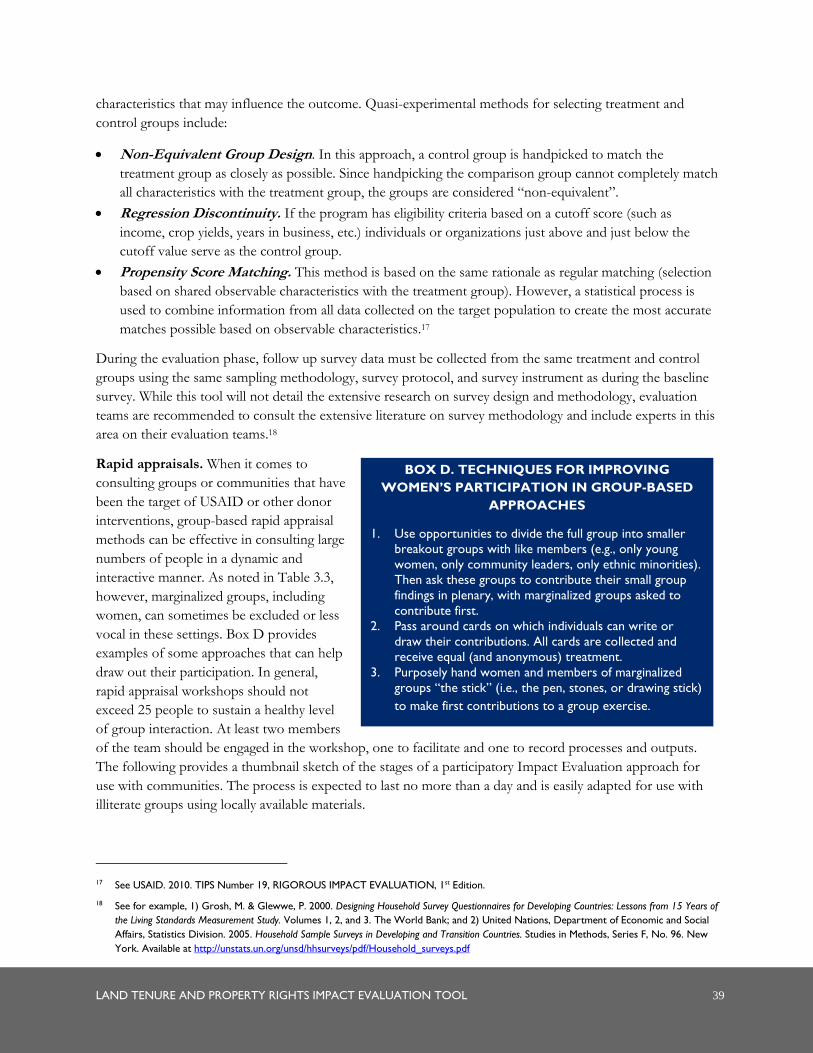
LAND TENURE AND PROPERTY RIGHTS IMPACT EVALUATION TOOL 39
characteristics that may influence the outcome. Quasi-experimental methods for selecting treatment and
control groups include:
Non-Equivalent Group Design. In this approach, a control group is handpicked to match the
treatment group as closely as possible. Since handpicking the comparison group cannot completely match
all characteristics with the treatment group, the groups are considered “non-equivalent”.
Regression Discontinuity. If the program has eligibility criteria based on a cutoff score (such as
income, crop yields, years in business, etc.) individuals or organizations just above and just below the
cutoff value serve as the control group.
Propensity Score Matching. This method is based on the same rationale as regular matching (selection
based on shared observable characteristics with the treatment group). However, a statistical process is
used to combine information from all data collected on the target population to create the most accurate
matches possible based on observable characteristics.17
During the evaluation phase, follow up survey data must be collected from the same treatment and control
groups using the same sampling methodology, survey protocol, and survey instrument as during the baseline
survey. While this tool will not detail the extensive research on survey design and methodology, evaluation
teams are recommended to consult the extensive literature on survey methodology and include experts in this
area on their evaluation teams.18
Rapid appraisals. When it comes to
consulting groups or communities that have
been the target of USAID or other donor
interventions, group-based rapid appraisal
methods can be effective in consulting large
numbers of people in a dynamic and
interactive manner. As noted in Table 3.3,
however, marginalized groups, including
women, can sometimes be excluded or less
vocal in these settings. Box D provides
examples of some approaches that can help
draw out their participation. In general,
rapid appraisal workshops should not
exceed 25 people to sustain a healthy level
of group interaction. At least two members
of the team should be engaged in the workshop, one to facilitate and one to record processes and outputs.
The following provides a thumbnail sketch of the stages of a participatory Impact Evaluation approach for
use with communities. The process is expected to last no more than a day and is easily adapted for use with
illiterate groups using locally available materials.
17 See USAID. 2010. TIPS Number 19, RIGOROUS IMPACT EVALUATION, 1st Edition.
18 See for example, 1) Grosh, M. & Glewwe, P. 2000. Designing Household Survey Questionnaires for Developing Countries: Lessons from 15 Years of
the Living Standards Measurement Study. Volumes 1, 2, and 3. The World Bank; and 2) United Nations, Department of Economic and Social
Affairs, Statistics Division. 2005. Household Sample Surveys in Developing and Transition Countries. Studies in Methods, Series F, No. 96. New
York. Available at http://unstats.un.org/unsd/hhsurveys/pdf/Household_surveys.pdf
BOX D. TECHNIQUES FOR IMPROVING
WOMEN’S PARTICIPATION IN GROUP-BASED
APPROACHES
1. Use opportunities to divide the full group into smaller
breakout groups with like members (e.g., only young
women, only community leaders, only ethnic minorities).
Then ask these groups to contribute their small group
findings in plenary, with marginalized groups asked to
contribute first.
2. Pass around cards on which individuals can write or
draw their contributions. All cards are collected and
receive equal (and anonymous) treatment.
3. Purposely hand women and members of marginalized
groups “the stick” (i.e., the pen, stones, or drawing stick)
to make first contributions to a group exercise.
40 LAND TENURE AND PROPERTY RIGHTS IMPACT EVALUATION TOOL
PART I: DEFINING INDICATOR CHANGES
1. Identifying changes of concern. The facilitators should present the outcomes and their respective indicators for
which USAID is interested in assessing change and the time period. This includes all outcomes and
indicators that were part of a baseline assessment applying rapid appraisal methods with that particular
target community(ies). The facilitator should also explain indicators and their purpose. The participants
can then be invited to introduce a limited number of additional indicators to capture outcomes they
regard as important in contributing to their well-being and have these added to the list. All indicators
should be presented visually, as either simple words or symbols, depending on group literacy.
2. Gathering information on the state of indicators. Participants are asked to evaluate the current state of the
indicators included in a baseline assessment they participated in, since presumably they contributed to
assessing the pre-intervention state when the baseline was conducted. For indicators that were not part of
the baseline assessment or in cases where most or all of the workshop participants were not part of the
assessment, participants should be asked to evaluate the states of the indicators, both in the present and
in the pre-intervention year. In such cases, facilitators may choose to mention significant events (e.g.,
elections, droughts, and major infrastructure installation) in the pre-intervention year to improve recall
capacity. Before-and-after states are posted alongside each indicator on separate large boards or sheets of
paper, and participants are asked to validate the implied change or lack of change.
PART II: IDENTIFYING THE CAUSES OF CHANGE
1. Constructing the causality map (tree). For each indicator, a simple picture of a tree with multiple branches and
roots is drawn on the ground or on a large sheet of paper. Above the tree or off to its side are listed the
pre-intervention indicator state and the present-day state. The facilitator asks participants about factors
they feel contributed to the indicator change (or lack of change), and then places the reasons they cite
along the tree.19 Reasons are recorded in simple words or as symbols on cards depending on literacy. If
participants attribute change to the project in general, the facilitator will want to probe which specific
project interventions contributed to the change. After completing this exercise for all participants,
facilitators should consider listing causal factors cited by other sources (but not by any of these group
members) and asking the participants if this is a valid factor influencing change. Factors receiving support
from the group are recorded and placed on the tree. If time permits, the team can explore the sequence
of causality with the participants, locating direct causes among the leaves, intermediate causes along the
trunk, and branches and root causes within the root structure. The idea is to produce various causality
maps that explain the causes leading to changes in the indicator states.
2. Rating causes. Each participant is then given 10 stones, stickers, or thumbtacks and asked to rank the
reasons provided in order of importance. Steps 3 and 4 are then repeated for each indicator.20
19 Alternatively, each participant can be asked to write/draw up to three reasons on cards, after which these are discussed and posted on the
tree with duplicate reasons consolidated. This can ensure all participants contribute, but may be more challenging in cases where many
participants are illiterate.
20 The team that piloted an earlier version of this tool eliminated this step due to the number of outcomes and interventions to be covered
with the communities, as well as concern that going to this level would take too much of the community’s time. Other teams facing similar
circumstances may elect to do the same.
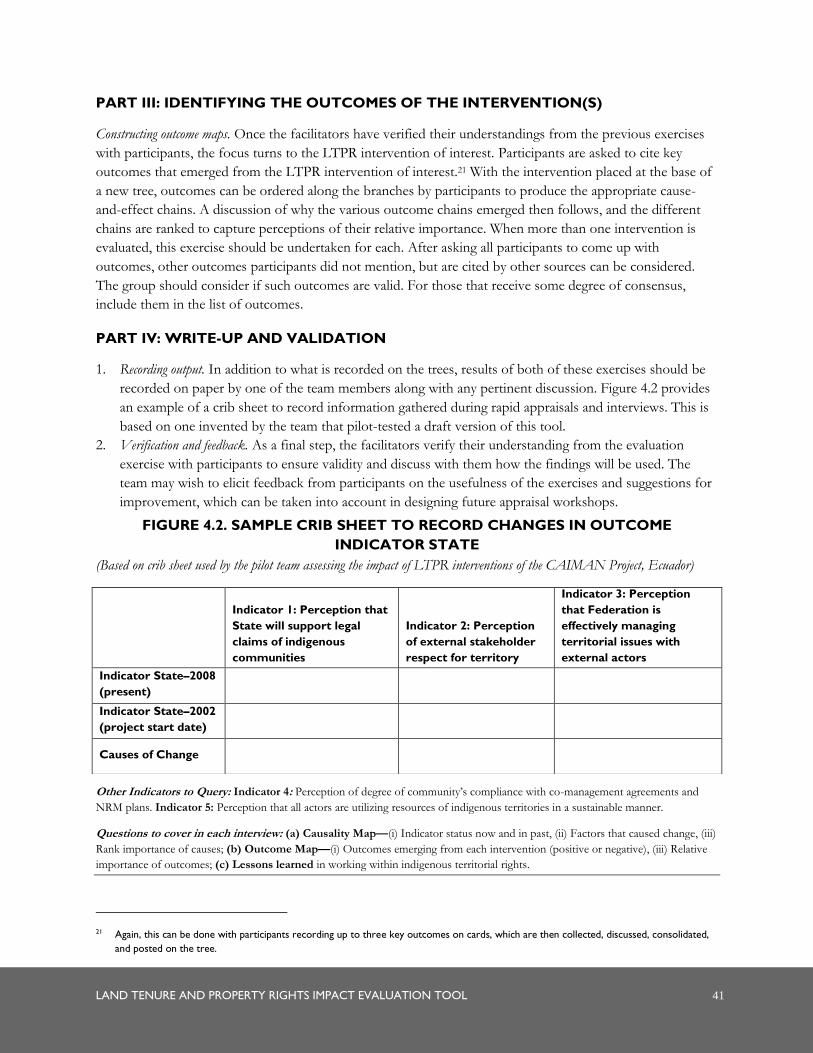
LAND TENURE AND PROPERTY RIGHTS IMPACT EVALUATION TOOL 41
PART III: IDENTIFYING THE OUTCOMES OF THE INTERVENTION(S)
Constructing outcome maps. Once the facilitators have verified their understandings from the previous exercises
with participants, the focus turns to the LTPR intervention of interest. Participants are asked to cite key
outcomes that emerged from the LTPR intervention of interest.21 With the intervention placed at the base of
a new tree, outcomes can be ordered along the branches by participants to produce the appropriate cause-
and-effect chains. A discussion of why the various outcome chains emerged then follows, and the different
chains are ranked to capture perceptions of their relative importance. When more than one intervention is
evaluated, this exercise should be undertaken for each. After asking all participants to come up with
outcomes, other outcomes participants did not mention, but are cited by other sources can be considered.
The group should consider if such outcomes are valid. For those that receive some degree of consensus,
include them in the list of outcomes.
PART IV: WRITE-UP AND VALIDATION
1. Recording output. In addition to what is recorded on the trees, results of both of these exercises should be
recorded on paper by one of the team members along with any pertinent discussion. Figure 4.2 provides
an example of a crib sheet to record information gathered during rapid appraisals and interviews. This is
based on one invented by the team that pilot-tested a draft version of this tool.
2. Verification and feedback. As a final step, the facilitators verify their understanding from the evaluation
exercise with participants to ensure validity and discuss with them how the findings will be used. The
team may wish to elicit feedback from participants on the usefulness of the exercises and suggestions for
improvement, which can be taken into account in designing future appraisal workshops.
FIGURE 4.2. SAMPLE CRIB SHEET TO RECORD CHANGES IN OUTCOME
INDICATOR STATE
(Based on crib sheet used by the pilot team assessing the impact of LTPR interventions of the CAIMAN Project, Ecuador)
Other Indicators to Query: Indicator 4: Perception of degree of community’s compliance with co-management agreements and
NRM plans. Indicator 5: Perception that all actors are utilizing resources of indigenous territories in a sustainable manner.
Questions to cover in each interview: (a) Causality Map—(i) Indicator status now and in past, (ii) Factors that caused change, (iii)
Rank importance of causes; (b) Outcome Map—(i) Outcomes emerging from each intervention (positive or negative), (iii) Relative
importance of outcomes; (c) Lessons learned in working within indigenous territorial rights.
21 Again, this can be done with participants recording up to three key outcomes on cards, which are then collected, discussed, consolidated,
and posted on the tree.
Indicator 1: Perception that
State will support legal
claims of indigenous
communities
Indicator 2: Perception
of external stakeholder
respect for territory
Indicator 3: Perception
that Federation is
effectively managing
territorial issues with
external actors
Indicator State–2008
(present)
Indicator State–2002
(project start date)
Causes of Change
42 LAND TENURE AND PROPERTY RIGHTS IMPACT EVALUATION TOOL
Semi-structured interviews and focus groups. When it comes to interviewing individuals or small groups,
team members will want to plan questions in advance, but integrate these into a conversational, rather than
survey, format. A suggested format for questions in the first stage of inquiry would be:
How would you evaluate the current state of [indicator])?22
In [year of the baseline assessment], you/this community were asked this same question and reported that [indicator] was X at that time, implying a change of Y between [year of the baseline assessment] and now. Is this the change that took place?
How does this compare with the situation in [selected year prior to intervention] when [X event] occurred?23
What factors do you think have led to this (lack of) change? Why?
Other informants we spoke with identified [X factors] as contributing to this change. Do you believe any of these factors has in fact contributed to this (lack of) change? Why?24
(Assembling all factors noted as relevant by the informant) Do you see these factors as being related to each other in any way? If so, how?
Which factors do you believe have been the most important? Why?
At this stage, questions should be open-ended and not lead the interviewee toward identifying or assigning
greater or lesser weight to any particular causal factor.
Once the informant has provided their analysis of changes in all the chosen indicators and the forces
contributing to those changes, the interviewer can proceed to the second stage of inquiry. This involves
specifically asking the person(s) about the impact of the LTPR intervention of interest. The questions might
be framed as:
What changes have emerged as a result of [the LTPR intervention(s)], both positive and negative?
Which of these have been positive, and which have been negative? How so?
Why do you think these changes occurred?25
Were there other factors that contributed to these changes? Which? How?
Once all perceived outcomes of an intervention are expressed, the interviewer should ask the individual(s) to
cite which outcomes have been the most profound and why. If the interviewee believes the intervention(s)
had little or no impact, the reasons for that perception should also be explored. The crib sheet in Figure 4.3
can help to record the information in an orderly way, and help the team keep track of the full set of
interventions and associated outcomes to query.
22 In cases where an outcome may be experienced differently by different population groups (e.g., men and women, youth, the elderly,
HIV/AIDS sufferers, and the very poor), it can be useful to ask about indicator states for these different groups.
23 If the team lacks a baseline and needs to rely on recall data for pre-intervention states, recollection of the pre-intervention state
corresponding to a particular year can be enhanced by creating an association with a widely known event that occurred in that same year,
such as a major political event or natural occurrence.
24 If time is lacking, this question and the next one can be eliminated.
25 If time is lacking, this question and the next can be eliminated.
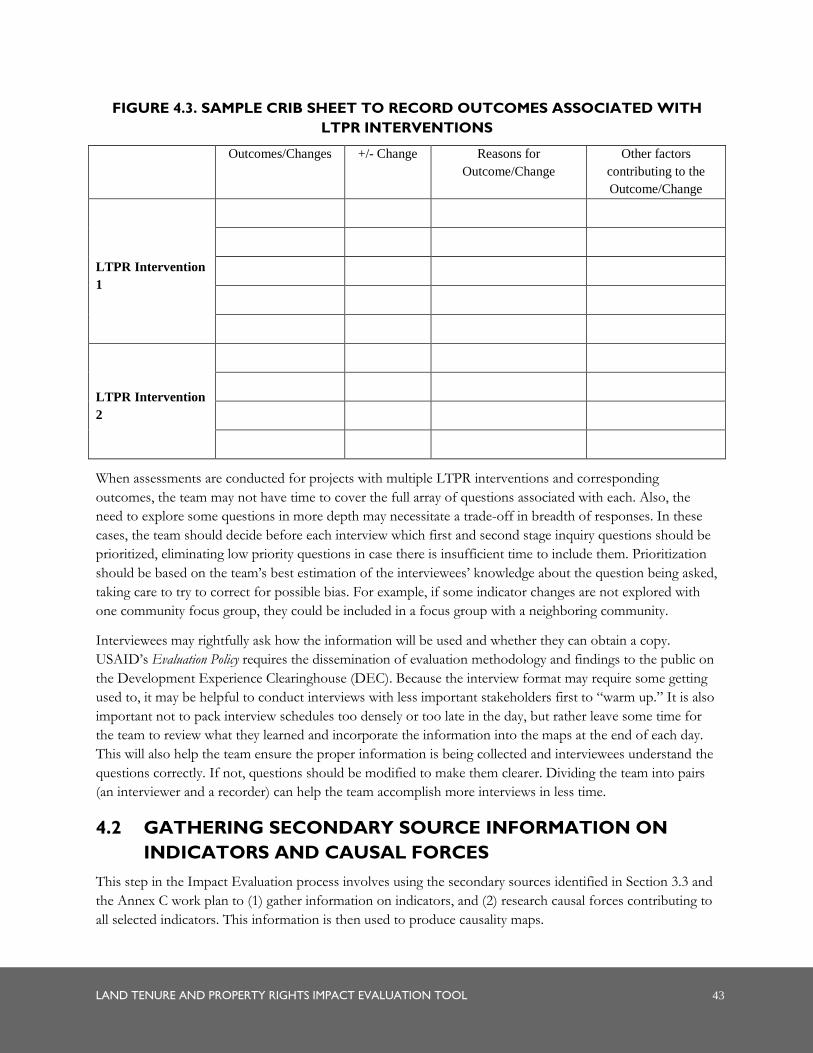
LAND TENURE AND PROPERTY RIGHTS IMPACT EVALUATION TOOL 43
FIGURE 4.3. SAMPLE CRIB SHEET TO RECORD OUTCOMES ASSOCIATED WITH
LTPR INTERVENTIONS
Outcomes/Changes +/- Change Reasons for
Outcome/Change
Other factors
contributing to the
Outcome/Change
LTPR Intervention
1
LTPR Intervention
2
When assessments are conducted for projects with multiple LTPR interventions and corresponding
outcomes, the team may not have time to cover the full array of questions associated with each. Also, the
need to explore some questions in more depth may necessitate a trade-off in breadth of responses. In these
cases, the team should decide before each interview which first and second stage inquiry questions should be
prioritized, eliminating low priority questions in case there is insufficient time to include them. Prioritization
should be based on the team’s best estimation of the interviewees’ knowledge about the question being asked,
taking care to try to correct for possible bias. For example, if some indicator changes are not explored with
one community focus group, they could be included in a focus group with a neighboring community.
Interviewees may rightfully ask how the information will be used and whether they can obtain a copy.
USAID’s Evaluation Policy requires the dissemination of evaluation methodology and findings to the public on
the Development Experience Clearinghouse (DEC). Because the interview format may require some getting
used to, it may be helpful to conduct interviews with less important stakeholders first to “warm up.” It is also
important not to pack interview schedules too densely or too late in the day, but rather leave some time for
the team to review what they learned and incorporate the information into the maps at the end of each day.
This will also help the team ensure the proper information is being collected and interviewees understand the
questions correctly. If not, questions should be modified to make them clearer. Dividing the team into pairs
(an interviewer and a recorder) can help the team accomplish more interviews in less time.
4.2 GATHERING SECONDARY SOURCE INFORMATION ON
INDICATORS AND CAUSAL FORCES
This step in the Impact Evaluation process involves using the secondary sources identified in Section 3.3 and
the Annex C work plan to (1) gather information on indicators, and (2) research causal forces contributing to
all selected indicators. This information is then used to produce causality maps.
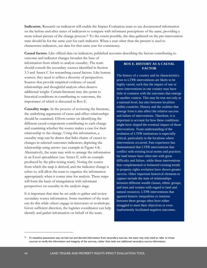
44 LAND TENURE AND PROPERTY RIGHTS IMPACT EVALUATION TOOL
Indicators. Research on indicators will enable the Impact Evaluation team to use documented information
on the before-and-after states of indicators to compare with informant perceptions of the same, providing a
more robust picture of the change process.26 To the extent possible, the data gathered on the pre-intervention
state should be for the same year for each indicator. When a year other than the present is used to
characterize indicators, use data for that same year for consistency.
Causal factors. Like official data on indicators, published accounts describing the factors contributing to
outcome and indicator changes broaden the base of
information from which to analyze causality. The team
should consult the secondary sources identified in Section
3.3 and Annex C for researching causal factors. Like human
sources, they need to reflect a diversity of perspectives.
Sources that provide empirical evidence of causal
relationships and thoughtful analysis often deserve
additional weight. Certain literature may also point to
historical conditions in contributing to outcomes, the
importance of which is discussed in Box E.
Causality maps. In the process of reviewing the literature,
the underlying arguments of cause-and-effect relationships
should be examined. Efforts center on identifying the
different causal components contributing to each change
and examining whether the source makes a case for their
relationship to the change. Using this information, a
causality map can be drawn that links chains of causes to
changes in selected outcomes indicators, depicting the
relationship using arrows (see example in Figure 4.4).
Alternatively, the team may wish to arrange the information
in an Excel spreadsheet (see Annex F, with an example
produced by the pilot-testing team). Noting the source
from which the map is derived, and the indicator change it
refers to, will allow the team to organize the information
appropriately when it comes time for analysis. These maps
will form the basis of triangulation with informant
perspectives on causality in the analysis stage.
It is important that time be set aside to gather and review
secondary source information. Some members of the team
can do this while others engage in interviews or workshops.
Given sufficient direction, the logistics coordinator can help
identify and gather information on behalf of the team.
26 If a baseline assessment was carried out and derived information from secondary sources, the team may only need to refer to those
sources to verify the information and integrity of the sources, rather than seek out additional secondary source information.
BOX E. HISTORY AS A CAUSAL
FACTOR
The history of a country and its characteristics
prior to LTPR interventions are likely to be
highly varied, such that the impact of one or
more interventions in one country may have
little in common with the outcomes that emerge
in another context. This may be true not only at
a national level, but also between localities
within countries. History and the realities that
emerge from it also affect the relative success
and failure of interventions. Therefore, it is
important to account for how these conditions
might have shaped the eventual impact of those
interventions. Team understanding of the
evolution of LTPR institutions is especially
critical, particularly in the locations where
interventions occurred. Past experience has
demonstrated that LTPR interventions that
conflict with existing local norms and practices
for land tenure have often met with great
difficulty and failure, while those interventions
that complemented or bolstered existing trends
in property rights evolution have shown greater
success. Other important historical elements to
capture include the state of relationships
between different wealth classes, ethnic groups,
and men and women with regard to land and
natural resources. LTPR interventions that
ignored historic inequalities or tensions
between these groups often have either
struggled to meet their objectives or even
inadvertently facilitated negative outcomes.
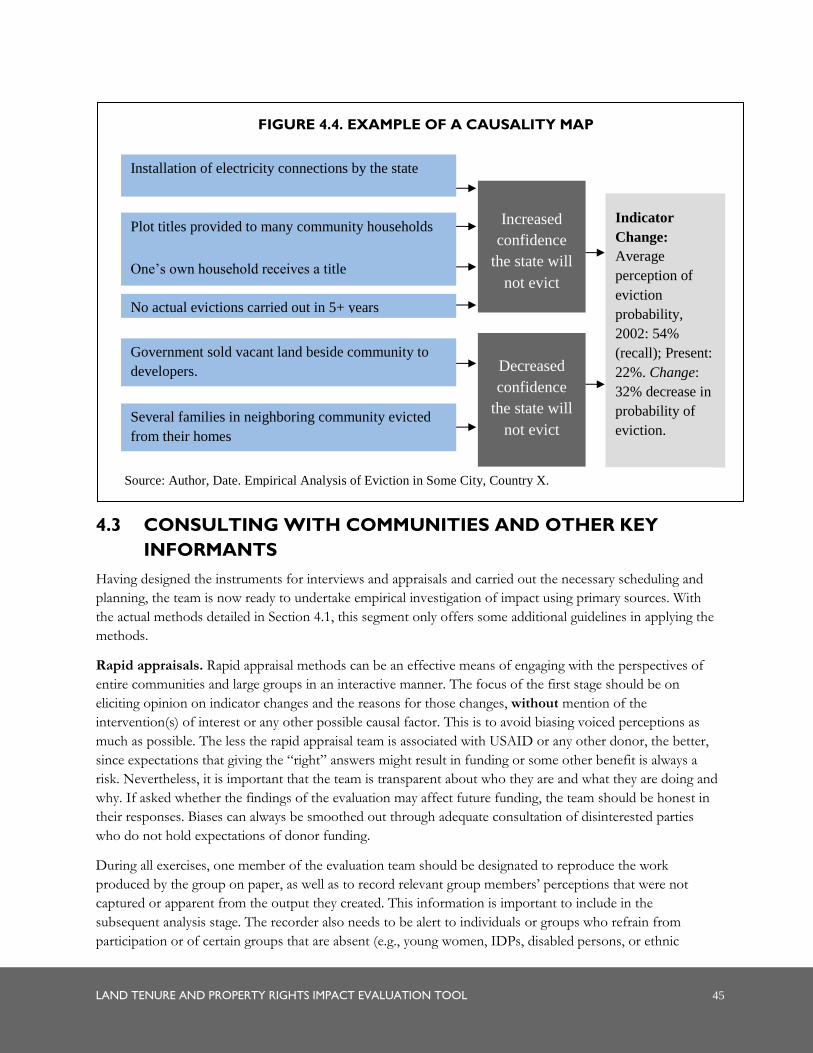
LAND TENURE AND PROPERTY RIGHTS IMPACT EVALUATION TOOL 45
4.3 CONSULTING WITH COMMUNITIES AND OTHER KEY
INFORMANTS
Having designed the instruments for interviews and appraisals and carried out the necessary scheduling and
planning, the team is now ready to undertake empirical investigation of impact using primary sources. With
the actual methods detailed in Section 4.1, this segment only offers some additional guidelines in applying the
methods.
Rapid appraisals. Rapid appraisal methods can be an effective means of engaging with the perspectives of
entire communities and large groups in an interactive manner. The focus of the first stage should be on
eliciting opinion on indicator changes and the reasons for those changes, without mention of the
intervention(s) of interest or any other possible causal factor. This is to avoid biasing voiced perceptions as
much as possible. The less the rapid appraisal team is associated with USAID or any other donor, the better,
since expectations that giving the “right” answers might result in funding or some other benefit is always a
risk. Nevertheless, it is important that the team is transparent about who they are and what they are doing and
why. If asked whether the findings of the evaluation may affect future funding, the team should be honest in
their responses. Biases can always be smoothed out through adequate consultation of disinterested parties
who do not hold expectations of donor funding.
During all exercises, one member of the evaluation team should be designated to reproduce the work
produced by the group on paper, as well as to record relevant group members’ perceptions that were not
captured or apparent from the output they created. This information is important to include in the
subsequent analysis stage. The recorder also needs to be alert to individuals or groups who refrain from
participation or of certain groups that are absent (e.g., young women, IDPs, disabled persons, or ethnic
Installation of electricity connections by the state
Plot titles provided to many community households
One’s own household receives a title
Government sold vacant land beside community to
developers.
Several families in neighboring community evicted
from their homes
No actual evictions carried out in 5+ years
Increased
confidence
the state will
not evict
Indicator
Change:
Average
perception of
eviction
probability,
2002: 54%
(recall); Present:
22%. Change:
32% decrease in
probability of
eviction.
Source: Author, Date. Empirical Analysis of Eviction in Some City, Country X.
FIGURE 4.4. EXAMPLE OF A CAUSALITY MAP
Decreased
confidence
the state will
not evict
46 LAND TENURE AND PROPERTY RIGHTS IMPACT EVALUATION TOOL
minorities), and special efforts should be made to consult them separately in a location where they may feel
more comfortable to speak candidly.
At the conclusion of the appraisal, a final set of causality maps (drawn from the tree exercises) should be
produced for each indicator once the team has summarized the findings and verified their understanding with
the participants. Separate outcome maps should depict each LTPR intervention included in the evaluation
and the associated chains of outcomes attributed by the participants. In addition to labeling maps with the
respective indicator or intervention, these illustrations should note the community name and appraisal date.
Interviews. Semi-structured interviews with government and organizational representatives, community
groups, USAID staff, and resource persons should be informal but focused on gathering a consistent set of
information from all interviewees. Interacting in a conversation-like fashion, the interviewer can probe
relevant commentary and loose ends. There are advantages to audio recording the interviews if this is
agreeable to the interviewee as taking notes can be distracting and disrupt discussion flow. However,
permission to record should always be sought and recording should not be done if the interviewee declines or
even appears uncomfortable with it. The focus of the interview should begin with the selected indicators:
eliciting perceptions on the state of those indicators in the pre-intervention year and the present, and
observations on the reasons for their (lack of) change and relative importance. Care will need to be taken in
how questions to the resource persons are framed— imposing the minimal amount of bias. The team’s
affiliation with USAID or the intervention is already likely to focus the person’s thinking on USAID
interventions, other donor projects, and perhaps land-related factors at the risk of ignoring or downplaying
other causal forces.
Soliciting the reasons why the interviewee believes a particular change is attributable to certain factors
uncovers the level of analysis they have given to comprehending the change process and can reveal evidence
that lends credibility to their view. When an interviewee cites more than one factor as a cause for a particular
outcome, questions should be asked about the relative importance of each factor and why it is such. In the
second stage of the interview, once all indicators have been discussed, the interviewer shifts to asking the
informant specifically about what changes he or she believes the LTPR intervention(s) brought about. In the
case of more than one intervention, each should be queried and considered separately. Skillful interviewing
involves knowing when questions have been answered even before the interviewer asks, following interesting
leads, and devising clarification and follow-on questions. The interviewer will want to take care that the
questions are well understood and elicit the right kind of information, rephrasing or probing as necessary.
Each appraisal or interview should produce information with which to shed light on change and the forces
contributing to it. Transcribing taped interviews and reviewing the discussions can help uncover details that
might have been missed or unclear during the actual interview. Assessments of pre-intervention and present
states for each indicator should be recorded in the common database together with the information obtained
from published sources. Annex E provides a template for how this database might be structured. For each of
the selected indicators, the team should then produce causality maps depicting the flows and interactions
between the identified causal factors based on the informant’s identification and analysis. Annex F provides a
tabular alternative for depicting these maps. Numbers or color codes can be used to indicate the weight
assigned by the informant regarding the importance of different causal factors. These maps should be labeled
with the interviewee’s name and the indicator change they refer to. Information obtained on the outcomes of
LTPR interventions should likewise be mapped with the identified outcomes flowing from each intervention
(or the tabular alternative in Annex F). These outcome maps are then labeled with the corresponding
intervention and the informant’s name.

LAND TENURE AND PROPERTY RIGHTS IMPACT EVALUATION TOOL 47
48 LAND TENURE AND PROPERTY RIGHTS IMPACT EVALUATION TOOL
.
CASE STUDY: DESIGNING AND IMPLEMENTING A MIXED-METHODS IMPACT EVALUATION
The Justice Project was designed to test an approach to improving access to justice issues for women related to land
rights in one subsection of USAID’s ProMara Program in Kenya. To assess the Justice Project’s effectiveness in
improving women’s local access to justice and land, the evaluation team employed a mixed-methods approach and
interviewed women and men in the Justice Project community (a treatment community) as well as in a similar
community in the same district, Ololong’oi, where the project has not been implemented (a control community).
Since the evaluation team was ultimately interested in determining whether the Justice Project improved women’s
local access to justice and their land rights in the community, we focused on four indicators:
Proportion of men and women who recognize women’s constitutional rights to own land,
Proportion of men who intend to provide equal inheritance to their sons and daughters,
Likelihood that women will inherit land from their husbands, and
Likelihood that women will access the local justice system if they experience threats to land rights.
Qualitative data collection was conducted to help identify causal mechanisms and explore behavioral explanations for
project outcomes related to improvements in elements of women’s access to justice, increased land access for
women, and early indications of other potential longer-term impacts. Qualitative fieldwork enabled participants from
the treatment and control communities to frame the context; articulate how the project ultimately played out in the
treatment community; and provide explanations, point out issues, and explain dynamics that we might have otherwise
overlooked. It also allowed for identification of any unintended consequences of this intervention.
Evaluators conducted 12 key informant interviews (KIIs) with chiefs, school officials, women who had disputes, and
Justice Project staff. Semi-structured interviews were conducted with each of the assistant chiefs by sub-location.
The evaluation team also conducted 17 focus group discussions with groups of men, women, youth, and elders in
both the treatment and control communities. In the treatment community, elders and women were grouped into
two categories: trainees/direct beneficiaries and non-trainees (community members who did not directly benefit from
the project). Men were also distinguished between men whose wives directly participated in a Justice activity (usually
peer sessions) and those whose wives did not participate in any project activities.
Quantitative household surveys were also conducted as part of the evaluation. Using a 95 percent level of confidence
and based on the 2010 Census, the evaluation team should have interviewed a minimum of 314 households in the
treatment community and 228 in the control community. However, the control community sample was drawn from
an incomplete list of households provided by the sub-location chief and village elders, which resulted in a lower
sample size in the control community. The total sample, combining both communities consists of 521 women and
396 men. The survey instrument for women asked about (i) individual and household demographics and
socioeconomic characteristics; (ii) land ownership and well-being indicators; (iii) potential and actual issues and
disputes; (iv) their perceptions about improvements in the local justice system within the past year; (v) their legal
knowledge; (vi) their familiarity with and participation in the Justice Project; and (vii) their awareness, recognition,
and perception of women’s land rights.
While the survey instrument was primarily designed to capture women’s perceived improvements in access to justice
and access to land, some of the outcomes require measuring changes in men’s perceptions. The following questions
were also administered to husbands to allow us to directly measure those changes: (i) their familiarity with the Justice
Project; (ii) their awareness, recognition, and perception of women’s land rights; and (iii) their perceptions about
improvements in the local justice system within the past year.

LAND TENURE AND PROPERTY RIGHTS IMPACT EVALUATION TOOL 49
5.0 ANALYZING,
REPORTING, AND
LEARNING
At this final stage of the Impact Evaluation process, the team is ready to analyze the information gathered to
assess the relative impact the intervention had on defined outcomes and report on its findings. Unlike most
conventional Impact Evaluations, however, a learning component involving USAID and the mission has
been incorporated as part of the tool and serves as an integral part of the reporting process. Efforts to
catalyze learning are expected to facilitate critical reflection and understanding about the role of LTPR
interventions and other factors in contributing to change. Such new appreciations have the capacity to
improve how future interventions will be conceived, designed, and implemented to meet their objectives
better.
5.1 ANALYZING INFORMATION
Analyzing quantitative data. The analysis of quantitative data will occur in two stages: 1) the calculation of
descriptive statistics, and 2) statistical testing of findings using appropriate methods.
SUMMARY OF STEPS: ANALYZING INFORMATION, REPORTING ON RESULTS, AND
CATALYZING LEARNING
1. Conduct quantitative analysis of survey findings, including significance testing.
2. Review causality maps, outcome maps, and other information collected.
3. Analyze the information to identify changes in outcome indicators, factors contributing to those changes,
the relative importance of those factors in effecting change, and elements that underscore or weaken the
validity of these causal factors. Produce figures that summarize these relationships.
4. Analyze the relative significance of LTPR intervention(s) as compared to other causal factors and the
underlying reasons, as well as outcomes commonly associated with the intervention(s).
5. Produce an Impact Evaluation Report according to the guidelines described above.
6. Schedule and prepare a meeting with mission staff to present the report and engage in a learning
discussion.
7. Hold a meeting comprising presentation of the report method and findings, a question and answer session,
learning exercises that lead to shared understandings regarding how and the extent to which LTPR
interventions contributed to principal outcomes, and facilitated discussions on the implications for future
LTPR interventions.
8. Share information on the evaluation prior to and upon completion of the evaluation with all partners and
stakeholders, and with the general public.
9. Submit completed evaluations to the Agency’s DEC.
10. Upload and store all quantitative data collected during the evaluation process in a central database.
50 LAND TENURE AND PROPERTY RIGHTS IMPACT EVALUATION TOOL
Calculating descriptive statistics. In addition to the calculation of selected evaluation indicators, means can be
generated according to specific demographic or geographic criteria, such as urban versus rural households,
male versus female respondents, governmental versus nongovernmental organizations, or for different age
categories.
Statistical testing. The Difference-in-Difference (DD) method is a common data analysis method for
experimental and quasi-experimental evaluations. The DD method estimates the difference in the outcome
during the post-intervention period between a treatment group and comparison group relative to the
outcomes observed during a pre-intervention baseline survey.
Two statistical tests are recommended for this method:
When only two populations are compared (for example, one treatment group compared to its control
group), T-tests of difference in means of key indicators and variables may be applied.
To compare key indicators and variables across more than two study populations (for example, if
multiple treatment and control groups are included in the evaluation), an F-test of difference in means
(such as analysis of variance [ANOVA] and regression analysis) may be applied.
Any statistically significant differences between treatment and control groups may be further analyzed using
the qualitative methods described below.
Analyzing qualitative data. Analyzing qualitative and asymmetric information garnered from numerous
interviews is a challenging task and tends to be much less straightforward than quantitative analysis. The
causality and outcome maps produced from primary and secondary sources can help the team readily identify
repeated attributions and outcomes that highlight patterns of causality and impact as well as important
differences in perceptions. The maps should be used in conjunction with original interview transcripts and
documentation produced from the appraisals that hold important details on informants’ analytical processes
and other factors shaping their thinking. Analysis of the information should focus on:
Comparison of primary and secondary source information on indicator change. Examine the degree of variance in
group and individual perceptions of change in outcome indicators, and how these perceptions compare
with information on indicators obtained from documented sources. Compare pre-intervention indicator
states reported in those baseline assessments with those that rely on informant recollection or even on
those derived from secondary source information. Baseline information is likely to be more reliable than
recalled states, but does not diminish the importance of people’s current perceptions of the past and
changes that have taken place since then.
The importance of the LTPR intervention. Assess the degree of attribution and weight assigned to the LTPR
intervention(s) of interest in shaping the various outcomes. Where the intervention(s) is not perceived to
be a priority causal factor, this merits a close examination of why this is the case. Where such
interventions were associated with negative changes in outcomes, as well as where they were seen to elicit
negative consequences or outcomes inconsistent with their objectives, extensive analysis of the reasons
given is warranted.27
27 In some cases, the reasons may reveal that the assumptions guiding project design and intervention sequencing did not adequately reflect
the reality of the situation, that gaps in information were present, and/or that circumstances changed over time but the project failed to
adapt to the new realities.
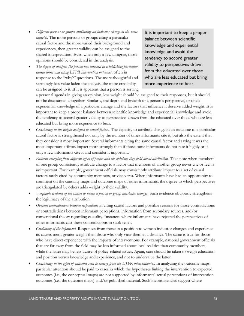
LAND TENURE AND PROPERTY RIGHTS IMPACT EVALUATION TOOL 51
Different persons or groups attributing an indicator change to the same
cause(s). The more persons or groups citing a particular
causal factor and the more varied their background and
experiences, then greater validity can be assigned to the
shared interpretation. Even when only a few disagree, those
opinions should be considered in the analysis.
The degree of analysis the person has invested in establishing particular
causal links and citing LTPR intervention outcomes, often in
response to the “why?” questions. The more thoughtful and
seemingly less value-laden the analysis, the more credibility
can be assigned to it. If it is apparent that a person is serving
a personal agenda in giving an opinion, less weight should be assigned to their responses, but it should
not be discounted altogether. Similarly, the depth and breadth of a person’s perspective, or one’s
experiential knowledge of a particular change and the factors that influence it deserve added weight. It is
important to keep a proper balance between scientific knowledge and experiential knowledge and avoid
the tendency to accord greater validity to perspectives drawn from the educated over those who are less
educated but bring more experience to bear.
Consistency in the weight assigned to causal factors. The capacity to attribute change in an outcome to a particular
causal factor is strengthened not only by the number of times informants cite it, but also the extent that
they consider it most important. Several informants citing the same causal factor and saying it was the
most important affirms impact more strongly than if those same informants do not rate it highly or if
only a few informants cite it and consider it important.
Patterns emerging from different types of people and the opinions they hold about attribution. Take note when members
of one group consistently attribute change to a factor that members of another group never cite or feel is
unimportant. For example, government officials may consistently attribute impact to a set of causal
factors rarely cited by community members, or vice versa. When informants have had an opportunity to
comment on the causality maps and outcome maps of other informants, the degree to which perspectives
are triangulated by others adds weight to their validity.
Verifiable evidence of the causes to which a person or group attributes changes. Such evidence obviously strengthens
the legitimacy of the attribution.
Obvious contradictions between respondents in citing causal factors and possible reasons for those contradictions
or contradictions between informant perceptions, information from secondary sources, and/or
conventional theory regarding causality. Instances where informants have rejected the perspectives of
other informants cast these contradictions in stark relief.
Credibility of the informant. Responses from those in a position to witness indicator changes and experience
its causes merit greater weight than those who only view them at a distance. The same is true for those
who have direct experience with the impacts of interventions. For example, national government officials
that are far away from the field may be less informed about local realities than community members,
while the latter may be less aware of policy-related issues. Again, care should be taken to weigh education
and position versus knowledge and experience, and not to undervalue the latter.
Consistency in the types of outcomes seen to emerge from the LTPR intervention(s). In analyzing the outcome maps,
particular attention should be paid to cases in which the hypotheses linking the intervention to expected
outcomes (i.e., the conceptual maps) are not supported by informants’ actual perceptions of intervention
outcomes (i.e., the outcome maps) and/or published material. Such inconsistencies suggest where
It is important to keep a proper
balance between scientific
knowledge and experiential
knowledge and avoid the
tendency to accord greater
validity to perspectives drawn
from the educated over those
who are less educated but bring
more experience to bear.

52 LAND TENURE AND PROPERTY RIGHTS IMPACT EVALUATION TOOL
conventional wisdom and dominant assumptions about the outcomes of LTPR interventions deserve to
be questioned. Important lessons can be drawn here for future LTPR project planning and intervention
sequencing.
Quality of the intervention planning process. If the LTPR intervention(s) were developed with the aid of the
SAIP Tool, it may also be useful to go back to the Intervention Inventories created during the
Intervention Planning Phase to examine whether any of the potential “unintended consequences” cited
actually emerged and if measures were established to mitigate those. Was there adequate consideration of
enabling conditions and planning and implementation of enabling interventions to ensure LTPR
interventions were successful? Was sequencing done well and were projections informing sequencing
assumptions reasonably accurate? Was consideration taken of the likely differential impacts of
interventions on women, men, boys, and girls?
With these elements in mind, the team should seek to synthesize information from the various causality maps
and outcome maps to 1) illustrate the overarching trends in indicator changes; 2) produce a causality map for
each indicator that depicts the dominant, credible thinking on contributing factors and their chains and flows
of causality; and 3) construct one or more outcome maps that illustrates the dominant, credible view about
the chief outcomes of each of the LTPR interventions examined. In cases where there was ample divergence
in opinion, clusters of consensus can be represented in two or more causality maps or outcome maps.
5.2 REPORTING RESULTS
The Impact Evaluation Report produced by the team should capture the elements of the analysis described
above and ultimately produce a picture of how the causality map played out for each outcome indicator and
the relative importance of LTPR interventions in shaping them. The core findings are most aptly captured in
causality map and outcome map figures that highlight relationships and contrast theory with reality. The
richness and complexity of the story and sources of information are best described in the text.
Elements of the report should include the following sections at a minimum:
Scope of the Impact Evaluation exercise, describing the purpose of the assessment, the LTPR intervention(s)
assessed, the timeframe, and the outcomes against which impact was evaluated; including the actual SOW
in an annex;
Methodology, describing the overall approach undertaken, sources consulted, and instruments applied; all
sources of information should be listed in an annex;
Description of LTPR intervention(s) and the hypotheses linking these to LTPR issues and strategic outcomes, as
illustrated by the conceptual map(s);
Impact assessment, divided by sections assigned to each of the outcomes of interest that describes the
indicators assigned to the respective outcomes, highlights the change in indicator states based on survey
results and informant perceptions as well as secondary sources (Annex E), and conveys the analysis of the
elements that produced their change and the relative importance of those causal factors (descriptions
should be supplemented with synthesis causality maps for each of the indicators);
Assessment of the importance of the LTPR intervention(s) of interest in contributing to changes in the various
outcome indicators and the rationale for their degree of significance;
An analysis of the expected and unexpected outcomes that informants associated with the LTPR interventions and
a comparison of these with the outcomes predicted by the intervention hypothesis (essentially, this

LAND TENURE AND PROPERTY RIGHTS IMPACT EVALUATION TOOL 53
compares and contrasts the outcome maps with their corresponding conceptual maps that capture the
project’s original theory of change.);
Summary and conclusions that underscore the chief findings of the Impact Evaluation and highlight the
relative importance of LTPR interventions in shaping important outcomes and contributing to
unexpected outcomes, as well as point out areas that are less clear and for which conclusions are difficult
to draw; providing specific recommendations for implementer and/or for future programming efforts;
and
As part of standardized reporting, the evaluation reports should include i) disclosure of conflict of
interest: in particular, USAID Evaluation Policy notes that for external evaluations, all evaluation team
members should provide a signed statement attesting to a lack of conflict of interest, or describing an
existing conflict of interest relative to the project being evaluated; and ii) statement of differences: the
policy notes that when applicable, evaluation reports should include statements regarding any significant
unresolved differences of opinion on the part of funders, implementers, and/or members of the
evaluation team.
An example of the table of contents developed by the team that piloted this tool in Ecuador is provided in
Annex G.
5.3 CATALYZING LEARNING
Given that the LTPR Impact Evaluation was undertaken with a learning objective in mind, the process does
not end with the production of a report. Another report delivered to USAID mission staff to read in isolation
is unlikely to cultivate the in-depth understanding of the connections between LTPR interventions and the
results emerging from them that is necessary to influence future LTPR intervention design. It is important
that USAID, including mission staff, have an opportunity to work with the team to understand and validate
the findings, reflect on their lessons, and harvest what they need to build on successes and address
weaknesses.
Once the draft report has been prepared, the team should schedule a half- or full-day meeting, when mission
staff can be available, to present the report and discuss the Impact Evaluation exercise and its findings.
Although the staff may be familiar with the general method of the assessment, team members will want to
provide a review and share information on specific sources of information consulted, the methods employed,
and the rationale for those choices.
Following the presentation and a subsequent question and answer session, the team can facilitate a learning
exercise among staff to highlight the findings. One approach is to present the stylized LTPR conceptual maps
linking interventions and hypothesized outcomes against the outcome maps representing informant
perceptions of intervention outcomes. The similarities and differences identified by the mission and staff can
be noted on cards and displayed, after which the cards are used to evoke discussion. Particular attention
should be given to exploring cases of considerable divergence between theoretical assumptions and reality,
and cases in which unexpected outcomes emerged.
This exercise can be followed by a presentation of the causality maps highlighting the number of causal
factors and the complexity of causal paths influencing the various outcomes. Discussions can center on what
new information and understanding these maps reveal, such as unexpected influences contributing to change
and how other causal factors interact with interventions to shape outcomes. The next step of the discussion
54 LAND TENURE AND PROPERTY RIGHTS IMPACT EVALUATION TOOL
should center on identifying the implications of this new understanding on how LTPR interventions should
be planned and implemented in future programs.
A third exercise might focus specifically on the findings related to gender. Staff will want to examine changes
associated with increased or diminished gender equality and the reported causal factors, specifically noting any
perceptions or evidence of LTPR interventions contributing to such changes. Even if there is no attribution
to the interventions, USAID staff should benefit from a deeper understanding of the factors that influence
gender relations and their equity. Similar exercises can be done for other vulnerable groups.
At this juncture, the USAID staff may want to tease out the implications of all findings for current and future
LTPR interventions, contemplating the kinds of changes needed in their design and implementation, actions
such changes would imply, and implications for resource allocations.
5.4 PROMOTING TRANSPARENCY AND SHARING FINDINGS
The USAID Evaluation Policy stresses the need for transparency, both in the planning and design phase, and
upon completion of the evaluation. During the planning and design phase, the information on the upcoming
evaluation should be provided online, and include the expected timing of release of findings. The information
should be included in the Annual Performance Plan and Report as well, and communicated to the public via
the USAID website.
Completed evaluations (and drafts of evaluation reports completed more than three months prior) must be
submitted to the Agency’s Development Experience Clearinghouse (DEC). Each completed evaluation must
include a three to five page summary of the purpose, background of the project, main evaluation questions,
methods, findings, conclusions, recommendations, and lessons learned from the evaluation where applicable.
As part of data warehousing, all quantitative data collected by USAID or the Agency’s implementing partners
for the purposes of an evaluation must be uploaded and stored in a central database.
Per the USAID Evaluation Policy, senior management within USAID are expected to play a specific role in
promoting learning from the evaluations, and promoting transparency by sharing findings widely and in an
accessible form with all partners and stakeholders, and with the general public, through summaries provided
online.

LAND TENURE AND PROPERTY RIGHTS IMPACT EVALUATION TOOL 55
ANNEX A: CONCEPTUAL
MAPS AND INDICATORS

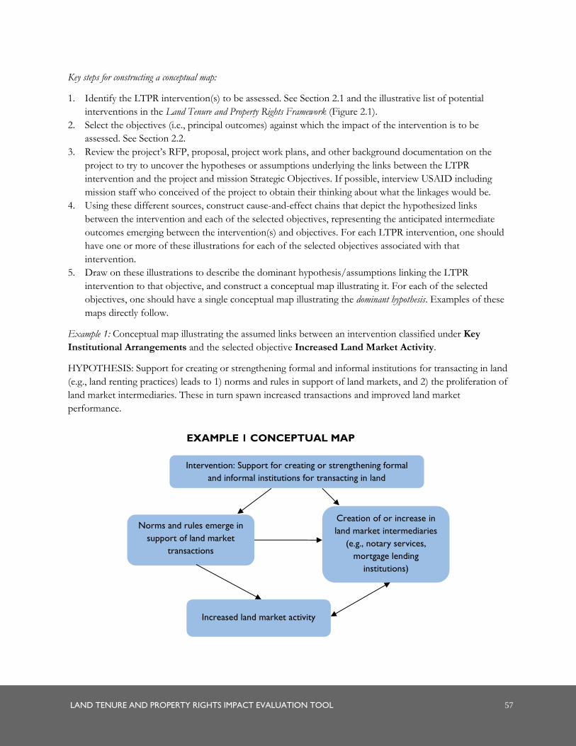
LAND TENURE AND PROPERTY RIGHTS IMPACT EVALUATION TOOL 57
Key steps for constructing a conceptual map:
1. Identify the LTPR intervention(s) to be assessed. See Section 2.1 and the illustrative list of potential
interventions in the Land Tenure and Property Rights Framework (Figure 2.1).
2. Select the objectives (i.e., principal outcomes) against which the impact of the intervention is to be
assessed. See Section 2.2.
3. Review the project’s RFP, proposal, project work plans, and other background documentation on the
project to try to uncover the hypotheses or assumptions underlying the links between the LTPR
intervention and the project and mission Strategic Objectives. If possible, interview USAID including
mission staff who conceived of the project to obtain their thinking about what the linkages would be.
4. Using these different sources, construct cause-and-effect chains that depict the hypothesized links
between the intervention and each of the selected objectives, representing the anticipated intermediate
outcomes emerging between the intervention(s) and objectives. For each LTPR intervention, one should
have one or more of these illustrations for each of the selected objectives associated with that
intervention.
5. Draw on these illustrations to describe the dominant hypothesis/assumptions linking the LTPR
intervention to that objective, and construct a conceptual map illustrating it. For each of the selected
objectives, one should have a single conceptual map illustrating the dominant hypothesis. Examples of these
maps directly follow.
Example 1: Conceptual map illustrating the assumed links between an intervention classified under Key
Institutional Arrangements and the selected objective Increased Land Market Activity.
HYPOTHESIS: Support for creating or strengthening formal and informal institutions for transacting in land
(e.g., land renting practices) leads to 1) norms and rules in support of land markets, and 2) the proliferation of
land market intermediaries. These in turn spawn increased transactions and improved land market
performance.
Norms and rules emerge in
support of land market
transactions
Intervention: Support for creating or strengthening formal
and informal institutions for transacting in land
Increased land market activity
Creation of or increase in
land market intermediaries
(e.g., notary services,
mortgage lending
institutions)
EXAMPLE 1 CONCEPTUAL MAP
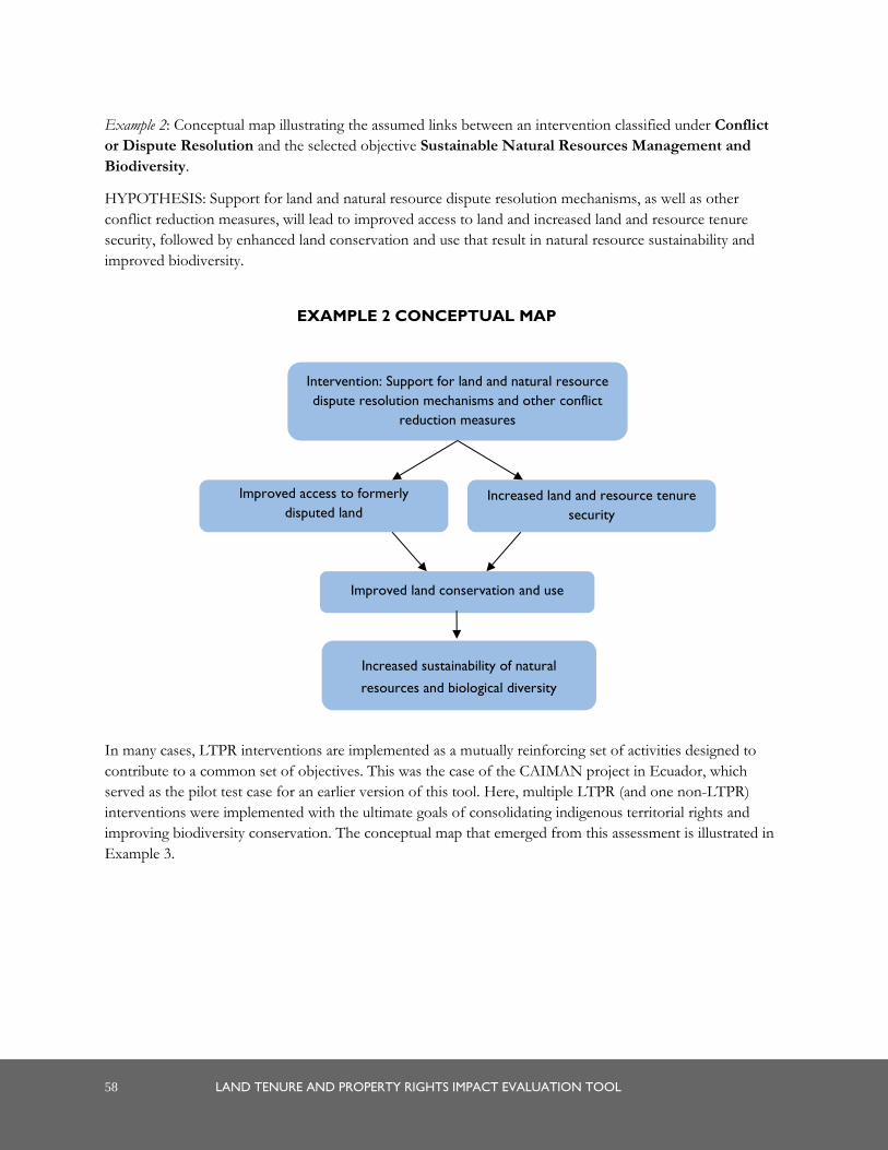
58 LAND TENURE AND PROPERTY RIGHTS IMPACT EVALUATION TOOL
Example 2: Conceptual map illustrating the assumed links between an intervention classified under Conflict
or Dispute Resolution and the selected objective Sustainable Natural Resources Management and
Biodiversity.
HYPOTHESIS: Support for land and natural resource dispute resolution mechanisms, as well as other
conflict reduction measures, will lead to improved access to land and increased land and resource tenure
security, followed by enhanced land conservation and use that result in natural resource sustainability and
improved biodiversity.
In many cases, LTPR interventions are implemented as a mutually reinforcing set of activities designed to
contribute to a common set of objectives. This was the case of the CAIMAN project in Ecuador, which
served as the pilot test case for an earlier version of this tool. Here, multiple LTPR (and one non-LTPR)
interventions were implemented with the ultimate goals of consolidating indigenous territorial rights and
improving biodiversity conservation. The conceptual map that emerged from this assessment is illustrated in
Example 3.
Improved access to formerly
disputed land
Improved land conservation and use
Intervention: Support for land and natural resource
dispute resolution mechanisms and other conflict
reduction measures
Increased land and resource tenure
security
Increased sustainability of natural
resources and biological diversity
EXAMPLE 2 CONCEPTUAL MAP
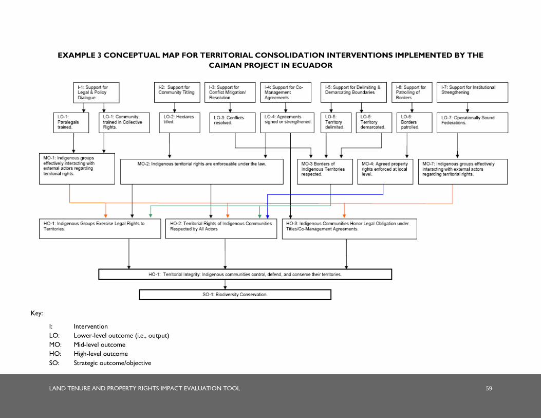
LAND TENURE AND PROPERTY RIGHTS IMPACT EVALUATION TOOL 59
EXAMPLE 3 CONCEPTUAL MAP FOR TERRITORIAL CONSOLIDATION INTERVENTIONS IMPLEMENTED BY THE
CAIMAN PROJECT IN ECUADOR
Key:
I: Intervention
LO: Lower-level outcome (i.e., output)
MO: Mid-level outcome
HO: High-level outcome
SO: Strategic outcome/objective


LAND TENURE AND PROPERTY RIGHTS IMPACT EVALUATION TOOL 61
ANNEX B: TEMPLATE FOR
INDICATOR SELECTION


LAND TENURE AND PROPERTY RIGHTS IMPACT EVALUATION TOOL 63
1. STRATEGIC OBJECTIVE OUTCOMES
Outcome Indicators Indicator
desirability (ability
to accurately
capture outcome
meaning and be
simple). Rate 1-5,
with 1 indicating
very poor
desirability and 5
indicating very
high desirability.
Source of statistical
or survey data on
indicator for the
pre-intervention
and post-
intervention years.
(List source(s) if
available or NO if
not available.)
Location of data
and cost/difficulty
of acquiring it.
Overall rating of
indicator,
considering
indicator
desirability, data
availability, and
cost. Rate 1-5,
with 1 being a
very poor
indicator and 5 a
best indicator.
1. Pre (fill
in year)
Post (fill
in year)
Pre Post
2. Pre Post Pre Post
3. Pre Post Pre Post
Outcome Indicators Indicator
desirability (ability
to accurately
capture outcome
meaning and be
simple). Rate 1-5,
with 1 indication
very poor
desirability and 5
indicating very
high desirability.
Source of statistical
or survey data on
indicator. (List
source(s) if
available or NO if
not available.)
Location of data
and cost/difficulty
of acquiring it.
Overall rating of
indicator,
considering
indicator
desirability, data
availability, and
cost. Rate 1-5,
with 1 being a
very poor
indicator and 5 a
best indicator.
1. Pre Post Pre Post
2. Pre Post Pre Post
3. Pre Post Pre Post

64 LAND TENURE AND PROPERTY RIGHTS IMPACT EVALUATION TOOL
2. LTPR ISSUE OUTCOMES
Outcome Indicators Indicator
desirability (ability
to accurately
capture outcome
meaning and be
simple). Rate 1-5,
with 1 indicating
very poor
desirability and 5
indicating very
high desirability.
Source of statistical
or survey data on
indicator for the
pre-intervention
and post-
intervention years.
(List source(s) if
available or NO if
not available.)
Location of data
and cost/difficulty
of acquiring it.
Overall rating of
indicator,
considering
indicator
desirability, data
availability, and
cost. Rate 1-5,
with 1 being a
very poor
indicator and 5 a
best indicator.
1. Pre Post Pre Post
2. Pre Post Pre Post
3. Pre Post Pre Post
Outcome Indicators Indicator
desirability (ability
to accurately
reflect outcome
meaning and be
simple). Rate 1-5,
with 1 indication
very poor
desirability and 5
indicating very
high desirability.
Source of statistical
or survey data on
indicator. (List
source(s) if available
or NO if not
available.)
Location of data
and cost/difficulty
of acquiring it.
Overall rating of
indicator,
considering
indicator
desirability, data
availability, and
cost. Rate 1-5,
with 1 being a
very poor
indicator and 5 a
best indicator.
1. Pre Post Pre Post
2. Pre Post Pre Post
3. Pre Post Pre Post

LAND TENURE AND PROPERTY RIGHTS IMPACT EVALUATION TOOL 65
3. INTERMEDIATE OUTCOMES
Outcome Indicators Indicator
desirability (ability
to accurately
capture outcome
meaning and be
simple and
precise). Rate 1-5,
with 1 indicating
very poor
desirability and 5
indicating very
high desirability.
Source of statistical
or survey data on
indicator for the
pre-intervention
and post-
intervention years.
(List source(s) if
available or NO if
not available.)
Location of data
and cost/difficulty
of acquiring it.
Overall rating of
indicator,
considering
precision, data
availability, and
cost. Rate 1-5,
with 1 being a
very poor
indicator and 5 a
best indicator.
1. Pre Post Pre Post
2. Pre Post Pre Post
3. Pre Post Pre Post
Outcome Indicators Indicator
precision (ability
to accurately
reflect outcome).
Rate 1-5, with 1
indication very
poor precision
and 5 indicating
very high
precision.
Source of statistical
or survey data on
indicator. (List
source(s) if available
or NO if not
available.)
Location of data
and cost/difficulty
of acquiring it.
1. Pre Post Pre Post
2. Pre Post Pre Post
3. Pre Post Pre Post


LAND TENURE AND PROPERTY RIGHTS IMPACT EVALUATION TOOL 67
ANNEX C: WORK PLAN
FOR ACQUISITION OF
SECONDARY SOURCE
INFORMATION
(TEMPLATE)

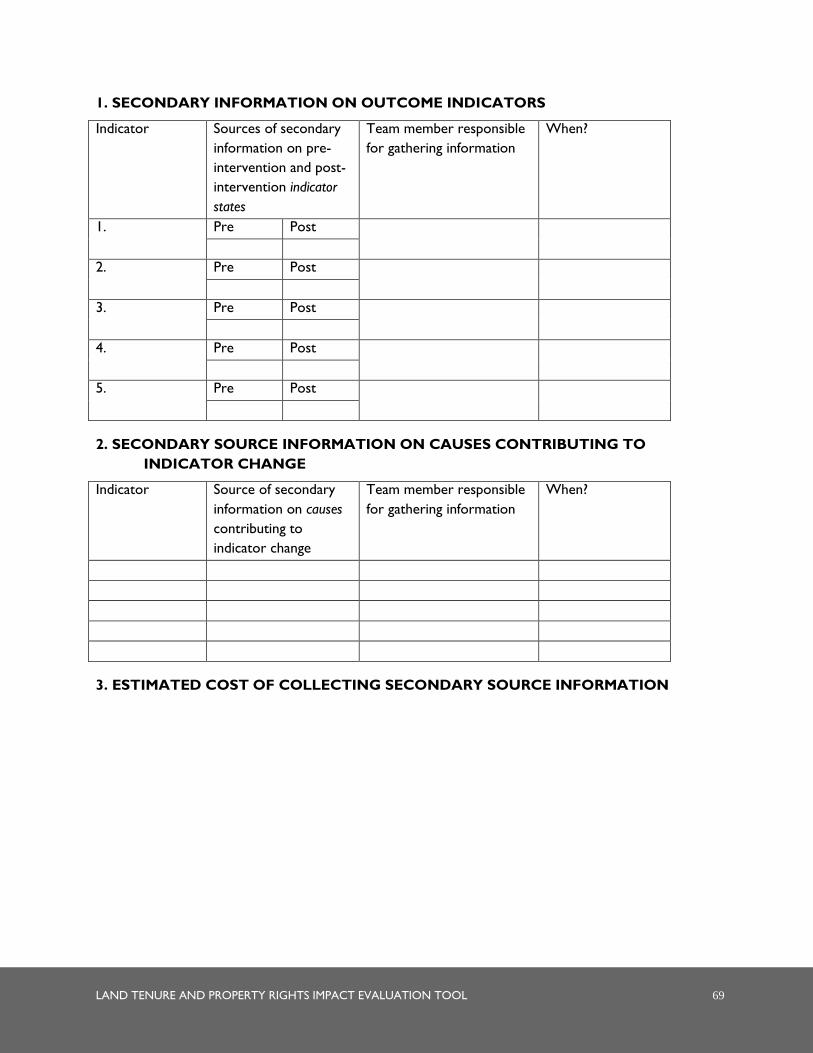
LAND TENURE AND PROPERTY RIGHTS IMPACT EVALUATION TOOL 69
1. SECONDARY INFORMATION ON OUTCOME INDICATORS
Indicator Sources of secondary
information on pre-
intervention and post-
intervention indicator
states
Team member responsible
for gathering information
When?
1. Pre Post
2. Pre Post
3. Pre Post
4. Pre Post
5. Pre Post
2. SECONDARY SOURCE INFORMATION ON CAUSES CONTRIBUTING TO
INDICATOR CHANGE
Indicator Source of secondary
information on causes
contributing to
indicator change
Team member responsible
for gathering information
When?
3. ESTIMATED COST OF COLLECTING SECONDARY SOURCE INFORMATION


LAND TENURE AND PROPERTY RIGHTS IMPACT EVALUATION TOOL 71
ANNEX D: WORK PLAN
FOR ACQUISITION OF
PRIMARY SOURCE
INFORMATION
(TEMPLATE)


LAND TENURE AND PROPERTY RIGHTS IMPACT EVALUATION TOOL 73
1. KEY INFORMANT AND FOCUS GROUP INTERVIEWS
NAME of
individual or
group
DATE of
interview
TIME of
interview
LOCATION of
interview
TEAM MEMBER
conducting interview
Project beneficiary
stakeholders
Other
stakeholders
Non-stakeholder
resource persons
74 LAND TENURE AND PROPERTY RIGHTS IMPACT EVALUATION TOOL
2. RAPID APPRAISAL WORKSHOPS
NAME of
community or
group
DATE of
workshop
TIME of
workshop (start
and end)
LOCATION of
workshop
FACILITATOR
NAMES
3. ESTIMATED TOTAL COST OF INTERVIEWS:
4. ESTIMATED TOTAL COST OF APPRAISAL WORKSHOPS:

LAND TENURE AND PROPERTY RIGHTS IMPACT EVALUATION TOOL 75
ANNEX E: TEMPLATE FOR
RECORDING CHANGE IN
INDICATOR STATES

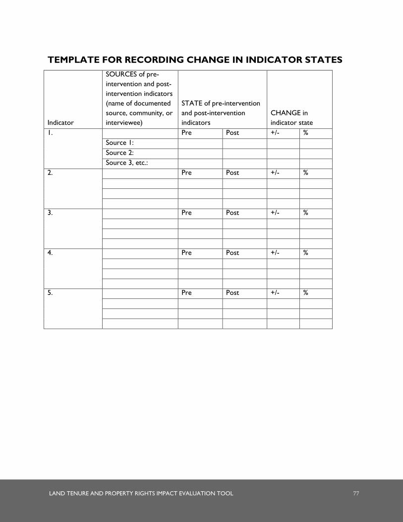
LAND TENURE AND PROPERTY RIGHTS IMPACT EVALUATION TOOL 77
TEMPLATE FOR RECORDING CHANGE IN INDICATOR STATES
Indicator
SOURCES of pre-
intervention and post-
intervention indicators
(name of documented
source, community, or
interviewee)
STATE of pre-intervention
and post-intervention
indicators
CHANGE in
indicator state
1. Pre Post +/- %
Source 1:
Source 2:
Source 3, etc.:
2. Pre Post +/- %
3. Pre Post +/- %
4. Pre Post +/- %
5. Pre Post +/- %


LAND TENURE AND PROPERTY RIGHTS IMPACT EVALUATION TOOL 79
ANNEX F: EXAMPLES OF
ALTERNATIVE CAUSALITY
MAPS AND OUTCOME
MAPS

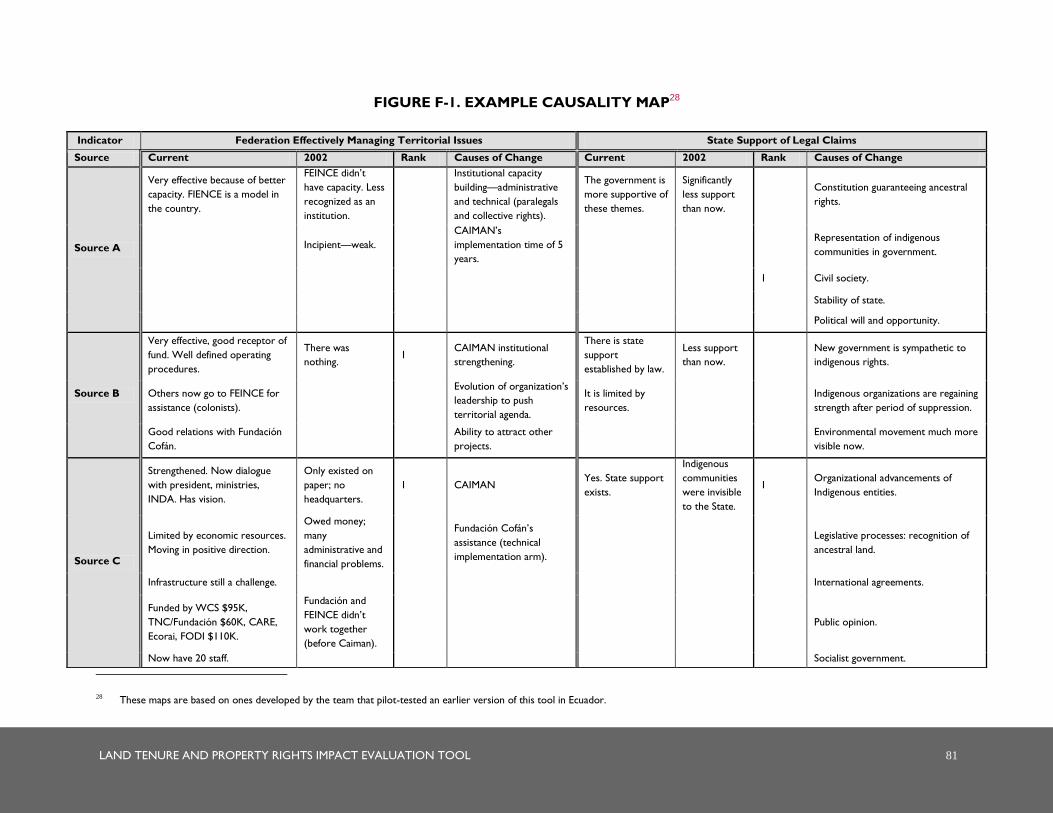
LAND TENURE AND PROPERTY RIGHTS IMPACT EVALUATION TOOL 81
FIGURE F-1. EXAMPLE CAUSALITY MAP28
28 These maps are based on ones developed by the team that pilot-tested an earlier version of this tool in Ecuador.
Indicator Federation Effectively Managing Territorial Issues State Support of Legal Claims
Source Current 2002 Rank Causes of Change Current 2002 Rank Causes of Change
Source A
Very effective because of better
capacity. FIENCE is a model in
the country.
FEINCE didn’t
have capacity. Less
recognized as an
institution.
Institutional capacity
building—administrative
and technical (paralegals
and collective rights).
The government is
more supportive of
these themes.
Significantly
less support
than now.
Constitution guaranteeing ancestral
rights.
Incipient—weak.
CAIMAN’s
implementation time of 5
years.
Representation of indigenous
communities in government.
1 Civil society.
Stability of state.
Political will and opportunity.
Source B
Very effective, good receptor of
fund. Well defined operating
procedures.
There was
nothing. 1
CAIMAN institutional
strengthening.
There is state
support
established by law.
Less support
than now.
New government is sympathetic to
indigenous rights.
Others now go to FEINCE for
assistance (colonists).
Evolution of organization’s
leadership to push
territorial agenda.
It is limited by
resources.
Indigenous organizations are regaining
strength after period of suppression.
Good relations with Fundación
Cofán.
Ability to attract other
projects.
Environmental movement much more
visible now.
Source C
Strengthened. Now dialogue
with president, ministries,
INDA. Has vision.
Only existed on
paper; no
headquarters.
1 CAIMAN Yes. State support
exists.
Indigenous
communities
were invisible
to the State.
1 Organizational advancements of
Indigenous entities.
Limited by economic resources.
Moving in positive direction.
Owed money;
many
administrative and
financial problems.
Fundación Cofán’s
assistance (technical
implementation arm).
Legislative processes: recognition of
ancestral land.
Infrastructure still a challenge. International agreements.
Funded by WCS $95K,
TNC/Fundación $60K, CARE,
Ecorai, FODI $110K.
Fundación and
FEINCE didn’t
work together
(before Caiman).
Public opinion.
Now have 20 staff. Socialist government.
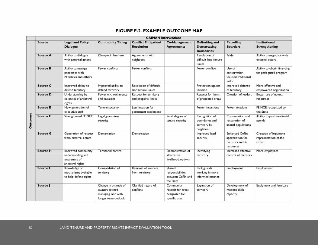
82 LAND TENURE AND PROPERTY RIGHTS IMPACT EVALUATION TOOL
FIGURE F-2. EXAMPLE OUTCOME MAP
CAIMAN Interventions
Ou
tco
mes
Source Legal and Policy
Dialogue
Community Titling Conflict Mitigation/
Resolution
Co-Management
Agreements
Delimiting and
Demarcating
Boundaries
Patrolling
Boarders
Institutional
Strengthening
Source A Ability to dialogue
with external actors
Changes in land use Agreements with
neighbors
Resolution of
difficult land tenure
issues
Pride Ability to negotiate with
external actors
Source B Ability to manage
processes with
Ministries and others
Fewer conflicts
Fewer conflicts Fewer conflicts Use of
conservation-
focused traditional
skills
Ability to obtain financing
for park guard program
Source C Improved ability to
defend territory
Improved ability to
defend territory
Resolution of difficult
land tenure issues
Protection against
invasion
Improved defense
of territory
More effective and
empowered organization
Source D Understanding by
colonists of ancestral
rights
Fewer encroachments
and invasions
Respect for territory
and property limits
Respect for limits
of protected areas
Creation of leaders Better use of natural
resources
Source E New generation of
executive staff
Tenure security Less invasion for
permanent settlement
Fewer incursions Fewer invasions FEINCE recognized by
the State
Source F Strengthened FEINCE Legal guarantee/
security
Small degree of
tenure security
Recognition of
boundaries and
territory by
neighbors
Conservation and
restoration of
animal populations
Ability to push territorial
agenda
Source G Generation of respect
from external actors
Demarcation Demarcation Improved legal
security
Enhanced Cofán
appreciation for
territory and its
resources
Creation of legitimate
representation of the
Cofán
Source H Improved community
understanding and
awareness of
ancestral rights
Territorial control Demonstration of
alternative
livelihood options
Identifying
territory
Increased effective
control of territory
More employees
Source I Knowledge of
mechanisms available
to help defend rights
Consolidation of
territory
Removal of invaders
from territory
Shared
responsibilities
between Cofán and
the State
Park guards
working in more
informed manner
Employment Employment
Source J Change in attitude of
owners toward
managing land with
longer term outlook
Clarified nature of
conflicts
Community
respect for areas
designated for
specific uses
Expansion of
territory
Development of
modern skills
capacity
Equipment and furniture

LAND TENURE AND PROPERTY RIGHTS IMPACT EVALUATION TOOL 83
ANNEX G: EXAMPLE OF
EVALUATION REPORT
TABLE OF CONTENTS

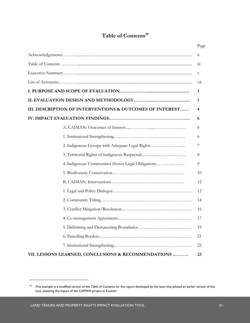
LAND TENURE AND PROPERTY RIGHTS IMPACT EVALUATION TOOL 85
Table of Contents29
Page
Acknowledgements………..............…................................................................................................... ii
Table of Contents………….................................................................................................................... iii
Executive Summary………..................................................................................................................... v
List of Acronyms…………..................................................................................................................... vii
I. PURPOSE AND SCOPE OF EVALUATION……………….................................... 1
II. EVALUATION DESIGN AND METHODOLOGY……….......….......................... 1
III. DESCRIPTION OF INTERVENTIONS & OUTCOMES OF INTEREST…… 4
IV. IMPACT EVALUATION FINDINGS:……………………………………………... 6
A. CAIMAN: Outcomes of Interest.....…………......………………… 6
1. Institutional Strengthening…...……………………………………. 6
2. Indigenous Groups with Adequate Legal Rights…………………... 7
3. Territorial Rights of Indigenous Respected…...…....………………. 8
4. Indigenous Communities Honor Legal Obligations……..….……... 9
5. Biodiversity Conservation………………………………………… 10
B. CAIMAN: Interventions ………………………………………… 12
1. Legal and Policy Dialogue…...………………………………………… 12
2. Community Titling…………..………………………………………… 14
3. Conflict Mitigation/Resolution...……………………………………… 16
4. Co-management Agreements..………………………………………… 17
5. Delimiting and Demarcating Boundaries……………………………… 19
6. Patrolling Borders...…………………………………………………… 21
7. Institutional Strengthening..…………………………………………… 22
VII. LESSONS LEARNED, CONCLUSIONS & RECOMMENDATIONS ..……… 23
29 This example is a modified version of the Table of Contents for the report developed by the team that piloted an earlier version of this
tool, assessing the impact of the CAIMAN project in Ecuador.

86 LAND TENURE AND PROPERTY RIGHTS IMPACT EVALUATION TOOL
ANNEXES
ANNEX A: SOW
ANNEX B: DOCUMENTS REVIEWED…………….................................................... 29
ANNEX C: KEY INFORMANTS...………………....................................................….. 32
ANNEX D: CAIMAN CONCEPTUAL MAP...…........................................................... 34
ANNEX E: CAIMAN OUTCOME INDICATOR SUMMARY…….............................. 35
ANNEX F: CAIMAN INTERVENTION SUMMARY...………………………………. 36
ANNEX G-1: PARK GUARD MONITORING DOCUMENTS—JOURNAL………… 37
ANNEX G-2: PARK GUARD MONITORING DOCUMENTS—ANIMAL
INVENTORY SHEET….….………………………………………………………………
38
ANNEX H: RAPID APPRAISAL WORKSHOP PROTOCOL…………………………. 39
ANNEX I: INTERVIEW SCHEDULE.…………………………………….…….……. 40
ANNEX J: DISCLOSURE CONFLICT OF INTEREST………………………….……. 41

U.S. Agency for International Development
1300 Pennsylvania Avenue, NW
Washington, DC 20523
Tel: (202) 712-0000
Fax: (202) 216-3524
www.usaidlandtenure.net