land use - fremont
TRANSCRIPT

Land UseChapter 2
City of FremontGeneral PlanAdopted December 2011

This page intentionally left blank.
2-2 | Land Use Adopted December 2011
City of Fremont
Adopted December 2011 Land Use | 2-3
General Plan
IntroductionThe purpose of the Land Use Element is to provide goals, policies, actions
diagrams and standards to guide future land use decisions in Fremont.
While all elements of the General Plan have equal weight under California
law, in some respects this Element is the most far-reaching. It informs all
other elements of the Plan, shaping the future transportation network and
the location of future housing sites, and influencing public facility require-
ments and park and recreation needs. It defines the City’s future open
space system, and responds to natural resource conservation issues and
safety hazards. It establishes the basic pattern of development in the City
for the next 20-25 years, including land uses and densities, and presents
the policies and actions to ensure that future development will enhance
the quality of life for all Fremont residents.
The Land Use Element is a particularly important tool for achieving Fre-
mont’s sustainability goals. Its policies will guide the City toward a land
use pattern that consumes less energy, is less dependent on automobiles,
supports local businesses, and is inclusive of persons of all ages and physi-
cal capabilities. The Element has also been carefully integrated with the
Mobility Element to promote a future land use pattern that reflects the
opportunities and constraints of the transportation system. Together, the
Land Use and Mobility Elements are the key to making the City a national
role model for suburban transformation.
The Element is divided into three sections. The first section provides an
overview of existing land uses and land use projections at the citywide
level. The second presents the General Plan Land Use Map and Land Use
Designations. It uses color coded categories, which are defined in detail
in this Element, to show the land use intent over the 20 to 25-year time
horizon assumed by the General Plan. The final section of the Land Use
Element presents goals, policies, and implementing actions. The policies
guide day-to-day City decisions on topics such as land use compatibility,
hillside protection, industrial land conversion, and the review of new de-
velopment.
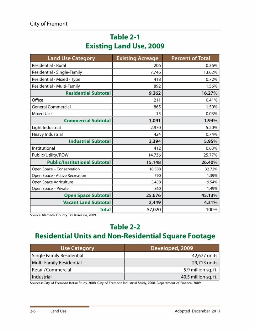
Fremont from above
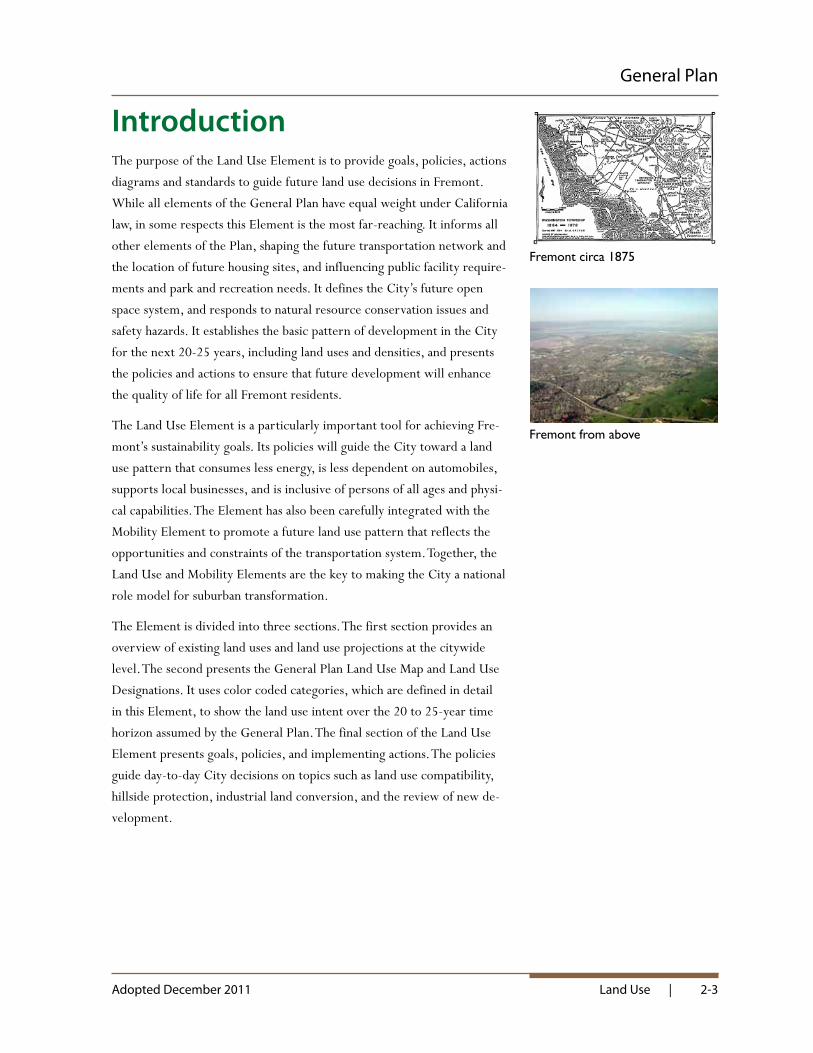
Fremont circa 1875

2-4 | Land Use Adopted December 2011
City of Fremont
Citywide Land Use ProfileExisting Land UsesFremont’s land use pattern is defined by the City’s topography, its agricul-
tural past, its early settlement patterns, its transportation network, and
its central location within the nation’s fourth largest major metropolitan
area. When the City incorporated in 1956, its boundaries included five
established small towns (Centerville, Irvington, Mission San Jose, Niles
and Warm Springs) and thousands of acres of farmland, open hills, salt
ponds, and marshes. In the past 50 years, much of the city envisioned by
Fremont’s founders has been built. The five original towns have grown and
been joined together by new neighborhoods and business districts.
As of 2010, Fremont is the fourth most populous city in the nine-county
Bay Area, the fifteenth most populous in California and the 95th larg-
est city in the United States, with a population of approximately 215,000
people. Geographically, the City is the second largest city in the Bay Area
after San Jose. Encompassing almost 90 square miles, Fremont covers a
larger land area than San Francisco, Boston, St. Louis, or Washington DC.
The City is largely defined by its open space frame, including the Fremont
hills to the east, the Baylands to the west and the Coyote Hills, Alameda
Creek and Quarry Lakes to the north and northwest (see Diagram 2-1).
Its position within the Bay Area is defined by adjacent communities; Union
City to the north, Milpitas to the south, and Newark to the west. The City
has further evolved into subareas centered around the original towns and
newer areas that have been developed during the last five decades. Some of
the subareas are defined by physical features, such as creeks or freeways,
while others are defined by the predominance of a particular land use such
as industry or open space.
Fremont Today
Historic Niles and Irvington - Fremont of Yesterday

Adopted December 2011 Land Use | 2-5
General Plan
Industrial uses are located in North Fremont, but mostly they are con-
centrated in the south and southwestern portions of the city. Commercial
uses are clustered in the five original towns, in shopping centers along
arterial streets, around freeway interchanges, and in the City Center.
Residential uses occur throughout the City, with low-density single family
neighborhoods and garden apartment complexes predominating. Public
facilities and parks are located in all parts of the City, serving surrounding
neighborhoods in some cases and the city as a whole in others.
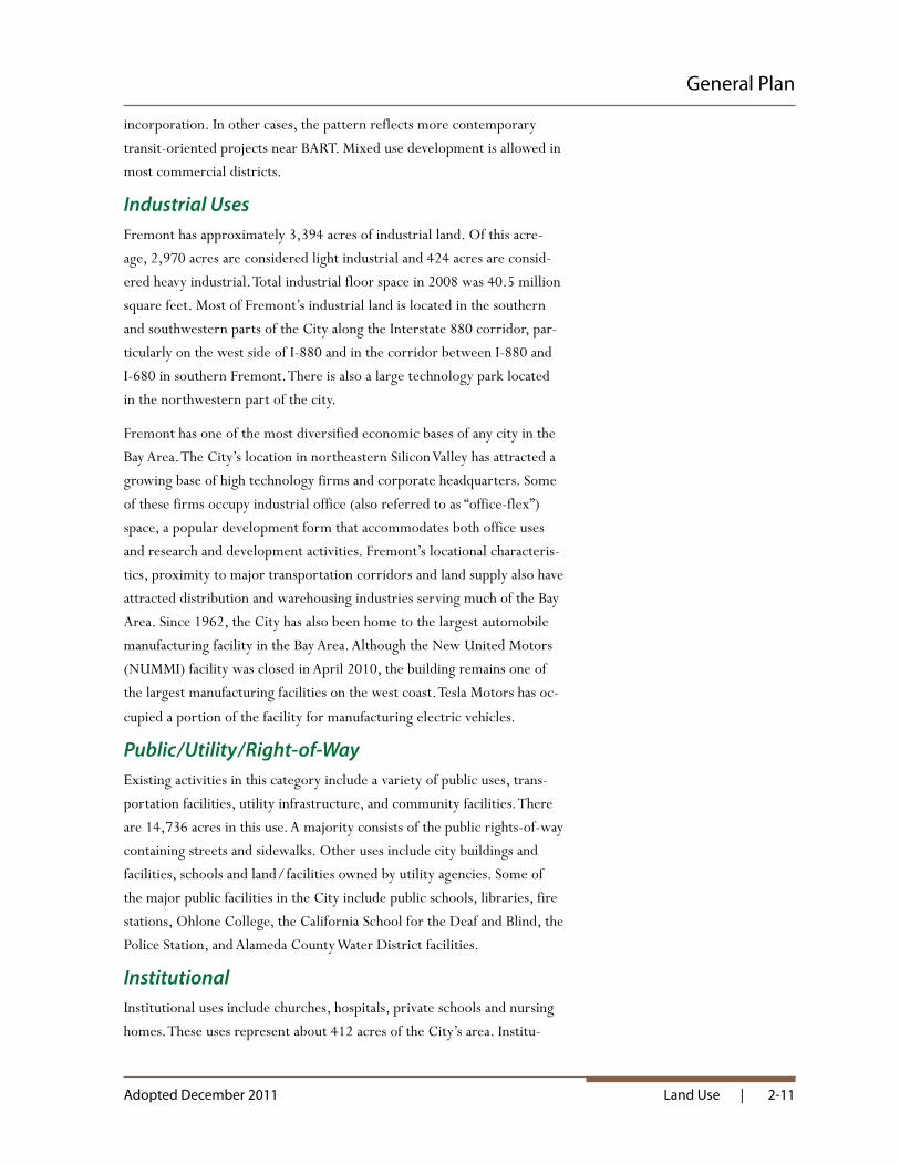
According to the Alameda County Assessor and as indicated in Table 2-1,
the City of Fremont covers approximately 57,000 acres (90 square miles).
This area includes 7,400 acres of water and salt ponds located in San Fran-
cisco Bay and 49,600 acres of land. About 45 percent of the land area is
permanent open space, including hillside and wetland preserves, grazing
land, cemeteries, regional parks and trails, and city parks. About 26 per-
cent is dedicated to streets, railroads, freeways, public facilities, and public
rights of way. The remaining 29 percent consists of land designated for
residential, commercial, and industrial uses, with residential uses repre-
senting a majority of the acreage. Table 2-2 presents residential units and
commercial and industrial square footage.
Hill Area Open Space
2-6 | Land Use Adopted December 2011
City of Fremont
Table 2-1 Existing Land Use, 2009
Land Use Category Existing Acreage Percent of TotalResidential - Rural 206 0.36%Residential - Single-Family 7,746 13.62%
Residential - Mixed - Type 418 0.72%Residential - Multi-Family 892 1.56%
Residential Subtotal 9,262 16.27%Office 211 0.41%General Commercial 865 1.50%Mixed Use 15 0.03%
Commercial Subtotal 1,091 1.94%Light Industrial 2,970 5.20%Heavy Industrial 424 0.74%
Industrial Subtotal 3,394 5.95%Institutional 412 0.63%Public / Utility / ROW 14,736 25.77%
Public / Institutional Subtotal 15,148 26.40%Open Space – Conservation 18,588 32.72%
Open Space - Active Recreation 790 1.39%
Open Space Agriculture 5,438 9.54%
Open Space – Private 860 1.49%
Open Space Subtotal 25,676 45.13%Vacant Land Subtotal 2,449 4.31%
Total 57,020 100%Source: Alameda County Tax Assessor, 2009
Table 2-2 Residential Units and Non-Residential Square Footage
Use Category Developed, 2009Single Family Residential 42,677 unitsMulti-Family Residential 29,713 unitsRetail / Commercial 5.9 million sq. ft.Industrial 40.5 million sq. ft.
Sources: City of Fremont Retail Study, 2008. City of Fremont Industrial Study, 2008. Department of Finance, 2009

La
nd U
se
| 2-
7
Thi
s is
a r
educ
ed im
age.
Ple
ase
see
the
mos
t cu
rren
t co
lor
full-
size
map
s av
aila
ble
at t
he F
rem
ont
Plan
ning
Div
isio
n or
onl
ine
at w
ww
.frem
ont.g
ov/p
lann
ing
The
info
rmat
ion
on t
his
diag
ram
is d
ynam
ic a
nd m
ay h
ave
chan
ged
sinc
e th
is p
age
was
last
pri
nted
.
Dia
gram
2-1
O
pen
Spac
e Fr
ame
Com
mun
ity D
evel
opm
ent D
epar
tmen
t- P
lann
ing
Div
isio
n39
550
Libe
rty S
treet
, P.O
. Box
500
6Fr
emon
t, C
alifo
rnia
945
37-5
006
ww
w.fr
emon
t.gov
/pla
nnin
g
City
of
Eas
t Pa
lo A
lto
City
of M
ilpita
s
Bay
Francisco
San
City
of H
ayw
ard
Uni
ncor
pora
ted
Ala
med
a C
ount
y
City
of N
ewar
kCity
of U
nion
City
City
of
Men
lo P
ark
City
of
Palo
Alto
City
of S
an J
ose
Uni
ncor
pora
ted
San
ta C
lara
Cou
nty
Dumba
rton
B
ridge
¬ «84
¬ «262
¬ «238
¬ «238
¬ «238
¬ «84
¬ «84
§̈ ¦880
¬ «238
§̈ ¦880
§̈ ¦880
§̈ ¦880
§̈ ¦680
§̈ ¦680
GRIMMER BLVD
WALNUT AVE
NILES CANYON RD
OSGOOD RD
DRISCOLL RD
NEW
ARK
BLVD
AUTO
MAL
L PK
WY
ALVARADO B
LVD
BLACO
W R
D
WA
SHIN
GTO
N B
LVD
MISSION BLVD
PASEO PADRE PKWY
MOWRY AVE
CHER
RY S
T
BOYCE RD
STEVENSON BLVD
CEN
TRA
L AV
E
WARM SPRINGS BLVD
FREMONT BLVD
DUST
ERBE
RRY
WAY
THO
RNTO
N AV
E
NIL
ES B
LVD
ALV
AR
AD
O N
ILES
RD
FREM
ONT B
LVD
PASE
O PADRE
PKW
Y
CENTRAL AVE
THORNTON AVE
PER
ALT
A B
LVD
DECOTO RD
GRIMMER B
LVD
STEVENSON BLVD
MISSIO
N BLV
D
MISSION BLVD
DU
RH
AM
RD
CUSHING P
KWY
KATO RD
SCO
TT C
REE
K
RD
WA
RR
EN A
V
N PARK VICTORIADR
N MILPITAS BL
N MCCARTHY BL
Ë
Gen
eral
Pla
n
01
23
0.5
Mile
s
Prin
ted
2018
-112
0 e
dc
Land
Use
City
Bou
ndar
y
Ope
n Sp
ace
Fram
eO
pen
Spa
ce
Urb
an G
row
th B
ound
ary
This
dia
gram
illu
stra
tes
the
open
spa
ce fr
ame
of F
rem
ont.
It co
nsis
ts o
f con
solid
ated
Gen
eral
Pla
n O
pen
Spac
e ca
tego
ries.
Ope
n Sp
ace
Fram
e
The
info
rmat
ion
conv
eyed
on
this
map
is d
ynam
ic a
nd m
ay
have
cha
nged
afte
r thi
s m
ap w
as p
rinte
d. P
leas
e co
nsul
t the
Pl
anni
ng D
ivis
ion
or o
ther
app
ropr
iate
age
ncy
for t
he m
ost
rece
nt in
form
atio
n or
sta
tus.
Use
rs s
houl
d ve
rify
desi
gnat
ions
, pol
icie
s, re
gula
tions
, an
d re
stric
tions
bef
ore
mak
ing
proj
ect c
omm
itmen
ts.

This page intentionally left blank.
2-8 | Land Use Adopted December 2011
City of Fremont

Adopted December 2011 Land Use | 2-9
General Plan
Residential UsesIn 2009, Fremont had approximately 9,300 acres of residential develop-
ment. This acreage accommodates 72,390 housing units, for an average
citywide residential density of 7.8 units per net acre.
Some 7,746 acres, or approximately 85 percent of the residential total,
was developed with single family homes. The average density in these areas
is 5.4 units per net acre. This relatively low density reflects the City’s early
evolution as an auto-oriented suburban community. Approximately 10
percent of Fremont’s residential land area is developed with multi-family
housing, including apartments and condominiums. Densities in these areas
are substantially higher, averaging over 24 units per net acre. The remain-
ing 5 percent includes a mix of medium density uses such as townhomes,
mobile homes, duplexes, triplexes, and four-plexes.
Single-family uses are spread throughout the City, except in the Baylands,
Hill Area and the industrial areas along I-880 in the southern part of the
City. Most of the City’s medium and high density uses are located in Cen-
tral Fremont and in the Centerville and Irvington Districts. The prevail-
ing development form in these areas consists of two to three story garden
apartment complexes in landscaped settings. Some of these complexes
consist of multiple buildings surrounding shared amenities such as lawns,
playgrounds and swimming pools. Mid-rise buildings of four to seven sto-
ries are rare, although a few exist.
The City has been experiencing more multi-family development as the
supply of vacant land has diminished and the focus has shifted to infill sites.
Since the early 1990s, numerous residential projects have been developed
at densities in the 15 to 30 unit per acre range, and a few have been devel-
oped at densities exceeding 30 units per acre. The highest density housing
is generally located in or near the City Center, including the area around
the Fremont BART station.
Single Family House
Multi-Family Housing
Archstone Apartments in the City Center

2-10 | Land Use Adopted December 2011
City of Fremont
Commercial UsesFremont contains approximately 1,091 acres of commercial development.
This includes 15 acres of mixed uses, 211 acres of office use and 865 acres
of general commercial which includes retail, services, hotels, restaurants,
entertainment, and shopping centers. Fremont’s commercial areas provide
community-wide services while also helping to provide identity and focal
points for subareas of the City. In 2008, the City’s commercial areas con-
tained nearly six million square feet of improved floor space.
The largest commercial area in the City extends from Mowry to Ste-
venson on the east and west and Argonaut Way to the BART station on
the north and south. When Fremont was founded, this area was slated
to become its “City Center” and its land use patterns reflect that intent.
The area comprises over 400 acres and includes office buildings, health
care uses, shopping centers, free-standing commercial uses, and larger
shopping centers such as the Fremont Hub. Smaller nodes of commercial
development exist in the historic town centers of Niles, Irvington, Cen-
terville, Mission San Jose and Warm Springs. With the exception of Warm
Springs, which is auto-oriented in form, these areas are reminiscent of
small town shopping districts with local stores, services, and restaurants
set along walkable local streets. Numerous neighborhood serving shop-
ping areas are also located throughout the City, typically in suburban-style
centers with large parking lots.
Over the last 20 years, more regionally-oriented shopping areas have
emerged. One of these areas is Pacific Commons, located on the west side
of Interstate 880 south of Auto Mall Parkway. This center includes big-box
retailers and smaller retail and restaurant uses. It is adjoined by car deal-
erships and other large format commercial activities serving customers
from Fremont and beyond. Additional regional commercial uses exist on
Auto Mall Parkway and around other freeway interchanges. Some of these
areas have historically been zoned for industry, but have been allowed to
develop as retail centers due to their capacity to generate revenue and ac-
commodate services that are difficult to locate in smaller neighborhood
shopping center sites.
Another subcategory of commercial land use in the City consists of mixed
use development. The predominant mixed use building form consists of
ground floor storefronts and services with residential units located above.
Only 15 acres in the City are currently developed in this manner. In some
cases, this pattern reflects historic building forms that pre-date Fremont’s
Fremont Restaurant
City Center Commercial Uses
Pacific Commons
City Center Mixed Use
Adopted December 2011 Land Use | 2-11
General Plan
incorporation. In other cases, the pattern reflects more contemporary
transit-oriented projects near BART. Mixed use development is allowed in
most commercial districts.
Industrial UsesFremont has approximately 3,394 acres of industrial land. Of this acre-
age, 2,970 acres are considered light industrial and 424 acres are consid-
ered heavy industrial. Total industrial floor space in 2008 was 40.5 million
square feet. Most of Fremont’s industrial land is located in the southern
and southwestern parts of the City along the Interstate 880 corridor, par-
ticularly on the west side of I-880 and in the corridor between I-880 and
I-680 in southern Fremont. There is also a large technology park located
in the northwestern part of the city.
Fremont has one of the most diversified economic bases of any city in the
Bay Area. The City’s location in northeastern Silicon Valley has attracted a
growing base of high technology firms and corporate headquarters. Some
of these firms occupy industrial office (also referred to as “office-flex”)
space, a popular development form that accommodates both office uses
and research and development activities. Fremont’s locational characteris-
tics, proximity to major transportation corridors and land supply also have
attracted distribution and warehousing industries serving much of the Bay
Area. Since 1962, the City has also been home to the largest automobile
manufacturing facility in the Bay Area. Although the New United Motors
(NUMMI) facility was closed in April 2010, the building remains one of
the largest manufacturing facilities on the west coast. Tesla Motors has oc-
cupied a portion of the facility for manufacturing electric vehicles.
Public / Utility / Right-of-WayExisting activities in this category include a variety of public uses, trans-
portation facilities, utility infrastructure, and community facilities. There
are 14,736 acres in this use. A majority consists of the public rights-of-way
containing streets and sidewalks. Other uses include city buildings and
facilities, schools and land / facilities owned by utility agencies. Some of
the major public facilities in the City include public schools, libraries, fire
stations, Ohlone College, the California School for the Deaf and Blind, the
Police Station, and Alameda County Water District facilities.
InstitutionalInstitutional uses include churches, hospitals, private schools and nursing
homes. These uses represent about 412 acres of the City’s area. Institu-

2-12 | Land Use Adopted December 2011
City of Fremont
tional uses are located throughout the City. Most of the health care uses
and hospitals are located in central Fremont near the BART station.
Open SpaceOpen Space is the single largest land use in Fremont, encompassing over
25,000 acres. Open space is classified with several categories by the Alam-
eda County Tax Assessor. Areas assessed as “Conservation” represent the
largest category, comprising over 18,558 acres. This includes most of the
Fremont Hills, the Baylands, and parks managed by the East Bay Regional
Park District. The hills are primarily rangeland, as the steep terrain and
poor access limit the potential for development. Most of this land is pri-
vately owned. The baylands primarily consist of wetlands and marshlands.
Much of this area is part of the San Francisco Bay (Don Edwards) National
Wildlife Refuge.
The second largest open space category is “Agriculture,” with 5,438 acres.
This category includes salt ponds along the Bay, grazing areas in the hills,
and remnant farms in the City and along the base of the foothills. The area
used for field crops and orchards was once substantial but today is very
small. “Private” open space includes about 860 acres. It includes dedicated
open space within multi-family developments and planned communities,
and cemeteries. Much of the acreage in this category was created within
hillside developments where homes were clustered, and the steeper ter-
rain was set aside as common open space. The “Active Recreation” cat-
egory includes about 790 acres. Community parks, neighborhood parks
and mini-parks are included in this category. The largest city park, Central
Park, is about 430 acres.
VacantAlmost 2,500 acres of land in Fremont is classified by the Tax Assessor
as “vacant.” Vacant sites generally consist of unimproved private proper-
ties that are planned and zoned for development. However, some of these
properties may be difficult to develop due to environmental and / or access
constraints. When constrained or unavailable properties are subtracted
out, only about 884 acres of vacant land remain. Most of this land is zoned
industrial and is located in the south and west parts of the City. About 172
acres of vacant land are zoned residential and about 45 acres are zoned
commercial as shown in Table i-2 (page i-27).
Baylands Open Space
Irvington High School Football Field

Adopted December 2011 Land Use | 2-13
General Plan
Projected Land DemandFremont is projected to add 14,880 households and 46,000 jobs in the
period from 2010 to 2035. As job growth exceeds household growth, the
City will move closer towards its vision of being a full-service community
with a balanced mix of jobs and housing. By 2035, it is projected that Fre-
mont will have 1.63 jobs per household, compared to 1.55 today. The Bay
Area average in 2035 is projected to be 1.5 jobs per household.
The higher rate of projected employment growth has implications for the
demand for commercial and industrial land, which in turn informs the
City’s General Plan Land Use Map. The Map does not show large areas
of vacant land designated for new low density residential neighborhoods,
as it once did. It continues to show large areas where future employment
growth may be accommodated and areas where mixed use development
combining residential and commercial uses are possible. Because the land
supply is more limited today, future development will need to occur at
higher densities and intensities than it has in the past, often on sites that
are “underutilized” rather than vacant or agricultural.
Assuming a 5 percent vacancy rate, the 14,880 new households projected
for 2010-2035 will translate into about 15,624 new housing units, or
about 625 new units a year. If these units were to develop at the same av-
erage density that now prevails in Fremont, more than 3,000 acres of land
per year would be required.
The City does not have 3,000 acres of land available for housing devel-
opment and could not accommodate this growth without building on
hillsides or in wetlands. Neither of these options is viable or desirable.
Growth will need to occur more densely than it has in the past, with a
growing share of future growth taking place on former commercial sites.
Mixed use projects will become more important as the City seeks to ac-
commodate new retail, housing, and office demand on the same sites in
order to use land more efficiently and reduce the necessity of driving.
The demand for land to support employment growth is more difficult to
calculate. As of 2010, there is a large inventory of vacant industrial build-
ing space due to poor economic conditions. In fact, the City experienced
a net loss of jobs between 2000 and 2010, and will spend some of the next
decade recovering jobs before net gains occur. Since the NUMMI facility
closure in 2010, the projected 25-year net gain of 46,000 jobs may not
begin for several years.
When the number of local jobs “matches” the amount of local housing, a community is said to have achieved a “jobs / housing balance.” Such a balance has many benefits, including reduced driving and traffic congestion, fewer air pollutant emissions and higher quality of life.
The average ratio in the Bay Area is about 1.5 jobs per household.
JOBS / HOUSING BALANCE
2-14 | Land Use Adopted December 2011
City of Fremont
Even with the large inventory of vacant space, future employment growth
will need to occur more densely than it has in the past. The same prin-
ciple that applies to residential uses applies to employment-generating
uses; Fremont will need to grow “up” rather than “out.” Higher develop-
ment intensity can also help create a more sustainable city, and provide the
pedestrian-oriented, urban workplaces and shopping experiences that are
missing in the City today. Strategically locating future employment around
BART and along urban corridors can create vibrant new centers while
revitalizing historic districts. Such development would reinforce the City’s
climate change and mobility goals and could transform the local business
environment.
Further away from transit, the remaining vacant sites in the City’s indus-
trial areas will be reserved for the large footprint industrial uses that have
been essential to the City’s economy since the 1960s. Preserving land
for these uses is key to retaining a balanced mix of job opportunities and
providing the supplies, products, and services needed to keep the City and
the region economically healthy.
Community Plan AreasThe City of Fremont covers about 90 square miles. Different parts of the
City face different land use challenges and hold different opportunities
for the future. While the General Plan maintains a citywide perspective,
it must also consider the unique needs of particular subareas and the way
that citywide policies affect localized land use decisions. The City has iden-
tified 11 distinct “Community Plan Areas” for this purpose. During the
past 20 years, a few of these areas have been the subject of neighborhood
plans, specific plans, and area plans. The Community Plan Element of the
General Plan provides a profile of each area and captures the key recom-
mendations of these plans.
The Community Plan Area boundaries are shown in the Community Plan
Element and Diagram 4-2 in the Community Character Element.
In 2008, the Governor of California signed into law Senate Bill (SB) 375, legislation aimed at creating a stronger link between land use and transportation planning to reduce greenhouse gases (GHG). The Bill encourages growth close to existing mass transit systems and infrastructure and discourages suburban sprawl. The General Plan embraces this concept and is consistent with the goals of SB 375
SENATE BILL 375

Adopted December 2011 Land Use | 2-15
General Plan
Future Land Use Map and DesignationsMap OverviewThe General Plan Land Use Map uses color-coded designations to express
the intended use of land across the Fremont area over the approximate
twenty-year time horizon of this General Plan. See Diagram 2-2 for future
land use. Preparation of the Land Use Map is explicitly required by the
California Government Code. The Map is part of the adopted General
Plan and carries the same legal weight as the Plan document itself.
In most cases, the designation on the Land Use Map matches the exist-
ing use of land as of 2010. In other cases, the designation may be differ-
ent from what is on the ground today, indicating that the City expects the
current use to change as Fremont adds population and jobs. For example,
a parcel that is vacant today but designated for residential use on the map
would be expected to be developed with housing during the next twenty
years. Similarly, a parcel that is in industrial use today but designated as
“mixed use” on the map would be expected to redevelop with a mix of
commercial and residential uses.
The Land Use Map is largely implemented through the City’s zoning regu-
lations. Each color-coded category on the map has a corresponding set of
compatible zoning districts. Many of the Land Use Map categories have
more than one corresponding zoning district, permitting a more fine-
grained interpretation of the map based on existing uses and local con-
ditions. Whereas the Map categories are intentionally broad, the zoning
designations are more prescriptive and address qualities such as building
heights, setbacks, permitted and conditional uses, allowable lot coverage,
and parking requirements. Parking is also addressed through policies in the
Mobility Element.
While the Land Use Map guides zoning, it is not the same as the Zoning
Map. By definition, the Land Use Map is intended to be general and does
not necessarily follow parcel boundaries. Moreover, the designation of an
area with a particular Map category does not mean that the most intense
zoning district consistent with that category is “automatically” permitted.
This is particularly true in the residential areas, where a range of zoning
densities applies within each category.
2-16 | Land Use Adopted December 2011
City of Fremont
In most cases, developing a property with a use that is not consistent with
what is shown on the Land Use Map would require an amendment to the
General Plan. The definitions below are intended to guide the determina-
tion of consistency. Policies in this Element provide additional guidance
for evaluating consistency, and for evaluating proposed Plan amendments.
Requests to amend the Plan are subject to a public process involving the
Planning Commission and City Council and are subject to evaluation un-
der the California Environmental Quality Act.
There are a total of 22 land use categories shown on the Land Use Map,
including five residential categories, two commercial categories, four
mixed use categories, three industrial categories, seven open space catego-
ries, and one public category. There is also an overlay category (shown on
the map with an outline rather than a color) that corresponds to transit-
oriented development areas and a second overlay that corresponds to
Study Areas. Streets and public rights-of-way are generally color coded
based on the land use they adjoin. However, freeways and railroad rights of
way remain uncolored on the Map.

La
nd U
se
| 2-
17
Thi
s is
a r
educ
ed im
age.
Ple
ase
see
the
mos
t cu
rren
t co
lor
full-
size
map
s av
aila
ble
at t
he F
rem
ont
Plan
ning
Div
isio
n or
onl
ine
at w
ww
.frem
ont.g
ov/p
lann
ing
The
info
rmat
ion
on t
his
diag
ram
is d
ynam
ic a
nd m
ay h
ave
chan
ged
sinc
e th
is p
age
was
last
pri
nted
.
Dia
gram
2-2
Pl
anne
d La
nd U
se
Com
mun
ity D
evel
opm
ent D
epar
tmen
t- P
lann
ing
Div
isio
n39
550
Libe
rty S
treet
, P.O
. Box
500
6Fr
emon
t, C
alifo
rnia
945
37-5
006
ww
w.fr
emon
t.gov
/pla
nnin
g
G
GGG
GGGG
G
GG
GG
GGG
GGG
G
G GGG
G
G
G
G
G
GGG
G
GG
GG
G
G
G
G
GG G
G
G
G G
G
G G
G
GG
G
GG
G
G
G
G
!!
!!
!!
!!
!!
!!
!!
!!
!!
!
!!
!!
!!
!!
!!
!!
!!
!!
!!
!
!!
!!
!!
!!
!!
!!
!!
!!
!!
!
!!
!!
!!
!!
!!
!!
!!
!!
!!
!
!!
!!
!!
!!
!!
!!
!!
!!
!!
!
!!
!!
!!
!!
!!
!!
!!
!!
!!
!
!!
!!
!!
!!
!!
!!
!!
!!
!!
!
!!
!!
!!
!!
!!
!!
!!
!!
!!
!
!!
!!
!!
!!
!!
!!
!!
!!
!!
!
!
!
!
!!
!!
!!
!
!!!!
!!
!!
!!
!!
!
!!
!!
!!
!!
!
!
!!
!!
!!
!!
!!
!!!
!!
!!!
!!
!!
!!
!!
!!
!!
!
!!
!!
!!
!!
!!
!
!!
!!
!!
!!
!!
!
!!
!!
!!
!!
!!
!
!!
!!
!!
!!
!!
!
!!
!!
!!
!!
!!
!
!!
!!
!!
!!
!!
!
!!
!!
!!
!!
!!
!
!!
!!
!!
!!
!!
!
!!
!!
!!
!!
!!
!
!!
!!
!!
!!
!!
!
!
!
!!
! ! !
!
!!
!!!
!!
!
!!!
!!!!!!
!!
!!
!!
!!!!
! !
!!
!!
!!!
!!
!!!
!!
!!
!!
!
!!!
!
!!!
!
!!!
!!!!
!!
!!!
!
!!!!
!!
!!!
!!!
!!
!
!!
!!
!!
!!!!
!!
!!
!
!!!
!!!
!!
!!
!!
!
!!
!!!!
!!
!!
!!
!
!!
!!
!!
!!
!
!!
!!
!!
Ñ Ò
Ñ Ö
Ñ Ò
Ñ Ö
Ñ Ò
Ñ Ò
(!¹
(!¹(!¹
(!¹
(!¹
(!¹
(!¹
(!¹
(!¹
(!¹
(!¹
(!¹
(!¹
(!¹
(!¹
(!¹
(!¹
(!¹
(!¹
(!¹
(!¹
(!¹
(!¹
(!¹
(!¹
(!¹
(!¹(!¹
(!¹(!¹
(!¹(!¹
(!¹
(!¹
(!¹ (!¹
(!¹ (!¹
(!¹
(!¹
(!¹
!!ô
!!ô
!!ô
!!ô
!!ô!!ô
!!ô
!!ô
!!ô
!!ô
!!ô
!!ô
!!ô
!!ô
!!ô
!!ô
!!ô
!!ô
!!ô
!!ô
!!ô
!!ô
!!ô
!!ô
!!ô
!!ô
!!ô
!!ô
!!ô
!!ô
!!ô
!!ô
!!ô
!!ô
!!ô
!!ô
!!ô
!!ô
!!ô
!!ô
!!ô
!!ô
!!ô
!!ô
!!ô
!!ô
!!ô
!!ô
!!ô
!!ô
!!ô
!!ô
!!ô
Ñ ×
Ñ ×
Ñ ×
Ñ ×
Ñ ×
Ñ ×
Ñ ×
Ñ ×
Ñ ×
Ñ ×
Ñ ×
Ñ ×
!(A
!(A
!(A!(A
!(A
!(A
!(A
City
of
Eas
t Pa
lo A
lto
City
of M
ilpita
s
Bay
Francisco
San
City
of H
ayw
ard
Uni
ncor
pora
ted
Ala
med
a C
ount
y
City
of N
ewar
kCity
of U
nion
City
City
of
Men
lo P
ark
City
of
Palo
Alto
City
of S
an J
ose
Uni
ncor
pora
ted
San
ta C
lara
Cou
nty
Dumba
rton
B
ridge
¬ «84
¬ «262
¬ «238
¬ «238
¬ «238
¬ «84
¬ «84
§̈ ¦880
¬ «238
§̈ ¦880
§̈ ¦880
§̈ ¦880
§̈ ¦680
§̈ ¦680
GRIMMER BLVD
WALNUT AVE
NILES CANYON RD
OSGOOD RD
DRISCOLL RD
NEW
ARK
BLVD
AUTO
MAL
L PK
WY
ALVARADO B
LVD
BLAC
OW R
D
WAS
HING
TON
BLVD
MISSION BLVD
PASEO PADRE PKWY
MOWRY AVE
CHER
RY S
T
BOYCE RD
STEVENSON BLVD
CENT
RAL
AVE
WARM SPRINGS BLVD
FREMONT BLVD
DUST
ERBE
RRY
WAY
THO
RNTO
N AV
E
NIL
ES B
LVD
ALVA
RADO
NIL
ES R
D
FREM
ONT B
LVD
PASE
O PADRE
PKW
Y
CENTRAL AVE
THORNTON AVE
PER
ALT
A B
LVD
DECOTO RD
GRIMMER B
LVD
STEVENSON BLVD
MISSIO
N BLV
D
MISSION BLVD
DU
RH
AM
RD
CUSHING P
KWY
KATO RD
SCO
TT C
REE
K
RD
WAR
REN
AV
(For
con
text
ual r
efer
ence
onl
y;
C
onsu
lt N
ewar
k G
ener
al P
lan)
ALA
MED
A C
REE
K
ALA
MED
A C
REE
K
HO
RS
ESH
OE
LAK
E
RA
INB
OW
LAK
E
LAG
O L
OS
OS
OS
SHIN
NPO
ND
KA
ISER
PON
DW
ILLO
WSL
OU
GH
TULE
PON
D
LAK
EEL
IZA
BET
H
NEW
AR
K S
LOU
GH
RES
ERVO
IR
RES
ERVO
IR
PLU
MM
ER
CR
EEK
MO
WR
YSL
OU
GH
MO
WR
Y SL
OU
GH
MU
D S
LOU
GH
CO
YO
TE C
RE
EK
CO
YO
TE C
RE
EK
Toe-
of-th
e-Hill
Toe-
of-th
e-Hill
Toe-of-the-Hill
Toe-
of-the
-Hill
Toe-of-the-Hill
Toe-of-the-Hill
Toe-
of-the-Hill
Toe-o
f-the-Hill
Toe-
of-th
e-Hill
Toe-of-the-Hill
Toe-of-t
he-H
ill
Toe-of-the-Hill
Toe-of-the-Hill
Toe-of-th
e-Hill
Toe-of-the-H
ill
Toe-
of-t
he-H
ill
Toe-
of-the-Hill
Toe-
of-the
-Hill
Ridgeli
ne
Ridg
elin
e
Ridgeline
Ridgeline
Rid
gelin
e
Rid
gelin
e
Ridgeline
Rid
gelin
e
Ridgeli
ne
Ridg
eline
Ridgelin
e
TC
TCG
TC
RE
G
G
G
G
MU
G
MU
G
G
TC
G
G
G
G
GG
G
GG
G
G
G
G
G
G
G
G
GC
C
G
G
GG
G
RE
G
G
G
CC
MU
G
MU
ME
D
G
G
G
S
S
S
T
TT
TT
T
T
T
T
RE
G
G
CC
CC
CC
CC
CC
CC CC S
S
T
S
T
T
T
G
CO
R
CO
R
CO
R
CO
R
CO
R
S
T
GR
CP
G
T
T
T
CO
R
CO
R
MU
S
G
S
MU
MU RE
G
G
G
CO
R
RE
G
G
CO
R
CO
RH
S
CO
R
CO
R
MU
G
CC
CO
R
CO
R
CO
R
HS
CO
R
CO
R
CO
R
CO
RC
OR
CO
R
CO
R
CO
R
CO
RC
OR
CO
R
T
T
RE
GT
S
CO
R
CO
R
S
S
CO
R
CO
R
CO
R
ME
D
CO
R
CO
R
CO
R
TC
G
G
G
G
G
T
HF
HF
HF
HF
HF
HF
HF
HF
HF
HF
HF
HF
HF
HF
HF
HF
HF
HF
HF
HF
HF
HF
HF
PV
T
PK
HF
HF
HF
HF
PK
RC
P
RC
P
HL
HL
HL
HL
HF
RC
P
PK
RC
P RC
P
RC
P
RC
P
RC
P
RC
P
PK
PK
PK
RC
P
RC
P
G
RC
P
RC
P
RC
PPK
PK
RC
P
PK
RC
P
RC
P
RC
P
PK
RC
PP
KP
KP
K
HF
PK
PK
PK
RC
P
PK
PK
RC
P
PK
HS
G
CO
R
RC
P
RC
P
HS
PK
HS
HSH
S
RC
P
RC
P
HS
RC
P
G
PK
PK
PK
PK
PK
PK
PK
HS
G RC
P
HF
PV
T
HS
PV
T
G
G
PV
T
PV
T
PV
T
RC
P
RC
P
RC
P
PK
PK
RC
P RC
P
PK
RC
P
PK
RC
P
RC
PR
CP
RC
P
RC
P
PV
T
PV
T
PK
RC
P
RC
P
RC
P
RC
P
RC
P
RC
P
RC
P
RC
P
RC
P
RC
P
RC
P
PV
T
PV
T
RC
P
RC
P
RC
P
RC
P
RC
P
PK
PK
PK
RC
P
RC
P
RC
P
RC
P
RC
P
PK
RC
P
PK
PK
PK
PK
PK
RC
P
RC
P
RC
P
RC
P PV
T
RC
P
PK
RC
P
RC
P
RC
P
RC
P
PKRC
P
PK
PK
RC
P
PK
RC
P
RC
P
RC
P
RC
P
HS
PV
T
HF
PK
PK
PK
PK
PV
TP
VT
PV
T
RC
P
PV
T
PV
T
RC
P
PV
T
PK
RC
P
PV
T
RC
P
PV
T
PV
T
PV
T
RC
P
RC
P
RC
P
RC
P
RC
P
RC
P
RC
P
RC
P
HF
RC
P
RC
P
RC
P
HL
RC
P
RC
P
RC
P
RC
P
HF
HL
HF
HS
HS
HS
PK
PK
RC
P
RC
P
RC
PR
CP
PV
T
PK
LOW
LOW
LOW
HR
LOW
ME
D
ME
D
ME
D
ME
D
ME
D
ME
D
ME
D
ME
D
LOW
UR
B
ME
D
HR
HR
LOWLO
W
HR
LOW
LOW
LOW
LM
LM
ME
D
LM
ME
DLM
LM
LM
LM
LMLM
LM
LM
ME
D
ME
D
ME
D
ME
D
ME
D
ME
DM
ED
ME
D
ME
D
ME
D
ME
D
HR
HR
HR
HR
LOW
LOWLO
W
HR
ME
D
UR
B
LOW
LOW
HR
HR
HR
HR
HR
HR
HR
HR H
R
HR
LMH
R
HR
HR
LOW
LOW
LOW
LOW
HR
HR
LOW
LOW
LOW
LOW
HR
HR
HR
HR
HR
HR
HR
LOW
LOW
LOW
LOW
LOW
LOW
LOW
LOW
LOW LO
W
LOW
HR
LOW
HR
HR
LOWLO
W
LOW
HR
ME
D
LOW
ME
D
LOW
HR
LOW
LOW
LOW
LOW
LOW
LOW
LOW
LOW
LOW
LOW
LM
HR
HR
HR
HR
HR
LOW
LOW
LM
LOW
LM
LM
LM
ME
D
ME
D
ME
D
ME
D
ME
D
ME
DM
ED
ME
D
LM
ME
D
ME
D
ME
D
ME
D
ME
D
ME
D
ME
D
ME
D
ME
DM
ED
ME
DM
ED
ME
D
LMLM
LM
LM
LM
LM
LM
LM
LM
LMLM
LM
LM
LM
LM
LM
LOW
LM
LMLO
W
LOW
LM
LM
LOW
LOW
LM
UR
B
ME
D
UR
B
UR
B
ME
D
UR
B
UR
B
UR
B
UR
B
LOW
HRHR
HR
HR
HR
HR
ME
D
LOW
HR
HR
UR
B
ME
D
ME
DLM
ME
D
ME
D
LM
LOW
LOW
LOW
LOW
LOW
ME
D
ME
D
LOW
LOW
LOW
LOW
LOW
LOW
LOW
LOW
LOW
LOW
LOW
LOW
LOW
LOW
LOW
LM
LM
HR
LM
LOW
LOW
HR
LM
LM
LM LM
LM
UR
B
HR
ME
D
RE
G
LOW ME
D
UR
B LM
LM
LOW
ME
D
LOW
LOW
HF
LM
LM
ME
D
ME
D
PK
LOW
G
ME
D
G
RC
P
G
G
PV
T
PV
T
PV
T
PV
T
PV
T
LM
RE
G
G
CTR
CTR
CTR
CTR
CTR
CTR
CTR
CTR
CO
R CO
R
CTR
CO
R
CTR
RC
P
RC
P
G
G
HR
HSHF
HF
HF
HF
HR
HR
HR
RC
P
HF
RC
P
RC
P
RC
P PV
TP
K
HR
G
CO
RLO
W
RC
P
TC
HF
LM
ME
D
G
ME
D
T
UR
B
RC
P
RC
P
RC
P
PK
PV
T
PV
T
CO
R
CO
R
CO
R
S
PV
T
LOW
LOW
LOW
G
RC
P
LOW
CO
R
RE
G
T
T
LOW
RC
P
PV
T
PV
T
PV
T
RC
P
PK
PK
TC
RC
P
PV
T
PV
T
RC
P
RC
P
RC
P
RC
P
T
UR
B RE
G
G
LOW
LOW
N PARK VICTORIADR
N MILPITAS BL
N MCCARTHY BL
Proposed RTE 84 Ext
Ë
Gen
eral
Pla
n
Prin
ted
2018
-112
0 e
dc
City
Bou
ndar
y
Com
mer
cial
- City
Cen
ter
Com
mer
cial
- Gen
eral
Com
mer
cial
- Reg
iona
l
Com
mer
cial
- Tow
n C
ente
r
Com
mer
cial
- Mix
ed U
se
Indu
stria
l- G
ener
al
Indu
stria
l- S
ervi
ce
Indu
stria
l- Te
ch
Inno
vatio
n C
ente
r
Ope
n S
pace
- Par
k
Ope
n S
pace
- Priv
ate
Ope
n S
pace
- Res
ourc
e C
onse
rvat
ion/
Pub
licG
GG
GG
GG
GG
Ope
n S
pace
- Gen
eral
Ope
n S
pace
- Hill
Fac
e
Ope
n S
pace
- Hill
(bey
ond
Rid
gelin
e)
Ope
n S
pace
- H
ill A
rea
(Mea
sure
A)
Pub
lic F
acili
ty
Res
iden
tial-
Urb
an
Res
iden
tial-
Med
ium
Res
iden
tial-
Low
-Med
ium
Res
iden
tial-
Low
Res
iden
tial-
Hill
side
Res
iden
tial
!!
!!
!!
!!
!
!!!!
!!
!!
!!
!!
!! ! ! !
Are
a of
Inte
rest
!!
!!
!!
!!
!!
!!
!!
!!
!!
!!
!!
!!
!!
!!
!!
!!
!!
!!
!!
!! !
!!
!!
!!
!!
!!!!!!
!!
!!
!!
!
! ! ! !
Stu
dy A
rea
Tran
sit O
rient
ed D
evel
opm
ent (
TOD
) Ove
rlay
Rid
gelin
e
Toe-
of-th
e-H
ill
Rou
te E
xten
sion
- Pla
nned
Uni
on P
acifi
c R
ailro
ad (U
PR
R)
Bay
Are
a R
apid
Tra
nsit
(BA
RT)
Ñ ÒB
AR
T S
tatio
n- E
xist
ing
or P
ropo
sed
Ñ ÖTR
AIN
Sta
tion-
Exi
stin
g or
Pro
pose
d!(A
Cem
eter
yÑ ×
Fire
Sta
tion
!!ôP
ark
(!¹S
choo
l
01
23
0.5
Mile
s
The
info
rmat
ion
conv
eyed
on
this
map
is d
ynam
ic a
nd m
ay
have
cha
nged
afte
r thi
s m
ap w
as p
rinte
d. P
leas
e co
nsul
t the
Pl
anni
ng D
ivis
ion
or o
ther
app
ropr
iate
age
ncy
for t
he m
ost
rece
nt in
form
atio
n or
sta
tus.
Use
rs s
houl
d ve
rify
desi
gnat
ions
, pol
icie
s, re
gula
tions
, an
d re
stric
tions
bef
ore
mak
ing
proj
ect c
omm
itmen
ts.
Land
Use
Plan
ned
Land
Use

This page intentionally left blank.
2-18 | Land Use Adopted December 2011
City of Fremont

Adopted December 2011 Land Use | 2-19
General Plan
Each land use designation (except some open space and public designations) includes a measurement of development intensity, expressed as density or FAR. The measurement indicates the level of development that is permitted on each parcel within a given designation.
For residential categories, this is expressed as density or number of units allowed per net acre. A “net” acre includes the area that can be used for development, including parcels for housing units, the private access streets and driveways that serve them, and private facilities and common areas developed for the use of project residents. Net acreage excludes public streets, public parks, utility easements that cannot be privately used, and lands that are unbuildable due to natural constraints such as flood plains and fault zones.
For commercial and industrial categories, intensity is expressed as Floor Area Ratio, or FAR. This is defined as the ratio between lot area and building floor area. For example, a 20,000 square foot parcel with a maximum allowable FAR of 2.0 would be permitted to have a 40,000 square foot building.
In most cases, the land use definitions only specify the maximum density or FAR that is permitted in an area. However, in a few cases, the definitions also specify the minimum density that may be required. This is particularly important for land around transit stations and in areas planned for urban density housing. Because the city has a limited supply of such properties, it is important to use them efficiently.
For example, it would be inconsistent to develop a property across the street from a BART station with single family homes when such sites offer the best opportunities in the city to reduce motor vehicle dependence, encourage transit ridership, and provide higher density housing and pedestrian-oriented workplaces.
MEASURING INTENSITY AND DENSITY
Density DiagramSource: APA Planning and Urban Design Standards, John Wiley & Sons, 2006

2-20 | Land Use Adopted December 2011
City of Fremont
Residential DesignationsFive residential designations appear on the Map. These designations are
defined as follows:
Hillside Residential (Less than 8.7 units per net acre where previously subdivided; less than 2.3 units per net acre else-where)The Hillside Residential designation generally corresponds to existing
neighborhoods within the boundaries set by Measure A, Fremont’s 1981
Hillside Initiative and further defined by the Hillside Combining Zoning
District. Hillside Residential areas may include single-family lots, hobby
farms, estates, and open space. These areas often have steep terrain, en-
vironmental constraints, and other natural features that preclude higher
densities. Hillside Residential areas also include existing single-family sub-
divisions, clustered housing with common open space, and other planned
developments. The intent of the Hillside Residential designation is to pre-
serve the character of existing hillside neighborhoods and achieve compat-
ible resource conservation and safety objectives. Outside of existing sub-
divisions and planned developments, new lots less than 20,000 square feet
are prohibited. Within existing subdivisions and planned developments,
lots less than 20,000 square feet currently exist; further increases in den-
sity (through subdivision and lot splits) are not permitted. Correlating
zoning includes the R-1-40 and R-1-20 districts. R-1-10, R-1-8, R-1-6,
and Planned District zoning are also present in established subdivisions.
Low Density Residential (2.3 to 8.7 units per net acre)The Low Density designation corresponds to most of Fremont’s single-
family residential neighborhoods. These areas are characterized by subdivi-
sions of detached homes, usually on lots of 5,000 to 10,000 square feet.
Low Density areas may also include larger-lot subdivisions in the 10,000
to 20,000 square foot range. Multiple zoning districts apply within Low
Density Residential areas to distinguish areas with different minimum lot
sizes. The high end of the density range, which would result in lots less
than 6,000 square feet, is only permitted where specific conditions are
met as established by the General Plan and Planned District zoning. Other
compatible uses, such as schools, child care centers, parks, and religious
facilities, may also locate in areas with this designation. Correlating zoning
includes R-1-10, R-1-8, R-1-6 and R-2 districts.
Hillside Residential
Low-Density Residential

Adopted December 2011 Land Use | 2-21
General Plan
Low-Medium Density Residential (8.8 to 14.5 units per net acre)The Low-Medium Density designation is intended for patio home (zero lot line) development, mobile home parks, and older parts of the City characterized by a mix of single-family homes and small multi-unit build-ings. Net density in these areas generally ranges from 8.8 to 14.5 units per acre, corresponding to site area allowances of 3,000 to 5,000 square feet per unit. While a mix of housing types is present, these areas retain the ba-sic character of single-family neighborhoods, such as front and rear yards, driveways, and garages. Other compatible uses, such as schools, child care centers, parks, and religious facilities, may also locate in areas with this designation. Correlating zoning includes small lot Planned Developments, R-2, R-G and some of the lower density R-3 districts.
Medium Density Residential (14.6 to 29.9 units per net acre)The Medium Density designation applies to garden apartments, condo-miniums, flats, townhouses, and low-rise multi-family complexes. Net densities in these areas generally range between 14.6 and 29.9 units per net acre, corresponding to site area allowances of 1,450 square feet per unit to 3,000 square feet per unit. These areas are multi-family in char-acter, but retain some of the characteristics of suburban neighborhoods such as landscaped yards, off-street parking, common open space, and low building heights. Structures in these areas are generally less than four sto-ries tall and have surface parking. Other compatible uses, such as schools, child care centers, parks, and religious facilities, may also locate in areas with this designation. Correlating zoning includes the R-3 district zones and the R-G zone.
Urban Residential (30 to 70 units per net acre)The Urban Residential designation applies to apartment buildings and condominiums that are generally four stories or more. Densities exceed 30 units per net acre and may be as high as 70 units per net acre, corre-sponding to site area allowances of 625 to 1,450 square feet per unit. On larger parcels with this designation, common open space and other shared amenities are typically provided. Structured parking is also usually includ-ed. Other compatible uses, such as schools, child care centers, parks, and religious facilities, may also locate in areas with this designation. While this designation is principally intended for residential development, some mixed use development (i.e., apartments above retail shops / services / of-fices) may be allowed under certain conditions. Densities above 70 units per net acre may also be permitted under certain conditions. Correlating zoning in Urban Residential areas includes the higher density R-3 zones and the R-4 zone.
Low-Medium Density Residential
Medium Density Residential
Urban Residential
Urban Residential

2-22 | Land Use Adopted December 2011
City of Fremont
Commercial and Mixed Use DesignationsFour commercial designations and one mixed use designation appear on
the map. These designations are defined below. For mixed use projects, al-
lowable residential densities are expressed in units per net acre to achieve
Housing Element objectives for these areas. In some instances minimum
densities may apply. Consistent with the Fremont Municipal Code, the
City Council may allow development that exceeds the FAR limits speci-
fied below if they find a project would provide substantial community
benefits and is consistent with the goals and policies of this General Plan.
Implementation 2-2.7.B indicates the conditions under which maximum
FAR’s may be exceeded.
The Community Character Element of the General Plan should be con-
sulted for additional guidance on the design of commercial and mixed use
areas. In general, the City envisions an emphasis on pedestrian access in all
commercial districts with buildings oriented toward streets and sidewalks,
especially in the City Center and Town Centers. The Community Plan Ele-
ment should be consulted for specific goals and policies for City Center
and each of the Town Center areas.
City CenterThe City Center designation applies to the 460+ acre area in the heart of
Fremont. The area was envisioned as Fremont’s downtown more than 50
years ago and today includes a mix of mostly auto-oriented commercial,
office, civic, health care, and limited residential uses. Looking forward,
City Center will become more urban in character, with more intense infill
development and redevelopment, particularly within ½ mile of BART.
Trees, sidewalks, benches, plazas, public art and other amenities that make
the streets pedestrian-friendly. While the City Center includes local-
serving uses, it is envisioned primarily as a regional commercial center,
employment center, and entertainment and cultural center. The designa-
tion also accommodates mid to high-rise residential projects and mixed
use projects incorporating housing above non-residential uses. The spatial
distribution of uses is further guided by policies in this Element, other
elements of the General Plan, the Zoning Ordinance, and the Downtown
Community Plan. In particular, the Downtown Community Plan should
be referenced for development standards and design guidelines for proj-
ects in the Downtown area.
City Center Urban Corridor
City Center Pedestrian Amenities
City Center Rendering

Adopted December 2011 Land Use | 2-23
General Plan
Commercial projects in the City Center are subject to a minimum FAR
of 0.80 and maximum FAR of 1.5. Mixed Use projects with ground floor
commercial and residential uses above are subject to a minimum FAR of
1.25 and maximum FAR of 2.5. FAR increases of up to 3.0 are permitted
within the TOD overlay. Mixed use projects located within the TOD Over-
lay are subject to minimum residential density of 50 units per acre. Such
sites or projects may be zoned for residential uses even though they fall
within the City Center General Plan designation.
Downtown District of the City Center
The Downtown district of the City Center is the 110 acre core area bound
by Mowry Avenue, Paseo Padre Parkway, Walnut Avenue and Fremont
Boulevard. The Downtown district has its own Community Plan to guide
land use and development decisions. The Downtown district is intended to
be a mixed-use, sustainable, pedestrian oriented destination for Fremont
and the region. The Community Plan specifies the allowable density in
the entire Downtown to be in the overall range of 0.80 to 1.5 FAR, or a
potential of 2,860,700 to 5,363,800 gross square feet of development.
Although, FAR and height limits do not apply to individual parcels. The
denser, compact development pattern will create a more walkable and
dynamic environment for Downtown.
Floor Area Ratio (FAR) = 1.5
Floor Area Ratio (FAR) = 0.8
Floor Area Ratio (FAR) = 2.5

2-24 | Land Use Adopted December 2011
City of Fremont
Town CenterThe Town Centers on the General Plan Land Use Map correspond to the
original business districts of Niles, Irvington, Centerville, and Mission
San Jose, and a cluster of established neighborhood shopping centers in
the Warm Springs District. Each area includes an aggregation of different
businesses and services that meets the needs of the surrounding com-
munity. While the character of each Town Center varies, all are intended
to be pedestrian-oriented with an attractive and distinct identity, along
with amenities such as small parks, public art, and plazas that creates a
Main Street ambiance. In some centers, such as Niles and Mission San
Jose, identity is already well established through the building fabric and
streetscape. In others, such as Warm Springs, identity will need to be
shaped by future planning decisions. Typical uses in Town Centers include
local services, retail, eating and drinking establishments, civic facilities,
housing, and mixed-use development.
Non-residential projects in the Town Centers are subject to a maximum
FAR of 0.5. Mixed-use projects with ground floor commercial and resi-
dential uses above are subject to a maximum FAR of 1.25. FAR increases
up to 2.5 are permitted where a TOD overlay has been applied. Minimum
FARs of 0.5 and minimum residential densities of 30 units / acre also apply
when the site is located within the TOD overlay (e.g., Irvington, Center-
ville).
General Commercial
The General Commercial designation applies to low-scale commercial,
service, and office uses located along the City’s arterials and collector
streets. Some of these areas were developed as auto-oriented “strip” shop-
ping centers while others are freestanding offices, commercial uses, or
clusters of businesses meeting the day-to-day needs of Fremont residents.
Multiple zoning designations apply within this category to distinguish their
different physical characteristics and uses. The zoning designations gener-
ally correspond to neighborhood retail uses, office uses, and service com-
mercial uses. Typical retail commercial uses might include supermarkets,
drug stores, restaurants, and miscellaneous small local-serving stores and
services. Typical office commercial uses might include banks, finance, real
estate, medical and dental offices, and professional services. Typical service
commercial uses might include hotels, gas stations, fast food restaurants,
used car sales, and minor auto repair businesses.
Bay Street, Irvington Town Center
Niles Town Center
Centerville Town Center
Floor Area Ratio (FAR) = 1.25
General-Commercial Office Use
Adopted December 2011 Land Use | 2-25
General Plan
Mixed-use projects with ground floor commercial and residential uses
above are permitted in the retail and office oriented zoning districts, but
not in the service commercial districts. The allowable FAR in General
Commercial areas ranges from a maximum of 0.30 for non-residential
projects up to a maximum of 0.80 for mixed-use projects.
Regional CommercialRegional Commercial areas include large-scale commercial uses serving a
citywide or regional market, typically on large sites along freeways or ma-
jor arterials. Retail uses within this category usually have large floor areas
and high sales volumes and may be considered shopping “destinations” by
consumers from Fremont and other cities across the Bay Area. Uses such
as furniture and electronic stores, auto dealerships, home improvement
stores, department stores, and “big box” retailers are included. Smaller
and more local-serving retail stores and personal services are generally
not appropriate but could be allowed if complementary to a regional use.
The permitted FAR in these areas is 0.30, with higher FARs permitted for
hotels on a case by case basis. Residential uses are not permitted.
Innovation CenterThis designation corresponds with the ±879 acre Warm Springs/South
Fremont Community Plan, adopted by the City Council on July 22, 2014.
The Innovation Center is a hybrid mixed-use designation that allows a
range of uses, which include industrial, research and development, office
and convention, hotels, retail and entertainment, residential, an elemen-
tary school and public open space.
The goal of the designation is to create an urban mix of uses surrounding
the new Warm Springs/South Fremont BART station. The allowed uses,
and corresponding zoning standards, are set to provide the opportunity
for inventive, flexible development for new and expanding businesses.
The highest intensities are designated within ¼ mile of the BART station
with slightly lower intensities between ¼ mile and ½ mile from the BART
station. Minimum FARs are 0.35 for industrial uses, 0.5 for research and
development uses, and 1.5 for office, convention and hotel uses. Retail
uses are limited and are intended to serve the Innovation Center. The
minimum building density for residential uses is 50 dwelling units per net
acre within ¼ mile radius of the BART station and 30 dwelling units per
net acre within ½ mile radius of the BART station, similar to the Urban
Residential land use designation. The minimum area for the elementary
school is 5 to 10 acres, but final required area and location would be
General Commercial: Office / Service Use
Floor Area Ratio (FAR) = 0.3
Regional Commercial: Pacific Commons

2-26 | Land Use Adopted December 2011
City of Fremont
determined by the California Department of Education and the Fremont
Unified School District.
Mixed UseThe Mixed Use designation applies to specific areas of the City that may
be appropriate for mixed commercial and residential projects, but are not
within a TOD overlay. This designation has been applied to areas of the
City that are beyond the half-mile radius of the BART and ACE stations,
but still would be attractive locations for projects that combine commer-
cial and higher-density residential uses. A range of commercial uses, such
as retail, restaurants, personal services and offices are permitted within
the Mixed Use designation. Housing is permitted but not required; how-
ever, a substantially higher FAR is applied to incentivize mixed use devel-
opment on these properties.
The allowable FAR in areas designated Mixed Use ranges from a maxi-
mum of 0.50 for non-residential projects to a maximum of 1.25 for
mixed-use projects that include residential.. All uses and development
shall be evaluated for land use compatibility with adjacent uses. Residen-
tial projects without commercial uses are not permitted in these areas.
Industrial DesignationsThree industrial designations appear on the map. Each designation is ori-
ented toward the production, distribution, and repair of consumer goods,
although the character of development varies in each case. Uses range
from low-rise office buildings to heavy manufacturing. Residential uses
are prohibited in all three of the industrial designations. Retail uses are
strictly limited, consistent with policies in the General Plan and standards
in the zoning regulations. The permitted FAR identified for each industrial
district may be increased subject to General Plan policies and the Finding
procedure for FAR increases.
Service IndustrialThis designation accommodates a variety of industrial uses which are gen-
erally oriented toward local businesses and residents. These include auto
repair and servicing, machine shops, woodworking and carpentry shops,
equipment rental and storage, small warehouse and delivery operations,
self-storage facilities, printers, small wholesalers, and other small-scale
industrial operations. A limited number of office, commercial recreation,
and group assembly uses also occur within these areas. Service Industrial
areas are often located on the perimeter of the City’s larger industrial
Bay Area Mixed Use
Mixed Use typically consists of ground floor commercial with residential above
Floor Area Ratio (FAR) = 1.25
Service Industrial Use

Adopted December 2011 Land Use | 2-27
General Plan
districts and in various locations in other parts of the City. Multiple zoning
districts may apply depending on the location of uses Given their prox-
imity to more sensitive uses, activities such as the handling of hazardous
materials are strictly limited and buffering from adjacent uses may be re-
quired. A permitted FAR of 0.35 applies.
Tech IndustrialThis designation primarily applies to areas used for research and develop-
ment, “clean and green” tech, and semi-conductor, computer hardware,
software and related technological, administrative, sales, and engineering
facilities. These areas play an essential role in the Silicon Valley economy
and provide a high volume of business-to-business sales tax for Fremont.
Manufacturing is permitted, provided that characteristics such as noise,
vibration, and odor do not generate significant impacts. Warehousing,
wholesaling, and distribution facilities also may locate within these areas.
A moderate level of hazardous materials handling and storage may occur.
Some of the Tech Industrial areas, such as Bayside and Ardenwood tech-
nology Parks, are characterized by a campus-like environment of one and
two story buildings on large parcels. Architectural and landscape standards
have been applied in these areas to maintain high standards of visual qual-
ity. Other areas with this designation have a more varied mix of parcels
and uses. A permitted FAR of 0.35 applies, although FARs up to 0.45 are
permitted for manufacturing and warehouse uses.
General IndustrialThis is the broadest of the three industrial designations, accommodating
such uses as heavy manufacturing, warehousing, recycling facilities, and
corporation yards. These areas have been mapped to recognize the greater
potential of these uses to generate off-site impacts, including noise, odors,
vibration, and truck traffic. General industrial uses may also handle and
store larger quantities of hazardous materials, and may require extensive
areas for outdoor storage. Buffering and screening may be required to
enhance public rights-of-way and ensure land use compatibility. General
Industrial areas support a wide range of quality jobs, generate a significant
amount of revenue, and provide essential services that underpin the local
and regional economies. Thus, it is important to protect these areas from
encroachment by potentially incompatible uses such as retail, office, group
assembly and other incompatible uses. A permitted FAR of 0.35 applies,
although FARs up to 0.45 are permitted for warehouse uses.
Floor Area Ratio (FAR) = 0.35
Technology Industrial Use
General Industrial Use

2-28 | Land Use Adopted December 2011
City of Fremont
Table 2-3 Commercial-Industrial Development Intensity
General Plan Measurement of Development Intensity
Commercial DesignationsFloor Area Ratio FAR (Min/Max)*
Residential Density (Min)
City Center Commercial Project 0.80-1.5* Mixed Use Project 1.25-2.5* 50 units/acre
City Center-TOD Overlay Max 3.0 50 units/acre
Town Center Commercial Project Max 0.5 n/a
Mixed Use Project Max 1.25 n/a
Town Center-TOD Overlay 0.5-2.5* 30 units/acre
General Commercial Commercial Project Max 0.3
Mixed Use Project Max 0.8 Residential allowed subject to FAR maximums
General Commercial-TOD Overlay Max 1.25 Residential allowed subject to FAR maximums
Regional Commercial Commercial Projects Max 0.3 n/a
Mixed Use Commercial Project Max 0.5 n/a
Mixed Use Project Max 1.25 n/a
Industrial DesignationsFloor Area Ratio
FAR (Max)*Residential Density
(Min)Innovation Center
Industrial Min 0.35
Research and Development Min 0.5Min 50 unit/net acre ¼ mile
from BART stationMin30 units/net acre between
¼ and ½ mile from BART sta-tion
Office and Convention Min 1.5
Lodging Min1.5
Assembly and other Nonresidential uses Limited per each ap-proved Master Plan
Elementary School Min 5 to 10 acres
Service Industrial 0.35 n/a
Tech Industrial 0.35 n/a
Manufacturing and Warehousing Uses 0.45 n/aGeneral Industrial 0.35 n/a
Warehousing Uses 0.45 n/a* Refer to zoning districts for more specific information on implementation

Adopted December 2011 Land Use | 2-29
General Plan
Open Space and Public DesignationsSeven open space designations and one public facility designation appear
on the map. These designations are defined as follows:
City ParksThis category includes parks that are owned and operated by the City of
Fremont, including active and passive recreation areas. Typical uses include
athletic fields, playgrounds, trails, tennis courts, and recreation centers.
The appropriate uses in any given park are based on the park’s classifica-
tion and standards and are further defined in the City’s Parks Master Plan
and the Parks and Recreation Element. City Parks are generally subject to
a height limit of 35 feet, with some exceptions, and an impervious surface
coverage limit of 15 percent.
Resource Conservation and Public Open SpaceThe Resource Conservation and Public Open Space category includes open
spaces that are located below the Toe of the Hill (TOH) and owned by pub-
lic or quasi-public agencies other than the City of Fremont. Open spaces
with this designation include regional parks such as Coyote Hills, and land
owned by the San Francisco Public Utilities Commission (Hetch Hetchy
Aqueduct), the Ohlone Community College District, and the US Fish and
Wildlife Service (Don Edwards Wildlife Refuge). This designation also
includes PG&E transmission line rights of way and Alameda County Flood
Control and Water Conservation District easements and rights of way. Re-
source Conservation and Public Open Space lands will remain as perma-
nent open space through the horizon year of this plan. A limited number of
recreational and regional park improvements, such as trails or interpretive
nature centers, may be appropriate. However, the focus in most areas is on
the preservation of natural open space and restoration and enhancement of
native habitat. Consistent with the 1981 and 2002 voter initiatives, public
land in the hill areas is excluded from this category and is mapped separate-
ly under “Hill Area Open Space”.
Private Open SpaceThe Private Open Space designation typically applies to private land set
aside as open space within planned communities. Private open space uses
may include natural areas, passive use areas, indoor and outdoor recre-
ation facilities, clubhouses, community amenities, such as playgrounds
and picnic areas, and some agricultural uses, such as livestock grazing, or-
chards, and small scale cultivation of crops. With the exception of ancillary
Warm Springs Community Park
Quarry Lakes

2-30 | Land Use Adopted December 2011
City of Fremont
structures related to the intended open space use, other types of develop-
ment are not permitted in areas with this designation.
Hill Area Open SpaceThe Hill Area Open Space designation applies to most of the open lands defined by voter-approved Measure A (Hillside Initiative of 1981) and Measure T (Hill Area Initiative of 2002). This designation includes two sub-areas, and a total of three designations, each depicted differently on
the General Plan Land Use Map.
Lands above the Toe of the Hill (TOH)-Measure TMeasure T applies to Fremont’s eastern Hill Area and includes all land above the TOH, extending south and east to Alameda Creek and Calaveras Creek. The TOH is the line along the base of the hills where the natural grade first becomes 20 % or more. The area defined by Measure T is fur-ther identified as the Hill Face Open Space and the Hill Open Space. Each of these is shown in a different shade of green on the Land Use Map.
• Hill Face Open Space is identified as all land between the TOH and the Ridgeline. The Ridgeline is a visual feature along the high point of the Hills established from a point of origin 1.5 miles away. Very low den-sity uses may be allowed at a density of one unit per 20 acres for existing parcels. Outdoor recreation and limited public and quasi-public uses are allowed. Grazing and other agricultural activities are also allowed.
• Hill Open Space is identified as land within the Hill Area beyond the Ridgeline and outside of the Hill Face. This land is primarily located east of the Ridgeline. Very low density residential uses may be allowed at a density of one unit per 20 acres for existing parcels and one unit per 100 acres for any future annexed parcels. Limited outdoor recreation and other agricultural activities are also allowed.
Lands generally lying east of Mission Boulevard and I-680 and below TOH-Measure A• Hillside Open Space (Measure A) applies to rural parcels generally lying east of Mission Boulevard and / or Interstate 680, up to the TOH. Compatible uses include passive outdoor recreation, agriculture, and rural residential development. Future residential development in this area may not exceed one unit per acre for unconstrained land and one unit per four acres for constrained lands. However, even lower densities shall be maintained where severe environmental constraints are present. For the purpose of calculating allowable density, environmentally constrained por-tions of property (such as slopes over 20 percent) shall be excluded.
Niles Hill Area
Adopted December 2011 Land Use | 2-31
General Plan
FLOOD HAZARD AREAS
• The Resource Conservation and Public Open Space designation applies to the City’s Baylands which is the most susceptible area in the City to flood hazards and the 100-year flood. The FEMA Flood Hazard Diagram in the Safety Element identifies these areas. This Diagram also identifies other areas in the City that may be subject to the 500-year flood. These areas are typically near open creeks and flood control channels, and in the areas around Lake Elizabeth. The City will annually update these areas based on the most recent flood hazard data from FEMA. The Resource Conservation and Public Open Space designation also applies to Alameda Creek and Quarry Lakes, which are resources used for groundwater recharge and stormwater management. This information is provided to comply with California Government Code Section 65302(a).
OPEN SPACE AND PUBLIC DESIGNATIONS
The State requires all general plans to contain an open space element to guide the comprehensive and
long-range preservation and conservation of open space lands. Because this topic overlaps many other
topics covered by the plan, local governments often combine open space with other elements. Fremont’s
General Plan meets the requirements for an open space element through the Land Use, Community
Character, Conservation, Safety, and Parks and Recreation Elements.
The government code specifically requires open space elements to address four topics. These topics, and
the places they are addressed in the Fremont General Plan, are listed below:
• Open Space for the Preservation of Natural Resources (Government Code 65560(b)(1)) The Land Use Element uses different “open space” map designations to identify areas that should be preserved for the preservation of plant and animal resources, including wetlands and hillsides. The Conservation Element includes policies that further address the protection of these areas.
• Open Space for the Managed Production of Resources (Government Code 65560(b)(2)) The Conservation Element includes policies for the management of open space lands (including grazing land), areas required for groundwater recharge, areas containing mineral deposits, and important water features such as creeks, lakes, ponds, wetlands and estuaries.
• Open Space for Outdoor Recreation (Government Code 65560(b)(3)) The Parks and Recreation Element identifies areas used for outdoor recreation, and areas suited for future recreational activities, including trails. It also addresses the potential for linear parks and open spaces along utility corridors. The Community Character Element identifies open space areas with scenic, historic, and cultural importance.
• Open Space for Public Health and Safety (Government Code 65560(b)(4)) The Safety Element addresses areas that must remain open space in the future because of naturally occurring hazards. It also identifies high fire hazard areas, and historical natural hazard boundaries such as inundation areas, landslide paths, and earthquake faults.

2-32 | Land Use Adopted December 2011
City of Fremont
Additional development standards for the hill areas are specified in Gen-eral Plan policies (especially in the Community Plan Element), zoning, and the Fremont Municipal Code and should be consulted further.
General Open SpaceThe General Open Space land use designation applies to private land with
an open space character that may be vacant or contain a previously estab-
lished use. Properties within this designation may be subject to constraints
of soil instability, property access, water and flood levels, landslides, fault
zones, or slopes in excess of 30 percent that restrict the use of the proper-
ty with structures. Allowable uses for this designation include cemeteries,
public facilities, recreation facilities, quasi-public facilities, one single fam-
ily home on a legally established lot, grazing, and small-scale cultivation.
New lots require a minimum size of 20 acres. Undeveloped portions of
property within the General Open Space designation should be set aside
for conservation purposes.
Public FacilityThe Public Facility designation generally applies to non-open space parcels
owned by public agencies or utilities. The designation includes City facili-
ties, public schools, water and sanitary district facilities, transit agency
facilities, utilities, and other federal, state, county, and local government
facilities. Not all public facilities appear under this designation—for map
legibility purposes, facilities less than one acre in size that are similar in
character to adjacent uses may be shown with the adjacent use designa-
tion. For example, individual fire stations and branch libraries may not
appear on the map. Conversely, sites designated as Public Facility are not
precluded from future private use through joint public-private develop-
ment, provided such development is consistent with the policies of the
General Plan. Allowable development intensity on Public Facility proper-
ties is determined on a case-by-case basis and a 45-foot height limit gener-
ally applies. Public Facility also applies to unmapped portions related to
freeway and railroad right-of-way.
Fremont Main Library

La
nd U
se
| 2-
33
Thi
s is
a r
educ
ed im
age.
Ple
ase
see
the
mos
t cu
rren
t co
lor
full-
size
map
s av
aila
ble
at t
he F
rem
ont
Plan
ning
Div
isio
n or
onl
ine
at w
ww
.frem
ont.g
ov/p
lann
ing
The
info
rmat
ion
on t
his
diag
ram
is d
ynam
ic a
nd m
ay h
ave
chan
ged
sinc
e th
is p
age
was
last
pri
nted
.
Dia
gram
2-3
H
ill A
rea
Com
mun
ity D
evel
opm
ent D
epar
tmen
t- P
lann
ing
Div
isio
n39
550
Libe
rty S
treet
, P.O
. Box
500
6Fr
emon
t, C
alifo
rnia
945
37-5
006
ww
w.fr
emon
t.gov
/pla
nnin
g
SAN
AN
TON
IOR
ESER
VOIR
ALA
MED
A CR
EEK
HO
RSE
SHO
ELA
KE
RA
INB
OW
LAK
ELA
GO
LOS
OSO
S
SHIN
NPO
ND
KA
ISER
PON
DW
ILLO
WSL
OU
GH
TULE
PON
D
LAK
EEL
IZA
BET
H
NEW
AR
KSL
OU
GH
RES
ERVO
IR
RES
ERVO
IR
PLU
MM
ERC
REE
K
CA
LAVE
RA
S R
ESER
VOIR
MO
WR
Y SL
OU
GH
MU
D S
LOU
GH
CO
YOTE
CR
EEK
CO
YOTE
CR
EEK
City
of M
ilpita
s
Bay
City
of H
ayw
ard
Uni
ncor
pora
ted
Ala
med
a C
ount
y
City
of N
ewar
kCity
of U
nion
City
City
of S
an J
ose
Uni
ncor
pora
ted
San
ta C
lara
Cou
nty
¬ «84
¬ «262
¬ «238
¬ «238
¬ «238
¬ «84
¬ «84
§̈ ¦880
¬ «238
§̈ ¦880
§̈ ¦880
§̈ ¦880
§̈ ¦680
§̈ ¦680
GRIMMER BLVD
WALNUT AVE
NILES CANYON RD
OSGOOD RD
DRISCOLL RD
NEW
ARK
BLVD
AUTO
MAL
L PK
WY
ALVARADO B
LVD
BLACO
W R
D
WAS
HING
TON
BLVD
MISSION BLVD
PASEO PADRE PKWY
MOWRY AVE
CHER
RY S
T
BOYCE RD
STEVENSON BLVD
CENT
RAL
AVE
WARM SPRINGS BLVD
FREMONT BLVD
DUST
ERBE
RRY
WAY
THO
RNTO
N AV
E
NIL
ES B
LVD
ALV
AR
AD
O N
ILES
RD
FREM
ONT B
LVD
PASE
O PADRE
PKW
Y
CENTRAL AVE
THORNTON AVE
PER
ALT
A B
LVD
DECOTO RD
GRIMMER B
LVD
STEVENSON BLVD
MISSIO
N BLV
D
MISSION BLVD
DU
RH
AM
RD
CUSHING P
KWY
KATO RD
SCO
TT C
REE
K
RD
WA
RR
EN A
V
EVA
NS
RD
N PARK VICTORIADR
JAC
KLI
N R
D
N MILPITAS BL
CAL
AVE
RA
SR
D
N MCCARTHY BL
Calav
eras Creek
Alameda Creek
AlamedaCreek
Alameda Creek
Alam
eda
Cree
k
Alamed
a Creek
San
Anto
nio
Cre
ek
Ë
Gen
eral
Pla
n
01
23
0.5
Mile
s
Prin
ted
2015
-061
6 e
dc
Land
Use
City
Bou
ndar
y
Toe-
of-th
e-H
ill
Mea
sure
T
Mea
sure
A
Area
sub
ject
to O
ther
Hills
ide
Reg
ulat
ions
Hill
Are
a
The
info
rmat
ion
conv
eyed
on
this
map
is d
ynam
ic a
nd m
ay
have
cha
nged
afte
r thi
s m
ap w
as p
rinte
d. P
leas
e co
nsul
t the
Pl
anni
ng D
ivis
ion
or o
ther
app
ropr
iate
age
ncy
for t
he m
ost
rece
nt in
form
atio
n or
sta
tus.
Use
rs s
houl
d ve
rify
desi
gnat
ions
, pol
icie
s, re
gula
tions
, an
d re
stric
tions
bef
ore
mak
ing
proj
ect c
omm
itmen
ts.

This page intentionally left blank.
2-34 | Land Use Adopted December 2011
City of Fremont

Adopted December 2011 Land Use | 2-35
General Plan
Overlay DesignationsTwo overlay designations appear on the Map. One indicates transit-orient-
ed development areas, and the other indicates Study Areas.
Transit Oriented Development (TOD) OverlayTransit Oriented Development (TOD) is an overlay designation applied
to areas generally within a ½ mile radius of the Fremont BART Station,
the future BART Stations in Irvington and Warm Springs, and the ACE/
Amtrak Station in Centerville. The Overlay only applies to property with
an underlying designation in one of the nine commercial, mixed use, and
industrial categories, or the Urban Residential category. Each TOD area
is unique. However, they share a common goal of maximizing transit use
through density, land use mix, building form, and design. Each TOD is
intended to be a vibrant pedestrian-oriented district. The particular mix of
uses around a given station will vary depending on surrounding land use,
access, infrastructure, and other factors. TOD areas will generally have
more intense development than immediately surrounding areas in order
to support transit ridership and promote a sense of place. Low-intensity
auto-oriented uses that do not take advantage of the proximity to transit
will be discouraged.
Parking requirements, setbacks, and other development standards are
aimed at encouraging transit use and walkability, although public and on-
street parking should be sufficient to anticipate and accommodate vehicle
trips from Fremont neighborhoods to each respective station. FARs may
range from 1.0 to 3.0 depending on location, with higher FARs typically
permitted in mixed use projects that incorporate housing over ground
floor commercial uses or high rise office buildings. Minimum FARs would
typically apply and will be specified through zoning, but in no case would
the minimum FAR be less than 0.5. If additional major investments in
public transit (additional rail stations or light rail systems) are made in the
future, this designation could be applicable in other locations.
Study AreaThe study area designation is used to identify areas or properties where
changes to the current General Plan designations are likely to be pro-
posed in the future. It would be premature to change the designation of
these lands at this time due to the need for future study and impact as-
sessment. As appropriate, the City may undertake or authorize studies of
these areas to respond to General Plan Amendment proposals or changing
circumstances in the City. All Study Areas have an underlying General Plan
Transit Oriented Development

2-36 | Land Use Adopted December 2011
City of Fremont
designation that will remain in effect until a General Plan amendment is
formally approved. General Plan text has been provided for each Study
Area and should be consulted for further guidance (see the Community
Plan Element for details).
Areas of InterestThe area of interest designation is used to identify areas of the City where
no land use change is envisioned but may include vacant or underutilized
land that has the potential for new development or redevelopment over
the long term. These areas may include other design-based policies related
to form, scale, function, landscaping. They may also identify gateways areas
where other special design treatment is warranted.
SummaryTable 2-4 provides a citywide summary of the 22 land use designations. It
indicates the total acreage in each designation on the General Plan Land
Use Map. It provides a means of quantifying the differences between land
uses and offers insight into the expected character of each area upon the
horizon year of this Plan (2035).

Adopted December 2011 Land Use | 2-37
General Plan
Table 2-4 General Plan Land Use Map Summary – Citywide
Land Use Classification Mapped Acreage - Net* Percent of Total
Residential- Hillside Residential 2,224.26 4.93%
Residential- Low-Medium 938.2 2.08%
Residential- Low 5,359.87 11.89%
Residential- Medium 1,090.53 2.42%
Residential- Urban 227.73 0.51%
Residential Subtotal 9,840.59 21.83%
Commercial- General 324.80 0.72%
Commercial- Regional 335.26 0.74%
Commercial Subtotal 660.06 1.46%
Mixed Use - City Center 368.56 0.82%
Mixed Use - Mixed Use 75.86 0.17%
Mixed Use - Town Center 177.54 0.39%
Mixed Use - Innovation Center 723.61 1.60%
Mixed Use Subtotal 1,345.57 2.98%
Industrial- General 848.17 1.88%
Industrial- Service 413.87 0.92%
Industrial- Tech 2,129.01 4.72%
Industrial Subtotal 3,391.05 7.52%
Open Space- Hillside (Measure A)** 157.68 0.35%
Open Space- Hill Face (Measure T)** 6,716.54 14.90%
Open Space- Hill (Measure T)** 3,931.15 8.72%
Open Space- City Park 1,124.95 2.50%
Open Space- General 79.50 0.18%
Open Space- Private 454.46 0.95%
Open Space- Resource Conserv / Public 15,716.73 34.86%
Open Space Subtotal 28,181.01 62.51%
Public Facility 1,178.36 2.61%
Right of Way (misc Public Agency parcels)*** 32.90 0.07%
Railroad Corridor*** 455.96 1.01%
Total 45,085.25 100.00%
* Total Gross Acreage of the City of Fremont = 57,010 acres** Open Space Hill Area subcategory*** Considered Public Facility for Land Use Planning PurposesSource: City of Fremont, 2014 (City Council Resolution 2014-45)

2-38 | Land Use Adopted December 2011
City of Fremont
Goals, Policies, and Implementing ActionsThis section of the Land Use Element presents goals, policies, and implementation actions. The text is orga-
nized into six major topic areas:
• City Form and Structure
• Directing Change
• Complete Neighborhoods
• Centers and Corridors
• Employment Districts
• Open Space
Collectively the policies in this Element provide the guidance needed to achieve Fremont’s land use vision.
They provide the foundation to protect and strengthen Fremont’s neighborhoods, create vibrant new shop-
ping districts and work places, and conserve the open spaces and natural areas valued so highly by residents.
Because these policies were prepared in tandem with those addressing mobility, they ensure that the City
will remain accessible and connected as it grows. Likewise, the policies in this chapter are closely linked to
the Community Character Element. This ensures that future land use decisions will create places of value
that respect Fremont’s past while creating a stronger sense of identity in the future.
The goals, policies and actions include supplemental text where needed to elaborate on how the policy is
interpreted or why it is important. As in other elements of the General Plan, policies and actions related to
the overarching theme of sustainability are identified by the sustainability icon.
Goal 2-1: City Form and StructureA city transformed from an auto-oriented suburb into a distinctive community known for its walkable neighborhoods, dynamic city center, transit-oriented development at focused locations, attractive shopping and entertainment areas, thriving work places, and harmonious blending of the natural and built environments.
This goal expresses the City’s intent to grow more sustainably and emerge as a more prominent city in the
Bay Area and national landscape in the coming years. In most of Fremont, the land use pattern is well es-
tablished. The policies below will strengthen the fabric of established areas while accommodating new infill
development. In other parts of Fremont, the potential exists for transformative change. The policies below
guide this change and ensure that it benefits the City as a whole.
As noted earlier in the General Plan, Fremont’s vision is to become “strategically urban.” This means that
new development will be focused in the City Center, along major corridors (especially Fremont Boulevard)
and around existing and future rail transit stations. “Strategically urbanizing” these areas will require differ-
ent strategies in each location. The City Center provides an opportunity to create a true urban space, with
lively shopping streets, office buildings, residences, and public facilities. Development in the Town Cen-

Adopted December 2011 Land Use | 2-39
General Plan
ters may be smaller in scale, building off the established pattern of low-rise historic buildings, homes, and
storefronts. On the other hand, South Fremont and Warm Springs offer opportunities to create entirely new
centers, with a character unlike any place else in Fremont today.
An important part of strengthening the City’s form is protecting the hills, baylands, and creeks that frame
Fremont. The policies below express a continued commitment to open space preservation and conservation
of natural resources. The undeveloped hills and baylands will remain a defining element of Fremont’s sense
of place as the City evolves.
• Policy 2-1.1: Fremont’s Regional IdentityCreate a positive regional identity for Fremont as a major San Francisco Bay Area city known for its out-standing neighborhoods, shopping areas, public facilities, parks, and employment districts. As the Bay Area’s fourth largest city in population and its second largest in land area, Fremont should continue to evolve into a major regional destination with a distinct cultural and civic identity and a reputation for reinventing the suburban development model.
o> Implementation 2-1.1.A: Fremont as a Regional LeaderPlay a prominent role in regional forums and discussions that address issues affecting the Bay Area and California, including such issues as climate change, sea level rise, reducing auto dependency, air quality improvements, energy and water conservation, and transit oriented development.
> Implementation 2-1.1.B: Fremont as a Regional Center
Support land use and transportation improvements which elevate Fremont’s status as a major Bay Area city and which improve connectivity between Fremont, San Francisco, Oakland, San Jose, and the rest of California.
o• Policy 2-1.2: A Complete CityPlan and develop Fremont’s available land supply in a way that achieves a balance between jobs and hous-ing, matches future jobs to the capabilities of the local workforce, and provides an array of shopping choices, recreational choices, and entertainment and cultural facilities, thereby reducing the need for residents to travel outside the City.
o• Policy 2-1.3: Maintain Fremont’s Open Space “Frame”Conserve the unique ecological characteristics of the Fremont Hills and San Francisco Bay shoreline and wetlands and recognize the contribution of these features to Fremont’s identity and livability. Future land use decisions should ensure the long-term protection of these areas as open space.
> Implementation 2-1.3.A: Urban Growth Boundary
Maintain an Urban Growth Boundary (UGB) as shown on Diagram 2-1 that defines the ultimate extent of urban development in Fremont. The UGB should be consistent with and reinforce the Hill Area Initiatives as well as the City’s policies for long-term protection of the Baylands. The UGB includes all of Fremont’s Community Plan Areas with the exception of the Hill Area and Baylands. Urban development beyond the UGB shall be prohibited, understanding that some limited uses are allowed.

2-40 | Land Use Adopted December 2011
City of Fremont
See Goal 6 and related policies for additional discussion of open space.
• Policy 2-1.4: NeighborhoodsSustain and enhance Fremont’s neighborhoods as the basic “building blocks” of the community. Fremont’s neighborhoods should accommodate a high quality of life by providing diverse housing choices, safe and walkable streets, and convenient access to services, schools, and parks. While the basic pattern of land uses in most neighborhoods is set, over time the City’s residential areas will adapt and evolve to reflect Fre-mont’s vision for a more sustainable future.
See Goal 2-3 and related policies for additional discussion of neighborhoods.
• Policy 2-1.5: Fremont City CenterPlan for the transformation of Fremont’s Central Business District into a pedestrian-oriented urban district known as “City Center.” City Center should contain a mix of office, retail, health care, government, high-density residential, cultural, and entertainment land uses, designed to create an active, lively street envi-ronment and strong sense of place. By 2035, Fremont City Center should be the major economic activity center of southern Alameda County.
> Implementation 2-1.5.A: CBD Concept Plan and Downtown Plan
Utilize the Central Area Community Plan, Central Business District Concept Plan and the Downtown Community Plan and Design Guidelines as the guiding documents for land use and urban design decisions in City Center. Update these plans as necessary to reflect development trends, land use changes, and emerging City priorities.
> Implementation 2-1.5.B: City Center as a Priority Development Area
Recognize City Center as Fremont’s highest priority for multi-family development and pedestrian-oriented shopping, cultural, civic, and entertainment land uses. Future land use decisions throughout Fremont should support the vision of City Center as the heart of the City, and should take care not to siphon off demand for these uses to other parts of the city.
> Implementation 2-1.5.C: Downtown
Identify the Downtown district of the City Center for very high intensity development. Projects in this area should be phased and designed so as not to preclude the long-term achievement of an urban environment. Allow a range of flexible uses in the Downtown while maintaining and enhancing retail opportunities. Minimum Floor Area Ratios shall be used to help achieve the vision for this area.
See the Community Plan Element for additional policies and actions on City Center.
• Policy 2-1.6: Town CentersRecognize Fremont’s five original towns—Centerville, Irvington, Mission San Jose, Niles, and Warm Springs—as important and unique places that contribute to Fremont’s identity. Plans for these districts should address the preservation of historic resources; appropriate areas for new commercial, residential, and mixed-use infill development; parking and transportation strategies which foster a pedestrian-oriented
Adopted December 2011 Land Use | 2-41
General Plan
shopping environment; and provisions to ensure that future development helps enhance and define each area’s character.
In Centerville, Irvington, Mission San Jose, and Niles, development should build on the strengths of the existing historic towns, retaining their basic form and encouraging infill. In Warm Springs, where the his-toric town no longer exists, the challenge is to re-create it—building a more pedestrian-friendly center that serves as a focal point for the southern part of Fremont.
> Implementation 2-1.6.A: Town Center Plan Updates
Implement and periodically update plans and / or design guidelines for Centerville, Irvington, Mission San Jose, and Niles to better achieve or facilitate the goals of the General Plan.
> Implementation 2-1.6.B: Warm Springs Town Center
Create a more defined “town center” in the Warm Springs area. Promote the long-term development of a walkable mixed-use center which serves as a gathering place and shopping area for the southern part of Fremont.
See the Community Plan Element for additional policies and actions on the Town Centers.
o• Policy 2-1.7: Becoming a More Transit-Oriented CityPlan for Fremont’s transition to a community that includes a mix of established lower-density neighbor-hoods and new higher-density mixed-use neighborhoods with access to high-quality transit. Transit-oriented development (TOD)—or the placement of higher density uses around transit facilities—should be recog-nized as the key strategy for accommodating Fremont’s growth in the next 20-25 years.
TOD can achieve multiple objectives, including reduced dependence on single passenger autos, environ-mental sustainability, reduced greenhouse gas emissions and energy use, enhanced public health (by encour-aging walking and improving air quality), a stronger sense of place, mixed income neighborhoods, higher transit ridership, and more fiscally efficient and responsible use of land. Based on the analysis performed as part of the General Plan, approximately two-thirds of Fremont’s household growth and one-third of its employment growth between 2010 and 2035 will occur within one-half mile of an existing or future BART station, or the ACE train station.
> Implementation 2-1.7.A: TOD Overlay
Focus the application of TOD development principles on the Fremont, Irvington, and Warm Springs / South Fremont BART Stations, the Centerville train station, and City Center, but consider other opportunities, particularly along the Fremont Boulevard corridor. Apply the TOD Overlay within a one-half mile radius from each transit station.
o> Implementation 2-1.7.B: Reducing the Predominance of ParkingEncourage future development in the vicinity of transit stations to utilize vertical development formats (i.e., buildings of four or more stories) rather than the suburban model of one- or two-story buildings surrounded by surface parking. This should be accomplished through such tools as parking “maximums” (i.e., limits on the number of spaces that may be provided to serve a new development) in the zoning ordinance, the development of parking structures, unbundling parking for mixed use and “shared” parking areas serving multiple parcels.

2-42 | Land Use Adopted December 2011
City of Fremont
> Implementation 2-1.7.C: Prohibition of New Low Employee Intensity Uses in TOD Areas
Ensure that zoning for transit oriented development areas discourages or prohibits new low employee intensity uses such as mini-storage warehouses, gas stations, or buildings surrounded by large surface parking lots. Land uses with low-value structural improvements (such as parking lots) or auto sales may be considered as acceptable interim uses, provided the sites can be easily redeveloped as market conditions change.
New projects within approximately one-half mile of the Centerville Train Station, the Fremont BART Station, the planned BART Stations, and anywhere in the entire City Center should be designed so as to not preclude the long-term vision of these areas as higher intensity transit oriented development areas. As noted in the land use definitions, minimum densities and intensities in these areas will apply in these areas to ensure that land is efficiently used. In addition, FARs that exceed the range specified by the General Plan may be permitted by the City Council for projects that provide extraordinary benefits to the city, have unique circumstances that would reduce impacts in comparison to other projects, or include the transfer of development rights. Transportation demand management measures may be used to offset the traffic impacts of more intense development.
See the Community Character Element for additional policies on TOD design.
See the Mobility Element for additional policies on encouraging transit-oriented development and parking.
o• Policy 2-1.8: Mixed-Use EmphasisEncourage mixed-use development combining residential and commercial uses in transit-oriented develop-ment areas and also in selected commercial areas as indicated on the General Plan Land Use Map. Mixed-use is encouraged in these areas to increase vitality and activity, provide housing opportunities, and advance sustainable development principles.
In the context of the General Plan, “mixed use” refers to housing with commercial uses, rather than office/retail, industrial / office, or other combinations of uses. There are two principal forms of mixed use. “Verti-cal” mixed-use refers to multi-story projects where residential uses are located above ground floor commer-cial space. “Horizontal” mixed-use usually refers to projects where commercial and residential uses occupy the same site, but in different buildings.
> Implementation 2-1.8.A: Mixed Use Ordinance
Revise provisions for mixed-use development in the Zoning Ordinance to reflect the policy recommendations of the General Plan.
• Policy 2-1.9: Thoroughfares as Multi-use CorridorsEnhance the role of Fremont’s major thoroughfares as multi-use corridors that connect the city and enhance civic identity. Fremont’s corridors should contribute to a more compact pattern of development, be de-signed to encourage transit use and reduce vehicle miles traveled, provide comfortable walking and bicy-cling environments, and project a positive image of the city.
Corridors can help Fremont achieve a more compact development pattern because they are often the best locations for higher-density mixed use development. Many corridors contain underutilized commercial

Adopted December 2011 Land Use | 2-43
General Plan
sites and are well served by the local bus system. Accommodating development here reduces the pressure on built-out residential areas, while at the same time bringing new life and creating a stronger identity along the city’s thoroughfares.
See the Mobility and Community Character Elements for a map and discussion of corridors.
> Implementation 2-1.9.A: Planning for Streetcars
Continue to study the feasibility of a streetcar, or other fixed transit, along Fremont Boulevard, with connections to the BART stations and other destinations in City Center. Land use planning and development decisions along the proposed route should achieve the densities necessary to support streetcar use.
> Implementation 2-1.9.B: Corridors and Transit
Ensure that development along major transit corridors is sited and designed to facilitate transit use. This should include strategic siting of bus stops and crosswalks, building entries and crosswalks close to transit stops, and comfortable waiting areas for buses or other transit vehicles.
See the Community Character Element for additional goals and policies related to corridors and design con-siderations to facilitate transit.
o• Policy 2-1.10: Pedestrian ScaleCreate a more pedestrian-oriented environment in Fremont’s City Center, its five Town Centers, and the other Transit-Oriented Development areas shown on the General Plan Land Use Map. These areas should be characterized by:
• Convenient and continuous sidewalks, crosswalks, and walkways;
• Easy access to transit;
• Comfortable outdoor spaces for pedestrian use; and
• Parking that is located in structures or in shared lots to the rear of buildings rather than between buildings and the streets they face.
> Implementation 2-1.10.A: Pedestrian-Oriented Zoning Standards
Develop zoning standards and incentives to achieve pedestrian-oriented development.
> Implementation 2-1.10.B: Parking Reductions and Alternative Mode Improvements
Ensure that reductions to parking standards and other changes that incentivize density are paired with improvements that provide viable alternatives to driving, including more frequent and convenient transit service, and new bicycle and pedestrian facilities.
While the city supports reductions to parking requirements to conserve land and promote alternative modes of travel, it must be recognized that this will only succeed if these other modes of travel are actually available. In particular, it will be important to maintain or increase transit service and improve bicycle facilities in tandem with reductions to the parking requirements.

2-44 | Land Use Adopted December 2011
City of Fremont
o• Policy 2-1.11: Infill EmphasisFocus new development on under-developed or “skipped over” sites that are already served by infrastructure and public streets. Strongly discourage, and where appropriate prohibit, the conversion of open space or underdeveloped land on the fringes of Fremont to urban uses.
All of the growth projected for Fremont over the next 20-25 years is anticipated take place within the exist-ing urbanized area. By growing more compactly, the City can preserve its hills and Baylands as open space.
> Implementation 2-1.11.A: Zoning and CIP to Support Infill
Ensure that zoning and capital improvement decisions are made in a way that supports reinvestment in the existing urbanized area and discourages development of vacant or agricultural land on the edges of the city.
> Implementation 2-1.11.B: Underutilized Land
Where appropriate, use available resources to achieve the more efficient and productive use of underutilized infill properties. Public investment and partnerships with the private sector should be used to incentivize infill development, particularly in the City Center, Town Centers and around transit stations.
Goal 2-2: Directing ChangeGrowth and development that is orderly and efficient, leverages public investment, ensures the continued availability of infrastructure and public services, reduces adverse impacts on adjacent properties, and protects the natural environment.
The corollary to Goal 2-1 is that growth and conservation must be carefully managed to maintain and
enhance Fremont’s high quality of life. Policies under Goal 2-2 provide the day to day guidance needed to
ensure that new development makes a positive contribution to the city and protects the elements of com-
munity life that Fremont residents value. Along with the implementing actions, the policies provide a frame-
work for the City’s planning, zoning, and environmental review processes. They provide further direction
on directing development into the Priority Development Areas (PDAs) and indicate the ongoing activities
necessary to manage change.
Fremont’s zoning ordinance is particularly important to this discussion. Zoning interprets the General
Plan at the parcel level and establishes detailed standards and parameters for the use of property. State law
requires zoning to be consistent with the General Plan; the policies below provide guidance on how the
consistency requirement may be interpreted. This goal also addresses the subdivision of land, the improve-
ment of infrastructure and public facilities to keep pace with growth, and the ways Fremont will carry out
its commitment to sustainable development.
• Policy 2-2.1: Opportunity Areas for Growth and ChangeGuide new growth and development to specific areas as prescribed by Diagram 2-2 in the General Plan, and as further directed by more detailed planning studies. As prescribed by the text below, growth areas may in-clude “primary” areas where land use changes are anticipated and encouraged and “secondary” growth areas where land use changes may be longer-term.

Adopted December 2011 Land Use | 2-45
General Plan
The primary growth areas include City Center, the areas around the proposed Irvington and Warm Springs / South Fremont BART station areas, the area around the Centerville ACE station, and within 1,000 feet of the Fremont Boulevard corridor and other Urban Corridors identified in the Community Character Element. The areas surrounding transit stations have been formally recognized as “Priority Development Areas” (PDAs) by ABAG and may be eligible for incentives such as transportation funds and other programs that facilitate growth. The secondary growth areas include other commercially and industrially zoned lands in the city with the potential to create job and housing opportunities while contributing to the city’s evolu-tion into a more sustainable and pedestrian-oriented city. This includes, but is not limited to, the Mowry East shopping district (at Mowry and I-880), the Shinn Terminus (at the end of Shinn Street), the Fremont Boulevard / Decoto gateway, the Warm Springs commercial area at the Mission and Warm Springs Boulevard intersection, and the remainder of Pacific Commons.
Opportunities for growth and change also exist within established neighborhoods, but are more limited in scope. Change in established neighborhoods will be more incremental, with a gradual shift toward mixed land uses and less rigid separation of commercial, public, and residential activities.
> Implementation 2-2.1.A: South Fremont / Warm Springs Specific Plan
[Editors Note: On July 22, 2014, Implementation 2-2.1A was deleted by City Council Resolution 2014-45 and remains for reference only. The Warm Springs/South Fremont Community Plan was adopted in its place by City Council Resolu-tion 2014-43]
> Implementation 2-2.1.B: Designation of Special Study Areas
Utilize “Special Study Area” (SSA) designations on the General Plan Land Use Map to identify areas where additional analysis is required prior to allowing changes to the land use. The Land Use Map designation for SSAs reflects the current allowable use, but as dictated by the General Plan text it is acknowledged that these areas may transition to new uses in the long-term. The types of studies to be conducted will vary from site to site, but may include analysis of traffic impacts, impacts of the proposed uses on adjacent property owners, and site-specific constraints (such as past use of toxic materials) which may influence future uses. Studies may be initiated by the City, property owners, or developers.
Special Study Areas have been designated on the following sites:
• Shinn Terminus, including the approximately 100 acres at the end of Shinn Street
• Irvington BART Station, located near the intersection of Washington Boulevard and Osgood Road. [Editors Note: This Study Area deleted by City Council Resolution 2019-54 on July 16th, 2019; See PLN2015-00262 Exhibit B]
• Henkel Property, located near the eastern end of Niles Boulevard [Editors Note: This Study Area deleted by City Council Resolution 2015-08 on March 3, 2015; See PLN2014-00338 Exhibit B]
In addition to the areas listed above, any area shown on the General Plan as “Service Industrial” that is less than 5 acres in size (or where the sum of all contiguous parcels with the designation is less than 10 acres) may be considered a candidate for a future General Plan Amendment. Such areas typically contain activities such as auto repair, building suppliers, older manufacturing enterprises, but are surrounded by higher-value residential or commercial uses. Such isolated pockets of industrial use may not be compatible with the long-term vision for their surrounding areas, or may not represent the most economically productive use of the land. Land use changes on such sites would still be subject to a General Plan Amendment process that would include appropriate environmental analyses and site planning studies.
2-46 | Land Use Adopted December 2011
City of Fremont
> Implementation 2-2.1.C: Designation of Areas of Interest
Utilize Area of Interest as defined on the General Plan Land Use Map to identify areas where new development or redevelopment is expected. The Land Use Map designation for these areas reflects the current allowable use, but as dictated by the General Plan text it is acknowledged that these areas may include specific design policies to achieve the vision for those areas as identified in the Community Plan section of the General Plan. Areas of Interest have been designated on the following sites:
• Downtown district of the City Center
• Mowry Gateway generally located at the Mowry Avenue and Farwell Drive intersection
• Decoto Road at Fremont Boulevard
o• Policy 2-2.2: Integrating Land Use and Transportation ChoicesEnsure that land use decisions consider the characteristics of the transportation network, including road ca-pacity, the quality of the streetscape, and the availability of public transportation and other modes of travel.
> Implementation 2-2.2.A: Development Review
Continue to use the development review process to evaluate and mitigate potential project-level impacts on traffic, parking, transportation safety, ingress and egress, and transit needs. Mitigation measures should be consistent with the City’s urban design and community character objectives, and should support local pedestrian and bicycle plans.
> Implementation 2-2.2.B: Interagency Station Area Planning
Coordinate land use planning activities around transit stations with BART, local bus providers, Caltrans, and other agencies responsible for transportation services in the Bay Area.
See the Mobility Element for additional policies and actions on the integration of land use and transporta-tion
o• Policy 2-2.3: Sustainable Development and BuildingIncorporate sustainability into land use planning decisions and procedures to the greatest extent feasible.
> Implementation 2-2.3.A: Sustainable Communities Strategy
Implement provisions of the Sustainable Communities Strategy through development plan review.
See the Sustainability Element for additional discussion of sustainable planning and development.
• Policy 2-2.4: Use of the General Plan Land Use MapEnsure that future land use decisions are fully consistent with the General Plan Land Use Map. Each General Plan land use category shall have at least one corresponding zoning district. More than one zoning district per General Plan category may be established for categories which accommodate a wide range of densities or development types. Residential zoning districts should generally be differentiated by the number of units allowed per net acre (or square feet of lot area per dwelling unit).

Adopted December 2011 Land Use | 2-47
General Plan
> Implementation 2-2.4.A: Conditions for Achieving General Plan Maximum Densities and Intensities
Amend municipal ordinances as needed to establish that the designation of an area with a particular General Plan designation is not an automatic entitlement to the highest General Plan density in the range associated with that designation. Increases in allowable density or intensity should not be permitted if the result would be a reduction of common open space within planned development, or if the integrity of an existing development would be compromised through the addition of new structures or stories.
This implementation measure is particularly applicable to the residential General Plan categories. Whereas the 1991 Fremont General Plan used 15 different density ranges to show residential areas, this Plan uses just five categories and relies on zoning to address the finer-grain distinctions within areas that have the same General Plan designation. For example, areas designated for Low Density Residential uses on the Plan map may include parcels zoned R-1-6 (6,000 square foot lots) and parcels zoned R-1-10 (10,000 square foot lots). The Low Density designation does not mean all properties with this designation are entitled to the denser zoning.
> Implementation 2-2.4.B: Parks and Public Facilities in the General Plan
Allow parks and public facilities in any General Plan land use category, provided that the use is consistent with other policies in the General Plan. A General Plan amendment shall not be required to locate a park or public facility in an area designated for other uses on the General Plan Land Use Map. The Land Use Map should be periodically updated to reflect parkland acquisition and the development of new city parks and public facilities.
> Implementation 2-2.4.C: Designation of Public Facilities on the Land Use Map
Use the “Public Facilities” designation on the General Plan Land Use Map to identify local, county, state, and federal government facilities as well as special district public facilities such as public schools and community colleges. The “Public Facilities” designation is intended to highlight these facilities as vital parts of the neighborhoods and communities they adjoin and acknowledge their presence as part of the city fabric. Unmapped locations related to freeway or railroad right-of-way are also considered “Public Facility”.
• Policy 2-2.5: Zoning and Subdivision RegulationsUse zoning and subdivision regulations to direct the city’s growth, ensure sufficient opportunities for new development, improve Fremont’s quality of life, create complete neighborhoods, reduce nuisances, achieve compatibility between adjacent properties and uses, address land use conflicts, and protect the health and safety of residents, visitors, and workers.
> Implementation 2-2.5.A: Zoning Update
Update Fremont’s zoning regulations, including the zoning map, to achieve consistency with the General Plan vision and Land Use Plan and shift toward a form-based approach to regulating development in City Center and the Town Centers.
The update should reflect best practices in zoning, including the use of form-based codes, and should explore innovative and creative ways to achieve a more pedestrian-friendly and sustainable land use pattern. At the same time, the update should also address zoning “fundamentals” such as definitions, allowable densities and floor area ratios, height and bulk controls, and the use of overlays to achieve place-specific objectives.

2-48 | Land Use Adopted December 2011
City of Fremont
> Implementation 2-2.5.B: Density Calculations
Develop new zoning definitions of net density which exclude undevelopable portions of the property in the calculation.
Undevelopable areas include public right-of-way, portions of a site to be used for street dedication and easements contained on the property
> Implementation 2-2.5.C: Transfer of Development Rights
Develop provisions for transfer of development rights (TDR) in the revised zoning code. Such provisions would establish the procedures and conditions for transferring the allowable density on a constrained or historically significant property to a “receiver” parcel where development would have a lesser impact.
> Implementation 2-2.5.D: Conditional Use and Zoning Administrator Permits
Use the conditional use and zoning administrator permit process to establish appropriate limitations on activities which could potentially create adverse effects and to provide an opportunity for public input into land use decisions.
> Implementation 2-2.5.E: Subdivision Regulations
Review and revise Fremont’s subdivision regulations as needed to be consistent with the General Plan and zoning.
> Implementation 2-2.5.F: Planned (P) District
Use Planned Development (P) zoning to provide flexibility in application of the zoning code, encourage more desirable site planning outcomes, or achieve particular mixes of land uses or unit types. Within mixed use areas, P District zoning may be used to indicate sites or portions thereof on which housing or
commercial is a required land use.
> Implementation 2-2.5.G: Overlay Zoning Districts
Use zoning overlay districts as needed to supplement zoning standards with additional regulations that reflect public policy objectives for a particular place or resource. This should include, but not be limited to:
• Historic Overlay Districts for areas that incorporate existing historic buildings and adjacent areas deemed important to the character of the district.
• Neighborhood Conservation Overlay Districts for areas which may not meet Secretary of the Interior Standards for historic districts but which have distinct architectural styles or vernacular characteristics which could be threatened by incompatible development.
• Policy 2-2.6: Residential Density RangesApply the density ranges in the Land Use Element definitions for Hillside, Low, Low-Medium, Medium, and Urban Density Residential when determining the appropriate zoning for residential areas. As noted in Policy 2-2.4, there should generally be more than one zoning designation for each residential General Plan desig-nation to recognize existing land use patterns.
o> Implementation 2-2.6.A: Minimum DensitiesApply minimum densities in Medium Density Residential and Urban Residential areas. The density of new development shall be no less than 14.6 units per net acre in Medium Density areas, and no less than 30

Adopted December 2011 Land Use | 2-49
General Plan
units per acre in Urban Residential areas. Higher minimum density standards may apply within designated Transit-Oriented Development overlay areas. Lower minimum densities may be considered where environmental protection, hazard reduction, and historic preservation goals would be compromised.
Prior to 2011, the City of Fremont required the density of new residential development to be equal to or greater than the midpoint of the density range associated with the property’s General Plan designation. Implementation Measure 2-2.6.A replaces that requirement with a minimum density requirement for all land designated Medium Density or Urban Residential. This is especially true in the City’s PDAs where dense infill development is preferred over land use compatibility. This ensures the efficient use of land and will help the City meet its housing goals.
o> Implementation 2-2.6.B: Density BonusesAllow densities which exceed the ranges defined in the Land Use Element for projects using State density bonus provisions (including senior housing and affordable housing), and for projects within designated Transit-Oriented Development overlay areas, as shown on the Land Use Map.
> Implementation 2-2.6.C: Second Units and Density
Exclude second units from density calculations for General Plan purposes.
> Implementation 2-2.6.D: Varying Density Levels Within a Single Project
Encourage the use of planned developments as a way to achieve design excellence, encourage site planning and architectural creativity, and preserve natural features on large or constrained sites. Within a given Planned District, there may be areas where the density exceeds the General Plan maximum, provided that the overall project-wide density falls within the General Plan range.
• Policy 2-2.7: Building Height and IntensityApply Floor Area Ratio (FAR) and building height standards in commercial, industrial, and mixed use areas which limit the intensity of development. As appropriate, zoning regulations may stipulate minimum FARs and building heights as well as maximums.
Consistent with the General Plan land use category definitions, minimum FARs would generally apply within the City Center, within one-half mile of the existing and future BART stations, and within one-half mile of the Centerville ACE station.
o> Implementation 2-2.7.A: FAR and Height StandardsRevise the FAR and height standards in the Fremont Zoning Ordinance to reflect the intent and implement the goals and policies of the General Plan, including provisions for increased density around transit stations and along major transit corridors.
> Implementation 2-2.7.B: Exceeding Allowable FAR and Height Standards
Permit FARs and heights which exceed the adopted maximums for projects which provide extraordinary benefits to the City, projects with unique circumstances which would reduce impacts relative to other projects (e.g., less than normal traffic generation), unique building requirements of a particular land use, or transfer of development potential between parcels in the project vicinity.
See also Implementation 2-1.7.C prohibiting low intensity uses near transit stations.

2-50 | Land Use Adopted December 2011
City of Fremont
• Policy 2-2.8: Constrained LandRecognize certain areas as having natural constraints which preclude their safe or environmentally sound development. These constraints are discussed in the Safety and Conservation Elements of the General Plan. The allowable density or intensity of development shall be set to recognize such constraints.
The designations on the General Plan Land Use Map reflect this policy. Hillsides and wetlands are generally designated as Open Space on the Map to recognize ecological, safety, access, and aesthetic concerns. This principle would be carried forward through zoning, and through other City ordinances regulating develop-ment near earthquake faults, in flood plains, and in other hazard-prone locations. The Safety and Conserva-tion Elements should be consulted for further guidance on what constitutes “constrained” land.
• Policy 2-2.9: Adequacy of InfrastructureAllow new development to occur only when the public facilities needed to serve that development are avail-able or will be provided by the development through the payment of impact fees.
> Implementation 2-2.9.A: Paying for Growth
Utilize impact fees, special assessments, developer-funded improvements, and other methods to ensure that new development pays its fair share of the cost of the capital improvement and service cost needs it generates.
See the Public Facilities Element for additional policies on infrastructure improvements.
• Policy 2-2.10: Growth ManagementProvide incentives, zoning regulations, capital investments, and other measures which focus development between 2010 and 2035 in the Priority Development Areas, and / or the City Center, Town Center, and existing and future BART station areas. Although the General Plan Land Use Map provides development ca-pacity in other parts of Fremont and can accommodate growth beyond 2035, steps should be taken to retain some of this capacity for the post-2035 period and guide development to the areas listed above.
This policy builds on Policy 2-2.1. The General Plan strives to balance a longer-term (40 or 50 year) view of Fremont’s future with the 25-year horizon used for the General Plan.
• Policy 2-2.11: Problem ParcelsAvoid the creation of “problem” parcels that are not practical to develop or provide with services. Work to eliminate or merge such parcels where they already exist. A problem parcel is defined as:
• Any parcel whose existence is not necessary to achieve an important public purpose and whose merger with an adjacent parcel could be compelled under state law or state law in conjunction with the General Plan; or
• Any parcel which, regardless of the minimum area or dimension requirements set forth in the Zoning Ordinance, is not practically developable because of its unusual dimensions, shape, or location relative to other parcels; or
• Any parcel which has other land use constraints, such as proximity to an active earthquake fault; or

Adopted December 2011 Land Use | 2-51
General Plan
• Any parcel with no street access or insufficient street frontage to provide access.
> Implementation 2-2.11.A: Lot Mergers
To the extent lawful and feasible, compel the merger of adjacent parcels under common ownership pursuant to state law or state law in conjunction with the General Plan.
> Implementation 2-2.11.B: Merger of Problem Parcels
To the extent lawful and feasible, require or encourage the acquisition and merger of problem parcels that adjoin non-problem parcels when discretionary approvals (including subdivisions) are requested for non-problem parcels.
> Implementation 2-2.11.C: Land Assembly
Encourage the assembly of small or awkwardly shaped contiguous parcels in order to create more viable development sites and promote the more productive and efficient use of land.
> Implementation 2-2.11.D: Flag Lots
Consider changes to the City’s development regulations for flag lots (new lots carved out of the rear portion of existing lots, connected to a public street by a narrow “flagpole” driveway) to address concerns regarding aesthetics, emergency access, infrastructure, and land use compatibility. Particular attention should be given to driveway design standards to ensure adequate screening and landscaping, minimize impervious surface coverage and related increases in stormwater runoff, and ensure adequate fire protection.
• Policy 2-2.12: Land BankingConsistent with state law, encourage the acquisition of vacant or underutilized land by the City for the long-term development of public facilities, parks, or other land uses that provide a public benefit. This practice—known as land banking—should be recognized as an important part of investing in the City’s future and reducing future expenses for land acquisition.
• Policy 2-2.13: Public-Private PartnershipsEncourage partnerships between the City and the private sector to undertake joint public-private develop-ment.
> Implementation 2-2.13.A: Public Benefit Uses in Large-Scale Development
Recognize the opportunity to incorporate activities that provide a public benefit (such as child care centers and libraries) within private development through public-private partnerships.
• Policy 2-2.14: Maintaining and Improving Development ContinuityIntegrate new large-scale development projects into the fabric of the existing community rather than allow-ing such projects to be self-contained, walled off or physically divided from surrounding uses. New devel-opment should be viewed as an opportunity to improve connectivity between neighborhoods. To the extent feasible, circulation systems and open spaces in such developments should tie into existing streets and open spaces on the perimeter. In addition, existing development should be retrofitted over time to reduce unnec-essary walls and barriers and improve pedestrian connections between neighborhoods.
2-52 | Land Use Adopted December 2011
City of Fremont
See the Mobility Element for additional policies on neighborhood connectivity.
• Policy 2-2.15: Land Use and TechnologyEncourage the use of technology to achieve more efficient land use patterns and more sustainable devel-opment. For example, this would include the use of stacked (mechanized) parking to reduce the land area required for surface parking or garages, access to wireless technology to facilitate home occupations and reduced commuting, and the development of gray water recycling systems to reduce water consumption.
Goal 2-3: Complete Neighborhoods
Compact, walkable, and diverse neighborhoods, each with an array of housing types and shopping choices, with parks, schools, and amenities that can be conveniently accessed by all residents.
More than any other physical feature, Fremont’s neighborhoods define the city and shape its sense of com-
munity. Over the years, the City’s neighborhoods have become increasingly diverse. Their form has evolved
from the small towns of pre-incorporation to the suburban tracts of the 1960s and 1970s, to the planned
communities and mixed density developments of more recent decades. The identity of the City’s neighbor-
hoods has also been shaped by demographic change. Although suburban in form, many neighborhoods have
taken on an international flavor that today defines Fremont as a global city.
The City’s neighborhoods will continue to evolve in the decades ahead. In areas where the basic develop-
ment pattern is set, continued reinvestment will be encouraged, with an emphasis on sustainable design. In
areas where the development pattern is still evolving, new neighborhoods will be safe, healthy, attractive,
and diverse. The objective across the city is to make each Fremont neighborhood a “complete” neighbor-
hood—with a variety of housing choices, community services, and an identifiable center that serves as a
gathering place for its residents.
• Policy 2-3.1: Neighborhood DiversitySustain a diverse array of neighborhoods in Fremont, ranging from semi-rural hillside neighborhoods to dense urban neighborhoods that are oriented around transit stations. The positive elements that define each neighborhood should be protected and enhanced in the future.
> Implementation 2-3.1.A: Zoning to Maintain Single Family Neighborhoods
Maintain a range of single family residential zones corresponding to the prevailing lot sizes, densities, and context of Fremont neighborhoods.
o• Policy 2-3.2: Neighborhood ReinvestmentEncourage continued reinvestment in Fremont neighborhoods by the public and private sectors. While the basic land use pattern in many neighborhoods is already set and will be maintained, their improvement and evolution should be viewed an important part of the City’s sustainability initiatives.

Adopted December 2011 Land Use | 2-53
General Plan
• Policy 2-3.3: Neighborhood CentersEnhance or create identifiable “centers” in each neighborhood which serve as local gathering places. Neigh-borhood centers may take a variety of forms. They may be civic uses such as parks, community centers, or schools; local shopping areas; or any other common ground where residents can congregate.
See Goal 4 for additional policies on neighborhood centers.
• Policy 2-3.4: Infill DevelopmentSupport infill development on vacant and underutilized land in Fremont’s neighborhoods, particularly where there are vacant lots or parcels that create “gaps” in the urban fabric and disrupt the continuity of a neighborhood. Such development should respect the scale and form of surrounding properties.
o• Policy 2-3.5: Balance of Services, Amenities, and UsesPromote design and land use decisions which improve the walkability of neighborhoods, enhance the ability to travel by bicycle or public transportation, and minimize the distance a resident must travel to reach basic services, shopping, parks, and schools. Except where precluded by steep terrain, each neighborhood should include a mix of compatible uses, including housing, parks, civic facilities, and local shopping and services.
o• Policy 2-3.6: ConnectivityImprove the ability to travel through neighborhoods and between neighborhoods on foot, bicycle, or automobile. Street layouts should facilitate pedestrian travel and connect homes with nearby services to the greatest extent feasible. Cul-de-sacs and dead-ends should be avoided if they require circuitous routes for pedestrians. Incomplete links in the City’s street system should be eliminated to improve circulation and reduce trip lengths.
o> Implementation 2-3.6.A: Neighborhood ConnectivityUndertake improvements which make Fremont’s neighborhood streets safer and more convenient for walking and bicycling. This is both a sustainability objective and a public health objective. The pedestrian and bicycle networks in Fremont’s neighborhoods should reflect universal design principles that make the City more accessible for seniors and others with mobility limitations.
> Implementation 2-3.6.B: Traffic Calming
Implement measures to slow down or “calm” traffic on local streets, thereby improving traffic safety and enhancing the quality of life in Fremont neighborhoods.
A reliable, sustainable source of funding for traffic calming projects should be identified to carry out this action. Creative approaches to obtaining funding should be encouraged and pursued. Traffic calming measures could be combined with new sidewalks and pathways, street trees and landscaping, crosswalks, and other design changes which make it safer and more comfortable to travel without a car.
See the Mobility Element for additional policies on traffic calming.

2-54 | Land Use Adopted December 2011
City of Fremont
o• Policy 2-3.7: Green NeighborhoodsIntegrate open space, parks, street trees, landscaping, and natural features into Fremont’s neighborhoods to enhance their visual quality and improve access to nature and recreation. The maintenance and improvement of Fremont’s parks, greenbelts, medians, flood control channels, urban forest, and other “green” features should be seen as an important part of the City’s efforts to address climate change by utilizing trees to se-quester carbon from the atmosphere.
The City strongly encourages tree planting on private property. Trees are recognized as contributing to the attractiveness and livability of the City. They are an effective buffering tool for adjoining land uses and will be an important part of Fremont’s climate strategy.
o> Implementation 2-3.7.A: Multi-Family Community GardensEncourage multi-family development projects to designate space for community gardening for residents. This applies both to new projects and to existing development projects which may have space available for gardening projects.
o• Policy 2-3.8: Location of Higher Density HousingGenerally locate new higher density housing in Priority Development Areas and the TOD Overlay where there is good access to transit, proximity to local-serving commercial uses, and proximity to collector or arterial streets. Conversely, the City should discourage the use of developable sites with these attributes for new low employee intensity or low value land uses.
See the Housing Element for policies allowing secondary units (in-law apartments), manufactured homes, and other housing types.
See Implementation 2-1.7.C prohibiting low density development near mass transit stations.
• Policy 2-3.9: Home OccupationsAllow home occupations in Fremont residences provided that impacts are controlled and do not alter resi-dential character.
The City permits home-based businesses in residential areas, subject to an annual business tax and licensing process to ensure that the uses will not have an adverse effect on adjacent properties. The business must re-ceive a permit from the Zoning Administrator and is limited to one room or an attached garage, with access from the interior of the home. Other performance standards and criteria apply.
> Implementation 2-3.9.A: Regulation of Home Occupations
Revisit the City’s requirements for home occupations to keep pace with best practices, respond to changes in technology and workplace organization, and address emerging neighborhood issues and concerns.
• Policy 2-3.10: Non-Residential and Civic Uses in Residential AreasAllow schools, day care centers, senior centers, group homes, public and semi-public facilities (e.g., church-es), and nursing care facilities in residential areas, subject to conditions which limit the impacts of these uses on nearby properties. To the extent permitted by state and federal law, conditions of approval may be placed

Adopted December 2011 Land Use | 2-55
General Plan
on such uses to ensure that they are operated in a manner that is sensitive to neighborhood concerns, and that maintains the quality of life. In addition, such uses should be sited in a way that minimizes the exposure of future occupants to noise, localized air pollution sources, and other environmental hazards.
> Implementation 2-3.10.A: Group Homes
Include zoning provisions for group homes which are fully compliant with state and federal law, and which recognize the importance of group homes to providing a positive, healthy living environment for persons with special needs. At the same time, zoning regulations should ensure that the potential for adverse land use impacts are mitigated to the extent feasible through performance standards, design requirements, and other requirements which protect the fundamental qualities of Fremont’s neighborhoods.
• Policy 2-3.11: Gated DevelopmentsStrongly discourage the creation of gated developments, or the gating of existing residential neighborhoods. This policy is intended to avoid adverse impacts on traffic and emergency vehicle access, and to maintain a broader sense of community and civic openness.
• Policy 2-3.12: Community PreservationMaintain community preservation and code enforcement programs which protect health and safety and keep Fremont neighborhoods free of nuisances and visual blight. These programs should also abate excessive noise, illegal dumping, illegal signage, graffiti, littering, and other activities that disrupt neighborhood qual-ity of life.
Fremont’s Community Development Department has a Community Preservation Division that responds to citizen complaints and proactively identify violations of the Fremont Municipal Code. In most jurisdictions, this operation is known as code enforcement. It addresses businesses operating without permits, illegal or unpermitted land uses, structures built without permits, unsafe or unsanitary housing, illegal fences, vehicle hazards and similar issues. Addressing these issues promptly is important to reducing blight and maintaining the quality of life in the city.
o• Policy 2-3.13: Environmental JusticeEnsure that no single neighborhood or population group is disproportionately impacted by environmental burdens and hazards.
Goal 2-4: Centers and CorridorsDistinctive, vibrant centers and corridors that accommodate housing, commerce, shopping, services, civic activities, entertainment, and culture.
Centers are the places in Fremont where residents shop, socialize, conduct business, and meet friends and
neighbors. They are the gathering places of the community, and they come in many shapes and sizes. Some
may be regional shopping centers that draw residents from across the Bay Area. Some may be small neigh-
borhood centers with a grocery store and restaurant. Some may extend for many city blocks and others may
consist of just a building or two. Their common bond is that they provide focal points for the City’s districts

2-56 | Land Use Adopted December 2011
City of Fremont
and neighborhoods, and for the City itself. See the Community Character Element for more information
regarding the design of Centers in the City.
Corridors have traditionally been associated with their transportation function—carrying vehicles from
freeways to homes and businesses in the city. Over the years, this function has influenced land use, to the
point that many corridors have become centers themselves. Some Fremont corridors are lined with shop-
ping, services, offices, and community institutions. The pattern largely favors automobiles over pedestrians
and other modes, and is part of Fremont’s legacy as an auto-centric city. Looking to the future, some of the
City’s corridors will be reshaped to reflect contemporary planning and development practices. Activity will
be focused around nodes rather than continuing the current linear commercial pattern, creating denser,
pedestrian-oriented places at key intersections. This is especially true along Fremont Boulevard, but it may
also apply along other corridors.
The City’s commitment to sustainable development will be especially apparent in Fremont’s centers and
along its corridors. Much of the City’s growth potential lies within these areas. Mixed use development,
combining upper floor residences over ground floor shops and services, will become more prevalent. Most
parking will be provided in structures rather than in surface lots. Walking and bicycling will be more conve-
nient and public transportation will become a more attractive travel choice. Close attention will be paid to
architectural design and the quality of the streetscape to ensure an attractive environment. See the Commu-
nity Character Element for more information regarding the design of Corridors in the City.
• Policy 2-4.1: CentersCreate inviting, pedestrian-oriented centers throughout Fremont. A center may be any place that provides a gathering place for residents and a focal point for the neighborhood around it, such as shopping centers, civic centers, community facilities, and neighborhood services.
> Implementation 2-4.1A: Business Improvement Districts
Consider creating Business Improvement Districts (BID) to facilitate Center revitalization.
• Policy 2-4.2: Retail HierarchyReinforce a hierarchy of retail centers in the City, characterized by:
• A City Center which accommodates pedestrian-oriented retail uses, including uses with a regional market area, uses that serve City Center residents and employees, and specialty and “niche” activities such as entertainment and outdoor dining.
• Town Centers, corresponding to Fremont’s original five towns and including uses serving several neighborhoods, such as local serving offices, restaurants, specialty retail stores, and other commercial uses.
• Neighborhood Centers, corresponding to smaller shopping centers and local-serving retail and service uses along major thoroughfares. Neighborhood Centers typically include a grocery or drug store, or other moderately sized anchor. New large-footprint retail uses are inappropriate in such areas.

Adopted December 2011 Land Use | 2-57
General Plan
• Regional Centers, which include general merchandise retailers and services in full depth and variety. Its main attractions are its anchors which include traditional, mass merchant department or fashion specialty stores.
> Implementation 2-4.2A: Retail Recruitment
Focus retail recruitment efforts on market niches and segments that are currently missing in Fremont.
> Implementation 2-4.2.B: City Center Land Use Enhancements
Strengthen City Center as the heart of Fremont by providing more complete and attractive retail shopping experiences. Downtown—generally defined as the area around Capitol Avenue and Liberty Street—should be enhanced as City Center’s showcase district.
Downtown should provide an urban shopping experience with pedestrian-oriented storefronts, sidewalks, attractive streetscapes, outdoor dining, structured (and on-street) parking, and shopping, dining, and entertainment choices that draw residents from across the City and region. Elsewhere in City Center, other forms of retail, including services for the area’s growing residential population and workforce, will be supported and encouraged.
See the Community Plan Element for additional discussion on the City Center land use mix. See also Economic Development Policy 2.5.
> Implementation 2-4.2.C: Retail Niche for Original Towns
Foster creation of retail niches for each of Fremont’s original towns. While businesses in these areas should primarily serve the surrounding communities, building designs and activities which “brand” the towns and reinforce their unique identities or specialties should encouraged in order to draw patrons from a larger market area.
See the Community Plan Element for specific land use policies that apply to each of the original towns.
• Policy 2-4.3: CorridorsRecognize the importance of Fremont’s corridors in shaping the image and identity of the city. Encourage their development as “complete streets” that accommodate multiple modes of transportation while support-ing a variety of land uses and utility infrastructure, including activities without an active street presence and uses which cannot be easily accommodated in centers.
This policy is particularly applicable to Fremont Boulevard, but it applies to other thoroughfares as well. In general, corridors should be recognized as having distinct segments, punctuated by activity nodes around key intersections. Streetscape improvements, design guidelines, public art, land use and zoning standards, signage, undergrounding utilities, and road design changes can be used to create a stronger sense of identity.
> Implementation 2-4.3.A: Zoning of Corridors
Revise zoning regulations as needed to achieve General Plan land use goals for corridors. This should include development standards which prohibit commercial “strip” development.

2-58 | Land Use Adopted December 2011
City of Fremont
> Implementation 2-4.3.B: Auto-Oriented Commercial Uses
Maintain development regulations which direct auto repair, auto sales, wholesale uses, and other auto-dependent activities to auto-oriented “service commercial” districts along corridors or freeways, rather than into neighborhood centers.
> Implementation 2-4.3.C: Auto-Related Services
Allow new gas stations and other auto-oriented services (such as car washes, drive-throughs, auto repair, equipment leasing and rental) only in locations where there would not be a negative impact on visual character and pedestrian orientation. New gas stations should generally be discouraged in areas zoned for “Retail Commercial” use (or the equivalent zone following the zoning update).
• Policy 2-4.4: Scale of Commercial DevelopmentRelate the intensity of commercial development to transportation capacity. More intense commercial uses and correspondingly higher FARs should generally be located within convenient walking distance of transit stations, particularly the Fremont BART station and proposed stations at Warm Springs / South Fremont and Irvington.
> Implementation 2-4.4.A: Scale Transitions
As projects are approved, require appropriate transitions in height, bulk, and density between commercial centers and surrounding lower scale residential areas to avoid impacts associated with abutting commercial uses and single family residential neighborhoods. Standards for buffering, noise reduction, and building step-downs should be included in the Zoning Ordinance to ensure land use compatibility.
• Policy 2-4.5: Meeting a Range of NeedsMaintain a mix of uses and activities in commercial centers that meet a range of neighborhood and citywide needs. Some centers may be characterized by predominantly retail uses, while others may contain a more varied mix of activities including civic, education, local-serving offices, and group assembly uses.
• Policy 2-4.6: Conversion of Older Shopping Centers and Commercial UsesSupport the adaptive reuse, renovation, or redevelopment of older shopping centers or commercial uses that are no longer viable due to changing market conditions, demographics, or retail trends. Such reuse or redevelopment should be planned to help sustain other retail centers in the City, provide opportunities for higher-density housing and civic or group assembly uses while ensuring that residents continue to have con-venient access to goods and services.
Policies 2-4.5 and 2-4.6 recognize that some “pruning back” of existing retail space may be needed in Fre-mont. Some of the City’s older shopping centers and commercial properties may be economically obsolete and may have difficulty competing with more contemporary centers. Yet these centers still serve as commu-nity focal points, providing affordable floor space, and goods and services to residents in nearby neighbor-hoods. Some centers could benefit from the introduction of new non-retail uses, such as public facilities, offices, services such as child care, and even housing to keep them viable. The City will support zoning regu-lations and other tools to facilitate economically productive use of all centers.

Adopted December 2011 Land Use | 2-59
General Plan
> Implementation 2-4.6.A: Service-Oriented Neighborhood Centers
Promote improvements to under performing commercial centers that would accommodate neighborhood services and assembly type uses such as martial arts schools, tutoring centers, banquet halls, and similar non-retail activities.
> Implementation 2-4.6.B: Evaluation of Under Performing Centers
Conduct a comprehensive evaluation of under performing retail centers, including outreach to the owners and operators of these centers. As appropriate, and with property owner consent, the City should support the rezoning of such centers for other uses.
• Policy 2-4.7: Collocation of Public Services in CentersEncourage the collocation of public services such as education, health care, libraries, child care, senior cen-ters and job training in shared facilities located within neighborhood and community centers. Such facilities and services may be incorporated within new large-scale private development as a way to provide commu-nity benefits and meet the service needs generated by that development.
See the Housing Element for additional policies on supportive services and housing
o• Policy 2-4.8: Connectivity and CentersStrengthen the connections between Fremont’s commercial centers and the neighborhoods around them—and between the different commercial centers themselves—through physical improvements, public transit, and coordinated land use and transportation planning.
o• Policy 2-4.9: Making Shopping Centers More Pedestrian FriendlySupport the transformation of auto-oriented shopping centers—currently characterized by retail strips sur-rounded by large surface parking lots—into more pedestrian-oriented centers.
The City aspires to create more contemporary “Main Street” shopping environments, with wide sidewalks, pedestrian crosswalks, transparent storefronts for window shopping, varied facades, awnings, attractive street furniture, public art, landscaping and street trees, decorative street lighting, and pedestrian-scaled signage. Where feasible, the rehabilitation of older shopping centers should include the relocation of parking to the rear of the center, and the development of new structures with these features closer to the street.
> Implementation 2-4.9.A: Centers to be Transformed
Achieve increased pedestrian orientation and access in commercial centers such as Warm Springs and Mowry East. This is a long-term objective to be accomplished over time by redesigning the interior circulation system in shopping areas, accommodating infill development, and incorporating building designs, facades, setbacks, landscaping, and sidewalks that facilitates pedestrian movement.
o• Policy 2-4.10: Activating Commercial CentersEncourage uses and activities in commercial centers which generate foot traffic, create a stronger sense of place, and bring life to outdoor spaces.

2-60 | Land Use Adopted December 2011
City of Fremont
> Implementation 2-4.10.A: Outdoor Dining
Review development regulations to identify, and where feasible remove, constraints to outdoor dining and sidewalk cafes, especially in the City Center and Town Center areas.
o• Policy 2-4.11: Access and ParkingEncourage the use of shared parking in commercial districts, rather than independent parking lots on each commercial property. This can reduce the total land area dedicated to parking, result in more efficient land uses, and create a more pedestrian-friendly environment.
o> Implementation 2-4.11.A: Non-Residential Parking StandardsReview the parking standards for commercial uses and seek revisions that ensure the adequacy of parking while minimizing the surface area used for this activity. Promote permeable parking lots, and the designation of preferred spaces for car-share vehicles. Consider the adoption of parking maximums in centers as a way to limit parking lot size and promote shared parking.
> Implementation 2-4.11.B: Location of Parking and Service Driveways
Require that parking and service uses be accessed from side streets or alleys, rather than along collector and arterial streets. In general, site plans should avoid curb cuts along major street frontages and promote access from other points along the property.
> Implementation 2-4.11.C: City Center Parking Strategy
Develop a comprehensive parking strategy for the City Center area.
See the Mobility Element for additional policies on parking.
o• Policy 2-4.12: Mixed Use and Multi-family Housing as a Component of CentersSupport the development of housing as a component of Fremont’s retail centers, preferably in vertical mixed use formats where housing is located on the upper floors of buildings with ground floor retail. The intensity of housing in mixed use development should be determined by designations on the General Plan Land Use Map and other General Plan policies supporting higher densities near transit. The following addi-tional guidelines should be used for siting housing within commercially designated areas:
• Mixed use projects incorporating housing above commercial uses are permitted within the City Center and Town Center designation, and in some General Commercial areas. Mixed use projects incorporating housing above commercial uses should not be permitted in Regional Commercial areas.
• Projects that are entirely residential (e.g., no ground floor retail use) may be appropriate in commercial areas in limited circumstances, as specified by zoning, specific plans, area plans, or General Plan policies and actions.
In the latter instance, the “P” (Planned Development) district can be an effective way to indicate where housing is a permitted or required use on commercially zoned properties.

Adopted December 2011 Land Use | 2-61
General Plan
> Implementation 2-4.12.A: Mixed Use Priorities
Concentrate mixed use (retail / housing) development in the City’s Priority Development Areas. City Center should be the highest priority for mixed use development. This should be reflected in the commitment of resources to infrastructure, parking, and streetscape improvements.
> Implementation 2-4.12.B: Housing in City and Town Centers
Use zoning to identify areas in the City Center where development that is entirely residential is acceptable, subject to a minimum density requirement of 50 units per net acre. Also use zoning to identify areas in the Town Centers where development that is entirely residential is acceptable, subject to a minimum density of 30 units per net acre.
• Policy 2-4.13: HotelsAllow hotels within Fremont’s commercial districts and along freeways subject to siting and design crite-ria. To the extent feasible, hotels should maintain frontages on adjacent commercial streets, and should be integrated with adjacent uses. Hotels are most appropriate in the City Center, Regional Centers and along regionally accessible corridors.
o• Policy 2-4.14: Use of Older and Historic Residences for Commercial ActivitiesAllow the conversion of older single family homes to commercial uses in the Town Center commercial dis-tricts and along commercially zoned corridors where residential use is no longer desirable.
This policy supports the concept of adaptive reuse as an alternative to demolition. Some of the City’s major corridors were once rural farm roads or small town streets and are still lined by homes dating from the City’s early settlement. There may be high volumes of traffic passing by, excessive noise levels, large adjacent commercial uses, and other factors which create a setting unsuitable for low density residential living. Too often, these homes face demolition and replacement with commercial uses. Encouraging the use of these structures for a limited range of compatible commercial uses can help achieve their preservation.
> Implementation 2-4.14.A: Reuse Regulations
Revise zoning as necessary to encourage the conversion of historic homes to alternative uses such as bed and breakfasts, offices and live-work studios.
> Implementation 2-4.14.B: State Historic Building Code
Utilize the State Historic Building Code to facilitate reuse the conversion of historic homes to alternative uses.
See the Community Character Element for additional policies on historic resources.
o• Policy 2-4.15: Commercial Uses and Public HealthManage commercial land uses and development in a way that contributes to the health and well-being of Fremont residents.

2-62 | Land Use Adopted December 2011
City of Fremont
o> Implementation 2-4.15.A: Fast Food RestaurantsLimit the proliferation of drive-through “fast food” restaurants. Where fast food restaurants are proposed in the City Center, Town Center, or TOD areas, they should be pedestrian-oriented.
This measure is specifically aimed at “drive-through” restaurants. The City discourages such businesses in locations where pedestrian orientation is desired. It also supports the trend toward healthier dining options at fast food businesses, and increased information to consumers about the nutritional value of their meals.
o> Implementation 2-4.15.B: Farmers MarketsSupport the development of farmers markets and other venues where locally grown produce and fresh foods can be sold.
Goal 2-5: Employment DistrictsStrengthen Fremont as a major regional job center, a health care and professional office hub, a preferred location for technology, research, and development, and home to a diverse mix of businesses and industries.
Commercial and industrial land uses comprise approximately 4,500 acres in Fremont and accommodate
almost 100,000 jobs. Most of the City’s employment-generating land is developed with low-rise industrial
and technology parks, reflecting the City’s suburban character and proximity to I-880 and I-680. However,
Fremont’s employment base is diverse. The City includes major medical centers and hospitals, warehouse
and distribution centers, corporate offices and banks, manufacturing facilities, light assembly and repair
businesses, colleges, government facilities, hotels, restaurants, and a vast array of retail and service jobs. Just
as neighborhoods and centers shape Fremont’s identity and quality of life, so do these workplaces.
The City’s commercial and industrial real estate markets continue to evolve. Although the City has a rela-
tively large inventory of industrial land, this supply is finite. Fremont is a different place today than it was
in 1970 or even 1990, when thousands of acres were available for development. The remaining land supply
may not be sufficient to accommodate projected demand over the next 20 years if development continues
to occur at low intensities. As vacant land becomes scarcer, a shift toward multi-story buildings and more
efficient use of property will be needed. Some of the City’s older industrial properties may be redeveloped
with more intense development. This is especially true near transit stations, but may also be true in the in-
dustrial districts with freeway access.
The limited industrial land supply means that the practice of converting industrially zoned land to other
uses—such as shopping centers or housing—should be discouraged. Policies in this chapter seek to pre-
serve the remaining industrial inventory and establish specific criteria for converting this land to non-indus-
trial uses. The City is committed to the long-term viability of its industrial sector and promoting employ-
ment generating uses. Fremont’s location at the gateway to Silicon Valley will continue to make it an ideal
location for technology enterprises, and its proximity to Bay Area airports, freeways, railroads, and ports
make it a logical focus for warehousing, distribution, and wholesaling. Intrusion of uses that are incompat-
ible with local industry should be avoided.

Adopted December 2011 Land Use | 2-63
General Plan
The new economy has created challenges for Fremont, but it also has created—and will continue to cre-
ate— opportunity. With two new BART stations on the way and an existing station that has yet to realize
its full potential, the City has a chance to create a new model for the 21st century workplace. The policies
below seek to keep Fremont an economically vibrant city, with a balance between traditional and emerging
industries, and a shift toward more urban, transit-oriented workplaces. The City has the capacity to create
dynamic new job centers in City Center and around the BART stations, defining a new image and identity
for Fremont in the decades ahead.
• Policy 2-5.1: Land Supply and Job GrowthMaintain an industrial land supply that is adequate and suitable for the continued growth of the City’s core industries, including computer and communications manufacturing, biotechnology, green technology, logistics / distribution, and emerging technologies. The City should capitalize on its proximity to Silicon Valley, regional transportation facilities, and educated and skilled work force to create opportunities for job growth.
See also Economic Development Policy 6-3.1
• Policy 2-5.2: Range of Employment DistrictsPlan for a range of workplace environments outside the City Center, accommodating many different kinds of businesses. Zoning should be used to differentiate areas which are reserved exclusively for industry and areas where other compatible uses may be permitted or conditionally permitted.
The City uses a variety of zoning districts to classify its industrial land based on use and locational aspects. This basic hierarchy is expected to remain, with development standards and use restrictions tailored to ac-commodate the particular needs of different industry types. Additional zoning districts will continue to be used to provide for offices, retail areas, and the various types of commercial development in the city.
> Implementation 2-5.2.A: Tech Industrial Areas
Accommodate a range of development settings in the “Tech Industrial” designation, including planned industrial parks with abundant landscaping and high design and aesthetic standards similar to Ardenwood and Bayside Technology Parks, and more conventional industrial businesses with outdoor storage and use of hazardous materials.
> Implementation 2-5.2.B: General Industrial Zoning
Retain an amount of land zoned “General Industrial” that is sufficient to meet long-term needs for heavy industrial uses, manufacturing, warehousing, distribution, and other uses that require outdoor yard space and are incompatible with more sensitive uses such as housing and retail development. The impacts of general industrial uses on the environment and nearby neighborhoods should continue to be regulated to maintain the quality of life, reduce potential hazards, and avoid nuisances.
> Implementation 2-5.2.C: Service Industrial Areas
Use one or more “Service Industrial” zoning districts to provide a buffer between general industrial areas and more sensitive land uses, and to accommodate local-serving businesses that are not appropriate for the City’s retail centers due to their visual character, operational requirements and off-site impacts.
2-64 | Land Use Adopted December 2011
City of Fremont
• Policy 2-5.3: Conversion of Industrial Land to Other UsesProhibit the conversion of industrially zoned land to non-industrial uses unless one of the following four conditions is met:
• The industrial use is isolated and is surrounded by incompatible uses.
• The industrial use is within one-quarter mile of a BART or ACE transit station, as measured from the center of the platform.
• Subsequent analysis and public input is provided through a Specific Plan process.
• It can be clearly demonstrated that an extraordinary benefit would be provided to the City.
This policy provides important criteria to be applied when evaluating General Plan Amendments. It rec-ognizes that industry may not be viable in all locations in the city in the long-term and gives the City the flexibility to respond to new economic opportunities. However, it establishes a rigorous test to ensure that those locations that are viable for industry are conserved for that purpose.
• Policy 2-5.4: Regulation of Employment-Generating Land UsesMaintain land development regulations which support economic growth and foster achievement of the City’s economic development objectives.
> Implementation 2-5.4.A: Higher Allowances for Manufacturing and Warehouses
Maintain higher floor area ratio and building height allowances in certain industrial areas for manufacturing and warehouses than for other building types, due to their unique function and space requirements.
Because of the higher permitted FARs, standards shall be established to ensure that such buildings are maintained as warehouses and not converted to uses generating higher trip volumes. Until such standards are adopted, warehouses shall be defined as buildings in which 90 percent of the floor area is devoted to storage and warehouse purposes.
> Implementation 2-5.4.B: Limits on Warehouses
Consider zoning standards which limit the extent of warehouses in the City’s higher value industrial districts and in close proximity to existing or planned residential uses. These standards could include requirements to set aside a minimum percentage of office space in all warehouse buildings in certain zones, and standards which require use permits for warehouses over 10,000 square feet in service or tech industrial areas. Warehouse uses should be located on sites with direct access to truck routes and where they will not impact residential uses.
• Policy 2-5.5: OfficesAccommodate a variety of office environments in Fremont, including:
• Region-serving offices and corporate headquarters. The most employee-intensive uses should be located in the City Center and areas within one-quarter mile of the BART stations.

Adopted December 2011 Land Use | 2-65
General Plan
• Local-serving offices in Town Center and General Commercial areas Local-serving offices include activities related to real estate, accounting firms, insurance offices, medical and dental offices, consulting firms, and small businesses.
• Medical office complexes, clinics, and surgery centers, particularly in the City Center Health Care district around Washington and Kaiser Hospitals
• Corporate offices and office-flex space associated with laboratories, manufacturing facilities, and other research and development uses, generally accommodated in Tech Industrial Areas
Zoning can be used to ensure that the types of offices described in this policy can all be accommodated. In addition to the City Center, the City also has an office oriented zoning district intended for professional of-fices, general commercial offices and limited personal services. Retail uses are strictly limited in this district and residential uses are not ordinarily permitted. In addition, offices are accommodated in some of the other commercial and industrial districts in the City, providing a variety of potential settings and meeting the needs of many types of office users.
> Implementation 2-5.5.A: Office as a Buffer Use
Where appropriate, use local-serving office uses as a buffer or transitional use between residential development and more intensive uses such as manufacturing and auto repair. New office development shall be designed to be compatible with nearby development.
> Implementation 2-5.5.B: Local Serving Offices
Allow small local-serving offices such as dentists, insurance firms, realtors, title companies, and banks in neighborhood commercial centers.
o• Policy 2-5.6: Employment Growth and the Transportation SystemLocate the City’s highest-intensity employment uses, such as office buildings and high employment uses, near BART stations and along major transit corridors, where vehicle trips can be reduced. New low inten-sity employee uses should not be permitted within one-half mile of existing and planned BART stations (as measured from the center of the platform) and would be considered inconsistent with the emphasis of this plan on Transit-Oriented Development.
> Implementation 2-5.6.A: Relating Employment Densities to Transportation and Infrastructure
When conducting transportation and infrastructure planning, recognize that each of the City’s industrial districts has different employment densities. Proposed projects which exceed the presumed employment densities may require additional environmental impact assessment to determine whether roads and infrastructure can accommodate the additional employment.
This implementation measure recognizes that the environmental analysis conducted as part of the 2010 General Plan Update was based on certain assumptions about the intensity of future development. In the industrial areas, the presumed floor area ratios were fairly low (consistent with the Land Use category definitions) and a relatively large ratio of building square feet per employee was assumed. In the event that more intense uses (such as office space) are approved on a particular property, the impacts could exceed those presumed for that parcel. Supplemental traffic studies, utility and infrastructure studies, and other analyses would then be required to consider the cumulative impacts of the additional growth.
2-66 | Land Use Adopted December 2011
City of Fremont
• Policy 2-5.7: Access to Commercial TransportationEnsure that parcels with access to rail or frontage on major truck routes are preserved for industrial land uses and other activities requiring these features.
> Implementation 2-5.7.A: Rail Access and Industrial Land
Where possible and consistent with other General Plan policies, maintain parcels with access to active rail lines and rail spurs for industrial use.
• Policy 2-5.8: Industrial Land Use CompatibilityAchieve compatibility between industrial uses and adjacent land uses through the regulation of industrial ac-tivities, limits on operations, and standards for buffering. This is particularly important in Service Industrial areas, since they may be adjacent to commercial and residential uses.
This policy is largely implemented through zoning and the development review process, including site plan review and environmental review. The zoning ordinance includes performance standards (for example, vehicle storage standards, landscaping and screening standards, exterior lighting requirements, etc.) that reduce the potential for land use conflicts. The ordinance also includes use permit requirements and findings to mitigate the potential impacts of certain activities of adjacent uses.
> Implementation 2-5.8.A: Discretionary Review in Service Industrial Areas
Use the zoning code to require discretionary review (use permits or Zoning Administrator’s permit) for uses in areas designated Service Industrial that could potentially impact nearby non-industrial uses.
> Implementation 2-5.8.B: Industrial Land Use and Hazardous Materials
Locate industrial uses that use, store, generate, or transport significant quantities of hazardous materials in areas where the risk of upset to sensitive uses such as schools, housing, or shopping areas is minimized. Require hazardous materials management plans and other measures to limit the risk of accidents and contamination.
See the Safety Element for additional discussion of hazardous materials management.
> Implementation 2-5.8.C: Appearance of Industrial Uses
Improve the visual quality and sustainability of industrial areas through requirements such as screening of storage areas, landscaping, prompt elimination of trash and roadside debris, and ongoing maintenance of buildings and properties.
• Policy 2-5.9: Optimizing the Use of Industrial LandEncourage more efficient and productive use of underutilized industrial land. Industrial land should be recognized as a limited resource that must be carefully managed to accommodate projected job growth and market needs.
• Policy 2-5.10: Encroachment of Incompatible UsesProtect industrial areas from encroachment by activities that would impair operations or create future land use conflicts.

Adopted December 2011 Land Use | 2-67
General Plan
> Implementation 2-5.10.A: Retail in Industrial Areas
Amend the zoning ordinance to limit large-scale, regional retail uses and shopping centers in industrially zoned areas. This will include a series of zoning map changes, and elimination of the Commercial-Industrial Overlay zone.
> Implementation 2-5.10.B: Zoning Ordinance Amendments
Amend the Zoning Ordinance to ensure that uses that are potentially incompatible with industry are not permitted (or are conditionally permitted, as appropriate) in the City’s general industrial zones.
Consideration should also be given to a temporary use permit process, or similar tool that would allow interim uses of property in cases where there may be high vacancy rates, or where demand for the desired type of development may take several years to materialize.
> Implementation 2-5.10.C: Group Assembly Uses
Limit the encroachment of group assembly uses in industrial areas. Use zoning to maintain a distinction between group assembly uses for sensitive populations (such as children) and non-sensitive populations
(adult schools, etc.)
• Policy 2-5.11: Employee-Serving UsesPermit a limited range of commercial or accessory uses that provide necessary services for industrial uses and workers in industrially designated areas. Appropriate non-industrial uses include copying services, branch banks, eating and drinking establishments, convenience shopping, gas stations and similar uses serv-ing the local workforce. Such uses should be clustered in centers within industrial areas rather than dis-persed in numerous industrial buildings.
> Implementation 2-5.11.A: Discretionary Review for Non-Industrial Uses
Require a use permit or Zoning Administrator Permit for all commercial uses in industrially designated areas to ensure conformance with the above policy.
> Implementation 2-5.11.B: Use Permit Findings for Non-Industrial Uses
Consider amending the findings for use permits for small retail uses in industrial areas to encourage commercial uses to cluster together rather than disperse throughout industrial areas.
> Implementation 2-5.11.C: Sale of Goods Processed on Site
In industrial areas, allow wholesale and retail sales of goods that are manufactured or assembled on-site. Retail sale of large heavy equipment and industrial machinery may be allowed in industrial areas, subject to a use permit or Zoning Administrator’s permit.
o• Policy 2-5.12: Transportation Demand ManagementDevelop and maintain ridesharing, carpooling, flextime, shuttle bus, and other programs in major employ-ment areas to reduce vehicle miles traveled, cut greenhouse gas emissions, and ease congestion on regional roadways.
See also Mobility Element policies on TDM.

2-68 | Land Use Adopted December 2011
City of Fremont
o• Policy 2-5.13: Amenities in Employment DistrictsEncourage the provision of employee-serving amenities in the City’s workplaces, such as parks and plazas, outdoor seating areas, fitness facilities, bicycle storage areas and showers.
This policy is particularly applicable to the transit-oriented development (TOD) areas and higher intensity development areas. Providing these types of amenities within or close to workplaces can reduce vehicle trips, encourage walking and bicycling, and support air quality, public health, and sustainability goals.
Goal 2-6: Open SpaceAn open space “ frame” around Fremont, complemented by local parks and natural areas, which together protect the City’s natural resources, provide opportunities for recreation, enhance visual beauty, and shape the City’s character.
Open space is a defining element of Fremont’s form. It is the single largest land use in the city limits,
encompassing over 25,000 acres. It provides structure to the City, space for recreation, and a means of
protecting important natural resources. The General Plan Land Use Map depicts several different categories
of open space, recognizing these varied functions and underscoring the importance of appropriate manage-
ment strategies for each category.
As noted earlier in this chapter, the basic elements of the open space system are the hills and the Baylands.
In between these two features is a network of city and regional parks, private open spaces, and institutional
open spaces. Both the open space “frame” around the urbanized area and the open space “mosaic” within
the urbanized area serve essential functions. Land use policies in the hills are largely guided by the 1981
and 2002 voter initiatives, while policies for the Baylands are guided by regional, state and federal resource
protection agency laws and programs. Policies for parks, private open space, and other open spaces in Fre-
mont reflect the City’s commitment to enhancing the City’s character, meeting the recreational needs of its
residents, and protecting the natural environment. These policies are supplemented by those in the General
Plan Conservation Element and the Parks and Recreation Element.
• Policy 2-6.1: Open Space Land Use CategoriesMaintain development regulations which distinguish between different types of open space, in conformance with voter-approved initiatives and in recognition of the different types of activities that take place on unde-veloped land.
These categories are defined in the Land Use Categories section of this General Plan Element.
o• Policy 2-6.2: Hill Area InitiativesAdhere to the Fremont provisions of the 1981 voter-approved Measure A Initiative and the 2002 voter-ap-proved Measure T Initiative, both of which are officially part of the Fremont Municipal Code, when making land use decisions for the Fremont hill area. These provisions impose more restrictive requirements on hill area development than would otherwise apply in designated open space areas.

Adopted December 2011 Land Use | 2-69
General Plan
Measure A, approved by Fremont voters in 1981, formally amended the text of the General Plan to add def-initions of the “Hill Area,” “Ridgeline,” “Toe of the Hill,” and “Hill Face.” The General Plan Map was likewise amended to depict these features and reduce allowable hillside densities. The intent of the ordinance was to protect the agricultural, recreational, and low density character of the Hill Area and provide special protec-tion to visually sensitive features such as the western hill face and ridgeline. The Measure generally applied to land east and north of Mission Boulevard and I-680.
Measure T, approved by voters in 2002, established additional limits on hillside development and incorporat-ed further language into the General Plan. The changes included new minimum parcel sizes for the Hill Area and the City’s sphere of influence. Additional use restrictions were established and further safeguards were placed on areas of special environmental concern. The Measure included provisions for clustering of allow-able density, restrictions on lot line adjustments and maximum floor area, and requirements for conserva-tion easements. The area covered by the Ordinance was slightly different than the area covered by Measure T, focusing more specifically on lands above the Toe of the Hill.
See the Hill Area Community Plan for the full adopted text of Measures A and T.
o• Policy 2-6.3: BaylandsManage Fremont’s Baylands as permanent open space. The habitat and ecological value of these areas should be conserved and restored to the greatest extent possible. This may include specific land management prescriptions not only for the baylands but for adjoining upland properties that may impact wetland or bay habitat value. Planning for the baylands should consider the effects of climate change and sea level rise.
Much of the Baylands acreage is in public ownership and is subject to regulation by agencies such as the US Department of Fish and Wildlife, California Department of Fish and Game, and Army Corps of Engineers. The acreage also includes ponds used for commercial salt production. These areas are generally designated for Resource Conservation on the Land Use Map.
• Policy 2-6.4: ParksMaintain and enhance a network of civic, neighborhood, community, and linear parks. Parks should be recognized as fundamental to Fremont’s quality of life, and should be carefully managed to create a balance between passive and active open space.
See the Parks and Recreation Element for additional policies on parks
• Policy 2-6.5: Linear Open Space ConnectionsUtilize open space, including parks, flood control channels, greenbelts, easements, and other open areas to connect the City, provide car-free corridors for pedestrians and bicyclists, and tie together Fremont’s neigh-borhoods, centers, and employment districts.
> Implementation 2-6.5.A: Linear Park Network
Utilize the Bicycle Master Plan and Pedestrian Master Plan and work with utility companies and other agencies to complete linear open space connections and trail parks throughout the City.

2-70 | Land Use Adopted December 2011
City of Fremont
• Policy 2-6.6: AgricultureAllow most agricultural uses in the City’s open space districts, and allow community gardening and “urban” agriculture in a wide range of settings. As defined by zoning, more intense agricultural uses in the hills may require a conditional use permit, consistent with the Hill Area Initiative of 2002.
The 2002 Hill Area Initiative permits agriculture in the Hill Area, including grazing, horticulture, flori-culture, and arboriculture. However, it explicitly excludes commercial vineyards, Christmas tree farms, poultry ranches, and most feedlots and pig farms. These rules are carried forward in the City’s Zoning Ordi-nance, where additional provisions for uses in the Open Space Zoning districts apply.
> Implementation 2-6.6.A: Regulations for Vineyards and Orchards
Adopt and maintain regulations for private vineyards and orchards which require consideration of the environmental impacts associated with these activities, along with measures to mitigate potential adverse effects.
• Policy 2-6.7: Environmentally Sensitive Use of Open SpaceRegulate recreational and public facility development on lands designated as open space to conserve the overall character of such sites and minimize impacts on recreational activities, mature landscaping, and envi-ronmentally sensitive areas.
> Implementation 2-6.7.A: Infrastructure in Open Space
Establish zoning standards which recognize the presence of infrastructure facilities such as radio and television towers within designated open space areas. Periodically update zoning standards for these areas in response to changing infrastructure needs, changes in energy and communication, and emerging technologies.
There are some public facilities and utilities that cannot feasibly be located in urbanized areas, but that serve an essential public need. There are also infrastructure facilities where City regulations may be preempted by state and federal law. This implementation measure does not apply to wastewater treatment facilities, landfills, and commercial power plants, which are prohibited uses in open space areas.
• Policy 2-6.8: Private Open SpaceGenerally require that areas more than one acre in size dedicated as “open space” as part of a development project be formally designated as Open Space on the General Plan Land Use Map. Binding agreements with the City such as open space easements or deed restrictions should be used to permanently protect such ar-eas. Vegetation in such areas should be managed consistently with the City’s water conservation, fire protec-tion, aesthetic, and sustainability goals.
• Policy 2-6.9: Protection of Planned Development Open SpaceStrongly discourage the encroachment of development onto common open space areas within planned de-velopments or other residential projects. Where feasible, shared open space areas in residential subdivisions shall be permanently restricted to open space uses through deed restrictions or other appropriate means.

Adopted December 2011 Land Use | 2-71
General Plan
> Implementation 2-6.9.A: Protection of Common Open Space Areas
Utilize the Multi-Family Design Guidelines to prohibit the conversion of common open space in planned developments and residential subdivisions into developable lots.
Editors Note: The City Council adopted the citizen-initiated ordinance entitled, “The Protect Fremont Open Space Initiative of 2012”, by Ordinance 14-2012 on July 17th, 2012 pursuant to Election Code Section 9215. The following policy from that initiative (Policy 2-6.9A) has been inserted in its unaltered form:
• Policy 2-6.9A: The Protect Fremont Private Open Space Initiative of 2012A. Land designated as private open space, either by the general plan, through zoning, or through approval as
part of a planned development, shall not have its open space use changed to another use except under one of the following two circumstances:
1. Through approval of a ballot measure by the voters of Fremont at a regular municipal election, or
2. Through the approval of the change by the Fremont City Council, after prior review by the Fremont Planning Commission and receipt of its recommendation, and based on the City Council findings that failure to redesignate the land would result in the taking of private property for public use without just compensation. Any such approval shall be limited to the minimum amount of development required to avoid a taking of private property.
B. The findings required under subsection A.2 of this policy must be supported by clear and convincing evidence.
C. The determinations of the City Council under subsection A.2 of this policy must be unanimous.
D. This policy shall only apply to contiguous areas of at least two acres in size that are designated as private open space and are not within a transit oriented development overlay area as defined by the General Plan.
E. Within one year of the passage of this measure, the land use designations in the general plan, zoning, and planned development plans within the City shall be brought into conformity in accordance with the provisions of this policy.
• Policy 2-6.10: Sphere of InfluenceAdvocate for open space conservation and resource protection in the unincorporated areas east of the Fremont city limits but within the City’s sphere of influence. These areas should remain in agricultural and open space uses for the lifetime of this General Plan.
> Implementation 2-6.10-A: Sphere and Community Plan Area Boundaries
Continue to work with the Alameda County Local Agency Formation Commission (LAFCO) and other appropriate agencies and districts to clarify the boundary of the Fremont sphere of influence.
See the Community Plan Element (Hill Area section) for General Plan policies on hillside protection adopted by voter initiative.

This page intentionally left blank.
2-72 | Land Use Adopted December 2011
City of Fremont