land use ordinance - welcome | town of bowdoinham use ordinance_proposed... · web viewthe word...
TRANSCRIPT

TTOWNOWN OFOF B BOWDOINHAMOWDOINHAM
LLANDAND U USESE O ORDINANCERDINANCE
PROPOSED REVISIONS FEBRUARY 25, 2011
TOWN OF BOWDOINHAMLAND USE ORDINANCE
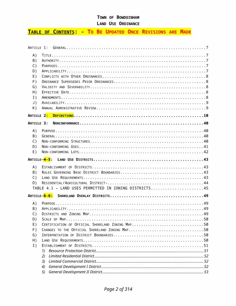
TABLE OF CONTENTS : - TO BE UPDATED ONCE REVISIONS ARE MADE
ARTICLE 1: GENERAL.....................................................................................................................................................7
A) TITLE.................................................................................................................................................................7B) AUTHORITY.......................................................................................................................................................7C) PURPOSES..........................................................................................................................................................7D) APPLICABILITY..................................................................................................................................................7E) CONFLICTS WITH OTHER ORDINANCES............................................................................................................8F) ORDINANCE SUPERSEDES PRIOR ORDINANCES................................................................................................8G) VALIDITY AND SEVERABILITY..........................................................................................................................8H) EFFECTIVE DATE...............................................................................................................................................8I) AMENDMENTS...................................................................................................................................................8J) AVAILABILITY...................................................................................................................................................9K) ANNUAL ADMINISTRATIVE REVIEW.................................................................................................................9
ARTICLE 2: DEFINITIONS...........................................................................................................................................10
ARTICLE 3: NONCONFORMANCE...............................................................................................................................40
A) PURPOSE..........................................................................................................................................................40B) GENERAL.........................................................................................................................................................40C) NON-CONFORMING STRUCTURES....................................................................................................................40D) NON-CONFORMING USES................................................................................................................................41E) NON-CONFORMING LOTS................................................................................................................................42
ARTICLE 4 5: LAND USE DISTRICTS..........................................................................................................................43
A) ESTABLISHMENT OF DISTRICTS......................................................................................................................43B) RULES GOVERNING BASE DISTRICT BOUNDARIES.........................................................................................43C) LAND USE REQUIREMENTS.............................................................................................................................43D) RESIDENTIAL/AGRICULTURAL DISTRICT-.......................................................................................................44TABLE 4.1 – LAND USES PERMITTED IN ZONING DISTRICTS...................................................................45
ARTICLE 5 6: SHORELAND OVERLAY DISTRICTS.....................................................................................................49
A) PURPOSE..........................................................................................................................................................49B) APPLICABILITY................................................................................................................................................49C) DISTRICTS AND ZONING MAP.........................................................................................................................49D) SCALE OF MAP................................................................................................................................................50E) CERTIFICATION OF OFFICIAL SHORELAND ZONING MAP...............................................................................50F) CHANGES TO THE OFFICIAL SHORELAND ZONING MAP.................................................................................50G) INTERPRETATION OF DISTRICT BOUNDARIES.................................................................................................50H) LAND USE REQUIREMENTS.............................................................................................................................50I) ESTABLISHMENT OF DISTRICTS......................................................................................................................51
1) Resource Protection District...................................................................................................................512) Limited Residential District....................................................................................................................523) Limited Commercial District...................................................................................................................524) General Development I District..............................................................................................................525) General Development II District.............................................................................................................536) Commercial Fisheries/Maritime Activities District................................................................................537) Stream Protection District......................................................................................................................53
J) TABLE OF USES...............................................................................................................................................55
ARTICLE 6 4: PERFORMANCE STANDARDS...............................................................................................................58
A) ACCESS MANAGEMENT...................................................................................................................................58B) BACK LOTS......................................................................................................................................................59C) EROSION AND SEDIMENTATION CONTROL......................................................................................................59
Page 2 of 201

TOWN OF BOWDOINHAMLAND USE ORDINANCE
D) HOME OCCUPATION........................................................................................................................................60E) LIGHTING........................................................................................................................................................60F) ROAD STANDARDS..........................................................................................................................................61G) SUBSURFACE WASTEWATER DISPOSAL..........................................................................................................61H) SIGNS..............................................................................................................................................................61I) TEMPORARY BUILDINGS.................................................................................................................................61J) TIMBER HARVESTING......................................................................................................................................61K) VERNAL POOLS...............................................................................................................................................62L) WATER QUALITY PROTECTION.......................................................................................................................62M) WIND MILLS...................................................................................................................................................62
ARTICLE 7: SHORELAND ZONING..............................................................................................................................63
A) SHORELAND ZONE APPLICATION & REVIEW PROCEDURES...........................................................................631) Permits Required.....................................................................................................................................632) Fees.........................................................................................................................................................633) Review Process........................................................................................................................................644) Submission Requirements........................................................................................................................66
B) APPROVAL CRITERIA......................................................................................................................................67C) SPECIAL EXCEPTIONS......................................................................................................................................68D) PERFORMANCE STANDARDS...........................................................................................................................69
1) Minimum Lot Standards..........................................................................................................................692) Principal and Accessory Structures........................................................................................................693) Piers, Docks, Wharves, Bridges and Other Structures and Uses Extending Over or Below the Normal
High-Water Line of a Water Body or Within a Wetland.........................................................................714) Campgrounds..........................................................................................................................................725) Individual Private Campsites..................................................................................................................726) Commercial and Industrial Uses.............................................................................................................737) Parking Areas..........................................................................................................................................738) Roads and Driveways..............................................................................................................................749) Stream Crossings.....................................................................................................................................7510) Signs........................................................................................................................................................7611) Storm Water Runoff.................................................................................................................................7712) Septic Waste Disposal.............................................................................................................................7713) Essential Services....................................................................................................................................7714) Mineral Exploration and Extraction.......................................................................................................7715) Agriculture..............................................................................................................................................7816) Timber Harvesting...................................................................................................................................7917) Clearing or Removal of Vegetation for Activities Other Than Timber Harvesting................................8618) Erosion and Sedimentation Control........................................................................................................8819) Soils.........................................................................................................................................................8920) Water Quality..........................................................................................................................................8921) Archaeological Site.................................................................................................................................8922) Marinas...................................................................................................................................................89
E) NONCONFORMANCE........................................................................................................................................901) Purpose....................................................................................................................................................902) General....................................................................................................................................................903) Non-conforming Structures.....................................................................................................................904) Non-conforming Uses..............................................................................................................................935) Non-conforming Lots...............................................................................................................................93
ARTICLE 8: FLOODPLAIN MANAGEMENT.................................................................................................................95
A) PURPOSE..........................................................................................................................................................95B) FLOODPLAIN APPLICATION & REVIEW PROCEDURES.....................................................................................95
1) Permit Required......................................................................................................................................952) Fees.........................................................................................................................................................953) Application Review Procedures..............................................................................................................95
Page 3 of 201

TOWN OF BOWDOINHAMLAND USE ORDINANCE
4) Review of Standards................................................................................................................................975) Application Submission Requirements....................................................................................................97
C) DEVELOPMENT STANDARDS...........................................................................................................................991) Construction Standards...........................................................................................................................992) Water Supply...........................................................................................................................................993) On Site Waste Disposal Systems.............................................................................................................994) Watercourse Carrying Capacity.............................................................................................................995) Residential...............................................................................................................................................996) Non Residential.....................................................................................................................................1007) Manufactured Homes............................................................................................................................1008) Recreational Vehicles............................................................................................................................1019) Accessory Structures.............................................................................................................................10110) Floodways.............................................................................................................................................10211) Enclosed Areas Below the Lowest Floor...............................................................................................10212) Bridges..................................................................................................................................................10313) Containment Walls................................................................................................................................10314) Wharves, Piers and Docks....................................................................................................................104
D) CONDITIONAL USE REVIEW..........................................................................................................................104E) CERTIFICATE OF COMPLIANCE......................................................................................................................105
ARTICLE 9: SUBDIVISION.........................................................................................................................................106
A) PURPOSE........................................................................................................................................................106B) ADMINISTRATIVE PROCEDURES....................................................................................................................106
1) Review & Approval Authority...............................................................................................................1062) Classification of Projects......................................................................................................................1063) Fees.......................................................................................................................................................107
C) APPLICATION REVIEW PROCEDURES............................................................................................................1071) Pre-Application Procedures (Minor & Major Subdivisions)................................................................1072) Preliminary Plan...................................................................................................................................1103) Final Plan..............................................................................................................................................1114) Subdivision Amendment........................................................................................................................112
D) APPLICATION SUBMISSION REQUIREMENTS.................................................................................................1131) Site Inventory & Analysis......................................................................................................................1132) Preliminary Plan...................................................................................................................................1143) Final Plan..............................................................................................................................................1184) Additional Requirements for Major Subdivisions - Final Plan.............................................................1205) Subdivision Amendment........................................................................................................................120
E) FINAL APPROVAL AND FILING......................................................................................................................121F) APPROVAL CRITERIA....................................................................................................................................122G) PERFORMANCE STANDARDS & DESIGN STANDARDS...................................................................................124
1) Vehicular Access...................................................................................................................................1242) Traffic....................................................................................................................................................1312) Visual Impact.........................................................................................................................................1323) Utilities..................................................................................................................................................1324) Water Supply.........................................................................................................................................1335) Sewage Disposal...................................................................................................................................1346) Fire Protection......................................................................................................................................1347) Financial Capacity................................................................................................................................1358) Technical Ability...................................................................................................................................1369) Shoreland..............................................................................................................................................13610) Floodplain.............................................................................................................................................13711) Wetlands & Waterbodies.......................................................................................................................13712) Historic & Archaeological....................................................................................................................13813) Groundwater.........................................................................................................................................13814) Wildlife Habitat.....................................................................................................................................13915) Natural Areas........................................................................................................................................140
Page 4 of 201

TOWN OF BOWDOINHAMLAND USE ORDINANCE
16) Open Space............................................................................................................................................14017) Environmental Impact...........................................................................................................................14118) Solid Waste Management......................................................................................................................14119) Air Quality.............................................................................................................................................14120) Water Quality........................................................................................................................................14121) Stormwater............................................................................................................................................14222) Sedimentation & Erosion Control.........................................................................................................14423) Compliance with Ordinances................................................................................................................14424) Impact of Adjoining Municipality.........................................................................................................14425) Spaghetti-lots.........................................................................................................................................14526) Liquidation Harvesting.........................................................................................................................145
H) GENERAL PROVISIONS..................................................................................................................................145I) WAIVERS.......................................................................................................................................................146J) INSPECTIONS & VIOLATIONS........................................................................................................................147
1) Inspections.............................................................................................................................................1472) Violations..............................................................................................................................................148
ARTICLE 10: SITE PLAN REVIEW............................................................................................................................149
A) PURPOSE........................................................................................................................................................149B) SITE PLAN APPLICATION REVIEW PROCEDURES..........................................................................................149
1) Review & Approval Authority...............................................................................................................1492) Classification of Projects......................................................................................................................1493) Fees.......................................................................................................................................................1504) Review Procedures................................................................................................................................1515) Application Submission Requirements..................................................................................................156
C) APPROVAL CRITERIA....................................................................................................................................160D) GENERAL PERFORMANCE STANDARDS.........................................................................................................162
1) Vehicular Access...................................................................................................................................1632) Internal Vehicular Circulation..............................................................................................................1633) Pedestrian Circulation..........................................................................................................................1644) Municipal Services................................................................................................................................1655) Visual Impact.........................................................................................................................................1656) Lighting.................................................................................................................................................1657) Signage..................................................................................................................................................1668) Buildings................................................................................................................................................1669) Landscaping..........................................................................................................................................16710) Buffering................................................................................................................................................16711) Utilities..................................................................................................................................................16712) Water Supply.........................................................................................................................................16713) Sewage Disposal...................................................................................................................................16814) Fire Protection......................................................................................................................................16815) Capacity of Applicant............................................................................................................................16816) Special Resources..................................................................................................................................16817) Historic & Archaeological....................................................................................................................16918) Groundwater.........................................................................................................................................16919) Wildlife Habitat.....................................................................................................................................16920) Natural Areas........................................................................................................................................16921) Environmental Impact...........................................................................................................................17022) Solid Waste Management......................................................................................................................17023) Hazardous, Special & Radioactive Materials.......................................................................................17024) Air Quality.............................................................................................................................................17025) Water Quality........................................................................................................................................17026) Stormwater............................................................................................................................................17127) Sedimentation & Erosion Control.........................................................................................................17128) Noise......................................................................................................................................................171
E) USE-SPECIFIC PERFORMANCE STANDARDS..................................................................................................171
Page 5 of 201

TOWN OF BOWDOINHAMLAND USE ORDINANCE
1) Asphalt/Concrete Plant/Fabrication.....................................................................................................1722) Automobile Graveyard & Junkyard......................................................................................................1723) Automobile Service Station...................................................................................................................1724) Bank/Financial Institution.....................................................................................................................1725) Bed & Breakfast....................................................................................................................................1726) Boarding House.....................................................................................................................................1737) Campground..........................................................................................................................................1738) Daycare, Center....................................................................................................................................1739) Daycare, Home......................................................................................................................................17410) Distribution Center...............................................................................................................................17411) Dog Kennels..........................................................................................................................................17412) Food Processing....................................................................................................................................17413) Gravel Pit..............................................................................................................................................17414) Home-Based Business...........................................................................................................................17415) Hotel, Motel, & Inn...............................................................................................................................17516) Manufactured Housing Park.................................................................................................................17517) Non-Roadside or Cross-Country Distribution Lines (greater than 34.5kV).........................................17518) Restaurant.............................................................................................................................................17519) Retail.....................................................................................................................................................17620) Self Storage Facility..............................................................................................................................17621) Telecommunication Tower....................................................................................................................17622) Warehouse.............................................................................................................................................17623) Wood Processing Facility.....................................................................................................................176
F) GENERAL PROVISIONS..................................................................................................................................176
ARTICLE 11: ADMINISTRATION, ENFORCEMENT, & PENALTIES...........................................................................179
A) ADMINISTERING AGENCIES...........................................................................................................................179B) PERMITS REQUIRED......................................................................................................................................180C) PERMIT APPLICATION REVIEW PROCEDURE.................................................................................................181D) PERMIT APPLICATION SUBMISSION REQUIREMENTS....................................................................................183E) ENFORCEMENT..............................................................................................................................................184
ARTICLE 12: APPEALS..............................................................................................................................................185
A) APPOINTMENT AND COMPOSITION................................................................................................................185B) CONFLICT OF INTEREST................................................................................................................................186C) POWERS AND DUTIES....................................................................................................................................186D) MEETINGS.....................................................................................................................................................188E) VOTING.........................................................................................................................................................189F) APPLICATION PROCEDURE............................................................................................................................189G) HEARINGS.....................................................................................................................................................189H) DECISIONS.....................................................................................................................................................190I) RECONSIDERATIONS......................................................................................................................................190J) APPEAL TO SUPERIOR COURT.......................................................................................................................190
APPENDIX 1: COMMUNITY ASSOCIATION DOCUMENTS AND CONSERVATION OWNERSHIP AND MANAGEMENT PLAN SUBMISSION REQUIREMENTS..........................................................................................................................191
APPENDIX 2: IRREVOCABLE LETTER OF CREDIT (SAMPLE LETTER)........................................................192
APPENDIX 3: IRREVOCABLE LETTER OF CREDIT (SAMPLE LETTER)........................................................194
Appendix 4: Four-Step Design Process..................................................................................................................195
Page 6 of 201

TOWN OF BOWDOINHAMLAND USE ORDINANCE
ARTICLE 1: GENERAL
A) Title
This Ordinance and the accompanying land use map shall be known and may be cited as the “Land Use Ordinance of the Town of Bowdoinham, Maine.”
B) Authority
1) This Ordinance has been prepared and adopted pursuant to the enabling provisions of Article VIII, Part 2, of the Maine Constitution, the provisions of Title 30-A MRSA Section 3001 (Home Rule), the Comprehensive Planning and Land Use Regulation Act, Title 30-A MRSA, Sections 4312 et.seq., Section 4352, Zoning Ordinances, and the Mandatory Shoreland Zoning Act, Title 38 MRSA Sections 435 et. seq.
2) The Town of Bowdoinham has the legal authority to adopt land use and control measures to reduce future flood losses pursuant to Title 30-A MRSA, Sections 3001-3007, 4352, 4401-4407, and Title 38 MRSA, Section 440.
3) The areas of special flood hazard, Zones A, A1-30, AE, AO, and AH, are identified by the Federal Emergency Management Agency in a report entitled "Flood Insurance Study - Town of Bowdoinham, Maine, Sagadahoc County," dated November 19, 1997 with accompanying "Flood Insurance Rate Map" dated November 19, 1997, which are hereby adopted by reference and declared to be a part of this Ordinance.
C) Purposes
1) The purposes of this Ordinance are:2) To implement the provisions of the Town’s Comprehensive Plan;3) To direct growth to identified growth areas of the Town, and to manage growth in the rural
areas;4) To promote the health, safety and general welfare of the residents of the community;5) To encourage the most appropriate use of land throughout the Town;6) To promote traffic safety;7) To provide safety from fire and other elements;8) To manage and conserve natural resources;9) To protect buildings and lands from flooding and accelerated erosion; and10) To conserve natural beauty and open space.
D) Applicability
The provisions of this Ordinance shall govern all land and water areas of the Town of Bowdoinham and all structures within the Town’s boundaries, including any structure built on, over, or abutting a water body.
Page 7 of 201

TOWN OF BOWDOINHAMLAND USE ORDINANCE
E) Conflicts with Other Ordinances
Whenever a provision of this Ordinance conflicts with or is inconsistent with another provision of this Ordinance or of any other ordinance, regulation or statute, the more restrictive provision shall control.
F) Ordinance Supersedes Prior Ordinances
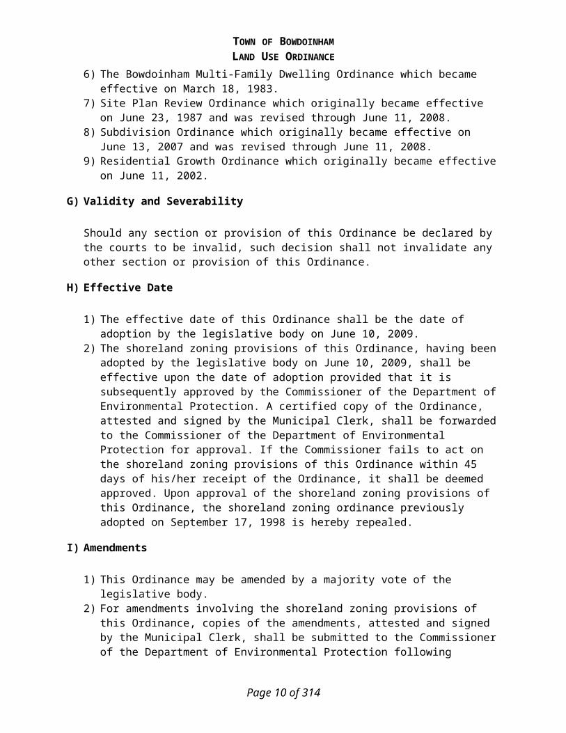
This Ordinance supersedes, repeals, and replaces the following Ordinances:1) Land Use Regulation & Shoreland Zoning Ordinance which originally became effective on
September 15, 1975 and was revised through June 11, 2008.2) Shoreland Zoning Ordinance which originally became effective on September 17, 1998 and
was revised through January 8, 2008.3) Building Permit Ordinance which originally became effective on March 3, 1969 and was
revised through January 8, 2008.4) Floodplain Management Ordinance which enacted on June 24, 1998.5) Ordinance Regulating Mobile Homes and House Trailers which originally became effective
on January 25, 1988 and was revised through April 18, 1988.6) The Bowdoinham Multi-Family Dwelling Ordinance which became effective on March 18,
1983.7) Site Plan Review Ordinance which originally became effective on June 23, 1987 and was
revised through June 11, 2008.8) Subdivision Ordinance which originally became effective on June 13, 2007 and was revised
through June 11, 2008.9) Residential Growth Ordinance which originally became effective on June 11, 2002.
G) Validity and Severability
Should any section or provision of this Ordinance be declared by the courts to be invalid, such decision shall not invalidate any other section or provision of this Ordinance.
H) Effective Date
1) The effective date of this Ordinance shall be the date of adoption by the legislative body on June 10, 2009.
2) The shoreland zoning provisions of this Ordinance, having been adopted by the legislative body on June 10, 2009, shall be effective upon the date of adoption provided that it is subsequently approved by the Commissioner of the Department of Environmental Protection. A certified copy of the Ordinance, attested and signed by the Municipal Clerk, shall be forwarded to the Commissioner of the Department of Environmental Protection for approval. If the Commissioner fails to act on the shoreland zoning provisions of this Ordinance within 45 days of his/her receipt of the Ordinance, it shall be deemed approved. Upon approval of the shoreland zoning provisions of this Ordinance, the shoreland zoning ordinance previously adopted on September 17, 1998 is hereby repealed.
I) Amendments
1) This Ordinance may be amended by a majority vote of the legislative body.
Page 8 of 201

TOWN OF BOWDOINHAMLAND USE ORDINANCE
2) For amendments involving the shoreland zoning provisions of this Ordinance, copies of the amendments, attested and signed by the Municipal Clerk, shall be submitted to the Commissioner of the Department of Environmental Protection following adoption by the municipal legislative body and shall not become effective unless approved by the Commissioner. If the Commissioner fails to act on any amendment within 45 days of his/her receipt of the amendment, it shall be deemed approved. Any application for a permit submitted to the municipality within the 45 day period shall be governed by the terms of the amendment, if such amendment is approved by the Commissioner.
J) Availability
A certified copy of this Ordinance shall be filed with the Municipal Clerk and shall be accessible to any member of the public. Copies shall be made available to the public at reasonable cost at the expense of the person making the request. Notice of this availability shall be posted.
K) Annual Administrative Review
1) The Code Enforcement Officer, Planning Board and Board of Appeals each shall report annually, in the month of January, to the Board of Selectmen on their respective experience with the administration of this Ordinance during the previous year. Their reports to the Board of Selectmen shall include any recommended amendments that would:
2) Enhance their ability to more effectively meet their respective administrative responsibilities under this Ordinance; and
3) Enhance the implementation of the purposes of this Ordinance contained in Article 1, Section 1, above.a) The failure of any person or board to comply with this provision shall not affect the
validity or enforceability of this Ordinance in any way.
Page 9 of 201
TOWN OF BOWDOINHAMLAND USE ORDINANCE
ARTICLE 2: DEFINITIONS
In the interpretation and enforcement of this Ordinance, all words other than those specifically defined in the Ordinance shall have the meaning implied by their context in the Ordinance or their ordinarily accepted meaning. In the case of any difference of meaning or implication between the text of this Ordinance and any map, illustration or table, the text shall control.
The word “person” includes a firm, association, organization, partnership, trust, company or corporation, as well as an individual or other legal entity.The present tense includes the future tense, the singular number includes the plural, and the plural numbers include the singular.The word “lot” includes the words “plot” and “parcel.”The word “structure” includes the word “building.”The word “used” or “occupied” as applied to any land or building, shall be construed to include the words “intended, arranged, or designed to be used or occupied.”The words “Town” or “municipality” means the Town of Bowdoinham, Maine.
Abutter: The owner of any property with one or more common boundaries, or across the street or stream from the property involved in an application or appeal.
Abutting property: Any lot which is physically contiguous with the subject lot or is located directly across a public or private way from the subject lot.
Accessory Building: A detached, subordinate building, the use of which is clearly incidental and related to that of the principal building or use of the land, and which is located on the same lot as that of the principal building or use.
Accessory Use or Structure: A use or structure that is customarily both incidental and subordinate to the principal use or structure on the same lot. The term “incidental” in reference to the principal use or structure shall mean both a) subordinate and minor in significance to the principal use or structure, and b) attendant to the principal use or structure. Such accessory uses, when aggregated, shall not subordinate the principal use of the lot.
Adjacent Grade: Means the natural elevation of the ground surface prior to construction next to the proposed walls of a structure.
Administrative Appeal: An appeal to the Board of Appeals from a determination made by the Code Enforcement Officer, Road Commissioner, Harbormaster or Planning Board in their administration of this Ordinance or any other ordinance or code over which they have jurisdiction.
Affordable housing: A decent, safe and sanitary dwelling, apartment or other living accommodation for a household whose income does not exceed 80% of the median income for the area as defined by the United States Department of Housing and Urban Development under the United States Housing Act of 1937, Public Law 412, 50 Stat. 888, Section 8, as amended.
Aggrieved party: A person whose land is directly or indirectly affected by the granting or denial of a permit or variance under this Ordinance, or a person whose land abuts or is across the road or street
Page 10 of 201

TOWN OF BOWDOINHAMLAND USE ORDINANCE
or body of water from land for which a permit or variance has been granted, or any other person or group of persons who have suffered particularized injury as a result of the granting or denial of such permit or variance.
Agricultural Land Management Practices: Means those devices and procedures utilized in the cultivation of land in order to further crop and livestock production and conservation of related soil and water resources.
Agricultural Uses: The production, keeping or maintenance for sale or lease, of plants, and/or animals, including but not limited to forages and sod crops, dairy animals and dairy products, poultry and poultry products, livestock, and livestock products, fruits and vegetables and ornamental and greenhouse products. Agriculture does not include forest management, timber harvesting activities and food processing operations.
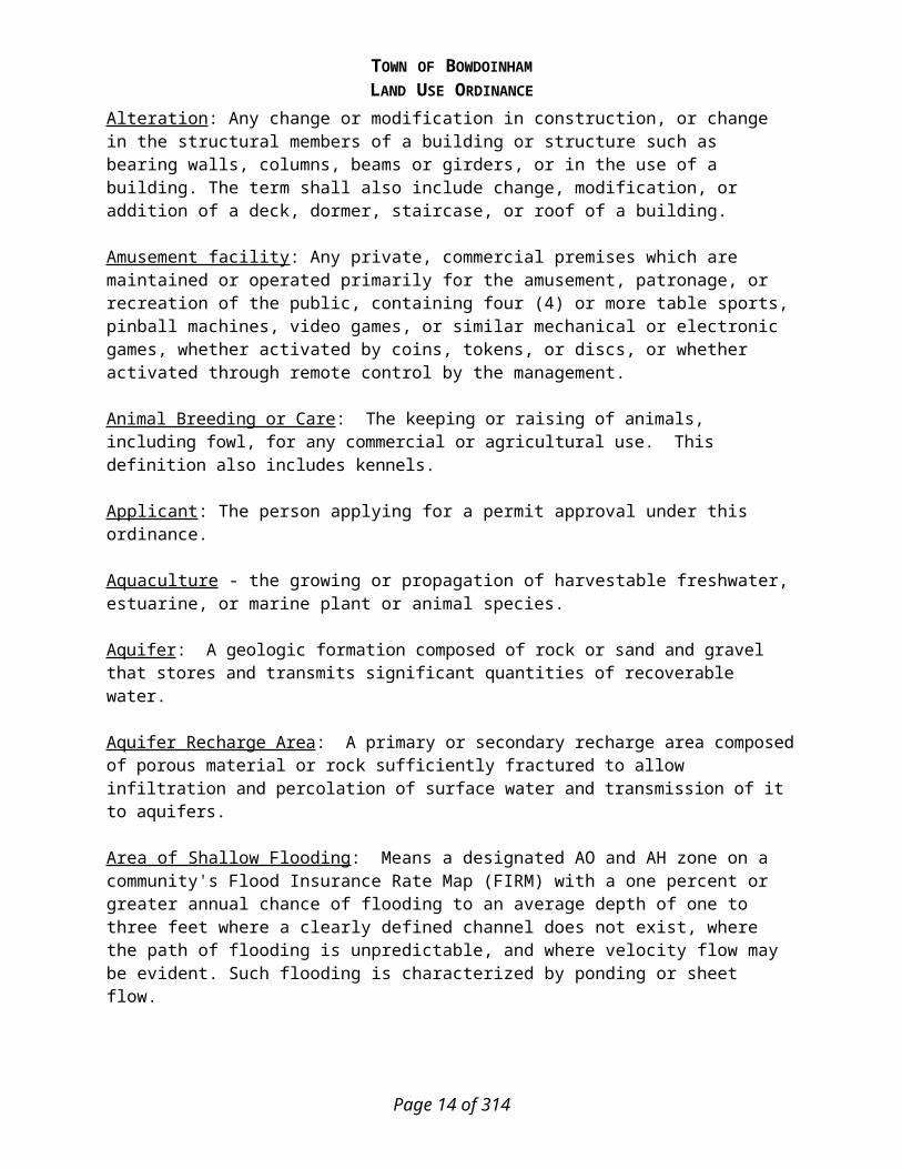
Alteration: Any change or modification in construction, or change in the structural members of a building or structure such as bearing walls, columns, beams or girders, or in the use of a building. The term shall also include change, modification, or addition of a deck, dormer, staircase, or roof of a building.
Amusement facility: Any private, commercial premises which are maintained or operated primarily for the amusement, patronage, or recreation of the public, containing four (4) or more table sports, pinball machines, video games, or similar mechanical or electronic games, whether activated by coins, tokens, or discs, or whether activated through remote control by the management.
Animal Breeding or Care: The keeping or raising of animals, including fowl, for any commercial or agricultural use. This definition also includes kennels.
Applicant: The person applying for a permit approval under this ordinance.
Aquaculture - the growing or propagation of harvestable freshwater, estuarine, or marine plant or animal species.
Aquifer: A geologic formation composed of rock or sand and gravel that stores and transmits significant quantities of recoverable water.
Aquifer Recharge Area: A primary or secondary recharge area composed of porous material or rock sufficiently fractured to allow infiltration and percolation of surface water and transmission of it to aquifers.
Area of Shallow Flooding: Means a designated AO and AH zone on a community's Flood Insurance Rate Map (FIRM) with a one percent or greater annual chance of flooding to an average depth of one to three feet where a clearly defined channel does not exist, where the path of flooding is unpredictable, and where velocity flow may be evident. Such flooding is characterized by ponding or sheet flow.
Area of Special Flood Hazard: Means the land in the floodplain having a one percent or greater chance of flooding in any given year, as specifically identified in the Flood Insurance Study cited in Article 1 of this Ordinance.
Page 11 of 201

TOWN OF BOWDOINHAMLAND USE ORDINANCE
Arterial: A controlled access road or a street or road with traffic signals at important intersections and/or stop signs on side streets or which is functionally classified by the Maine Department of Transportation as an arterial.
Authorized agent: An individual or a firm having written authorization to act on behalf of a property owner. The authorization shall be signed by the property owner(s).
Automobile Graveyard: means a yard, field or other outdoor area used to store 3 or more unregistered or uninspected motor vehicles, as defined in Title 29-A, section 101, subsection 42, or parts of the vehicles. "Automobile graveyard" includes an area used for automobile dismantling, salvage and recycling operations. Automobile graveyard does not include:A) An area used for temporary storage of vehicles or vehicle parts by an establishment or place of
business that is primarily engaged in doing vehicle repair work to make repairs to render a motor vehicle serviceable. In order for a vehicle's storage to be considered temporary, it must be removed from the site within 180 calendar days of its receipt;
B) An area used by an automobile hobbyist to store, organize, restore or display antique autos, antique motorcycles, classic vehicles, horseless carriages, reconstructed vehicles, street rods or parts of these vehicles as these vehicles are defined in Title 29-A, section 101 as long as the hobbyist's activities comply with all applicable federal and state statutes and rules and municipal ordinances, other than ordinances that are more restrictive than this subsection regarding the storage of vehicles or vehicle parts that are collected by a hobbyist. For the purposes of this subparagraph, an automobile hobbyist is a person who is not primarily engaged in the business of selling any of those vehicles or parts from those vehicles;
C) An area used for the parking or storage of vehicles, vehicle parts or equipment intended for use by a municipality, quasi-municipal entity or state or federal agency;
D) An area used for the storage of operational farm tractors and related farm equipment, log skidders, logging tractors or other vehicles exempted from registration under Title 29-A, chapter 5;
E) An area used for the parking or storage of vehicles or equipment being offered for sale by a dealer, equipment dealer, trailer dealer or vehicle auction business as defined in Title 29-A, section 851;
F) An area used for the storage of vehicles by an establishment or place of business that is primarily engaged in business as a new vehicle dealer as defined in Title 29-A, section 851;
G) An area used for temporary storage of vehicles by an establishment or place of business that is primarily engaged in business as an insurance salvage pool. In order for a vehicle's storage to be considered temporary under this subparagraph, the vehicle must be removed from the site within 180 days of receipt of title by the business; or
H) An area used for the parking or storage of operational commercial motor vehicles, special equipment or special mobile equipment as defined in Title 29-A, section 101 that is temporarily out of service but is expected to be used by the vehicle or equipment owner or by an operator designated by the owner. This subsection does not exempt an area used for the parking or storage of equipment or vehicles that are not operational while stored or parked in the area.
Automobile Recycling Business: means the business premises of a dealer or a recyclerlicensed under Title 29-A, sections 851 to 1112 who purchases or acquires salvage vehicles for the purpose of reselling the vehicles or component parts of the vehicles or rebuilding or repairing salvage vehicles for the purpose of resale or for selling the basic materials in the salvage vehicles, as long as 80% of the business premises specified in the site plan in section 3755-A, subsection 1, paragraph C is used for automobile recycling operations. Automobile recycling business does not include:
Page 12 of 201

TOWN OF BOWDOINHAMLAND USE ORDINANCE
1. Financial institutions as defined in Title 9-B, section 131, subsections 17 and 17-A;2. Insurance companies licensed to do business in the State;3. New vehicle dealers, as defined in Title 29-A, section 851, licensed to do business in the State;
or4. That portion of the business premises that is used for temporary storage of vehicles by an
establishment or place of business that is primarily engaged in business as an insurance salvage pool. In order for a vehicle's storage to be considered temporary under this subparagraph, the vehicle must be removed from the site within 180 days of receipt of title by the business.
Airport: Shall be as defined by the Federal Aviation Administration.
Air Strip: Shall be for the private use of the property owner in flying an aircraft. No money shall be charged or made from the use of the air strip.
Automobile Repair Garage: A business establishment engaged in general repair, engine rebuilding, parts replacement, rebuilding or reconditioning of motor vehicles, body, frame or fender straightening and repair, painting and undercoating, but where no engine fuels are sold at retail. An Auto Repair Service Garage shall not be considered a home-based business for the purpose of this ordinance.
Automobile Service Station: A business establishment engaged in the sale of engine fuel, kerosene, motor oil and lubricants directly to the public.
Average Daily Traffic (ADT): The average number of vehicles per day that enter or exit the premises or travel over a specific section of road.
Back lot: A lot does not have frontage on a private or pubic road, except to meet the Performance Standard in Article 64.B.
Basal Area - the area of cross-section of a tree stem at 4 1/2 feet above ground level and inclusive of bark.
Base Flood: Means the flood having a one percent chance of being equaled or exceeded in any given year, commonly called the 100-year flood.
Basement - any portion of a structure with a floor-to-ceiling height of 6 feet or more and having more than 50% of its volume below the existing ground level.
Bed and breakfast: Any residential dwelling in which the resident or residents of the dwelling provide overnight lodging to the public for compensation for less than two weeks. There shall be no provisions for cooking in any individual guest room.
Boarding, lodging facility: Any residential dwelling in which the resident or residents of the dwelling provide overnight lodging to the public for compensation for more than two weeks. There shall be no provisions for cooking in any individual guest room.
Boat Launching Facility - a facility designed primarily for the launching and landing of watercraft, and which may include an access ramp, docking area, and parking spaces for vehicles and trailers.
Page 13 of 201
TOWN OF BOWDOINHAMLAND USE ORDINANCE
Buffer: A part of a property or an entire property, which is not built upon and is specifically designed to separate and thus minimize the effects of a land use activity (e.g. noise, dust, visibility, glare, etc) on adjacent properties or on sensitive natural resources. This area may be occupied by a fence, wall, and/or landscaping for screening purposes.
Building: Any three-dimensional enclosure, which is used for the housing, shelter or enclosure of persons, animals or property.
Bureau – State of Maine Department of Conservation’s Bureau of Forestry
Business and Professional Offices: The place of business of individuals or groups providing professional services, including but not limited to, doctors, lawyers, accountants, financial advisors, architects, surveyors, real estate and insurance businesses, psychologists, counselors, or a place in which a business conducts its administrative, financial or clerical operations or provides services, including banks, credit unions and other financial services excluding free standing automated machines (ATMS).
Campground: Any area of tract of land which is used for temporary overnight accommodation with or without shelter, such as a tent or recreational vehicle, by two or more parties, for which a fee is charged. The word “campground” shall include the words “camping ground” and “tenting grounds.”
Canopy – the more or less continuous cover formed by tree crowns in a wooded area.
Cemetery: Property used for the interring of the dead.
Certificate of Compliance: A document signed by the Code Enforcement Officer stating that a structure is in compliance with all of the provisions of this Ordinance.
Change of Use: A change in the type of occupancy/use of a building, structure, or a portion thereof, and/or the land, such that the basic type of use is changed, such as from retail to office or storage to a restaurant, but not including a change in the occupants.
Church: A building or structure, or group of buildings or structures, designed, primarily intended and used for the conduct of religious services, excluding school.
Civic, convention center: A building or complex of buildings that house municipal offices and services, and which may include cultural, recreational, athletic, convention and entertainment facilities owned and/or operated by a government agency.
Club: Any voluntary association of persons organized for social, religious, benevolent, literary, scientific, or political purposes, whose facilities, especially a clubhouse, are open to members and guests only and not the general public, and not engaged in activities customarily carried on by a business or for pecuniary gain. Such term shall include fraternities, sororities, and social clubs generally.
Cluster development: A form of development that allows a subdivision design in which individual lot sizes and setbacks are reduced in exchange for the creation of common open space and recreation areas, the preservation of environmentally sensitive areas, agriculture and silviculture and the reduction in the size of road and utility systems.
Page 14 of 201

TOWN OF BOWDOINHAMLAND USE ORDINANCE
Coastal wetland - All tidal and subtidal lands; all lands with vegetation present that is tolerant of salt water and occurs primarily in a salt water or estuarine habitat; and any swamp, marsh, bog, beach, flat or other contiguous low land that is subject to tidal action during the highest tide level for the year in which an activity is proposed as identified in tide tables published by the National Ocean Service. Coastal wetlands may include portions of coastal sand dunes. The portion of a river that is subject to tidal action is a coastal wetland.
Code Enforcement Officer: A person appointed by the Board of Selectmen to administer and enforce this Ordinance. Reference to the Code Enforcement Officer may be construed to include Building Inspector, Plumbing Inspector, Health Officer and the like where applicable.
Collector Street: A street that collects traffic from local streets and connects with arterials or a street or road functionally classified as a collector by the Maine Department of Transportation.
Commercial recreation: Any commercial enterprise that receives a fee in return for the provision of some recreational activity including but not limited to: campgrounds, racquet and tennis clubs, health facility, amusement parks, golf courses, gymnasiums and swimming pools, etc., but not including amusement facility, as defined herein.
Commercial Use: Of, relating to, concerning or arising from the use of lands, buildings or structures, other than as a home occupation (as defined below), the intent or result of which activity is the production of income from the buying and selling of goods and/or services.
Common Open Space: Land within or related to a subdivision, that is not part of the individual lots, which is designed and intended for: (a) formal uses such as walkways, parks and greens;
(b) recreational uses such as playgrounds, fields and courts for the common use and enjoyment of the residents of the subdivision, or if so designated by the applicant in the subdivision plan, for use by the general public; and
(c) natural uses such as wildlife habitat preservation, wood lots, buffer zones, and preservation of scenic features and natural views.
Common open space may include complementary structures and improvements, typically used for maintenance and operation of the open space, such as for outdoor recreation or agricultural use.
Community center: A building that provides a meeting place for local, non-profit community organizations on a regular basis. The center shall not be engaged in activities customarily carried on by a business.
Community living arrangement: A housing facility for 8 or fewer persons with disabilities that is approved, authorized, certified or licensed by the State. A community living arrangement may include a group home, foster home or intermediate care facility.
Complete Application: An application shall be considered complete upon submission of the required fee and all information required by this ordinance as determined by: the Code Enforcement Officer, a vote of the Planning Board, or by a vote of the Planning Board to waive the submission of required information.
Page 15 of 201

TOWN OF BOWDOINHAMLAND USE ORDINANCE
Complete Substantial Construction: The completion of a portion of the improvements, which represents no less than thirty percent of the costs of the proposed improvements within a subdivision. If the subdivision is to consist of individual lots to be sold or leased by the subdivider, the cost of construction of buildings on those lots shall not be included. If the subdivision is a multifamily development, or if the applicant proposes to construct the buildings within the subdivision, the cost of building construction shall be included in the costs of proposed improvements.
Comprehensive Plan: The Comprehensive Plan of the Town of Bowdoinham.
Conditional Use: A conditional use of land or building is a use that generally would be appropriate in the zoning district for which it is proposed after review and with certain restrictions and controls to meet the intentions and purposes of this Ordinance. Conditional uses are permitted only after review and approval by the Planning Board.
Condominium: Real estate, portions of which are designated for separate ownership and the remainder of which are designed for common ownership solely by the owners of those portions under a declaration, or an amendment to a declaration, duly recorded pursuant to Maine law. Real estate is not a condominium unless the undivided interests in the common elements are vested in the unit owners. Any real estate development consisting exclusively of clustered, detached, single family residences is not a condominium, unless so designated in the declaration.
Conforming: A building, structure, use of land or portion thereof, that complies with the provisions of this Ordinance.
Conservation Easement: A non-possessory interest in real property imposing limitations or affirmative obligations, the purpose of which include retaining or protecting natural, scenic or open space values of real property; assuring its availability for agricultural, forest, recreational or open space use; protecting natural resources or maintaining air or water quality.
Construction: Includes building, erecting, altering, reconstructing, moving upon or any physical operations on the premises which are required for construction. Excavation, fill, paving, drainage, and the like, shall be considered as part of construction.
Construction Operations: The use of a tract of land for the storage of construction equipment and materials used in residential, institutional, industrial and commercial construction. This use does not include the manufacturing or processing of concrete and/or asphalt, or the extraction or processing of earth materials, unless previously grandfathered.
Convenience Store: A store of less than two thousand (2,000) square feet of floor space intended to serve the convenience of a residential neighborhood with items such as, but not limited to, basic foods, newspapers, emergency home repair articles, and other household items. A convenience store may include the sale of motor fuels.
Corner Lot: A lot located at the intersection of two streets, roads or public rights-of-way.
Critical rural area: A rural area that is specifically identified and designated by a municipality’s or multi-municipal region’s comprehensive plan as deserving maximum protection from development to preserve natural resources and related economic activities that may include, but are not limited to,
Page 16 of 201

TOWN OF BOWDOINHAMLAND USE ORDINANCE
significant farmland, forest land or mineral resources; high value wildlife or fisheries habitat; scenic areas; public water supplies; scarce or especially vulnerable natural resources; and open lands functionally necessary to support a vibrant rural economy.
Cross-sectional area – the cross-sectional area of a stream or tributary stream channel is determined by multiplying the stream or tributary stream channel width by the average stream or tributary stream channel depth. The stream or tributary stream channel width is the straight line distance from the normal high-water line on one side of the channel to the normal high-water line on the opposite side of the channel. The average stream or tributary stream channel depth is the average of the vertical distances from a straight line between the normal high-water lines of the stream or tributary stream channel to the bottom of the channel.
Curb Cut: The opening along the curb line or street right-of-way line at which point vehicles may enter or leave the street.
Day Care, Home: Anyone who provides, on a regular basis and for consideration, care, and protection which is required to be licensed by the State, for three to twelve unrelated persons for any part of a day, out of their primary residence. Any facility, the chief purpose of which is to provide education, shall not be considered to be day care home. In addition to any other review required under this ordinance, a day care home shall be considered a home-based business and shall be allowed under the conditions and regulations applicable to home-based businesses.
Day Care, Center: A house or other place conducted or maintained by anyone who provides, on a regular basis and for consideration, care and protection for 13 or more children under 16 years of age, except children related to the operator by blood, marriage or adoption, who are unattended by parents or guardians, for any part of a day, except that any facility the chief purpose of which is to provide education, shall not be considered to be a day care center.
DBH – the diameter of a standing tree measured 4.5 feet from ground level.
Deck: A level structure adjacent to a building elevated above the surface of the ground which may have a railing, but no roof.
Density: The number of dwelling units per acre of land.
Developed Area: Any area on which a site improvement or change is made, including buildings, landscaping, parking areas, and streets.
Development: Means any man made change to improved or unimproved real estate, including but not limited to buildings or other structures, mining, dredging, filling, grading, paving, excavation, drilling operations or storage of equipment or materials.
Dimensional requirements - numerical standards relating to spatial relationships including but not limited to setback, lot area, shore frontage and height.
Disability - any disability, infirmity, malformation, disfigurement, congenital defect or mental condition caused by bodily injury, accident, disease, birth defect, environmental conditions or illness; and also includes the physical or mental condition of a person which constitutes a substantial
Page 17 of 201

TOWN OF BOWDOINHAMLAND USE ORDINANCE
handicap as determined by a physician or in the case of mental handicap, by a psychiatrist or psychologist, as well as any other health or sensory impairment which requires special education, vocational rehabilitation or related services.
Disruption of shoreline integrity - the alteration of the physical shape, properties, or condition of a shoreline at any location by timber harvesting and related activities. A shoreline where shoreline integrity has been disrupted is recognized by compacted, scarified and/or rutted soil, an abnormal channel or shoreline cross-section, and in the case of flowing waters, a profile and character altered from natural conditions.
District: A specified portion of the municipality, delineated on the land use map, within which certain regulations and requirements or various combinations thereof apply under the provisions of this Ordinance.
Dog Kennel: Any place, building, tract of land or structure where more than three privately owned dogs or other pets, are kept at any one time for their owners in return for a fee.
Driveway: A vehicular access way serving not more than two (2) dwelling units.
Dwelling: Any building or structure or portion thereof designed or used for residentialpurposes.
1. Dwelling unit – a room or suite of rooms used by a family as a habitation that is separate from other such rooms or suites of rooms, and which contains independent living, cooking, sleeping, bathing and sanitary facilities.
2. Single-family dwelling – any structure containing only one (1) dwelling unit for occupation by not more than one (1) family.
3. Two-family dwelling – A building containing only two (2) dwelling units, for occupation by not more than two (2) families.
4. Multi-family dwelling – A building containing three (3) or more dwelling units, such buildings designed exclusively for residential use and occupancy by three (3) or more families living independently of one another, with the number of families not exceeding the number of dwelling units.
Elevated Building: Means a non-basement building a. built, in the case of a building in Zones A1-30, AE, A, AO, or AH, to have the top of the elevated floor elevated above the ground level by means of pilings, columns, post, piers, or "stilts;" and adequately anchored so as not to impair the structural integrity of the building during a flood of up to one foot above the magnitude of the base flood. In the case of Zones A1-30, AE, A, AO, or AH, Elevated Building also includes a building elevated by means of fill or solid foundation perimeter walls with hydraulic openings sufficient to facilitate the unimpeded movement of flood waters, as required in Article 8.C.
Elevation Certificate: An official form (FEMA Form 81-31, 01/03, as amended) that: is used to verify compliance with the floodplain management regulations of the National Flood Insurance Program; and, is required for purchasing flood insurance.
Emergency operations - operations conducted for the public health, safety or general welfare, such as protection of resources from immediate destruction or loss, law enforcement, and operations to rescue human beings, property and livestock from the threat of destruction or injury.
Page 18 of 201

TOWN OF BOWDOINHAMLAND USE ORDINANCE
Engineered Subsurface Wastewater Disposal System: A subsurface wastewater disposal system designed, installed, and operated as a single unit to treat 2,000 gallons per day or more; or any system designed to treat wastewater with characteristics significantly different from domestic wastewater.
Enlargement or expansion of a structure: An increase of the building footprint, floor area and/or increase in the height of the structure beyond its present highest point. Alterations of existing buildings which are required in order to meet the requirements of the Americans with Disabilities Act (ADA) and/or the State Fire Code are not considered to be enlargements or expansions of a structure and are not required to meet otherwise applicable setback requirements, provided the alterations are the minimum necessary to satisfy the ADA and/or State Fire Code.
Enlargement or expansion of use: Any intensification of use in time, volume, or function, whether or not resulting from an increase in the footprint, height, floor area, land area or cubic volume occupied by a particular use. Increases which are required in order to meet the requirements of the Americans with Disabilities Act and/or the State Fire Code are not considered to be enlargements or expansions of use.
Essential services - gas, electrical or communication facilities; steam, fuel, electric power or water transmission or distribution lines, towers and related equipment; telephone cables or lines, poles and related equipment; gas, oil, water, slurry or other similar pipelines; municipal sewage lines, collection or supply systems; and associated storage tanks. Such systems may include towers, poles, wires, mains, drains, pipes, conduits, cables, fire alarms and police call boxes, traffic signals, hydrants and similar accessories, but shall not include buildings which are necessary for the furnishing of such services.
Extractive industries: The excavation, processing or storage of soil, topsoil, peat, loam, sand, gravel, rock or other mineral deposits, not including:A) The excavation of material incidental to and at the site of approved construction of buildings,
driveways or parking areas;B) The excavation of material incidental to and at the site of construction or repair of streets; andC) The excavation, processing or storage of less than ten (10) cubic yards of material on a lot wihin
a one-year period.
Family: One or more persons occupying a dwelling and living as a single housekeeping unit, as distinguished from a group occupying a tourist home, rooming house, hotel, motel or inn.
Farming: The cultivation of the soil for food products or other useful or valuable growth of the field or garden, nursery stock and non-commercial greenhouses.
Filling: Depositing or dumping any matter on or into the ground or water.
Final Plan: The final drawings on which the applicant’s plan of subdivision is presented to the Board for approval and which, if approved, shall be recorded at the Registry of Deeds.
Fisheries, Significant Fisheries: Areas identified by a governmental agency such as the Maine Department of Inland Fisheries and Wildlife, Atlantic Salmon Authority, or Maine Department of Marine Resources as having significant value as fisheries and any areas so identified in the municipality’s comprehensive plan.
Page 19 of 201

TOWN OF BOWDOINHAMLAND USE ORDINANCE
Flood or Flooding: A general and temporary condition of partial or complete inundation of normally dry land areas from:
a. The overflow of inland or tidal waters.b. The unusual and rapid accumulation or runoff of surface waters from any source.c. The collapse or subsidence of land along the shore of a lake or other body of water as a
result of erosion or undermining caused by waves or currents of water exceeding anticipated cyclical levels or suddenly caused by an unusually high water level in a natural body of water, accompanied by a severe storm, or by an unanticipated force of nature, such as flash flood or an abnormal tidal surge, or by some similarly unusual and unforeseeable event which results in flooding as defined in paragraph a.1. of this definition.
Flood Elevation Study: Means an examination, evaluation and determination of flood hazards and, if appropriate, corresponding water surface elevations.
Flood Insurance Rate Map (FIRM): Means an official map of a community, on which the Federal Insurance Administrator has delineated both the special hazard areas and the risk premium zones applicable to the community.
Flood Insurance Study: See Flood Elevation Study.
Floodplain or Flood-prone Area: Means any land area susceptible to being inundated by water from any source (see flooding).
Floodplain Management: Means the operation of an overall program of corrective and preventive measures for reducing flood damage, including but not limited to emergency preparedness plans, flood control works, and floodplain management regulations.
Floodplain Management Regulations: Means zoning ordinances, subdivision regulations, building codes, health regulations, special purpose ordinances (such as a floodplain ordinance, grading ordinance, and erosion control ordinance) and other applications of police power. The term describes such state or local regulations, in any combination thereof, which provide standards for the purpose of flood damage prevention and reduction.
Floodproofing: Means any combination of structural and non-structural additions, changes, or adjustments to structures which reduce or eliminate flood damage to real estate or improved real property, water and sanitary facilities, structures and contents.
Floodway: See Regulatory Floodway.
Floodway Encroachment Lines: Mean the lines marking the limits of floodways on federal, state, and local floodplain maps.
Floor Area: The sum of the horizontal areas of the floor(s) of a structure enclosed by exterior walls.
Food Processing Facility: Means an establishment in which food is processed or otherwise prepared and packaged for human consumption.
Page 20 of 201

TOWN OF BOWDOINHAMLAND USE ORDINANCE
Footprint: Exterior outline of the buildings. All dimensions shall be measured between exterior faces of walls, plus the horizontal area of any unenclosed portions of a structure such as porches and decks.
Forest management activities - timber cruising and other forest resource evaluation activities, pesticide or fertilizer application, management planning activities, timber stand improvement, pruning, regeneration of forest stands, and other similar or associated activities, exclusive of timber harvesting and the construction, creation or maintenance of roads.
Forest Stand - a contiguous group of trees sufficiently uniform in age class distribution, composition, and structure, and growing on a site of sufficiently uniform quality, to be a distinguishable unit.
Forested wetland - a freshwater wetland dominated by woody vegetation that is six (6) meters tall (approximately twenty (20) feet) or taller.
Forestry: The operation of timber tracks, tree farms, forest nurseries, the gathering of forest products, or the performance of forest services.
Foundation - the supporting substructure of a building or other structure, excluding wooden sills and post supports, but including basements, slabs, frostwalls, or other base consisting of concrete, block, brick or similar material.
Franchise Restaurant: A restaurant that is required by contractual or other arrangement to offer any of the following: standardized menu, employee uniforms, interior and/or exterior color scheme(s), architectural design, signage or similar standardized features, or which adopts a name or food presentation format which causes it to be substantially identical to another restaurant regardless of ownership or location.
Freeboard: Means a factor of safety usually expressed in feet above a flood level for purposes of floodplain management. Freeboard tends to compensate for the many unknown factors, such as wave action, bridge openings, and the hydrological effect of urbanization of the watershed, that could contribute to flood heights greater than the height calculated for a selected size flood and floodway conditions.
Freshwater wetland - freshwater swamps, marshes, bogs and similar areas, other than forested wetlands, which are:
a. Of ten or more contiguous acres; or of less than 10 contiguous acres and adjacent to a surface water body, excluding any river, stream or brook, such that in a natural state, the combined surface area is in excess of 10 acres; and
b. Inundated or saturated by surface or ground water at a frequency and for a duration sufficient to support, and which under normal circumstances do support, a prevalence of wetland vegetation typically adapted for life in saturated soils.
Freshwater wetlands may contain small stream channels or inclusions of land that do not conform to the criteria of this definition.
Frontage, road: The linear distance of the front lot line along the street measured between the side lot lines.
Page 21 of 201

TOWN OF BOWDOINHAMLAND USE ORDINANCE
Frontage, shore: The horizontal distance, measured in a straight line, between the intersections of the lot lines with the shoreline.
Functionally water-dependent uses - those uses that require, for their primary purpose, location on submerged lands or that require direct access to, or location in, coastal or inland waters and that can not be located away from these waters. The uses include, but are not limited to commercial and recreational fishing and boating facilities, excluding recreational boat storage buildings, finfish and shellfish processing, fish storage and retail and wholesale fish marketing facilities, waterfront dock and port facilities, shipyards and boat building facilities, marinas, navigation aids, basins and channels, retaining walls, industrial uses dependent upon water-borne transportation or requiring large volumes of cooling or processing water that can not reasonably be located or operated at an inland site, and uses that primarily provide general public access to coastal or inland waters.
Functionally Dependent Use: Means a use which cannot perform its intended purpose unless it is located or carried out in close proximity to water. The term includes only docking facilities, port facilities that are necessary for the loading and unloading of cargo or passengers, and ship building and ship repair facilities, but does not include long-term storage or related manufacturing facilities.
Garage: An accessory building, or part of a principal building, including a car port, used primarily for the storage of motor vehicles as an accessory use.
Gravel Pit: Any commercial operation which removes sand, gravel, clay, rock, or other like material from its natural location and to transport the product removed, away from the extraction site.
Grocery Store: A business establishment engaged in the sale of groceries.
Ground cover – small plants, fallen leaves, needles and twigs, and the partially decayed organic matter of the forest floor.
Groundwater: All of the water found beneath the surface of the ground. For purposes of aquifer protection, this term refers to the subsurface water present in aquifers and recharge areas.
Growth area: An area that is designated in a municipality’s or multi-municipal region’s comprehensive plan as suitable for orderly residential, commercial or industrial development, or any combination of those types of development, and into which most development projected over 10 years is directed.
Hardship: See undue hardship.
Harvest Area - the area where timber harvesting and related activities, including the cutting of trees, skidding, yarding, and associated road construction take place. The area affected by a harvest encompasses the area within the outer boundaries of these activities, excepting unharvested areas greater than 10 acres within the area affected by a harvest.
Hazardous Material, Matter & Waste: Any gaseous, liquid or solid materials, either in pure form or incorporated into other materials, designated as hazardous by the Maine Department of Environmental Protection.
Page 22 of 201

TOWN OF BOWDOINHAMLAND USE ORDINANCE
Height of Building: Vertical distance measured from the average elevation of the predevelopment grade to the highest point of the roof.
Height of Structure - the vertical distance between the mean original (prior to construction) grade at the downhill side of the structure and the highest point of the structure.
High Intensity Soil Survey: A map prepared by a Certified Soil Scientist, identifying the soil types down to 1/8 acre or less at a scale equivalent to the subdivision plan submitted. The map shall show the location of all test pits used to identify the soils, and shall be accompanied by a log of each sample point identifying the textural classification and the depth to a limiting factor such as seasonal high water table or bedrock at that location. Single soil test pits and their evaluation for suitability for subsurface waste water disposal systems shall not be considered to constitute high intensity soil surveys.
Historic or Archaeological Resources: Areas identified by a governmental agency such as the Maine Historic Preservation Commission as having significant value as an historic or archaeological resource and any areas identified in the municipality’s comprehensive plan.
Historic Structure: Means any structure that is:a. Listed individually in the National Register of Historic Places (a listing maintained by the
Department of Interior) or preliminarily determined by the Secretary of the Interior as meeting the requirements for individual listing on the National Register;
b. Certified or preliminarily determined by the Secretary of the Interior as contributing to the historical significance of a registered historic district or a district preliminarily determined by the Secretary of the Interior to qualify as a registered historic district;
c. Individually listed on a state inventory of historic places in states with the Maine Historic Preservation Commission; or
d. Individually identified by the Town’s Comprehensive Plan
Home-Based Business: A business performed or conducted within a dwelling or accessory structure by the residents thereof, which:
a. Is accessory to a residential use, and; b. Is clearly incidental and secondary to the residential use of the dwelling unit, and; c. Does not change the character of the dwelling.
Home-based business may include, but are not necessarily limited to, arts and crafts work, dressmaking, tutoring, music teaching, and the use of a portion of a dwelling as a bed and breakfast inn, a day care home, professional offices such as those of a physician, dentist, lawyer, engineer, architect, hairdresser, barber, real estate broker, insurance agent, or accountant, or similar uses.
Home Occupation: An occupation performed or conducted within one’s dwelling or accessory structure at their residence and meets the Performance Standard in Article 46, Section D.
Hospital: An institution providing, but not limited to, overnight health services, primarily for in-patients, and medical or surgical care for the sick or injured, including as an integral part of the institution such related facilities as laboratories, out-patient departments, training facilities, central service facilities, and staff offices.
Page 23 of 201
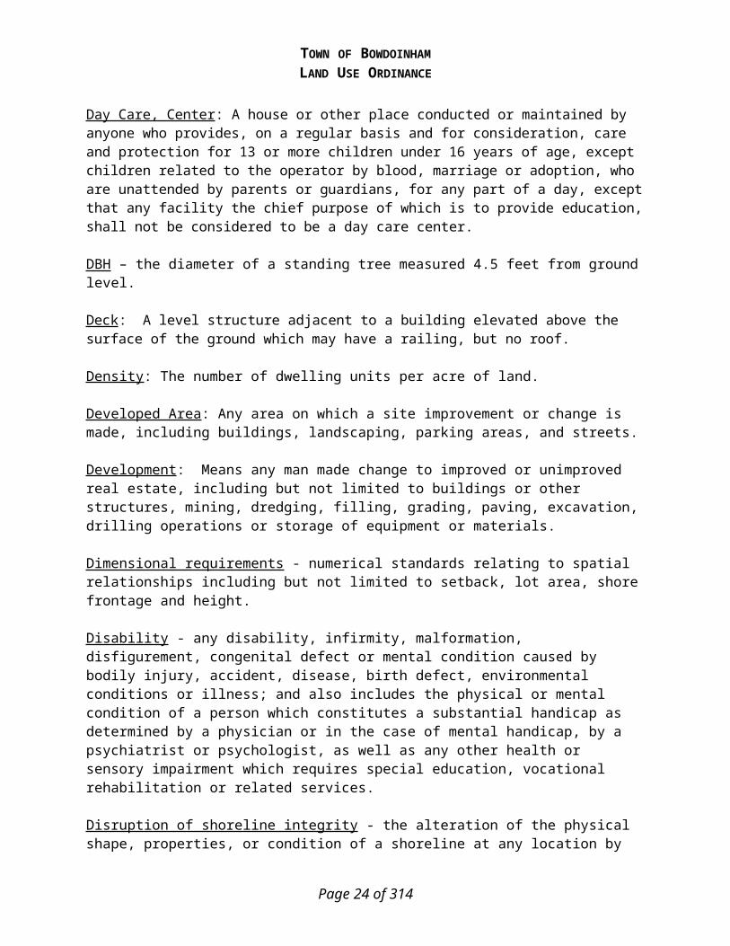
TOWN OF BOWDOINHAMLAND USE ORDINANCE
Hotel/motel: A commercial building or group of buildings built to accommodate for a fee travelers and other transient guests who are staying for a limited duration, with sleeping rooms without cooking facilities, each rental unit having its own private bathroom and its own separate entrance leading either to the outdoors or to a common corridor or hallway. A hotel may include restaurant facilities where food is prepared and meals served to its guests and other customers.
Hundred-Year Flood: See Base Flood.
Impervious Surface: Structures and other man-made improvements to land and materials covering the land which substantially reduce the infiltration of water. Impervious surfaces shall include, but are not limited to, roofs, paved areas, parking lots, and driveways, regardless of surface materials.
Impervious Area: The total area of a parcel that consists of buildings and associated constructed facilities or areas that will be covered with a low-permeability material, such as asphalt or concrete, and areas such as gravel roads and unpaved parking areas that will be compacted through design or use to reduce their permeability. Common impervious areas include, but are not limited to, rooftops, walkways, patios, driveways, parking lots or storage areas, concrete or asphalt paving, gravel roads, packed earthen materials, and macadam or other surfaces which similarly impede the natural infiltration of stormwater.
Increase in nonconformity of a structure - any change in a structure or property which causes further deviation from the dimensional standard(s) creating the nonconformity such as, but not limited to, reduction in water body, stream or coastal or freshwater wetland setback distance, increase in lot coverage, or increase in height of a structure. Property changes or structure expansions which either meet the dimensional standard or which cause no further increase in the linear extent of nonconformance of the existing structure shall not be considered to increase nonconformity. For example, there is no increase in nonconformity with the setback requirement for water bodies, wetlands, or streams if the expansion extends no further into the required setback area than does any portion of the existing nonconforming structure. Hence, a structure may be expanded laterally provided that the expansion extends no closer to the water body, tributary stream, or wetland than the closest portion of the existing structure from that water body, tributary stream, or wetland. Included in this allowance are expansions which in-fill irregularly shaped structures.
Individual private campsite - an area of land which is not associated with a campground, but which is developed for repeated camping by only one group not to exceed ten (10) individuals and which involves site improvements which may include but not be limited to a gravel pad, parking area, fire place, or tent platform.
Industrial - The assembling, fabrication, finishing, manufacturing, packaging or processing of goods, or the extraction of minerals.
Industrial use: Of, relating to, concerning, or arising from the assembling, fabrication, finishing, manufacturing, packaging or processing of non agricultural goods, the extraction of minerals..Industry: An establishment engaged in the mechanical or chemical transformation of materials or substances into new products which may include the assembly of component parts, the manufacture of products, and/or the blending of materials such as lubricating oils, plastics or resins.
Page 24 of 201

TOWN OF BOWDOINHAMLAND USE ORDINANCE
Institutional use: Of, relating to, concerning or arising from the use of lands, buildings, or structures for a non-profit, public or quasi-public use, or institution such as a church, library, public or private school, hospital, or municipally owned or operated building, structure or land used for public, charitable, educational, religious, governmental, medical or similar purposes.
Junkyard: means a yard, field or other outside area used to store, dismantle or otherwise handle:
A) Discarded, worn-out or junked plumbing, heating supplies, household appliances and furniture;B) Discarded, scrap and junked lumber;C) Old or scrap copper, brass, rope, rags, batteries, paper, trash, rubber debris, waste and all scrap iron,
steel and other scrap ferrous or non-ferrous material; andD) Garbage dumps, waste dumps, and sanitary fills.
Kennel: An establishment in which more than four (4) dogs or four (4) cats are sold, housed, bred, boarded, or trained for a fee.
Land Management Road - a route or track consisting of a bed of exposed mineral soil, gravel, or other surfacing materials constructed for, or created by, the passage of motorized vehicles and used primarily for timber harvesting and related activities, including associated log yards, but not including skid trails or skid roads.
Land use ordinance: An ordinance or regulation of general application adopted by the municipal legislative body which controls, directs or delineates allowable uses of land and the standards for those uses.
Landscape Buffer: An area within a property or site, generally adjacent to and parallel with a property line, either consisting of natural existing vegetation or created by the use of trees and shrubs, designed to limit continuously the view of and/or sound from the site to adjacent sites or properties.
Level of Service: A description of the operating conditions a driver will experience while traveling on a particular street or highway calculated in accordance with the provisions of the Highway Capacity Manual, 1991 edition or most current edition, published by the National Academy of Sciences, Transportation Research Board. There are six levels of service ranging from Level of Service A, with free traffic flow and no delays to Level of Service F, with forced flow and congestion resulting in complete failure of the roadway.
Licensed Forester - a forester licensed under 32 M.R.S.A. Chapter 76.
Light Manufacturing: An establishment which is engaged in the mechanical transformation of materials into new products, including the assembling of component parts.
Local Street: A public street or road which is not identified as an arterial or collector. A local street includes a proposed street shown on an approved and recorded subdivision.
Locally Established Datum: Means, for purposes of this ordinance, an elevation established for a specific site to which all other elevations at the site are referenced. This elevation is generally not referenced to the National Geodetic Vertical Datum (NGVD) or any other established datum and is used in areas where Mean Sea Level data is too far from a specific site to be practically used.
Page 25 of 201

TOWN OF BOWDOINHAMLAND USE ORDINANCE
Lot: A tract or parcel of land, in the same ownership, provided that parcels located on opposite sides of a public or private road shall be considered each a separate tract or parcel unless such road was established by the owner of the parcels on both sides thereof.
Lot Area - The area of land enclosed within the boundary lines of a lot, minus land below the normal high-water line of a water body or upland edge of a wetland and areas beneath roads serving more than two lots.
Lot, corner: A lot with at least two contiguous sides abutting upon a street or right-of-way.
Lot coverage: The percentage of a lot covered by all impervious area.
Lot lines: The lines bounding a lot as defined below:i. Front lot line:
a. interior lots - the line separating the lot from a street right-of-way; b. corner lots - the line separating the lot from a public right-of-way; c. back lots – the line that is parallel (closest to being parallel) to the street right-of-way.
ii. Rear lot line: the lot line opposite the front lot line. a. On a lot pointed at the rear, the rear lot line shall be an imaginary line between the side lot
lines parallel to and the front lot line, not less than ten (10) feet long, lying farthest from the front lot line.
b. On a corner lot, if the lot abuts two public right-of-ways, then the rear lot line shall be opposite the front line of least dimension.
iii. Side lot line: any lot line other than the front lot line or rear lot line.
Lot of Record: A parcel of land, a legal description of which or the dimensions of which are shown, on a document or map on file with the County Register of Deeds.
Lot width: The average distance between the side boundaries of the lot.
Lowest Floor: Means the lowest floor of the lowest enclosed area (including basement). An unfinished or flood resistant enclosure, usable solely for parking of vehicles, building access or storage in an area other than a basement area is not considered a building's lowest floor, provided that such enclosure is not built so as to render the structure in violation of the applicable non-elevation design requirements described in Article 8.C of this ordinance.
Maine Uniform Building & Energy Code (MUBEC): Uniform Building Code adopted by the State of Maine.
Manufactured Housing: Means a structure, transportable in one or more sections, which is built on a permanent chassis and is designed for use with or without a permanent foundation when connected to the required utilities. For floodplain management purposes the term manufactured home also includes park trailers, travel trailers, and other similar vehicles placed on a site for greater than 180 consecutive days. Manufactured Home Park or Subdivision - means a parcel (or contiguous parcels) of land divided into two or more manufactured home lots for rent or sale.
Page 26 of 201
TOWN OF BOWDOINHAMLAND USE ORDINANCE
Manufactured Housing Park: A parcel of land under unified ownership approved by the municipality for the placement of three (3) or more manufactured homes.
Marina - a business establishment having frontage on navigable water and, as its principal use, providing for hire offshore moorings or docking facilities for boats, and which may also provide accessory services such as boat and related sales, boat repair and construction, indoor and outdoor storage of boats and marine equipment, bait and tackle shops and marine fuel service facilities.
Market value - the estimated price a property will bring in the open market and under prevailing market conditions in a sale between a willing seller and a willing buyer, both conversant with the property and with prevailing general price levels.
Mean Sea Level: Means, for purposes of the National Flood Insurance Program, the National Geodetic Vertical Datum (NGVD) of 1929, or other datum, to which base flood elevations shown on a community's Flood Insurance Rate Map are referenced.
Medium Intensity Soil Survey: A map identifying the soil types down to mapping units of three (3) acres at a scale equivalent to the subdivision plan submitted. The soils shall be identified in accordance with the National Cooperative Soil Survey.
Mineral Exploration - hand sampling, test boring, or other methods of determining the nature or extent of mineral resources which create minimal disturbance to the land and which include reasonable measures to restore the land to its original condition.
Mineral Extraction - any operation within any twelve (12) month period which removes more than one hundred (100) cubic yards of soil, topsoil, loam, sand, gravel, clay, rock, peat, or other like material from its natural location and to transport the product removed, away from the extraction site.
Minor Development: Means all development that is not new construction or a substantial improvement, such as repairs, maintenance, renovations, or additions, whose value is less than 50% of the market value of the structure. It also includes, but is not limited to: accessory structures as provided for in Article 8.C.9, mining, dredging, filling, grading, paving, excavation, drilling operations, storage of equipment or materials, deposition or extraction of materials, public or private sewage disposal systems or water supply facilities that do not involve structures; and non-structural projects such as bridges, dams, towers, fencing, pipelines, wharves, and piers.
Moratorium: A land use ordinance or other regulation approved by a municipal legislative body which temporarily defers development by withholding any authorization or approval necessary for development.
Motel: Same as Hotel.
Municipal Use: A governmental use funded whole or in part by the Town of Bowdoinham including, by way of illustration and without limitation, municipal buildings, public schools, public parks, public recreational facilities and fire stations.
Page 27 of 201

TOWN OF BOWDOINHAMLAND USE ORDINANCE
National Geodetic Vertical Datum (NGVD): Means the national vertical datum, whose standard was established in 1929, which is used by the National Flood Insurance Program (NFIP). NGVD was based upon mean sea level in 1929 and also has been called “1929 Mean Sea Level (MSL)”.New Construction - means structures for which the "start of construction" commenced on or after the effective date of the initial floodplain management regulations adopted by a community and includes any subsequent improvements to such structures.
Native – indigenous to the local forests.
Natural Areas and Natural Communities, Unique Natural Area and Natural Communities: Areas identified by a governmental agency such as the Maine Department of Conservation Natural Areas Program as having significant value as a natural area and any areas identified in the municipality’s comprehensive plan.
Neighborhood convenience store: A store of less than 1,500 square feet of floor space intended to serve the convenience of a residential neighborhood primarily with the sale of merchandise including such items as, but not limited to, basic foods, newspapers, emergency home repair articles, and other household items, that may include “sit down,” dining or “eat-in” foods or take out windows.
Net Residential Acreage: The total acreage of a lot, minus the area for streets or access and unsuitable area for development.
Net residential density: The number of dwelling units per net residential acreage.
New England Vernacular: Type of buildings that include such features as pitched roofs, vertical rectangle windows and have historically have been built in town, such as old farm houses.
Non-conforming: A building, structure, use of land, or portion thereof, legally existing on the effective date of adoption or amendment of this Ordinance which thereafter fails to conform to all applicable provisions of this Ordinance.
Non-Conforming Condition – non-conforming lot, structure or use which is allowed solely because it was in lawful existence at the time this Ordinance or subsequent amendment took effect.
Non-Conforming Lot - a single lot of record which, at the effective date of adoption or amendment of this Ordinance, does not meet the area, frontage, or width requirements of the district in which it is located.
Non-Conforming Structure - a structure which does not meet any one or more of the following dimensional requirements; setback, height, or lot coverage, but which is allowed solely because it was in lawful existence at the time this Ordinance or subsequent amendments took effect.
Non-Conforming Use - use of buildings, structures, premises, land or parts thereof which is not allowed in the district in which it is situated, but which is allowed to remain solely because it was in lawful existence at the time this Ordinance or subsequent amendments took effect.
Normal High-Water Line:
Page 28 of 201

TOWN OF BOWDOINHAMLAND USE ORDINANCE
a. Non-Tidal Waters - that line which is apparent from visible markings, changes in the character of soils due to prolonged action of the water or changes in vegetation, and which distinguishes between predominantly aquatic and predominantly terrestrial land. Areas contiguous with rivers and great ponds that support non-forested wetland vegetation and hydric soils and that are at the same or lower elevation as the water level of the river or great pond during the period of normal high-water are considered part of the river or great pond.
b. Tidal Waters – setbacks are measured from the upland edge of the coastal wetland.
Nursing home: A privately operated establishment where maintenance and personal or nursing care are provided for persons who are unable to care for themselves.
Parking Space: A minimum area of 200 square feet, 20 feet by 10 feet, exclusive of drives, aisles or entrances, fully accessible for the storage or parking of vehicles.
Parks and recreation: Non-commercially operated recreation facilities open to the general public including, but not limited to playgrounds, parks, monuments, green strips, open space, mini-parks, athletic fields, boat launching ramps, piers and docks, picnic grounds, swimming pools, and wildlife nature preserves, along with any necessary accessory facilities, rest rooms, bath houses, and the maintenance of such land and facilities. The term shall not include campgrounds, or commercial recreation and amusement centers.
Patio: A level area adjacent to a dwelling unit constructed of stone, cement or other material located at ground level, with no railing or other structure above the level of the ground.
Permitted use: A use that is listed as a permitted use in one or more or the districts established by this Ordinance. The term shall not include any prohibited uses.
Person - an individual, corporation, governmental agency, municipality, trust, estate, partnership, association, two or more individuals having a joint or common interest, or other legal entity.
Piers, docks, wharves, bridges and other structures and uses extending over or beyond the normal high-water line or within a wetland.
Temporary: Structures which remain in or over the water for less than seven (7) months in any period of twelve (12) consecutive months.Permanent: Structures which remain in or over the water for seven (7) months or more in any period of twelve (12) consecutive months.
Planned unit development: A development of land that is under unified control and is planned and developed as a whole in a single development operation or programmed series of development stages. The development often includes a mixture of uses and may include streets, buildings, open spaces and other site features.
Planning Board: The Planning Board of the Town of Bowdoinham.
Preliminary Plan: The preliminary drawings indicating the proposed layout of the subdivision to be submitted to the Planning Board for its consideration.
Page 29 of 201

TOWN OF BOWDOINHAMLAND USE ORDINANCE
Primary Conservation Area: The portion of a site that is unsuitable for development and/or intensive use including the area of the site that is defined as unsuitable area.
Principal Structure - a building other than one which is used for purposes wholly incidental or accessory to the use of another building or use on the same premises.
Principal Use - a use other than one which is wholly incidental or accessory to another use on the same premises.
Professional Engineer: A professional engineer, licensed in the State of Maine.
Public and private schools: Primary and secondary schools, or parochial schools, which satisfy either of the following requirements: the school is not operated for profit or as a gainful business; or the school teaches courses of study that are sufficient to qualify attendance in compliance with State of Maine compulsory education requirements.
Public Facility - any facility, including, but not limited to, buildings, property, recreation areas, and roads, which are owned, leased, or otherwise operated, or funded by a governmental body or public entity.
Public utility: Any person, form, corporation, municipal department, board or commission authorized to furnish gas, steam, electricity, waste disposal, communication facilities, transportation or water to the public.
Public Water System: A water supply system that provides water to at least 15 service connections or services water to at least 25 individuals daily for at least 30 days a year.
Recent floodplain soils - the following soil series as described and identified by the National Cooperative Soil Survey:
Fryeburg Hadley LimerickLovewell Medomak OndawaAlluvial Cornish CharlesPodunk Rumney SacoSuncook Sunday Winooski
Recording Plan: An original of the Final Plan, suitable for recording at the Registry of Deeds.
Recreation and Conservation: Non-intensive recreational uses not requiring structures, such as hunting, fishing, hiking, snowmobiling, fire prevention activities, wildlife management practices, soil and water conservation practices, harvesting of wild crops, and public and private parks and recreation areas involving minimal structural development.
Recreational Facility - a place designed and equipped for the conduct of sports, leisure time activities, and other customary and usual recreational activities, excluding boat launching facilities.
Recreational Vehicle - a vehicle or an attachment to a vehicle designed to be towed, and designed for temporary sleeping or living quarters for one or more persons, and which may include a pick-up camper, travel trailer, tent trailer, camp trailer, and motor home. In order to be considered as a
Page 30 of 201

TOWN OF BOWDOINHAMLAND USE ORDINANCE
vehicle and not as a structure, the unit must remain with its tires on the ground, and must be registered with the State Division of Motor Vehicles.
Regulatory Floodway: Means the channel of a river or other water course and the adjacent land areas that must be reserved in order to discharge the base flood without cumulatively increasing the water surface elevation more than one foot, and when not designated on the community’s Flood Insurance Rate Map or Flood Boundary and Floodway Map, it is considered to be the channel of a river or other water course and the adjacent land areas to a distance of one-half the width of the floodplain, as measured from the normal high water mark to the upland limit of the floodplain.
Replacement System - a system intended to replace: 1.) an existing system which is either malfunctioning or being upgraded with no significant change of design flow or use of the structure, or 2.) any existing overboard wastewater discharge.
Residential Density: The number of dwelling units per acre.
Residual Basal Area - the average of the basal area of trees remaining on a harvested site.
Residual Stand - a stand of trees remaining in the forest following timber harvesting and related activities
Restaurant: An eating place in which food is prepared and sold for immediate consumption by the customer either on or off premises at the customer’s choice.
Retail Business: Any shop or store for the retail sale of goods or personal services, excluding any drive-up service, free-standing retail stand, gasoline service and motor vehicle repair service, new and used car sales and service, trailer and mobile home sales and service.
Riding Arena/Boarding Stable (private use): An indoor riding arena and/or horse stable built for the private use of the property owner that is not open to the public and does not board more than three horses for payment.
Riding Arena/Boarding Stable (public use): An indoor riding arena and/or horse stable that is open to the public and/or does board more than three horses for payment.
Right-of-way: All public or private roads and streets, state and federal highways, private ways (now called public easements), and public land reservations for the purpose of public access, including utility rights-of-way.
Riprap - rocks, irregularly shaped, and at least six (6) inches in diameter, used for erosion control and soil stabilization, typically used on ground slopes of two (2) units horizontal to one (1) unit vertical or less.
River - a free-flowing body of water including its associated floodplain wetlands from that point at which it provides drainage for a watershed of twenty five (25) square miles to its mouth.
Riverine: Means relating to, formed by, or resembling a river (including tributaries), stream, brook, etc.
Page 31 of 201

TOWN OF BOWDOINHAMLAND USE ORDINANCE
Road - a route or track consisting of a bed of exposed mineral soil, gravel, asphalt, or other surfacing material constructed for or created by the repeated passage of motorized vehicles, excluding a driveway as defined.
Rooming House: Same as Bed and Breakfast.
Rural area: A geographic area that is identified and designated in a municipality’s or multimunicipal region’s comprehensive plan as an area that is deserving of some level of regulatory protection from unrestricted development for purposes that may include, but are not limited to, supporting agriculture, forestry, mining, open space, wildlife habitat, fisheries habitat and scenic lands, and away from which most development projected over 10 years is diverted.
Self-Storage Facilities: A structure divided into separate rental compartments used for temporary storage needs of small businesses, apartment dwellers, and other residential uses.
Service Business: Any business or establishment which provides a service of a non retail nature for hire by others, conducted through the application of some specialized knowledge, training, skill or talent, or through the employment of some special action or work.
Service Drop - any utility line extension which does not cross or run beneath any portion of a water body provided that:
a. in the case of electric service1) the placement of wires and/or the installation of utility poles is located entirely upon
the premises of the customer requesting service or upon a roadway right-of-way; and2) the total length of the extension is less than one thousand (1,000) feet.
b. in the case of telephone service1) the extension, regardless of length, will be made by the installation of telephone wires
to existing utility poles, or2) the extension requiring the installation of new utility poles or placement underground
is less than one thousand (1,000) feet in length.
Setback (shoreline): the nearest horizontal distance from the normal high-water line of a water body or tributary stream, or upland edge of a wetland, to the nearest part of a structure, road, parking space or other regulated object or area.
Setback (property line): The minimum horizontal distance from a lot line to the nearest part of a building, including porches, steps and railings.
Shopping center: Any concentration of two or more retail stores or service establishments under one ownership or management containing 15,000 square feet or more of gross floor space.
Shoreland zone - the land area located within two hundred and fifty (250) feet, horizontal distance, of the normal high-water line of any great pond or river; within 250 feet, horizontal distance, of the upland edge of a coastal wetland, including all areas affected by tidal action; within 250 feet of the upland edge of a freshwater wetland; or within seventy-five (75) feet, horizontal distance, of the normal high-water line of a stream of special significance.
Page 32 of 201

TOWN OF BOWDOINHAMLAND USE ORDINANCE
Shoreline – the normal high-water line, or upland edge of a freshwater or coastal wetland.
Sight Distance: The length of an unobstructed view from a particular access point to the farthest visible point of reference on a roadway. Used in this ordinance as a reference for unobstructed road visibility.
Sign: The display of a word or words, lettering, parts of letters, figures, numerals, phrases, sentences, emblems, devices, pictures, trade names, trade marks by which anything is made known, and/or combination of these shall be deemed signs.
Significant River Segments - See Appendix B or 38 M.R.S.A. section 437.
Site Plan: A plan, drawn to scale, showing uses and structures proposed for a parcel of land as required by municipal ordinance. It includes lot lines, building sites, reserved open spaces, buildings, and major landscape features, both natural and man-made.
Site Plan Review: A review of a proposed development conducted by the Planning Board or Code Enforcement Officer using the standards contained in this Ordinance.
Sketch Plan: Conceptual maps, renderings, and supportive data describing the project proposed by the applicant for initial review prior to submitting an application for subdivision approval.
Skid Road or Skid Trail - a route repeatedly used by forwarding machinery or animal to haul or drag forest products from the stump to the yard or landing, the construction of which requires minimal excavation.
Slash - the residue, e.g., treetops and branches, left on the ground after a timber harvest.
Special Flood Hazard Area: See Area of Special Flood Hazard.
Start of Construction: Means the date the building permit was issued, provided the actual start of construction, repair, reconstruction, rehabilitation, addition, placement, substantial improvement or other improvement was within 180 days of the permit date. The actual start means either the first placement of permanent construction of a structure on a site, such as the pouring of slab or footings, the installation of piles, the construction of columns, or any work beyond the stage of excavation; or the placement of a manufactured home on a foundation. Permanent construction does not include land preparation, such as clearing, grading and filling; nor does it include the installation of streets and/or walkways; nor does it include excavation for basement, footings, piers, or foundations or the erection of temporary forms; nor does it include the installation on the property of accessory buildings, such as garages or sheds not occupied as dwelling units or not part of the main structure. For a substantial improvement, the actual start of construction means the first alteration of any wall, ceiling, floor, or other structural part of a building, or modification of any construction element, whether or not that alteration affects the external dimensions of the building.
Stream: Means a channel between defined banks. A channel is created by the action of surface water and has 2 or more of the following characteristics.1. It is depicted as a solid or broken blue line on the most recent edition of the U.S. Geological
Survey 7.5-minute series topographic map.
Page 33 of 201

TOWN OF BOWDOINHAMLAND USE ORDINANCE
2. It contains or is known to contain flowing water continuously for a period of at least 6 months of the year in most years.
3. The channel bed is primarily composed of mineral material such as sand and gravel, parent material or bedrock that has been deposited or scoured by water.
4. The channel contains aquatic animals such as fish, aquatic insects or mollusks in the water or, if no surface water is present, within the stream bed.
5. The channel contains aquatic vegetation and is essentially devoid of upland vegetation.Stream or brook does not mean a ditch or other drainage way constructed, or constructed and maintained, solely for the purpose of draining storm water or a grassy swale
Street: Any vehicular right-of-way that is (1) an existing Town, state or county road: (2) shown upon a subdivision plat approved by the Planning Board; (3) accepted or laid out and taken through action of the Town; (4) a private right-of-way approved by the Town; (5) a street shown on a subdivision plan in which the Town has reserved rights under the provisions of 23 M.R.S.A. § 3032; or (6) a privately owned road, that is not intended to be dedicated as a public street
Street Classification:
a. Arterial Street: A major thoroughfare, which serves as a major traffic way for travel through the municipality and between municipalities.
b. Collector Street: A street with average daily traffic of 1,500 vehicles per day or greater, or streets which serve as feeders to arterial streets, and collectors of traffic from minor streets.
c. Cul-de-sac: A street with only one outlet and having the other end for the reversal of traffic movement.
d. Industrial or Commercial Street: Streets servicing industrial or commercial uses. e. Minor Residential Street: A street servicing only residential properties and which has an
average daily traffic of less than 1,500 vehicles per day. f. Private Right-of-Way: A privately owned street, that is not intended to be dedicated as a
public street.
Structure - anything built for the support, shelter or enclosure of persons, animals, goods or property of any kind, together with anything constructed or erected with a fixed location on or in the ground, exclusive of fences, and poles, wiring and other aerial equipment normally associated with service drops as well as guying and guy anchors. The term includes structures temporarily or permanently located, such as decks, patios, and satellite dishes. For floodplain management purposes, a gas or liquid storage tank that is principally above ground is also a structure.
Structural Alteration: Any change to a structure, other than simple replacement of the supporting members, such as posts, columns, plates, joists, or girders.
Subdivision: The division of a tract or parcel of land into 3 or more lots within any 5year period that begins on or after September 23, 1971. This definition applies whether the division is accomplished by sale, lease, development, buildings or otherwise. The term "subdivision" also includes the division of a new structure or structures on a tract or parcel of land into 3 or more dwelling units within a 5-year period, the construction or placement of 3 or more dwelling units on a single tract or parcel of land and the division of an existing structure or structures previously used for commercial or industrial use into 3 or more dwelling units within a 5-year period.
Page 34 of 201

TOWN OF BOWDOINHAMLAND USE ORDINANCE
1. In determining whether a tract or parcel of land is divided into 3 or more lots, the first dividing of the tract or parcel is considered to create the first 2 lots and the next dividing of either of these first 2 lots, by whomever accomplished, is considered to create a 3rd lot, unless: a. Both dividings are accomplished by a subdivider who has retained
one of the lots for the subdivider's own use as a single-family residence that has been the subdivider's principal residence for a period of at least 5 years immediately preceding the 2nd division; or
b. The division of the tract or parcel is otherwise exempt under this Ordinance.
2. The dividing of a tract or parcel of land and the lot or lots so made, which dividing or lots when made are not subject to this Ordinance, do not become subject to this Ordinance by the subsequent dividing of that tract or parcel of land or any portion of that tract or parcel. The municipal reviewing authority shall consider the existence of the previously created lot or lots in reviewing a proposed subdivision created by a subsequent dividing.
3. A lot of 40 or more acres shall be counted as a lot. 4. The following divisions do not result in lots that must be counted:
a. A division accomplished by devise does not create a lot or lots for the purposes of this definition, unless the intent of the transferor is to avoid the objectives of this Ordinance.
b. A division accomplished by condemnation does not create a lot or lots for the purposes of this definition, unless the intent of the transferor is to avoid the objectives of this Ordinance.
c. A division accomplished by order of court does not create a lot or lots for the purposes of this definition, unless the intent of the transferor is to avoid the objectives of this Ordinance.
d. A division accomplished by gift to a person related to the donor of an interest in property held by the donor for a continuous period of 5 years prior to the division by gift does not create a lot or lots for the purposes of this definition, unless the intent of the transferor is to avoid the objectives of this Ordinance. If the real estate exempt under this paragraph is transferred within 5 years to another person not related to the donor of the exempt real estate as provided in this paragraph, then the previously exempt division creates a lot or lots for the purposes of this subsection. "Person related to the donor" means a spouse, parent, grandparent, brother, sister, child or grandchild related by blood, marriage or adoption. A gift under this paragraph can not be given for consideration that is more than 1/2 the assessed value of the real estate.
e. A division accomplished by a gift to a municipality if that municipality accepts the gift does not create a lot or lots for the purposes of this definition, unless the intent of the transferor is to avoid the objectives of this Ordinance.
f. A division accomplished by the transfer of any interest in land to the
Page 35 of 201

TOWN OF BOWDOINHAMLAND USE ORDINANCE
owners of land abutting that land that does not create a separate lot does not create a lot or lots for the purposes of this definition, unless the intent of the transferor is to avoid the objectives of this Ordinance. If the real estate exempt under this paragraph is transferred within 5 years to another person without all of the merged land, then the previously exempt division creates a lot or lots for the purposes of this subsection.
5. The division of a tract or parcel of land into 3 or more lots and upon each of which lots permanent dwelling structures legally existed before September 23, 1971 is not a subdivision.
6. In determining the number of dwelling units in a structure, the provisions of this Ordinance regarding the determination of the number of lots apply, including exemptions from the definition of a subdivision of land.
7. Notwithstanding the provisions of this Ordinance, leased dwelling units are not subject to subdivision review if the municipal reviewing authority has determined that the units are otherwise subject to municipal review at least as stringent as that required under this subchapter.
8. The grant of a bona fide security interest in an entire lot that has been exempted from the definition of subdivision under paragraphs 4.a – 4.f above, or subsequent transfer of that entire lot by the original holder of the security interest or that person's successor in interest, does not create a lot for the purposes of this definition, unless the intent of the transferor is to avoid the objectives of this Ordinance.
Subdivision, Major: Any subdivision containing six or more lots or dwelling units including an amendment to an approved subdivision that will result in the creation of a total of more than six (6) lots in the entire subdivision.
Subdivision, Minor: Any subdivision containing five or fewer lots or dwelling units. Tract or Parcel of Land: All contiguous land in the same ownership, provided that lands located on opposite sides of a public or private road shall be considered each a separate tract or parcel of land unless such road was established by the owner of land on both sides thereof.
Substantial Completion: This term shall mean the completion of a foundation, addition or other evidence satisfactory to the Planning Board and/or Code Enforcement Officer.
Substantial Damage: Means, damage of any origin sustained by a structure whereby the cost of restoring the structure to its before damage condition would equal or exceed 50 percent of the market value of the structure before the damage occurred.
Substantial Improvement: Means any reconstruction, rehabilitation, addition, or other improvement of a structure, the cost of which equals or exceeds 50 percent of the market value of the structure before the start of construction of the improvement. This term includes structures which have incurred substantial damage, regardless of the actual repair work performed. The term does not, however, include either:
Page 36 of 201

TOWN OF BOWDOINHAMLAND USE ORDINANCE
Any project for improvement of a structure to correct existing violations of state or local health, sanitary, or safety code specifications which have been identified by the local code enforcement official and which are the minimum necessary to assure safe living conditions; orAny alteration of a Historic Structure, provided that the alteration will not preclude the
structure's continued designation as a historic structure, and a variance is obtained from the community’s Board of Appeals.
Substantial Start - completion of thirty (30) percent of a permitted structure or use measured as a percentage of estimated total cost.
Substantial Start – Shoreland Zoning – The completion of thirty (30) percent of a permitted structure or use
measured as a percentage of estimated total cost. Site Plan Review - The completion of a portion of the development, which represents no less
than thirty percent of the costs of the proposed improvements. Subdivision - The completion of a portion of the development, which represents no less than
thirty percent of the costs of the proposed improvements within a subdivision. If the subdivision is to consist of individual lots to be sold or leased by the subdivider, the cost of construction of buildings on those lots shall not be included. If the subdivision is a multifamily development, or if the applicant proposes to construct the buildings within the subdivision, the cost of building construction shall be included in the costs of proposed improvements.
Land Use - The completion of thirty (30) percent of a permitted structure or use measured as a percentage of estimated total cost.
Building– The completion of thirty (30) percent of a permitted structure measured as a percentage of estimated total cost.
Substantially Commenced: Completion of ten (10) percent of a permitted structure or use measured as a percentage of estimated total cost.
Subsurface sewage disposal system – any system designed to dispose of waste or waste water on or beneath the surface of the earth; includes, but is not limited to: septic tanks; disposal fields; grandfathered cesspools; holding tanks; pretreatment filter, piping, or any other fixture, mechanism, or apparatus used for those purposes; does not include any discharge system licensed under 38 M.R.S.A. section 414, any surface waste water disposal system, or any municipal or quasi-municipal sewer or waste water treatment system..
Sustained Slope - a change in elevation where the referenced percent grade is substantially maintained or exceeded throughout the measured area.
Swimming pool: An outdoor, man-made receptacle or excavation designed to hold water to a depth of at least twenty-four (24) inches, primarily for swimming or bathing, whether in the ground or above the ground.
Temporary Building: A building that is located in a given location on a property for less than 8 months.
Tidal waters – all waters affected by tidal action during the maximum spring tide.
Page 37 of 201

TOWN OF BOWDOINHAMLAND USE ORDINANCE
Timber Harvesting and Related Activities – the cutting and removal of the timber for the primary purpose of selling or processing forest products; the construction and maintenance of roads used primarily for timber harvesting and other activities conducted to facilitate timber harvesting.
The cutting or removal of trees in the Shoreland Zone on a lot that has less than two (2) acres within the Shoreland Zone shall not be considered timber harvesting; such cutting or removal of trees shall be regulated pursuant to Article 7.D.17.
Town Road – Any vehicular right-of-way containing a road that is owned by the Town.
Tributary stream – a free-flowing body of water from the outlet of a great pond or the confluence of two (2) perennial streams as depicted on the most recent edition of a United States Geological Survey 7.5 minute series topographic map, or if not available, a 15-minute series topographic map, to the point where the body of water becomes a river or flows to another water body or wetland within the shoreland area.
Undue hardship: As used in this Ordinance, the words “undue hardship” shall mean all of the following:a. That the land in question cannot yield a reasonable return; andb. That the need for a variance is due to the unique circumstances of the property and not to the
general conditions in the neighborhood; andc. That the granting of a variance will not alter the essential character of the locality; andd. That the hardship is not the result of action taken by the applicant or a prior owner.A variance is not justified unless all elements are present in the case.
Upland edge of a wetland - the boundary between upland and wetland. For purposes of a coastal wetland, this boundary is the line formed by the landward limits of the salt tolerant vegetation and/or the maximum spring tide level, including all areas affected by tidal action. For purposes of a freshwater wetland, the upland edge is formed where the soils are not saturated for a duration sufficient to support wetland vegetation; or where the soils support the growth of wetland vegetation, but such vegetation is dominated by woody stems that are six (6) meters (approximately twenty (20) foot) tall or taller.
Unsuitable Area for Development: The area of the parcel that has limitations or constraints for use as part of a conventional residential subdivision. The following land areas shall be considered unsuitable:
a. Areas within a floodway or 100-year flood hazard area, as shown on the Federal Flood Boundary and Floodway Map or Federal Flood Insurance Rate Map.
b. Wetlands including land which has been created by filling or draining a wetland. c. Areas of rights-of-way and easements, except for new streets that are part of the subdivision. d. Stream channels, as measured from the top of banks, and other surface water bodies, as
measured from the high water mark. e. Areas with a sustained slope of thirty-three (33) percent or more.
In determining the total unsuitable area of the parcel, no geographic area shall be counted more than once.
Use: The purpose for which land or a building is arranged, designed, or intended, or for which either land or a building is or may be occupied or maintained.
Page 38 of 201

TOWN OF BOWDOINHAMLAND USE ORDINANCE
Uses Permitted: Includes only permitted uses and not conditional uses or non-permitted uses.
Variance: A relaxation of the terms of this ordinance where such variance will not be contrary to the public interest and where, owing to conditions peculiar to the property and not the result of the actions of the applicant, a literal enforcement of the ordinance would result in unnecessary and undue hardship. As used in this ordinance, a variance is authorized only for dimensional requirements such as frontage, lot area, lot width, structure height, percentage of lot coverage, and setback requirements; establishment or expansion of a use otherwise prohibited shall not be allowed by variance, nor shall a variance be granted because of the presence of nonconformities in the zoning district or uses in an adjoining zoning district
Vegetation - all live trees, shrubs, and other plants including without limitation, trees both over and under 4 inches in diameter, measured at 4 1/2 feet above ground level.
Vernal Pool: Vernal pools are seasonal, semi-permanent or permanent bodies of water that are essential breeding habitat for certain amphibians and invertebrates, and generally hold water for 2-5 months in spring and early summer.
Violation: Means the failure of a structure or development to comply with a community's floodplain management regulations.
Volume of a structure - the volume of all portions of a structure enclosed by roof and fixed exterior walls as measured from the exterior faces of these walls and roof.
Waiver: A relaxation of the review procedures, the submission requirements, and/or performance standards by the Planning Board.
Warehouse: A structure used primarily for the storage, deposit, stocking and/or distribution of commodities.
Water Body - any great pond, river, tributary stream or stream.
Water crossing - any project extending from one bank to the opposite bank of a river, stream, tributary stream, or wetland whether under, through, or over the water or wetland. Such projects include but may not be limited to roads, fords, bridges, culverts, water lines, sewer lines, and cables as well as maintenance work on these crossings. This definition includes crossings for timber harvesting equipment and related activities.
Wetland: Areas identified by a wetlands scientist or soils scientist which are inundated or saturated by surface or groundwater at a frequency and for a duration sufficient to support, and which under normal circumstances do support, a prevalence of wetland vegetation typically adapted for life in saturated soils, as defined in the Federal Manual for Identifying and Delineating Jurisdictional Wetlands dated 1/10/89 and as amended from time to time. The term "wetland" shall include all coastal and freshwater wetlands.
Page 39 of 201

TOWN OF BOWDOINHAMLAND USE ORDINANCE
Wildlife Habitat; Significant Wildlife Habitat: Areas identified by a governmental agency such as the Maine Department of Inland Fisheries and Wildlife as having significant value as habitat for wild animals and any areas identified in the municipality’s comprehensive plan.
Windfirm - the ability of a forest stand to withstand strong winds and resist windthrow, wind rocking, and major breakage.
Wind Mill: A wind energy conversion system consisting of a wind turbine, a tower, footings, electrical infrastructure, fence and any other associated equipment or structures.
Wind Mill Farm: More then one wind energy conversion system consisting of a wind turbine, a tower, footings, electrical infrastructure, fence and any other associated equipment or structures located on a single lot for the purposes of creating energy for sale.
Woody Vegetation - live trees or woody, non-herbaceous shrubs.
Page 40 of 201
TOWN OF BOWDOINHAMLAND USE ORDINANCE
ARTICLE 3: NONCONFORMANCE
A) Purpose.
It is the intent of this Ordinance to promote land use conformities, except that non-conforming conditions that existed before the effective date of this Ordinance or amendments thereto shall be allowed to continue but may not be expanded, reconstructed, or structurally altered, except as set forth in this Ordinance.
B) General
1) Transfer of Ownership. Non-conforming structures, lots, and uses may be transferred, and the new owner may continue the non-conforming use or continue to use the non-conforming structure or lot, subject to the provisions of this Ordinance.
2) Repair and Maintenance. This Ordinance allows, without a permit, the normal upkeep and maintenance of non-conforming uses and structures including repairs or renovations that do not involve expansion of the non-conforming use or structure, and such other changes in a non-conforming use or structure as federal, state, or local building and safety codes may require.
C) Non-conforming Structures
1) Expansions. A non-conforming structure may be added to or expanded after obtaining a permit from the same permitting authority as that for a new structure, if such addition or expansion does not create an increase the nonconformity of a structure and is in accordance with subparagraphs (a) and (b) below.
a) A non-conforming structure shall not be added to or enlarged unless such addition or enlargement does not increase the linear extent of the nonconformance of the structure or a variance is obtained from the Board of Appeals.
b) Whenever a new, enlarged or replacement foundation is constructed under a non-conforming structure, the structure and new foundation must be placed such that the setback requirements are met to the greatest practical extent as determined by the Planning Board or its designee, basing its decision on the criteria specified in Section C. 2- Relocation, below. The construction or enlargement of a foundation under an existing dwelling shall not be considered an expansion provided that:(i) The completed foundation does not extend beyond the exterior dimensions of the
structure.(ii) The completed foundation does not cause the structure to be elevated by more than
three (3) additional feet, as measured from the original ground level to the bottom of the first floor sill.
(iii)The addition of an open patio with no structure elevated more than three inches above ground level shall not constitute the expansion of a non-conforming structure. The addition of steps or the enclosure of an existing porch shall not constitute the expansion of a non-conforming structure. But the addition of a deck does constitute
Page 41 of 201

TOWN OF BOWDOINHAMLAND USE ORDINANCE
the expansion of a non-conforming structure and the deck shall meet all the dimensional requirements of this Ordinance.
2) Relocation. A non-conforming structure may be relocated within the boundaries of the parcel on which the structure is located provided that the site of relocation conforms to all setback requirements to the greatest practical extent as determined by the Planning Board or its designee, and provided that the applicant demonstrates that the present subsurface sewage disposal system meets the requirements of State law and the State of Maine Subsurface Wastewater Disposal Rules (Rules), or that a new system can be installed in compliance with the law and said Rules. In no case shall a structure be relocated in a manner that causes the structure to be more non-conforming.
a) In determining whether the building relocation meets the setback to the greatest practical extent, the Planning Board or its designee shall consider the size of the lot, the slope of the land, the potential for soil erosion, the location of other structures on the property and on adjacent properties, the location of the septic system and other on-site soils suitable for septic systems, and the type and amount of vegetation to be removed to accomplish the relocation.
3) Reconstruction or Replacement. Any nonconforming building, or a building containing a nonconforming use, which is hereafter damaged or destroyed by fire, flood, lighting, wind, structural failure or other accidental cause, may be restored or reconstructed in conformity with its original dimensions and used as before, within three (3) years of the date of such damage or destruction; provided, however, that such reconstruction and use shall not be more nonconforming than the prior nonconforming building or use. Nothing in this section shall prevent that demolition of the remains of any building so damage destroyed.
D) Non-conforming Uses
1) Expansions. Expansions of non-conforming uses are prohibited.
2) Resumption Prohibited. A lot, building or structure in or on which a non-conforming use is discontinued for a period exceeding one year, or which is superseded by a conforming use, may not again be devoted to a non-conforming use except that the Planning Board may, for good cause shown by the applicant, grant up to a one year extension to that time period.
3) Change of Use. Subject to approval by the Board of Appeals, a lawful nonconforming use may be changed to another nonconforming use that is deemed less objectionable and detrimental than the existing lawful nonconforming use. a) A change in use is one that results in an activity that is different in nature and purpose
from the original use; results in a difference in the quality, character, degree, and kind of activity; and is different in kind in its effect on the neighborhood.
b) Less objectionable and detrimental means that the new proposed nonconforming use will have a lesser effect on the neighborhood and on the property on which the use occurs, is less noticeable than the current use, is closer in nature to the uses allowed in the zoning district, or represents a decline in the volume and intensity of the use.
c) The Board of Appeals will review any application for change in nonconforming use in accordance with the following standards:
d) The hours of operation are decreased or not increased.
Page 42 of 201
TOWN OF BOWDOINHAMLAND USE ORDINANCE
e) Undesirable effects such as noise, glare, vibration, smoke, dust, odor, or fire hazard are decreased or not increased.
f) Hazardous traffic conditions are minimized or not increased and the amount of traffic is decreased or not increased.
g) The appearance of the property from public ways and abutting properties is improved and the value of adjacent properties will not be adversely affected.
h) Unsanitary conditions as a result of sewage disposal, air emissions, or other aspects of its design or operation will not be created.
E) Non-conforming Lots
1) Non-conforming Lots: A non-conforming lot of record as of the effective date of this Ordinance or amendment thereto may be built upon, without the need for a variance, provided that such lot is in separate ownership and not contiguous with any other lot in the same ownership, and that all provisions of this Ordinance except lot area, lot frontage and shore frontage can be met. Variances relating to setback or other requirements not involving lot area, lot width or shore frontage shall be obtained by action of the Board of Appeals.
2) Contiguous Built Lots: If two or more contiguous lots or parcels are in a single or joint ownership of record at the time of adoption of this Ordinance, if all or part of the lots do not meet the dimensional requirements of this Ordinance, and if a principal use or structure exists on each lot, the non-conforming lots may be conveyed separately or together, provided that the State Minimum Lot Size Law (12 M.R.S.A. sections 4807-A through 4807-D) and the State of Maine Subsurface Wastewater Disposal Rules are complied with.a) If two or more principal uses or structures existed on a single lot of record on the
effective date of this ordinance, each may be sold on a separate lot provided that the above referenced law and rules are complied with. When such lots are divided each lot thus created must be as conforming as possible to the dimensional requirements of this Ordinance.
3) Contiguous Lots - Vacant or Partially Built: If two or more contiguous lots or parcels are in single or joint ownership of record at the time of or since adoption or amendment of this Ordinance, if any of these lots do not individually meet the dimensional requirements of this Ordinance or subsequent amendments, and if one or more of the lots are vacant or contain no principal structure the lots shall be combined to the extent necessary to meet the dimensional requirements.
Page 43 of 201

TOWN OF BOWDOINHAMLAND USE ORDINANCE
ARTICLE 4 5 : LAND USE DISTRICTS
A) Establishment of Districts
1) For the purposes of this Ordinance, the Town of Bowdoinham is hereby divided into the following base land use districts:
a) Residential/Agricultural District
2) Overlay Districts. The Shoreland Overlay Districts, established in Article 5, are special purpose zoning districts in which additional regulations, beyond those set forth in the base districts apply. The regulations of the base districts shall remain in effect unless the regulations set forth in the overlay district are more stringent.
B) Rules Governing Base District Boundaries
1) The location and boundaries of the land use districts are established as shown on the “Town of Bowdoinham Land Use Map,” dated June 10, 2009, which is hereby made a part of this Ordinance. This map shall be on file in the office of the Town Clerk.
2) Unless otherwise set forth on the Town of Bowdoinham Land Use Map, district boundary lines are a) property lines, b) the centerlines of roads, or such lines extended, c) boundaries indicated as following railroad lines shall be construed to be midway
between the main tracks;d) the center lines of water courses or such lines extended, ande) boundaries indicated as following or parallel to the centerlines of roads shall be
construed to follow or be parallel to the centerline of that roadway, or f) the Town boundary lines.
3) Where uncertainty exists as to the exact location of district boundary lines, the Board of Appeals shall be the final authority as to location.
C) Land Use Requirements.
Except as hereinafter specified, no building, structure or land shall hereafter be used or occupied, and no building or structure or part thereof shall hereafter be erected, constructed, expanded, moved, or altered and no new lot shall be created except in conformity with all of the regulations herein specified for the district in which it is located, unless a variance is granted.
Page 44 of 201

TOWN OF BOWDOINHAMLAND USE ORDINANCE
D) Residential/Agricultural District-
1) Dimensional Requirements:
a) For All Lots Which Do Not Meet Subsection b below.
(i) Minimum Lot Size – 1 acre(ii) Maximum Residential Density – 1 acre(iii)Minimum Road Frontage1 - 150 feet(iv)Minimum Setbacks for Buildings –
(A) Front Yard - 50 feet(B) Side Yard - 10 feet(C) Rear Yard - 10 feet
b) Lots Which Are Within A Subdivision (which is created after June 10, 2009).
(i) Minimum Lot Size – 1 acre (ii) Maximum Net Residential Density – 1 acre(iii)Minimum Road Frontage - 150 feet(iv)Minimum Setbacks for Buildings –
(A) Front Yard - 50 feet(B) Side Yard - 10 feet(C) Rear Yard - 10 feet
(v) Open Space Requirement - 25% of Net Residential Area
c) Structures shall not cover more than 20% of any lot.
1 The Minimum Road Frontage requirement may be waived by the Code Enforcement Officer if the property meets the Back Lot Performance Standard in Article 64, Section B.
Page 45 of 201
TOWN OF BOWDOINHAMLAND USE ORDINANCE
TABLE 45.1 – LAND USES PERMITTED IN ZONING DISTRICTS
KEY
District-
R/A– Residential/Agricultural District
Reviewing Authority
A – Allowed without a permitRC– Permitted with permit from Road CommissionerCEO – Permitted with permit from Code Enforcement OfficerLPI – Local Plumbing InspectorPB – Permitted with permit from Planning BoardSPR – Site Plan Review permitP – Permit RequiredNP – Not permitted
See Footnotes at end of Table. All uses are subject to the general performance standards of Article 6 4.
Page 46 of 201

TOWN OF BOWDOINHAMLAND USE ORDINANCE
LAND USES DISTRICTR/A
Agricultural & Resource Uses-
Access onto Town Road RCAgriculture AAgriculture products processing SPRBoarding and riding stables (private) CEO1
Extractive industry SPREarthmoving (less then 100 cubic yards) AEarthmoving(100 cubic yards or greater) CEO2
Greenhouses CEO1
Non-roadside or cross-country distribution lines (greater than 34.5kV) SPR
Subsurface Wastewater Disposal System LPITimber Harvesting AWind Mill CEO2
Agricultural or Resource Use not specified above CEO2
Accessory structures, uses or services (for items above) P3
Residential Uses-
Condominiums PBSingle-family dwelling CEO1
Two-family dwelling CEO1
Individual campsites AMulti-family dwelling (3 or more) PB and CEO1
Manufactured Housing Park PBSubdivision PBHome Occupation A4
Residential Use not specified above CEOThe construction, alteration, relocation, demolition or replacement of any building or part thereof.
CEO1
Accessory structures, uses or services (for items above) P3
Industrial Uses-
Automobile graveyard SPRAirport (Public Use) SPRAir Strip (Private Use) SPR5
Bulk oil & fuel storage (over 500 gallons, except for on-site usage) SPR
Junkyard SPRLandfill SPR
Page 47 of 201

TOWN OF BOWDOINHAMLAND USE ORDINANCE
Light manufacturing SPRLumber yard SPRManufacturing SPRPulp mill SPRSaw mill SPRSolid waste transfer station SPRTransportation facility & terminal SPRWarehouse SPRIndustrial Use not specified above SPRThe construction, alteration, relocation, demolition or replacement of any building or part thereof.
CEO1
Accessory structures, uses or services (for items above) P3
Institutional Uses-
Cemetery SPRChurch SPRCivic, convention center SPRCommunity Center SPRGovernmental Facilities SPRHospital SPRMedical clinic SPRMuseum SPROutdoor recreation (parks, playgrounds, etc) SPR
Public or private school SPRPublic facility utility SPRInstitutional Use not specified above SPRThe construction, alteration, relocation, demolition or replacement of any building or part thereof.
CEO1
Accessory structures, uses or services (for items above) P3
Commercial Uses-
Adult businesses SPRAlternative health services (physical therapy, massage, chiropractic, etc.) SPR
Amusement Facility SPRArt gallery/craft shop/gift shop SPRAutomobile Repair Garage SPRAutomobile Sales Business SPRAutomobile Service Station SPRBar SPRBed & Breakfast SPRBoarding & Lodging facility SPR
Page 48 of 201

TOWN OF BOWDOINHAMLAND USE ORDINANCE
Boarding and riding stables (public) SPRBoat building/repair SPRCampground SPRCommercial complex SPRCommunication tower SPRConstruction Business SPRConvenience store SPRDaycare Center SPRFinancial institution SPRFuneral home SPRGrocery store SPRGym / Fitness club SPRHome-Based Business SPRHotel, motel SPRKennel- (breeding/boarding facility) SPRLaundry, dry cleaning establishment SPRNursing home, care facility SPROutdoor recreation (golf course, etc) SPRProfessional offices, office building SPRPublishing, printing SPRRedemption center SPRRestaurant SPRRepair service (other than auto & boat) SPRRetail business SPRSalon / Day Spa SPRSelf storage facility SPRService business SPRTheater SPRVeterinary clinic SPRWholesale business SPRWind Mill Farm SPRCommercial Use not specified above SPRThe construction, alteration, relocation, demolition or replacement of any building or part thereof.
CEO1
Accessory structures, uses or services (for items above) P3
1 A Building Permit from the Code Enforcement Officer is required.2 A Land Use Permit from the Code Enforcement Officer is required.3 A permit for an accessory structure or use shall be given by the same permitting authority who issued the permit for the original use/structure, if a permit was required.4 A Home Occupation is allowed if it meets the Performance Standard in Article 46,, Section D. If the Performance Standard in Article 46, Section D is not met, then the use shall be considered a Home-Based Business.5 A Tier I Site Plan Review Permit shall be required from the Code Enforcement Officer.
Page 49 of 201
TOWN OF BOWDOINHAMLAND USE ORDINANCE
ARTICLE 6 5 : SHORELAND OVERLAY DISTRICTS
A) Purpose
The purposes of this Ordinance are to further the maintenance of safe and healthful conditions; to prevent and control water pollution; to protect fish spawning grounds, aquatic life, bird and other riparian wildlife habitat; to protect buildings and lands from flooding and accelerated erosion; to protect archaeological and historic resources; to protect commercial fishing and maritime industries; to protect freshwater and coastal wetlands; to control building sites, placement of structures and land uses; to conserve natural, native vegetation along the shoreline, visual corridors and actual points of access to inland and coastal waters; to conserve natural beauty and open space; and to anticipate and respond to the impacts of development in shoreland areas.
B) Applicability
The Shoreland Zone shall be:
1) All areas within 250 feet, horizontal distance, of the:
a) normal high water line of any riverb) upland edge of a coastal wetland, including all areas affected by tidal actionc) upland edge of freshwater wetlands, which are
(i) Of ten or more contiguous acres; or of less than 10 contiguous acres and adjacent to a surface water body, excluding any river, stream or brook, such that in a natural state, the combined surface area is in excess of 10 acres; and
(ii) Inundated or saturated by surface or ground water at a frequency and for a duration sufficient to support, and which under normal circumstances do support, a prevalence of wetland vegetation typically adapted for life in saturated soils.
(iii)Freshwater wetlands may contain small stream channels or inclusions of land that do not conform to the criteria of this definition.
2) All land areas within 75 feet, horizontal distance, of the normal high-water line of tributary streams.
3) The Shoreland Zone includes any structure built on, over or abutting a dock, wharf or pier, or other structure extending or located below the normal high-water line of a water body or within a freshwater or coastal wetland.
C) Districts and Zoning Map
Official Shoreland Zoning Map. The areas to which this Ordinance is applicable are hereby divided into the following districts as shown on the Official Shoreland Zoning Map which is made a part of this Ordinance:
Page 50 of 201

TOWN OF BOWDOINHAMLAND USE ORDINANCE
a) Resource Protectionb) Limited Residentialc) Limited Commerciald) General Development Ie) General Development IIf) Commercial Fisheries/Maritime Activitiesg) Stream Protection
D) Scale of Map.
The Official Shoreland Zoning Map shall be drawn at a scale of not less than: 1 inch = 2000 feet. District boundaries shall be clearly delineated and a legend indicating the symbols for each district shall be placed on the map.
E) Certification of Official Shoreland Zoning Map.
The Official Shoreland Zoning Map shall be certified by the attested signature of the Municipal Clerk and shall be located in the municipal office. In the event the municipality does not have a municipal office, the Municipal Clerk shall be the custodian of the map.
F) Changes to the Official Shoreland Zoning Map.
If amendments, in accordance with Article 1, Section H, are made in the district boundaries or other matter portrayed on the Official Shoreland Zoning Map, such changes shall be made on the Official Shoreland Zoning Map within thirty (30) days after the amendment has been approved by the Commissioner of the Department of Environmental Protection.
G) Interpretation of District Boundaries.
1) District boundary lines are shown on the Official Shoreland Zoning Map, as defined in Section I below and as may be determined by a qualified professional.
2) The boundaries of the shoreland area are as defined herein in Section B above.a) Boundaries indicated as following or parallel to shore lines shall be construed to follow
or be parallel to the normal high water mark of such shore lines, and in the event of changes in the shore line shall be construed as moving with the actual shore line.
3) Where uncertainty exists as to the exact location of district boundary lines, the Board of Appeals shall be the final authority as to location.
H) Land Use Requirements.
Except as hereinafter specified, no building, structure or land shall hereafter be used or occupied, and no building or structure or part thereof shall hereafter be erected, constructed, expanded, moved, or altered and no new lot shall be created except in conformity with all of the regulations herein specified for the district in which it is located, unless a variance is granted.
Page 51 of 201

TOWN OF BOWDOINHAMLAND USE ORDINANCE
I) Establishment of Districts
The Shoreland Zone, as stated, above is hereby divided into the following districts as shown on the Official Shoreland Zoning Map, which is made part of this Ordinance:
1) Resource Protection District.
The Resource Protection District includes areas in which development would adversely affect water quality, productive habitat, biological ecosystems, or scenic and natural values. This district shall include the following areas when they occur within the limits of the shoreland zone, exclusive of the Stream Protection District, except that areas which are currently developed2 and areas which meet the criteria for the Limited Commercial, General Development I, or Commercial Fisheries/Maritime Activities Districts need not be included within the Resource Protection District.
a) Areas within 250 feet, horizontal distance, of the upland edge of freshwater wetlands, and wetlands associated with rivers, which are rated "moderate" or "high" value waterfowl and wading bird habitat, including nesting and feeding areas, by the Maine Department of Inland Fisheries and Wildlife (MDIF&W) that are depicted on a Geographic Information System (GIS) data layer maintained by either MDIF&W or the Department of Environmental Protection as of December 31, 2008 or based on field determination by MDIF&W.
b) Floodplains along rivers and floodplains along artificially formed great ponds along rivers, defined by the 100 year floodplain as designated on the Federal Emergency Management Agency's (FEMA) Flood Insurance Rate Maps or Flood Hazard Boundary Maps, or the flood of record, or in the absence of these, by soil types identified as recent floodplain soils. This district shall also include 100 year floodplains adjacent to tidal waters as shown on FEMA's Flood Insurance Rate Maps or Flood Hazard Boundary Maps.(i) The location of the 100 year floodplain on a lot may be determined by a professional
surveyor.
c) Areas of two or more contiguous acres with sustained slopes of 20% or greater.
d) Areas of two (2) or more contiguous acres supporting wetland vegetation and hydric soils, which are not part of a freshwater or coastal wetland as defined, and which are not surficially connected to a water body during the period of normal high water.
e) Land areas along rivers subject to severe bank erosion, undercutting, or river bed movement, and lands adjacent to tidal waters which are subject to severe erosion or mass movement, such as steep coastal bluffs.
2 Areas which are currently developed shall be considered an area on a lot of not more than one acre that meets one of the following:
(1) the area contains a dwelling, a commercial/institutional/industrial building, or a subsurface wastewater disposal system; or
(2) a permit has been issued for one of the items listed in (1) above; or(3) the lot is part of an approved subdivision.
Page 52 of 201

TOWN OF BOWDOINHAMLAND USE ORDINANCE
The areas of the Resource Protection District are shown on the Official Shoreland Zoning Map through use of aerial data. The actual, on-the-ground location of the Resource Protection District shall be determined by the District’s description above and may be located by a professional surveyor.
2) Limited Residential District.
The Limited Residential District includes those areas suitable for residential and recreational development. It includes areas other than those in the Resource Protection District, or Stream Protection District, and areas which are used less intensively than those in the Limited Commercial District, the General Development District, or the Commercial Fisheries/Maritime Activities District.
Areas that are shown as Resource Protection on the Official Shoreland Zoning Map, but are proven not to be Resource Protection based on on-the-ground determination shall be considered to be the Limited Residential District.
3) Limited Commercial District.
The Limited Commercial District includes areas of mixed, light commercial and residential uses, exclusive of the Stream Protection District, which should not be developed as intensively as the General Development Districts. This district includes areas of two or more contiguous acres in size devoted to a mix of residential and low intensity business and commercial uses. Industrial uses are prohibited. Please refer to the Official Shoreland Zoning Map for the location of the Limited Commercial District.
4) General Development I District.
The General Development I District includes the following types of existing, intensively developed areas:a) Areas of two or more contiguous acres devoted to commercial, industrial or intensive
recreational activities, or a mix of such activities, including but not limited to the following:(i) Areas devoted to manufacturing, fabricating or other industrial activities;(ii) Areas devoted to wholesaling, warehousing, retail trade and service activities, or
other commercial activities; and(iii)Areas devoted to intensive recreational development and activities, such as, but not
limited to amusement parks, race tracks and fairgrounds.b) Areas otherwise discernible as having patterns of intensive commercial, industrial or
recreational uses.
Please refer to the Official Shoreland Zoning Map for the location of the General Development I District.
Page 53 of 201

TOWN OF BOWDOINHAMLAND USE ORDINANCE
5) General Development II District.
The General Development II District includes the same types of areas as those listed for the General Development I District. The General Development II District, however, shall be applied to newly established General Development Districts where the pattern of development at the time of adoption is undeveloped or not as intensively developed as that of the General Development I District. Please refer to the Official Shoreland Zoning Map for the location of the General Development II District.
6) Commercial Fisheries/Maritime Activities District.
The Commercial Fisheries/Maritime Activities District includes areas where the existing predominant pattern of development is consistent with the allowed uses for this district as indicated in the Table of Land Uses, Article 5, Section J, and other areas which are suitable for functionally water-dependent uses, taking into consideration such factors as:
a) Shelter from prevailing winds and waves;b) Slope of the land within 250 feet, horizontal distance, of the shoreline;c) Depth of the water within 150 feet, horizontal distance, of the shoreline;d) Available support facilities including utilities and transportation facilities; ande) Compatibility with adjacent upland uses.f) The following described property is specifically included in the Commercial
Fisheries/Maritime Activities District, being a parcel of land on the southeast side of the Cathance River, bounded and described as follows: beginning at a point on the western corner of Map U-2, Lot 13, where Lot 13 abuts the Bay Road and the Cathance River; thence in a southeasterly direction along the Bay Road a distance of 273’ +/- to a point which is midway between the southeasterly boundary of Map U-2, Lot 13 and the northwesterly boundary of Map U-2, Lot 14; thence in a northeasterly direction along a line parallel to the northwesterly boundary, or extension of the boundary, of Map U-2, Lot 14 a distance of 450’ to a point; thence in a northwesterly direction along a line parallel to the Bay Road and the first call in this description a distance of 100’ +/- to a point on the southerly side of the Cathance River; thence in a southwesterly direction along the Cathance River a distance of 540’ +/- to the point of beginning.(i) All map references are to the Bowdoinham tax maps prepared by John E. O’Donnell
& Associates, Auburn, Maine dated 1968 as revised up to and including the May, 2002 revisions.
(ii) Excluded from this District are areas that are undeveloped and are in the 100-year floodplain or consist of wetland vegetation and hydric soils. These areas shall be considered part of the Resource Protection District. Anyone seeking to develop in this District shall be required to demonstrate that the area to be developed is not in the 100-year floodplain and is not in an area with wetland vegetation and hydric soils.
7) Stream Protection District.
The Stream Protection District includes all land areas within seventy-five (75) feet, horizontal distance, of the normal high-water line of a tributary stream, exclusive of those areas within two-hundred and fifty (250) feet, horizontal distance, of the normal high-water line of a river, or within two hundred and fifty (250) feet, horizontal distance, of the upland
Page 54 of 201
TOWN OF BOWDOINHAMLAND USE ORDINANCE
edge of a freshwater or coastal wetland. Where a stream and its associated shoreland area are located within two-hundred and fifty (250) feet, horizontal distance, of the above water bodies or wetlands, that land area shall be regulated under the terms of the shoreland district associated with that water body or wetland.
Page 55 of 201

TOWN OF BOWDOINHAMLAND USE ORDINANCE
J) Table of Uses
All land use activities, as indicated in Table 56.1, Land Uses in the Shoreland Zone, shall conform with all of the applicable land use standards in Article 7. The district designation for a particular site shall be determined from the Official Shoreland Zoning Map.
Key to Table 1:Yes - Allowed (no permit required but the use must comply with all applicable land use
standards.)No - ProhibitedPB - Allowed with permit issued by the Planning Board.CEO - Allowed with permit issued by the Code Enforcement OfficerLPI - Allowed with permit issued by the Local Plumbing Inspector
Abbreviations:RP - Resource Protection GD General Development I and General Development IILR - Limited Residential CFMA - Commercial Fisheries/Maritime ActivitiesLC - Limited Commercial SP - Stream Protection
The following notes are applicable to the Land Uses Table 56.1 on the following page:
1Requires permit from the Code Enforcement Officer if more than 100 square feet of surface area, in total, is disturbed.2In RP not allowed in areas so designated because of wildlife value.3Provided that a variance from the setback requirement is obtained from the Board of Appeals.4Functionally water-dependent uses and uses accessory to such water dependent uses only (See note on previous page).5See further restrictions in Article 7, Section D.13.6Except when area is zoned for resource protection due to floodplain criteria in which case a permit is required from the PB.7Except as provided in Article 7, Section D.8.c.8Single family residential structures may be allowed by special exception only according to the provisions of Article 7, Section CF., Special Exceptions. Two-family residential structures are prohibited.9Except for commercial uses otherwise listed in this Table, such as marinas and campgrounds, that are allowed in the respective district.10Excluding bridges and other crossings not involving earthwork, in which case no permit is required.11Permit not required, but must file a written “notice of intent to construct” with CEO.
Page 56 of 201

TOWN OF BOWDOINHAMLAND USE ORDINANCE
TABLE 56.1. LAND USES IN THE SHORELAND ZONE
LAND USES DISTRICTSP RP LR LC GD CFMA
1. Non-intensive recreational uses not requiring structures such as hunting, fishing and hiking yes yes yes yes yes yes
2. Motorized vehicular traffic on existing roads and trails
yes yes yes yes yes yes
3. Forest management activities except for timber harvesting & land management roads
yes yes yes yes yes yes
4. Timber harvesting yes CEO yes yes yes yes5. Clearing or removal of vegetation for activities other than timber harvesting
CEO CEO yes yes yes yes
6. Fire prevention activities yes yes yes yes yes yes7. Wildlife management practices yes yes yes yes yes yes8. Soil and water conservation practices yes yes yes yes yes yes9. Mineral exploration no yes1 yes1 yes1 yes1 yes110. Mineral extraction including sand and gravel extraction
no PB2 PB PB PB PB
11. Surveying and resource analysis yes yes yes yes yes yes12. Emergency operations yes yes yes yes yes yes13. Agriculture yes PB yes yes yes yes14. Aquaculture PB PB PB yes yes yes15. Principal structures and uses
A. One and two family residential, including driveways
PB3 PB8 CEO CEO CEO no
B. Multi-unit residential no no PB PB PB noC. Commercial no no9 no9 PB PB PB4D. Industrial no no no no PB PB4E. Governmental and institutional no no PB PB PB PB4F. Small non-residential facilities for
educational, scientific, or nature interpretation purposes
PB3 PB CEO CEO CEO PB4
16. Structures accessory to allowed uses PB3 PB CEO CEO yes yes17. Piers, docks, wharfs, bridges and other
structures and uses extending over or below the normal high-water line or within a wetlanda. Temporaryb. Permanent
CEO10
PBCEO10
PBCEO10
PBCEO10
PBCEO10
PBCEO10
PB4
18. Conversions of seasonal residences to year-round residences
LPI LPI LPI LPI LPI no
19. Home occupations PB PB PB CEO yes yes20. Private sewage disposal systems for allowed uses LPI LPI LPI LPI LPI LPI21. Essential services PB5 PB5 PB PB PB PB
Page 57 of 201

TOWN OF BOWDOINHAMLAND USE ORDINANCE
A. Roadside distribution lines (34.5kV and lower)
CEO5 CEO5 yes11 yes11 yes11 yes11
B. Non-roadside or cross-country distribution lines (greater than 34.5kV)
PB5 PB5 PB PB PB PB
C. Other essential services PB5 PB5 PB PB PB PB22. Service drops, as defined, to allowed uses yes yes yes yes yes yes23. Public and private recreational areas involving minimal structural development
PB PB PB CEO CEO CEO4
24. Individual, private campsites CEO CEO CEO CEO CEO CEO25. Campgrounds no no6 PB PB PB no26. Road construction PB no7 PB PB PB PB427. Land management roads yes PB yes yes yes yes28. Parking facilities no no6 PB PB PB PB429. Marinas PB no PB PB PB PB30. Filling and earth moving of <10 cubic yards CEO CEO yes yes yes yes31. Filling and earth moving of >10 cubic yards PB PB CEO CEO CEO CEO32. Signs yes yes yes yes yes yes33. Uses similar to allowed uses CEO CEO CEO CEO CEO CEO34. Uses similar to uses requiring a CEO permit CEO CEO CEO CEO CEO CEO35. Uses similar to uses requiring a PB permit PB PB PB PB PB PB
Page 58 of 201
TOWN OF BOWDOINHAMLAND USE ORDINANCE
ARTICLE 6 4 : PERFORMANCE STANDARDS
A) Access Management
This section applies to new driveway and commercial entrances onto Town Roads.
1) Sight Distance Criteria:a) All entrances shall be so located such that vehicles approaching or using the entrance will be
able to obtain adequate sight distance in both directions along the public way or to maneuver safely and without interference with traffic.
b) Measurements to determine sight distance shall be made in the proposed entrance at a point ten (10’) feet from the edge of shoulder line with the height of eye three and one-half (3.5’) feet above the pavement. The sight distance shall be computed from this point measuring along the roadway to a point where an approaching height of object four and one quarter (4.25’) feet is first seen.
c) Driveway placement shall be such that an exiting vehicle has an unobstructed sight distance according to the following schedule:
d) Lots existing prior to the adoption of this Ordinance that cannot meet the Minimum Sight Distance may be able to have one driveway entrance that shall be located where best sight distance is available or at another location if approved by the Road Commissioner.
2) Geometry:a) The entrance shall be designed such that the grade within the right-of-way does not exceed
10%.b) For uncurbed public ways the entrance shall in general slope away from the road surface at a
rate of not less than one quarter inch (1/4”) per foot, nor more than one inch (1”) per foot for a distance of not less than the prevailing width of the existing shoulder, but in no case less than four (4) feet from the edge of pavement.
c) No part of the entrance shall extend beyond the property lot frontage for the lot being served.
d) The entrance shall not be located close to an intersection and should be back at least fifty (50) feet.
3) Drainage:a) The applicant must provide at his/her expense suitable and approved drainage structures at
all entrances.
Page 59 of 201
Highway Speed (MPH) Recommend Sight Distance (in feet) Minimum Sight Distance
(in feet)
25 250 17530 300 21035 350 24540 400 28045 450 31550 500 35055 550 385

TOWN OF BOWDOINHAMLAND USE ORDINANCE
b) Existing roadside drainage in gutter or ditch lines shall not be impeded by the applicant. The applicant shall be responsible for fixing any damage to existing roadside drainage in gutter or ditch lines.
c) Surface drainage shall be provided so that all surface water on the areas adjacent to the road shall be carried away from the roadway.
d) Where a drainage culvert is required to maintain roadside drainage the Road Commissioner or his/her designee must approve the pipe diameter/length and type pipe material prior to installation.
4) Construction:a) The owner is responsible for all construction and restoration of disturbed areas for the
entrance within the limits of the Right-of-way.b) The entire portion of any entrance within the limits of the right-of-way shall be constructed
with a minimum fifteen- (15) inch well-graded gravel base course (MDOT Type C).5) Curb and Sidewalk:
a) When sidewalk or curb exists at the proposed entrance the applicant shall remove and replace such materials at the applicant’s expense. Any granite curb to be removed by the applicant will remain the property of the Town.
b) Where curb exists, curb tip-downs shall be provided at each side of a new entrance.c) Where sidewalk is removed to accommodate a new entrance a new walk surface of equal
type construction is to be provided. The sidewalk area at all entrances is to meet handicap accessibility requirements and conform to the American with Disabilities Act guidelines. In general sidewalks shall meet the following:(i) The maximum sidewalk longitudinal transition slope is not to exceed one (1) vertical to
twelve (12) horizontal.(ii) The maximum sidewalk cross-slope is not to exceed two percent (2%).(iii)No abrupt changes in grade are permitted.
B) Back lots.
A back lot must meet the following standards:
1) The lot must be able to contain a circle, which has a diameter that is equal to or greater than the required Lot Frontage for the base District the lot is located in.
2) The lot shall be connected to a public street by a right-of-way having a minimum width of thirty (30) feet for the total length of the right-of-way. A minimum right-of-way width of fifty (50) feet is recommended. a) The property owner may have fee ownership of the right-of-way area that is required or
recommended.3) The right-of-way shall be constructed for the safe passage for fire engines.4) No buildings shall be located within the right-of-way.
C) Erosion and Sedimentation Control
Soil erosion and sedimentation of watercourses and water bodies must be minimized by an active program meeting the requirements of the Maine Erosion and Sediment Control Handbook for Construction: Best Management Practices, dated March 2003.
Page 60 of 201

TOWN OF BOWDOINHAMLAND USE ORDINANCE
D) Home Occupation
1) A home occupation must be carried on wholly within a dwelling unit or a structure customarily accessory to a dwelling unit.
2) A home occupation must be conducted by a member or members of the family residing in the dwelling unit.
3) A home occupation shall not have any employees.4) A home occupation must not materially injure the usefulness of the dwelling unit or
accessory structure for normal residential purposes. 5) A home occupation may have a name sign not to exceed 6 square feet in size. If the sign is
illuminated, the lighting shall be by exterior, shielded and non-flashing lights, which shall be turned off from 10 p.m. to 6 a.m.
6) There shall be no visible exterior storage of materials or variation from the residential character of the principal building and no other exterior indication of the business.
7) Objectionable conditions such as noise, vibration, smoke, dust, electrical disturbance, odors, heat, glare or any activity at unreasonable hours shall not be permitted of a home occupation.
E) Lighting
1) It is the purpose of this standard to encourage the use of lighting systems that reduce light pollution while increasing night time safety, utility, security and productivity.
2) All flood light fixtures shall be located in such a manner to prevent direct glare onto a roadway and to minimize impact on abutting properties.
3) No laser source light or any similar high intensity light shall be projected above the horizon. No moving lights or searchlights for advertising purposes shall be installed in any District, except where approved on a temporary basis. The use of search lights for any business shall be limited to not more than four (4) events per calendar year. During any one event, the use of search lights shall be limited to five (5) days consecutively and shall not be used between the hours of 10:30 PM and sunrise.
4) This standard does not prohibit the following:a) The use of temporary outdoor lighting used during customary holiday seasons.b) The use of temporary outdoor lighting used for civic celebrations and promotions.c) Lighting required by a government agency for the safe operation of airplanes, or security
lighting required on government buildings or structures. d) Emergency lighting by police, fire and rescue authorities.
Page 61 of 201

TOWN OF BOWDOINHAMLAND USE ORDINANCE
F) Road Standards
1 The maximum grade be may increased up to 12% for a distance of 150 feet or less.
G) Subsurface Wastewater Disposal
Subsurface wastewater disposal systems shall be in conformance with the State of Maine’s Subsurface Wastewater Disposal Rules.
H) Signs
The following provisions shall govern the use of signs in all districts, except as may be allowed/permitted in other sections of this Ordinance:1) A sign shall not to exceed 6 square feet in size. If the sign is illuminated, the lighting shall be
by exterior, shielded and non-flashing lights, which shall be turned off from 10 p.m. to 6 a.m.
I) Temporary Buildings
Temporary buildings shall meet the minimum setbacks as required in this Ordinance.
J) Timber Harvesting
1) Timber harvesting activities shall comply with the Erosion & Sedimentation Control performance standard within this ordinance.
2) Shall comply with all applicable State Laws, Rules, and Standards.
Page 62 of 201
Design StandardsDescription: Roadways
Serving-Roadways Serving-
Less than 10 dwelling units.
10 or more dwelling units.
Minimum Right-of-Way Width 50 ft. 50 ft.
Minimum Traveled Way 18 ft. 22 ft. Minimum Grade 1% 2% Maximum Grade 12% 10%1
Roadway Crown 1/4”/ft. 1/4”/ft. Minimum Shoulder Width 2 ft. 3ft. Maximum grade at intersection 3% for 75’ 3% for 100’Minimum curb radii at intersections 15 ft. 20 ft. Aggregate Sub base Course 12” 15” Crushed Aggregate Base Course 5” 6”

TOWN OF BOWDOINHAMLAND USE ORDINANCE
K) Vernal Pools
Any activity within 250-ft of a vernal pool shall comply with all applicable State Laws, Rules, and Standards.
L) Water Quality Protection
No activity shall locate, store, discharge, or permit the discharge of any treated, untreated, or inadequately treated liquid, gaseous, or solid materials of such nature, quantity, toxicity, or temperature that run off, seep, percolate, or wash into surface or ground waters so as to contaminate, pollute, or harm such waters or cause nuisances, such as objectionable shore deposits, floating or submerged debris, oil or scum, color, odor, taste, or unsightliness or be harmful to human, animal, plant or aquatic life.
M) Wind Mills
1) The wind mill shall meet the minimum setbacks as required in this Ordinance.2) The wind mill shall be located so that the distance it is setback from the property line is equal
to or greater than its height, as measured to its highest part. a) In order for this setback to be reduced, the property owner/applicant must obtain an
easement from any property owner(s) whose property(s) would be located within this setback distance, which is a radius equal to the height of the wind mill measured from the outer base of the wind mill.
b) In order for this setback to be reduced towards a roadway, the property owner/applicant must obtain written permission from the owner of the roadway.
Page 63 of 201

TOWN OF BOWDOINHAMLAND USE ORDINANCE
ARTICLE 7: SHORELAND ZONING
A) Shoreland Zone Application & Review Procedures
1) Permits Required.
After the effective date of this Ordinance no person shall, without first obtaining a permit, engage in any activity or use of land or structure requiring a permit in the district in which such activity or use would occur; or expand, change, or replace an existing use or structure; or renew a discontinued nonconforming use. A person who is issued a permit pursuant to this Ordinance shall have a copy of the permit on site while the work authorized by the permit is performed.
a) A permit is not required for the replacement of an existing stream crossing culvert as long as:(i) The replacement culvert is not more than 25% longer than the culvert being replaced;(ii) The replacement culvert is not longer than 75 feet; and(iii)Adequate erosion control measures are taken to prevent sedimentation of the water,
and the crossing does not block fish passage in the watercourse.b) A permit is not required for an archaeological excavation as long as the excavation is
conducted by an archaeologist listed on the State Historic Preservation Officer’s level 1 or level 2 approved list, and unreasonable erosion and sedimentation is prevented by means of adequate and timely temporary and permanent stabilization measures.
c) Any permit required by this Ordinance shall be in addition to any other permit required by other law or ordinance.
2) Fees.
a) Application Review Fee. An application for a shoreland zone permit requires a fifty dollar ($50.00) application fee, plus all mailing and advertising costs for the processing of the application. The fee shall not be refundable.
b) Technical Review Fee. In addition to the application fee, the applicant shall be responsible to pay for a technical review fee. The initial deposit for the technical review fee may be five hundred dollars ($500.00) to cover the Town’s legal and technical costs for hiring independent consulting services to review engineering and other technical submissions associated with the application, and to ensure compliance with regulations, if necessary. (i) The Board may reduce the amount of the technical review fee or eliminate the fee if it
determines that the scale or nature of the project will require little or no outside review.
(ii) This fee must be paid to the Town and shall be deposited into a special escrow account, which shall be separate and distinct from all other municipal accounts.
(iii)The application will be considered incomplete until evidence of payment of this fee is submitted to the Town.
Page 64 of 201

TOWN OF BOWDOINHAMLAND USE ORDINANCE
(iv) If the balance in this special account is drawn down by 75%, the applicant shall be notified, and the applicant shall bring the balance back up to the original deposit amount. The Board shall continue to notify the applicant and require a deposit as necessary whenever the balance of the escrow account is drawn down by 75% of the original deposit.
(v) The Town shall provide the applicant, with an accounting of his or her account, upon written request.
c) The Town shall refund all of the remaining monies, including accrued interest, in the account after the payment by the Town of all costs and services related to the review. Such refund shall be accompanied by a final accounting of expenditures from the fund. The monies in such fund shall not be used by the Town for any enforcement purposes.
3) Review Process
a) Code Enforcement Officer(i) The applicant shall submit a complete application including all submission
requirements to the Code Enforcement Officer. (ii) The Code Enforcement Officer shall review the application within ten (10) days of
the receipt of the application to determine whether or not the submission is complete. If the application is determined to be incomplete, the applicant shall be notified in writing of this finding, which shall specify the additional materials required to make the application complete, and shall advise the applicant that the application will not be reviewed until the additional information is submitted. Failure to submit the additional information within six months shall be deemed an abandonment of the application.
(iii)Once the Code Enforcement Officer receives a complete application, notice shall be sent by first class mail to all abutting property owners.
(iv)The Code Enforcement Officer shall take final action on said application within ten (10) days of finding the application complete. The Code Enforcement Officer shall act to deny, to approve, or to approve the application with conditions as are deemed advisable to assure compliance with the approval criteria and performance standards of this article.
(v) In issuing its decision, the Code Enforcement Officer shall make written findings of fact that establish whether the proposed development does or does not meet the standards of approval, performance standards, and other requirements of this Ordinance.
(vi)The Code Enforcement Officer shall notify the applicant, of the decision, including the findings of fact and any conditions of approval.
b) Planning Board Review Procedure(i) The complete application form, evidence of payment of the required fees, and the
required plans and related information must be submitted to the Town Planner at least twenty-one (21) days prior to the meeting at which it is to be considered.
(ii) Within seven (7) days of receipt of the application, the Town Planner shall review the material and make a preliminary determination on whether or not the submission is complete.(A) If the application is determined to be incomplete, the applicant shall be notified in
writing of this finding, which shall specify the additional materials required to
Page 65 of 201
TOWN OF BOWDOINHAMLAND USE ORDINANCE
make the application complete, the applicant shall be advised that the application will not be reviewed until the additional information is submitted, and all additional information must be submitted no later ten (10) days prior to the meeting at which it is to be considered. Failure to submit the additional information within six months shall be deemed an abandonment of the application.
(B) As soon as the application is determined to be preliminarily complete: (1) the applicant shall be notified in writing of this finding; and(2) notice of the application shall be sent by first class mail to all abutting
property owners.(iii)Once the application is placed on the agenda, the Planning Board shall review the
material and determine whether or not the submission is complete. If the application is determined to be incomplete, the Board shall notify the applicant in writing of this finding, shall specify the additional materials required to make the application complete and shall advise the applicant that the application will not be considered by the Board until the additional information is submitted to the Board. These steps, except the notification requirements, shall be repeated until the application is found to be complete.
(iv) After the Planning Board has determined that a complete application has been filed, it shall begin its substantive review of the application within thirty (30) days of this finding.
(v) The Planning Board may hold an on-site inspection of the site to review the existing conditions, field verify the information submitted and investigate the development proposal. The Board may schedule this visit either before or after the first meeting at which the application is considered. The Board may decide not to hold an on-site inspection when the site is snow covered. (A) If a review is pending during a period when there is more than one foot of snow
cover, the deadline by which the Planning Board shall take final action may be extended. This extension shall not exceed thirty (30) days after the site is clear of snow and Board is able to conduct an on-site inspection.
(vi) The Planning Board may hold a public hearing within 30 days of the filing of the completed application. The Planning Board shall give written notice of the date, time, and place of the public hearing at which the application will be considered, to the applicant, and all abutting property owners by first-class mail. The determination of the names and owners shall be based upon the records of the local Assessor's Office. The Planning Board shall publish the time, date, and place of the hearing at least one time, the date of the first publication to be at least seven (7) days prior to the hearing in a newspaper of area-wide circulation.
(vii) If a permit is either denied or approved with conditions, the reasons as well as conditions shall be stated in writing. No approval shall be granted for an application involving a structure if the structure would be located in an unapproved subdivision or would violate any other local ordinance, or regulation or statute administered by the municipality.
(viii) Failure of any property owner to receive notice under this section for any reason shall not necessitate a new hearing and shall not invalidate any action by the Planning Board.
(ix)All time limits provided for in this section may be extended by mutual agreement of the applicant and Planning Board.
Page 66 of 201

TOWN OF BOWDOINHAMLAND USE ORDINANCE
c) Procedure for Public Hearing of an Application(i) The purpose of the public hearing is to allow the applicant and affected property
owners to provide information as part of the record that the Board will use in considering its action on the application. Testimony presented at the hearing should be related to factual information about the application and related submissions and the project's compliance with the review standards and other regulations and requirements of this ordinance or other municipal ordinances.
(ii) The Chair shall provide the applicant or his/her representative with an opportunity to make any statement or presentations at the beginning of the hearing. The Chair shall then allow the members of the Board to ask questions of the applicant and for the applicant to answer those questions. Following Board questions, the Chair shall open the public hearing to the public for statements, information submissions, or questions about the project. At the close of the public comment period, the Chair shall afford the applicant an opportunity to answer any questions raised by the public, rebut any statements or information submitted, and cross-examine anyone offering testimony on the application. The Chair may allow the applicant this opportunity after each member of the public testifies if that is deemed to be desirable. At the conclusion of the applicant's response, the hearing shall be closed.
d) Procedure for Final Action on an Application(i) The Board shall act to deny, to approve, or to approve the application with
conditions. The Board may impose such conditions as are deemed advisable to assure compliance with the approval criteria and performance standards of this article.
(ii) In issuing its decision, the Board shall make written findings of fact that establish whether the proposed development does or does not meet the standards of approval, performance standards, and other requirements of this Ordinance.
(iii)The Board shall notify the applicant, of the action of the Board, including the findings of fact and any conditions of approval.
e) Time Limitations. All time limits provided for in this section may be extended by mutual agreement of the applicant and Board.
4) Submission Requirements.
a) The applicant shall submit the following number of copies:(i) For Code Enforcement Officer Review– Two (2) copies(ii) For Planning Board Review – Nine (9) copies
b) The application shall submit the following information:(i) Completed application form.(ii) Evidence of right, title or interest in the property.(iii)Copy of the Town’s Assessors Property Map(iv)Evidence of payment of application fee.(v) Site plan of the portion of the parcel with the shoreland zone at a scale of not more
than one hundred (100) feet to the inch showing as a minimum:(A) the name of the owner, north arrow, date and scale;(B) the boundaries of the parcel(C) the Shoreland Zone District boundary(s)
Page 67 of 201

TOWN OF BOWDOINHAMLAND USE ORDINANCE
(D) the required shoreland setback(E) The major natural features of the property, including wetlands, vernal pools,
streams, ponds, floodplains, groundwater aquifers, significant wildlife habitats, scenic views or areas, significant geological features, or other important natural features.
(F) Location and dimensions of existing developed areas (non-vegetated areas), such as buildings, driveways, decks/patios and walkways
(G) location of existing subsurface wastewater disposal system, if applicable(H) existing restrictions or easements on the site;(I) the location and size of existing utilities or improvements servicing the site;(J) proposed development including locations of buildings, impervious areas, and
non-vegetated areas(vi) a valid plumbing permit or a completed application for a plumbing permit, including
the site evaluation approved by the Plumbing Inspector, shall be submitted whenever the nature of the proposed structure or use would require the installation of a subsurface sewage disposal system.
(vii) Photographs of the site.(viii) Cost breakdown of proposed project. (ix) (viii) A narrative describing how the proposed project meets the Approval Criteria in
Section BC below and the Performance Standards in Section D below of this article, along with the necessary supporting evidence.
B) General Provisions
1) Permits shall expire one year from the date of issuance if a substantial start is not made in construction or in the use of the property during that period. If a substantial start is made within one year of the issuance of the permit, the applicant shall have one additional year to complete the project, at which time the permit shall expire.
C) B Approval Criteria
The applicant shall have the burden of proving that the proposed land use activity is in conformity with the purposes and provisions of this Ordinance. The Planning Board shall approve an application or approve it with conditions if it makes a positive finding based on the information presented that the proposed use:
1) Will maintain safe and healthful conditions.2) Will not result in water pollution.3) Will provide adequate provisions for the collection and disposal of all stormwater that runs
off proposed streets, parking areas, roofs, and other impervious surfaces.4) Will take adequate measures to prevent soil erosion and the sedimentation of watercourses
and waterbodies.5) Will take adequate measures to avoid and to minimize having an adverse effect on wetlands
and/or waterbodies.6) Will provide for the disposal of all wastewater in accordance with the State of Maine
Subsurface Wastewater Disposal Rules.
Page 68 of 201
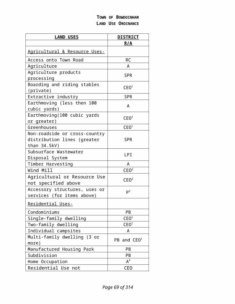
TOWN OF BOWDOINHAMLAND USE ORDINANCE
7) Will not have an adverse impact on spawning grounds, fish, aquatic life, bird or other riparian wildlife habitat.
8) Will conserve natural, native vegetation along the shoreline.9) Will conserve visual corridors.10) Will conserve access to inland and coastal waters.11) Will not have an adverse effect on historic and/or archaeological sites.12) Will not adversely affect existing commercial fishing or maritime activities in a Commercial
Fisheries/Maritime Activities district.13) Will be in compliance with the Town’s Floodplain Management provisions.14) Will be in conformance with the provisions of Article 7, Section D, Performance Standards.
C) Special Exceptions.
In addition to the criteria specified in Article 7.BC above, excepting structure setback requirements, the Planning Board may approve a permit for a single family residential structure in a Resource Protection District provided that the applicant demonstrates that all of the following conditions are met:
1) There is no location on the property, other than a location within the Resource Protection District, where the structure can be built.
2) The lot on which the structure is proposed is undeveloped and was established and recorded in the registry of deeds of the county in which the lot is located before the adoption of the Resource Protection District.
3) All proposed buildings, sewage disposal systems and other improvements are:a) Located on natural ground slopes of less than 20%; andb) Located outside the floodway of the 100-year flood-plain along rivers and artificially
formed great ponds along rivers and outside the velocity zone in areas subject to tides, based on detailed flood insurance studies and as delineated on the Federal Emergency Management Agency's Flood Boundary and Floodway Maps and Flood Insurance Rate Maps; all buildings, including basements, are elevated at least one foot above the 100-year flood-plain elevation; and the development is otherwise in compliance with any applicable municipal flood-plain ordinance. If the floodway is not shown on the Federal Emergency Management Agency Maps, it is deemed to be 1/2 the width of the 100-year flood-plain.
c) The total ground-footprint, including cantilevered or similar overhanging extensions, of all principal and accessory structures is limited to a maximum of 1,500 square feet. This limitation shall not be altered by variance.
d) All structures, except functionally water-dependent structures, are set back from the normal high-water line of a water body, tributary stream or upland edge of a freshwater or coastal wetland to the greatest practical extent, but not less than 75 feet, horizontal distance. In determining the greatest practical extent, the Planning Board shall consider the depth of the lot, the slope of the land, the potential for soil erosion, the type and amount of vegetation to be removed, the proposed building site's elevation in regard to the flood-plain, and its proximity to moderate-value and high-value wetlands.
Page 69 of 201

TOWN OF BOWDOINHAMLAND USE ORDINANCE
D) Performance Standards
1) Minimum Lot Standards.
Minimum Lot- Minimum Area (sq. ft.) Shore Frontage (ft.)
a) Residential per dwelling unit 40,000 200
b) Governmental, Institutional, Commercial or Industrial per principal structure
(i) Within the Shoreland Zone Adjacent to Tidal Areas, Exclusive of Those Areas Zoned for Commercial Fisheries and Maritime Activities-
40,000 200
(ii) Within the Shoreland Zone Adjacent to Tidal Areas Zoned for Commercial Fisheries and Maritime Activities- NONE NONE
(iii)Within the Shoreland Zone Adjacent to Non-tidal Areas-60,000 300
c) Public and Private Recreational Facilities
(i) Within the Shoreland Zone Adjacent to Tidal and Non-Tidal Areas- 40,000
200
d) Land below the normal high-water line of a water body or upland edge of a freshwater or coastal wetland and land beneath rights-of-way and/or easements serving more than two (2) lots shall not be included toward calculating minimum lot area.
e) Lots located on opposite sides of a public or private road shall be considered each a separate tract or parcel of land unless such road was established by the owner of land on both sides thereof after September 22, 1971.
f) The minimum width of any portion of any lot within one hundred (100) feet, horizontal distance, of the normal high-water line of a water body or upland edge of a freshwater or coastal wetland shall be equal to or greater than the shore frontage requirement for a lot with the proposed use.
g) If more than one residential dwelling unit, principal governmental, institutional, commercial or industrial structure or use, or combination thereof, is constructed or established on a single parcel, all dimensional requirements shall be met for each additional dwelling unit, principal structure, or use.
h) A cluster subdivision may be allowed as permitted in the underlying district provided that the overall dimensional requirements, including frontage and lot area per dwelling unit, are met. When determining whether dimensional requirements are met, only land area within the shoreland zone shall be considered.
2) Principal and Accessory Structures.
Page 70 of 201

TOWN OF BOWDOINHAMLAND USE ORDINANCE
a) All new principal and accessory structures shall be set back at least one hundred (100) feet, horizontal distance, from the normal high-water line of water bodies, streams, or the upland edge of a coastal or freshwater wetland, except that in the General Development I District the setback from the normal high-water line shall be at least twenty five (25) feet, horizontal distance, and in the Commercial Fisheries/Maritime Activities District there shall be no minimum setback. In the Resource Protection District the setback requirement shall be 250 feet, horizontal distance, except for structures, roads, parking spaces or other regulated objects specifically allowed in that district in which case the setback requirements specified above shall apply.
(i) The water body, stream, or freshwater/coastal wetland setback provision shall neither apply to structures which require direct access to the water body or freshwater/coastal wetland as an operational necessity, such as piers, docks and retaining walls, nor to other functionally water-dependent uses.
(ii) On a non-conforming lot of record on which only a residential structure exists, and it is not possible to place an accessory structure meeting the required water body, stream or freshwater/coastal wetland setbacks, the code enforcement officer may issue a permit to place a single accessory structure, with no utilities, for the storage of yard tools and similar equipment. Such accessory structure shall not exceed eighty (80) square feet in area nor eight (8) feet in height, and shall be located as far from the shoreline or stream as practical and shall meet all other applicable standards, including lot coverage and vegetation clearing limitations. In no case shall the structure be located closer to the shoreline or stream than the principal structure.
b) Principal or accessory structures and expansions of existing structures which are permitted in the Resource Protection, Limited Residential, Limited Commercial, and Stream Protection Districts, shall not exceed thirty-five (35) feet in height. This provision shall not apply to structures such as transmission towers, windmills, antennas, and similar structures having no floor area.
c) The lowest floor elevation or openings of all buildings and structures, including basements, shall be elevated at least one foot above the elevation of the 100 year flood, the flood of record, or in the absence of these, the flood as defined by soil types identified as recent flood-plain soils. In those municipalities that participate in the National Flood Insurance Program and have adopted the April 2005 version, or later version, of the Floodplain Management Ordinance, accessory structures may be placed in accordance with the standards of that ordinance and need not meet the elevation requirements of this paragraph.
d) The total footprint area of all structures, parking lots and other non-vegetated surfaces, within the shoreland zone shall not exceed twenty (20) percent of the lot or a portion thereof, located within the shoreland zone, including land area previously developed, except in the General Development District adjacent to tidal waters and rivers that do not flow to great ponds classified GPA, and in the Commercial Fisheries/Maritime Activities District, where lot coverage shall not exceed seventy (70) percent.
e) Retaining walls that are not necessary for erosion control shall meet the structure setback requirement, except for low retaining walls and associated fill provided all of the following conditions are met:(i) The site has been previously altered and an effective vegetated buffer does not exist;(ii) The wall(s) is(are) at least 25 feet, horizontal distance, from the normal high-water
line of a water body, stream, or upland edge of a coastal or freshwater wetland;
Page 71 of 201

TOWN OF BOWDOINHAMLAND USE ORDINANCE
(iii)The site where the retaining wall will be constructed is legally existing lawn or is a site eroding from lack of naturally occurring vegetation, and which cannot be stabilized with vegetative plantings;
(iv)The total height of the wall(s), in the aggregate, are no more than 24 inches;(v) Retaining walls are located outside of the 100-year floodplain on rivers, streams,
coastal wetlands, and streams, as designated on the Federal Emergency Management Agency’s (FEMA) Flood Insurance Rate Maps or Flood Hazard Boundary Maps, or the flood of record, or in the absence of these, by soil types identified as recent flood plain soils.
(vi)The area behind the wall is revegetated with grass, shrubs, trees, or a combination thereof, and no further structural development will occur within the setback area, including patios and decks; and
(vii) A vegetated buffer area is established within 25 feet, horizontal distance, of the normal high-water line of a water body, stream, or upland edge of a freshwater or coastal wetland when a natural buffer area does not exist. The buffer area must meet the following characteristics:(A) The buffer must include shrubs and other woody and herbaceous vegetation.
Where natural ground cover is lacking the area must be supplemented with leaf or bark mulch;
(B) Vegetation plantings must be in quantities sufficient to retard erosion and provide for effective infiltration of stormwater runoff;
(C) Only native species may be used to establish the buffer area;(D) A minimum buffer width of 15 feet, horizontal distance, is required, measured
perpendicularly to the normal high-water line or upland edge of a coastal or freshwater wetland;
(E) A footpath not to exceed the standards in Article 7.D.17.b.i, may traverse the buffer;
f) Notwithstanding the requirements stated above, stairways or similar structures may be allowed with a permit from the Code Enforcement Officer, to provide shoreline access in areas of steep slopes or unstable soils provided: that the structure is limited to a maximum of four (4) feet in width; that the structure does not extend below or over the normal high-water line of a water body or upland edge of a coastal or freshwater wetland, (unless permitted by the Department of Environmental Protection pursuant to the Natural Resources Protection Act, 38 M.R.S.A. section 480-C); and that the applicant demonstrates that no reasonable access alternative exists on the property.
3) Piers, Docks, Wharves, Bridges and Other Structures and Uses Extending Over or Below the Normal High-Water Line of a Water Body or Within a Wetland.
a) Access from shore shall be developed on soils appropriate for such use and constructed so as to control erosion.
b) The location shall not interfere with existing developed or natural beach areas.c) The facility shall be located so as to minimize adverse effects on fisheries.d) The facility shall be no larger in dimension than necessary to carry on the activity and be
consistent with the surrounding character and uses of the area. A temporary pier, dock or wharf in non-tidal waters shall not be wider than six feet for non-commercial uses.
e) No new structure shall be built on, over or abutting a pier, wharf, dock or other structure extending beyond the normal high-water line of a water body or within a freshwater or
Page 72 of 201

TOWN OF BOWDOINHAMLAND USE ORDINANCE
coastal wetland unless the structure requires direct access to the water body or wetland as an operational necessity.
f) New permanent piers and docks on non-tidal waters shall not be permitted unless it is clearly demonstrated to the Planning Board that a temporary pier or dock is not feasible, and a permit has been obtained from the Department of Environmental Protection, pursuant to the Natural Resources Protection Act.
g) No existing structures built on, over or abutting a pier, dock, wharf or other structure extending beyond the normal high-water line of a water body or within a freshwater or coastal wetland shall be converted to residential dwelling units in any district.
h) Except in the General Development Districts and Commercial Fisheries/Maritime Activities District, structures built on, over or abutting a pier, wharf, dock or other structure extending beyond the normal high-water line of a water body or within a coastal or freshwater wetland shall not exceed twenty (20) feet in height above the pier, wharf, dock or other structure.
i) The structure should be placed to minimize the shading on existing vegetation.j) The applicant must demonstrate that a community or shared dock is not possible.k) The applicant must minimize the use of wood preservatives, stains and paints on said
structure.l) The storage of floats and boats must occur on the upland.
4) Campgrounds.
Campgrounds shall conform to the minimum requirements imposed under State licensing procedures and the following:
a) Campgrounds shall contain a minimum of five thousand (5,000) square feet of land, not including roads and driveways, for each site. Land supporting wetland vegetation, and land below the normal high-water line of a water body shall not be included in calculating land area per site.
b) The areas intended for placement of a recreational vehicle, tent or shelter, and utility and service buildings shall be set back a minimum of one hundred (100) feet, horizontal distance, from the normal high-water line of water bodies, streams, or the upland edge of a coastal or freshwater wetland.
5) Individual Private Campsites.
Individual private campsites not associated with campgrounds are allowed provided the following conditions are met:
a) One campsite per lot existing on the effective date of this Ordinance, or thirty thousand (30,000) square feet of lot area within the shoreland zone, whichever is less, may be permitted.
b) Campsite placement on any lot, including the area intended for a recreational vehicle or tent platform, shall be set back seventy-five (75) feet, horizontal distance, from the normal high-water line of water bodies, streams, or the upland edge of a freshwater or coastal wetland.
Page 73 of 201
TOWN OF BOWDOINHAMLAND USE ORDINANCE
c) Only one recreational vehicle shall be allowed on a campsite. The recreational vehicle shall not be located on any type of permanent foundation except for a gravel pad, and no structure except a canopy shall be attached to the recreational vehicle.
d) The clearing of vegetation for the siting of the recreational vehicle, tent or similar shelter in a Resource Protection District shall be limited to one thousand (1000) square feet.
e) A written sewage disposal plan describing the proposed method and location of sewage disposal shall be required for each campsite and shall be approved by the Local Plumbing Inspector. Where disposal is off-site, written authorization from the receiving facility or land owner is required.
f) When a recreational vehicle, tent or similar shelter is placed on-site for more than one hundred and twenty (120) days per year, all requirements for residential structures shall be met, including the installation of a subsurface sewage disposal system in compliance with the State of Maine Subsurface Wastewater Disposal Rules unless served by public sewage facilities.
6) Commercial and Industrial Uses .
The following new commercial and industrial uses are prohibited within the shoreland zone:
a) Auto washing facilitiesb) Auto or other vehicle service and/or repair operations, including body shopsc) Chemical and bacteriological laboratoriesd) Storage of chemicals, including herbicides, pesticides or fertilizers, other than amounts
normally associated with individual households or farmse) Commercial painting, wood preserving, and furniture strippingf) Dry cleaning establishmentsg) Electronic circuit assemblyh) Laundromatsi) Metal plating, finishing, or polishingj) Petroleum or petroleum product storage and/or sale except storage on same property as
use occurs and except for storage and sales associated with marinask) Photographic processingl) Off-set Printingm) Junkyard, Automobile Graveyard and Automobile Recycling Businessn) Slaughter House
7) Parking Areas.
a) Parking areas shall meet the shoreline and stream setback requirements for structures for the district in which such areas are located, except that in the Commercial Fisheries/Maritime Activities District parking areas shall be set back at least twenty-five (25) feet, horizontal distance, from the shoreline. The setback requirement for parking areas serving public boat launching facilities in Districts other than the General Development I District and Commercial Fisheries/Maritime Activities District shall be no less than fifty (50) feet, horizontal distance, from the shoreline or stream if the Planning Board finds that no other reasonable alternative exists further from the shoreline or stream.
Page 74 of 201

TOWN OF BOWDOINHAMLAND USE ORDINANCE
b) Parking areas shall be adequately sized for the proposed use and shall be designed to prevent stormwater runoff from flowing directly into a water body, stream or freshwater/coastal wetland and where feasible, to retain all runoff on-site.
c) In determining the appropriate size of proposed parking facilities, the following shall apply:(i) Typical parking space: Approximately ten (10) feet wide and twenty (20) feet long,
except that parking spaces for a vehicle and boat trailer shall be forty (40) feet long.(ii) Internal travel aisles: Approximately twenty (20) feet wide.
8) Roads and Driveways.
The following standards shall apply to the construction of roads and/or driveways and drainage systems, culverts and other related features.
a) Roads and driveways shall be set back at least one-hundred (100) feet, horizontal distance from the normal high-water line of water bodies, streams, or the upland edge of a freshwater or coastal wetland unless no reasonable alternative exists as determined by the Planning Board. If no other reasonable alternative exists, the road and/or driveway setback requirement shall be no less than fifty (50) feet, horizontal distance, upon clear showing by the applicant that appropriate techniques will be used to prevent sedimentation of the water body, stream, or coastal or freshwater wetland. Such techniques may include, but are not limited to, the installation of settling basins, and/or the effective use of additional ditch relief culverts and turnouts placed so as to avoid sedimentation of the water body, stream, or coastal or freshwater wetland.
On slopes of greater than twenty (20) percent the road and/or driveway setback shall be increased by ten (10) feet, horizontal distance, for each five (5) percent increase in slope above twenty (20) percent.
Article 7.D.8.a does not apply to approaches to water crossings or to roads or driveways that provide access to permitted structures and facilities located nearer to the shoreline or tributary stream due to an operational necessity, excluding temporary docks for recreational uses. Roads and driveways providing access to permitted structures within the setback area shall comply fully with the requirements of Article 7.D.8.a except for that portion of the road or driveway necessary for direct access to the structure.
b) Existing public roads may be expanded within the legal road right of way regardless of their setback from a water body, tributary stream or wetland.
c) New roads and driveways are prohibited in a Resource Protection District except that the Planning Board may grant a permit to construct a road or driveway to provide access to permitted uses within the district. A road or driveway may also be approved by the Planning Board in a Resource Protection District, upon a finding that no reasonable alternative route or location is available outside the district. When a road or driveway is permitted in a Resource Protection District the road and/or driveway shall be set back as far as practicable from the normal high-water line of a water body, stream, or upland edge of a coastal or freshwater wetland.
Page 75 of 201

TOWN OF BOWDOINHAMLAND USE ORDINANCE
d) Road and driveway banks shall be no steeper than a slope of two (2) horizontal to one (1) vertical, and shall be graded and stabilized in accordance with the provisions for erosion and sedimentation control contained in Article 7.D.18.
e) Road and driveway grades shall be no greater than six (6) percent except for segments of less than two hundred (200) feet.
f) In order to prevent road and driveway surface drainage from directly entering water bodies, streams or coastal or freshwater wetlands, roads and driveways shall be designed, constructed, and maintained to empty onto an unscarified buffer strip at least (50) feet plus two times the average slope, in width between the outflow point of the ditch or culvert and the normal high-water line of a water body, stream, or upland edge of a coastal or freshwater wetland. Surface drainage which is directed to an unscarified buffer strip shall be diffused or spread out to promote infiltration of the runoff and to minimize channelized flow of the drainage through the buffer strip.
g) Ditch relief (cross drainage) culverts, drainage dips and water turnouts shall be installed in a manner effective in directing drainage onto unscarified buffer strips before the flow gains sufficient volume or head to erode the road, driveway, or ditch. To accomplish this, the following shall apply:
(i) Ditch relief culverts, drainage dips and associated water turnouts shall be spaced along the road, or driveway at intervals no greater than indicated in the following table:
Grade Spacing(Percent) (Feet)
0-2 2503-5 200-1356-10 100-8011-15 80-6016-20 60-4521 + 40
(ii) Drainage dips may be used in place of ditch relief culverts only where the grade is ten (10) percent or less.
(iii)On sections having slopes greater than ten (10) percent, ditch relief culverts shall be placed at approximately a thirty (30) degree angle downslope from a line perpendicular to the centerline of the road or driveway.
(iv)Ditch relief culverts shall be sufficiently sized and properly installed in order to allow for effective functioning, and their inlet and outlet ends shall be stabilized with appropriate materials.
Page 76 of 201

TOWN OF BOWDOINHAMLAND USE ORDINANCE
(1) Ditches, culverts, bridges, dips, water turnouts and other storm water runoff control installations associated with roads and driveways shall be maintained on a regular basis to assure effective functioning.
9) Stream Crossings.
a) This standard applies to crossings over the following streams: (i) all tidal streams,(ii) Sedgely Brook, from the West Branch to its intersection with the parcel referred to as
Tax Map R04, Lot 017, and (iii)the Abagadasset River.
b) A permit shall be required from the Code Enforcement Officer for all stream crossings that must meet this standard.
c) Crossing Structure. Bridges and open bottom structures are required that span the channel, as well as both banks allowing dry passage for wildlife that move along the watercourse.
d) Channel Span. The structure span should be at least 1.2 times the bankfull width and provide banks on one or both sides with sufficient headroom to provide dry passage for semi-aquatic and terrestrial wildlife. The structure shall be designed to take into consideration stream associated floodplains and be constructed to allow dry passage of wildlife at least 90% of the year.
e) In-structure Substrate. The substrate within the structure should match the characteristics of the substrate in the natural stream channel (mobility, slope, stability, confinement) while maintaining water column depths similar to natural stream conditions to allow species passage. The substrate shall resist significant displacement during flood events.
f) Structure Openness Ratio. The structure must maintain a headroom height of 4 feet above the grade of dry bank passage and an openness ratio >0.5 meters.
g) The following stream crossings do not have the meet this stream crossing standard:(i) Stream crossings for timber harvesting,(ii) Stream crossings for agricultural, and(iii)Stream crossings that will be in place for less than six months.
10) Signs.
The following provisions shall govern the use of signs in the Resource Protection, Stream Protection, Limited Residential and Limited Commercial Districts:
a) Signs relating to goods and services sold on the premises shall be allowed, provided that such signs shall not exceed six (6) square feet in area and shall not exceed two (2) signs per premises. In the Limited Commercial District, however, such signs shall not exceed sixteen (16) square feet in area. Signs relating to goods or services not sold or rendered on the premises shall be prohibited.
b) Name signs are allowed, provided such signs shall not exceed two (2) signs per premises, and shall not exceed twelve (12) square feet in the aggregate.
c) Residential users may display a single sign not over three (3) square feet in area relating to the sale, rental, or lease of the premises.
d) Signs relating to trespassing and hunting shall be allowed without restriction as to number provided that no such sign shall exceed two (2) square feet in area.
Page 77 of 201

TOWN OF BOWDOINHAMLAND USE ORDINANCE
e) Signs relating to public safety shall be allowed without restriction.f) No sign shall extend higher than twenty (20) feet above the ground.g) Signs may be illuminated only by shielded, non-flashing lights, there shall be no internal
lighting.
11) Storm Water Runoff.
a) All new construction and development shall be designed to minimize storm water runoff from the site in excess of the natural predevelopment conditions. Where possible, existing natural runoff control features, such as berms, swales, terraces and wooded areas, shall be retained in order to reduce runoff and encourage infiltration of stormwaters.
b) Storm water runoff control systems shall be maintained as necessary to ensure proper functioning.
12) Septic Waste Disposal.
a) All subsurface sewage disposal systems shall be installed in conformance with the State of Maine Subsurface Wastewater Disposal Rules, and the following: (i) clearing or removal of woody vegetation necessary to site a first-time system and any
associated fill extensions, shall not extend closer than seventy-five (75) feet, horizontal distance, from the normal high-water line of a water body or the upland edge of a freshwater or coastal wetland and
(ii) A holding tank is not allowed for a first-time residential use in the shoreland zone.
13) Essential Services.
a) Where feasible, the installation of essential services shall be limited to existing public ways and existing service corridors.
b) The installation of essential services, other than road-side distribution lines, is not allowed in a Resource Protection or Stream Protection District, except to provide services to a permitted use within said district, or except where the applicant demonstrates that no reasonable alternative exists. Where allowed, such structures and facilities shall be located so as to minimize any adverse impacts on surrounding uses and resources, including visual impacts.
c) Damaged or destroyed public utility transmission and distribution lines, towers and related equipment may be replaced or reconstructed without a permit.
14) Mineral Exploration and Extraction.
a) Mineral exploration to determine the nature or extent of mineral resources shall be accomplished by hand sampling, test boring, or other methods which create minimal disturbance of less than one hundred (100) square feet of ground surface. A permit from the Code Enforcement Officer shall be required for mineral exploration which exceeds the above limitation. All excavations, including test pits and holes, shall be immediately capped, filled or secured by other equally effective measures to restore disturbed areas and to protect the public health and safety. Except within Resource Protection Districts adjacent to significant freshwater wetlands which are rated "moderate" or "high" value by the Maine Department of Inland Fisheries and Wildlife (MDIF&W) that are depicted on a
Page 78 of 201

TOWN OF BOWDOINHAMLAND USE ORDINANCE
Geographic Information System (GIS) data layer maintained by either MDIF&W or the Department as of December 31, 2008, mineral extraction may be performed under the following conditions:(i) A reclamation plan shall be filed with, and approved, by the Planning Board before a
permit is granted. Such plan shall describe in detail procedures to be undertaken to fulfill the requirements of subsection iii below.
(ii) No part of any extraction operation, including drainage and runoff control features, shall be permitted within one hundred (100) feet, horizontal distance of the normal high-water line of any water body, stream, or the upland edge of a freshwater or coastal wetland. Extraction operations shall not be permitted within fifty (50) feet, horizontal distance, of any property line without written permission of the owner of such adjacent property.
(iii)Within twelve (12) months following the completion of extraction operations at any extraction site, which operations shall be deemed complete when less than one hundred (100) cubic yards of materials are removed in any consecutive twelve (12) month period, ground levels and grades shall be established in accordance with the following:(A) All debris, stumps, and similar material shall be removed for disposal in an
approved location, or shall be buried on-site. Only materials generated on-site may be buried or covered on-site.
(B) The final graded slope shall be two and one-half to one (2 1/2:1) slope or flatter.(C) Top soil or loam shall be retained to cover all disturbed land areas, which shall be
reseeded and stabilized with vegetation native to the area. Additional topsoil or loam shall be obtained from off-site sources if necessary to complete the stabilization project.
(iv) In keeping with the purposes of this Ordinance, the Planning Board may impose such conditions as are necessary to minimize the adverse impacts associated with mineral extraction operations on surrounding uses and resources.
15) Agriculture.
a) All spreading of manure shall be accomplished in conformance with the Manure Utilization Guidelines published by the Maine Department of Agriculture on November 1, 2001, and the Nutrient Management Law (7 M.R.S.A. sections 4201-4209).
b) Manure shall not be stored or stockpiled within seventy-five (75) feet horizontal distance, of water bodies, streams, or coastal or freshwater wetlands. All manure storage areas within the shoreland zone must be constructed or modified such that the facility produces no discharge of effluent or contaminated storm water.
c) Agricultural activities involving tillage of soil greater than forty thousand (40,000) square feet in surface area, within the shoreland zone shall require a Conservation Plan to be filed with the Planning Board. Non-conformance with the provisions of said plan shall be considered to be a violation of this Ordinance.
d) There shall be no new tilling of soil within seventy-five (75) feet, horizontal distance, from water bodies and coastal wetlands; nor within twenty-five (25) feet, horizontal distance, of streams and freshwater wetlands. Operations in existence on the effective date of this ordinance and not in conformance with this provision may be maintained.
e) Newly established livestock grazing areas shall not be permitted within seventy-five (75) feet, horizontal distance, of water bodies and coastal wetlands, nor; within twenty-five
Page 79 of 201

TOWN OF BOWDOINHAMLAND USE ORDINANCE
(25) feet, horizontal distance, of tributary streams and freshwater wetlands. Livestock grazing associated with ongoing farm activities, and which are not in conformance with the above setback provisions may continue, provided that such grazing is conducted in accordance with a Conservation Plan.
16) Timber Harvesting.
Timber harvesting shall conform with the following Standards:a) Shoreline integrity and sedimentation. Persons conducting timber harvesting and related
activities must take reasonable measures to avoid the disruption of shoreline integrity, the occurrence of sedimentation of water, and the disturbance of water body and stream banks, water body and stream channels, shorelines, and soil lying within water bodies, streams and coastal or freshwater wetlands. If, despite such precautions, the disruption of shoreline integrity, sedimentation of water, or the disturbance of water body and stream banks, water body and stream channels, shorelines, and soil lying within water bodies, streams and coastal or freshwater wetlands occurs, such conditions must be corrected.
b) Slash treatment. Timber harvesting and related activities shall be conducted such that slash or debris is not left below the normal high-water line of any water body or stream, or the upland edge of a coastal or freshwater wetland. This section does not apply to minor, incidental amounts of slash that result from timber harvesting and related activities otherwise conducted in compliance with this section.(i) Slash actively used to protect soil from disturbance by equipment or to stabilize
exposed soil, may be left in place, provided that no part thereof extends more than 4 feet above the ground.
(ii) Adjacent to great ponds, rivers and wetlands:(A) No accumulation of slash shall be left within 50 feet, horizontal distance, of the
normal high-water line or upland edge of a wetland; and(B) Between 50 feet and 250 feet, horizontal distance, of the normal high-water line
or upland edge of a wetland, all slash larger than 3 inches in diameter must be disposed of in such a manner that no part thereof extends more than 4 feet above the ground.
(iii)Timber harvesting and related activities must leave adequate tree cover and shall be conducted so that a well-distributed stand of trees is retained. This requirement may be satisfied by following one of the following three options:(A) Option 1 (40% volume removal), as follows:
(1) Harvesting of no more than 40 percent of the total volume on each acre of trees 4.5 inches DBH or greater in any 10 year period is allowed. Volume may be considered to be equivalent to basal area;
(2) A well-distributed stand of trees which is windfirm, and other vegetation including existing ground cover, must be maintained; and,
(3) Within 75 feet, horizontal distance, of the normal high-water line of rivers, streams, and within 75 feet, horizontal distance, of the upland edge of a freshwater or coastal wetlands, there must be no cleared openings. At distances greater than 75 feet, horizontal distance, of the normal high-water line of a river or upland edge of a coastal or freshwater wetland, timber harvesting and related activities must not create single cleared openings greater than 14,000 square feet in the forest canopy. Where such openings exceed 10,000 square feet, they must be at least 100 feet, horizontal distance,
Page 80 of 201
TOWN OF BOWDOINHAMLAND USE ORDINANCE
apart. Such cleared openings will be included in the calculation of total volume removal. Volume may be considered equivalent to basal area.
(B) Option 2 (60 square foot basal area retention), as follows:(1) The residual stand must contain an average basal area of at least 60 square
feet per acre of woody vegetation greater than or equal to 1.0 inch DBH, of which 40 square feet per acre must be greater than or equal to 4.5 inches DBH;
(2) A well-distributed stand of trees which is windfirm, and other vegetation including existing ground cover, must be maintained; and,
(3) Within 75 feet, horizontal distance, of the normal high-water line of water bodies and within 75 feet, horizontal distance, of the upland edge of coastal or freshwater wetlands, there must be no cleared openings. At distances greater than 75 feet, horizontal distance, of the normal high-water line of a river or upland edge of a coastal or freshwater wetland, timber harvesting and related activities must not create single cleared openings greater than 14,000 square feet in the forest canopy. Where such openings exceed 10,000 square feet, they must be at least 100 feet, horizontal distance, apart. Such cleared openings will be included in the calculation of the average basal area. Volume may be considered equivalent to basal area.
(C) Option 3 (Outcome based), which requires: An alternative method proposed in an application, signed by a Licensed Forester or certified wildlife professional, submitted by the landowner or designated agent to the State of Maine Department of Conservation’s Bureau of Forestry (Bureau) for review and approval, which provides equal or better protection of the shoreland area than this rule.
Option 3 does not become effective until the legislative effective date of the statewide standards.
Landowners must designate on the Forest Operations Notification form required by 12 M.R.S.A. chapter 805, subchapter 5 which option they choose to use. If landowners choose Option 1 or Option 2, compliance will be determined solely on the criteria for the option chosen. If landowners choose Option 3, timber harvesting and related activities may not begin until the Bureau has approved the alternative method.
The Bureau may verify that adequate tree cover and a well-distributed stand of trees is retained through a field procedure that uses sample plots that are located randomly or systematically to provide a fair representation of the harvest area.
(iv)Skid trails, yards, and equipment operation. This requirement applies to the construction, maintenance, and use of skid trails and yards in shoreland areas.(A) Equipment used in timber harvesting and related activities shall not use river,
stream or stream channels as travel routes except when surface waters are frozen and snow covered, and the activity will not result in any ground disturbance.
(B) Skid trails and yards must be designed and constructed to prevent sediment and concentrated water runoff from entering a water body, stream, or coastal or freshwater wetland. Upon termination of their use, skid trails and yards must be stabilized.
Page 81 of 201
TOWN OF BOWDOINHAMLAND USE ORDINANCE
(C) Setbacks:(1) Equipment must be operated to avoid the exposure of mineral soil within 25
feet, horizontal distance, of any water body, stream, or coastal or freshwater wetland. On slopes of 10 percent or greater, the setback for equipment operation must be increased by 20 feet, horizontal distance, plus an additional 10 feet, horizontal distance, for each 5 percent increase in slope above 10 percent. Where slopes fall away from the resource, no increase in the 25-foot setback is required.
(2) Where such setbacks are impracticable, appropriate techniques shall be used to avoid sedimentation of the water body, stream or coastal or freshwater wetland. Such techniques may include the installation of sump holes or settling basins, and/or the effective use of additional ditch relief culverts and ditch water turnouts placed to avoid sedimentation of the water body, stream, or coastal or freshwater wetland. If, despite such precautions, sedimentation or the disruption of shoreline integrity occurs, such conditions must be corrected.
(v) Land Management Roads. Land management roads, including approaches to crossings of water bodies, stream channels, and freshwater wetlands, ditches and other related structures, must be designed, constructed, and maintained to prevent sediment and concentrated water runoff from directly entering the water body, stream or coastal or freshwater wetland. Surface water on or adjacent to water crossing approaches must be diverted through vegetative filter strips to avoid sedimentation of the watercourse or freshwater or coastal wetland. Because roadside ditches may not extend to the resource being crossed, vegetative filter strips must be established in accordance with the setback requirements in Article 7.D.16.vii of this rule.(A) Land management roads and associated ditches, excavation, and fill must be set
back at least:(1) 100 feet, horizontal distance, from the normal high-water line of a river or
freshwater or coastal wetland;(2) 50 feet, horizontal distance, from the normal high-water line of tributary
streams; and(3) 25 feet, horizontal distance, from the normal high-water line of streams
(B) The minimum 100 foot setback specified in Article 7.D.16.v.A.1 above may be reduced to no less than 50 feet, horizontal distance, and the 50 foot setback specified in Article 7.D.16.v.A.2 above may be reduced to no less than 25 feet, horizontal distance, if, prior to construction, the landowner or the landowner’s designated agent demonstrates to the Planning Board’s satisfaction that no reasonable alternative exists and that appropriate techniques will be used to prevent sedimentation of the water body, stream, or coastal or freshwater wetland. Such techniques may include, but are not limited to, the installation of settling basins, and/or the effective use of additional ditch relief culverts and turnouts placed to avoid sedimentation of the water body, stream or coastal or freshwater wetland. If, despite such precautions, sedimentation or the disruption of shoreline integrity occurs, such conditions must be corrected.
(C) On slopes of 10 percent or greater, the land management road setback must be increased by at least 20 feet, horizontal distance, plus an additional 10 feet, horizontal distance, for each 5 percent increase in slope above 10 percent.
Page 82 of 201

TOWN OF BOWDOINHAMLAND USE ORDINANCE
(D) New land management roads are not allowed within the shoreland area along Significant River Segments as identified in 38 M.R.S.A. section 437, nor in a Resource Protection District, unless, prior to construction, the landowner or the landowner’s designated agent makes a clear demonstration to the Planning Board’s satisfaction that no reasonable alternative route exists outside the shoreland zone, and that the new road must be set back as far as practicable from the normal high-water line and screened from the river by existing vegetation.
(E) Ditches, culverts, bridges, dips, water turnouts and other water control installations associated with roads must be maintained on a regular basis to assure effective functioning. Drainage structures shall deliver a dispersed flow of water into an unscarified filter strip no less than the width indicated in the setback requirements in Article 7.D.16.vii. Where such a filter strip is impracticable, appropriate techniques shall be used to avoid sedimentation of the water body, stream, or coastal or freshwater wetland. Such techniques may include the installation of sump holes or settling basins, and/or the effective use of additional ditch relief culverts and ditch water turnouts placed to avoid sedimentation of the water body, stream, or coastal or freshwater wetland. If, despite such precautions, sedimentation or the disruption of shoreline integrity occurs, such conditions must be corrected.
(F) Road closeout and discontinuance. Maintenance of the water control installations required in Article 7.D.16.v.E must continue until use of the road is discontinued and the road is put to bed by effective installation of water bars or other adequate road drainage structures at appropriate intervals, constructed to avoid surface water flowing over or under the water bar, and extending a sufficient distance beyond the traveled way so that water does not reenter the road surface.
(G) Upgrading existing roads. Extension or enlargement of presently existing roads must conform to the provisions of Article 7.D.16. Any nonconforming existing road may continue to exist and to be maintained, as long as the nonconforming conditions are not made more nonconforming.
(H) Exception. Extension or enlargement of presently existing roads need not conform to the setback requirements of Article 7.D.16.v.A if, prior to extension or enlargement, the landowner or the landowner’s designated agent demonstrates to the Planning Board’s satisfaction that no reasonable alternative exists and that appropriate techniques will be used to prevent sedimentation of the water body, \ stream, or coastal or freshwater wetland. Such techniques may include, but are not limited to, the installation of settling basins, and/or the effective use of additional ditch relief culverts and turnouts placed to avoid sedimentation of the water body, stream, or coastal or freshwater wetland. If, despite such precautions, sedimentation or the disruption of shoreline integrity occurs, such conditions must be corrected.
(I) Additional measures. In addition to the foregoing minimum requirements, persons undertaking construction and maintenance of roads and river, stream and stream crossings must take reasonable measures to avoid sedimentation of surface waters.
(vi)Crossings of waterbodies. Crossings of rivers, streams, and tributary streams must allow for fish passage at all times of the year, must not impound water, and must allow for the maintenance of normal flows.
Page 83 of 201

TOWN OF BOWDOINHAMLAND USE ORDINANCE
(A) Determination of flow. Provided they are properly applied and used for the circumstances for which they are designed, methods including but not limited to the following are acceptable as a means of calculating the 10 year and 25 year frequency water flows and thereby determining water crossing sizes as required in Article 7.D.16: The United States Geological Survey (USGS) Methods; specifically: Hodgkins, G. 1999. Estimating the Magnitude of Peak Flows for Streams in Maine for Selected Recurrence Intervals. U.S. Geological Survey. Water Resources Investigations Report 99-4008. 45 pp.
(B) Upgrading existing water crossings. Extension or enlargement of presently existing water crossings must conform to the provisions of Article 7.D.16. Any nonconforming existing water crossing may continue to exist and be maintained, as long as the nonconforming conditions are not made more nonconforming; however, any maintenance or repair work done below the normal high-water line must conform to the provisions of Article 7.D.16.
(C) Other Agency Permits. Any timber harvesting and related activities involving the design, construction, and maintenance of crossings on waterbodies other than a river, stream or tributary stream may require a permit from the Land Use Regulation Commission, the Department of Environmental Protection, or the US Army Corps of Engineers.
(D) Any timber harvesting and related activities involving the design, construction, and maintenance of crossings of freshwater wetlands identified by the Department of Inland Fisheries and Wildlife as essential wildlife habitat require prior consultation with the Department of Inland Fisheries and Wildlife.
(E) Notice to Bureau of Forestry. Written notice of all water crossing construction maintenance, alteration and replacement activities in shoreland areas must be given to the Bureau prior to the commencement of such activities. Such notice must contain all information required by the Bureau, including:(1) a map showing the location of all proposed permanent crossings;(2) the GPS location of all proposed permanent crossings;(3) for any temporary or permanent crossing that requires a permit from state or
federal agencies, a copy of the approved permit or permits; and(4) a statement signed by the responsible party that all temporary and permanent
crossings will be constructed, maintained, and closed out in accordance with the requirements of this Section.
(F) Water crossing standards. All crossings of rivers require a bridge or culvert sized according to the requirements of Article 7.D.16.vi.G below. Streams and tributary streams may be crossed using temporary structures that are not bridges or culverts provided:(1) concentrated water runoff does not enter the stream or tributary stream;(2) sedimentation of surface waters is reasonably avoided;(3) there is no substantial disturbance of the bank, or stream or tributary stream
channel;(4) fish passage is not impeded; and,(5) water flow is not unreasonably impeded.
Subject to Article 7.D.16.vi.F above, skid trail crossings of streams and tributary streams when channels of such streams and tributary streams are frozen and
Page 84 of 201

TOWN OF BOWDOINHAMLAND USE ORDINANCE
snow-covered or are composed of a hard surface which will not be eroded or otherwise damaged are not required to use permanent or temporary structures.
(G) Bridge and Culvert Sizing. For crossings of river, stream and tributary stream channels with a bridge or culvert, the following requirements apply:(1) Bridges and culverts must be installed and maintained to provide an opening
sufficient in size and structure to accommodate 10 year frequency water flows or with a cross-sectional area at least equal to 2 1/2 times the cross-sectional area of the river, stream, or tributary stream channel.
(2) Temporary bridge and culvert sizes may be smaller than provided in Article 7.D.16.vi.G.1 if techniques are effectively employed such that in the event of culvert or bridge failure, the natural course of water flow is maintained and sedimentation of the water body or stream is avoided. Such crossing structures must be at least as wide as the channel and placed above the normal high-water line. Techniques may include, but are not limited to, the effective use of any, a combination of, or all of the following:a. use of temporary skidder bridges;b. removing culverts prior to the onset of frozen ground conditions;c. using water bars in conjunction with culverts;d. using road dips in conjunction with culverts.
(3) Culverts utilized in river, stream and tributary stream crossings must:a. be installed at or below river, stream or tributary stream bed elevation;b. be seated on firm ground;c. have soil compacted at least halfway up the side of the culvert;d. be covered by soil to a minimum depth of 1 foot or according to the
culvert manufacturer's specifications, whichever is greater; ande. have a headwall at the inlet end which is adequately stabilized by riprap
or other suitable means to reasonably avoid erosion of material around the culvert.
(4) River, stream and tributary stream crossings allowed under Article 7.D.16, but located in flood hazard areas (i.e. A zones) as identified on a community's Flood Insurance Rate Maps (FIRM) or Flood Hazard Boundary Maps (FHBM), must be designed and constructed under the stricter standards contained in that community's National Flood Insurance Program (NFIP). For example, a water crossing may be required to pass a 100-year flood event.
(5) Exception. Skid trail crossings of streams within shoreland areas and wetlands adjacent to such streams may be undertaken in a manner not in conformity with the requirements of the foregoing subsections provided persons conducting such activities take reasonable measures to avoid the disruption of shoreline integrity, the occurrence of sedimentation of water, and the disturbance of stream banks, stream channels, shorelines, and soil lying within ponds and wetlands. If, despite such precautions, the disruption of shoreline integrity, sedimentation of water, or the disturbance of stream banks, stream channels, shorelines, and soil lying within ponds and wetlands occurs, such conditions must be corrected.
(H) Skid trail closeout. Upon completion of timber harvesting and related activities, or upon the expiration of a Forest Operations Notification, whichever is earlier, the following requirements apply:
Page 85 of 201

TOWN OF BOWDOINHAMLAND USE ORDINANCE
(1) Bridges and culverts installed for river, stream and tributary stream crossings by skid trails must either be removed and areas of exposed soil stabilized, or upgraded to comply with the closeout standards for land management roads in Article 7.D.16.vi.I below.
(2) Water crossing structures that are not bridges or culverts must either be removed immediately following timber harvesting and related activities, or, if frozen into the river, stream or tributary stream bed or bank, as soon as practical after snowmelt.
(3) River, stream and tributary stream channels, banks and approaches to crossings of water bodies and tributary streams must be immediately stabilized on completion of harvest, or if the ground is frozen and/or snow-covered, as soon as practical after snowmelt. If, despite such precautions, sedimentation or the disruption of shoreline integrity occurs, such conditions must be corrected.
(I) Land management road closeout. Maintenance of the water control features must continue until use of the road is discontinued and the road is put to bed by taking the following actions:(1) Effective installation of water bars or other adequate road drainage structures
at appropriate intervals, constructed to reasonably avoid surface water flowing over or under the water bar, and extending sufficient distance beyond the traveled way so that water does not reenter the road surface.
(2) Water crossing structures must be appropriately sized or dismantled and removed in a manner that reasonably avoids sedimentation of the water body or tributary stream.
(3) Any bridge or water crossing culvert in roads to be discontinued shall satisfy one of the following requirements:a. it shall be designed to provide an opening sufficient in size and structure
to accommodate 25 year frequency water flows;b. it shall be designed to provide an opening with a cross-sectional area at
least 3 1/2 times the cross-sectional area of the river, stream or tributary stream channel; or
c. it shall be dismantled and removed in a fashion to reasonably avoid sedimentation of the river, stream or tributary stream.
If, despite such precautions, sedimentation or the disruption of shoreline integrity occurs, such conditions must be corrected.
(vii) Slope Table
Filter strips, skid trail setbacks, and land management road setbacks must be maintained as specified in Article 7.D.16, but in no case shall be less than shown in the following table.
Average slope of land between Width of strip between exposedexposed mineral soil and shoreline mineral soil and theshoreline(feet along surface of the ground) (percent)
Page 86 of 201

TOWN OF BOWDOINHAMLAND USE ORDINANCE
0 2510 4520 6530 8540 10550 12560 14570 165
17) Clearing or Removal of Vegetation for Activities Other Than Timber Harvesting.
a) In the Resource Protection District the cutting or removal of vegetation shall be limited to that which is necessary for uses expressly authorized in that district.
b) Except in areas as described in Article 7.D.17.a, above, and except to allow for the development of permitted uses, within one hundred (100) feet, horizontal distance, from any other water body, stream, or the upland edge of a coastal or freshwater wetland, a buffer strip of vegetation shall be preserved as follows:(i) There shall be no cleared opening greater than 250 square feet in the forest canopy
(or other existing woody vegetation if a forested canopy is not present) as measured from the outer limits of the tree or shrub crown. However, a footpath not to exceed six (6) feet in width as measured between tree trunks and/or shrub stems is allowed provided that a cleared line of sight to the water through the buffer strip is not created.
(ii) Selective cutting of trees within the buffer strip is allowed provided that a well-distributed stand of trees and other natural vegetation is maintained. For the purposes of Article 7.D.17.b.ii a "well-distributed stand of trees" shall be defined as maintaining a rating score of 16 or more in each 25-foot by 50-foot rectangular (1250 square feet) area as determined by the following rating system.
Diameter of Tree at 4-1/2 feet Above PointsGround Level (inches)
2 - < 4 in. 14 – <8 in. 28-< 12 in. 412 in. or greater 8
The following shall govern in applying this point system:
(A) The 25-foot by 50-foot rectangular plots must be established where the landowner or lessee proposes clearing within the required buffer;
(B) Each successive plot must be adjacent to, but not overlap a previous plot;(C) Any plot not containing the required points must have no vegetation removed
except as otherwise allowed by this Ordinance;(D) Any plot containing the required points may have vegetation removed down to
the minimum points required or as otherwise allowed by is Ordinance;
Page 87 of 201

TOWN OF BOWDOINHAMLAND USE ORDINANCE
(E) Where conditions permit, no more than 50% of the points on any 25-foot by 50-foot rectangular area may consist of trees greater than 12 inches in diameter.
For the purposes of Article 7.D.17.b.ii “other natural vegetation” is defined as retaining existing vegetation under three (3) feet in height and other ground cover and retaining at least five (5) saplings less than two (2) inches in diameter at four and one half (4 ½) feet above ground level for each 25-foot by 50-foot rectangle area. If five saplings do not exist, no woody stems less than two (2) inches in diameter can be removed until 5 saplings have been recruited into the plot.
Notwithstanding the above provisions, no more than 40% of the total volume of trees four (4) inches or more in diameter, measured at 4 1/2 feet above ground level may be removed in any ten (10) year period.
(A) In order to protect water quality and wildlife habitat, existing vegetation under three (3) feet in height and other ground cover, including leaf litter and the forest duff layer, shall not be cut, covered, or removed, except to provide for a footpath or other permitted uses as described in Article 7.D.17 paragraphs (b) and (b)(i) above.
(B) Pruning of tree branches, on the bottom 1/3 of the tree is allowed.(C) In order to maintain a buffer strip of vegetation, when the removal of storm-
damaged, diseased, unsafe, or dead trees results in the creation of cleared openings, these openings shall be replanted with native tree species unless existing new tree growth is present.
Article 7.D.17.b does not apply to those portions of public recreational facilities adjacent to public swimming areas as long as cleared areas are limited to the minimum area necessary.
c) At distances greater than one hundred (100) feet, horizontal distance, from the normal high-water line of any water body, stream, or the upland edge of a freshwater or coastal wetland, there shall be allowed on any lot, in any ten (10) year period, selective cutting of not more than forty (40) percent of the volume of trees four (4) inches or more in diameter, measured 4 1/2 feet above ground level. Tree removal in conjunction with the development of permitted uses shall be included in the forty (40) percent calculation. For the purposes of these standards volume may be considered to be equivalent to basal area.
In no event shall cleared openings for any purpose, including but not limited to, principal and accessory structures, driveways, lawns and sewage disposal areas, exceed in the aggregate, 25% of the lot area within the shoreland zone or ten thousand (10,000) square feet, whichever is greater, including land previously cleared. This provision shall not apply to the General Development or Commercial Fisheries/Maritime Activities Districts.
d) Legally existing nonconforming cleared openings may be maintained, but shall not be enlarged, except as allowed by this Ordinance.
e) Fields and other cleared openings which have reverted to primarily shrubs, trees, or other woody vegetation shall be regulated under the provisions of Article 7.D.17.
Page 88 of 201

TOWN OF BOWDOINHAMLAND USE ORDINANCE
f) The vegetation clearing standards of this ordinance can be exceeded on a temporary basis exclusively for the purpose of controlling the spread of invasive species and restoring natural areas with prior written approval of the Code Enforcement Officer under the following conditions:(i) The work shall be completed according to the Maine Natural Areas Program Fact
Sheets under the supervision of a public natural resource agency or municipal department.
(ii) Woody species removed that exceed the required stand scoring limits are nonnative invasive species including: Norway Maple (Acer platanoides), Japanese barberry (Berberis thunbergii), Asiatic bittersweet (Celastrus orbiculata), glossy buckthorn (Frangula alnus), Morrow’s honeysuckle (Lonicera morrowii), Japanese honeysuckle (Lonicera japonica), Tartarian honeysuckle (Lonicera tatarica), multiflora rose (Rosa multiflora), or other species identified as woody invasive plants by the Maine Natural Areas Program (MNAP).
If removal of these species exceeds the required stand scoring limits, native species will be planted to return the area to compliance with the “well distributed stand” definition as specified in this section prior to the start of the next growing season.(i) Non-native invasive woody species under three (3) feet in height and herbaceous
invasive species including Japanese knotweed (Fallopia japonica), purple loosestrife (Lythrum salicaria), and other species identified as invasive plants by the Maine Natural Areas Program (MNAP) can be removed if the area is replanted and monitored for the successful establishment of native species at an equal or greater density than the species removed.
(ii) Temporary erosion control measures shall be installed prior to the start of the activity if the invasive species removal effort has the potential to result in erosion of soil into the resource.
(iii)All disturbed areas shall be permanently stabilized.
18) Erosion and Sedimentation Control.
a) All activities which involve filling, grading, excavation or other similar activities which result in unstabilized soil conditions and which require a permit shall also require a written soil erosion and sedimentation control plan. The plan shall be submitted to the permitting authority for approval and shall include, where applicable, provisions for:(i) Mulching and revegetation of disturbed soil.(ii) Temporary runoff control features such as hay bales, silt fencing or diversion ditches.(iii)Permanent stabilization structures such as retaining walls or rip-rap.
b) In order to create the least potential for erosion, development shall be designed to fit with the topography and soils of the site. Areas of steep slopes where high cuts and fills may be required shall be avoided wherever possible, and natural contours shall be followed as closely as possible.
c) Erosion and sedimentation control measures shall apply to all aspects of the proposed project involving land disturbance, and shall be in operation during all stages of the activity. The amount of exposed soil at every phase of construction shall be minimized to reduce the potential for erosion.
d) Any exposed ground area shall be temporarily or permanently stabilized within one (1) week from the time it was last actively worked, by use of riprap, sod, seed, and mulch, or
Page 89 of 201

TOWN OF BOWDOINHAMLAND USE ORDINANCE
other effective measures. In all cases permanent stabilization shall occur within nine (9) months of the initial date of exposure. In addition:(i) Where mulch is used, it shall be applied at a rate of at least one (1) bale per five
hundred (500) square feet and shall be maintained until a catch of vegetation is established.
(ii) Anchoring the mulch with netting, peg and twine or other suitable method may be required to maintain the mulch cover.
(iii)Additional measures shall be taken where necessary in order to avoid siltation into the water. Such measures may include the use of staked hay bales and/or silt fences.
e) Natural and man-made drainage ways and drainage outlets shall be protected from erosion from water flowing through them. Drainageways shall be designed and constructed in order to carry water from a twenty five (25) year storm or greater, and shall be stabilized with vegetation or lined with riprap.
19) Soils.
All land uses shall be located on soils in or upon which the proposed uses or structures can be established or maintained without causing adverse environmental impacts, including severe erosion, mass soil movement, improper drainage, and water pollution, whether during or after construction. Proposed uses requiring subsurface waste disposal, and commercial or industrial development and other similar intensive land uses, shall require a soils report based on an on-site investigation and be prepared by state-certified professionals. Certified persons may include Maine Certified Soil Scientists, Maine Registered Professional Engineers, Maine State Certified Geologists and other persons who have training and experience in the recognition and evaluation of soil properties. The report shall be based upon the analysis of the characteristics of the soil and surrounding land and water areas, maximum ground water elevation, presence of ledge, drainage conditions, and other pertinent data which the evaluator deems appropriate. The soils report shall include recommendations for a proposed use to counteract soil limitations where they exist.
20) Water Quality.
No activity shall deposit on or into the ground or discharge to the waters of the State any pollutant that, by itself or in combination with other activities or substances, will impair designated uses or the water classification of the water body, stream or coastal or freshwater wetland.
21) Archaeological Site.
Any proposed land use activity involving structural development or soil disturbance on or adjacent to sites listed on, or eligible to be listed on the National Register of Historic Places, as determined by the permitting authority, shall be submitted by the applicant to the Maine Historic Preservation Commission for review and comment, at least twenty (20) days prior to action being taken by the permitting authority. The permitting authority shall consider comments received from the Commission prior to rendering a decision on the application.
22) Marinas.
Page 90 of 201

TOWN OF BOWDOINHAMLAND USE ORDINANCE
a) Marinas must not interfere with the free and safe navigation and reasonable public use of the rivers and waterways.
b) Marinas must be in conformity of the Army Corps of Engineers guidelines “For the Placement of fixed floating structures in Navigable Waters of The United States regulated by New England District” (July 1996 or most recent edition). The Army Corps’ “rule of thumb” for mooring fields (Army Corps guideline #10, 1996) shall not apply in the Town of Bowdoinham.
c) In a linear waterway, such as a river or narrow estuary, a reasonable area of public water should be maintained for the public interest. In such areas, the marina structure in the water shall extend from shore a distance that does not exceed 25% of the width of the waterway as measured at mean low water.
d) All structures and boats docked at marinas must be sited to provide a reasonable buffer between the boat and/or structure and the full scope of boats at nearby moorings, in order to provide safe access to those moorings. The minimum buffer zone between the scope of the moorings for moored boats and marina boats and/or structures is 15 feet.
e) The overall length of a marina, including all floats and docks, shall not exceed 280 linear feet along the length shore. Counting all piers, docks, wharves and other uses projecting into the water as boat slips, there shall be no more than 20 boat slips.
f) In general, to prevent conflicts with neighboring waterfront property owners, the required minimum setback is 25 feet from the side property line.
g) The maximum boat length shall not exceed 34 feet.h) Marinas shall not engage in either significant boatyard maintenance activities (including,
but not limited to, extensive engine repair, stripping of paint, and power-washing) or the commercial storage and pumping of fuel.
E) Nonconformance
1) Purpose.
It is the intent of this Ordinance to promote land use conformities, except that non-conforming conditions that existed before the effective date of this Ordinance or amendments thereto shall be allowed to continue, subject to the requirements set forth in this section. Except as otherwise provided in this Ordinance, a non-conforming condition shall not be permitted to become more non-conforming.
2) General.
a) Transfer of Ownership. Non-conforming structures, lots, and uses may be transferred, and the new owner may continue the non-conforming use or continue to use the non-conforming structure or lot, subject to the provisions of this Ordinance.
b) Repair and Maintenance. This Ordinance allows, without a permit, the normal upkeep and maintenance of non-conforming uses and structures including repairs or renovations that do not involve expansion of the non-conforming use or structure, and such other changes in a non-conforming use or structure as federal, state, or local building and safety codes may require.
3) Non-conforming Structures.
Page 91 of 201

TOWN OF BOWDOINHAMLAND USE ORDINANCE
a) Expansions. A non-conforming structure may be added to or expanded after obtaining a permit from the same permitting authority as that for a new structure, if such addition or expansion does not increase the non-conformity of the structure and is in accordance with subparagraphs (i) and (ii) below.(i) After January 1, 1989 if any portion of a structure is less than the required setback
from the normal high-water line of a water body or stream or the upland edge of a freshwater or coastal wetland, that portion of the structure shall not be expanded, as measured in footprint, floor area, or volume, by 30% or more, during the lifetime of the structure. If a replacement structure conforms with the requirements of subsection c, below and is less than the required setback from a water body, stream or freshwater or coastal wetland, the replacement structure may not be expanded if the original structure existing on January 1, 1989 had been expanded by 30% in footprint and volume since that date.
(ii) Whenever a new, enlarged, or replacement foundation is constructed under a non-conforming structure, the structure and new foundation must be placed such that the setback requirement is met to the greatest practical extent as determined by the Planning Board or its designee, basing its decision on the criteria specified in subsection b Relocation, below. If the completed foundation does not extend beyond the exterior dimensions of the structure, except for expansion in conformity with subsection 3.a.i above, and the foundation does not cause the structure to be elevated by more than three (3) additional feet, as measured from the uphill side of the structure (from original ground level to the bottom of the first floor sill), it shall not be considered to be an expansion of the structure.
b) Relocation. A non-conforming structure may be relocated within the boundaries of the parcel on which the structure is located provided that the site of relocation conforms to all setback requirements to the greatest practical extent as determined by the Planning Board or its designee, and provided that the applicant demonstrates that the present subsurface sewage disposal system meets the requirements of State law and the State of Maine Subsurface Wastewater Disposal Rules (Rules), or that a new system can be installed in compliance with the law and said Rules. In no case shall a structure be relocated in a manner that causes the structure to be more non-conforming.
In determining whether the building relocation meets the setback to the greatest practical extent, the Planning Board or its designee shall consider the size of the lot, the slope of the land, the potential for soil erosion, the location of other structures on the property and on adjacent properties, the location of the septic system and other on-site soils suitable for septic systems, and the type and amount of vegetation to be removed to accomplish the relocation. When it is necessary to remove vegetation within the water or wetland setback area in order to relocate a structure, the Planning Board shall require replanting of native vegetation to compensate for the destroyed vegetation. In addition, the area from which the relocated structure was removed must be replanted with vegetation. Replanting shall be required as follows:
(i) Trees removed in order to relocate a structure must be replanted with at least one native tree, three (3) feet in height, for every tree removed. If more than five trees are planted, no one species of tree shall make up more than 50% of the number of trees planted. Replaced trees must be planted no further from the water or freshwater or coastal wetland than the trees that were removed.
Page 92 of 201

TOWN OF BOWDOINHAMLAND USE ORDINANCE
Other woody and herbaceous vegetation, and ground cover, that are removed or destroyed in order to relocate a structure must be re-established. An area at least the same size as the area where vegetation and/or ground cover was disturbed, damaged, or removed must be reestablished within the setback area. The vegetation and/or ground cover must consist of similar native vegetation and/or ground cover that was disturbed, destroyed or removed.
(ii) When a structure is relocated on a parcel the original location of the structure shall be replanted with vegetation which may consist of grasses, shrubs, trees, or a combination thereof.
c) Reconstruction or Replacement. Any non-conforming structure which is located less than the required setback from a water body, stream, or freshwater or coastal wetland and which is removed, or damaged or destroyed, regardless of the cause, by more than 50% of the market value of the structure before such damage, destruction or removal, may be reconstructed or replaced provided that a permit is obtained within eighteen (18) months of the date of said damage, destruction, or removal, and provided that such reconstruction or replacement is in compliance with the water body, stream or freshwater or coastal wetland setback requirement to the greatest practical extent as determined by the Planning Board or its designee in accordance with the purposes of this Ordinance. In no case shall a structure be reconstructed or replaced so as to increase its non-conformity. If the reconstructed or replacement structure is less than the required setback it shall not be any larger than the original structure, except as allowed pursuant to subsection a above, as determined by the non-conforming footprint, floor area and volume of the reconstructed or replaced structure at its new location. If the total amount of footprint, floor area and volume of the original structure can be relocated or reconstructed beyond the required setback area, no portion of the relocated or reconstructed structure shall be replaced or constructed at less than the setback requirement for a new structure. When it is necessary to remove vegetation in order to replace or reconstruct a structure, vegetation shall be replanted in accordance with subsection b above.
Any non-conforming structure which is located less than the required setback from a water body, stream, or freshwater or coastal wetland and which is removed by 50% or less of the market value, or damaged or destroyed by 50% or less of the market value of the structure, excluding normal maintenance and repair, may be reconstructed in place if a permit is obtained from the Code Enforcement Officer within one year of such damage, destruction, or removal.
In determining whether the building reconstruction or replacement meets the setback to the greatest practical extent the Planning Board or its designee shall consider, in addition to the criteria in subsection b above, the physical condition and type of foundation present, if any.
d) Change of Use of a Non-conforming Structure. The use of a non-conforming structure may not be changed to another use unless the Planning Board, after receiving a written application, determines that the new use will have no greater adverse impact on the water
Page 93 of 201

TOWN OF BOWDOINHAMLAND USE ORDINANCE
body, stream, or coastal or freshwater wetland, or on the subject or adjacent properties and resources than the existing use.
In determining that no greater adverse impact will occur, the Planning Board shall require written documentation from the applicant, regarding the probable effects on public health and safety, erosion and sedimentation, water quality, fish and wildlife habitat, vegetative cover, visual and actual points of public access to waters, natural beauty, floodplain management, archaeological and historic resources, and commercial fishing and maritime activities, and other functionally water-dependent uses.
4) Non-conforming Uses.
a) Expansions. Expansions of non-conforming uses are prohibited, except that non-conforming residential uses may, after obtaining a permit from the Planning Board, be expanded within existing residential structures or within expansions of such structures as allowed in subsection 3.a.i above.
b) Resumption Prohibited. A lot, building or structure in or on which a non-conforming use is discontinued for a period exceeding one year, or which is superseded by a conforming use, may not again be devoted to a non-conforming use except that the Planning Board may, for good cause shown by the applicant, grant up to a one year extension to that time period. This provision shall not apply to the resumption of a use of a residential structure provided that the structure has been used or maintained for residential purposes during the preceding five (5) year period.
c) Change of Use. An existing non-conforming use may be changed to another non-conforming use provided that the proposed use has no greater adverse impact on the subject and adjacent properties and resources, including water dependent uses in the CFMA district, than the former use, as determined by the Board of Appeals. The determination of no greater adverse impact shall be made according to criteria listed in subsection 3.d above.
5) Non-conforming Lots.
a) Non-conforming Lots: A non-conforming lot of record as of the effective date of this Ordinance or amendment thereto may be built upon, without the need for a variance, provided that such lot is in separate ownership and not contiguous with any other lot in the same ownership, and that all provisions of this Ordinance except lot area, lot width and shore frontage can be met. Variances relating to setback or other requirements not involving lot area, lot width or shore frontage shall be obtained by action of the Board of Appeals.
b) Contiguous Built Lots: If two or more contiguous lots or parcels are in a single or joint ownership of record at the time of adoption of this Ordinance, if all or part of the lots do not meet the dimensional requirements of this Ordinance, and if a principal use or structure exists on each lot, the non-conforming lots may be conveyed separately or together, provided that the State Minimum Lot Size Law (12 M.R.S.A. sections 4807-A through 4807-D) and the State of Maine Subsurface Wastewater Disposal Rules are complied with.
Page 94 of 201

TOWN OF BOWDOINHAMLAND USE ORDINANCE
If two or more principal uses or structures existed on a single lot of record on the effective date of this ordinance, each may be sold on a separate lot provided that the above referenced law and rules are complied with. When such lots are divided each lot thus created must be as conforming as possible to the dimensional requirements of this Ordinance.
c) Contiguous Lots - Vacant or Partially Built: If two or more contiguous lots or parcels are in single or joint ownership of record at the time of or since adoption or amendment of this Ordinance, if any of these lots do not individually meet the dimensional requirements of this Ordinance or subsequent amendments, and if one or more of the lots are vacant or contain no principal structure the lots shall be combined to the extent necessary to meet the dimensional requirements.
F) Special Exceptions.
In addition to the criteria specified in Article 7. B C above, excepting structure setback requirements, the Planning Board may approve a permit for a single family residential structure in a Resource Protection District provided that the applicant demonstrates that all of the following conditions are met:
1) There is no location on the property, other than a location within the Resource Protection District, where the structure can be built.
2) The lot on which the structure is proposed is undeveloped and was established and recorded in the registry of deeds of the county in which the lot is located before the adoption of the Resource Protection District.
3) All proposed buildings, sewage disposal systems and other improvements are: a) Located on natural ground slopes of less than 20%; and b) Located outside the floodway of the 100-year flood-plain along rivers and artificially
formed great ponds along rivers and outside the velocity zone in areas subject to tides, based on detailed flood insurance studies and as delineated on the Federal Emergency Management Agency's Flood Boundary and Floodway Maps and Flood Insurance Rate Maps; all buildings, including basements, are elevated at least one foot above the 100-year flood-plain elevation; and the development is otherwise in compliance with any applicable municipal flood-plain ordinance. If the floodway is not shown on the Federal Emergency Management Agency Maps, it is deemed to be 1/2 the width of the 100-year flood-plain.
c) The total ground-footprint, including cantilevered or similar overhanging extensions, of all principal and accessory structures is limited to a maximum of 1,500 square feet. This limitation shall not be altered by variance.
d) All structures, except functionally water-dependent structures, are set back from the normal high-water line of a water body, tributary stream or upland edge of a freshwater or coastal wetland to the greatest practical extent, but not less than 75 feet, horizontal distance. In determining the greatest practical extent, the Planning Board shall consider the depth of the lot, the slope of the land, the potential for soil erosion, the type and amount of vegetation to be removed, the proposed building site's elevation in regard to the flood-plain, and its proximity to moderate-value and high-value wetlands.
Page 95 of 201

TOWN OF BOWDOINHAMLAND USE ORDINANCE
Page 96 of 201

TOWN OF BOWDOINHAMLAND USE ORDINANCE
ARTICLE 8: FLOODPLAIN MANAGEMENT
A) Purpose
1) Certain areas of the Town of Bowdoinham, Maine are subject to periodic flooding, causing serious damages to properties within these areas. Relief is available in the form of flood insurance as authorized by the National Flood Insurance Act of 1968. Therefore, the Town of Bowdoinham, Maine has chosen to become a participating community in the National Flood Insurance Program, and agrees to comply with the requirements of the National Flood Insurance Act of 1968 (P.L. 90-488, as amended) as delineated in this Ordinance.
2) It is the intent of the Town of Bowdoinham, Maine to require the recognition and evaluation of flood hazards in all official actions relating to land use in the floodplain areas having special flood hazards.
3) The National Flood Insurance Program, established in the aforesaid Act, provides that areas of the Town of Bowdoinham having a special flood hazard be identified by the Federal Emergency Management Agency and that floodplain management measures be applied in such flood hazard areas.
B) Floodplain Application & Review Procedures
1) Permit Required .
a) Before any construction or other development (as defined in Article 2), including the placement of manufactured homes, begins within any areas of special flood hazard, a Flood Hazard Development Permit shall be obtained from the Code Enforcement Officer.
2) Fees .
a) Application Fee. An application must be accompanied by an application fee, plus all mailing and advertising costs for the processing of the application. The fee shall be non-refundable. This application fee shall be paid to the municipality. The application fees shall be as follows:
(i) Minor Development - $25.00
(ii) New Construction & Substantial Improvements - $50.00
b) An additional fee may be charged if the Code Enforcement Officer and/or the Board of Appeals wants the assistance of a professional engineer or other expert. The expert's fee shall be paid in full by the applicant within 10 days after the Town submits a bill to the applicant. Failure to pay the bill shall constitute a violation of the ordinance and be grounds for the issuance of a stop work order. An expert shall not be hired by the municipality at the expense of an applicant until the applicant has been given an opportunity to be heard on the subject.
3) Application Review Procedures .
a) The applicant shall submit a complete application including all submission requirements to the Code Enforcement Officer.
Page 97 of 201

TOWN OF BOWDOINHAMLAND USE ORDINANCE
b) Once the Code Enforcement Officer receives the a complete application, notice shall be sent by first class mail to all abutting property owners.
c) The Code Enforcement Officer shall review the application within ten (10) days of the receipt of the application to determine whether or not the submission is complete. (i) If the application is determined to be incomplete, the applicant shall be notified in
writing of this finding, which shall specify the additional materials required to make the application complete, and shall advise the applicant that the application will not be reviewed until the additional information is submitted.
(ii) Failure to submit the additional information within six months shall be deemed an abandonment of the application.
d) The Code Enforcement Officer shall take final action on said application within ten (10) days of finding the application complete. (i) The Code Enforcement Officer shall act to deny, to approve, or to approve the
application with conditions as are deemed advisable to assure compliance with the standards of approval and performance standards of this ordinance.
(ii) If the application satisfies the requirements of this Ordinance, approve the issuance of one of the following Flood Hazard Development Permits based on the type of development:
(A) A two part Flood Hazard Development Permit for elevated structures. Part I shall authorize the applicant to build a structure to and including the first horizontal floor only above the base flood level. At that time the applicant shall provide the Code Enforcement Officer with an Elevation Certificate completed by a Professional Land Surveyor, licensed professional engineer or architect based on the Part I permit construction, “as built”, for verifying compliance with the elevation requirements of Article 8.C, paragraphs 5, 6, or 7. Following review of the Elevation Certificate data, which shall take place within 72 hours of receipt of the application, the Code Enforcement Officer shall issue Part II of the Flood Hazard Development Permit. Part II shall authorize the applicant to complete the construction project; or,
(B) A Flood Hazard Development Permit for Floodproofing of Non-Residential Structures that are new construction or substantially improved non-residential structures that are not being elevated but that meet the floodproofing standards of Article 8.C.6. The application for this permit shall include a Floodproofing Certificate signed by a licensed professional engineer or architect; or,
(C) A Flood Hazard Development Permit for Minor Development for all development that is not new construction or a substantial improvement, such as repairs, maintenance, renovations, or additions, whose value is less than 50% of the market value of the structure. Minor development also includes, but is not limited to: accessory structures as provided for in Article 8.C.9, mining, dredging, filling, grading, paving, excavation, drilling operations, storage of equipment or materials, deposition or extraction of materials, public or private sewage disposal systems or water supply facilities that do not involve structures; and non-structural projects such as bridges, dams, towers, fencing, pipelines, wharves and piers.
(iii)In issuing its decision, the Code Enforcement Officer shall make written findings of fact.
Page 98 of 201

TOWN OF BOWDOINHAMLAND USE ORDINANCE
4) Review of Standards .
a) The Code Enforcement Officer shall:
(i) Review all applications for the Flood Hazard Development Permit to assure that proposed developments are reasonably safe from flooding and to determine that all pertinent requirements of Article 8.C (Development Standards) have been, or will be met;
(ii) Utilize, in the review of all Flood Hazard Development Permit applications:
(A) the base flood and floodway data contained in the "Flood Insurance Study - Town of Bowdoinham, Maine;"
(B) in special flood hazard areas where base flood elevation and floodway data are not provided, the Code Enforcement Officer shall obtain, review and reasonably utilize any base flood elevation and floodway data from federal, state, or other technical sources, including information obtained pursuant to Article 8.B.5.n.i.B, Article 8.C.10, and Article 9.G.11.e, and in order to administer Article 8.C of this Ordinance; and,
(C) when the community establishes a base flood elevation in a Zone A by methods outlined in Article 8.B.5.n.i.B,the community shall submit that data to the Maine Floodplain Management Program in the State Planning Office.
(iii)Make interpretations of the location of boundaries of special flood hazard areas shown on the maps described in Article 1 of this Ordinance;
(iv) In the review of Flood Hazard Development Permit applications, determine that all necessary permits have been obtained from those federal, state, and local government agencies from which prior approval is required by federal or state law, including but not limited to Section 404 of the Federal Water Pollution Control Act Amendments of 1972, 33 U.S.C. 1344;
5) Application Submission Requirements .
The application for a Flood Hazard Development Permit shall include:
a) The name, address and phone number of the applicant, owner, and contractor;
b) An address and a map indicating the location of the construction site;
c) A copy of the Bowdoinham Tax Sheet showing the property;
d) Documentation showing right, title or interest in the property;
e) Photographs of the site;
f) A site plan showing location of existing and/or proposed development, including but not limited to structures, sewage disposal facilities, water supply facilities, areas to be cut and filled, and lot dimensions;
g) A statement of the intended use of the structure and/or development;
h) A statement of the cost of the development including all materials and labor;
Page 99 of 201

TOWN OF BOWDOINHAMLAND USE ORDINANCE
i) A copy of the Subsurface Wastewater Disposal System application for system to be installed on the property or existing on the property;
j) Specification of dimensions of the proposed structure and/or development;
k) A description of the extent to which any water course will be altered or relocated as a result of the proposed development; and,
l) A statement of construction plans describing in detail how each applicable development standard in Article 8.C will be met.
m) [Items n-q apply only to new construction and substantial improvements.]
n) The elevation in relation to the National Geodetic Vertical Datum (NGVD), or to a locally established datum in Zone A only, of the:
(i) base flood at the proposed site of all new or substantially improved structures, which is determined:
(A) in Zones A1-30, AE, AO, and AH, from data contained in the "Flood Insurance Study - Town of Bowdoinham, Maine," as described in Article 1; or,
(B) in Zone A:
(1) from any base flood elevation data from federal, state, or other technical sources (such as FEMA’s Quick-2 model, FEMA 265/July 1995), including information obtained pursuant to Article 8.C.10 and Article 9.G.11.e;
(2) from the contour elevation extrapolated from a best fit analysis of the floodplain boundary when overlaid onto a USGS Quadrangle Map or other topographic map prepared by a Professional Land Surveyor or licensed professional engineer, if the floodplain boundary has a significant correlation to the elevation contour line(s); or, in the absence of all other data,
(3) to be the elevation of the ground at the intersection of the floodplain boundary and a line perpendicular to the shoreline which passes along the ground through the site of the proposed building.
(ii) highest and lowest grades at the site adjacent to the walls of the proposed building;
(iii)lowest floor, including basement; and whether or not such structures contain a basement; and,
(iv) level, in the case of non-residential structures only, to which the structure will be floodproofed;
o) A description of an elevation reference point established on the site of all developments for which elevation standards apply as required in Article 8.C;
p) A written certification by a Professional Land Surveyor, licensed professional engineer or architect, that the base flood elevation and grade elevations shown on the application are accurate;
q) The following certifications as required in Article 8.C by a licensed professional engineer or architect:
(i) a Floodproofing Certificate (FEMA Form 81-65, 01/03, as amended), to verify that the floodproofing methods for any non-residential structures will meet the
Page 100 of 201

TOWN OF BOWDOINHAMLAND USE ORDINANCE
floodproofing criteria of Article 8.B.5.n.iv; Article 8.C.6; and other applicable standards in Article 8.C;
(ii) a Hydraulic Openings Certificate to verify that engineered hydraulic openings in foundation walls will meet the standards of Article 8.C.11.b.i;
(iii) a certified statement that bridges will meet the standards of Article 8.C.12;
(iv) a certified statement that containment walls will meet the standards of Article 8.C.13.
C) Development Standards.
All developments in areas of special flood hazard shall meet the following applicable standards:
1) Construction Standards -
a) be designed or modified and adequately anchored to prevent flotation (excluding piers and docks), collapse or lateral movement of the development resulting from hydrodynamic and hydrostatic loads, including the effects of buoyancy;
b) use construction materials that are resistant to flood damage;
c) use construction methods and practices that will minimize flood damage; and,
d) use electrical, heating, ventilation, plumbing, and air conditioning equipment, and other service facilities that are designed and/or located so as to prevent water from entering or accumulating within the components during flooding conditions.
2) Water Supply - All new and replacement water supply systems shall be designed to minimize or eliminate infiltration of flood waters into the systems.
3) On Site Waste Disposal Systems - On site waste disposal systems shall be located and constructed to avoid impairment to them or contamination from them during floods.
4) Watercourse Carrying Capacity - All development associated with altered or relocated portions of a watercourse shall be constructed and maintained in such a manner that no reduction occurs in the flood carrying capacity of the watercourse.
5) Residential - New construction or substantial improvement of any residential structure located within:
a) Zones A1-30, AE, and AH shall have the lowest floor (including basement) elevated to at least one foot above the base flood elevation.
b) Zones AO and AH shall have adequate drainage paths around structures on slopes, to guide floodwater away from the proposed structures.
c) Zone AO shall have the lowest floor (including basement) elevated above the highest adjacent grade:
(i) at least one foot higher than the depth specified in feet on the community's Flood Insurance Rate Map; or,
(ii) at least three feet if no depth number is specified.
Page 101 of 201

TOWN OF BOWDOINHAMLAND USE ORDINANCE
d) Zone A shall have the lowest floor (including basement) elevated to at least one foot above the base flood elevation utilizing information obtained pursuant to Article 8.B.5.n.i.B, Article 8.B.4.ii and Article 9.G.11.e.
6) Non Residential - New construction or substantial improvement of any non-residential structure located within:
a) Zones A1-30, AE, and AH shall have the lowest floor (including basement) elevated to at least one foot above the base flood elevation, or together with attendant utility and sanitary facilities shall:
(i) be floodproofed to at least one foot above the base flood elevation so that below that elevation the structure is watertight with walls substantially impermeable to the passage of water;
(ii) have structural components capable of resisting hydrostatic and hydrodynamic loads and the effects of buoyancy; and,
(iii)be certified by a licensed professional engineer or architect that the floodproofing design and methods of construction are in accordance with accepted standards of practice for meeting the provisions of this section. Such certification shall be provided with the application for a Flood Hazard Development Permit, as required by Article 8.B.5.q and shall include a record of the elevation above mean sea level to which the structure is floodproofed.
b) Zones AO and AH shall have adequate drainage paths around structures on slopes, to guide floodwater away from the proposed structures.
c) Zone AO shall have the lowest floor (including basement) elevated above the highest adjacent grade:
(i) at least one foot higher than the depth specified in feet on the community's Flood Insurance Rate Map; or,
(ii) at least three feet if no depth number is specified; or,
(iii)together with attendant utility and sanitary facilities be floodproofed to meet the elevation requirements of this section and floodproofing standards of subsection 6.a above.
d) Zone A shall have the lowest floor (including basement) elevated to at least one foot above the base flood elevation utilizing information obtained pursuant to Article 8.B.5.n.i.B, Article 8.B.4.ii and Article 9.G.11.e; or
(i) together with attendant utility and sanitary facilities meet the floodproofing standards of subsection 6.a above.
7) Manufactured Homes - New or substantially improved manufactured homes located within:
a) Zones A1-30, AE, and AH shall:
(i) be elevated such that the lowest floor (including basement) of the manufactured home is at least one foot above the base flood elevation;
(ii) be on a permanent foundation, which may be poured masonry slab or foundation walls, with hydraulic openings, or may be reinforced piers or block supports, any of
Page 102 of 201

TOWN OF BOWDOINHAMLAND USE ORDINANCE
which support the manufactured home so that no weight is supported by its wheels and axles; and,
(iii)be securely anchored to an adequately anchored foundation system to resist flotation, collapse, or lateral movement. Methods of anchoring may include, but are not limited to:
(A) over-the-top ties anchored to the ground at the four corners of the manufactured home, plus two additional ties per side at intermediate points (manufactured homes less than 50 feet long require one additional tie per side); or by,
(B) frame ties at each corner of the home, plus five additional ties along each side at intermediate points (manufactured homes less than 50 feet long require four additional ties per side).
(C) all components of the anchoring system described in subsections A and B above shall be capable of carrying a force of 4800 pounds.
b) Zones AO and AH shall have adequate drainage paths around structures on slopes, to guide floodwater away from the proposed structures.
c) Zone AO shall have the lowest floor (including basement) of the manufactured home elevated above the highest adjacent grade:
(i) at least one foot higher than the depth specified in feet on the community's Flood Insurance Rate Map; or,
(ii) at least three feet if no depth number is specified; and,
(iii)meet the anchoring requirements of subsection a.iii above.
d) Zone A shall:
(i) be elevated on a permanent foundation, as described in subsection a.ii above, such that the lowest floor (including basement) of the manufactured home is at least one foot above the base flood elevation utilizing information obtained pursuant to Article 8.B.5.n.i.B, Article 8.B.4.ii and Article 9.G.11.e; and
(ii) meet the anchoring requirements of a.iii above.
8) Recreational Vehicles - Recreational Vehicles located within:
a) Zones A1-30, AE, and AH shall either:
(i) be on the site for fewer than 180 consecutive days,
(ii) be fully licensed and ready for highway use. A recreational vehicle is ready for highway use if it is on its wheels or jacking system, is attached to the site only by quick disconnect type utilities and security devices, and has no permanently attached additions; or,
(iii)be permitted in accordance with the elevation and anchoring requirements for"manufactured homes" in Article 8.C.7.a.
9) Accessory Structures - Accessory Structures, as defined in Article 2, located within Zones A1-30, AE, AO, AH, and A, shall be exempt from the elevation criteria required in Article 8.C. 5 and 6 above, if all other requirements of Article 8.C and all the following requirements are met. Accessory Structures shall:
Page 103 of 201

TOWN OF BOWDOINHAMLAND USE ORDINANCE
a) be 500 square feet or less and have a value less than $3000;
b) have unfinished interiors and not be used for human habitation;
c) have hydraulic openings, as specified in Article 8.C.11.b, in at least two different walls of the accessory structure;
d) be located outside the floodway;
e) when possible be constructed and placed on the building site so as to offer the minimum resistance to the flow of floodwaters and be placed further from the source of flooding than is the primary structure; and,
f) have only ground fault interrupt electrical outlets. The electric service disconnect shall be located above the base flood elevation and when possible outside the Special Flood Hazard Area.
10) Floodways –
a) In Zones A1-30 and AE riverine areas, encroachments, including fill, new construction, substantial improvement, and other development shall not be permitted within a regulatory floodway which is designated on the community's "Flood Insurance Rate Map" or "Flood Boundary and Floodway Map," unless a technical evaluation certified by a licensed professional engineer is provided demonstrating that such encroachments will not result in any increase in flood levels within the community during the occurrence of the base flood discharge.
b) In Zones A1-30, AE, and A riverine areas for which no regulatory floodway is designated, encroachments, including fill, new construction, substantial improvement, and other development shall not be permitted in the floodway as determined in subsection c below, unless a technical evaluation certified by a licensed professional engineer is provided demonstrating that the cumulative effect of the proposed development, when combined with all other existing development and anticipated development:
(i) will not increase the water surface elevation of the base flood more than one foot at any point within the community; and,
(ii) is consistent with the technical criteria contained in Chapter 5 entitled "Hydraulic Analyses," Flood Insurance Study - Guidelines and Specifications for Study Contractors, (FEMA 37/ January 1995, as amended).
c) In Zones A1-30, AE, and A riverine areas for which no regulatory floodway is designated, the regulatory floodway is determined to be the channel of the river or other water course and the adjacent land areas to a distance of one-half the width of the floodplain as measured from the normal high water mark to the upland limit of the floodplain.
11) Enclosed Areas Below the Lowest Floor - New construction or substantial improvement of any structure in Zones A1-30, AE, AO, AH, and A that meets the development standards of Article 8.C, including the elevation requirements of subsections5, 6, or 7 and is elevated on posts, columns, piers, piles, "stilts," or crawlspaces may be enclosed below the base flood elevation requirements provided all the following criteria are met or exceeded:
a) Enclosed areas are not "basements" as defined in Article 2;
Page 104 of 201

TOWN OF BOWDOINHAMLAND USE ORDINANCE
b) Enclosed areas shall be designed to automatically equalize hydrostatic flood forces on exterior walls by allowing for the entry and exit of flood water. Designs for meeting this requirement must either:
(i) be engineered and certified by a licensed professional engineer or architect; or,
(ii) meet or exceed the following minimum criteria:
(A) a minimum of two openings having a total net area of not less than one square inch for every square foot of the enclosed area;
(B) the bottom of all openings shall be below the base flood elevation and no higher than one foot above the lowest grade; and,
(C) openings may be equipped with screens, louvers, valves, or other coverings or devices provided that they permit the entry and exit of flood waters automatically without any external influence or control such as human intervention, including the use of electrical and other non-automatic mechanical means;
c) The enclosed area shall not be used for human habitation; and,
d) The enclosed areas are usable solely for building access, parking of vehicles, or storage.
12) Bridges - New construction or substantial improvement of any bridge in Zones A1-30, AE, AO, AH, and A shall be designed such that:
a) when possible, the lowest horizontal member (excluding the pilings, or columns) is elevated to at least one foot above the base flood elevation; and
b) a licensed professional engineer shall certify that:
(i) the structural design and methods of construction shall meet the elevation requirements of this section and the floodway standards of Article 8.C.10, and
(ii) the foundation and superstructure attached thereto are designed to resist flotation, collapse and lateral movement due to the effects of wind and water loads acting simultaneously on all structural components. Water loading values used shall be those associated with the base flood.
13) Containment Walls - New construction or substantial improvement of any containment wall located within:
a) Zones A1-30, AE, AH, and A shall:
(i) have the containment wall elevated to at least one foot above the base flood elevation;
(ii) have structural components capable of resisting hydrostatic and hydrodynamic loads and the effects of buoyancy; and,
(iii)be certified by a licensed professional engineer or architect that the design and methods of construction are in accordance with accepted standards of practice for meeting the provisions of this section. Such certification shall be provided with the application for a Flood Hazard Development Permit, as required by Article 8.B.5.q.
b) Zones AO and AH shall have adequate drainage paths around containment walls on slopes, to guide floodwater away from the proposed walls.
c) Zone AO shall have the top of the containment wall elevated above the highest adjacent grade:
Page 105 of 201

TOWN OF BOWDOINHAMLAND USE ORDINANCE
(i) at least one foot higher than the depth specified in feet on the community's Flood Insurance Rate Map; or,
(ii) at least three feet if no depth number is specified; and
(iii)shall meet the requirements of subsections a.ii and a.iii above.
14) Wharves, Piers and Docks - New construction or substantial improvement of wharves, piers, and docks are permitted in Zones A1-30, AE, AO, AH, and A, in and over water and seaward of the mean high tide if the following requirements are met:
a) wharves, piers, and docks shall comply with all applicable local, state, and federal regulations; and
b) for commercial wharves, piers, and docks, a licensed professional engineer shall develop or review the structural design, specifications, and plans for the construction.
D) Conditional Use Review
1) The Planning Board shall hear and decide upon applications for conditional uses provided for in this Ordinance. The Planning Board shall hear and approve, approve with conditions, or disapprove all applications for conditional uses. An applicant informed by the Code Enforcement Officer that a Conditional Use Permit is required shall file an application for the permit with the Planning Board.
2) Review Procedure for a Conditional Use Flood Hazard Development Permit
a) The Flood Hazard Development Permit Application with additional information attached addressing how each of the conditional use criteria specified in the Ordinance will be satisfied, may serve as the permit application for the Conditional Use Permit.
b) Before deciding any application, the Planning Board shall hold a public hearing on the application within thirty days of their receipt of the application.
c) If the Planning Board finds that the application satisfies all relevant requirements of the ordinance, the Planning Board must approve the application or approve with conditions within 45 days of the date of the public hearing.
d) A Conditional Use Permit issued under the provisions of this Ordinance shall expire if the work or change involved is not commenced within 180 days of the issuance of the permit by the Planning Board.
e) The applicant shall be notified by the Planning Board in writing over the signature of the Chairman of the Planning Board that flood insurance is not available for structures located entirely over water or seaward of mean high tide.
3) Expansion of Conditional Uses
a) No existing building or use of premises may be expanded or enlarged without a permit issued under this section if that building or use was established or constructed under a previously issued Conditional Use Permit or if it is a building or use which would require a Conditional Use Permit if being newly-established or constructed under this Ordinance.
Page 106 of 201
TOWN OF BOWDOINHAMLAND USE ORDINANCE
E) Certificate of Compliance
No land in a special flood hazard area shall be occupied or used and no structure which is constructed or substantially improved shall be occupied until a Certificate of Compliance is issued by the Code Enforcement Officer subject to the following provisions:
1) For New Construction or Substantial Improvement of any elevated structure the applicant shall submit to the Code Enforcement Officer, an Elevation Certificate completed by a Professional Land Surveyor, licensed professional engineer, or architect, for compliance with Article 8.C subsections 5, 6, and 7.
2) The applicant shall submit written notification to the Code Enforcement Officer that the development is complete and complies with the provisions of this ordinance
3) Within 10 working days, the Code Enforcement Officer shall:
a) review the Elevation Certificate and the applicant’s written notification; and,
b) upon determination that the development conforms with the provisions of this ordinance, shall issue a Certificate of Compliance.
F) General Provisions
1) The start of construction must take place within 180 days of the permit date. a) The start of construction means either the first placement of permanent construction of a
structure on a site, such as the pouring of slab or footings, the installation of piles, the construction of columns, or any work beyond the stage of excavation; or the placement of a manufactured home on a foundation. Permanent construction does not include land preparation, such as clearing, grading and filling; nor does it include the installation of streets and/or walkways; nor does it include excavation for basement, footings, piers, or foundations or the erection of temporary forms; nor does it include the installation on the property of accessory buildings, such as garages or sheds not occupied as dwelling units or not part of the main structure.
b) For a substantial improvement, the start of construction means the first alteration of any wall, ceiling, floor, or other structural part of a building, or modification of any construction element, whether or not that alteration affects the external dimensions of the building.
2) Construction must be completed within one year of the permit date.
Page 107 of 201
TOWN OF BOWDOINHAMLAND USE ORDINANCE
ARTICLE 9: SUBDIVISION
A) Purpose.
The purposes of this section are:
1) To provide for the expeditious, equitable, and efficient review of proposed subdivisions; 2) To establish standards for the application of the approval criteria of the State Subdivision
Law, found in Title 30-A M.R.S.A. §4401 et seq.; 3) To ensure that development in the Town of Bowdoinham meets the goals and conforms to
the policies of the adopted Comprehensive Plan; 4) To ensure the comfort, convenience, safety, health, and welfare of the people of the Town of
Bowdoinham; 5) To protect the environment and conserve the natural and cultural resources identified in the
adopted Comprehensive Plan as important to the community; 6) To ensure that an adequate level of services and facilities are available to the residents of new
subdivisions and that lots in subdivisions can support the proposed uses and structures; 7) To minimize the potential impacts from new subdivisions on neighboring properties and on
the municipality; and 8) To promote the development of an economically sound and stable community.
B) Administrative Procedures
1) Review & Approval Authority.
The Planning Board is authorized to review and act on all applications for subdivisions. In considering subdivisions under this section, the Planning Board may act to approve, disapprove, or approve the project with conditions as are authorized by these provisions.
2) Classification of Projects.
a) The Town Planner shall classify each proposed project as:(i) Minor projects shall include the following projects:
(A) Any subdivision containing five or fewer lots or dwelling units.(B) An amendment to an approved subdivision that will result in the creation of a
total of five or less lots to the entire subdivision.(ii) Major projects shall include the following projects:
(A) Any subdivision containing six or more lots or dwelling units.(B) An amendment to an approved subdivision that will result in the creation of a
total of six or more lots in the entire subdivision.(iii)Subdivision Amendment. An application to revise an existing subdivision without
creating an additional lot or dwelling unit.(i) Minor Subdivision. Any subdivision containing five or fewer lots or dwelling units. (ii) Major Subdivision. Any subdivision containing six or more lots or dwelling units. (iii)Subdivision Amendment. An application to revise an existing subdivision.
Page 108 of 201

TOWN OF BOWDOINHAMLAND USE ORDINANCE
3) Fees.
a) Application Fee.(i) An application for subdivision must be accompanied by an application fee, plus all
mailing and advertising costs for the processing of the application. The fee shall be non-refundable. This application fee shall be paid to the municipality. The application fees shall be as follows:(A) Site Inventory and Analysis - $100.00(B) Preliminary Plan - $150.00 per lot or dwelling unit.(C) Final Plan - $150.00 per lot or dwelling unit(D) Amendment –
(1) If the revision involves only modifications of the approved plan, without the creation of additional lots or dwelling units - $150.00
(2) If the revision involves the creation of additional lots or dwelling units - $150.00 per lot or dwelling unit.
b) Technical Review Fee. In addition to the application fee, the applicant shall be responsible to pay for a technical review fee. The initial deposit towards the technical review fee shall be $200 per lot or dwelling unit to cover the Town’s legal and technical costs for hiring independent consulting services to review engineering and other technical submissions associated with the application, and to ensure compliance with regulations. (i) The Board may reduce the amount of the technical review fee or eliminate the fee if it
determines that the scale or nature of the project will require little or no outside review.
(ii) This fee must be paid to the Town and shall be deposited into a special escrow account, which shall be separate and distinct from all other municipal accounts.
(iii)The application will be considered incomplete until evidence of payment of this fee is submitted to the Town.
(iv) If the balance in this special account is drawn down by 75%, the applicant shall be notified, and the applicant shall bring the balance back up to the original deposit amount. The Board shall continue to notify the applicant and require a deposit as necessary whenever the balance of the escrow account is drawn down by 75% of the original deposit.
(v) The Town shall provide the applicant with an accounting of his or her account, upon written request.
(vi)The Town shall refund all of the remaining monies, including accrued interest, in the account after the payment by the Town of all costs and services related to the review. Such refund shall be accompanied by a final accounting of expenditures from the fund. The monies in such fund shall not be used by the Town for any enforcement purposes.
C) Application Review Procedures
1) Pre-Application Procedures (Minor & Major Subdivisions).
Page 109 of 201

TOWN OF BOWDOINHAMLAND USE ORDINANCE
a) Staff Workshop - Prior to submitting a formal application, the applicant or his/her representative shall schedule a pre application conference with the Town Planner. The pre application conference shall be informal and informational in nature. There shall be no fee for a pre application review, and such review shall not cause the plan or any related application to be a pending application or proceeding under Title 1 M.R.S.A., Section 302. No decisions on the substance of the plan shall be made at the pre application conference.(i) Purpose of Workshop.
(A) Allow the Town Staff to understand the nature of the proposed use and the issues involved in the proposal.
(B) Allow the applicant to understand the development review process and required submissions.
(C) Identify issues that need to be addressed in future submissions.(D) Make the applicant aware of any opportunities for coordinating the development
with community policies, programs, or facilities.(ii) Site Inspection. The Town Planner may schedule a site inspection if deemed
necessary, and offer guidance on any requests for waivers and variations from the submission requirements.
(iii)Information Required(A) The proposed site, including its location, size, and general characteristics,(B) The nature of the proposed use and potential development,(C) Any issues or questions about existing municipal regulations and their
applicability to project, and(D) Any requests for waivers from the submission requirements.
b) Planning Board Workshop - The applicant may request to meet with the Planning Board to discuss the Town’s requirements and procedures. If the applicant requests a meeting with the Board, the Town Planner will schedule the item as a pre-application meeting at the next available meeting of the Board. This meeting shall be informational in nature. (i) Purpose of Workshop.
(A) Allow the Planning Board to understand the nature of the proposed use and the issues involved in the proposal.
(B) Allow the applicant to understand the development review process and required submissions.
(C) Identify issues that need to be addressed in future submissions.(D) Make the applicant aware of any opportunities for coordinating the development
with community policies, programs, or facilities.(ii) Information Required
(A) The proposed site, including its location, size, and general characteristics,(B) The nature of the proposed use and potential development,(C) Any issues or questions about existing municipal regulations and their
applicability to project, and(D) Any requests for waivers from the submission requirements.
c) Site Inventory & Analysis.(i) After the Staff Workshop and the Planning Board Workshop, if requested by the
applicant, the applicant shall submit the Site Inventory & Analysis Application to the Town Planner.
Page 110 of 201

TOWN OF BOWDOINHAMLAND USE ORDINANCE
(ii) The Site Inventory & Analysis review must be completed prior to the submission of the formal subdivision application. The Board shall authorize the submission of the formal application when the site analysis phase is complete.
(iii)The Site Inventory & Analysis procedures are intended to provide the applicant and the Planning Board with a better understanding of the site and the opportunities and constraints imposed on its use by both the natural and built environment. The focus of the Site Inventory & Analysis process is on the overall utilization of the parcel. It is anticipated that this analysis will result in a subdivision plan that reflects the conditions of the site; those areas most suitable for conservation and open space will be preserved, those areas most suitable for the proposed use will be utilized, while those that are not suitable for development or that present significant constraints will be avoided to the maximum extent possible.
(iv)The Site Inventory & Analysis shall be submitted at least twenty-one days prior to a scheduled meeting of the Board.
(v) Upon receipt of the Site Inventory & Analysis materials, the Town Planner shall review the material and determine whether all materials on the checklist have been submitted. (A) If the submission is determined to be incomplete, the Town Planner shall notify
the applicant in writing of this finding, shall specify the additional material required to make the submission complete, and shall advise the applicant that the application will not be considered by the Planning Board until the additional information is submitted. These steps shall be repeated until all materials have been submitted.
(B) When the submission is determined to be complete, the Town Planner will place the item on the agenda for review by the Planning Board, and distribute copies of the submission to the members of the Planning Board, Town Manager, Code Enforcement Officer, Public Works Director, and Fire Chief, and where appropriate, Harbormaster and Water District.
(vi)The Town shall, at the applicant’s expense, notify all abutting property owners of the pending application and the date, time, and place of the meeting at which the Planning Board will review the site inventory and analysis submission.
(vii) The applicant, or applicant’s duly authorized representative, shall attend the meeting of the Board to present the Site Inventory & Analysis. Failure to attend the meeting to present the plan shall result in a delay of the Board's consideration of the plan until the next meeting which the applicant or representative attends.
(viii) Within forty-five (45) days of the first Planning Board meeting at which the site inventory and analysis is discussed or within another time limit as may be otherwise mutually agreed to by the Board and the applicant, the Board shall complete its review of the site inventory and analysis.
(ix)The Planning Board shall schedule an on-site inspection of the site to review the existing conditions, field-verify the information submitted, and investigate the development proposal. The Board may schedule this visit either before or after the first meeting at which the application is considered. A written notice for such site inspections shall be published at least once in a newspaper of general circulation in the community, and the date of the publication shall be at least seven (7) days prior to the site inspection. Notice shall also be sent by first class mail to all property owners of record within five hundred (500) feet of the parcel on which the proposed development is located.
Page 111 of 201

TOWN OF BOWDOINHAMLAND USE ORDINANCE
(A) If a review is pending during a period when there is more than one foot of snow cover, the deadline by which the Planning Board shall take final action on the site inventory and analysis may be extended. This extension shall not exceed thirty (30) days after the site is clear of snow and Board is able to conduct an on-site inspection.
(x) The Board shall review the submission to determine if the information provides a clear understanding of the site and identifies opportunities and constraints that help determine how it should be used, areas that are appropriate for conservation areas, and areas that are appropriate for development. The Board shall also consider any input received from members of the staff or public. The outcome of the review process is the identification by the Board of the issues and constraints that must be addressed in the formal subdivision application. Review of the Site Inventory and Analysis will be considered complete upon a finding by the Planning Board that the appropriate areas have been determined for development and for conservation or open space.
(xi)The Planning Board may waive the site inventory and analysis process or reduce the information to be included in the site inventory and analysis for minor subdivisions or for amendments to approved subdivision plans if the Planning Board finds that the scale or complexity of the project or the characteristics of the site make the process or information unnecessary to understand the development opportunities and constraints of the site.
d) Rights not Vested. The pre-application meeting with the Town Planner, the submittal or review of the sketch plan or site inventory and analysis, or the on-site inspection shall not be considered the initiation of the review process for the purposes of bringing the plan under the protection of Title 1 M.R.S.A., §302.
2) Preliminary Plan.
a) The Board may require, where it deems necessary to make a determination regarding the criteria for approval from Title 30-A M.R.S.A., §4404, or the standards from Section 1-811 of this ordinance, that a Minor Subdivision application comply with some or all of the submission requirements for a Major Subdivision application.
b) The preliminary plan application shall be submitted at least twenty-one days prior to a scheduled meeting of the Board.
c) The applicant, or applicant’s duly authorized representative, shall attend the meeting of the Board to present the preliminary plan. Failure to attend the meeting to present the plan shall result in a delay of the Board's consideration of the plan until the next meeting which the applicant or representative attends.
d) When an application for preliminary plan approval of a subdivision is submitted, the Town Planner shall: (i) Date stamp the application. (ii) Notify by first-class mail, abutting property owners that an application for
subdivision approval has been submitted, specifying the location of the proposed subdivision and including a general description of the project.
(iii)Notify the clerk and the review authority of the neighboring municipalities if any portion of the subdivision abuts or crosses the municipal boundary.
Page 112 of 201

TOWN OF BOWDOINHAMLAND USE ORDINANCE
(iv)Within seven (7) days of the receipt of a formal preliminary plan application, the Town Planner shall review the material and determine whether or not the submission is preliminarily complete.(A) If the application is determined to be incomplete, the applicant shall be notified in
writing of this finding, which shall specify the additional materials required to make the application complete, shall advise the applicant that the application will not be reviewed until the additional information is submitted, and all additional information must be submitted no later ten (10) days prior to the meeting at which it is to be considered. Failure to submit the additional information within six months shall be deemed an abandonment of the application.
(B) When the submission is determined to be preliminarily complete, the Town Planner will place the item on the agenda for review by the Planning Board, and distribute copies of the submission to the members of the Planning Board, Town Manager, Code Enforcement Officer, Public Works Director, and Fire Chief, and where appropriate, Harbormaster and Water District.
(v) Upon a determination that a complete application has been submitted for review, the Board shall determine whether to hold a public hearing on the preliminary plan application. (A) If the Board decides to hold a public hearing, it shall hold the hearing within
thirty days of determining that it has received a complete application, and shall publish a notice of the date, time and place of the hearing in a newspaper of general circulation in the Town at least once, the date of the first publication to be at least seven days prior to the hearing. A copy of the notice shall be mailed by the Town to the property owners within five hundred (500) feet.
(vi)Within thirty days from the public hearing, or within sixty days of determining a complete application has been received if no hearing is held, or within another time limit as may be otherwise mutually agreed to by the Board and the applicant, the Board shall make findings of fact on the application and approve, approve with conditions, or deny the preliminary plan application. (A) When granting approval to a preliminary plan, the Board shall state the conditions
of such approval, if any, with respect to: (1) The specific changes which it will require in the final plan; (2) The character and extent of the required improvements for which waivers
may have been requested and which the Board finds may be waived without jeopardy to the public health, safety, and general welfare; and
(3) The construction items for which cost estimates and performance guarantees will be required as prerequisite to the approval of the final plan.
(vii) Approval of a preliminary plan shall not constitute approval of the final plan or intent to approve the final plan, but rather it shall be deemed an expression of approval of the design of the preliminary plan as a guide to the preparation of the final plan. The final plan shall be submitted for approval by the Board upon fulfillment of the requirements of this ordinance and the conditions of preliminary approval, if any. Prior to the approval of the final plan, the Board may require that additional information be submitted and changes in the plan be made as a result of further study of the proposed subdivision or as a result of new information received.
3) Final Plan.
Page 113 of 201

TOWN OF BOWDOINHAMLAND USE ORDINANCE
a) Within six months after the approval of the preliminary plan, the applicant shall submit an application for approval of the final plan at least ten days prior to a scheduled meeting of the Board. If the application for the final plan is not submitted within six months after preliminary plan approval, the Board shall require resubmission of the preliminary plan, except as stipulated below. (i) If an applicant cannot submit the final plan within six months, due to delays caused
by other regulatory bodies, reasons beyond the applicant’s control, or other reasons deemed acceptable by the Board, the applicant may request an extension. Such a request for an extension to the filing deadline shall be filed, in writing, with the Board prior to the expiration of the filing period.
(ii) In considering the request for an extension, the Board may approve the extension if it finds that the applicant has made due progress in preparation of the final plan and in pursuing approval of the plans before other agencies, and that municipal ordinances or regulations which may impact on the proposed development have not been amended.
b) The final plan shall approximate the layout shown on the preliminary plan, plus any changes required by the Board.
c) Prior to submittal of the final plan application, the following approvals shall be obtained in writing, where applicable: (i) Maine Department of Environmental Protection, under the Site Location of
Development Act, Natural Resources Protection Act, or if a waste water discharge license is needed.
(ii) Maine Department of Human Services, if the applicant proposes to provide a common water system for the lots in the subdivision or if an engineered subsurface wastewater disposal system(s) is to be utilized.
(iii) U.S. Army Corps of Engineers, if a permit under Section 404 of the Clean Water Act is required.
d) The applicant or applicant’s duly authorized representative shall attend the meeting of the Board to discuss the final plan. Failure to attend the meeting to present the final plan application shall result in a delay of the Board's consideration of the plan until the next meeting which the applicant or representative attends.
e) Before the Board grants approval of the final plan, the applicant shall meet the performance guarantee requirements.
f) The Board shall determine whether to hold a public hearing on the final application. (A) If the Board decides to hold a public hearing, it shall hold the hearing within
thirty days of determining that it has received a complete application, and shall publish a notice of the date, time and place of the hearing in a newspaper of general circulation in the Town at least once, the date of the first publication to be at least seven days prior to the hearing. A copy of the notice shall be mailed by the Town to the property owners within five hundred (500) feet.
g) Within thirty days from the public hearing or within sixty days of determining that an application is complete, if no hearing is held, or within another time limit as may be otherwise mutually agreed to by the Board and the applicant, the Board shall make findings of fact, and conclusions relative to the criteria for approval contained in Title 30-A M.R.S.A., §4404 and the standards of this ordinance. If the Board finds that all the criteria of the statute and the standards of this ordinance have been met, they shall approve the final plan. If the Board finds that any of the criteria of the statute or the standards of this ordinance have not been met, the Board shall either deny the application
Page 114 of 201
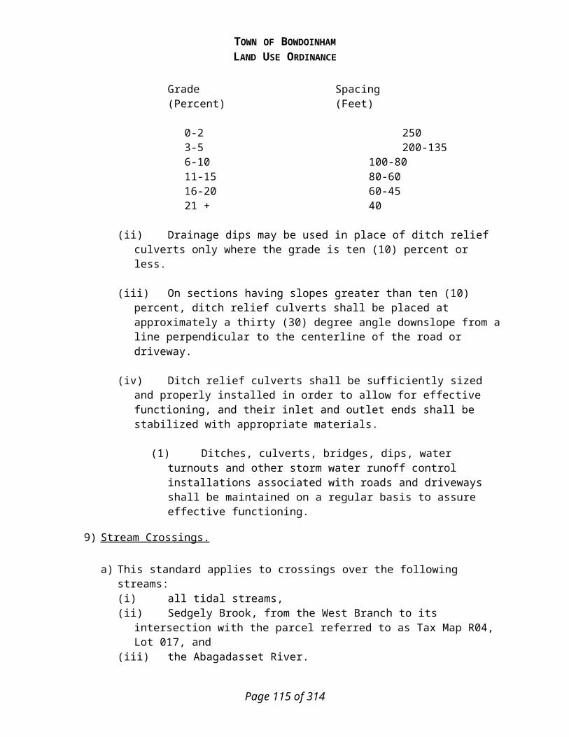
TOWN OF BOWDOINHAMLAND USE ORDINANCE
or approve the application with conditions to ensure all of the standards will be met by the subdivision. The reasons for any conditions shall be stated in the records of the Board.
4) Subdivision Amendment.
a) If the revision involves the creation of additional lots or dwelling units, the procedures for preliminary plan approval shall be followed.
b) If the revision involves only modifications of the approved plan, without the creation of additional lots or dwelling units, the procedures for final plan approval shall be followed.
c) The Board's scope of review shall be limited to those portions of the plan which are proposed to be changed.
a) If the revision involves the creation of additional lots or dwelling units; and the applicant is the developer or the subdivision is less than five years old:(i) the procedures for preliminary plan approval (ii) the scope of review shall be the entire subdivision.
b) If the revision involves the creation of additional lots or dwelling units and the applicant is the purchaser of one of the lots within the subdivision:(i) then the procedures for preliminary plan approval shall be followed and (ii) the scope of review shall be the lots or dwelling units that the application is for and
subdivision’s infrastructure (i.e. road, utilities, fire protection).c) If the revision involves a modification of the approved plan (such as relocation of rights-
of-way, changes of grade by more than 1%, changes in conditions of approval, etc.), without the creation of additional lots or dwelling units:(i) the Code Enforcement Officer shall notify the Planning Board of the proposed
change and the reason for the change. (A) If no Board member objects to the proposed change within seven days, the Code
Enforcement Officer shall issue any approval under this section in writing and shall transmit a copy of the approval to the Board within five days.
(B) If any member of the board objects to the change, a formal plan amendment must be submitted for Planning Board consideration as stated in subsection c, above.
(ii) the Code Enforcement Officer may approve the modifications of a property line, if the proposed lots will meet the standards in Article 5 of this Ordinance.
(A) An amended subdivision plan must be recorded at the registry of deeds and a copy of the recorded plan must be submitted to the Town.
D) Application Submission Requirements
1) Site Inventory & Analysis.
a) The submission must include the following information unless the Planning Board, by formal vote, waives the submission of specific items of information based upon a finding that the information is not needed to determine the optimal utilization of the parcel.
b) Eleven (11) copies of a Site Locus Map drawn at a size adequate to show the relationship of the proposed subdivision to the adjacent properties, and to allow the Board to locate the subdivision within the municipality. The location map shall show: (i) Existing subdivisions in the proximity of the proposed subdivision.
Page 115 of 201

TOWN OF BOWDOINHAMLAND USE ORDINANCE
(ii) Locations and names of existing streets. (iii)An outline of the proposed subdivision and any remaining portion of the owner’s
property if the formal application will cover only a portion of the owner’s entire contiguous holding.
(iv)The Tax Map and Lot number of the parcel proposed to be subdivided.c) Eleven (11) copies of an accurate scale Site Inventory Plan of the parcel at a scale of not
more than fifty (50) feet to the inch showing the existing conditions of the area proposed to be subdivided based upon published sources and showing the following: (i) The proposed name of the development, north arrow (True Meridian), date, and scale. (ii) The boundaries of the parcel based upon a standard boundary survey prepared by a
registered land surveyor and giving the bearings and distances of all property lines. (iii)Existing restrictions or easements on the site (if none, so state). (iv)The general topography of the site including an indication of those areas where the
slope is likely to be greater than 20%. (v) The major natural features of the site and within five hundred (500) feet of the site,
including wetlands, vernal pools, streams, ponds, floodplains, groundwater aquifers, significant wildlife habitats, scenic views or areas, significant geological features, or other important natural features.
(vi)A medium intensity soil survey superimposed on the subdivision plan. The Planning Board may require the submission of a high intensity soils survey with the preliminary plan if it determines that a high intensity survey is needed to evaluate the appropriate use of the property.
(vii) Vegetative cover conditions on the property as depicted on a current aerial photo of the site.
(viii) The general drainage pattern of the site and adjacent areas within five hundred (500) feet of the site.
(ix)Existing buildings, structures, or other improvements on the site including streets, driveways, stone walls, fences, trails, and cemeteries (if none, so state).
(x) Locations of all culturally, historically or archaeologically significant buildings, features, or sites.
(xi)The location and size of existing utilities or improvements servicing the site (if none, so state).
(xii) Any potential sources of fire protection water supply within one half mile of the site including public water mains, existing fire ponds, or possible sources of water supply.
(xiii) The visual character of the site including existing conditions along existing streets, property lines, and water bodies, and the location and nature of scenic views of the parcel and/or from the parcel that should be considered in the design of the subdivision.
d) Eleven (11) copies of a Site Analysis Map at the same scale as the inventory plans (see B above) highlighting the opportunities and constraints of the site in a bubble diagram or annotated format. This map should enable the Planning Board to determine: (i) which portions of the site are unsuitable for development or use (Primary
Conservation Areas); (ii) which areas of the site have potential conservation or open space value (Secondary
Conservation Areas) that should be addressed in the subdivision plan; (iii)which portions of the site are unsuitable for on-site sewage disposal;
Page 116 of 201
TOWN OF BOWDOINHAMLAND USE ORDINANCE
(iv)which areas of the site may be subject to off-site conflicts or concerns (noise, lighting, traffic, etc.); and
(v) which areas are well suited for the proposed use. e) Eleven (11) copies of a Site Analysis Narrative describing the existing conditions of the
site, the constraints and opportunities created by the site, the open space conservation potential of the site, and the proposed development. This submission should include any preliminary studies done relative to the site including wetland delineations, traffic studies, market studies, or other information that will help the Board understand the project.
2) Preliminary Plan.
a) The application for preliminary plan approval shall include eleven (11) copies of the required information.
b) Application Form. (i) Proposed name of the subdivision, or identifying title, and the name of the
municipality in which it is located, plus the assessor's map and lot numbers. (ii) An indication of the type of water supply system(s) to be used in the subdivision.
c) Location Map. The location map shall be drawn at a scale of not more than 500 feet to the inch showing the relationship of the proposed subdivision to the adjacent properties, to allow the Board to locate the subdivision within the Town. The location map shall show: (i) Existing subdivisions within 1000 feet of the proposed subdivision. (ii) Locations and names of existing and proposed streets within 1000 feet. (iii)Boundaries and designations of land use districts within 1000 feet. (iv)An outline of the proposed subdivision and any remaining portion of the owner's
property if the preliminary plan submitted covers only a portion of the owner's entire contiguous holding.
d) Preliminary Plan. The preliminary plan shall be submitted in full-sized copies of one or more maps or drawings or more if requested by the Board, which may be printed or reproduced on paper, with all dimensions shown in feet or decimals of a foot. The preliminary plan shall be drawn to scale of not more than one hundred feet to the inch. The preliminary plan shall have the following: (i) A boundary survey of the parcel, giving complete descriptive data by bearings and
distances, made and certified by a registered land surveyor. The corners of the parcel on the Right of Way shall be located on the ground and marked by monuments. The plan shall indicate the type of monument found or to be set at each lot corner.
(ii) The date the plan was prepared, north point, and graphic map scale. (iii)The names and addresses of the record owner, applicant, and individual or company
who prepared the plan, and adjoining property owners. (iv)A high intensity soil survey, if required by the Board.(v) All wetland areas regardless of size shall be identified on the survey by a soil scientist
or other recognized professional as determined by the Board. (vi)The number of acres within the proposed subdivision, location of property lines,
existing buildings, vegetative cover type, and other essential existing physical features. The location of any trees larger than 24 inches in diameter at breast height shall be noted on the plan. Any contiguous forested area with more than five trees greater than 24 inches in diameter at breast height shall be depicted as a group on the
Page 117 of 201

TOWN OF BOWDOINHAMLAND USE ORDINANCE
plan. On wooded sites, the plan shall indicate the area where clearing for lawns and structures shall be permitted and/or any restrictions to be placed on clearing existing vegetation.
(vii) The area on each lot where existing forest cover will be permitted to be converted to lawn, structures or other cover and any proposed restrictions to be placed on clearing existing vegetation.
(viii) The location of all rivers, streams, brooks, wetlands and vernal pools within or adjacent to the proposed subdivision.
(ix)Contour lines at one or two foot intervals, specified by the Board, showing elevations in relation to mean sea level.
(x) The location and size of existing and proposed sewers, water mains, culverts, and drainage ways on or adjacent to the property to be subdivided.
(xi)The location, names, and present widths of existing streets and highways within 300 feet of any proposed intersection, and existing and proposed easements, building lines, parks and other open spaces on or adjacent to the subdivision. The plan shall contain sufficient data to allow the location, bearing and length of every street line, lot line, and boundary line to be readily determined and be reproduced upon the ground. These lines shall be tied to reference points previously established. In order to facilitate the addition of the subdivision into the municipal property records, this information shall also be made available in a format compatible with the assessor's records.
(xii) The width and location of any streets, public improvements or open space shown upon the official map and the comprehensive plan, if any, within the subdivision.
(xiii) The location of any open space to be preserved. (xiv) All parcels of land proposed to be dedicated to public use and the conditions of
such dedication. (xv) If any portion of the subdivision is in a flood-prone area, the boundaries of any
flood hazard areas and the 100-year flood elevation, as depicted on the municipality's Flood Insurance Rate Map, shall be delineated on the plan.
(xvi) Areas within or adjacent to the proposed subdivision which have been identified as high or moderate value wildlife habitat by the Maine Department of Inland Fisheries and Wildlife or within the comprehensive plan.
(xvii) Areas within or adjacent to the proposed subdivision which have been designated to have a critical natural area by the Maine Natural Areas Program or within the comprehensive plan.
(xviii) A map showing the location of all test pits dug on the site shall be submitted. (xix) The land use district, if any, in which the proposed subdivision is located and the
location of any land use boundaries affecting the subdivision. (xx) The proposed subdivision lot lines and lot areas as well as building envelopes and
setback requirements. (xxi) Any area designated as a site of historic, prehistoric, or archeological importance
by the Comprehensive Plan or the Maine Historic Preservation Commission together with information about the significance of the site.
(xxii) The Board may require additional information to be submitted, where it finds necessary in order to determine whether the criteria of Title 30-A M.R.S.A., §4404 are met.
(xxiii) The location of disposal for land clearing and construction debris. (xxiv) Street plans
Page 118 of 201

TOWN OF BOWDOINHAMLAND USE ORDINANCE
(A) Detailed construction drawings showing a plan view, profile, and typical cross- section of the proposed streets and The plan view shall be at a scale of one-inch equals no more than fifty feet.
(B) The vertical scale of the profile shall be one-inch equals no more than five feet. (C) The plans shall include the following information:
(1) Date, scale, and north point, indicating magnetic or true.(2) Intersections of the proposed street with existing streets.(3) Roadway and right-of-way limits including edge of pavement, edge of
shoulder, sidewalks, and curbs.(4) Kind, size, location, material, profile and cross-section of all existing and
proposed drainage structures and their location with respect to the existing natural waterways and proposed drainage ways.
(5) Complete curve data shall be indicated for all horizontal and vertical curves. (6) Turning radii at all intersections. (7) Centerline gradients. (8) Size, type and locations of all existing and proposed overhead and
underground utilities, to include but not be limited to water, sewer, electricity, telephone, lighting, and cable television.
e) Supporting Documents (i) Verification of right, title, or interest in the property. (ii) A copy of the most recently recorded deed for the parcel. A copy of all deed
restrictions, easements, rights-of-way, or other encumbrances currently affecting the property.
(iii)When water is to be supplied by public water supply, a written statement from the servicing water district shall be submitted indicating that there is adequate supply and pressure for the subdivision and that the district approves the plans for extensions where necessary. Where the district's supply line is to be extended, a written statement from the fire chief, stating approval of the location of fire hydrants, if any, and a written statement from the district approving the design of the extension shall be submitted.
(iv)When water is to be supplied by private wells, evidence of adequate ground water supply and quality shall be submitted by a well driller or a hydrogeologist familiar with the area.
(v) A description of the proposed ownership, improvement and management of all facilities and improvements that will be privately owned and maintained including streets, open space, drainage facilities, and recreational areas or facilities including common docks together with drafts of community association documents if an association will be responsible for the ownership or management of any land or facilities, and a declaration of covenants, conditions, and restrictions meeting the requirements of Appendix 1.
(vi)Written offers to convey title to the municipality of all public open spaces shown on the plan, and copies of agreements or other documents showing the manner in which open spaces to be retained by the applicant or lot owners are to be maintained shall be submitted. If open space or other land is to be offered to the Town, subject to Town Meeting approval, written evidence that the municipal officers are satisfied with the legal conditions and documentation shall be provided.
(vii) The method of disposal for land clearing and construction debris.
Page 119 of 201

TOWN OF BOWDOINHAMLAND USE ORDINANCE
(viii) A hydrogeologic assessment prepared by a certified geologist or registered professional engineer, experienced in hydrogeology, when:(A) Any part of the subdivision is located over a sand and gravel aquifer, as shown on
a map entitled "Hydrogeologic Data for Significant Sand and Gravel Aquifers," by the Maine Geological Survey, 1998, File No. 98-138, 144 and 147; or
(B) The subdivision has an average density of more than one dwelling unit per 100,000 square feet, or
(C) The Board may require a hydrogeologic assessment in other cases where site considerations or development design indicate greater potential of adverse impacts on groundwater quality. These cases include extensive areas of shallow to bedrock soils; or cluster developments in which the average density is less than one dwelling unit per 100,000 square feet but the density of the developed portion is in excess of one dwelling unit per 80,000 square feet; and/or proposed use of shared or common subsurface wastewater disposal systems.
(ix)A storm water management plan, prepared by a licensed professional engineer in accordance with the Stormwater Management for Maine: Best Management Practices, published by the Maine Department of Environmental Protection (1995) or current edition. The Board may waive submission of the storm water management plan when the proposed subdivision will not involve grading which changes drainage patterns and the addition of impervious surfaces such as roofs and driveways is less than 5% of the area of the subdivision.
(x) An erosion and sedimentation control plan, prepared in accordance with the Maine Erosion and Sediment Control Handbook for Construction: Best Management Practices, dated March 2003.
(xi) If any portion of the subdivision is located within an area identified as high or moderate value wildlife habitat by the Maine Department of Inland Fisheries and Wildlife the plan shall indicate appropriate measures for the preservation of the values which qualify the site for such designation.
(xii) If any portion of the subdivision is located within an area designated as a critical natural area by the comprehensive plan or the Maine Natural Areas Program the plan shall indicate appropriate measures for the preservation of the values which qualify the site for such designation.
(xiii) Subsurface wastewater disposal systems test pit analyses, prepared by a Licensed Site Evaluator shall be provided.
(xiv) An estimate of the amount and type of vehicular traffic to be generated on a daily basis and at peak hours. Trip generation rates used shall be taken from Trip Generation Manual, 1991 edition or current edition, published by the Institute of Transportation Engineers. Trip generation rates from other sources may be used if the applicant demonstrates that these sources better reflect local conditions. Planning Board may require a Traffic Impact Study if the proposed subdivision will generate over 100 trips per day.
(xv) A list of infrastructure improvements with cost estimates prior to the sale of lots, that will be completed by a professional experienced in preparing such information, and evidence that the applicant has financial commitments or resources to cover these costs.
(xvi) The applicant shall notify the Road Commissioner, the Fire Chief in writing of the proposed subdivision, the number of dwelling units proposed, the length of roadways, and the size and construction characteristics of any multi-family, commercial or
Page 120 of 201

TOWN OF BOWDOINHAMLAND USE ORDINANCE
industrial buildings. The applicant must submit copies of these written notifications to the Board. The Board shall request that the Fire Chief and Road Commissioner comment upon their ability to service the proposed subdivision and list any concerns they may have.
(xvii) The Board may require additional information to be submitted, where it finds necessary in order to determine whether the criteria of Title 30-A M.R.S.A., §4404 are met.
3) Final Plan.
a) The final plan shall consist of one or more maps or drawings drawn to a scale of not more than one hundred feet to the inch. Eleven (11) copies of the plan shall be submitted. In addition, one copy of the final plan, reduced to a size of 11 by 17 inches, and all accompanying information shall be distributed by the Town Planner to each Board member no less than ten days prior to the meeting.
b) The final plan shall include or be accompanied by all of the Application, Location Map, Preliminary Plan, and Supporting Document Requirements, updated and changes summarized where appropriate.
c) The following notes as appropriate shall appear on the recorded plan: (i) “The developer of the subdivision does not intend to offer the street(s) shown on this
plan for acceptance by the Town Meeting as a public street(s).”(ii) “The Town of Bowdoinham shall not be responsible for the maintenance, repair,
plowing, or similar services for the private road(s) shown on this plan.” (iii) “Any private road shown on this plan shall not be accepted as a public street by the
Town of Bowdoinham unless approved at a duly called Town Meeting.” d) Conditions of Approval. The following notes shall appear on the recording plat of every
plan: (i) “The property shown on this plan may be developed and used only as depicted on this
approved plan. All elements and features of the plan and all representations made by the applicant concerning the development and use of the property which appear in the record of the Planning Board approval are conditions of approval. No change from the conditions of approval is permitted unless an amended plan is submitted and approved under the provisions of this Ordinance governing revisions to approved plans.”
(ii) “No changes, erasures, modifications, or revisions shall be made in this final plan after approval has been given by the Board and endorsed in writing on the plan, unless the revised final plan is first submitted and the Board approves any modifications.”
(iii)“Failure to complete a substantial start of construction of this subdivision within five years of the date of approval and signing of the plan shall render this plan null and void.”
(iv) “The applicant/developer must provide the Town with a signed and sealed letter from a professional engineer, which states that the subdivision road has been constructed to the Town’s Street Design Standards and Street Construction Standards. The Code Enforcement Officer shall not issue a building permit for a lot within the subdivision until this requirement is met.”
Page 121 of 201

TOWN OF BOWDOINHAMLAND USE ORDINANCE
(v) “The applicant/developer must adhere to the following Articles of the Land Use Ordinance: Article 9.E – Final Approval & Filing, Article 9.H – General Provisions, and Article 9.J.1 – Inspections.”
e) Performance Guarantees. The conditions and amount of the performance guarantee shall be determined by the Planning Board with the advice of the Consulting Engineer, Town Manager, Municipal Officers, and/or Town Attorney. (i) Types of Performance Guarantees. The applicant shall provide one of the following
performance guarantees for an amount adequate to cover the total construction costs of all required improvements, taking into account the time span of the construction schedule and the inflation rate for construction costs: (A) An escrow account funded by cash or a certified check payable to the Town of
Bowdoinham and governed by an escrow agreement in a form reviewed by the Town Attorney and acceptable to the Town Manager.
(B) An irrevocable letter of credit from a financial institution in a form reviewed by the Town Attorney and acceptable to the Town Manager.
(ii) Contents of Guarantee. (A) The performance guarantee shall be based on a construction schedule, including
cost estimates for each major phase of construction, taking into account inflation, and provisions for inspections of each phase of construction.
(B) The performance guarantee instrument must specify a date after which the applicant will be in default and the Town shall have access to the funds to finish construction. The performance guarantee may, at the discretion of the Town Manger, provide for partial releases of the performance guarantee amount as specific portions of the required improvements are completed.
(iii)Escrow Account. A cash payment for the establishment of an escrow account shall be made by either a certified check payable to the Town of Bowdoinham or direct deposit into a bank account opened in the name of the Town of Bowdoinham as escrow agent. Any interest earned on the escrowed funds shall be retained by the Town for the intended purposes of the escrow account. Any accumulated, unused interest and escrow funds shall be released consistent with subsection vii ,below of this Ordinance.
(iv)Letter of Credit. An irrevocable letter of credit from a bank or other lending institution shall should be in substantially the form of Appendix 2 to this Ordinance.
(v) Phasing of Development. The Board may approve plans to develop in sections. This may be accomplished by limiting final approval to those lots abutting that section of the proposed subdivision street which is covered by a performance guarantee. When development is phased, road construction shall commence from an existing public way. Final approval of lots in subsequent phases shall be given only upon satisfactory completion of all requirements pertaining to previous phases.
(vi)Duration of Guarantee. The performance guarantee shall remain in force for the entire period during which development of the subdivision occurs (or in the case of default, while the Town pursues its remedies for default) until the guarantee is released by the Town in accordance with subsection vii ,below. If the time frame for constructing the improvements covered by the guarantee is extended, the performance guarantee shall also be extended.
(vii) Release of Guarantee. Prior to the release of any part of the performance guarantee, the Town Manager shall determine to his/her satisfaction that the proposed improvements meet or exceed the design and construction requirements for that
Page 122 of 201

TOWN OF BOWDOINHAMLAND USE ORDINANCE
portion or phase of the subdivision for which the release is requested. The decision of the Town Manager shall be based upon the report of an Engineer obtained by the Town Manager or other engineer retained by the Town, and any other agencies and departments who may be involved.
(viii) Default. If, upon inspection, the Town finds that any of the required improvements have not been constructed in accordance with the plans and specifications filed as part of the application, or have not been completed within any time limit for completion established by the Planning Board, the inspector shall so report in writing to the Town Manager, and the applicant or builder. The Town Manager shall take any steps necessary to preserve the Town’s rights.
(ix) Improvements Guaranteed. Performance guarantees shall be tendered for all improvements required to meet the standards of this ordinance and for the construction of the streets, monumentation, utilities, storm water management facilities, public water systems, pedestrian and bicycle trails, landscaping in open spaces, and erosion and sedimentation control measures, all as determined by the Planning Board.
4) Additional Requirements for Major Subdivisions - Final Plan.
a) A list of construction and maintenance items, with both capital and annual operating cost estimates, prepared by a professional experienced in preparing such information, that must be financed by the municipality, or quasi-municipal districts.
(i) These lists shall include but not be limited to:
(A) Schools, including busing (B) Street maintenance and snow removal (C) Police and fire protection (D) Solid waste disposal (E) Recreation facilities (F) Storm water drainage (G) Water supply
5) Subdivision Amendment.
a) The applicant shall submit ten (10) copies of the following:(i) the approved plan (ii) the proposed revised plan, which shall indicate that it is the revision of a previously
approved and recorded plan and shall show the title of the subdivision and the book and page or cabinet and sheet on which the original plan is recorded at the Registry of Deeds.
(iii)supporting information to allow the Board to make a determination that the proposed revisions meet the standards of this ordinance and the criteria of the statute.
E) Final Approval and Filing
1) Upon findings of fact and determination that all standards in Title 30-A M.R.S.A., §4404, and this ordinance have been met, and upon voting to approve the subdivision, the Board
Page 123 of 201

TOWN OF BOWDOINHAMLAND USE ORDINANCE
shall sign the final plan. The Board shall specify in writing its findings of facts and reasons for any conditions or denial.
2) Recording plat. The Board shall sign one mylar and two paper originals of the final plan. One of the signed paper originals shall be retained by the Board as part of its permanent records. The applicant shall be responsible for recording the signed final plan in the Registry of Deeds. Any subdivision plan not recorded in the Registry of Deeds within ninety days of the date upon which the plan is approved and signed by the Board shall become null and void. Once the final plan is recorded at the Registry of Deeds the applicant shall submit a paper copy of the recorded plan to the Town for the Town’s permanent records.
3) At the time the Board grants final plan approval, it may permit the plan to be divided into two or more sections subject to any conditions the Board deems necessary in order to ensure the orderly development of the plan. If any municipal, quasi-municipal department head, or superintendent of schools notified of the proposed subdivision informs the Board that their department or district does not have adequate capital facilities to service the subdivision, the Board shall require the plan to be divided into two or more sections subject to any conditions the Board deems necessary in order to allow the orderly planning, financing and provision of public services to the subdivision. If the expansion, addition or purchase of the needed facilities is included in the Town's capital improvements program, the time period of the phasing shall be no longer than the time period contained in the capital improvements program for the expansion, addition or purchase.
4) No changes, erasures, modifications, or revisions shall be made in any final plan after approval has been given by the Board and endorsed in writing on the plan, unless the revised final plan is first submitted and the Board approves any modifications, except in accordance with Article 9.H. The Board shall make findings that the revised plan meets the criteria of Title 30-A M.R.S.A., §4404, and the standards of these regulations and this ordinance. In the event that a plan is recorded without complying with this requirement, it shall be considered null and void, and the Board shall institute proceedings to have the plan stricken from the records of the Registry of Deeds.
5) The approval by the Board of a subdivision plan shall not be deemed to constitute or be evidence of any acceptance by the Town of any street, easement, or other open space shown on such plan. When a park, playground, or other recreation area shall have been shown on the plan to be dedicated to the Town, approval of the plan shall not constitute an acceptance by the Town of such areas. The Board shall require the plan to contain appropriate notes to this effect. The Board may also require the filing of a written agreement between the applicant and the municipal officers covering future deed and title dedication, and provision for the cost of grading, development, equipment, and maintenance of any such dedicated area.
6) Failure to complete substantial construction accomplish a substantial start of the subdivision within five years of the date of approval and signing of the plan shall render the plan null and void. Upon determining that a subdivision's approval has expired under this paragraph, the Board shall have a notice placed in the Registry of Deeds to that effect.
F) Approval Criteria
The Planning Board shall consider both these approval criteria and the criteria established by Title 30-A M.R.S.A §4404 in the review of a subdivision, and find that the proposal meets these criteria. The application shall be approved unless it is determined that the applicant has failed to meet one or more of these standards. In all instances, the burden of proof shall be on the
Page 124 of 201

TOWN OF BOWDOINHAMLAND USE ORDINANCE
applicant to produce evidence sufficient to warrant a finding that all applicable criteria have been met. 1) Vehicular Access – The proposed road design will provide for safe access to and egress from
public and private roads.
2) Traffic – The proposed subdivision will not cause unreasonable highway or public road congestion or unsafe conditions with respect to the use of the highways or public roads existing or proposed and, if the proposed subdivision requires driveways or entrances onto a state or state aid highway located outside the urban compact area of a urban compact municipality as defined by Title 23, Section 754, the Department of Transportation has provided documentation indicating that the driveways or entrances conform to Title 23, Section 704 and any rules adopted under that section.
3) Visual Impact – The proposed development will not have an adverse effect on the scenic or natural beauty of the area, including water views and scenic views.
4) Utilities – The proposed development will not impose an unreasonable burden on existing utilities.
5) Water Supply – The proposed subdivision has sufficient water available for the reasonably foreseeable needs of the subdivision.
6) Sewage Disposal – The proposed development will be provided with adequate sewage waste disposal.
7) Fire Protection – The proposed development will have adequate fire protection.
8) Capacity of Applicant – The applicant meets the following criteria:
a) Right, Title and Interest in Property – The applicant has the right, title and interest in the property.
b) Financial Capacity – The applicant has the financial capacity to complete the proposed development.
c) Technical Ability – The applicant has the technical ability to carry out the proposed development.
9) Special Resources –
a) Shoreland – The proposed subdivision will not adversely affect the quality of the water body or unreasonably affect the shoreline of the water body and is in compliance with the Shoreland Zoning provisions of this Ordinance.
b) Floodplain – The proposed subdivision is in compliance with the Floodplain Management provisions of this Ordinance.
c) Wetlands & Waterbodies – The proposed subdivision will not have an undue adverse impact on wetlands and/or waterbodies, to the extent that is practicable.
d) Historic & Archaeological – The proposed subdivision will not have an undue adverse effect on historic and/or archaeological sites.
e) Groundwater – The proposed subdivision will not adversely affect the quality or quantity of groundwater.
f) Wildlife Habitat – The proposed subdivision will not have an undue adverse effect on wildlife habitat.
Page 125 of 201

TOWN OF BOWDOINHAMLAND USE ORDINANCE
g) Natural Areas – The proposed subdivision will not have an undue adverse effect on rare and irreplaceable natural areas.
10) Environmental Impact – The landscape will be preserved in its natural state to the extent that is practical by minimizing tree removal, disturbance of soil and retaining existing vegetation.
11) Solid Waste Management – The proposed development will provide for adequate disposal of solid wastes.
12) Hazardous, Special & Radioactive Materials – The proposed development will handle, store, and use all materials identified as hazardous, special or radioactive in accordance with the standards of Federal and State agencies.
13) Air Quality – The proposed development will not result in undue air pollution or odors.
14) Water Quality – The proposed development will not result in water pollution.
15) Stormwater – The proposed subdivision will provide for adequate stormwater management.
16) Sedimentation & Erosion Control – The proposed subdivision will take adequate measures to prevent soil erosion and the sedimentation of watercourses and waterbodies.
17) Compliance with Ordinances – The proposed subdivision conforms with the provisions of this Land Use Ordinance and other ordinances and regulations of the Town of Bowdoinham.
18) Town Plans & Vision Statements – The proposed subdivision is consistent with the intent of the Town’s Plans, including but not limited to the Comprehensive Plan, Waterfront Plan, and Transportation Vision Statement.
19) Municipal Services – The development will not have an unreasonable adverse impact on municipal services, including municipal road systems, fire department, solid waste program, schools, open spaces, recreational programs and facilities, and other municipal services and facilities.
20) Impact of Adjoining Municipality – For any proposed subdivision that crosses municipal boundaries, the proposed subdivision will not cause unreasonable traffic congestion or unsafe conditions with respect to the use of existing public ways in an adjoining municipality in which part of the subdivision is located.
21) Spaghetti-lots – Any lots in the proposed subdivision which have shore frontage on a river, stream, brook, great pond or coastal wetland shall have a lot depth to shore frontage ratio less than or equal to 5 to 1.
22) Liquidation Harvesting – Timber on the parcel being subdivided has not been harvested in violation of rules adopted pursuant to Title 12, Section 8869, subsection 14.
G) Performance Standards & Design Standards
The performance standards in this article are intended to clarify and expand upon the approval criteria. Compliance with the performance standards of this section shall be considered to be evidence of meeting the appropriate approval criteria. The Planning Board may waive any of the general performance standards based upon a written request of the applicant. A waiver of any
Page 126 of 201

TOWN OF BOWDOINHAMLAND USE ORDINANCE
general performance standard may be granted only if the Board finds that the standard is not required for the proposed project to be in compliance with the approval criteria.
Compliance with the design standards of this section shall be considered to be evidence of meeting the appropriate performance standards. Proposed subdivisions not in compliance with the design standards may be considered, but the applicant shall provide clear and convincing evidence that the proposed design will meet the performance standards.
In all instances, the burden of proof shall be upon the applicant to present adequate information to indicate the statutory criteria for approval and performance standards have been or will be met.
1) Vehicular Access –
a) Performance Standards.(i) At a minimum, provision shall be made for vehicular access to the subdivision and
circulation within the subdivision in such a manner as to: (A) Safeguard against hazards to traffic and pedestrians on existing streets and within
the subdivision.(B) Provide safe and convenient circulation on adjacent public streets and within the
subdivision. (C) Minimize the number of new points of vehicle access onto the existing public
road system. (ii) More specifically, access and circulation shall also conform to the following
standards: (A) Where necessary to safeguard against hazards to traffic and pedestrians and/or to
avoid traffic congestion, provision shall be made for turning lanes, traffic directional islands, frontage roads, sidewalks, bicycle ways, and traffic controls within existing public streets consistent with accepted highway design standards.
(B) Access ways to subdivisions shall be designed to avoid queuing of entering vehicles on any street. Left-lane storage capacity may be provided as needed to meet anticipated demand. A study or analysis to determine the need for a left-turn storage lane may be done.
(C) Where site conditions allow, provision shall be made for the extension of streets to connect with nearby streets and to provide access to adjoining lots of similar existing or potential use. Such interconnected streets shall be designed to discourage use by through traffic.
(iii)Streets shall be named in accordance with the Road Addressing Ordinance. The developer shall either install street name, traffic safety, and control signs meeting Town specifications or reimburse the Town for the costs of their installation. Street lighting shall be installed by the developer as approved by the Board.
(iv)Following street construction, the developer or contractor shall conduct a thorough clean-up of stumps and other debris from the entire street right-of-way. If on-site disposal of the stumps and debris is proposed, the site shall be indicated on the plan, and be suitably covered with fill and topsoil, limed, fertilized, and seeded and identified on the plan.
b) Design Standards (i) Standards for the Layout of Lots and Streets
Page 127 of 201

TOWN OF BOWDOINHAMLAND USE ORDINANCE
(A) The layout of the lots and streets within the subdivision shall minimize the number of points of vehicular access onto existing public streets.
(B) The subdivision shall be laid out so that lots have their vehicular access from internal streets within the subdivision and shall not have direct vehicular access to or from existing public streets unless the size or shape of the parcel being subdivided or site or natural constraints such as wetlands or slopes do not reasonably accommodate a layout that allows access from an internal street or the site inventory and analysis demonstrates that the best utilization of the parcel will require the creation of lots fronting on existing public streets.
(C) If lots are created that have direct vehicle access to or from an existing public street, the number of access points shall be minimized through the use of shared driveways or common access ways.
(D) If shared driveways or common access ways are utilized, the final subdivision plan must contain a note on the final plan limiting vehicle access to these lots to the shared or common access.
(ii) Access Control. Where a lot has frontage on two (2) or more streets, the access to the lot shall be provided across the frontage and to the street where there is lesser potential for traffic congestion and for hazards to traffic and pedestrians. This restriction shall appear as a note on the plan and as a deed restriction for the affected lot.
(iii)Sight Distances. Streets and other accesses shall be located and designed in profile and grading to provide adequate sight distance measured in each direction. (A) Sight distances shall be measured from the driver’s seat of a vehicle standing on
that portion of the exit with the front of the vehicle a minimum of ten (10) feet behind the curb line or edge of shoulder, with the height of the eye 3.5 feet, to the top of an object 4.25 feet above the pavement.
(B) A minimum sight distance of ten (10) feet for each mile per hour of the posted speed limit shall be provided. The Planning Board may require a more or less stringent standard for sight distances depending on the condition of the road, the volume of traffic on a road or other circumstances unique to the property. A more or less stringent standard may be allowed or required only if recommended by a traffic engineer.
(iv)Vertical Alignment. Accesses shall be designed to prevent surface water from draining across the intersection. Accesses shall slope upward or downward from the gutter line at a maximum slope of three percent (3%) for at least seventy-five (75) feet. The maximum grade over the entire length shall not exceed ten percent (10%), except where the Planning Board grants a wavier up to twelve percent (12%). Accesses shall be flat enough to prevent the dragging of any vehicle undercarriage.
(v) Access Layout and Design. The layout and design of the intersection of a proposed street or other access with an existing or proposed public street shall be appropriate for the anticipated use and traffic volume. Any access with a peak hour traffic volume of more than fifty (50) passenger car equivalent trips shall be designed based on a site specific traffic analysis prepared by a traffic engineer.
(vi)Minimum Corner Clearance. Corner clearance shall be measured from the point of tangency of the corner to the point of tangency of the access. Unsignalized intersections shall provide fifty (50) feet of corner clearance; signalized intersections shall provide one hundred and fifty (150) feet of corner clearance.
Page 128 of 201

TOWN OF BOWDOINHAMLAND USE ORDINANCE
(vii) Access Spacing. Accesses and street intersections shall be separated from adjacent accesses or streets, by at least one hundred fifty (150) feet from other residential access and street intersections, and two hundred (200) feet from other commercial accesses and streets. All access and street intersections shall be at least ten (10) feet from a property line.
(viii) Curb Requirements. All accesses entering a curbed street shall be curbed with materials matching the street curbing to a point recommended by the Bowdoinham Road Commissioner. Sloped curbing is required around all raised channelization islands or medians.
(ix)Reserve strips controlling access to streets shall be prohibited except where their control is placed with the municipality.
(x) Where a subdivision borders an existing narrow street (not meeting the right-of-way width requirements of the standards for streets in this ordinance), or when the comprehensive plan indicates plans for realignment or widening of a road that would require use of some of the land in the subdivision, the plan shall indicate reserved areas for widening or realigning the road marked “Reserved for Road Realignment (Widening) Purposes.” Land reserved for such purposes may not be included in computing lot area or setback requirements of the zoning ordinance. When such widening or realignment is included in the municipality’s capital investment plan, the reserve area shall not be included in any lot.
(xi)Any subdivision containing more than fifteen (15) dwelling units or lots, shall have at least two (2) street connections with existing public streets, streets shown on an Official Map, or streets on an approved subdivision plan for which performance guarantees have been filed and accepted.
(xii) The centerline of the roadway shall be the centerline of the right-of-way. (xiii) Where street lengths exceed one thousand (1,000) feet between intersections with
other streets, the Board may require a utility/pedestrian easement, at least twenty (20) feet in width, to provide for underground utility crossings and/or a pedestrian pathway of at least five (5) feet in width, constructed in accordance with design standards in this section. Maintenance obligations of the easement shall be included in the written description of the easement.
(xiv) Dead-End Streets. (A) Dead-end streets shall be constructed to provide a cul-de-sac turnaround or other
turnaround approved by the Road Commissioner and the Fire Chief. (B) The turnaround shall be designed to accommodate the largest vehicle that may
use the roadway, including but not limited to school buses and emergency vehicles.
(C) The Board may also require the reservation of a fifty-foot easement in line with the street to provide continuation of the road where future subdivision is possible.
(D) If a hammerhead or T-turnaround is approved, no driveways shall enter onto the turnaround and each leg will measure fifty (50) feet.
(E) A dead-end street shall be limited to a maximum of fifteen (15) dwelling units (not including corner lots that gain their access from another street).
(F) The length of a dead-end shall not exceed one thousand five hundred (1,500) feet. (xv) Sidewalks.
(A) Sidewalks are required if connection to an existing sidewalk is feasible.
Page 129 of 201

TOWN OF BOWDOINHAMLAND USE ORDINANCE
(B) Sidewalks are required for streets carrying more than one hundred fifty (150) trips a day or to a distance within the subdivision as deemed appropriate by the Planning Board.
(C) The Planning Board may permit sidewalks on one side of the street or may waive the requirement for sidewalks if the Board finds that there are adequate alternative provisions for pedestrians outside of the roadway or the right-of-way or that the scale of the project makes sidewalks unnecessary on one or both sides.
(xvi) Curbs shall be installed wherever needed to control storm water drainage or vehicle movement. The specified traveled way width shall be measured between the curbs.
(xvii) The Street Design Standards are as follows:
Page 130 of 201
Street Design StandardsMinor Major
Description: Subdivision Subdivision 1 Minimum Right-of-Way Width 50 ft. 50 ft.
Minimum Traveled Way (Pavement) 18 ft. 22 ft. Sidewalk Width NA 5 ft. Minimum Grade 1% 2% Maximum Grade2 10% 10%Minimum Centerline Radius 100 ft. 150 ft. Minimum Tangent between Reverse Curves 75 ft 100 ftRoadway Crown 1/4”/ft. 1/4”/ft. Minimum Shoulder Width 3 2 ft. 3ft. Minimum angle of street intersections 60 60 Maximum grade at intersection 3% for 75’ 3% for 100’Minimum curb radii at intersections 15 ft. 20 ft. Minimum ROW radii at intersections 10 ft. 25 ft. Aggregate Sub base Course 12” 15” Crushed Aggregate Base Course3 3” 4” Hot Bituminous Pavement Base Course (a)3 2” 2” Hot Bituminous Pavement Surface Course (b)3 1” 1”
Bituminous Sidewalks NA 2”

TOWN OF BOWDOINHAMLAND USE ORDINANCE
1 The road shall be constructed to the standards for a Major Subdivision where the road serves 6 or more dwelling units. The road standards may be reduced to the Minor Subdivision standards where the road only serves 5 or less dwelling units.
2 The maximum grade be may increased up to 12% for a distance of 150 feet or less with a waiver from the Planning Board.
3 If the Planning Board waives the requirement for the road to be paved, then the requirement for crushed aggregate base shall be increased by 4 inches.
(xviii) Street Construction Standards(A) The minimum thickness of material after reaching ninety-five percent (95%) of
modified Proctor maximum density shall meet the specifications in below.
Page 131 of 201

TOWN OF BOWDOINHAMLAND USE ORDINANCE
Minimum Pavement Materials Thicknesses
1 If the Planning Board waives the requirement for the road to be paved, then this requirement for crushed aggregate base shall be increased by 4 inches.
(B) Bases and Pavement (1) The Aggregate Subbase Course shall be sand or gravel of hard durable
particles free from vegetative matter, lumps, or balls of clay and other deleterious substances. The gradation of the part that passes a three-inch (3") square mesh sieve shall meet the grading requirements below.
(2) An Aggregate Base Course shall be placed on top of the subbase course. The Aggregate Base Course shall be screened or crushed gravel of hard durable particles free from vegetative matter, lumps, or balls of clay and other
Page 132 of 201
Minor Subdivision
MajorSubdivision
Aggregate Subbase Course 12" 15" (Max. sized stone 6") Crushed Aggregate Base Course1 3" 4"
Hot Bituminous Pavement1
Total Thickness 3" 3" Surface Course 1" 1" (MeDOT 403.210 Superpave Mix 3/8” [9.5mm]) Base Course 2" 2" (MeDOT 403.207 Superpave Mix 3/4” [19mm])*
Aggregate Subbase Grading Requirements
Sieve Designation Percentage by Weight Passing Square Mesh Sieves
1/4 inch 25-70% No. 40 0-30% No. 200 Aggregate for the subbase shall contain no particles of rock exceeding six inches in any dimension
0-7%

TOWN OF BOWDOINHAMLAND USE ORDINANCE
deleterious substances. The gradation of the part that passes a three-inch (3") square mesh sieve shall meet the grading requirements of below.
(3) Pavement Joints. Where pavement joins an existing pavement, the existing pavement shall be cut along a smooth line to form a neat, even, vertical joint.
(4) Pavements.a. Minimum standards for the base layer of pavement shall be the Maine
Department of Transportation Specifications for plant mix grade B with an aggregate size no more than 1 inch maximum and a liquid asphalt content between 4.8% and 6.0% by weight depending on aggregate characteristics. The pavement may be placed between April 15 and November 15, provided the air temperature in the shade at the paving location is 35°F or higher and the surface to be paved is not frozen or unreasonably wet.
b. Minimum standards for the surface layer of pavement shall be the Maine Department of Transportation Specifications for plant mix grade C or D with an aggregate size no more than 3/4 inch maximum and a liquid asphalt content between 5.8% and 7.0% by weight depending on aggregate characteristics. The pavement may be placed between April 15 and October 15, provided the air temperature in the shade at the paving location is 50°F or higher.
c) Standards for Public Streets
Any street within the subdivision that is proposed for acceptance as a public street by the Town shall conform to the following standards:
(i) Designation as Potential Public Streets. All submissions must clearly indicate if any streets within the subdivision are being proposed as potential public streets. The final plan must clearly indicate which streets or portions of streets are potential public streets. The final plan shall include a note similar to the following:
Page 133 of 201
Base Course Grading Requirements
Sieve Designation Percentage by Weight Passing Square Mesh Sieves
1/2 inch 45-70% 1/4 inch 30-55% No. 50 0-20% No. 200
Aggregate for the base shall contain no particles of rock exceeding two inches in any dimension
0-5%

TOWN OF BOWDOINHAMLAND USE ORDINANCE
(A) “Street is proposed to be a public street and will be offered to the Town for acceptance by Town Meeting as a public street. Until ______ Street is accepted by the Town as a public street or the ownership of the street has been transferred to a homeowners association, (applicant) will be responsible for the maintenance of the street. The Town of Bowdoinham shall not be responsible for any maintenance of _____ Street until, and unless, it is accepted by the Town as a public street.”
(ii) Design and Construction Standards.
A proposed public street must conform to the design and construction standards for a private street as set forth in Article 9.G.1.b except as follows: (A) The minimum traveled way (pavement) width set out in Article 9.G.1.b.xvii,
Street Design Standards shall be increased to twenty (20) feet for proposed public streets in a minor subdivision and to twenty-four (24) feet for proposed public streets in a major subdivision.
(B) The total thickness of the bituminous pavement for minor subdivision roads and all other roads as set out in Article 9.G.1.b.xvii-Minimum Pavement Materials Thickness shall be increased to four inches (4”). The thickness of the base course shall be increased to 2.5” and the thickness of the pavement course increased to 1.5”.
(C) If the applicant requests a waiver of the bituminous pavement requirement, then the Planning Board shall consult the Road Commissioner in determining whether or not the waiver should be granted. The Road Commissioner shall give the reasons for his/her decision in writing. The Planning Board shall not grant the wavier without receiving the support of the Road Commissioner in writing.
d) Maintenance Guarantee.(i) Prior to the release of the approved subdivision plan to the applicant by the Town,
the applicant shall provide the Town Manager with documentation that a maintenance guarantee escrow account has been established to assure the maintenance of any proposed streets by the applicant until the streets are turned over to a home owners association or accepted as a public. The escrow account is intended to assure that appropriate summer and winter maintenance will be done by the applicant until they are deeded to the association or the Town, or to provide funds for the Town to do the maintenance if the applicant does not.
(ii) The escrow account shall be established in accordance with Article 9.D.3.e.iii and approved by the Town Manager with the advice of the Road Commissioner. The account shall provide that the applicant may withdraw funds from the account only with the written approval of the Town Manager and only to pay for prior expenditures related to the maintenance of the streets. The escrow account shall also allow the Town to withdraw funds from the account to pay for maintenance done by the Town after failure by the applicant to meet his obligation to maintain the road.
(iii)If the applicant fails to maintain the private street, the Town may provide the same level of summer and winter maintenance that it provides to public streets upon twenty-four (24) hours written notice to the applicant and may withdraw funds from the escrow account to cover its costs for labor, equipment, and materials to provide the maintenance. If the Town uses this cost recovery provision, it shall provide the
Page 134 of 201

TOWN OF BOWDOINHAMLAND USE ORDINANCE
applicant with a written accounting of the work performed, costs, and withdrawals from the escrow account.
(iv)The escrow account shall remain in effect until the proposed street is either accepted by the Town as a public street or turned over to a homeowners association that will be responsible for its maintenance. The transfer of ownership and the maintenance responsibility to the homeowners must be approved by the Planning Board prior to the release of the escrow account. Any balance remaining in the account when the street is accepted or turned over to the homeowners shall be refunded to the applicant.
(v) The amount of the initial escrow account shall be the estimated cost of providing winter and summer maintenance for the proposed street for a period of three (3) years if it is located in a major subdivision or two (2) years if located in a minor subdivision. The amount of the account must be approved in writing by the Town Manager with the advice of the Road Commissioner.
(vi) If the applicant makes an offer of dedication of the public streets to the Town and the Town Meeting does not approve the acceptance of the streets or if the applicant does not make an offer of dedication within five years, the applicant must establish a homeowners association if one does not exist and must turn over the ownership and maintenance responsibility to the association within ninety (90) days of the Town Meeting’s action or the expiration of the five (5) years.
2) Traffic –
The proposed subdivision will not cause unreasonable highway or public road congestion or unsafe conditions with respect to the use of the highways or public roads existing or proposed and, if the proposed subdivision requires driveways or entrances onto a state or state aid highway located outside the urban compact area of a urban compact municipality as defined by Title 23, Section 754, the Department of Transportation has provided documentation indicating that the driveways or entrances conform to Title 23, Section 704 and any rules adopted under that section.
a) Performance Standards.
(i) The street providing access to the subdivision and neighboring streets and the first intersection(s), or an intersection within two thousand (2,000) feet of the street providing access to the subdivision, whichever is less, which can be expected to carry traffic generated by the subdivision shall have the capacity or be suitably improved to accommodate that traffic and avoid unreasonable congestion. Intersections on major access routes to the site which are functioning at a Level of Service C (see definition) or better prior to the development will function at a minimum of Level of Service C after development. If any intersection is functioning at a Level of Service D or lower prior to the development, the project will not reduce the current level of service.
The Planning Board may approve a subdivision not meeting this requirement if the applicant demonstrates that: (A) A public agency has committed funds to construct improvements necessary to
bring or maintain the level of service at this standard, or
(B) The applicant will assume the financial responsibility for the improvements necessary to maintain or bring the level of service to the applicable standard and will assure the completion of the improvements with a financial guarantee acceptable to the Town.
Page 135 of 201

TOWN OF BOWDOINHAMLAND USE ORDINANCE
2) Visual Impact –
a) Performance Standards.(i) When the proposed subdivision is located on a hillside that is visible from a public
street, water body, or public facility, the subdivision must be designed so that it fits harmoniously into the visual environment when viewed by the public from public areas.
(ii) In predominantly natural environments, site clearing must be minimized and vegetation must be retained or provided to minimize the visual intrusion of the development.
(iii)The plan shall, by notes on the final plan and deed restrictions, limit the clearing of trees to those areas designated on the plan.
(iv) When a proposed subdivision is located within a scenic view-shed, the subdivision must be designed to minimize the encroachment of all buildings, structures, landscaping, and other site features on the scenic view.
b) Design Standards.(i) The Planning Board may require a landscaping plan that includes street trees to be
planted no more than 50 feet apart. (ii) Subdivisions within the Rural Residential Districts shall maintain any existing
vegetated buffer along existing roads. The buffer may be broken only for driveways and streets.
(iii)Where practical the subdivision shall be designed to encourage locating buildings within forested areas and to discourage locating buildings in open fields visible from existing public roads.
(iv)Subdivisions should be buffered from adjacent properties where feasible. The subdivision plan should demonstrate how this will be accomplished. If necessary, the Planning Board may require the establishment of a natural or landscaped buffer to reduce the impacts of the subdivision on adjacent buildings or uses, including agriculture, as well as the impacts of the adjacent uses on the subdivision.
3) Utilities –
a) The subdivision must be provided with adequate electrical, telephone, and telecommunication service. New utility lines and facilities must be screened from view to the extent feasible.
b) Utilities serving subdivisions shall be installed underground, in order to minimize the visual impact of the subdivision. The Board may approve overhead utilities when the applicant provides evidence that the increased costs of underground utilities will raise the costs of the housing beyond the market in that location. When utilities are installed underground, the subdivider shall install appropriate signs indicating the location of such utilities.
(i) The Board may approve overhead utilities when the applicant provides evidence that:
(A) the increased costs of underground utilities will raise the costs of the housing beyond the market in that location and
(B) overhead utilities will not have an undue visual impact due to the setting of the subdivision.
(ii) When utilities are installed underground, the subdivider shall install appropriate signs indicating the location of such utilities.
4) Water Supply –
Page 136 of 201

TOWN OF BOWDOINHAMLAND USE ORDINANCE
a) Water Quality. Water supplies shall meet the primary drinking water standards contained in the Maine Rules Relating to Drinking Water. If existing water quality contains contaminants in excess of the secondary drinking water standards in the Maine Rules Relating to Drinking Water, that fact shall be disclosed in a note on the plan to be recorded in the Registry of Deeds.
b) Public Water Supply.
(i) The subdivision shall connect to the public water system if the subdivision meets the following parameters:
Number of Lots Distance from Existing Water Main to Property1
3 300 feet4 400 feet5 500 feetFor each additional lot Add 100 feet
1The distance shall be measured along the road from the nearest water main to the property boundary, including the distance to cross the road if necessary.
(ii) The proposed subdivision will not cause an unreasonable burden on an existing water supply.
(iii)The servicing water district shall review and approve in writing the overall system design, size and location of mains, gate valves, hydrants, and service connections.
(iv)A proposed subdivision shall not generate a demand on the source, treatment facilities, or distribution system of the Consumers Maine Water Company or the Bowdoinham Water District beyond the capacity of those system components, considering improvements that are planned to be in place prior to occupancy of the subdivision.
(v) The applicant shall be responsible for paying the costs of improvements to the supplier’s system as necessary to alleviate any deficiencies or expand the capacity of the system needed to service the subdivision.
(vi)The complete water supply system within the subdivision, including fire hydrants and laterals to the property line of each lot created shall be installed at the expense of the applicant.
(vii) Once the completed system has been installed and successfully tested by the servicing water district it will be deeded to the servicing water district at no cost, along with any easements necessary to permit maintenance or repair in the future.
c) Private Water Supply.
(i) The water supply shall be from individual wells or a private community water system.
(ii) Individual wells shall be sited and constructed to prevent infiltration of surface water and contamination from subsurface wastewater disposal systems and other sources of potential contamination.
(iii)Lot design shall permit placement of wells, subsurface wastewater disposal areas, and where required, reserve sites for subsurface wastewater disposal areas in compliance
Page 137 of 201

TOWN OF BOWDOINHAMLAND USE ORDINANCE
with the Maine Subsurface Wastewater Disposal Rules, the Well Drillers and Pump Installers Rules, and the Bowdoinham Building Code Ordinance.
(iv) If a central water supply system is provided by the applicant, the location and protection of the source and the design, construction, and operation of the system shall conform to the standards of the Maine Rules Relating to Drinking Water (10-144A C.M.R. 231).
(v) Design Standards.
(A) Dug wells shall not be constructed within one hundred (100) feet of the edge of the pavement of any street, if located downhill from the street. In no case shall a dug well be located within fifty (50) feet of the edge of the pavement of any street, if located uphill of the street. This restriction shall be included as a note on the plan and included in deed restrictions for the affected lots.
(B) The Planning Board may require the applicant to demonstrate that a potable water supply of at least three hundred and fifty (350) gallons/day can be obtained.
5) Sewage Disposal –
a) The development must be provided with a method of disposing of sewage which is in compliance with the State Plumbing Code and the Subsurface Wastewater Disposal Rules.
b) The applicant shall submit evidence of site suitability for subsurface sewage disposal prepared by a Maine Licensed Site Evaluator in full compliance with the requirements of the State of Maine Subsurface Wastewater Disposal Rules. (i) The site evaluator shall certify in writing that all test pits which meet the
requirements for a new system represent an area large enough for a disposal area on soils which meet the Disposal Rules.
c) A second site with suitable soils shall be shown as a reserve area for future replacement of the disposal area if the limiting factor has been identified as being within eighteen (18) inches of the surface.
d) In no instance shall a disposal area be constructed on class D soils. e) When two (2) or more lots or buildings in different ownership share the use of a common
subsurface disposal system, the system must be owned and maintained in common by an owners' association. Covenants in the deeds for each lot must require mandatory membership in the association and provide for adequate funding of the association to assure proper maintenance of the system.
6) Fire Protection –
a) In areas where the Planning Board determines, based upon the written recommendation of the Fire Chief or his/her designee, where a reliable water supply for fire fighting purposes is not available within one-half mile of the site, the subdivider shall be responsible for providing an adequate water supply for fire protection.
b) Acceptable methods include, but are not limited to, fire ponds, other water sources or underground storage. An easement shall be granted to the Town for access to and maintenance of dry hydrants or reservoirs where necessary.
c) Design Standards.
(i) If fire hydrants connected to a public water supply system are provided, they shall be located in accordance with the standards of the Fire Department and the standards of
Page 138 of 201

TOWN OF BOWDOINHAMLAND USE ORDINANCE
the water district and each location shall be approved in writing by the Fire Chief or his/her designee.
(ii) Where fire ponds are built for fire protection, a minimum storage capacity of ten thousand (10,000) gallons plus additional storage of two thousand (2,000) gallons per lot or principal building or such other amount as required by the Fire Chief shall be provided. The Planning Board may approve an alternate storage capacity based on the fire flow calculation of the current NFPA requirements and as approved by the Fire Chief.
(iii)Where fire ponds are proposed for water storage, the capacity of the pond shall be calculated based on the lowest projected water level less an equivalent of three (3) feet of ice.
(iv)A detailed plan of the required pond, dry hydrant, piping, and/or access road shall be submitted as part of the application. The Fire Chief shall approve the design of all storage facilities.
(v) Hydrants or other provisions for fire protection water supply shall meet the specifications of the Fire Department and the current NFPA requirements. The design of hydrants shall be approved by the Fire Chief or his/her designee. The minimum pipe size connecting dry hydrants to ponds or underground storage shall be eight (8) inches.
(vi)Where a dry hydrant or other water source is not within the right-of-way of an existing public street, an easement shall be provided to the Town for access to, maintenance, and use of the dry hydrant or reservoir. A suitable access way to the hydrant or other water source shall be constructed by the applicant. It shall be built to standards approved by the Fire Chief. Once the hydrant is constructed and the easement accepted by the Town, the Town shall be responsible for the inspection. The maintenance of the access, hydrant and water source shall be subject to subsection a below.
(A) The applicant and/or homeowners association shall be responsible for the maintenance of the access way, hydrant and fire protection water supply following its installation. The Fire Department will be responsible for inspecting the access, hydrant and fire protection water supply to ensure safe working order, however if the Fire Chief determines that any improvements are necessary, then the applicant and/or homeowners association shall be responsible for any improvements.
7) Financial Capacity – a) Estimated Costs. The applicant shall specify the estimated cost of the development and
itemize the estimated major expenses, including the projected cost of measures taken to minimize or prevent adverse effects on the environment during construction and operation. The itemization of major costs may include, but is not limited to, the cost of the following activities: land purchase, roads, utilities, erosion control, pollution abatement and landscaping.
b) The Applicant shall provide one of the following unless otherwise approved by the Board: (i) Letter of Commitment to Fund: A letter of commitment acceptable to the Board from
a financial institution, governmental agency, or other funding agency indicating a
Page 139 of 201

TOWN OF BOWDOINHAMLAND USE ORDINANCE
commitment to provide a specified amount of funds, and specifying how those funds will be used.
(ii) Self-Financing (A) Annual Report: The most recent corporate annual report indicating availability of
liquid assets to finance the development together with explanatory material interpreting the report; or
(B) Bank Statements: Copies of bank statements or other evidence indicating availability of funds if the applicant will personally finance the development.
8) Technical Ability – a) The applicant shall retain qualified contractors and consultants to supervise, construct,
and inspect the required improvements in the proposed subdivision. b) In determining the applicant’s technical ability, the Board shall consider the applicant’s
previous experience, the experience and training of the applicant’s consultants and contractors, and the existence of violations of previous approvals involving the applicant, consultants, contractors, or other agents of the applicant.
9) Shoreland –
a) Any subdivision shall be in conformance with the Shoreland Zoning provisions Article 5 and Article 7 of this Ordinance.
b) Whenever situated entirely or partially within the watershed of any pond or lake or within 250 feet of any wetland, great pond or river as defined in Title 38, chapter 3, subchapter I, article 2B, the proposed subdivision will not adversely affect the quality of that body of water or unreasonably affect the shoreline of that body of water.
c) When lots in a subdivision have frontage on an outstanding river segment, the proposed subdivision plan must require principal structures to have a combined lot shore frontage and setback from the normal high-water mark of 500 feet.
(i) To avoid circumventing the intent of this provision, whenever a proposed subdivision adjoins a shoreland strip narrower than 250 feet which is not lotted, the proposed subdivision shall be reviewed as if lot lines extended to the shore.
(ii) The frontage and set-back provisions of this paragraph do not apply either within areas zoned as general development or its equivalent under shoreland zoning, Title 38, chapter 3, subchapter I, article 2-B, or within areas designated by ordinance as densely developed. The determination of which areas are densely developed must be based on a finding that existing development met the definitional requirements of section 4401, subsection1, on September 23, 1983.
d) When a proposed subdivision is immediately visible from a great pond, river, or stream, the development must be designed so that it fits harmoniously into the visual environment when viewed from the water body. In predominantly natural environments, site clearing must be minimized, natural vegetation must be maintained adjacent to the shoreline to soften the appearance of the development, and vegetation must be retained or provided to minimize the visual intrusion of the development. In developed shoreland environments, the appearance of the new development when viewed from the water must be compatible with the existing visual character in terms of scale, massing, and height to the maximum extent possible. Storage and service areas must be screened or landscaped to minimize their visual impact.
Page 140 of 201
TOWN OF BOWDOINHAMLAND USE ORDINANCE
e) The subdivision plan must provide for access to abutting navigable water bodies for the use of the occupants of the development as appropriate.
f) Provisions must be included in the design and layout of the subdivision to avoid the proliferation of individual docks if the subdivision is adjacent to a navigable water body. If the location of the subdivision makes it likely that docking facilities will be developed, the plan must provide for not more than one “common dock” including appropriate provisions for access and parking, if needed, for the residents of the subdivision unless the Planning Board approves one or more additional common docks based upon the size or layout of the subdivision. The final plan for the subdivision must contain a condition that prohibits the installation of private docks unless specifically approved by the Planning Board. The Planning Board may approve one or more private docks only if it finds that the provision of a common dock will have a greater impact on the shoreline and the water body.
10) Floodplain –
a) The proposed subdivision is in compliance with the Floodplain Management provisions of Article 8 of this Ordinance.
b) All such proposals are consistent with the need to minimize flood damage.
c) All public utilities and facilities, such as sewer, gas, electrical and water systems are located and constructed to minimize or eliminate flood damages.
d) Adequate drainage is provided so as to reduce exposure to flood hazards.e) All proposals include base flood elevations, flood boundaries, and, in a riverine
floodplain, floodway data. These determinations shall be based on engineering practices recognized by the Federal Emergency Management Agency.
f) Any proposed development plan must include a condition of plan approval requiring that structures on any lot in the development having any portion of its land within a Special Flood Hazard Area, are to be constructed in accordance with Article VI of this ordinance. Such requirement will be included in any deed, lease, purchase and sale agreement, or document transferring or expressing an intent to transfer any interest in real estate or structure, including but not limited to a time-share interest. The condition shall clearly articulate that the municipality may enforce any violation of the construction requirement and that fact shall also be included in the deed or any other document previously described. The construction requirement shall also be clearly stated on any map, plat, or plan to be signed by the Planning Board or local reviewing authority as part of the approval process.
11) Wetlands & Waterbodies –
a) The subdivision must not adversely affect the water quality or shoreline of any adjacent water body, to the extent practicable.
b) Activities within 250 feet of vernal pools shall meet requirements set by Maine Department of Environmental Protection’s Natural Resources Protection Act.
12) Historic & Archaeological –
a) If any portion of the site has been identified as containing historic or archaeological resources by Maine Historic Preservation Commission, the development must include appropriate measures for protecting these resources, including but not limited to,
Page 141 of 201
TOWN OF BOWDOINHAMLAND USE ORDINANCE
modification of the proposed design of the site, timing of construction, and limiting the extent of excavation.
b) Proposed subdivisions which include or are adjacent to buildings or sites on the National Register of Historic Places or which the comprehensive plan has identified as being of historical significance shall be designed in such a manner as to minimize the impacts on the historic features. When the historic features to be protected include buildings, the placement and the architectural design of new structures in the subdivision shall be similar to the historic structures. The Board may require the applicant to seek the advice of the Maine Historic Preservation Commission.
13) Groundwater –
a) Projects that involve on-site water supply or sewage disposal systems with a total capacity of two thousand (2,000) gallons per day or greater must demonstrate that the groundwater at the property line will comply with the standards for safe drinking water as established by the State of Maine.
b) Ground Water Quality (i) No subdivision shall increase any contaminant concentration in the ground water to
more than one-half of the Primary Drinking Water Standards. No subdivision shall increase any contaminant concentration in the ground water to more than the Secondary Drinking Water Standards.
(ii) If ground water contains contaminants in excess of the primary standards, and the subdivision is to be served by on-site ground water supplies, the applicant shall demonstrate how water quality will be improved or treated.
(iii)If ground water contains contaminants in excess of the secondary standards, the subdivision shall not cause the concentration of the parameters in question to exceed one hundred and fifty percent (150%) of the ambient concentration.
(iv)When a hydrogeologic assessment is submitted, the assessment may contain any of the following information at the request of the Planning Board: (A) A map showing the basic soils types. (B) The depth to the water table at representative points throughout the subdivision. (C) Drainage conditions throughout the subdivision. (D) Data on the existing ground water quality, either from test wells in the
subdivision or from existing wells on neighboring properties. (E) An analysis and evaluation of the effect of the subdivision on ground water
resources. In the case of residential developments, the evaluation shall, at a minimum, include a projection of post-development nitrate-nitrogen concentrations at any wells within the subdivision, or at the subdivision boundaries; or at a distance of one thousand (1,000) feet from potential contamination sources, whichever is a shortest distance.
(F) A map showing the location of any subsurface wastewater disposal systems and drinking water wells within the subdivision and within two hundred (200) feet of the subdivision boundaries.
(G) The location of the proposed subsurface wastewater systems and the well exclusion area shall be shown on the Recording Plat.
(v) Projections of ground water quality shall be based on the assumption of drought conditions (assuming sixty percent (60%) of annual average precipitation).
(vi)Subsurface wastewater disposal systems and drinking water wells shall be constructed as shown on the map submitted with the assessment. If construction
Page 142 of 201

TOWN OF BOWDOINHAMLAND USE ORDINANCE
standards for drinking water wells or other measures to reduce ground water contamination and protect drinking water supplies are recommended in the assessment, those standards shall be included as a note on the final plan, and as restrictions in the deeds to the affected lots.
c) Ground Water Quantity (i) Ground water withdrawals by a proposed subdivision utilizing an association well
shall not lower the water table beyond the boundaries of the subdivision.
14) Wildlife Habitat –
a) Performance Standard
(i) If any portion of a proposed subdivision lies within areas identified and mapped by the Department of Inland Fisheries and Wildlife, the applicant shall demonstrate that there shall be minimal impacts on the habitat and species it supports. The plan shall provide for protection of the identified resource in a manner acceptable to the Maine Department of Inland Fisheries and Wildlife or in accordance with the recommendations of a wildlife biologist with demonstrated experience with the wildlife resource being impacted and approved by the Board. In the latter situation, the report prepared by the wildlife biologist shall assess the potential impact of the subdivision on the significant habitat and adjacent areas that are important to the maintenance of the affected species and shall describe appropriate mitigation measures to ensure that the subdivision will have minimal impacts on the habitat and the species it supports. These areas include:
(A) Habitat for species appearing on the official state or federal lists of endangered or threatened species;
(B) High and moderate value waterfowl habitats, including nesting and feeding areas; or
(C) A high or moderate value deer wintering area.
b) Design Standard
(i) The following standards are designed to protect the significant wildlife resources identified in the Town. The Board recognizes that wildlife management must take into account many site-specific variables. Applicants proposing to subdivide land within identified wildlife resources must consult with the Maine Department of Inland Fisheries and Wildlife or a qualified wildlife biologist and provide their written comments to the Board. The guidelines of this section shall apply to only those subdivisions which include significant wildlife habitat or resources identified above.
(ii) The habitat of species appearing on the official state or federal lists of endangered or threatened species shall be maintained in common space.
(iii)Deed restrictions and notes on the plan shall reflect standards from the Department of Inland Fisheries and Wildlife for removal of vegetation within two hundred and fifty (250) feet of the habitat for species appearing on the list of endangered or threatened species unless the Maine Department of Inland Fisheries and Wildlife has approved cutting of vegetation in writing.
Page 143 of 201

TOWN OF BOWDOINHAMLAND USE ORDINANCE
(iv)There shall be no cutting of vegetation within the strip of land extending seventy-five (75) feet inland from the normal high-water mark or upland limit of wetland of high and moderate value waterfowl habitats, including nesting and feeding areas, unless the Maine Department of Inland Fisheries and Wildlife has approved such cutting of vegetation in writing. This restriction shall appear as a note on the plan and as a deed restriction to the affected lots.
(v) Protection of Deer Wintering Area. The report prepared by a wildlife biologist, shall include a management plan for deer wintering areas.
(vi) If the proposed subdivision includes other important wildlife habitat as identified by the Department of Inland Fisheries and Wildlife or the comprehensive plan, the restrictions on activities in and around these areas shall be reviewed by the Department or a qualified wildlife biologist, and their comments presented in writing to the Board.
15) Natural Areas –
a) If any portion of the subdivision is located within an area designated as a unique natural area by the Comprehensive Plan or the Maine Natural Areas Program, the plan shall indicate appropriate measures for the preservation of the values which qualify the site for such designation, including but not limited to, modification of the proposed design of the site, timing of construction, and limiting the extent of excavation. The Board may require the applicant to seek the advice of the Maine Natural Areas Program.
b) The Planning Board may require a survey from a qualified professional of the area in question if it has not been previously surveyed.
16) Open Space –
a) A major or minor subdivision shall reserve a portion of the parcel, per the requirements of the district, as common open space.
b) There are three components to planning for common open space:
(i) determining the total area required,
(ii) determining the actual part(s) of the parcel that will be set aside as common open space, and
(iii)determining ownership of the common open space.
c) The placement of common open space shall be determined by following the Four Step Planning Process outlined in Appendix 4.
d) The applicant’s plan for the ownership of the common open space must be indicated in the subdivision plan. The common open space may be owned by:
(i) a homeowner association,
(ii) a land trust or conservation organization, or
(iii) the owner of the property at the time of the subdivision.
e) The common open space must be permanently protected by appropriate conservation easements or deed restrictions or other legally binding protection that is enforceable including the right of the Town to enforce the provisions.
Page 144 of 201

TOWN OF BOWDOINHAMLAND USE ORDINANCE
f) Unusual conditions in a given parcel may suggest the need for flexibility or an alternative proposal for securing the objectives outlined in the definition of common open space and in the Four Step Planning Process, in which case the applicant may choose to request a waiver or adjustment of one or more provisions, as described in Article 9.I-Waivers.
17) Environmental Impact –
a) The landscape will be preserved in its natural state to the extent that is practical by minimizing tree removal, disturbance of soil and retaining existing vegetation.
b) Extensive grading and filling must be avoided as far as possible.
c) The proposed subdivision will not cause a reduction in the land’s capacity to hold water so that a dangerous or unhealthy condition results.
18) Solid Waste Management –
a) The proposed subdivision will not cause an unreasonable burden on the municipality’s ability to dispose of solid waste, if municipal services are to be utilized.
b) The Planning Board shall require the applicant to make arrangements for the disposal of the solid waste in accordance with the Bowdoinham Solid Waste Ordinances. The alternate arrangements shall be at a disposal facility which is in compliance with its license.
c) The Association of the proposed subdivision shall construct and maintain a recycling and trash receptacle at the intersection of the nearest Town Road appropriate to size of the subdivision. The receptacle is to be shielded from public view and accessible to the Town Solid Waste Contractor or a privately owned operation.
d) If the additional solid waste from the proposed subdivision exceeds the capacity of the municipal solid waste facility, causes the municipal facility to no longer be in compliance with its license from the Department of Environmental Protection, or causes the municipality to exceed its contract with a non-municipal facility, the applicant shall make alternate arrangements for the disposal of solid waste. The alternate arrangements shall be at a disposal facility, which is in compliance with its license. The Board may not require the alternate arrangement to exceed a period of five years.
19) Air Quality –
The proposed development will met the Maine Department of Environmental Protection and U.S. Environmental Protection Agency standards.
20) Water Quality –
a) The proposed development will not result in water pollution. In making this determination, the Planning Board shall at least consider:
(i) The elevation of the land above sea level and its relation to the floodplain;
(ii) The nature of soils and subsoils and their ability to adequately support waste disposal;
(iii)The slope of the land and its effect on effluents;
(iv) The availability of streams for disposal of effluents; and
(v) The applicable state and local health and water resource rules and regulations.
Page 145 of 201

TOWN OF BOWDOINHAMLAND USE ORDINANCE
b) The proposed subdivision shall not discharge wastewater to a water body without a license from the Maine Department of Environmental Protection.
c) Discharges of storm water shall be treated to remove oil, grease, and sediment prior to discharge into surface water bodies.
d) If the project is located within the direct watershed of a ‘body of water most at risk from development’ or ‘a sensitive or threatened region or watershed’ as identified by the Maine Department of Environmental Protection (DEP), and is of such magnitude as to require a stormwater permit from the DEP, the project must comply with the standards of the DEP with respect to the export of total suspended solids and/or phosphorous. If the project does not require a stormwater permit from the DEP, it must be designed to minimize the export of phosphorous from the site to the extent reasonable with the proposed use and the characteristics of the site.
21) Stormwater –
a) Performance Standards.
(i) Adequate provision shall be made for the management of the quantity and quality of all storm water generated within the subdivision, and any drained ground water through a management system using practices as described in or equivalent to those described in the Storm Water Management for Maine: Best Management Practices, published by the Maine Department of Environmental Protection, 1995 or current edition. The storm water management system shall be designed to meet the following standards:
(A) Quantity
(1) Peak discharge rates shall be limited to the predevelopment levels for the two-(2-) year, ten-(10-) year, and twenty-five-(25-) year frequency, twenty-four (24-) hour duration storm.
(2) Storm water management provisions shall use storm water BMP’s that provide for the infiltration of surface runoff into the ground and that minimize the total volume of runoff from the site.
(B) Quality. Any subdivision that will result in the creation of more than twenty thousand (20,000) square feet of impervious area such as roads, drives, walks, and roofs, or five (5) or more acres of disturbed area shall manage the quality of the storm water runoff to meet the following standards. Storm water best management practices (BMP’s) appropriate for the site and type of activity must be used to meet the standards specified in this section. Preference shall be given to the use of nonstructural BMP’s where feasible. The standards must be met at the property line or before the runoff enters a water body, whichever point is first reached by the runoff. Retention of the first one-half inch of runoff from a storm event for twenty-four (24) hours may be required.
(1) Sliding Scale Total Suspended Solids (TSS) Standard – Storm water from the impervious areas and disturbed areas in each identified subwatershed on the site must be treated by the use of storm water best management practices designed to remove total suspended solids to the levels indicated in the Maine Department of Environmental Protection’s “Sliding Scale TSS Standard (Chapter 500, Storm Water Management, Section 4.A.(2)(a)).” The
Page 146 of 201

TOWN OF BOWDOINHAMLAND USE ORDINANCE
prescribed level of treatment must be applied to all impervious surfaces such that the weighted average TSS removal equals or exceeds the prescribed removal level.
(2) Basic Stabilization Standard – Each project subject to this section shall prepare a storm water facilities management plan which shall be reviewed and approved as part of the subdivision approval. This plan shall set forth the types and frequencies of proposed maintenance activities for all private elements of the storm water system and shall identify the party responsible for carrying out each maintenance activity.
If the subdivision contains less than twenty thousand (20,000) square feet of impervious area, the storm water shall be treated by the use of best management practices equivalent to those described in the Storm Water Management for Maine: Best Management Practices, published by the Maine Department of Environmental Protection, 1995 or current edition, to achieve, by design, a fifteen percent (15%) reduction in total suspended solids.
(3) Ditches, swales, and other open storm water channels must be designed, constructed, and stabilized using erosion and sedimentation control best management practices that achieve long term erosion control, and must receive adequate routine maintenance to maintain capacity and prevent or correct any erosion of the channel’s bottom or side slopes.
(4) The project site must be maintained to prevent or correct erosion problems.
Where necessary to achieve the above standards, there shall be provided easements or drainage rights-of-way with swales, culverts, catch basins, or other means of channeling surface water within the subdivision and over other properties
b) Design Standards.
(i) The design of best management practices shall be substantially equivalent to those described in the Storm Water Management for Maine: Best Management Practices, published by the Maine Department of Environmental Protection, 1995 or current edition.
(ii) The minimum pipe size for any storm drainage pipe shall be fifteen (15) inches for driveway entrances and eighteen (18) inches for cross culverts. The minimum pipe size between drainage structures and at inlets and outfalls shall be fifteen (15) inches. Maximum trench width at the pipe crown shall be the outside diameter of the pipe plus two (2) feet. Pipe shall be bedded in a fine granular material reaching a minimum of six (6) inches below the bottom of the pipe and extending to six (6) inches above the top of the pipe. The material shall contain no stones larger than three (3) inches, lumps of clay, or organic matter.
(iii)Catch basins shall be installed where necessary and when located within a street shall be located at the curb line.
(iv)Storm Drainage Construction Standards.
(A) Materials
Page 147 of 201

TOWN OF BOWDOINHAMLAND USE ORDINANCE
(1) Storm drainage pipes shall conform to the requirements of Maine Department of Transportation materials specifications Section 706 for non-metallic pipe and Section 707 for metallic pipe. Plastic (polyethylene) pipes shall not be installed except in closed systems such as street underdrains. Bituminous-coated steel pipes shall not be used.
(2) Where the storm drainage pipe is to be covered by ten (10) feet or more of fill material, pipe material with a fifty-(50-)year life shall be used. These materials include concrete pipe, polymer coated galvanized corrugated steel pipe, polyvinyl-chloride (PVC) pipe, and corrugated aluminum alloy pipe.
(B) Pipe Gauges. Metallic storm drainage pipe shall meet the thickness requirements determined by the Road Commissioner.
(C) Drain inlet alignment shall be straight in both horizontal and vertical alignment unless specific approval of a curvilinear drain is obtained in writing from the Board, after consulting with an engineer.
22) Sedimentation & Erosion Control –
a) The proposed subdivision shall prevent soil erosion from entering water bodies, wetlands, and adjacent properties.
b) The procedures outlined in the erosion and sedimentation control plan shall be implemented during the site preparation, construction, and clean-up stages.
c) Topsoil shall be considered part of the subdivision and shall not be removed from the site except for surplus topsoil from roads, parking areas, and building excavations unless the removal has received site plan approval in accordance with the extraction provisions of the Zoning Ordinance.
d) Soil erosion and sedimentation of watercourses and water bodies must be minimized by an active program meeting the requirements of the Maine Erosion and Sediment Control Handbook for Construction: Best Management Practices, dated March 2003.
23) Compliance with Ordinances –
a) The proposed subdivision shall conform with the provisions of this Land Use Ordinance and other ordinances and regulations of the Town of Bowdoinham.
b) Any future division shall constitute a revision to the plan and shall require approval from the Board based upon the criteria of the subdivision statute at the time of the revision, the standards of the Town’s Subdivision Ordinance then in effect, and any conditions placed on the original approval.
24) Impact of Adjoining Municipality –
If the subdivision is located in two (2) or more municipalities, the applicant shall demonstrate that the project will meet the standards of Article 9.2 for all roads impacted by the subdivision regardless of in which municipality the impacted roads are located.
25) Spaghetti-lots –
Any lots in the proposed subdivision which have shore frontage on a river, stream, brook, great pond or coastal wetland shall have a lot depth to shore frontage ratio less than or equal to 5 to 1.
26) Liquidation Harvesting –
Page 148 of 201

TOWN OF BOWDOINHAMLAND USE ORDINANCE
a) Timber on the parcel being subdivided has not been harvested in violation of rules adopted pursuant to Title 12, section 8869, subsection 14.
b) If a violation of rules adopted by the Maine Forest Service to substantially eliminated liquidation harvesting has occurred, the municipal reviewing authority must determine prior to granting approval for the subdivision that 5 years have elapsed from the date the landowner under whose ownership the harvest occurred acquired the parcel.
c) A municipal reviewing authority may request technical assistance from the Department of Conservation, Bureau of Forestry to determine whether a rule violation has occurred, or the municipal reviewing authority may accept a determination certified by a forester licensed pursuant to Title 32, chapter 76.
d) If a municipal reviewing authority requests technical assistance from the bureau, the bureau shall respond within 5 working days regarding its ability to provide assistance. If the bureau agrees to provide assistance, it shall make a finding and determination as to whether a rule violation has occurred. The bureau shall provide a written copy of its finding and determination to the municipal reviewing authority within 30 days of receipt of the municipal reviewing authority’s request. If the bureau notifies a municipal reviewing authority that the bureau will not provide assistance, the municipal reviewing authority may require a subdivision applicant to provide a determination certified by a licensed forester.
e) For the purposes of this subsection, “liquidation harvesting” has the same meaning as in Title 12, section 8868, subsection 6 and “parcel” means a contiguous area within one municipality owned by one person or a group of persons in common or joint ownership.
f) This subsection takes effect on the effective date of rules adopted pursuant to Title 12, section 8869, subsection 14.
H) General Provisions 1) Prior to the sale of any lot, the subdivider shall provide the Board with a letter from a
Registered Land Surveyor, stating that all monumentation shown on the plan has been installed.
2) Upon completion of street construction and prior to a vote by the municipal officers to submit a proposed public way to a town meeting, a written certification signed by a professional engineer shall be submitted to the municipal officers at the expense of the applicant, certifying that the proposed public way meets or exceeds the design and construction requirements of this ordinance. If there are any underground utilities, the servicing utility shall certify in writing that they have been installed in a manner acceptable to the utility. "As built" plans shall be submitted to the municipal officers and to the utility.
3) The subdivider shall be required to maintain all improvements and provide for snow removal on streets and sidewalks until or control is placed with a lot owners' association or until accepted by the Town.
The subdivider must submit an inspection report from a licensed engineer that confirms that the infrastructure has been constructed to the approved standard before control is placed with a lot owners’ association or before it is offer to the Town.
4) If at any time it appears necessary or desirable to modify the required improvements before or during the construction of the required improvements, the inspecting official is authorized to approve minor modifications due to unforeseen circumstances such as encountering hidden
Page 149 of 201
TOWN OF BOWDOINHAMLAND USE ORDINANCE
outcrops of bedrock, deviations in the actual locations of streams, drainage ways, or wetlands, , etc. Prior to approving any change, the inspecting official shall notify the Planning Board of the proposed change and the necessity for the change.
a) If no Board member objects within four working days, the inspecting official shall issue any approval under this section in writing and shall transmit a copy of the approval to the Board within three working days.
b) If any member of the board objects to the change, a formal plan amendment must be submitted for Planning Board consideration. Revised plans showing the approved changes shall be filed with the Board.
For major modifications, such as relocation of rights-of-way, property boundaries, changes of grade by more than 1%,, etc., the subdivider shall obtain permission from the Board to modify the plans.
The subdivider may not sell a lot or dwelling unit within the subdivision until:
c) The infrastructure serving that dwelling has been constructed as approved. The subdivider must provide a inspection report that confirms the infrastructure has been constructed as approved. Infrastructure shall include but is not be limited to: roadway, power, cable, telephone, stormwater, fire protection.
d) Any applicable conditions of approval have been met.
I) Waivers1) Waivers of Submission Requirements Authorized
a) On request by the applicant or on its own motion where the Planning Board determines there are special circumstances relating to a particular parcel proposed to be subdivided, it may waive portions of the submission requirements, except any submission requirements as to which the Ordinance specifically prohibits waiver.
b) For a requested waiver to be granted, the applicant must demonstrate that the Planning Board can evaluate the proposed subdivision under the standards of 30-A M.R.S.A. §4404 and of this Ordinance without the information contained in the submissions for which the applicant requests a waiver.
c) A request for a waiver must be made in writing by the applicant.
d) The Board shall review the request and either approve, modify, or deny it by formal vote of the Board.
2) Waivers of Standards Authorized
a) Where the Planning Board makes written findings of fact that:
(i) due to special circumstances of a particular parcel proposed to be subdivided, the provision of certain required improvements is not required to provide for the public health, safety, or welfare or is inappropriate because of inadequate or nonexistent connecting facilities adjacent to or in proximity of the proposed subdivision, or
(ii) where the Planning Board makes written findings of fact that, due to special circumstances of a particular parcel proposed to be subdivided, compliance with certain of the standards of 30-A M.R.S.A. §4404 or of this Ordinance is not required,
Page 150 of 201

TOWN OF BOWDOINHAMLAND USE ORDINANCE
the Board, on request by the applicant may waive such requirement or standard, subject to appropriate conditions, provided the waivers do not have the effect of nullifying the intent and purpose of the Bowdoinham Comprehensive Plan, or this Ordinance, and provided that the public health, safety, and welfare will not be compromised by the waiver.
b) A request for a waiver must be made in writing by the applicant.
c) The Board shall review the request and either approve, modify, or deny it by formal vote of the Board.
3) Waivers may only be granted in accordance with subsections 1 and 2 above. When granting waivers, the Board may set conditions so that the purposes of this Ordinance are met.
4) Waivers to Be Shown on the Recording Plan. When the Planning Board grants a waiver from any of the submission requirements or standards required by this Ordinance or from any of the standards of 30-A M.R.S.A §4404 or this Ordinance, the recording plan, to be recorded at the Registry of Deeds, shall indicate the waivers granted and the date on which they were granted.
J) Inspections & Violations
1) Inspections .
a) At least five days prior to commencing construction of required improvements, the subdivider or builder shall: (i) Notify the Code Enforcement Officer in writing of the time when (s)he proposes to
commence construction of such improvements infrastructure, so that the Code Enforcement Officers can arrange for inspections to assure that all municipal specifications, requirements, and conditions of approval are met during the construction of required improvements, and to assure the satisfactory completion of improvements and utilities required by the Board.
(ii) Deposit with the municipal officers a check for the amount of 2% of the estimated costs of the required improvements (roads and all utilities, storm water management and erosion control), to pay for the costs of inspection. These funds shall be held by the Town, shall be accounted for in a separate account, and shall be used for the inspection of the improvements. If upon satisfactory completion of construction and cleanup there are funds remaining in the account, the surplus shall be refunded to the subdivider or builder as appropriate. If the inspection account shall be drawn down by 90%, the subdivider or builder shall deposit an additional 1% of the estimated costs of the required improvements.
b) If the inspecting official finds upon inspection of the improvements that any of the required improvements have not been constructed in accordance with the plans and specifications filed by the subdivider, he shall so report in writing to the Code Enforcement Officer, municipal officers, Board, and the subdivider and builder. The Code Enforcement Officer subject to the direction of the municipal officers shall take any steps necessary to assure compliance with the approved plans.
c) At the close of each summer construction season the Town shall, at the expense of the subdivider, have the site inspected by a qualified individual. By October 1 of each year during which construction was done on the site, the inspector shall submit a report to the Board based on that inspection, addressing whether storm water and erosion control
Page 151 of 201

TOWN OF BOWDOINHAMLAND USE ORDINANCE
measures (both temporary and permanent) are in place, are properly installed, and appear adequate. The report shall also include a discussion and recommendations on any problems which were encountered.
d) Monuments(i) Minor Subdivisions. Minor Subdivisions will have iron pins at the corner points of
every lot. (A minimum of four (4) pins) (ii) Major Subdivisions.
(A) Stone or precast reinforced concrete monuments shall be set at all street intersections and points of curvature, but no further than seven hundred and fifty (750) feet apart along all street lines.
(B) Stone or precast reinforced concrete monuments shall be set at all corners and angle points of the subdivision boundaries where the interior angle of the subdivision boundaries is one hundred and thirty-five (135) degrees or less, except where monumentation exists prior to this subdivision.
(C) Stone or precast reinforced concrete monuments shall be a minimum of four (4) inches square at the top and four (4) feet in length, and set in the ground at final grade level. If site conditions prohibit the installation of a four-(4-) foot monument, the Code Enforcement Officer may approve alternative provisions for permanent monumentation. After they are set, a drill hole one-half inch deep shall locate the point or points described above.
(D) All other subdivision boundary corners and angle points, as well as all lot boundary corners and angle points shall be marked by suitable monumentation, as required by the Maine Board of Registration of Land Surveyors.
2) Violations .
a) No plan of a division of land within the municipality which would constitute a subdivision shall be recorded in the Registry of Deeds until a final plan has been approved by the Board in accordance with this ordinance.
b) A person shall not convey, offer or agree to convey any land in a subdivision which has not been approved by the Board and recorded in the Registry of Deeds.
c) A person shall not sell, lease or otherwise convey any land in an approved subdivision which is not shown on the plan as a separate lot.
d) No public utility, water district or any utility company of any kind shall serve any lot in a subdivision for which a final plan has not been approved by the Board.
e) Development of a subdivision without Board approval shall be a violation of law. Development includes grading or construction of roads, grading of land or lots, or construction of buildings which require a plan approved as provided in this ordinance and recorded in the Registry of Deeds.
f) No lot in a subdivision may be sold, leased, or otherwise conveyed before the street upon which the lot fronts is completed in accordance with this ordinance up to and including the entire frontage of the lot. No unit in a multi-family development shall be occupied before the street upon which the unit is accessed is completed in accordance with this ordinance.
g) Violations of the above provisions of this section are a nuisance and shall be punishable in accordance with the provisions of Title 30-A M.R.S.A., § 4452.
Page 152 of 201

TOWN OF BOWDOINHAMLAND USE ORDINANCE
ARTICLE 10: SITE PLAN REVIEW
A) Purpose
1) General Purpose
a) The site plan review provisions set forth in this section are intended to protect public health and safety, promote educational, cultural, economic and general welfare of the community, and manage environmental impacts by assuring that non-residential and multi-family construction is designed and developed in a manner which assures that adequate provisions are made for traffic safety and access, emergency access, water supply, sewage disposal; management of stormwater, erosion and sedimentation; protection of the groundwater, wildlife habitat, fisheries, and unique natural areas; protection of historic and archaeological resources; minimizing the adverse impacts on adjacent properties; and fitting the project harmoniously into the fabric of the community.
2) Specific Intent
a) Promote orderly and beneficial development, which complements the character of the Town of Bowdoinham.
b) Enhance the Town of Bowdoinham’s visual character by insuring that structures, signs and other developments are properly related to their property and to surrounding properties and structures, especially in regard to the natural terrain and landscaping, and that the exterior appearances of structures, signs and other improvements relate harmoniously to their environment.
c) Provide for the protection and preservation of buildings, structures and places of historic, architectural, cultural or neighborhood significance.
d) Conserve the natural beauty of the Town of Bowdoinham.
B) Site Plan Application Review Procedures
1) Review & Approval Authority .
The Code Enforcement Office is authorized to review and act on Tier I Site Plans. The Planning Board is authorized to review and act on Tier II and Tier III Site Plans. In considering site plans under this section, the Planning Board or Code Enforcement Officer may act to approve, disapprove, or approve the project with conditions as are authorized by these provisions.
2) Classification of Projects .
a) The Town Planner shall classify each proposed project as Tier I, II or III.
b) Tier I projects shall include the following projects:(i) Home-Based Business that meet the Performance Standard in Article 10.E.14.
Page 153 of 201

TOWN OF BOWDOINHAMLAND USE ORDINANCE
(ii) An increase in the floor area of less than 1,000 sq ft. This provision may only be used once in a five year period.
(iii)A Home Daycare.(iv)Boarding House.(v) Riding Arena/Boarding Stable. (vi)Home Occupation that does not meet the Performance Standards of Article 64.D.(vii) Private Air Strips.(viii) Business Name Sign change.(ix)Projects involving only the installation of impervious surfaces less than 20,000 sq ft. (x) (ix) A change of use that is within the same classification (i.e. commercial, industrial,
institutional)(xi) (x) An amendment to a Site Plan that do not trigger Tier II or Tier III review as listed
in Subsection C and D below.c) Tier II projects shall include the following projects:
(i) Smaller scale, less complex projects for which a less complex review process is adequate to protect the Town's interest.
(ii) Projects involving the construction or addition of fewer than five thousand (5,000) square feet of gross nonresidential floor area.
(iii)Projects involving only the installation creation of twenty thousand (20,000) to eighty thousand (80,000) square feet of impervious surfaces less than 20,000 sq ft.
(iv)Projects involving the conversion of existing buildings or structures from one use to another without enlargement of the gross floor area.
(v) Home-Based Business that does not meet the Performance Standard in Article 10.E.14.
(vi)Any project which involves drilling for or excavating natural resources, including mineral extraction, on land or under water where the area affected is between 5,000 and 30,000 square feet.
(vii) A change of use that is not within the same classification (i.e. commercial, industrial, institutional)
(viii) An amendment to a Site Plan which meets one of the above subsections i-vii.d) Tier III projects shall include the following projects:
(i) Larger, more complex projects for which a more detailed review process and additional information are necessary.
(ii) Projects involving the construction or addition of five thousand (5,000) or more square feet of gross nonresidential floor area.
(iii)Any project which involves drilling for or excavating natural resources, including mineral extraction, on land or under water where the area affected is in excess of 30,000 square feet.
(iv)Projects involving the creation of more than eighty thousand (80,000) twenty thousand (20,000) square feet or more of impervious area.
(v) Projects requiring review which are not classified as a Tier II development.(vi)An amendment to a Site Plan which meets one of the above subsections i-v.
3) Fees .
a) Application Fee(i) An application for site plan review must be accompanied by an application fee, plus
all mailing and advertising costs for the processing of the application. The fee shall
Page 154 of 201

TOWN OF BOWDOINHAMLAND USE ORDINANCE
not be refundable. This application fee shall be paid to the municipality. The application fee shall be as follows:(A) Tier I application shall be twenty-five dollars ($25.00).(B) Tier II application shall be five hundred dollars ($500.00).(C) Tier III application:
(1) Site Inventory & Analysis fee shall be one-hundred dollars ($100.00).(2) Formal Application fee shall be nine hundred dollars ($900.00).
b) Technical Review Fee (for Tier II and III projects only).(i) In addition to the application fee, the applicant shall be responsible to pay for a
technical review fee. The initial deposit towards the technical review fee shall be $500.00 to cover the Town’s legal and technical costs for hiring independent consulting services to review engineering and other technical submissions associated with the application, and to ensure compliance with regulations.
(ii) The Board may reduce the amount of the technical review fee or eliminate the fee if it determines that the scale or nature of the project will require little or no outside review.
(iii)This fee must be paid to the Town and shall be deposited into a special escrow account, which shall be separate and distinct from all other municipal accounts.
(iv)The application will be considered incomplete until evidence of payment of this fee is submitted to the Town.
(v) If the balance in this special account is drawn down by 75%, the applicant shall be notified, and the applicant shall bring the balance back up to the original deposit amount. The Board shall continue to notify the applicant and require a deposit as necessary whenever the balance of the escrow account is drawn down by 75% of the original deposit.
(vi)The Town shall provide the applicant with an accounting of his or her account upon written request.
(vii) The Town shall refund all of the remaining monies, including accrued interest, in the account after the payment by the Town of all costs and services related to the review. Such refund shall be accompanied by a final accounting of expenditures from the fund. The monies in such fund shall not be used by the Town for any enforcement purposes.
4) Review Procedures .
a) The Planning Board or Code Enforcement Officer shall use the following procedures in reviewing applications for site plan review.
b) Tier I application. (i) The applicant shall submit a complete application including all submission
requirements to the Code Enforcement Officer. (ii) Once the Code Enforcement Officer receives the application, notice shall be sent by
first class mail to all abutting property owners.(iii)The Code Enforcement Officer shall review the application within ten (10) days of
the receipt of the application to determine whether or not the submission is complete. If the application is determined to be incomplete, the applicant shall be notified in writing of this finding, which shall specify the additional materials required to make the application complete, and shall advise the applicant that the application will not
Page 155 of 201

TOWN OF BOWDOINHAMLAND USE ORDINANCE
be reviewed until the additional information is submitted. Failure to submit the additional information within six months shall be deemed an abandonment of the application.
(iv)The Code Enforcement Officer shall take final action on said application within ten (10) days of finding the application complete. The Code Enforcement Officer shall act to deny, to approve, or to approve the application with conditions as are deemed advisable to assure compliance with the standards of approval and performance standards of this ordinance.
(v) In issuing its decision, the Code Enforcement Officer shall make written findings of fact that establish whether the proposed development does or does not meet the standards of approval, performance standards, and other requirements of this Ordinance.
(vi)The Code Enforcement Officer shall notify the applicant of the decision, including the findings of fact and any conditions of approval.
c) Tier II and III applications.(i) Staff Workshop - Prior to submitting a formal application, the applicant or his/her
representative shall schedule a pre application conference with the Town Planner. The pre application conference shall be informal and informational in nature. There shall be no fee for a pre application review, and such review shall not cause the plan or any related application to be a pending application or proceeding under Title 1 M.R.S.A., Section 302. No decisions on the substance of the plan shall be made at the pre application conference.(A) Purpose of Workshop.
(1) Allow the Town Staff to understand the nature of the proposed use and the issues involved in the proposal.
(2) Allow the applicant to understand the development review process and required submissions.
(3) Identify issues that need to be addressed in future submissions.(4) Make the applicant aware of any opportunities for coordinating the
development with community policies, programs, or facilities.(B) Site Inspection. The Town Planner may schedule a site inspection if deemed
necessary, and offer guidance on any requests for waivers and variations from the submission requirements.
(C) Information Required(1) The proposed site, including its location, size, and general characteristics,(2) The nature of the proposed use and potential development,(3) Any issues or questions about existing municipal regulations and their
applicability to project, and(4) Any requests for waivers from the submission requirements.
(ii) Site Inventory and Analysis. (A) Applicants with projects classified as Tier II projects shall not be required to
submit a site inventory and analysis and may proceed directly to preparing and submitting a formal site plan review application.
(B) Applicants with projects classified as Tier III projects shall submit a site inventory and analysis for Planning Board review. This review must be completed prior to the submission of the formal site plan review application.(1) Except a Site Inventory and Analysis shall not be required for an Amendment
to a Site Plan.
Page 156 of 201

TOWN OF BOWDOINHAMLAND USE ORDINANCE
(C) The review of the site inventory and analysis shall be informational and shall not result in any formal approval or disapproval of the project by the Planning Board.
(D) The Board shall review the submission to determine if the information provides a clear understanding of the site and identifies opportunities and constraints that help determine how it should be used and developed.
(E) The outcome of the review process shall be a determination by the Board of the issues and constraints that must be addressed in the formal site plan review application.
(F) The Board shall review the site inventory and analysis with the applicant and shall authorize the submission of the formal application when the site analysis is complete.
(G) The Board shall also act on any requests for waivers.(H) The Site Inventory and Analysis review procedure shall be as follows:
(1) All submission requirements shall be submitted to the Town Planner at least twenty-one (21) days prior to the meeting at which it is to be considered.
(2) Upon receipt of a site inventory and analysis, the Planner shall give a dated receipt to the applicant. Within seven (7) days of the receipt of a site inventory and analysis submission for a major development, the Planner shall review the material and determine whether or not the submission is preliminarily complete. a. If the submission is determined to be incomplete, the applicant shall be
notified in writing of this finding, which shall specify the additional material required to make the submission complete, shall advise the applicant that the application will not be reviewed until the additional information is submitted, and that all additional information must be submitted no later ten (10) days prior to the meeting at which it is to be considered.
b. When the submission is determined to be complete by the Planner, the applicant shall be notified in writing of this finding and the item placed on the agenda for informal review by the Board and an on-site inspection may be scheduled.
(3) Upon receipt of a complete application, the Planner shall notify the Selectmen, Town Manager, Fire Chief, Road Commissioner, Public Works Director, Solid Waste Manager, Recreation Director, Community & Economic Development Director and the Code Enforcement Officer and abutting property owners of the pending application.
(4) The Planning Board may hold an on-site inspection of the site to review the existing conditions, field verify the information submitted and investigate the development proposal. The Board may schedule this visit either before or after the first meeting at which the application is considered. A written notice for such site inspections shall be published at least once in a newspaper of general circulation in the community, and the date of the publication shall be at least seven (7) days prior to the site inspection. Notice shall also be sent by first class mail to all property owners of record within five hundred (500) feet of the parcel on which the proposed development is located.a. If a review is pending during a period when there is more than one foot of
snow cover, the deadline by which the Planning Board shall take final action on the site inventory and analysis may be extended. This extension
Page 157 of 201

TOWN OF BOWDOINHAMLAND USE ORDINANCE
shall not exceed thirty (30) days after the site is clear of snow and Board is able to conduct an on-site inspection.
(5) The Board shall complete its review of the submission and notify the applicant in writing of its findings.
(iii)Site Plan Application Review Procedure(A) Applications for major developments will not be received until the review of the
site inventory and analysis is completed.(B) The complete application form, evidence of payment of the required fees, and the
required plans and related information must be submitted to the Town Planner at least twenty-one (21) days prior to the meeting at which it is to be considered.
(C) Within seven (7) days of the receipt of a formal development review application, the Town Planner shall review the material and determine whether or not the submission is preliminarily complete.(1) If the application is determined to be incomplete, the applicant shall be
notified in writing of this finding, which shall specify the additional materials required to make the application complete, shall advise the applicant that the application will not be reviewed until the additional information is submitted, and all additional information must be submitted no later ten (10) days prior to the meeting at which it is to be considered. Failure to submit the additional information within six months shall be deemed an abandonment of the application.
(2) As soon as the application is determined to be complete, the applicant shall be notified in writing of this finding. The notification requirements of subsection (d) below shall be met and the item placed on the agenda for substantive review within thirty (30) days of this finding.
(D) Upon receipt of a formal site plan review application, the Planner shall give a dated receipt to the applicant and shall notify the Selectmen, Town Manager, Fire Chief, Road Commissioner, Public Works Director, Solid Waste Manager, Recreation Director, Community & Economic Development Director and the Code Enforcement Officer and abutting property owners of the pending application.
(E) Within thirty (30) days of the receipt of a formal site plan review application, the Planning Board shall review the material and determine whether or not the submission is complete. If the application is determined to be incomplete, the Board shall notify the applicant in writing of this finding, shall specify the additional materials required to make the application complete and shall advise the applicant that the application will not be considered by the Board until the additional information is submitted to the Board. These steps, except the notification requirements, shall be repeated until the application is found to be complete.
(F) After the Planning Board has determined that a complete application has been filed, it shall begin its substantive review of the proposed development within thirty (30) days of this finding.
(G) The Planning Board may hold an on-site inspection of the site to review the existing conditions, field verify the information submitted and investigate the development proposal. The Board may schedule this visit either before or after the first meeting at which the application is considered. The Board may decide not to hold an on-site inspection when the site is snow covered. Written notice of
Page 158 of 201

TOWN OF BOWDOINHAMLAND USE ORDINANCE
the on-site inspection shall be provided to all parties entitled to notice under subsection (d) above.
a. If a review is pending during a period when there is more than one foot of snow cover, the deadline by which the Planning Board shall take final action may be extended. This extension shall not exceed thirty (30) days after the site is clear of snow and Board is able to conduct an on-site inspection.
(H) The Planning Board shall hold a public hearing within 30 days of the filing of the completed application. The Planning Board shall give written notice of the date, time, and place of the public hearing at which the application will be considered, to the applicant and all property owners of record within five hundred (500) feet of the parcel on which the proposed development is located by first-class mail. The determination of the names and owners shall be based upon the records of the local Assessor's Office. The Planning Board shall publish the time, date, and place of the hearing at least once, the date of the first publication to be at least seven (7) days prior to the hearing in a newspaper of area-wide circulation.
(I) Failure of any property owner to receive notice under this section for any reason shall not necessitate a new hearing and shall not invalidate any action by the Planning Board.
(J) All time limits provided for in this section may be extended by mutual agreement of the applicant and Planning Board.
(iv)Procedure for Public Hearing of an Application(A) The purpose of the public hearing is to allow the applicant and affected property
owners to provide information as part of the record that the Board will use in considering its action on the application. Testimony presented at the hearing should be related to factual information about the application and related submissions and the project's compliance with the review standards and other regulations and requirements of this ordinance or other municipal ordinances.
(B) The Chair shall provide the applicant or his/her representative with an opportunity to make any statement or presentations at the beginning of the hearing. The Chair shall then allow the members of the Board to ask questions of the applicant and for the applicant to answer those questions. Following Board questions, the Chair shall open the public hearing to the public for statements, information submissions, or questions about the project. At the close of the public comment period, the Chair shall afford the applicant an opportunity to answer any questions raised by the public, rebut any statements or information submitted, and cross-examine anyone offering testimony on the application. The Chair may allow the applicant this opportunity after each member of the public testifies if that is deemed to be desirable. At the conclusion of the applicant's response, the hearing shall be closed.
(v) Procedure for Final Action on an Application(A) The Planning Board shall take final action on said application within thirty (30)
days of the public hearing. The Board shall act to deny, to approve, or to approve the application with conditions. The Board may impose such conditions as are deemed advisable to assure compliance with the standards of approval and performance standards of this ordinance.
Page 159 of 201

TOWN OF BOWDOINHAMLAND USE ORDINANCE
(B) In issuing its decision, the Board shall make written findings of fact that establish whether the proposed development does or does not meet the standards of approval, performance standards, and other requirements of this Ordinance.
(C) The Board shall notify the applicant of the action of the Board, including the findings of fact and any conditions of approval.
(vi)Time Limitations. All time limits provided for in this section may be extended by mutual agreement of the applicant and Board.
d) Site Plan Amendment.
The scope of review shall be limited to those portions of the plan which are proposed to be changed.
5) Application Submission Requirements .
a) Submission Requirements for Tier I projects. The applicant shall submit two (2) copies of the following:(i) Completed application form.(ii) Evidence of right, title or interest in the property.(iii)Evidence of payment of application fee.(iv)Site plan of the parcel at a scale of not more than one hundred (100) feet to the inch
showing as a minimum:(A) the name of the development, north arrow, date and scale;(B) the boundaries of the parcel, as shown on the Town’s Tax Maps(C) existing buildings, structures, or other improvements on the site;(D) existing restrictions or easements on the site;(E) the location and size of existing utilities or improvements servicing the site;(F) proposed development including locations of buildings, impervious areas, storage
areas, signage and lighting(G) if a private sewage disposal system will be used, a suitable location for a system.
(v) Breakdown of proposed project costs. (vi) (v) A narrative describing how the proposed project meets the Approval Criteria in
Section VI, along with the necessary supporting evidence.
b) Submission Requirements for Site Inventory and Analysis. (Tier III applications only)
(i) The site inventory and analysis is intended to provide both the applicant and the Planning Board with a better understanding of the site and the opportunities and constraints imposed on its use by both the natural and built environment. It is anticipated that this analysis will result in a development plan that reflects the conditions of the site; those areas that are suitable for the proposed use will be utilized, while those that are not suitable or present significant constraints will be avoided to the maximum extent possible. Therefore, the submission requirements provide that the applicant submit basic information about the site and an analysis of that information. The site inventory and analysis submission must contain, at a minimum, the following information:
(ii) The names, addresses, and phone numbers of the record owner and the applicant.
Page 160 of 201

TOWN OF BOWDOINHAMLAND USE ORDINANCE
(iii)The names and addresses of all consultants working on the project.(iv)Evidence of right, title, or interest in the property.(v) Evidence of payment of the site inventory and analysis fee.(vi)Eleven (11) copies of an accurate scale inventory plan of the parcel at a scale of not
more than one hundred (100) feet to the inch showing as a minimum:(A) the name of the development, north arrow, date and scale;(B) the boundaries of the parcel;(C) the relationship of the site to the surrounding area;(D) the topography of the site;(E) the major natural features of the site, including wetlands, streams, ponds,
floodplains, groundwater aquifers, significant wildlife habitats or other important natural features;
(F) existing buildings, structures, or other improvements on the site;(G) existing restrictions or easements on the site;(H) the location and size of existing utilities or improvements servicing the site;(I) a class D medium intensity soil survey; and(J) if a private sewage disposal system will be used, a suitable location for a system.
(vii) Eleven (11) copies of a narrative describing the existing conditions of the site, the proposed use and the constraints or opportunities created by the site. This submission should include any traffic studies, utility studies, market studies or other preliminary work that will assist the Planning Board in understanding the site and the proposed use.
(viii) Eleven (11) copies of any requests for waivers from the submission requirements for the site plan review application.
c) Submission Requirements for Tier II and Tier III Site Plan Review Applications
(i) Applications for site plan review must be submitted on application forms provided by the Town.
(ii) Projects classified as Tier II projects shall go through a simplified review process. (iii)The Planning Board shall have the authority to waive any review standards if it finds
they are inapplicable to Tier II projects.(iv)The submission must contain at least the exhibits and information specified in this
section, unless specifically waived in writing.(v) All applications for site plan review must contain the following information:
(A) a fully executed and signed copy of the application for development review;(B) evidence of payment of the application and technical review fees; and(C) Eleven (11) copies of written materials plus eleven (11) sets of maps or drawings.
The maps or drawings must be at a scale sufficient to allow review of the items listed under approval criteria:(1) forty (40) feet to the inch is preferred, but in no case shall the scale exceed
one hundred (100) feet to the inch for that portion of the tract of land being proposed for development.
(2) General Information.a. record owner's name, address, and phone number and applicant's name,
address and phone number, if different.b. the location of all required building setbacks, yards, and buffers.
Page 161 of 201

TOWN OF BOWDOINHAMLAND USE ORDINANCE
c. names and addresses of all property owners within two hundred (200) feet of any and all property boundaries.
d. sketch map showing general location of the site within the municipality based upon a reduction of the tax maps.
e. boundaries of all contiguous property under the total or partial control of the owner or applicant regardless of whether all or part is being developed at this time.
f. the tax map and lot number of the parcel or parcels on which the project is to be located.
g. a copy of the deed to the property, an option to purchase the property or other documentation to demonstrate right, title or interest in the property on the part of the applicant.
h. the name, registration number and seal of the person who prepared the plan, if applicable.
i. cost of the proposed development. j. evidence of the applicant's financial capacity to complete it. This
evidence should be in the form of a letter from a bank or other source of financing indicating the name of the project, amount of financing proposed or available, and individual's or institution's interest in financing the project or in the form of a letter from a certified accountant or annual report indicating that the applicant has adequate cash flow to cover anticipated costs.
k. evidence of the applicant's technical capability to carry out the project as proposed.
(3) Existing Conditions Plan including the following:a. zoning classification(s), including overlay and/or subdistricts, of the
property and the location of zoning district boundaries if the property is located in two (2) or more zoning districts or subdistricts or abuts a different district.
b. the bearings and length of all property lines of the property to be developed and the source of this information.
c. location and size of any existing sewer and water mains, culverts and drains, on-site sewage disposal systems, wells, underground tanks or installations, and power and telephone lines and poles on the property to be developed and on abutting streets or land that may serve the development and an assessment of their adequacy and condition to meet the needs of the proposed use. Appropriate elevations must be provided as necessary to determine the direction of flow.
d. location, names, and present widths of existing public and/ or private streets and rights - of-way within or adjacent to the proposed development.
e. The location, dimensions and ground floor elevation of all existing buildings on the site.
f. the location and dimensions of existing driveways, parking and loading areas, walkways, and sidewalks on or immediately adjacent to the site.
g. location of intersecting roads or driveways within two hundred (200) feet of the site.
Page 162 of 201

TOWN OF BOWDOINHAMLAND USE ORDINANCE
h. the location of open drainage courses, wetlands, stonewalls, graveyards, fences, stands of trees, and other important or unique natural areas and site features, including but not limited to, floodplains, deer wintering areas, significant wildlife habitats, scenic areas, habitat for rare and endangered plants and animals, unique natural communities and natural areas, sand and gravel aquifers, and historic and/ or archaeological resources, together with a description of such features.
i. the direction of existing surface water drainage across the site, and any off-site drainage facilities that will be used.
j. the location, front view, dimensions, and lighting of existing signs.k. location and dimensions of any existing easements and copies of existing
covenants or deed restrictions.l. the location of the nearest fire hydrant or other water supply for fire
protection.(4) Proposed Development Activity
a. estimated demand for water supply and sewage disposal, together with the location and dimensions of all provisions for water supply and wastewater disposal, and evidence of their adequacy for the proposed use, including soils test pit data if on-site sewage disposal is proposed.
b. the direction of proposed surface water drainage across the site, and from the site, with an assessment of impacts on downstream properties.
c. provisions for handling all solid wastes, including hazardous and special wastes, and the location and proposed screening of any on-site collection or storage facilities.
d. the location, dimensions, and materials to be used in the construction of proposed driveways, parking and loading areas, and walkways and any changes in traffic flow onto or off-site.
e. a grading plan showing the existing and proposed topography of the site at two (2) foot contour intervals, or such other interval as the Planning Board may determine
f. proposed landscaping and buffering.g. the location, dimensions, and ground floor elevation of all proposed
buildings or building expansion proposed on the site.h. location of proposed signs together with the method for securing the sign.i. location and type of exterior lighting.j. the location of all utilities, including fire protection systems.k. a general description of the proposed use or activity.l. an estimate of the peak hour and daily traffic to be generated by the
project.m. the existing and proposed method of handling stormwater runoff, erosion
and sedimentation control measures, and water quality and/or phosphorous export management provisions.
n. A written statement from any utility district providing service to the project as to the adequacy of the water supply in terms of quantity and pressure for both domestic and fire flows.
o. Breakdown of proposed project costs. p. o. Approval Block. Space must be provided on the plan drawing for the
signatures of the Planning Board and date together.
Page 163 of 201

TOWN OF BOWDOINHAMLAND USE ORDINANCE
(5) Additional Submission Requirements for Tier III Applications:
a. a narrative and/ or plan describing how the proposed development plan relates to the site inventory and analysis.
b. a stormwater drainage and erosion control program showing:i. the existing and proposed method of handling stormwater runoff.ii. the direction of flow of the runoff, through the use of arrows.iii. the location, elevation, and size of all catch basins, dry wells,
drainage ditches, swales, retention basins, and storm sewers.iv. engineering calculations used to determine drainage requirements
based upon the 25-year 24-hour storm frequency; this is required only if the project will significantly alter the existing drainage pattern due to such factors as the amount of new impervious surfaces being proposed, and methods of controlling erosion and sedimentation during and after construction.
c. A groundwater impact analysis prepared by groundwater hydrologist for projects involving on-site water supply or sewage disposal facilities with a capacity of two thousand (2,000) gallons or more per day.
d. The name, license number, and seal of the surveyor, architect, engineer, landscape architect and/ or similar professional who prepared the plan.
e. A utility plan showing, in addition to provisions for water supply and wastewater disposal, the location and nature of electrical, telephone, cable TV, and any other utility services to be installed on the site.
f. A planting schedule keyed to the site plan indicating the general varieties and sizes of trees, shrubs, and other vegetation to be planted on the site, as well as information pertaining to provisions that will be made to retain and protect existing trees, shrubs, and other vegetation.
g. A traffic impact analysis demonstrating the impact of the proposed project on the capacity, level of service and safety of adjacent streets, if the project or expansion will provide parking for fifty (50) or more vehicles or generate more than one hundred (100) trips during the a.m. or p.m. peak hour based upon the latest edition of the trip generator manual of the Institution of Traffic Engineers.
(6) Waiver of the Submission Requirements. The Planning Board may waive any of the submission requirements based upon a written request of the applicant. Such request must be made at the time of the Site Inventory & Analysis review or at the initial review of the application if there is no Site Inventory & Analysis review. A waiver of any submission requirement may be granted only if the Board finds that the information is not required to determine compliance with the standards and criteria.
C) Approval Criteria
The following criteria shall be used in reviewing applications for site plan review and shall serve as minimum requirements for approval of the application. The application shall be approved unless it is determined that the applicant has failed to meet one or more of these standards. In all
Page 164 of 201
TOWN OF BOWDOINHAMLAND USE ORDINANCE
instances, the burden of proof shall be on the applicant to produce evidence sufficient to warrant a finding that all applicable criteria have been met.
1) Vehicular Access – The proposed site layout will provide for safe access to and egress from public and private roads.
2) Internal Vehicular Circulation – The proposed site layout will provide for the safe movement of passenger, service, and emergency vehicles through the site.
3) Pedestrian Circulation – The proposed site layout will provide for safe pedestrian circulation both on-site and off-site.
4) Municipal Services – The development will not have an unreasonable adverse impact on municipal services, including municipal road systems, fire department, solid waste program, schools, open spaces, recreational programs and facilities, and other municipal services and facilities.
5) Visual Impact – The proposed development will not have an adverse effect on the scenic or natural beauty of the area, including water views and scenic views.
6) Lighting – All exterior lighting will be designed to avoid undue glare, adverse impact on neighboring properties and rights-of-ways, and the unnecessary lighting of the night sky.
7) Signage – The proposed signage will not detract from the design of the proposed development and the surrounding properties and will not constitute hazards to vehicles and pedestrians.
8) Buildings – The proposed structures will relate harmoniously to the terrain and to existing buildings in the vicinity, so as to have a minimally adverse effect on the environmental and aesthetic qualities of the neighboring areas.
9) Landscaping – The proposed development will provide adequate landscaping in order to define, soften, and/or screen the appearance of parking and developed areas as well as to enhance the physical design of the buildings and the overall development.
10) Buffering – The proposed development will provide for the buffering of adjacent uses where there is a transition from one type of use to another use and for the screening of mechanical equipment and service and storage areas
11) Utilities – The proposed development will not impose an unreasonable burden on existing utilities.
12) Water Supply – The proposed development will be provided with an adequate supply of water.
13) Sewage Disposal – The proposed development will be provided with adequate sewage waste disposal.
14) Fire Protection – The proposed development will have adequate fire protection.
15) Capacity of Applicant – The applicant meets the following criteria:
a) Right, Title and Interest in Property – The applicant has the right, title and interest in the property.
b) Financial Capacity – The applicant has the financial capacity to complete the proposed development.
c) Technical Ability – The applicant has the technical ability to carry out the proposed development.
Page 165 of 201

TOWN OF BOWDOINHAMLAND USE ORDINANCE
16) Special Resources –
a) Shoreland – The proposed development will be in compliance with the Town’s Shoreland Zoning Ordinance.
b) Floodplain – The proposed development will be in compliance with the Town’s Floodplain Management Ordinance.
c) Wetlands & Waterbodies – The proposed development will not have an adverse impact on wetlands and/or waterbodies, to the extent that is practicable.
d) Historic & Archaeological – The proposed development will not have an adverse effect on historic and/or archaeological sites.
e) Groundwater – The proposed development will not adversely impact either the quality or quantity of groundwater available to abutting properties or to public water supply systems.
f) Wildlife Habitat – The proposed development will not have an undue adverse effect on wildlife habitat.
g) Natural Areas – The proposed development will not have an undue adverse effect on rare and irreplaceable natural areas.
17) Environmental Impact – The landscape will be preserved in its natural state to the extent that is practical by minimizing tree removal, disturbance of soil and retaining existing vegetation.
a) Solid Waste Management – The proposed development will provide for adequate disposal of solid wastes.
b) Hazardous, Special & Radioactive Materials – The proposed development will handle, store, and use all materials identified as hazardous, special or radioactive in accordance with the standards of Federal and State agencies.
c) Air Quality – The proposed development will not result in undue air pollution or odors.
d) Water Quality – The proposed development will not result in water pollution.
e) Stormwater – The proposed development will provide for the collection and disposal of all stormwater that runs off proposed streets, parking areas, roofs, and other impervious surfaces, which must not have an adverse impact on abutting or downstream properties.
f) Sedimentation & Erosion Control – The proposed development will take adequate measures to prevent soil erosion and the sedimentation of watercourses and waterbodies.
18) Noise – The proposed development will control noise levels so that it will not create a nuisance for neighboring properties.
19) Compliance with Ordinances – The proposed development conforms with the provisions of this Land Use Ordinance and other ordinances and regulations of the Town of Bowdoinham.
20) Town Plans & Vision Statements – The proposed development is consistent with the intent of the Town’s Plans, including but not limited to the Comprehensive Plan, Waterfront Plan, and Transportation Vision Statement.
D) General Performance Standards
The performance standards in this article are intended to clarify and expand upon the approval criteria. Compliance with the performance standards of this section shall be considered to be
Page 166 of 201

TOWN OF BOWDOINHAMLAND USE ORDINANCE
evidence of meeting the appropriate approval criteria. In all instances, the burden of proof shall be upon the applicant to present adequate information to indicate the statutory criteria for approval and performance standards have been or will be met.
The Planning Board may waive any of the general performance standards based upon a written request of the applicant. Such request must be made at the time of the Site Inventory & Analysis review or at the initial review of the application if no Site Inventory & Analysis review. A waiver of any general performance standard may be granted only if the Board finds that the standard is not required for the proposed project to be in compliance with the approval criteria.
1) Vehicular Access – a) Adequacy of Road System - Vehicular access to the site must be on roads which have
adequate capacity to accommodate the additional traffic generated by the development. A Traffic Impact Study may be required by the Planning Board if deemed necessary by the Director of Public Works or the Road Commissioner.
b) Access into the Site - Vehicular access to and from the development must be safe and convenient.
(i) Any driveway or proposed street must be designed so as to provide the minimum sight distance according to the Maine Department of Transportation standards.
(ii) Points of access and egress must be located to avoid hazardous conflicts with existing turning movements and traffic flows.
(iii)The grade of any proposed drive or street must be not more than 3% for a minimum of forty (40) feet, from the intersection. The Planning Board may require a greater distance if deemed necessary by the Public Works Director.
(iv)Where it is necessary to safeguard against hazards to traffic and pedestrians and/or to avoid traffic congestion, the applicant shall be responsible for providing turning lanes, traffic directional islands, and traffic controls within public streets.
c) Accessway Location and Spacing -
(i) Private entrances/exits must be located at least fifty (50) feet from the closest unsignalized intersection and one hundred fifty (150) feet from the closest signalized intersection, as measured from the point of tangency for the corner to the point of tangency for the accessway. This requirement may be reduced if the shape of the site does not allow conformance with this standard.
(ii) Private accessways in or out of a development must be separated by a minimum of seventy-five (75) feet where possible.
2) Internal Vehicular Circulation – a) All roadways must be designed to harmonize with the topographic and natural features of
the site insofar as practical by minimizing filling, grading, excavation, or other similar activities which result in unstable soil conditions and soil erosion, by fitting the development to the natural contour of the land and avoiding substantial areas of excessive grading and tree removal, and by retaining existing vegetation during construction. The road network must provide for vehicular, pedestrian, and cyclist safety, all season emergency access, snow storage, and delivery and collection services.
Page 167 of 201

TOWN OF BOWDOINHAMLAND USE ORDINANCE
b) Proposed developments that will be served by delivery vehicles must provide a clear route for such vehicles with appropriate geometric design to allow turning and backing for the largest expected vehicles.
c) Clear routes of access must be provided and maintained for emergency vehicles to and around buildings and must be posted with appropriate signage (fire lane - no parking).
d) The layout and design of parking areas must provide for safe and convenient circulation of vehicles throughout the parking lot.
e) Off-street parking must conform to the following standards:(i) Parking areas with more than two (2) parking spaces must be arranged so that it is not
necessary for vehicles to back into the street.(ii) All parking spaces, access drives, and impervious surfaces must be located at least ten
(10) feet from any side or rear lot line, except where standards for buffers require a greater distance. This requirement may be reduced if the shape of the site does not allow conformance with this standard.
(iii)No parking spaces or asphalt type surface may be located within five (5) feet of the front property line; standards for buffers may require a greater distance.
(iv) Parking lots on adjoining lots may be connected by accessways not to exceed twenty-four (24) feet in width.
(v) Parking stalls must conform to the following standards:
ParkingAngle
StallWidth
SkewWidth
StallDepth
AisleWidth
90o 9’-0” - 18’-0” 24’-0” – 2-way60o 8’-6” 10’-6” 18’-0” 16’-0” – 1-way45o 8’-6” 12’-9” 17’-6” 12’-0” – 1-way30o 8’-6” 17’-0” 17’-0” 12’-0” – 1-way
(vi) In lots utilizing diagonal parking, the direction of proper traffic flow must be indicated by signs, pavement markings or other permanent indications and maintained as necessary.
(vii) Parking areas for nonresidential uses must be designed to permit each motor vehicle to proceed to and from the parking space provided for it without requiring the moving of any other motor vehicles. Double stack parking may be permitted for resident parking in conjunction with residential uses if both spaces in the stack are assigned to the occupants of the same dwelling unit.
(viii) Provisions must be made to restrict the "overhang" of parked vehicles when it might restrict traffic flow on adjacent through roads, restrict pedestrian or bicycle movement on adjacent walkways, or damage landscape materials.
(ix) Parking areas must be designed and landscaped to create a pedestrian-friendly environment. A landscaped border must be created around parking lots. There must be at least one (1) island for every twenty (20) spaces. Landscaping must screen the parking area from adjacent residential uses and from the street.
(x) Parking lots should be located to the side or rear of the building. Parking should not be located between the building and the street.
(xi) Whenever the area between the street and the front of the building is used for parking or vehicle movement, a vegetated buffer strip must be established along the edge of the road right-of-way. This buffer strip must soften the appearance of the site from the road and must create defined points of access to and egress from the site.
Page 168 of 201

TOWN OF BOWDOINHAMLAND USE ORDINANCE
(xii) Any establishment which caters to and/or offers its goods, facilities or services to the general public shall maintain at least one of its required parking spaces as an accessible space for handicapped persons.
(xiii) At least one parking space shall be provided for each employee per shift.
3) Pedestrian Circulation –a) The site plan must provide for a system of pedestrian ways within the development
appropriate to the type and scale of development. b) This system must connect the major building entrances/exits with parking areas and with
existing sidewalks, if they exist or are planned in the vicinity of the project. c) Where an existing or planned public sidewalk is interrupted by a proposed project driveway,
the sidewalk material must continue to be maintained across the driveway, or the driveway must be painted to distinguish it as a sidewalk.
d) The pedestrian network may be located either in the street right-of-way or outside of the right-of-way in open space or recreation areas.
e) The system must be designed to link the project with residential, recreational, and commercial facilities, schools, bus stops, and existing sidewalks in the neighborhood or, when appropriate, to connect with amenities such as parks or open space on or adjacent to the site.
f) The system shall be safely separated from vehicular traffic through landscape buffers and curbing.
4) Municipal Services –
A letter shall be requested from the appropriate Town Officials to address that the development will not have an unreasonable adverse impact on municipal services, including municipal road systems, fire department, solid waste program, schools, open spaces, recreational programs and facilities, and other municipal services and facilities.
5) Visual Impact – a) When a proposed development is located on a hillside that is visible from a public street,
road, water body, or facility, the development must be designed so that it fits harmoniously into the visual environment when viewed by the public from public areas. In predominantly natural environments, site clearing must be minimized and vegetation must be retained or provided to minimize the visual intrusion of the development. In developed environments, the appearance of the new development, when viewed by the public from public areas, must be compatible with the existing visual character in terms of scale, massing, and height to the maximum extent reasonable.
b) When a proposed development is located within the viewshed of an identified view from a public street or facility, the development must be designed to minimize the encroachment of all buildings, structures, landscaping, and other site features on the identified view.
6) Lighting – All exterior lighting will be designed to avoid undue glare, adverse impact on neighboring properties and rights-of-ways, and the unnecessary lighting of the night sky.a) Building facades may be illuminated with soft lighting of low intensity that does not draw
inordinate attention to the building. The light source for the building facade illumination must be concealed.
Page 169 of 201

TOWN OF BOWDOINHAMLAND USE ORDINANCE
b) Building entrances may be illuminated using recessed lighting in overhangs and soffits, or by use of spotlighting focused on the building entrances with the light source concealed (e.g., in landscaped areas). Direct lighting of limited exterior building areas is permitted when necessary for security purposes.
c) The proposed development must have adequate exterior lighting to provide for its safe use during nighttime hours, if such use is contemplated.
d) Lighting may be used which serves security, safety and operational needs but which does not directly or indirectly produce deleterious effects on abutting properties or which would impair the vision of a vehicle operator on adjacent roadways. Lighting fixtures must be shielded or hooded so that the lighting elements are not exposed to normal view by motorists, pedestrians, or from adjacent dwellings and so that they do not unnecessarily light the night sky. Direct or indirect illumination must not exceed 0.5 footcandles at the lot line or upon abutting residential properties.
e) All exterior lighting, except security lighting, must be turned off between 11 P.M. and 6 A.M. unless located on the site of a commercial or industrial use which is open for business during that period.
f) Wiring to light poles must be underground.
7) Signage – The proposed signage will not detract from the design of the proposed development and the surrounding properties and will not constitute hazards to vehicles and pedestrians.a) Signs should be placed at right angles to the street so as to be viewed from both directions.
Simple, geometrically shaped signs set low to the ground must be used.b) Signs may be illuminated only by shielded, non-flashing lights. Any sign illumination must
be turned off from 10 p.m. to 6 a.m., except if the business is open then the sign illumination may remain on during the hours of operation. No internal or flashing lights shall be permitted.
c) Business/Institutional name signs shall be permitted, provided such signs shall not exceed two (2) signs per property, except for a property which contains more then one business.
d) Properties which contain one business or institutional use. (i) No name sign shall be greater than fifteen (15) square feet. (ii) The total area of name signs on the property shall not exceed twenty-five (25) square
feet.e) Properties containing more than one business or institutional use.
(i) May have a directory sign, which contains a name sign for the complex, as well as name signs for the individual businesses or institutional uses. The name sign for the complex shall not exceed fifteen (15) square feet and the name signs for the individual businesses or institutional uses shall not exceed six (6) square feet. The total square footage for the directory sign shall not exceed sixty (60) feet.
(ii) Each individual business or institutional use may have a name sign not to exceed fifteen (15) square feet.
f) No free standing sign shall extend higher than twenty (20) feet above the ground.g) The business/institutional name sign must be located on the same property as the business.
8) Buildings – The proposed structures will relate harmoniously to the terrain and to existing buildings in the vicinity, so as to have a minimally adverse effect on the environmental and aesthetic qualities of the neighboring areas.a) New buildings should be compatible with the neighborhood such that they reflect the overall
building bulk, square footage, dimensions, placement of the building on the lot, and rhythm
Page 170 of 201

TOWN OF BOWDOINHAMLAND USE ORDINANCE
of buildings and spaces along the street edge and minimize the visual impact on the neighborhood. The visual impact of a building shall be measured by its relationship to other buildings on the lot, design of the front of the building, and the rhythm of buildings and open spaces along the street. The Planning Board may require additional buffering to the road or abutting properties if the proposed building is not compatible with the neighborhood.
b) The architectural design of the building shall be consistent with the New England vernacular and shall include such features as pitched roofs, vertical rectangle windows, and the appearance of brick, stone, log, clapboard or shingle. (i) The proposed development could be exempt from this standard if the development
will be screened so that it is not visible from the road and abutting properties; or (ii) Depending on the tier of the application, either the Planning Board or the Code
Enforcement Officer may require additional landscaping and/or screening to the road and abutting properties.
c) Where there is a reasonably uniform relationship between the front walls of buildings and the street, new buildings must be placed on a lot in conformance with the established relationship. For buildings on corner lots, the setback relationship of both streets should be maintained.
d) The main entrance to the building should be oriented to the street unless the parking layout or the grouping of the buildings justifies another approach, and should be clearly identified as such through building and site design, landscaping, and/or signage.
e) In rural, uncongested areas buildings should be set back from the road so as to conform with the rural character of the area. If the parking is in front, a generous, landscaped buffer between road and parking lot is to be provided. Unused areas should be kept natural, as field, forest, wetland, etc.
f) The site design should avoid creating a building surrounded by a parking lot.g) The building height shall not exceed 40 feet.
9) Landscaping – The proposed development will provide adequate landscaping in order to define, soften, and/or screen the appearance of parking and developed areas as well as to enhance the physical design of the buildings and the overall development.a) Landscaping must be provided as part of site design. The landscape plan for the entire site
must use landscape materials to integrate the various elements on site, preserve and enhance the particular identity of the site, and create a pleasing site character.
b) The landscaping should define street edges, break up parking areas, soften the appearance of the development, and protect abutting properties.
10) Buffering – The proposed development will provide for the buffering of adjacent uses where there is a transition from one type of use to another use and for the screening of mechanical equipment and service and storage areas.a) Buffering must be designed to provide a year-round visual screen in order to minimize
adverse impacts. It may consist of fencing, evergreens, berms, rocks, boulders, mounds, or a combination thereof.
b) Exposed nonresidential storage areas, exposed machinery, and areas used for the storage or collection of discarded automobiles, auto parts, metals or other articles of salvage or refuse must have sufficient setbacks and screening to provide a visual buffer sufficient to minimize their impact on abutting residential uses and users of public streets.
Page 171 of 201

TOWN OF BOWDOINHAMLAND USE ORDINANCE
c) All dumpsters or similar large collection receptacles for trash or other wastes must be screened by fencing or landscaping.
d) The Planning Board may require buffering from impervious areas located adjacent to residential uses.
11) Utilities –The development must be provided with electrical, telephone, and telecommunication service adequate to meet the anticipated use of the project. New utility lines and facilities must be screened from view to the extent feasible. If the service in the street or on adjoining lots is underground, the new service must be placed underground.
12) Water Supply – a) If the project is to be served by a public water supply, the applicant must secure and submit
a written statement from the supplier that the proposed water supply system conforms with its design and construction standards, will not result in an undue burden on the source or distribution system, and will be installed in a manner adequate to provide needed domestic and fire protection flows.
b) The proposed development shall connect to public water, unless the applicant can show that it is economically unfeasible.
13) Sewage Disposal – a) The development must be provided with a method of disposing of sewage which is in
compliance with the State Plumbing Code and the Subsurface Wastewater Disposal Rules.b) When two (2) or more lots or buildings in different ownership share the use of a common
subsurface disposal system, the system must be owned and maintained in common by an owners' association. Covenants in the deeds for each lot must require mandatory membership in the association and provide for adequate funding of the association to assure proper maintenance of the system.
14) Fire Protection – The proposed development will have adequate fire protection as determined by the Fire Chief and State Fire Marshal’s Office.
15) Capacity of Applicant – The applicant meets the following criteria:a) Right, Title and Interest in Property – The applicant must demonstrate that they have the
right, title and interest in the property.b) Financial Capacity – The applicant must demonstrate that they have the capacity to carry out
the project in accordance with this ordinance and the approved plan.c) Technical Ability – The applicant must demonstrate that they have the technical capacity to
carry out the project in accordance with this ordinance and the approved plan.
16) Special Resources – a) Shoreland – The proposed development will be in compliance with the Shoreland Zoning
provisions of Article 5 and 7 of this ordinance if located within the Shoreland Zone.b) Floodplain – If any portion of the site is located within a special flood hazard area as
identified by the Federal Emergency Management Agency, all use and development of that portion of the site must be consistent with the Floodplain Management provisions of Article 8 of this ordinance.
c) Wetlands & Waterbodies – The proposed development will not have an adverse impact on wetlands and/or waterbodies, to the extent that is practicable.
Page 172 of 201

TOWN OF BOWDOINHAMLAND USE ORDINANCE
(i) The development must not adversely affect the water quality or shoreline of any adjacent water body, to the extent practicable. The development plan must provide for access to abutting navigable water bodies for the use of the occupants of the development as appropriate.
(ii) When a proposed development is immediately visible from a great pond, river, or stream, the development must be designed so that it fits harmoniously into the visual environment when viewed from the water body. In predominantly natural environments, site clearing must be minimized, natural vegetation must be maintained adjacent to the shoreline to soften the appearance of the development, and vegetation must be retained or provided to minimize the visual intrusion of the development. In developed shoreland environments, the appearance of the new development when viewed from the water must be compatible with the existing visual character in terms of scale, massing, and height to the maximum extent possible. Storage and service areas must be screened or landscaped to minimize their visual impact.
(iii)Activities within 250 feet of vernal pools shall meet requirements set by Maine Department of Environmental Protection’s Natural Resources Protection Act.
17) Historic & Archaeological – a) If any portion of the site has been identified as containing historic or archaeological
resources, the development must include appropriate measures for protecting these resources, including but not limited to, modification of the proposed design of the site, timing of construction, and limiting the extent of excavation.
b) Proposed developments which include or are adjacent to buildings or sites on the National Register of Historic Places, Maine Historic Preservation Commission or when the Comprehensive Plan has identified as being of historical significance, shall be designed in such a manner as to minimize the impacts on the historic features. When the historic features to be protected include buildings, the placement and the architectural design of new structures shall be similar to the historic structures. The Board may require the applicant to seek the advice of the Maine Historic Preservation Commission.
18) Groundwater –
Projects that involve on-site water supply or sewage disposal systems with a capacity of two thousand (2,000) gallons per day or greater must demonstrate that the groundwater at the property line will comply, following development, with the standards for safe drinking water as established by the State of Maine.
19) Wildlife Habitat – a) If any portion of a property lies within areas identified and mapped by the Department of
Inland Fisheries and Wildlife, the applicant shall demonstrate that there shall be minimal impacts on the habitat and species it supports. The plan shall provide for protection of the identified resource in a manner acceptable to the Maine Department of Inland Fisheries and Wildlife or in accordance with the recommendations of a wildlife biologist with demonstrated experience with the wildlife resource being impacted and approved by the Board. In the latter situation, the report prepared by the wildlife biologist shall assess the potential impact of the development on the significant habitat and adjacent areas that are important to the maintenance of the affected species and shall describe appropriate
Page 173 of 201
TOWN OF BOWDOINHAMLAND USE ORDINANCE
mitigation measures to ensure that the development will have minimal impacts on the habitat and the species it supports. These areas include:
(i) Habitat for species appearing on the official state or federal lists of endangered or threatened species;
(ii) High and moderate value waterfowl habitats, including nesting and feeding areas; or
(iii)A high or moderate value deer wintering area.
20) Natural Areas –
a) If any portion of the property is located within an area designated as a unique natural area by the Comprehensive Plan or the Maine Natural Areas Program, the plan shall indicate appropriate measures for the preservation of the values which qualify the site for such designation, including but not limited to, modification of the proposed design of the site, timing of construction, and limiting the extent of excavation. The Board may require the applicant to seek the advice of the Maine Natural Areas Program.
b) The Planning Board may require a survey from a qualified professional of the area in question if it has not been previously surveyed.
21) Environmental Impact – a) The landscape will be preserved in its natural state to the extent that is practical by
minimizing tree removal, disturbance of soil and retaining existing vegetation.
b) Extensive grading and filling must be avoided as far as possible.
c) The proposed development will not cause a reduction in the land’s capacity to hold water so that a dangerous or unhealthy condition results.
22) Solid Waste Management – The proposed development will provide for adequate disposal of solid wastes. All solid waste must be disposed of at a licensed disposal facility having adequate capacity to accept the project’s wastes.
23) Hazardous, Special & Radioactive Materials – a) Hazardous, Special and Radioactive Materials - The handling, storage, and use of all
materials identified by the standards of a federal or state agency as hazardous, special or radioactive must be done in accordance with the standards of these agencies.
b) No flammable or explosive liquids, solids or gases shall be stored in bulk above ground unless they are located at least seventy-five (75) feet from any lot line, or forty (40) feet in the case of underground storage. For the purposes of this section, bulk storage shall be considered one thousand (1,000) gallons or greater. All materials must be stored in a manner and location which is in compliance with appropriate rules and regulations of the Maine Department of Public Safety and other appropriate federal, state, and local regulations.
24) Air Quality –
The proposed development will met the Maine Department of Environmental Protection and U.S. Environmental Protection Agency standards.
25) Water Quality –
Page 174 of 201
TOWN OF BOWDOINHAMLAND USE ORDINANCE
a) No proposed development shall locate, store, discharge, or permit the discharge of any treated, untreated, or inadequately treated liquid, gaseous, or solid materials of such nature, quantity, obnoxiousness, toxicity, or temperature that may run off, seep, percolate, or wash into surface or groundwater so as to contaminate, pollute, or harm such waters or cause nuisances, such as objectionable shore deposits, floating or submerged debris, oil or scum, color, odor, taste, or unsightliness or be harmful to human, animal, plant, or aquatic life.
b) All storage facilities for fuel, chemicals, chemical or industrial wastes, and biodegradable raw materials, must meet the standards of the Maine Department of Environmental Protection and the State Fire Marshall's Office.
c) If the project is located within the direct watershed of a ‘body of water most at risk from development’ or ‘a sensitive or threatened region or watershed’ as identified by the Maine Department of Environmental Protection (DEP), and is of such magnitude as to require a stormwater permit from the DEP, the project must comply with the standards of the DEP with respect to the export of total suspended solids and/or phosphorous. If the project does not require a stormwater permit from the DEP, it must be designed to minimize the export of phosphorous from the site to the extent reasonable with the proposed use and the characteristics of the site.
26) Stormwater – Adequate provisions must be made for the collection and disposal of all stormwater that runs off proposed streets, parking areas, roofs, and other surfaces, through a stormwater drainage system and maintenance plan, which must not have adverse impacts on abutting or downstream properties.a) To the extent possible, the plan must retain stormwater on the site using the natural features
of the site.b) Unless the discharge is directly to the ocean or major river segment, stormwater runoff
systems must detain or retain water such that the rate of flow from the site after development does not exceed the predevelopment rate.
c) The applicant must demonstrate that on- and off-site downstream channel or system capacity is sufficient to carry the flow without adverse effects, including but not limited to, flooding and erosion of shoreland areas, or that he/she will be responsible for whatever improvements are needed to provide the required increase in capacity and/or mitigation.
d) All natural drainage ways must be preserved at their natural gradients and must not be filled or converted to a closed system unless approved as part of the site plan review.
e) The design of the stormwater drainage system must provide for the disposal of stormwater without damage to streets, adjacent properties, downstream properties, soils, and vegetation.
f) The design of the storm drainage systems must be fully cognizant of upstream runoff which must pass over or through the site to be developed and provide for this movement.
g) The biological and chemical properties of the receiving waters must not be degraded by the stormwater runoff from the development site. The use of oil and grease traps in manholes, the use of on-site vegetated waterways, and vegetated buffer strips along waterways and drainage swales, and the reduction in use of deicing salts and fertilizers may be required, especially where the development stormwater discharges into a gravel aquifer area or other water supply source, or a great pond.
27) Sedimentation & Erosion Control – a) All building, site, and roadway designs and layouts must harmonize with existing
topography and conserve desirable natural surroundings to the fullest extent possible, such that filling, excavation and earth moving activity must be kept to a minimum. Parking lots
Page 175 of 201

TOWN OF BOWDOINHAMLAND USE ORDINANCE
on sloped sites must be terraced to avoid undue cut and fill, and/or the need for retaining walls. Natural vegetation must be preserved and protected wherever possible.
b) Soil erosion and sedimentation of watercourses and water bodies must be minimized by an active program meeting the requirements of the Maine Erosion and Sediment Control Handbook for Construction: Best Management Practices, dated March 2003.
28) Noise – a)Noise levels on a site abutting any residential use shall be kept to a minimum between the
hours of 9 p.m. and 6 a.m.b) The Planning Board may specify an activity or business’s hours of operation to address the
level of noise, if necessary.
E) Use-Specific Performance Standards
The performance standards in this article are intended to clarify and expand upon the approval criteria. Compliance with the performance standards of this section shall be considered to be evidence of meeting the appropriate approval criteria. In all instances, the burden of proof shall be upon the applicant to present adequate information to indicate the statutory criteria for approval and performance standards have been or will be met.
The Planning Board may waive any of the use-specific performance standards based upon a written request of the applicant. Such request must be made at the time of the Site Inventory & Analysis review or at the initial review of the application if there is no Site Inventory & Analysis review. A waiver of any use-specific performance standard may be granted only if the Board finds that the standard is not required for the proposed project to be in compliance with the approval criteria.
1) Asphalt/Concrete Plant/Fabrication –
a) The proposed use must be screened so that it is not visible from the road and neighboring properties, to the greatest extent practicable.
b) Must maintain a minimum buffer of 100 ft to the property lines and to any waterbody.
2) Automobile Graveyard & Junkyard -
The proposed use must be screened so that it is not visible from the road and neighboring properties.
3) Automobile Service Station –
a) Only two gas pumps (4 nozzles) and one diesel pump (2 nozzles) shall be allowed.b) All impervious areas must maintain a 50 foot buffer from the side and rear property lines.c) Must comply with all applicable State statutes, Rules and Standards.
4) Bank/Financial Institution -
Only one drive through teller lane shall be allowed, in addition to one drive up ATM.
Page 176 of 201

TOWN OF BOWDOINHAMLAND USE ORDINANCE
5) Bed & Breakfast –
a) A maximum of six guest bedrooms shall be allowed within the dwelling or permitted attached structures.
b) The bed & breakfast shall function as a private home with house guests. c) There shall be no less than one parking space for each rental room in addition to the
spaces required for the dwelling unit.d) There shall be at least one bathroom provided for the rental rooms, in addition to the
bathroom for the dwelling unit.e) No provisions for cooking in individual rooms shall be allowed, only cooking in the main
kitchen is allowed.f) Each rental room shall have not less than ten by twelve feet horizontal dimensions.g) Each rental room shall be equipped with an approved smoke detector.h) Total sleeping accommodations shall be for twelve (12) or fewer guests. i) Breakfast shall be the only meal served to guests and shall be limited to overnight guests. j) A structure shall not be used or occupied as a bed & breakfast inn until the Bowdoinham
Fire Chief certifies the structure to be in compliance with applicable sections of the most recent edition of the NFPA 101 Life Safety Code, all necessary State approvals have been received, and a certificate of use and occupancy has been issued by the Code Enforcement Officer.
6) Boarding House –
a) No provisions for cooking in individual rooms shall be allowed, only cooking in the main kitchen is allowed.
b) A maximum of six guest bedrooms shall be allowed within the dwelling or permitted attached structures.
c) The boarding house shall function as a private home with house guests. d) There shall be no less than one parking space for each rental room in addition to the
spaces required for the dwelling unit.e) Each rental room shall have not less than ten by twelve feet horizontal dimensions.f) Each rental room shall be equipped with an approved smoke detector.g) Total sleeping accommodations shall be for twelve (12) or fewer guests. h) A structure shall not be used or occupied as a bed & breakfast inn until the Bowdoinham
Fire Chief certifies the structure to be in compliance with applicable sections of the most recent edition of the NFPA 101 Life Safety Code, all necessary State approvals have been received, and a certificate of use and occupancy has been issued by the Code Enforcement Officer.
7) Campground –
a) A 100-foot buffer shall be maintained around the perimeter of the property, with the exception of the access drive.
b) For each tent site which is provided with a fire pit, the fire pit shall be approved by the Fire Chief.
c) Campgrounds shall conform to the minimum requirements imposed under State licensing procedures.
Page 177 of 201

TOWN OF BOWDOINHAMLAND USE ORDINANCE
d) Each recreational vehicle, tent, or shelter site shall contain a minimum of 5,000 square feet, not including roads and driveways, wetlands and land below the normal high water line of a water body;
e) A minimum of 200 square feet of off-street parking plus maneuvering space shall be provided for each recreational vehicle, tent, or shelter site.
f) The area intended for placement of the recreational vehicle, tent or shelter and utility and service buildings shall meet the required setbacks for the District in which the campground is located.
g) Screening shall be required when necessary to shield the ground from abutting properties.h) Water supply and electrical utilities should be installed underground.i) There must be “Quiet Hours” from 11 p.m. to 7 a.m.
8) Daycare, Center –
a) Day Care Centers and Nursery Schools shall have at least 1,000 square feet of lot area per child.
b) There shall be a twenty-foot setback for outdoor play areas in side and rear yards, which set-back shall be enforced by fencing and/or plantings. Outdoor play areas shall not be permitted in front yards or yards adjacent to a street.
c) Must comply with all applicable State Laws, Rules and Standards.
9) Daycare, Home –
a) The parking area shall be designed to provide a safe location for vehicular ingress and egress and for the loading and unloading of children.
b) Must comply with all applicable State Laws, Rules and Standards.c) Must meet the standards for a Home Based-Business.
10) Distribution Center -
All impervious areas must maintain a 50 foot buffer from the side and rear property lines.
11) Dog Kennels –
a) Outside kennel and exercise areas must maintain a minimum buffer of 100 feet to the property line.
b) Dogs shall not be kept outside between the hours of 10:00 p.m. and 6:00 a.m.
12) Food Processing -
All impervious areas, except for the access drive, must maintain a 50 foot buffer from the side and rear property lines.
13) Gravel Pit –
a) Must maintain a 100 foot buffer to property lines and waterbodies.
Page 178 of 201
TOWN OF BOWDOINHAMLAND USE ORDINANCE
b) Must be screened so that it is not visible from the road or abutting properties.c) Must comply with all applicable State statutes, Rules and Standards.
14) Home-Based Business –
a) Home-based businesses are limited to those uses which may be conducted within a residential dwelling without substantially changing the appearance or condition of the residence or accessory structures and which are compatible with the districts in which they are located.
b) The use of a dwelling unit or its accessory structure for a home-based business shall clearly be incidental and subordinate to its use for residential purposes.
c) A home-based business must be carried on wholly within a dwelling unit or a structure customarily accessory to a dwelling unit.
d) A home-based business must be conducted by a member or members of the family residing in the dwelling unit.
e) A home-based business may not have more than the equivalent of three full-time employees, for a total of 120 hours per week.
f) A home-based business must not materially injure the usefulness of the dwelling unit or accessory structure for normal residential purposes.
g) A home-based business shall be allowed one name sign, which shall be no larger than ten (10) square feet. The signs may be illuminated only by shielded, non-flashing lights. Any sign illumination must be turned off from 10 p.m. to 6 a.m., except if the business is open then the sign illumination may remain on during the hours of operation. No internal or flashing lights shall be permitted.
h) There shall be no visible exterior storage of materials or variation from the residential character of the principal building and no other exterior indication of the business.
i) Objectionable conditions such as noise, vibration, smoke, dust, electrical disturbance, odors, heat, glare or any activity at unreasonable hours shall not be permitted of a home-based business.
j) In addition to the off-street parking provided to meet the normal requirements of the dwelling, adequate off-street parking shall be provided for the vehicles of the maximum number of users a home-based business may attract during peak operating hours.
k) A home-based business may involve the provision of professional, technical or business services, individual or small group private instruction, or the sale of products.
l) A home-based business shall not create greater traffic than normal for the area in which it is located or generate more than 20 vehicle trips/day.
15) Hotel, Motel, & Inn –
All impervious areas must maintain a 50 foot buffer from the side and rear property lines.
16) Manufactured Housing Park –
A fifty (50) foot wide buffer strip shall be provided along any mobile home park boundary that abuts land used for residential use if the per-acre density of homes within the mobile home park is at least two times greater than:a) The density of residential development on immediately adjacent parcels of land, or
Page 179 of 201

TOWN OF BOWDOINHAMLAND USE ORDINANCE
b) If the immediately adjacent parcels of land are undeveloped, the maximum net residential density permitted by applicable municipal ordinances or State law.
17) Non-Roadside or Cross-Country Distribution Lines (greater than 34.5kV) –
a) The applicant must demonstrate:(i) the proposed cost and benefits of the proposed project,(ii) potential impacts on abutters, the environment and wildlife habitat, (iii)how potential impacts on abutters, the environment and wildlife habitat will be
minimized,b) The proposed poles/towers shall be located so that it will have the least affect on abutters,
the environment, and wildlife habitat.c) The construction of non-roadside or cross-country distribution lines or gas pipelines must
be scheduled so that the construction will have the least impact on abutting property owners, other persons that may be directly affected by the construction, the environment, and wildlife habitat.
18) Restaurant -
No drive through shall be allowed.
19) Retail -
No retail building may be larger than 20,000 square feet.
20) Self Storage Facility –
a) A Self Storage Facility is a fully enclosed structure with individual, secured units (accessed with or without supervisions) used for the exclusive purpose of storage of non-hazardous business or personal materials.
b) The footprint of the structure shall be no larger than 25,000 sq. ft. in size. The building shall not exceed a height of 35 feet.
c) All impervious areas, except for the access drive, must maintain a 50 foot buffer from the side and rear property lines.
21) Telecommunication Tower –
a) The tower should be located so that the distance it is setback from the property line is equal to or greater than its height. (i) In order for this setback to be reduced, the applicant must obtain an easement from
any property owner(s) whose property(s) would be located within this setback distance, which is a radius equal to the height of the tower measured from the outer base of the tower.
b) Wireless communications facilities which have been abandoned or which have remained unused for a period of eighteen months shall be removed, unless an extension is obtained from the Planning Board prior to the 18 month lapse. Prior to approval, the applicant
Page 180 of 201

TOWN OF BOWDOINHAMLAND USE ORDINANCE
shall submit a bond acceptable to the Town in an amount sufficient to pay for the cost of removal of the facility. The bond shall be made available to the town upon a finding, including adequate written notice to the applicant, that the facilities have not been used for an eighteen-month period.
22) Warehouse -
All impervious areas, except for the access drive, must maintain a 50 foot buffer from the side and rear property lines.
23) Wood Processing Facility -a) The proposed use shall be screened so that it is not visible from the road or abutting
properties.b) Must maintain a minimum of a fifty foot vegetative buffer around the perimeter of the
property.
F) General Provisions
1) All construction performed under the authorization of a building permit or certificate of occupancy issued for development within the scope of this ordinance shall be in conformance with the approved site plan.
2) Unless otherwise specified by the Planning Board/Code Enforcement Officer in their approval Ssubstantial construction start of the improvements covered by any site plan approval must be substantially commenced completed within twelve (12) months of the date upon which the approval was granted. If a substantial start is made within one year of the issuance of the permit, the applicant shall have one additional year to complete the project. a) If construction has not been substantially started commenced and substantially completed
within the specified period, the approval shall be null and void. b) The applicant may request an extension of the approval completion deadline prior to the
expiration of the period. Such request must be in writing and must be made to the permitting authority that granted the permit Planning Board. The Planning Board/Code Enforcement Officer may grant up to two (2), six (6) month extensions to the periods if the approved plan conforms to the ordinances in effect at the time the extension is granted and any and all federal and state approvals and permits are current.
3) Approvals of site plans are dependent upon and limited to the proposals and plans contained in the application and supporting documents submitted and affirmed to by the applicant. Any variation from the plans, proposals, and supporting documents, except minor changes that do not affect approval standards, is subject to review and approval.
4) Minor changes in approved plans necessary to address field conditions may be approved by the Code Enforcement Officer provided that any such change does not affect compliance with the standards or alter the essential nature of the proposal. Any such change must be endorsed in writing on the approved plan by the Code Enforcement Officer.
5) Any project involving the construction of more than twenty thousand (20,000) square feet of gross floor area or fifty thousand (50,000) square feet of impervious surface, must provide the Code Enforcement Officer with a set of construction plans showing the building(s) and site improvements as actually constructed on the site. These "as-built" plans must be submitted within thirty (30) days of the issuance of a certificate of occupancy for the project or occupancy of the building.
Page 181 of 201

TOWN OF BOWDOINHAMLAND USE ORDINANCE
6) The Planning Board may require the filing of a improvement guarantee or the execution of a conditional agreement with the Town by the applicant.a) Application
(i) Improvement Guarantee - The Planning Board may require the posting of an improvement guarantee in such amount and form as specified in subsection B below as is reasonably necessary to ensure the proper installation of all off-site improvements required as conditions of approval. The nature and duration of the guarantee shall be structured to achieve this goal without adding unnecessary costs to the applicant.
(ii) Upon substantial completion of all required improvements, the developer must notify the Code Enforcement Officer of the completion or substantial completion of improvements, and must send a copy of such notice to the appropriate municipal officials. The respective municipal officials shall inspect all improvements and shall file a report indicating either approval, partial approval, or rejection of such improvements with a statement of reasons for any rejection.
(iii)The Planning Board shall either approve, partially approve, or reject the improvements on the basis of the report of the municipal officials.
(iv) If the improvements are approved, the guarantee shall be released. Where partial approval is granted, the developer shall be released from liability only for that portion of the improvements approved.
b) Form of Guarantee.Performance guarantees may be provided by a variety of means including, but not limited to, the following which must be approved as to form and enforceability by the Town Manager.
(i) Security Bond. The applicant may obtain a security bond from a surety bonding company authorized to do business in the state.
(ii) Letter of Credit. The applicant may provide an irrevocable letter of credit from a bank or other reputable lending institution.
(iii)Escrow Account. The applicant may deposit cash or other instruments readily convertible into cash at face value, either with the municipality, or in escrow with a bank. Any such account must require Town approval for withdrawal and must stipulate that the Town can withdraw the money upon forty-eight (48) hour advance notice to the applicant to complete the guaranteed improvements.
Page 182 of 201

TOWN OF BOWDOINHAMLAND USE ORDINANCE
ARTICLE 11: ADMINISTRATION, ENFORCEMENT, & PENALTIES
A) Administering Agencies
1) Code Enforcement OfficerUnless otherwise provided in this Ordinance, the Code Enforcement Officer (CEO) shall administer and enforce this Ordinance. No permit application shall be approved by the Code Enforcement Officer except in compliance with the provisions of this Ordinance. The Code Enforcement Officer shall have the following duties:
a) Applications and fees. Review and act upon applications as set forth in this Ordinance. Collect any fees due. Refer/process all applications as required.
b) CEO Permit approvals. Act upon permit applications that are under the jurisdiction of the CEO as set forth in this Ordinance.
c) Board of Appeals applications. Refer requests for variances and administrative appeals to the Board of Appeals.
d) Inspections. Inspect sites where permit applications have been approved to ensure compliance with local ordinances.
e) Complaints and violations. Investigate complaints and reported violations.f) Reports and records. Keep written inspection reports and thorough records.g) Appeals. Participate in appeals procedures.h) Violation notices. Issue violation notices.i) Enforcement. Carry out enforcement procedures as outlined in Section C below and as
required by State Statute and State Rules.j) Consent agreements. Process or act on consent agreements involving violations of this
Ordinance.k) Court. Appear and represent the Town in court when necessary. l) Permit revocations. Revoke any permit after notice if it was issued in error or if it was
based on erroneous information.m) Interpretation. Refer matters to the Board of Appeals when there is a question concerning
the interpretation of this Ordinance.
2) Local Plumbing Inspector
The Local Plumbing Inspector shall have the following duties:
a) Applications and fees. Act upon all Subsurface Wastewater Disposal System Applications and Plumbing Applications. Collect any fees due.
b) Inspections. Inspect sites where permit applications have been approved to ensure compliance with State Rules and Codes.
c) Violation notices. Issue violation notices.
3) Town Planner
Process and review the applications, which are under the jurisdiction of the Planning Board, as set forth in this Ordinance.
Page 183 of 201

TOWN OF BOWDOINHAMLAND USE ORDINANCE
4) Planning Board
The Planning Board shall be responsible for reviewing and acting upon applications as set forth in this Ordinance.
5) Board of Appeals
a) The Board of Appeals shall be responsible for deciding administrative appeals and variances in accordance with the requirements of this Land Use Ordinance.
b) The role of the Board of Appeals is limited to ensuring that the Code Enforcement Officer, Road Commissioner, and Planning Board acted in accordance with the required procedures and the criteria set forth in this Ordinance and that variances are granted in strict conformity with the requirements of this Ordinance.
6) Road Commissioner
The Road Commissioner shall be responsible for reviewing and acting upon applications as set forth in this Ordinance.
B) Permits Required
1) It shall be unlawful, without first obtaining a permit from the appropriate reviewing authority, to:a) engage in any activity or use of land or structure requiring approval in the district in
which such activity or use would occur; or b) expand, change, or replace an existing use or structure; or c) renew a discontinued nonconforming use; or d) engage in the construction, alteration, relocation, demolition or replacement of any building
or part thereof; ore) perform plumbing workf) create a subsurface wastewater disposal systemg) engage in any activity that requires a permit a under the Maine Uniform Building &
Energy Code2) The change of a business shall not require a permit, if the change of business is not a change
of the land use (i.e. retail business, service business, professional office).3) The following activities are exempt from requiring a building permit, if the property is in
compliance with all of the Town of Bowdoinham’s Ordinances and the Maine Uniform Buiding & Energy Code, as well as all applicable Statutes, Rules, and Regulations of the State of Maine:a) The construction, alteration, addition, relocation, demolition, or replacement of a shed or
residential accessory structure that has a total area of 150 sq ft or less.b) The maintenance, repair, or replacement of a portion of a building that does not involve any
change in the building’s internal layout or external footprint, which includes any deck area.4) Certificate of Occupancy.
a) A certificate of occupancy shall be required and obtained from the Code Enforcement Officer prior to the occupancy or use of any building, structure or any portion thereof which has been erected, structurally altered or changed in its use or structure, or with regard to the creation of a new use or change in use of any parcel of land or portion thereof currently
Page 184 of 201

TOWN OF BOWDOINHAMLAND USE ORDINANCE
existing or hereinafter created. The requirement for a Certificate of Occupancy may be waived by the CEO/BI for storage sheds, detached garages and detached barns.
b) Occupancy without the required certificate shall be deemed to be a violation of this Code and subject to enforcement action as provided in Article 12.C of this Ordinance.
5) Installation of Public Utility Service. A public utility, water district, sanitary district or any utility company of any kind may not install services to any new structure located in the shoreland zone unless written authorization attesting to the validity and currency of all local permits required under this or any previous Ordinance has been issued by the appropriate municipal officials or other written arrangements have been made between the municipal officials and the utility.
C) Permit Application Review Procedure
1) Code Enforcement Officer. The procedure for administering a permit shall be as follows, unless specified elsewhere in this Ordinance or in the Maine Uniform Building & Energy Code:a) Submission of Permit Application
(i) Determination of complete application. Within 30 days of the date of receiving a written application the Code Enforcement Officer shall review the application for completeness. If the application is incomplete the Code Enforcement Officer shall notify the applicant in writing and specify the additional material that is needed to make the application complete. Failure to submit the additional information within six months shall be deemed an abandonment of the application.
(ii) Action on complete application. Within seven (7) working days of the date of receipt of a complete application the Code Enforcement Officer shall:(A) examine such application to determine whether or not the proposed building,
structure or use would be in compliance with this Ordinance, and (B) act to deny, to approve, or to approve the application with conditions as are
deemed advisable to assure compliance with the ordinance.b) Applicant Responsibility
(i) Burden of proof. The applicant shall have the burden of proving that the proposed project, development or land use activity is in conformity with the purposes and provisions of this Ordinance.
(ii) Posting. Within seven (7) working days of receiving the approval, the applicant shall conspicuously post any approval issued, on the lot where the activity will occur, at a location clearly visible from the public street or road.
c) Expiration of Approval. If no substantial progress of construction has been made within one (1) year from the date the approval is granted, the approval becomes invalid. Permits shall expire one year from the date of issuance if a substantial start is not made the in construction or in the use of the property during that period. If a substantial start is made within one year of the issuance of the permit, the applicant shall have one additional year to complete the project, at which time the permit shall expire. The Code Enforcement Officer shall renew the approval within 30 days after the expiration of the approval upon payment of a fee as specified in this Ordinance. Otherwise the permit becomes invalid and the application process must begin anew. (i) The applicant may request an extension of the completion deadline prior to the
expiration of the permit. Such request must be in writing to Code Enforcement
Page 185 of 201

TOWN OF BOWDOINHAMLAND USE ORDINANCE
Officer. The Code Enforcement Officer may grant up to two (2), one (1) year extensions to the periods if all federal and state approvals and permits are current.
d) Permit Approval(i) An application for a permit shall not be approved prior to the applicant receiving their
driveway/entrance permit, if one is required. A driveway/entrance permit is required from: (A) the Town’s Road Commissioner for access onto a Town roadway, or(B) the Maine Department of Transportation for access onto a State roadway.
(ii) An application for a permit shall not be approved prior to the applicant receiving their Natural Resources Protection Act permit from Maine Department of Environmental Protection, if one is required.
(iii)An application for a permit shall not be approved prior to the applicant receiving their Site Plan Review permit, if one is required.
(iv) An application for a permit shall not be approved if the property or the proposed project is not in compliance with the following State of Maine’s Statutes:(A) Junkyards & Automobile Graveyards Statute(B) Dangerous Building Statute
2) Local Plumbing Inspector. The procedure for administering a permit shall be as required per the Subsurface Wastewater Disposal Rules and the Maine State Internal Plumbing Code.
3) Road Commissioner. The procedure for administering a permit shall be as follows:a) Submission of Permit Application
(i) Determination of complete application. Within 30 days of the date of receiving a written application the Road Commissioner or his/her designee shall review the application for completeness. If the application is incomplete the Road Commissioner or his/her designee shall notify the applicant in writing and specify the additional material that is needed to make the application complete. Failure to submit the additional information within six months shall be deemed an abandonment of the application.
(ii) Action on complete application. Within seven (7) working days of the date of receipt of a complete application the Road Commissioner or his/her designee shall:(A) examine the application and complete a site inspection to determine whether or
not the proposed entrance is compliance with this Ordinance. (B) act to deny, to approve, or to approve the application with conditions as are
deemed advisable to assure compliance with the ordinance.b) Applicant Responsibility
(i) Burden of proof. The applicant shall have the burden of proving that the proposed project, development or land use activity is in conformity with the purposes and provisions of this Ordinance.
(ii) Posting. Within seven (7) working days of receiving the approval, the applicant shall conspicuously post any approval issued, on the lot where the activity will occur, at a location clearly visible from the public street or road.
c) Expiration of Approval. If no substantial progress of construction is not completed has been made within one (1) year from the date the approval is granted, the approval becomes invalid. The Road Commissioner or his/her designee shall renew the approval within 30 days after the expiration of the approval upon payment of a fee as specified in
Page 186 of 201

TOWN OF BOWDOINHAMLAND USE ORDINANCE
this Ordinance. Otherwise the permit becomes invalid and the application process must begin anew.
4) Planning Board. The procedure for administering a permit shall be as specified in Article 7, Article 9 and Article 10 of this Ordinance, according to the type of permit being requested.
5) Board of Appeals. The procedure for administering a permit shall be as specified in Article 12 of this Ordinance.
D) Permit Application Submission Requirements
1) Written application. Every applicant for a permit shall submit a written application on a form provided by the municipality. The following items, when appropriate, shall be included with the application.a) A scaled site plan showing
(i) The shape, size and location of the lot to be built upon and structure(s) to be erected, altered or removed.
(ii) Any structure(s) already on the lot.(iii)Depth of front yards of structure(s) and adjoining lots.
b) Statement of intended use.c) Documentation that the applicant has right, title or interest in the property.d) Any other information needed by the Code Enforcement Officer, Road Commissioner,
Planning Board, or the Board of Appeals to determine compliance with the provisions of this Ordinance and/or any other information required by this Ordinance.
e) Signature. All applications shall be signed by the owner of the property or the owner’s legal agent, certifying that the information on it is complete and accurate. If the person signing the application is not the owner or lessee of the property, then that person shall submit a letter of authorization from the owner or lessee.
f) Application to be dated. All applications shall be dated, and the date and time of its receipt shall be noted upon each application.
g) Any other information as required by the Maine Uniform Building & Energy Code. 2) Fees.
a) No permit shall be issued until the application fee(s) are paid. Application fees shall not be nonrefundable, unless noted elsewhere in this Ordinance. Checks are to be made payable to the Town of Bowdoinham.
b) Code Enforcement Officer. Application fees for a permit from the Code Enforcement Officer shall be is follows:(i) The fee for a building permit shall be as follows:
Page 187 of 201
Additions to single family dwellings and structures accessory thereto $0.05/sq ft*
1 or 2 family dwelling (not including basement) under 2000 sq. feet $0.15/sq ft*
1 or 2 family dwelling (not including basement) 2000 sq. feet and greater $0.20 /sq ft*
Residential Garages, Barns, storage sheds $0.05/sq ft*Commercial structures, multiple family dwellings, and additions to these structures $0.20 /sq ft*
Demolition Only $20.00Interior work $20.00Any work not fitting into the above categories $20.00Minimum Permit Fee $20.00* New Buildings and additions are measured on the exterior.

TOWN OF BOWDOINHAMLAND USE ORDINANCE
(ii) Other permits from the Code Enforcement Officer shall be twenty-five (25) dollars.
c) Local Plumbing Inspector. Application fees for a permit from the Local Plumbing Inspector shall be as required by the State of Maine.
d) Road Commissioner. Application fee for a permit from the Road Commissioner shall be fifty (50) dollars.
e) Planning Board. Application fees for a permit from the Planning Board shall be as specified in the Ordinance.
f) Board of Appeals. Application fees for a permit from the Board of Appeals shall be fifty ($50) dollars, plus any and all advertising costs.
E) Enforcement
1) Civil Violations. Any violation of this Ordinance shall be deemed to be a civil violation.2) Violations. It shall be the duty of the Code Enforcement Officer to enforce the provisions of this
Ordinance. If the Code Enforcement Officer shall find that any provision of this Ordinance is being violated, he shall notify in writing the person responsible for such violation, indicating the nature of the violation and ordering the action necessary to correct it, including discontinuance of illegal use of land, buildings, structures, or work being done, removal of illegal buildings or structures, and abatement of nuisance conditions. A copy of such notices shall be maintained as a permanent record.
3) Consent agreements. When the action does not result in the correction or abatement of the violation or nuisance condition, the Code Enforcement Officer, Board of Selectmen, or its authorized agent, may enter into a consent agreement to eliminate violations and to collect civil penalties without court action. Such agreements shall not allow an illegal structure or use to continue.
4) Legal Actions. When the above action (subsection 2 and/or 3) does not result in the correction or abatement of the violation or nuisance condition, the Municipal Officers, upon notice from the Code Enforcement Officer, are hereby authorized and directed to institute any and all actions and proceedings, either legal or equitable, including court proceedings, seeking injunctions of violations and the imposition of fines, that may be appropriate or necessary to enforce the provisions of this Ordinance in the name of the municipality.
5) Penalty. Any person, including but not limited to a landowner, a landowner's agent or a contractor, who orders or conducts any activity in violation of this Ordinance shall be penalized in accordance with Title 30-A, MRSA Section 4452. Each day that the violation occurs shall constitute a separate offense, beginning with the day following notification by the Code Enforcement Officer of such violation.
Page 188 of 201
TOWN OF BOWDOINHAMLAND USE ORDINANCE
ARTICLE 12: APPEALS
A) Appointment and Composition
1) The municipal officers shall appoint members of the Board of Appeals in accordance with the requirements of Title 30-A MRSA Section 2691.
2) The Board shall consist of five members appointed by the municipal officers of the Town of Bowdoinham for five years. The initial appointments shall be set forth in this ordinance in order to ratify the existing appeals board membership.
3) The municipal officers may appoint up to three (3) associated members to the Board for five (5) year terms. The Chairperson of the Board of Appeals shall designate which associate at a meeting shall serve in place of any absent member.
4) Neither a municipal officer nor his or her spouse may be a member or an associate member of the Board of Appeals.
5) Any member of the board of Appeals may be removed form the Board, for cause, by the municipal officers before expiration of that member’s term, but only after notice and an opportunity for a hearing at which the member in question has an opportunity to refute specific charges. The term “for cause” shall include failure to attend three (3) consecutive Board meetings or hearings without sufficient justification, or for voting when the member has a conflict of interest.
6) When there is a permanent vacancy of a full or associate member, the Secretary of the Board of Appeals shall immediately notify the Town Clerk. The municipal officers shall within 60 days appoint a person to fill the unexpired term.
7) The Board shall elect annually a chairman and secretary from its membership. In the absence of the Chairperson, the Board shall elect an Acting Chairperson as necessary.a) The Chairperson shall perform all the duties required by law, this ordinance, or rules
adopted by the Board. The Chairperson shall preside at all meetings of the Board and rule on issues of evidence, order, and procedure, and shall take such other actions as are necessary for the efficient and orderly conduct of hearings, unless directed otherwise by a majority of the Board. The Chairperson shall appoint any committee found necessary to carry out the business of the Board.
b) The Secretary, subject to the direction of the Board and the Chairperson, shall keep minutes of all Board proceedings, showing the vote of each question. The Secretary shall also arrange proper and legal notice of hearings, attend to correspondence of the Board, and to other duties as are normally carried out by a Secretary. The Secretary shall keep a record of all resolutions, transactions, correspondence, findings and determination of the Board, and shall prepare a complete record of each hearing including: dates(s), time(s), place(s)of the hearing(s); subject of the hearing; identification of each participant; any agreements made between parties and the Board regarding procedures; the testimony presented; findings of fact and conclusion; the decisions of the Board; and the date of issuance of the decision. All records are public and may be inspected at reasonable times.
c) The Acting Chairperson shall serve in the absence of the Chairperson and shall have all the powers of the Chairperson during the Chairperson’s absence, disability, or disqualification.
Page 189 of 201

TOWN OF BOWDOINHAMLAND USE ORDINANCE
B) Conflict of Interest
1) Any question of whether a particular issue involves a “conflict of interest” sufficient to disqualify a member form voting thereon, shall be decided by a majority vote of the members, except the member whose potential conflict is under consideration.
2) The term “conflict of interest” shall be construed to mean direct or indirect pecuniary interest, which shall include pecuniary benefit to any member of the person’s immediate family (parents, spouse, grandparents, children, grandchildren, e.g.) or employer or the employer of any member of the person’s immediate family.
C) Powers and Duties
The powers and duties of the Board of Appeals shall be as follows:
1) Administrative Appeals. To hear and decide appeals where it is alleged that there is an error in any requirement, decision, or determination made by, or failure to act by, the Code Enforcement Officer, Planning Board, Road Commissioner or Harbormaster in the administration of this Ordinance. The hearing on the appeal shall be considered a public hearing and subject to the public hearing notice requirements of Section G below. a) Code Enforcement Officer. The Board of Appeals may hear and decide appeals where it
has been alleged that there is an error in any interpretation, determination, requirement or decision made by the Code Enforcement Officer or in any other administrative matter involving the Code Enforcement Officer in the administration of any applicable Land Use Ordinances of the Town of Bowdoinham. Administrative appeals shall not include enforcement decisions by the Code Enforcement Officer or the failure to provide for enforcement. The burden of proof shall be on the Appellant to demonstrate that the Code Enforcement Officer erred. The Board shall not conduct a de novo review, but shall act in a purely appellate capacity and shall limit its review to the record evidence that was before the Code Enforcement Officer and the parties’ arguments based on that record evidence. In acting on administrative appeals, the Board of Appeals may sustain, modify or reverse the action of the Code Enforcement Officer. The Board of Appeals may reverse the Code Enforcement Officer’s action only upon a finding that said action was clearly contrary to applicable provisions of the Ordinance or that the record evidence compels a different conclusion.
b) Planning Board. The Board of Appeals may hear and decide appeals from any final decision of the Planning Board, by any aggrieved party. The Board of Appeals shall not conduct a de novo review, but shall act in a purely appellate capacity, and shall limit its review to the record developed before the Planning Board, and to the parties’ arguments based on that record. The burden of proof shall be on the appellant to demonstrate that the Planning Board erred. The Board of Appeals shall have the power to affirm, reverse, or modify, with or without conditions, the decision of the Planning Board or , if the record is not sufficient or further information needs to be provided, to remand the matter back to the Planning Board for further proceedings. The Board of Appeals shall reverse the decision of the Planning Board only upon a finding that the decision was clearly contrary to the applicable provisions of the Ordinance or that the record evidence compels a contrary conclusion.
c) Road Commissioner. The Board of Appeals may hear and decide appeals where it has been alleged that there is an error in any interpretation, determination, requirement or
Page 190 of 201
TOWN OF BOWDOINHAMLAND USE ORDINANCE
decision made by the Road Commissioner in the administration of this Land Use Ordinance. The burden of proof shall be on the Appellant to demonstrate that the Road Commissioner erred. The Board shall not conduct a de novo review, but shall act in a purely appellate capacity and shall limit its review to the record evidence that was before the Road Commissioner and the parties’ arguments based on that record evidence. In acting on administrative appeals, the Board of Appeals may sustain, modify or reverse the action of the Road Commissioner. The Board of Appeals may reverse the Road Commissioner’s action only upon a finding that said action was clearly contrary to applicable provisions of the Ordinance or that the record evidence compels a different conclusion.
d) Harbormaster Appeals. The Board may hear and determine appeals from decisions rendered by the Bowdoinham Harbormaster pursuant to the Harbor and Waterfront Rules and Regulations.
2) Variances. To authorize variances, within the limitations set forth in this Ordinance. a) Variances may be granted only from dimensional requirements such as frontage, lot
area, lot width, structure height, percentage of lot coverage, and setback requirements.(i) The Board of Appeals shall not grant a variance from dimensional requirements
unless it finds that:(A) The proposed structure or use would meet the performance standards of this
Ordinance except for the specific provision which has created the non-conformity and from which relief is sought; and
(B) The strict application of the terms of this Ordinance to the petitioner and the petitioner’s property would cause undue hardship. The term “undue hardship” as used in this subsection means:(1) The land in question cannot yield a reasonable return unless a variance is
granted; and(2) The need for a variance is due to the unique circumstances of the property
and not to the general conditions in the neighborhood; and(3) The granting of a variance will not alter the essential character of the locality;
and(4) The hardship is not the result of action taken by the applicant or a prior
owner.b) Variances shall not be granted for establishment of any uses otherwise prohibited by
this Ordinance, except as provided for in Article 3, Section D- Non-conforming Uses and/or Article 7, Section E.4.C- Non-conforming Uses.
c) The Board of Appeals may grant a variance to an owner of a dwelling to make that dwelling accessible to a person with a disability who is living in the dwelling. The Board shall restrict any variance granted under this subsection solely to the installation of equipment or the construction of structures necessary for access to or egress from the dwelling by the person with the disability. The Board may impose conditions on the variance, including limiting the variance to the duration of the disability or to the time that the person with the disability lives in the dwelling. For the purposes of this subsection, a disability has the same meaning as a physical or mental handicap under Title 5 MRSA Section 4553 and the phrase “structures necessary for access to or egress from the dwelling” is defined to include railing, wall or roof systems necessary for the safety or effectiveness of the structure.
d) The Board of Appeals shall limit any variances granted as strictly as possible in order to ensure conformance with the purposes and provisions of this Ordinance to the greatest
Page 191 of 201

TOWN OF BOWDOINHAMLAND USE ORDINANCE
extent possible, and in doing so may impose such conditions on the variances as it deems necessary.
e) In areas subject to the Shoreland Zone:(i) A copy of each variance request, including the application and all supporting
information supplied by the applicant, shall be forwarded by the municipal officials to the Commissioner of the Department of Environmental Protection at least twenty (20) days prior to action by the Board of Appeals. Any comments received from the Commissioner prior to the action by the Board of Appeals shall be made part of the record and shall be taken into consideration by the Board of Appeals.
(ii) A copy of all variances granted by the Board of Appeals shall be submitted to the Department of Environmental Protection within 7 days of the decision.
f) If a variance is granted under this section, the Board shall prepare a certificate, prepared in recordable form, indicating the name of the current property owner, identifying the property by reference to the last recorded deed in its chain of title and indicating the fact that a variance including any conditions on the variance, has been granted and the date of the granting. The certificate must be recorded by the property owner in the local registry of deeds within 30 days of final approval of the variance or the variance is void. The variance is not valid until recorded as provided in this subsection.
g) The Board may grant variances as allowed under the Maine Uniform Building & Energy Code.
3) Ordinance Interpretation. The Board may interpret the provisions of any Town Ordinance which are called into question. An interpretation may be made as part of an appeal or may be at the request of the Board of Selectmen, Planning Board, Code Enforcement Officer, local Plumbing Inspector or Road Commissioner.
4) District Boundary Lines Interpretation. An interpretation of Zone boundaries may be made as part of an appeal hearing, or made at the request of the Board of Selectmen, Planning Board, or Code Enforcement Officer.
5) Limitations. The Board of Appeals may not hear appeals for requests for tax abatements or poverty abatements.
D) Meetings
1) The annual organization meeting of the Board of Appeals shall be the first regular meeting of each fiscal year.
2) The regular meeting of the Board shall be pursuant to a schedule adopted by the Board. The Chairperson shall call a meeting of the Board in response to a written request for an administrative or variance appeal by any aggrieved party or property owner, or a interpretation appeal by a town official as provided for above. Such a meeting shall be held within thirty (30) days of receipt of a written application and the applicant and abutters and town officials shall have at least seven (7) days notice of the meeting date.
3) Special meetings of the Board may be called by the Chairperson. At least forty eight (48) hours written notice of the time, place, and business of the meeting shall be given to each member of the Board of Appeals, Selectmen, Town Manager, Planning Board, and Code Enforcement Officer or Local Plumbing Inspector.
4) All meetings of the Board of Appeals shall be open to the public, except executive sessions. No votes may be taken by the Board except in public meeting. The Board shall not hold executive sessions except for consultation between the Boards and its legal counsel
Page 192 of 201

TOWN OF BOWDOINHAMLAND USE ORDINANCE
concerning litigation or other legal matters where premature general public knowledge would clearly place the Town or Board at a substantial disadvantage.
E) Voting
1) A quorum shall consist of three (3) members of the Board. No hearing or meeting of the Board shall be held, nor any action taken, in the absence of a quorum; however, those members present shall be entitled to request the Chairperson to call a special meeting for a subsequent date. If a member has a conflict of interest, that member shall not be counted by the Board in establishing the quorum for such matter.
2) Decisions on any matter before the Board shall require the affirmative vote of a majority of the membership at the meeting or hearing but not less than three (3) affirmative votes.
3) If the Board has associate members, the Chairperson shall appoint an associate member to act for a regular member who is: disqualified from voting, unable to attend the hearing, or absent from any portion of the hearing due to late arrival. The associate member will act for the regular member until the case is decided.
4) No member shall vote on the determination of any matter requiring public hearing unless he or she has attended the public hearing thereon.
F) Application Procedure
1) Any person aggrieved by an action which comes under the jurisdiction of the Board must file such application for appeal, in writing on forms provided by the Town within thirty (30) days of the granting or denial of a permit or application. The applicant shall file this appeal at the office of the Town Clerk, setting forth the ground for the appeal. Upon receiving the application for appeal, the Town Clerk shall notify the Chairperson of the Board.
2) Any person requesting a variance which comes under the jurisdiction of the Board of Appeals must file an application for a variance, in writing on forms provided by the Town. The application must be filed with the Town Clerk, who, upon receiving the application shall notify the Chairperson of the Board.
3) The burden of proof shall be on the applicant.
G) Hearings
1) The Board of Appeals shall schedule a public hearing on all appeals applications within thirty (30) days of the filing of a completed application for an administrative appeal or variance. The thirty (30) day requirement may be extended by mutual agreement between the Board and the applicant.
2) The Board of Appeals shall cause notice of the date, time, and place of such hearing, the location of the building or lot referenced in the appeal, and the general nature of the question involved, to be given to the applicant, and to be published in a newspaper of general circulation in the municipality at least seven (7) dates prior to the hearing. The Board shall also cause notice of the hearing to be given to the owners of abutting property, owners of he property referenced in the appeal (if no the applicants), the Selectmen, the Planning Board, the Code Enforcement Officer, and the Plumbing Inspector (if relevant) at least ten (10) days prior to the date of the hearing.
3) The Board of Appeals is authorized to adopt “Rules of Conduct and Procedures for Conducting Public Hearings.”
Page 193 of 201

TOWN OF BOWDOINHAMLAND USE ORDINANCE
H) Decisions
1) Decisions by the Board shall be made not later than thirty (30) days from the date of the final hearing on the appeal.
2) The final decision on any matter before the Board shall be made by written order signed by the Chairperson. The transcript of testimony, if any, and exhibits, together with all papers and requests filed in the proceedings, shall constitute the record. All decisions shall become part of the record and shall include a statement of findings and conclusions, as well as the reasons or basis therefore, upon all the materials issues of fact, law or discretion presented and the appropriate order, relief or denial thereof.
3) Notice of any decision shall be sent by certified mail or had delivered to the applicant, his or her representative or agent, the Planning Board, and Code Enforcement Officer, the Selectmen within seven (7) days of the decision.
4) Decisions of the Board shall be filed in the office of the Town Clerk and shall be made a public record. The date of filing of each decision shall be entered in the official records and minutes of the Board.
I) Reconsiderations
1) The Board may reconsider any decision reached under this Section within 45 days of its prior decision of its own accord, or upon the request of an aggrieved party. A request to the Board to reconsider must be files within 10 days of the decision to be reconsidered. A reconsideration vote and the action taken on that reconsideration must be completed within 45 days of the date of the vote on the original decision.
2) Reconsideration should be for one of the following reasons:a) The record contains significant factual errors due to fraud or mistake, regarding facts
upon which the decision was based; orb) The Board misinterpreted the ordinance, followed improper procedures, or acted beyond
its jurisdiction.3) If the Board shall denies an appeal, a second appeal of a similar nature shall not be brought
before the Board within one year from the date of denial by the Board of the first appeal, unless it is the opinion of a majority of the Board that an error, mistake or misunderstanding of facts has occurred.
J) Appeal to Superior Court
Any aggrieved party who participated as a party during the proceedings before the Board of Appeals may appeal to superior court in accordance with State laws within 45 days from the date of any decision of the Board of Appeals.
CERTIFIED TO BE A TRUE COPY OF ORDINANCE ADOPTED BY THE VOTERS OF THE TOWN OF BOWDOINHAM AT TOWN MEETING HELD ON WEDNESDAY, JUNE 10, 2009.
Page 194 of 201

TOWN OF BOWDOINHAMLAND USE ORDINANCE
“ATTEST: A TRUE COPY OF AN ORDINANCE ENTITLED LAND USE ORDINANCE, AS CERTIFIED TO ME BY THE MUNICIPAL OFFICIER OF THE TOWN OF BOWDOINHAM, MAINE, AND ADOPTED BY TOWN MEETING ON THE 10TH DAY OF JUNE, 2009.”______________________________PAMELA C. ROSS, BOWDOINHAM, TOWN CLERK
Page 195 of 201

TOWN OF BOWDOINHAMLAND USE ORDINANCE
APPENDIX 1: COMMUNITY ASSOCIATION DOCUMENTS AND CONSERVATION OWNERSHIP AND MANAGEMENT PLAN SUBMISSION REQUIREMENTS
1. A description of all lands and facilities to be owned by the Community Association. This description shall include a map of the proposal, highlighting the precise location of those lands and facilities.
2. Statements setting forth the powers, duties, and responsibilities of the Community Association, including the services to be provided.
3. A Declaration of Covenants, Conditions, and Restrictions, giving perpetual easement to the lands and facilities owned by the Community Association. The Declaration shall be a legal document that also provides for automatic Association membership for all owners in the subdivision or land development and shall describe the mechanism by which owners participate in the Association, including voting, elections, and meetings. Furthermore, it shall give power to the Association to own and maintain the common property and to make and enforce rules.
4. Statements prescribing the process by which Community Association decisions are reached and setting forth the authority to act.
5. Statements requiring each owner within the subdivision or land development to become a member of the Community Association. Statements setting cross covenants or contractual terms binding each owner to all other owners for mutual benefit and enforcement.
6. Requirements for all owners to provide a pro rata share of the cost of the operations of the Community Association.
7. A process of collection and enforcement to obtain funds from owners who fail to comply. 8. A process for transition of control of the Community Association from the developer to the unit
owners. 9. Statements describing how the lands and facilities of the Community Association will be insured,
including limit of liability. 10. Provisions for the dissolution of the Community Association, in the event the Association should
become enviable. 11. The boundaries, acreage, and proposed ownership of all proposed conservation areas and
provisions for the management of open space detailing the entities responsible for maintaining various elements of the property and describing management objectives and techniques for each part of the property.
Page 196 of 201

TOWN OF BOWDOINHAMLAND USE ORDINANCE
APPENDIX 2: IRREVOCABLE LETTER OF CREDIT (SAMPLE LETTER) Date
Letter of Credit No.
Town of Bowdoinham 30 Main Street Bowdoinham, Maine 04032-1209
Gentlemen:
We, [Name of Bank](the “Bank”), hereby open our Irrevocable Letter of Credit in favor of the Town of Bowdoinham (the “Town”) in the original amount of _______________________($) for the account of [Developer] (such amount is herein called the “Stated Amount”).
We hereby irrevocably authorize you to draw on us in accordance with the terms and conditions hereinafter set forth, by a sight draft in the aggregate amount not exceeding the Stated Amount. Partial drawings under this Letter of Credit are permitted.
Subject to the foregoing and the further provisions of this Letter of Credit, a demand for payment may be made by you by presentation of your sight draft, accompanied by your certificate in the form of Appendix C hereto to the effect that [state conditions secured by Letter of Credit: for example, “Developer has failed to complete construction of subdivision road prior to required completion date.”]
A sight draft under this Letter of Credit must bear on its fact the clause:
“Drawn under Letter of Credit Number _________”
The demand for payment hereunder shall not exceed the Stated Amount.
Demand for payment under this Letter of Credit may be made prior to expiration at any time during the Bank’s business hours at its office at [Bank address] on a day on which you and the Bank’s office are open for the purpose of conducting commercial banking business (a “Business Day”). Any demand for payment and all other communications tot he Bank relation to this Letter of Credit shall be in writing and addressed and presented to [Bank officer], as its office at [Bank address] and shall make specific reference to this Letter of Credit by number. If demand for payment is made by you hereunder before 4:00 P.M., prevailing time, on a Business Day and provided that such demand for payment conforms to the terms and conditions hereof, payment shall be made to you of the amount demanded, in immediately available funds not later than 10:00 A.M., prevailing time, on the next succeeding Business Day.
This Letter of Credit, including the attached Appendix C., sets forth in full the terms of our undertaking and this undertaking shall not in any way be amended or amplified by reference to any document, instrument, or agreement referred to herein (except the Uniform Customs defined below) or to which this Letter of Credit relates and, in any such reference, shall not be deemed to incorporate herein by reference any document, instrument or agreement.
Page 197 of 201

TOWN OF BOWDOINHAMLAND USE ORDINANCE
This Letter of Credit is not transferable.
Except as otherwise expressly stated herein, this Letter of Credit is subject to the Uniform Customs and Practice for Documentary Credits (1993 Revision), International Chamber of Commerce Publication Number 500, and any subsequent revisions thereof approved by the International Chamber of Commerce (the “Uniform Customs”). As to matters not governed by the Uniform Customs and as to the obligations of the Bank upon presentation of a sight draft by the Town, this Letter of Credit shall be governed by and construed in accordance with the laws of the State of Maine.
This Letter of Credit shall expire on the Bank’s close of business at its office in [Bank address] on the earlier to occur of:
(a) 4:00 P.M., Prevailing Time, on [at least 30 days after deadline for completion of improvements] or, if that date is not a Business Day, on the first Business Day after that date; or (b) the date on which we receive a certificate from the Town that no amounts are due [under stated conditions.]
Very truly yours,
Bank By: __________________________ Title
Page 198 of 201
TOWN OF BOWDOINHAMLAND USE ORDINANCE
APPENDIX 3: IRREVOCABLE LETTER OF CREDIT (SAMPLE LETTER)
(To Letter of Credit Number ________) Certificate of the Town
of Bowdoinham [Bank]
Attention: [Bank]
Re: Irrevocable Letter of Credit Number _______________
Gentlemen:
The undersigned, being duly authorized officer of the Town of Bowdoinham, hereby certifies to [Bank] as follows:
A. The amount of $ _________ is due and payable to the Town of Bowdoinham because [state conditions in default].
B. The undersigned is making demand for payment under the Letter of Credit identified above in the amount of $ ___________.
IN WITNESS WHEREROF, the undersigned, a duly authorized officer of the Town of Bowdoinham, has executed and delivered this Certificate this _____day of ______________ 200 ___.
TOWN OF BOWDOINHAM
By: _____________________ ItsDuly Authorized
Page 199 of 201

TOWN OF BOWDOINHAMLAND USE ORDINANCE
APPENDIX 4: FOUR-STEP DESIGN PROCESS
Subdivisions shall be designed in accordance with the following four step process. The submission of the preliminary plan for minor and major subdivisions shall include documentation of the four-step design process for determining the layout of the subdivision including proposed conservation lands, house sites, streets, and lot lines in accordance with the following process. Applicants shall submit four separate sketch maps indicating the findings of each step of the design process, if so requested by the Planning Board.
Step 1: Delineate the Common Open Space
The area to be designated as common open space shall be delineated based upon the Primary and Secondary Conservation Areas identified in accordance with the following:
1. The minimum percentage and acreage of required common open space shall be calculated by the applicant in accordance with the provisions of this ordinance.
2. The proposed common open space shall be designated using the Site Analysis Map. 3. The Primary Conservation Areas on the site shall be incorporated into the common
open space. Other areas with significant natural resource value or which are identified as potential open space in the Comprehensive Plan shall also be considered for inclusion as Primary Conservation Areas.
4. The Secondary Conservation Areas on the site shall then be included in the common open space based upon their value and priority for preservation. In determining which Secondary Conservation Areas should be included in the common open space, the applicant shall prioritize natural and cultural resources on the tract in terms of their highest to lowest suitability for inclusion in the proposed common open space in consultation with the Planning Board. On the basis of those priorities and practical considerations related to the tract's configuration, its context in relation to resource areas on adjoining and neighboring properties, and the applicant's subdivision objectives, sufficient Secondary Conservation Areas shall be included in the common open space to meet at least the minimum area percentage requirement for common open space.
Step 2: Location of Building Sites
Potential building sites shall be tentatively located taking into consideration the proposed common open space identified in Step 1 as well as other relevant data from the Site Inventory Plan and Site Analysis Map, such as topography and soils. Building sites should generally be located at least 100 feet from Primary Conservation Areas and at least 50 feet from Secondary Conservation Areas, taking into consideration the potential negative impacts of development on such areas as well as the potential positive benefits of such locations to provide attractive views and visual settings for residences and other uses.
Step 3: Alignment of Streets and Ways
Based upon the designated building sites, a street plan shall be designed to provide vehicular
Page 200 of 201

TOWN OF BOWDOINHAMLAND USE ORDINANCE
access to each site. The street layout shall bear a logical relationship to topographic conditions. Impacts of the street plan on proposed conservation lands shall be minimized, particularly with respect to crossing environmentally sensitive areas such as wetlands and minimizing cut and fill. Street connections shall generally be encouraged to minimize the number of new cul-de-sacs and to facilitate access to and from buildings in different parts of the subdivision.
Step 4: Drawing in the Lot Lines
Upon completion of the preceding three steps, lot lines shall be drawn as required to delineate the boundaries of individual lots.
Page 201 of 201