lands department ˜˜˜˜ 3d spatial data in lands department … · 3d spatial data in lands...
TRANSCRIPT

1
3D Spatial Data3D Spatial Datain Lands Department,in Lands Department,HKSAR GovernmentHKSAR Government
Presented by Nelson HonPresented by Nelson Hon--fun YAMfun YAM14 May 200714 May 2007
Lands DepartmentLands Department
��������3D Spatial Data in Lands Department3D Spatial Data in Lands Department
1. Background2. Current user Requirements for 3D Model3. Specifications of Prototype 3D model4. Spatial Data for Prototype 3D model5. Design workflow for creating 3D model6. Architecture of Proposed Data Processing
System7. Prototype 3D Model of West Kowloon8. Technical Difficulties9. Conclusions10. Recommendations
Lands DepartmentLands Department
��������
1. Background1. Background3D visualization of spatial data has been widely 3D visualization of spatial data has been widely used in public consultation and public used in public consultation and public participation for land development, public works participation for land development, public works and environmental assessment projects.and environmental assessment projects.
Increasing demand for 3D spatial data from Increasing demand for 3D spatial data from Government departments and general public.Government departments and general public.
In late 2005, Lands Department conducted a In late 2005, Lands Department conducted a study on the workflow to create 3D model in study on the workflow to create 3D model in Hong Kong. Hong Kong.
Lands DepartmentLands Department
��������2. Current user Requirements for 3D Model2. Current user Requirements for 3D Model
Computer animation Computer animation -- engineering proposals, engineering proposals, visual impact assessment for planning proposal.visual impact assessment for planning proposal.RealReal--time visualization applications time visualization applications -- 3D noise 3D noise models.models.Common Data Features Common Data Features –– fafaççade of buildings, ade of buildings, terrain, road.terrain, road.Positional Accuracy Positional Accuracy –– metre to metre to centimetrescentimetres..Coordinate System Coordinate System –– majority Hong Kong 1980 majority Hong Kong 1980 Grid, minority local coordinate system.Grid, minority local coordinate system.
Lands DepartmentLands Department
��������
3. Specifications of Prototype 3D Model3. Specifications of Prototype 3D Model
Lands DepartmentLands Department
��������
Building Building InfrastructureInfrastructureTerrainTerrain
3. Specifications of Prototype 3D Model3. Specifications of Prototype 3D Model
Lands DepartmentLands Department
��������
Building Building –– Level 1, Level 2 & Level 3Level 1, Level 2 & Level 3Level 1 Level 1 –– model extruded from the footprint to model extruded from the footprint to the general roof topthe general roof top

2
3. Specifications of Prototype 3D Model3. Specifications of Prototype 3D Model
Lands DepartmentLands Department
��������
Level 2 Level 2 –– enhanced Level 1 Building with facades enhanced Level 1 Building with facades
3. Specifications of Prototype 3D Model3. Specifications of Prototype 3D Model
Lands DepartmentLands Department
��������
Level 3 Level 3 –– model with detailed architectural model with detailed architectural characteristics with facades characteristics with facades
3. Specifications of Prototype 3D Model3. Specifications of Prototype 3D Model
Lands DepartmentLands Department
��������
Infrastructure Infrastructure –– Level 1 & Level 2Level 1 & Level 2Level 1 Level 1 –– modeling of surface roadsmodeling of surface roads
3. Specifications of Prototype 3D Model3. Specifications of Prototype 3D Model
Lands DepartmentLands Department
��������
Level 2 Level 2 –– modeling of major bridges and flyoversmodeling of major bridges and flyovers
3. Specifications of Prototype 3D Model3. Specifications of Prototype 3D Model
Lands DepartmentLands Department
��������
Terrain Terrain –– TIN draped over OrthophotoTIN draped over Orthophoto
3. Specifications of Prototype 3D Model3. Specifications of Prototype 3D Model
Lands DepartmentLands Department
��������
Horizontal Horizontal ±± 0.3 metre and vertical 0.3 metre and vertical ±± 0.4 0.4 metre for the creation of models of metre for the creation of models of Building and Infrastructure. Building and Infrastructure. surveyed points of the Terrain have to surveyed points of the Terrain have to attain attain ±± 1 metre in both horizontal and 1 metre in both horizontal and vertical positional accuracy.vertical positional accuracy.Hong Kong 1980 GridHong Kong 1980 GridHong Kong Principal DatumHong Kong Principal Datum

3
4. Spatial Data for Prototype Model4. Spatial Data for Prototype Model
Lands DepartmentLands Department
��������
Base Map (1:1000) from Lands DepartmentBase Map (1:1000) from Lands Department
Level ValueSpot Heights
Level ValueRoad
Podium Top Level, Podium Base LevelPodium Polygon
Contour ValueContour
Building Top Level, Building Base LevelBuilding Polygon
Height Related AttributeMap Features
4. Spatial Data for Prototype Model4. Spatial Data for Prototype Model
Lands DepartmentLands Department
��������
Digital Orthophoto DOP5000 from Lands DDigital Orthophoto DOP5000 from Lands DGround pixel size 0.5 m x 0.5 m Ground pixel size 0.5 m x 0.5 m
4. Spatial Data for Prototype Model4. Spatial Data for Prototype Model
Lands DepartmentLands Department
��������
Building plans from Building DepartmentBuilding plans from Building DepartmentSurvey plans and engineering drawings from Survey plans and engineering drawings from engineering departmentsengineering departmentsPhotograph of buildingsPhotograph of buildings3D Models from various department 3D Models from various department (CEDD, HyD, PD)(CEDD, HyD, PD)
5. Design workflow for Creating 3D model5. Design workflow for Creating 3D model
Lands DepartmentLands Department
��������
B1000 Data Enhancement
Generation of Level 1 Building Level 1 Building
Workflow of creation of Level 1 Building
Photographs of buildings Image
EnhancementMapping the façade of
Level 2 Building Level 2 Building
Level 1 Building is reused for creation of Level 2 Building
Source data Process Database Workflow of creation of Level 2 Building
3D models from other
departments
Quality Assessment
Modification of 3D models to
Level 2 Building
Level 1 & Level 2 BuildingLevel 1 & Level 2 Building
5. Design workflow for Creating 3D model5. Design workflow for Creating 3D model
Lands DepartmentLands Department
��������
Level 3 BuildingLevel 3 Building
B1000 Data & ImageEnhancement
Mapping the façade of Level 3 Building Level 3 Building
Photographs ofbuildings
Building Plans
3D models from other
departments
Quality Assessment
Modification of 3D models to
Level 3 Building
5. Design workflow for Creating 3D model5. Design workflow for Creating 3D model
Lands DepartmentLands Department
��������
Level 1 & 2 InfrastructureLevel 1 & 2 Infrastructure
B1000 Data Enhancement Generation of surface models Level 1 Infrastructure
Survey Plan & Engineering Drawings
Generation of structure models Level 2 Infrastructure
3D models from other departments
Quality Assessment Modifications of 3D models to structure models
4
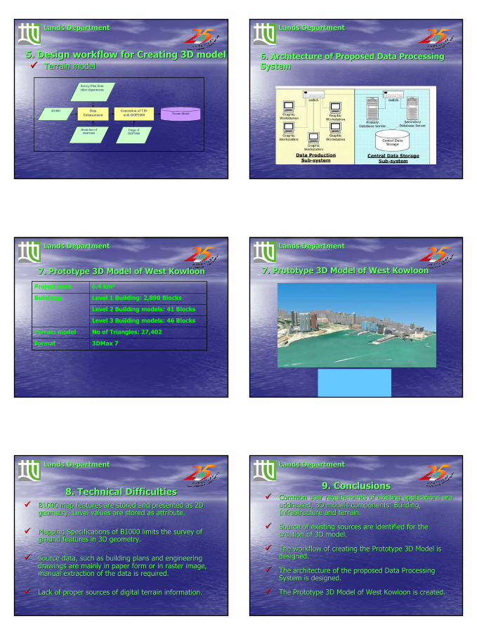
5. Design workflow for Creating 3D model5. Design workflow for Creating 3D model
Lands DepartmentLands Department
��������
Terrain modelTerrain model
B1000 Data Enhancement
Generation of TINwith DOP5000 Terrain Model
Survey Plan from other departments
Break-line of DOP5000
Image of DOP5000
6. Architecture of Proposed Data Processing 6. Architecture of Proposed Data Processing SystemSystem
Lands DepartmentLands Department
��������
7. Prototype 3D Model of West Kowloon7. Prototype 3D Model of West Kowloon
Lands DepartmentLands Department
��������
3DMax 7Format
No of Triangles: 27,402 Terrain model
Level 3 Building models: 46 Blocks
Level 2 Building models: 41 Blocks
Level 1 Building: 2,890 BlocksBuildings
6.4 km2Project Area
7. Prototype 3D Model of West Kowloon7. Prototype 3D Model of West Kowloon
Lands DepartmentLands Department
��������
Video of West Kowloon (demo)
8. Technical Difficulties8. Technical DifficultiesB1000 map features are stored and presented as 2D B1000 map features are stored and presented as 2D geometry. Level values are stored as attribute.geometry. Level values are stored as attribute.
Mapping Specifications of B1000 limits the survey of Mapping Specifications of B1000 limits the survey of ground features in 3D geometry.ground features in 3D geometry.
Source data, such as building plans and engineering Source data, such as building plans and engineering drawings are mainly in paper form or in raster image, drawings are mainly in paper form or in raster image, manual extraction of the data is required.manual extraction of the data is required.
Lack of proper sources of digital terrain information.Lack of proper sources of digital terrain information.
Lands DepartmentLands Department
��������9. Conclusions9. Conclusions
Common user requirements of existing applications are Common user requirements of existing applications are addressed, 3D models components: Building, addressed, 3D models components: Building, Infrastructure and terrain.Infrastructure and terrain.
Source of existing sources are identified for the Source of existing sources are identified for the creation of 3D model.creation of 3D model.
The workflow of creating the Prototype 3D Model is The workflow of creating the Prototype 3D Model is designed.designed.
The architecture of the proposed Data Processing The architecture of the proposed Data Processing System is designed.System is designed.
The Prototype 3D Model of West Kowloon is created.The Prototype 3D Model of West Kowloon is created.
Lands DepartmentLands Department
��������

5
10. Recommendations10. RecommendationsProposed components in the prototype 3D Model are Proposed components in the prototype 3D Model are recommended to form the basis of the territoryrecommended to form the basis of the territory--wide 3D Spatial wide 3D Spatial Database.Database.
The workflow of creating Prototype 3D Model is recommended.The workflow of creating Prototype 3D Model is recommended.
The proposed Data Processing System is recommended to The proposed Data Processing System is recommended to implement.implement.
Workflow and administrative framework is recommended to setup Workflow and administrative framework is recommended to setup for the exchange of 3D models between government departments.for the exchange of 3D models between government departments.
The current mapping specifications and data structures of Base The current mapping specifications and data structures of Base Maps are recommended to be revised in order to support the Maps are recommended to be revised in order to support the creation of 3D models.creation of 3D models.
Lands DepartmentLands Department
��������Lands DepartmentLands Department
��������Further Enquires:Further Enquires:
Thank YouThank You
ENDEND
Lands DepartmentLands Department
��������