landscape definition and meaning
TRANSCRIPT

INTRODUCTION

LANDSCAPE DESIGN
• Landscape design is an independent profession and a design and art tradition, practiced by landscape designers, combining nature and culture
Design scope• Landscape design focuses on both the integrated master landscape planning of a property
and the specific garden design of landscape elements within it.• It is often divided into hardscape design and softscape design.• Landscape designers often collaborate with related disciplines such as architecture and
geography, soils and civil engineering, surveying, landscape contracting, botany, and artisan specialties.

DESIGN APPROACH
Factors in designing include objective qualities; such as:• The climate and microclimates;• Topography and orientation,• Site drainage and groundwater recharge;• Municipal and resource building codes, • Soils and irrigation,• Human and vehicular access and circulation,• Recreational amenities (ie: sports and water),• Furnishings and lighting,• Native plant habitat botany when present,• Property safety and security,• Construction detailing, and other measurable considerations.
Factors in designing also include subjective qualities such as: • Genus loci (the special site qualities to emphasize); • Client's needs and preferences; • Desirable plants and elements to retain on site, modify, or replace and available to use as borrowed scenery
from beyond;• Artistic composition from perspectives of both looking upon and being in the gardens;• Spatial development and definition;• Plant palettes in designed layouts, and artistic focal points for enjoyment.
There are innumerable other design factors and considerations brought to the complex process of designing a landscape that is beautiful, well functioning, and thrives over time.

SITE PLANNING
• Site planning refers to the organizational stage of the landscape design process.
• It involves the organization of land use zoning, access, circulation, privacy, security, shelter, land drainage, and other factors.
• This is done by arranging the compositional elements of landform, water, buildings, planting, paving, drives, parking, street furniture and lighting elements.
• Site planning generally begins by assessing a potential site for development through site analysis.
• Information about slope, soils, hydrology, vegetation, parcel ownership, orientation, etc. are assessed and mapped.
• By determining areas that are poor for development (such as floodplain or steep slopes) and better for development, the planner or architect can assess optimal location and design a structure that works within this space.

SITE ANALYSIS• Site Analysis is an element in site planning and design.
• Site analysis is an inventory completed as a preparatory step to site planning which involves research, analysis, and synthesis. It primarily deals with basic data as it relates to a specific site.
• The topic itself branches into the boundaries of architecture, landscape architecture, engineering, economics, and urban and regional planning.

SITE PLAN
• A site plan is a "graphic representation of the arrangement of buildings, parking, drives, landscaping and any other structures that are part of a development project".
• Such a plan of a site is an architectural plan, landscape architectural document, and a detailed engineering drawing of proposed improvements to a given land parcel.
• A site plan "usually shows a building footprint, travel ways (roads, footpaths, trails), parking, drainage facilities, sanitary and sewer lines, water supply lines, trails, lighting, and landscaping and garden elements".
• A site plan is a "set of construction drawings that a builder or contractor uses to make improvements to a property. Site plans are often prepared by a design consultant who must be either a licensed engineer, architect, landscape architect or land surveyor".

SITE PLAN BUILDING BLOCKS
A site plan is a top view, of a property that is drawn to scale. A site plan shows:• Property lines• Outline of existing and proposed buildings and structures• Distance between buildings• Distance between buildings and property lines (setbacks)• Parking lots, indicating parking spaces• Driveways• Surrounding streets• Landscaped areas• Easements• Ground sign location

FUNDAMENTALS

• Lacking speed, strength etc., we humans have long learnt to attack a situation with our minds.• We posses the ability to weigh the factors of a problem and reason out a response.• We are able to learn not only from our own experiences but also from the accumulated wisdom of history.• Our essential strength is our unique power of perception (making ourselves aware of all conditions and
applicable factors) and deduction (deriving, through reason, an appropriate means of procedure) . Perception and deduction being the essence of all planning.
• Surely with our superior minds we should have built paradise on earth!...... butWe have plundered our forests.We have ripped our hills and laid them open to erosion and ever deepening gullies.We have befouled our rivers killing the fish and driving off the wildlife due to the stench.Our tightly packed homes show little consideration for refreshing foliage, clean air or sunlight.Our cluttered highways, sprawling suburbs and straining cities offend more often than they
please.• We are victims of our own building. Somewhere in the complex process of evolving our living spaces,
cities and roadways and in our fascination for technology we have neglected our human needs.
We are able to write manuals on how best to grow orchids but little has been written about the nature of the physical environment best suited to human culture. The ecological framework best suited for us to thrive is not fully understood.

Ugliness is the absence of beauty resulting from a sensed lack of unity among the components or the presence of incongruous elements. Beauty pleases and ugliness tends to disturb. It therefore follows that a visual harmony of all parts of the landscape is desirable.
• Elimination of incongruous elements usually effects an improvement.• Introduction of accentuating elements: If elimination can improve a landscape quality it follows that other
elements might be introduced with the same result.The landscape character of any area may be developed or intensified by eliminating any negative elements and by accentuating its positive qualities. For this we must not only recognize the essential natural character of a land area but also posses knowledge that will enable us to achieve the optimum development of that character.
• Land use as a landscape factor: Very few areas can be reserved in their pristine state or developed solely for the display of their natural beauty. Land is generally considered in terms of use.The most important factor in considering the use of land is a thorough understanding of its landscape character in the broadest sense. The planner must comprehend the physical nature of the site and its extensional environment before it is possible to:
1. Recognize those uses for which the site is suited and which will utilize its full potential.2. Introduce into the area only those uses which are appropriate.3. Apply and develop such uses in studied relationship to the landscape features.4. Ensure that these applied uses are integrated to produce a modified landscape that is functionally efficient
and visually attractive.5. Determine whether or not a project is unsuited and would be incongruous not only on the immediate site
but in the surrounding environs as well and thus appear to be misplaced, unfit and ugly. Such an improper use would be disturbing not only aesthetically but also practically, for an unsuitable use forced upon a parcel of land generates frictions that may not only destroy the most desirable qualities of the area but preclude proper function as well.

• Landscape Organization: the untouched landscape is in a repose of equilibrium. It has its own cohesive, harmonious order in which all forms are an expression of geologic structure, climate, growth, and other natural forces. As human activity in an area increase , the landscape becomes more and more organized; agreeably if the organization is one of fitting relationships, disagreeably if the relationships are chaotic or illogical.It follows as a guiding principle that to preserve or create a pleasing site all the various elements or parts must be brought into harmony – does not imply that everything should blend with or get lost in the landscape through camouflage.
• Contrast: form, color or texture of a handsome object can be emphasized through contrast. E.g. Bridges, falling waters…

LIMITATIONS
The Earthscape: From the ice sheathed poles to the blazing deserts; the earthscape varies infinitely. Man has learnt first to survive and then later to thrive through a process of adaptation. Some of us delude ourselves that we will finally subject nature to our control and thereby conquer nature.
Major Landscape elements:There are dominant natural landscape forms, features and forces that we can hardly if at all alter. We must accept them and adapt ourselves and our planning to them. These include topographical forms like mountains ranges, river valleys, and coastal plains; such features as precipitation, frost, fog, the water table, and seasonal temperatures, and such forces as winds, tides, sea and air currents, the process of growth, solar radiation, and gravity. These we analyze to the extent necessary to make an accurate assessment of their influence and effects. Then, if wise, we will shape our plans in full awareness of, and in response to, the constraints and possibilities. Such considerations are fundamental to the placing of cities, the zoning of a community, the alignment of highways, the siting of industries, or the orientation or layout of a single house or garden.

OPORTUNITIES
MINOR LANDSCAPE ELEMENTS:There are also
landscape elements of lesser consequence such as hills, groves, and streams that we as planners and designers can modify.
There are four general courses of action:
1.Preservation2.Accentuation 3.Alteration 4.Destruction.

LAND
•When land passes from one owner to another, certain legal rights are also transferred with the property including right to cultivate, mine, do earthwork, remove soil or vegetation, build etc.
•Certain responsibilities by law or tradition also are part of the deal, e.g. not to cause damage to neighbors’ property by directing storm flow, increasing gradient and causing offsite slippage, erosion, silting or generate undue air, water, noise or visual pollution.
LAND
• AS HERITAGE: Our ancestors lived off the bounty of the land without causing significant and irreparable ecological consequences . Will we gift our children the same?AS RESOURCE:Land, water, and vegetation are our ultimate resources. Mismanaged, they may be lost to us forever, and our wealth and wellbeing proportionately diminished.Soil Bank: The topsoil reservoir is the vital substance that is the basis of all agricultural productivity. It is a thin layer of weathered rock intermixed with organic matter in depths ranging from a few inches to a few feet. This rich skim overlaying sub soils and rocks may have taken thousands of years to make. Once lost, it is gone forever. It has been scooped, dug, hauled and washed and blown away through the rivers and winds to the seas. Food: All forms of life derive from the land and its cover of soil. In the chlorophyll of plants Carbon-di-oxide and moisture are transformed by the energy of the sun into the basic sugars and starches of our food chain. This chemical miracle happens only when the conditions are right. The resulting forms of life vary from region to region.Habitat: All living organisms are interacting and interdependent. All are contributors and have a role in the biologic scheme of things. Each living organism lays claim to a necessary living space which have changed when environmental conditions have changed. Initially such territories were spontaneously formed leaving the earth time to heal between uses for preparation of new and often higher forms of life. Only humans have seen fit to claim sole rights on land, dividing properties on haphazard and geometric basis without regard for topographic considerations.
Nature is patient and has immense powers of recuperation and regeneration. We can recreate the landscape as a more bountiful earthly habitat once we understand the processes and laws of nature and commit society to a supportive nature –human relationship.

THE ESSENCE OF LAND PLANNING
•Seek the most suitable site•Let the site suggest plan forms•Extract the full site potential

The usual (easiest/cheapest) change in the land profile
ACTIONS:•Clear the land, strip, bury or remove the top soil•Provide a “workable” land profile (as flat as possible)•Convey all water to S/W drains or to the edge of the land•Make a good wide access road•Give the building a suitable setting with a front setback•Keep the front setback even- this looks neat!•Pave courtyards to cut maintenance •Make lawns

POSSIBILITIES…
•Existing topographical profile: possibility of a rich variety of structural forms conceived in harmony with the natural landscape
•The revised topography due to the bulldozer; the rocks are buried, the natural vegetation removed, the stream is contained in the S/W drain or culvert. The topsoil is redistributed as a cover of equal thickness. An artificial fauna and flora is created. This is our constructed paradise.
•A better way is to build with nature. This provides the human scale and charm which we find appealing in the older cultures where an economy of materials and space dictated a close relationship between the buildings and the landscape form.

POSSIBILITIES…
If we have to use earthmovers to create a new landscape (and sometimes we must), then let us use them to create a landscape of topographical interest with pleasant, useful forms of human scale

EARTH FORMS

EARTH FORMS

EARTH FORMS

EARTH FORMS

SLOPE STABILIZATION, RETENTION

SLOPE STABILIZATION, RETENTION

SLOPE RETENTION

SLOPE RETENTION

WATER
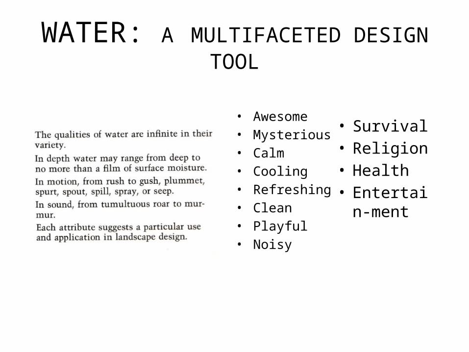
WATER: A MULTIFACETED DESIGN TOOL
• Awesome• Mysterious• Calm• Cooling• Refreshing• Clean• Playful• Noisy
• Survival• Religion• Health• Entertain-
ment


WATER SCARCITY & RELATED ENVIRONMENTAL PROBLEMS Major global concern. A third of the world facing the problem. Mainly due to rapid population growth & deteriorating water quality. Expected to become a further serious issue. Effects of climate change & variability & poor management of water resources further
exacerbate the problem. In arid & semi-arid regions, the problem is accentuated by prolonged droughts and
the process of desertification. Due to the highly specific characteristics of their climate, cities in these regions will
probably face more major water challenges in the near future.
The UNESCO-IHP has grouped water related environmental problems faced by cities into the following broad categories: Access to water and sanitation infrastructure and services Urban waste water pollution Resource degradation Water related hazardsMost developing countries typically face all four problems simultaneously.

URBAN WATER CYCLE AND URBANIZATION
Transformation of undeveloped land into urban land (including transportation corridors).
Increased energy release (i.e. greenhouse gases, waste heat, and heated surface runoff).
Increased demand on water supply (municipal and industrial).
The overall urban water cycle is illustrated in fig., showing the main components and pathways.
The changes in the water budget from predevelopment to developed conditions of the urban water cycle in arid and semi-arid regions is a complex process and not easy to explain
Leakage
Urban Land Area
Water supply
Urban Drainage
Wastewater collection
Water treatment
Stormwater management
Overflow treatment
Wastewater treatment
Groundwater Surface waters
Import of raw potable water
Precipitation Evapotranspiration
Urbanization causes many changes to the hydrologic cycle, including radiation flux, amounts of precipitation, evaporation and infiltration and increased runoff. The changes in the rainfall - runoff components of the hydrologic cycle can be summarized as follows (Marsaek et al., 2006):
FIG. URBAN WATER CYCLE –MAIN COMPONENTS & PATHWAYS
SOURCE: Urban Water Cycle: Processes and interactions, by Marsalek et al., IHP-VI, Technical Publications in Hydrology, No. 78, UNESCO, Paris, 2006.

The process of urbanization often causes changes in groundwater levels because of a decrease in recharge and increased withdrawal. Three major conditions disrupt the subsurface hydrologic balance and produce declines in groundwater levels (Todd and Mays, 2005): Reduced groundwater recharge due to paved surfaces and storm
water sewers Increased groundwater discharge by pumping wells Decreased groundwater recharge due to export of wastewater
collected by sanitary sewers. Decreased groundwater levels can cause land subsidence.
Groundwater pollution is another consequence of urbanization, which has been experienced in many arid and semi-arid regions of the world. Groundwater pumping in many coastal areas in many arid and semi-arid regions has caused severe saltwater intrusion, making hitherto potable groundwater, unusable for municipal water supplies.

• Confine development to uplands.• Protect wetlands, streams, and
water bodies by leaving adequate borders of vegetation.
• Preserve and utilize the natural drainage ways.
• Minimize excavation and grading.• Preclude soil erosion by
providing sheet flow and well knit ground covers.
• Detain heavy surface runoff in swales or ponds to provide regulated flows, filtering, and ground water recharge.
• Return to the earth or its receptor water of quality and quantity equal to that withdrawn.
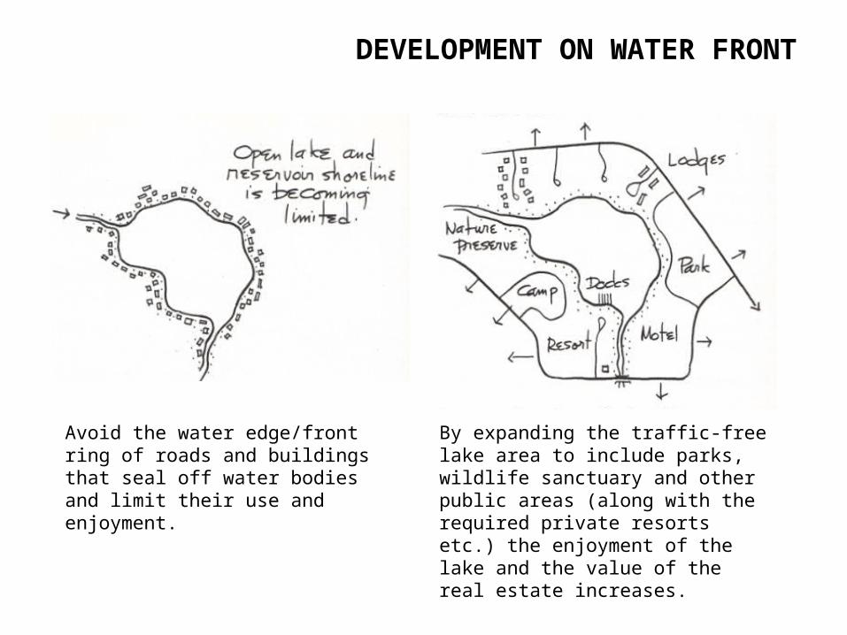
DEVELOPMENT ON WATER FRONT
Avoid the water edge/front ring of roads and buildings that seal off water bodies and limit their use and enjoyment.
By expanding the traffic-free lake area to include parks, wildlife sanctuary and other public areas (along with the required private resorts etc.) the enjoyment of the lake and the value of the real estate increases.

TREATMENT OF THE WATER EDGE
For safety the water edge should slope to a depth more than that of a swimmer or 2.0m before the deep part starts
Rectilinear excavation forms can be reshaped to create free form lakes
Utilize the bank slopes

Beach or shore
Natural BankConstructed water features are often
inspired by nature
WATER EDGE DETAILINGFUNDAMENTALS TO BE KEPT IN MIND:
• Minimize disruption: Where banks or shores are stable, the less intervention done the better it is.
• Maintain smooth flows: Avoid the use of elements that obstruct currents or block the action of waves.
• Slope or armor the banks, if necessary: This will absorb the energy where the currents are swift or the impact of the waves is heavy.
• Attain access to water: This By use of Ghats ,docks, piers, floats, ramps, etc.• Avoid jetties:• Avoid diverting strong currents: The results can be unpredictable and disastrous.• Design to the worst conditions: Consider recorded water levels and the heights of
wind driven surf.• Preclude flooding: The floor level of the habitable structures should be above the
100-year-flood level.