landscape design guidelines - toronto 1 – preface – covers the purpose of vegetation for...
TRANSCRIPT
September 2015
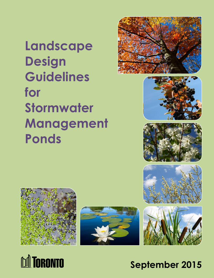
Landscape
Design
Guidelines
for
Stormwater
Management
Ponds

Insert Blank Page This Text Will Not Print
Landscape Design Guidelines for Stormwater Management Ponds

Contact us:
Stormwater Management Tel: 416-338-1303
Water Infrastructure Management Fax: 416-338-2828
Toronto Water
Metro Hall, Stn. 1180, 18th Floor
55 John Street
Toronto, ON M5V 3C6
City of Toronto Landscape Design Guidelines for Stormwater Management Ponds:
Internet: www.toronto.ca/water
This publication is available in both print and online formats.
September 2015

September 2015 iii
Table of Contents
Table of Contents
Introduction ............................................................................. v What This Guideline Contains .......................................................... v
Acknowledgments ................................................................. vii Chapter 1 – Preface ................................................................. 1
Landscape Design in Stormwater Management Ponds ..................... 2 Purpose of the Document .................................................................. 3
Chapter 2 – Landscape Design Guidelines ........................... 5
Landscape Design Concepts ............................................................. 5 Stabilization of Shoreline .............................................................. 6 Mitigation of Effects on Temperature and Dissolved Oxygen ..... 6 Deterrence of Geese ...................................................................... 7 Barriers to Public Access and Public Safety ................................. 7 Enhancement of Linkages ............................................................. 7 Amenity Benefits .......................................................................... 7
Landscape Design Factors ................................................................ 8 Landform, Grading and Orientation ............................................. 8 Tree Protection Plan .................................................................... 10
Planting Strategy ......................................................................... 11 Landscape Design Components ...................................................... 12
Permanent Pool and Forebay ...................................................... 13 Zone 1 – Deep Water Areas ........................................................ 14 Zone 2 – Shallow Water Areas ................................................... 15 Zone 3 – Extended Detention or Shoreline Fringe Areas ........... 16 Zone 4 – Flood Fringe Areas ...................................................... 17 Zone 5 – Shoreline Areas ............................................................ 19
Inlet Structure.................................................................................. 21 Concealing Inlet Structures ......................................................... 21 Recommended Plantings ............................................................. 22
Outlet Structures ............................................................................. 23 Bottom-Draw Outlets .................................................................. 24 Cooling Trenches ........................................................................ 24 Seepage Outlets ........................................................................... 26
Outlet Channels ........................................................................... 27 Vegetated Swales ........................................................................ 28
Spillway .......................................................................................... 32 Maintenance Access Road .............................................................. 34
Concealed Maintenance Access Route ....................................... 36 Hybrid Trail or Maintenance Access Route................................ 36 High Use or Urban Trail ............................................................. 37
iv September 2015
Landscape Design Guidelines for Stormwater Management Ponds
Vehicle Access Barriers .............................................................. 37 Provision for Algae Control ............................................................ 38 Public Safety ................................................................................... 38
Fencing ........................................................................................ 40 Signage ........................................................................................ 41 Water Level Indicators ................................................................ 42 Barrier Plantings ......................................................................... 44
Chapter 3 – Design Review and Pond Assumption Procedure ............................................................................... 45
Submission and Approval of Landscaping Plans............................ 45
Submission Requirements ........................................................... 45 Approval Process ........................................................................ 47
Assumption of Stormwater Management Ponds............................. 49 Inspection and Maintenance Activities ....................................... 50 Monitoring Requirements ........................................................... 52 After Assumption ........................................................................ 55
Appendix
Appendix A – Acceptable Plant Species for Stormwater Management
Ponds
Appendix B – Wet Ponds: Summary of Design Guidance
Appendix C – Pond Warning Sign
Appendix D – Bibliography
Glossary
Index
September 2015 v
Introduction
Introduction
We have written Landscape Design Guidelines for Stormwater
Management Ponds for City of Toronto staff and consulting engineers.
The purpose of this guideline is to ensure there is consistency in our
approval and construction practices. Clients—that’s you—want to be
instructed in the same way each time you come to us, regardless of
which office you may visit. This guideline will help ensure that the
information provided by staff is the same in all offices.
This guideline is written for City staff and consulting engineers
working on preparing a landscaping plan for stormwater ponds for
public or private developments.
This guideline takes you step by step through all the criteria you will
need in preparing a landscape design for a stormwater management
pond. If you are going to be preparing a landscaping plan for a
stormwater pond in the city of Toronto, this guideline is for you.
This guideline is available in both print and online formats.
What This Guideline Contains
Chapter 1 – Preface – covers the purpose of vegetation for
stormwater ponds and the objectives of this manual.
Chapter 2 – Landscape Design Guidelines – covers landscape
concepts, design components, landscaping zones, inlet and outlet
structures, cooling trenches, spillway, maintenance access road, algae
control and public safety
Chapter 3 – Design Review and Pond Assumption Procedure –
covers submission requirements, approval process, assumption
process, inspection and maintenance activities, monitoring
requirements and post assumption.
vi September 2015
Landscape Design Guidelines for Stormwater Management Ponds
Appendix A – Acceptable Plant Species for Stormwater
Management Ponds – contains acceptable plant species for tree,
shrub, herbaceous, submergent, floating, robust emergent, broadleaved
emergent and narrowleaved emerget plant types for stormwater ponds.
Appendix B – Wet Ponds: Summary of Design Guidance – contains
a list of design elements necessary for the operational success of a wet
pond.
Appendix C – Pond Warning Sign – contains a standard drawing on
the placement of a pond warning sign on a steel post at a stormwater
pond.
Appendix D – Bibliography – contains a listing of stormwater pond
design guidelines and criteria published from current City
departments, former cities of Toronto, and other neighbouring cities.
Glossary – an alphabetical list of technical terms relating to landscape
design of stormwater ponds and their definitions.
Index – an alphabetical list of topics, keywords and synonyms used in
this manual.

September 2015 vii
Acknowledgments
Acknowledgments
I must thank the working group for your active participation and
contributions to this design guideline, which without your knowledge
and experience, this document could not have been written:
Parks, Forestry & Recreation
Norman DeFraeye Supervisor, Ravine Protection
Julia Murnaghan Natural Environment Specialist
Alex Shevchuk Project Manager, Landscape Architecture
Toronto Water
Patrick Cheung Senior Engineer
David Kellershohn Manager, Stormwater Management
Allen Li Senior Engineer
Weng Liang Senior Engineer
Engineering & Construction Services
Robert Klimas Senior Engineer
Nhat-Anh Nguyen Manager, Development Engineering
Pat Scanga Senior Engineer
Lawrence Shintani Senior Engineer
Judy Tse Director, Engineering Review
Thank you!
Vicky Shi
Engineer
Toronto Water

Insert Blank Page This Text Will Not Print
September 2015 1
Chapter 1 – Preface
Chapter 1 – Preface
Toronto City Council adopted the Wet Weather Flow Master Plan
(WWFMP) and a 25-Year Implementation Plan in 2003. The goal of
the WWFMP is to reduce and ultimately eliminate the adverse impacts
of wet weather flow, which is runoff generated when it rains or snows,
to protect our environment and improve the ecosystem health of the
watersheds. The plan was developed with the recognition that wet
weather flow will be managed on a watershed basis accompanied by a
preferred hierarchy of solutions starting with “at source”, followed by
“conveyance,” and concluding with “end-of-pipe.”
End-of-pipe stormwater management facilities receive stormwater
from a conveyance system and discharge the treated water to the
receiving waters. Some examples of end-of-pipe stormwater
management facilities include:
• wetponds
• wetlands
• dry ponds; infiltration basins
Stormwater management ponds are the most common end-of-pipe
stormwater management facility, and are reliable in operation, over a
range of different storm events. The City currently maintains about 85
retention and detention ponds for the purposes of stormwater
management. Retention ponds, also commonly called wet ponds refer
to facilities that maintain a permanent pool, while detention ponds,
often called dry ponds contain stormwater only in the aftermath of
significant rainfall events. A detention pond will hold the water for a
short time and then slowly release it, normally within 24–48 hours.
The design of these stormwater management ponds is subject to the
approval of the Ministry of the Environment and Climate Change and
must meet the requirements of the Ministry's Stormwater Management
Planning and Design Manual.
Stormwater management ponds are usually constructed when a new
subdivision is created. The City and Toronto Region Conservation
Authority (TRCA) have site-specific requirements for new
developments to control and reduce the peak rate of stormwater runoff
from the subdivision so as not to cause flooding downstream and also
improve the quality of the stormwater runoff by removing sediments.
Stormwater ponds are one of the end-of-pipe solutions for meeting
these requirements and therefore most of the existing ponds were built
by developers and later assumed by the City. In recent years, the City

2 September 2015
Landscape Design Guidelines for Stormwater Management Ponds
has also built several stormwater management ponds as retrofits to
improve the quality of stormwater discharge from existing
neighbourhoods.
Landscape Design in Stormwater Management Ponds
Vegetation is an integral part of many stormwater management
facilities including ponds, wetlands, vegetated filter strips and
bioretention filters. Vegetation takes up nutrients, and in wet facilities,
it promotes settling by reducing flow velocities and preventing re-
suspensionof sediments. Vegetation can also be utilized in the design
of stormwater management facilities to achieve the following:
• Intercept rainfall and airborne pollutants.
• Filter out coarse sediments.
• Trap and accumulate floatables.
• Reinforce the structure of spreaders, weirs and retaining walls.
• Impede colonization by undesirable invasive species.
• Conceal fencing and structures.
In addition to water quality improvement, other benefits of utilizing
vegetation as part of stormwater management facility design include:
• stabilization of banks, shoreline and slopes
• mitigation of effects on temperature and dissolved oxygen
• deterrence of geese
• provision of barriers to improve public safety
• enhancement of linkages
• provision of aesthetic benefits
Although constructed stormwater management ponds are not natural,
they can be landscaped to look natural and are often used as habitat by
migrant birds and animals. When they are located close to parks or
vegetated areas, they should be integrated as naturally as possible into
those areas. To provide for public safety, a variety of design features
and safety measures should also be incorporated into the site-specific
landscape design to mitigate risks.
The preferred approach is to consider the landscape as an component
and recognize that elements of the landscape are effective functional
design tools that can also be employed to achieve the stormwater
management objectives. The application of this approach requires the
efforts of a multi-disciplinary design team, working in collaboration to
September 2015 3
Chapter 1 – Preface
explore solutions that integrate planning, engineering and landscape
architecture.
Therefore, at the site-specific scale, the design of the landscape should
be a key parameter that contributes to the successful integration of
stormwater management facilities as amenities within the community's
open space system. As a result, the site-specific landscape not only
defines the visual character of the facility, but also contributes to
functional performance in terms of operation and maintenance, public
safety, contaminant removal, and other environmental benefits.
Purpose of the Document
The objective of this document is to identify acceptable standards on
physical design, maintenance and monitoring of landscapes at a site-
specific level, for stormwater management ponds in the City of
Toronto. These facilities will ultimately achieve optimal functional
performance while becoming valued community assets. For example,
it will identify acceptable standards and requirements for side slopes,
maintenance access, plant types, paths and fencing.
This document was prepared jointly by staff from Toronto Water,
Engineering & Construction Services and Parks, Forestry &
Recreation divisions. The design guidelines will be used in the review
and approval of stormwater management ponds proposed by
developers to meet City stormwater management requirements. The
guidelines are intended to be used in conjunction with the Stormwater
Management Planning and Design Manual prepared by the Ministry
of the Environment, the City of Toronto's Wet Weather Flow
Management Policy and Guidelines, and the Guiding Principles for
Infrastructure Review prepared by Toronto Parks, Forestry &
Recreation to guide practitioners in the process of developing
stormwater management strategies and planning and designing
stormwater management ponds.
Note that this guideline is not intended to deal with the hydraulic or
hydrologic design of a storm water management pond. The
Stormwater Management Planning and Design Manual and Wet
Weather Flow Management Guidelines are the major reference
documents for the stormwater management pond engineering design.
The guidelines present a general framework of the City's expectations
of approval requirements on landscape design for stormwater
management ponds and are not meant to restrict creative solutions.
The City recognizes that flexibility is important to accomodate site-

4 September 2015
Landscape Design Guidelines for Stormwater Management Ponds
specific conditions. As a result, the City may consider any innovative
approach if it can be demonstrated that the approach can achieve the
required performance objectives.
September 2015 5
Chapter 2 – Landscape Design Guidelines
Chapter 2 – Landscape Design Guidelines
Landscape Design Concepts
Stormwater management ponds are the most common end-of-pipe
stormwater management facility used in Toronto. Its main functions
are stormwater quantity control and quality control to prevent a
community from flooding and watercourses from becoming polluted.
With appropriate design on landscaping, stormwater management
ponds can also benefit the community. The landscape and grading
design has to allow for maintenance and management of the pond over
its lifetime. Issues to consider are collection of trash, maintenance of
plants and dredging of sediment. The following sections describe the
main concerns that should be addressed through landscape design.
The landscaping design for stormwater ponds shall consider the
following factors:
• stabilization of shoreline
• mitigation of effects on temperature and dissolved oxygen
• deterrence of waterfowl such as geese
• barriers to public access and public safety
• enhancement of linkages
• community benefits
6 September 2015
Landscape Design Guidelines for Stormwater Management Ponds
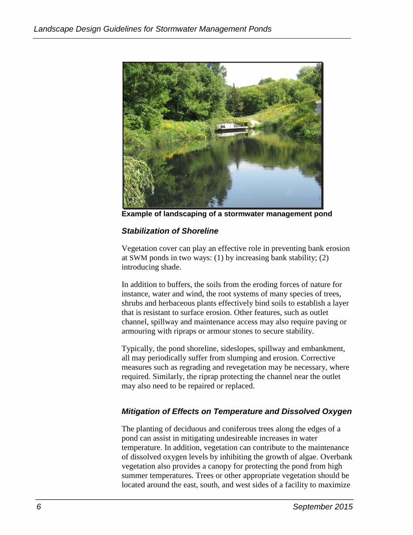
Example of landscaping of a stormwater management pond
Stabilization of Shoreline
Vegetation cover can play an effective role in preventing bank erosion
at SWM ponds in two ways: (1) by increasing bank stability; (2)
introducing shade.
In addition to buffers, the soils from the eroding forces of nature for
instance, water and wind, the root systems of many species of trees,
shrubs and herbaceous plants effectively bind soils to establish a layer
that is resistant to surface erosion. Other features, such as outlet
channel, spillway and maintenance access may also require paving or
armouring with ripraps or armour stones to secure stability.
Typically, the pond shoreline, sideslopes, spillway and embankment,
all may periodically suffer from slumping and erosion. Corrective
measures such as regrading and revegetation may be necessary, where
required. Similarly, the riprap protecting the channel near the outlet
may also need to be repaired or replaced.
Mitigation of Effects on Temperature and Dissolved Oxygen
The planting of deciduous and coniferous trees along the edges of a
pond can assist in mitigating undesireable increases in water
temperature. In addition, vegetation can contribute to the maintenance
of dissolved oxygen levels by inhibiting the growth of algae. Overbank
vegetation also provides a canopy for protecting the pond from high
summer temperatures. Trees or other appropriate vegetation should be
located around the east, south, and west sides of a facility to maximize
September 2015 7
Chapter 2 – Landscape Design Guidelines
shading and minimize solar exposure of open water areas. Reducing
solar exposure will help to reduce heat gain in water before
discharging to receiving water, which helps maintain a healthy and
aesthetic pond conditions, reducing algae blooms and the potential for
anaerobic conditions to develop.
Deterrence of Geese
Dense woody vegetation around a pond is the most effective method
of discouraging undesirable species of waterfowl from contaminating
facilities which have a permanent pool. Minimizing the amount of
mown grass will also minimize the geese habitat.
Barriers to Public Access and Public Safety
Dense woody vegetation around the perimeter of a pond is useful to
deter the public from accessing pond areas, steep slopes and other
areas which are deemed potentially hazardous. Proper signage, fencing
or railings can also be applied to warn and deter public access.
Enhancement of Linkages
The establishment of diverse communities of plants in conjunction
with a stormwater management pond can contribute to the
establishment of linkages between natural wooded areas, providing
terrestrial habitat benefits at a larger scale.
Amenity Benefits
Vegetation can be utilized to enhance views and contribute to the
establishment of a unique character for a development. Vegetation can
also be effective in blending a pond into parks or specific surroundings
and integrating with trail systems, overlook points, interpretive
stations, and seating areas.

8 September 2015
Landscape Design Guidelines for Stormwater Management Ponds
Landscape Design Factors
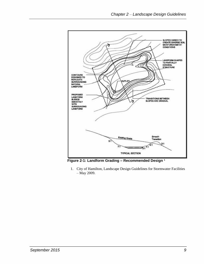
Landform, Grading and Orientation
Grading should be designed to reflect the landform character of the
surrounding natural landscape. Orient wet ponds with their longest
axis aligned northwest to southeast, or west to east to maximize
opportunities to mitigate temperature increases through shading.
Orientation should be carefully considered in situations where the
stormwater management pond is a tributary to an existing or proposed
coldwater aquatic community. For more information on recommended
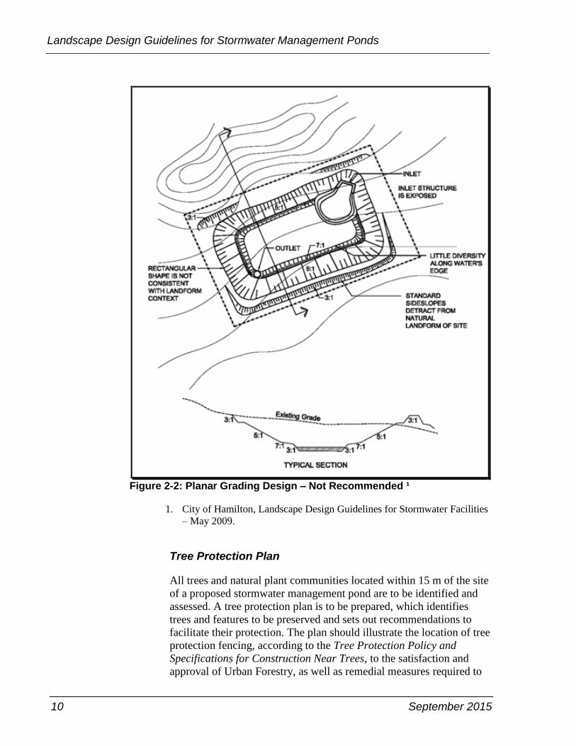
grading and proper slope design, see Figure 2-1. The planar grading
design, as shown in Figure 2-2, is not recommended for its angular
transitions and long stretches with standard slope gradients.
For detailed side slopes design, see Appendix B, Wet Ponds: Summary
of Design Guidance.
September 2015 9
Chapter 2 – Landscape Design Guidelines
Figure 2-1: Landform Grading ‒ Recommended Design ¹
1. City of Hamilton, Landscape Design Guidelines for Stormwater Facilities
– May 2009.
10 September 2015
Landscape Design Guidelines for Stormwater Management Ponds
Figure 2-2: Planar Grading Design ‒ Not Recommended ¹
1. City of Hamilton, Landscape Design Guidelines for Stormwater Facilities
– May 2009.
Tree Protection Plan
All trees and natural plant communities located within 15 m of the site
of a proposed stormwater management pond are to be identified and
assessed. A tree protection plan is to be prepared, which identifies
trees and features to be preserved and sets out recommendations to
facilitate their protection. The plan should illustrate the location of tree
protection fencing, according to the Tree Protection Policy and
Specifications for Construction Near Trees, to the satisfaction and
approval of Urban Forestry, as well as remedial measures required to
September 2015 11
Chapter 2 – Landscape Design Guidelines
minimize impacts on trees during the construction period, including
pruning, root pruning or fertilization.
As part of this process, plant material suitable for transplantation or
reuse in the landscaping of stormwater management ponds should be
recommended for its relocation, or transplantation. For more
information, call Parks, Forestry & Recreation Division, at 416-338-
TREE(8733) or go to www.toronto.ca/trees/bylaws_policies.htm.
Planting Strategy
Careful selection of plant material is the critical factor to ensure that
stormwater pond functional objectives are achieved and minimize
maintenance requirements.
The following principles should be applied to guide the selection of
plant material and the generation of planting strategies for stormwater
management ponds.
Plan for Succession
Vegetation communities are dynamic and can change over time to
adapt to the developing environment. Planting design must recognise
this process to ensure that planting objectives are achieved over the
long term.
Maximum Benefits to Site Environment
An understanding of the ecological, physical and social context of a
site will help to direct the selection of appropriate plant species and the
assembly and configuration of plant communities which are
appropriate to the site in order to provide the maximum benefit.
Avoid Non-Native and Invasive Species
Since stormwater management ponds are linked to a network of
habitats which are connected by the watercourse downstream of the
facility, it is important that plant material within the stormwater
management pond site be native and indigenous to the bioregion. The
introduction of non-native, invasive species can threaten plant
communities throughout the watershed and must be avoided.
12 September 2015
Landscape Design Guidelines for Stormwater Management Ponds
Maximum Diversity
The use of a wide range of native, indigenous trees, shrubs,
wildflowers, grasses, sedges and aquatic plants will enhance
biodiversity on a watershed-wide scale and also contribute to the
system’s resiliency and ability to maintain itself. Plants such as cattail
and common reed are aggressive and may thwart diversity goals.
Recognize Human Factors
Planting design should be developed with recognition of the
requirements of the adjacent residents, users of the site and the
community-at-large related to interpretive opportunities, aesthetics,
public safety issues and other associated factors.
The planting plans shall be prepared by a landscape architect and
approved by the City, and all plantings to be in accordance with the
Canadian Standards for Nursery Stock as prepared by the Canadian
Nursery Landscape Association.
Landscape Design Components
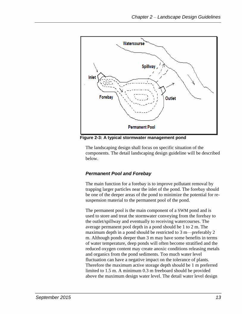
There are four main design components for stormwater management
ponds (see Figure 2-3) including
• forebay
• permanent pool
• inlet
• outlet.
September 2015 13
Chapter 2 – Landscape Design Guidelines
Figure 2-3: A typical stormwater management pond
The landscaping design shall focus on specific situation of the
components. The detail landscaping design guideline will be described
below.
Permanent Pool and Forebay
The main function for a forebay is to improve pollutant removal by
trapping larger particles near the inlet of the pond. The forebay should
be one of the deeper areas of the pond to minimize the potential for re-
suspension material to the permanent pool of the pond.
The permanent pool is the main component of a SWM pond and is
used to store and treat the stormwater conveying from the forebay to
the outlet/spillway and eventually to receiving watercourses. The
average permanent pool depth in a pond should be 1 to 2 m. The
maximum depth in a pond should be restricted to 3 m—preferably 2
m. Although ponds deeper than 3 m may have some benefits in terms
of water temperature, deep ponds will often become stratified and the
reduced oxygen content may create anoxic conditions releasing metals
and organics from the pond sediments. Too much water level
fluctuation can have a negative impact on the tolerance of plants.
Therefore the maximum active storage depth should be 1 m preferred
limited to 1.5 m. A minimum 0.3 m freeboard should be provided
above the maximum design water level. The detail water level design
14 September 2015
Landscape Design Guidelines for Stormwater Management Ponds
can be referenced in Appendix B, Wet Ponds: Summary of Design
Guidance.
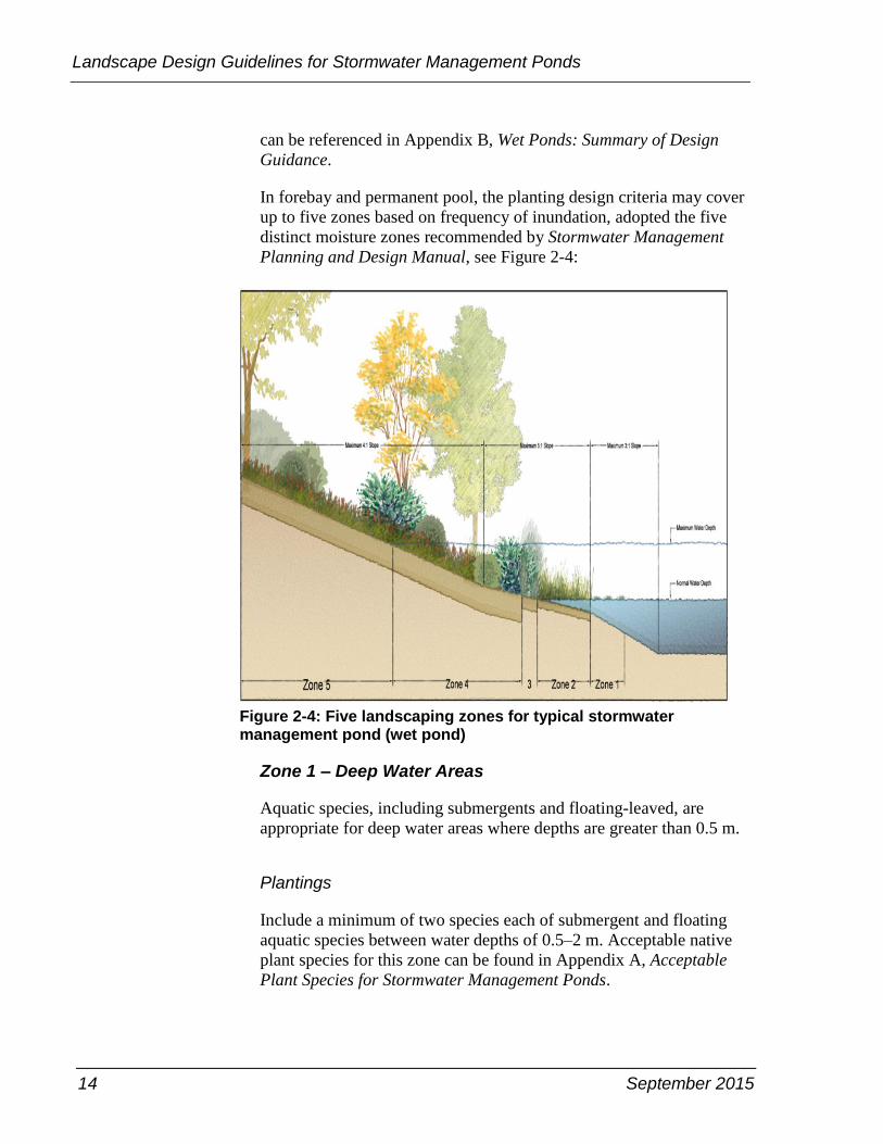
In forebay and permanent pool, the planting design criteria may cover
up to five zones based on frequency of inundation, adopted the five
distinct moisture zones recommended by Stormwater Management
Planning and Design Manual, see Figure 2-4:
Figure 2-4: Five landscaping zones for typical stormwater management pond (wet pond)
Zone 1 – Deep Water Areas
Aquatic species, including submergents and floating-leaved, are
appropriate for deep water areas where depths are greater than 0.5 m.
Plantings
Include a minimum of two species each of submergent and floating
aquatic species between water depths of 0.5–2 m. Acceptable native
plant species for this zone can be found in Appendix A, Acceptable
Plant Species for Stormwater Management Ponds.
September 2015 15
Chapter 2 – Landscape Design Guidelines
Topsoil
Provide a layer of 0.3 m of topsoil for the first one metre below the
permanent water level. The design engineer or site supervisor or both
should review the suitability of subsoil material and compaction with
the landscape architect. Side slopes should be 3H:1V or flatter, to
maximize the area available for plantings.
Spacing
Provide a minimum of 40 per cent vegetative coverage to minimize
shallow water warming and help to prevent algae growth.
Recommended number of plants is three plants per linear metre of
water's edge.
Planting Time
Plant bare root tubers or rhizomes in:
• Spring: from frost free ground, generally early-April to mid-May,
must be before bud break.
• Fall: from approximately 2 to 3 weeks after leaf drop to mid-
October.
Zone 2 – Shallow Water Areas
Submergent and emergent vegetation should be used in the shallow
water area zone, where the water is less than 0.5 m deep.
Plantings
Provide a minimum of two species each of robust, broadleaved and
narrow leaved emergent plants for water depths less than 0.5 m. The
planting rows should be perpendicular to the direction of the water
flow to minimize the potential for channelization. Acceptable native
plant species for this zone can be found in Appendix A, Acceptable
Plant Species for Stormwater Management Ponds.
Topsoil
Provide a layer of 0.3 m of topsoil below the permanent water level.
The design engineer or site supervisor or both should review the
suitability of subsoil material and compaction with the landscape
architect. For safety reasons, side slopes should be 5H:1V or less.
16 September 2015
Landscape Design Guidelines for Stormwater Management Ponds
Spacing
Provide 100 per cent vegetative coverage to discourage loafing geese
and to act as a barrier to casual entry. Recommended number of plants
is three plants per linear metre of water's edge.
Planting Time
If bare root stock including root tubers and rhizomes is used:
Spring: from frost free ground, generally early-April to mid-May, must
be before bud break.
• Fall: from approximately 2 to 3 weeks after leaf drop to mid-
October.
• If container grown stock is used, plant from mid-April to mid-
October.
Seeding
Emergents can be introduced using an approved seedbank material or
an appropriate stormwater management pond native seed mix. Native
grass and herb seed mixtures should be sown in the early spring before
mid-April or late in the fall; mid-October to mid-November.
Zone 3 – Extended Detention or Shoreline Fringe Areas
The extended detention or shoreline fringe is defined as the area below
the 2-year floodline or normal water depth, and is generally within one
metre horizontally from the permanent water level. This zone will be
subject to higher soil moisture conditions as a result of frequent water
level fluctuations, and the influence of the permanent pool itself.
Plantings
Include a minimum of two species each of flood tolerant shrubs,
grasses and herbs. There should be at least two planting rows of
shrubs, perpendicular to the direction of the water flow, to minimize
the potential for channelization. Acceptable native plant species for
this zone can be found in Appendix A, Acceptable Plant Species for
Stormwater Management Ponds.

September 2015 17
Chapter 2 – Landscape Design Guidelines
Topsoil
Provide a minimum layer of 0.3 metre of topsoil for seeding areas, 0.6
metre of topsoil for the shrub planting areas, and one metre of topsoil
for the tree planting areas.
The design engineer or site supervisor or both should review the
suitability of subsoil material and compaction with the landscape
architect. For safety reasons, side slopes should be 5H:1V or flatter, for
at least 3 m beyond the permanent pool.
Spacing
Provide 100 per cent vegetated coverage to discourage loafing geese
and to act as a barrier to casual entry. Small shrubs should be planted
at one metre on centre and large shrubs at 1.5 to 2 m on centre.
Planting Time
If bare root stock is used:
• Spring: from frost free ground, generally early-April to mid-May,
must be before bud break.
• Fall: from approximately 2 to 3 weeks after leaf drop to mid-
October.
If container grown stock is used, plant from mid-April to mid-October.
Seeding
Flood tolerant grasses and herbs can be introduced using an approved
seedbank material or an appropriate stormwater management pond
native seed mix.
Native grass and herb seed mixtures should be sown in the early spring
before mid-April or late in the fall; mid-October to mid-November.
Zone 4 – Flood Fringe Areas
The flood fringe is defined as the area between the 2 and 100 year
floodlines. As this area is only infrequently flooded, the plants must be
able to withstand periods of inundation and periods of drought.
18 September 2015
Landscape Design Guidelines for Stormwater Management Ponds
Plantings
Include a minimum of two flood tolerant species each of grasses and
herbs, and four flood tolerant species each of shrubs and trees. A
suitable mix of deciduous and coniferous trees should be used.
Acceptable native plant species for this zone can be found in Appendix
A, Acceptable Plant Species for Stormwater Management Ponds.
Topsoil
Provide a minimum layer of 0.3 m of topsoil for seeding areas, 0.6 m
of topsoil for the shrub planting areas, and one metre of top soil for the
tree planting areas. The design engineer or site supervisor or both
should review the suitability of subsoil material and compaction with
the landscape architect. For maintenance reasons, side slopes should
be 4H:1V or flatter.
Spacing
Provide a minimum of 50 per cent of an overall planting coverage
Example: number of trees and shrubs = ½ x dry area of the pond block
above the permanent pool water level ÷ spacings of trees/shrubs.
• small shrubs should be planted at one metre on centre
• large shrubs at 1.5–2 m on centre
• tree whips at 3 m on centre
• caliper trees at 5 m on centre
Within a horizontal distance of 3 m from the permanent water level
edge, suitable overhanging trees should also be planted to provide
shade to the pond.
Planting Time
If bare root stock is used:
• Spring: from frost free ground,generally early-April to mid-May,
must be before bud break.
• Fall: from approximately 2 to 3 weeks after leaf drop to mid-
October.
September 2015 19
Chapter 2 – Landscape Design Guidelines
If transplanted stock including balled and burlapped (B&B) stock is
used:
• Deciduous trees: Fall after leaf drop, or in spring and prior to leaf
out.
• Coniferous trees: Spring planting only.
If container grown stock is used, plant from mid-April to mid-October.
Seeding
A commercially available native grass and herb seed mixture suitable
for slope stabilization is recommended. Native grass and herb seed
mixtures should be sown in the early spring; before mid-April or late
in the fall; mid-October to mid-November.
Zone 5 – Shoreline Areas
The upland planting area should provide a minimum of a 3 m buffer
strip from the maximum design water level mark. Since soil moisture
is not directly influenced by the presence of the pond, the plants
selected for this area must be tolerant of drought conditions.
Plantings
Provide a minimum of two upland species each of grasses and herbs,
and four upland species each of shrubs a suitable mix of deciduous and
coniferous trees should be used. Acceptable native plant species for
this zone can be found in Appendix A, Acceptable Plant Species for
Stormwater Management Ponds.
Topsoil
Provide a minimum layer of 0.3 m of topsoil for seeding areas, 0.6 m
of topsoil for the shrub planting areas, and 1 m of topsoil for the tree
planting areas. The design engineer or site supervisor or both should
review the suitability of subsoil material and compaction with the
landscape architect. For maintenance reasons, side slopes should be
4H:1V or flatter .
20 September 2015
Landscape Design Guidelines for Stormwater Management Ponds
Spacing
Provide a minimum of 50 per cent of an overall planting coverage
Example: number of trees and shrubs = ½ x dry area of the pond
block above the permanent pool water level ÷ spacings of trees/shrubs.
• small shrubs should be planted at one metre on centre
• large shrubs at 1.5–2 m on centre
• tree whips at 3 m on centre
• caliper trees at 5 m on centre
Within a horizontal distance of 3 m from the permanent water level
edge, suitable overhanging trees should also be planted to provide
shade to the pond.
Planting Time
If bare root stock is used:
• Spring: from frost free ground, generally early-April to mid-May,
must be before bud break
• Fall: from approximately 2 to 3 weeks after leaf drop to mid-
October.
If transplanted stock including balled and burlapped stock is used:
• Deciduous trees: Fall after leaf drop, or in spring and prior to leaf
out.
• Coniferous trees: Spring planting only.
If container grown stock is used, plant from mid-April to mid-October.
Seeding
A commercially available native grass and herb seed mixture suitable
for slope stabilization is recommended. Native grass and herb seed
mixtures should be sown in the early spring; before mid-April or late
in the fall; mid-October to mid-November.
September 2015 21
Chapter 2 – Landscape Design Guidelines
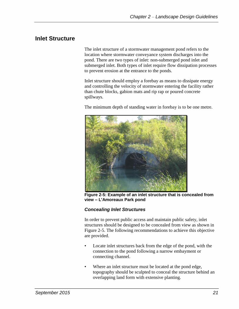
Inlet Structure
The inlet structure of a stormwater management pond refers to the
location where stormwater conveyance system discharges into the
pond. There are two types of inlet: non-submerged pond inlet and
submerged inlet. Both types of inlet require flow dissipation processes
to prevent erosion at the entrance to the ponds.
Inlet structure should employ a forebay as means to dissipate energy
and controlling the velocity of stormwater entering the facility rather
than chute blocks, gabion mats and rip rap or poured concrete
spillways.
The minimum depth of standing water in forebay is to be one metre.
Figure 2-5: Example of an inlet structure that is concealed from view ‒ L'Amoreaux Park pond
Concealing Inlet Structures
In order to prevent public access and maintain public safety, inlet
structures should be designed to be concealed from view as shown in
Figure 2-5. The following recommendations to achieve this objective
are provided.
• Locate inlet structures back from the edge of the pond, with the
connection to the pond following a narrow embayment or
connecting channel.
• Where an inlet structure must be located at the pond edge,
topography should be sculpted to conceal the structure behind an
overlapping land form with extensive planting.
22 September 2015
Landscape Design Guidelines for Stormwater Management Ponds
• Utilize planted fieldstone to construct wing walls, conceal
concrete headwalls and mitigate erosion.
Safety barriers, such as railings or fence, may be necessary in critical
areas such as above headwalls or where there are significant changes
in grade, for example, 600 mm in height. Typically, a railing will be
required when the permanent water depth exceeds 0.6 m with interior
sideslopes steeper than 3H:1V.
Generally, a pond that is gently sloping less than 3H:1V and has other
safety features like warning signage, vegetative and barrier plantings,
and safety ledges along the pond perimeter does not require a fence.
See "Public Safety" on page 38. Where the installation of a fence is
required to provide fall protection, a 1.2 m black vinyl coated
chainlink fence according to OPSD 972.131 should be used. For
example of a black vinyl coated chainlink fence, see Figure 2-6.
Figure 2-6: Inlet structure of stormwater wet pond (at southwest corner of Staines Road and Seasons Drive)
Recommended Plantings
Extensive planting should be installed to conceal fences and barriers.
See Zones 3, 4 and 5 descriptions above for detailed requirements.
Acceptable plant species for these zones can be found in Appendix A,
Acceptable Plant Species for Stormwater Management Ponds.
September 2015 23
Chapter 2 – Landscape Design Guidelines
Outlet Structures
In order to achieve water quality and quantity control objectives as
well as ecological targets in the receiving watercourse and downstream
watershed, outlet structure designs should be developed in
consideration of a range of factors beyond those related to the
regulation of flows discharged from the stormwater management
facility, including the following:
• Aquatic habitat and fish community targets for the receiving
watercourse and subwatershed, for instance, water temperature.
• Watercourse stability and fluvial geomorphological
characteristics. Outlet structures should be designed, located and
oriented based on an understanding of fluvial characteristics of the
receiving watercourse to ensure that the installation of the outlet
and flows generated do not result in erosion, increased instability
or alteration to channel morphology.
• Groundwater interflow and discharge patterns should be
considered in the design process to ensure that groundwater
movement to existing discharge areas is not interrupted, as well as
to identify opportunities to enhance groundwater discharge where
it is appropriate.
• Ecological influences on adjacent vegetation communities and
ecosystems should be understood to ensure that the
implementation of outlet structures does not impact adjacent
habitats.
There are at least three basic parts to an outlet structure
• outlet structure in the pond
• flow control structure/device, which may be in a chamber below
ground or in a small building
• outlet discharge to the environment, like a diversion structure.
The site-specific requirements for any outlet structure design will be
determined on a case by case basis. For example, the requirement and
design of any diversion structure in a natural creek will need to be
discussed with the staff of TRCA and Toronto Water. In general, the
outlet channel immediately below the pond should be modified to
conform to natural dimensions, and lined with properly-sized riprap
placed over filter cloth. For outfall protection, emergency spillways,
stilling basins/plunge-pools, rock deflectors, check dams and other
24 September 2015
Landscape Design Guidelines for Stormwater Management Ponds
devices could be used and designed to reduce flow velocities to non-
erosive levels.
If outlet structures are to be placed within environmentally sensitive
sites, then the placement and design of such structures should be
determined by experts from the consultant, City and approval agencies
such as, Toronto and Region Conservation Authority, Ministry of
Natural Resources and Department of Fisheries and Oceans prior to
submission of the engineering drawings.
Pond outlets should be designed with the objective of mitigating
downstream impacts. Some innovative design of the outlet system can
reduce the potential thermal impact. The following alternative outlet
designs should be considered to achieve this target.
Bottom-Draw Outlets
There are temperature benefits from a bottom-draw facility, although
this is dependent on the size of the permanent pool and the release
depth. Lower temperatures – in the order of several degrees Celsius
occur several metres below the permanent pool surface. Ponds with
permanent pool depths greater than 3 m, however, are likely to become
thermally stratified during the summer months. The water at depths
can become anoxic, and there is a potential for metals and nutrients to
be remobilized. Although oxygen deprivation can be solved by re-
aeration at the outlet, for example discharge over rocks, the discharge
of polluted water would be undesirable. Accordingly, ponds with a
very deep release—greater than 3 m—should consider re-aeration in
the pond itself to prevent thermal stratification from occurring. The
design must also take into consideration the possible reductions in
sedimentation and resuspension of sediment collected at the pond
bottom.
Cooling Trenches
Cooling trenches are designed to cool down discharging of the pond
water to the downstream watercourse. The required dimensions of the
trench are determined by: pond size, effluent rates, temperature of
discharge from the pond, existing downstream temperature, and
distance from the receiving waterbody.
Cooling trenches are placed at the pond outlet and are typically built
by a stone-filled trench buried below ground. By contact with the stone
media results in a transfer of heat from the water to the stones,
effectively reducing the temperature of water discharged at the outlet
September 2015 25
Chapter 2 – Landscape Design Guidelines
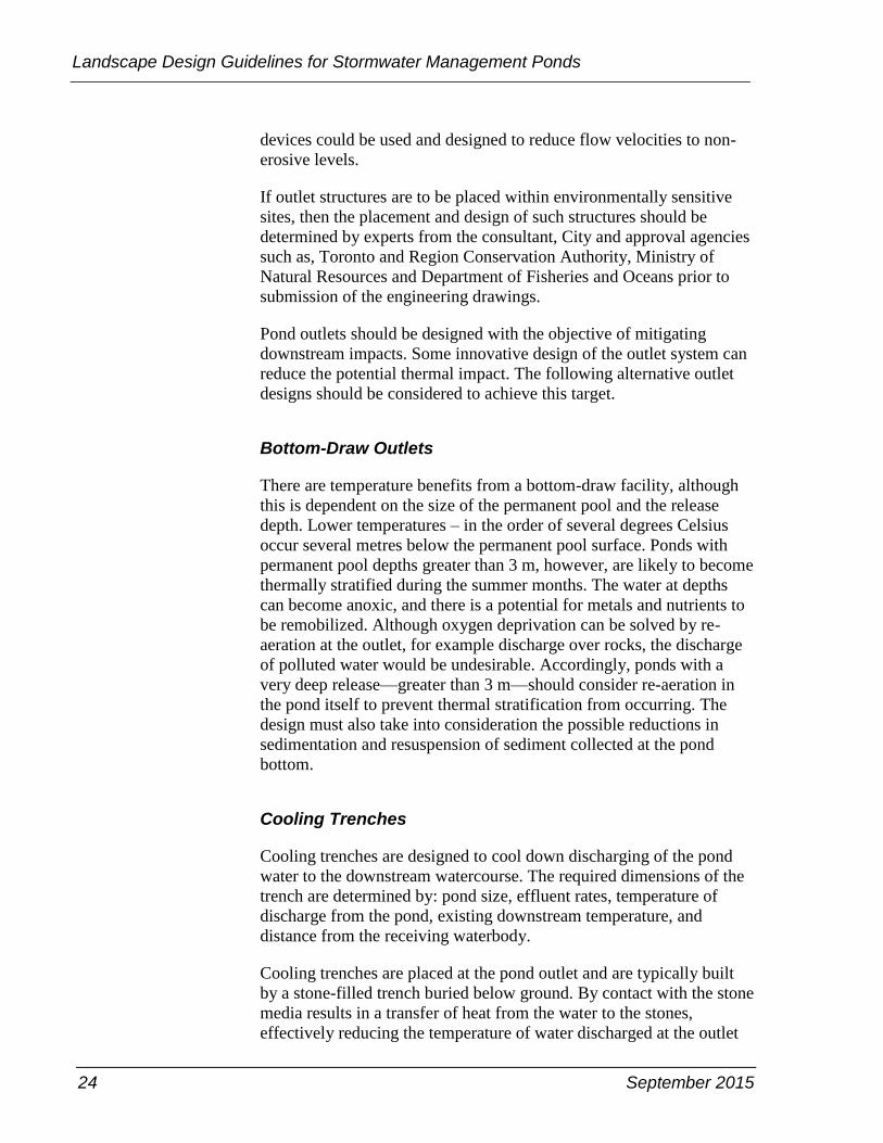
of the trench. It is preferred that the cooling trenches have multiple
outlets in order to simulate the natural pattern of discharge to the
downstream watercourse as seen in Figure 2-7 and 2-8.
Figure 2-7: Cooling trench ‒ longitudinal section
Figure 2-8: Cooling trench ‒ profile section
26 September 2015
Landscape Design Guidelines for Stormwater Management Ponds
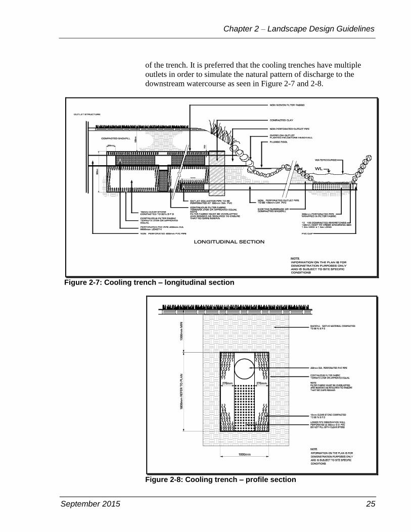
Seepage Outlets
Seepage outlets are designed to achieve temperature reduction
objectives through three processes
• heat transfer with filter medium, similar to the cooling trench
• gradual discharge to densely shaded, well vegetated buffer strips
• provision of groundwater recharge and discharge to the
watercourse through subsurface interflow.
Figure 2-9: Seepage outlet
Seepage outlets are designed to be situated downstream of the facility
outlet and are comprised of the following components as shown above
in Figure 2-9
• a header pipe that feeds a set of small diameter, clear stone or
coarse sand filled outlet pipes
September 2015 27
Chapter 2 – Landscape Design Guidelines
• outlet pipes are spaced apart and are configured to discharge into
existing depressions, drainage ways or areas of permeable soil that
are set back from the edge of the watercourse
• clean-outs for each header pipe and outlet pipe to facilitate
flushing
• a bypass outlet to ensure continous operation of the facility in the
event, the seepage outlet system may become compromised over
time.
The system should be designed with a degree of redundancy to
compensate for potential blockage or reduced rates of discharge from
one or more of the outlet pipes that may result from the penetration of
root systems or other factors.
Outlet Channels
Long, narrow, well-vegetated outlet channels have proven to be
effective in mitigating temperature increases through shading,
transferring heat to substrate and by encouraging infiltration. Natural
channel design techniques can be used to ensure the channel conforms
to the natural characteristics of the valleylands. Outlet channels should
be designed
• as narrow tributaries with width to depth ratios approaching
1H:1V, contingent upon gradient and conveyance parameters
• to have a gentle gradient to maximize contact time. Channels
should be lined with clear stone substrate with a minimum depth
of 200 mm.
• with a continuous band of woody riparian vegetation and a
minimum width of 3 m along each side of the outlet channel to
facilitate shading and enhance stream stability. Species such as
eastern white cedar and red osier dogwood should be planted in
combination with fast-growing riparian pioneer species such as
poplar, as well as longer lived, large canopy species such as red
maple and hemlock.

28 September 2015
Landscape Design Guidelines for Stormwater Management Ponds
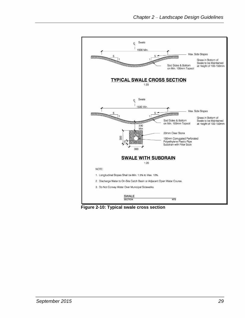
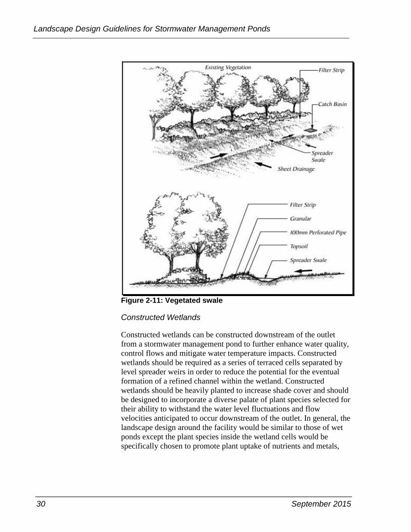
Vegetated Swales
In situations where the stormwater management facility is located
adjacent to an existing vegetated area with high soil moisture
conditions or a shallow water table, a swale is an effective tool to filter
runoff by distributing stormwater over a broad vegetated area, see
Figure 2-10 and Figure 2-11. The swale also provides additional
benefits related to water quality improvement and moderation of
discharge rates. The configuration and design of swales are determined
in large part by existing site parameters including: topography, soil,
and vegetation community composition.
The swale should be planted continuously along its length for a
distance extending at least 2.5 to 3 m from the crest of the swale on all
sides to ensure stability and to create dense shade. An overflow outlet
or bypass must be incorporated into the design of the swale to ensure
that flows do not result in rilling and erosion within the adjacent
vegetated filter area.
September 2015 29
Chapter 2 – Landscape Design Guidelines
Figure 2-10: Typical swale cross section
30 September 2015
Landscape Design Guidelines for Stormwater Management Ponds
Figure 2-11: Vegetated swale
Constructed Wetlands
Constructed wetlands can be constructed downstream of the outlet
from a stormwater management pond to further enhance water quality,
control flows and mitigate water temperature impacts. Constructed
wetlands should be required as a series of terraced cells separated by
level spreader weirs in order to reduce the potential for the eventual
formation of a refined channel within the wetland. Constructed
wetlands should be heavily planted to increase shade cover and should
be designed to incorporate a diverse palate of plant species selected for
their ability to withstand the water level fluctuations and flow
velocities anticipated to occur downstream of the outlet. In general, the
landscape design around the facility would be similar to those of wet
ponds except the plant species inside the wetland cells would be
specifically chosen to promote plant uptake of nutrients and metals,
September 2015 31
Chapter 2 – Landscape Design Guidelines
Recommended Plant Material
Regardless of the type of the outlet structure, planting material for the
outlets should contribute to the concealment of outlet structures. The
requirement of details of plantings can be chosen from Zones 3, 4 or 5
according to the different site conditions.
Water tolerant trees and shrubs should be planted in dense quantities
between the flow spreader or dissipator at the end of the outlet, and the
receiving watercourse, to minimize erosion. If flow spreaders, or
equivalent, are not feasible at the end of the outlet, then outlet channels
should be native grass lined, meandering swales that extend to the
watercourse bank. Tree and shrub planting along the outlet channel is
required, with densities sufficient to provide a closed canopy over the
outlet. Acceptable native plant species can be found in Appendix A,
Acceptable Plant Species for Stormwater Management Ponds.
Sediment controls must be installed prior to construction of the outlet
structure and grassed swale.
32 September 2015
Landscape Design Guidelines for Stormwater Management Ponds
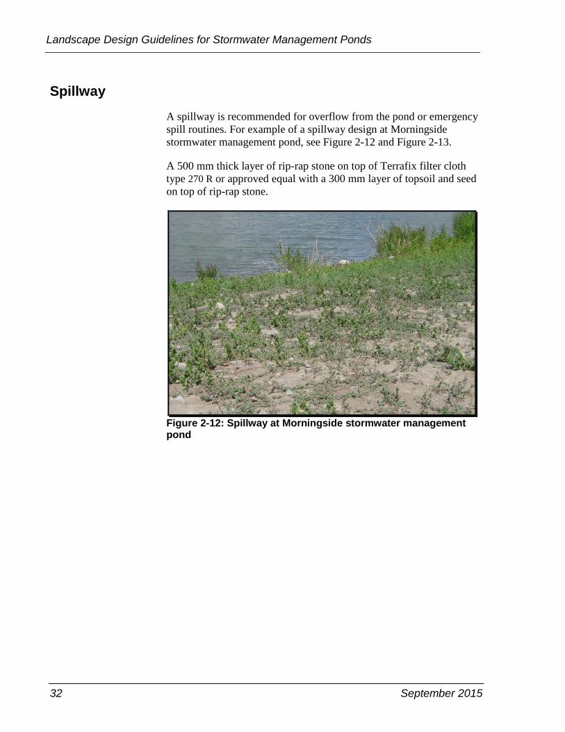
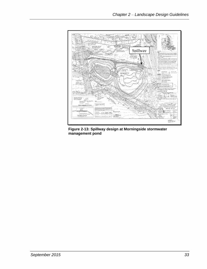
Spillway
A spillway is recommended for overflow from the pond or emergency
spill routines. For example of a spillway design at Morningside
stormwater management pond, see Figure 2-12 and Figure 2-13.
A 500 mm thick layer of rip-rap stone on top of Terrafix filter cloth
type 270 R or approved equal with a 300 mm layer of topsoil and seed
on top of rip-rap stone.
Figure 2-12: Spillway at Morningside stormwater management pond
September 2015 33
Chapter 2 – Landscape Design Guidelines
Figure 2-13: Spillway design at Morningside stormwater management pond
Spillway

34 September 2015
Landscape Design Guidelines for Stormwater Management Ponds
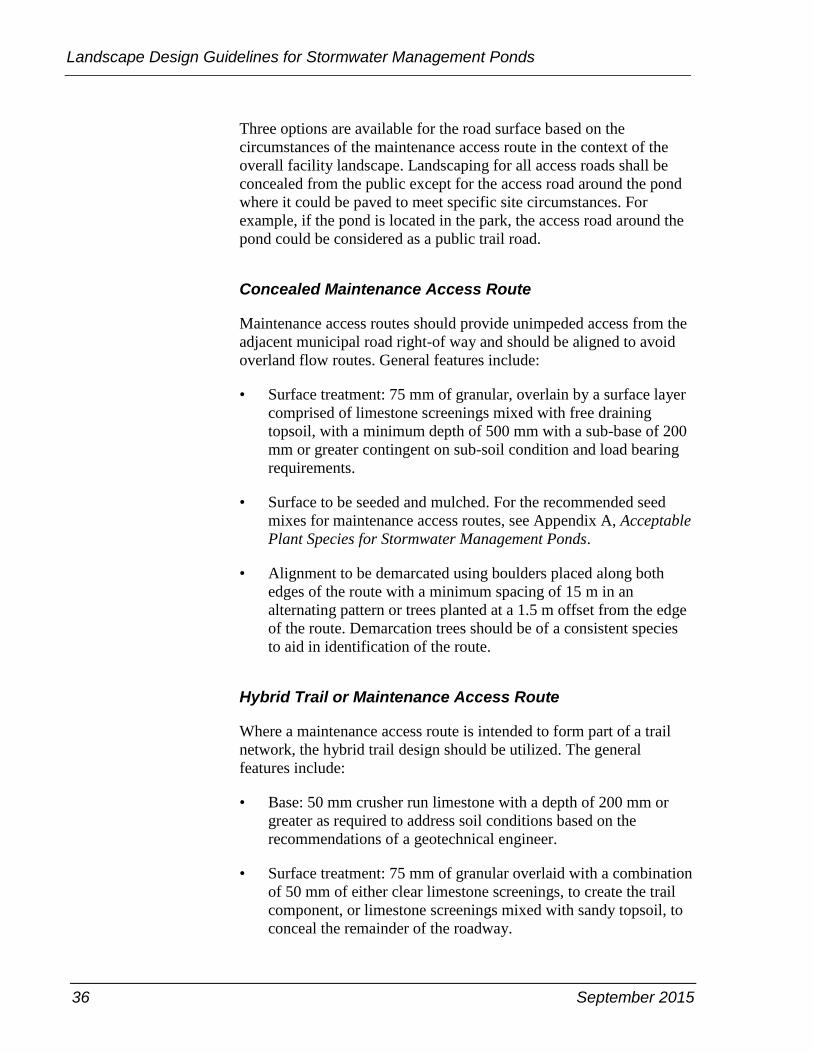
Maintenance Access Road
The main purpose of an access road is to facilitate inspection and
maintenance. Frequent maintenance usually involves small pieces of
equipment such as mowers and light trucks. Access also involves
facilitating inspector access to, into and through a stormwater pond or
wetland to inspect and identify any items that require repairs. Critical
appurtenances should be easily and safely accessed for inspection and
minor maintenance, such as lubricating a pond valve. Although
dredging and cleaning are less frequent maintenance items, site access
will be required for heavy equipment including a steel track heavy
excavator, backhoes, dump trucks, and vacuum trucks.
Maintaining ingress and egress points for the facility at all times is
important in case of emergency repair or rescue. Without a permanent
access route when access is needed, it would be necessary to create a
temporary route which would be disruptive to plant life and
community aesthetics. Access for major repairs is similar to
construction access and involves protecting existing trees, pavement,
utilities, and signage against damage while accessing the areas that
require repairs. General access requirements are:
• Sufficient width to allow vehicles to turn around and the vehicle
size will be determined by the maintenance requirements
associated with specific design.
• Access to the riser is to be provided by lockable manhole covers,
and manhole steps within easy reach of valves and other controls.
• Be capable of supporting heavy vehicle, such as a steel track
heavy excavator.
• Be at least 4 m wide and 2 m on each direction.
• A maximum slope of 15 per cent, and be appropriately stabilized
to withstand maintenance equipment and vehicles.
The maintenance access road must extend from street to the forebay,
riser, inlet/outlet, as well as longitudinally within the pond along its
centreline and should be aligned to avoid overland flow routes. See
Figures 2-14 and 2-15.
September 2015 35
Chapter 2 – Landscape Design Guidelines
Figure 2-14: Access road along pond bank at Earl Bales Park pond
Figure 2-15: Access road from pond bank to the centre of the Earl Bales Park pond
36 September 2015
Landscape Design Guidelines for Stormwater Management Ponds
Three options are available for the road surface based on the
circumstances of the maintenance access route in the context of the
overall facility landscape. Landscaping for all access roads shall be
concealed from the public except for the access road around the pond
where it could be paved to meet specific site circumstances. For
example, if the pond is located in the park, the access road around the
pond could be considered as a public trail road.
Concealed Maintenance Access Route
Maintenance access routes should provide unimpeded access from the
adjacent municipal road right-of way and should be aligned to avoid
overland flow routes. General features include:
• Surface treatment: 75 mm of granular, overlain by a surface layer
comprised of limestone screenings mixed with free draining
topsoil, with a minimum depth of 500 mm with a sub-base of 200
mm or greater contingent on sub-soil condition and load bearing
requirements.
• Surface to be seeded and mulched. For the recommended seed
mixes for maintenance access routes, see Appendix A, Acceptable
Plant Species for Stormwater Management Ponds.
• Alignment to be demarcated using boulders placed along both
edges of the route with a minimum spacing of 15 m in an
alternating pattern or trees planted at a 1.5 m offset from the edge
of the route. Demarcation trees should be of a consistent species
to aid in identification of the route.
Hybrid Trail or Maintenance Access Route
Where a maintenance access route is intended to form part of a trail
network, the hybrid trail design should be utilized. The general
features include:
• Base: 50 mm crusher run limestone with a depth of 200 mm or
greater as required to address soil conditions based on the
recommendations of a geotechnical engineer.
• Surface treatment: 75 mm of granular overlaid with a combination
of 50 mm of either clear limestone screenings, to create the trail
component, or limestone screenings mixed with sandy topsoil, to
conceal the remainder of the roadway.

September 2015 37
Chapter 2 – Landscape Design Guidelines
• Width of the trail portion should be 2.4 m, aligned along the edge
of the roadway nearest to the pond or wetland. The edge of the
concealed portion of the roadway will be demarcated as described
in the previous section.
High Use or Urban Trail
For ponds that are situated in a more urban context or where high
levels of trail use are anticipated, a trail should be designed according
to the following:
• Surface treatment: asphalt or another appropriate hard surface
material as required by Parks, Forestry & Recreation.
• Major linkages in the community wide trail network must be
designed in accordance with the requirements of the Accessibility
for Ontarians with Disabilities Act, with gradients that do not
exceed 8 per cent and other barrier free access initiatives
implemented as required based on site-specific conditions.
Vehicle Access Barriers
Where maintenance access routes and trails intersect road right-of-
ways, barriers are required to restrict unauthorized vehicular access to
the facility. Barriers are to be implemented in accordance with the
following:
• Removable metal bollards should be installed.
• Maximum spacing of 1.5 m.
• Where vehicle access is required for maintenance purposes, fixed
bollards should be installed at 3 m apart with a removable bollard
installed at the mid-point between the two.
• Boulders and plantings in strategic locations across the frontage of
the facility to block or discourage off-road access around the
bollards.
38 September 2015
Landscape Design Guidelines for Stormwater Management Ponds
Provision for Algae Control
Excessive algae growth can be a problem in some stormwater
management ponds, particularly in catchment areas subject to high
nutrient loads. Excessive algae growth can compromise the quality of
water within the pond as well as the functional effectiveness of the
pond. Algae can clog outlet structures and can render a pond unsightly.
Dead and decaying algae can yield an odour which is offensive to
neighbouring residents.
To control algae growth, barley straw bags should be installed around
the perimeter of the pond prior to commissioning. In the process of
decomposition, barley straw releases a chemical that is converted to
hydrogen peroxide in the presence of sunlight. Low levels of hydrogen
peroxide inhibit the rate of growth of algae but will not harm fish or
other aquatic plants. It is important to note that hydrogen peroxide
does not eliminate existing algae but does inhibit the growth of new
algae.
A kilogram of barley straw is required for each 1000 square metres of
pond surface area. The straw should be distributed at a minimum rate
of three kilograms per bag. The bags should be installed off shore of
the pond edge and anchored with concrete blocks. Fresh barley straw
bags are to be installed in the pond in the spring of each of the two
years prior to assumption and finally upon assumption of the facility.
Public Safety
Public safety must be carefully accounted for when planning,
designing, and maintaining urban stormwater detention and retention
facilities, including inlet and outlet structures. The potential risks are
numerous, but they can be managed, in general, by safety design
features, signage, and fencing and proper maintenance practices.
Indeed, the great paradox of designing safe stormwater detention and
retention facilities that are attractive, interesting, well maintained, and
inviting, will encourage regular use in a safe environment.
The following are some general considerations to reduce safety risks:
• Grade the overall site with safety in mind. For example, provide
mild side slopes leading to and within the pond and minimize the
use of vertical walls. Use safety railings when vertical walls or
overly steep slopes are used.
September 2015 39
Chapter 2 – Landscape Design Guidelines
• Although it is recognized that permanent pools and fluctuating
water levels are potential drowning hazards, risk can be
minimized through the implementation of design techniques that
deter public access to specific hazard areas. The installation of
fencing around the perimeter of the pond block will deter public
access.
• Blocks reserved for stormwater management ponds must be of
adequate size to ensure that side slopes do not exceed the
allowable maximum slopes and there is room to accommodate
safety design features. For example, signs, graduated side slopes,
vegetative and barrier plantings, and safety ledges along the pond
perimeter. It is good practice to integrate a “safety ledge” also
referred to as a safety bench around the perimeter of the
permanent pool of a pond. This recommendation is also consistent
with another technique related to stormwater quality
enhancement: integrating a littoral zone of emergent vegetation
around the pond perimeter. Integrating a safety bench with
emergent vegetation will help to discourage people from wading
into the pond.
• Outlets pose particular risks and merit special attention. Do not
utilize open, unprotected pipes as outlets; instead, integrate the
outlet pipe into an outlet structure that has smaller openings or
utilize a sloping trash/safety rack at the pipe entrance. The rack
should have a surface area that is many times larger than the
surface area of the outlet pipe to reduce entrance velocities—
which is necessary to minimize the risk of a person being pinned
against the rack and to assure that if debris is a factor, at least
some of the surface area of the rack will be open during flooding
to enable the pond to drain.
• Proper grates should be installed on inlet and outlet structures to
restrict public access to the storm sewer system. The grates at inlet
or outlet structures are shown in Figures 2-5 and 2-6.
• For outflow grates in the pond, these grates should be parabolic
not flat. The reason for this is both safety and for retrieval of
debris. Specify a parabolic grate or bird cage grate such as OPSD
400.120.
• Inflow and outflow pipes should be separated by sufficient
distances and assure that the pipes are not directly across from
each other. This will avoid the creation of a continuous flow
stream, that is to say current, which could pose dangers for the

40 September 2015
Landscape Design Guidelines for Stormwater Management Ponds
public. If this is not feasible, utilize an energy dissipator at the
outlet where it discharges into the facility.
• In general, stormwater management ponds are not considered to
significantly increase the surrounding area's risk of West Nile
Virus. Multiple agencies are in agreement on this topic, including
Health Canada, Ontario Ministry of Health, Ontario Ministry of
the Environment and Climate Change, and Toronto Public Health.
This risk is low because mosquitoes generally require a stable,
shallow, and stagnant water surface for more than seven days to
allow larvae to reach maturation. In order to promote water
movement—cause the larvae to drown and avoid standing water
greater than seven days old—the ponds should be designed as
being constantly recharged during each rainfall event to drain the
captured water within 48 hours. During dry weather conditions,
the water surface is also exposed to wind turbulence. Therefore, it
is important to take steps to eliminate shallow-stagnant water in
the bottom of any “dry” basins that can be conducive to mosquito
breeding. For example, determine maximum groundwater table
elevations prior to design, consider the use of gravity underdrains
and avoid the use of outlet structure designs that are subject to
plugging.
Fencing
Fencing of the entire perimeter of stormwater management ponds is
discouraged. The need for fencing is also determined by slope. A
steeply sloped pond is more hazardous than a gently sloped pond.
Black-vinyl-coated chainlink fencing 1.8 m high, based on OPSD
972.130, should be installed along the property line where the
stormwater management facility block abuts private property, and it
should be continuous with no gates permitted. The fence should be
located at an offset distance of 0.15 m from the property line within
the stormwater management block, and chainlink mesh should be
affixed to the stormwater management facility side of the posts and
rails.
Fencing is not required along the property line where a stormwater
management facility abuts a public park, open space, natural area, or
road right-of-way.
Subject to the approval of the adjacent landowners and the City, a
living fence with boundary delineation markers may be substituted for
chainlink fencing where stormwater management facilities abut
September 2015 41
Chapter 2 – Landscape Design Guidelines
commercial, industrial, institutional or high density residential land
uses.
Safety barriers should be installed along the top edge of headwalls,
retaining walls and other structures where the change in vertical
elevation exceeds 600 mm in height.
Signage
Install identification signage in a prominent location along the
municipal road frontage or in an appropriate location along the
interface between the pond block and the adjacent open space or park
block. Signage should indicate
• the name of the pond or facility
• the City of Toronto name plate and logo.
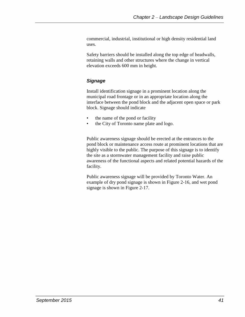
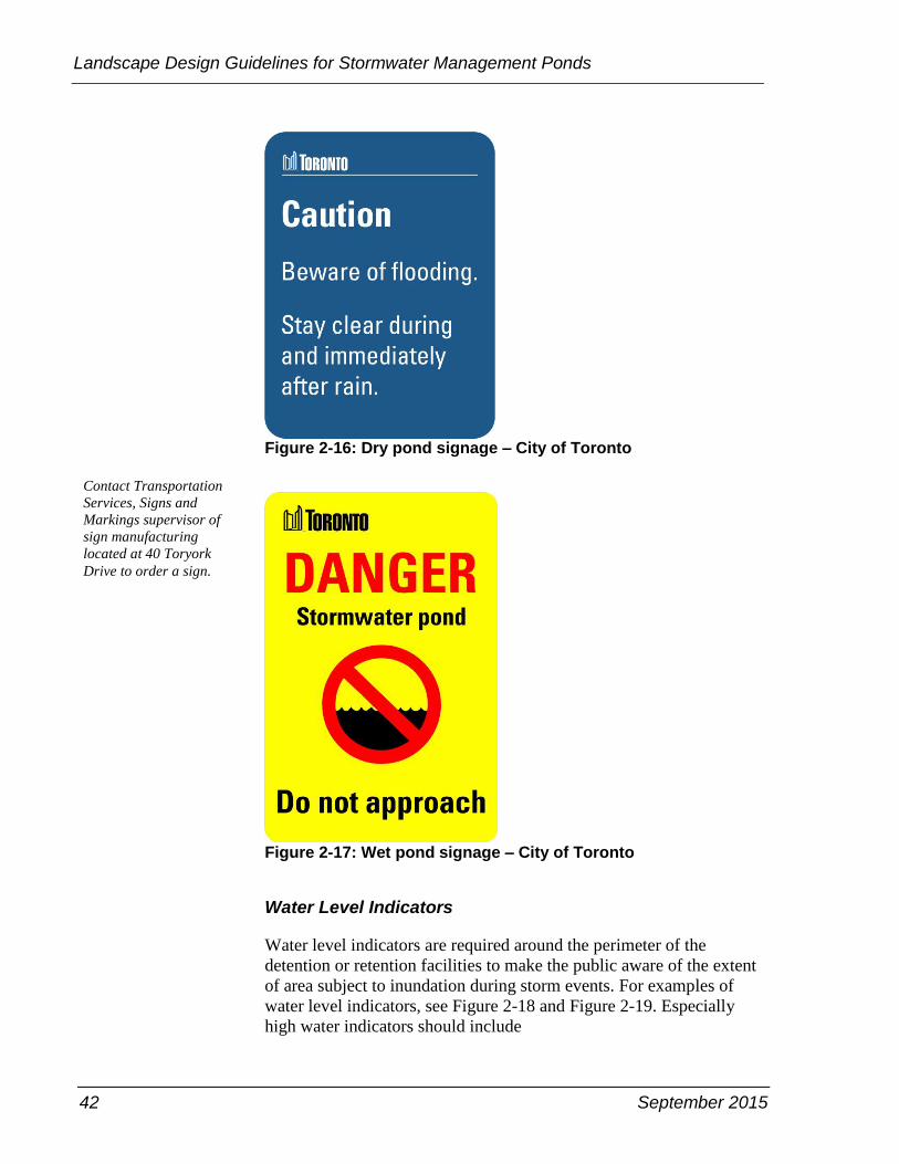
Public awareness signage should be erected at the entrances to the
pond block or maintenance access route at prominent locations that are
highly visible to the public. The purpose of this signage is to identify
the site as a stormwater management facility and raise public
awareness of the functional aspects and related potential hazards of the
facility.
Public awareness signage will be provided by Toronto Water. An
example of dry pond signage is shown in Figure 2-16, and wet pond
signage is shown in Figure 2-17.
42 September 2015
Landscape Design Guidelines for Stormwater Management Ponds
Figure 2-16: Dry pond signage – City of Toronto
Figure 2-17: Wet pond signage – City of Toronto
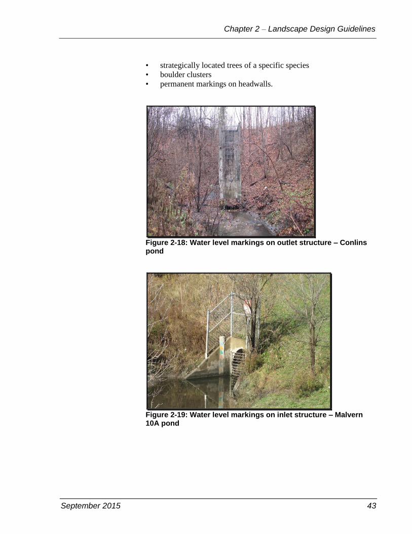
Water Level Indicators
Water level indicators are required around the perimeter of the
detention or retention facilities to make the public aware of the extent
of area subject to inundation during storm events. For examples of
water level indicators, see Figure 2-18 and Figure 2-19. Especially
high water indicators should include
Contact Transportation
Services, Signs and
Markings supervisor of
sign manufacturing
located at 40 Toryork
Drive to order a sign.
September 2015 43
Chapter 2 – Landscape Design Guidelines
• strategically located trees of a specific species
• boulder clusters
• permanent markings on headwalls.
Figure 2-18: Water level markings on outlet structure – Conlins pond
Figure 2-19: Water level markings on inlet structure – Malvern 10A pond
44 September 2015
Landscape Design Guidelines for Stormwater Management Ponds
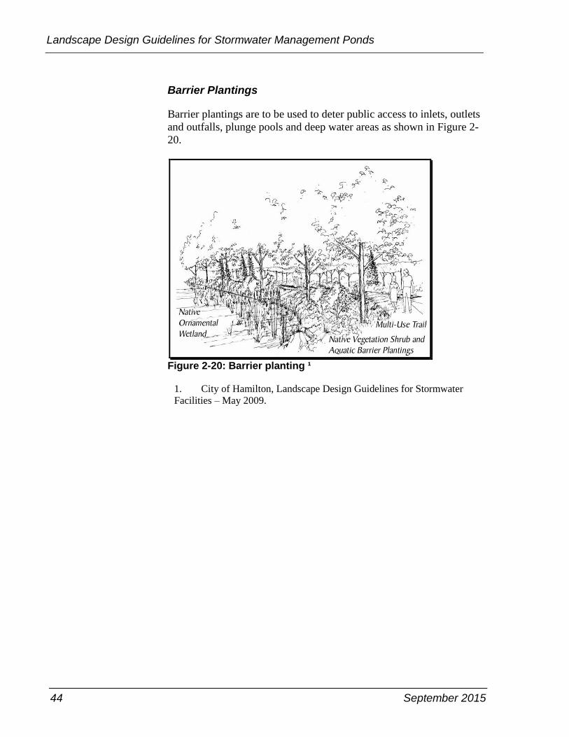
Barrier Plantings
Barrier plantings are to be used to deter public access to inlets, outlets
and outfalls, plunge pools and deep water areas as shown in Figure 2-
20.
Figure 2-20: Barrier planting ¹
1. City of Hamilton, Landscape Design Guidelines for Stormwater
Facilities – May 2009.
September 2015 45
Chapter 3 – Design Review and Pond Assumption Procedure
Chapter 3 – Design Review and Pond Assumption Procedure
In order to build a stormwater pond to meet the City's perspectives, it
becomes necessary that developers and consultants understand the
design review and post construction assumption procedure. The
general development application process is described in the Building
Toronto Together – A Development Guide, which is on the City's
website. The specific procedure for the design review and assumption
of stormwater management ponds is addressed in this chapter.
Submission and Approval of Landscaping Plans
Submission Requirements
Landscape plan submissions must be prepared in accordance with the
following requirements:
All landscape plans are to be prepared and sealed by a landscape
architect having full membership in the Ontario Association of
Landscape Architects.
All landscape grading is to be coordinated with the site grading,
subdivision grading and drainage plans.
All landscape plans are to be prepared in metric and folded to 8.5
x 11 inches.
The engineering drawings,
calculations and
stormwater management
report submission is
described in the Building
Toronto Together – A
Development Guide. The
landscaping plan
submission is the main
focus of this document.
46 September 2015
Landscape Design Guidelines for Stormwater Management Ponds
Information on landscape site plans will include the following:
• key plan
• north arrow
• scale
• existing and proposed contours
• surveyed top of bank
• bottom of bank
• limits of TRCA floodline
• ravine and naural features protection boundary
• adjacent roads and properties
• finished floor elevations of adjacent buildings
• location and extent of underground structures and services
• surveyed locations and descriptions of all trees on site and within
15 m on adjacent lands
• surveyed locations and descriptions of all trees including dripline
and tree protection zone on site and within 15 m on adjacent lands
• surveyed locations and descriptions of all natural features on site
and within 15 m on adjacent lands
• existing trees including dripline and tree protection zone to be
protected on site and within 15 m on adjacent lands
• location and design details including cross-sections and profiles
for all proposed watercourses realignments if applicable
• location of proposed tree protection hoarding
• existing trees to be transplanted
• existing trees to be removed
• new plantings keyed to plant list
• seeded areas and seed mixed
• locations of barley straw bag installation for algae control
• locations of all ground signs
• details for all planting, paving, fencing, structures and railings,
and so on
• location and description of seed bank including donor and
recipient sites
• vegetation monitoring plan, and
• receiving watercourse erosion mitigation contingency plan
The detailed landscape plan submission will be reviewed by City staff
to ensure conformity with the guidelines set out in this document and
once approved; the drawings will be incorporated into the subdivision
agreement.
September 2015 47
Chapter 3 – Design Review and Pond Assumption Procedure
Approval Process
Stormwater management ponds have the potential to be integral and
complementary components of a community. Planning approaches that
address stormwater management ponds as potentially valuable
components of the community open space system are consistent with
the vision and principles of the City. A well executed open space
network that includes stormwater management ponds has been proven
to enhance the marketability of a development by establishing a
character for the community and increasing the range of available
amenities. In considering the design and landscape of the open space
network, emphasis should be placed on establishing a seamless system
of spaces with complementary uses built upon the existing natural
features of the site.
Consistent with the general submission requirements, opportunities to
explore landscape-based stormwater management ponds should be
addressed as part of various types of development applications
including:
• official plan amendment, secondary plan and large infill
development applications
• plans of subdivision
• site plan applications
The general development submission and approval process is
addressed in Building Toronto Together – A Development Guide. The
stormwater management pond design and stormwater management
report shall be submitted and reviewed by following the process as
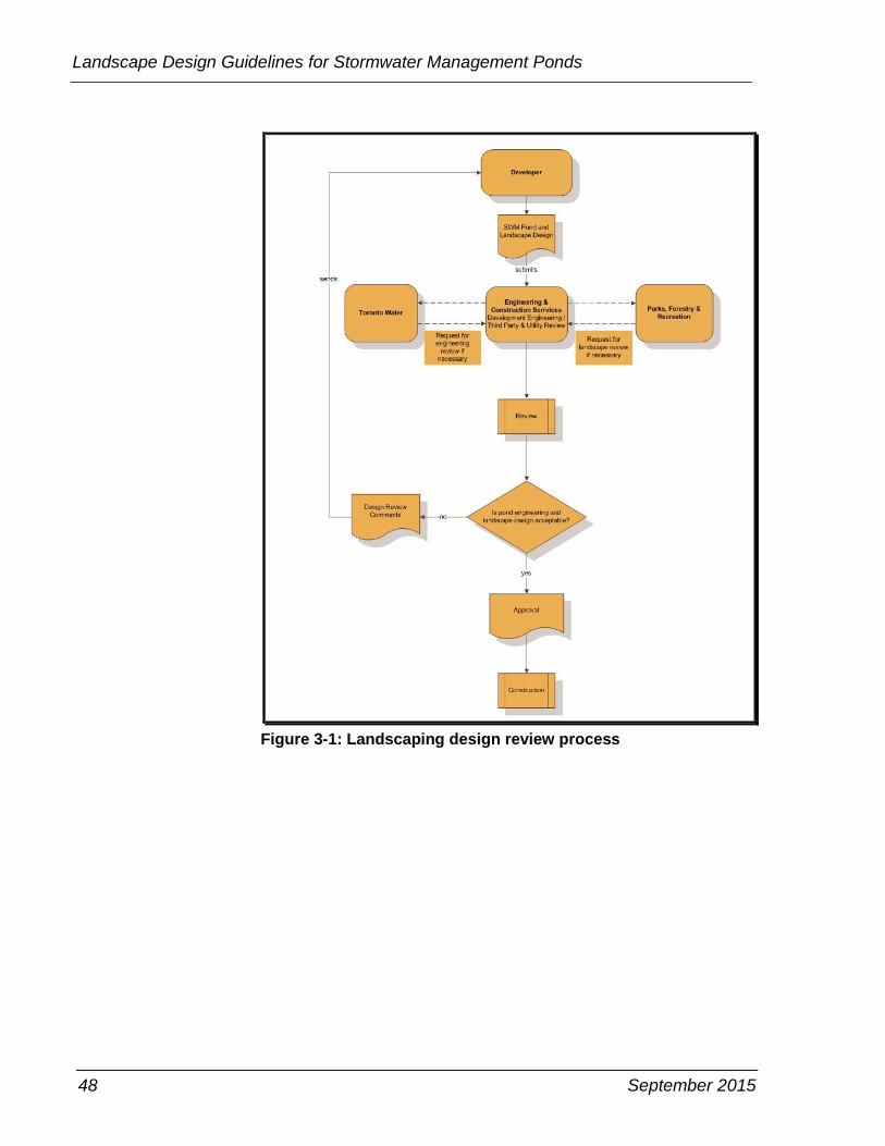
illustrated in Figure 3-1.
48 September 2015
Landscape Design Guidelines for Stormwater Management Ponds
Figure 3-1: Landscaping design review process
September 2015 49
Chapter 3 – Design Review and Pond Assumption Procedure
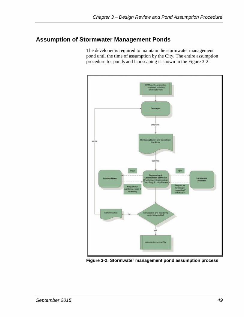
Assumption of Stormwater Management Ponds
The developer is required to maintain the stormwater management
pond until the time of assumption by the City. The entire assumption
procedure for ponds and landscaping is shown in the Figure 3-2.
Figure 3-2: Stormwater management pond assumption process
50 September 2015
Landscape Design Guidelines for Stormwater Management Ponds
There are five main steps to the process for assumption of stormwater
management pond landscaping as follows:
Once landscaping is in place, a Completion Notification
Certificate must be submitted by the landscape architect and a
monitoring program must be completed within the first year.
Monitoring reports must be submitted to the Engineering Review
section for review on an annual basis.
Following the developer's submission of a request for assumption
and monitoring report, the Engineering Review section will
arrange for an inspection of the landscaping to verify that the
landscaping has been installed in conformity with the approved
site and landscape plans.
A list of deficiencies noted during the site inspection will be
forwarded to the landscape architect.
The developer and landscape architect will rectify the deficiencies
and notify the Engineering Review section that such work is
complete.
The Engineering Review section will coordinate a final inspection
of the stormwater management pond landscaping and sign-off on
the stormwater management pond landscape component if all
identified deficiencies are rectified.
Note that final landscape inspections will only be conducted
between June 1 and September 30 to ensure that vegetation can be
inspected when it is in leaf.
Inspection and Maintenance Activities
After any pond maintenance activities, the plantings shall be
maintained or replaced according to the original design. The following
list describes the inspection and maintenance activities for stormwater
management pond landscape components at the time of assumption
and for the regular inspection and maintenance routine:
Routine Inspection
After every major storm event to ensure stability and function of the
facility, approximately four times annually.
September 2015 51
Chapter 3 – Design Review and Pond Assumption Procedure
Litter Removal
Remove all litter from the site on a monthly basis during the period
from March to December. This task includes the removal of litter and
debris from the permanent pool and sediment forebay.
Vegetation Communities
Tree and Shrub Maintenance
• Ensure rodent protection remains in contact with the ground.
• Prune out any dead or damaged limbs.
• Water trees as required to maintain health considering
meteorological, soil and site conditions as well as species
requirements.
Seeded Area Maintenance
• Monitor after initial seeding to ensure that adequate cover density
has been achieved.
• Overseed as required to eliminate bare patches.
• Repair and reseed any rills or gullies which may form during the
grow-in period.
• Remove weeds which may have become established during the
germination and grow-in periods.
• Monitor to ensure that established species correspond with
specified seed mix species composition. Overseed as required to
achieve specified composition and distribution.
• For areas designed to be maintained, mow to maintain a height of
60–75 mm.
• Irrigate seeded areas as required to ensure germination and
establishment.
Shrubs and Shrub Bed Maintenance
• Prune out dead or damaged branches.
• Remove weeds from mulched beds.
• Water shrubs as required to ensure healthy growth in
consideration of soil, meteorological and site conditions as well as
species requirements.
52 September 2015
Landscape Design Guidelines for Stormwater Management Ponds
Algae Control
Install barly straw bags in spring of each year and year of assumption.
Other Landscape Components
Rock works and natural stone flow control structures and spillways:
• Overseed as required ensuring that adequate vegetation cover is
established in the voids between the stone.
• Adjust grades if required to achieve specified water levels.
Fences, Signage and Furnishings
Repair activities are to include the following as necessary, such as
removal of graffiti, touch up painting, replacement or tightening of
loose hardware, ensuring all elements are securely anchored, inspect
and repair as required.
Monitoring Requirements
With respect to the landscape components of stormwater management
facilities, the monitoring program is focused on gauging the
sustainability, performance and evolution of the vegetation community
to identify remedial maintenance activities that may be required. A
description of the recommended monitoring program is provided in the
following section.This recommendation applies to monitoring by the
developer before assumption and ongoing monitoring by the city after
assumption.
Vegetation Community Monitoring Program
Tree and shrubs shall be inspected visually to identify dieback, stress
or presence of disease every two years. One inspection in spring after
leaf out and one inspection in fall after leaf drop.
Aquatic vegetation shall be inspected visually to confirm desired
species composition bi- annually, in the middle of the summer.
Ground cover shall be inspected visually to confirm adequate cover
and desired species composition, bi-annually, once in spring and once
in late summer.
September 2015 53
Chapter 3 – Design Review and Pond Assumption Procedure
Undesirable species shall be inspected visually bi-annually in the
middle of summer and in early fall.
Erosion Monitoring Program
The erosion and displacement shall be inspected visually by bi-
annually, once in spring, and once in fall at the components below:
• spillway
• trails, if any
• maintenance access roads
Photographic Inventory
Photographs should be taken twice yearly corresponding with the
spring and fall monitoring sessions. Photographs should be taken from
fixed locations that are identified on a site map and should include
photographs of the inlet and outlet structures, overflow spillway, trails
and maintenance access routes and key components of the vegetation
community as well as any noted deficiencies.
Subsequent photographic sessions should include areas where
deficiencies were previously identified to document the effectiveness
of the remedial works. Each photograph should be annotated with a
description of the subject matter.
The photo inventory package should be bound with a key map and
digital photographs on a compact disc. This documentation should
form part of the monitoring report for the site that will be submitted to
the City as a condition of assumption of the facility.
Reporting
Monitoring reports must be submitted to the Engineering Review
section for review on an annual basis. Reports should include the
following information:
• pond name, location, street address and reference number
• date of completion of construction
• date of expiration of warranty period
• general description of the facility
• observations related to water quality, presence of wildlife
• general pond conditions
• statement of water quality
54 September 2015
Landscape Design Guidelines for Stormwater Management Ponds
• summary of findings of monitoring inspections
• comparative analysis of data and evaluation in comparison to
original design objectives and previous monitoring findings
• summary of physical status of various components of the facility
including vegetation community, inlet and outlet structures,
maintenance access routes and other components
• summary of facility performance including explanation of any
discrepancies between performance of the vegetation community,
that is survival, degree of invasive colonization, and so on
• photographic inventory
• key map that documents photograph locations and the locations of
any issues of concern identified
Where the performance of a vegetation community or other landscape
components such as the establishment of groundcover remains
deficient over an extended time period, recommendations for
remediation of deficencies to the facility should be made and
submitted for review and approval by the City along with an estimate
of the cost of the improvements. The improvements should be
implemented immediately upon receipt of approval from City, and
must be compeleted prior to assumption of the facility. The monitoring
program must continue after the improvements are implemented until
it is confirmed that targets are being achieved over two successive
monitoring years.
Effective monitoring is essential to ensure that stormwater
management objectives are achieved. This will in turn contribute to the
sustainability of the Don River, Humber River, Etobicoke Creek,
Highland Creek and Rouge River watersheds.
Data Inventory
The proponent should conduct the monitoring program until
assumption of the facility by the City. All the information including
as-built drawings, monitoring reports and wellness report will be
collected and submitted to Toronto Water, Water Infrastructure
Management section and added into the Division's stormwater
management pond geodatabase.

September 2015 55
Chapter 3 – Design Review and Pond Assumption Procedure
After Assumption
Once the stormwater management pond is assumed, Toronto Water
will carry on an operations and maintenance program. The specific
landscape activities will follow what is described in the "Inspection
and Maintenance Activities" section on page 50. The remaiing
operation and maintenance activities will follow the stormwater pond
operation and mainenance manual submitted as part of the final
submission or as-built package. If any landscape monitoring program
is required to continue, the detailed procedure will be the same content
as the "Monitoring Requirements" section on page 52.

Insert Blank Page This Text Will Not Print
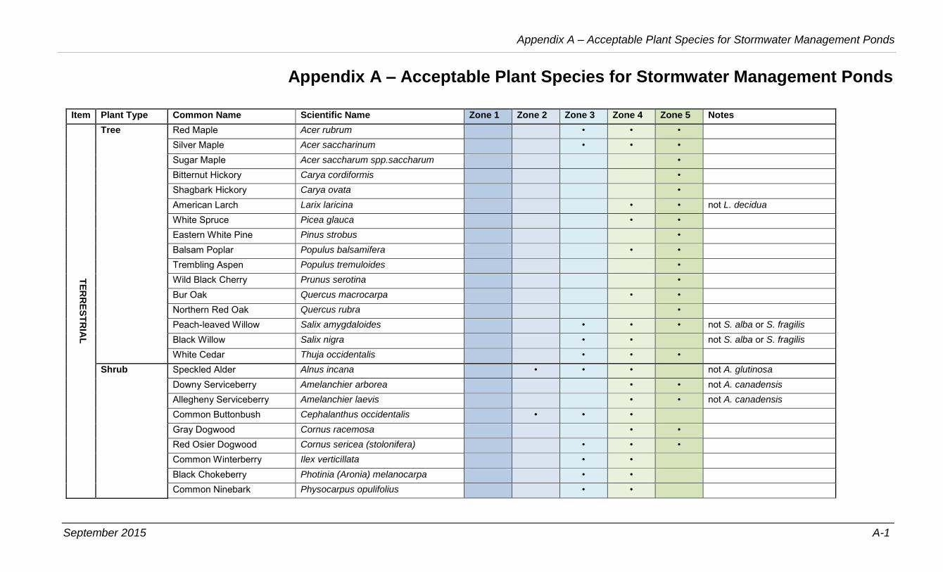
September 2015 A-1
Appendix A – Acceptable Plant Species for Stormwater Management Ponds
Appendix A – Acceptable Plant Species for Stormwater Management Ponds
Item Plant Type Common Name Scientific Name Zone 1 Zone 2 Zone 3 Zone 4 Zone 5 Notes
TE
RR
ES
TR
IAL
Tree Red Maple Acer rubrum • • • Silver Maple Acer saccharinum • • • Sugar Maple Acer saccharum spp.saccharum • Bitternut Hickory Carya cordiformis • Shagbark Hickory Carya ovata • American Larch Larix laricina • • not L. decidua White Spruce Picea glauca • • Eastern White Pine Pinus strobus • Balsam Poplar Populus balsamifera • • Trembling Aspen Populus tremuloides • Wild Black Cherry Prunus serotina • Bur Oak Quercus macrocarpa • • Northern Red Oak Quercus rubra • Peach-leaved Willow Salix amygdaloides • • • not S. alba or S. fragilis Black Willow Salix nigra • • not S. alba or S. fragilis White Cedar Thuja occidentalis • • •
Shrub Speckled Alder Alnus incana • • • not A. glutinosa Downy Serviceberry Amelanchier arborea • • not A. canadensis Allegheny Serviceberry Amelanchier laevis • • not A. canadensis Common Buttonbush Cephalanthus occidentalis • • • Gray Dogwood Cornus racemosa • • Red Osier Dogwood Cornus sericea (stolonifera) • • • Common Winterberry Ilex verticillata • • Black Chokeberry Photinia (Aronia) melanocarpa • • Common Ninebark Physocarpus opulifolius • •
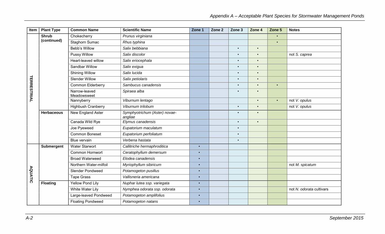
Appendix A – Acceptable Plant Species for Stormwater Management Ponds
A-2 September 2015
Item Plant Type Common Name Scientific Name Zone 1 Zone 2 Zone 3 Zone 4 Zone 5 Notes
TE
RR
ES
TR
IAL
Shrub (continued)
Chokecherry Prunus virginiana • Staghorn Sumac Rhus typhina • Bebb’s Willow Salix bebbiana • • Pussy Willow Salix discolor • • not S. caprea Heart-leaved willow Salix eriocephala • • Sandbar Willow Salix exigua • • Shining Willow Salix lucida • • Slender Willow Salix petiolaris • • Common Elderberry Sambucus canadensis • • • Narrow-leaved Meadowsweet
Spiraea alba • •
Nannyberry Viburnum lentago • • not V. opulus Highbush Cranberry Viburnum trilobum • • not V. opulus
Herbaceous New England Aster Symphyotrichum (Aster) novae-angliae
• •
Canada Wild Rye Elymus canadensis • • Joe Pyeweed Eupatorium maculatum • Common Boneset Eupatorium perfoliatum • Blue vervain Verbena hastata •
AQ
UA
TIC
Submergent Water Starwort Callitriche hermaphroditica • Common Hornwort Ceratophyllum demersum • Broad Waterweed Elodea canadensis • Northern Water-milfoil Myriophyllum sibiricum • not M. spicatum Slender Pondweed Potamogeton pusillus • Tape Grass Vallisneria americana •
Floating Yellow Pond Lily Nuphar lutea ssp. variegata • White Water Lily Nymphea odorata ssp. odorata • not N. odorata cultivars Large-leaved Pondweed Potamogeton amplifolius • Floating Pondweed Potamogeton natans •
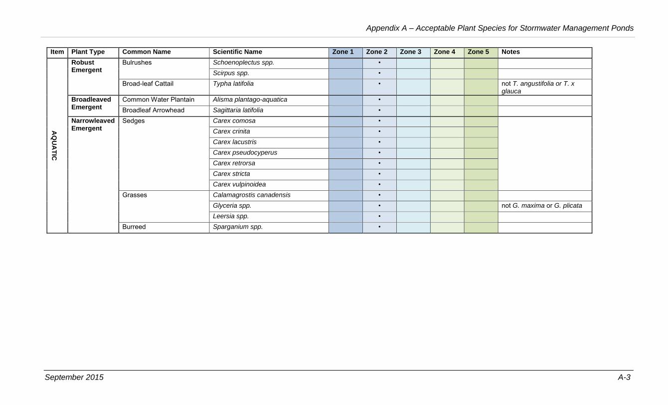
September 2015 A-3
Appendix A – Acceptable Plant Species for Stormwater Management Ponds
Item Plant Type Common Name Scientific Name Zone 1 Zone 2 Zone 3 Zone 4 Zone 5 Notes
AQ
UA
TIC
Robust Emergent
Bulrushes Schoenoplectus spp. • Scirpus spp. •
Broad-leaf Cattail Typha latifolia • not T. angustifolia or T. x glauca
Broadleaved Emergent
Common Water Plantain Alisma plantago-aquatica • Broadleaf Arrowhead Sagittaria latifolia •
Narrowleaved Emergent
Sedges Carex comosa • Carex crinita •
Carex lacustris •
Carex pseudocyperus •
Carex retrorsa •
Carex stricta •
Carex vulpinoidea •
Grasses Calamagrostis canadensis • Glyceria spp. • not G. maxima or G. plicata Leersia spp. •
Burreed Sparganium spp. •

Insert Blank Page This Text Will Not Print
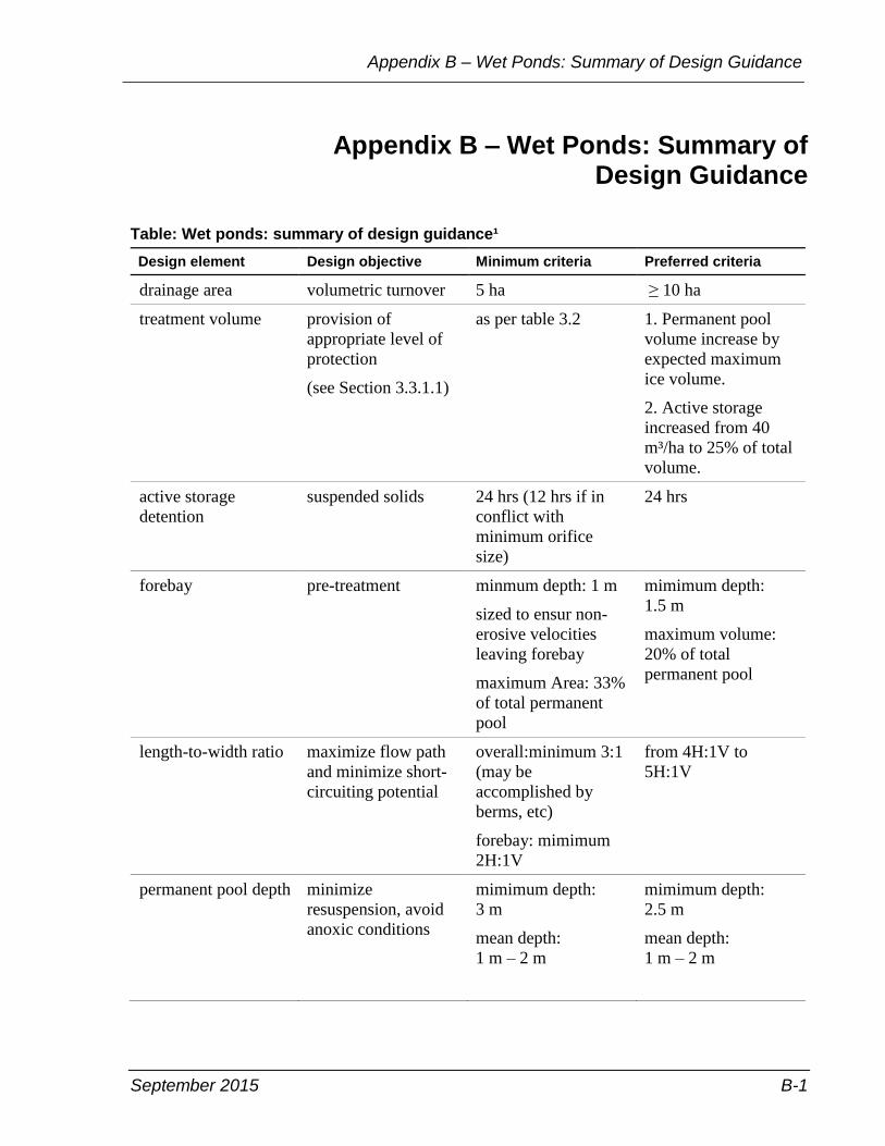
September 2015 B-1
Appendix B – Wet Ponds: Summary of Design Guidance
Appendix B – Wet Ponds: Summary of Design Guidance
Table: Wet ponds: summary of design guidance¹
Design element Design objective Minimum criteria Preferred criteria
drainage area volumetric turnover 5 ha ≥ 10 ha
treatment volume provision of
appropriate level of
protection
(see Section 3.3.1.1)
as per table 3.2 1. Permanent pool
volume increase by
expected maximum
ice volume.
2. Active storage
increased from 40
m³/ha to 25% of total
volume.
active storage
detention
suspended solids 24 hrs (12 hrs if in
conflict with
minimum orifice
size)
24 hrs
forebay pre-treatment minmum depth: 1 m
sized to ensur non-
erosive velocities
leaving forebay
maximum Area: 33%
of total permanent
pool
mimimum depth:
1.5 m
maximum volume:
20% of total
permanent pool
length-to-width ratio maximize flow path
and minimize short-
circuiting potential
overall:minimum 3:1
(may be
accomplished by
berms, etc)
forebay: mimimum
2H:1V
from 4H:1V to
5H:1V
permanent pool depth minimize
resuspension, avoid
anoxic conditions
mimimum depth:
3 m
mean depth:
1 m – 2 m
mimimum depth:
2.5 m
mean depth:
1 m – 2 m
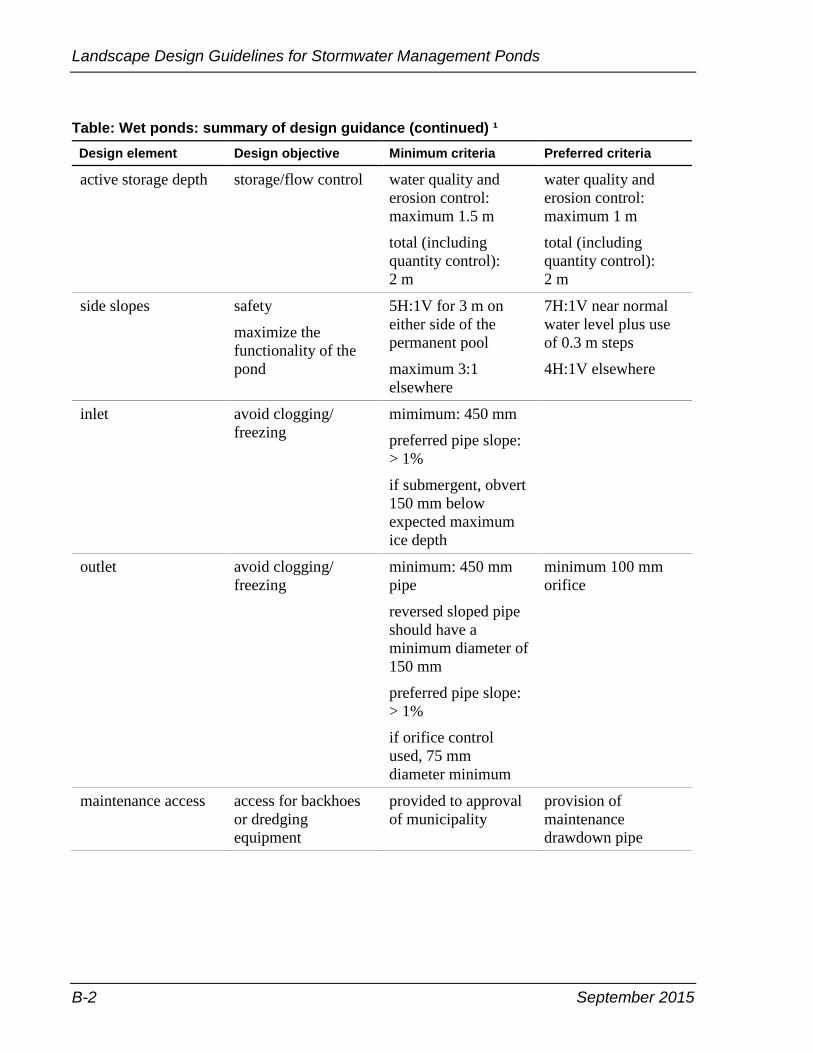
Landscape Design Guidelines for Stormwater Management Ponds
B-2 September 2015
Table: Wet ponds: summary of design guidance (continued) ¹
Design element Design objective Minimum criteria Preferred criteria
active storage depth storage/flow control water quality and
erosion control:
maximum 1.5 m
total (including
quantity control):
2 m
water quality and
erosion control:
maximum 1 m
total (including
quantity control):
2 m
side slopes safety
maximize the
functionality of the
pond
5H:1V for 3 m on
either side of the
permanent pool
maximum 3:1
elsewhere
7H:1V near normal
water level plus use
of 0.3 m steps
4H:1V elsewhere
inlet avoid clogging/
freezing
mimimum: 450 mm
preferred pipe slope:
> 1%
if submergent, obvert
150 mm below
expected maximum
ice depth
outlet avoid clogging/
freezing
minimum: 450 mm
pipe
reversed sloped pipe
should have a
minimum diameter of
150 mm
preferred pipe slope:
> 1%
if orifice control
used, 75 mm
diameter minimum
minimum 100 mm
orifice
maintenance access access for backhoes
or dredging
equipment
provided to approval
of municipality
provision of
maintenance
drawdown pipe

September 2015 B-3
Appendix B – Wet Ponds: Summary of Design Guidance
Table: Wet ponds: summary of design guidance (continued) ¹
Design element Design objective Minimum criteria Preferred criteria
sediment drying area sediment removal while preferable,
should only be
incorporated into the
design when it
imposed no
additional land
requirement
to be provided above
maxium water quality
water level
drainage returned to
pond
buffer safety minimum 7.5 m
above maximum
water quality/erosion
control water level
minimum 3 m above
high water level for
quantity control
1. Ontario Ministry of the Environment, Stormwater Management Planning and Design Manual, Table
4.6, 2003.

Insert Blank Page This Text Will Not Print
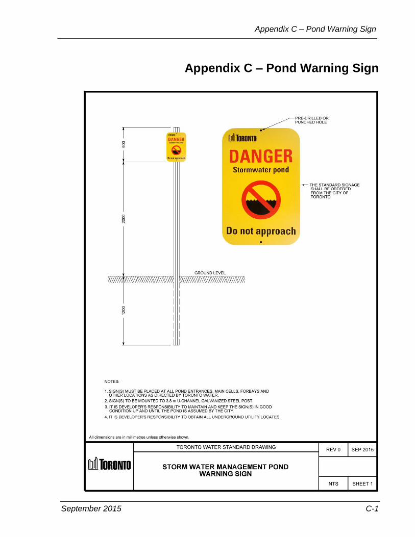
September 2015 C-1
Appendix C – Pond Warning Sign
Appendix C – Pond Warning Sign

Insert Blank Page This Text Will Not Print

September 2015 D-1
Appendix D – Bibliography
Appendix D – Bibliography
Drainage Policy (Former Municipalities in Toronto)
City of Toronto, Scarborough District – Drainage Policy
By City of Toronto Works and Emergency Services Department.
Published by City of Toronto, March 1998.
Stormwater Design Criteria (Provincial)
Ministry of the Environment – Stormwater Management Planning
and Design Manual
By Ministry of the Environment. Published by Province of
Ontario, March 2003.
Design Guidelines (Current City Departments)
Building Toronto Together – A Development Guide
By Toronto Building. Published by City of Toronto, 55 John
Street, Toronto, Ontario, M5V 3C6, 2011.
Design Criteria for Sewers and Watermains
By Technical Services. Published by City of Toronto, 55 John
Street, Toronto, Ontario, M5V 3C6, November 2009.
Wet Weather Flow Management Policy
By Toronto Water. Published by City of Toronto, 55 John Street,
Toronto, Ontario, M5V 3C6, August 2003.
Wet Weather Flow Management Guidelines
By Toronto Water. Published by City of Toronto, 55 John Street,
Toronto, Ontario, M5V 3C6, November 2006.
Design Guideline (Other Municipalities)
Toronto and Region Conservation Authority – Landscape Design
Guide for Low Impact Development
By Toronto and Region Conservation Authority, June 2010.
Toronto and Region Conservation Authority – Post-Construction
Restoration Guidelines
By Toronto and Region Conservation Authority, July 2004.

Landscape Design Guidelines for Stormwater Management Ponds
D-2 September 2015
Toronto and Region Conservation Authority – Seed Mix Guidelines
By Toronto and Region Conservation Authority, July 2004.
Toronto and Region Conservation Authority – Stormwater
Management Pond Planting Guidelines
By Toronto and Region Conservation Authority, September 2007.
Town of Markham – Stormwater Management Pond Safety and
Maintenance Criteria
By Les Arishenkoff, Town of Markham, June 1, 1999.
Town of Richmond Hill – Stormwater Management Landscape
Design Criteria & Implementation Guidelines
By Schollen & Company Inc. in association with Aquafor Beech
Limited, LGL Limited and Gerber Geosciences. Published by the
Town of Richmond Hill, 225 East Beaver Creek, Richmond Hill,
Ontario L4C 4Y5, May 15, 2006.
City of Hamilton – Landscape Design Guidelines for Stormwater
Facilities
By A.J. Clarke and Associates Limited. Published by City of
Hamilton, 71 Main Street West, Hamilton, Ontario, L8P 4Y5,
2006.
Style Guides
City of Toronto – Writing Clearly: A Writing and Style Guide for the
Toronto Public Service
By Strategic Communications, City Manager’s Office. Published
by City of Toronto, 55 John Street, Toronto, Ontario, M5V 3C6,
2009.
September 2015 Glossary-1
Glossary
Glossary
Aquatic – Relating to or consisting of or being in water.
Applicant – The owner of lands or his or her authorized agent
requiring services.
BMP or Best Management Practices – State of the art methods or
techniques used to manage the quality and improve the quality of wet
weather flow. BMPs include source controls, conveyance controls and
end-of-pipe controls.
City – The City of Toronto—the corporation—and will be referred to
as the City for the purposes of this document.
Consulting Engineer – A professional engineer or firm of engineers
retained by the City or a developer, skilled, and experienced in
municipal work and land development projects and registered with the
Professional Engineers of Ontario.
Dry Pond – An extended pond is dry during the period without
rainfall or snow melt. During rainfall or snowmelt period, the pond
will be flooded to store the surface runoff.
Developer – The owner of land upon which municipal services will be
located and ultimately owned by the City.
Ecosystem – A community of living organisms such as human, plants,
animals and microbes in conjunction with the non living components
of their environment, for instance air, water and mineral soil,
interacting as a system. These biotic and abiotic components are
regarded as linked together through nutrient cycles and energy flows.
As ecosystems are defined by the network of interactions among
organisms, and between organisms and their environment, they can
come in any size but usually encompass specific, limited spaces—
although some scientists say that the entire planet is an ecosystem.
End-of-Pipe – A structural Best Management Practice that is located
at the end of a flow conveyance route, before stormwater enters into
the natural water systems, such as creeks, rivers, lakes, groundwater.
End-of-Pipe controls on surface and below ground but are not limited
to wet ponds, constructed wet lands and other similar systems.
Landscape Design Guidelines for Stormwater Management Ponds
Glossary-2 September 2015
Erosion – The wearing away of the land surface by running water,
wind, ice or other geologic agents, including such processes as
gravitational creep or detachment and movement of soil or rock
fragments by water, wind, ice or gravity.
Fluvial – is used in geography and Earth science to refer to the
processes associated with rivers and streams and the deposits and
landforms created by them.
General Manager – The person appointed by the City from time to
time as the General Manager of Toronto Water and his or her
successors or his or her duly authorized representative.
Geomorphology – is the scientific study of landforms and the
processes that shape them. Geomorphologists seek to understand why
landscapes look the way they do, to understand landform history and
dynamics, and to predict future changes through a combination of field
observations, physical experiments, and numerical modeling.
Geomorphology is practiced within geography, geology, geodesy,
engineering geology, archaeology, and geotechnical engineering, and
this broad base of interest contributes to a wide variety of research
styles and interests within the field.
Groundwater – Underground water that is held in the soil and in
pervious rocks.
Habitat – The type of environment in which an organism normally
lives.
Indigenous – produced, growing, living, or occurring naturally in a
particular region or environment.
Inlet Structure – a device which controls the volume of discharge to
the municipal storm water pond.
Inundation – The rising of a body of water and its overflowing onto
normally dry land.
Invasive Species – Any non-indigenous species, or non-native, plants
or animals. They adversely affect the habitats and bioregions they
invade economically, environmentally, or ecologically, or both,
Landscape Design – is an independent profession and a design and art
tradition, practised by landscape designers, combining nature and
culture. In contemporary practice landscape design bridges between
landscape architecture and garden design.
September 2015 Glossary-3
Glossary
Landscape Architect – A professional registered in the province of
Ontario, who develops land for human use and enjoyment through
effective placement of structure, vehicular and pedestrian ways, and
plantings, also landform, grading, surface treatment.
MOECC – Ministry of Environment and Climate Change
Offical Plan – The Offical Plan adopted by the City. It is a blueprint
for how the City will grow over the next 30 years.
OPSD – Ontario Provincial Standard Drawing
Owner – A person who has any right, title, estate, or interest in a
property, other than that of only an occupant and, where that person is
a corporation, shall include the officers, directors and shareholders of
that corporation, and shall include any person with authority or power
over or control of that property on the behalf of an owner. An owner
includes a developer.
Pruning – Pruning is a horticultural practice involving the selective
removal of parts of a plant, such as branches, buds, or roots. Reasons
to prune plants include deadwood removal, shaping by controlling or
directing growth, improving or maintaining health, reducing risk from
falling branches, preparing nursery specimens for transplanting, and
both harvesting and increasing the yield or quality of flowers and
fruits. Pruning must be undertaken in accordance with current
arboricultural standards, and to the satisfaction of Urban Forestry.
Riparian Vegetation – Riparian is also the proper nomenclature for
one of the fifteen terrestrial biomes of the earth. Plant habitats and
communities along the river margins and banks are called riparian
vegetation, characterized by hydrophilic—water loving— plants.
Stormwater – Surface runoff resulting from rain or snowmelt events.
Stormwater Management Pond – A land depression or
impoundment created for the detention or retention of stormwater
runoff.
Subwatershed – The drainage area of one or more contributing
watercourses to a river.
Swales – An open conveyance system designed to carry minor flows,
usually lined with shrubs, grasses or rip-rap or both.
Watershed – The drainage area of a river, stream, creek and so on.

Landscape Design Guidelines for Stormwater Management Ponds
Glossary-4 September 2015
Wet Ponds – The most common end-of-pipe stormwater management
facility employed in the province of Ontario. Wet ponds can be
designed to efficiently provide for water quality, erosion and quantity
control, reducing the need for multiple end-of-pipe facilities. Wet
ponds can be designed with extensive landscaping and associated
recreational amenities, contributing to the character of the community
and enhancing its marketability.
Wetland – is an area of land whose soil is saturated with water either
permanently or seasonally. A vegetated area such as a bog, fen, marsh,
or swamp, where the soil or root zone is saturated for part of the year.

September 2015 Index-1
Index
Index
A
access road, requirements ........................ 35
access route
barriers ................................................. 38
concealed ............................................. 37
maintenance ......................................... 37
algae
control ............................................ 39, 52
growth of ................................................ 6
amenity, benefits ........................................ 7
approval process ...................................... 48
as-built drawings ...................................... 56
assumption
final inspection ..................................... 51
process ................................................. 50
steps ..................................................... 51
assumption procedure .............................. 45
assumption, after ...................................... 57
B
bank erosion ............................................... 6
barley straw .............................................. 39
barrier plantings ....................................... 45
barriers, public access ................................ 7
biodiversity .............................................. 12
bird cage grate .......................................... 40
bottom-draw outlets ................................. 24
broadleaved emergent species
acceptable ....................... See Appendix A
C
cooling trenches ....................................... 24
D
deep water areas, zone 1 .......................... 14
deficiencies, assumption .......................... 51
design components .................................. 12
design review, process ............................. 49
design, factors ............................................ 5
detention pond, definition .......................... 1
dissolved oxygen ....................................... 6
drowning hazards .................................... 40
E
erosion monitoring .................................. 54
extended detention ................................... 16
F
fencing
installation ........................................... 40
perimeter .............................................. 41
floating species
acceptable ...................... See Appendix A
flood fringe areas, zone 4 ........................ 17
forebay ..................................................... 13
G
geese, deter ................................................ 7
grates ....................................................... 40
guideline
hydraulic ................................................ 3
objective ................................................ 3
H
herbaceous species
acceptable ...................... See Appendix A
hydrogen peroxide ................................... 39
I
inlet structure
concealing ............................................ 21
Index-2 September 2015
Landscape Design Guidelines for Stormwater Management Ponds
non-submerged ..................................... 21
submerged ............................................ 21
inspection, activities
maintenance ......................................... 51
invasive species ........................................ 11
L
landscape architect ............................. 12, 45
litter removal ............................................ 51
littoral zone .............................................. 40
M
maintenance access road .......................... 35
moisture zones ......................................... 14
monitoring program ................................. 53
monitoring reports, what to show ............ 54
N
narrowleaved emergent species
acceptable ....................... See Appendix A
O
outflow grates .......................................... 40
outlet channels ......................................... 28
outlet structures
design factors ....................................... 23
parts of ................................................. 23
plant material ....................................... 32
outlets, risks ............................................. 40
P
permanent pool ........................................ 13
photo inventory ........................................ 54
plant species ........................ See Appendix A
planting strategies .................................... 11
pond
design submission ................................ 48
grading ................................................... 8
orientation .............................................. 8
pond assumption, process ........................ 50
pond outlets ............................................. 24
ponds, how many ....................................... 1
public access, deter .................................... 7
public safety ............................................ 39
R
report, submission ................................... 48
retention pond, definition .......................... 1
robust emergent species
acceptable ...................... See Appendix A
S
safety barriers .......................................... 22
safety bench ............................................. 40
safety ledges ............................................ 40
safety rack, trash ...................................... 40
safety risks, reduce .................................. 39
seeded area, maintenance ........................ 52
seepage outlets ......................................... 27
shallow water areas, zone 2 ..................... 15
shoreline areas, zone 5 ............................. 19
shoreline fringe areas, zone 3 .................. 16
shoreline stabilization ................................ 6
shrub area, maintenance .......................... 52
shrub species
acceptable ...................... See Appendix A
signage
dry pond ............................................... 42
installation ...................... See Appendix C
wet pond .............................................. 42
site plans, what to show ........................... 46
solar exposure, reducing ............................ 7
species, non-native .................................. 11
spillway ................................................... 33
stagnant water .......................................... 41
submergent species
acceptable ...................... See Appendix A
submission requirements ......................... 45
swale x-section, typical ........................... 29

September 2015 Index-3
Index
T
temperature, water ................................. 6, 8
tree maintenance ...................................... 52
tree protection plan .................................. 10
tree species
acceptable ....................... See Appendix A
U
urban trail ................................................. 38
V
vegetated swales ...................................... 29
vegetation
benefits ................................................... 2
purpose ................................................... 2
vegetation monitoring .............................. 53
W
water level design ............... See Appendix B
water level indicators ............................... 43
wellness report ......................................... 56
West Nile Virus ....................................... 41
wetlands, constructed .............................. 31
Z
zone 1 ...................................................... 14
zone 2 ...................................................... 15
zone 3 ...................................................... 16
zone 4 ...................................................... 17
zone 5 ...................................................... 19


Insert Blank Page This Text Will Not Print

1 of 1
Toronto Water
Metro Hall
55 John Street, Stn. 1180, 18th Floor
Toronto, ON M5V 3C6
toronto.ca/water